estimation of runoff for agricultural watershed using · pdf filethirteenth international...
TRANSCRIPT
Thirteenth International Water Technology Conference, IWTC 13 2009, Hurghada, Egypt
����
ESTIMATION OF RUNOFF FOR AGRICULTURAL WATERSHED
USING SCS CURVE NUMBER AND GIS
Samah Al-Jabari 1 Majed Abu Sharkh 1�and Ziad Al-Mimi 2
1 College of Engineering and Technology, Palestine Polytechnic University P.O. Box 198, Hebron-West Bank, Palestine
2 Institute of Environmental and Water Studies, Birzeit University P.O. Box 14, Birzeit-West Bank, Palestine
ABSTRACT Watershed is the area covering all the land that contributes runoff water to a common point. In Palestine, the availability of accurate information on runoff is scarcely available in most sites. However, quickening of watershed management programmed for conservation and development of natural resources management has necessitated the runoff information. Advances in computational power and growing availability of spatial data have made it possible to accurately predict the runoff. The possibility of rapidly combining data of different types in a Geographical Information System (GIS) has led to significant increase in its use in hydrological applications. Many methods are used to estimate the runoff from a watershed. The curve number method, also known as the hydrological soil cover complex method, is a versatile and widely used procedure for runoff estimation. This method includes several important properties of the watershed namely, soils permeability, land use and antecedent soil water conditions which are taken into consideration. In the present study, the runoff from SCS Curve Number model modified for Palestinian condition has been used by using conventional database and GIS for Wadi Su’d watershed in Dura area of the Hebron district, West Bank. In the present study, SCS method is to be used with GIS to estimate the runoff from Wadi Su’d watershed as a case study for agricultural watershed. The Wadi is located in Dura area of the Hebron District-West Bank. The watershed having a geographical area of 1.87 square kilometer and the average annual rainfall is around 500 mm. The rainfall and land use data were used along with the experimental data of soil classification and infiltration rate for the estimation of the runoff for the study area. The results of the present study show that the average annual runoff depth for the study area (Wadi Su'd watershed) is 36.3 mm, and the average volume of runoff from the same watershed is 67840.2 cubic meter per year. The amount of runoff represents 7.3% of the total annual rainfall. In the present study, the methodology for determination of runoff for Wadi Su’d using GIS and SCS method was described. This approach could be applied in other Palestinian watersheds for planning of various conservations measures. Keywords: Rainfall, Runoff, Watershed, SCS Curve Number, GIS.

Thirteenth International Water Technology Conference, IWTC 13 2009, Hurghada, Egypt
����
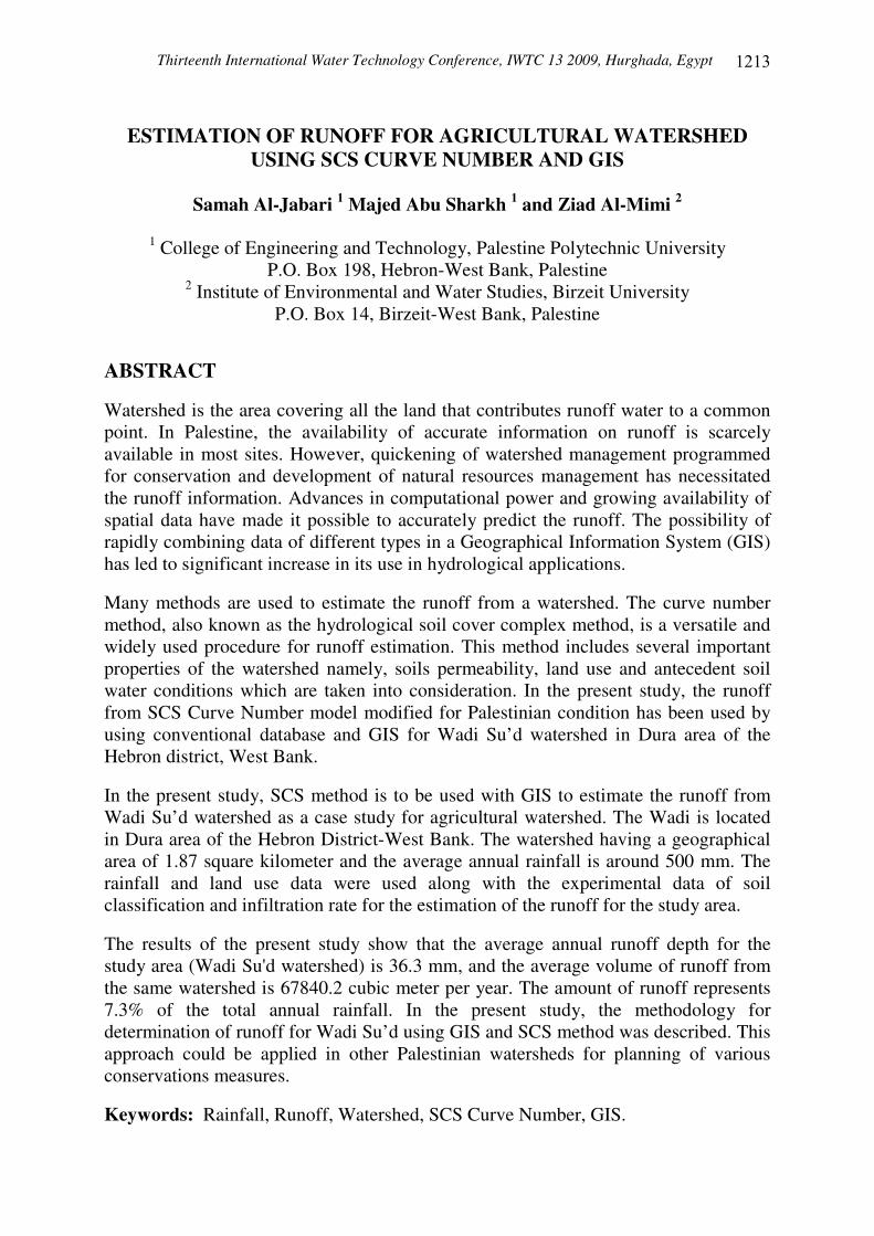
1. INTRODUCTION The problem most often encountered in hydrological studies is the need for estimating runoff from a watershed for which there is records of precipitation and no records of runoff. An approach to solution of this problem is to compare runoff characteristics with those of watershed characteristics. Watershed characteristics which may be mostly readily compared to estimating the volume of runoff that will result from a given amount of rainfall are soil type and cover, which includes land use. In Palestine, availability of runoff records is very limited compared to rainfall records, especially for medium and small catchments. Since discharge values are necessary for such ungauged catchments for the design of various hydraulic structures such as small dam, some analytical methodologies have to be utilized to estimate the same. Many such methods are available ranging from simple empirical equations relating catchment characteristics to the runoff, to complicated physical models that flow the movement of water from the farthest point of the catchments. Hydrologists of the Soil Conservation Services constantly encounter the problem of estimating direct runoff where no records are available for the specific watershed. Soil Conservation Service (USDA, 1985) curve number method is a well accepted tool in hydrology, which uses a land conditions factor called "the curve number". It is reliance an only one parameter and its responsiveness to four important catchment properties, i.e. soil type, land use, surface condition, and antecedent moisture condition, increased its popularity. The hydrological in Palestine studies are limited. Some investigators have studies the hydrology of different wadis and watersheds in the West Bank and Gaza strip in order to develop additional usable water resources to help in solving future hydrological problems. The measurements of the runoff in the West Bank are very rare and the majority of the available data is only estimations, e.g. 7-14% of the annual rainfall (Rofe and Raffety, 1963), and 5% (ARIJ, 2004). Wadi Su'd watershed (study area) is not gauged; therefore, to estimate the surface runoff for this watershed the US Soil Conservation Service Method (SCS) were applied. 2. STUDY AREA The study area, named Wadi Su'd, is located at Dura city of the Hebron area, West Bank which will known later as Wadi Su'd watershed. The watershed having a geographical area of 1.87 square kilometer, Figure (1) shows the study area and its location. Physiographically, the watershed is divided into hills, pediments. Elevation in the watershed ranges from 550 to 820 m above mean sea level. The average annual precipitation at Dura area for the last five years is approximately 500 mm. About 90% of this rainfall is received from November to April, and the major land use/land cover categories in the watershed are: pasture, agricultural area, and stony waste land (Data obtained from Dura Municipality).
Thirteenth International Water Technology Conference, IWTC 13 2009, Hurghada, Egypt
����
Figure (1): Location of the Study Area (Wadi Su'd Watershed)
Thirteenth International Water Technology Conference, IWTC 13 2009, Hurghada, Egypt
����
3. MATERIALS AND METHODS
3.1 Watershed Boundary, Grid Setup and Land Use The watershed boundary was restricted and the grid to conduct the experiments in suitable sites was setup by land surveying using Navigation GPS (Magellan). The conventional land use\land cover map of the watershed was obtained by the land survey technique using (GPS), and digitized map from a rectified aerial photo for Wadi Su'd watershed. Boundaries of different land use class were digitized in the (ArcGIS.9), and the attribute where linked to them. 3.2 Soil and Infiltration Tests The Unified Soil Classification System (USCS) was adopted in this work to classify soils at different points. Sieve analysis and moisture content experiments were carried out to classify the soil samples of the project. The infiltration rate which is helped to classify the soil was measured using Double Ring Infiltrometer manufactured for this purpose. 3.3 The SCS Curve Number Method The SCS curve number method (SCS, 1972), also known as the Hydrologic Soil Cover Complex Method was developed by the Soil Conservation Service (SCS) of the U.S. Department of Agriculture for use in rural areas. It is a versatile and widely used procedure for runoff estimation. The requirements for this method are low, rainfall amount and curve number. The curve number is based on the areas hydrologic soil group, land use treatment and hydrologic condition. As defined by SCS soil scientists, Soils may be classified into four hydrologic groups (A, B, C and D), (USDA, 1985), depend on infiltration, soil classification and other criteria. Land use and treatment classes are used in the preparation of hydrological soil-cover complex, which in turn are used in estimating direct runoff. Antecedent Moisture Condition (AMC) is an indicator of watershed wetness and availability of soil moisture storage prior to a storm, and can have a significant effect on runoff volume. Recognizing its significance, SCS developed a guide for adjusting CN according to AMC based on the total rainfall in the 5-day period preceding a storm. Three levels of AMC are used in the CN method: AMC-I for dry, AMC-II for normal, and AMC-III for wet conditions. Table (�) gives seasonal rainfall limits for these three antecedent moisture conditions.
Table (1): Classification of Antecedent Moisture Conditions
Total 5-days Antecedent Rainfall (mm) AMC
Dormant Season Growing Season I <12.7 < 35.6 II 12.7 – 27.9 35.6 – 53.3 III > 27.9 > 53.3
Thirteenth International Water Technology Conference, IWTC 13 2009, Hurghada, Egypt
����
The CN values documented for the case of AMC-II (USDA, 1985). To adjust the CN for the cases of AMC-I and AMC-III, the following equations are used (Chow, 2002):
)1....(......................................................................)*058.0(10
*2.4
)(
)()(
II
III CN
CNCN
−=
)2.(......................................................................)*13.0(10
*23
)(
)()(
II
IIIII CN
CNCN
+=
where, )( IICN is the curve number for normal condition, )( ICN is the curve number for dry condition, and )( IIICN is the curve number for wet condition. The rainfall-runoff equation used by the SCS for estimating depth of direct runoff from storm rainfall is:
)3........(......................................)2.0(8.0
)2.0( 2
SpSP
SPQ >
+−
=
where, S is the watershed storage mm; Q is the actual direct runoff mm; and P is the total rainfall mm. The equation has one variable P and one parameter S . S is related to curve number (CN) by:
)4....(..........................................................................................25425400 −=
CNS
Where CN is a dimensionless parameter and its value range from 1 (minimum runoff) to 100 (maximum runoff). It is determined based on hydrologic soil group, land use, land treatment, and hydrologic conditions. 4. RESULTS AND DISCUSSION
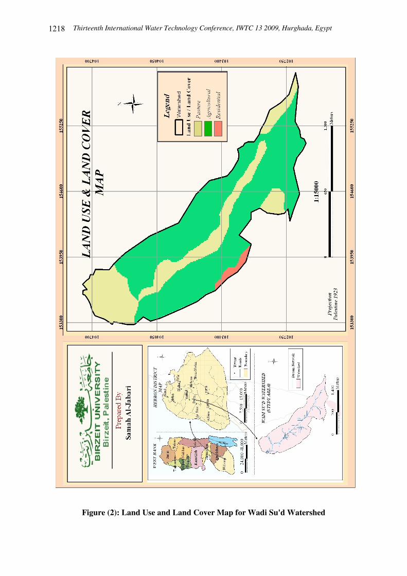
4.1 Land Use and Land Cover Three land use and land cover classes were categorized in the watershed as given in Table (2). The land use and land cover map for Wadi Su'd watershed is shown in Figure (2).
Table (2): Classes of Land Use/Cover of the Study Area
Percentage of Area (%) Area (m2) Land Use 69.82 1304954.00 Agricultural 28.45 531652.10 Pasture 1.73 32269.60 Residential 100 ������� SUM
Thirteenth International Water Technology Conference, IWTC 13 2009, Hurghada, Egypt
����
Figure (2): Land Use and Land Cover Map for Wadi Su'd Watershed
Thirteenth International Water Technology Conference, IWTC 13 2009, Hurghada, Egypt
���
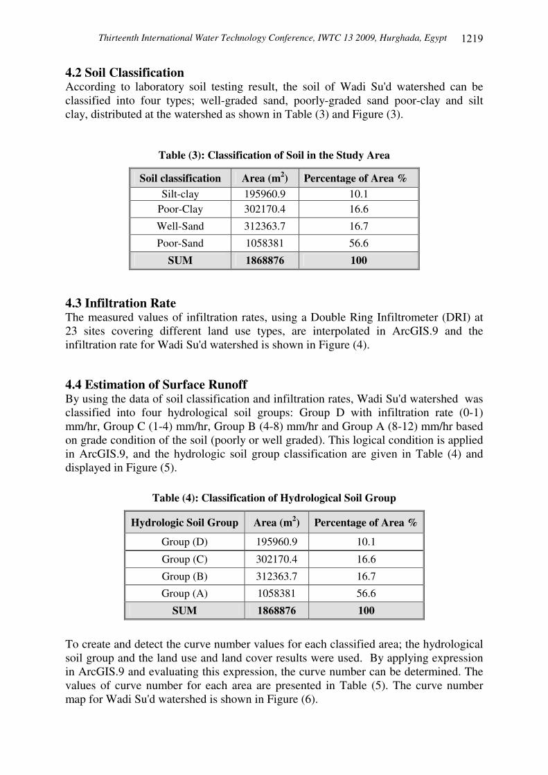
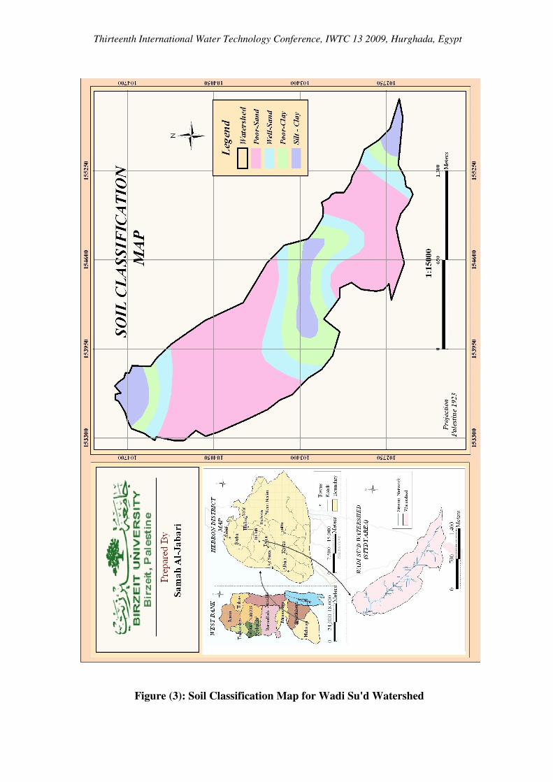
4.2 Soil Classification According to laboratory soil testing result, the soil of Wadi Su'd watershed can be classified into four types; well-graded sand, poorly-graded sand poor-clay and silt clay, distributed at the watershed as shown in Table (3) and Figure (3).
Table (3): Classification of Soil in the Study Area
Percentage of Area % Area (m2) Soil classification 10.1 195960.9 Silt-clay 16.6 302170.4 Poor-Clay
16.7 312363.7 Well-Sand
56.6 1058381 Poor-Sand
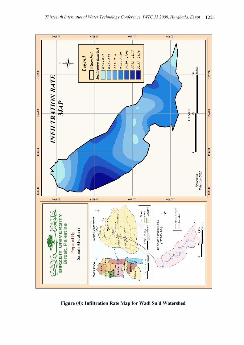
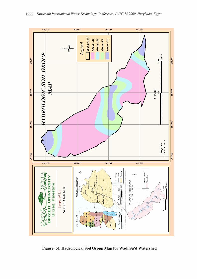
100 ������� SUM 4.3 Infiltration Rate The measured values of infiltration rates, using a Double Ring Infiltrometer (DRI) at 23 sites covering different land use types, are interpolated in ArcGIS.9 and the infiltration rate for Wadi Su'd watershed is shown in Figure (4). 4.4 Estimation of Surface Runoff By using the data of soil classification and infiltration rates, Wadi Su'd watershed was classified into four hydrological soil groups: Group D with infiltration rate (0-1) mm/hr, Group C (1-4) mm/hr, Group B (4-8) mm/hr and Group A (8-12) mm/hr based on grade condition of the soil (poorly or well graded). This logical condition is applied in ArcGIS.9, and the hydrologic soil group classification are given in Table (4) and displayed in Figure (5).
Table (4): Classification of Hydrological Soil Group
Percentage of Area % Area (m2) Hydrologic Soil Group
10.1 195960.9 Group (D)
16.6 302170.4 Group (C)
16.7 312363.7 Group (B)
56.6 1058381 Group (A)
100 ������� SUM
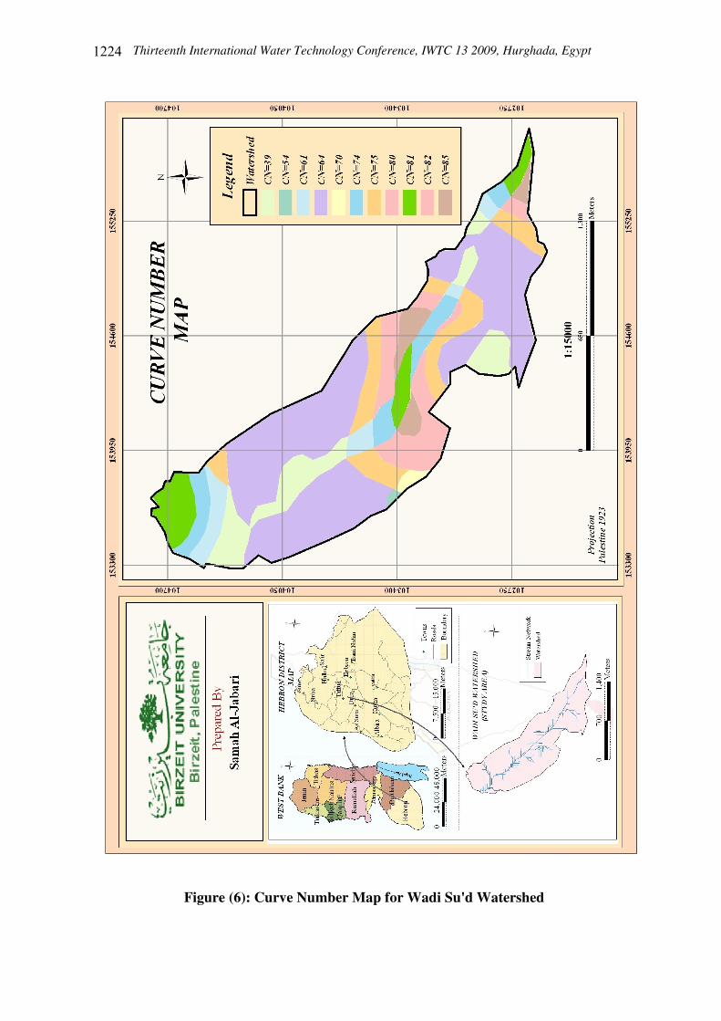
To create and detect the curve number values for each classified area; the hydrological soil group and the land use and land cover results were used. By applying expression in ArcGIS.9 and evaluating this expression, the curve number can be determined. The values of curve number for each area are presented in Table (5). The curve number map for Wadi Su'd watershed is shown in Figure (6).
Thirteenth International Water Technology Conference, IWTC 13 2009, Hurghada, Egypt
Figure (3): Soil Classification Map for Wadi Su'd Watershed
Thirteenth International Water Technology Conference, IWTC 13 2009, Hurghada, Egypt
����
Figure (4): Infiltration Rate Map for Wadi Su'd Watershed
Thirteenth International Water Technology Conference, IWTC 13 2009, Hurghada, Egypt
����
Figure (5): Hydrological Soil Group Map for Wadi Su'd Watershed
Thirteenth International Water Technology Conference, IWTC 13 2009, Hurghada, Egypt
����
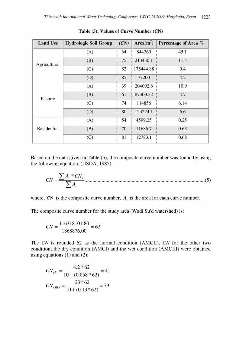
Table (5): Values of Curve Number (CN)
Land Use Hydrologic Soil Group (CN) Area(m2) Percentage of Area %
(A) 64 844260 45.1
(B) 75 213430.1 11.4
(C) 82 175444.88 9.4 Agricultural
(D) 85 77200 4.2
(A) 39 204092.6 10.9
(B) 61 87300.52 4.7
(C) 74 114856 6.14 Pasture
(D) 80 123224.1 6.6
(A) 54 4599.25 0.25
(B) 70 11686.7 0.63 Residential
(C) 81 12783.1 0.68
Based on the data given in Table (5), the composite curve number was found by using the following equation, (USDA, 1985):
)5.(..........................................................................................*
�
�=i
ii
A
CNACN
where, CN is the composite curve number, iA is the area for each curve number. The composite curve number for the study area (Wadi Su'd watershed) is:
6200.186887680.116318101 ==CN
The CN is rounded 62 as the normal condition (AMCII), CN for the other two condition; the dry condition (AMCI) and the wet condition (AMCIII) were obtained using equations (1) and (2):
41)62*058.0(10
62*2.4)( =
−=ICN
79)62*13.0(10
62*23)( =
+=IIICN
Thirteenth International Water Technology Conference, IWTC 13 2009, Hurghada, Egypt
����
Figure (6): Curve Number Map for Wadi Su'd Watershed
Thirteenth International Water Technology Conference, IWTC 13 2009, Hurghada, Egypt
����
The values of curve number for the three antecedent moisture conditions are listed in Table (6).
Table (6): Curve Number for Three Antecedent Moisture Conditions
AMC I II III CN 41 62 79
To calculate the surface runoff depth, apply the hydrological equations (3) and (4). These equations depend on the value of rainfall ( P ) and watershed storage ( S ) which calculated from adjusted curve number. Thus, before applying equation (3) the value of (S) should be determined for each antecedent moisture condition (AMC) as shown below. There are three conditions: These results are summarized in the Table (7).
Table (7): Values Used in Hydrological Equations
AMC CN S P>0.2S I 41 365.512 73.102
II 62 155.677 31.135
III 79 67.519 13.504
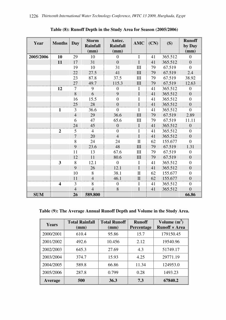
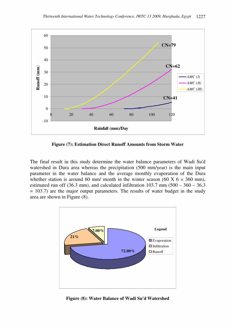
The Rainfall data and the result of surface runoff depth for the last five rainfall seasons in the study area were obtained, and the result of season 2005/2006 as an example is presented in Table (8). As a result of the calculations, based on the SCS method, it was found that the average annual surface runoff rate (depth) for the last five years in Wadi Su'd watershed is equal to 36.3 mm multiple by the area of the watershed (A = 1868876 m2) gives the total average volume of runoff as (67840.2 m3), which represents 7.3 % of the total annual rainfall. The annual rainfall and runoff during (2000-2006) in the study area are shown in Table (9). The direct runoff in Wadi Su'd watershed (study area) resulting from a given precipitation and antecedent moisture condition can be estimated using an appropriate curve number shown in Figure (7).
Thirteenth International Water Technology Conference, IWTC 13 2009, Hurghada, Egypt
����
Table (8): Runoff Depth in the Study Area for Season (2005/2006)
Year Months Day Storm Rainfall
Antec. Rainfall AMC (CN) (S) Runoff
by Day (mm) (mm) (mm)
2005/2006 10 29 10 0 I 41 365.512 0 11 17 31 0 I 41 365.512 0 19 10 31 III 79 67.519 0 22 27.5 41 III 79 67.519 2.4 23 87.8 37.5 III 79 67.519 38.92 27 49.7 115.3 III 79 67.519 12.63 12 7 9 0 I 41 365.512 0 8 6 9 I 41 365.512 0 16 15.5 0 I 41 365.512 0 25 28 0 I 41 365.512 0 1 3 36.6 0 I 41 365.512 0 4 29 36.6 III 79 67.519 2.89 6 47 65.6 III 79 67.519 11.11 24 45 0 I 41 365.512 0 2 5 4 0 I 41 365.512 0 7 20 4 I 41 365.512 0 8 24 24 II 62 155.677 0 9 23.6 48 III 79 67.519 1.31 11 13 67.6 III 79 67.519 0 12 11 80.6 III 79 67.519 0 3 8 12.1 0 I 41 365.512 0 9 26 12.1 I 41 365.512 0 10 8 38.1 II 62 155.677 0 11 4 46.1 II 62 155.677 0 4 3 8 0 I 41 365.512 0 4 4 8 I 41 365.512 0
SUM 2� 589.800 66.86
Table (9): The Average Annual Runoff Depth and Volume in the Study Area.
Years Total Rainfall (mm)
Total Runoff (mm)
Runoff Percentage
Volume (m3) Runoff × Area
2000/2001 ���� 95.86 15.7 179150.45
2001/2002 492.6 10.456 2.12 19540.96
2002/2003 645.3 27.69 4.3 51749.17
2003/2004 374.7 15.93 4.25 29771.19
2004/2005 589.8 66.86 11.34 124953.0
2005/2006 287.8 0.799 0.28 1493.23
Average 500 36.3 7.3 67840.2
Thirteenth International Water Technology Conference, IWTC 13 2009, Hurghada, Egypt
����
-10
0
10
20
30
40
50
60
0 20 40 60 80 100 120
Rainfall (mm)/Day
Run
off (
mm
)
AMC (I)
AMC (II)
AMC (III)
Figure (7): Estimation Direct Runoff Amounts from Storm Water
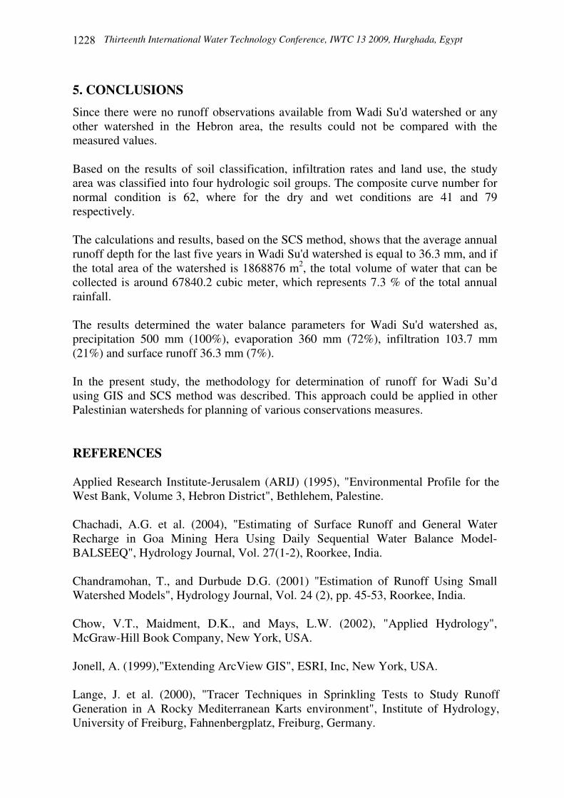
The final result in this study determine the water balance parameters of Wadi Su'd watershed in Dura area whereas the precipitation (500 mm/year) is the main input parameter in the water balance and the average monthly evaporation of the Dura whether station is around 60 mm/ month in the winter season (60 X 6 = 360 mm), estimated run off (36.3 mm), and calculated infiltration 103.7 mm (500 – 360 – 36.3 = 103.7) are the major output parameters. The results of water budget in the study area are shown in Figure (8).
Legend
72.00%
21%7.00%
Evaporation
Infiltration
Runoff
Figure (8): Water Balance of Wadi Su'd Watershed
CN=41
CN=62
CN=79
Thirteenth International Water Technology Conference, IWTC 13 2009, Hurghada, Egypt
����
5. CONCLUSIONS
Since there were no runoff observations available from Wadi Su'd watershed or any other watershed in the Hebron area, the results could not be compared with the measured values. Based on the results of soil classification, infiltration rates and land use, the study area was classified into four hydrologic soil groups. The composite curve number for normal condition is 62, where for the dry and wet conditions are 41 and 79 respectively. The calculations and results, based on the SCS method, shows that the average annual runoff depth for the last five years in Wadi Su'd watershed is equal to 36.3 mm, and if the total area of the watershed is 1868876 m2, the total volume of water that can be collected is around 67840.2 cubic meter, which represents 7.3 % of the total annual rainfall. The results determined the water balance parameters for Wadi Su'd watershed as, precipitation 500 mm (100%), evaporation 360 mm (72%), infiltration 103.7 mm (21%) and surface runoff 36.3 mm (7%). In the present study, the methodology for determination of runoff for Wadi Su’d using GIS and SCS method was described. This approach could be applied in other Palestinian watersheds for planning of various conservations measures. REFERENCES Applied Research Institute-Jerusalem (ARIJ) (1995), "Environmental Profile for the West Bank, Volume 3, Hebron District", Bethlehem, Palestine. Chachadi, A.G. et al. (2004), "Estimating of Surface Runoff and General Water Recharge in Goa Mining Hera Using Daily Sequential Water Balance Model-BALSEEQ", Hydrology Journal, Vol. 27(1-2), Roorkee, India. Chandramohan, T., and Durbude D.G. (2001) "Estimation of Runoff Using Small Watershed Models", Hydrology Journal, Vol. 24 (2), pp. 45-53, Roorkee, India. Chow, V.T., Maidment, D.K., and Mays, L.W. (��), "Applied Hydrology", McGraw-Hill Book Company, New York, USA. Jonell, A. (1999),"Extending ArcView GIS", ESRI, Inc, New York, USA. Lange, J. et al. (2000), "Tracer Techniques in Sprinkling Tests to Study Runoff Generation in A Rocky Mediterranean Karts environment", Institute of Hydrology, University of Freiburg, Fahnenbergplatz, Freiburg, Germany.
Thirteenth International Water Technology Conference, IWTC 13 2009, Hurghada, Egypt
���
Mohammadin, A. et al. (2003), "Estimation of Runoff for East Bani Naim Watershed Using SCS Curve Number Method and GIS", Graduation Project Palestine Polytechnic University, Hebron-West Bank, Palestine. Palestinian Hydrology Group (2004), "Agricultural Water Harvesting Manual", Ramallah, Palestine. Qannam, Z. (2003), "A Hydrogeological, Hydrochemical and Environmental Study in Wadi Al Arroub Drainage Basin, South West Bank, Palestine", Freiberg On-line, Geosciences, Vol. 9, Institute für Geologies / LHS Hydrogeologie, TU Bergakademie Freiberg, Germany. Rao, M.K., and Karanth, K.R. (1988), "Studies on Infiltration Characteristics of Soils in Granitic Areas", Hydrology Journal, Vol. XI, No. 1, pp. 34-39, Roorkee, India. Romero, D., Madramootoo, A. and Enright, P. (2002), "Modeling the Hydrology of an Agricultural Watershed in Quebec Using SLURP", Canadian Biosystems Engineering, Vol.44, pp 11-20, Canada. Sturm, C., Ribbe, L. and Schwabe, C. (1996), "Water resources management in the West Bank, Palestine- Final Report", ASA Program, Carl Duisberg Gesellschaft E.V., Berlin. USDA, Soil Conservation Service (1985), "National Engineering Handbook", USA. William, T.L. and Robert, V.W. (1951),"Series in Soil Engineering", John Wiley and Sons Inc., USA.