executive summarydocuments.worldbank.org/curated/en/705561476802810524/... · web viewthe...
TRANSCRIPT

SEPTEMBER 2015 version
SFG1158 V1 REV

Table of ContentsEXECUTIVE SUMMARY................................................................................................. I1 INTRODUCTION...................................................................................................11
1.1 Background................................................................................................................................11
1.2 Environmental and Social Impact Assessment of the Project....................................................12
1.3 Objectives of the Environmental and Social Impact Assessment...............................................12
1.4 Scope of the ESIA Study...........................................................................................................14
1.5 Methodology.............................................................................................................................15
1.5.1 Desk-Review......................................................................................................................15
1.5.2 Screening and Scoping.......................................................................................................16
1.5.3 Collection of Available Information..................................................................................16
1.5.4 Defining Project Area of Influence (PAI)..........................................................................17
1.5.5 Field Visits.........................................................................................................................17
1.5.6 Public Consultations..........................................................................................................18
1.5.7 Description of the Existing Environment...........................................................................18
1.5.8 Identification of Environmental Impacts............................................................................18
1.5.9 Environmental & Social Mitigation Plan...........................................................................18
1.5.10 Environmental and Social Management and Monitoring Plan...........................................19
1.5.11 Preparation of ESIA report................................................................................................19
2 DESCRIPTION OF TRANS-HINDUKUSH ROAD CONNECTIVITY PROJECT...................202.1 Bamyan- Baghlan Road (B2B)..................................................................................................21
2.2 Salang Highway Road...............................................................................................................27
2.3 Description of Project Setting....................................................................................................31
3 POLICIES, LEGAL AND ADMINISTRATIVE FRAMEWORK.........................................383.1 Afghanistan Environmental and Social Safeguard Policies and Procedures..............................38
3.1.1 The Environmental Law of Afghanistan (2007).................................................................39
3.1.2 Afghan Environmental Assessment Procedures.................................................................40
3.1.3 The Land Expropriation Law (2005) and its Amendments (2009).....................................42
3.1.4 Law on the Preservation of Afghanistan’s Cultural and Historical Artefacts (2004)..........43
3.1.5 National Waste Management Policy..................................................................................43

3.1.6 Air Quality Standards........................................................................................................44
3.1.7 Forest Law.........................................................................................................................44
3.1.8 Other Plans and Strategies.................................................................................................44
3.1.9 Multi-lateral Environmental Agreements (MEA)..............................................................45
3.2 World Bank Policy on Environmental and Social Assessment..................................................45
3.2.1 Environmental Assessment (OP 4.01)................................................................................47
3.2.2 Involuntary Resettlement (OP 4.12)...................................................................................47
3.2.3 Physical Cultural Resources (OP 4.11)..............................................................................48
3.2.4 Bank’s Policy on Access to Information............................................................................49
3.3 Mine Risk Management.............................................................................................................49
4 DESCRIPTION OF BASELINE CONDITIONS..............................................................504.1 Physical Resources....................................................................................................................50
4.1.1 Topography........................................................................................................................50
4.1.2 Soils...................................................................................................................................51
4.1.3 Seismic & Geological Characteristics................................................................................52
4.1.4 Hydrology..........................................................................................................................56
4.1.5 Air Quality and Climate.....................................................................................................59
4.2 Natural/Biological Resources....................................................................................................60
4.2.1 Flora...................................................................................................................................60
4.2.2 Fauna.................................................................................................................................60
4.2.3 Protected Areas..................................................................................................................63
4.3 Other Environmental Consequences:.........................................................................................66
4.3.1 Range Land........................................................................................................................66
4.3.2 Agricultural Land...............................................................................................................66
4.3.3 Urban.................................................................................................................................66
4.3.4 Energy Considerations.......................................................................................................67
4.3.5 Use of Natural/Depletable Resources.................................................................................67
4.3.6 Urban Quality/Design of the Built Environment................................................................68
4.3.7 Historic and Cultural Resources.........................................................................................68
4.4 Socio-Economic Considerations................................................................................................68
4.4.1 Demographic Profile..........................................................................................................69
4.4.2 Socio-Economic Baseline Study by USAID..........................................................................70
4.4.3 Follow up Survey & Validation of Baseline Data..............................................................73

4.4.4 Findings of the Baseline Study..........................................................................................75
4.5 Public Health and Safety............................................................................................................92
4.5.1 Noise..................................................................................................................................93
4.5.2 Other Infrastructure Systems..............................................................................................93
5. ENVIRONMENTAL AND SOCIAL IMPACTS ANALYSIS.............................................945.1 Introduction...............................................................................................................................94
5.2 Scoping of Environmental & Social Impact...............................................................................94
5.3 Types of Impacts.......................................................................................................................97
5.4 Physical Resources....................................................................................................................97
5.4.1 Topography and Soil..........................................................................................................97
5.4.2 Seismic & Geological Characteristics..............................................................................103
5.4.3 Water Resources..............................................................................................................104
5.4.4 Air Quality Climate.........................................................................................................108
5.5 Natural/Biological Resources..................................................................................................112
5.5.1 Flora.................................................................................................................................112
5.5.2 Fauna (wildlife)...............................................................................................................113
5.5.3 Protected Area.................................................................................................................114
5.6 Social Aspects..........................................................................................................................114
5.6.1 Loss of Land....................................................................................................................115
5.6.2 Loss of Structure..............................................................................................................116
5.6.3 Loss of Livelihoods & Businesses...................................................................................117
5.6.4 Loss of Crops/Trees.........................................................................................................118
5.6.5 Loss of access to Community Infrastructure/Public Utilities...........................................119
5.6.6 Use of Natural/Depleting Resources................................................................................119
5.6.7 Energy Considerations.....................................................................................................120
5.6.8 Urban Quality/Design of the Built Environment..............................................................121
5.6.9 Historical and Cultural Resources....................................................................................121
5.7 Other Socio-Economic Considerations....................................................................................121
5.7.1 Public Health and Safety..................................................................................................123
5.7.2 Noise................................................................................................................................125
5.7.3 Other Infrastructure Systems............................................................................................127
6 PROPOSED ACTIONS AND ALTERNATIVES..........................................................1286.1 The Proposed Action...............................................................................................................128

6.2 Analysis of Alternatives...........................................................................................................130
6.2.1 The No Action Alternative...............................................................................................130
6.2.2 Site Alternative................................................................................................................131
6.2.3 Design Alternatives..........................................................................................................131
6.2.4 Technology Alternatives..................................................................................................131
6.2.5 Alternatives Warranting Consideration in Detail.............................................................131
7. STAKEHOLDER AND PUBLIC CONSULTATION.....................................................1327.1 Introduction.............................................................................................................................132
7.2 Socio Economic survey of PAFs identified in the First Segment................................................135
7.2.1 Survey Methodology........................................................................................................135
7.2.2 Profile of Project Affected Families (PAFs)....................................................................136
8 ENVIRONMENTAL & SOCIAL MANAGEMENT PLAN..............................................1428.1 Introduction.................................................................................................................................142
8.2 Purpose of Site Specific-ESMP...............................................................................................142
8.3 Monitoring & Institutional Arrangement.................................................................................143
8.4 Capacity Building and Training...............................................................................................146
8.5 Estimated Budget for the ESIA................................................................................................146
9 GRIEVANCE REDRESS MECHANISM....................................................................14810.1 Grievance Redress Mechanism; objectives and functions.......................................................148
9.2 Grievance Redress Committee (GRC).....................................................................................149

Appendix
Appendix A Chance Find Procedures
Appendix B Project Affected Household Survey Questionnaire
Appendix C Specific Environmental and Social Conditions
Appendix D Format for Social Committee for Grievance Redress
Appendix E List of Members of Social Committee for Grievance Redress
Appendix F Public Notification
Appendix G List of Affected Families Identified in the First Segment
Appendix H Procedures for Mine Risk Management in World Bank-Funded Projects in
Afghanistan
Appendix I Resettlement Policy Framework
Appendix J Strip Plan
Appendix K List of sensitive receptors

ACRONYMS/GLOSSARY
ADB Asian Development Bank
AIRP Afghanistan Infrastructure Rehabilitation Program
ANEPA Afghanistan National Environmental Protection Agency
ARTF Afghanistan Reconstruction Trust Fund
B2B Bamyan to Baghlan
CFR Code of Federal Regulations
COPA Conditions of Particular Application
dB Decibel
EA Environmental Assessment
EIA Environmental Impact Assessment
ESIA Environmental and Social Impact Assessment
EMA Environmental Management Act
ESMP Environmental and Social Management Plan
GC General Contractor
GCOC General Conditions of Contract
GoA Government of Afghanistan
GDP Gross Domestic Product
IDA International Development Association
IEE Initial Environmental Examination
Jerib 0.2 Hectares/2000 Square Meters
KM Kilometer
Kph Kilometers per Hour
MOEW Ministry of Energy and Water
MOI Ministry of Interior

MOTCA Ministry of Transport and Civil Aviation
MoPW Ministry of Public Works
MRRD Ministry of Rural Rehabilitation and Development
MSL Mean Sea Level
MoIC Ministry of Information and Culture
NEPA National Environmental Protection Agency
NGO Non-Governmental Organization
NMT Non-Motorized Traffic
OP Operational Policy
PAP Project-Affected Person
PPE Personal Protective Clothing
PRT Provincial Reconstruction Team
RAP Resettlement Action Plan
ROW Right-of-Way
SS-ESMP Site-Specific Environmental and Social Management Plan
SPM Suspended Particulate Matter
Sta Station
ToR Terms of Reference
UN United Nations
UNEP United Nations Environmental Program
USAID United States Agency for International Development
USD United States Dollar
WB World Bank

Definitions of words and phrases
Affected Persons (APs), for the purposes of this RPF, mean all the people directly affected by project-related land acquisition that leads to their physical relocation or loss of assets, or access to assets, with adverse impacts on livelihoods. This includes any person, household (sometimes referred to as project affected family), firms, or public or private institutions who on account of project-related land acquisition would have their (i) standard of living adversely affected; (ii) right, title or interest in all or any part of a house, land (including residential, commercial, artisanal mining, agricultural, plantations, forest and/or grazing land), water resources or any other moveable or fixed assets acquired, possessed, restricted or otherwise adversely affected, in full or in part, permanently or temporarily; and/or (iii) business, occupation, place of work or residence, or habitat adversely affected, with or without displacement. APs therefore include; i) persons affected directly by the acquisition or clearing of the right of-way or construction work area; (ii) persons whose agricultural land or other productive assets such as mining, trees or crops are affected; (iii) persons whose businesses are affected and who might experience loss of income due to project-related land acquisition impacts; (iv) persons who lose work/employment as a direct result of project-related land acquisition ; and (v) people who lose access to community resources/property as a result of project-related land acquisition.
Census means the pre-appraisal population record of potentially affected people, which is prepared through a count based on village or other local population data or census.
Compensation means payment in cash or kind for an asset to be acquired or affected by a project at replacement costs.
Cut-off-date means the date after which people will not be considered eligible for compensation, if they are not included in the list of APs as defined by the census. Normally, the cut-off date for the titleholders is the date of the detailed measurement survey.
Displacement means either physical relocation or economic displacement directly caused by project-related land acquisition.
Detailed Measurement Survey means the detailed inventory of losses that is completed after detailed design and marking of project boundaries on the ground.
Encroachers mean those persons who extend their property beyond that for which they hold a title are encroachers and would not be eligible for compensation for land for which they do not possess a title.
Entitlement means the range of measures comprising cash or kind compensation, relocation cost, income rehabilitation assistance, transfer assistance, income substitution, and relocation

which are due to /business restoration which are due to APs, depending on the type and degree nature of their losses, to restore their social and economic base.
Livelihood Restoration means the measures required to ensure that APs have the resources to at least restore, if not improve, their livelihoods. Restoration of livelihood of all APs is one of the key objectives of the World Bank’s resettlement policy. It requires that people are given the means and assistance necessary for them to improve, or at least restore, their livelihood and living conditions to pre-project levels. Inventory of Losses means the pre-appraisal inventory of assets as a preliminary record of affected or lost assets.
Jerib means the traditional unit of measurement of Afghanistan. One Jerib is equivalent to 2,000 square meters of land. One hectare is equivalent to 5 Jeribs.
Land Acquisition means the process whereby a person is compelled by a public agency to alienate all or part of the land s/he owns, possesses, or uses, to the ownership and possession of that agency, for public purposes, in return for prompt and fair compensation. This includes direct acquisition and easement.
Non-titled means those who have no recognizable rights or claims to the land that they are occupying and includes people using private or state land without permission, permit or grant.
Poor Those falling below the UN poverty line of 1 dollar per person per day or equivalent to 52 Afghanis.
Relocation means the physical shifting of APs from his/her pre-project place or residence, place for work or business premises.
Rehabilitation means the assistance provided to severely affected APs to supplement payment of compensation for acquired assets in order to improve, or at least achieve full restoration of, their pre-project living standards and quality of life to pre-project level.
Replacement Cost means the method of valuation of assets that helps determine the amount sufficient to replace lost assets and cover transaction costs. In applying this method of valuation, depreciation of structures and assets should not be taken into account. For losses that cannot easily be valued or compensated for in monetary terms (e.g., access to public services, customers, and suppliers; or to mining, fishing, grazing, or forest areas), attempts are made to establish access to equivalent and culturally acceptable resources and earning opportunities.
Resettlement means all social and economic impacts that are permanent or temporary and are (i) caused by acquisition of land and other fixed assets, (ii) by change in the use of land, or (iii) restrictions imposed on land as a result of the project.

Resettlement Plan means the time-bound action plan with budget setting out resettlement strategy, objectives, entitlements, actions, responsibilities, monitoring and evaluation.
Severely Affected APs means APs that are affected by significant impacts within the meaning of the definition below.
Significant Impact means PAPs are (i) being physically displaced from housing, or (ii) losing ten per cent or more of their productive assets (income generating).
Sharecropper and/or Tenant cultivator is a person who cultivates land they do not own for an agreed proportion of the crop or harvest.
Structures mean all structures affected, or to be acquired, by the project such as living quarters, wells, hand pumps, agricultural structures such as rice bins, animal pens, stores/warehouses, commercial enterprises including roadside shops and businesses.
Squatters mean the same as non-titled person i.e. those people without legal title to land and/or structures occupied or used by them. World Bank policy explicitly states that such people cannot be denied assistance to restore livelihoods and living conditions based on the lack of title.
Temporary displacement means displacement where an occupier or owner of land is required to vacate land for a limited period to enable public works to be carried out on the land but can then return to the land and use it as before the displacement.
Vulnerable means any people who might suffer disproportionately or face the risk of being marginalized from the effects of resettlement i.e; (i) single household heads with dependents; (ii) disabled household heads; (iii) poor households; (iv) elderly households with no means of support; (v) the landless or households without security of tenure; and (vi) ethnic minorities.
Environmental impact assessment (EIA) An instrument to identify and assess the potential environmental impacts of a proposed project, evaluate alternatives, and design appropriate mitigation, management, and monitoring measures.
Project area of influence The area likely to be affected by the project, including all its ancillary aspects, such as power transmission corridors, pipelines, canals, tunnels, relocation and access roads, borrow and disposal areas, and construction camps, as well as unplanned developments induced by the project (e.g., spontaneous settlement, logging, or shifting agriculture along access roads). The area of influence may include, for example, (i) the watershed within which the project is located; (ii) any affected estuary and coastal zone; (iii) off-site areas required for resettlement or compensatory tracts; (iv) the airshed (e.g., where airborne pollution such as smoke or dust may enter or leave the area of influence); (v) migratory routes of humans, wildlife, or fish, particularly where they relate to public health and economic activities.

EXECUTIVE SUMMARY
Introduction
This executive summary presents the main findings of Environmental and Social Impact Assessment (ESIA) conducted for the Segment 1 ( the first 23.7km) of the Bamyan to Baghlan section of Trans-Hindukush road connectivity project. This study aims at examining the environmental and social impacts of the project and proposed mitigation measures including their management. The road design and rehabilitation is to be funded by World Bank as part of the Afghanistan Reconstruction Trust Fund (ARTF), and International Development Association (IDA). The Trans-Hindukush road connectivity project, categorized as a category ‘A’ project, requires an Environmental and Social Impact Assessment in accordance with the World Bank’s Operational Policies on Environmental Assessment (OP 4.01) and Involuntary Resettlement Policy (OP 4.12).
Project Development Objective
The project development objective is improved road transport connectivity across the Hindukush mountain range between the Kabul region and Afghanistan’s Northern provinces.
Project Components:
The proposed project would achieve the Project Development Objective through the implementation of the two project components described below
Component 1: Road construction. Component 1 will include (i) civil works for the rehabilitation and upgrading of two separate roads, namely the B2B road and the Salang highway, (ii) consulting services, for the supervision of works for the same roads and for regular technical audits by an independent international auditor to verify that road works have been executed in compliance with the technical specifications, and (iii) goods, which will include a small number of equipment items which MPW may need to keep the two roads open during construction. The MPW already commissioned and received detailed feasibility and design studies for the two roads, which the World Bank team reviewed and which will be further refined during project preparation. Design of the highway includes all the road safety features typically applied under international good practice. The finalized technical design of the Baghlan to Bamiyan road will include ducts and fiber optic cables. The new cable along this road will therefore also become part of the "data highway" for Afghanistan and provide a backup loop for the existing trans-Hindukush cable along the Salang highway.
As described earlier, for procurement purposes the civil works will be divided into smaller lots in order to facilitate the participation of local groups and contractors and to make the best possible use of their capabilities. This is also expected to reduce the security risk for the project

since this procurement strategy is expected to generate strong support by local communities, including in areas dominated by insurgent forces.
It is estimated that within the total cost of Component, about US$ 170 million will be spent on the Baghlan to Bamiyan road, US$ 55 million will be spent on the Salang highway and tunnel, while the remainder of US$ 15 million will be spent on goods and services benefitting both roads
Component 2: Institutional support and project management. This component will be comprised of several subcomponents:
a) Road Safety. This will include a review of the existing design for the two roads with the specific purpose of detecting and remedying any potential design deficiencies in terms of road safety. This activity will be combined with practical training of engineers at the MPWH on road safety issues.
b) Definition of asset management arrangements for the trans-Hindukush roads. This subcomponent will include activities to define the most appropriate arrangements for the effective and efficient management, operation and maintenance of the newly upgraded roads, after their completion. This will include a study on the feasibility of introducing tolling and outsourcing the management of the roads to the private sector. The objective is to avoid a repetition of the cycle of quick road deterioration observed in the past due to the lack of enforcement of axle load limits, inadequate management and maintenance, the excessive use of snow chains, and the absence of incentives for good management. The Bank team will work with IFC to develop an appropriate solution involving the private sector. The setup for the management of the trans-Hindukush roads will be also developed with the added objective of generating social benefits for the communities living along the road, such as the use of small and medium-sized local firms whenever this is possible and efficient.
c) Information and communications campaign. This will include the design and execution of MPW’s information and communications campaign for the purpose of building public and stakeholder support for upgrading of the two roads. This is especially important because the construction works will occasionally cause disruptions of the normal traffic patterns. The communications/outreach campaign is expected to include ICT-based citizen feedback mechanisms and will also promote road safety awareness among road users.
d) Training and capacity building. This subcomponent will include resources to fund various types of training and capacity building for staff of the MPW and DPW.
e) Project management support, including the cost of the Project Management Unit (PMU) operation.

The World Bank has decided to provide funds for developing the Trans-Hindukush road connectivity project having the following two sub projects:
a. Upgrading the Bamyan to Baghlan highway (152 Kms.) as an alternative route when Salang highway is closed due to weather related disruptions and maintenance works.
b. Long term rehabilitation of Salang highway including repairs to the tunnels and construction of a new reinforced heavy duty concrete pavement for about 30 Kms. length, located between 2,500 and 3,400 meters altitude above sea level.
The current update Environmental Impacts Assessment report is carried out for the rehabilitation and upgrading of Bamyan-Baghlan highway road. Considering the guideline of this report, it is recommended that the contractor should prepare and conduct a sites-specific EMP for the Salang corridor.
What is the purpose of this ESIA Study?
The purpose of this study is to conduct an Environmental & Social Impact Assessment (ESIA) of the first segment, which is the first 23.7km of the Bamyan to Baghlan highway of the proposed project. Specifically, this report seeks to achieve the following:
Study the impacts identified during the previous EIA and baselines at Socio Economic Study of Bamyan to Baghlan road rehabilitation project to ascertain whether they have been accurately predicted or situations have changed, focusing primarily on the first segment as the Detailed Engineering Designs of the remaining sections have not yet be completed.
Establish whether mitigation measures proposed are still relevant or new ones have to be recommended;
Draft appropriate management clauses and actions to be included in the contract document;
Develop monitoring program to ensure that the proposed mitigation measures are being implemented effectively; and
Determine appropriate cost estimates for the remedial measures which may not be part of the engineering design to be included in the Bill of Quantities (e.g. cost of HIV/AIDS Program, cost of monitoring, etc.)

Scope & Methodology used
This includes the review of existing EIA and relevant socio-economic baseline documents which have been already conducted by USAID during 2009-2010 and are particularly relevant to the Project location. A wide range of documents relating to Feasibility Studies, Environmental Scoping Statement, Environmental Impact Assessment and Socio-Economic Baseline studies have been reviewed to establish a set of best practice mitigation measures for potential impacts. Several of these documents related to Trans-Hindukush Road Connectivity Project have been prepared for donor agencies such as the USAID, World Bank and ADB, thus making them excellent reference sources. In addition, the site visits community consultation and collecting the required data through screening process were carried out. And also other documents reviewed include country specific environmental data prepared by NEPA, UNEP and other agencies such as the WB, IFC, WFP and WHO.
Policies, Legal and Administrative Framework
The desk study was carried out to assess and prepared the most applicable legal and administrative framework for the proposed project. The assessment has taken into consideration, both relevant Afghanistan laws and the World Bank policies and procedures.
Afghanistan Laws and Regulations
1. The Environmental Law of Afghanistan (2007)2. Afghanistan EIA Regulation (2008)3. National Environmental Impact Assessment Policy (2007)4. The Law on Managing Land Affairs 5. Afghan Land Policy (2007)6. The Land Expropriation Law (2000) and its Amendments (2005)7. Law on the Preservation of Afghanistan’s Cultural and Historical Artifacts8. National Waste Management Policy9. Air Quality Standards10. Forest Law (2008)11. Multi-lateral Environmental Agreements (MEA)
Applicability of World Bank Policies and ProceduresS. No. World Bank Policy Applicability Remarks/Actions1. Environmental
Assessment OP 4.01
Based on conducted studies, the construction of the road have some environmental impacts on water bodies, existing slopes in case of mountainous and hilly areas and on trees along the road
Implementation of Site- Specific Environmental and Social Management Plan (SS-ESMP)

S. No. World Bank Policy Applicability Remarks/Actions2. Natural Habitats
OP 4.04 N/A None .
3 Pest Management OP 4.09
N/A -
4 Physical Cultural Resources 4.11
A structure presumed to be from Buddhist times has been observed at KM 134 and is the only observed cultural site within the vicinity of the road
The structure is approximately at 50 meters from the road. It is recommended that the site is fenced to prevent any interference during project works. In case of any further unexpected discovery, Chance find procedures will be followed (Appendix A)
5 Involuntary Resettlement OP 4.12
The project will require land acquisition, loss of productive assets etc. and thus negatively impact PAFs.
The ESIA includes Resettlement Policy Framework (RPF), based on which, a RAP has been prepared.
6 Indigenous People OP 4.10
N/A People living in the area are considered ethnic in a very generic sense and by no means are classified as ‘indigenous people’ or ‘indigenous ethnic minorities’ in Afghanistan.
7 Forest OP 4.36 No virgin forest in the area -
8 Safety and DamsOP 4.37
N/A -
9 Project on International Water ways OP 7.50
N/A -
10 Project in Dispute Area OP 7.60
N/A -
Potential Environmental ImpactsThe rehabilitation of Salang highway will involve repairs of existing pavements, galleries and tunnels and is expected to have only minimal adverse environmental impacts. However, the proposed Bamyan to Baghlan road has extensive cut and fill requirements and unmanaged disposal of cut material can have significant impact to surface hydrology. Borrow pit excavations near the project site and potentially within the agriculture land can cause drainage issues.

Similarly requirement of crushed rock for road construction will involve quarry operations and can have potential environmental impacts.
Design interventions shall ensure balancing of cut and fill activities and dumping of cut material safely as well as measures to control the accelerated erosion during exaction period. Mitigation measures to control other potential adverse impact by implementing specific contract provisions for environmental protection are suggested in this report.
Similarly other potential adverse impact on soil and other geological conditions have been identified in the study and specific mitigation measures have been suggested.
The study has also identified some potential impacts on natural and biological resources. Cutting of trees, vegetation clearance and the interruption of existing irrigation canals are the recognized impacts. Mitigation measures have been suggested accordingly. No major disruption of wildlife migration patterns is indicated.
Potential Social ImpactsThe road improvements are expected to have positive social impacts in the form of improved access to social services, markets and jobs for communities of the areas, and therefore contribute to improving living standards in the project area. The road improvements are also expected to result in improvement in the incomes and result in reduction of poverty in the Zone of Influence (PAI). According to findings from the follow up socio economic survey about 60% households were found to be ‘Extremely Poor’ with an income of less than US$1 per capita per day.
However, based on the project’s preliminary design, the Bamyan to Baghlan road will also involve land/asset acquisition and resettlement impacts. The road is expected to be widened to 10m, the existing road width is between 5 to 12 meters. Also, the B2B road works will involve adverse social impacts on community structures, displacement of road side business and community services interruption, including impacts on community health and safety.
It is essential to note, the Salang highway rehabilitation works are not expected to involve any adverse social impact, as the rehabilitation work does not take place in the area with any potential or usable lands for resettlement.
In order to assess alternatives to avoid acquisition and the financial implications of it an exhaustive Social Impact Assessment (SIA) has been undertaken. This includes development of the project socio economic baseline study, which was commissioned by the USAID in 2009. A follow up survey was conducted during September-October 2014 to establish the validity and reliability of the data in the current context. As per the current assessment estimates, as much as 650-700 affected families will lose a part of their residential, commercial or agricultural properties along the Bamyan to Baghalan road corridor. A detailed 100 % household census was carried out by the Project Management Unit (PMU) team to collect socio-economic information on the status of affected families in the first segment of the road project, where 97 PAFs will be

impacted. There has also been a strip plan prepared for the first segment, which includes inventory of impacts land and properties.
The ESIA includes a Resettlement Policy Framework (RPF), which will guide preparation of RAPs of all the segments of the road project. The RPF provides entitlement matrix for eligibility criteria and guidelines for procedures and consultation GRM to be followed under project.
Environmental and Social Impacts AnalysisEnvironmental and social impact assessment started with the scoping analysis where the key potential impacts were identified and followed by more detailed impact analysis in chapter sixth of this document. The negative environmental and social impacts of the project are expected to be relatively less significant.
Positive Impacts
The local, regional and national economies would expand Road safety and comfort will improve Reduction in vehicle operating and transportation costs Increased employment and income opportunities Improved healthcare delivery Better market access for farm produce Government agents would be able to collect taxes
Negative Impacts
Loss of Land Loss of residence, and community structures (i.e. irrigation structures) Loss of agricultural products Loss of livelihood & road-side businesses Removal of existing trees, gardens and plantations Contamination of water resources Dust and Air Pollutions Noise Pollution Soil Erosion and Sedimentation Expropriation of Farmlands Impacts on Traffic Diversions Wastes generation Community services interruption
Environmental & Social Management Framework

This Environmental and Social Management Framework provides general policies, guidelines, codes of practice and procedures to be integrated into the implementation of the proposed World Bank supported Trans Hindukush Road Connectivity Project (THRCP). ESMF outlines the process for identifying potential adverse social and environmental impacts caused by improvement of Baghlan to Bamyan Highway and Salang highway roads. It describes the implementation and institutional arrangements for managing and mitigating environmental and social impacts. To effectively implement the environmental and social management measures suggested as part of the ESMF, necessary budgetary provisions has been be made for the project to ensure upfront appreciation of the financial requirements and allow early planning and budgeting accordingly. Majority of the cost of the mitigation measures will be integrated in the contractor’s cost and provided in the Project Bill of Quantities (BoQ) and based on the ESMF, the Site Specific Environmental and Social Management Plan (SS-ESMP) will be prepared and attaching with the project procurement package.
Tentative budget for the project includes the environmental and social management costs other than the good engineering practices. The total estimated budget for implementation of environmental and social management for the entire project is USD 1,117,000 which is to be used as provision sum for the implementation of mitigation measures.
Resettlement Policy Framework (RPF) Due to the size of the project and lack of time & institutional capacities, it was considered that the resettlement impact can be identified in phases and solutions for mitigation are implemented in a phased manner. In order to have guidance to how the resettlement will be planned and implemented, a resettlement policy framework has been prepared (Appendix I). The RPF is customized from the RPF approved by line ministries for another World Bank funded CASA 1000 project by MoEW. The RPF sets out the principles and policies to guide development of RAPs of all the Segments of the road project. This will not only ensure a consistent resettlement plan but also develop the capacities of the implementing and supervising agencies gradually and simultaneously.
Resettlement Action PlanGuided by the RPF a Resettlement Action Plan (RAP) has been prepared for the first Segment of Bamyan to Baghlan road to ensure an appropriate plan for involuntary resettlement of Project Affected Persons (PAPs) therein. The RAP document contains a full inventory of the adversely affected PAPs and a description and assessment of the expected adverse impact on these PAPs including the proposed measures for mitigation and compensation. The RAP is prepared through extensive consultation with the PAPs and the proposed measures have been discussed with them.
Monitoring & Institutional Arrangements

Regular monitoring of all significant environmental and social parameters is important to ensure compliance of the ESMF. Monitoring of the Site-Specific ESMP will not only help in detecting the scale and extent of impact caused by the project overtime, it will also inform whether mitigation actions have been properly and timely implemented and are working as envisaged in the safeguard documents. A monitoring plan has been suggested in this report to monitor the environmental and social mitigation measures. Institutional strengthening and capacity building strategy is also provided.
Grievance Redress Mechanism
A comprehensive grievance redress mechanism has been developed to address the concerns of affected persons and general public related to the project activities. This system will be in place immediately after the project is approved. In the meantime an intermediate system of GRM on similar lines has been put in place. Grievance redress committees have been constituted in the first segment’ project area, along the GRCs at Project level and HQ level. Details of grievance redress mechanism for THRCP have been included in ESMF and RAP for the B2B road segment 1.
ConsultationThere were a series of consultation conducted with local communities to discuss alternatives, and to avoid/ minimize adverse impacts. The consultation process and the analysis of alternatives led to the significant reduction of the adverse impact of this project. For example, consultations with affected people, within the area of segment 1, led to the decision to divert the road for 0.3 km in order to avoid existing irrigation facilities (Kariz system). This change in project design reduced the number of irrigation structures directly affected by the project from 3 to 2 and minimized the impact of the project on irrigation and other community structures.
Structure of this report
This ESIA report is structured in 9 Chapters as listed below:
1. INTRODUCTION. 2. POLICIES, LEGAL AND ADMINISTRATIVE FRAMEWORK. 3. DESCRIPTION OF PROJECT SITTING4. DESCRPTION OF BASELINE CONDITIONS5. ENVIRONMENTAL AND SOCIAL IMPACTS ANALYSIS6. PROPOSED ACTIONS AND ALTERNATIVES7. STAKEHOLDER AND PUBLIC CONSULTATION 8. ENVIRONMENTAL SOCIAL MANAGEMENT PLAN9. GRIEVANCE REDRESSAL MECHANISM

Conclusions and Recommendations
The development of Trans-Hindukush Road Connectivity Project will lower transportation costs, reduce travel time and will provide a significant aid to the poor through greatly improved transport infrastructure and access to marketplaces. The construction/rehabilitation and operation of the project will bring a large number of direct and induced employment opportunities to the local economy. Furthermore, the ESIA shows that there are none of the significant potential impacts identified that cannot be adequately managed and mitigated. In addition to Bamyan to Baghlan road, the Salang highway is also considered to be rehabilitated. The Salang highway is expected to generate minor negative environmental impacts. The rehabilitated infrastructure will be environmentally sound in their design, sitting, maintenance and operation. Conventional engineering designs with proven records of reliable performance will be adopted for the rehabilitation of this road. The minor environmental impacts anticipated during the rehabilitation works which can be mitigated by applying measures set out in the ESMF and ESIA’s Specific Environmental and Social Conditions.The ESMF has been prepared which will guide the preparation of Site-Specific ESMP for Salang corridor and the segments of Bamyan to Baghlan. It is recommended to carry out a preliminary environmental study for the Salang highway rehabilitation during technical engineering survey and the site specific ESMP should be prepared in order to address the negative environmental impacts. There is an overall appreciation by majority of the population living in the zone of influence. The development of road will require land acquisitions, demolition of some of the existing structures like houses, shops and other buildings. All this will require a comprehensive RAP process to provide for all issues related to land acquisition, payment of compensation and established mechanisms. A Resettlement Policy Framework (RPF) has been prepared to guide the development of such a RAP. The location of the project road requires construction material to be source from outside the project area. The project design process and the contractor(s) will have to identify specific sources and the ESM unit of the PMU will be required to conduct a comprehensive assessment for approval of the sites chosen by the contractor.All the affected families will be identified in a phased manner as the project develops into the next Segment of implementation. The resettlement costs will include compensation and assistance allowances to help the PAPs for their relocation and resettlement expenses. The contractor(s) will have to ensure appropriate safety standards, applicable gender principles and labor laws.

Environmental and Social Impact Assessment - Trans-Hindukush Road Connectivity Project
1 INTRODUCTION
1.1 BackgroundRoads are lifeline to any country’s economic development and welfare of its people. The conflicts, wars and dispute have caused huge damages to the road infrastructures of Afghanistan. The Government of Islamic Republic of Afghanistan now accords a high priority to improve national highways, regional highways, provincial roads and rural accessibility and reconstruction of rural access infrastructure. The Government of Islamic Republic of Afghanistan’s (GoIRA) 2006 Master Plan for Road Improvements identified the Afghan road network as follows:
Table 1: Road network in Afghanistan
Regional Highways
Ring Road & highways connecting Afghanistan to neighboring countries
3,442 KMs.
National Highways
Linking provincial capitals to Ring Road 4,884 KMs.
Provincial Roads
Linking district headquarters to their provincial capitals 9,656 KMs.
Urban/City Road
Connecting people inside cities 3,800 KMs.
Rural Road Gravel or earth surfaced (secondary and tertiary roads)101,400
KMs.
The need of a robust transport infrastructure is very critical for sustainable development of Afghanistan. A good transport infrastructure will enable accelerated economic growth, alleviate poverty and create a secure and safe development environment. There is a substantial need of investment of transport infrastructure to connect markets and facilitate regional trade. The agriculture industry and the extractive sectors have a vast potential to contribute to the development of Afghanistan and improved road network can be a major booster in development of these sectors. The Government of Islamic Republic of Afghanistan (GoIRA) has identified the Bamyan to Baghlan Corridor also called the Bamyan-Dushi Road, located within the Provinces of Bamyan to Baghlan, as a national highway requiring significant construction maintenance because of its strategic importance in providing an alternate route for Salang highway. The World Bank has decided to support the MoPW for developing the Trans-Hindukush road connectivity project having the following two sub projects:
22

Environmental and Social Impact Assessment - Trans-Hindukush Road Connectivity Project
I. Upgrading the Bamyan to Baghlan highway (152 Kms.) as an alternative route when Salang highway is closed due to weather related disruptions and maintenance works. The upgrading works will consist the planned civil works in the proposed project include widening the road at some segments and pavement rehabilitation along the entire length of the road. The existing Baghlan to Bamyan road width is between 5 to 12 meters. The road is expected to be widened to 10 m (with two 3.5m lanes and 1.5m road shoulder on either side), while the Right of Way (ROW) for B2B sub project section is set as 30m while the Right of Way (ROW) for B2B sub project section is set as 30m.
II. Long term rehabilitation of Salang highway including repairs to the tunnels and construction of a new reinforced heavy duty concrete pavement for about 86 Km length within the existing alignment, located between 2,500 and 3,400 meters altitude above sea level.
1.2 Environmental and Social Impact Assessment of the ProjectAccording to the WB Safeguards policies and Afghan EIA regulations, considering the scale of the project activities, it was recommended to carry out a detailed Environmental and Social Impact Assessment (ESIA) for the Trans-Hindukush road connectivity project. This ESIA is aimed at
Presenting an assessment of the potential environmental and social impacts of the project as a result of the project activities.
Undertake a preliminary assessment of the impacts of the project activities, explore alternative approaches to fulfill the objectives and consider the Afghanistan Environmental Law, EIA regulations and World Bank Safeguard policies that need to guide the decisions about this project design and implementation.
Identifying and make recommendations for possible mitigation measures to be undertaken to address potential adverse impacts of the project activities.
Guiding the preparation of a Resettlement Action Plan (RAP) based on the Resettlement Policy Framework (RPF) annexed in this ESIA in order to ensure a consistent approach to resettlement practices for all activities involving land acquisition and displacement.
Commence a public consultation process to engage the Project Affected Persons (PAPs) in the process of planning and implementation of the project.
23

Environmental and Social Impact Assessment - Trans-Hindukush Road Connectivity Project
1.3 Objectives of the Environmental and Social Impact AssessmentThe fundamental objective of this environmental and social impact assessment is to ensure that the proposed road rehabilitation, maintenance and spot improvement project will take care of
Social Aspects
1. By identifying the social ramifications of the project so that the implementers understand the consequences of their decisions before they act and the affected people get the opportunity to have their views and concerns incorporated in the design process. It will help in making the project responsive to the social development concerns.
2. By consulting communities and taking care of their views and concerns the chances of mitigating the negative impacts and improve the quality of decision making on project design and implementation will be greatly enhanced. Communities’ consultation will improve the project impacts and ensure poverty alleviation, improve inclusion and build ownership of the community.
3. Minimize and compensate for adverse social impact on all affected people with special attention to the vulnerable and the poor.
Environmental Aspects
To provide environmentally sound interventions and contributes to the development of environmental assets.
Ensure that the environmental factors are considered in the decision-making process and facilitate the design of a monitoring program.
To identify, assess and specify methods, measures and standards, to be included in the detailed design, construction and operation of the proposed project which are necessary to mitigate the environmental impacts and reduce them to acceptable levels.
Adoption of measures (and mechanisms for their incorporation in the project) to enhance beneficial impacts.
The purpose of this ESIA is thus to ensure that environmental and social issues have been foreseen in the development and implementation plans of the project and that environmental and social issues associated with this project are adequately anticipated and addressed.
24

Environmental and Social Impact Assessment - Trans-Hindukush Road Connectivity Project
Certain categories of projects are generally deemed to have a significant effect on the social scenario and the environment. With the large scale of activities proposed, this project has been classified as Category ‘A’ project. Such projects are likely to have significant adverse environmental impacts that are sensitive, diverse or unprecedented. These impacts may affect an area broader than the sites or facilities subject to physical works. Environmental impact assessment for a Category ‘A’ project examines the project’s potential negative and positive environmental impacts, compares them with those of feasible alternatives and recommends any measures needed to prevent, minimize, mitigate or compensate for adverse impacts and improve environmental performance.
1.4 Scope of the ESIA Study The Environmental Impact Assessment (EIA) study was undertaken to incorporate the environmental and social considerations into the Bamyan to Baghlan subproject planning and design process in order to ensure that the road improvement options under consideration are environmentally sound and sustainable. The EIA report is based on data collected from the following sources that include:
Results of the previous Environmental Impact Assessment (EIA) and findings of a Socio-Economic Baseline Study commissioned by United States Agency for International Development (USAID) in years of 2009 -2010 for Bamyan to Baghlan road.
Results of these existing documents and assessment in order to clarify certain aspects that were not sufficiently addressed to meet the national government regulation and WB Safeguard policies.
In view of the above, the ESIA is to be carried out with the following purposes:
(i) MoPW updated the current ESIA along with RPF and RAP only for Bamyan to Baghlan highway road subproject which is 152 km of upgrading and rehabilitation. In order to proper implementation of SS-ESMP, a Environmental and Social Management Framework (ESMF) for implementing, monitoring and reporting of the environmental mitigation and enhancement measures is suggested, for all stages of the project cycle, planning and design stage, construction stage, and operations and maintenance stages. Based on the ESMF and identified potential environmental and social impacts, the Site-Specific Environmental and Social Management Plan (SS-ESMP) will be prepared. The Site-Specific ESMP will include the site specific mitigation measures as identified in the ESIA. The Environmental and Social Management Unit (ESMU) would be responsible to make sure the preparation and implementation of SS-ESMP.
25

Environmental and Social Impact Assessment - Trans-Hindukush Road Connectivity Project
(ii) The Trans-Hindukush Road Connectivity Project also cover the rehabilitation and repairing of Salang corridor, tunnel along with galleries within the existing alignment which will not involve any land acquisition issues and no new construction intended during this section of the road. The expected potential environmental impacts during the road rehabilitation would mostly be air pollution, noise pollution and waste generation which will be treated and minimized through implementation of site-specific mitigation measures. Based on the guidelines of ESIA’s and Specific Environmental and Social Conditions as in Appendix-C a site-specific ESMP should be prepared for the entire road section by the contractor.
Figure 1: ESIA Approach
26
Mitigation Options
Residual Impact
Assessment of Magnitude
Impact Prediction
Resettlement/ Management Plan
Monitoring & Reporting
Scoping Document
Screening Checklist Stakeholde
r Consultations
Existing
Socio-Econo
mic baseli
ne Data
& Surve
y of PAFs
Project
Planning & Designing

Environmental and Social Impact Assessment - Trans-Hindukush Road Connectivity Project
1.5 MethodologyThe following specific assessment methods have been used during the development of this Environmental and Social Impact Assessment report:
1.5.1 Desk-Review
This included the review of existing EIA and relevant socio-economic baseline documents which were conducted by USAID during 2009-2010 and are particularly relevant to the Project location. A wide range of documents relating to Feasibility Studies, Environmental Scoping Statement, Environmental Impact Assessment and Socio-Economic Baseline studies have been reviewed to establish a set of best practice mitigation measures for potential impacts. Several of these documents related to Bamyan-Baghlan Rehabilitation were prepared for donor agencies such as the USAID, World Bank and ADB, thus making them excellent reference sources. In addition, other documents reviewed include country specific environmental data prepared by NEPA, UNEP and other agencies such as the WB, IFC, WFP and WHO.
Generally the road projects will create a range of negative impacts on physical, biological and human environment. Understanding the environmental settings and issues and constraints along the proposed Bamyan to Baghlan provinces road rehabilitation and bridge improvement activities is essential for the design of the proposed road projects.
1.5.2 Screening and Scoping
Environmental screening exercise of the project roads were undertaken to determine the major environmental issues and define the scope of work for conducting environmental assessment. As per the recommendation of the Environmental Screening report, detailed Environmental Assessment has been carried out for the project roads.
In 2010 USAID carried out a scoping exercise to identify and highlight the key issues and impacts likely to occur during the construction and operation and maintenance phases of the Bamyan-to-Baghlan sub-project under consideration. The effort focused on the most important aspects of impact identification. The methodology followed the conventional pattern for EIA’s and meets the requirements of National and International Environmental Impact Assessment guidelines and procedures. In addition, the USAID conducted a Socio-Economic Baseline study (2009) on the same sub-project.
27

Environmental and Social Impact Assessment - Trans-Hindukush Road Connectivity Project
1.5.3 Collection of Available Information
The present Environment and Social Management (ESM) team collected and reviewed the existing scoping statement, EIA and socio-economic baseline studies, published regulations, guidelines, and national policy documents. Information on existing environmental conditions, necessary to provide the basic background for impact identification and assessment, has been obtained from these sources. The national legislative and institutional framework, World Bank policies, procedures, guidelines etc has also been reviewed. The Socio-Economic Baseline Study in 2009 covered a sample of 62 villages (out of a total of 180) within the PAI covering 219 sampled households. It covered basic socio-economic household data plus a settlement survey (distance to services), business and transport surveys.
1.5.4 Defining Project Area of Influence (PAI)
The Project Area of Influence is divided into two: direct (PAI) and indirect (PAI). The direct project area of influence is confined up-to ROW about 30 m. and (ii) indirect project influence area which covers 5 km both side of the road.
(i) Roadside features like roadside religious structures, public structures, houses, schools, clinics, graves, water bodies etc. on which impacts of road improvement are generally confined up-to ROW, whereas, direct impact zone especially for roadside trees is limited up to line of the proposed road cross section.
(ii) The indirect project influence area has been defined as the area falling within 5 km on either side of the project roads. This was defined based on the socio economic impact of the project in the local context, which would include the near communities that will directly experience the highway. The Socio-Economic Baseline Study covered a sample of 62 villages (out of a total of 180) within the PAI covering 219 sampled households. It covered basic socio-economic household data plus a settlement survey (distance to services), business and transport surveys. The details of the settlements along the project are of influence presented in the Table 03.
The borrow pit area, quarry location and construction comp are proposed outside of the ROW within the project influence area. There are no power transmission corridors, pipelines, canals, tunnels, watershed within the project influence area. The following table illustrates the important issues within the Project Influence Area:
Table 2: The Issues within the Project Influence Area
Issues Reason Mitigated Fauna No fauna of biological significance identified
in the project area.Protected Areas No protected areas within the vicinity of the
28

Environmental and Social Impact Assessment - Trans-Hindukush Road Connectivity Project
roadUrban Quality No impacts identified.Socio-economics Impacts will be beneficial.Public Health Impacts will be beneficial.
1.5.5 Field Visits
Detailed site visits had been carried out in 2009 and 2010 in order to gain first-hand knowledge of existing environmental and social conditions and also to put the proposed road designs and construction works into context. During 2012, 2013 & 2014, renewed field visits along with screening and transect walk were also carried out to supplement the available information with emphasis on those areas identified as being of environmental interest during the scoping process. During the trips, information on physical resources, ecological resources, economic development activities, socio-economic aspects, health, cultural and other values in the project area were collected. A survey was also conducted to update the Socio-Economic baseline study in the zone of influence of the project. A detailed 100 % household census was carried out by the Project Management Unit (PMU) team to collect socio-economic information on the status of affected families in the first segment of the road project, where 97 PAFs will; be impacted (see the Resettlement Action Plan (RAP) across 10 villages in Doshi district.
1.5.6 Public Consultations
During 2009 and 2010 the field visits were conducted which included consultations with various stakeholders along all sections of the proposed Bamyan to Baghlan provinces. The purpose was to obtain supplementary information on social, socio-economic and socio-cultural conditions, and views on various aspects of the project. The consultation was also to obtain background information relevant to impact assessment and environmental management and, in particular, to identify any areas of specific concern which needed to be addressed. Finally, the purpose of the consultation was to reaffirm free, prior, and informed consultation leading to broad community support for the project. Additional public consultations were conducted during the preparations of the present project.
1.5.7 Description of the Existing Environment
Baseline data on the physical, biological and socio-economic environment of the project area has been collected and evaluated. Direct information was also obtained by visiting the project area. The Project Area comprises the area which will be under direct influence (i.e., where the environmental impacts of the construction activity can be felt) of the project and includes the road section and its influence area, quarry and borrow areas, etc.
29

Environmental and Social Impact Assessment - Trans-Hindukush Road Connectivity Project
1.5.8 Identification of Environmental and Social Impacts
Key potentially benefits as well as adverse impacts on physical, biological and socio-economic environment, including social impacts associated with the project construction, and operation and maintenance phases of the project have been identified.
1.5.9 Environmental & Social Mitigation Plan
The feasible and cost effective mitigation measures that may reduce the potentially adverse environmental and social impacts to acceptable levels and enhance the beneficial impacts have been prepared. The Environmental and Social Management Framework has been prepared to guide the development of SS-ESMPs for Salang Corridor and also for segments of B2B. In addition to ESMF, The Specific Environmental and Social Conditions of Particular Application (COPA) is prepared for use in the B2B and Salang Highway Project. The mitigations measures have been adapted for the project contractual conditions. The COPA will be part of SS-ESMP document along with project procurement package and the contractor shall consider and implement it during project implementation. The COPA portion of the Conditions of Contract shall specifically state that the Contractor shall take all reasonable steps to protect the environment on and off the Site and to avoid damage or nuisance to persons or to property of the public or others resulting from pollution, noise or other causes arising as a consequence of his methods of operation. The Contractor shall conduct its operations being aware of and employ necessary means and measures for eliminating and/or if impracticable, minimizing environmental impacts pertaining to, but not limited to:
Water quality; Air Quality; Flora; Protection of soils; Social Issues, such as; service interruption ; Solid / liquid waste Management; Natural Resources; Noise; Historical and cultural heritage; Irrigation Systems; Protection of utilities; and Health and Safety.
1.5.10 Environmental and Social Management and Monitoring Plan
An environmental and social management and monitoring plan has been developed to be fully integrated with the overall project management effort, the monitoring plan is part of ESMF
30

Environmental and Social Impact Assessment - Trans-Hindukush Road Connectivity Project
which include a program for monitoring environmental and social impacts during and after construction has been prepared.
1.5.11 Preparation of ESIA report
The final step is the preparation of Environmental and Social Impact Statement which addresses items called for in the national concerned institutions and other international financing institutions guidelines and the local communities and their leaders.
Considering the above standards, the social and environmental consultants have reviewed the existing and related documents and re-evaluate, validate and present additional (if required) baseline data on the relevant environmental characteristic of the project area/proposed road alignment. Baseline data were assembled through existing ESIA and relevant documents, field observation, measurements, sampling and laboratory analysis. On the basis of information obtained from the above activities, potential positive and negative impact of the project the ESIA is prepared.
2 DESCRIPTION OF TRANS-HINDUKUSH ROAD CONNECTIVITY PROJECT
As described above the Trans-Hindukush road connectivity is very crucial for not only economic development of Afghanistan but also its national integration. Salang Highway, built almost half a century before carries almost all the traffic from North to South and vice-versa. Connecting the Baghlan-Kunduz region to Jalalabad-Kabul region with almost ten thousand vehicles transporting goods and passengers every day, the Salang highway is one of the highest motor-able roads but gets frequently affected by heavy snowfall and landslides etc. The traffic disruptions cause huge economic costs and losses. Only alternative route to Salang highway is the unpaved Bamyan to Baghlan road, which due to its condition is only used by smaller vehicles. The Government of Islamic Republic of Afghanistan (GoIRA) has identified the Bamyan to Baghlan Corridor also called the Bamyan-Dushi Road, located within the Provinces of Bamyan and Baghlan, as a national highway requiring significant construction and maintenance because of its strategic importance in providing an alternate route for Salang highway.
The World Bank has decided to provide funds for developing the Trans-Hindukush road connectivity project having the following two sub projects:
1. Upgrading the Bamyan to Baghlan highway (152 Kms.) as an alternative route to Salang highway which is subject to weather related disruptions and maintenance works.
2. Long term rehabilitation of Salang highway including repairs to the tunnels and construction of a new reinforced heavy duty concrete pavement for about 30 Kms. length, located between 2,500 and 3,400 meters altitude above sea level.
31

Environmental and Social Impact Assessment - Trans-Hindukush Road Connectivity Project
The Trans Hindukush road connectivity project with total estimated cost of US$ 250 million will consist of the following main components:
Component 1: Road Construction (US$ 240 million): This will include:
I. Civil works for rehabilitation and upgrading of B2B road and the Salang highway.
II. Consulting services, for supervision of works for these roads and regular technical audits.
III. Goods, which will include small equipment items which MoPW may need to keep the two roads open during construction.
The total cost of component 1 includes US$ 170 million to be spent on rehabilitation of B2B road, US$ 55 million will be spent on Salang highway and tunnel and US$ 15 million will be spent on goods and services benefitting both the roads.
Component 2: Institutional support and project management (US$ 10 million): This will include provisions for road safety arrangements, effective O&M of the upgraded roads, information and communication campaigns, training & capacity building and management support cost of the PMU.
The Trans-Hindukush Road Connectivity Project will bring out benefits by way of:
I. Improvements in the physical and road/alternative access,
II. Improvement in services due to quicker and safe mode of transport,
III. Reduction in traffic congestion in the city/town and Salang pass which is currently used to connect Kabul with the northern parts of the country,
IV. Employment potential-including skilled, semi-skilled and unskilled labour-both during construction, operation and maintenance phases of the project with specific attention to employment potential of local population as well as necessity for imparting any specialized skills to them to be eligible for such employment in the project,
V. Facilitate development of tourism,
VI. Reduced pollution, better vehicle maintenance, fuel saving due to better quality of road,
VII. Overall development of the economy and improved living conditions for the people.
32

Environmental and Social Impact Assessment - Trans-Hindukush Road Connectivity Project
2.1 Bamyan- Baghlan Road (B2B)The Government of Islamic Republic of Afghanistan (GoIRA) has identified the Bamyan – Baghlan Corridor also called the Bamyan-Dushi Highway, located within the Provinces of Bamyan and Baghlan, as a national highway requiring significant construction maintenance because of its strategic importance in providing an alternate route for travel between the north and central/south provinces of Afghanistan. The upgraded road will decrease time and risks associated with travel in the region; facilitate better emergency response and access to social services; and provide new regional trade opportunities. The Bamyan-Baghlan Corridor as a National Highway has a strategic importance as it provides an alternative route from Kabul going towards north bypassing Salang Highway. The upgraded asphalt road will provide a year around alternative route to the Salang Highway, as well as increased security by reducing the time to respond to local, regional or national incidents, and facilitate access to social services and provide new regional trade opportunities including agriculture and mining. The road also responds to an urgent need of the agriculturists and fulfils their long standing demand of better access to markets and preservation of infrastructure facilities.
This sub-project starts at the intersection with Kabul to Dushi part of ring road in Baghlan province at about Km 160 from Kabul and ends at the intersection with road to Maidan Shar in Bamyan along the Charikar Bamyan road. The total length of the project road is about 152 km which has been divided into following 6 segments:
1. First segment (0+ 00 - 23.700)2. Second segment (23+700 - 45+200) 3. Third segment (45+200 - 66+00)4. Fourth segment (66+00 - 85+800)5. Fifth segment (85+800 - 123+40)6. Sixth segment (123+40 - 152+250)
The project road passes along the districts of Doshi, Tala Wa Barfak, Kuhmrad, Saighan and Shibar in Baghlan and Bamyan provinces. It also passes many villages directly along the project road and a total of 180 villages located in the zone of influence of the road which will also be benefited.
The proposed road will mainly follow the alignment of the existing unpaved road. The topography along the project highway can be described as a combination of flat to rolling to semi mountainous from Km 0 to Km 80, mountainous from Km 80 to Km 150, semi mountainous from Km 150 to end of project. Km 0 to Km 85.8 follows the valley of the Surkhab River.
Physical Characteristics A review of the project designs and other relevant issues has been carried out with particular reference to establishing the form and scope of the works, probable construction methods and materials, and operational characteristics of the completed road, in
33

Environmental and Social Impact Assessment - Trans-Hindukush Road Connectivity Project
order to identify potential sources of impact of the project on the environment. The characteristics of the project have been considered having regarded, in particular, to the size of the project, the use of natural resources, the production of waste, pollution and nuisances, and the risk of accidents. The existing Baghlan to Bamyan road width is between 5 to 12 meters and the planned civil works in the proposed project include widening the road at some segments and pavement rehabilitation along the entire length of the road. The road is expected to be widened to 10 m (with two 3.5m lanes with 1.5m road shoulder on either side). 15 meter is the right of way (ROW) from the edge of the road.
The works shall consist of the review of design of the horizontal and vertical alignments including super elevation and curve widening of the existing roadway which includes construction of new asphalt pavement, replacement or rehabilitation of existing 11 bridges, replacement of cross drainage culverts, construction of new 839 drainage culverts and roadside drains, relocation and improvement of existing irrigation canals, other ancillary works such as stone masonry retaining walls, riprap slope protection, etc.
In general, the project will involve civil works including excavation and embankment, rock blasting, gabions and revet mattresses, slope reinforcement and retaining walls, aggregate courses, bridges & culverts construction, reinforcing steel, stone masonry for retaining wall, guard wall, culvert-inlet/outlet structure, bed protection, lined ditch, permanent traffic control and signage, vegetation (bush) clearing, earth (soil) movement, topographic leveling, alignment and re-alignment of road segments, road pavement, coal tarring, etc with potential environmental impacts. The widening of the Baghlan to Bamyan road will require significant cutting of slopes and filling of valley areas, albeit along the existing corridor and alignment. Due to these unprotected slopes, significant erosion and therefore sediment transportation and deposition happen which need to be mitigated. The landscape is otherwise unremarkable as there are no forests and no known significant natural habitats.
Right of Way
The existing alignment and right of way along the project corridors varies from 5 m to 12 m. Encroachment is evident along the existing carriageway with shops and residences in the project corridor. The proposed improvements require a Corridor of Impact (COI) of between 10 m to 30 m. Most of the cross sections fit within the proposed Right of Way (ROW). The project is anticipated to have an impact upon properties and agricultural land that currently occupies the right of way. It is considered likely that rehabilitation works will impact an area of land between 3-5 meters wide on each side of the existing pavement. An assessment of aerial photographs of the alignment reveal that around 20% of the road passes either adjacent to, or between agricultural land. That would equate to an area anywhere between 10 and 30 hectares of land (50-160 Jeribs). The amount of agriculture land under segment 1 is 11.5
34

Environmental and Social Impact Assessment - Trans-Hindukush Road Connectivity Project
Jeribs or 2.2 hectares. In addition, there have been a total of 27 families who will lose a part of their residential houses and will have to move back for road-widening.
Pavement Requirements
During the study it was noted that the Bamyan to Baghlan roads have been overlaid or strengthened on previous occasions. The existing corridor is a gravel road with inferior quality and poor appurtenance structures. The proposed pavement and construction involves construction of new 2 lanes which is expected to be widened to 10 m (with two 3.5m lanes and 1.5m road shoulder on either side). The proposed new construction involves asphalt pavements and surface treatments, 75 mm asphalt concrete surface (wearing course), 75 mm asphalt concrete surface (wearing course) for shoulder, 75 mm asphalt concrete base course, 75 mm asphalt concrete base course (hard shoulder), double-bituminous surface treatment (DBST), asphalt prime coat, asphalt tack coat emulsified asphalt, Portland cement concrete pavement, 250mm thick. The design is under review and based and verification may propose some changes on the above mentioned parameters.
Cross Drainage Structures
The existing road is narrow, earthen and snaky with no appurtenance structures like culverts, retaining walls etc. except bridges over the Surkhab River. As the existing alignment and proposed alignment runs along the foot of the hills or from the neighborhood of topographic break the alignment mostly crosses fan shaped unconsolidated depositions where stream flow appear to spread over a larger area having no specific channel course making difficult to choose the most suitable and sustainable channel course. As the outlet of the catchment basin is spread over large width so the velocity is reduced immediately and sediments are lifted having large size boulders and thickness of material up to 3.5 meters. In addition, the size of catchment basin varies also the shapes, having high steep slopes result high velocity flow which transport the unconsolidated surface of the catchment basin consists of boulders and clay particles. All the pipe structures having diameter of 1 meter is shifted to box culverts having dimensions of1.0m x 1.0m. Approximately 80 percent of the dimensions are changed and culverts with large sizes are proposed.
According to the design documents Volume 2 of 5 Roadwork (Sub-volume 2.3 of 4) CBR values of the existing road material for the first section are 4 to 10%. The road cut and road widening material of these intervals which they have 1:1 side slope cutting ratio and formed from stone fragments, gravel and sand can be used in embankment filling but the existing road CBR values accordance design documents are below 10% so in the alignment of this section especially from 15+930Km to 16+930Km the existing road sub grade should be improved.
From 0+130 to 0+330 there is proposed cutting of conglomerate at the left side of the road and the proposed rations of cutting is 0.3H: 1V is not suitable because the of the semi soft condition of the conglomerates at mentioned places; therefore, the cutting slope should be changed to 1H: 1V.
The existing Bamyan to Baghlan highway is provided with 11 mostly single span bridges. The Bridge no 1 is located near to the starting point of the highway for crossing over a small
35

Environmental and Social Impact Assessment - Trans-Hindukush Road Connectivity Project
tributary and all other bridges are for crossing Surkhab River. The rehabilitation of existing 11 bridges, replacement of cross drainage culverts, construction of new 839 drainage culverts and roadside drains, relocation and improvement of existing irrigation canals, other ancillary works such as stone masonry retaining walls, riprap slope protection, etc. The construction of bridge and required the Plain Cement Concrete, Class B (15MPa) below bottom slab of box culverts, culvert wing walls, guard wall, Cover Concrete ditch, Reinforcing steel in guard wall, reinforced concrete box culverts, cut-off walls, culvert wing walls, apron slabs, PCCP, covered reinforced concrete ditch, Reinforcing steel in piers, pier footing, wing walls, abutments and abutment footings, Reinforcing steel in deck slabs, sidewalks, approach slabs and sleeper slabs, Reinforced Concrete Culverts, mortared joints, Class B-Retaining Wall, Guard wall, Culvert-Inlet/Outlet Structure, Bed Protection, Lined Ditch.
Ancillary or Associated Activities (borrow pit and quarry operation)
The major construction materials required for the Bamyan to Baghlan corridor are soil, sand, aggregates, bitumen, steel and cement. Selected soil required for the project will be procured from proposed borrows areas, which are located mainly outside or RoW.
Based on the total requirement and availability of each soil type, estimates of soil quantity to be obtained from each of the borrow areas, three borrow -pit areas are proposed along the road corridor in accordance with the environmental management guidelines. The first proposed borrow area is located within 4+000 km of the road, second borrow area is in the 16+000 km and the third one is within 29+000 km of the road. The proposed borrow pits are located outside of the ROW in distance of more than 500 meters from local residents and afar from area of influence. There is no forest land or tress, water bodies and agricultures lands within 500 meters of those ancillary areas. The sites are located on the available government owned land which is dispute free land. Pollution Prevention technologies and practices will be applied in construction phase according to the nation and International good practices and standards. The specific mitigation measures and guidelines are proposed under chapter five which will be implemented by contractor with regular monitoring by PMU.
Quarry Operation: Based on the guidelines provided under chapter 5 of this report, the contractors will be made responsible for obtaining rock and stone and operating their own and crusher plants. Prior to opening of any quarry or rock crushing facility, the contractor will require approval from the local provincial office of Ministry of Mines and Petroleum. The quarry locations will be decided by the local authorities from the ministry of mine and will be selected in consultation with local communities. The guideline for establishing of quarry along with site specific mitigation measures will be included in the Quarry Management Plan which should be prepared by contractor and approved by PMU/MPW. The PMU will make
36

Environmental and Social Impact Assessment - Trans-Hindukush Road Connectivity Project
sure that the operation should be based on proposed guidelines which will not harm the surrounded environment and the plans will be regularly monitored by regional ESM officers.
Construction Camp: During primary assessment, five locations for construction camps are proposed along the road. The first construction camp are located on the left side of road sta 42+500, the second camp can be located on the right side of road sta 56+500, the third camp can be located on the right side of road sta 71+000, the fourth construction camp can be located on the right side of road sta 131+000 and the fifth proposed construction camp can be located on the left side of road sta 141+000. The proposed construction camps will be sited based on the ESIA guidelines considering site-specific ESMP. The Contractor will submit a site plan of all construction camps indicating the location of fuel supplies, stockpile sites, offices and the construction area for approval by the Engineer to be approved prior to establishing any camps. The specific guidelines has been reflected in the SS-ESMP.
Settlements
The Bamyan to Baghlan road corridor pass through rural settlements and agricultural areas. The details of the settlements along the project are of influence presented in the Table 03.
Table 3: List of villages within the Bamyan-Baghlan subproject Influence area
S.NO Location Distance from the start point in KM.
Types District Province
1 KundahSang km 7. Village Dushi Baghlan2 GardAb Km. 10 Small Village Dushi Baghlan3 PustahLang km 11.5. Small Village Dushi Baghlan4 Robat km 18.5 Small Village Dushi Baghlan5 KalanGuzar km 32.4 Small Village Dushi Baghlan6 Zaghang km 35.5 Small Village Dushi Baghlan7 Sarband km 39 Small Village Dushi Baghlan8 Sia Pushtah km 42 Small Village Dushi Baghlan9 ShutorJangal km 43.5 Small Village Dushi Baghlan10 Dadu km 52.5. Small Village Dushi Baghlan11 Tala km 67.7 Small Town Tala Baghlan12 Barfak km 79. Village Tala Baghlan13 DouAb Makhi
Zareenkm 103 Large village Kuhmard Bamyan
14 Douab Area 150 Small town Shabir Bamyan
37

Environmental and Social Impact Assessment - Trans-Hindukush Road Connectivity Project
2.2 Salang Highway RoadAfghanistan’s only viable land route linking Kabul to Northern Afghanistan is via the Salang Tunnel and connecting road, collectively known as the Salang Corridor. This corridor crosses the towering Hindukush mountain range with peaks as high as 7,708m (25,289ft), making it one of the world’s most dramatic and imposing landscapes. Nearly 100 percent of goods reaching Kabul from the north each year are transported via this road linkage, and 6,100 vehicles currently pass through the route each day. Constructed in 1964, the Salang Tunnel has fallen into severe disrepair endangering drivers with poor ventilation, lighting and road conditions; severely impacting traffic flow; and costing Afghanistan’s economy over $ 60 million a year. Improving the capacity, safety and reliability of the Salang Corridor is also essential to development of Afghanistan’s extractives industry. Northern Afghanistan contains tens of billions of dollars of potential revenue in extractives, making it key to long-term Afghan economic growth.
Afghanistan urgently needs its only viable land route linking South Afghanistan and Kabul to Northern Afghanistan via the Salang Tunnel to be more reliable, safe, and an economically feasible option. There are several immediate consequences if nothing is done to address the present condition of the Salang Corridor. First, there is a safety issue; structural deficiencies in the tunnel as well as ineffective tunnel ventilation create health hazards from the stagnant carbon monoxide. Avalanches continually threaten the safety of the passage. Secondly, inaction has as adverse effect on the trade. As Afghanistan increase its economic viability in the mining, trade, agriculture, and manufacturing sectors, a safe route to transport goods to market is crucial. Safe passage through the Hindukush mountain linking North and South Afghanistan and connecting to Central Asian neighboring countries is key to the future economic stability of the Afghanistan. Third, when the Salang Tunnel further deteriorates and
38

Environmental and Social Impact Assessment - Trans-Hindukush Road Connectivity Project
is forced to close indefinitely, the political implications of Afghanistan being totally reliant on Iran and Pakistan are unacceptable to not only Afghanistan but the international community.
The Salang Tunnel is a section of the strategic transportation infrastructure that provides the primary overland connectivity through the Hindukush Mountains. The tunnel saves travelers more than 60 hours when compared to current alternate routes between Kabul and the Northern provinces.
The Salang Tunnel, situated at kilometer 113.9 on the Kabul-Salang-Dushi Highway within Parwan Province, is considered among the most important stretches of road in all of Afghanistan. The 2.6 kilometer long tunnel and its 21 avalanche galleries (15 galleries on the south side and six on the north side) has served as the major conduit for traffic traveling from Kabul to the northern provinces and beyond to Uzbekistan and Tajikistan since its construction by the Soviet Union in 1964. The existing Salang tunnel saves more than 60 hours of travel time when compared to current alternate routes between Kabul and the Northern provinces. At an elevation of 3,319m, the tunnel cuts through Salang Pass (elevation 3,880m), one of the highest passes in Afghanistan.
Figure 2: Traffic at Salang highway
There are no fully paved alternative routes for transit between northern and southeastern Afghanistan. Existing alternate routes also traverse through rough mountain passes at high elevation and most include long sections of narrow, unpaved trails with variable stream and river crossings.In 1982, the detonation of an explosive-loaded truck caused major damage to mainly the Northern part of the tunnel. The tunnel underwent repairs in 2003 and 2010/2011. In addition,
39

Environmental and Social Impact Assessment - Trans-Hindukush Road Connectivity Project
there have been numerous rehabilitation and emergency repair projects in recent years to slow or stop the continued deterioration of the tunnel and to keep it operational. For the most part, these efforts have served only as minor and temporary measures as the tunnel’s structural
flaws and the unabated flow of overloaded trucks quickly overwhelm the repair and return the tunnel to a dangerous and degraded condition.
Despite restoration efforts, the Salang Tunnel and its avalanche galleries are in a severe state of disrepair. With poor ventilation, minimal lighting, failed drainage (tunnel and pavement), significant water inflows, heavily deteriorated pavement, and poor traffic control, the tunnel is a safety hazard. Traffic accidents are frequent and fatalities are common. Accidents and breakdowns can result in severe traffic jams, and truck drivers are forced to spend hours and sometimes days waiting to get through the tunnel. Major snowfall in the winter closes the tunnel for weeks at a time and avalanche have resulted in many deaths over years. Passengers wait long periods in the upper galleries or in the tunnel result are exposed to extremely high levels of vehicle exhaust. As a result, carbon monoxide exposures are such that deaths have been reported. Civilian and military movement between Northern and Southern Afghanistan, as well as from the other Central Asian Republics, have led to an increase in overall traffic volume and the number of military vehicles. The increase of traffic over time, based on economic and population growth, and lack of alternate route will further exacerbate the problems associated with the condition of the tunnel.
Figure 3: Avalanche gallery on Salang highway
40

Environmental and Social Impact Assessment - Trans-Hindukush Road Connectivity Project
The present condition of the road corridor is very poor and dilapidated. Due to the long term poor maintenance and over usage, general condition of the road and tunnel had deteriorated to the level that it is posing danger to the travelling community. The current condition severely effect road users in terms of the travel cost and time. The calculated loss to Afghanistan's economy due to this un-satisfactory condition is over $60 million a year.
A mission of MoPW had visited Salang Highway on September 2014, during the visit it was noticed that the road in South Salang to and through the Salang Tunnel as well as North Salang requires major rehabilitation. The wearing surface in most of the road is completely eradicated. Based on the conducted surveys, the 86 km of road length is in a very bad condition for traffic passing and most of the pavement is damaged. Major rehabilitation work is required to be taken up on the Salang road from Jabalsaraj to Ulang (32 Km), Ulang to Doshakh (29 Km) and from Doshakh to Khenjan (25 Km) alongwith existing Tunnels and Galleries which also require major repairs. Khenjan to Puli Dushi only routine maintenance is required. On the salang road corridor there are 21 avalanche galleries (15 galleries on the south side and six on the north side). The current galleries are inadequate, with damaged surface and leakages from the roofs and walls.
The rehabilitation for Salang Tunnel required the following civil works: Cracks and leakage Ceiling system Heating system Drainage system Ventilation system Lighting system
In addition, the snow avalanches protection, cracks leakage of galleries, back filling and structures repair are included.
41

Environmental and Social Impact Assessment - Trans-Hindukush Road Connectivity Project
2.3 Description of Project Setting The Trans-Hindukush road connectivity project is divided into two work components, rehabilitation of Bamyan to Baghlan road and Salang highway. The works related to rehabilitation of Salang highway is limited to rehabilitation of existing tunnels and parts of existing road surface. The environmental impact assessment therefore is largely relevant to the first work component, which is the Bamyan to Baghlan road. In this part of the report the project setting defined is of the Bamyan to Baghlan road. This road directly connects two provinces of Afghanistan, Bamyan in the centre and Baghlan in the North. Bamyan province, where the road ends, lies in the highlands of Afghanistan and nearly the whole area is mountainous or semi-mountainous, while only 1.8% of its area is made up of flat land. With 439,900 inhabitants it is the 27th most populous province in the country out of 34. Approximately 97% of the population lives in rural areas. 86 percent of the population earns a living through agriculture and livestock. One of the key agricultural products in Bamyan province is potato with as much as 150,000 tons produced annually.The project road passes through residential areas, agricultural and cultivated areas, alluvial fans, barren lands and near river banks. There are culvert structures existing of varying sizes which are used for irrigation and road drainage purposes, and existing retaining walls to prevent soil erosion. Irrigation ditches and canals of variable sizes are also found along the existing road.There are also eleven existing bridges of different types of superstructures which are either to be replaced or improved. There are also flooded areas where the finished road elevation is to be raised substantially or road realignment is needed to avoid flooding.
The works shall consist of the design of the horizontal and vertical alignments including super elevation and curve widening of the existing roadway from Dushi in Baghlan province, Station
42

Environmental and Social Impact Assessment - Trans-Hindukush Road Connectivity Project
0+000 to about Station 152+250 in Bamyan province, which includes construction of a new asphalt pavement, replacement or rehabilitation of existing bridges, replacement of cross drainage culverts, construction of new drainage culverts and roadside drains , relocation and improvement of existing irrigation canals. Other ancillary works such as stone masonry retaining walls, riprap slope protection, etc., preparation of bill of quantity, environmental impact assessment and geo-technical investigation are also required to be taken up.
The proposed Project starts in Dushi, Baghlan Province and winds its way south west to Bamyan, the capital of Bamyan Province. Figure 6; illustrates the location of the road within Bamyan to Baghlan Provinces.
Figure 4: Location of the road in Bamyan & Baghlan Provinces
Figure 5: Bamyan-Baghlan Road across districts
43

Environmental and Social Impact Assessment - Trans-Hindukush Road Connectivity Project
Figure 6 : Road view at 0 KM
The project road starts at the outskirts of Dushi at the intersection with the road to Kabul. The road immediately crosses a small bridge and starts to traverse a valley floor adjacent to the Surkhab River. The road continues along the south bank of the river wedged between the mountain slopes and the fertile agricultural lands until it crosses to the north bank of the river.
44

Environmental and Social Impact Assessment - Trans-Hindukush Road Connectivity Project
Figure 7: Road view at 10.6 KMs.
At this point road crosses a small village called Kunda Sang. In this village some displacement of houses and other structures may be required which fall on the Right of Way.
45

Environmental and Social Impact Assessment - Trans-Hindukush Road Connectivity Project
Figure 8: Road view at 22 KMs.
Figure above shows how the river has eroded the riverbanks; farmers used a variety of methods to strengthen the embankments including old Russian military vehicles.
Figure 9: Road view at 34 KMs.
Small villages dot the landscape, some within the right of way and some set well back. It is often hard to tell which compounds were occupied and which were no longer in use. Figure above also illustrates the rice crops grown in this area.
46

Environmental and Social Impact Assessment - Trans-Hindukush Road Connectivity Project
Figure 10: Road view at 44 KMs.
Irrigation systems are a key aspect of agriculture in this region. Fed by the perennial Bamyan and Surkhab Rivers there is plentiful supply of water for agriculture in the main valleys. The situation is different beyond the main valleys where water supply is less regular and farmers rely on rain-fed cropping.
Figure 11: Road view at 98 KMs.
The road reaches the town of Doab (Meaning two rivers) at Km 98. At this point the Bamyan River converges with two rivers to the north to form the Surkhab River. Note the change in the river water color where the rivers join. After Doab the road begins a journey through scarcely populated landscape for about thirty kilometers. The valley becomes narrow and what little relatively flat land is available is intensively farmed right up to the embankments of the Bamyan River.
47

Environmental and Social Impact Assessment - Trans-Hindukush Road Connectivity Project
Figure 12: Road View at 134 KMs.
In the narrow valley area the road crosses the river several times. At Km 130 the valley begins to open out on the approach to the village of Gandak at Km 134. Gandak is populated by the ethnic Hazara population.
Figure 13: Road view at 138 KMs.
Upon leaving Gandak the valley begins to narrow, along with the width of the Bamyan river. Small bridges provide the only access to the steep mountains west of the project road. Little agricultural land can be found in this area and very few isolated housing compounds can be observed.
48

Environmental and Social Impact Assessment - Trans-Hindukush Road Connectivity Project
Figure 14: Road view at 144 KMs.
The road then enters a very narrow valley with vertical side slopes, some of which overhang the project road. Significant blasting will be required in this section of the road. The project road finishes at Km 152.
49

Environmental and Social Impact Assessment - Trans-Hindukush Road Connectivity Project
3 POLICIES, LEGAL AND ADMINISTRATIVE FRAMEWORK
3.1 Afghanistan Environmental and Social Safeguard Policies and Procedures
Afghanistan’s National Environmental Protection Agency (NEPA) was established in the year 2005. In the same year, the Afghanistan Environmental Law was issued by Government of Afghanistan. The law defines the Agency’s function and role of NEPA for environmental protection at country level. As per the law, NEPA serves as Afghanistan Environmental policy-making and regulatory institution.
Legislative Framework - The Environmental Management Act (EMA) prepared by NEPA focuses on several areas including:
1- Integrated Environmental Management Environmental Impact Assessment Integration of Environmental Issues into Development Planning
2- Integrated Pollution Control Pollution Prevention Control (including licensing) Waste Management (duty of care, waste management licenses etc)
3- Water Resource Conservation and Management
4- Biodiversity and Natural Resource Conservation and Management National Biodiversity Strategy Protected Areas Management Sustainable Use and Conservation of Species Species Trade Access to Genetic Resources
5- Compliance and Enforcement
In addition to the EMA several other environmental related laws currently exist are illustrated below.
Table 4: Afghanistan Environmental and Social laws and regulations
Afghanistan Environmental laws and regulations Date
Environmental Law Jan-2007
Environmental Impact Assessment March-2008
Forest Law 2000
Law on Managing Land Affairs 2008
Law on Land Expropriation 2005 (Amended)
Nature Protection Law 1986/2000
Hunting and Wildlife Protection Law 2000
50

Environmental and Social Impact Assessment - Trans-Hindukush Road Connectivity Project
3.1.1 The Environmental Law of Afghanistan (2007)Afghanistan enacted an updated Environment Law on January 25, 2007. The Environment Law has five main purposes: 1) improve livelihoods and protect the health of humans, fauna and flora; 2) maintain ecological functions and evolutionary processes; 3) secure the needs and interests of present and future generations; 4) conserve natural and cultural heritage; and 5) facilitate the reconstruction and sustainable development of the national economy. The implementing agency for the Environment Law is the Afghan National Environmental Protection Agency (ANEPA), which acts as an independent institutional entity, and is responsible for coordinating and monitoring conservation and rehabilitation of the environment. The Environment law contains a supremacy clause which states: “where there is inconsistency between the provisions of this Act and any other law that affects the environment, other than the Constitution of Afghanistan, this Act shall prevail.” This addition makes the Environment Law a very powerful law when planning projects and activities that could impact the environment.
The Environment Law contains a blanket prohibition on two types of activities. The first is that “no person may undertake an activity or implement a project, plan or policy that is likely to have a significant adverse effect on the environment” unless the provisions of Article 16 are followed. The second is that “no ministry or national authority may grant an authorization for the execution or implementation of a project, plan or policy that is likely to have a significant adverse effect on the environment” unless the provisions of Article 16 are followed. The language in the Afghan Environment Law is substantially similar to that of the National Environmental Policy Act (hereafter U.S.-NEPA) in the United States and the standard of “significantly affecting the quality of the human environment.” Also similar to the U.S.-NEPA process, the Afghan Environment Law requires that the person or agency make an informed choice regarding the proposed action, rather than requiring a specific course of action or no action. The Afghan Environment Law, again similar to U.S.-NEPA, requires that environmental issues be integrated into all national and local land use plans and natural resource management plans developed by relevant ministries and national institutions.
One of the requirements of the process under the Afghan Environment Law is the submission of a preliminary assessment. The preliminary assessment should contain accurate information to allow ANEPA to determine the potential adverse effects and positive impacts of the project, plan, policy or activity. ANEPA will review the brief and solicit advice from the EIA Board of Experts (see below) before making a decision to authorize the project, plan, policy or activity. ANEPA can also place conditions on the proposed project, plan, policy or activity, without requiring further action by the proposing party. However, if ANEPA considers the adverse effects likely to be significant, it can require the proposing party to submit an Environmental Impact Statement or a Comprehensive Mitigation Plan under the Law. If ANEPA chooses to require a comprehensive mitigation plan, it must include the
51

Environmental and Social Impact Assessment - Trans-Hindukush Road Connectivity Project
following: 1) a description of the mitigation measures that will be implemented in order to prevent, reduce or otherwise manage the environmental impacts of a project, plan, policy or activity; 2) how these measures will be implemented; and 3) any other information prescribed by ANEPA. The costs incurred in preparing the preliminary assessment, an environmental impact statement, a final record of opinion or a comprehensive mitigation plan are the responsibility of the applicant proposing the project, plan, policy or activity.
On the basis of the preliminary assessment and any required follow–up documentation, such as an Environmental Impact Statement or Comprehensive Mitigation Plan, ANEPA can choose to either grant or refuse to grant the permit for the project, plan, policy or activity. If ANEPA, acting on the advice of the EIA Board of Experts, finds that the environmental impacts and concerns are adequately addressed by the environmental impact statement/preliminary assessment it can grant the permit subject to any conditions recommended by the EIA Board of Experts. If ANEPA, acting on the advice of the EIA Board of Experts, finds that the implementation of the project would bring about unacceptable significant adverse effects or that the proposed mitigation measures would be inadequate, it can reject the proposed project, plan, policy or activity, and the reasons for rejection must be provided in writing. A permit may also be withdrawn if the applicant fails to comply with any of the terms and conditions of the permit. Permits will lapse if the applicant fails to implement the project, plan or policy or undertake the activity within three years from the date of issuance.
The Environment Law requires that affected persons be given the opportunity to comment on the proposed project, plan, policy or activity, as well as the preliminary assessment, the environmental impact statement, the final record of opinion and a comprehensive mitigation plan (if one was required) before ANEPA approves the permit. The applicant must also demonstrate to ANEPA that there has been an appropriate time and meaningful opportunity, in both individual consultations and public hearings, for affected persons to comment on the proposed project, plan, policy or activity. If the proposed project is likely to have “highly significant adverse effects on the environment,” affected persons must have the opportunity to participate in each of the phases of approval by ANEPA.
3.1.2 Afghan Environmental Assessment Procedures
Prior to 2005 no formal EA process has been practiced in Afghanistan. As a result many projects, such as deep well drilling or large-scale irrigation projects were conducted without considering the environmental consequences of such activities. Additionally, there wasn’t, and in some circumstances, still isn’t any consistent application of EA amongst donor agencies and international organizations currently working in the country.
52

Environmental and Social Impact Assessment - Trans-Hindukush Road Connectivity Project
Figure 15: Environmental Impact Assessment Procedure at NEPA
Specific guidelines have now been produced as part of the Environmental Management Act to deal with Environmental Impact Assessment. In theory there are several key stages in the assessment procedure as follows:
53
Resubmit
Implementation & follow upRedesign
ApprovedNot Approved
Decision making
Review
ESIA report
Mitigation & Impact Management
Impact Analysis
Public Involvement
No ESIA
Scoping
Screening
Proposal Identification
ESIA Required
Environmental and Social Impact Assessment - Trans-Hindukush Road Connectivity Project
1- Any project, plan or policy of significant size or scope (no screening list defined as yet) shall submit to NEPA a brief containing enough information to enable NEPA to determine the potential adverse effects and positive impacts of the project, plan or policy.
2- After reviewing the brief and acting on behalf of the EIA Board of Experts (yet to be established) NEPA will either:
a. Recommend the project proceeds without further environmental assessment; or
b. Submit an environmental assessment / comprehensive mitigation plan3 The outline of the EA is roughly similar to that contained herewith, however,
alternatives should also be considered, e.g. alternative design, technologies, routes etc.4 Once the EA has been approved by the Executive Secretary General (acting on the
advice of the EA Board of Experts) a permit is granted allowing continuation of the proposed project, plan or policy. If the permit is refused for whatever reason an appeal can be submitted within 60 days of the refusal.
The regulations also state that Public Participation should also be part of the EA process. Public participation in this sense includes distributing copies of the EA to affected persons and undertaking public hearings.
3.1.3 The Land Expropriation Law (2005) and its Amendments (2009)
The Law sets out the provisions for governing the expropriation or acquisition of land for public interest purposes, such as the establishment of public infrastructure or for the acquisition of land with cultural or scientific values, land of higher agricultural productivity and large gardens. It declares, inter alia, that:
a) The acquisition of a plot or a portion of plot, for public interest is decided by the Council of Ministers and will be compensated at fair value based on the current market rates (Article 2).
b) The acquisition of a plot or part of it should not prevent the owner from using the rest of the property or hamper its use. If this difficulty arises, the whole property will be acquired (Article 4).
c) The right of the owner or land user will be terminated three months prior to start of civil works on the project and after the proper reimbursement to the owner or person using the land has been made. The termination of the right of the landlord or the person using the land would not affect their rights on collecting their last harvest from the land, except when there is emergency evacuation (Article 6).
54

Environmental and Social Impact Assessment - Trans-Hindukush Road Connectivity Project
d) In case of land acquisition, the following factors shall be considered for compensation: value of land; value of houses, buildings and the land; values of trees, orchards and other assets on land (Article 8).
e) The value of land depends on the category and its geographic location (Article 11).
f) In accordance with the provisions of the law residential land plots shall be distributed to individuals whose lands or houses have been expropriated against a fixed project price. It can be arranged with the owner if he wishes to exchange his property subject to acquisition with government land. The difference on the values of land will be calculated (Article 15).
g) Where the State-owned lands is being used by State and mixed departments are possessed by the municipality, local chief or other departments, in that case only constructional materials shall belong to the former possessors, and they shall not be paid the land and building prices. (Article 16)
The Law however, is silent on resettlement. It makes no special provision for a resettlement plan or indeed and arrangements for resettlement. In addition, the current law does not permit squatters and occupiers of land under customary deeds to receive compensation for the loss of their land. Given these identified shortcomings, MoPW will follow the World Banks Operational Policy 4.12 for Involuntary Resettlement which is considered an international best practice for such issues.
3.1.4 Law on the Preservation of Afghanistan’s Cultural and Historical Artefacts (2004)
According to the Law on the Preservation of Afghanistan Historical and Cultural Artifacts, an operation which causes destruction or harm to the recorded historical and cultural sites or artifacts is prohibited. The law provides for:
a) No one can build or perform construction on the recorded historical and cultural site unless approved or granted permission or agreement is issued from the Archaeology Institute (Article 7).
b) If a construction project harms a historical or cultural artifact, the project will be stopped until proper measures are taken to preclude such harm (Article 11).
c) Digging wells, ditches, rock blasting, driving over and any other operations which cause destructions of the recorded historical and cultural sites is prohibited without coordination and permission of Archaeology Institute (Article 16).
3.1.5 National Waste Management Policy A Draft National Waste Management Policy was prepared in 2008. The policy makes recommendations for the management of medical waste, hazardous waste and municipal solid
55
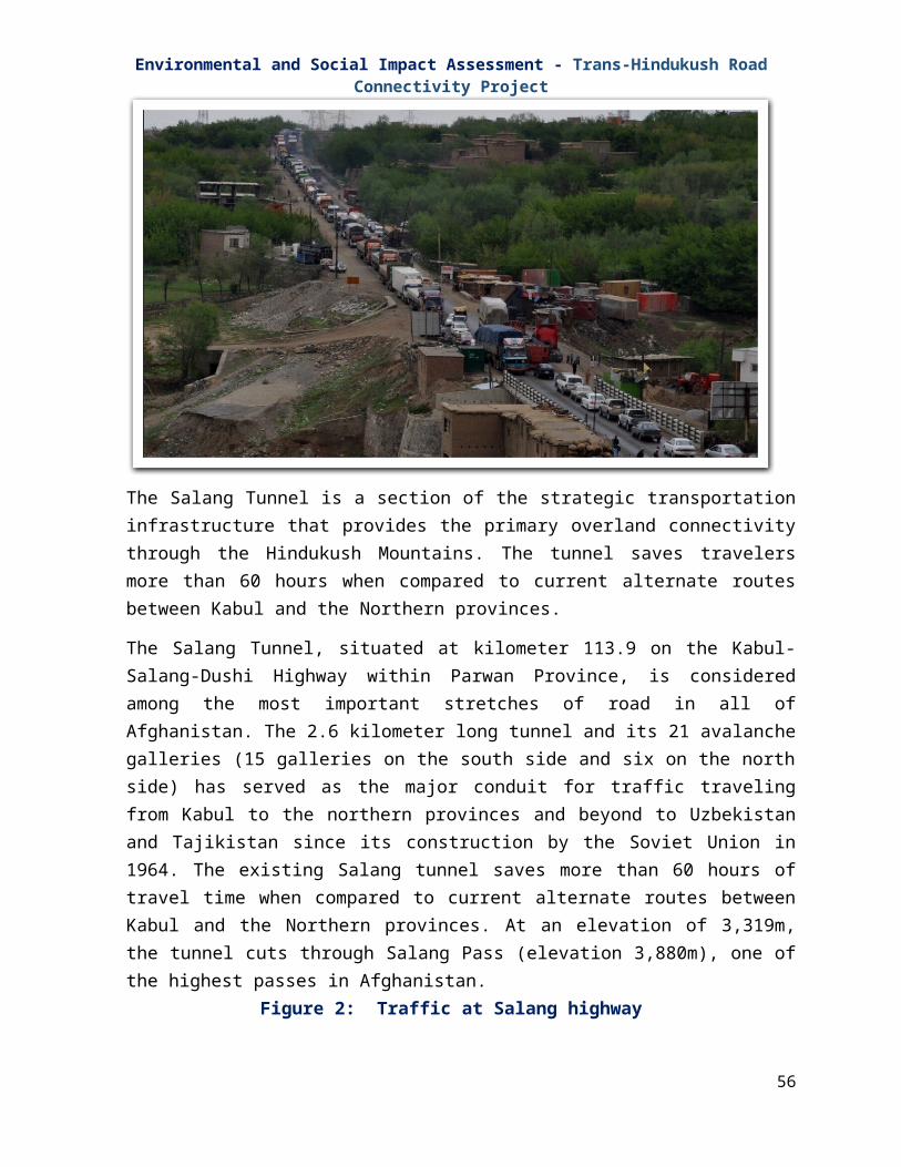
Environmental and Social Impact Assessment - Trans-Hindukush Road Connectivity Project
waste. Although still in draft format, the ESIA will seek to adhere to the requirements of the policy where practical, e.g. the requirement to reduce, reuse and recycle waste and to dispose of hazardous waste as per international standards.
3.1.6 Air Quality Standards
Afghanistan has drafted National Ambient Air Quality Standards. The primary objective of Air Quality Standards is to ensure that all citizens should have access to outdoor air without significant risk to their health, where this is economically and technically feasible. The secondary objectives of Air Quality Standards are:
To provide the basis for assessing the quality of air;
To act as the foundation for setting control programs;
To assess the new sources of air pollution; and
To create awareness and alert the public
3.1.7 Forest Law
The Forest Law was approved in 2012. The main purpose of the Law is to manage forest resources in a sustainable manner with a participatory approach involving forest restoration, protection, development, exploitation and improvement and to protect and increase forest productivity and maintaining a balance between growing and exploitation of forests. In addition the Law aims to:
Slow down winds and to prevent their undesirable impacts; Prevent soil erosion caused by floods and winds; Control risks of floods; Increase underground water levels; Manage surface water flows; Restore and protect public parks, for tourism development; Protect animal species and wild birds and their living environment; Conserve biodiversity, ecosystems and natural habitats; Control desertification; and Encourage the active participation of all member of society in management and
protection of forest resources3.1.8 Other Plans and Strategies
In addition to the above laws, Afghanistan is also preparing plans and strategies important to the Project including the Draft National Plan for Sustainable Rangeland Management in Afghanistan. The plan forms the basis for the establishment of a Rangeland Law which will update the Pasture Law from the 1970’s.
56

Environmental and Social Impact Assessment - Trans-Hindukush Road Connectivity Project
3.1.9 Multi-lateral Environmental Agreements (MEA)
According to the UNEP, Afghanistan is signatory to a number of multi-lateral environmental agreements. Table 2 provides a summary of these agreements. B&B will not be affected by any of these agreements, nor will B&B affect any of these agreements.
Table 5: Afghanistan MEAs# Title1 Convention on Biological Diversity2 Desertification Convention UNCCD3 United Nations Framework Convention on Climate Change4 Convention on International Trade in Endangered Species of Fauna and Flora5 Vienna Convention for the Protection of the Ozone Layer
3.2 World Bank Policy on Environmental and Social Assessment The World Bank requires ESIA of projects proposed for Bank financing to help ensure that they are environmentally sound and sustainable in order to improve decision making of the Bank on the project. The Environment Strategy outlines the Bank’s approach to address the environmental challenges and ensures that Bank projects and programs integrate principles of environmental sustainability. The Bank's guideline regarding the conduct of an ESIA has been adequately followed by the Environment and Social Management Team.
The ESIA provides guidance on the approach to be taken during planning and implementation of projects and ensures the effective application of the World Bank’s safeguard policies, IFC/World Bank Group's General EHS (Environment, Health and Safety) Guidelines.
Table 6: Applicability of World Bank Safeguard PoliciesS. No. World Bank Policy Applicability Remarks/Actions
1. Environmental Assessment OP 4.01
Based on conducted studies, the construction of the road have some environmental impacts on water bodies, existing slopes in case of mountainous and hilly areas and on trees along the road
Implementation of Site- Specific Environmental and Social Management Plan (SS-ESMP)
2. Natural Habitats OP 4.04
N/A None
3 Pest Management OP 4.09
N/A -
4 Physical Cultural A structure presumed to be from The structure is
57

Environmental and Social Impact Assessment - Trans-Hindukush Road Connectivity Project
S. No. World Bank Policy Applicability Remarks/ActionsResources 4.11 Buddhist times has been observed
at KM 134 and is the only observed cultural site within the vicinity of the road
approximately at 50 meters from the road. It is recommended that the site is fenced to prevent any interference during project works. In case of any further unexpected discovery, Chance find procedures will be followed (Appendix A)
5 Involuntary Resettlement OP 4.12
The project will require land acquisition, loss of productive assets etc. and thus negatively impact PAFs.
The ESIA includes Resettlement Policy Framework (RPF), which will guide preparations of RAPs. A RAP has been prepared for the first segment of the project.
6 Indigenous People OP 4.10
N/A People living in the area belong to different ethnic groups, none of which can be classified as ‘indigenous people’.
7 Forest OP 4.36 No virgin forest in the area -8 Safety and Dams
OP 4.37 N/A -
9 Project on International Water ways OP 7.50
N/A -
10 Project in Dispute Area OP 7.60
N/A -
World Bank Safeguard Policies which are triggered for this project:
Environmental Assessment (OP 4.01);
Involuntary Resettlement (OP 4.12); and
Physical Cultural Resources (OP 4.11)
3.2.1 Environmental Assessment (OP 4.01)
The OP 4.01 requires among others that screening for potential impacts is carried out early, in order to determine the level of EA to assess and mitigate potential adverse impacts. The Bank’s project screening criteria group projects into four categories:
58

Environmental and Social Impact Assessment - Trans-Hindukush Road Connectivity Project
1. Category A – A proposed project is classified as Category ‘A’ if it is likely to have significant adverse environmental impacts that are ‘sensitive’, diverse or unprecedented. For such project the borrower is responsible for preparing a report, normally an Environmental Impact Assessment (EIA).
2. Category B – A proposed project is classified as Category ‘B’ if it potential adverse environmental impacts are less adverse than those of Category ‘A’ project. The scope of Environmental Impact Assessment for Category ‘B’ may vary from project to project, but it is narrower than that of Category ‘A’ project.
3. Category C - A proposed project is classified as Category ‘C’ if it is likely to have minimal or no adverse environmental impacts. Beyond screening, no further Environmental Assessment Action is required for a Category ‘C’ project.
4. Category FI- A proposed project is classified as Category ‘FI’ if it involves investment of Bank’s funds through Financial Intermediaries (FIs), in subprojects that may result in adverse environmental impacts.
The OP 4.01 is applicable to the rehabilitation, maintenance and spot improvement of Bamyan-Baghlan and Salang Highway Rehabilitation project. This project has been classified as Category ‘A’ project. This ESIA has been conducted that appropriate as part of project design, including public consultation process.
3.2.2 Involuntary Resettlement (OP 4.12)
This policy deals with the issues and concerns related to land/assets acquisition, their compensation for all categories of affected persons and affected assets, relocation, resettlement, loss of livelihood, access and related issues. If involuntary resettlement is not properly mitigated, it creates severe economic, social and environmental problems in the project area. People face impoverishment when their productive sources are lost, and they are relocated to such environment where their productive skills are not properly utilized, the competition for resources is increased, the community institutions and local networks are weakened. Where it is not feasible to avoid resettlement, these activities should be conceived and executed as a sustainable development program. Displaced persons should be properly consulted and should have opportunities to participate in planning and implementing resettlement programs. The following are the main objectives of Bank’s OP 4.12:
Involuntary resettlement should be avoided up to the possible limit or minimized by exploring other viable alternatives;
Where it is not feasible to avoid, resettlement, resettlement activities should be conceived and executed as sustainable development program, providing sufficient investment resources to enable the persons displaced by the project to share in project benefits;
59

Environmental and Social Impact Assessment - Trans-Hindukush Road Connectivity Project
Displaced persons should be assisted in their efforts to improve their livelihoods and standards of living or at least restore to the extent of pre-displacement levels.
Displaced persons may be classified into:
i. Those with formal legal rights to land, including customary and traditional rights recognized under the law of the country;
ii. Those who do not have formal legal rights to land at the time the census begins but have a claim to such land or assets—provided that such claims are recognized under the law or become recognized through a process identified in the resettlement plan; and
iii. Those who have no recognizable legal right or claim to the land they are occupying.
The Bamyan to Baghlan road upgrading involves displacement of affected persons close to the Right of Way (ROW) and OP 4.12 is therefore triggered to deal with the relocation and resettlement of the persons displaced due to construction of the road. The prescribed responses to adverse impacts are presented in the Resettlement Policy Framework (RPF), in Annex I, based on the Afghan legal framework and compliant with World Bank Operational Policy 4.12. A Resettlement Action Plan (RAP) has been prepared for this first segment of the road.
3.2.3 Physical Cultural Resources (OP 4.11)
This policy is premised on the need to investigate and take inventory of Physical Cultural Resources (PCR) likely to be affected. Mitigations are provided for in cases of adverse impacts on Physical Cultural Resources. Mitigation measures should be undertaken in conjunction with the appropriate authorities, organizations and institution that are also required to be consulted and involved in the management of cultural property.
The Bank does not support development actions likely to significantly damage non-replicable cultural property, and does assist only those projects sited or designed to prevent such damage. The ESIA identifies that there are no known physical cultural resources within the PAI, but appendix A provides the chance find procedures (based on existing national law) to be used during implementation, if necessary.
3.2.4 Bank’s Policy on Access to Information
The Bank’s policy on disclosure requires that all the people residing in the given areas of a project have the right to be informed of consulted regarding the proposed project in the respective areas. In this regard therefore, the summary of the study of the projects actions and other relevant information will be disclosed to public prior to the commencement of the project. The disclosure shall be carried out in-country through the Ministry of Public Works
60

Environmental and Social Impact Assessment - Trans-Hindukush Road Connectivity Project
and National Environmental Protection Agency along the project corridors. It shall also be made available at the World Bank Info-shop.
All Project construction activities will follow the World Bank IFCs General Health and Safety Guidelines1 for Occupational Health and Safety (OHS) and Community Health and Safety. These documents provide guidelines for issues such as water quality and availability, disease prevention, physical hazards, chemical hazards and the use of personal protective equipment (PPE).
3.3 Mine Risk Management
This project will not be implemented without appropriate mine-risk management. Current practice (evolved during field implementation) for managing mine risk have been robust. The Afghanistan Mine Action Standards as provided by the Mine Action Coordination Center of Afghanistan (MACCA) will be part of the project safeguard framework. All risk assessment and clearance tasks shall be implemented in coordination with the MACCA. These procedures may need to be amended in the future, depending on evolving circumstances. MACCA procedures at appended at Appendix H.
1 http://www.ifc.org/wps/wcm/connect/554e8d80488658e4b76af76a6515bb18/Final%2B-%2BGeneral%2BEHS%2BGuidelines.pdf?MOD=AJPERES
61

Environmental and Social Impact Assessment - Trans-Hindukush Road Connectivity Project
4 DESCRIPTION OF BASELINE CONDITIONS
The Trans-Hindukush road connectivity project is divided in two parts, the Bamyan to Baghlan road and the Salang highway. The Bamyan to Baghlan road was assessed on environmental and social baseline conditions during 2009-10 by USAID. The baseline estimates establish the initial values of social indicators as of July 2009 that will show how the improvement of the road influences social and economic development in the area. This chapter provides information on the physical, biological and socio-economic elements of the Bamyan to Baghlan road component of the Trans-Hindukush road connectivity project, which shall also be used as benchmarks for future monitoring. The area considered for assessment of baseline conditions span the whole corridor of Bamyan-Baghlan road project which will be large enough in extent to include all potential impacts from the proposed activities. Data were obtained as a result of field surveys and review of socio-economic baseline study and environment impact assessment commissioned by USAID in the year 2009-2010.
4.1 Physical Resources 4.1.1 Topography
Afghanistan’s topography in general is dominated by the Hindukush Mountains which run northeast to southwest through the central portion of the country dividing the Northern provinces from the remainder of the country. The southwest is occupied by desert plateau. The lowest point in the country is at Amu Darya (Afghanistan’s northern west border) at 258 meters above mean sea level (msl). The highest point is at Nowshakh (northeast border with Pakistan) 7,485 meters above msl. The southern and western parts of the country are covered by deserts at elevations ranging from 500 to 1,000 meters above msl.
The Project Area itself is located in the Hindukush mountain range a 500-mile mountain range stretching between north-western Pakistan and eastern and central Afghanistan. The topography of the project road is variable, but in general it has four distinct sections. From Dushi to Tala, the first 80 Kms of the road traverses agricultural land in the valley, occasionally the road rises out of the valley floor 30-40 meters as it rounds bends in the River. From Tala the topography becomes more varied, the valley becomes narrower and the side slopes steeper. This continues to around Ghandak area where the road then enters a very narrow gorge area with steep, almost vertical side slopes for approximately 10 kilometers. Upon leaving this section at around Km150 the road re-enters more open valley slopes and agricultural land similar to the setting around the Tala section of the road. The elevation of the road changes considerably over its extent, starting at around 820 meters above sea level in Dushi and finishing at around 2200 meters above msl. This equates to an average of a drop of 1 meter every 100 meters travelled from Bamyan to Dushi.
62

Environmental and Social Impact Assessment - Trans-Hindukush Road Connectivity Project
Figure 16: KMs. 16 (930 meters above msl),The road is elevated from the valley floor as the river flows to the north side of valley. The valley floor is heavily cultivated and has width of around 500 meters. Rice is a key crop in this portion of the road.
Figure 17: KMs. 132 (2,177 meters above msl),The valleys begin to narrow after Tala although they do open out to provide for areas cultivation as illustrated above. Wheat and potatoes are grown in these elevated areas.
Figure 18: Km. 139 (2,200 meters above msl),The side slopes are very steep within this narrow valley. The width the river ranges from five to six meters.
Figure 19: Km. 144 (2,240 meters above msl) The side slopes here are vertical and in some cases form giant overhangs. This bridge will be replaced by a new structure.
4.1.2 Soils
Within the country as a whole, the soils are categorized as high mountains Serozems, deserts steppe or meadow steppe. Loess is found in north. The river valley soils are generally alluvial or meadow alluvial.
Serozems and brown desert soils cover large portions of the country in the north and southwest. Overgrazing, deforestation, desertification, degradation of watersheds and erosion have been identified as significant environmental issues contributing to soil degradation and reduced soil productivity throughout Afghanistan. Land degradation has also been caused by land mines, which reduce access to agricultural land and irrigation. Within the project area
63

Environmental and Social Impact Assessment - Trans-Hindukush Road Connectivity Project
itself productive soils are limited to the valley floors. These areas are farmed intensively from Dushi to around Km 70 after which the fertile areas become smaller and the climate becomes less favorable to multiple cropping patterns. The predominant crops vary along the alignment, with rice being grown in the wide valleys closer to Dushi and potato dominating the agricultural land around Bamyan. Wheat was also grown and fruit orchards (apple, apricot and peach) were observed in the first 50 kilometers or so of the road. Silts and other materials washing down from the barren side slopes had begun to impact upon the fertile soils in the valleys.
Farmers have attempted to construct walls and mud barriers to protect their land, but heavy rainfall and run-off from the slopes is still impacting negatively on the productive soils in the valleys.
Figure 20: 41 Km.Mud wall protecting fertile land from encroaching sandy materials washed down from side slopes
Figure 21: 40 Km.Sandy materials washed down from the side slopes encroaching on farmland
4.1.3 Seismic & Geological Characteristics
Afghanistan has some of the most complex and varied geology in the world. The oldest rocks are Archean and they are succeeded by rocks from the ProteroPAIc and every PhaneroPAIc system up to the present day. The country also has a long and complicated tectonic history, partly related to its position at the western end of the Himalaya. This diverse geological foundation has resulted in a significant mineral heritage with over 1400 mineral occurrences recorded to date. Historical mining concentrated mostly on precious stone production, with some of the oldest known mines in the world believed to have been established in Afghanistan to produce lapis lazuli for the Egyptian Pharaohs. More recent exploration in the 1960s and 1970s resulted in the discovery of significant resources of metallic minerals, including copper, iron and gold, and non-metallic minerals, including halite, talc and mica.
64

Environmental and Social Impact Assessment - Trans-Hindukush Road Connectivity Project
Different types of geological formations are encountered along the road alignment, these formations are presented below.
Table 7: Different types of geological formationsType Description Location (Km)
Slope Debris
This material exists at the natural slopes of the hills. Main grain size is gravel and cobble with occasional boulder size material. General angle of the slope is 50-70 degrees due to weak cementation state. Thickness of the stratum reaches 15.0 meters.
79.850 – 79.950
85.940 – 86.000
92.400 – 92.440
92.520 – 92.560
94.920 – 94.950
95.800 – 95.840
102.300 – 102.450
102.940 – 103.480
107.990 – 108.020
110.870 – 110.910
113.720 – 113.805
114.500 – 114.700
123.200 – 123.280
124.520 – 124.600
131.200 – 131.580
Alluvium Alluvium is observed in rivers, creeks and valleys. It is represented by granular material. Grain size varies from sand to boulder depending on the energy of the transporting agent. Locally this layer of clay can be found at the plain areas.
17.300 – 17.800
23.150 – 23.500
24.290 –
65

Environmental and Social Impact Assessment - Trans-Hindukush Road Connectivity Project
Type Description Location (Km)24.500
28.200 – 28.700
29.450 – 29.590
37.050 – 38-050
42.600 – 45.660
47.190 – 47.500
47.950 – 49.120
49.650 – 50.650
58.420 – 58.785
72.565 – 72.815
72.960 – 73.330
74.940 – 77.140
83.500 – 83.500
87.970 – 88.160
90.720 – 100.075
103.760 – 104.015
105.000 – 105.120
107.310 – 107.490
107.710 – 107.760
119.965 – 120.440
66

Environmental and Social Impact Assessment - Trans-Hindukush Road Connectivity Project
Type Description Location (Km)121.635 – 121.805
126.900 – 127.760
127.910 – 128.160
129.870 – 130.500
132.940 – 133.500
TerraceMaterial
Terrace material covers extensive areas of the road alignment. Urban settlements are formed on terrace areas. Terrace material grain size varies from sand to boulder. Slopes are measures around 75-90 degrees. Materials of terrace formation accompany slope debris at the slope of the hills.
Colluvial Fans
Colluvial fans are formed by the floods in the valleys. Grain size depends on the energy of the floods and therefore varies from silty – sand material to large boulders. Spread and thickness of these materials depends on the slope of the valley and the topography.
Loess
Loess is formed by fluvio – eolian transportation agents. It is mainly composed of fine grained material like silt, fine sand and occasional gravel size material. They are light brown in color and cemented by surface water with rapid evaporation. Loess is encountered over terrace material.
14.240 – 14.290
16.640 – 16.910
64.820 – 65.750
134.690 – 134.900
Tuffs
Tuffs are well cemented with cavities frequently observed. At the top of the hills the angle of the material is almost vertical. Tuffs are found above loess material.
14.300 – 14.900
15.080 – 16.640
ConglomerateThey are formed by cementation of course gravels. Cementation degree is high.
IntrusiveRocks
These rocks are represented by granite, quartz diorite, diorite porphyry, diorite and gabbro.
Granite Granite is encountered at different chainages along
67
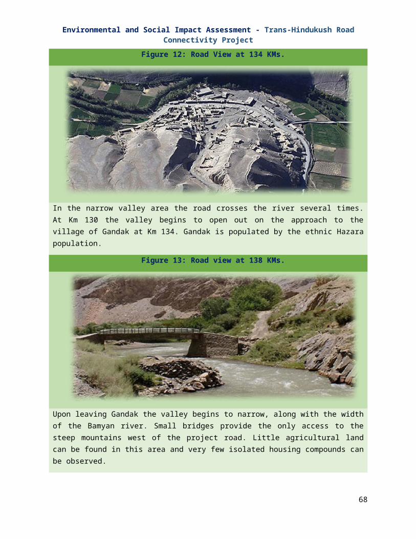
Environmental and Social Impact Assessment - Trans-Hindukush Road Connectivity Project
Type Description Location (Km)the road alignment. They are pink, pale pink and grey in color. Their strength is strong and grain size is medium – course. They are mainly pale colored due to the high content of quartz. They are rippable by blasting and special care should be given to safe cut slope for the risk of rock falling during excavation.
Quartz,Dioriteporphyry,Diorite
To distinguish between these rocks is very difficult by macro description on a road alignment. They are closely jointed with joints filled with clay and sand sized material. Rippability of these rocks is possible by blasting.
VolcanicRocks
Volcanic rocks are represented by rhyolite and basalt. They are strong and green, dark grey in color. Joints are widely spaced. Safe cut slope for this rock type is recommended as (v/h) ¼.
Seismic activity in the project area can be significant. Bamyan is located on the Herat fault, a 1200-km-long, east-west suture through central Afghanistan, that trend northward into the Hindukush Mountains north of Kabul at its eastern end. The Bamyan region is located in the transition zone between the intense seismic activity that characterizes the Indo-Asian plate boundary in eastern Afghanistan, and the largely inactive central part of Afghanistan.
4.1.4 Hydrology
The sources of most of Afghanistan’s rivers are in the mountains. Water levels in the rivers vary greatly with the highest levels in spring and early summer. In the remaining seasons the rivers may change into small streams or entirely disappear. Five river basins can be differentiated in Afghanistan:
The Kabul Basin (Indus): The Kabul Basin includes the Kabul and Logar Rivers and their tributaries which drain the eastern part of the country. The rivers within the eastern basin flow generally to the east and eventually join the Indus River and the Arabian Sea.
The Hilmand Basin: The rivers of the Hilmand Basin flow generally to the southwest to the Lake of Sistan on the Afghanistan-Iran border and include the Helmand, the country’s longest river, the Farah and the Khash. The Arghandab River forms part of the Hilmand Basin.
The Northern Basin: The Rivers in the northern part of the country flow northward to the Amu Darya River on the country’s northern boundary (and eventually to the Aral Sea) or disappear in the desert sands.
68

Environmental and Social Impact Assessment - Trans-Hindukush Road Connectivity Project
The Amu Darya Basin: The Amu Darya basin has its headwater in the High Pamir Mountains of Afghanistan and Tajikistan. The Basin covers 14% of the national territory but drains more than 57% of the total annual water flow of Afghanistan. Therefore the basin has great hydropower potential that is largely unused. The Project Road lies within this Basin.
The Harrirod – Murghab: The Harrirod – Murghab river basin contributes a tiny 4 percent of the total flow of Afghanistan. The main rivers are the Hari, which takes its source from the western slope of the Koh-i-Baba Mountains in the central highlands and the Murghab, which comes from the Tir Band-I Mountains.
Table 8: Key features of river basins in Afghanistan
River Basin Kabul Hilmand NorthernAmu
DaryaHarirod- Murghab
Area (KM2) 76, 908 262, 341 70,901 90, 692 77,604Settled Population 7,184,974 5,887,571 2,783,033 2,968,122 1,722,275Population Density 93 22 39 33 22Water Bodies 25 2,271 33 62 13Marshlands 264 2,284 205 678 127Irrigated Land 3,060 4,758 2,378 3,540 1,725Rain Fed Land 1,554 2,344 18,747 13,156 9,371Range Land 37,152 113,258 32,148 56,643 52,481Forest Cover 12,141 114 64 648 99
As stated above, the Project Road is located within the Amu Darya basin. The Amu Darya basin covers 14 percent of the national territory, but alone it drains more than half (57 percent) of the total annual water flow of Afghanistan. Therefore, the basin has great hydropower potential that is largely unused.
The basin is divided into five main sub-basins namely Panj, Kokcha, Ab-I Rustaq, Khanabad and Kunduz. The project road is located within the Kunduz sub-basin of the Amu Darya River Basin.
Table 9: Land Cover in Kunduz Sub-basinS. No. Land Cover Area (KM2) % of Area
1 Natural Forest 200 1.52 Irrigated(one crop per year) 1033 3.693 Irrigated (two crops per year) 257 0.924 Permanent snow 258 0.925 Rain-fed crops 3014 10.86 Rangeland 21086 75.257 Rock outcrop / bare soil 646 2.318 Sand covered areas 933 3.33
69

Environmental and Social Impact Assessment - Trans-Hindukush Road Connectivity Project
9 Water bodies 0.5 0.00
Surface Water- The Bamyan Rod flows north from Bamyan to Doab at Km 100 in Tala wa Barfak district where it meets Kahmard Rod and Saighan Rod. At this point the rivers join and change name to the Surkhab River. Most of the tributaries of these rivers are dry during the autumns and winter months except during rainy season and the summer months when the snow melts. Flow fluctuations are high with flash floods during spring and summer.
The Surkhab River is a perennial steep sloped mountain river with narrow waterway having gravel and boulder bed material. At most of the locations the road alignment runs along the riverbank within the active flood zone. Along the river in its course of traversing no substantial flood plains were observed and all the flood flow seems to be contained in the channel or river width. The river is characterized with flow having abundant rapids, high velocity and transporting large volume of sediments.
The riverbed is mainly composed of course gravel with cobbles and boulders as outlined by geotechnical investigation with rock outcrops at some locations. The riverbanks were noted to be fairly stable and severe bank erosion were not noted. Thus, the river channel seems stable.
At Dushi the Surkhrab meets with the Andarab River and it became the Pul-i Khumri River. Most of the villages in the project area extract the groundwater for drinking purposes. Groundwater is unknown, although in this area of Afghanistan there is generally little storage of water due to high levels of snowmelt water from the mountains infiltrating the below ground aquifers. Seasonal flooding can be problematic in the region with flash floods forming from Surrounding Mountains. These flash floods in the spring and early summer can have detrimental effects on the project road by washing out low lying sections close to the rivers.
Little water quantity or quality data is available for the project area as whole; however, some recent studies have been undertaken in the Bamyan region as part of the Bamyan Master Plan (2007). The following summarizes the findings of these studies.
Water Quality- The overall water quality in the Bamyan valley is good. Almost all investigated river water, canal water, and groundwater gauging points fulfill international guidelines and standards for drinking and river water. Only the hardness of some ground-water samples reflects the calcium-carbonate rich underlying geology. At some gauging points ammonium contents are high, which most likely must be attributed to the non-existing waste water treatment and rather high numbers of livestock at certain areas of catchment. However, organic testing of two water samples reveals no instant threat to human health. Although this testing did not show the presence of fecal bacteria, the utilization of river water at Bamyan center for household purposes has to be considered as hygienically unsafe and needs to be avoided. Gasoline derived cabonatic compounds and softening plasticizers have been detected. Despite the positive judgment on the overall water quality a lot of activities must considerably improve the situation. (Remove pit latrine, filling stations, and car washes
70

Environmental and Social Impact Assessment - Trans-Hindukush Road Connectivity Project
from direct river environment, appropriate use of fertilizers, waste water treatment, no increasing of livestock number).
Water Quantity- As the main river (the Bamyan Rod) in the region is perennial; currently there is no continuing threat of water scarcity for most parts of Bamyan valley. But drought years are a common phenomenon in the Hindukush Mountains, which affect the people of Bamyan and their agriculture economy (especially potatoes), and food, fodder and fuel production. With retreating glaciers in the Koh-e Baba Mountains and increasing population in the Bamyan valley, the future comprises unknown variables in terms of sufficient water supply.
The existing highway is provided with 11 mostly single span bridges. The Bridge no 1 is located near to the starting point of the highway for crossing over a small tributary and all other bridges are for crossing Surkhab River. It was noted that the bridge crossing were mainly governed by the topography and location of settlements.
Table 10: Existing bridge locations on the Bamyan-Baghlan highwayBridge
NumberBridge Type Station
Mtrs.LengthMtrs.
WidthMtrs.
HeightMtrs.
B-11 Arched Bridge 154+540 15.00 4.50 3.80B-10 Trussed Bridge 148+640 26.37 3.00 2.80B-9 Steel Girder 146+640 36.20 3.00 2.90B-8 Steel Girder 134+640 36.30 4.10 3.75B-7 Steel Girder 119+640 34.20 7.50 2.80B-6 Steel Girder 111+640 26.80 7.35 2.70B-5 Trussed Bridge 105+640 34.20 7.50 2.80B-4 Trussed Bridge 80 +640 34.30 7.50 2.80B-3 Trussed Bridge 79 +720 30.15 3.90 2.70B-2 Concrete Slab
Bridge10+629 40.00 3.50 3.50
B-1 Concrete Slab Bridge
0+080.95 8.00 3.50 2.00
4.1.5 Air Quality and Climate
Climate, particularly precipitation and wind patterns, is a major determinant of air quality. Afghanistan’s climate is continental, arid to semi-arid, with considerable variations from place to place according to altitude. Its lowland areas have cold winters and hot summers. The mountains are extremely cold in winter and cool in summer. Winter lasts from October to May. Most of the country’s fresh water supply is reported to fall as snow in the mountains. The climate in the project area is variable from the lower altitude of Dushi to the elevated Bamyan. The average monthly temperature and precipitation levels for Bamyan are provided below. As can be seen, the summer is relatively mild and the winters cold with sub-zero temperatures for 3- 4 months of the year. No climatic data is available for Dushi, but the
71

Environmental and Social Impact Assessment - Trans-Hindukush Road Connectivity Project
following data was found for Baghlan, approximately 30 km north from Dushi (elevation 550 meters above msl).
Table 11: average monthly temperature and precipitation levels for Bamyan
Winter time Minimum mean temperature -2.730 C (Jan)Absolute minimum temperature -230 C (Jan 27, 1969)
Summer time Maximum Mean temperature 38.20 C (Aug)Mean air temperature 27.3670 C (Jul)Absolute maximum temperature 42.50 C (Jul. 6, 1960)
Precipitation Maximum mean monthly precipitation 66.72 mmMaximum 1-day precipitation 30.7 mm (Mar. 21, 1966)
Climatic and soil conditions of the Project Area are such, that it is likely to be subject to dust storms in the summer months, leading to higher levels of Suspended Particulate Matter (SPM). In addition, due to the unpaved status of the project road, elevated levels of SPM are present along the entire route during the summer months created by vehicle movements, especially heavy goods vehicles. This creates significant health hazards, as was reported at Gandak Health Clinic and also causes significant nuisance in the roadside villages.
4.2 Natural/Biological Resources
4.2.1 Flora
Afghanistan’s vegetation is typical of the semi-deserts and steppes. Ephemeris vegetation grows in the sandy semi-deserts and halophiles vegetation is found in the salt semi-deserts. The most common trees on the more humid soils are oaks, ashes, willows, poplars and fruit trees in orchards. Himalayan forest, including evergreen oak woods grow in the borderland between Afghanistan and Pakistan. Unfortunately, areas supporting natural flora habitat are diminishing. The Asian Development Bank (ADB) reports that one of the most critical environmental problems of Afghanistan is massive deforestation and overgrazing. It is estimated that forest cover declined from 3.4 to 2.6 percent of total land area between 1970 and 1990. Since then, continued timber harvesting and the use of forest resources for fuel have reduced forest cover to less than two percent of the total area.
Analysis of the available data for this region has revealed no documentation of potential habitat for threatened or endangered plant species within the immediate vicinity of the Project Road. It is possible that some special status flora may exist within the mountains, but they are unlikely to be impacted by Project Works. Some mature trees can be found within the Right of Way, and these may need to be removed.
72

Environmental and Social Impact Assessment - Trans-Hindukush Road Connectivity Project
4.2.2 Fauna
Afghanistan's National Environmental Protection Agency (NEPA) has officially released Afghanistan's first list of protected species. The species on this list are now protected against illegal hunting or harvest. NEPA, with help from the Wildlife Conservation Society, Kabul University and the Ministry of Agriculture, Irrigation and Livestock, created the Afghanistan Wildlife Executive Committee (AWEC) to facilitate the listing process. 138 species are currently on the list, which includes 74 mammals, 54 birds, 7 plants, one amphibian, one reptile and an insect. The list includes well known species such as the snow leopard (Panthera uncia), the wolf and the brown bear, as well as lesser-known species such as the Paghman salamander (Paradactylodon mustersi), goitered gazelle (Gazella subgutturosa), Saker falcon (Falco cherrug), markhor (Capra falconeri), and the Himalayan elm tree (Ulmus wallichiana).
The releasing of the much needed list comes at a very critical time as Hamid Karzai's Presidential Decree banning hunting in the country expired in March 2009. NEPA's job includes managing these protected species by writing up recovery plans for the threatened species. They will re-evaluate the species every five years to see if the populations have recovered to the point where they can be removed from the protected species list.
In addition the IUCN database was searched for Threatened or Endangered (T&E) species in Afghanistan.
Table 12: Birds AfghanistanSpecies
Total number of birds 388Global threatened birds 14Country endemics 1
Table 13: Threatened or Endangered (T&E) species in AfghanistanSpcRecID Species Common Name Category
359 Oxyura leucocephala White-headed Duck EN467 Marmaronetta angustirostris Marbled Teal VU2451 Columba eversmanni Yellow-eyed Pigeon VU3374 Gyps bengalensis White-rumped Vulture CR3531 Clanga clanga Greater Spotted Eagle VU
73

Environmental and Social Impact Assessment - Trans-Hindukush Road Connectivity Project
SpcRecID Species Common Name Category3535 Aquila heliacal Eastern Imperial
EagleVU
3811 Pelecanus crispus Dalmatian Pelican VU3172 Vanellus gregarious Sociable Lapwing CR2760 Otis tarda Great Bustard VU3619 Falco cherrug Saker Falcon EN3371 Neophron percnopterus Egyptian Vulture EN3363 Haliaeetus leucoryphus Pallas's Fish-eagle VU2786 Leucogeranus leucogeranus Siberian Crane CR
32131 Chlamydotis macqueenii Asian Houbara VU
Source:
http://www.birdlife.org/datazone/country/afghanistan/species
Birdlife International (BLI) identifies habitats of special interest for avian communities. The BLI database was searched for significant habitats. These areas are listed in below:
Table 14: List of Significant Habitats of AfghanistanArea Habitat Type Within the B&B
PAI?Ab-i-Istada Lake No
74

Environmental and Social Impact Assessment - Trans-Hindukush Road Connectivity Project
Area Habitat Type Within the B&B PAI?
Bande Amir Lakes NoDarqad River floodplain NoDashte Nawar Desert plateau NoHamun-i-Puzak Lake NoHari Rud Valley NoImam Sahib River floodplain NoJalalabad Valley NoKhost Foothills NoKole Hashmat Khan Wetland NoNorth-western steppe Plains NoPamir-i-Buzurg Mountains NoPech and Waygal Valleys NoRegistan desert Desert NoSafed Koh Mountains NoSalang Kotal Mountains NoSmall Pamir Mountains, valleys and rivers NoNote: There are not significant habitats reported within the PAI of B&B program
Source:http://www.birdlife.org
The proposed project area has a very limited value as a habitat for T&E species because of the lack of vegetative cover or other suitable habitat. The area around the proposed project area is currently developed as a road, and is frequently disturbed by human activity.
Formally, several protected natural areas were established in the country since the 1960s. They have not been managed properly for decades and are mostly being degraded. These natural protected areas are located far from the proposed road and will not be affected by the proposed project.
Within the Project Area little in the way of wildlife can be observed. Consultation with local residents revealed that the most prominent animal species in the Project Area were fox and rabbit. It is possible that higher up in the more remote parts of the mountains other species are present, however, the fauna of this region has not been documented within the last 25 years and as such the exact nature of the species in this region is unknown.
No threatened or endangered species are known to exist in vicinity B&B Roads project, and there are no protected areas within the PAI.
This country/territory profile has been compiled based on the wealth of scientific data on the world's bird species and the sites critical to their conservation available in Bird Life's Data zone.
75

Environmental and Social Impact Assessment - Trans-Hindukush Road Connectivity Project
4.2.3 Protected Areas
Six protected areas have been identified in the country. None of these are located within the proposed project area. They are described below
Table 15: Official natural protected area of AfghanistanName Area ha Year Elevation, Mtrs. Designation
Ab-i-estada 27,000 1977 1,950-2,100 Waterfowl sanctuaryDashte Nawar 7,500 1977 3,200-3,210 Waterfowl sanctuaryPamir-i-Buzurg(Wakhan) 67,938 2014 3,250-6,103 Wildlife reserveKole Hashmat Khan 191 1973 1,792-1,794 Wildlife reserveAjar-valley 40,000 1978 2,000-3,800 Wildlife reserveBande-amir 41,000 2009 2,900-2,832 Waterfowl sanctuary
Ab-I-Estada Waterfowl Sanctuary- Ab-I Istada is a large saline lake located at about 2,000 m elevation in the south corner of Ghazni province (Nawa district). Ab-I Istada drains the water from the Ghazni, Sardeh and Nahara Rod and it overflows into the Arghistan River – itself a tributary of the Arghandab River – in years with good rainfall. The site is remarkable for the migratory greater flamingos arriving at high-water level in spring (late March or April), breeding in summer on the islands and departing when water level is low in September or early October. More than 100 other bird species are also present. The site was once a critical stopover point for the central population of Siberian cranes, which bred in the Russian tundra and wintered in north-central India. The last reliable report of a Siberian crane at Ab-I Istada was of one shot dead by a hunter in 1986. Local residents reported that no flamingos had bred successfully since 1999.
Figure 22: Proposed protected areas of Afghanistan
Dashte-Nawar Waterfowl Sanctuary- The Dasht-e-Nawar Waterfowl Sanctuary is located in Ghazni Province in eastern Afghanistan. Dasht-I Nawur is an extensive high-altitude plain
76

Environmental and Social Impact Assessment - Trans-Hindukush Road Connectivity Project
in southeast Afghanistan. Some 600 km2 in area, the plain lies at about 3,350 m elevation, with surrounding peaks, holding ibex and urial, rising to 4,800 m. A narrow brackish lake, more than 10 km long, occurs in the plain. Dasht-I Nawur serves as an important breeding and staging ground for a large number of migratory waterfowl. There are records of breeding populations of avocets (Recurvirosta avocetta), redshanks (Tringaetanus), greater sandplovers (Charadriusle schenaultia), and common terns (Sterna hirundo). The area is also a unique, high-elevation breeding ground for greater flamingo. In contrast with Ab-I Istada, the local population in Dasht-I Nawur does not hunt flamingos. Rather, they revere them, as they associate the pink colour of the plumage with the blood of the martyred Imam Hussain. The villagers of Qarya said that they had seen one flamingo in 2002 and eight in 2001, but that no flamingos had successfully bred since then. Pamir Buzurg (Proposed) Wildlife Sanctuary- The proposed Pamir Buzurg Wildlife Sanctuary is located in the extreme north eastern part of the country. The Wakhan corridor was recently announced as a second national park in Afghanistan.
Kole Hashmat Khan (Proposed) Waterfowl Sanctuary- Kole Hashmat Khan (also known as Lake Chaman) is a small, shallow, slightly saline, eutrophic and reed-covered wetland situated below Bala Hissar fort at the edge of Kabul city, within the Kabul Basin. The lake is the only remaining water body and marsh area of the formerly extensive wetlands on the plain of Kabul. It is fed by a tributary of the Logar River, and has no outlet except when the water level is exceptionally high.
The lake is L-shaped, about 2.5 km in length and 0.3-1.0 km in width, and has a maximum depth of 1.5 m. Large areas of former wetland have been converted into agricultural land. The small wetland valley was a worship centre for centuries for followers of Buddhism, Hinduism and Islam. The wetland was long used as a royal hunting area and was declared a waterfowl reserve in the 1930s by King Zahir Shah. The site is important for migrating and wintering water birds. Many settlements are encroaching into the wetland area, and the reeds are cut for sale as roof thatch, destroying the nesting habitat for birds. The site has an important recreational and educational potential for the city of Kabul.
Ajar Valley Wildlife Reserve- Established in 1978, the Ajar Valley Wildlife Reserve (40,000 hectares) is a former royal hunting ground located in Bamyan Province in the central part of the country. The Reserve is located 45 kilometers west of the middle portion of the project road.
Bande Amir National Park- The Band-i Amir Lakes in the upper part (approximately 2,900 m elevation) of the Northern river basin comprise one of the world’s uniquely beautiful natural landscapes. Band-i Amir consists of a chain of six ‘lapis lazuli’ lakes nestled between 300 m-high magenta rock walls. From west to east, these are: Band-i-Gholaman (‘Dam of the Slave’), Band-I Qambar (‘The Groom’s Dam’), Band-I-Haibat (‘Dam of Awe’, Band-I-Panir
77

Environmental and Social Impact Assessment - Trans-Hindukush Road Connectivity Project
(‘Dam of Cheese’), Band-i-Pudina (‘The Mint Dam’) and Band-i-Zulfiqar (‘Dam of the Sword of Ali’). The two largest lakes, Haibat and Zulfiqar, cover 490 ha and 90 ha, respectively. Panir Lake, only 100 m in diameter, is the smallest. The white travertine dams (about 10 m high and 3 m thick) that separate the lakes are formed when gaseous carbon dioxide from calcium-rich spring water is driven out by bacterial or algal activity, forming the mineral deposits that create the dams. The waters of the lakes are oligotrophic and calcareous, with a pH of 7.8. Their stunning deep blue color is a result of the water’s purity and high lime content. Surface water temperature reaches 14-17 °C during sum- mer. In winter, the lakes freeze over. The site became Afghanistan’s first national park in 1973. UNEP reports that Band- i Amir National Park is in good hydrological condition and has remained generally unchanged since studies conducted in 1977 by FAO and UNDP. The Park is located approximately 50 kilometers west of Bamyan town.
4.3 Other Environmental Consequences:4.3.1 Range Land
The project road traverses areas of rangeland used by grazing animals. Project works are unlikely to impact upon the significant areas of rangeland in the region.
4.3.2 Agricultural Land
Agricultural activities are extensive in the valleys which the project traverses. Most of the agricultural land is rain fed and only small portions of agricultural land are irrigation fed. Road rehabilitation works will impact upon these bands of fertile land and may result in a loss of productive lands.
The project is anticipated to have an impact upon properties and agricultural land that currently occupies the right of way. It is considered likely that rehabilitation works will impact an area of land between 3-5 meters wide on each side of the existing pavement. An assessment of aerial photographs of the alignment reveal that around 20% of the road passes either adjacent to, or between agricultural land. That would equate to an area anywhere between 10 and 30 hectares of land (50-160 Jeribs) along the entire road project (B2B road). A jerib of land in this area can fetch between 8,000 – 10,000 USD. The amount of productive land under segment 1, for which the ESIA is applicable is much smaller. Please refer to the cleared RAP for segment-1, which includes compensation payment including livelihood restoration for those PAPs with significant land impacts.
78

Environmental and Social Impact Assessment - Trans-Hindukush Road Connectivity Project
4.3.3 Urban
Two significant urban areas exist at either end of the Project Road, Bamyan and Dushi. Other villages such as Doab, Tala, Gandak, Jangal, etc, can be observed along the Project Road. Some of the village areas have shops and residential properties very close to the project road; as such some of these buildings may have to be demolished to make way for the road.
Regarding property in the Right of Way, data has been collected for Segment 1 and there are 97 PAFs whose properties will be directly impacted by project works.
4.3.4 Energy Considerations
The World Bank reports that the vast majority of the Afghan population relies on traditional household fuels (wood, bushes, crop residues and animal waste) for its energy needs. There are reports of over-exploitation of forestry resources and non-sustainable production and use of fuel wood leading to deforestation and severe environmental degradation in many areas.
The energy situation in the project area is reported as follows:
Electrical Supply & Demand: Within the project area numerous villages are connected to rural electrification grids supported by micro hydropower sourced from the Surkhab and Bamyan rivers.
Energy Resources: Most energy is sourced from either the above mentioned micro-hydro facilities or from small scale diesel powered generators. In addition, several coal mines can be found in the mountains close to the project road, in particular three are located within 1.5 kilometers of the road as follows:
Km 87.5 within one kilometer of the road
Km 92.1 within one kilometer of the road
Km 98.2 within one and a half kilometers of the road.
Petroleum Products: No petroleum producing facilities are known to exist in the Project Area.
4.3.5 Use of Natural/Depletable Resources
Construction of the Project Road will require the use of certain natural resources. The country is well supplied with rock, sand and other quarried construction materials as required for the proposed construction works. Construction materials from natural/Depletable resources will include the following:
79

Environmental and Social Impact Assessment - Trans-Hindukush Road Connectivity Project
Rock: As far as possible the project will attempt to balance all cut and fill, thus reducing the requirement for the opening of quarries. However, additional rock material may be required and it is probable that the Contractor will be responsible for setting up their own quarries and rock crushing plants.
Gravel and Sand: The source of sand and gravel has yet to be determined.
Wood: Wood is required during the rehabilitation process to help construct bridges, culverts etc and as a general material for camp construction.
Water: Water will be extracted from the Bamyan and Surkhab rivers.
4.3.6 Urban Quality/Design of the Built Environment
The main urban areas within the Project Area are Bamyan and Dushi. Numerous small villages line both alignments from Bamyan to Dushi. Some of these villages comprise housing and businesses within the ROW which as stated above, may need to be demolished. However, none of these properties is of any significant architectural or aesthetic value. Improvements to the Project Road are only likely to develop the urban centers of Bamyan and Dushi, the generation of economic activity in the region will act as a stimulus for the growth of these urban areas.
4.3.7 Historic and Cultural Resources
Historic and cultural resources include monuments, structures, works of art, the sites of outstanding universal value from historical, aesthetic, scientific ethnological and/or anthropological points of view, including unrecorded graveyards and burial sites. Afghanistan is rich in historic and cultural resources. The responsibility for preservation, maintenance and assessment of historical and cultural monuments in Afghanistan rests with the Archaeological Committee under the Ministry of Information and Culture (MOIC).
Bamyan was home to the 6th century Buddha’s destroyed by the Taliban. It is also home to several other notable historic items resulting from various influences dating from the 5 th
century and its location along the ancient silk route. An adobe castle structure has been observed at KM 134, 50 meters off the project road. According to Bamyan NEPA representative, this structure exists from the Buddhist time and is the only observed cultural heritage site within the vicinity of the road. Given the circumstances and even otherwise the rich cultural heritage of Bamyan, it could be possible that chance finds could occur during project works. Consultations have been done with MOIC and it is recommended that the site be fenced off to prevent any interference during project works. In case of any unexpected discoveries, chance find procedures will be applicable.
80

Environmental and Social Impact Assessment - Trans-Hindukush Road Connectivity Project
4.4 Socio-Economic Considerations
The analysis of baseline estimates for social and economic indicators in the Bamyan to Baghlan road’s Zone of Influence (PAI) a 30 kilo meters corridor bracketing the 152 kilo meters road is provided below. The percentage of the district population estimated as falling within the PAI is based on the percentage figure used in the Socio-Economic baseline by USAID (2009), as no major changes in settlement patterns have occurred in the meantime.
4.4.1 Demographic Profile
Table 16: Population of Bamyan & Baghlan Provinces
S. No. Province Total Population
% Population Male Female RatioRural Urban
1 Bamyan 439,900 97% 3% 51:492 Baghlan 894,900 80% 20% 51:49
Source: ‘Estimated population of Afghanistan 2014-2015’-CSO
Table 17: Population Estimates for the Zone of Influence (PAI)
S. No. Province Civil Divisions in PAI
Population % PAI Area PAI Population
1
Bamyan
Bamyan City 83,800 38% 31,8442 Shebar 29,600 79% 23,3843 Shaighan 24,100 16% 3,8564 Kahmard 36,500 32% 11,680A Sub Total 174,000 - 70,7645
Baghlan
Dahana Ghuri 59,200 56% 33,1526 Dushi 67,200 65% 43,6807 Khinjan 30,600 2% 6128 Tala wa Barfak 30,300 44% 13,332B Sub Total 187,300 - 90,776C Total PAI (A+B) 361,300 - 161,540
Source: ‘Estimated population of Afghanistan 2014-2015’-CSO
Table 18: Female & Male Population Estimates for the Zone of Influence (PAI)
S. No. ProvinceCivil Division
Population
PAI %
PAI Population
Female Male Female Male
1 Bamyan Bamyan City 41,900 41,900 38% 15,922 15,922
2 Shebar 14,300 15,300 79% 11,297 12,087
81

Environmental and Social Impact Assessment - Trans-Hindukush Road Connectivity Project
3 Saighan 11,800 12,300 16% 1,888 1,968
4 Kahmard 17,800 18,700 32% 5,696 5,984
A Sub-Total 85,800 88,200 - 34,803 35,961
5
Baghlan
Dahana Ghuri 28,800 30,400 56% 16,128 17,024
6 Dushi 32,800 34,400 65% 21,320 22,360
7 Khinjan 15,000 15,600 2% 300 312
8Tala wa Barfak 14,600 15,700 44% 6,424 6,908
B Sub-Total 91,200 96,100 - 44,172 46,604
C Total PAI (A+B)153,600 184,300 - 72,216 82,565
Source: ‘Estimated population of Afghanistan 2014-2015’-CSO
4.4.2 Socio-Economic Baseline Study by USAIDThe Socio-Economic baseline study commissioned by USAID in year 2009 for this project has been reviewed for the purpose of this ESIA. An update of the baseline information is being carried on and data is being collected on all major critical parameters on the affected families identified during the land survey. This data will be used to derive the baseline estimates for the purpose of future evaluations.
The baseline study by USAID concentrated on 26 indicators as listed below:
1. Household Incomes 2. Employment 3. Wages 4. Population in the zone of influence (PAI) along the road (men/women), 5. Number of people benefitting from the road (men/women) 6. Incidence of Poverty 7. Travel Times 8. Travel Costs 9. Traffic volumes 10. Maintenance and operation cost of vehicles 11. Number of businesses 12. Total amount of sales values 13. Agricultural production 14. Amount invested in the businesses 15. Cost of public transportation
82

Environmental and Social Impact Assessment - Trans-Hindukush Road Connectivity Project
16. Cost of freight transport 17. Prices of essential food 18. Prices of agricultural inputs 19. Prices of essential household stuff that were not locally produced 20. Shopkeeper monthly sales revenue 21. Access to Healthcare and Education (men/women) 22. Access to market 23. Literacy rates (men/women) 24. Number of acres of irrigated land 25. Numbers of acres of cultivated land 26. Number of security incidences
The study categorized all these 26 indicators into five major groups of indicators given below to analyze the baseline social and economic situation in the PAI.
1. Social indicators 2. Trade indicators 3. Agricultural indicators 4. Traffic count and Transport indicators5. Security indicators
The survey was aimed at estimating net impact of a road project using Double Difference Method of collecting data from sample villages in the PAI and control unit (control villages outside the PAI having similar characteristics but no roads).
The survey was designed to carry out
(i) Scoping surveys of the villages in PAI and control villages (ii) Household surveys (iii) Settlement demographic surveys (iv) Shop-keeper/business surveys (v) Freight transport companies’ surveys (vi) Drivers’ surveys (vii) Passenger surveys (viii) Traffic counts Out of the total 180 villages in the PAI, 62 villages (35%) were selected randomly for the survey and 8 villages were identified as control villages.
4-5 households from each of the PAI villages and 9-10 households in each control village were randomly selected for the survey. In total 219 households in the PAI villages and 74 households in the control villages were interviewed for establishing baseline household data.
Household Survey: Households are an important and fundamental socio-economic unit in Afghanistan, defined by group of persons living together and sharing a kitchen. These were therefore targeted, and structured household questionnaires were used to gather information on household income, employment, wages, education, health care practices, agricultural
83

Environmental and Social Impact Assessment - Trans-Hindukush Road Connectivity Project
production, and gender issues, poverty and others. This information was collected through interview with the senior member of the family or household head.
Settlement Demographic Survey: A second set of survey questionnaires was used at the village level, to collect information about the distance of the village from the road, population, road-benefitted population, schools and clinics, agricultural land base and available amenities in the village. These questionnaires were enumerated through interviews with village leaders or in their absence with any senior member in the community.
Shopkeeper/Businesses Survey: The third survey instrument was sought to obtain information about shop ownership, business investment, goods sold, and product prices (both locally produced and not locally produced). In addition to this structured questionnaire targeting individual shopkeepers, the survey team registered the numbers of shops categorized by the goods they were selling, and used the project road for transporting goods to or from the sample enterprises.
Driver Survey: Driver interviews were often undertaken in tandem with the freight transport company surveys. However, driver surveys were also undertaken along the road and/or at bus and taxi depots. A total of 50 vehicles operators were interviewed. The questionnaires cover topics such as vehicle operators‟ frequency of travel, travel patterns, ownership, costs, income, and security along the road.
Passenger Survey: This survey provided basic data on origin/destination, travel times, fares, and income levels of the passengers. Passenger surveys were carried out primarily at bus depots and along the road. The questionnaire also contained questions for assessing expected impacts of the rehabilitation of the road. In total, 50 passengers were interviewed.
Freight Transport Companies: The survey of freight transport companies focused on urban areas, where shipping companies tended to set up shop. Structured interviews were conducted with those firms, and information were collected on transportation destinations, vehicle types used for transport, travel time, costs, and prices, and operation and maintenance costs of vehicles. Seven (7) companies in Pul-i Khomri and 3 companies in Bamyan province were found conducting business on Dushi – Bamyan Highway and were interviewed by the enumerators.
Traffic Counts: The survey team carried out traffic counts along project road. These traffic counts provide volume and composition of traffic passing on the roads. The traffic counts entail directional counts of passenger vehicles (cars, buses and minibuses) and freight vehicles (two axle, three axle and articulated trucks). This was a seven-day count, conducted every day from 6 am to 6 pm, at three locations preferably at the head and tail of the project roads and the middle. In an effort to avoid confounding the counts with local traffic and traffic moving to other directions using a part of the road, survey team positioned the counters on the outskirts of the two towns, Bamyan and Dushi. Counters noted the direction and vehicle type of each passing vehicle (motorized) over the counting period 6 am to 6 pm.
84

Environmental and Social Impact Assessment - Trans-Hindukush Road Connectivity Project
The Study Team obtained views and opinion of the key informants on project road and social issues by meeting with central government officials particularly with the Ministry of Public Works, Ministry of Transport and Civil Aviation, Ministry of Rural Rehabilitation and Development, Ministry of Agriculture, Irrigation and Livestock, Ministry of Public Health, and Ministry of Labour and Social Affairs. The team also met provincial governor of Baghlan and provincial governess of Bamyan provinces. In the absence of any formal census data it is hard to accurately identify the number of villages or rural settlements in Afghanistan. Under the National Solidarity Program (NSP) of Ministry Rural Rehabilitation and Development, a group of families or rural settlements have been identified as one NSP community and they elect a council to plan and implement their development programme, this council is called a Community Development Council (CDC). Similarly, there were 613 CDCs in Bamyan and 646 in Baghlan provinces. The team met with 2 CDCs in each province. The team conducted FGD in the PAI and also interviewed the staff of the police sub-station on the project road. The Team also met with PRT and other USAID people. The team came across with ADB, WB, DFID and CIDA‟s rural infrastructure development experts. Freight and passenger transport companies (Bamyan and Dushi) were interviewed to determine the institutional set-up for their respective markets and costs and prices. Local development agencies and NGOs were also interviewed.
The study team conducted FGD in the PAI area in order to collect population;s perspective of the project road rehabilitation, any key issues, and the people’s priority demands beyond the road rehabilitation that might affect potential impact of the project road. The team conducted 3 FGDs, 1 in Bamyan, 1 in Dushi and 1 in Karimak. The FGD also helped the study team to validate the survey data collected by the survey team. Shown below is an example of an FGD carried out in the PAI.
The team reviewed all available data and reports providing background on economic conditions in the zone of influence, provinces and Afghanistan more generally. Central Statistics Office (CSO) and Afghanistan Research and Evaluation Unit (AREU) were the main sources of secondary information. AREU library is rich in collection and documentation of other organizations’ works in Afghanistan. The team gathered secondary sources of information primarily through library works in these two organizations.
4.4.3 Follow up Survey & Validation of Baseline Data
As mentioned above the socio-economic baseline study was commissioned by USAID and data was collected in the year 2009. It was felt necessary that a validation exercise is taken up in a follow up survey to establish the validity and reliability of the data in the current context. Accordingly a follow up survey was conducted during September-October 2014. The survey was conducted in 12 Villages in the Zone of Influence (PAI) covering 611 households. Data has been analysed for 605 households after data cleaning and validating for consistencies. A list of respondents covered under the survey is provided at Appendix L.
85

Environmental and Social Impact Assessment - Trans-Hindukush Road Connectivity Project
Table 19: No. of respondents, by village coveredS. No.
Village No. of Respondents
1 Bagh Mulla Sha 952 Char Bagh 883 Choghak 364 Dahane Kayan 45 Gozar 576 Kondasang 757 Lokhtoghai 858 Pule Kondasang 19 Rubat 5010 Shalezar 9411 Toghloq 20Total 605
Follow up Survey, 2014
In addition to the household survey Focus Group Discussions (FGDs) and interviews of key informants were also conducted to collect information and understand the perspective of the community towards the road rehabilitation project.
Profile of respondents
In all, 605 respondents have been interviewed and basic information on the profile of their households was collected a summary of the profile of respondents is provided below:
Table 20: No. of respondents, by genderS. No.
Gender No. (%) of Respondents
1 Female 15 (2%)2 Male 590 (98%)Total 605
Follow up Survey, 2014
98% respondents interviewed were male and only 15 female respondents could be interviewed.
Table 21: No. of respondents, by ethnicityS. No.
Ethnicity No. of Respondents
1 Hazara 470 (77%)2 Pashtun 8 (3%)
86

Environmental and Social Impact Assessment - Trans-Hindukush Road Connectivity Project
3 Tajik 127 (20%)Total 605
Follow up Survey, 2014
Majority of the respondents (77%) were from Hazara community, 20% were Tajik and 3% were Pashtun.
Table 22: No. of respondents, by age groupS. No.
Age Group No. of Respondents
1 Up to 30 years 38 (6%)2 31 to 50 years 334 (55%)3 50 to 65 years 193 (32%)4 Above 65 years 40 (7%)Total 605
Follow up Survey, 2014
It was primarily attempted to interview the head of the households in order to obtain complete socio-economic information about the families. 55% of the respondents were in the age group of 31 to 50 years, 32% were from age 50 to 65 years and 7% were above 65 years of age.
4.4.4 Findings of the Baseline Study
Social indicators
The 2009 baseline study reported averages for individual income and their quintile picture. For the sample, average monthly individual income of an earning member was 4,750 Afs. (US$95) for the people living in the PAI-villages. The corresponding figure for the control village was 3,919 Afs. (US$78). Thus the individual income was about 22% higher for the PAI-villages than the control villages.
Table 23: Individual Monthly Income of Villagers Living in the PAI and Control Villages
QuintilePAI-Village Control VillageIndividual Household Individual Household
First Quintile (Highest)12,590 ($251)
25,453 ($509)
8,941 ($179)
15,453 ($309)
87

Environmental and Social Impact Assessment - Trans-Hindukush Road Connectivity Project
Second Quintile (Medium high)
4,870 ($97)10,162 ($203)
3,425 ($68)7,895 ($158)
Third Quintile (Medium) 3,701 ($74)5,476 ($109)
2,599 ($52) 4,102 ($82)
Fourth Quintile (Medium low) 2,520 ($50) 3,478 ($70) 1,491 ($30) 2,980 ($60)Fifth Quintile (Low) 980 ($20) 1,702 ($34) 798 ($16) 1,498 ($30)
All-Average 4,750 ($95)9,403 ($188)
3,919 ($78)5,758 ($115)
Socio-Economic Baseline Study, 2009
Information was also collected under the follow up survey of income levels of the households. The average monthly income of households as per this survey was 12,260 Afs. (US$ 245).
Table 24: Household monthly income of respondents covered under the follow up surveyMonthly Income (in Afs.)
Average 12,260Minimum 2,420Maximum 40,500Follow up Survey, 2014
As can be seen above there are huge disparities in the income levels amongst the respondent households.
Income levels and economic activities are improving very rapidly in Afghanistan and considering the changes including factoring the inflation since 2009 to 2014, the income levels reported by the respondents in the follow up survey largely reflect consistency. As per Baseline Survey 2009, the average monthly household income was 9,403 Afs., whereas the follow up survey in 2014 it was found to be 12,260 Afs.
In order to assess the poverty status of the households covered under the baseline, there were no reliable statistics about the poverty line. On international standards of measurement of poverty in developing countries, people are treated to be ‘extremely poor’ when per capita income per day is US$1 or below. The average family size of the sample in the Baseline Study area was 6.5 for the PAI-villages, and 5.3 for the control villages. On this count, 2nd to 5th quintiles clearly fell below poverty line and can be termed as ‘poor households’. It is very likely that the road rehabilitation will result in improvement in the incomes and result in reduction of poverty in the PAI.
Similarly almost 60% households covered under the follow up survey were found to be ‘Extremely Poor’ with less than US$ 1 per capita per day income.
88

Environmental and Social Impact Assessment - Trans-Hindukush Road Connectivity Project
The Baseline Study also attempted to quantify rates of employment by household members in the sampled villages by using field data. Average participation rate in PAI villages was about 20.25%. This was about one-half of the national average of 40%. The control villages exhibited a low rate of employment participation.
Table 25: Employment Rates of Household Members in the PAI and Control Villages
Survey VillagesTotal HH Members
Employed Members
Employment Participation Rate (%)
PAI-Villages 1414 286 (20.25%)Control Villages 391 48 (12.15%)
Socio-Economic Baseline Study, 2009
The average employment participation rate of the households covered under the follow up survey was almost 27%, though marginally higher than the baseline estimates of 2009 study. The difference can be caused by a different sample with varied family size and diversified occupational pattern can bring different results.
The occupational diversification was very limited both in PAI-villages and control villages covered under the Baseline Study 2009. More than 80 percent of the working populations were involved in farming and rest were in police service, armed force service, teaching, shop-keeping, driving and weaving. Monthly wage-income varied from 2,300 to 6,700 Afs. depending on the occupation. In discussion with the local people, it appeared that the poorer people had great demands for skill training. Affordability and opportunities posed them major constraints to implementation. Development of semi-skilled and skilled manpower should be addressed as a social policy and long term strategy to receive more benefits on the road.
Table 26: Occupations & Wages of Household Members in PAI and Control VillagesOccupations PAI-Villages
(Afs./month) Control Villages (Afs./month)
Farming 2,300 1,900Driving 6,700 -Teacher 3,600 -Soldier 6,200 6,200Police 6,000 -Tailor 2,400 -Labor 4,500 4,100NGO worker 4,000Socio-Economic Baseline Study, 2009
The responses on occupational pattern, need of employment and skill development as per the follow up survey were found to be very similar to the baseline estimates and it underlines the need and demand for skill up-gradation and employment opportunities in the project area.
89

Environmental and Social Impact Assessment - Trans-Hindukush Road Connectivity Project
Table 27: Average Wages earned by respondents, by OccupationOccupations Average Wages (Afs./month)Agricultural Labourer 3,100Skilled Wage Labourer 9,600Semi/Unskilled Labourer 5,400Service-Private 9,900Service-Government 14,400Other Occupations 6,400
Follow up Survey, 2014
The monthly wage income as per the Follow up Survey varies as the occupational pattern reported also varies. However the highest employment opportunities were available in services and unskilled labour.
The Baseline Study found that average distance to find work varied from settlement to settlement. On an average, workers travelled about 7 km to find works. Sixty-six percent of the workers found work within a distance of 2 km. More than 80 percent of the workers found job within a distance of 5 km. Those who live in Shiber area were found to go to a longer distance than the others to find work. In control villages, average distance travelled by the workers was 1.6 km only to find work. Lack of road infrastructure compelled the people in the control villages to find their work in their communities.
Table 28: Average Distance to Find WorkDistance (in KMs.) No. of Households Percent Cumulative
PercentUp to 2 144 66% 66%2 - 5 37 15% 81%5 -10 8 3% 84%10 - 20 10 5% 89%20 - 40 10 5% 94%Above 40 14 6% 100%Total 219 100% -Socio-Economic Baseline Study, 2009
The Follow up Survey also finds that majority of the working population is travelling only up to 5 Kms. to find work. Only in case of workers employed in service sector were travelling longer distances.
Table 29: Distance travelled to place of workDistance (in KMs.) No. of Households Percent Cumulative
Percent
90

Environmental and Social Impact Assessment - Trans-Hindukush Road Connectivity Project
Distance (in KMs.) No. of Households Percent Cumulative Percent
5 -10 35 5.79% 93.06%10 - 20 20 3.31% 96.36%20 - 40 14 2.31% 98.68%Above 40 8 1.32% 100.00%Total 605 100.00% -Follow up Survey, 2014
The Baseline Study also assessed the non-money income measures of material well-being, evidence from the field survey data indicated that 85% of the households in the PAI possessed a radio, followed by a television (29%) and a bicycle (22%). Ownership of small portable generator is another asset that was used by only 9 percent of the households.
Table 30: Asset Ownership across Sample Households in the PAI
AssetsHousehold with Asset Household without this
AssetNumber Percent Number Percent
Radio 187 85% 32 15%Television 64 29% 155 71%By-cycle 50 22% 169 78%Car 8 3% 211 97%Truck 13 5% 206 95%Well in compound 44 20% 175 80%Electric pump 6 2% 213 98%Generator 20 9% 199 91%Indoor pumping 1 0.4% 218 99.6%Satellite TV 22 10% 197 90%Socio-Economic Baseline Study, 2009
The follow up survey found that not much has changed in terms of asset ownership pattern in the households. Radio remains the most common assets owned by majority of them and there has been a slight improvement in the percentage of households owning a television.
Table 31: Ownership of Assets, No. of Households
AssetsHousehold with AssetNumber Percent
Radio 478 79%Television 200 33%Bicycle 182 30%Car 12 2%
91

Environmental and Social Impact Assessment - Trans-Hindukush Road Connectivity Project
Two-wheeler 19 3%Other vehicals 12 2%Generator 67 11%Other agricultural equipments 124 20%Irrigation/ Water Pump 121 20%
Follow up Survey, 2014
In addition to material possessions, the social indicators developed in the Baseline Studies used literacy rate and school attendance by school age children. Whether or not a household member was literate (can read and write) and children are currently attending school were recorded, along with total household populations. Following results were obtained as provided in Table below.
Table 32: Literacy rate of Household members and access of children to school
Survey VillagesHousehold size
Literate Members
Literacy Rate(%)
% of Children Enrolled
Female-Male Student
PAI-Villages 6.5 2.4 36.9% 41.45% 27 : 73Control Villages 5.3 0.6 11.3% 32.01% 22 : 78Socio-Economic Baseline Study, 2009
On an average, there were more than 2 literate members in each sample family in the PAI, and the corresponding figure in control village was 0.6. The percentage of children enrolled in primary schools was highest in PAI-villages (41.45%) and lowest in control villages (32.01%). The overall picture of children access to primary school was not satisfactory.
Table 33: Literacy rate of Household members and access to primary school %Literacy Rate 33.40%% of Children Enrolled 54.35%Female-Male Student 24 : 76
Follow up Survey, 2014
The follow up survey reflects that there is no significant change on literacy parameters since 2009 to 2014. In fact the literacy rate amongst this sample was found marginally lower than the previous sample. Percentage of children of eligible age enrolled in primary schools has improved only marginally to 54% in 2014 from 41% in 2009. Majority of the respondents opined that better road connectivity with improve access to education facilities for their children.
The Baseline Survey 2009 found that 70% of the children living in the control villages and about 60% of the children living in PAI villages were not enrolled in primary schools, and thus they remained without the blessing of education though the distance of travelling to schools was only a moderate problem in both categories of villages, which was only an
92

Environmental and Social Impact Assessment - Trans-Hindukush Road Connectivity Project
average of 0.71 km from sampled households in the PAI-villages and 2.65 km in control villages.
Table 34: Distance to Nearest Primary School from sample household in the PAIDistance (in KMs.) No. of Households Percent Cumulative
PercentUp to 1 153 69.9% 69.9%1- 2 28 12.8% 82.7%2 -3 25 11.4% 94.1%3 - 5 9 4.1% 98.2%5 - 10 3 1.4% 99.6%Above 10 1 0.4% 100%Total 219 100% -
Socio-Economic Baseline Study, 2009
Though there is a marginal improvement seen in the enrolment rate of children as per the follow up survey, the average distance travelled to reach a school was 1.35 Km. The change therefore can be attributed to higher awareness amongst the parents to educate their children.
As per the Baseline Survey, the children who were attending schools, girl students were always fewer, which varied from 23% in control villages to 28% in the PAI-villages. If this is the case at the primary school level, one might think that the disproportion of girl and boy students would be much wider at the higher education level, partly because of the social culture and early marriage of girls, and partly because of the economic conditions of the rural families. Most donor-aided projects were ‘gender-neutral’; that is, projects were built on the assumption that both men and women would be equitably impacted by interventions.
The reality however is that women and men do not have equal access to receive the project benefits, because of socio-cultural and economic constraints. The issue of gender-inequality should be dealt with not only as a part of ‘social policy’ but also as a reflection of this issue in all the project design to accelerate minimization of gaps between men and women. It is also notable that around 70% of the children in the control villages and 60% of the children in the PAI-villages remained outside the stream of education system. All these issues need to be properly addressed both at the policy level as well as the project level.
With respect to access to health care centre, the Baseline Survey found that average distance from the households to the nearest health centre was 6.77 km. Forty-three percent of the sample households had health care centres within the range of 5 km distance.
Table 35: Distance to Health Care Centre from the sample households in the PAIDistance (in KMs.) No. of Households Percent Cumulative
PercentUp to 2 37 17% 17%
93

Environmental and Social Impact Assessment - Trans-Hindukush Road Connectivity Project
2 - 5 56 26% 43%5 -10 75 34% 77%10 - 15 38 17% 94%15 - 20 9 4% 98%Above 20 4 2% 100%Total 219 100% -Socio-Economic Baseline Study, 2009
The households covered under the follow up survey had comparatively better access to health care centers. Almost 60% of the households had access to a health care center within 5 km.
Table 36: Access to Health Care Centre, by distance (Km.)Distance (in KMs.) No. of Households Percent Cumulative
PercentUp to 2 170 28.10% 28.10%2 - 5 197 32.56% 60.66%5 -10 100 16.53% 77.19%10 - 15 85 14.05% 91.24%15 - 20 48 7.93% 99.17%Above 20 5 0.83% 100.00%Total 605 100% -Follow up Survey, 2014
As per the Baseline Study 2009, Frequency of visit to health centre by the male and children was higher in control villages than the PAI-villages. Women visit to health centre was higher in PAI-villages. Overall frequency of visit to health centre by all these three groups of people ranged between 11 to 30 times per year.
Table 37: Frequency of Health Centre visits by the Men, Women and Children per YearSurvey Villages Men Women ChildrenPAI-villages 11.32 20.78 28.60Control villages 12.09 19.77 29.27Socio-Economic Baseline Study, 2009
The Follow up Survey, 2014 the frequency of visit to health care centre by men, women and children could not be captured.
The baseline study also provides information with regard to respondents’ estimate for travel times to maternal child clinics, the average for all responses was about 2.33 hours. 62 percent of the sample households reached to the maternal clinic by 3 hours. More than 95 percent of the sample respondents said that they used the Bamyan-Dushi Highway to access
94

Environmental and Social Impact Assessment - Trans-Hindukush Road Connectivity Project
health care and maternal child clinics. They have also expressed that this travel time parameter will diminish with road rehabilitation as automobile traffic becomes more common.
Table 38: PAI Household travel time to Maternal Child ClinicTime (in Hours) No. of Households Percent Cumulative
PercentUp to 1.00 70 32% 32%1 – 3 66 30% 62%3 -5 60 28% 90%5 – 10 18 8% 98%Above 10 5 2% 100%Total 219 100% -Socio-Economic Baseline Study, 2009
As per the follow up survey, average travel time to reach the nearest maternal/child clinic was 1.45 hours. The respondents of follow up survey also reported that the road improvement will significantly reduce the travel time in case of maternal emergencies.
Trade indicators
Under the Baseline Study 2009, eight markets were surveyed and fifty shops were interviewed in detail. 62 percent of the shops were found in business for 5 years or less. Agricultural goods, dry goods, textiles and garments were the major group of commodities in the markets. Most of the markets had 1-2 pharmaceutical shops.
Table 39: Markets in the PAI and Different Commodities Sold
Market Location Agricultural goods
Dry goods
MeatPharmaceuticals
Textiles & Garments
Others
Kandehsang Kandehsang
7 20 3 1 2 6
Tala Wa Barfak
Surkhjoy 13 34 6 3 13 35
Shutur Jangal Shutur Jangal
0 8 2 1 20 10
Dahan Wado Dahan Wado
4 12 4 2 20 16
Tala Wa Barfak
Center 9 40 3 7 10 34
Bolola Av Par 0 9 0 1 0 4Ghandak Ghandak 0 100 4 2 5 15Du Ab Du Ab 170 8 5 4 21 43
95

Environmental and Social Impact Assessment - Trans-Hindukush Road Connectivity Project
Makhizarin Makhizarin
Socio-Economic Baseline Study, 2009
Three major markets in the villages covered under the follow up survey were visited by the survey team. It was found that the product profile and availability of commodities in these markets were very similar to the profile presented above. The only new addition was phone recharge cards available in all the three markets covered under the study. Majority of the informants interviewed reported that daily need items were available in the local markets and the shopkeepers travel to the nearest urban centres to procure their stocks regularly. The community overwhelmingly believed that the new road will not only improve availability of products but will also bring more choices and better prices for them.
As per the Baseline Survey 2009, the food staples among the group of common shop goods had, in some cases, fairly standard prices, and in others, prices all over the map. This was shown for Potato, Rice, Wheat, Sugar, and Tea in the Table below.
Table 40: Prices of key food staples in the markets of the PAI-Villages
ItemAverage Price(Afs/kg)
Min and max price(Afs/kg)
Modal Value(Afs/kg)
Potato 5.50 4.00 – 7.00 5.00Rice 28.50 23.00 – 30.00 29.00Wheat 14.25 14.00 – 15.00 14.00Sugar 45.50 43.00 – 50.00 45.75Tea 75.75 70.00 – 85.00 78.70
Socio-Economic Baseline Study, 2009
The prices for the goods listed varied somewhat, as might be expected in places where there was little competition and substantial transportation costs.
Essential household foodstuffs not produced locally but available in the markets of the PAI were generally Perahan and Tunban, shoes, toothpaste, tooth-brass and washing soap. The average price of a Perahan with Turban was 250 afs. German made shoes were found mostly used, and a pair of shoes was sold at 500 afs. Prices for toothpaste varied depending on the countries from where they were imported. Chinese tooth pastes were generally used by the households and their price was only 10 Afs per unit. Those toothpastes which were imported from England or America, prices were as high as 25 afs per unit. Chinese tooth brushes were commonly used by the locality. Washing soaps were generally imported from Iran.
There has been an overall increase in prices of food items since 2009 and most of the food items at the time of Follow up Survey 2014 had an increase of at least 50% in the prices. High
96

Environmental and Social Impact Assessment - Trans-Hindukush Road Connectivity Project
food inflation and seasonal variations in prices do not make these changes comparable for any conclusion.
Table 41: Prices of Essential Household Stuff Not Locally Produced
ItemsAverage Price(Afs)/unit
Min and max price(Afs)/unit
Modal Value(afs/unit)
Perhan & Tunban 350 300 – 400 350Shoes (pair) 500 450 – 600 500Toothpaste 10 10 - 250 10Tooth brass 25 25 – 150 25Washing soap 15 15 – 50 15Socio-Economic Baseline Study, 2009
With respect to the usefulness of the Bamyan-Dushi highway to the traders and the shop operators, it was reported that over 90 percent of the village shops had their goods arrived, at least in part, along the project road. For the majority, these goods were brought by either horse or donkey cart as the road condition was very bad.
Access to market by the villagers was mostly on foot. The average service area for the shops was 4.5 kilo meters – basically, their village and its surrounding area, though more than 52 percent of the shops covered their service area up to 1 km.
Table 42: Access to Market from Home in the PAI
Range of Distance (km) No. of Shops Percent Cumulative percent
Up to 1 26 52% 52%1 – 3 4 8% 60%3 – 5 3 6% 66%5 – 10 9 18% 84%Above 10 8 16% 100%Total 50 100% -Socio-Economic Baseline Study, 2009
Note: Average distance from home to market is 4.5 km.
Shopkeepers were also asked to report an average daily gross sales revenue estimate and a majority did so. However, these estimates ranged from an exceptionally low 212 afs/day to 10,000 Afs/day. Majority of the shops (66 percent) fell within the range of 500 to 2,000 afs. The average for the sample of non-zero responses was 1,305 afs/day, or, US US$26.10 per day.
97

Environmental and Social Impact Assessment - Trans-Hindukush Road Connectivity Project
Table 43: Average sales revenue per day by the shops in the markets in the PAIRange of Sales/Day (Afs.) No. of Shops Percent200 - 500 10 20%500 – 1,000 19 38%1,000 – 2,000 14 28%2,000 -5,000 5 10%5,000 – 10,000 2 4%Total 50 100
Socio-Economic Baseline Study, 2009
Almost 60 percent of these goods were produced locally, and the rest were identified as “foreign” in origin. The amount invested in shops varied from 20,000 afs to more than 100,000 afs. Investment amount of about 74 percent of the shops fell within the range of 20,000 afs to 60,000 afs. On an average the amount invested per shop in the sample market was 53,194 afs (US$1063.88).
Table 44: Amount Invested in Shops in the PAI
Range of Investment (Afs) No. of shops Percent Cumulative percent
20,000 – 40,000 19 38% 38%40,000 – 60,000 18 36% 74%60,000 -80,000 6 12% 86%80,000 – 100,000 3 6% 92%More than 100,00 4 8% 100Total 50 100 -
Socio-Economic Baseline Study, 2009
Note: Average investment was 53,194 afs (US$1,063.88) per shop.
Agricultural indicators
The primary reason that most rural settlements existed in the study area was the presence of water and suitable agricultural land. Given this, one would expect agriculture to be the dominant economic activity in the area, as is the case. However, in response to a survey question, it was found that that 60% of the respondent households raised crops. The 219 households surveyed reported a total irrigated land area of 585.70 Jeribs (116.00 hectares), which worked out to 2.67 Jeribs (0.53 hectare) per household. However, if only 70 percent of households were engaged in growing crops, then this figure rose to 0.89 hectare per household. The farming households covered under the follow up survey reflect an almost
98

Environmental and Social Impact Assessment - Trans-Hindukush Road Connectivity Project
identical picture of agricultural activity almost 65% households were growing crops with an average land holding size of 2 to 3 Jeribs per household.
Much of the production of food staples in the study area was used within the household and was not offered for sale. In particular, the study found that crops such as corn and wheat are almost completely consumed within producing households. On the other hand, marketed crops such as potato, and fruits and nuts were clearly important sources of income for farm households. Potatoes were extensively grown by almost all the farms for household use and as a marketed product. Commonly grown crops frequency, disposition, and yield estimates (among survey respondents) for the study area were reported in Table- below
Table 45: Dispensation of crops grown in the PAI-villages
Crop No. of HH
HH consumption(% of growing crop)
Grown for Sale (%)
Agricultural output sold/HH (Afs)
Average price /kg (Afs)
Apple 43 25.8 74.2 10,576 110Apricot 87 19.7 21.3 12,890 90Peach 98 12.4 87.6 6,423 190Potato 102 50.9 49.1 25,978 5Wheat 115 98.5 1.5 2,034 14Rice 120 98.9 1.1 1,312 28Socio-Economic Baseline Study, 2009
With a similar land holding size the consumption pattern of the crops grown have no significant change in the follow up survey also. Almost 90% of the grain produced was being consumed by the households, 75% of the potato crop was consumed for self and 20 to 25% of the fruits and vegetables grown were consumed. The value of agricultural output sold per household has increased however the same is due to increased market price over the time.
Farming practices were mixed with respect to technology. Out of 131 respondents who both answered yes to the growing of crops and about how they cultivated their field, it was reported that 44 used animal traction and/or hand tools, 45 used both animals and tractors, and 42 used tractors and hand tools. Farmers and villagers anticipated that on rehabilitation of the road, tractors would be becoming increasingly available in the PAI area and many tractor owners would be able to rent out their services to farmers for a fee.
Table 46: Farming Practice with Respect to Technology used by Farmers in the PAISample Using Animal
TractionHand Plough Machine
Farmers Using 44 45 42Percent of Sample 33.58% 34.35% 32.06%Socio-Economic Baseline Study, 2009
99

Environmental and Social Impact Assessment - Trans-Hindukush Road Connectivity Project
Out of the sample covered in the follow up survey, only 510 households were cultivating their land and animal traction was still the most common primarily because majority of them had very small land holdings. Majority of the farmers reported that better road access will improve availability of tractors and fuel and improve their productivity.
Table 47: Use of Technology by FarmersSample Using Animal
TractionHand Plough Machine
Farmers Using 240 110 160Percent of Sample 47.06% 21.57% 31.37%Follow up Survey, 2014
Most of the farmers had irrigated land area, and proportions of irrigated and non-irrigated area were 73.19 percent and 26.81 percent respectively. Along with the use of various cultivation technologies, the survey data permitted an assessment of the portion of farmers who were using fertilizer and other purchased inputs for their crop production. The Table below reports those statistics.
Input % Farmers using input
Average expenditure (Afs)
Price/Kg(Afs)
Fertilizer 92.8 3,085.26 10.70Pesticide 69.2 293.12 250.00
Seeds 95.5 1,732.34Potato: 14.20Wheat: 15.70Rice: 85.70
Table 48: Use of purchased inputs in the PAISocio-Economic Baseline Study, 2009
Information on use of agricultural inputs by the farming households reflects a negative trend. Only 70% of the farmers were using fertilizers and pesticides. The per unit expenditure on use of fertilizers and pesticides has increased by almost 60% since 2009. The use of seed, expenditure and prices has increased marginally.
In addition to cropping questions, households were asked to report on the number of poultry and livestock they had. Almost 68.50 percent of the 219 households kept some number of poultry, 42 percent reported owning sheep, 44.75 percent reported keeping goats, and almost 36 percent reported keeping one or more cows. 38.35 percent of the households reported to have a horse and/or donkey in their houses.
Table 49: Poultry & Livestock Enterprise of the Sample Households in the PAI
Item Poultry Sheep Goats CowsHorses
Donkeys
Average Number of 7 5 5 2 1 1
100

Environmental and Social Impact Assessment - Trans-Hindukush Road Connectivity Project
Flock/HerdNumber of Farmers Keeping 150 92 98 78 5 79
Percent of Total 68.50%
42.00%
44.75%
35.62%
2.28% 36.07%
Socio-Economic Baseline Study, 2009
The ownership pattern of poultry and livestock of the respondent households of the follow up survey is reflected below.
Table 50: Ownership of Livestock & Poultry of the Households
Item Poultry Sheep Goats Cows Horses
Donkeys
Average Number of Flock/Herd 8 6 4 2 1 1
Number of Households owning 307 305 360 175 2 190
Percent of Total 50.74 50.41 59.50 28.93 0.33 31.40Follow up Survey, 2014
During the Baseline Survey, respondents were asked whether or not they used the Bamyan to Dushi Highway to transport their goods to market. Of those crop farmers (131) who responded to this question, 100 (76.33 percent) said that they did use the road and 31 (23.67 percent) said that they did not. However among the 67 farmers who provided a response to the question regarding where they marketed their product, 15 percent said that they sold it in the village. The remainder carried their goods to markets in the nearest district or provincial centre to sell. The apparent difference in these two sets of percentages can be explained by the fact that many farmers did not have a marketed surplus.
Out of the 510 farming households interviewed in follow up survey, the users of B2B road were slightly higher (84.31 percent). All of them were very optimistic about the improvements in their lives and incomes with the prospects of the road rehabilitation project, especially the ones growing fruits and vegetables.
With respect to transport costs, the respondents under the Baseline Study were asked what percentage of their final sale price was consumed by transport costs. Of the farmers who provided a response to this question, 60 said that transport costs were zero as they carry their products by their own animal either horse or donkey. The average percentage cost among the non-zero responses was around 10 percent. However, these responses ranged from 2 to 20 percent, and must be taken with a note of caution. It is not clear, in retrospect, that the respondents had adequate numeracy to calculate this percentage.
Majority of the respondents in the Follow up Survey reported that road improvement will significantly reduce the transportation cost of agricultural inputs and marketed produce.
101

Environmental and Social Impact Assessment - Trans-Hindukush Road Connectivity Project
Traffic count and Transport indicators
The traffic counts provided the study team with a measure of the volume and composition of traffic passing on the Bamyan-Dushi Highway, and provided important background information for determining potential impacts of the rehabilitation such as increased traffic volume and total cost savings from decreasing travel times and travel costs in the follow-up years.
Table 51: Average daily traffic volume by vehicle type
Location DirectionPassengers’ Vehicles
Freight Vehicles Tota
lCars Minibuses Buses
Two axle
Three axle
DushiIn-bound 75 64 17 18 8 182Out-bound 78 62 8 27 29 204
Middle(Karimark)
Towards Bamyan
32 36 9 56 10 143
Towards Dushi 32 37 8 64 9 150
BamyanIn-bound 21 10 33 190 19 273Out-bound 19 10 38 227 23 317
Socio-Economic Baseline Study, 2009
As seen above, only minibus travelled over the full length of the project road. Freight vehicles travelled only a shorter distance and at different sections along the project road. All these were private transports and no public transport was available on the project road. Average daily traffic frequency on the project road at the start up point in Dushi was 386 vehicles per day and the corresponding figure at the end point location in Bamyan was 590 vehicles per day. At middle point location near Karimak, traffic counts indicated that 293 vehicles/day used the project road. On both the extreme sites (Bamyan and Dushi), traffic volume was higher than the middle site (Karimak). Then again, traffic volume at Bamyan site was about 1.53 times higher than Dushi site and 2.01 times higher than the Karimak. It was also obvious that the passengers‟ vehicles were more concentrated at Dushi site whereas the freight vehicles are more concentrated at Bamyan site. At Karimak site (middle of the road), both passengers and freight vehicles were dramatically low indicating that major volume of vehicles were not operating over the full length of the road.
102

Environmental and Social Impact Assessment - Trans-Hindukush Road Connectivity Project
Passengers’ travel time by minibus took 10-12 hours to cover the project length. It is because of the lack of security, bad condition of the road and high curvature of the road with the mountains, all vehicles only used the road during the day time.
Travel costs were another important transportation indicator that the study team tracked across a number of road users. Ticket price was 800 Afs. (US$16) per passenger for travelling from Bamyan to Dushi by micro-bus. Micro-bus drivers tended to be waiting for a trip more than they are actually making them. On an average they performed two trips a week.
Freight services could not cover the whole length of the project road because of the poor road conditions at different sections of the road though the minibuses were capable to overcome these constraints. Freight vehicles were found at different sections of the project road, and their movements were in limited scale. On an exercise it was estimated that Freight vehicle would take 22-24 hours under the present road conditions. Travel time will decline significantly on rehabilitation of the road. The freight travel time will decline from 24 hours to around 8 hours on improvement of the road as was anticipated by the freight drivers.
Freight rate varied depending on the type of commodity, and also timely booking of the load. If freight was already booked, and if still remained surplus capacity, then one could bargain, and thus the rate might fall for the additional capacity. However, on an exercise it was worked out that on an average, freight rate was US$ 0.78/MT/km. This worked out to about 6,240 Afs. (US$124.8)/MT from Bamyan to Dushi. It was anticipated by the freight owners that on improvement of the road, freight costs would drop down by 75 percent per ton.
In this survey interviews were made with 13 owners and drivers of the vehicles in order to determine the operation and maintenance costs of vehicles. Operation and maintenance (O&M) cost of vehicle was very high as was expressed by the owners and drivers. Many owners were reluctant to drive their vehicles over the project road. On an exercise taking some selected items on O&M which have direct impact on road improvement, it has been found that annual O&M costs for a typical minibus accounted for 126400 Afs. and the corresponding figure is more than double for a truck (26400 Afs.).
Information on traffic count and transport indicators has not been as scientifically collected in the follow up survey due to lack of trained resources and adverse security conditions. The indicators were compared and discussed during the focus group discussions and with the key informants for validating the data. The findings can be summarized as below:
There has been no significant change in daily traffic volume on the Bamyan to Baghlan road since 2009.
103

Environmental and Social Impact Assessment - Trans-Hindukush Road Connectivity Project
Estimation of an average travel time as mentioned in the Baseline Study could not be validated as there are significant variations between different segment of the road and in different seasons.
The average freight rate from Bamya to Dushi has increased from 6240 Afs/MT from 2009 to 10000 Afs/MT in 2014.
Almost all the respondents reported that the road improvement will increase the traffic volume and reduce the travel time to a large extent. Most of them believed that travel costs and freight rates will also reduce.
Security indicators
Illegal Armed Groups (IGEs), Anti-Government Elements (AGEs) still exist in the two provinces, land conflicts usually form around ethnic divisions between Tajiks and Hazaras. Deh Salah and Puli Hesar are the districts known for drug-trafficking – it has gone worse than before. There are threats even on building the road especially in Tala wa Barfak area. The spill-over effect may impact the project road.
There has been a minor improvement in the security situation since 2009 however the gains seem to have been lost as the violence incidents have increased in the recent past.
1
2
3
4
4.5 Public Health and SafetyAccess to adequate and safe water and sanitation facilities is limited. It is estimated that 23 percent of the population has access to safe water. Many provincial and secondary towns have no networked services. Water borne diseases are a major cause of the prevailing high infant and mortality rates.
Approximately 85,000 children under the age of five die annually from diarrheal diseases. Few residential or public buildings in Afghan cities have sewerage facilities and those that do discharge their wastewater directly into rivers without treatment.
Public health facilities are considerably better in both Bamyan and Dushi than the villages that line the route with hospitals located in both towns. Within the villages along the route access to health care is patchy, the larger villages such as Ghandak have their own functioning health clinic with nurse and midwife and a good stock of medical supplies. However, other
104

Environmental and Social Impact Assessment - Trans-Hindukush Road Connectivity Project
smaller villages have no clinics and as such residents must travel long distances, sometimes by foot, to reach the clinics which may or may not be able to treat them depend upon their illness. Additionally, some health clinics often do not have adequate staff numbers and also suffer from a lack of available drugs. This is a similar situation throughout much of Afghanistan where healthcare in urban areas is significantly better than the poorer rural areas.
Safety issues related to civil unrest and crime are a concern in this region of Afghanistan. Recent attacks have escalated on the project roads as anti-government elements establish themselves in the area.
Traffic safety is also a significant problem in the mountain region. Anecdotal information from road users indicated that accidents involving trucks, cars and non- motorized transport are frequent on the Project road especially during the winter months.
4.5.1 Noise
Noise can disturb sleep and relaxation, interfere with an individual’s ability to perform complicated tasks, be a source of annoyance, influence mood and stress levels, and otherwise detract from the quality of life. Economic effects of noise include impacts to property values, impaired health, and lowered working efficiency.
Noise levels within the Project corridor are generally low, especially in the mountainous areas where traffic volumes are lowest. Several sensitive receptors are located close to the Bamyan to Baghlan project road, including health clinics and schools etc. A list of sensitive receptors identified is provided at Appendix K.
4.5.2 Other Infrastructure Systems
The available data indicated the following:
Water Supply Systems: Piped water supply systems exist only in urban areas and are in need of urgent repair. Coverage is poor and many provincial and secondary towns have no networked services. No piped water supply systems were observed in the area of segment one. Also, no other community services were observed within the area of segment 1.
Wastewater Collection Systems: Virtually no rural areas and few residential or public buildings in Afghan cities have networked wastewater collection sewerage facilities and those that do discharge their wastewater directly into rivers without treatment. The World Bank reports that in 1997, sanitation coverage was estimated to be 23 percent of the urban population (versus eight percent of the rural population). No piped wastewater collection systems are known to be within the potential direct impact area.
105

Environmental and Social Impact Assessment - Trans-Hindukush Road Connectivity Project
Power Generation Systems: As stated above, many villages have access to electricity via micro-hydropower facilities the power units are linked to a rural electrification grid that can be seen in most villages and running adjacent to the project road. Rehabilitation works may impact upon the network.
Irrigation Systems: Agricultural irrigation systems are located throughout the project area. Many are intricate and feed a wide range of fertile land in the valleys. Many of the irrigation channels run adjacent to the road and will need to be diverted during rehabilitation works. There is an irrigation structures located in the area of segment-1, which runs parallel to road for about 600 m. The second canal is about 300 m which is located in Kondah sang village. The project is not expected to disturb/block irrigation system during construction period. In addition, the protection walls are proposed along the entire length of these canals.
106

Environmental and Social Impact Assessment - Trans-Hindukush Road Connectivity Project
5. ENVIRONMENTAL AND SOCIAL IMPACTS ANALYSIS
5.1 IntroductionThis part of the report identifies the potential impacts of the project during construction and maintenance/operational phases, and analyses their magnitude and significance. In addition, and in line with the World Bank Guidelines OP 4.12 for involuntary resettlement, a Resettlement Policy Framework has been prepared, to guide the preparation of a Resettlement Action Plan (RAP) to ensure an appropriate plan for involuntary resettlement of Project Affected Persons (PAPs). The RAP document contains a full inventory of the adversely affected PAPs and a description and assessment of the expected adverse impact on these PAPs including the proposed measures for mitigation and compensation. The RAP for first segment has been prepared through extensive consultation with the PAPs and the proposed measures were discussed with them based on fair and acceptable solutions. The RAP complements the ESIA process and provides detailed mitigation for the corresponding aspects in conjunction with the ESMF.
5.2 Scoping of Environmental & Social Impact
The identified negative and positive environmental impacts of the project have been outlined in this chapter. The assessment is based on the information assembled from various sources including the outcome of the existing EIA review, scoping statement and along with stakeholder’s consultation and site visits. They have been quantified as potential environmental and social impacts of the proposed project, and have been categorized under the various project phases, as Pre-construction phase impacts, Construction Phase impacts and Operation and Maintenance Phase impacts. The impacts of the project were assessed on the following parameters:
Positive Impacts
The local, regional and national economies would expand
Road Safety, Accidents and Comfort
Vehicle Operating and Transportation Costs
Employment and Income and Jobs opportunities
Improved healthcare delivery
Market for farm produce become more accessible
Government agents would be able to collect taxes
107

Environmental and Social Impact Assessment - Trans-Hindukush Road Connectivity Project
Negative Impacts
Loss of agricultural Land Loss of residence and other structures Loss of agricultural products Loss of livelihood & businesses Removal of existing tress and vegetable Contamination of water resources Dust and Air Pollutions Noise Pollution Soil Erosion and Sedimentation Expropriation of Farmlands Impacts on Traffic Diversions Wastes generation Community conflicts
Based on desktop assessment and reviewing of existing scoping statement and the EIA/SIA conducted by USAID, the following positive and negative potential environmental and social impacts were identified for Bamyan - Baghlan highway.
108

Environmental and Social Impact Assessment - Trans-Hindukush Road Connectivity Project
Table 52: Summary of identified Potential Environmental ImpactsIdentified Potential Environmental and Social Impacts of the Bamyan - Baghlan Highway
Degree of Influence
Physical EnvironmentTopography XXSoil XXSeismic and Geological characteristic XWater Quality XXAir Quality XXBiological EnvironmentFlora XFauna 0Protect Area 0Social EnvironmentLand Use XXXSocio-Economic Characteristic +Public Health +Safety XXHistorical and Cultural resources 0Noise XXOther Infrastructure Systems 0Urban Quality 0Use of Natural/Depletable Resource 0
Legend: + = beneficial 0= no significantX = Less significant, but require observation XX = significant XXX = requires particular attention & mitigation XXXX = very significant require mitigation
According to desktop assessment and further studies along with consultation, the following issues are identified and confirmed which to be eliminated from ESIA studies.
Table 53: Summary of issue within the zone of project area Issues Reason Mitigated Fauna No fauna of biological significance identified in
the project area.Protected Areas No protected areas within the vicinity of the roadUrban Quality No impacts identified.Socio-economics Impacts will be beneficial.Public Health Impacts will be beneficial.
109

Environmental and Social Impact Assessment - Trans-Hindukush Road Connectivity Project
5.3 Types of ImpactsEnvironmental and social consequences resulting from the impacts of projects such as the Dushi – Bamyan Highway include:
Direct Impacts: i.e., those directly due to the Project itself such as the impacts to air quality resulting from construction activities, equipment and vehicles. Direct impacts also include the impact of construction expenditures in the local economy.
Indirect Impacts: i.e., those resulting from activities prompted by the Project, but not directly attributable to it. The use of rock and other construction materials, for example, has an indirect impact of increasing the demand for these materials.
Cumulative Impacts: The cumulative impact assessment is not relevant for this project, as the Bamiyan to Baghlan, and the Salang Highway are both existing roads that are only being rehabilitated and upgraded. Hence there are no or very little cumulative impacts from the addition of this project as the road already exists in these corridors for many years. Therefore, based on the land use and geophysical terrain of this corridor, it is to be expected there will not be many additional concurrent investments in other modes of transport in this fragile region as well. For these reasons, the rehabilitation and upgrading works planned under this project are not expected to have cumulative impacts.
Short-term: i.e., impacts which occur during construction and affect land use, air quality and other factors. Many of these impacts, however, will be short-lived and without long-lasting effects. Even the effects of some relatively significant impacts such as borrow pits, for example, may be eventually erased if appropriate mitigation actions are taken. Many potential short-term negative impacts can be avoided or otherwise mitigated through proper engineering designs and by requiring Contractors to apply environmentally appropriate construction methods. Or;
Long-term: i.e., construction impacts that could, for example, affect regional hydrology and flooding if poor design practices are used.
Both short-term and long-term impacts may be either beneficial or adverse. Short-term positive impacts will include, for example, the generation of employment opportunities during construction period. Long-term benefits will include enhanced development opportunities, improved transport services, easier access to commercial and service facilities; faster communications and commodity transport; improved access to markets and growth centers and increased services and commercial facilities.
5.4 Physical Resources 5.4.1 Topography and Soil
Cut and Fill Requirements: Extensive cut and fill activities will be required along the projects alignment. Unmanaged disposal of cut material can have significant impacts to surface hydrology. However, for the Bamyan - Dushi Highway project extensive surveys have been undertaken to assess the practicability of balancing cut with fill by USAID.
110

Environmental and Social Impact Assessment - Trans-Hindukush Road Connectivity Project
Approximately 3.2 million cubic meters of material will be blasted or excavated during the rehabilitation works; it is estimated that as much as 4.2 million cubic meters will be re-used for building up embankments along much of the project alignment which is currently affected by flooding from the adjacent rivers. Notwithstanding the above, there may be excess cut in certain areas that cannot be re-used due to it material type. Such cut will have to be disposed of in some area.
Borrow Pit Excavations: Embankments and other requirements for fill will necessitate the use of borrow pits close to the project sites and potentially within agriculturally productive lands. Unless properly controlled, borrow pits causes drainage and visual problems and present a potential for increased vector activity (e.g., mosquitoes or water contamination). It is estimated that around 1.1 million cubic meters of borrow material will be required during construction. Based on the total requirement and availability of each soil type, estimates of soil quantity to be obtained from each of the borrow areas, three borrow-pit areas are proposed along the road corridor. The first borrow area is located within 4+000 km of the road, second borrow area is in the 16+000 km and the third one is within 29+000 km of the road.
Quarry Operations: Crushed rock will be needed for construction purposes. Operation of quarries can have significant environmental problems if not managed correctly, more specifically uncontrolled excavation of rock material can leave unsightly scars on mountain sides and can also potentially make slopes unstable.
Construction Camp: During primary assessment, five locations for construction camps are proposed along the road. The first construction camp are located on the left side of road sta 42+500, the second camp can be located on the right side of road sta 56+500, the third camp can be located on the right side of road sta 71+000, the fourth construction camp can be located on the right side of road sta 131+000 and the fifth proposed construction camp can be located on the left side of road sta 141+000. The proposed construction camps will be sited based on the ESIA guidelines considering site-specific ESMP. The Contractor will submit a site plan of all construction camps indicating the location of fuel supplies, stockpile sites, offices and the construction area for approval by the Engineer to be approved prior to establishing any camps. If there is a need to put any equipment or facilities outside the expropriation boundary it will be done in the agreement of the owner and under Engineer approval.
Potential Impacts: The following potential impacts to the area’s topography and soil are most likely to occur in the construction stage:
Loss of top soil of RoW (30) and effect the agriculture, productive lands and watercourse including irrigation channels will be effected during cutting and filling activities. There
111

Environmental and Social Impact Assessment - Trans-Hindukush Road Connectivity Project
have been two irrigation canals in the area of segment 1, which run parallel to road for about 900 m.
Loss of Soil for Agricultural Production: Loss of productive land in the first segment with change of 0+ 00-23.700, second segment 23+700-45+200, and the last segment within the station of 123+40-152+250 has been identified as most significant impacts of the project on the local population. This impact is particularly sensitive in an area where the economy is dependent upon agriculture. The total loss of agricultural land along the entire B2B road has been estimated as (10 and 30 hectares). The amount of productive land within the area of segment 1 is about 11.5 Jerib, which have been owned by 34 families. Of these, 5 families are losing more than 20% to their total landholding.
Loss of residential area and road-side business: a total of 27 families are located within the proposed RoW, who will lose a part of the houses and will have to move back. 38 families are losing their shops.
Borrow Pits: Borrow/ open pits and its excavation activities may result in land disputes, soil erosion, loss of potential cropland, loss of vegetation, landscape degradation, and damage to road embankments.
Erosion and Landslide: increased runoff and/or increased velocities which could lead to additional soil loss.
Conversion of Agricultural Soils Due to Indirect/Induced Impacts: The road improvements often facilitate development along the affected road corridor. As noted above, the urban portions of the Project Area have been identified as locations in which such expansions and their effects on agricultural productivity are matters of concern.
Contamination Due to Spills or Hazardous Materials: Potential soil contamination is a possibility resulting from poorly managed fuels, oils and other hazardous liquids used during the project works.
Water contamination of Surkhab Rivers: Result detrimental impacts to the ecology and flow of the river and may result in significant impacts to upstream and downstream habitats.
The Significant Impacts of Construction Camp: The camps to be established will generate social conflicts in the nearby settlements through interaction between the workers and the local residents. Besides, construction of camps will increase soil erosion and dust pollution as a result of clearing the vegetative cover. Furthermore, poor sanitation and waste disposal in the camps will affect health of nearby residents. There is the possibility of transmission of communicable diseases such as HIV/AIDS from workers to local population and vice versa.
112

Environmental and Social Impact Assessment - Trans-Hindukush Road Connectivity Project
Dust and Noise Pollution: Increased dust and noise pollution within the operation area due to cutting and blasting
A short-term impact on ecology along the road is likely due to minor vegetation clearance of road-side vegetation
Mitigation Measures: Potential adverse impacts to topography and soil in the Project Area will be avoided or otherwise mitigated by implementing the SS-ESMP. The following mitigation measures are recommended:
For land/asset issues under segment 1, a RAP has already been prepared, which includes compensation details along with livelihood restoration measures.
Cut and Fill Requirements: Designs shall ensure that as far as possible all cut and fill activities are balanced. Where excess fill material cannot be re-used contract provisions shall ensure that none of the excess material is dumped into the Bamyan or Surkhab Rivers (or any of their tributaries). Such actions could have detrimental impacts to the ecology and flow of the river and may result in significant impacts to upstream and downstream habitats. Any locations identified by the Contractor where excess cut material will be produced shall be reported to the PMU/ MoPW and a suitable location identified by both parties for the disposal of this inert waste. All materials should be confined to government owned land and in no circumstances should be dumped on agricultural or productive lands. Neither should this material impact upon any watercourse including irrigation channels. In the event of any spoil or debris from construction works being deposited in any of the afore mentioned areas or any silt washed down to any area, then all such spoil, debris or material and silt shall be immediately removed and the affected land and areas restored to their natural state by the Contractor to the satisfaction of the PMU/MoPW.
Borrow Pits: Due to the high quantity of required borrow, the Contractor shall prepare a borrow pit action plan that should be submitted to the PMU/ MoPW prior to the start of construction. The plan will include the locations of all proposed borrow pits. The locations of the borrow pits shall be approved by the PMU/ MoPW and representatives of the affected communities. In addition, the plan shall ensure that:
Borrow areas will be located outside the RoWs.
Pit restoration will follow the completion of works in full compliance all applicable standards and specifications.
Arrangements for opening and using material borrow pits will contain enforceable provisions.
113

Environmental and Social Impact Assessment - Trans-Hindukush Road Connectivity Project
The excavation and restoration of the borrow areas and their surroundings, in an environmentally sound manner to the satisfaction of the PMU/MoPW will be required before final acceptance and payment under the terms of contracts.
Borrow pit areas will be graded to ensure drainage and visual uniformity.
Topsoil from borrow pit areas will be saved and reused in re-vegetating the pits to the satisfaction of the PMU/MoPW.
Additional borrow pits will not be opened without the restoration of those areas no longer in use.
Erosion: To reduce the impacts of erosion, engineering designs shall ensure:
The side slopes of cuttings and embankments will be designed to reflect soil strength and other considerations as included in the project specifications in order to reduce slips or erosion;
To prevent soil erosion in areas of steep mountainous slopes, rock-fall fences, rip-rap, retaining structures and gabion baskets for river bank protection will be included in the engineering design;
For embankments greater than 6m, stepped embankments will be used; and
Ditches shall be designed for the toe of slopes in cut sections with gutters or drainage chutes designed to carry water down-slope to prevent erosion. Interceptor ditches shall be constructed near the top of slopes, or on benches, in cut slopes. For steep slopes drainage will be designed and constructed to intercept longitudinal flow and carry water away from fill slopes.
In addition, the guidelines outlined below will be applied strictly in order to mitigate the usual negative impacts associated with such sites.
The contractor will submit the following to the relevant authorities for approval and thereafter present to the PMU:
Exact location (makers to be placed in the field) – avoid slopes. Plan of the area indicating type and size of trees Excavation plan (management of vegetation and top soil volume and depth
of excavation) Rehabilitation plan for the pit and access road.
The Contractor will seek the approval of such plans from the relevant authorities especially from the local provincial office of Ministry of Mines (MoMP) and Petroleum and National Environmental Protection Agency (NEPA), and the affected landowners/neighbours, and submit all relevant documents and approvals to the PMU/MPW.The Contractor should observe the following at the site.
114

Environmental and Social Impact Assessment - Trans-Hindukush Road Connectivity Project
In constructing access roads to the site, agriculture reserves will be by passed.
The surface of the borrow pit site should first be cleared of all unwanted materials including grass and vegetation.
The topsoil should be carefully removed and stockpiled. The surface of the stockpiled topsoil will be protected against erosion and
wind by planting local grass. After removal of materials the contractor will spread the topsoil on the pit
surface. The contractor will reshape the site at gradients not exceeding 1:5 unless otherwise specified.
The relevant PMU when satisfied with the restoration of the site will issue the contractor with Certificate. The sum approved in the bill of qualities will then be released. On the other hand where the Contractor is not able to restore the site, the Contract Sum for the borrow pit restoration will be withheld. A new contract or Contractor will have to be signed with another firm to restore the site and the original contract sum used to pay the new contractor.
Quarry Operations: No existing quarries have been identified within the Project Area. As such, contractors will be made responsible for obtaining rock and stone and operating their own and crusher plants. Prior to opening of any quarry or rock crushing facility, the Contractor will require approval from the relevant local authorities and the PMU/MoPW to ensure that land owners are adequately compensated for land use and that the sites are not located in an area likely to cause significant detriment to the local environment. Therefore, the quarry locations will be decided by the local authorities from the ministry of mine and will be selected in consultation with local communities considering the EISA guidelines and accordingly the site-specific mitigation measures for the quarry management should be applied. The Contractor shall prepare the Quarry Management Action Plan that should be submitted to the PMU/ MoPW prior to the start of construction. The Quarries Management Plan should also ensure the following considerations:
The quarry and crusher located at least 500 meters from urban areas to prevent noise and dust impacts;
Located outside of agricultural land; and
Where possible located on government owned lands.
No extraction of gravel or sand from rivers beds shall be permitted, unless no other cost effective sources are available.
115

Environmental and Social Impact Assessment - Trans-Hindukush Road Connectivity Project
During construction, the PMU/MoPW and the Contractor will both be responsible for ensuring that embankments are monitored during continuously during construction for signs of erosion and ensuring:
Material that is less susceptible to erosion will be selected for placement around bridges and culverts; and
Re-vegetation of exposed areas including; (i) selection of fast growing and grazing resistant species of preferably local grasses and shrubs; (ii) immediate re-vegetation of all slopes and embankments if not covered with gabion baskets; (iii) placement of fiber mats to encourage vegetation growth, although due to the arid conditions in most of the road, this may only feasible where there is regular rainfall or other natural water supply.
All fuel and chemical storage (if any) shall be sited on an impervious base within a bund and secured by fencing. The storage area shall be located away from any watercourse or wetlands. The base and bund walls shall be impermeable and of sufficient capacity to contain 110 percent of the volume of tanks.
Filling and refueling shall be strictly controlled and subject to formal procedures.
All valves and trigger guns shall be resistant to unauthorized interference and vandalism and be turned off and securely locked when not in use.
The contents of any tank or drum shall be clearly marked. Measures shall be taken to ensure that no contaminated discharges enter any soils.
In addition to the above, the Contractor will be responsible for preparation of an emergency response plan which will cover containment of hazardous materials, oil spills, and work-site accidents. The plan will detail the process for handling, and subsequently reporting, emergencies, and specify the organizational structure (including responsibilities of nominated personnel). The plan will be submitted to the PMU/MoPW for approval. Implementation of the plan will be monitored by the PMU/MoPW. Any emergencies, and how they were handled, will be reported in monthly progress reports.
Irrigation structures: The construction work for protection walls is not expected to disturb/block irrigation system for a long period. However, proper measures have been considered for avoiding adverse impact on agricultural crop and orchards. These mitigation measures, for which the contractor will be mainly responsible, are included, as following:
116

Environmental and Social Impact Assessment - Trans-Hindukush Road Connectivity Project
The Contractor shall arrange meeting with relevant irrigation association (IA) to identify suitable time for construction of protection walls along those irrigation canals. The construction activities should not be during crop season.
The Contractor will be responsible to restore the irrigation facilities to their original working condition within 24 hours. These measures will be applied if the contractor works cause to interrupt irrigation facilities due to ancillary or associated activities.
5.4.2 Seismic & Geological Characteristics
Potential Impact:
Seismic Issues - Seismic events in this area of Afghanistan have the ability to cause damage to structures including bridges.
Geological Issues: Given Afghanistan’s circumstances, the Project-induced demand for geological resources is unlikely to cause or contribute significantly to their depletion. Rock materials will be obtained from quarries in or near the project site and hauled by road to the site as needed. Existing sources, if in active operation, are expected to be used in most cases although contractors may elect to use other supply options provided they are cost competitive and provide rock meeting established quality standards. Issues relating to quarried materials are discussed above in the Topography section.
Mitigation Measures:
Seismic Issues - The seismic characteristics of the potentially affected area shall be taken into account during the design phase of the Project. Earthquake loading shall be applied to the design of structures, including bridges, to ensure that seismic events do not have negative impacts during the operational phase of the Project.
Geological Issues: Actions to ensure the use of proper sources of rock have been noted above to the degree warranted by the nature of the Project. Other than the actions as noted and adherence to good engineering practice, no mitigation actions related geological characteristics are warranted.
5.4.3 Water Resources
Potential Impacts: Direct impacts of the Project will include:
Surface Hydrological Characteristics.
Surface water (Surkhab River) might get contaminated due to the disposal of construction waste generated during the project activity; earth and stone work activities, this contamination will not only endanger the aquatic life but may also
117

Environmental and Social Impact Assessment - Trans-Hindukush Road Connectivity Project
result in jeopardizing the health of natives that use this water for meeting domestic requirement. In addition to that, construction waste, if left unattended will result in forming leachate that will percolate through the soil strata and will reach underground water table and hence, will end up contaminating it. Also the water for construction and consumption may come in conflict with local water demand.
There is a possibility that various materials like fuel, lubricant oil and other oily products, which are used during the construction phase may contaminate groundwater, if they are not handled properly. During the construction phase, the sanitary wastewater will be generated at the workers’ camp(s). If this wastewater is allowed to stagnate in water ponds on the site, it can percolate into the soil, thereby, contaminating groundwater. This impact is temporary and minor negative in nature.
The assessment area for the water quality assessment is normally taken as all the areas within 5km of the project influence area. The water sensitive receivers were identified. The proposed method of construction and operational activities of the project were reviewed and potential sources of water quality impact that may arise during the construction and operational phase were described. Identified Water Sensitive Receivers (WSRs) in and around the project area is present in Table 54:
Table 54: Identified Water Receivers (WSRs) within the B2B subproject Area
S.No (WSRs) location name: Stations
1 Near to Puli Dushi 0+200 - 0+5002 Baghi Mullah Sha Irrigation canal 2+900 - 3+520
3 Kondah Sang Irrigation Canal 07+00-07+300
4 Dahan-I- Kayan 18+3005 Lokhtoghai 22+006 Neat to Tala 80+007 Narrow valley-Shibar 138+00
Wetland Characteristics. No biologically significant wetlands have been identified that would be significantly affected by project works;
Flood and Inundation Characteristics. Anecdotal information and site observations indicate that the road is prone to wash-outs in certain sections caused either directly by the Bamyan and Surkhab rivers or from flash floods within the rivers tributaries. Eleven bridges will be reconstructed across the rivers and hundreds of culverts and drainage structures will be constructed or repaired. Inadequate assessment of the hydrological conditions in the area may result in the failure of some of these structures. This would result in several impacts including cost to rebuild the structures and potential flooding of lands.
118

Environmental and Social Impact Assessment - Trans-Hindukush Road Connectivity Project
There are two irrigation structures located in the area of segment-1; Baghi Mullah Sha Irrigation canal, and Kondah Sang Irrigation canal. These canals run parallel to road for about 920 m (620 m and 300 m, respectively). There has been detailed information given about these irrigation structures in the site-specific ESMP for segment-1. The ESMP concludes, the project is not expected to disturb/block irrigation system during construction period. In addition, the protection walls are proposed along the entire length of these two canals, for the purpose of protecting of road and irrigation canal.
Mitigation: The riverbanks in the project site must be protected by fences during the construction phase. Driving of machinery within rivers, streams or on their banks should be prevented except in cases when it is impossible to avoid due to construction of a certain structure or building bridges and culverts. Maintaining, refueling and cleaning construction machinery shall be carried out at locations which are far away from the direct vicinity of rivers, spillage of any kind of dangerous substances must be avoided. Mitigation actions to address these potential impacts on river are recommended to include:
Surface Hydrological Characteristics: Potential adverse impacts to surface hydrology in the construction phase of the Project will be avoided through the enforcement of contract provisions and oversight by the PMU/ MoPW and there are five WSR have been identified which are close to the road and may effected during contraction phase; therefore, the following specific mitigation measures should be applied:
Protection of surface and groundwater reserves from any source of contamination such as the construction and oily waste that will degrade its potable quality;
The project will involve the design and construction of protection walls along the two irrigation canals, for the purpose of protecting of road and irrigation canals
The solid waste will be disposed off in designated landfill sites to sustain the water quality for domestic requirements;
Water required for construction is obtained in such a way that the water availability and supply to nearby communities remain unaffected;
For construction purposes, water shall be drawn from surface water bodies on priority and as available;
Regular water quality monitoring according to determined sampling schedule;
The irrigation canals in the area of segment 1 will be kept to a minimum, protective walls be (reconstructed); and the contractor shall ensure that construction debris do not find their way into these irrigation canals which may get clogged
Wastes must be collected, stored and taken to approve disposal site.
119

Environmental and Social Impact Assessment - Trans-Hindukush Road Connectivity Project
The Contractor shall ensure that no tools or machinery are washed in any water source or areas that shall drain into an existing watercourse, stream, or canal.
The Contractor shall ensure that rain run-off from the construction sites is not deposited directly into any watercourse, stream, or canal.
The Contractor shall check on a weekly basis that all equipment for prevention of oil and or lubrication leaks and ensure that all equipment oil and lubrication replacements are performed only in maintenance and repair areas.
The Contractor shall arrange with the village representatives those works which might interfere with the flow of irrigation waters to be carried out at such times as will cause the least disturbance to irrigation operations. Should any operation being performed by the Contractor interrupt existing irrigation facilities, the Contractor shall restore the irrigation appurtenances to their original working conditions within 24 hours of being notified of the interruption.
The Contractor shall construct, maintain, remove and reinstate as necessary temporary drainage works and take all other precautions necessary for the avoidance of damage by flooding and silt washed down from the Works. The Contractor shall also provide adequate precautions to ensure that no spoil or debris of any kind are allowed to be pushed, washed down, fallen or be deposited on land adjacent to the Site;
Area Wetland Characteristics: No mitigation required other than adoption of surface water protection measures; and
Subsurface Hydrology: Short term, impacts to surface water courses are foreseen during the course of the rehabilitation phase of the Project. However, the ESMF along with COPA portion of the Conditions of Contract shall specifically state that “The Contractor shall prevent interference with the supply to, of abstraction from, of the pollution of, water resources ….including underground percolating water…”
Flood and Inundation Characteristics: Hydrological studies should be completed during the design phase of the project to ensure that flood events will not affect the road structure or any of the bridges and drainage structures.
5.4.4 Air Quality Climate
Potential Impacts: Potential air quality impacts are can be hypothesized in both the construction and operational stages of the Project as follows:
Construction Phase: During construction the rehabilitation and ongoing maintenance works will have a minor impact on local air quality through emission of exhaust from emissions from construction machinery, asphalt plants and vehicular traffic. Emissions
120

Environmental and Social Impact Assessment - Trans-Hindukush Road Connectivity Project
may be carried over longer distances depending upon the wind speed, direction, temperature of surrounding air and atmospheric stability.
The critical sources of air pollution during the construction phase will be:
Asphalt plants that generate toxic emissions which contain unburnt carbon particles, sulphur compounds and dust from batch preparation;
Quarry areas that generate fugitive dust during crushing;
Traffic diversion routes marked along dirt tracks that generate fugitive dust when in use by vehicular traffic; and
Transportation of materials and other construction activities that create dust emissions.
During construction, the continuous operation of machinery and movement of heavy trucks and vehicles may generate gaseous emissions and have a minor negative impact on the surrounding environment.The overall impact on the quality of air during the construction phase will, however, be limited to the project’s implementation phase only.
Air Sensitive ReceiversAir sensitive receivers of the project area include general public, school, mosques, fruit gardens etc. Any other premises or places having similar sensitivity to the air pollutants may also be considered to be the sensitive receptors/receivers.Based on the criteria set out above, the representative ASRs for the first segment have been identified close to the Project Site and a brief description of the representative ASRs is presented in Table 55.
Table 55: Identified Air Sensitive Receivers (ASRs) within the B2B subproject Area
No Name Village Location(at Km point)
From center Line (Aprox…)
1 Zaher School Bagh Mulla Sha 02+300 50 m2 Dwelling Units Bagh Mulla Sha 03+740 <20 m 3 Dwelling Units Dahan Moroo 03+800 <20 m4 Dwelling Units Gazar 05+560 <20 m5 Dwelling Units Konjak 06+880 <20 m6 Dwelling Units Kundasang 07+000 <20 m7 Market Pule Kundasang 10+500 <20 m8 Dwelling Units Pule Kundasang 10+500 <20 m
121

Environmental and Social Impact Assessment - Trans-Hindukush Road Connectivity Project
9 Darul uloom (Mosque) Pule Kundasang 10+800 16 m10 High School Pule Kundasang 11+000 40 m11 Dwelling Units Charbagh 12+500 <20 m12 Jamatkhana (Place of
worship)Charbagh 12+800 80 m
13 Dwelling Units Dahan Karoo 14+550 <20 m14 Dwelling Units Sorkhak Bini 15+000 <20 m15 Dwelling Units Rabat 17+200 <20 m16 Mosque Rabat 17+200 16 m17 Clinic Rabat 17+900 16 m18 Police Station Dahan Kayan 18+300 20 m19 Dwelling Units Dahan Kayan 18+300 <20 m20 Dwelling Units Lokhtoghai 22+000 <20 m21 Dwelling Units Shalezar 23+700 <20 m
Operational Stage: Once completed, the air quality impacts due to the proposed construction of the Dushi – Bamyan Highway will be overwhelmingly positive. Current severe high levels of suspended particulate matter (SPM) in areas in which road conditions prompt traffic to use unpaved areas adjacent to the road (e.g., in areas of bridge or road collapses) will be substantially reduced. Other air quality impacts due to increasing levels of vehicular traffic are most appropriately measured against a “base case” that estimates the likely ambient air quality without the project (but taking all other foreseeable changes into account) versus the most likely situation with the project. In this instance the proposed road improvement activities are unlikely to have any substantial impact due to diverted or generated traffic resulting from the improvement activities. Economic recovery in Afghanistan may lead to increased vehicular travel, and, if so, the improvements will facilitate the flow of the increased traffic - but will not have induced it. The foreseeable levels of traffic are unlikely to result in significant adverse impacts to air quality in the Project Area. Measured against a base case that takes economic growth and related factors into account, the net air quality impacts of the Project will lessen the additional pollutant emissions that would have resulted from use of poorly paved and unimproved roads. Improvements in road surface condition and traffic capacity will alleviate local congestion that might have otherwise occurred. It will improve traffic flow, thereby reducing engine idling and the resulting local air quality degradation. Improved vehicle performance on a new better road surface will serve to alleviate potential air pollution levels to a modest degree. The improvement activities will allow the traffic generated by the improved economic conditions to flow more smoothly and efficiently and will thus be beneficial.
122

Environmental and Social Impact Assessment - Trans-Hindukush Road Connectivity Project
Mitigation Measures: Potential air quality impacts in the construction and operational stages of the Project are as follows:
Construction Stage: Potential air quality impacts in the construction stage of the Project will be mitigated by implementation of the following controls:
During the environmental assessment, some sensitive receptors have been identified which are close to the road within 20m, therefore, the preventive measures against dust should be adopted for on-site mixing and unloading operations. During school time regular water sprinkling of the site should be carried out to suppress excessive dust emission(s);
During excavation and construction activities, the community people, school’s principal, teachers, the shopkeepers of the local markets and the staff of clinics will be consulted for dust reduction and air pollution and their vision will be address in the water spray plan,
Service roads (used for earthmoving equipment and general transport) should be regularly sprayed with water during dry weather and all excavation work should be sprinkled with water;
Vehicles used for construction should be tuned properly and regularly to control emission of exhaust gases.
All vehicles, machinery, equipment and generators used during construction activities should be kept in good working condition and be properly tuned and maintained in order to minimize the exhaust emissions;
The road crossings, overpasses/underpasses, signage, humps, road shoulders, relocation of school entrances and other specific measures are proposed to be included in road design and will be implemented during construction phase
Vehicle speed in the project area should be prescribed not more than 20 km/ hr and controlled accordingly;
Construction workers should be provided with masks for protection against the inhalation of dust and the contractor will be equipped with First AID Kits;
Construction equipment being maintained to a good standard and fitted with pollution control devices. The equipment (including the pollution control devices) will be checked at regular intervals to ensure they are maintained in working order and the checks will be recorded by the contractor as part of environmental monitoring;
Ensuring that all vehicles transporting potentially dust-producing material are not overloaded, are provided with adequate tail-boards and side- boards, and are adequately covered with a tarpaulin (covering the entire load and secured at the sides and tail of the vehicle) during transportation;
123

Environmental and Social Impact Assessment - Trans-Hindukush Road Connectivity Project
Not permitting the operation of hot-mix, asphalt, aggregate or concrete plant in close proximity of populated settlements nor within 500m of sensitive uses (such as schools, and hospitals);
During periods of high wind any dust generating activities will not be permitted within 200m of populated settlements located in the direction of prevailing wind;
Material stockpiles being located in sheltered areas and be covered with tarpaulins or other such suitable covering to prevent material becoming airborne;
Preparation of a dust suppression program, submitted to the PMU/MoPW prior to commencement of the works. The plan will detail the action to be taken to minimize dust generation (e.g. spraying unsurfaced roads with water, covering stock-piles, and blasting with use of small charges etc) and will identify the type, age and standard of equipment to be used
Open burning of solid waste from the Contractor’s camps should be strictly banned; Emissions from power generators and construction machinery are important point
sources at the construction sites. Proper maintenance and repair is needed to minimize the hazardous emissions;
Asphalt, hot mix and batching plants should be equipped with dust control equipment as a pollution preventive measure such as fabric filters or wet scrubbers to reduce level of dust emissions;
NEQS applicable to gaseous emissions generated by construction vehicles, equipment and machinery should be enforced during construction works; and
Ensure precautions to reduce the level of dust emissions from hot mix plants, crushers and batching plants e.g. providing them as applicable, with protection canvasses and dust extraction units. Mixing equipment should be well sealed and equipped as per existing standards.
5.5 Natural/Biological Resources5.5.1 Flora
Potential Impacts: Minor impacts upon habitats and flora of the project area are expected as a result of the road rehabilitation and formation of new alignments (the small changes occur around Km140). Rehabilitation work will directly cause minor degradation of local ecology through the clearance of small areas of vegetation – mostly ground cover - at work sites and ancillary sites. A short-term impact on ecology along the road is likely due to minor vegetation clearance of road-side vegetation, and around other related areas such as quarry sites, material stockpiling areas and worksites during the construction period.
Habitat fragmentation occurs when a road cuts through an ecosystem. However, the project road has existed for some time and if original construction caused habitat fragmentation, the ecosystems have re-established albeit as smaller units around the roads. The project will not cause any further physical habitat fragmentations as the rehabilitation works will be within the
124

Environmental and Social Impact Assessment - Trans-Hindukush Road Connectivity Project
existing ROW and detours will utilize existing tracks and roads which have been cut for some time.
Plant species present within the ROW are either introduced species or ubiquitous native species, which are highly tolerant of agriculture, grazing, compaction, and other disturbances.
Trees are vital ecosystem, which perform variety of functions for the improvement of environment such as reduction in air pollution, noise abatement, cooling effect on earth, supply of oxygen etc. About 3600 numbers of trees of different species and belonging to different age groups will be cut due to the proposed road corridor. The trees coming in the ROW are mostly Mulberry, Apricot, Peach, Poplar, Willow and etc.
Establishment of contractor’s camps and warehouses for storage of equipment’s, material etc. shall involve clearing of vegetation from the area causing a negative impact. During the entire construction period, dust laden polluted air will form a dust film on the leaves, thus blocking sunshine and stomata, thereby hindering photosynthesis process and cause quaintly causing detrimental effect on the plant health. Also during the construction activities, the contractor’s workers may damage the vegetation including trees (for use as firewood to fulfill the camp’s requirements).
Other potential impacts to roadside trees will be avoided by ensuring that roadside activities such as asphalt plants, construction camps and other ancillary features are properly sited. Therefore, in light of the nature of the project and the types of works envisaged, there will be little, if any, loss of flora or habitat.
Mitigation Measures: The following mitigation measures shall be applied to prevent impacts to the limited flora in the project area:
Vegetation clearance during construction activities, especially of trees and along the road-side, will be minimized;
Trees felled shall be replaced on a three to one basis in consultation with landowners; and
Contractors will be responsible for supplying appropriate and adequate fuel in workers’ camps to prevent fuel-wood collection.
5.5.2 Fauna (wildlife)
Potential Impacts: Consideration has been given to potential direct impact to wildlife due to:
125

Environmental and Social Impact Assessment - Trans-Hindukush Road Connectivity Project
Habitat Loss: Improvements will occur within the existing RoW with little if any loss of habitat. Borrow pits and quarries used will require the approval of the PMU/MoPW. No significant habitat loss is anticipated due to direct impacts.
Habitat Fragmentation: Habitat fragmentation occurs when a road cuts through an ecosystem, fragmenting an area into weaker ecological sub-units, thus making the whole more vulnerable to invasion and degradation. In this instance, the fact that proposed construction actions will occur within areas already devoted to transport and the fact that all improvement activities will be contained within the existing RoWs minimizes any potential for further habitat fragmentation.
Disruption of Wildlife Migration Patterns: No evidence has come to light indicating that the existing ROW interrupts wildlife migration corridors in the vicinity of the Project Road.
Accidents Involving Wildlife: Accidents involving wildlife attempting to cross the road are a potential impact faced by many road projects. In this instance, the fact that the corridor is devoted to transport or otherwise altered by man minimizes any potential for such impacts. Field investigations revealed no evidence suggesting a potential for increased accidents involving wildlife due to the proposed road construction.
Consideration has also been given to potential indirect wildlife impacts under the following headings:
Accessibility: Penetration of previously unmodified areas and upgrading existing roads generally facilitates an increase in the number of people having access and is sometimes accompanied by an increased likelihood of impacts to area wildlife. In this instance, the magnitude of the increased accessibility to areas bordering the roadway and the lack of significant wildlife habitat make significant impacts to wildlife unlikely.
Ecological Disequilibrium: Opening of a transport corridor sometimes results in the introduction of a new plant and animal species along the roadway upsetting the dynamic balance that exists in the ecosystem and altering predator-prey relationships. In this instance, the fact that the corridor is devoted to transport or otherwise altered by man minimizes any potential for ecological disequilibrium.
Mitigation Measures: The review of potential impacts to wildlife due to construction of the road indicated no need for mitigation.
126

Environmental and Social Impact Assessment - Trans-Hindukush Road Connectivity Project
5.5.3 Protected Area
Potential Impact: The Ajar Valley Wildlife Reserve is located 45 km west of the middle portion of the road. The Band-e Amir National Park is also located in Bamyan Province near the Ajar Valley Wildlife Reserve. The Park is located approximately 50 kilometers west of Bamyan town. Both sites are located upstream from the project road thus precluding any potential impacts to surface water. Distance to these sites also reduces any potential groundwater impacts. However, rehabilitation of the road will improve access to these areas. This will have both positive and negative impacts. On the positive side more tourists will be able to access the site thus bringing money into the economy of this very poor region. Tourism is being actively encouraged in Bamyan Province and by improving access to these areas, specifically from Kabul; trade along the road and within the region in general will increase to provide for tourists. However, additional tourism could put pressure on these sites if they are not managed in the correct manner. Illegal hunting and habitat destruction could result from increased tourism.
Mitigation Measures: Any mitigation required as a result of potential damaging activities by increased access to these sites is largely beyond the scope of this project. However, it is recommended that NEPA and the relevant officials in Bamyan Province keep a record of visitors to both Ajar and Bande Amir to assess how improvements to the road have impacted upon visitor numbers to these sites. They should also carefully assess if the increase in visitors has had a detrimental or positive impact to these areas.
5.6 Social AspectsSocial impacts are consequences to human population of any public or private action that alter the ways in which people live, work and organized to meet their needs and generally cope as members of society. It also includes cultural impacts involving changes to the norms, values and beliefs that guides and rationalize their cognition of themselves and their society. Adverse social impacts can be in the form of:
Loss of productive Land Loss of Structures, including community structures (i.e. irrigation structures) Loss of Livelihoods & Businesses Loss of Crops/Trees Loss of access to Community Infrastructure/Public Utilities Loss of community service
127

Environmental and Social Impact Assessment - Trans-Hindukush Road Connectivity Project
5.6.1 Loss of Land
Potential Impact: Potential land use impacts vary between the pre-construction and construction phases of the Project as follows:
Pre-Construction Phase: As discussed previously, rehabilitation of the road will necessitate the widening of the road to incorporate raised embankments. This activity is estimated to impact upon a significant area of productive land. The amount of productive land in the area of segment 1, for which the ESIA is applicable, is much small, about 2.2ha.
Construction Phase: During the construction phase some portion of land is needed for setting up construction support infrastructure, dumping of material, erecting labor camps etc. This activity may cause temporary loss of land and adversely affect their owners/users.
Mitigation Measures:
Pre-Construction Phase: In accordance with World Bank OP 4.12, on involuntary resettlement, a project requires a full Resettlement Action Plan (RAP) in case the number of affected people is from 200 and above and/or when the land acquisition has significant impact, i.e. exceeding 10 percent of the total holding and/or livelihood impact.
In this regard, with the support of established social committee comprehensive consultations and discussion will be conducted with each PAPs, community elders, CDCs, local government agencies, rich people and other stakeholders. For the first Segment of the road these processes have been completed and based on the RPF developed for this project, a RAP has been prepared to compensate the affected families whose land will be acquired. As provided for in the RAP, compensation at replacement value of land in cash based on current market rates will be payable to all the title owners whose land will be acquired for the project and those who do not have recognizable legal title will also be provided resettlement assistance in form of cash. The following compensation is decided and will be paid to PAPs as per the RAP guideline:
a) Orchard land, which include various types of standing fruitful trees (Mulberry, Apricots, Peach and Almond) -AFN 530,000 per Jerib. Compensation for the affected trees is based on the prevailing market price and was agreed in consultation with PAFs.
b) Non-orchard Agriculture and residential land land -AFN 450,000 per Jerib. The price of residential land per sq. m is AFN 225.
Construction Phase: The contractors will be required to coordinate all construction camp activities with neighboring land uses. Contracts for the Project activities will also require
128

Environmental and Social Impact Assessment - Trans-Hindukush Road Connectivity Project
construction operators to maintain and cleanup campsites and respect the rights of local landowners. If located outside the ROW, written agreements with local landowners for temporary use of the property will be required and sites must be restored to a level acceptable to the owner within a predetermined time period.
5.6.2 Loss of Structure
Potential Impact: Potential impacts on loss of structure vary between the pre-construction and construction phases of the Project as follows:
Pre-Construction Phase: The structures within the ROW may require demolition or partial demolition. A total of 27 residential houses will be affected in the area of segment 1. Those affected families will loss a part of their houses and will need to move back. Also, there have been a total of 39 shops that need to be relocated to another location.
Construction Phase: During the construction phase some structures may be needed to be evacuated, locked or inaccessible due to the construction activity. This activity may cause temporary or permanent loss of structure and adversely affect their owners/users.
Mitigation Measures:
Pre-Construction Phase: Same, in accordance with World Bank OP 4.12. These impacts will be compensated in cash at replacement cost, free of depreciation and salvage material deductions.
Construction Phase: The contractor will be required to compensate for any loss beyond the structures for which compensation has been paid and provided for in the RAP. Temporary damages, if any will have to be restored to a level acceptable to the owner.
Loss of Residential/commercial land: Based on the RAP, these impacts will be compensated at replacement value in cash at current market rates, similarly established by the committee mentioned before. The committee decided on the rate for such land as under:
Loss & damages to Houses, buildings, structures: These impacts will be compensated in cash at replacement cost free of depreciation, salvaged materials, and transaction costs deductions. An estimation of replacement cost has been done by the valuation committee as under:
a) Structures like residential rooms, shops, other buildings and structures with roof-AFN 550 per square meter of built up area
b) Boundary wall-AFN 512 per meter in length
c)
129

Environmental and Social Impact Assessment - Trans-Hindukush Road Connectivity Project
5.6.3 Loss of Livelihoods & Businesses
Potential Impact: Potential impacts on loss of livelihoods & businesses vary between the pre-construction and construction phases of the Project as follows:
Pre-Construction Phase: The loss of land or structure falling within the ROW and may require demolition or partial demolition can cause loss of livelihood and business to the affected person(s).
Construction Phase: During the construction phase some structures may be needed to be evacuated, locked or inaccessible due to the construction activity. This activity may cause temporary or permanent loss of livelihood & business and adversely affect their owners/users.
Mitigation Measures:
Pre-Construction Phase: In the absence of any substantial and verifiable system to calculate incomes of such small businesses in the rural areas of the Afghanistan the compensation for business losses cannot be ascertained. However these businesses will be entitled to compensation for any loss of assets similar to as described above. Such affected persons or members of their families will also be entitled to avail the capacity building and training opportunity for an alternative sustainable livelihood.
Construction Phase: Contractor shall be required to arrange for suitable alternative livelihood to the person(s) losing their livelihood temporarily during the construction phase.
Business losses: In the absence of any substantial and verifiable system to calculate incomes of such small businesses in the rural areas of Afghanistan, the compensation for business losses cannot be ascertained. However these businesses will be entitled to compensation for any loss of asset similar to as described above, such affected persons or members of their families will also be entitled to avail the capacity building and training opportunities made available to the others PAPs as mentioned at 2 above. Shop owners losing their shops will be entitled to preferential allotment of shops in the proposed shopping arcades to be constructed on the road side. The cost for developing/construction of these shopping arcades has been incorporated in the budget provided in the ESIA and detailed in the RAP.
Income losses for workers and employees: Such affected persons will also be entitled for the capacity building & training opportunities on a priority basis. These PAPs shall also be given priority in employment in project related activities.
House owners: House owners/renters who are forced to relocate their houses will be provided with a lump sum relocation allowance of AFN 15,000 per resident PAF to cover for their relocation expenses for moving to an alternative accommodation. This is
130

Environmental and Social Impact Assessment - Trans-Hindukush Road Connectivity Project
in addition to their entitlement for compensation in lieu of loss of land and building as described above.
Community Structures and Public Utilities: Will be fully replaced or rehabilitated so as to satisfy their pre-project functions.
Vulnerable Households: Vulnerable people like women household heads, mentally/physically challenged will be given priority in support and rehabilitation for suitable employment opportunities in project related activities.
Impacts on irrigation canals: Project will ensure that any irrigation channels are diverted and rehabilitated to previous standards and the existing canals will be protected during contraction phase. There are two irrigation structures; Baghi Mullah Sha Irrigation canal, and Kondah Sang Irrigation canal, located in the area of segment-1. These canals run parallel to road for about 920 m (620 m and 300 m, respectively). The project is not expected to disturb/block those irrigation systems for a long period . Further details have been reflected in the SS-ESMP.
5.6.4 Loss of Crops/Trees
Potential Impact: Potential impacts on loss of crops/trees vary between the pre-construction and construction phases of the Project as follows:
Pre-Construction Phase: The loss of land falling within the ROW and may require acquisition and can cause loss of crop/tree to the affected person(s).
Construction Phase: During the construction phase some part of land may be needed for setting up construction support infrastructure, dumping of material, erecting labor camps etc. This activity may cause temporary loss of crop/tree and adversely affect their owners/users.
Mitigation Measures:
Pre-Construction Phase: These impacts will be compensated in cash based on the principle of income replacement.
Income from crops losses: In case of a land being acquired with standing crops, the owner will be allowed to harvest the crop within the period till such time the road construction activity is not affected. In case of an urgent need and if the crop is being lost due to the construction related activity, the affected person will be compensated through cash compensation at current market rates for the full harvest of 1 agricultural season.
131

Environmental and Social Impact Assessment - Trans-Hindukush Road Connectivity Project
Tree losses: Ascertainment of compensation of loss of trees was also attempted however conflicting information was reported by various persons in terms of age, size of trees, weight of wood and yield of fruit bearing trees. It was also reported that some potential PAFs realizing the probability of land acquisition, cut their trees and would now lose on compensation if trees were to be counted for compensation. The committee therefore suggested two land rates as described at 1) above to cover for the losses of trees.
Construction Phase: Any temporary loss during the construction phase will have to be compensated to the owner.
5.6.5 Loss of access to Community Infrastructure/Public Utilities
Potential Impact: Potential impacts on loss of access to Community Infrastructure/Public Utilities vary between the pre-construction and construction phases of the Project as follows:
Pre-Construction Phase: The Community Infrastructure/Public Utilities within the ROW may require demolition or partial demolition.
Construction Phase: During the construction phase some Community Infrastructure/Public Utilities may be needed to be evacuated, locked or inaccessible due to the construction activity. This activity may cause temporary or permanent loss of access to Community Infrastructure/Public Utilities and adversely affect their users.
Mitigation Measures:
Pre-Construction Phase: All community structures and public utilities will be fully replaced or rehabilitated so as to satisfy their pre project function.
Construction Phase: Any temporary inaccessibility will have to be replaced with suitable alternatives by the contractor ensuring similar service levels. Any permanent loss will be replaced with alternative facility.
5.6.6 Use of Natural/Depleting Resources
Potential Impacts: Certain natural resources will be required for Project works including rock, gravel, sand and water. The issue of quarried rock materials is discussed above under Item 5.4.1 (Topography). The potential impacts resulting from water extraction are discussed under Item 5.4.4 (Hydrology). Extraction of gravel and sand from river beds can have significant impacts on the environment, they include:
River bed and Bank erosion: When sand and gravel removed from a river bed exceed the amount of material transported into it from upstream there is a net sediment
132

Environmental and Social Impact Assessment - Trans-Hindukush Road Connectivity Project
loss into the system. In simple terms the river responds by eroding its banks or bed or both. What actually happens depends on the composition of the bed and banks and their susceptibility to erosion;
Siltation: Increases in riverbed erosion or river bank erosion as a direct or indirect result of river sand and gravel extraction, will release sediments into the river system. Most of these finer sediments will have downstream impacts;
Groundwater Quality and Quantity: If extraction occurs below the riverbed level, groundwater recharge into floodplain aquifers maybe severely reduced. This will impact upon boreholes and wells in the area. The same process will occur if the riverbed becomes lowered through erosion processes that can be linked to extraction;
Riparian Habitat: increased erosion will impact upon the riparian habitat; Water Quality: extraction of material will increase suspended solids downstream
effecting water users and the ecosystem; Aquatic Wildlife: Extraction will have a direct impact to fish, aquatic fauna and
larger aquatic mammals through destruction or disturbance of their habitat; and Other Impacts: Noise and dust created by traffic movement within the riverbed and
adjacent to the extraction sites can cause disturbance to residential areas.
As such, the extraction of gravel and sand from the riverbeds of the Bamyan and Surkhab rivers should be prohibited unless there is not an economically viable alternative.
Mitigation Measures: If there is no alternative sources of sand and gravel to the Bamyan and Surkhab Rivers a due diligence will be required which will compare the effects of the river extraction with other available sources and methods. The due diligence will be reviewed and approved by the PMU/ MoPW.
5.6.7 Energy Considerations
Potential Impacts: Several coalmines are located within two kilometers of the project road between Km87 and Km102. Road closures due to blasting or excavation in these areas could impact upon transport vehicles entering and leaving these sites. In addition, rural electrification networks can be found throughout the project area powered by the Bamyan and Surkhab Rivers. Some of the networks are located within the RoW and may be impacted upon during construction.
Mitigation Measures: Contract provisions should ensure that commercial activities have adequate access along the project road. This should include provisions that the road is not closed for more than two hours at a time to allow commercial activities and the transport of goods and people to continue without considerable delay. The potential impacts to electricity networks are discussed below under the heading of Other Infrastructure Systems.
133

Environmental and Social Impact Assessment - Trans-Hindukush Road Connectivity Project
5.6.8 Urban Quality/Design of the Built Environment
Potential Impacts: There are no significant urban environments within the vicinity of the project, as such there is unlikely to be any impacts to urban quality. The project road does not enter either Dushi or Bamyan. Small villages such as Gandak will be impacted upon, but buildings are single story adobe style compounds or houses that offer no architectural importance.
Mitigation Measures: None warranted.
5.6.9 Historical and Cultural Resources
Potential Impacts: The project area is also home to several notable historic items resulting from various influences dating from the 5th century and its location along the ancient silk route. Given the rich cultural heritage of Bamyan, it could be possible that chance finds could occur during project works. An adobe castle structure has been observed at KM 134, 50 meters off the project road. According to Bamyan NEPA representative, this structure exists from the Buddhist time and is the only observed cultural heritage site within the vicinity of the road.
Mitigation Measures: To avoid potential adverse impacts to historic and cultural resources, the Project specifications will state that the Contractor shall:
Adhere to accepted international practice and all applicable historic and cultural preservation requirements of the Government of Afghanistan, including all appropriate local government entities, and
In the event of unanticipated discoveries of cultural or historic artifacts (movable or immovable) in the course of the work, the Contractor shall take all necessary measures to protect the findings and shall notify the MoPW and provincial-level representatives of the Archaeological Committee and the Ministry of Information and Culture. If continuation of the work would endanger the finding, project work shall be suspended until a solution for preservation of the artifacts is agreed upon.
Given the circumstances and even otherwise the rich cultural heritage of Bamyan, it could be possible that chance finds could occur during project works. Consultations have been done with MoIC and it is recommended that the site be fenced off to prevent any interference during project works. In case of any unexpected discoveries, chance find procedures will be applicable.
5.7 Other Socio-Economic Considerations Potential Impacts: The Project is expected to have significant beneficial impacts to the economy of the project area. The key benefits include:
134

Environmental and Social Impact Assessment - Trans-Hindukush Road Connectivity Project
Improved access to markets: The road will improve access to markets in the north of the country, this is critical in Bamyan where farmers produce a significant amount of Afghanistan’s potato crop;
Reduction in travel times: Journey times from Bamyan to Dushi will reduce from some eight hours to around three hours;
Reduction of maintenance costs: maintenance of vehicles due to poor road condition drives up the costs of agricultural products;
Increased Reconstruction effort in remote areas: improved access to these areas may also allow a more intense level of reconstruction effort in the remote areas including facilities such as schools and clinics.
Improved access to health and education facilities: Improved road conditions will most likely result in increased traffic on the roads including mini-bus and taxi services, this will enable people to access health care and educational facilities more easily;
Increased tourism potential: Increased access to Bande Amir and Ajar Valley will have positive impacts to the tourist economy; and
Creation of Jobs - The construction efforts are anticipated to require an element of locally hired labor.
In addition to the above, contract documents should specify that at least 50% of the workforce are hired locally. In the event that skilled personnel are not available in such numbers it is recommended that at least 50% of the workforce is Afghan nationals.
Regarding temporary impacts to local roads and traffic, contracts should include the following:
A clause specifying that care must be taken during the construction period to ensure that disruptions to traffic and road transport are minimized. The Contractor shall ensure that the roads remain open to traffic during construction activities;
The Contractor will prepare a traffic control plan, to be approved by the PMU/ MoPW. The plan will include haulage and work site routes, traffic control devices, temporary fencing, barriers and barricades, detours, traffic signs and speed limits, and safe passage of pedestrians;
Prior to construction activities, the Contractor will install all signs, barriers and control devices needed to ensure the safe use of the road by traffic and pedestrians, as required by the traffic control plan;
Signs, crossing guards and other appropriate safety features will be incorporated at grade level rail and road crossings;
Local authorities and residents in a working area will be consulted before any detours for construction or diverted public traffic are established;
Disposal sites and haul routes will be identified and coordinated with local officials; and
135

Environmental and Social Impact Assessment - Trans-Hindukush Road Connectivity Project
Construction vehicles will use temporary roads constructed for that purpose to minimize damage to agricultural land and local access roads. Where local roads are used, they will be maintained and reinstated to their original condition after the completion of work.
5.7.1 Public Health and Safety
Potential Impacts: Potential impacts due to the proposed construction can be identified as follows:
The construction activities and vehicular movement at construction sites and access service roads may result in road side accidents particularly inflicting local communities who are not familiar with presence of heavy equipment. This is a temporary and minor negative impact.
Quality of groundwater and surface water resources available in the nearby local communities may be affected due to the construction activities, oil spillage and leakage, roadside accidents etc.
The labour works with different transmittable diseases may cause spread out of those diseases in the local residents.
Health risks and workers safety problems may result at the workplace if the working conditions provide unsafe and/or unfavorable working environment due to storage, handling and transport of hazardous construction material. Workers will be provided with safe and healthy working environment taking into account risks inherent to the particular sector and specific classes of hazards in Project area.
Positive Impacts
Easier access to health care facilities. Positive health impacts may result due to quicker response time in emergency situations and improved access to health care facilities for the women, children, elders and sick patients those living in remote areas, or those requiring care at hospitals in Pul-I-Khumri or Bamyan;
The construction of road will not require demolition, restricted access to any public facility, school or clinic etc. There are no potential adverse impacts in terms of access to schools or clinics in the first segment of the road.
Noise levels with health consequences. Potential noise issues are discussed at Item 5.7.2 below;
Safety. Construction of the road will improve security in the region by allowing the PRTs better and quicker access to the remote areas in the region; and
136

Environmental and Social Impact Assessment - Trans-Hindukush Road Connectivity Project
Worker Safety. Accidents are common during a project of this size and scale. Accidents can occur if workers are not adequately trained or qualified for the job or if they have incorrect safety equipment and clothing.
Mitigation Measures: Mitigation related to the identified potential impacts is as follows: Easier access to health care facilities: The anticipated impacts are beneficial and no
mitigation is warranted; Contamination of local water supplies during construction: Contract provisions to
ensure that ancillary facilities are properly sited will be incorporated in all contract documents (see section relating to Hydrology above);
Noise levels with health consequences: Potential noise issues associated with the Project are discussed in Item 5.7.2 below.
Safety: Project is anticipated to improve security in the region, as such no mitigation required; and
Worker Safety. Contractors shall provide basic emergency health care facilities for their employees. Adequate PPE will also be provided including hard hats and protective eye and footwear. All employees shall be suitably qualified to operate their specific machinery and equipment.
There should be proper control on construction activities and Oil spillage leakage of vehicles.
The Borrow areas should be fenced properly and banned for the movement of the residents.
The labour works with different transmittable diseases should be restricted within the construction site.
Efforts will be made to create awareness about road safety among the drivers operating construction vehicles;
Timely public notification on planned construction works; Close consultation with local communities to identify optimal solutions for diversions
to maintain community integrity & social links; Seeking cooperation with local educational facilities (school teachers) for road safety
campaigns; Provision of proper safety and diversion signage, particularly at urban areas and at
sensitive/accident-prone spots. Setting up speed limits in close consultation with the local stakeholders; and If identified, consider additional guard rails at accident-prone stretches and sensitive
locations (schools and markets). The communicable disease of most concern during construction phase, like sexually-
transmitted disease (STDs) such as HIV/AIDS, should be prevented by successful initiative typically involving health awareness; education initiatives; training heath workers in disease treatment; immunization program and providing health service.
137

Environmental and Social Impact Assessment - Trans-Hindukush Road Connectivity Project
Reducing the impacts of vector borne diseases on long-term health effect of workers should be accomplished through implementation of diverse interventions aimed at eliminating the factors that lead to disease, which includes
Prevention of larval and adult propagation of vectors through sanitary improvements and elimination of breeding habitat close to human settlements.
Eliminate any unusable impounding of water During construction work, pedestrian and vehicular passages should be provided for
crossing near settlement Bridges and other structures have to be structurally stable enough to bear maximum
ground acceleration recorded for the area in past. Fencing should be strong enough so that it cannot be broken easily by local people for
making passages. Discharge of any wastewater at upstream of the point of public supply should be
restricted. Batching plants should be installed away from settlements Use of water should not disturb public water availability. Source of water should be
selected carefully.
During construction activities, the World Bank IFCs General Health and Safety Guidelines for Occupational Health and Safety (OHS) and Community Health and Safety will be followed. These documents provide guidelines for issues such as water quality and availability, disease prevention, physical hazards, chemical hazards and the use of personal protective equipment (PPE). The guideline is linked within this report.
5.7.2 Noise
Potential Impacts:
Noise is most pervasive environmental problem in the urban areas especially on the road side. Noise is a by-product of human activity, and area of exposure increases as function of mobility and construction activities. Main sources are heavy machinery during of B2B road corridor are bulldozers, blasting, excavators, stabilizers, concrete mixing plant, pneumatic drills, stone crushers asphalt plants and other equipments. The above machinery is expected to generate noise levels that would be severe in the areas whereas previously no roadside construction is done as in the case of the proposed project. Noise generated by construction machinery is likely to affect sensitive receptors located within 50 meter of the proposed Expressway. This impact is temporary and minor negative in nature. Several sensitive receptors are located close to the Bamyan to Baghlan project road, including health clinics and schools etc. A list of sensitive receptors identified is provided at Appendix K.
138

Environmental and Social Impact Assessment - Trans-Hindukush Road Connectivity Project
Data provided in environmental assessments for recent World Bank funded projects in Central Asia noted that potential construction related noise levels of 85-90 decibel (dBA) at 18 m from the source would be reduced to less than 62 dBA at a distance of 600 m from the source. For example, excavation noise levels, assuming bulldozer and dump truck activity only, would yield an equivalent continuous noise level (Leq) of approximately 85 dBA at 18 m. These noise levels would decrease by about three or four dBA with every doubling of distance and would be reduced to approximately 67 dBA at 250 m. International guidelines and best practice indicate that noise levels from mobile construction equipment (e.g. Bulldozer) in residential areas should not exceed 75 dBA and 60 dBA for stationary equipment (e.g. generator).
It should be noted that most of the project road is sparsely populated, and as such and short term localized construction noise is unlikely to have significant impacts. It is considered most likely that any significant impacts would result from long-term exposure to noise that may result from construction facilities such as rock crushing plants and quarries where operational activities may last for the entire construction period. In addition, there are numerous schools and health clinics etc. located along the route which are classified as noise sensitive receptors.
Mitigation Measures: Cooperation between the Contractor and the local residents is essential and it is the responsibility of the PMU/MoPW to arrange meetings between these parties and arrange such matters as work schedules (hours of equipment operation, traffic lanes to be kept open, diversion roads, etc.), locations of work camps and material storage areas, and siting of rock crushers and batch plants.
In addition, contracts should contain provisions to mitigate potential noise and vibration impacts during construction are recommended through the use of:
Source Controls, i.e., requirements that all exhaust systems will be maintained in good working order; properly designed engine enclosures and intake silencers will be employed; and regular equipment maintenance will be undertaken;
Site Controls, i.e., requirements that stationary equipment will be placed as far from sensitive land uses as practical; selected to minimize objectionable noise impacts; and provided with shielding mechanisms where possible;
Work near Sensitive Receptors shall be limited to short term activities. No asphalt plants, rock crushing plants or any long term generators of significant noise shall be allowed within 500 meters of sensitive receptors;
Time and Activity Constraints, i.e., operations will be scheduled to coincide with periods when people would least likely be affected; work hours and work days will be limited to less noise-sensitive times. Hours-of work will be approved by the site engineer having due regard for possible noise disturbance to the local residents or other activities. Construction activities will be strictly prohibited between 10 PM and 6 AM in the residential areas. When operating close to sensitive areas such as residential, nursery, or medical facilities, the Contractor’s hours of working shall be limited to 8 AM to 6 PM;
139

Environmental and Social Impact Assessment - Trans-Hindukush Road Connectivity Project
Community Awareness, i.e., public notification of construction operations will incorporate noise considerations; methods to handle complaints will be specified. Sensitive receptors will be avoided as possible (i.e., aggregate crushers, operators, etc.). Disposal sites and haul routes will be coordinated with local officials;
Blasting will only be carried out during the day and according to a pre- established schedule, the adjacent communities will be notified of the blasting times well in advance;
Use of blasting mats to reduce noise during blasting operations; Use of low volume charges will reduce the potential for vibration induced damage to
structures; In the event of damage proven to be due to the contractor’s activities, owners of
structures will be fully compensated; and Baseline and Routine Noise Monitoring as Part of Construction Supervision. Pre-
construction monitor of existing noise and vibration may be undertaken to provide a baseline for the measurement of impacts during the construction period if determined to be warranted by the PMU/MoPW Routine monitoring may also be required in areas of high potential impact (e.g., pile-driving sites and areas of intensive noise generating activities) if considered warranted by the PMU/MoPW.
5.7.3 Other Infrastructure Systems
Potential Impacts: No water supply networks have been identified in the project area. Two Micro Hydropower (MHP) electricity networks are identified in the project corridor in the Kondah Sang village within the station of 8+045 and the second MHP is located within the station of 8+150 and within the RoW, which will be affected by the intervention. In addition, three graveyards will also be affected within the station of 3-3+ 020, 14+555, and 14+600 in the road corridor. The irrigation systems are present throughout the project area, some of which run immediately adjacent to the project road. Impacts to these irrigation systems both are short term or permanent and may have significant impacts on agricultural practices in the project corridor. The foreseen effected structures will be more specified in the SS-ESMPs.
Mitigation Measures: To mitigate impacts to irrigation networks, the ESMF will have specific guidelines for the contractors including consultation and coordinate with all relevant PAPs relevant public authorities to avoid significant adverse impacts. Before commencing construction work a survey to establish the detailed location of all irrigation systems affected by the Works shall be undertaken. Survey results shall be recorded in plan form to the satisfaction of the PMU/MoPW. Any temporary changes to irrigation should be re-instated to their original state on completion of works using the baseline survey. Local farmers should be consulted throughout the process to ensure adequate flows through any altered channels. In addition, during construction, under no circumstances shall any irrigation channel be blocked or contaminated with waste. In addition, the community should be consulted and get agreement of relocation of graves and shrines. In case of any negative livelihood on affected families, they have to be compensated as per the compensation matrix in the RPF annexed as Appendix I.
140

Environmental and Social Impact Assessment - Trans-Hindukush Road Connectivity Project
6 PROPOSED ACTIONS AND ALTERNATIVES
6.1 The Proposed ActionThe proposed road project, as defined in this report, connects two provinces of Afghanistan Bamyan in the center and Baghlan in the north. Bamyan province, where the road ends, lies in the highlands of Afghanistan and nearly the whole area is mountainous or semi-mountainous, while only 1.8% of its area is made up of flat land. The current road permits traffic to avoid the Salang Highway, which subjects all north and south bound traffic to considerable time delays during the winter months, even under the best of conditions. However, the Bamyan-Dushi Highway in its present condition is virtually impassable during the winter months, and even during summer is a very slow and arduous detour. The provision in this proposal to design an asphaltic concrete paved road will provide a year around alternative route to the Salang Highway, as well as increase security by reducing the time to respond to local, regional, or national incidents, and facilitate access to social services and provide new regional trade opportunities including agriculture and mining. The project starts at the intersection with Kabul to Dushi part of ring road in Baghlan province at about Km 160 from Kabul,Sta 0+000 with coordinates of N3,939,920.182, E472,334.273 and ends at the intersection with road to Maidan Shar in Bamyan province along the Charikar Bamyan road with coordinates of N3,855,522.499, E407,570.077.
The project road passes through residential areas, agricultural and cultivated areas, alluvial fans, barren lands and near river banks. There are culvert structures existing of varying sizes which are used for irrigation and road drainage purposes, and existing retaining walls to prevent soil erosion. Irrigation ditches and canals of variable sizes are also found along the existing road.
There are also eleven existing bridges of different types of superstructures which are either to be replaced or improved. There are also flooded areas where the finished road elevation is to be raised substantially or road realignment is needed to avoid flooding.The works shall consist of the design of the horizontal and vertical alignments including super elevation and curve widening of the existing roadway from Dushi in Baghlan province, Sta 0+000 to about Sta 152+250 in Bamyan province, which includes but is not limited to construction of a new asphalt pavement, replacement or rehabilitation of existing bridges, replacement of cross drainage culverts, construction of new drainage culverts and roadside drains , relocation and improvement of existing irrigation canals, other ancillary works such as stone masonry retaining walls, riprap slope protection, etc.
141

Environmental and Social Impact Assessment - Trans-Hindukush Road Connectivity Project
Figure 23 Typical Bridge Structure (Bridge No. 1)
142

Environmental and Social Impact Assessment - Trans-Hindukush Road Connectivity Project
Figure 24: Drainage Culverts Cross section, Culvers NOS. C-003 and C-004
6.2 Analysis of Alternatives
This section describes the proposed alternatives that were considered to satisfy the purpose and need for the improvement of a reliable transportation route between district centers of the Bamyan to Baghlan. The purpose of the analysis of alternatives as part of the ESIA process is to select the best among all possible project options. The suggested recommendations and alternatives were evaluated and analyzed which are organized as below:
6.2.1 The No Action Alternative
The “No Action” Alternative in this instance is defined as a decision not to undertake the proposed construction of the Dushi - Bamyan Highway. The “No Action” Alternative would result in the continued deterioration of the road, bridges and drainage structures along the Right of Way (RoW), thereby severely impeding the economic recovery of the Project Area and the country as a whole. All benefits would be foregone. The relatively minor, less than significant environmental impacts (such as noise and short-term air quality impacts due to maintenance activities) and inconveniences (such as traffic diversions) would be avoided in the short-run. In the long-run, however, the steadily declining state of the roadway would severely cripple Afghanistan’s recovery efforts. In light of these considerations, the “No Action” Alternative is deemed to be neither prudent not in the best interest of Afghanistan or those with an interest in, and attempting to assist restoration of, Afghanistan’s wellbeing.
143

Environmental and Social Impact Assessment - Trans-Hindukush Road Connectivity Project
6.2.2 Site Alternative
Site alternatives generally include alternative routes, re-alignments, by-passes and similar actions. In this instance, due to the topographical conditions of the region no site alternatives can be considered as there is no alternate route from Dushi to Bamyan.
6.2.3 Design Alternatives
In the corridor area between stations 143+100 and 144+100, multiple alignments were studied to minimize the impacts and reduce project costs. Due to the terrain and the minimum design speed of 40 kph, forcing a road that mimics the existing alignment would require removal of a significant portion of the mountain side. Therefore, two other options were studied. One option tunneled through the mountain and eliminated approximately one kilometer of roadway. This option was eliminated because it would be too expensive to tunnel (approximately 50,000$ per meter). The other option was to add two bridge crossings and avoid the mountainous terrain. This option is recommended and show on the plans because it eliminates the massive excavation.
The alignment for the structure near station 145+500 was also studied for alternate solutions. The existing bridge alignment is too sharp of a curve to meet the 40 kph design speed. One alternate solution was to place the bridge in a curve. This option was eliminated due to complexities on the structure design. The option as shown on the plans places the bridge on a tangent with minimum horizontal curves on both sides of the structure. Due to the short tangents, this bridge will be placed on a constant super elevation of 8% the entire length. In the next design phase, the alignment after the bridge between stations 145+700 and 145+900 will be studied for possible cost savings. It may be more feasible to add bridge crossings to eliminate the massive cut just like the previous discussion.
The existing design include the traffic signage along the road, but it was also recommended to consider the signage for speed control along with barriers near to villages, schools, road collectors and livestock passage areas.
Furthermore, along with the existing road alignment, the PMU/MOPW recommended 10 vehicle parking stations which to be designed and constructed along the both side of the road and road collectors. It will provide good facilities and refreshment for drivers and passengers.
6.2.4 Technology Alternatives
All projects conducted as part of ARTF and IDA are required to maximize the use of (locally hired) manual labor to the extent possible and to use Afghan professional staff to the greatest extent possible and to mentor them, and give them greater management and implementation responsibility. Consideration of technologically advanced and capital intensive approaches to road construction in these circumstances was, therefore, eliminated from detailed consideration.
6.2.5 Alternatives Warranting Consideration in Detail
No alternatives have been identified that warrant further consideration in detail.
144

Environmental and Social Impact Assessment - Trans-Hindukush Road Connectivity Project
7. STAKEHOLDER AND PUBLIC CONSULTATION
VII.1 Introduction
As part of the environmental assessment commissioned by USAID, the study team performed a program of consultation with relevant stakeholders in order to assess the potential direct and indirect impact of the project. During the course of consultation, the team met the following:
1. Governor of Bamyan Province 2. Deputy District Governor of Dushi 3. Villagers in Jangal village in Baghlan4. Headmaster and Pharmacist at Kalan Guzar5. Shopkeepers at Kunda Sang village 6. Farmers in the PAI7. Drivers and Shopkeepers at Gandak8. Head of Department, Regional NEPA, Bamyan
The Summary of the consultation reflects an overwhelming support and appreciation of the project and everyone believe that the road rehabilitation project will bring huge social and economic benefits to the region. Some of the inhabitants raised the issue of resettlement and compensation payment to the affected people.
The ESM team at the PMU has initiated another process of consultations with the stakeholder agencies and communities. Community consultation for the first segment has already been completed and summary of those consultation meetings are part of RAP for the first segment. And community consultation for the remaining segments is currently being undertaken in the project area. This round of public consultations with PAFs, community elders and local officials is being conducted with the following key objectives:
1 To inform PAPs about and discuss the nature and scale of adverse impacts of the project on their livelihoods in a more transparent and direct manner and seek their feedback and participation in the project cycle.
2 To give affected communities a chance to have a say and express their views in the planning and implementation of the project that affect them directly.
3 Explains to the PAPs about project salient features and compensation mechanisms for loss of their lands, trees and properties
4 To obtain qualitative as well as quantitative information on viable income generation and livelihood interventions which PAPs could engage themselves in order to restore their income and livelihoods in a self-sustaining manner.
5 To inform local authorities of the impacts, agree on a cut-off date, solicit their views on the project and discuss their responsibility for the smooth functioning of the overall project operations.
145

Environmental and Social Impact Assessment - Trans-Hindukush Road Connectivity Project
The consultation team has visited communities and held meetings and interacted with elders, men, youth and women as separate groups. In communities where CDCs and other visible organizations are identified, there was interaction with those groups also. Separate consultation meetings were held with each affected family within the first segment.
Figure 25: Consultations with community members, elders by ESM team of PMU, MoPW
Structured formats have been designed for use at the meetings and information collected from them including the proceedings of these meetings is recorded. Public announcement have been made and notices were posted on the public places to make the community aware about the project and inviting them for consultations (Appendix F). Before the initiation of the consultation and data collection processes, a detailed briefing of the ESM team at PMU was held with the objective to explain them the processes and practices to be followed in this exercise.
During the reconnaissance survey also there was consultation held with provincial and district government officials, CDC members and office bearers, DDA, NGOs, and some communities. Summary of views and expectations of the community and population at large is described below:
i. People living in the villages along the proposed road came up with their own expectations from this road improvement project. Majority of them are as under:
a. Road will bring faster access to Kabul and other parts of Afghanistan.b. Better public transport and load carriage facilities will be available after the road is
built.c. Significant increase in land prices along the road.d. Better security environment.
146

Environmental and Social Impact Assessment - Trans-Hindukush Road Connectivity Project
e. Increase in small enterprises and trade opportunities.f. Improved access to health and medical facilities.g. Improved access to education facilities.h. Improved average price realization for crops/fruits.i. Overall sustainable economic development of the area.j. Improved all season access to other parts of country.k. Improved quality of life for women & children.
ii. Similarly the consultations also brought out major issues and concerns of the public at large and specifically some of the potential affected persons
a. Many people expressed their reservations about adequate amount of compensation for the loss of cultivable land and other private affected properties. Higher market rates were demanded.
b. Some people also expressed their concerns about weakened security conditions after withdrawal of international security forces and safety to ensure smooth progress of the project.
c. Some of the community members were doubtful about smooth resettlement & compensation payment process due to lack of clear titles and ownership documents.
d. Concerns were raised by many people about the possibility of getting employment in the road construction project.
e. Lack of clarity on grievance redress systems and how to approach them.f. Some concerns were raised about existing public structures (i.e. irrigation
structures, etc) and graves etc.g. People also mentioned that the construction company should be firm on design
considerations which have been disclosed to them.h. Concerns were also expressed by persons loosing shops etc. demanding livelihood
compensation from the Government.i. People also raised issues of speed control and road safety issues. j. Drainages, culverts, road crossings and road side shelters were also demanded by
some of the community members.
This RAP document recommends action on people’s perceptions, suggestions from participants from these consultations and the mitigation measures of all identified potential negative impacts. An effective implementation of RAP will also maximize the positive impacts of this road investment.
147

Environmental and Social Impact Assessment - Trans-Hindukush Road Connectivity Project
7.2 Socio Economic survey of PAFs identified in the First Segment
A detailed socio-economic survey was conducted by ESM team of the PMU at MoPW during October-November 2014 to collect the baseline information on the socio-economic conditions of the project affected families identified by Arazi team in the first segment of the road project.
A structured questionnaire was canvassed for collecting the information with the respondent primarily the head of the family or in their absence other member of the family who could provide all the information including the information and views of the female members in the family. In order to cross check and validate the information collected, a resurvey was conducted in the villages following in the PAI of the first segment to ensure the authenticity of the list of PAPs and their data.
A Focused Group Discussion (FGDs) were also held in each village/CDC in the area with an objective to make them aware about the benefits of the road project and proposed resettlement process.
7.2.1 Survey Methodology
Figure 26: Survey of PAPs by ESM team of PMU, MoPW
The Salang highway rehabilitation does not involve any adverse social impact however the Bamyan to Baghlan road will involve some adverse social impacts. As per the assessment estimates, as much as 650-700 affected families will be affected in terms of losing part of their residential, commercial or agricultural properties. A detailed PAFs identification survey for the first segment has already been completed and survey for the remaining segments is being undertaken and the resettlement and compensation will be decided accordingly.
In order to assess the level of vulnerability of the affected families, information was collected on all critical socio-economic parameters during the survey. A structured questionnaire was used to collect information and this information has been entered into a database application
148

Environmental and Social Impact Assessment - Trans-Hindukush Road Connectivity Project
customized for this purpose. It is proposed that data related to all the PAPs identified in the next segments will be collated which would serve as a baseline to assess the project impact in the future. The information collected also included total assets in terms of land, rooms and other structures owned by the family and the part of that which would be acquired or required to be demolished for construction of the road. This was supplemented by community consultations, Focus Group Discussions to collect additional data and also validate the household data. It is pertinent to mention here that despite of best possible care exercised in the data collection process, some minor contradictions and lack of clarity were observed.
The identification of PAFs has been undertaken for the first segment of the Bamyan to Baghlan road. The survey was initially done by the ARAZI team based on land and structures falling on the right of way of the road alignment. As per this survey, in the first segment of the road project there are 36 PAFs who are directly affected by the project in terms of loss of land having land titles. Also the survey team found out that there are some families those who are losing some structures, rooms, trees and other assets beyond the list of PAFs identified by the ARAZI team. Further to this, the second survey conducted by PMU team identified another 61 families who will get affected by loss of land, structures (residences, shops etc.) and other assets. The total number of affected families directly affected in terms of loss of land or other assets or both in the 1st Segment are 97.
7.2.2 Profile of Project Affected Families (PAFs)
Figure 27: Survey of PAPs by ESM team of PMU, MoPW
As per the identification of PAFs completed so far, in the first segment of the road project there are total 97 PAFs who are directly affected by the project in terms of loss of land. 63 out of them belong to Tajik community and 34 families are from Hazara community. Out of the 97 families, 3 families do not live in the area and hence could not be contacted for collecting detailed socio-economic information pertaining to their family. List of PAFs identified is provided at Appendix G. Location of PAFs, their assets likely to be affected along the road are reflected on a strip plan provided at Appendix J
149

Environmental and Social Impact Assessment - Trans-Hindukush Road Connectivity Project
Demography
All the 97 affected families belong to the following 10 villages/CDCs of Dushi district of
Baghlan province mentioned in the table below.
Table 56: Number of identified PAFs, by village, present/ not present
S.No. CDC/ Village Present Not Present Total1. Bagh Mulla Sha 22 3 252. Char Bagh 2 0 2
3. Dahane Kayan 13 0 13
4. Gozar 2 0 2
5. Kondasang 15 0 15
6. Konjak 13 0 13
7. Lokhtoghai 12 0 12
8. Pule Kondasang 6 0 6
9. Rubat 7 0 7
10. Shalezar 2 0 2
Total 94 3 97
94 PAFs from the above mentioned 10 villages have an average household size of 7 persons. With total to 658 persons of which 56% are male and 44% are female. 35% of the family members are below 14 years of age. Only 22 members (14 male and 8 female) in these families are old aged (above 65 years). Data analysis here pertains to only 94 PAFs, 3 absentee PAFs’ information was not available.
Table 57: Number of identified PAPs, by gender, by age category
GenderAge Category
Total0-14 Years 15-18 Years 19-65 Years Above 65 Years
Male 128 51 174 14 367Female 103 40 140 8 291Total 231 91 314 22 658
Table 58: Number of identified PAPs, by gender, by school going children Families where at least one child Total Going to
SchoolNot Going to
SchoolFamilies having girls in age group of 6-18 years 75 43 32Families having boys in age group of 6-18 years 80 62 18
150

Environmental and Social Impact Assessment - Trans-Hindukush Road Connectivity Project
Out of the 94 PAFs, 80 families have boy(s) in the age group of 6 to 18 and in 43 families at least one of them is going to school. 75 families have girl(s) in the age group of 6 to 18 and in only 43 families at least one of them is going to school.
Dwelling Unit (house)
All the 94 PAFs own a house; have a title and all the houses have permanent walls and roofs. They have sufficient water supply for their needs and have electricity.
Ownership of Assets
The data on ownership of assets reflects an average standard of living, rural characteristic and low middle class income of the families. 6 families own a car also.
Table 59: Ownership of Assets, No. of PAFsAsset Type No. of Families Television 33
Radio 72
Generator 11
Car 6
Two Wheeler 3
Bicycle 17
Other Vehicles 2
Tractors 3
Other Agricultural Equipments 91
Irrigation/ Water Pump 79
Ownership of Livestock
Majority of the families (74) own cow, some of them own sheep/goat and almost half of them (44/94) own poultry birds.
Table 60: Ownership of Livestock, No. of PAFs
Livestock No. of Animals/Birds No. of Families
Cow1 142 to 4 51More than 4 9
Goat 2 3
151

Environmental and Social Impact Assessment - Trans-Hindukush Road Connectivity Project
Livestock No. of Animals/Birds No. of Families
2 to 4 65 to 6 3More than 6 11
Poultry
2 32 to 4 115 to 10 20More than 10 10
Employment
Majority of the PAPs reported their primary occupation in farming (55%) and the next most popular activity was livestock (18%). 7% PAPs are Agricultural Labourers, 6% PAPs are engaged in service related to government and 5% in Trading/Shopkeeper. Majority of the PAPs have employment round the year. Average number of days employed for wage labourers varies between 150-250 days in a year.
Table 61: Primary Occupation of PAPs, by Type of Activity, by Gender
Primary OccupationProject Affected Persons (Nos.)
% of PAPsMale Female Total
Farmer 120 3 123 54.67Livestock 12 29 41 18.22Agricultural Laborer 15 0 15 6.67Skilled Wage Laborer 9 0 9 4.00Semi/Unskilled Laborer 7 0 7 3.11Service - Private Sector 5 0 5 2.22Service – Government 14 0 14 6.22Trader/Shopkeeper 11 0 11 4.89Small Entrepreneur 0 0 0 0.00Others 0 0 0 0.00
Total 193 (86%) 32 (14%) 225 100.00
Income
152

Environmental and Social Impact Assessment - Trans-Hindukush Road Connectivity Project
Data analysis of the income reported by the PAFs reveals an average annual income of AFN 302,602 which approximately is AFN 12,300 per person per month for the employed population.
Table 62: Annual Income of PAFs (AFN.), by Type of ActivityAgriculture Wage/
SalaryLivestock Other Total
No. of PAFs 34 80 24 13 94Average 97107 329680 20975 65832 303602Minimum 25000 72000 4100 45000 65500Maximum 250000 2120000 86000 130000 1850500
Expenditure
Respondents were requested to provide expenditure incurred per month on various needs. On an average a household spends AFN 7320 per month on food expenses. 52% of their total monthly expenditure is on food items. Some families spend up to 72% and some only 35% of their monthly expenditure on food. Next biggest expenditure is on clothing and health expenses.
Table 63: Average Monthly Expenditure of PAFs (AFN.)No. of PAFs
Average Minimum Maximum
Food Items 94 7320 3500 17500Health and Medicine 94 1000 100 2500Clothes 94 826 100 4500Education 58 722 200 3000Agricultural inputs and farming related 86 344 100 1100Maintenance of house and building 88 384 100 2500Maintenance of livestock 61 226 100 1100Cultural and Religious 93 505 100 1800Fuel and Electricity 90 251 250 900Travel and Transport 94 350 180 600Miscellaneous 22 1800 150 6000
Table 64: Average Monthly Expenditure of PAFs (%)
153

Environmental and Social Impact Assessment - Trans-Hindukush Road Connectivity Project
Average Minimum MaximumFood Items 52% 35% 72%Health and Medicine 8% 1% 14%Clothes 12% 1% 19%Education 5% 0% 14%Agricultural inputs and farming related
3% 0% 6%
Maintenance of house and building 4% 0% 11%Maintenance of livestock 2% 0% 7%Cultural and Religious 5% 0% 8%Fuel and Electricity 4% 2% 6%Travel and Transport 4% 1% 7%Miscellaneous 1% 0% 20%Total 100%
154

Environmental and Social Impact Assessment - Trans-Hindukush Road Connectivity Project
8 ENVIRONMENTAL & SOCIAL MANAGEMENT PLAN
8.1 Introduction In order to be effective implementation of Site-Specific ESMP, the Environmental and Social Management Framework is prepared which will be fully integrated with overall project management efforts at all levels, which itself should be aimed at guide preparation of SS-ESMP for the road Segments.
The ESMF includes the screening process for road segments, environmental and social management procedure, institutional arrangements, Environmental and Social Mitigation Measures Plan (ESMMP), monitoring arrangement which will guide the development of Site-Specific ESMP. The SS-ESMP will include the site specific potential environmental and social impacts of the project area as a result of the project activities and accordingly it should be prepared for each segment including a separate Site-Specific ESMP for Salang. This will allow all the responsible entities of the project to determine if the proposed mitigation measures are adequately followed, and are sufficient to provide the necessary environmental and social protection. Based on ESMF, the SS-ESMP was prepared for the first segment of B2B Highway road.
Most of the project environmental management activities will be carried out during the construction phase, since this is when most impacts can be expected to arise. Management will very largely be concerned with controlling impacts which may result from the actions of the Contractor, through enforcement of the construction contract clauses related to protection of the environment as a whole and of the components within it. In this respect, it is important to recognize that successful mitigation of construction impacts can only be achieved if the environmental protection measures, as set out in the construction contract, and are properly enforced.
8.2 Purpose of Site Specific-ESMPThe Project SS-ESMP is a project-specific source document detailing the environmental and social protection requirements to mitigate and minimize the adverse impacts. The Project SS-ESMP’s primary purpose is to ensure that the environmental requirements and social commitments associated with the project are carried forward into implementation and operational phases of the project and are effectively managed.
The prepared SS-ESMP that would guide construction covers the areas listed below:
Water resources, erosion control and flood prevention management Noise and vibration management Construction dust management Public and occupational health and safety
155

Environmental and Social Impact Assessment - Trans-Hindukush Road Connectivity Project
Waste management Traffic management: road diversion and accident prevention Borrow pits management Management of fuels and oils Emergency response management Contractor/workers-community relations management
Various mitigation measures like provision of car parks, water and sanitation facilities and development of a shopping arcade for assisting those PAPs who would lose their shops etc., will be provided. These facilities will be created on Government land and no adverse impact is expected by creation of these facilities. The very minor environmental impacts will be generated which can be mitigated via Site-Specific ESMP.
8.3 Monitoring & Institutional Arrangement One of the basic elements of any Environmental and Social Impact Assessment (ESIA) implementation and management is the appropriate institutional framework that will ensure the timely establishment and functioning of the team or agency mandated to implement the plan. The major institutions that are involved in the ESIA are
The Ministry of Public Works IC-UNOPS National Environmental Protection Agency The World Bank Local provincial and district Government offices
The Provincial office of the National Environmental Protection Agency will carry out regulatory monitoring to ensure that all agreed mitigations are actually implemented in line with environmental regulatory requirements.
In addition to this IC-UNOPS is responsible for continuous capacity building of the PMU for this purpose. IC-UNOPS also has the secondary responsibility of monitoring of the environmental and social aspects by the contractors.
Regular monitoring of all significant environmental and social parameters is important to ensure compliance of the Site Specific-ESMP. Monitoring of the SS-ESMP not only helps in detecting the scale and extent of impact cause by the project overtime, it also informs whether mitigation actions have been properly and timely implemented and are working as envisaged in the safeguard documents. The monitoring plan is reflected in the ESMF.
The PMU/MoPW is responsible for the implementation of the Environmental & Social Safeguard measures through their contractors who would be accountable to the MoPW.
156

Environmental and Social Impact Assessment - Trans-Hindukush Road Connectivity Project
Therefore, under the PMU/MoPW the Environmental and Social Safeguard Management Unit (ESMU) will be established. The ESMU will be working under the close supervision of the PMU/MoPW and reporting to the Executive Director of the PMU.
A structure of the proposed ESMU is outlined below:
The ESMU in collaboration with their technical counterparts will have overall responsibilities for implementing the environmental and social safeguards requirements and compliance with the ESIA in the planning and implementation of the Trans-Hindukush Road Connectivity Project. The site supervision and monitoring of the Site-Specific ESMP implementation will be carried out by regional ESM officers, who will be supported by other technical specialists as necessary. Because it will be important to promote the participation of women in consultations, one female safeguard Officer will also be involved. The regional ESM officers with the support of ESMU will facilitate and coordinate regular stakeholder consultation meetings and community participation with PAPs and also supervision of RAP implementation.
In addition, the contractor shall have an Environmental and Social Safeguard Officer on the site who will be responsible for all environmental and social safeguard issues and SS-ESMP implementation.
The Environmental and Social Management Unit will make sure that all project staff and counterpart who are involve in project implementation receive both initial and ongoing
157
PMU
Social Safeguards Specialist
Provincial ESM Officers
(2)Civil Servants
Environment Safeguard Specialist
Safeguard Officer
(Female)
Provincial ESM Officers
(2)IC-UNOPS
Manager ESMU

Environmental and Social Impact Assessment - Trans-Hindukush Road Connectivity Project
environmental and social safeguard awareness and training sufficient to ensure they are familiar with their environmental and social safeguard responsibilities under the SS-ESMP.
The ESMU will be led by an ESM manager who will be responsible for overall supervision and monitoring of ESIA, SS-ESMP, RAP, endorsements and reporting, he will be supported by two environmental and social safeguard specialist along with one female safeguard Officer at HQ, other two ESM officer along with two safeguard officers from civil servants will be placed at regional offices.
Under the overall guidance and direct supervision of ESM Manager, the ESMU will be responsible for overall Environmental and social safeguard issues of the project. The following are the specific duties and responsibilities of ESMU:
Ensure the preparation of Site-Specific Environmental and Social Management Plans for each sections as per the ESMF and Resettlement Policy Framework
Ensure that the Program’s Environmental and Social Impact Assessment and RAP are well understood by the key counterparts responsible for project implementation
Review and endorse all project documents and ESMPs to ensure the incorporation of environmental and social issues in project packages
Ensure implementation of Site-Specific Environmental and Social Management Plans and RAP implementation
Ensure monitoring of the deliverables of the services provided by the implementing NGO as outlined in the RPF
Overall supervision of Environmental Specialists, Regional ESM Officers and engineers in order to conduct Environmental and social safeguard considerations and monitoring of proposed mitigation measures.
Support the Program Engineers to implement design verifications according to the ESIA requirements and monitor the incorporation of community inputs into sub-project designs
Carry out the proper consultations with PAPs and stakeholders along the road alignment Conduct trainings and workshops for the ESMU staff, contractors and project engineers to
ensure they well understand the environmental and social safeguard requirements Carry out consultation with female PAPs and women along the project alignment and also
assure the gender mainstreaming into project life cycle Prepare monthly progress reports quarterly and annual report, briefs, periodical reports and
statistical data as required for further reporting to MoPW and World Bank.
8.4 Capacity Building and TrainingThe Environmental and Social Management Unit will make sure that all project staff and counterpart who are involve in project implementation receive both initial and ongoing
158

Environmental and Social Impact Assessment - Trans-Hindukush Road Connectivity Project
environmental and social safeguard awareness and training sufficient to ensure they are familiar with their environmental and social safeguard responsibilities under the SS-ESMP.
The Environmental and social safeguard induction training will, as a minimum cover:
The environmental and social management staff will receive an advance ESM trainings The civil servant staff will receive technical trainings on ESMP preparation,
implementation of mitigation measures and supervision and monitoring The ESMU will train the contractors and assure they well understand the environmental
and social safeguard issues Several Environmental and Social safeguard workshops and seminars will be conducted The Environmental and Social Safeguard Guidelines will be translated into local
language and will be disseminated to project staff and contractors.
8.5 Estimated Budget for the ESIA To effectively implement the environmental and social management measures suggested as part of the ESMF, necessary budgetary provisions have to be made for the project to ensure upfront appreciation of the financial requirements and allow early planning and budgeting accordingly. The cost of mitigation measures will be included into BoQ of project document and the SS-ESMP should be attached with the Project Procurement Package. The total estimated cost for implementing the project' social and environmental management costs is estimated. Therefore, the total estimated budget for the entire project is $ 1,117,000.
Table 65: ESIA Estimated BudgetNo. Proposed Mitigation/Control Measures Responsibility to
MonitorCost Estimates/
Provisional Sums(US$)
1 Plantation of 5000 trees along the road, including transportation, watering and protection
PMU/MoPW 50,000
2 Construction of 10 Car parking & maneuvering including drinking water and sanitation facilities
PMU/MoPW 517,000
3 Environmental and Social Management trainings and workshops
PMU/MoPW 50,000
4 Rehabilitation of graves, micro hydro power project etc. Rehabilitation of other public utilities and assets in the affected areas lost due to the project
PMU/MoPW 100,000
5 Development of two shopping arcades along the roadside with total 30 shops (15 shops each)
PMU/MoPW 200,000
6 Supervision, facilitation, mentoring and Implementation of Resettlement processes including awareness generation and monitoring through
PMU/MoPW 200,000
159

Environmental and Social Impact Assessment - Trans-Hindukush Road Connectivity Project
No. Proposed Mitigation/Control Measures Responsibility to Monitor
Cost Estimates/Provisional Sums
(US$)external agencies/NGOs
Total Estimate 1,117,000
160

Environmental and Social Impact Assessment - Trans-Hindukush Road Connectivity Project
9 GRIEVANCE REDRESS MECHANISM
The best efforts made in designing the resettlement plan were aimed at ensuring that all potential impacts of the project are identified and all Project Affected Persons (PAPs) are enlisted to provide mitigation measures to address the potential impacts, and to chart out a mechanism to implement these mitigation measures. However during the project implementation, the stakeholders (mostly PAPs) may still have some grievances with respect to the project activities, their impacts, compensation and other mitigation measures.
A comprehensive grievance redress mechanism has been developed to address the concerns of affected persons and general public related to the project activities. This system will be in place immediately after the project is approved. In the meantime an intermediate system of GRM on similar lines has been put in place. Grievance redress committees have been constituted in the first segment’ project area, along the GRCs at Project level and HQ level.
A format for constitution of social committee for grievance redressal is provided at Appendix D. Formation of the committee at the first Segment project area and the list of members is provided at Appendix E
10.1 Grievance Redress Mechanism; objectives and functions
The primary objective of this Grievance Redress Mechanism is to ensure that the views and concerns of those affected by project activities are heard and acted upon in a timely, effective and transparent manner. Further it will be to provide a forum to mediate conflict and cut down on lengthy litigation, which often delays the projects. It will also facilitate people who might have objections or concerns regarding the project activities to raise their objections and through conflict resolution so that these can be addressed adequately. The Grievance Redress Mechanism will be transparent, accessible to all, inclusive, participative and unbiased. PAPs will be made fully aware of their rights and the procedures for making a grievance. All grievances need to be recorded in a database along with outcome of grievance redress – and closely monitored and analysed in terms of category of grievances of speed of resolution
The main functions of the Grievance Redress Mechanism will be as follows:
Provide a mechanism to PAPs to address the concerns arising as a result of project activities, eligibility entitlements provided in RAP and compensation paid,
Record the grievance of PAPs, to enable tracking and review categorize and prioritize the grievances,
Determine and implement the mitigation actions to address the grievances, Inform PMU, MoPW of serious cases within one week; and Report to the aggrieved parties about the developments regarding their grievances and the
decision of the project authorities
161

Environmental and Social Impact Assessment - Trans-Hindukush Road Connectivity Project
Monitoring and analysis of grievances, tracking response time Inform communities within the project area of influence to utilize GRM services
9.2 Grievance Redress Committee (GRC)
A multi-stage Grievance Redress Mechanism will be adopted. These Committees will be formed at various levels.
Road Segment Level (GRC): Relevant CDC members, Representative of PAFs, Contractor & Project Staff (PMU).
Project Level (GRC): PMU/MoPW, Arazi, MoJ, District/Provincial Governors, Provincial Director of MoPW, Safeguards officer from ESMU/PMU, AKDN (NSP Facilitating Partner) and Community Representatives.
Head Quarter Level (GRC): Deputy Minister (MoPW), PMU Director and PMU’s Social team
Functions of GRC
1. Ensure that handling of grievances is in accordance with Afghan law and World Bank procedures.
2. Ensure that follow-up actions in response to grievances are taken within an agreed time-frame. Maintain record of all registered grievances in a database, along with details on the nature of the issues raised the case history, and actions taken.
3. Report on resolved/unresolved grievances a weekly basis to the PMU.
4. Coordinate with Government departments, at district, provincial and national level and civil society organizations for resolving the grievances of the local communities.
5. Coordinate with community representatives on the efficacy and usefulness of grievance redress procedures and recommend changes if any required to MoPW.
6. Assign member(s) to undertake site visits to assess issues raised as and when needed.
Procedure of Dealing with Grievances
Awareness generation-The PMU through ESMU team will ensure awareness generation
campaigns about the project related activities to the extent so as to make the citizens aware to
claim their rights and entitlements as described under the resettlement plan.
Submitting grievances and recording procedures-Grievances can be submitted to the
district governor’s office, PMU representative/counterpart at provincial level or to the
implementing NGO. Grievances can also be submitted through email, SMS and phone calling.
In case the issue is not resolve at the first and second/project levels, it will be brought to the
162

Environmental and Social Impact Assessment - Trans-Hindukush Road Connectivity Project
GRC at HQ level in the next meeting. The issues can also be resolved at community level and
recorded for all future references.
GRC meetings, proceedings and recommendations- In case an issue raised is not resolved
at the local level, a copy of the registered complaint will be forwarded to next level for
consideration. The GRC’s meetings are to be held every second week to assess grievances,
identify action to be taken and assign responsibility for follow-up. Cases put before the GRC
will be assessed according to their urgency, and the social environmental, technical or
operational issues that they may raise. Along with the details of each case, recommendations
for referral or action will be entered into a database, to which PMU staff will have access.
After the GRC meetings, its’ minutes and recommendations will be sent to the PMU within a
week of the GRC meeting. The same information will also be sent to the relevant applicants.
All efforts will be made by PMU to implement the recommendations of GRC as soon as
possible. ED, PMU will report to inter-ministerial committee about the disposal of complaints
and pending status regularly.
Appeals and legal recourse- Issues not resolved at GRC level will be escalated at the MoPW
level, Ministry, if considers necessary will attempt a hearing on the matter in order to resolve
it. In case of no resolution, such issues will be referred to the court of law with the approval of
H.E. Minister of Public Works. The diagram below presents various level of GRM
committees for trans-Hindukush road connectivity project.
163

Environmental and Social Impact Assessment - Trans-Hindukush Road Connectivity Project
Dissemination
The procedures and processes described herein shall be disseminated after translation in local languages in the project area.
164
If still unresolved, the affected person(s) may choose to exercise their rights under Afghanistan Law to refer the matter to a court of law
Unresolved
EndResolved
3 Weeks
Head Quarter Level (GRC)Deputy Minister (MoPW) ,PMU Director & social team
Unresolved
EndResolved
3 Weeks
Project Level (GRC)PMU/MoPW, Arazi, District/Provincial Governors, Provincial Director of
MoPW, AKDN (NSP Facilitating Partner) and Community Representatives
Unresolved
EndResolved
1-2 Weeks
Road Segment Level (GRC)Relevant CDC members, Representative of PAFs, Contractor & Project
Staff

Environmental and Social Impact Assessment - Trans-Hindukush Road Connectivity Project
Appendix AChance Find Procedures
1. Cultural property include monuments, structures, works of art, or sites of significant points of view, and are defined as sites and structures having archaeological, historical, architectural, or religious significance, and natural sites with cultural values. This includes cemeteries, graveyards and graves.
2. Chance find procedures will be used as follows:
(a) Stop the construction activities in the area of the chance find;(b) Delineate the discovered site or area;(c) Secure the site to prevent any damage or loss of removable objects. In cases of
removable antiquities or sensitive remains, a night guard shall be present until the responsible local authorities and the Archaeology Institute take over;
(d) Notify the supervisory Engineer who in turn will notify the responsible local authorities and the Archaeology Institute immediately (within 24 hours);
(e) Responsible local authorities and the Archaeology Institute would be in charge of protecting and preserving the site before deciding on subsequent appropriate procedures. This would require a preliminary evaluation of the findings to be performed by the archeologists from the Archaeology Institute (within 72 hours). The significance and importance of the findings should be assessed according to the various criteria relevant to cultural heritage; those include the aesthetic, historic, scientific or research, social and economic values;
(f) Decisions on how to handle the finding shall be taken by the responsible authorities from the Archaeology Institute. This could include changes in the layout (such as when finding an irremovable remain of cultural or archeological importance) conservation, preservation, restoration and salvage;
(g) Implementation authority for the decision concerning the management of the finding shall be communicated in writing by the Archaeology Institute; and
(h) Construction work will resume only after permission is given from the responsible local authorities and the Archaeology Institute concerning safeguard of the heritage.
3. These procedures must be referred to as standard provisions in construction contracts, when applicable. During project supervision, the Site Engineer shall monitor the above regulations relating to the treatment of any chance find encountered are observed.
4. Relevant findings will be recorded in World Bank Project Supervision Reports (PSRs), and Implementation Completion Reports (ICRs) will assess the overall effectiveness of the project’s cultural property mitigation, management, and activities, as appropriate.
165

Environmental and Social Impact Assessment - Trans-Hindukush Road Connectivity Project
Appendix BBamyan-Baghlan HighwaySocial Impact Assessment
PROJECT AFFECTED HOUSEHOLD SURVEY QUESTIONNAIRE
Serial No.Date of
InterviewD D M M Y Y
Start Time
End Time
A. Identification of the Household
Respondent’s NameRelation to
HH*Social Group#
CDC/Village
قریهDistrict Province
* Preferred Target respondent is Head of the household. Only if the head of the household is not available, interview the next elder in the family and specify the relationship of the respondent with the head of the household (Use Code as at ‘B’)# Social Groups: Pashtun-1, Tajik-2, Hazara-3, Uzbek-4, Turkmen-5, Nuristani-6, Baloch-7, Pashai-8, Others-9.
B. Profile of household members (Definition of a household: a group of people who share a kitchen on a daily basis)
Sl. No.
Name (Start with Head of Household)
Rel
atio
n w
ith
Hea
d of
HH
*Se
x(M
-1 F
-2)
Age
(in Y
ears
)
Mar
ital
Stat
us*
Edu
catio
nal
Qua
lific
atio
n*U
sual
Act
ivity
*
Prim
ary
Occ
upat
ion*
Typ
e of
W
orke
r*
1 1
2
3
4
5
6
7
8
9
10
166

Environmental and Social Impact Assessment - Trans-Hindukush Road Connectivity Project
11
12
13
14
15
* Use following Codes: Relationship with HH: Self/Head of HH-1, Spouse-2, Father-3 Mother-4, Uncle-5, Aunt-6, Brother -7, Sister -9, Son -10, Daughter -11, Nephew-12, Niece-12Son in Law -13, Daughter in Law-14, Own Grandson-15, Own Grandaughter-16, Sibling’s grandchildren-17, Cousin (brother)-18, Cousin (sister)-19 Live-in domestic help-20, Others (specify)-21. Marital Status: Married-1, Unmarried-2, Divorced-3, Widow/Widower-4, Separated/Deserted-5.Educational Qualification: Illiterate -1 Just literate -2 Primary -3 Middle -4 Matriculate -5 Intermediate -6 Graduate and above -7 Professional qualification –Specify-8 other -Specify -9 Usual Activity : Worker -1 Unemployed -2 House wife -3 Student -4 Old/Retired -5 School age children not going to school -6 Non-school age children -< 6 years -7 Handicapped -8 ;Others -Specify -9 Primary Occupation: Subsistence Farmer-1 Organized farmer -2 Fishery-3 Animal Husbandry/Dairy-4 Daily Wages-Agricultural Labourer-5 Skilled Wage Labourer-6 Semi Unskilled Wage Labourer-7 Service-Private Sector-8 Service-Government-9 Trade Business-from fixed premises/ Shop Keeper-10 Owner of Small Enterprise-11 Other Self-employed-12 Professionals-13 Home based worker-14 Street Vendor-15 Others -Specify)-16 Type of Worker : Main worker-1 Marginal worker-2 (Main worker>180 days engagement year; Marginal worker<180 days engagement year)
2. Education Status of Children - Age Group 6 – 18 years) (Nos.)
Total Childrenin Age group(6-18 Years)
School going statusIf not in school
what do they do?Disabled
Enrolled Dropped outNever
EnrolledEarning Wages
Idle
Girls
Boys
D. Household’s Assets (Note: Also crosscheck the Land Ownership details collected during Land Survey by ARAZI Team and update if needed)1. House/Dwelling Unit
Particulars (Use Codes)
a) House (Having a house to live-1, Homeless-2)
b) Ownership of House (Title Owned-1, Rented-2, Just Occupied -3)
c)
House
Wall Type (Permanent-1,Temporary-2)
d) Roof Type (Permanent-1,Temporary-2)
e) Floor Type (Permanent-1,Temporary-2)
f) Electricity Supply (Yes-1,No-2)
g) Availability of Water (Sufficient-1, Insufficient-2)
h) Toilet Facility (Yes-1,No-2)
2. Other Assets OwnedParticulars Codes Response If Yes, Nos.
167

Environmental and Social Impact Assessment - Trans-Hindukush Road Connectivity Project
Codea) Television (Yes-1, No-
2)
b) Radio (Yes-1, No-2)
c) Generator (Yes-1, No-2)
d) Car (Yes-1, No-2)
e) Two Wheeler (Yes-1, No-2)
f) Bicycle (Yes-1, No-2)
g) Other Vehicles (Yes-1, No-2)
h) Tractor (Yes-1, No-2)
i) Other Agricultural Equipment’s (Yes-1, No-2)
j) Irrigation/ Water Pump (Yes-1, No-2)
3. Livestock Owned
Particulars CodesResponse
CodeIf Yes, Nos.
a) Cow (Yes-1, No-2)
b) Sheep (Yes-1, No-2)
c) Goat (Yes-1, No-2)
d) Camel (Yes-1, No-2)
e) Poultry (Yes-1, No-2)
f) Other (Yes-1, No-2)
4. Trees Owned
ParticularsOn Homestead Land On Farm Land
CodesResponse
CodeIf Yes, Nos. Codes
Response Code
If Yes, Nos.
a) Fruit Trees (Yes-1, No-2) (Yes-1, No-2)
b) Non-Fruit Trees (Yes-1, No-2) (Yes-1, No-2)
H. Household Income and Expenditures
168

Environmental and Social Impact Assessment - Trans-Hindukush Road Connectivity Project
1. Household Income from Agriculture during the previous year Include all sources-Own as well as from rented in or rented out land
S.No. Crop*Area
Planted(Jeribs)
Production Market Rate
(AFN/Unit)#
Unit Total For Self Sold
1
2
3
4
5
6
7
8
9
10
*Include all Crops/Vegetables/Fodder- Annual -Winter/Summer)-Perennial Crops #If respondent tells a range, use the average of the lower & higher values; for products with no local market, write ‘0’
2. Household Income from Wage Earnings during the previous yearSl. No.
Type of
work*Employer#
Place of work@
Days of Work (Annual) Wage rate (AFN/Day)
Men Women Children Men Women Children
12
3
Total*Type of work: Agriculture - 1, Construction -2, other activities -3.#Employer: Private-1, Government/Donors -2, Others-3.@Place of work: In village -1, nearby village – 3, Distant Villages -4, Nearby Town/ City -5, Other Locations -6.
3. Household Income from Livestock during the previous year
S.No. SpeciesProduction Market Rate
(AFN/Unit)#Unit Total For Self Sold
1 Cow
2 Sheep
3 Goat
4 Camel
5 Poultry
169

Environmental and Social Impact Assessment - Trans-Hindukush Road Connectivity Project
6 Other#If respondent tells a range, use the average of the lower & higher values; for products with no local market, write ‘0’
4. Household Income from Other Sources during the previous year
S.No. Other SourcesTotal Income during the
Year (AFN)
1
2
3
4
5
6
5. Household Expenditures -Average Monthly Household Expenditure
ExpenditureAverage Monthly
Expenditure (AFN.)
1 Food items
2 Health and Medicine
3 Clothes
4 Education
5 Agricultural inputs and farming related expenses
6 Maintenance of House and other infrastructure
7 Maintenance of Livestock
8 Cultural and Religious expenses
9 Fuel and Electricity
10 Transport
11 Recreation and Luxury items
170

Environmental and Social Impact Assessment - Trans-Hindukush Road Connectivity Project
ExpenditureAverage Monthly
Expenditure (AFN.)
12 Others (specify……………………………………………………………………..)
13 Others (specify……………………………………………………………………..)
14 Others (specify……………………………………………………………………..)
15 Others (specify……………………………………………………………………..)
Total
Signature of the Respondent Signature of the Surveyor
Bamyan-Baghlan HighwaySocial Impact Assessment
LAND SURVEY QUESTIONNAIRE
Serial No.Date of
InterviewD D M M Y Y
Start Time
End Time
B. Respondents’ Information
1. General Information
Name Social Group#
CDC/Village
قریهDistrict Province
* Preferred Target respondent is Head of the household ( خانواده Only if the head of the household is not .(سرپرستavailable, interview the next elder in the family # Social Groups: Pashtun-1, Tajik-2, Hazara-3, Uzbek-4, Turkmen-5, Nuristani-6, Baloch-7, Pashai-8, Others-9.
A. Assets held by the household1. Total Land ownership/operating Type of Land
HoldingFor House
(In Sq.Mtrs.)Yard -for cattle
(In Sq.Mtrs.)Kitchen Garden
(In Sq.Mtrs.)Other uses(In Sq.Mtrs.)
Total(In Sq.Mtrs.)
Home Stead Land
A
Owned & Cultivated by Self(Area in Jerib)
Rented out(Area in Jerib)
Other category
(Encroached)(Area in
171

Environmental and Social Impact Assessment - Trans-Hindukush Road Connectivity Project
Jerib)
Irrigated Rainfed Irrigated Rainfed Area
Cultivable B
Orchard C
Non - Cultivable D
Total
2. Total Building/Structure Residential Rooms (Nos.)
Shops (Nos.)
Residential Rooms (Area in Sq. Mtrs.) Shops (Area in Sq. Mtrs.)
Wall (Nos.) Other Buildings (Nos.)
Wall (Length in Mtrs.) Other Buildings (Area in Sq. Mtrs.)
B. Loss to the household by Acquisition for the Project
1. Land Loss to the Household (Area in Sq. Mtrs.) ONLY MENTION THE AREA PROPOSED TO BE ACQUIRED Type of Land
HoldingFor House
(In Sq.Mtrs.)Yard -for cattle
(In Sq.Mtrs.)Kitchen Garden
(In Sq.Mtrs.)Other uses(In Sq.Mtrs.)
Total(In Sq.Mtrs.)
Home Stead Land
A
Owned & Cultivated by Self(In Sq.Mtrs.)
Rented out(In Sq.Mtrs.)
Other category (Encroached)(In Sq.Mtrs.)
Irrigated Rainfed Irrigated Rainfed Area
Cultivable B
Orchard C
Non - Cultivable D
Total
2. Loss of Building/Structure ONLY MENTION THE AREA PROPOSED TO BE ACQUIRED Residential Rooms (Nos.)
Shops (Nos.)
172

Environmental and Social Impact Assessment - Trans-Hindukush Road Connectivity Project
Residential Rooms (Area in Sq. Mtrs.) Shops (Area in Sq. Mtrs.)
Wall (Nos.) Other Buildings (Nos.)
Wall (Length in Mtrs.) Other Buildings (Area in Sq. Mtrs.)
Signature of the Respondent
Signature of the Surveyor
173

Environmental and Social Impact Assessment - Trans-Hindukush Road Connectivity Project
Appendix C
Specific Environmental and Social Conditions
The following has been extracted from the Conditions of Particular Application (COPA) prepared for use in the Trans-Hindukush Road Connectivity Project.
General Provisions and Precautions
The Contractor shall take all reasonable steps to protect the environment on and off the Site and to avoid damage or nuisance to persons or to property of the public or others resulting from pollution, noise or other causes arising as a consequence of his methods of operation.
The Contractor shall be solely responsible for the remedy or mitigation measure(s) required by the environment related effects of any of his construction or construction-related activities. In case of an environmental problem, the Contractor shall immediately notify the PMU/MoPW who will instruct him as to the next course of action to take. Among the situations which may require such steps, are complaints or legal actions by third parties on matters such as environmental damage to property and natural resources, ground subsidence, interruption of groundwater flow, and surface and groundwater contamination.
During the entire process of constructing the Works - including preparation of the site and clean up upon completion - the Contractor shall exercise the utmost care in order to prevent damage to the environment. The Contractor shall conduct is operations being aware of and employ necessary means and measures for eliminating and/or if impracticable, minimizing environmental impacts pertaining to, but not limited to:
Water quality; Air Quality; Flora; Protection of soils; Social Issues; Solid / liquid waste Management; Natural Resources; Noise; Historical and cultural heritage; Irrigation Systems; Protection of utilities; and Health and Safety.
The Contractor shall provide full co-operation and assistance in all environmental management surveillance carried out by the PMU/MoPW.
174

Environmental and Social Impact Assessment - Trans-Hindukush Road Connectivity Project
Water Quality
The following conditions shall apply to avoid adverse impacts to water quality:
The Contractor shall ensure that no tools or machinery are washed in any water source or areas that shall drain into an existing watercourse, stream, or canal.
The Contractor shall ensure that rain run-off from the construction sites is not deposited directly into any watercourse, stream, or canal.
The Contractor shall ensure that all temporary construction facilities are locate at least 50 meters away from a water course, stream, or canal.
The Contractor shall weekly check all equipment for prevention of oil and or lubrication leaks and ensure that all equipment oil and lubrication replacements are performed only in maintenance and repair areas.”
The Contractor shall not interrupt or interfere with the flow, or level, of irrigation waters without making prior arrangements with and obtaining the agreement of the authorities having jurisdiction.
The Contractor shall arrange with the authorities having jurisdiction those works which might interfere with the flow of irrigation waters to be carried out at such times as will cause the least disturbance to irrigation operations. Should any operation being performed by the Contractor interrupt existing irrigation facilities, the Contractor shall restore the irrigation appurtenances to their original working conditions within 24 hours of being notified of the interruption.
The Contractor shall at all times ensure that all existing stream courses and drains within, and adjacent to the Site are kept safe and free from any debris and any excavated materials arising from the Works.
The Contractor shall ensure that chemicals and concrete agitator washings are not deposited into watercourses.
Air Quality
The following conditions shall apply to avoid adverse impacts to air quality:
The Contractor shall not install any furnaces, boilers or other similar plant or equipment using any fuel that may produce air pollutants without prior written consent of the of the local authorities having jurisdiction.
The Contractor shall not burn debris or other materials on the Site. Stockpiles of sand and aggregate greater than 20 m3 for use in concrete manufacture
shall be enclosed walls extending above the pile and beyond the front of the pile. Effective water sprays shall be used during the delivery and handling of all raw sand
and aggregate and other similar materials, when dust is likely to be created and to dampen them during dry and windy weather.
175

Environmental and Social Impact Assessment - Trans-Hindukush Road Connectivity Project
Areas within the Site where there is a regular movement of vehicles shall have an acceptable all- weather surface.
Conveyor belts shall be fitted with wind-boards, and conveyor transfer points and hopper discharge areas shall be enclosed to minimize dust emission. All conveyors carrying materials that have the potential to create dust shall be totally enclosed and fitted with belt cleaners.
Cement and other such fine-grained materials delivered in bulk shall be stored in closed silos.
All air vents on cement silos shall be fitted with suitable fabric filters provided with either shaking or pulse-air cleaning mechanisms. The fabric filter area shall be determined using an air-cloth ratio (filtering velocity) of 0.01 - 0.03 m/s.
Weigh hoppers shall be vented to a suitable filter. The filter bags in the cement silo dust collector must be thoroughly shaken after
cement is blown into the silo to ensure adequate dust collection for subsequent loading.
The provision of adequate dust suppression plant including water bowsers with spray bars.
Areas of reclamation shall be completed, including final compaction, as quickly as possible consistent with good practice to limit the creation of windblown dust.
In dry periods, the Contractor shall spray roads within the construction areas of the Site a minimum of two or more times per day, as necessary to control dust to the satisfaction of the PMU/MoPW.
The Contractor shall require that all vehicles, while parked on the site have their engines turned off.
The Contractor shall ensure that all trucks used for transporting materials to and from the site are covered with canvas tarpaulins, or other acceptable type cover, properly secured to prevent debris and/or materials from falling from or being blown off the vehicle(s).
The Contractor shall provide construction walls in all locations where strong winds could cause the blowing of dust and debris.
The Contractor shall undertake at all times the necessary actions to prevent dust nuisance.
Where dusty materials are being discharged to vehicles from a conveying system at a fixed transfer point, a three-sided roofed enclosure shall be provided with a flexible curtain across the entry. Exhaust fans shall be provided for this enclosure and vented to a suitable fabric filter system.
The Contractor shall frequently clean and water the concrete batching plant and crushing plant sites and ancillary areas to minimize dust.
Dry mix batching shall be carried out in a totally enclosed area with exhaust to suitable fabric filters.
176

Environmental and Social Impact Assessment - Trans-Hindukush Road Connectivity Project
Preparation of a dust suppression program, submitted to the PMU/MoPW prior to commencement of the works. The plan will detail the action to be taken to minimize dust generation (e.g. spraying un-surfaced roads with water, covering stock-piles, and blasting with use of small charges etc) and will identify the type, age and standard of equipment to be used.
Protection of Soils
Cut and Fill Activities: In undertaking cut and fill activities associated with the Works the Contractor shall ensure:
Where excess fill material cannot be re-used contract provisions shall ensure that none of the excess material is dumped into the Bamyan or Surkhab Rivers (or any of their tributaries);
Any locations identified by the Contractor where excess cut material will be produced shall be reported to the PMU/MoPW and a suitable location identified by both parties for the disposal of this inert waste;
All materials should be confined to government owned land and in no circumstances should be dumped on agricultural or productive lands. Neither should this material impact upon any watercourse including irrigation channels;
In the event of any spoil or debris from construction works being deposited in any of the afore mentioned areas or any silt washed down to any area, then all such spoil, debris or material and silt shall be immediately removed and the affected land and areas restored to their natural state by the Contractor to the satisfaction of the PMU/MoPW.
Borrow Pits: The contractor should prepare the borrow pits management plan and the following conditions shall apply:
Borrow pit excavation should be coordinated and approved prior to opening by the PMU/MoPW to ensure that as few borrow pits are opened as possible.
Borrow pits will be located out of agricultural areas to reduce the potential impact to economically valuable land.
Topsoil from borrow pit areas will be saved and reused in re-vegetating the pits if required.
Consultation with the local population should be held to determine if they would like the borrow pit to remain open. The borrow pit can then act as a water resources for cattle. Pit restoration will follow the completion of works if the local population decides it is not needed.
The excavation and restoration of the borrow areas and their surroundings, in an environmentally sound manner to the satisfaction of the PMU/MoPW will be required
177

Environmental and Social Impact Assessment - Trans-Hindukush Road Connectivity Project
before final acceptance and payment under the terms of contracts. This will include re-vegetation and stabilization of slopes.
Additional borrow pits will not be opened without the restoration of those areas no longer in use.
Quarries: Prior to opening of any quarry or rock crushing facility, the Contractor will require approval from the relevant local authorities and the PMU/MoPW to ensure that land owners are adequately compensated for land use and that the sites are not located in an area likely to cause significant detriment to the local environment. The contractor should prepare the quarry management plan and should ensure that quarries and crusher plants are:
Located at least 500 meters from urban areas to prevent noise and dust impacts. Located outside of agricultural land. Where possible located on government owned lands
Spills and Leak: The Contractor shall ensure that:
All fuel and chemical storage (if any) shall be sited on an impervious base within a bund and secured by fencing. The storage area shall be located away from any watercourse or wetlands. The base and bund walls shall be impermeable and of sufficient capacity to contain 110 percent of the volume of tanks;
Filling and refueling shall be strictly controlled and subject to formal procedures; All valves and trigger guns shall be resistant to unauthorized interference and
vandalism and be turned off and securely locked when not in use; and The contents of any tank or drum shall be clearly marked. Measures shall be taken to
ensure that no contaminated discharges enter any soils.
Erosion: The following conditions shall apply to prevent erosion:
Material that is less susceptible to erosion will be selected for placement around bridges and culverts; and
Re-vegetation of exposed areas including; (i) selection of fast growing and grazing resistant species of preferably local grasses and shrubs; (ii) immediate re-vegetation of all slopes and embankments if not covered with gabion baskets; (iii) placement of fiber mats to encourage vegetation growth, although due to the arid conditions in most of the road, this may only feasible where there is regular rainfall or other natural water supply.
Protection of Flora
To avoid impacts to flora the following shall apply:
178

Environmental and Social Impact Assessment - Trans-Hindukush Road Connectivity Project
Vegetation clearance during construction activities, especially of trees and along the road-side, will be minimized;
Trees felled shall be replaced on a three to one basis in consultation with landowners; and
Contractors will be responsible for supplying appropriate and adequate fuel in workers’ camps to prevent fuel-wood collection.
Avoidance of Social Impacts
To avoid adverse social impacts, the following clauses shall be included:
The construction camps by Contractor will be set up at a distance from habitation and in no circumstances should obstruct or hinder open access to the homes and should not impact their privacy.
Not less than 50% of the Contractor’s total labor force shall be Afghanistan citizens. The Sub- Contractor shall transmit on a monthly basis to the Employer a report on the numbers of Afghan and Non- Afghan staff and workforce. The listing shall be by discipline and skill levels and must show the percentages of Afghan versus Non-Afghan Nationals, and by nationality;
Commercial activities, including coalmines, shall have adequate access along the project road. This should include provisions that the road is not closed for more than two hours at a time.
To avoid impacts associated with construction camps and temporary construction facilities the following conditions shall apply:
All sewage and waste water discharges shall be collected and treated in an approved system installed on site;
Upon completion of the Contract, all elements of the camp shall be removed and the site, as far as possible, be returned to its original condition unless designated for alternative uses with approval of the PMU/MoPW;
The Contractor will provide medical examinations and emergency medical care for the construction staff and will provide suitable and clean sanitary facilities and necessary safety equipment, including special masks covering nose and mouth, for employees when applicable. The Contractor will also provide clean potable water, food and housing when necessary;
The burning of materials where unavoidable in open air shall be done under strict supervision;
The Contractor shall not burn tires, asphaltic materials, oil or any materials that will produce dense smoke, either for the purpose of incineration or to augment the burning power of other matter;
179

Environmental and Social Impact Assessment - Trans-Hindukush Road Connectivity Project
Extreme caution shall be taken to dispose of materials so as to avoid damage or destruction to private property or to cause excessive air pollution; and
Regarding temporary sites, written agreements with local landowners for temporary use of the property will be required and sites must be restored to a level acceptable to the owner within a predetermined time period.
Noise
To avoid adverse impacts due to noise, the Contractor shall consider noise and vibration as an environmental constraint in its design, planning and execution of the Works. The Contractor shall take all appropriate measures to ensure that work carried out by the Contractor, whether on or off the Site, will not cause any unnecessary or excessive noise which may disturb local inhabitants.
Without prejudice to the generality of the foregoing, noise level reduction measures shall include the following:
Source Controls, i.e., requirements that all exhaust systems will be maintained in good working order; properly designed engine enclosures and intake silencers will be employed; and regular equipment maintenance will be undertaken;
Site Controls, i.e., requirements that stationary equipment will be placed as far from sensitive land uses as practical; selected to minimize objectionable noise impacts; and provided with shielding mechanisms where possible;
Work near Sensitive Receptors shall be limited to short term activities. No asphalt plants, rock crushing plants or any long term generators of significant noise shall be allowed within 500 meters of sensitive receptors;
Time and Activity Constraints, i.e., operations will be scheduled to coincide with periods when people would least likely be affected; work hours and work days will be limited to less noise-sensitive times. Hours-of-work will be approved by the site engineer having due regard for possible noise disturbance to the local residents or other activities. Construction activities will be strictly prohibited between 10 PM and 6 AM in the residential areas. When operating close to sensitive areas such as residential, nursery, or medical facilities, the Sub- Contractor’s hours of working shall be limited to 8 AM to 6 PM;
Community Awareness, i.e., public notification of construction operations will incorporate noise considerations; methods to handle complaints will be specified. Sensitive receptors will be avoided as possible (i.e., aggregate crushers, operators, etc.). Disposal sites and haul routes will be coordinated with local officials;
Blasting will only be carried out during the day and according to a pre- established schedule, the adjacent communities will be notified of the blasting times well in advance;
Use of blasting mats to reduce noise during blasting operations;
180

Environmental and Social Impact Assessment - Trans-Hindukush Road Connectivity Project
Use of low volume charges will reduce the potential for vibration induced damage to structures;
In the event of damage proven to be due to the contractor’s activities, owners of structures will be fully compensated.
Protection of Historic and Cultural Resources
To avoid potential adverse impacts to historic and cultural resources, the Contractor shall:
In the event of unanticipated discoveries of cultural or historic artifacts (movable or immovable) in the course of the work, the Contractor shall take all necessary measures to protect the findings and shall notify the PMU/MoPW and provincial-level representatives of the Archaeological Committee under the Ministry of Information and Culture. If continuation of the work would endanger the finding, project work shall be suspended until a solution for preservation of the artifacts is agreed upon.
Fence off the structure at Km 134 to prevent any interference during project works.
Protection of Irrigation Systems
To avoid potential adverse impacts to irrigation, the Contractor shall:
Any temporary changes to irrigation should be re-instated to their original state on completion of works using the baseline survey.
Local farmers and village elders should be consulted throughout the construction period by the Contractor to ensure adequate flows through any altered channels.
Protection of Utilities
To avoid potential adverse impacts to utilities, the Contractor shall:
Any temporary changes to electricity networks should be re-instated to their original state on completion of works using the baseline survey.
Locals and village elders should be consulted throughout the construction period by the Contractor to ensure adequate electricity supply throughout project works.
Health and Safety
To avoid health and safety impacts the Contractor shall conform to the following:
Due precautions shall be taken by the Contractor to ensure the safety and security of his staff and labor to ensure that medical staff, first aid equipment and stores, sick bay and suitable ambulance service are available at the camps, housing, and on the Site at all times throughout the period of the Contract and that suitable arrangements are made for the prevention of epidemics and for all necessary welfare and hygiene requirements
181

Environmental and Social Impact Assessment - Trans-Hindukush Road Connectivity Project
The Contractor shall report to the PMU/MoPW details of any accident or incident pertaining to the security of its personnel, equipment, the site, its camp or the completed Works as soon as possible after its occurrence. The report shall be based on a detailed investigation by the Contractor of the event and provide particulars of what occurred (with explanatory sketch as necessary), who was involved (including names, and affiliations of such persons), what caused the incident, when the incident occurred (time and date), where the incident occurred and why the incident occurred. In the case of any fatality or serious injury, the Contractor shall, in addition, notify the PMU/MoPW immediately by the quickest available means.
The Contractor shall at all times take the necessary precautions to protect all staff and labor employed on the Site from insect nuisance, rats, and other pests and reduce the dangers to health and the general nuisance caused by the same. The Contractor shall provide his staff and labor with suitable prophylactics for the prevention of malaria and shall take steps to prevent the formation of stagnant pools of water.
The Contractor shall, so far as is reasonably practicable, having regard to local conditions, provide on the Site an adequate supply of drinking and other water for the use of his staff and labor
Communicable diseases of most concern during the construction phase due to labor mobility are sexually transmitted diseases (STIs) such as HIV/AIDS. Inspite of the observed dent in the HIV/AIDS epidemic, the infection rates are still low in the whole country. Therefore, there is no evidence of HIV in the project area and the chances of spread of HIV/AIDS are much less. But in addition to this, it is recommended that the contractor incorporates STI/HIV/AIDS awareness and prevention program into the training programs for all construction workers. Also extend the awareness and prevention program to the nearby local communities. An awareness program will ensure that workers are apprised of the modes of transmission and risk of infection.
Save insofar as the Contract otherwise provides, the Contractor shall provide and maintain such accommodation and amenities as he may consider necessary for all his staff and labor, employed for the purposes of or, in connection with the Contract, including all fencing, water supply (both for drinking and other purposes), electricity supply, sanitation, cookhouses, fire prevention and fire-fighting equipment, air conditioning, cookers, refrigerators, furniture and other requirements in connection with such accommodation or amenities. On completion of the Contract, unless otherwise agreed with the Employer, the temporary camps/housing provided by the Contractor shall be removed and the site reinstated to its original condition, all to the approval of the PMU/MoPW.
Traffic safety
182

Environmental and Social Impact Assessment - Trans-Hindukush Road Connectivity Project
The Contractor shall ensure that disruptions to traffic and road transport are minimized. The contractor shall ensure that the roads remain open to traffic during construction activities;
Prior to construction activities, the Contractor will install all signs, barriers and control devices needed to ensure the safe use of the road by traffic and pedestrians, as required by the traffic control plan;
Signs, crossing guards and other appropriate safety features will be incorporated at grade level rail and road crossings;
Local authorities and residents in a working area will be consulted before any detours for construction or diverted public traffic are established;
Disposal sites and haul routes will be identified and coordinated with local officials; and
Construction vehicles will use temporary roads constructed for that purpose to minimize damage to agricultural land and local access roads. Where local roads are used, they will be maintained and reinstated to their original condition after the completion of work.
Site-Specific Environmental and Social Management Plan
Based on ESMF, the Site-Specific Environmental and Social Management Plan SS-ESMP shall be prepared and need to be approved by ESMU. The SS-ESMP which shall contain measures to incorporate and implement the mitigation actions outlined above.
Incorporated within the ESMP will be separate sections relating to:
A traffic control plan. The plan will include haulage and work site routes, traffic control devices, temporary fencing, barriers and barricades, detours, traffic signs and speed limits, and safe passage of pedestrians;
A survey to establish the detailed location of all irrigations systems affected by the Works;
A survey to establish the detailed location of all electricity networks affected by the project;
An emergency response plan which will cover containment of hazardous materials, oil spills, and work-site accidents shall be prepared. The plan will detail the process for handling, and subsequently reporting, emergencies, and specify the organizational structure (including responsibilities of nominated personnel); and
Preparation of a dust suppression program. The plan will detail the action to be taken to minimize dust generation (e.g. spraying un-surfaced roads with water, covering stock-piles, and blasting with use of small charges etc) and will identify the type, age and standard of equipment to be used.
183

Environmental and Social Impact Assessment - Trans-Hindukush Road Connectivity Project
The Contractor shall submit regular environmental reports to the PMU/MoPW as a requirement of its environmental and social management plan. A summary report shall be submitted as part of the monthly progress report. Reports shall comprehensively address all relevant aspects of environmental and social requirements and, in particular, report on all environmental audits undertaken during the period covered by the report.
Failure to Comply
If the Contractor fails to comply with any Environmental requirements set forth in the Contract the PMU/MoPW may (after advising the Contractor in writing of the dissatisfactory and the Contractor’s failure to take corrective action to the satisfaction of the PMU/MoPW, within two weeks after such notification) withhold up to twenty percent (20%) of the approved amount due to the Contractor for interim payments for the Work. Such withholdings may be made from successive interim payments after the initial withholding until the Contractor remedies, to the satisfaction of the PMU/MoPW, the non- compliance for which the initial withholding was made.
184

Environmental and Social Impact Assessment - Trans-Hindukush Road Connectivity Project
Appendix D
Bamyan-Baghlan HighwaySocial Impact Assessment
Social Committee for Grievance Redress
اجتماعی کمیتهProject Name: Bamyan Baghlan Highway
Village: District:
Province Baghlan
محل / / / / / در که میالدی مطابق شمسی هجری مورخ امروزی نشست درروی( ) بود گردیده تدویر محل بزرگان و متنفذین نمایندگان، از تعداد اشتراک به
شکایات ( سمع اجتماعی کمیته ایجاد و نتیجه ) GRCتشکیل در که پذیرفت صورت گفتگو و آرا بحث اکثر تایید به ذیل اشخاصشکایات ( سمع اجتماعی کمیته اعضای .) GRCمجلس، گردید تعین
1.: آدرس ........................................ .............................. ولد محترم2.: ............................... آدرس ........................................ ولد محترم3.: ............................... آدرس ........................................ ولد محترم4.: ............................... آدرس ........................................ ولد محترم5. : ............................... آدرس ........................................ ولد محترم6. : ............................... آدرس ........................................ ولد محترم7. : ............................... آدرس ........................................ ولد محترم8. : ............................... آدرس ........................................ ولد محترم
بروز صورت در و نظارت را کار پروژه، کار شروع اثنای در تا داریم مسولیت فوق اجتماعی کمیته اعضای مایاناجتماعی مشکل ) کدام است( ضرورت سرک پروژه سازی عریض جهت که نیاز مورد زمین منازعات حل آن بشمول فصل و حل قسمت در
همچنان و نموده جانبه همه همکاری پروژه کار بهتر تطبیق جهت پروژه مسولین با و نموده عندالموقع اقدامات ) . تشریح شکایات آوری جمع طرزالعمل نمایم الزم توجه آن مراقبت و حفظ قسمت در پروژه تکمیل از بعد
میگردد).
وسالم
.. امضاء ... .... .................... ..... .......... ............ محترم امضاء محترم
.. امضاء ............ ............... ..... ........... ........... محترم امضاء محترم
185

Environmental and Social Impact Assessment - Trans-Hindukush Road Connectivity Project
....... ........................ ....... امضاء ................ ........... محترم امضاء محترم
....... ........................ ....... امضاء ................ ............ محترم امضاء محترم
……………… : امضاء پوپل یونس محمد پروژه اجتماعی مسوول
: : ولسوالی تاییدی و مهر انکشافی شورای تاییدی و مهر
186

Environmental and Social Impact Assessment - Trans-Hindukush Road Connectivity Project
Appendix E
187

Environmental and Social Impact Assessment - Trans-Hindukush Road Connectivity Project
188

Environmental and Social Impact Assessment - Trans-Hindukush Road Connectivity Project
189

Environmental and Social Impact Assessment - Trans-Hindukush Road Connectivity Project
190

Environmental and Social Impact Assessment - Trans-Hindukush Road Connectivity Project
Appendix F
191

Environmental and Social Impact Assessment - Trans-Hindukush Road Connectivity Project
Appendix G
List of Affected Families identified in the First SegmentS. No. CDC/Village PAP Name
1 Bagh Mulla Sha Muhammad Rahim2 Bagh Mulla Sha Shah Nazar
3 Bagh Mulla Sha Muhammad Aman
4 Bagh Mulla Sha Muhammad Kareem
5 bagh mulla sha Sulaiman
6 Bagh Mulla Sha Del Agha
7 Bagh Mulla Sha Moneer
8 Bagh Mulla Sha Ghulam Hazrat
9 Bagh Mulla Sha Abdul Hakim
10 Bagh Mulla Sha Haji Dawood
11 Bagh Mulla Sha Haji Abdul Saboor
12 Bagh Mulla Sha Abdul Rahman
13 Bagh Mulla Sha Gul Ahmad
14 Bagh Mulla Sha Ziawudin
15 Bagh Mulla Sha Faiz Rahman
16 Bagh Mulla Sha Muhammad Jan
17 Bagh Mulla Sha Mula Mezrab
18 Bagh Mulla Sha Muhammad Yaqoub
19 Bagh Mulla Sha Ghulam Qader
20 Bagh Mulla Sha Haji Atiqullah21 Gozar Said Shah Mir Kho22 Gozar Adul Ahmad23 Konjak Muhammad Easa24 Konjak Muhammad Azam25 Konjak Ghulam Sakhi26 Kondasang Zekria27 Kondasang Waisudin28 Pole Kondasang Abdul Satar
29 Pole Kondasang Gulabudin30 Kondasang Muhayudin31 Kondasang Ghulam Sakhi32 Kondasang Muhammad Ibrahim33 Konjak Abdul Ghafar34 Kondasang Noorullah35 Kondasang Serajudin36 Kondasang Haji Abdul Rahim
37 Bagh Mulla Sha Ghulam Dastgir
192

Environmental and Social Impact Assessment - Trans-Hindukush Road Connectivity Project
S. No. CDC/Village PAP Name38 Bagh Mulla Sha Najibullah
39 Bagh Mulla Sha Ghulam Rabani
40 Bagh Mulla Sha Haji Jamil
41 Bagh mulla sha Haji Merza Mir42 Konjak Rahmatullah43 Konjak Hazi Muhammad Jan
44 Konjak Baz Mohammad45 Konjak Abdul Mobin46 Konjak Hayatullah
47 Konjak Haji Mohammad Khan
48 Konjak Abdul Qayoum49 Konjak Said Mir Khan50 Konjak Abdul Rahman51 Kondasang Hayatullah52 Kondasang Nasrudin53 Kondasang Shamsudin54 Kondasang Abdul Ghafar55 Kondasang Ghulam Muhayudin56 Kondasang Abdul Wahed57 Kondasang Muhammad Morad
58 Pule Kondasang Abdul Satar
59 Pule Kondasang Abdul Hai
60 Pule Kondasang Ghulam Haidar
61 Pule Kondasang Merza Nazar62 CharBagh Abdullah63 CharBagh Nematullah64 Rubat Amrudeen65 Rubat Amrudin66 Rubat Najman67 Rubat Abdul Nazar68 Rubat Khoda Dad69 Rubat Ali Dad70 Dahane Kayan Noor Big71 Dahane Kayan Mula Ala Nazar72 Dahane Kayan Ebrahim73 Dahane Kayan Khosh Ahmad74 Rubat Muhammad Dad75 Dahane Kayan Mir Ahmad76 Dahane Kayan Amrullah77 Dahane Kayan Ali Madad78 Dahane Kayan Khadem Hossain79 Dahane Kayan Jan Ali80 Dahane Kayan Khairudin81 Dahane Kayan Said Morad82 Dahane Kayan Ghulam Haidar83 Dahane Kayan Paiwand Ali
193

Environmental and Social Impact Assessment - Trans-Hindukush Road Connectivity Project
S. No. CDC/Village PAP Name84 Lokhtoghai Ekramudin85 Lokhtoghai Ghulam Haidar86 Lokhtoghai Dad Muhammad
87 Lokhtoghai Dad Muhammad88 Lokhtoghai Qari Abdullah89 Lokhtoghai Said Morad90 Lokhtoghai Abdul Khaleq91 Lokhtoghai Niaz Ali92 Lokhtoghai Muhammad Naser93 Lokhtoghai Merza Nazar94 Lokhtoghai Abdul Aziz95 Lokhtoghai Joma Khan
96 Shalezar Haji Ahmad and his Brother's partners
97 Shalezar Khoshamad
194

Environmental and Social Impact Assessment - Trans-Hindukush Road Connectivity Project
Appendix H
Procedures for Mine Risk Management in World Bank-Funded Projects in Afghanistan
Background:The following procedures are designed to respond to the risks caused by the presence of mines in Afghanistan, in the context of:
Community rehabilitation / construction works to be identified and implemented by the communities themselves (for small projects of up to $100,000 each);
Small and medium-size works to be identified by local authorities and implemented by local contractors (for projects up to $5m each);
Works to be implemented directly by Government departments/agencies, without use of contractors;
Large works to be implemented by contractors (for projects above $5m);
General comment applying to all following procedures: All risk assessment and clearance tasks shall be implemented in coordination with the Mine Action Center for Afghanistan (MACA). These procedures may need to be amended in the future depending on evolving circumstances.
Procedure for Community-Managed Works
Applicability: This procedure applies to community rehabilitation / construction works to be identified and implemented by the communities themselves (for small projects of up to $100,000 each).
Overall approach: The communities should be responsible for making sure that the projects they propose are not in mine-contaminated areas, or have been cleared by MACA (or a mine action organization accredited by MACA).
Rationale: Communities are best placed to know about mined areas in their vicinity, and have a strong incentive to report them accurately as they will carry out the works themselves.
Procedure:1. Communities are required to submit a reply to a questionnaire regarding the suspected presence of mines in the area where Bank-funded community-managed projects will be implemented. This questionnaire should be formally endorsed by the Mine Action Program for Afghanistan (MAPA). It will be a mandatory attachment to the project submission by the communities and should be signed by community representatives and the external project facilitator. External project facilitators will receive training from MAPA. Financing agreements with the communities should make clear that communities are solely liable in case of a mine-related accident.
2. If the community certifies that there is no known mine contamination in the area, the ministry responsible for the selection of projects should check with MACA whether any different observation is reported on MACA’s data base.
195

Environmental and Social Impact Assessment - Trans-Hindukush Road Connectivity Project
o If MACA’s information is the same, the project can go ahead for selection. The community takes the full responsibility for the assessment, and external organizations cannot be made liable in case of an accident.
o If MACA’s information is different, the project should not go ahead for selection as long as MACA’s and community’s statements have not been reconciled.
3. If the community suspects mine contamination in the area,
o If the community has included an assessment / clearance task in the project agreed to be implemented by MACA (or by a mine action organization accredited by MACA), the project can go ahead for selection.
o If the community has not included an assessment / clearance task in the project, the project should not go ahead for selection as long as this has not been corrected.
o Mine clearance tasks must be implemented by MACA or by a mine action organization accredited by MACA. Communities will be penalized (subsequent funding by World-Bank funded projects shall be reduced or cancelled) if they elect to clear mines on their own.
Procedure for Small and Medium-size Works Contracted OutApplicability: This procedure applies to small- and medium-size works to be identified by local authorities and implemented by local contractors (for projects up to $5m each).
Overall approach: MACA (or a mine action organization accredited by MACA) should provide detailed information on the mine-related risks (either based on previously done and updated general survey or on a new general survey) before projects are considered for selection. Only project sites assessed to have a nil-to-low risk would be eligible for selection, unless they have been determined by MACA or by a mine action organization accredited by MACA.
Rationale: Neither local authorities nor local contractors have the capacity to assess the mine-related risks in a systematic way, while they may have incentives to underestimate them.
Procedure:
1. Prior to putting up a project for selection, a general survey should be carried out by MACA (or a mine action organization accredited by MACA) to assess mine-related risks in the area of the project (this should include checking information available in the MACA data base).
2. If MACA provides information suggesting a nil-to-low risk in the proposed project area, the project can go ahead for selection.
3. The contract between the responsible ministry and the contractor will include a clause stating that in case of an accident, legal liability would be fully and solely borne by the
196

Environmental and Social Impact Assessment - Trans-Hindukush Road Connectivity Project
contractor.
4. If MACA assesses a potentially high risk in the area (whether due to the presence of mines or uncertainty),
o If the project includes an assessment / clearance task agreed to be implemented by MACA (or by a mine action organization accredited by MACA), it can go ahead for selection based on agreed funding modalities (clearance may be funded either under a contract with a Bank-funded project or under existing donor agreements with the mine action organization);
o If the project does not included an assessment / clearance task, it should not go ahead for selection as long as this has not been corrected.
Procedure for Works to be implemented directly by Government Departments/Agencies, without use of contractors
Applicability: This procedure applies to works to be implemented directly by Government departments/agencies, without use of contractors.
Overall approach: MACA (or a mine action organization accredited by MACA) should provide detailed information on the mine-related risks (either based on previously done and updated general survey or on a new general survey) before works or installation of goods/materials are carried out in any given area. Work would only be allowed to proceed in areas assessed to have a nil-to-low risk, unless they have been de-mined by a mine action organization accredited by MACA.
Rationale: Government departments and agencies responsible for providing services currently do not have the capacity to assess the mine-related risks in a systematic way, and currently follow a process of consulting with MACA prior to carrying out activities.
Procedure: 1. Prior to carrying out work, the Government department/agency will consult with MACA to assess mine-related risks in the area (this should include checking information available in the MACA data base). If not already done, a general survey should be carried out by MACA (or by a mine action organization accredited by MACA) to assess mine-related risks in the area. 2. If MACA provides detailed information on mine-related risks which suggest a nil-to-low risk in the proposed area, the work can proceed. The Government would be solely liable in case of a mine-related accident.
3. If information provided by MACA cannot support the assessment of a nil-to-low risk in the proposed area (whether due to the presence of mines or uncertainty), works should not go ahead before MACA (or a mine action organization accredited by MACA) carries out the necessary further assessment and/or clearance for risks to be downgraded to nil-to-low, based on agreed funding modalities (clearance may be funded either under a contract with a Bank-funded project or under existing donor agreements with the mine action organization).
197

Environmental and Social Impact Assessment - Trans-Hindukush Road Connectivity Project
Procedure for Large Works Using ContractorsApplicability: This procedure applies to large works to be implemented by large contractors (projects above $5m).
Overall approach: The main contractor should be responsible for dealing with mine-related risks, in coordination with the UN Mine Action Center.
Procedure:1. As part of the preparation of the bidding documents, a general survey should be carried out
by MACA (or a mine action organization accredited by MACA) on all the areas where contractors may have to work (broadly defined). This survey should provide detailed information on mine-related risks in the various areas allowing for an un-ambiguous identification of areas that have a nil-to-low risk of mine/UXO contamination and areas where the risk is either higher or unknown. The survey should be financed out of the preparation costs of the bidding documents.
2. All survey information should be communicated to the bidders (with sufficient legal caveats so that it does not entail any liability), as information for the planning of their activities (e.g., location of campsites, access roads to quarries).
3. Depending on the nature and location of the project and on the available risk assessment, two different options can be used.
Option 1 – Mine-clearance activities are part of the general contract
a. Based on the general survey results, a specific budget provision for mine action during construction is set aside as a separate provisional sum in the tender documents for the general contract.
b. As a separately identified item in their bid, the bidders include a provision for a further detailed mine assessment and clearance during construction.
c. On the instruction of the Supervision Engineer and drawing on the specific provisional sum for mine action in the contract, the contractor uses one of several nominated sub-contractors (or a mine action organization accredited by MACA) to be rapidly available on call, to carry out assessment prior to initiation of physical works in potentially contaminated areas, and to conduct clearance tasks as he finds may be needed. The Contractor may also hire an international specialist to assist him in preparing and supervising these tasks. The Contractor is free to choose which of the accredited sub-contractors to use, and he is fully responsible for the quality of the works and is solely liable in case of accident after an area has been demined.
d. To avoid an “over-use” of the budget provision, the Contractor is required to inform the Supervision Engineer in writing (with a clear justification of the works to be carried out) well in advance of mobilizing the mine-clearing team. The Supervision Engineer has the capacity
198

Environmental and Social Impact Assessment - Trans-Hindukush Road Connectivity Project
to object to such works.
Option 2 – Mine-clearance activities are carried out under a separate contract
a. Specific, separately-awarded contracts are issued for further surveying and/or clearing of areas with a not-nil-to-low risk (under the supervision of the Engineer) by specialized contractors (or a mine action organization accredited by MACA). The definition of the areas to be further surveyed / cleared should be limited to those areas where any contractor would have to work, and should not include areas such as camp sites and quarries/material sites which are to be identified by the Contractor during and after bidding of the works. As a result of these further surveys and possibly clearance works, mine-related risk in the entire contract area is downgraded to nil-to-low.
b. The contract with the general Contractor specifies the extent of the portion of the construction site of which the Contractor is to be given possession from time to time, clearly indicating restrictions of access to areas where the mine risk is not nil-to-low. It also indicates the target dates at which these areas will be accessible. Following receipt of the notice to commence works from the Engineer, the Contractor can start work in all other areas.
c. The general Contractor is invited to include in its bid an amount for mine-security, to cover any additional survey / clearance he may feel necessary to undertake the works.
4. In case of an accident, a Board of Inquiry is assembled by MACA to investigate on the causes of the accident and determine liabilities. Large penalties should be applied on the Contractor if the Board determines that the accident resulted from a breach of safety rules.
5. All parties involved in this process are required to closely coordinate with MACA and to provide the Government, local communities, MACA, as well as any interested party the full available information on mine-related risks that may reasonably be required (e.g., maps of identified minefields, assessments for specific areas).
199

Environmental and Social Impact Assessment - Trans-Hindukush Road Connectivity Project
Reference
Afghanistan Environmental Law (Issue# 373). Jan 2006, Official Gazette
Afghanistan Environmental Impact Assessment regulation EIA (Issue#939), Mar 2008 NEPA, Official Gazette
Law on Managing Land Affairs (Issue# 958), July 2008, Official Gazette
The Law on the Preservation of the Historic and Culture of Afghanistan, (Issue#828), May 2014, Official Gazette
Socio-Economic Baseline Study Report, Bamayan-Dushi Road, USAID, Afghanistan
Environmental Impact Assessment Report, Bamayan-Dushi Road, USAID, Afghanistan
World Bank Safeguard Policies.
Resettlement Policy Framework for Resettlement and Compensation in connection with South Asia Regional Electricity Trade Project (CASA-1000)
200

Environmental and Social Impact Assessment - Trans-Hindukush Road Connectivity Project
Appendix I
Resettlement Policy Framework (RPF)
The RPF guide resettlement and compensation related issues for Trans-Hindukush Road Connectivity Project which is attached as a separate annex.
201

Environmental and Social Impact Assessment - Trans-Hindukush Road Connectivity Project
Appendix J
Strip Plan
The strip plan for the first segment of B2B Highway (23.7 km) is attached as separate annex in PDF file.
202

Environmental and Social Impact Assessment - Trans-Hindukush Road Connectivity Project
Appendix K
List of Sensitive Receptors
No Name Village Location(at Km point)
From center Line
(Aprox…)1 Zaher School Bagh Mulla Sha 02+300 50 m2 Dwelling Units Bagh Mulla Sha 03+740 <20 m 3 Dwelling Units Dahan Moroo 03+800 <20 m4 Irrigation canal Baghi Mullah Sha 2+900 - 3+520 20 m5 Dwelling Units Gazar 05+560 <20 m6 Dwelling Units Konjak 06+880 <20 m7 Dwelling Units Kundasang 07+000 <20 m8 Irrigation canal Kondah Sang 07+00-07+300 20m9 Market Pule Kundasang 10+500 <20 m10 Dwelling Units Pule Kundasang 10+500 <20 m11 Darul uloom (Mosque) Pule Kundasang 10+800 16 m12 High School Pule Kundasang 11+000 40 m13 Dwelling Units Charbagh 12+500 <20 m14 Jamatkhana (Place of
worship)Charbagh 12+800 80 m
15 Dwelling Units Dahan Karoo 14+550 <20 m16 Dwelling Units Sorkhak Bini 15+000 <20 m17 Dwelling Units Rabat 17+200 <20 m18 Mosque Rabat 17+200 16 m19 Clinic Rabat 17+900 16 m2- Police Station Dahan Kayan 18+300 20 m21 Dwelling Units Dahan Kayan 18+300 <20 m22 Dwelling Units Lokhtoghai 22+000 <20 m23 Dwelling Units Shalezar 23+700 <20 m
203