extent : extent : 2222000000.0..00.0hhhhaaaa s.f....
TRANSCRIPT
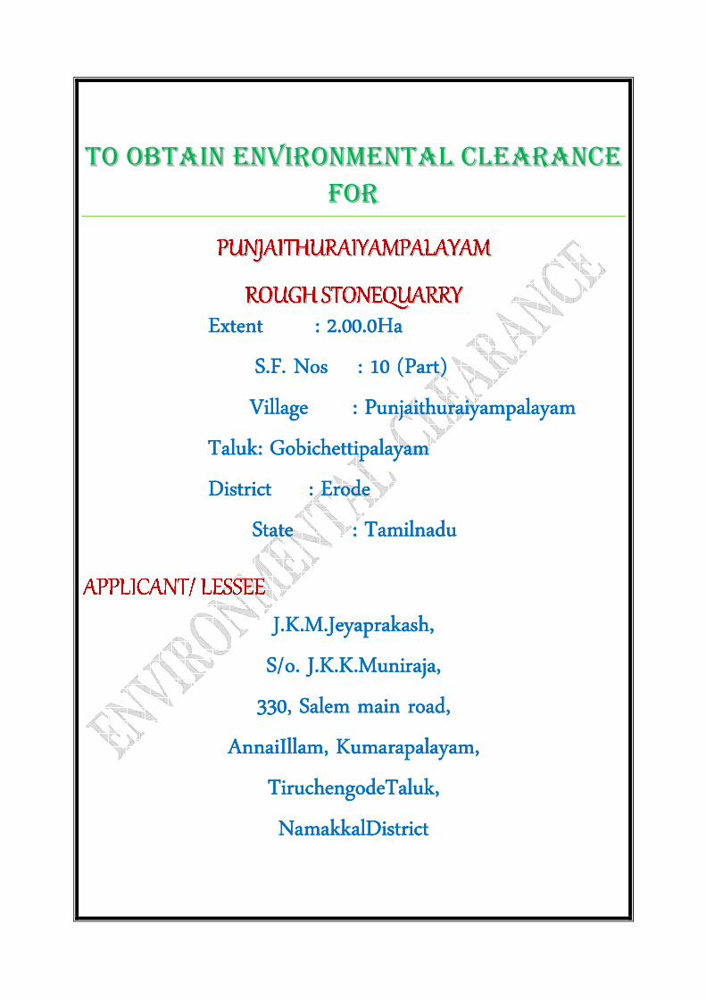
TTOO OOBBTTAAIINN EENNVVIIRROONNMMEENNTTAALL CCLLEEAARRAANNCCEE
FFOORR
Extent : Extent : Extent : Extent : 2222....00000000.0.0.0.0HHHHaaaa
S.F. NosS.F. NosS.F. NosS.F. Nos : : : : 10101010 (Part)(Part)(Part)(Part)
Village : Village : Village : Village : PunjaithuraiyampalayamPunjaithuraiyampalayamPunjaithuraiyampalayamPunjaithuraiyampalayam
Taluk: Taluk: Taluk: Taluk: GobichettipalayamGobichettipalayamGobichettipalayamGobichettipalayam
District : District : District : District : ErodeErodeErodeErode
State : State : State : State : TamilnaduTamilnaduTamilnaduTamilnadu
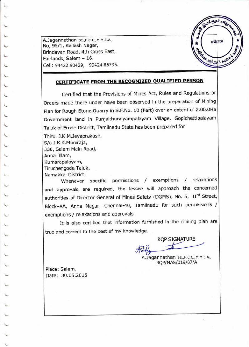
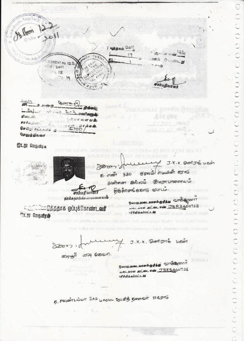
J.K.M.JeyaprakashJ.K.M.JeyaprakashJ.K.M.JeyaprakashJ.K.M.Jeyaprakash,,,,
S/o. J.K.K.Muniraja,S/o. J.K.K.Muniraja,S/o. J.K.K.Muniraja,S/o. J.K.K.Muniraja,
330, Salem main road,330, Salem main road,330, Salem main road,330, Salem main road,
AnnaiIllam, AnnaiIllam, AnnaiIllam, AnnaiIllam, Kumarapalayam,Kumarapalayam,Kumarapalayam,Kumarapalayam,
TiruchengodeTaluk,TiruchengodeTaluk,TiruchengodeTaluk,TiruchengodeTaluk,
NamakkalNamakkalNamakkalNamakkalDistrictDistrictDistrictDistrict

To consider the proposal for the grant of Environmental Clearance for Rough Stone quarrying in
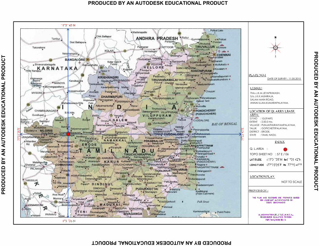
at S.F.No: 10 (part) of PunjaithuraiyampalayamVillage in GobichettipalayamTaluk, Erode District
by Thiru. J.K.M.Jeyaprakash,
The Proposal is for mining of Rough Stone by Thiru. J.K.M.Jeyaprakash. The salient features of the
proposal are as follows:
S.No: Details of the proposal : Data furnished Page No:
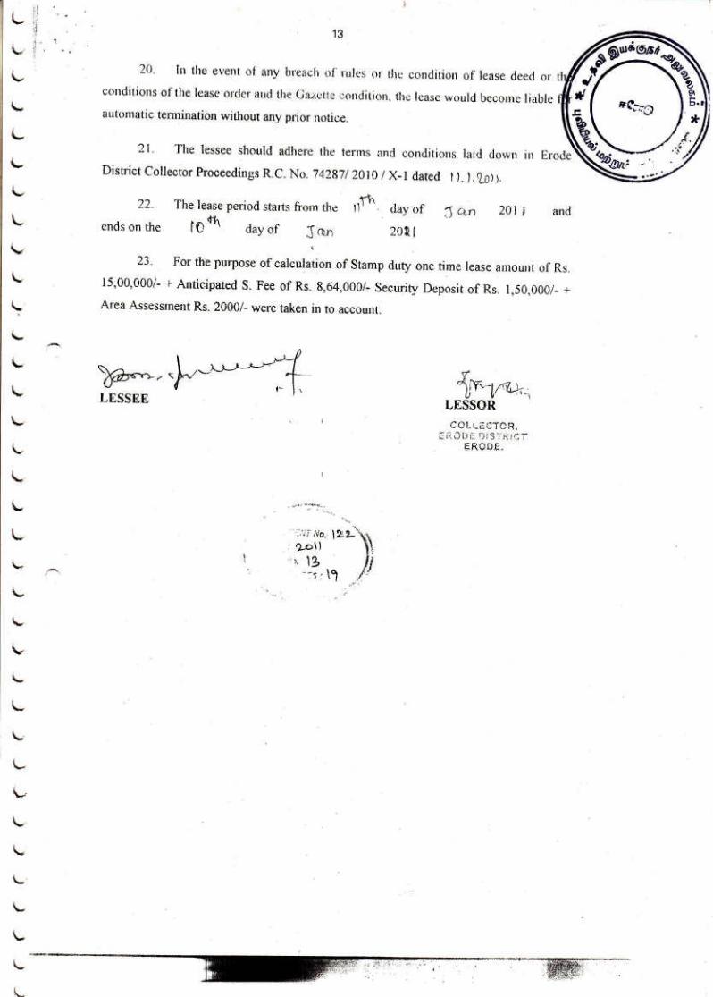
1.
Name of the owner/Firm
:
J.K.M.Jeyaprakash,
S/o. J.K.K.Muniraja,
330, Salem main road,
AnnaiIllam, Kumarapalayam,
TiruchengodeTaluk,
Namakkal District.
Mobile No: 7598614661
19,51,107,
137
2. Type of quarrying (Savudu/Rough
stone/ Sand/Granite) :
It is a Rough Stone quarry 51,107,137
3. S.F.No of the quarry site with area
break up :
10 (Part) 51,107,137
4. Village in which situated : PunjaithuraiyampalayamVillage 51,107,137
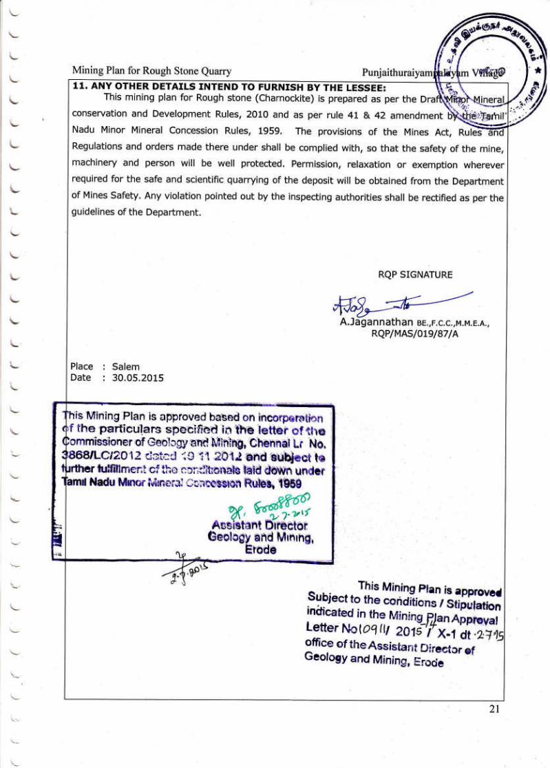
5. Taluk in which situated : GobichettipalayamTaluk 51,107,137
6. District in which situated : Erode District 51,107,137
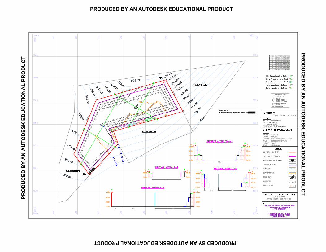
7. Extent of quarry (in ha) 2.00.0Ha 51,107,137
8.
Period of quarrying proposed
:
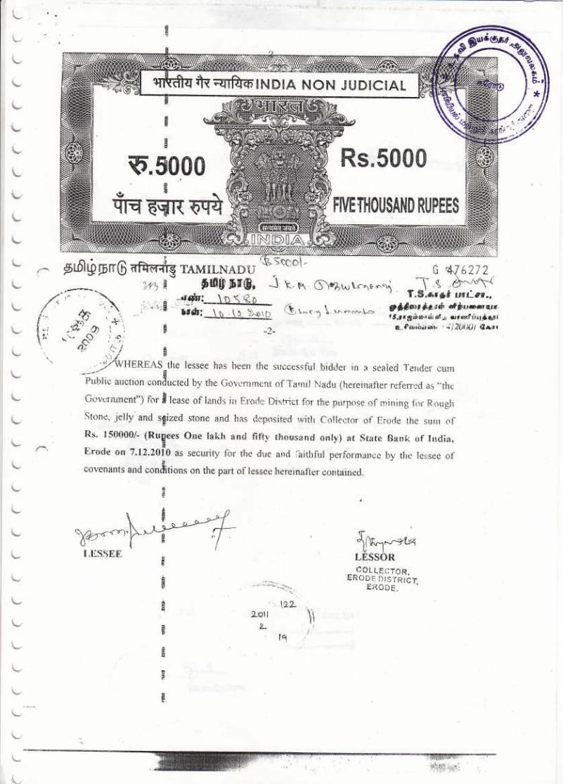
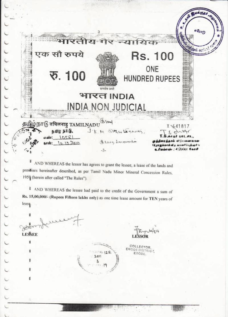
The lease deed was executed 11.01.2011 and the lease
will get expiry on 10.01.2021. The remaining lease
period is about five years.
51,71,107,
139
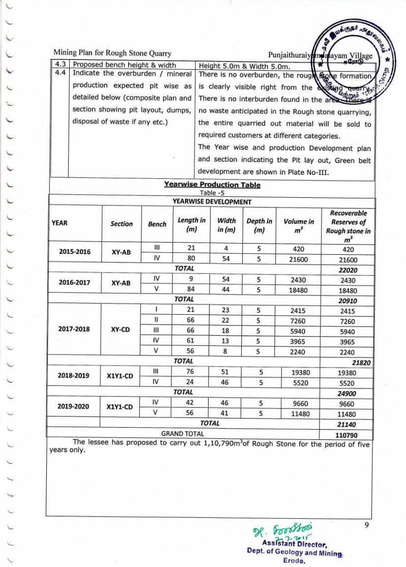
9. Production (Quantity in m3) : The proposed quantity of Rough Stone is 110790m
3 17,83,139
10. Lattitude and Longitude of all
corners of the quarry site :
11031’35’’N to 11
031’42’’N
77023’35’’E to 77
023’43’’E
17,73,141
11. Topo sheet No : 57 E/06 73,141
12.
Precise area communication
approved by the District Collector
with date
: The proceeding letter:Rc.No. 74287/2010/X-1 Dated:
11.01.2011 The Precise letter: Rc.No. 12077/2015-35 /X-1 Dated:
06.05.2015
107
13.
Mining plan approved by the
Assistant Director of the District
with date
: Rc.No. 10911/2015-17/X-1 Dated: 02.07.2015 51
14.
Water Requirement:
1. Drinking & Domestic
purpose (in KLD)
2. Dust suppression & Green
Belt (in KLD) ;
Purpose Quantity
KLD
Source
Drinking 0.3KLD Water vendors
Domestic purpose 0.3KLD Nearby well or
water vendors
Dust suppression and
Afforestation
0.4KLD Nearby well or
water vendors
31,91,143
15. Depth of quarrying
: Proposed depth of mining is 25m(15m above the
ground level + 10m below the ground level)
17,85,141
16.
Project cost (Excluding EMP cost)
:
The total project cost including EMP cost (A+B+C) is
about Rs.64,16,000/-(Rupees Sixty four lakhs sixteen
thousand only)
69,101,179
17. EMP cost
: The total EMP cost is around Rs. 4,16,000/- (Rupees
Four lakhs sixteen thousand only)
101,179

Checklist for Mining of Minor Mineral 2.00.0Hamine lease area
1. Name of the owner/Firm : J.K.M.Jeyaprakash, Page No:
2.
Correspondence Address
with Pin Code :
S/o. J.K.K.Muniraja,
330, Salem main road,
AnnaiIllam, Kumarapalayam,
TiruchengodeTaluk,
NamakkalDistrict.
19,51,107,13
7
3. Mobile Number : 7598614661 19,71,147
4. Email [email protected] 19,71,147
5.
Type of quarrying
(Earth/ Rough stone and
Gravel/Sand/Granite)
:
It is a Rough stone Quarry project in
PunjaithuraiyampalayamVillage.
51,107,137
6. S.F. No of the Quarry site
: S.F.No: 10 (Part)atPunjaithuraiyampalayamVillage,
GobichettipalayamTaluk, Erode District
51,107,137
7.
Village , Town Panchayat/
Panchayat Union in which
the village is situated
:
Village : Punjaithuraiyampalayam
Panchayat Union:Gobichettipalayam
51,107,137
8. Taluk in which situated : GobichettipalayamTaluk 51,107,137
9. District in which situated : Erode District 51,107,137
10. Extent of quarry (in Ha) : 2.00.0Ha 51,107,137
11.
New or existing quarry
:
It is a Fresh Quarry lease of Rough stone quarry (the area
has been quarrying operation earlier) in
PunjaithuraiyampalayamVillage
17,51,107,14
1
12.
If in case of existing Rough
stone and Gravel/ Blue
Metal/ Granite Quarry, the
length, width and depth to
which quarrying has already
been done (below the ground
level/ above the ground level)
:
Pit No. Length
Max in (m)
Width Max
in (m)
Depth Max
in (m)
I 33 53 5
II 77 60 5
79
13.
If quarrying had been done
below the ground level/above
the Ground level, the height
of quarrying
: The quarrying operation already done by the depth for
5m
79
14.
Name of the owner who had
earlier undertaken the
quarrying & a copy of
mining lease issued with date
:
It is a Fresh Quarry lease of Rough stone quarry (the area
has been quarrying operation earlier) in
PunjaithuraiyampalayamVillage
17,51,107,14
1
15.
Proof of land ownership.
If owned patta copy.
If not own patta land
agreement/ lease copy
entered with the owner (to be
enclosed)
:
It is a Government land, the applicant has obtained tender
from the Government.
73,107,
16.
Period of quarrying
:
The lease deed was executed 11.01.2011 and the lease
will get expiry on 10.01.2021. The remaining lease period
is about five years.
51,71,107,13
9
17. Production (quantity in m
3)
: The proposed quantity of reserves for remaining plan
period is to be mine is 110790m3(or) 19574 Lorry
17,83,139
Loadsof Rough stone up to a depth of 25m(15m above
the ground level + 10m below the ground level) for a
period of Five years.
Description Rough stone
in m3
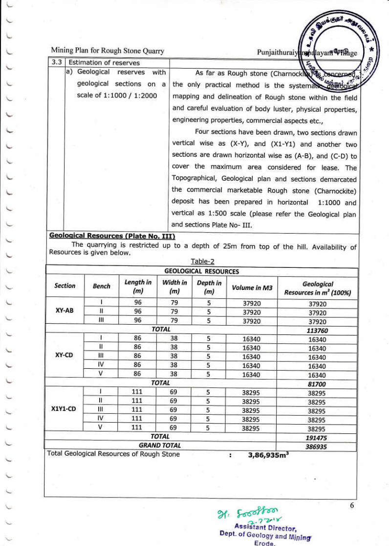
Geological Resources 386935
Available Mineable reserves 110790
Five years plan period As in the
approved mining plan
110790
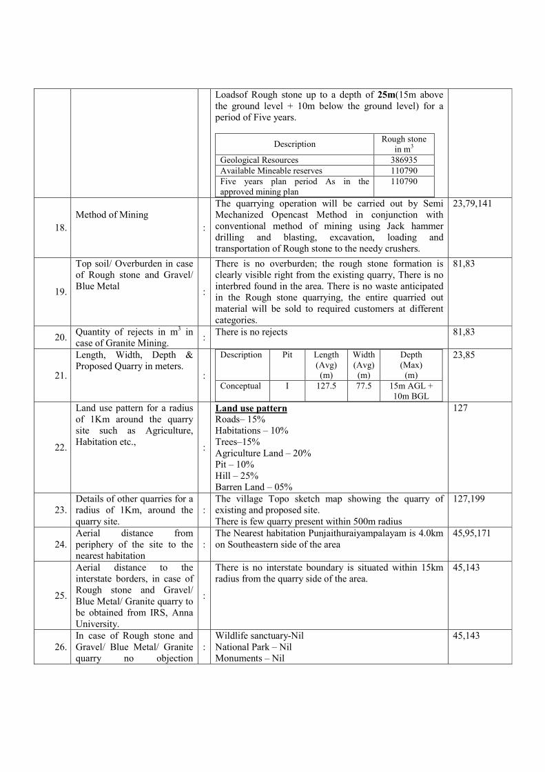
18.
Method of Mining
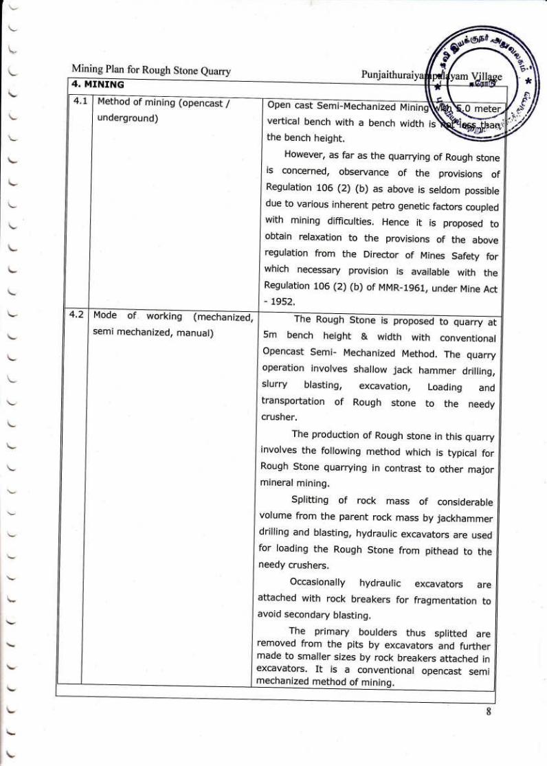
:
The quarrying operation will be carried out by Semi
Mechanized Opencast Method in conjunction with
conventional method of mining using Jack hammer
drilling and blasting, excavation, loading and
transportation of Rough stone to the needy crushers.
23,79,141
19.
Top soil/ Overburden in case
of Rough stone and Gravel/
Blue Metal :
There is no overburden; the rough stone formation is
clearly visible right from the existing quarry, There is no
interbred found in the area. There is no waste anticipated
in the Rough stone quarrying, the entire quarried out
material will be sold to required customers at different
categories.
81,83
20. Quantity of rejects in m
3 in
case of Granite Mining. :
There is no rejects
81,83
21.
Length, Width, Depth &
Proposed Quarry in meters. :
Description Pit Length
(Avg)
(m)
Width
(Avg)
(m)
Depth
(Max)
(m)
Conceptual I 127.5 77.5 15m AGL +
10m BGL
23,85
22.
Land use pattern for a radius
of 1Km around the quarry
site such as Agriculture,
Habitation etc., :
Land use pattern
Roads– 15%
Habitations – 10%
Trees–15%
Agriculture Land – 20%
Pit – 10%
Hill – 25%
Barren Land – 05%
127
23.
Details of other quarries for a
radius of 1Km, around the
quarry site.
:
The village Topo sketch map showing the quarry of
existing and proposed site.
There is few quarry present within 500m radius
127,199
24.
Aerial distance from
periphery of the site to the
nearest habitation
:
The Nearest habitation Punjaithuraiyampalayam is 4.0km
on Southeastern side of the area
45,95,171
25.
Aerial distance to the
interstate borders, in case of
Rough stone and Gravel/
Blue Metal/ Granite quarry to
be obtained from IRS, Anna
University.
:
There is no interstate boundary is situated within 15km
radius from the quarry side of the area.
45,143
26.
In case of Rough stone and
Gravel/ Blue Metal/ Granite
quarry no objection
:
Wildlife sanctuary-Nil
National Park – Nil
Monuments – Nil
45,143

certificate from the
concerned district Forest
Officer/ Wild Life
Sanctuaries/ National Parks/
HACA/ Western Ghats
region if the quarry site is
within 15 Kms of these areas.
Sathyamangalam Tiger Reserve (Guthiyalathur Reserve
forest) is located about 15m on the Northern side of the
lease area.
The lease area falls in Western Ghats region.
27.
Aerial distance to the nearest
eco-sensitive areas, CRZ,
Forests, Monuments etc.,
within 15Kms of these areas.
:
There is no eco-sensitive areas, CRZ, within the radius
of 15km
45,143
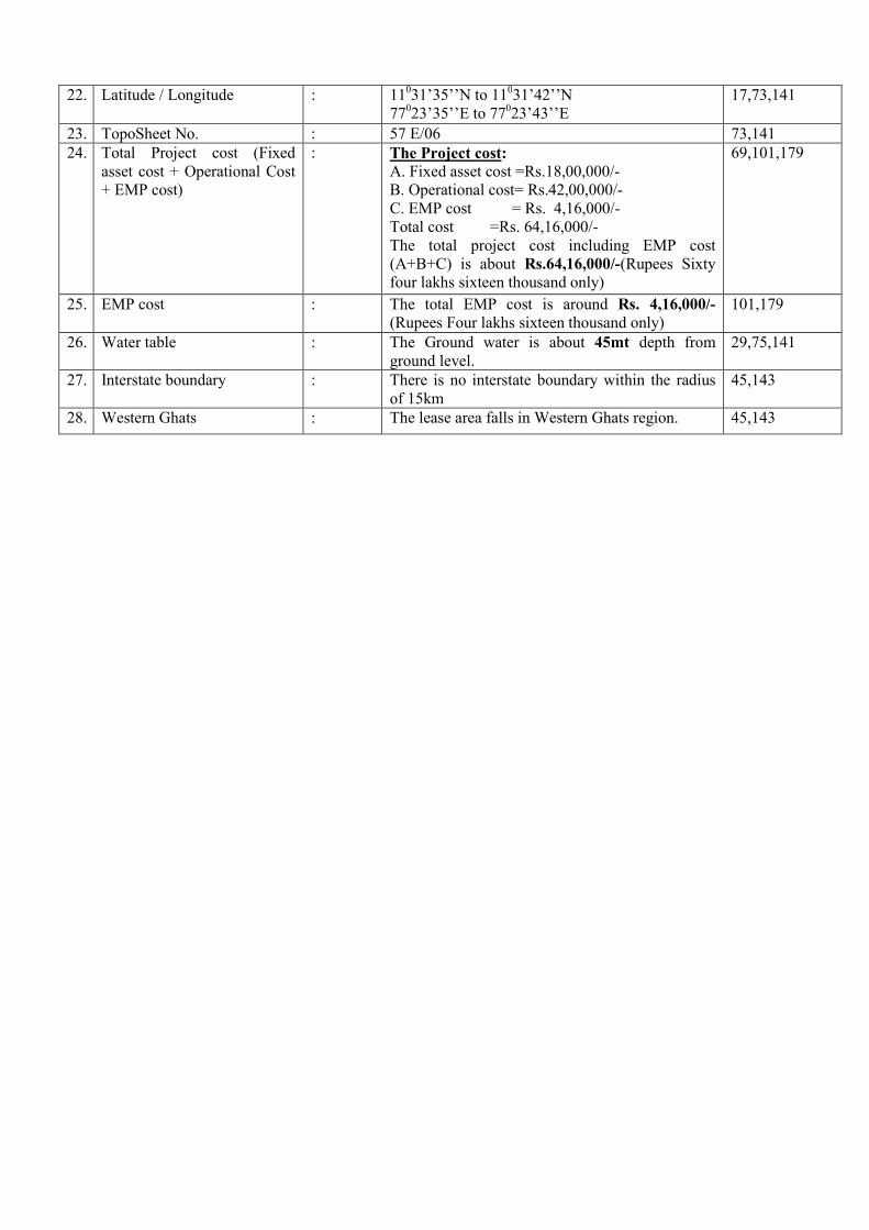
28. Latitude and Longitude of all
corners of the quarry site. :
11031’35’’N to 11
031’42’’N
77023’35’’E to 77
023’43’’E
17,73,141
29. Topo Sheet No : 57 E/06 73,141
30.
Copy of explosives license
and a consent letter/
agreement of competent
recognized person who has
agreed to handle explosive
for the blasting, in case of
Rough stone and Gravel/
Blue Metal/ Granite quarry.
:
A copy of agreement is enclosed.
203,205
31.
Brief details of APC
measures proposed to be
proposed to be implemented.
:
The Air quality will be affected during the quarrying
period due to blasting and jackhammer drilling, which
will be within prescribed limits. Air quality will be
monitored periodically as per norms and Mitigation
measures will be carried out to prevent dust and air
propagation in to air.
Mist water spraying will be carried out to suppress
dust and also wet drilling practiced.
95
32.
Mine Closure Plan to be
furnished in Mining plan.
:
There is no proposal for back filling, reclamation and
rehabilitation. The quarry pit will be fenced by barbed
wire to prevent inherent entry of public and cattle. The
quarried out pit will be allowed to collect rain and
seepage water which will act as a reservoir for storage.
This water storage will enhance the static level and
ground water recharge on nearby wells.
101
33.
Mining plan prepared by
(Xerox copy of certificate to
be attached)
:
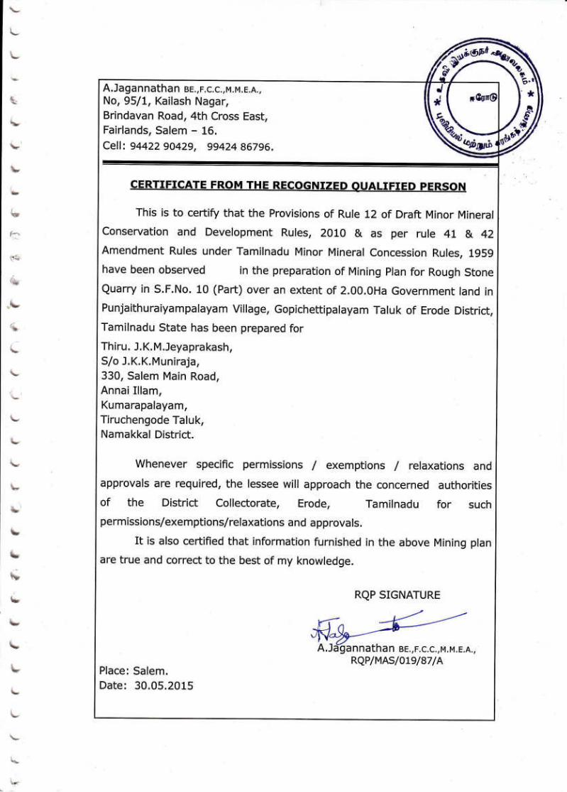
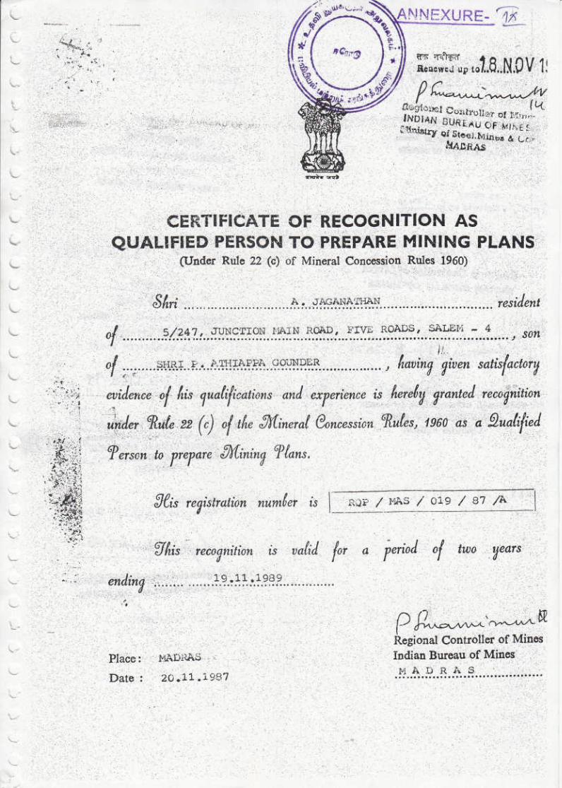
RQP certificate with validity is enclosed as Annexure
No: IX
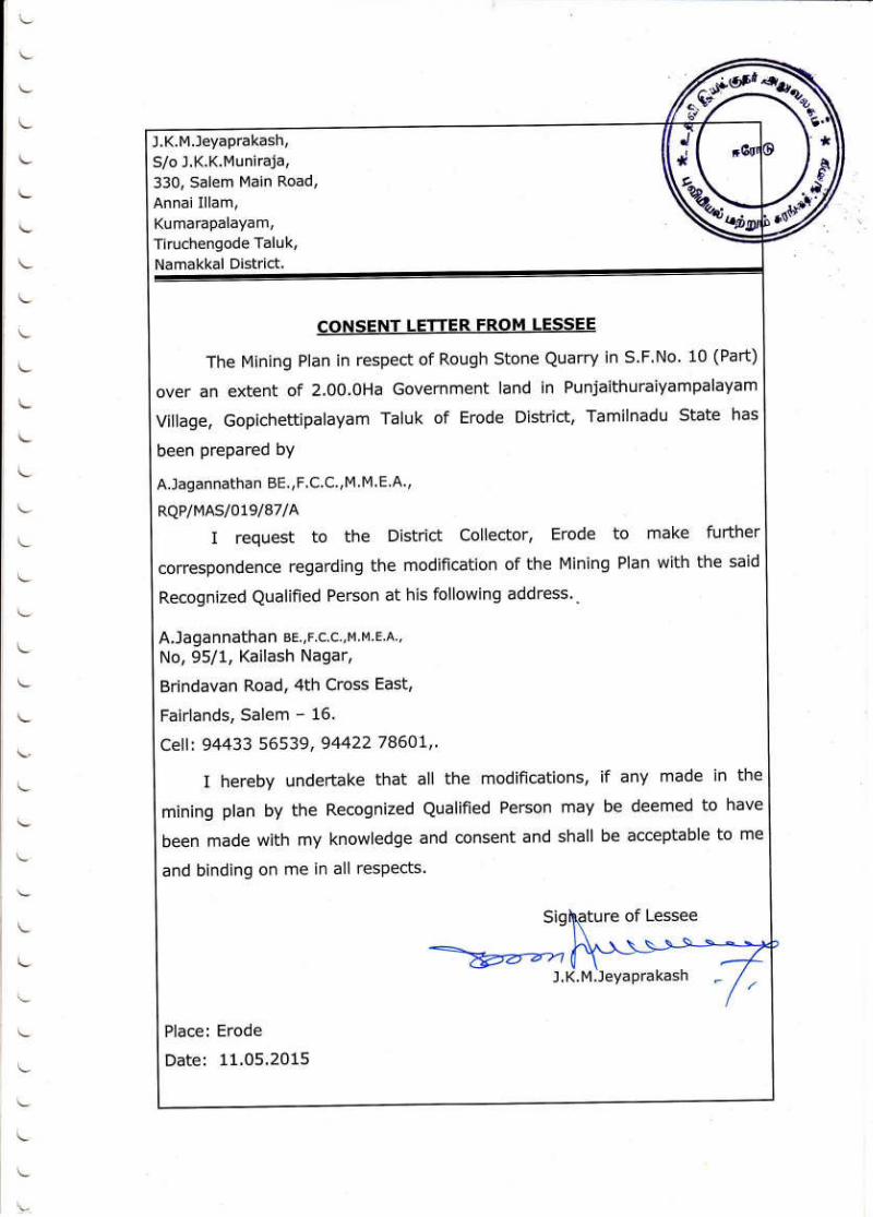
53,105,121
34.
Precise area communication
approved by the District
Collector :
The proceeding letter was received from the District
Collector, Erode vide Rc.No. 74287/2010/X-1 Dated:
11.01.2011
The Collector letter was received from the District collector
Erode videRc.No. 12077/2015-35 /X-1 Dated: 06.05.2015
107
35.
Mining plan approved by the
Deputy/ Assistant Director of
the District. :
The Mining Plan was got approval by the Assistant
Director, Department of Geology and Mining, Erode vide
Rc.No. 10911/2015-17/X-1 Dated: 02.07.2015
51

36.
Water requirement :
a) Drinking & domestic
purposes in KLD.
b) Dust suppression (in
KLD)
c) Green belt (in KLD)
:
Drinking Water –0.3 KLD
& Domestic purpose
Dust Suppression – 0.3 KLD
Green belt - 0.4 KLD
Total – 1.0 KLD
31,91,143
37.
Source of water
:
Purpose Sources
Drinking &
Domestic
Purpose
Water purchase from approved water
vendors available in
Punjaithuraiyampalayam (4km –SE
side)
Dust
suppression
Nearby well or water vendors
Green belt
development
Nearby well or water vendors
31,91,143
38. Ground water table
: The Ground water is about 45mt depth from ground
level.
29,75,141
39.
Project Cost (excluding EMP
Cost)
:
The Project cost: A. Fixed asset cost =Rs.18,00,000/-
B. Operational cost= Rs.42,00,000/-
C. EMP cost = Rs. 4,16,000/-
Total cost = Rs. 64,16,000/-
The total project cost including EMP cost (A+B+C) is
about Rs.64,16,000/-(Rupees Sixty four lakhs sixteen
thousand only)
69,101,179
40. EMP Cost
: The total EMP cost is around Rs. 4,16,000/- (Rupees
Four lakhs sixteen thousand only)
101,179
41. Disclosure RQP
A.Jagannathan, BE, F.C.C., M.M.E.A.,
RQP/MAS/019/87/A
53,105,121
42.
Soft copy of the Form–1,
Pre –feasibility report and
Mining plan in CD.
:
There is enclosed Soft copy for form –1, Pre – feasibility
report and mining plan in CD.
207
43.
Key map showing the
approach roads to the site to
be attested by the Deputy/
Assistant Director of
Geology and Mining of the
concerned District.
:
The Key map showing with approach roads to the site is
enclosed. Plate No. IC
129
44.
Village map with S.F. Nos&
salient features such as
vegetation, habitations etc.,
for a radius of 500m around
the quarry site.
:
Village map with S.F.No and Salient features such as
vegetation, habitation etc., for 500mt radius is enclosed as
plate no.IB
111,127
45.
If lakes, Ponds, river, nallah,
odai etc. are situated near the
quarry site permission from
the concerned PWD
authorities for mining
:
Kunderippallam Dam is situated about 6km away from
the Northwestern side of the area.
There are no major water bodies like river, Pond, lake,
etc., within 500m radius.
89

1. Signature of the applicant
J.K.M.Jeyaprakash,
2. Signature of the Recognized qualified person
A.Jagannathan, BE, F.C.C., M.M.E.A.,
RQP/MAS/019/87/A
46.
Section map for mining to be
attested by the Deputy/
Assistant Director of
Geology and Mining of the
concerned District.
:
The Geological Plan and section in 1:1000 & 1:500 scales
is enclosed.
133
47.
Photograph of the proposed
Mining site with S.F.Nos and
attested by at least VAO.
:
The Photo of the Mines site is enclosed. 167
48. Form –1 To be signed by
applicant :
I am hereby signed 49
49.
Pre- Feasibility Report to be
signed by Both applicant and
RQP. :
Pre-feasibility report has been signed by the applicant and
RQP
183
50.
First and last page and the
page at which quantity of
mining has been worked out
to be signed by the
Deputy/Assistant Director of
Geology and Mining of the
concerned District.
:
First page and last page and the quantity proposed in the
plan have been signed by the Assistant Director of
Geology and Mining.
67,83
51.
Affidavit from the applicant
that child labour is not being
employed in the mining
activity.
:
It is been ensured that the labor will not be employed less
than 18 years, No child labour will engaged or
entertained for any kind of quarrying operations. All the
labour engaged for quarrying operations will be insured
during the quarry lease period.
197,199,201
52.
Affidavit from the applicant
regarding planting of trees
around the quarry site in
fulfillment of the Green belt
commitment furnished.
:
Affidavit from the applicant regarding the proposal for
planting trees around the quarry and fulfillment of
greenbelt commitment is enclosed.
197,199,201
53.
Details (POD) Regarding
communicating the proposal
to the members of the
committee.
:

INDEX FILE
S.No DESCRIPTION PAGE
NOS
1 To Obtain Environmental Clearance 3
2 Environmental Clearance Format 5-9
3 Declaration Letter 11
4 Demand Draft 13
5 Form-1 15-49
6 Approved Mining Plan along with
Approval Letter 51-135
7 Pre-Feasibility Report 137 - 183
8 VAO signed for Quarry site 167
9 Baselines Studies 185-195
10 Affidavit Document 197-199
11 Copy of Explosive License 201-203
12 Consolidated Above Document In
PDF Format (DVD)
205

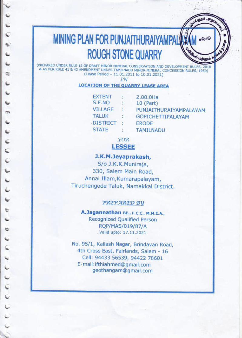
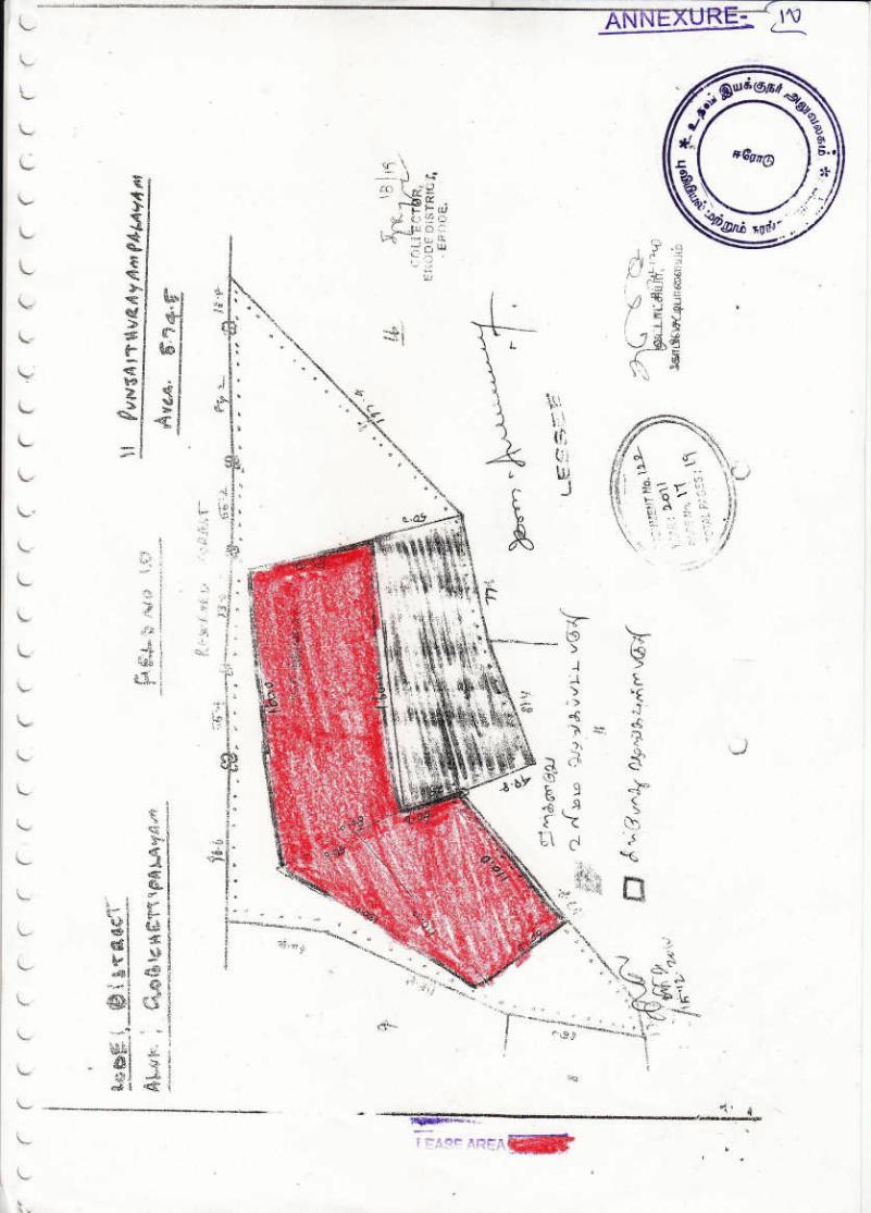
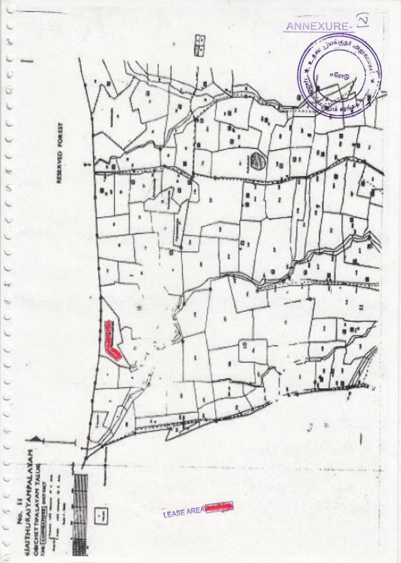
PUNJAITHURAIYAMPALAYAM ROUGH STONE QUARRY LEASE APPLIED AREA (2.00.0HA)
The proponentMr. J.K.M.Jeyaprakashhas applied for Environmental clearance for the proposed
quarryRough stone for over an extent of2.00.0Hain S.F.No:10 (Part) at
PunjaithuraiyampalayamVillage, GobichettipalayamTaluk, Erode District andTamilnadu
Salient features of the proposal are as follows:
1. Name of the Owner + Firm : J.K.M.Jeyaprakash,
S/o. J.K.K.Muniraja,
330, Salem main road,
AnnaiIllam, Kumarapalayam,
TiruchengodeTaluk,
Namakkal District.
Mobile No: 7598614661
Page No:
19,51,107,137
2. Location of the quarry-
S.F.No.
: S.F.No: 10
(Part)atPunjaithuraiyampalayamVillage,
GobichettipalayamTaluk, Erode District
17,51,107,137
3. Purpose of Application : It is a Rough stone Quarry project in
PunjaithuraiyampalayamVillage.
17,51,107,137
4. Extent of quarry in Ha- : 2.00.0Ha 17,51,107,137
5. Land use planning
a) Mining
b) Storage of Topsoil over
burden
c) Infrastructure Road
d) Utilized Area
Total
:
Description Present area
in (Ha)
Area at the
end of lease
period (Ha.)
Area Under Quarrying 0.58.5 1.54.0 Infrastructure Nil 0.01.0
Roads 0.01.0 0.02.0 Green belt Nil 0.10.0 Unutilized 1.40.5 0.33.0
Grand Total 2.00.0 2.00.0
23,93,141
6. Production (quantity in m3) : The proposed quantity of reserves for remaining
plan period is to be mine is 110790m3(or) 19574
Lorry Loads of Rough stone up to a depth of 25m
Rough Stone (15m above the ground level + 10m
below the ground level) for a period of Five years
Description Rough stone
in m3
Geological Resources 386935
Available Mineable reserves 110790
Five years plan period As in the
approved mining plan
110790
17,83,139
7. Top soil & overburden
(quantity in m3)
: There is no overburden, the rough stone formation
is clearly visible right from the existing quarry,
There is no interburden found in the area. There is
no waste anticipated in the Rough stone
quarrying, the entire quarried out material will be
sold to required customers at different categories.
81,83
8. Method of Mining : The quarrying operation will be carried out by
Semi Mechanized Opencast Method in
conjunction with conventional method of mining
using Jack hammer drilling and slurry blasting,
excavation, loading and transportation of Rough
stone to the needy crushers.
23,79,141
9. Life of Mine as per approved
mining plan
: The lease deed was executed 11.01.2011 and the
lease will get expiry on 10.01.2021. The
remaining lease period is about five years.
51,71,107,139

10. Height / width of the bench : Height 5.0 m & Width 5.0 m. 23,81,159
11. Source of water / quantity
required
Quantity
required
(in litres)
Source
31,91,143
a. Drinking&Domestic
Purpose
0.3 KLD Approved Water vendors
b. Dust Suppression 0.3KLD Nearby well or water vendors
c. Green belt development 0.4KLD Nearby well or water vendors
12. Waste water
Sewage water
Mode of disposal
:
:
There is no waste water. 41,91,175
The septic tank isconstructed on permanent
structure with in the quarry lease area.
To local Panchyat Authority
13. APC Measures : 1.Mist Spray using water tankers,
2. Enclosed covered system. (Tarpaulin) for
transportation.
37
14. Ariel distance of nearest
habitation
:
S.
No Name of the Village
Approxima
te distance
& Direction
from lease
area
Approximat
e population
1. PudhuThottam 6km – NE 700
2. Kempanaickenpalayam 10km- NW 800
3 PujaiThuraiyampalayam 4km -SE 600
4 Kavandampalayam 3km - SW 500
45,93,171
15. Ariel distance from Reserve
forest, Sensitive areas, Forest,
Bird sanctuaries, Wild life
sanctuaries, National parks,
Monuments etc., within 15km
: Wildlife sanctuary-Nil
National Park – Nil
Monuments – Nil
Sathyamangalam Tiger Reserve (Guthiyalathur
Reserve forest) is located 15m on the Northern
side of the lease area.
45,143
16. Land owner ship document
Own patta land
Lease
Govt. Poromboke
:
:
:
It is a Government land, the applicant has obtained
tender from the Government.
73,107,
17. Land use classification : It is a Fresh Quarry lease of Rough stone quarry
(the area has been quarrying operation earlier) in
PunjaithuraiyampalayamVillage
17,51,107,141
18. Mining plan
Prepared by
:
A.Jagannathan, BE, F.C.C., M.M.E.A.,
RQP/MAS/019/87/A
53,105,121
Approved by : The Mining Plan was got approval by the
Assistant Director, Department of Geology and
Mining, Erode vide Rc.No. 10911/2015-17/X-1
Dated: 02.07.2015
51
19. Precise area statement
Approved by
: The proceeding letter was received from the
District Collector, Erode vide Rc.No.
74287/2010/X-1 Dated: 11.01.2011
The Collector letter was received from the District
collector Erode videRc.No. 12077/2015-35 /X-1
Dated: 06.05.2015
107
20. Nearby quarries : There is few quarry present within 500m radius 127,199
21. Nearby lake / river/ odai /
channel etc.
: Kunderippallam Dam is situated about 6km away
from the North-western side of the area.
There are no major water bodies like river, Pond,
lake, etc., within 500m radius.
89
22. Latitude / Longitude : 11031’35’’N to 11
031’42’’N
77023’35’’E to 77
023’43’’E
17,73,141
23. TopoSheet No. : 57 E/06 73,141
24. Total Project cost (Fixed
asset cost + Operational Cost
+ EMP cost)
: The Project cost:
A. Fixed asset cost =Rs.18,00,000/-
B. Operational cost= Rs.42,00,000/-
C. EMP cost = Rs. 4,16,000/-
Total cost =Rs. 64,16,000/-
The total project cost including EMP cost
(A+B+C) is about Rs.64,16,000/-(Rupees Sixty
four lakhs sixteen thousand only)
69,101,179
25. EMP cost : The total EMP cost is around Rs. 4,16,000/-
(Rupees Four lakhs sixteen thousand only)
101,179
26. Water table : The Ground water is about 45mt depth from
ground level.
29,75,141
27. Interstate boundary : There is no interstate boundary within the radius
of 15km
45,143
28. Western Ghats : The lease area falls in Western Ghats region. 45,143
From:
J.K.M.Jeyaprakash,
S/o. J.K.K.Muniraja,
330, Salem main road,
Annai Illam, Kumarapalayam,
Tiruchengode Taluk,
Namakkal District
Mobile No: 7598614661
To:
THE CHAIRMAN,
STATE LEVEL ENVIRONMENT IMPACT ASSESSMENT AUTHORITY,
PANAGAL BUILDING, SAIDAPET,
CHENNAI
Sir,
Sub: Submission of Approved Mining Plan (Rc.No. 10911/2015-17/X-1 Dated:
02.07.2015) Form–I and Pre-feasibility report for obtaining Environmental
Clearance for our Punjaithuraiyampalayam Rough stoneQuarry - Reg.,
*****
I am here by submitting the processing fee in the form of demand draft for rupeestwenty
thousand, along with Form-1, Pre-feasibility report and Copy of Approved mining plan to your
good office for obtaining clearance from SEIAA, Chennai, for our Punjaithuraiyampalayam
Rough stoneQuarryLease applied area for over an extent of2.00.0Ha located in S.F.No. 10
(Part)of Punjaithuraiyampalayam Village, Gobichettipalayam Taluk, ErodeDistrict, Tamilnadu.
I have submitted all the relevant documents to your good office to the best of our
knowledge.If any clarifications are required, we are ready to submit the same to your office at
your convenient time. Also we are ready to present the project in front of the committee.
Hence we request your good office to kindly process our application and allow us to
present our project at the earliest.
Thanking you.
Yours sincerely
J.K.M.Jeyaprakash,
Place:Erode
Date:


FORM I
(I) BASIC INFORMATION
S. No Item Details
1 Name of the project/s PunjaithuraiyampalayamRough stone quarry project.
2 S. No. in the schedule 1(a)
3 Proposed capacity/
area/length/tonnage to be
handled/command area/lease
area/number of wells to be drilled
The proposed quantity of reserves for remaining plan
period is to be mine is 110790m3of Rough stone for
a period ofFive years only.
Area =2.00.0Ha.
The command area =1.67.0Ha(effective quarrying
area after leaving safety distance).
It is a shallow open cast quarry. The outcrop of the
massive Rough stone formation is clearly inferred.
Hence no wells are proposed or nor drilled.
4 New/Expansion/ Modernization
It is a Fresh Quarry lease of Rough stone quarry (the
area has been quarrying operation earlier) in
Punjaithuraiyampalayam Village
5
Existing capacity/Area etc. The proposed quantity of reserves for remaining plan
period is to be mine is 110790m3(or) 19574 Lorry
Loads of Rough stone up to a depth of 25m Rough
Stone (15m above the ground level + 10m below the
ground level) for a period of Five years .
Description
Rough
stone
in m3
Geological Resources 386935
Available Mineable reserves 110790
Five years plan period As in the
approved mining plan
110790
6 Category of project i.e. `A’ or ‘B’ Category – B2.
7 Does it attract the general condition? If
yes, please specify.
7.5m safety distance from the adjacent Government
lands and Bench loss.
8 Does it attract the specify condition? If
yes, please specify.
The project does not attract any specify condition in
the lease area.
9 Location 11
031’35’’N to 11
031’42’’N
77023’35’’E to 77
023’43’’E
Plot/ Survey/ Khasra No. 10 (Part)
Village Punjaithuraiyampalayam
Taluk Gobichettipalayam
District Erode
State Tamilnadu
10 Nearest railway station/ airport along
with distance in kms
IngurRailway station -39kms-SE
CoimbatoreAirport-67kms-SW

11
Nearest Town, city, District
Headquarters along with distance in kms
Town - Gobichettipalayam-9kms-SE
Nearest City - Erode-41kms-SE
District - Erode-41 kms-SE
12
Village Panchayats, ZilaParishad,
Municipal Corporation, Local body
(complete postal addresses with
telephone nos. to be given)
Village –Punjaithuraiyampalayam
Panchayat Union –Gobichettipalayam
Taluk –Gobichettipalayam
District –Erode
13 Name of the applicant J.K.M.Jeyaprakash,
14
Registered Address
S/o. J.K.K.Muniraja,
330, Salem main road,
AnnaiIllam, Kumaraplayam,
TiruchengodeTaluk,
Namakkal District.
15
Address for correspondence:
Name J.K.M.Jeyaprakash,
Designation (Owner/Partner/CEO) Proprietor / Owner
Address
S/o. J.K.K.Muniraja,
330, Salem main road,
AnnaiIllam, Kumaraplayam,
TiruchengodeTaluk,
Namakkal District.
E-mail [email protected]
Mobile No. 7598614661
Fax No. -
16
Details of Alternative Sites examined, if
any. Location of these sites should be
shown on a Topo sheet.
There is no alternative sites are examined. The
project is site specific.
17 Interlinked Projects There is no interlinked project.
18 Whether separate application of
interlinked project has been submitted?
As there is no interlinked project, no application has
been submitted.
19 If yes, date of submission As there is no interlinked project, no application has
been submitted.
20 If no, reason The project involves Rough stone Quarry only.
21
Whether the proposal involves approval/
clearance under: if yes, details of the
same and their status to be given.
(a) The Forest (Conservation) Act,
1980?
(b) The Wildlife (Protection) Act, 1972?
(c) The C. R. Z. Notification, 1991?
(a) The project does not attract the Forest
(Conservation) Act 1980.
(b) There is no wild life in the project site area under
the Wildlife (protection) Act 1972.
(C) The project area does not fall the C.R.Z
Notification, 1991.

22
Whether there is any Government Order/
Policy relevant/ relating to the site?
The proceeding letter was received from the District
Collector, Erode vide Rc.No. 74287/2010/X-1 Dated:
11.01.2011
The Collector letter was received from the District
collector Erode videRc.No. 12077/2015-35 /X-1
Dated: 06.05.2015.
The Mining Plan was got approval by the Assistant
Director, Department of Geology and Mining, Erode
vide Rc.No. 10911/2015-17/X-1 Dated: 02.07.2015.
23 Forest land involved (hectares) No forest land is involved lease area.
24
Whether there is any litigation pending
against the project and/ or land in which
the project is propose to be set up?
(a) Name of the Court
(b) Case No.
(c) Orders/ directions of the Court, if any
and its relevance with the proposed
project.
There is no court case pending, litigations relating to
the project directly and indirectly.
(II) Activity
1. Construction operation or decommissioning of the project involving actions, which will
cause physical changes in the locality (topography, land use changes in water bodies, etc.)
S. No Information/Checklist
confirmation Yes/No
Details thereof (with approximate
quantities/rates, wherever possible) with sources
of information data
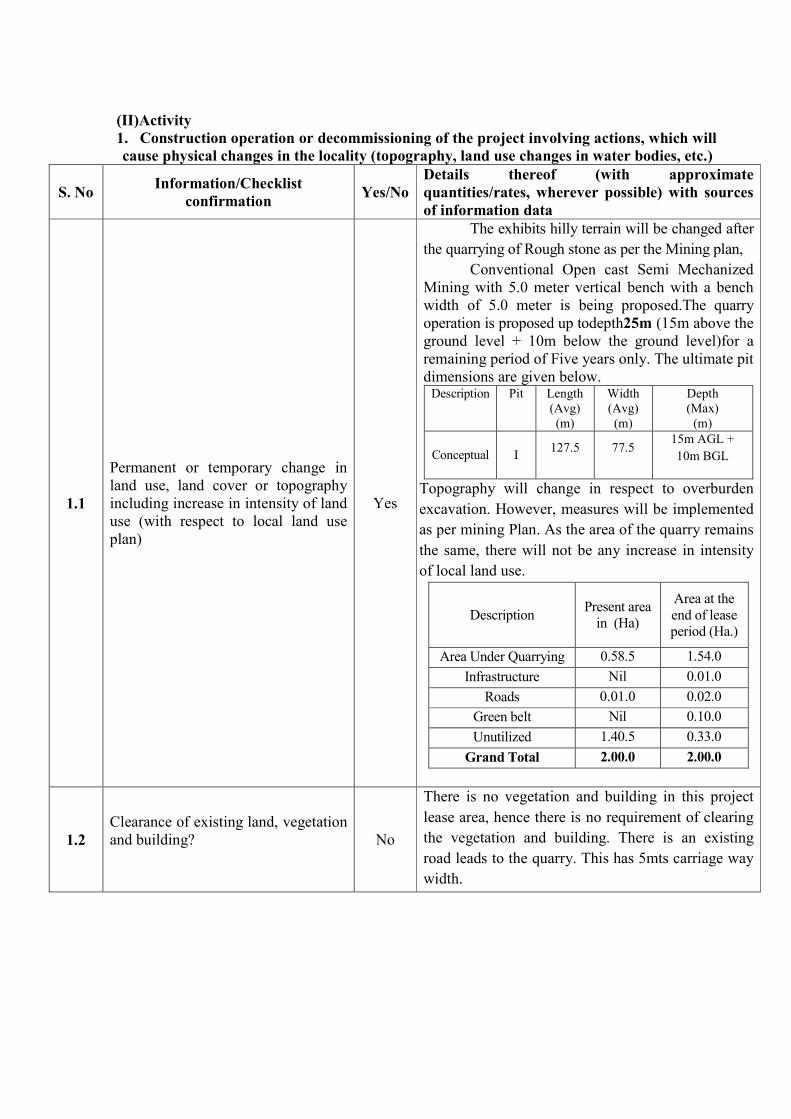
1.1
Permanent or temporary change in
land use, land cover or topography
including increase in intensity of land
use (with respect to local land use
plan)
Yes
The exhibits hilly terrain will be changed after
the quarrying of Rough stone as per the Mining plan,
Conventional Open cast Semi Mechanized
Mining with 5.0 meter vertical bench with a bench
width of 5.0 meter is being proposed.The quarry
operation is proposed up todepth25m (15m above the
ground level + 10m below the ground level)for a
remaining period of Five years only. The ultimate pit
dimensions are given below. Description
Pit Length
(Avg)
(m)
Width
(Avg)
(m)
Depth
(Max)
(m)
Conceptual I 127.5 77.5
15m AGL +
10m BGL
Topography will change in respect to overburden
excavation. However, measures will be implemented
as per mining Plan. As the area of the quarry remains
the same, there will not be any increase in intensity
of local land use.
Description Present area
in (Ha)
Area at the
end of lease
period (Ha.)
Area Under Quarrying 0.58.5 1.54.0
Infrastructure Nil 0.01.0
Roads 0.01.0 0.02.0
Green belt Nil 0.10.0
Unutilized 1.40.5 0.33.0
Grand Total 2.00.0 2.00.0
1.2
Clearance of existing land, vegetation
and building?
No
There is no vegetation and building in this project
lease area, hence there is no requirement of clearing
the vegetation and building. There is an existing
road leads to the quarry. This has 5mts carriage way
width.
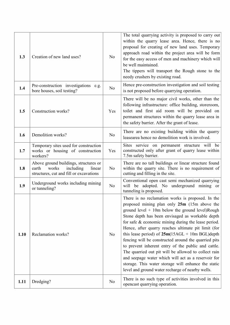
1.3 Creation of new land uses? No
The total quarrying activity is proposed to carry out
within the quarry lease area. Hence, there is no
proposal for creating of new land uses. Temporary
approach road within the project area will be form
for the easy access of men and machinery which will
be well maintained.
The tippers will transport the Rough stone to the
needy crushers by existing road.
1.4 Pre-construction investigations e.g.
bore houses, soil testing? No
Hence pre-construction investigation and soil testing
is not proposed before quarrying operation.
1.5 Construction works? Yes
There will be no major civil works, other than the
following infrastructure: office building, storeroom,
toilet and first aid room will be provided on
permanent structures within the quarry lease area in
the safety barrier. After the grant of lease.
1.6 Demolition works? No There are no existing building within the quarry
leasearea hence no demolition work is involved.
1.7
Temporary sites used for construction
works or housing of construction
workers?
Yes
Sites service on permanent structure will be
constructed only after grant of quarry lease within
7.5m safety barrier.
1.8
Above ground buildings, structures or
earth works including linear
structures, cut and fill or excavations
No
There are no tall buildings or linear structure found
within the quarry site. There is no requirement of
cutting and filling in the site.
1.9 Underground works including mining
or tunneling? No
Conventional open cast semi mechanized quarrying
will be adopted. No underground mining or
tunneling is proposed.
1.10 Reclamation works? No
There is no reclamation works is proposed. In the
proposed mining plan only 25m (15m above the
ground level + 10m below the ground level)Rough
Stone depth has been envisaged as workable depth
for safe & economic mining during the lease period.
Hence, after quarry reaches ultimate pit limit (for
this lease period) of 25m(15AGL + 10m BGL)depth
fencing will be constructed around the quarried pits
to prevent inherent entry of the public and cattle.
The quarried out pit will be allowed to collect rain
and seepage water which will act as a reservoir for
storage. This water storage will enhance the static
level and ground water recharge of nearby wells.
1.11 Dredging? No There is no such type of activities involved in this
opencast quarrying operation.
1.12 Offshore structures? No There is no such type of activities involved; It is an
inland quarrying project.
1.13 Production and manufacturing
processes? No
No production or manufacturing is involved in
thisRough stone quarrying. The Rough stone is
liberated from the parent rock mass and transported
to the needy crushers.
1.14 Facilities for storage of goods or
materials? No
There is no proposal for storage of material within
the quarry lease area. The Rough stone will be
loaded directly to the tippers and transported to
needy crushing site.
1.15
Facilities for treatment or disposal of
solid waste or liquid effluents?
No
The entire quarried Rough stone will be consumed.
The anticipated waste will be very negligible the
entire Rough stone irrespective of size has a good
commercial market at present market scenario.
Domestic waste water will be treated in Septic Tank
followed by soak pit. The manure will be treated and
used for green belt development.TheRough stone will
not produce toxic effluence in the form of solid,
liquid or gas.No waste water will be discharged by
quarry operation.
1.16 Facilities for long term housing of
operational workers? No
The proposed project is 2.00.0Ha. The minimum
employees are available in the nearby villages,
hence long term housing of operational workers are
not proposed. Rest shelter will be constructed on
permanent structure within the lease area on
boundary barrier after the grant of quarrylease.
1.17 New road, rail or sea traffic during
construction or operation? No
No new roads, rail or sea traffic is proposed during
operation, the existing road will be utilized for
transportation of the Rough stone. There is no
habitations or villages enrouted between the stone
quarry and crushing site.
However, internal roads within the quarry lease area
will be developed and maintained as per statutory
norms.
1.18
New road, rail, air waterborne or
other transport infrastructure
including new or altered routes and
stations, ports, airports etc.?
No
There is no such type of activities involved in this
project.
Existing road will be utilized for the transportation
of Rough stone to the needy crusher sites.
1.19
Closure or diversion of existing
transport routes or infrastructure
leading to changes in traffic
movements?
No
The project will not cause any changes and
hindrance in the existing traffic movements.
There is no a habitation or villages en-route between
the stone quarry to the nearby crushing sites.
1.20 New or diverted transmission lines or
pipelines? No
The project does not involve diversion of
transmission/pipe lines.

1.21
Impoundment, damming, culverting,
realignment or other changes to the
hydrology of watercourses or
aquifers?
No
The quarrying operation is restricted up to a depth of
25m (15m above the ground level + 10m below the
ground level). The Ground water occurrence in this
area is45mt depth from ground profile (45m in
summer and at 40m in rainy season). Hence there is
no damage for ground water hydrology or aquifers.
1.22 Stream crossings? No There is no stream crossing within the lease area.
1.23 Abstraction or transfers of water from
ground or surface waters? No
The proposed quarryingdoes not require any
abstraction or transfer of water from the Ground or
surface water bodies.
1.24 Changes in water bodies or the land
surface affecting drainage or run-off? No
The quarry operation is restricted up to a depth of
25m (15m above the ground level + 10m below the
ground level). Quarry operation will not affect the
drainage pattern of the lease area.There is no change
in water bodies or the land surface affected during
run off.
1.25
Transport of personnel or materials
for construction, operation or
decommissioning?
No
During operation phase, after grant of lease
quarrying personnel willbe broughtfrom surrounding
villages by applicant’sjeep or van.
The materials and tools shall be transported by
trucks and tippers, the existing road and
infrastructure facilities are sufficient. No
construction operationor decommissioning
envisaged.
1.26
Long-term dismantling or
decommissioning or restoration
works?
No
No Dismantling and decommissioning are proposed in
this project.
1.27
Ongoing activity during
decommissioning which could have
an impact on the environment?
No There is no such type of activities involved in this
project.
1.28 Influx of people to an area in either
temporarily or permanently? Yes
During operational phase, the manpower requirement
will be around11.Local people are envisaged in this
quarry operation. Inherent entry of public will be
strictly prevented.
No child labor will be deployed for any type of
quarrying operation. All the labors engaged for
quarrying operations will be trained, equipped with
protective devices and insured till the end of life of
quarry.
1.29 Introduction of alien species? No There is no proposal to introduce alien species.
1.30 Loss of native species or genetic
diversity? No
There will be no loss of native species or genetic
diversity taken during the quarry operation as the
lease area is devoid of Plantation, vegetation and
agriculture.
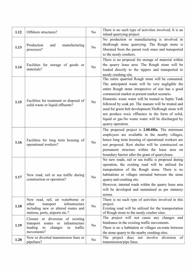
1.31 Any other actions? No
Temporary approach road will be formed and
maintain within the lease area.
Tippers will be transport the Rough stone to needy
crushers by existing road. (already in good
condition)
No long term dismantling or decommissioning is
involved in this project. This project is sites specific
and may not have any significant impact on the
environment.
2. Use of Natural resources for construction or operation of the project (such as land, water,
materials or energy, especially any resources which are non -renewable or in short supply):
S. No Information/Checklist confirmation Yes/
No
Details thereof (with approximate
quantities/rates, wherever possible) with
sources of information data
2.1 Land especially undeveloped or
agricultural land (ha) No
Total quarry lease area is 2.00.0Ha,It is a
Government land, the applicant has obtained tender
from the Government.
The lease area exhibits hilly terrain.Theoutcrop of
the massive Rough stone formation is clearly
inferred. The slope is gentle towards Southern
side. The altitude of the area is above 272m
(Maximum) from MSL.
2.2 Water (expected source & competing
users) unit: KLD Yes
The project does not require huge water for
quarrying operation, about 1 KLD of water will be
used for the project.(More than 5 L/Person)
1. Drinking Water –0.3KLD
& Domestic purpose
2. Dust Suppression – 0.3 KLD
3. Green belt - 0.4 KLD
Total – 1 KLD
0.3 KLD of Packaged Drinking water will be
brought from the approved water vendors in
Punjaithuraiyampalayamvillage which is about
4kmon the Southeastern side of the area.
Water for dust suppression and Green belt
development around 0.3 KLD & 0.4 KLD.Total
requirement for the project is around 1KLD.
2.3 Minerals (MT) No No minerals used for construction purposes.

2.4
Construction material - Stone,
aggregates, and/Soil (expected source-
MT)
No The proposed Rough stone quarry project does
not require any construction material.
2.5 Forests and timber (source-MT) No There is no forests and timber (source –MT)
2.6
Energy including electricity and fuels
(source, competing users) unit: fuel
(MT),Energy (MW)
Yes
The limited scale of activities adopted in Rough
stone quarrying does not require high-tension
electric power supply. The quarrying operation is
only for daytime. The electricity will be used only
for mine office and lighting around the quarry
during night time. The existing electric line near
the quarry site will be used.
Fuels are used for operating machineries and
vehicles during quarrying process and
transportation. Fuel required for this project life is
about 88640 Litersof HSD for entire project life.
2.7 Any other natural resources (use
appropriate standard units) No No other natural resource will be required.
3. Use, storage, transport, handling or production of substances or materials, which could be
harmful to human health or the environment or raise concerns about actual or perceived risks to
human health.
S. No Information/Checklist confirmation Yes/
No
Details thereof (with approximate
quantities/rates, wherever possible) with
sources of information data
3.1
Use of substances or materials, which
are hazardous (as per MSIHC rules) to
human health or the environment (flora,
fauna, and water supplies)
No
There is no proposal for storage, handling or
transportation of any hazardous materials or
substances as per MSIHC rules in this Rough
stone quarry project.
3.2
Changes in occurrence of disease or
affect disease vectors (e.g. insect or
water borne diseases)
No
The Rough stone does not produce any toxic
effluent in the form of solid, liquid and gas,
hence the diseases related to insect or water
borne diseases is not envisaged. There is no
proposal of storage of water inside the project
area. The seepage water and rain water will be
drained immediately by 5HP pumps and it will be
used for Green Belt Development and for dust
suppression on haul and quarry roads.

3.3 Affect the welfare of people e.g. by
changing living conditions? No
Welfare of people will get positive change due to
the project, where a number of Welfare activities
are being undertaken. Due to increase of the
employment earning of local people and lifestyle
of the people will enhance, around 11 peoples
will be directly benefit to this project.
No child labor will be engaged for any
type of quarrying operation. All the labor will be
insured and the salary and benefits will be paid as
per the Labor enforcement officers(Ministry of
labor and welfare) Norms
3.4
Vulnerable groups of people who could
be affected by the project e.g. hospital
patients, children’s, the elderly etc.,
No
There is no effect envisaged for the vulnerable
groups of people who could be affected by the
project. The Rough stone will be transported to
the needy crusher by tarpaulin cover to prevent
spillage.
3.5 Any other causes No There is no othercause are envisaged.
4. Production of solid wastes during construction or operation or decommissioning MT/mounts)
S. No Information/Checklist confirmation Yes/
No
Details thereof (with approximate
quantities/rates, wherever possible) with
sources of information data
4.1 Spoil, overburden or mine wastes No
The Rough stone quarrying does not produce any
waste. The entire Rough stone irrespective of
size will be sold in commercial market.
Waste storage does not arise.
4.2 Municipal waste (domestic and or
commercial wastes) Yes
The small quantity of Municipal waste will be
generated shall be disposed as per guidelines.
4.3 Hazardous wastes (as per Hazardous
Waste Management Rules) No
In this quarrying activities waste oil will be
generated during the operation period it will be
sent to authorize Re- Circulars as per SPCB/
CPCB norms. Care and maintenance of vehicles
by experience qualified mechanics will be
undertaken to prevent breakdown and spillage of
oils and lubes.
4.4 Other industrial process wastes No Industrial wastages are not generated during the
quarrying operation.
4.5 Surplus product No There is no such type of activities in this quarry.
4.6 Sewage sludge or other sludge form
effluent treatment Yes
Sanitary facilities will be constructed
onpermanent structure and the sewage waste will
be disposed periodically as per the norms.
4.7 Construction or demolition wastes No No Construction or demolition wastes involved
in this quarry.
4.8 Redundant machinery or equipment No No redundant machineries involved in this
project.
4.9 Contaminated soils or other materials No There is no a contaminated material or soil
observed in the quarrylease area.
4.10 Agricultural wastes No There is no agricultural waste anticipated.
4.11 Other solid wastes No There is no other solid waste anticipated.
5. Release of pollutants or any hazardous, toxic or noxious substances to air (Kg/hr)
S. No Information/Checklist confirmation Yes/
No
Details thereof (with approximate
quantities/rates, wherever possible) with
sources of information data
5.1 Emissions from combustion of fossil
fuels from stationary or mobile sources Yes
The emissions of SO2 (Sulfur dioxide) &NO2
(Nitrogen dioxide) may be due to use of diesel
operated quarry machinery and vehicles.Better
maintenance of equipment in good condition will
help to reduce such emissions.
5.2 Emissions from production processes Yes
Dust is the main pollutant produced in the
proposed activity. Emission from loading,
drilling and blasting but they will be maintained
within limits by proper maintenance and
sprinkling of water and Afforestation
developments. Tarpaulin covers will be covered
in vehicles during transportation.
5.3 Emissions from materials handing
including storage or transport Yes
Fugitive dust will be generated from material
handling activities.
Dust suppression by water sprinklers will be
provided to prevent the fugitive dust emissions
during loading. Tarpaulin covers will be covered
in vehicles during transportation.
5.4 Emissions form construction activities
including plant and equipment No
No major construction activities are envisaged.
It’s a conventional Eco friendly quarrying
operation.
5.5
Dust or odors form handling of
materials including construction
materials, sewage and waste
No
Minor Dust will be generated during breaking of
rocks, transportation of Rough stone and it will
be controlled. However, there is no possibility of
any odor generation as there are no organic
solvents/processes involved.
5.6 Emissions from incineration of waste No The Rough stone quarrying does not produce
any toxic effluent.
5.7
Emissions from burning of waste in
open air (e.g. slash materials,
construction debris)
No There is no such type of activities involved in
this quarry project.
5.8 Emissions from any other sources No Emissions from other sources are not envisaged.
6. Generation of Noise and Vibration, and Emissions of Light and Heat:
S. No Information/Checklist confirmation Yes/
No
Details thereof (with approximate
quantities/rates, wherever possible) with
sources of information data
6.1 From operation of equipment e.g.
engines, ventilation plant, crushers Yes
Due to operation of machineries there is likely
hood of some increase in noise level. The noise
level at site will be maintained below
permissible limit. Measures like lubrication &
preventive maintenance shall be taken to control
noise from the machineries.
The vibration during the moment of machinery
will be minimal for a short span that will be well
within the prescribed limits.
6.2 From industrial or similar processes No There is no proposal of processing plant.
6.3 From construction or demolition No No construction or demolition work takes place.
6.4 From blasting or piling No
The quarrying activity will be carried out
blasting for shattering effect and loosen the
Rough stone. However, controlled blasting
measures will be adopted for minimizing ground
vibration.
6.5 From construction or operational
traffic Yes
The transport of Rough stone through tippers
can produce noise but are maintained within
permissible limits, by keeping machinery in
proper condition as per RTO & TNPCB Norms
and maintenance under experience and qualified
mechanics.
6.6 From lighting or cooling systems No
The quarry operation will be carried out at the
day time only hence the lighting and cooling
systems are not required.
6.7 From any other sources No
This quarrying project is site specific which is
operated by jackhammer drilling and limited
blasting;hence external power other than HSD is
not involved in this project.
7. Risks of contamination of land or water from releases of pollutants into the ground
or into sewers, surface water, ground water, coastal water or the sea:
S. No Information/Checklist confirmation Yes/
No
Details thereof (with approximate
quantities/rates, wherever possible) with
sources of information data
7.1 From handling, Storage, use or
spillage of hazardous materials No
No hazardous materials will be used in the
process.
Oiling and lubrication of hauling vehicles will
be done by using oil tray to prevent spillage of
oil.
Vehicles and machinery will be well maintained
to prevent leakage of oil.
7.2
The discharge of sewage will be
collected on soap pits will be
discharge to a place authorized by
municipal authorizes as per guidelines
No
Septic tank will be cleaned periodically and the
sludge generated will be used as manure in the
green belt.
7.3 By deposition of pollutants emitted to
air into the land or into water No
There is likely hood of increase of Particulate
Matter due to quarrying operations. Regular
sprinkling of water will suppress dust at
points/places of generation.
7.4 From any other sources No
An efficient and effective management plan is
proposed for the project; hence it may not have
any significant impact on the surrounding
environment.
7.5
Is there a risk of long term buildup of
pollutants in the environment from
these sources?
No
No such type of activities not involved in this
quarry.
8. Risk of accidents during construction or operation of the project, which could
affect human health or the environment
S. No Information/Checklist confirmation Yes/
No
Details thereof (with approximate
quantities/rates, wherever possible) with
sources of information data
8.1
From explosions, spillages, fires etc.,
form storage, handling, use or
production of hazardous substances
No
The drilling and blasting are involved in the
project for liberation and splitting of Rough
stone. The explosive materials will be
brought from authorized explosive license
holder during blasting. There is no proposal
of storage of explosives after the grant of
quarry lease.
8.2 From any other causes Yes
The risks of accidents are envisaged in
quarry operations, failure of quarry pit
slopes, excavators, tipper movement, etc.
However, all safety measures shall be taken
to prevent any accidents. The quarrying
activities will be monitored under the
supervision of experienced and qualified
competent mines foreman.

8.3
Could the project be affected by natural
disasters causing environmental damage
(e.g. floods, earthquakes, landslides,
cloudburst etc.)?
No
There is no earthquake, floods, Landslides,
cloud burst recorded in the lease area.It’s an
opencast quarrying, hence this project could
not affect severely due to the natural
disasters.
9. Factors which should be considered (such as consequential development) which could
lead to environmental effects to environmental effects or the potential for cumulative impacts
with other existing or planned activities in the locality
S. No Information/Checklist confirmation Yes/
No
Details thereof (with approximate
quantities/rates, wherever possible) with
sources of information data
9.1
Lead to development of supporting.
cities, ancillary development or
development stimulated by the project
which could have impact on the
environment e.g.:
• Supporting infrastructure (roads,
power supply, waste or waste
treatment, etc.)
• housing development
• extractive industries
• supply industries
• other
No
Living standard will be improved of the
nearby villagers.
Theproposed project shall directly/indirectly
develop the area by providing employment,
tax to government, development of ancillary
units, shopkeeper, supermarket, mechanic
shed etc.,
The workers are available from the nearby
villages, hence the project will not attract
housing Development, Extractive industries,
supply industries or any other activities.
9.2 Lead to after- use of the site, which
could havean impact on environment No
The land does not used after the completion
of quarrying operation the fencing will be
constructed around the quarried pits to
prevent the inherent entry of public and
cattle.
9.3 Set a precedent for later developments No
A better after use scenario with increase in
greenery, besides the quarried out pit will
act as a temporary reservoir which will
enhance the static level of the Ground water
in the nearby wells.
9.4
Have cumulative effects due to
proximity to other existing or planned
projects with similar effects
No
No cumulative impacts are envisaged.

(III) Environmental Sensitivity
S.
No Areas
Name/
identity
Aerial distance (within 15 km.)
Proposed project location boundary
1
Areas protected under international
conventions, national or local
legislation for their ecological,
landscape, cultural or other related
value
No
There are no such protected areas like
ecological landscape, cultural area etc.
identified within the 15 Km radius.
2
Areas which are important or sensitive
for ecological reasons - Wetlands,
watercourses or other water bodies,
coastal zone, biospheres, mountains,
forests
No
There is no coastal zone, Eco sensitive zone
within the radius of 15Km. The area does not
fall in HACA region.
Sathyamangalam Tiger Reserve
(Guthiyalathur Reserve forest) is located
about 15m on the Northern side of the lease
area.
The lease area falls in Western Ghats region.
Kunderippallam Dam is situated about 6km
away from the Northwestern side of the area.
3
Areas used by protected, important or
sensitive species of flora or fauna for
breeding, nesting, foraging, resting,
over wintering, migration
No There is no protected sensitive species are
identified within the 15km radius.
4 Inland, coastal, marine or
underground waters No
There is no Inland, coastal, and marine or
underground water around the site.
5 State, National boundaries No There is noState, National boundarieswithin
15 Km radius
6
Routes or facilities used by the public
for access to recreation or other
tourist, pilgrim areas
No There is no tourist, pilgrim areas within 15
Km radius
7 Defense installations No No defense installation found within 15Kms
from the project area.
8 Densely populated or built-up area Yes
Kempanaickenpalayamis densely populated
village. This is about 10km on Northwestern
side of the area.
S.
No Name of the Village
Approximate
distance &
Direction
from lease
area
Approximate
population
1. PudhuThottam 6km – NE 700
2. Kempanaickenpalayam 10km- NW 800
3 PujaiThuraiyampalayam 4km -SE 600
4 Kavandampalayam 3km - SW 500
9
Areas occupied by sensitive man-
made land uses
(hospitals, schools, places of worship,
community facilities)
Yes
Pujaithuraiyampalayamis having all the
facilitieswhich are at a distance of
4kmonSoutheasternside of lease area.
10
Areas containing important, high
quality or scarce resources
(ground water resources, surface
resources, forestry, agriculture,
fisheries, tourism, minerals)
No
The quarry operation is restricted to only 25m
(15m above the ground level + 10m below the
ground level) for a remaining period of Five
years. Hence the ground water will not be
affected beside the area is devoid of
agriculture, Forestry, Tourist place etc.,
11
Areas already subjected to pollution
or environmental damage. (those
where existing legal environmental
standards are exceeded)
No
This is the fresh quarry project, hence the area
has not subjected to pollution or
environmental damage. The atmosphere is
quite fresh and it is proposed to carry out the
quarrying operations an Eco friendly manner.
12
Areas susceptible to natural hazard
which could cause the project to
present environmental problems
(earthquakes, subsidence, landslides,
erosion, flooding or extreme or
adverse climatic conditions)
No
The areas are not susceptible to natural
hazards like landslides, earthquake, it is a high
stable land. There are no evidences recorded
in the past history.
“I hereby given undertaking that the data and information given in the application and enclosures
are true to the best of my knowledge and belief and I am aware that if any part of the data and
information submitted is found to be false or misleading at any stage, the project will be rejected
and clearance give, if any to the project will be revoked at our risk and cost.
Date:
Place: Erode
1. Signature of the proponent withNameand Full Address
J.K.M.Jeyaprakash,
S/o. J.K.K.Muniraja,
330, Salem main road,
AnnaiIllam, Kumarapalayam,
TiruchengodeTaluk,
Namakkal District
Mobile No: 7598614661
2. Signature of the Recognized qualified person
A.Jagannathan, BE, F.C.C., M.M.E.A.,
RQP/MAS/019/87/A


�������� ����
NOT TO SCALE
���� � �
�����
Q. L.AREA :
TOPO SHEET NO : 57 E / 06
���������� ����������
���������� ����������
����������
����������
����� ����
DATE OF SURVEY : 11.05.2015
������
Thiru.J.K.M.JEYAPRAKASH,
S/o.J.K.K.MUNIRAJA,
SALAM MAIN ROAD,
ANNAI ILLAM,KUMARAPALAYAM.
�������� �! "#�$$% �����
�$��
S.F.NO : 10/(PART)
EXTENT : 2.00.0 Ha.
VILLAGE : PUNJAITHURAIYAMPALAYAM,
TALUK : GOPICHETTIPALAYAM,
DISTRICT : ERODE,
STATE : TAMIL NADU.
PR
OD
UC
ED
BY
AN
AU
TO
DE
SK
ED
UC
AT
ION
AL
PR
OD
UC
TPRODUCED BY AN AUTODESK EDUCATIONAL PRODUCT
PR
OD
UC
ED
BY
AN
AU
TO
DE
SK
ED
UC
AT
ION
AL
PR
OD
UC
TPRODUCED BY AN AUTODESK EDUCATIONAL PRODUCT

����� �����
�� ��� �� �
���� ������ �� ������
����� ���� ���
���� ������
ROADSHard surface
Loose surface
RAILROADS
BOUNDARIES
�����
TOPO SHEET NO :57 E / 06
!" #"$%& !" #'(%&
))!("#"$%* ))!("#'(%*
!")#+,%&
!(-# (%&
�������
Thiru.J.K.M.JEYAPRAKASH,
S/o.J.K.K.MUNIRAJA,
SALAM MAIN ROAD,
ANNAI ILLAM,KUMARAPALAYAM.
�������� �� ������ �����
�����
S.F.NO : 10/(PART)
EXTENT : 2.00.0 Ha.
VILLAGE : PUNJAITHURAIYAMPALAYAM,
TALUK : GOPICHETTIPALAYAM,
DISTRICT : ERODE,
STATE : TAMIL NADU.
PR
OD
UC
ED
BY
AN
AU
TO
DE
SK
ED
UC
AT
ION
AL
PR
OD
UC
T
PRODUCED BY AN AUTODESK EDUCATIONAL PRODUCT
PR
OD
UC
ED
BY
AN
AU
TO
DE
SK
ED
UC
AT
ION
AL
PR
OD
UC
T
PRODUCED BY AN AUTODESK EDUCATIONAL PRODUCT

TOPO SHEET NO :57 E / 06
���������� ����������
������� �������
�� ��
APPROACH ROAD
VILLAGE ROAD
HABITATION
TREES
AGRICULTURE LAND
PIT
W IND DIRECTION
HILL
BARREN LAND
e ee
�������� �� �
����� ��� !"
ROADS (15%)
HABITATION (10%)
TREES (15%)
AGRICULTURE LAND (20%)
PIT (10%)
HILL (25%)
BARREN LAND (05%)
e ee
DESCRIPTION PERCENTAGE INDEX
LANDUSE PATTERN
bbb
��##���
Thiru.J.K.M.JEYAPRAKASH,
S/o.J.K.K.MUNIRAJA,
SALAM MAIN ROAD,
ANNAI ILLAM,KUMARAPALAYAM.
��$�� �� �% &'�(() ���#�
�(���
S.F.NO : 10/(PART)
EXTENT : 2.00.0 Ha.
VILLAGE : PUNJAITHURAIYAMPALAYAM,
TALUK : GOPICHETTIPALAYAM,
DISTRICT : ERODE,
STATE : TAMIL NADU.
bbb
bbb
e
e
ee
e
e
e
ee
ee
e
ee e
e
e
ee
e
e
e
e
e
e
e
e
e
ee
e
e
e
e
eee
e
e
e
e
e
e
e
e
e
e
ee
e
e
e
e
e
e
e
e
e
e
e
e
e
e
e
e
e
e
ee
e
e
e
e
ee
ee
e
e
e
e
e
e
e
e
ee
e
e
e
e
e
ee
**+,*-./01
**+,2-*301
**+,*-*401
**+,*-5,01
66789:;<=>
??@ABCDBEF
GGHIJKLMNO
GGHIJKPJNO
TowardsThuckanaickenpalayam
Tow
ard
sBu
ngalo
wpud
ur
Towards
Thuckanaickenpalayam
e
e
e
e
e
e
e
PR
OD
UC
ED
BY
AN
AU
TO
DE
SK
ED
UC
AT
ION
AL
PR
OD
UC
T
PRODUCED BY AN AUTODESK EDUCATIONAL PRODUCT
PR
OD
UC
ED
BY
AN
AU
TO
DE
SK
ED
UC
AT
ION
AL
PR
OD
UC
T
PRODUCED BY AN AUTODESK EDUCATIONAL PRODUCT

18.0Km
�� �� ����
S TATE HIGHWAY
VILLAGE ROAD
APPROACH ROAD
HABITATION
��� �� ���
Sathiyam angalam
Gopichettipalayam
Karattadipalayam4.5Km
5.7
Km
Bungalowputhur
Thuckanaickenpalayam
2.1Km
16.7Km
Athani
12.6Km2.5
Km
���
Thiru.J.K.M.JEYAPRAKASH,
S/o.J.K.K.MUNIRAJA,
SALAM MAIN ROAD,
ANNAI ILLAM,KUMARAPALAYAM.
������� �� ������ ���
���
S.F.NO : 10/(PART)
EXTENT : 2.00.0 Ha.
VILLAGE : PUNJAITHURAIYAMPALAYAM,
TALUK : GOPICHETTIPALAYAM,
DISTRICT : ERODE,
STATE : TAMIL NADU.
PR
OD
UC
ED
BY
AN
AU
TO
DE
SK
ED
UC
AT
ION
AL
PR
OD
UC
T
PRODUCED BY AN AUTODESK EDUCATIONAL PRODUCT
PR
OD
UC
ED
BY
AN
AU
TO
DE
SK
ED
UC
AT
ION
AL
PR
OD
UC
T
PRODUCED BY AN AUTODESK EDUCATIONAL PRODUCT

1
2
3
4
5
6
7
�����
Q.L. AREA BOUNDARY
7.5m SAFETY DISTANCE
TEMPORARY BENCH MARK
APPROACH ROAD
CONTOUR
QUARRY ROAD
STRIKE&DIP
QUARRY PIT
ROUGH STONE
����� ���� � ��� ��� ���
SCALE 1 : 1000
������
Thiru.J.K.M.JEYAPRAKASH,
S/o.J.K.K.MUNIRAJA,
SALAM MAIN ROAD,
ANNAI ILLAM,KUMARAPALAYAM.
������� � ����� ����
�����
S.F.NO : 10/(PART)
EXTENT : 2.00.0 Ha.
VILLAGE : PUNJAITHURAIYAMPALAYAM,
TALUK : GOPICHETTIPALAYAM,
DISTRICT : ERODE,
STATE : TAMIL NADU.
���� �����
DATE OF SURVEY : 11.05.2015
�������� �� �
+ +PR
OD
UC
ED
BY
AN
AU
TO
DE
SK
ED
UC
AT
ION
AL
PR
OD
UC
T
PRODUCED BY AN AUTODESK EDUCATIONAL PRODUCT
PR
OD
UC
ED
BY
AN
AU
TO
DE
SK
ED
UC
AT
ION
AL
PR
OD
UC
T
PRODUCED BY AN AUTODESK EDUCATIONAL PRODUCT

�����
Q.L. AREA BOUNDARY
7.5m SAFETY DISTANCE
TEMPORARY BENCH MARK
APPROACH ROAD
CONTOUR
QUARRY ROAD
STRIKE&DIP
QUARRY PIT
ROUGH STONE
�������
Thiru.J.K.M.JEYAPRAKASH,
S/o.J.K.K.MUNIRAJA,
SALAM MAIN ROAD,
ANNAI ILLAM,KUMARAPALAYAM.
������ �� ���� ����
���
S.F.NO : 10/(PART)
EXTENT : 2.00.0 Ha.
VILLAGE : PUNJAITHURAIYAMPALAYAM,
TALUK : GOPICHETTIPALAYAM,
DISTRICT : ERODE,
STATE : TAMIL NADU.
���� ������
DATE OF SURVEY : 11.05.2015
�������� �� �
+ +
������������������ �
������� ������� ��� !
��������� ��� ! �������
SCALE 1 : 1000
SECTION HOR 1 : 1000, VER 1: 500
c
c
c
c
c
+ +
+ +
+ +
+ +
+ +
1
2
3
4
5
6
7
15m
6m
23m
36m
36m
4m
30m
25m
25m
21m 51m
3m
3m
96m 86m
79m
111m
38m 69m
+++++++++++++++
++++++++++
+
++++++++++++++++
+++
++
+ +
+ + + + +
+ + + + + + + + + + + + + + +
+ +
34m
33m
31m 15m
"#$%$&' ( ")%' *+&, -%$ "+''$#&
cc
cc c
cc
cc
c
.
PR
OD
UC
ED
BY
AN
AU
TO
DE
SK
ED
UC
AT
ION
AL
PR
OD
UC
T
PRODUCED BY AN AUTODESK EDUCATIONAL PRODUCT
PR
OD
UC
ED
BY
AN
AU
TO
DE
SK
ED
UC
AT
ION
AL
PR
OD
UC
T
PRODUCED BY AN AUTODESK EDUCATIONAL PRODUCT
�����
Q.L. AREA BOUNDARY
7.5m SAFETY DISTANCE
TEMPORARY BENCH MARK
APPROACH ROAD
CONTOUR
QUARRY ROAD
STRIKE&DIP
QUARRY PIT
ROUGH STONE
�������
Thiru.J.K.M.JEYAPRAKASH,
S/o.J.K.K.MUNIRAJA,
SALAM MAIN ROAD,
ANNAI ILLAM,KUMARAPALAYAM.
������ �� ���� ����
���
S.F.NO : 10/(PART)
EXTENT : 2.00.0 Ha.
VILLAGE : PUNJAITHURAIYAMPALAYAM,
TALUK : GOPICHETTIPALAYAM,
DISTRICT : ERODE,
STATE : TAMIL NADU.
���� �����
DATE OF SURVEY : 11.05.2015
�������� �� �
+ +
������� ��� � �������
SCALE 1 : 1000
SECTION HOR 1 : 1000, VER 1: 500
c
c
c
c
c
1
2
3
4
5
6
7
88m 79m
64m
96m
31m 61m
+++
++
+
+++++
++
++
+
+ +
+ + + + +
+
cc
cc c
cc
cc
c
�
PR
OD
UC
ED
BY
AN
AU
TO
DE
SK
ED
UC
AT
ION
AL
PR
OD
UC
T
PRODUCED BY AN AUTODESK EDUCATIONAL PRODUCT
PR
OD
UC
ED
BY
AN
AU
TO
DE
SK
ED
UC
AT
ION
AL
PR
OD
UC
T
PRODUCED BY AN AUTODESK EDUCATIONAL PRODUCT
PREPREPREPRE----FEASIBILITY REPORTFEASIBILITY REPORTFEASIBILITY REPORTFEASIBILITY REPORT
(Under the Guidelines of Ministry of Environment and Forest in terms of the provisions of
EIA notification 2006 and specifically in circular No J-11013/41/2006-IA.II (I) dated 30th December, 2010)
Minor Mineral – Rough stone
Mining Project – Category “B2”
Lease Area – 2.00.0Ha (less than 5Ha)
S.F.No. – 10 (Part)
Village – Punjaithuraiyampalayam
Taluk – Gobichettipalayam
District – Erode
State – Tamilnadu
PROJECT PROPONENTPROJECT PROPONENTPROJECT PROPONENTPROJECT PROPONENT
J.K.M.Jeyaprakash,
S/o. J.K.K.Muniraja,
330, Salem main road,
Annai Illam, Kumarapalayam,
Tiruchengode Taluk,
Namakkal District
1.1.1.1. EXECUTIVE SUMMERYEXECUTIVE SUMMERYEXECUTIVE SUMMERYEXECUTIVE SUMMERY J.K.M.Jeyaprakash has been obtained permission from District collector Erode to quarry
Rough stone over an extent of 2.00.0Ha in Survey No: 10 (Part), Punjaithuraiyampalayam
Village, Gobichettipalayam Taluk, Erode District, Tamilnadu state by District Collector
Erode, Rc.No. 12077/2015-35 /X-1 Dated: 06.05.2015, for a remaining period of Five years
subjected to submission of Environmental clearance from MoEF / SEIAA, consent for
Establishment and Consent for operation from TNPCB.
SALIENT FEATURES OF THE PROJECTSALIENT FEATURES OF THE PROJECTSALIENT FEATURES OF THE PROJECTSALIENT FEATURES OF THE PROJECT
S.NO PARTICULAR DETAILS
1. Name of the Proponent J.K.M.Jeyaprakash
2. Type of Project Rough stone
3. Location Survey No. 10 (Part)
Punjaithuraiyampalayam Village,
Gobichettipalayam Taluk,
Erode District,
4. Mining lease area 2.00.0Ha
5. Type of land
Patta/forest/PWD
Government land- Non forest
6. Precise area communication
approved by the District
collector
The proceeding letter was received from the District
Collector, Erode vide Rc.No. 74287/2010/X-1 Dated:
11.01.2011
The Collector letter was received from the District
collector Erode vide Rc.No. 12077/2015-35 /X-1
Dated: 06.05.2015
7. Mining plan approved by the
Deputy/Assistant Director of
the District
The Mining Plan was got approval by the Assistant
Director, Department of Geology and Mining, Erode
vide Rc.No. 10911/2015-17/X-1 Dated: 02.07.2015
8. Life of period The lease deed was executed 11.01.2011 and the lease
will get expiry on 10.01.2021. The remaining lease
period is about five years.
9. Production capacity The proposed quantity of reserves for remaining plan
period is to be mine is 110790m3(or) 19574 Lorry
Loads of Rough stone up to a depth of 25m (15m
above the ground level + 10m below the ground level)
for a period of Five years .
Description Rough stone
in m3
Geological Resources 386935
Available Mineable reserves 110790
Five years plan period As in the
approved mining plan
110790

10. Method of Mining The quarrying operation will be carried out by Semi
Mechanized Opencast Method in conjunction with
conventional method of mining using Jack hammer
drilling and blasting, excavation, loading and
transportation of Rough stone to the needy crushers.
11. Ultimate depth of Mining Proposed depth of mining is 25m (15m above the
ground level + 10m below the ground level)
12. Latitude 11031’35’’N to 11
031’42’’N
13. Longitude 77023’35’’E to 77
023’43’’E
14. Topo sheet No. 57 E/06
15. Topography of MSL area 272m from MSL
16. Land use classification It is a Fresh Quarry lease of Rough stone quarry (the
area has been quarrying operation earlier) in
Punjaithuraiyampalayam Village
17. Ground water level 45m to 40m water table in summer to rainy season
18. Climatic condition Rainfall – 850/annum
Temperature -42ºC - 23ºC
19. Land use pattern
Description Present
area in
Ha,
Area at the
end of the
lease period
Ha Area Under Quarrying 0.58.5 1.54.0
Infrastructure Nil 0.01.0 Roads 0.01.0 0.02.0
Green belt Nil 0.10.0
Unutilized 1.40.5 0.33.0
Grand Total 2.00.0 2.00.0
20. Nearest habitation Punjaithuraiyampalayam - 4.0km -SE
21. Nearest Town Gobichettipalayam - 9km -SE
22. Nearest Railway station Ingur -39km -SE
23. Nearest Airport Coimbatore - 67km SW
24. Nearest National Highways &
State Highways
NH 209 – Sathyamangalam - Coimbatore -17km- SW
SH 82 – Sathyamangalam –Athani -3km- S
25. Nearest Hospital Punjaithuraiyampalayam - 4km -SE
26. Aerial distance to the nearest
Eco sensitive areas, CRZ,
forest, wild life sanctuary,
Interstate boundary, critically
polluted area if the quarry site
is within 500m of these areas.
More than 500m from Eco sensitive areas, CRZ,
forest, wild life sanctuary, Interstate boundary,
critically polluted area.
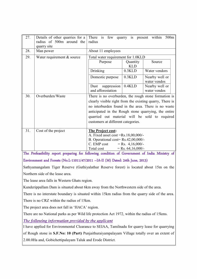
27. Details of other quarries for a
radius of 500m around the
quarry site
There is few quarry is present within 500m
radius
28. Man power About 11 employees
29. Water requirement & source Total water requirement for 1.0KLD
Purpose Quantity
KLD
Source
Drinking 0.3KLD Water vendors
Domestic purpose 0.3KLD Nearby well or
water vendos
Dust suppression
and afforestation
0.4KLD Nearby well or
water vendos
30. Overburden/Waste There is no overburden, the rough stone formation is
clearly visible right from the existing quarry, There is
no interburden found in the area. There is no waste
anticipated in the Rough stone quarrying, the entire
quarried out material will be sold to required
customers at different categories.
31. Cost of the project The Project cost:
A. Fixed asset cost =Rs.18,00,000/-
B. Operational cost= Rs.42,00,000/-
C. EMP cost = Rs. 4,16,000/-
Total cost = Rs. 64,16,000/-
The Prefeasibility report preparing for following condition of GovernmThe Prefeasibility report preparing for following condition of GovernmThe Prefeasibility report preparing for following condition of GovernmThe Prefeasibility report preparing for following condition of Government of India Ministry of ent of India Ministry of ent of India Ministry of ent of India Ministry of
Environment and Forests (No.LEnvironment and Forests (No.LEnvironment and Forests (No.LEnvironment and Forests (No.L----11011/47/2011 11011/47/2011 11011/47/2011 11011/47/2011 ––––IAIAIAIA----II (M) Dated: 24th June, 2013)II (M) Dated: 24th June, 2013)II (M) Dated: 24th June, 2013)II (M) Dated: 24th June, 2013)
Sathyamangalam Tiger Reserve (Guthiyalathur Reserve forest) is located about 15m on the
Northern side of the lease area.
The lease area falls in Western Ghats region.
Kunderippallam Dam is situated about 6km away from the Northwestern side of the area.
There is no interstate boundary is situated within 15km radius from the quarry side of the area.
There is no CRZ within the radius of 15km.
The project area does not fall in ‘HACA’ region.
There are no National parks as per Wild life protection Act 1972, within the radius of 15kms.
I have applied for Environmental Clearance to SEIAA, Tamilnadu for quarry lease for quarrying
of Rough stone in S.F.No: 10 (Part) Punjaithuraiyampalayam Village totally over an extent of
2.00.0Ha and, Gobichettipalayam Taluk and Erode District.

I will not deploy any child labors below 18 years for any type of quarrying operation. All labours
engaged for quarrying operation will be insured till the end of life of quarry period.
All type of safety / protective equipment’s will be provided to all the labourers working in my
quarry site.
I will sincerely follow and execute the afforestation and Green belt during the course of
quarrying operation and maintain afforestation after the expiry of quarrying lease.
I ensure to involve and participate in the corporate social responsibilities of the local community
as declared in the report.
The quarry operation has not been commenced and will likely to operate after grant of
Environmental clearance and grant of quarry lease.
I solemnly declare & affirm that there are few quarries within 1Km radius from the periphery of
the quarry site.
S.No. Name of the
Owner
Extent Lease
Period
Lease
Status
1.
2.
Besides I wish to state that the approach roads belong to me only and no other pattaroads are
encountered.
No habitations / Village are located within 500 meters radius from the periphery of my quarry.
The quarrying operation will not cause any hindrance to the nearby public and also it will not
cause any hindrance to nearby villagers and human settlements during transportation of mineral.
I wish to state there is no protected areas notified within the radius of 10km from the proposed
quarry site under the Wildlife (protection) Act. 1972.
No critically polluted areas as identified within the radius of 10km from the quarry site by CPCB
constituted under water (prevention and control of pollution) Act, 1974.
No Eco Sensitive areas as identified within the radius of 10km from the proposed quarry site.
There is no Interstate and International boundary within 5km radius from the boundary of the
quarry site.
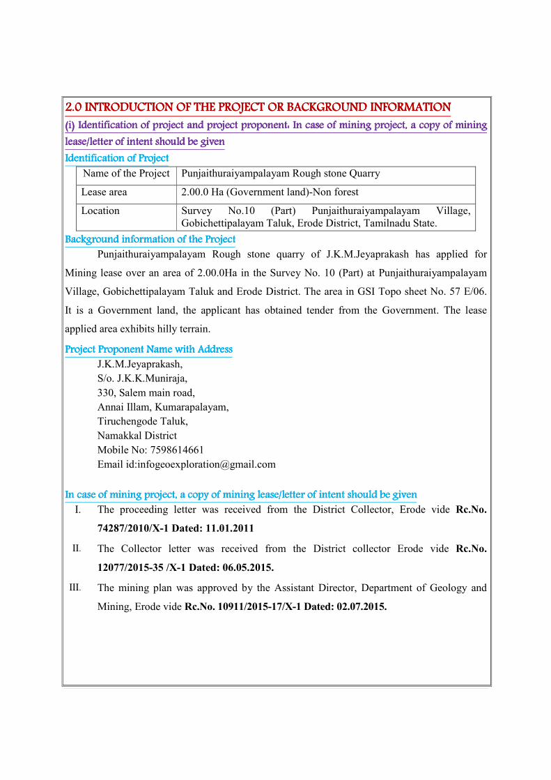
2.02.02.02.0 INTRODUCTION OF THE PROJECT OR BINTRODUCTION OF THE PROJECT OR BINTRODUCTION OF THE PROJECT OR BINTRODUCTION OF THE PROJECT OR BACKGROUND INFORMATIONACKGROUND INFORMATIONACKGROUND INFORMATIONACKGROUND INFORMATION
(i) (i) (i) (i) Identification oIdentification oIdentification oIdentification of project and project proponent: f project and project proponent: f project and project proponent: f project and project proponent: In case of miningIn case of miningIn case of miningIn case of mining project, a copy of mining project, a copy of mining project, a copy of mining project, a copy of mining
lease/llease/llease/llease/letter of intent should be givenetter of intent should be givenetter of intent should be givenetter of intent should be given
Identification of ProjectIdentification of ProjectIdentification of ProjectIdentification of Project
Name of the Project Punjaithuraiyampalayam Rough stone Quarry
Lease area 2.00.0 Ha (Government land)-Non forest
Location Survey No.10 (Part) Punjaithuraiyampalayam Village,
Gobichettipalayam Taluk, Erode District, Tamilnadu State.
Background information of the ProjectBackground information of the ProjectBackground information of the ProjectBackground information of the Project
Punjaithuraiyampalayam Rough stone quarry of J.K.M.Jeyaprakash has applied for
Mining lease over an area of 2.00.0Ha in the Survey No. 10 (Part) at Punjaithuraiyampalayam
Village, Gobichettipalayam Taluk and Erode District. The area in GSI Topo sheet No. 57 E/06.
It is a Government land, the applicant has obtained tender from the Government. The lease
applied area exhibits hilly terrain.
Project ProponentProject ProponentProject ProponentProject Proponent Name with AddressName with AddressName with AddressName with Address
J.K.M.Jeyaprakash,
S/o. J.K.K.Muniraja,
330, Salem main road,
Annai Illam, Kumarapalayam,
Tiruchengode Taluk,
Namakkal District
Mobile No: 7598614661
Email id:[email protected]
In case of mining project, a copy of mining lease/letter of intent should be givenIn case of mining project, a copy of mining lease/letter of intent should be givenIn case of mining project, a copy of mining lease/letter of intent should be givenIn case of mining project, a copy of mining lease/letter of intent should be given
I. The proceeding letter was received from the District Collector, Erode vide Rc.No.
74287/2010/X-1 Dated: 11.01.2011
II. The Collector letter was received from the District collector Erode vide Rc.No.
12077/2015-35 /X-1 Dated: 06.05.2015.
III. The mining plan was approved by the Assistant Director, Department of Geology and
Mining, Erode vide Rc.No. 10911/2015-17/X-1 Dated: 02.07.2015.

(ii) (ii) (ii) (ii) Brief descriBrief descriBrief descriBrief description of nature of the projectption of nature of the projectption of nature of the projectption of nature of the project
The Rough stone quarrying operation is proposed to carry out by conventional opencast
Semi mechanized method by formation of benches. Five benches are proposed with a height of
5mts on Rough stone. The width of each bench is proposed not less than the height. The quarry
operation involves jackhammer drilling; Slurry blasting and excavators are used for loading of
Rough stone to needy crushers.
The proposed quantity of reserves is about 110790m3 of Rough stone. There is no
overburden, the rough stone formation is clearly visible right from the existing quarry, there is no
interburden found in the area. There is no waste anticipated in the Rough stone quarrying, the
entire quarried out material will be sold to required customers at different categories. The quarry
operation is proposed up to depth for 25m (15m above the ground level + 10m below the ground
level) for a remaining period of Five years plan period.
(iii) (iii) (iii) (iii) Need for the projNeed for the projNeed for the projNeed for the project and its importanceect and its importanceect and its importanceect and its importance to the country and or regionto the country and or regionto the country and or regionto the country and or region
The Rough stone is important building material to our country and Region, it’s a vital
material for construction industries and the Rough stone quarrying project falls in the area of
Erode District, where plenty of Road widening projects are been carried Sathyamangalam -
Coimbatore (NH-209), Sathyamangalam - Athani (SH–82) is being under massive development
hence a lot of Rough stone is required for Granular sub base (GSB) and also for the culverts and
bridges. Besides catering domestic construction project.
Other infrastructure projects like building, Bridges are also under progress hence there is a huge
demand of Rough stone for public sector companies and local private sector projects.
The earning source in the targeted area is limited, most of the people in and around the
area depend upon the seasonal agriculture, much of the people migrate to nearby towns where
good, and industries and factories are growing up. Through this project will give employment
opportunities to 11 employees directly and 6 people indirectly. Mineral Industries of the state of
Tamil Nadu provides employment opportunities for the people of the state as well as in the
specific project area. The Quarrying is one among the major core sector for industries, which
plays a vital process of country’s economic development.

(iv) (iv) (iv) (iv) Demand and supply gapDemand and supply gapDemand and supply gapDemand and supply gap
There is a huge demand of Rough stone in Erode District as many National Road projects
(NH-209) connecting Sathyamangalam -Coimbatore is under massive development for its
widening and strengthening operation apart from this many bridges and fly overs are also being
under construction. There is a huge demand of Rough stone for infrastructure development of the
state; hence the project is significant to the state.
The Railway line from Erode-Tiruppur is also under progress where huge Rough stone is
required as Ballast. Other internal panchayat Roads, State Highway roads and Major District
Roads are also under progress, besides all these public works projects the Rough stone is widely
used for domestic construction project like Hospital, School, Government Building and Housing,
Construction. It is worth mentioning that the Rough stone of Erode District.
(v) (v) (v) (v) Imports vs indigenous productionImports vs indigenous productionImports vs indigenous productionImports vs indigenous production
There is no import of Rough stone at present in India.
(vi) (vi) (vi) (vi) Export PossibilityExport PossibilityExport PossibilityExport Possibility
There are no possibilities for export.
(vii) (vii) (vii) (vii) Domestic/Export MarketsDomestic/Export MarketsDomestic/Export MarketsDomestic/Export Markets
The applicant after obtaining the lease will fetch a domestic market as mentioned earlier.
It is propose to sell Rough stone domestic needy crushers for roads project and other
infrastructure development projects for public and private sector companies.
(viii) (viii) (viii) (viii) Employment Generation (Direct aEmployment Generation (Direct aEmployment Generation (Direct aEmployment Generation (Direct and Indirect) due to the projectnd Indirect) due to the projectnd Indirect) due to the projectnd Indirect) due to the project
It is proposed to deploy about 11 employees directly and 6 persons will be indirectly
Benefited .The tentative man power required for the proposed Rough stone quarry shall be as
follows.
a. Skilled labor
Mines foreman/
Permit Mines Manager : 1
Excavator operator : 1
Co- operator : 1
Jack hammer operator : 4
Blaster/ mate : 1
b. Semi-skilled
Watchman : 1
c. Unskilled : 2
Total : 11

The above man power is adequate to meet out the production schedule and the machinery
strength envisaged in the mining plan and also to comply with the stationary provisions of quarry
safety regulation.
It is been ensured that the labours will not be deployed less than 18 years, No Child
labours will engaged or entertained for any kind of quarrying operations. All the labours
engaged for quarrying operations will be insured till the end of life of quarry.
3.03.03.03.0 PROJECT DESCRIPTIONPROJECT DESCRIPTIONPROJECT DESCRIPTIONPROJECT DESCRIPTION
(i) (i) (i) (i) Type of project including interlinked and interdependent projects, if Type of project including interlinked and interdependent projects, if Type of project including interlinked and interdependent projects, if Type of project including interlinked and interdependent projects, if anyanyanyany
The Punjaithuraiyampalayam Rough stone quarry; it is an opencast semi mechanized
quarry. There is no interlinked & interdependent project.
(ii) (ii) (ii) (ii) Location (map showing general location, specific location, andLocation (map showing general location, specific location, andLocation (map showing general location, specific location, andLocation (map showing general location, specific location, and project boundary & projecproject boundary & projecproject boundary & projecproject boundary & project t t t
site layout) with coordinatessite layout) with coordinatessite layout) with coordinatessite layout) with coordinates
� The project is proposed for the quarrying of Rough stone at proposed capacity of
110790m3
is about 2.00.0Ha in Punjaithuraiyampalayam Village,
Gobichettipalayam Taluk, and Erode District.
� The entire quarry lease area falls in the Government land the area exhibits hilly
terrain.
� The Altitude of the area is above 272m (Maximum) from MSL.
� The area is mentioned in GSI Topo sheet No. 57 E/06
� The Latitude between of 11031’35’’N to 11
031’42’’N
� The Longitude between of 77023’35’’E to 77
023’43’’E WGS 1984 datum.

LOCATION MAP OF THE PROJECT AREA WITH CO ORDINATES
PROJECT AREA
11031’35’’N to 11
031’42’’N
77023’35’’E to 77023’43’’E

(iii) (iii) (iii) (iii) Details of alternate sDetails of alternate sDetails of alternate sDetails of alternate sites considered and the basis of selecting the proposed site, particularly ites considered and the basis of selecting the proposed site, particularly ites considered and the basis of selecting the proposed site, particularly ites considered and the basis of selecting the proposed site, particularly
the environmental considerations gone into shthe environmental considerations gone into shthe environmental considerations gone into shthe environmental considerations gone into should be highlightedould be highlightedould be highlightedould be highlighted
There is no alternative sites examined, the entire Rough stone will be transported to the
needy crusher. This Rough stone quarry project is site specific.
(iv(iv(iv(iv ) ) ) ) Size or magnitude of operationSize or magnitude of operationSize or magnitude of operationSize or magnitude of operation
The total area of the project is about 2.00.0Ha. It is proposed quantity is 110790m3 of
Rough stone for a remaining period of Five years. The quarry proposed up to depth of 25m (15m
above the ground level + 10m below the ground level) by conventional open cast semi
mechanized quarrying operation involves jackhammer drilling, slurry explosives blasting,
hydraulic excavator attached with bucket are used for loading and unloading the Rough stone
from pithead to crushing site.
(v) (v) (v) (v) Project description with process details (a schematic diagram/flow chart showing the Project description with process details (a schematic diagram/flow chart showing the Project description with process details (a schematic diagram/flow chart showing the Project description with process details (a schematic diagram/flow chart showing the
project layout, components of the project etc. should be given)project layout, components of the project etc. should be given)project layout, components of the project etc. should be given)project layout, components of the project etc. should be given)
The project is mineral for Rough stone and the lease area comprises of 2.00.0Ha of
Government land. The quarrying operation is involved open cast semi mechanized mining with
5.0m vertical bench with a bench width is not a less than the bench height. The quarry operation
involves jackhammer drilling, explosives blasting; Hydraulic excavators are used for loading of
Rough stone to needy crushers. It is proposed quantity is 110790m3 of Rough stone. The
remaining period of quarry is Five years.
Topography: Topography: Topography: Topography:
The lease area exhibits hilly terrain. The outcrop of the massive Rough stone formation is
clearly inferred. The slope is gentle towards Southern side. The altitude of the area is above
272m (Maximum) from MSL.
Regional geology:Regional geology:Regional geology:Regional geology:
The peninsular gneiss forms the oldest rock formations, in which the massive formation
of charnockite lies over with rich accumulation of recent quaternary formation. On regional scale
the Charnockite body trends N60ºE-S60ºW with dipping towards SE800.
Regional stratigraphic sequence:
AGE FORMATION
Recent – Quaternary weathered formation
------------Unconformity------------
Archaean–Charnockite
Peninsular Gneiss complex
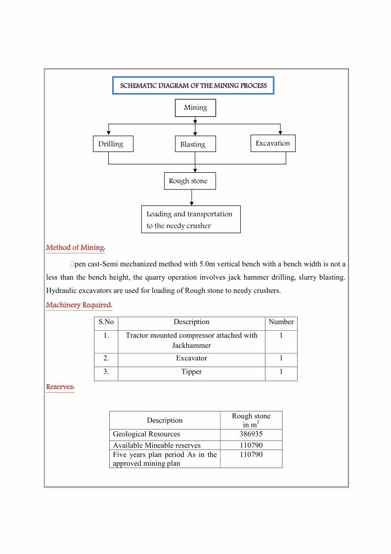
Method of Mining:Method of Mining:Method of Mining:Method of Mining:
Open cast-Semi mechanized method with 5.0m vertical bench with a bench width is not a
less than the bench height, the quarry operation involves jack hammer drilling, slurry blasting.
Hydraulic excavators are used for loading of Rough stone to needy crushers.
Machinery Required:Machinery Required:Machinery Required:Machinery Required:
S.No Description Number
1. Tractor mounted compressor attached with
Jackhammer
1
2. Excavator 1
3. Tipper 1
Reserves:Reserves:Reserves:Reserves:
Description Rough stone
in m3
Geological Resources 386935
Available Mineable reserves 110790
Five years plan period As in the
approved mining plan
110790
SCHEMATIC DIAGRAM OF THE MINING PROCESSSCHEMATIC DIAGRAM OF THE MINING PROCESSSCHEMATIC DIAGRAM OF THE MINING PROCESSSCHEMATIC DIAGRAM OF THE MINING PROCESS
Mining
Excavation Blasting Drilling
Rough stone
Loading and transportation
to the needy crusher
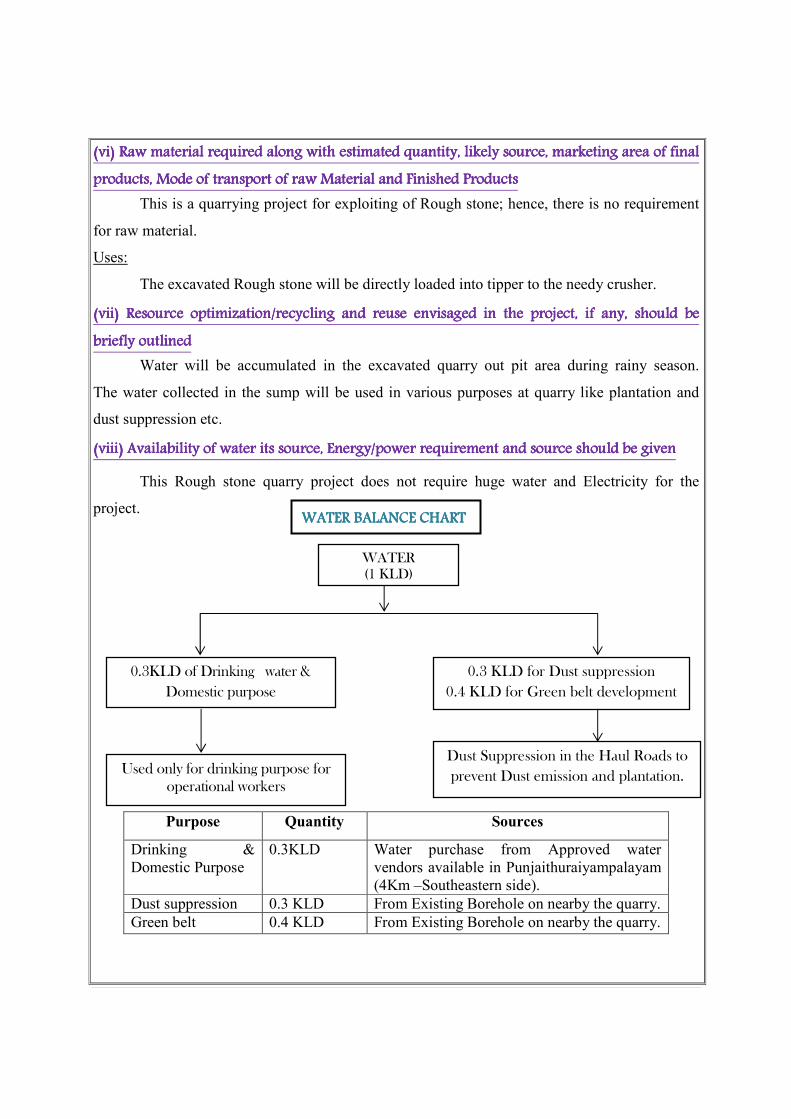
(vi) (vi) (vi) (vi) Raw material required aRaw material required aRaw material required aRaw material required along with estimated quantity, likely long with estimated quantity, likely long with estimated quantity, likely long with estimated quantity, likely source, marketingsource, marketingsource, marketingsource, marketing area of final area of final area of final area of final
productproductproductproducts, Mode of transport of raw s, Mode of transport of raw s, Mode of transport of raw s, Mode of transport of raw Material andMaterial andMaterial andMaterial and Finished ProductsFinished ProductsFinished ProductsFinished Products
This is a quarrying project for exploiting of Rough stone; hence, there is no requirement
for raw material.
Uses:
The excavated Rough stone will be directly loaded into tipper to the needy crusher.
(vii) (vii) (vii) (vii) Resource optimization/recycling and reuse envisaged in the project,Resource optimization/recycling and reuse envisaged in the project,Resource optimization/recycling and reuse envisaged in the project,Resource optimization/recycling and reuse envisaged in the project, if any, should be if any, should be if any, should be if any, should be
bbbbriefly outlinedriefly outlinedriefly outlinedriefly outlined
Water will be accumulated in the excavated quarry out pit area during rainy season.
The water collected in the sump will be used in various purposes at quarry like plantation and
dust suppression etc.
(viii) (viii) (viii) (viii) Availability of water its source, Energy/power requirement and source should be givenAvailability of water its source, Energy/power requirement and source should be givenAvailability of water its source, Energy/power requirement and source should be givenAvailability of water its source, Energy/power requirement and source should be given
This Rough stone quarry project does not require huge water and Electricity for the
project.
Purpose Quantity Sources
Drinking &
Domestic Purpose
0.3KLD Water purchase from Approved water
vendors available in Punjaithuraiyampalayam
(4Km –Southeastern side).
Dust suppression 0.3 KLD From Existing Borehole on nearby the quarry.
Green belt 0.4 KLD From Existing Borehole on nearby the quarry.
Used only for drinking purpose for
operational workers
Dust Suppression in the Haul Roads to
prevent Dust emission and plantation.
0.3KLD of Drinking water &
Domestic purpose
0.3 KLD for Dust suppression
0.4 KLD for Green belt development
WATER
(1 KLD)
WATER BALANCWATER BALANCWATER BALANCWATER BALANCE CHARTE CHARTE CHARTE CHART

Energy
Electricity for Mines office and Lights only at nights (working is restricted on day time
only between 9Am to 5Pm).
Diesel (HSD) will be used for quarrying machineries around 88640 Liters of HSD will be used
for the entire project life. Diesel will be brought from nearby diesel pumps. No power is required
for the project. Lightings on the Night will be taken from nearby electric poles after obtaining
permission from concerned authorities.
1.For Rough stone:
Per hour Excavator will consume = 16 liters / hour
Per hour Excavator will excavate = 20m3of Rough stone
For 110790m3 = 110790/20
= 5540 hours
Diesel consume 5540 working hours = 5540 hours x 16 liters
Total diesel consumption = 88640 Liters of HSD will be utilized for Rough
Stone
1. Diesel consumption of Rough stone = 88640 Liters
(ix) (ix) (ix) (ix) Quantity of wastes to be generated (liquid and solid) and scheme for their Quantity of wastes to be generated (liquid and solid) and scheme for their Quantity of wastes to be generated (liquid and solid) and scheme for their Quantity of wastes to be generated (liquid and solid) and scheme for their
management/disposalmanagement/disposalmanagement/disposalmanagement/disposal
Top soil: There is no top soil
Overburden/Waste: There is no overburden; the rough stone formation is clearly visible right
from the existing quarry, there is no interbred found in the area. There is no waste anticipated in
the Rough stone quarrying, the entire quarried out material will be sold to required customers at
different categories.
Waste water: There will not be any process effluent generation from the quarry lease area.
Domestic effluent from the mine office is discharged in septic tank and soak pit.
There is no toxic effluent expected to generate in the form of solid liquid and gases and the no
requirement of treatment of waste.
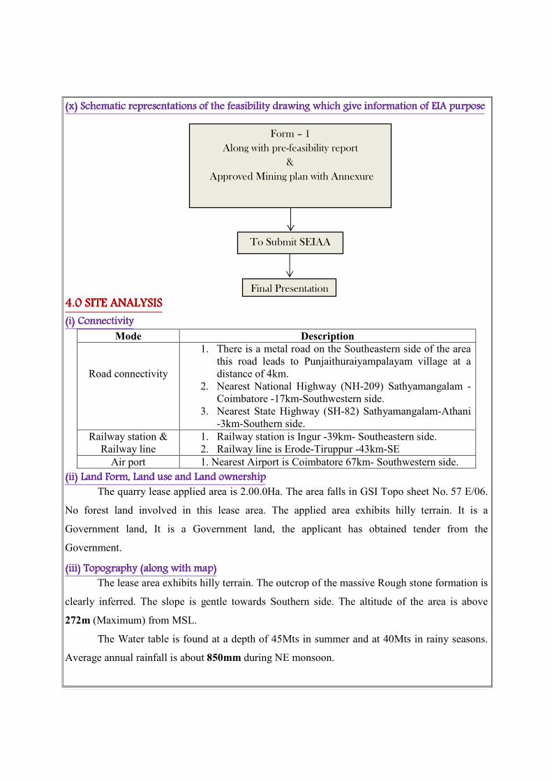
(x) (x) (x) (x) Schematic representations of the feasibility drawing which give information of EIA purposeSchematic representations of the feasibility drawing which give information of EIA purposeSchematic representations of the feasibility drawing which give information of EIA purposeSchematic representations of the feasibility drawing which give information of EIA purpose
4.0 4.0 4.0 4.0 SITE ANALYSISSITE ANALYSISSITE ANALYSISSITE ANALYSIS
(i) (i) (i) (i) Connectivity Connectivity Connectivity Connectivity
Mode Description
Road connectivity
1. There is a metal road on the Southeastern side of the area
this road leads to Punjaithuraiyampalayam village at a
distance of 4km.
2. Nearest National Highway (NH-209) Sathyamangalam -
Coimbatore -17km-Southwestern side.
3. Nearest State Highway (SH-82) Sathyamangalam-Athani
-3km-Southern side.
Railway station &
Railway line
1. Railway station is Ingur -39km- Southeastern side.
2. Railway line is Erode-Tiruppur -43km-SE
Air port 1. Nearest Airport is Coimbatore 67km- Southwestern side.
(ii) Land Form, Land use and Land owner(ii) Land Form, Land use and Land owner(ii) Land Form, Land use and Land owner(ii) Land Form, Land use and Land ownershipshipshipship
The quarry lease applied area is 2.00.0Ha. The area falls in GSI Topo sheet No. 57 E/06.
No forest land involved in this lease area. The applied area exhibits hilly terrain. It is a
Government land, It is a Government land, the applicant has obtained tender from the
Government.
(iii) Topography (along with map)(iii) Topography (along with map)(iii) Topography (along with map)(iii) Topography (along with map)
The lease area exhibits hilly terrain. The outcrop of the massive Rough stone formation is
clearly inferred. The slope is gentle towards Southern side. The altitude of the area is above
272m (Maximum) from MSL.
The Water table is found at a depth of 45Mts in summer and at 40Mts in rainy seasons.
Average annual rainfall is about 850mm during NE monsoon.
Form – 1
Along with pre-feasibility report
&
Approved Mining plan with Annexure
To Submit SEIAA
Final Presentation
(iv) Existing land use pattern (agriculture, non(iv) Existing land use pattern (agriculture, non(iv) Existing land use pattern (agriculture, non(iv) Existing land use pattern (agriculture, non----agriculture, forest, water boagriculture, forest, water boagriculture, forest, water boagriculture, forest, water bodidididies (including area es (including area es (including area es (including area
under CRZ)under CRZ)under CRZ)under CRZ), shortest distances from the periphery of the project to periphery of the forests, , shortest distances from the periphery of the project to periphery of the forests, , shortest distances from the periphery of the project to periphery of the forests, , shortest distances from the periphery of the project to periphery of the forests,
national park, wild life sanctuary, eco sensitive areas, water bodies (distance from the HFL of national park, wild life sanctuary, eco sensitive areas, water bodies (distance from the HFL of national park, wild life sanctuary, eco sensitive areas, water bodies (distance from the HFL of national park, wild life sanctuary, eco sensitive areas, water bodies (distance from the HFL of
the river), CRZ. In case of notified industrialthe river), CRZ. In case of notified industrialthe river), CRZ. In case of notified industrialthe river), CRZ. In case of notified industrial area, a copy of the area, a copy of the area, a copy of the area, a copy of the Gazette Gazette Gazette Gazette notification should be notification should be notification should be notification should be
given.given.given.given.
The quarry lease applied area exhibits hilly terrain. The area is a dry barren land devoid
of Agriculture and Habitations. The land is not used for any specific vegetation. No major water
bodies in the vicinity of the area, Ground water occurrence in this area are 45mt depth. The
quarrying is restricted up to 25m (15m above the ground level + 10m below the ground level)
hence the quarry operation will not be affected by the ground water. The region experiences semi
– humid climate and there is scanty growth of vegetation in and around the lease applied area
(seasonal vegetation is mostly practiced).
� Sathyamangalam Tiger Reserve (Guthiyalathur Reserve forest) is located about 15m on
the Northern side of the lease area.
� The lease area falls in Western Ghats region.
� Kunderippallam Dam is situated about 6km away from the Northwestern side of the area.
� There is no interstate boundary is situated within 15km radius
� There is no CRZ within the radius of 15km.
� The project area does not fall in ‘HACA’ region.
� There are no National parks as per Wild life protection Act 1972, within the radius of
15kms.
� There is few quarry is present within the radius of 500m.
(v) Existing Infrastructure (v) Existing Infrastructure (v) Existing Infrastructure (v) Existing Infrastructure
There is no existing infrastructure present in the applied area. A permanent mine office
has been proposed in the lease area. A well-equipped first aid facility will be made available.
Permanent rest shelter is proposed. At the quarry site, urinal and latrine are proposed.
Water for drinking purpose be supplied form the approved water vendors. A small water
tank is also proposed which will be used for water sprinkling, plantation etc.
(vi) Soil Classification(vi) Soil Classification(vi) Soil Classification(vi) Soil Classification
The Rough stone formation is clearly inferred. This land does not sustain any type of
vegetation or Agriculture.
(vii) Climatic data form secondary sources(vii) Climatic data form secondary sources(vii) Climatic data form secondary sources(vii) Climatic data form secondary sources
The area receives rainfall of about 850mm/ annum and the rainy season is mainly from
Oct - Jan during North East, monsoon. The summer is hot with maximum temperature of 42°C
and winter encounters a minimum temperature of 23°C.
(viii) Social infrastructure available(viii) Social infrastructure available(viii) Social infrastructure available(viii) Social infrastructure available
There is no social infrastructure within the radius of 1Km like schools, universities,
hospitals, prisons and community housing etc.
5. PLANNING B5. PLANNING B5. PLANNING B5. PLANNING BRIEFRIEFRIEFRIEF
(i) Planning Concept (type of industries, facilities, transportation etc) Town and Country (i) Planning Concept (type of industries, facilities, transportation etc) Town and Country (i) Planning Concept (type of industries, facilities, transportation etc) Town and Country (i) Planning Concept (type of industries, facilities, transportation etc) Town and Country
Planning/Development authority ClassificationPlanning/Development authority ClassificationPlanning/Development authority ClassificationPlanning/Development authority Classification
The total area of the project is about 2.00.0Ha. The proposed quantity is around
110790m3
of Rough stone for a remaining period of Five years. Conventional Open cast semi
mechanized quarrying the quarry operation involves jackhammer drilling, slurry explosives
blasting, excavator are used for loading of Rough stone through tippers to the needy crusher.
There are no habitations or villages en-route between the quarry sites the loaded vehicles
are allowed to move only below 40Kms per hour on the roads. The haul roads are sprinkled
periodically to prevent dust. Other facilities such as power, transportation and communication,
social infrastructure facilities are locally available near project site. Nearest town is
Gobichettipalayam, facilities like Dispensary, post office are available in
Punjaithuraiyampalayam 4km on SE side.
(ii) Population projection(ii) Population projection(ii) Population projection(ii) Population projection
There are few villages located in this area within 5km radius; the approximate distance
and population are given below.
S.No Name of the Village
Approximate distance
& Direction from
lease
applied area
Approximate
population
1. Pudhu Thottam 6km – NE 700
2. Kempanaickenpalayam 10km- NW 800
3. PujaiThuraiyampalayam 4km -SE 600
4. Kavandampalayam 3km - SW 500
Basic human welfare Amenities such as Health Center, Schools, Communication
Facilities, and Commercial Centers etc are available at Punjaithuraiyampalayam located at a
distance of 4kms on the South eastern side of the area.
(iii) Land use planning (breakup along with green belt etc(iii) Land use planning (breakup along with green belt etc(iii) Land use planning (breakup along with green belt etc(iii) Land use planning (breakup along with green belt etc....))))
The land use planning of the quarry area of the total extent of 2.00.0Ha is given below
Description Present Area Area at the end of Area Under Quarrying 0.58.5 1.54.0
Infrastructure Nil 0.01.0 Roads 0.01.0 0.02.0
Green belt Nil 0.10.0 Unutilized 1.40.5 0.33.0
Grand Total 2.00.0 2.00.0
((((iv) Assessment of Infrastructure Demand (Physical & Social)iv) Assessment of Infrastructure Demand (Physical & Social)iv) Assessment of Infrastructure Demand (Physical & Social)iv) Assessment of Infrastructure Demand (Physical & Social)
The existing road facilities are already available which shall be used and maintained.
The labors requirement is drawn from the nearest villages. The labors will be brought by jeeps
and vans to the quarry site, Medical facilities are available near the project site, Government and
private hospitals and other basic amenities and infrastructure facilities like communication
center, school supermarket, bus stand are also available in Gobichettipalayam at a distance of
9kms (SE). This quarry project will provide employment for about 11 persons directly.
(v) Amenities/Facilities(v) Amenities/Facilities(v) Amenities/Facilities(v) Amenities/Facilities
The simple methods adopted and the limited scale of activities involved in Rough stone
quarrying does not require High Tension Electric Power supply or huge worship facilities. The
quarrying work is restricted to one general shift during daytime 9.00am to 5.00pm with 1.00pm -
2.00pm lunch break. Major Machinery repair works are attended at Erode minor repairs are
carried out by the nearby mechanics. All facilities and amenities are available in Erode which is
41Km on the Southeastern side of the area.
Packaged drinking water will be brought from approved vendors. Mine office, storeroom,
toilet and first-aid room will be provided on permanent structures within the lease area after the
grant of lease.
6. PROPOSED INFRASTRUCTURE6. PROPOSED INFRASTRUCTURE6. PROPOSED INFRASTRUCTURE6. PROPOSED INFRASTRUCTURE
(i) Industrial Area (Processing area)(i) Industrial Area (Processing area)(i) Industrial Area (Processing area)(i) Industrial Area (Processing area)
There is no processing area proposed within the lease applied area.
(ii) Residential area (Non processing area)(ii) Residential area (Non processing area)(ii) Residential area (Non processing area)(ii) Residential area (Non processing area)
There is no residential area within 500mts of the lease applied area.

(iii) Green Belt(iii) Green Belt(iii) Green Belt(iii) Green Belt
All along the boundary barrier is selected for Green belt development by planting and
maintaining native species. The total area for proposed for Green belt is around 0.10.0Ha out of
2.00.0Ha. The estimated budget for plantation and maintenance of Green belt development
would be around Rs. 30,000/-
(iv) Social infrastructure(iv) Social infrastructure(iv) Social infrastructure(iv) Social infrastructure
About 11 employees will be directly benefited and 6 persons will be indirectly benefited,
the lease ensure to share all responsible for special benefits like water, health care, Education
benefits, and promotion of socio cultural activities of the nearby villages.
(v) Connectivity (traffic and transportation road/ Rail/ Metro/ Water ways etc.,)(v) Connectivity (traffic and transportation road/ Rail/ Metro/ Water ways etc.,)(v) Connectivity (traffic and transportation road/ Rail/ Metro/ Water ways etc.,)(v) Connectivity (traffic and transportation road/ Rail/ Metro/ Water ways etc.,)
Mode Description
Road connectivity
1. There is a metal road on the Southeastern side of the
area this road leads to Punjaithuraiyampalayam village
at a distance of 4km.
2. Nearest National Highway (NH-209) Sathyamangalam
- Coimbatore -17km-Southwestern side.
3. Nearest State Highway (SH-82) Sathyamangalam-
Athani -3km-Southern side.
Railway station &
Railway line
1. Railway station is Ingur -39km- Southeastern side.
2. Railway line is Erode-Tiruppur -43km-SE
Air port 1. Nearest Airport is Coimbatore 67km- Southwestern side.
(vi) Drinking Water management (Source & Sup(vi) Drinking Water management (Source & Sup(vi) Drinking Water management (Source & Sup(vi) Drinking Water management (Source & Supply of water)ply of water)ply of water)ply of water)
This proposed Rough stone quarry project does not require huge water either for
beneficiation or processing. Water required for drinking domestic consumption for labors is
around 0.3KLD. The packaged Drinking water for this will be brought from approved water
vendors is available in Punjaithuraiyampalayam on 4km Southeastern side.
(vii) Sewerage System(vii) Sewerage System(vii) Sewerage System(vii) Sewerage System
Toilets will be constructed on permanent structure and sewage will be discharged once in
three months. The sewage waste will be collected in soak pit and discharged as manure for Green
belt development.
(viii) Industrial Waste Management(viii) Industrial Waste Management(viii) Industrial Waste Management(viii) Industrial Waste Management
No industrial waste will be generated from the project.

(ix) Solid Waste Management(ix) Solid Waste Management(ix) Solid Waste Management(ix) Solid Waste Management
The waste generated during quarrying activity is negligible rock mass during handling
and re handling. Hence, there is no waste in this quarrying operation. There is no solid waste
generation during the quarrying operation.
(x) Power Requirement & Supply / source(x) Power Requirement & Supply / source(x) Power Requirement & Supply / source(x) Power Requirement & Supply / source
The proposed Rough stone and Gravel quarrying does not required any power supply for
the quarrying operation. It is proposed to operate in day time only from 9 Am to 5Pm with 1
Hour lunch interval between 1Pm to 2Pm.
7. REHABILITATION AND RESETTLEMENT (R & R PLAN)7. REHABILITATION AND RESETTLEMENT (R & R PLAN)7. REHABILITATION AND RESETTLEMENT (R & R PLAN)7. REHABILITATION AND RESETTLEMENT (R & R PLAN)
(i) Policy to be adopted (Central/State) in respect of t(i) Policy to be adopted (Central/State) in respect of t(i) Policy to be adopted (Central/State) in respect of t(i) Policy to be adopted (Central/State) in respect of the project he project he project he project affected personsaffected personsaffected personsaffected persons including home including home including home including home
oustees, land oustees and landless oustees, land oustees and landless oustees, land oustees and landless oustees, land oustees and landless laborers (laborers (laborers (laborers (a brief outline to be given)a brief outline to be given)a brief outline to be given)a brief outline to be given)
The lease applied area is a Government land in Punjaithuraiyampalayam village,
Gobichettipalayam Taluk, Erode District hence there is no Rehabilitation and resettlement is
involved. The employed labours will be insured as per the Government norms till the end of the
life of the quarry. Periodical medical test will be conducted for the labors to monitor the
occupational disease. The salaries and benefits will be paid as specified by the instruction given
by the labor enforcement officers.
8. PROJECT8. PROJECT8. PROJECT8. PROJECT SCHEDULE & COST ESTIMATESSCHEDULE & COST ESTIMATESSCHEDULE & COST ESTIMATESSCHEDULE & COST ESTIMATES
(i) Likely date of start of construction and likely date of completion (Time schedule for the (i) Likely date of start of construction and likely date of completion (Time schedule for the (i) Likely date of start of construction and likely date of completion (Time schedule for the (i) Likely date of start of construction and likely date of completion (Time schedule for the
project to be given)project to be given)project to be given)project to be given)
The Rough stone quarrying project is likely to get commenced after the execution of
quarrying lease. The proposed quantity of reserves is around 110790m3 of Rough stone for the
period of Five years.

(ii) Estimated project cost along with analysis in te(ii) Estimated project cost along with analysis in te(ii) Estimated project cost along with analysis in te(ii) Estimated project cost along with analysis in terms of economic viability of the projectrms of economic viability of the projectrms of economic viability of the projectrms of economic viability of the project
A. Fixed Asset Cost: Land cost = Rs. 15, 00,000/-
Labours shed = Rs. 1, 00,000/-
First aid room & Accessories = Rs. 1, 00,000/-
Sanitary facilities = Rs. 1, 00,000/-
Total Fixed assets cost = Rs. 18, 00,000/-
B. Operation cost:
Machineries to be used = Rs.41, 00,000/-
Fencing cost = Rs. 1, 00,000/-
Total operation = Rs.42, 00,000/-
C. (I). EMP Estimation:
Air Quality Sampling = Rs. 52, 000/-
Water quality sampling = Rs. 18, 000/-
Noise monitoring = Rs. 2, 000/-
Ground vibration test = Rs. 4, 000/-
Total EMP Estimation cost = Rs. 76,000/-
(II). Expenditure and maintenance:
Drinking water facility for the labors = Rs. 50,000/-
Sanitary arrangement = Rs. 50,000/-
Safety kits = Rs. 10,000/-
Water sprinkling = Rs. 1, 00,000/-
Afforestation cost = Rs. 30,000/-
CSR Cost = Rs. 1, 00,000/-
Total Expenditure and maintenance cost = Rs. 2, 40,000/-
Grand Total (I + II) = Rs. 4, 16,000/-
The total project cost:
A. Fixed Asset cost = Rs. 18,00,000/-
B. Operational cost = Rs. 42,00,000/-
C. EMP cost = Rs. 4,16,000/-
Total cost = Rs. 64, 16,000/-
� The Total project cost including EMP cost is (A+B+C) Rs. 64,16,000/- (Rupees Sixty
four lakhs sixteen thousand only)
� The total EMP cost is Rs. 4,16,000/- (Rupees four lakhs sixteen thousand only)

Population Benefit
The applicant ensures to take social responsibilities like providing School Note books,
Uniforms to the Students below poverty level beside if the villages require any borehole for
public use the applicant ensure to do so.
The applicant will also take part and contribute the native cultural activities in the nearby
villages. During summer seasons packaged drinking water will be kept will be kept in the village
for public and for tress passers. The applicant will involve and contribute all the socio cultural
allocation in and around the area. The budget provisions and allocation for all the above
activities will be around Rs 20,000 for the period of Nine months.
MINE CLOSURE PLAN:
Steps proposed for phased restoration, reclamation of already mined out areas:
� After the exploitation the Rough stone fencing will be constructed around the pit to
prevent inherent entry of public.
� The pit will be allowed to collect water which will act as a temporary Reservoir which
will enhance the Ground water level of the nearby areas.
� There is no proposal for back filling, reclamation and re habitation. The quarry pit will be
fenced to prevent inherent entry of public.
Measures to be under taken on mine closure as per Act & Rules:
Measure will be taken as per Act & Rules.
Mitigation measure to be undertaken for safety and restoration / reclamation of the already mined
out area:
� Drilling will be carrying out by wet drilling to control the dust into the air.
� Blasting will be carrying out on limited scale.
� Mist spray on haul road will be proposed to prevent the dust propagation into the air.
� The plantation will be carried out on the safety barriers to prevent Noise, besides wet
drilling will be practiced to prevent dust.
� All the machineries will be maintained in good conditions as per RTO and TNPCB
Norms to prevent Noise, Smoke and vibration.
� Machineries will be periodically maintained by experienced mechanic to minimize noise,
Smoke and ground vibration.

9. ANALYSIS OF PROPOSAL (FINAL RECOMMENDATIONS)9. ANALYSIS OF PROPOSAL (FINAL RECOMMENDATIONS)9. ANALYSIS OF PROPOSAL (FINAL RECOMMENDATIONS)9. ANALYSIS OF PROPOSAL (FINAL RECOMMENDATIONS)
(i) Financial and social benefits with special emphasis on the benefit to the local people (i) Financial and social benefits with special emphasis on the benefit to the local people (i) Financial and social benefits with special emphasis on the benefit to the local people (i) Financial and social benefits with special emphasis on the benefit to the local people
including tribal population, if any, in the areaincluding tribal population, if any, in the areaincluding tribal population, if any, in the areaincluding tribal population, if any, in the area
The lease applied area is Punjaithuraiyampalayam Village, Gobichettipalayam Taluk,
Erode District. There are no tribal populations in and around the area about 11 personals directly
will be benefited by these projects, besides the government. The proposed quarry will bring
economic benefits to the state by the way of royalty for mineral, surface rent, sale tax/VAT,
income tax etc.
The socio- Economic conditions of the village and distance will enhance due to the
project, hence, the project should be allowed after considering all the parameters. The detail
furnished in this mining plan is based on information provided by the State Government and the
lessee. By considering the merit of the project the permission may be granted.
Date :
Place : Erode
1. Signature of the Applicant
J.K.M.Jeyaprakash,
2. Signature of the Recognized qualified person
A.Jagannathan, BE, F.C.C., M.M.E.A.,
RQP/MAS/019/87/A
BASE LINE STUDIESBASE LINE STUDIESBASE LINE STUDIESBASE LINE STUDIES
The base line study is prepared for PunjaithuraiyampalayamRough stonequarry project.
Base line studies provide a base data for regular Environmental Monitoring and Environmental
Impact Assessment (EIA).
The baseline study is provides bench mark for carrying out environmental Impact
assessment due to the course of quarrying and mining activities. The purpose of these studies is
to evaluate the benefited and adverse effect of developing activities on the neighborhood
environment and the area where the quarrying is proposed to carry out.
Mr. J.K.M.Jeyaprakashhas applied for Rough stonequarry project lease for over an
extent of 2.00.0Ha located in S.F.No. 10 (Part) ofPunjaithuraiyampalayamVillage in
GobichettipalayamTaluk, ErodeDistrict.
The comprehensive base line studies and standards constitute of collecting data on
Ambient Air quality, Water quality, Ground water table and Flora and Fauna statistics.
Ground water tGround water tGround water tGround water tableableableable
The Erodedistrict the main rock type of peninsular gneiss forms the oldest rock
formations, in which the massive formation of Rough stone lies over with rich accumulation of
recent quaternary formation. On regional scale the Rough stone body trends N600E- S60
0W with
dipping towards SE800. The water table is found at a depth of 45m in summer and at 40m in
rainy seasons. (Which is observed from an open well which is 850mts NE of the area)
The average annual normal rainfall is about 850mm / annumand the rainy season is
mainly from Oct – Jan during Northeast monsoon. The Government of Tamilnadu under the roof
of TWAD formed an Authority to monitoring ground water table. The quarrying operation does
not require any water for a regular quarry activity and the quarrying is restricted to only 25m
(15m above the ground level + 10m below the ground level) for a remaining period of Five
years,hence there is no intersection of Ground water table during the life of quarrying operation.
General approach to EnvGeneral approach to EnvGeneral approach to EnvGeneral approach to Environmentironmentironmentironment
The Environmental besides data comprise of the features present of the site area its
includes environmental features such as forest area, conservation area, water bodies, industries,
wild life and fauna place of historic and importance etc.,
The data collected to cover the following.
1. Air environment
2. Noise Environment
3. Water environment
Air Environment Air Environment Air Environment Air Environment
Air environment is responsible for the health of human beings, animals, wild life and
vegetation. Air pollutants emitted by project and non-point source are transported dispersed or
concentrated by meteorological and topographical conditions.
The atmosphere is dynamic system which absolute range of solid, Liquid or gases from
both Natural and Manmade source. There substances travel through the air disappear and reveal
among themselves and also with other substances both physically and chemically which result in
air pollution.
The Rough stone proposed to quarry is nontoxic which does not emit any undesirable
pollutants in the form of solid liquid or gas. The dust emitted during the transportation of
vehicles the drilling will be carried out in wet condition to prevent dust into air and the haul
roads will be periodically sprinkled with mist water spray to prevent dust into the atmosphere.
The area in and around is quit fresh and the impact an air environment will always be under
controlled and will be monitored. No processing or beneficiation is proposed except quarrying
hence the impact an air will be controlled monitored and mitigated.
The ambient air quality within the study area on both core and buffer zone forms the
baseline information. The air quality monitoring points selected based on the Meteorological
conditions, topography of the study area and likely impact boundary location of the ambient air
quality monitoring stations was selected on the basis of wind pattern.
The ambient Air quality monitoring stations are shown in the map. Four major pollutions
were consideration significantly.
I. Particle matter - PM
II. Suspended Particle Matter - SPM
III. Sulphur dioxide - SO2
IV. Nitrogen dioxide - NO2
Respectively the overall of emission we identified the direction of the wind in the
majority observed time was predominantly south west to North East direction.
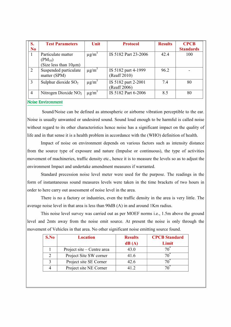
S.
No
Test Parameters Unit Protocol Results CPCB
Standards
1 Particulate matter
(PM10)
(Size less than 10µm)
µg/m3 IS 5182 Part 23-2006 42.4 100
2 Suspended particulate
matter (SPM)
µg/m3 IS 5182 part 4-1999
(Reaff 2010)
96.2 -
3 Sulphur dioxide SO2 µg/m3
IS 5182 part 2-2001
(Reaff 2006)
7.4 80
4 Nitrogen Dioxide NO2 µg/m3 IS 5182 Part 6-2006 8.5 80
Noise Environment Noise Environment Noise Environment Noise Environment
Sound/Noise can be defined as atmospheric or airborne vibration perceptible to the ear.
Noise is usually unwanted or undesired sound. Sound loud enough to be harmful is called noise
without regard to its other characteristics hence noise has a significant impact on the quality of
life and in that sense it is a health problem in accordance with the (WHO) definition of health.
Impact of noise on environment depends on various factors such as intensity distance
from the source type of exposure and nature (Impulse or continuous), the type of activities
movement of machineries, traffic density etc., hence it is to measure the levels so as to adjust the
environment Impact and undertake amendment measures if warranted.
Standard precession noise level meter were used for the purpose. The readings in the
form of instantaneous sound measures levels were taken in the time brackets of two hours in
order to here carry out assessment of noise level in the area.
There is no a factory or industries, even the traffic density in the area is very little. The
average noise level in that area is less than 90dB (A) in and around 1Km radius.
This noise level survey was carried out as per MOEF norms i.e., 1.5m above the ground
level and 2mts away from the noise emit source. At present the noise is only through the
movement of Vehicles in that area. No other significant noise emitting source found.
S.No Location Results
dB (A)
CPCB Standard
Limit
1 Project site – Centre area 43.0 70*
2 Project Site SW corner 41.6 70*
3 Project site SE Corner 42.6 70*
4 Project site NE Corner 41.2 70*

Water EnvironmentWater EnvironmentWater EnvironmentWater Environment
Geo Physical investigation was carried out by signal stacking resistivity meter 3 profiling
was carried out in the area for lease and 15 Vertical electrical sounding was carried out to find
out the lateral variation and vertical in homogeneity’s it was observed that the water table is
found to be 45mts below ground level and the same was correlated with the wells found at a
distance of 850mts NE of the area.
Test Protocol Results Limits as per IS 10500 : 2012
Acceptable
Limit
Permissible limit in the
absence of alternate
source
Colour IS : 3025 part : 4-1983
(Reaff : 2006)
9.2Hazen 6 15
Odour IS : 3025 part : 5-1983
(Reaff : 2006)
Agreeable Agreeable Agreeable
pH at 250C IS : 3025 part : 11-1983
(Reaff : 2006)
6.3 7.5 – 8.5 No relaxation
Total Dissolved
solids
IS : 3025 part : 16-1984
(Reaff : 2006)
1415mg/l 600 mg/l 2000mg/l
Aluminiumas Al IS : 3025 part 2:2004
(Reaff : 2009)
BDL
(DL:0.005
mg/l)
0.04 mg/l
0.2 mg/l
Barium as Ba IS : 3025 Part 2:2004
(Reaff : 2009)
0.25 mg/l 0.7mg /l No relaxation
Boran as B IS : 3025 Part 2:2004
(Reaff : 2009)
BDL (DL:
0.1 mg/l)
0.5mg /l 1.0mg/l
Calcium as Ca IS: 3025 Part 2: 2004
(Reaff : 2009)
148.7mg/l 75mg/l 200mg/l
Chloride as Cl IS : 3025 Part 32-1988
(Reaff . 2009)
475mg/l 245mg/l 1000mg/l
Copper as Cu IS: 3025 part 2: 2004
(Reaff : 2009)
BDL
(DL:0.01
mg/l)
0.05mg/l 1.5mg/l
Fluoride as F IS : 3025 Part 60: 2008 0.70mg/l 1.0mg/l 1.5mg/l
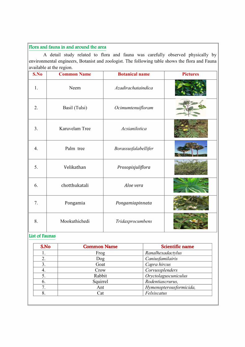
Flora aFlora aFlora aFlora and fauna in and around the areand fauna in and around the areand fauna in and around the areand fauna in and around the area
A detail study related to flora and fauna was carefully observed physically by
environmental engineers, Botanist and zoologist. The following table shows the flora and Fauna
available at the region.
S.No Common Name Botanical name Pictures
1. Neem Azadirachataindica
2. Basil (Tulsi) Ocimumtenuifloram
3. Karuvelam Tree Acsianilotica
4. Palm tree Borassusfalabellifer
5. Velikathan Prosopisjuliflora
6. chotthukatali Aloe vera
7. Pongamia Pongamiapinnata
8. Mookuthichedi Tridaxprocumbens
List of Faunas List of Faunas List of Faunas List of Faunas
S.NoS.NoS.NoS.No Common NameCommon NameCommon NameCommon Name Scientific nameScientific nameScientific nameScientific name 1. Frog Ranalhexadactylus
2. Dog Caniusfamilairis
3. Goat Capra hircus
4. Crow Corvussplenders
5. Rabbit Oryctolaguscuniculus
6. Squirrel Rodentiascrurus,
7. Ant Hymenopterousformicida,
8. Cat Felsiscatus

Conclusion Conclusion Conclusion Conclusion
The base line studies relents no hazardous levels of dust and noise and prevailing at the
project area. A well implemented environmental Management plan as discussed in the mining
plan will help in mitigation the adverse effects due to quarrying activities.
The movement of vehicles is very minimal. The entire vehicle used will be periodically
maintained by well experienced mechanic and kept under TNPCB standards, emission testing
will be carried out periodically and water will be sprinkled periodically to prevent dust into air.
The small quantity of non-humus rich surface soil will be removed and preserved in the
boundary barrier to facilitate the Afforestation.
Blasting will be used for heaving effect and not shattering effect hence the fly rock
problem will not arise. This is because the Rough stone industry requires only huge blocks which
are free from induced cracks and fissures.
Environmental care and attitude of preventing environment is inducted to the proponent
and advice to carry out and mitigate the minor impacts due to quarrying. Appropriate persons are
advice to get employed to protect the Environment and Ecology of the area.
Date :
Place : Erode
1. Signature of the Applicant
J.K.M.Jeyaprakash,
2. Signature of the Recognized qualified person
A.Jagannathan,BE, F.C.C., M.M.E.A.,
RQP/MAS/019/87/A
