falmouth cruise terminal environmental impact assessment
TRANSCRIPT

Falmouth Cruise Terminal Environmental Impact Assessment
Technological and Environmental
Management Network

Falmouth Cruise Terminal Mott MacDonald Environmental Impact Assessment Port Authority of Jamaica
233455/08/A - 22 June 2007/ P:\Croydon\MMH\Maritime\MAR PROJECTS\233455 Falmouth Cruise Terminal, Jamaica\Reports\Report 08A - EIA\233455 - Report 08A.doc/DR
Port Authority of Jamaica 15-17 Duke Street Kingston Jamaica
Falmouth Cruise Terminal
Environmental Impact Assessment
June 2007 Mott MacDonald St Anne House 20-26 Wellesley Road Croydon Surrey CR9 2UL UK Tel : 44 (0)20 8774 2000 Fax : 44 (0)20 8681 5706


Falmouth Cruise Terminal Mott MacDonald Environmental Impact Assessment Port Authority of Jamaica
S-1 233455/08/A - 22 June 2007/ P:\Croydon\MMH\Maritime\MAR PROJECTS\233455 Falmouth Cruise Terminal, Jamaica\Reports\Report 08A - EIA\233455 - Report 08A.doc
Executive Summary
INTRODUCTION
The Port Authority of Jamaica proposes to develop a cruise ship pier at Falmouth in the Parish of Trelawny. This development is now subject to a feasibility study which includes an Environmental Impact Assessment (EIA) which is a requirement of the National Environment and Planning Agency (NEPA) in exercising their powers under the NRCA Act 1991. Technological and Environmental Management Network (TEMN) Limited has been engaged by the Port Authority of Jamaica, through Mott MacDonald Limited to carry out the EIA, and this report presents the findings thereof.
The site located within the historic town of Falmouth. Falmouth, capital of the Parish of Trelawny, is situated on Jamaica’s north coast near Montego Bay. Founded by Thomas Reid in 1769, Falmouth flourished as a county seat and market centre for the Parish of Trelawny for several decades.
The project envisions the development of berthing facilities, including dredging of the existing channel through offshore reefs, as well as the development of landside facilities required to handle the volume of cruise ship passengers disembarking during the vessels stay in the town
The proposed cruise terminal is to be developed on the Falmouth foreshore within the confines of the existing natural harbour. The terminal’s marine works will encompass construction of a finger pier capable of accommodating two “megaliner” cruise ships simultaneously. The design vessel is the “Genesis” class cruise ship, which is currently under development and scheduled for delivery in late 2009.
The particulars of these vessels are:
• Overall Length: 360m
• Maximum Draught: 9.3m below waterline
• Air Draught: 65m above waterline
• Beam: 47m (55.9m at bridge)
• Displacement: 106,000tonnes
• Passenger Capacity: 5,400 (double occupancy)/6,360 (maximum)
• Crew Capacity: 2,100
Construction of the finger pier will most likely be a suspended concrete deck supported on a foundation of vertical and raking steel piles driven into the underlying stratum. The overall size of the finger pier will be in the order of 350m long and 30m wide, and will accommodate vehicles for transfer of passengers and crew, and provisioning of vessels. The finger pier will also comprise pneumatic berthing fenders, mooring bollards, lighting, water supply lines and safety equipment. No significant buildings or superstructures are envisaged to be constructed on the pier deck.

Falmouth Cruise Terminal Mott MacDonald Environmental Impact Assessment Port Authority of Jamaica
S-2 233455/08/A - 22 June 2007/ P:\Croydon\MMH\Maritime\MAR PROJECTS\233455 Falmouth Cruise Terminal, Jamaica\Reports\Report 08A - EIA\233455 - Report 08A.doc
Extending approximately 100m out from the extremity of the pier two mooring dolphins will be installed, which will be accessed from the main pier by steel truss walkways. The dolphins will be isolated structures comprising a suspended deck on driven steel raking piles. The plan dimensions of the deck structures will be approximately 6m x 6m, and will support mooring hooks, lighting, aids to navigation, and safety equipment.
To accommodate the draught of the proposed design vessels, dredging of the existing entrance channel and harbour basin will be required to a depth of 11.5m below Chart Datum. The quantum of dredging is estimated to be in the order of 4.4M cubic metres pending further navigation studies to confirm the final required size and configuration of the navigable area. In planning the basin, emphasis will be placed on minimising total dredge volume and preventing loss of reef.
The method of dredging will primarily be by cutter suction dredger (CSD). A trailer suction hopper dredger (TSHD) may also be required. However, the most suitable form of dredging cannot be established until an offshore ground investigation has been carried out.
In conjunction with dredging operations, an Environmental Management and Monitoring programme will be implemented to control and contain suspended sediments to prevent impacts on environmentally sensitive areas. This will most likely require deployment of silt curtains encompassing the dredger, and turbidity monitoring of the surrounding waters.
Due to the volume of material to be dredged, offshore disposal will be necessary unless an alternative onshore site can be established. A suitable offshore location will be chosen, which will be approval by regulatory bodies and affected parties. Should a CSD be employed, disposal will most likely be via underwater pipeline pumping directly to the offshore site. In the case of a TSHD, material will be transported by the TSHD to the offshore site and released via bottom discharge.
There will be a small amount of reclamation along the existing shoreline to reinstate the Falmouth foreshore close to its original configuration as shown on historical navigation charts. The new shoreline will be armoured with natural stone in keeping with the harbours former aesthetic. All reclamation material will be placed behind bunds to minimise turbidity. Where dredged material is hydraulically placed, discharge weirs encompassed by silt curtains will be adopted to minimise escape of fines into the harbour.
Plans include the construction of landside facilities to handle the influx of passengers from the vessels and extensive refurbishing of the area surrounding the pier.
IMPACT ASSESSMENT
The Environmental Impact Assessment was carried out by a multidisciplinary team, and utilised skills in biological assessments, hydrogeology, environmental chemistry, socioeconomics, oceanography and project management. A comprehensive evaluation of the study area was carried out and the environmental character of the area determined. This was related to the development plans and the potential impacts identified. Recommendations are made which are aimed at ensuring compliance with relevant environmental statutes, and ensuring the preservation or restoration of the ecological balance through the mitigation of anticipated impacts.

Falmouth Cruise Terminal Mott MacDonald Environmental Impact Assessment Port Authority of Jamaica
S-3 233455/08/A - 22 June 2007/ P:\Croydon\MMH\Maritime\MAR PROJECTS\233455 Falmouth Cruise Terminal, Jamaica\Reports\Report 08A - EIA\233455 - Report 08A.doc
Environmental Chemistry Impacts
Water Quality
Present Impact
Water quality data collected indicated that at most sites the critical parameters were within the NEPA and USEPA standards. The exceptions were at the mouth of the Martha Brae and the culvert at Little Bridge Falmouth.
The standard for nitrate was generally exceeded at the sites that had reduced salinity indicating that the fresh water inputs were significant sources of this nutrient. As indicated by the ESL investigation, the nitrate level at the marine sites was at or close to the standard indicating little or no headroom for absorbing additional input.
Data indicate slightly elevated phosphate levels at the mouth of the Martha Brae while at all other sites the level was at or close to the NEPA interim standard for marine waters indicating little or no headroom for absorbing increased input of this nutrient.
The data indicated little impact from TSS at the time of sampling. The relatively elevated levels at the mouth of the Martha Brae and the culvert at Little Bridge were below the proposed ambient standard and appeared to have little influence on the levels at the marine sites.
Impact from faecal coliform appeared to be confined to the stations in the vicinity of the Martha brae and Little bridge (Stations 3 and 4).
Data indicated Dissolved Oxygen (DO) levels generally within the USEPA standard for marine waters. The large deficit at the bottom of the water column at the mouth of the Martha a Brae river indicates a DO level well above the saturation value (DOsat). This suggests the onset of eutrophic conditions at this site and is in keeping with the elevated nitrate level determined.
Projected Impact
The major impacts expected from the development of Port Facilities include:
• Increased sediment load associated with dredging activities and the disposal of spoil.
• Increased fresh water run off due to expansion of paved area.
• Increased nutrient input associated with increased fresh water input.
• Increased potential for oil spills.
Air Quality/Noise
Impact from the project on air quality is likely to be of significance in the construction phase as a result of earth moving operations and the movement of heavy duty vehicles.
Impact on noise levels will likely be associated with the operation of construction equipment and the movement of traffic associated with construction activities. In particular extreme noise and vibration may result from pile driving operations depending on the exact procedure to be employed.

Falmouth Cruise Terminal Mott MacDonald Environmental Impact Assessment Port Authority of Jamaica
S-4 233455/08/A - 22 June 2007/ P:\Croydon\MMH\Maritime\MAR PROJECTS\233455 Falmouth Cruise Terminal, Jamaica\Reports\Report 08A - EIA\233455 - Report 08A.doc
Ecological Impacts
The extent of the impacts on an ecosystem and its associated flora and fauna are a function of the magnitude of the development, the nature of the resources in question, the capacity of the environment to absorb and recover from these impacts, as well as the methodology and mitigation measures applied in relation to project activities.
The proposed cruise terminal and harbour expansion project calls for dredging in order to widen and deepen the existing entrance channel and harbour basin as well as the construction of berthing facilities, a cruise terminal, promenade, a coach/car park, and sewage treatment facilities/drainage systems to accommodate the influx of tourists. The primary activities that are likely to create environmental impacts during the construction phase are the dredging activities as well as the construction of aforementioned facilities. Additional impacts anticipated for the post-construction operational phase of the project relate to the cumulative nature of impacts arising from increased numbers of tourists transiting the area.
Dredging impacts
Loss of Habitat and Biodiversity
Port dredging and coastal development often impact upon reef habitats and possibly carry with them an inherent risk of further degradation of coastal ecosystems. Such negative impacts are a major concern to Jamaican coastal areas where the reefs are already stressed from a number of anthropogenic and natural threats including uncontrolled/inappropriate coastal development, excessive nutrient loading from sewage and fertilizer runoff, over fishing, recreational misuse related to tourism, anchor damage, as well as hurricanes, diseases affecting corals and urchins and repeated bleaching events.
The method of dredging proposed for the project calls for the use of cutter suction dredger (CSD) as well as trailer suction hopper dredger (TSHD), if required. The dredging activities will contribute to physical, chemical and biological changes to the harbour’s ecology, with possible direct and indirect impacts on the nearby fringing coral reef, seagrass beds and bioluminescence in Oyster Bay. More specifically, the environmental impacts of dredging include the removal of living coral, alteration and removal of benthic habitats, removal of feeding and spawning areas, increased turbidity and siltation and deposition of resuspended fine sediments on nearby coral reefs. There is also the potential for changes in the bathymetry of the entrance to the harbour to change the existing wave regime and current patterns within it with resulting in impacts upon on dinoflagellate populations that create and support the natural bioluminescence of the area.
Loss of Coral Cover
Direct impacts of dredging include the long term loss of benthic habitat, and the short term attenuation of light which impedes the photosynthesis of seagrasses, macroalgae and other autotrophs. The localised removal of coral reef habitat all along the existing channel will result in the permanent loss of a vibrant coral reef community at the entrance to the channel. This impact constitutes a localised, direct and significant impact to the marine ecosystem in the area by:
• Locally removing a highly productive portion of the coral reef in the area (heavily used by fishers at present)

Falmouth Cruise Terminal Mott MacDonald Environmental Impact Assessment Port Authority of Jamaica
S-5 233455/08/A - 22 June 2007/ P:\Croydon\MMH\Maritime\MAR PROJECTS\233455 Falmouth Cruise Terminal, Jamaica\Reports\Report 08A - EIA\233455 - Report 08A.doc
• exposing the surrounding corals to high suspended sediment concentrations during dredging activities; and in the long run
• subjecting the corals in the area to gradual smothering due to increased maritime traffic and the inherent threat of accidental groundings, repeated re-suspension of bottom sediments and potential pollution
Loss of Fish Habitat
Widening of the entrance of the channel will partially remove the reef wall which is a primary habitat to Bermuda Chub which school on and nearby the wall drop-off. The potential exists for disruption to fish habitat, spawning and feeding grounds and possibly fish migratory routes. This represents a direct long-term adverse impact to the fish community on the reef and in the harbour.
Loss of the Seagrass Beds
Dredging activities in the shallows of harbour will reduce seagrass coverage which serve as nursery habitats for juvenile fish and other biota. Since seagrass areas trap sediment that might otherwise drift onto the adjacent coral reefs, their localised removal from the harbour entrance could introduce a potential long-term impact contributing on adjacent coral reefs due to increased turbidity in the water column.
Loss of bioluminescent phytoplankton
Deepening of the channel and the resulting changes to the bathymetry in the channel and the harbour, may alter current patterns in and out of the harbour. Changes in current speeds, directions and patterns of flow could contribute to changing the flushing rate and the water chemistry of the bay thus altering the conditions necessary to maintaining the distinctive composition of the phytoplankton community and the associated bioluminescence unique to Oyster Bay. The sensitive nature of the Oyster Bay coastal environment is one of the few such places left in Jamaica and in the world. Definitive action must be taken to ensure that this natural resource is not adversely affected by the development.
Turbidity and Sediment Dispersal
The sedimentation and turbidity impacts associated with the dredging operations are expected to have short-term impacts on the seagrass beds and the nearby coral reefs.
Specific potential environmental impacts of dredging include:
• increased turbidity causing decrease in light penetration and smothering of coral
• short-term decreases in dissolved oxygen levels
• dispersal of sediment from the dredge area onto nearby coral reefs
• release of natural and anthropogenic contaminants from sediment and the ensuing uptake by fish and other biota
• accidental leaks or spills of dredged materials from broken dredge equipment during the dredging operation.

Falmouth Cruise Terminal Mott MacDonald Environmental Impact Assessment Port Authority of Jamaica
S-6 233455/08/A - 22 June 2007/ P:\Croydon\MMH\Maritime\MAR PROJECTS\233455 Falmouth Cruise Terminal, Jamaica\Reports\Report 08A - EIA\233455 - Report 08A.doc
While turbidity and sedimentation can be contained to a certain extent, consideration must be given to the direction of prevailing currents at the northern end of the channel, which could compromise the efficacy of the sediment curtains by dispersing the fine sediments over nearby coral reefs.
In contrast to the short-term impacts of sedimentation related to dredging activities, sedimentation and turbidity created by the wash from ship propellers and thrusters, presents a long-term impact which could affect the water quality in the long term due to the repeated resuspension of sediments. Sea grasses and coral recruits would suffer should chronically high sediment loads prevail.
Disposal of Dredge Material
Offshore Disposal
Disposal of dredged materials may cause impacts similar to those associated with the dredging operation. The current proposal calls for offshore disposal of dredge material at a location to be determined and approved by appropriate regulatory bodies. The impacts associated with disposal of dredge material in the open sea include turbidity in the water column and the scattered settlement of dredge material over a large area. Inadvertent spillage or leakage of dredge material, over coral reefs during transit also presents a potential impact.
Land Disposal and Use of Dredge Material for Reclamation
Land disposal of dredge materials carries with it the possibility of significant impacts for terrestrial and/or nearby aquatic ecosystems. Improper disposal can affect the ground water, contaminate surface run-off and eventually re-enter the harbour. The use of dredge material containing large quantities fine particulate matter as fill for the land reclamation of the old harbour front presents a potentially significant impact. Although the plan calls for use of bunds for containing the reclamation material and silt curtains to minimize turbidity in the harbour during the operation, an accidental rupture of the containment bund could result in spillage of the material into the harbour, with the resulting sedimentation posing a threat to nearby coral reefs.
Coastal Erosion
Dredging of the reef on the eastern side of the channel, immediately west of Bush Cay may compromise the natural protection to the southern shoreline from wave action compared to the present situation. Increased ship traffic in the harbour and waves reflecting off the hard surface of vertical shore structures may cause erosion of the beach area on Bush Cay or decrease the stability of the shoreline on either side of the pier.
Maintenance Dredging
Given the proximity of the port to the Martha Brae River there is a potential requirement for maintenance dredging to remove the sediments carried downstream in the harbour. Maintenance dredging and the resulting increase in sedimentation and turbidity present repetitive, impacts on nearby reefs and seagrass beds, and as such should possibly be minimized.

Falmouth Cruise Terminal Mott MacDonald Environmental Impact Assessment Port Authority of Jamaica
S-7 233455/08/A - 22 June 2007/ P:\Croydon\MMH\Maritime\MAR PROJECTS\233455 Falmouth Cruise Terminal, Jamaica\Reports\Report 08A - EIA\233455 - Report 08A.doc
Impacts arising from Construction of Terminal Buildings and Associated Infrastructure
The proposed development of Falmouth waterfront entails the construction of the cruise ship terminal, the construction of a finger pier and associated mooring structures. The following is a list of impacts to the ecology of the area resulting from the activities associated with the proposed landside development plan.
Vegetation and Avifauna
Based on the information provided, an estimated 8.5 hectares of wetland habitat would be removed by the creation of parking lots, a water treatment plant and by future developments in the locations currently proposed. Apart from the potential effect on wetland avifauna, the importance of mangrove habitat to the maintenance of the bioluminescence in the bay cannot be over emphasized. Any clearing of woodlands, especially in the mangroves to the south of the town will further compromise an already stressed and degraded coastal area and should be avoided. Existing undisturbed mangrove areas should be left intact. The location for the aforementioned facilities could be placed in the already degraded wetland area to the east where rice ponds were previously created and abandoned due to the effects of salt water intrusion. This alternative location would allow for partial remediation and creation of a buffer zone of rehabilitated mangroves so that protection from runoff is offered to both the seashore to the north and the river and its watershed to the south
Change in Drainage Patterns and Resulting Impacts on Marine Ecology
The development of the port facilities and its environs calls for restoration of existing buildings in the town and will entail excavation activities required for upgrading the associated infrastructure (i.e. laying/modifying of water/sewage pipes, electrical cables, etc., paving of roads). Increased hard surface area from the development as well as modified drainage facilities (as per Falmouth Cruise Terminal Conceptual Drainage Scheme Drainage Philosophy, May 2007) have the potential to bypass the natural filtering process offered by mangrove habitats and release larger volumes of sediment laden water onto sensitive near shore habitats.
The loss of mangroves to the south of the town from the construction of parking and water treatment facilities could decrease the filtering capacity of the ecosystem and further increase the risk of terrestrial runoff containing (contaminated) suspended solids draining directly into the harbour. Excessive runoff during heavy rains, especially during the construction phase, could lead to elevated nutrient loading into the bay. The resulting turbidity and sedimentation would negatively impact the inshore water quality and the marine ecosystem.
Airborne and Noise Pollution
The increased traffic to the area, use of heavy equipment during the construction of the port facilities, including the transportation of building materials will create noise and elevate dust levels, which could prove to be disturbing not only to the residents of Falmouth, but also to the birds in the area. Airborne pollution, especially dust from exposed piles of sand or cement may further stress the local flora and fauna, and pose a health risk to construction workers and residents in the vicinity.

Falmouth Cruise Terminal Mott MacDonald Environmental Impact Assessment Port Authority of Jamaica
S-8 233455/08/A - 22 June 2007/ P:\Croydon\MMH\Maritime\MAR PROJECTS\233455 Falmouth Cruise Terminal, Jamaica\Reports\Report 08A - EIA\233455 - Report 08A.doc
Transportation and Storage of Construction Materials
Transportation of heavy machinery and building supplies/materials implies heavy traffic on the roads leading to the site with possible negative impacts to the surrounding area (dust, spillage, emissions and noise). Use of uncovered trucks for transporting building materials as well as improper storage of building materials, especially gravel, sand and cement on the construction site could lead to inadvertent dispersal of materials during heavy rains or high winds during dry periods. This could have a negative impact on the coastal waters. Improper storage or handling of hazardous or flammable materials, including fuel, paints and solvents) could result in soil contamination and eventual leaching (or direct runoff) of these substances into the harbour waters.
Disposal of Construction Debris
Each phase of the development will produce solid waste, the disposal of which, if not managed properly could have negative impacts on the site and the surrounding area. Construction materials including concrete waste, wood, steel, packaging plastics could be dispersed and could end up blocking drainage channels or creating direct damage to near-shore flora/fauna if not disposed of at an approved disposal site. Construction wastes are of particular concern in the absence of adequate waste management facilities, as it is difficult to monitor discharges and ensure that hazardous wastes do not end up in sewers or landfills.
Sewage and Garbage Disposal
Inadequate provision of portable restrooms and garbage dumpsters at the construction site could lead to unsanitary conditions. Resulting impacts would vary from unsightly littering of the site, fly and vermin infestations to increased nutrient loading of coastal areas. Reliable sewage treatment systems are a long term concern for the area. It is essential for the plans to examine the carrying capacity of the existing infrastructure in Falmouth and to modify the infrastructure especially the sewage treatment systems to ensure that they can meet the town demands as well as increased demands during peak tourist season. The main objective is to ensure that the sewage treatment, garbage disposal facilities and associated services are capable of handling increases in capacity while ensuring that there is no direct discharge of untreated effluent into the watershed which drains directly into inshore marine waters.
Availability of Potable Water
Requirements for potable water will increase during both the construction and operational phases of this development. Plans already underway to increase the amount of water being supplied to the town of Falmouth are regarded as being of sufficient quantity (NWA Study and letter d/d) to supply the cruise ship development as well. However, this factor remains one that should be monitored on a long term basis.

Falmouth Cruise Terminal Mott MacDonald Environmental Impact Assessment Port Authority of Jamaica
S-9 233455/08/A - 22 June 2007/ P:\Croydon\MMH\Maritime\MAR PROJECTS\233455 Falmouth Cruise Terminal, Jamaica\Reports\Report 08A - EIA\233455 - Report 08A.doc
Impacts arising from Cruise Ship Traffic
Environmental issues common to shipping (and the cruise industry) operations are worthy of careful consideration here. While harbour dredging may be viewed as a short term impact (possibly repeated due to maintenance dredging), it is important to note the chronic and highly repetitive impacts resulting from ships passing through shallow channels which create plumes of resuspended sediment from the action of their propellers. The larger the vessel, the more sediment is suspended in the water and later deposited on potentially sensitive habitats. For this reason, it is important to consider restricting the passage and anchoring of large cruise ships in biologically sensitive areas.
Potential damage from cruise ship anchors, cruise ship groundings and the inherent risk of future accidents and environmental damage to these fragile and irreplaceable ecosystems represent a long-term negative impact.
Ballast Water and Invasive Species
Cruise ships rely on quantities of ballast water to stabilize the vessel. Ballast water discharge is the leading source of non-native or invasive species in marine waters. However, there is no requirement to take on or discharge ballast at or near the terminal for the cruise ships expected at the terminal.
Cruise Ship Sewage –Black and Grey Water Discharges
Cruise ship sewage or black water generated from toilets is typically more concentrated than land based sewage and may contain bacteria, pathogens, diseases and viruses requiring treatment prior to release at sea. Grey water, which represents the largest proportion of liquid waste generated by cruise ships, includes drainage from dishwashers, showers, laundry, baths, galleys, and washbasins.
It can contain pollutants such as fecal coliform, food waste, oil and grease, detergents, shampoos, cleaners, pesticides, heavy metals, and, on some vessels, medical and dental wastes. It is estimated that a typical cruise ship carrying 3,000 passengers and crew produces up to 10 gallons of black water per person per day, or 15,000 to 30,000 gallons per day, and 30 to 85 gallons of grey water per passenger per day per person, or 90,000 to 255,000 gallons per day.
Regulations prohibit the discharge within three nautical miles of shore of untreated or inadequately treated sewage with a faecal coliform bacterial count greater than 200 MPN per 100 milliliters, or total suspended solids exceeding 150 mg/100 ml. According to the cruise line industry, black and gray waters are discharged only when underway and not while in ports. These practices are difficult to monitor, thus making it challenging to confirm whether the companies are in compliance with stated industry policies or international regulations.
Contaminated Bilge Water
Bilge water may contain oil or petroleum substances resulting from oil spills and leaks occurring during the use and maintenance of on-board mechanical systems. Illegal discharge of bilge/ballast water by cruise vessels in international or coastal waters, as well as oil spills resulting from collisions and groundings have been documented extensively because they represent a serious threat to pelagic and coastal marine life.

Falmouth Cruise Terminal Mott MacDonald Environmental Impact Assessment Port Authority of Jamaica
S-10 233455/08/A - 22 June 2007/ P:\Croydon\MMH\Maritime\MAR PROJECTS\233455 Falmouth Cruise Terminal, Jamaica\Reports\Report 08A - EIA\233455 - Report 08A.doc
Petroleum pollution is known to have adverse effects on coral reefs, wetlands, marshes, mangroves, as well as on marine mammals, sea birds, fish, and plankton and other invertebrates associated with these ecosystems. Juvenile and larval forms of many species are especially vulnerable to even extremely small quantities of hydrocarbons at low concentrations. Long-term exposure to low concentrations can be as harmful as short-term exposure to higher concentrations especially in harbours with poor flushing action where the marine plants or animals are continuously exposed to discharges of oil and contaminated bilge products, resulting in irreversible damage to the flora and fauna in these coastal waters.
Air Pollution
Air pollution from cruise ships is generated by diesel engines that burn high sulfur content fuel, producing sulfur dioxide, nitrogen oxide and particulate matter in addition to carbon monoxide, carbon dioxide, and hydrocarbons. Shipboard incinerators also burn large volumes of garbage, plastics, and medical waste, producing dioxin, furans, and other toxics. Large marine engines contribute substantially to local air pollution in port areas. Emissions from ships in general are a significant source of air pollution, especially in ports of call. “A single large ship visiting a port could pump out as much sulphur dioxide as 2000 cars and trucks driving all year round.” (Cruise Control, 2002).
Impacts of tourism
The current project is designed to accommodate approximately 15,000 passengers and crew at peak times, which is twice the current population of the town. The main concerns arising from this possible (worst case scenario) influx to the town relate to the capacity of the facilities to deal with the sewage and solid waste generated as well as the associated wear and tear on the surrounding environment. Exceeding the carrying capacities of marine and inland sites has the potential to further degrade the inland and marine attractions (Oyster Bay bioluminescence, diving, etc.) that make Falmouth an attractive tourist destination. Determining the actual carrying capacity of the surrounding ecosystems would require further studies since the area to be exploited by arriving cruise ship visitors and the actual number of passengers per unit time would have to be defined more precisely.
SOCIOECONOMIC IMPACTS
Socioeconomic impacts include construction and post-construction impacts.
Construction Impacts
The construction impacts of the proposed development include land use, employment and income, transportation and community development.
Land Use
During the construction phase the proposed development will have negative impacts on land use as there will be some displacement of persons using lands for commercial, residential and public uses. The proposal includes the relocation of affected land uses to other suitable sites within the SIA study area. Additionally, during renovation of existing structures, the occupants of these structures will also be displaced.

Falmouth Cruise Terminal Mott MacDonald Environmental Impact Assessment Port Authority of Jamaica
S-11 233455/08/A - 22 June 2007/ P:\Croydon\MMH\Maritime\MAR PROJECTS\233455 Falmouth Cruise Terminal, Jamaica\Reports\Report 08A - EIA\233455 - Report 08A.doc
Further, the proposed development may attract new residents to the area, which reportedly has a shortage of housing as well as several squatter settlements. Construction workers originating from outside of the SIA study area may squat on lands if adequate housing solutions are not identified and made accessible during construction of the proposed development
Employment and Income
Employment and income would be impacted both negatively and positively by the proposed development. The positive impact is represented by the creation of jobs during the construction phase of the development. The negative impact is the temporary loss of income by businesses which will be displaced.
Transportation
Proposed changes to the road network and transportation routes accessing the site will also have negative impacts as regular movement of people, goods and services will be temporarily affected. See Conceptual Site diagram in Appendix 5.
Community Development
The construction impact on the community will be a short-term negative impact as during construction and renovation activities, there might be limited or no access to certain areas of the affected areas of the Historic District. Additionally the public market would be relocated and access to goods and services offered by the facility may be temporarily lost.
Post-Construction Impacts
The post-construction impacts of the proposed development include national/regional impacts, land use, employment, community development and recreational impacts.
National/Regional Development
The proposed development includes the development of a cruise ship pier and terminal and associated infrastructure. Additionally, a large portion of the Historic District of Falmouth will be renovated and will be marketed as a heritage tourism site. This has implications for the tourism industry of the country. Increased visitor arrivals will result in increased foreign exchange earnings for the country as well as increased exposure.
The proposed development will have a significant impact on the architectural and archaeological assets of the country. Falmouth’s rich history will be enhanced and highlighted by the proposed development which will have educational benefits as there will be an increased opportunity for Jamaicans and visitors to learn more about the history of the country.
Further, the proposed development will have a significant and long-term positive impact on regional and national employment. After construction, the proposed development will generate employment for management, security and maintenance personnel, tour operators (within the SIA study area and other areas within the parish of Trelawny and neighbouring parishes) as well as personnel in the various shopping facilities. The socio-economic survey revealed a 15 percent unemployment rate among respondents. This is higher than the national average of 10.3 for 2006 (ESSJ 2006). Providing that the labour force within the SIA study area has the necessary skills and training, the development will contribute to lowering unemployment rates on a local, regional and national scale.

Falmouth Cruise Terminal Mott MacDonald Environmental Impact Assessment Port Authority of Jamaica
S-12 233455/08/A - 22 June 2007/ P:\Croydon\MMH\Maritime\MAR PROJECTS\233455 Falmouth Cruise Terminal, Jamaica\Reports\Report 08A - EIA\233455 - Report 08A.doc
Land Use
The post-construction land use impact includes the potential for improving the services of the community. During the site visit, it was noted that the public market was in a deplorable condition with unclean drains, dilapidated stalls, and shops with inadequate protection for vendors and shoppers from natural elements. The proposed development will relocate the public market. The facilities will be upgraded and properly maintained to provide improved product to the population and be an attraction for visitors.
The Historical District of Falmouth will be renovated and will be a tourist attraction for trolley rides, walk tours etc. As such, old piers will be restored, buildings will be renovated and the town will get a face lift. There may also be positive changes in property values.
The proposed development incorporates an area that is currently residential with over 60 structures. This settlement appears informal with houses that are of substandard quality. These residences will need to be relocated which may be a positive impact if the new site is properly planned with the necessary infrastructure and the housing units are built according to building codes and regulations. Further, if the residents own their new homes, their socio-economic situation may change as they would now have collateral to access credit for entrepreneurial enterprises which would have a market in the expected visitors to the area.
Employment opportunities that will be available after construction of the proposed development may lead to migration to the SIA study area. New immigrants workers may squat on lands if adequate housing solutions are not identified and made accessible during development of the facilities. This would be a long-term negative impact.
Employment
As mentioned above in the national/regional impacts, the post-construction phase of the proposed development will provide employment on the local, regional and national scale.
Transportation
The proposed development includes some long-term changes to transportation routes. There will be new roads constructed and traffic flows will change within the Historic District. These impacts may however, be seen as positive as the physical infrastructure of the community would improve (new roads, new trolley service), and existing routes will be refurbished. New areas of the town will be opened for development with attendant increased accessibility.
Community Development/Recreational
The post-construction impacts on the community/community development and recreation are both positive and negative. The positive impact includes improved recreational facilities and infrastructure for the community. Currently, the waterfront area of the site consists of historic buildings (especially the Hampden Wharf) that are in various states of disrepair. The waterfront area will be redeveloped- the pier will be constructed, the historic piers will be restored, a trolley route is proposed along the waterfront which will provide access to a number of historic buildings, which will be renovated (Hampden Wharf, Tharpe House, Old Foundry etc.). The proposed development would improve and upgrade the access roads, and provide a clean sanitary and safe environment for the community members and visitors to enjoy..
The proposed development has the potential for increasing employment and therefore has the potential for increasing migration to the area and the population of the area. Additionally, it is assumed the attractions will attract more visitors (local, national and tourists). There will be increased vehicular

Falmouth Cruise Terminal Mott MacDonald Environmental Impact Assessment Port Authority of Jamaica
S-13 233455/08/A - 22 June 2007/ P:\Croydon\MMH\Maritime\MAR PROJECTS\233455 Falmouth Cruise Terminal, Jamaica\Reports\Report 08A - EIA\233455 - Report 08A.doc
traffic and the need for services (for example, banks and ATMs) will increase. The existing social services and infrastructure may not be able to facilitate the increased activities anticipated in the SIA study area.
HYDROGEOLOGY
Water supply for the development will be more than adequate given the now competed upgrade of the Martha Brae Treatment Plant.
Sewerage disposal can be a considerable impact if the appropriate sewerage systems are not implemented to protect coastal waters. However, this impact is completely mitigable and all precautions will be implemented by the developers to ensure that a tertiary level treatment plant is installed. Flood protection shall also be a part of the design criteria.
Being a coastal development storm surge will be an issue as it is for all piers world wide and as such design adjustments will need to be made to ensure that the pier survives anticipated storm surge events which can be up to 2.1m with a 10% chance of occurrence. The impact is mitigable with appropriate engineering measures.
The pre- and post- runoff calculations indicate that the post-development runoff increase is directly the result of the additional paved area. The use of permeable pavements could reduce the runoff from these paved areas and increase visual amenity. Provided the implemented drainage systems are appropriately designed to cope with the predicted 25 yr return storm runoff for normal flows and a 1 in 200 yr event for extreme flows it is likely that flooding on site will be of a low impact.
As a result of the development, off site interests should see no increase beyond the usual flooding currently experienced, as no existing water courses will be degraded, only upgraded. In other words, the development will not contribute to any increased flooding in the surrounding areas than they have already become used to.
There will be no impact downstream as the development is at the coast. Pollution control measures as outlined above will be incorporated along with flow control devices to reduce pollution and sediment loads to the receiving water bodies.
The open channels located at the south east of the site will be culverted to allow maximisation of useable space. The culverts will be designed to accommodate the flows derived from the flood modelling exercise. During installation of the culverted sections some disturbance will occur but with the appropriate controls as outlined the impact will not persist beyond the construction phase.
Development of portions of the North Polder for parking and mixed commercial use can be subjected to flooding during extreme events. Adequate lifting above predicted flood stages, flood control measures and pollution control measures will ensure that the expansion is protected from significant flood events. Consideration will need to be given to flood control during development of these areas.
COASTAL DYNAMICS
The main impacts on coastal dynamics identified with this development are as follows:
1) As currents were shown to oscillate with the changing tide, rotating direction completely around the compass rose, any plume generated by dredging exercises can be expected to travel into the eastern section of the lagoon during certain phases of the tide. As such, it can be expected that uncontained sediment plumes generated during any proposed dredging exercise will at times affect the entire bay.

Falmouth Cruise Terminal Mott MacDonald Environmental Impact Assessment Port Authority of Jamaica
S-14 233455/08/A - 22 June 2007/ P:\Croydon\MMH\Maritime\MAR PROJECTS\233455 Falmouth Cruise Terminal, Jamaica\Reports\Report 08A - EIA\233455 - Report 08A.doc
The use of silt screens is recommended to minimize sediment plume movement within the harbour.
If necessary, sediment-plume concentrations and movement may be predicted by collecting bore-hole data in the area proposed for dredging and numerically modeling this information to calculate the actual sediment movement and concentrations away from source.
2) Large amounts of debris and silt are discharged by the Martha Brae River during periods of heavy outflow, and this may have significant implications for the maintenance of the navigational channel’s depth. Siltation and deposition rates in the turning basin should be calculated to design a proper channel maintenance program.
A maintenance program to clean the area following such episodes of heavy outflow should be considered for both aesthetic reasons and as a safety precaution regarding the increased marine traffic expected in the area.
3) The vertical faced revetment adjacent to the cruise ship pier will no doubt reflect waves transmitted through the channel. These reflected waves will combine with more incoming waves to increase wave height and produce a criss-cross interference pattern which will have implications for ship and small craft stability.
The reflected waves will also be diverted across the channel towards the tip of the Bush Cay peninsula where the change in coastal processes may alter the existing beach morphology, leading to re-alignment and possibly erosion of the peninsula’s tip. Mitigation for this process will entail detailed study and investigation, leading to the design of protective measures.
The open piling nature of the berth itself will induce eddy currents during periods of increased current speeds, and while this will modify sediment transport to a certain extent, it is not anticipated to have any adverse effects on the surrounding waters.
4) The provided wave modeling shows an increase in wave energy in the berthing area due to the deepening of the ship’s channel and turning basin. The beach area to the southeast will be affected by waves approaching through the ships channel and being diffracted towards this area. As such these waves will arrive from the northwest (inside the channel) and may cause a longshore drift on this section of coastline from the west to the east. If these waves are not modified to approach parallel to the shoreline, erosion may occur.
The beach area to the northwest of the pier is very close to the edge of the proposed channel , and this increase in seabed slope may cause erosion on this section of coastline.
These beaches are maintained by swell action approaching through the channel, and the sediment type is composed of a mixture of riverine and coralline sources. Beach reclamations planned for these areas must take into account this modified wave-climate.
5) For the design of the planned coastal structures along this section of the shoreline, the wave height plots provide informative data regarding the extreme wave height for which the structure should be designed to withstand. The results show quite a variation in wave heights as a function of direction, which indicates that Falmouth is very well protected by an extensive reef system, and has very shallow water depths inside the reefs. The wave heights that reach the shoreline are consequently shown to be significantly reduced. The majority of the wave energy is dissipated more than 900m offshore of the proposed Falmouth Cruise Ship location.
The investigations that have been carried out further show that the static storm surge is predicted to reach values of up to 1.7m at the shoreline. This finding, when considered in the context of vertical walls to be placed at the shoreline, indicated that the design process needs

Falmouth Cruise Terminal Mott MacDonald Environmental Impact Assessment Port Authority of Jamaica
S-15 233455/08/A - 22 June 2007/ P:\Croydon\MMH\Maritime\MAR PROJECTS\233455 Falmouth Cruise Terminal, Jamaica\Reports\Report 08A - EIA\233455 - Report 08A.doc
to consider both the predicted static surge value, plus the predicted wave height at the shoreline, amplified to account for near total reflection of this incident wave energy.
RECOMMENDED MITIGATION AND MONITORING
Environmental Chemistry
Water Quality Impact Mitigation
The main mitigation strategy should focus on:
• Deploying sediment screens to minimise increase in sediment load to Oyster Bay as a result of the dredging;
• Control of storm water to minimise impact on the bay;
An oil spill contingency plan should be developed for the operation in order to minimise impact should an incident occur.
Deployment of Sediment Screens
The deployment of sediment screens should be carried out prior to the commencement of dredging operations and should be verified by visual monitoring (aerial and ground) as well as the collection and analysis of samples. These should be deployed at critical points in order to prevent or control the spread of suspended sediment associated with the dredging operation. Screens should be deployed at strategic locations around the dredge site as well as at the entrance to the lagoon. Monitoring sites should be established to provide information on water quality variation at the dredge site, nearby reefs, and the entrance to Oyster Bay.
Control of Surface Run Off
Surface drainage should be directed to minimise the impact of projected increased run off on salinity levels in Oyster Bay.
Air Quality/Noise
Mitigation of Dust Impact
• Dust protection gear should be provided for all personnel including security personnel at sensitive locations
• Wet suppression alone, or with approved binding agents to be used on-site on a routine basis using a water truck
• Wet spray power vacuum street sweeper to be used on paved roadways
• Use of wind screen fabric or solid wood barriers around the perimeter of construction site
• Use of wheel-wash stations or crushed stone at construction ingress/egress areas
• Covering active stockpiles with plastic tarps, and seeding or using approved soil stabilizers on inactive stockpiles.
• Covering dump trucks during material transport on public roadways

Falmouth Cruise Terminal Mott MacDonald Environmental Impact Assessment Port Authority of Jamaica
S-16 233455/08/A - 22 June 2007/ P:\Croydon\MMH\Maritime\MAR PROJECTS\233455 Falmouth Cruise Terminal, Jamaica\Reports\Report 08A - EIA\233455 - Report 08A.doc
The effectiveness of mitigation methods should be verified by carrying out of weekly monitoring of dust at sensitive sites.
Noise Impact Abatement
• Screening of activities to modulate noise impact.
• Provide notice to community concerning any possible serious impact from noise/vibration
• Scheduling of high impact activity during hours where human exposure is likely to be at a minimum.
• Provide noise protection gear to personnel at risk to exposure.
The effectiveness of mitigation methods should be verified by carrying out of weekly monitoring of noise at sensitive sites.
Ecology
The proposed mitigation measures are intended to ameliorate the magnitude of the environmental impacts that have been assessed and identified.
Mitigation for Dredging Activities
Loss of Habitat and Biodiversity
Mitigating the loss of approximately 20 hectares of coral and seagrass cover due to dredging could be partially addressed by a carefully planned and executed relocation plan which would entail the removal of corals, gorgonians and urchins destined for destruction by the dredging operation at the mouth of the channel, specifically Chub Castle and reef communities in and to either side of the channel, and relocating the designated benthic components to an appropriate recipient site. Similar measures are recommended for mitigating the loss of seagrass beds due to dredging activities in the shallows of the harbour. Mitigation measures would entail mapping of seagrass areas directly affected by dredging activities in the harbour area, harvesting seagrass prior to dredging activities and replanting 130% of area affected to compensate for possible mortality.
Mitigating the Loss of bioluminescent Phytoplankton in Oyster Bay
Given the delicate nature of Oyster Bay it is critical to understand the impacts of dredging on the Bay’s circulation patterns. Mitigation measures might involve:
i) restoring the mangrove area on the eastern side of the harbour and the watershed immediately south of the main road entering the town of Falmouth from the east. These areas were originally impacted by development activities (and subsequently abandoned) which took place in the 1960’s or
ii) placing submerged bunds across the inner entrance to the harbour to restrict the volume of water entering or leaving the bay. Further modelling studies will be required to demonstrate the feasibility and effectiveness of these options.

Falmouth Cruise Terminal Mott MacDonald Environmental Impact Assessment Port Authority of Jamaica
S-17 233455/08/A - 22 June 2007/ P:\Croydon\MMH\Maritime\MAR PROJECTS\233455 Falmouth Cruise Terminal, Jamaica\Reports\Report 08A - EIA\233455 - Report 08A.doc
Mitigating impacts of dredging and disposal of dredge material:
The primary impacts related to the actual dredging include the disturbance/destruction of the substrate as well as the resulting sedimentation and turbidity. The mitigation response calls for the proper deployment of silt curtains to contain the spread of the sediment plume onto adjacent reefs or seagrasses. The following are minimal recommended mitigation measures:
• Curtains placed on dredge to trap sediments and therefore limit the lateral movement of turbid water
• Proper deployment of silt curtains such that the lower end of the curtain extends deep enough into the water column to effectively minimize sediment transport
• No dredging in periods of rapid water movements, when trade winds are strong, or during the rainy season when large influxes of fresh water could move significant volumes of sediment laden waters from the Martha Brae River into the harbour
• Maintaining the dredging equipment in proper state of repair and monitoring for ruptures and where necessary, repairing and/or replacing leaky pipes and faulty couplings of the spoil discharge pipes
• Use of appropriate dredging equipment (TSHD) for finer sediments in the harbour to minimize the level of turbidity during dredging operations
• Dredge to a slightly greater depth than absolutely necessary to reduce the need for maintenance dredging
• The connection of a conical reflective shield to the outlet as silt suppression and dispersion control mechanism
• Establish a dredging monitoring and emergency response plan for the dredging operation to :
o Monitor the direction of the plume
o Monitor for equipment malfunction and accidental dredge spills. Establish a protocol which mandates the immediate cessation of dredging operations until all equipment malfunctions have been addressed
o Contain dredge spills and implement redundancy and/or back-up solutions
Mitigation of impacts from land disposal and use of dredge material for reclamation
• If dredge material is deemed to be appropriate for use in designated shore reclamation areas, appropriate containment measures including berms and silt curtains must be implemented, especially during the construction phase
Mitigation for Construction Impacts
Mitigating impacts on vegetation from construction activities:
• Removal of mangroves in currently undisturbed areas should be avoided completely

Falmouth Cruise Terminal Mott MacDonald Environmental Impact Assessment Port Authority of Jamaica
S-18 233455/08/A - 22 June 2007/ P:\Croydon\MMH\Maritime\MAR PROJECTS\233455 Falmouth Cruise Terminal, Jamaica\Reports\Report 08A - EIA\233455 - Report 08A.doc
• Watershed is in need of remediation (replanting of mangroves) and careful planning regarding its future use
• Investigate the directing of drainage water into wetland areas as a means of natural filtration to remove suspended solids prior to release to inshore waters
• Incorporating green areas into the plan to facilitate drainage and offset the creation of hard surfaces during the development of the impermeable water front dock
• The appropriate plants can be used to landscape the area post development and would serve to help increase the number of birds seen in the area. They would help to attract other habitat generalists which were not seen in the survey. Birds such as Bananaquits, Warblers, Humming birds, Orioles and Doves.
Mitigation of Change in Drainage Patterns and Resulting Impacts on Marine Ecology
• The creation of adequate storm water drainage channels and containment areas to compliment/augment the existing drainage channels and canalization
• Maintaining storm water drainage systems/areas and redirecting flows during periods of heavy rain are steps that can minimize erosion and surface runoff into the coastal waters
• Proper storage of earth materials within enclosures or containment berms to prevent or limit sedimentation and blockage of drainage channels and containment areas
• Appropriate use of sediment traps/silt curtains during any approved land reclamation
• Proper removal and disposal of construction debris
• Creating green areas and gardens to facilitate drainage
• Use of wetland areas to filter storm water runoff before allowing it access to coastal areas
Mitigation of airborne and noise pollution:
• Proper storage and covering of construction materials
• Limit operations to daylight hours
Mitigation of impacts from transportation and storage of construction materials :
• Arrangements should be made with contractors and subcontractors to ensure that the vehicles used for transporting building materials to the site are appropriately covered to minimize dust.
• Dust producing building materials such as sand or cement should be stockpiled in low enclosures and covered, away from drainage areas where they could easily be dispersed by wind or washed away during heavy rains.

Falmouth Cruise Terminal Mott MacDonald Environmental Impact Assessment Port Authority of Jamaica
S-19 233455/08/A - 22 June 2007/ P:\Croydon\MMH\Maritime\MAR PROJECTS\233455 Falmouth Cruise Terminal, Jamaica\Reports\Report 08A - EIA\233455 - Report 08A.doc
Mitigation of impacts from disposal of construction debris:
• Development and implementation of a site waste management plan should be a requirement and the responsibility of the building contractor to provide for the designation of appropriate waste storage areas on the site and a schedule be provided for the timely collection and removal of construction debris to an approved dump site.
• Organic waste produced during site clearing should be mechanically mulched and composted at the site and used for landscaping at a later date.
• Adequate provisions need to be made for the proper collection, storage and removal of hazardous waste
Mitigation measures in relation to solid wastes
The solid waste accruing from the general commissioning of the port facilities includes biodegradable and non-biodegradable components. The biodegradable components includes in large part discarded and unconsumed food from restaurant and bar and refreshment stands. The non-biodegradable component relates to packaging materials, construction wastes and damaged and abandoned equipment and equipment parts. A major component of the non-biodegradable wastes would be ‘plastics’ and Styrofoam in general in the form of bottles, cups, boxes and wrappings. Methods to ensure the separation of waste into these different constituents and subsequent disposal as appropriate need to be investigated and the most suitable implemented.
Mitigation of impacts from sewage
The primary impacts associated with human wastes and domestic effluents are: eutrophication or nutrient-enrichment increases in the risks of pathogenic diseases, and increases in Biological Oxygen Demand (BOD) and Total Suspended Solids (TSS). The mitigative responses for dealing with these impacts include the application of progressive and conservative treatment options e.g. BESST (Biologically Engineered Single Sludge Treatment) Technology for the recycling and reuse of effluents. These responses reduce the levels of macro-nutrients, BOD substances and suspended solids to levels where they do not constitute a threat to human health, or a risk to the integrity of the environment.
Providing an adequate number of portable restrooms (chemical toilets or dry composting toilets) and dumpsters is essential to keeping the construction site clean and pest free.
• Arrangements need to be made for regular garbage collection and removal of sewage from the construction site. All measures must be taken to ensure that untreated sewage is not directed into the harbour/bay waters
Mitigation of Environmental Impacts Arising from Cruise Ship Traffic
The efficacy of proposed mitigation measures is directly linked to the capacity to monitor and enforce the international (IMO) and local laws and regulations pertaining to cruise ship waste management and operation while in Jamaican waters. It is common practice for the cruise industry to rely on Memoranda of Understanding (MOU) or “Environmental Guidelines” established between the cruise ship industry and the government of countries to be visited to define specific environmental practices to be adopted, however MOUs and guidelines do not include provisions for monitoring or for effective enforcement (Klein, 2003). Enforcement presents its own challenges however there are certain measures which ports can take to mitigate cruise related environmental impacts by establishing regulations and enforceable laws, including regular monitoring for compliance and significant penalties for non-compliance.

Falmouth Cruise Terminal Mott MacDonald Environmental Impact Assessment Port Authority of Jamaica
S-20 233455/08/A - 22 June 2007/ P:\Croydon\MMH\Maritime\MAR PROJECTS\233455 Falmouth Cruise Terminal, Jamaica\Reports\Report 08A - EIA\233455 - Report 08A.doc
Mitigating damage to coral reefs
• Prohibiting anchoring of cruise ships in ecological sensitive areas such as coral reefs, marine parks, etc.
• Institution of a regional port fee or head tax (apart from existing passenger taxes of dockage fees) to support local tourism and environmental restoration/mitigation projects
• Environmental retribution where a designated percentage of profits generated by the cruise industry is directed specifically to the support of coral reef restoration projects in the area
Mitigating loss of biodiversity
• Adopting strict measures (perhaps modeled on California’s law) (Cruise Control, 2002) which specifically prohibits dumping ballast water inside the Exclusive Economic Zone (200 miles from shore).
Mitigation for Bilge discharge
• Abiding by the strictest of either international and/or Jamaican rules and regulations which require that filtered oily wastes (< 15 ppm oil contents) are discharged at least 12 nautical miles off shore
Mitigation for Black-Grey water discharge
• Set “No discharge zones” from 3 to 12 miles from the coast line
• Explicitly prohibit discharge of untreated sewage by cruise ships in Jamaican waters
Solid waste Mitigation
• Requirement for cruise line companies to adopt and comply with MARPOL guidelines pertaining to solid waste disposal regulations
• Ensuring portside waste reception facilities and waste management strategies are adequate to accommodate the waste generated by passengers while onshore
• Providing fee-based waste disposal services (i.e. services not covered by dockage fees) would ensure proper waste disposal
Mitigating Air pollution
• Requirement for air emissions to be curtailed when within 12 miles of the port.
• Requirement for use of low sulphur fuel by visiting vessels
• Prohibiting the use of ship’s incinerators while in port
• Providing a hook up to the shore power grid for ships while in port
• Air monitoring of cruise ships, testing stack emissions---which can help uncover violations but enforcement would be difficult

Falmouth Cruise Terminal Mott MacDonald Environmental Impact Assessment Port Authority of Jamaica
S-21 233455/08/A - 22 June 2007/ P:\Croydon\MMH\Maritime\MAR PROJECTS\233455 Falmouth Cruise Terminal, Jamaica\Reports\Report 08A - EIA\233455 - Report 08A.doc
• NEPA should issue regulations to reduce air emission from cruise ships visiting Jamaican harbours. Accession to Conventions to reduce air emissions from ships worldwide
• Work with international regulatory bodies to develop and adopt air-sampling programs especially for cruise ships idling in ports of call
• Requirement for visiting cruise liners to install the latest air pollution control equipment.
Mitigation of Socio-economic Impacts
Mitigative measures are recommended to off-set the negative impacts of the proposed development.
Mitigation of land use Impacts
The negative land use impacts are both short and long-term construction impacts, which include the displacement and permanent relocation of businesses and residences in the area. It is recommended that a relocation plan be developed and agreed upon by all relevant parties prior to any preparatory work for construction. Additionally, adequate notice to be given to the public regarding the expected changes to the community. The community and especially those persons who will be displaced should be included in the development activities whether in the participatory framework or by providing jobs or through compensation for loss of income.
The proposed development may lead to increased migration to the SIA study area as employment opportunities arise both in post construction phases of the development. It is therefore very important that housing solutions be developed concurrently with other developments in order to prevent the further proliferation of squatting in the area.
Mitigation of Employment Impacts
Negative employment impacts are also short-term though significant. It is recommended that the persons whose sources of income are disrupted by the proposed development be compensated through employment opportunities during and after construction or by monetary compensation.
Mitigation of Transportation Impacts
The negative impacts of transportation are short-term construction impacts. This impact may be minimized through community buy-in and sufficient and timely information on road closures and alternative routes. If the community approves the development and are benefiting from it, then the changes and resultant inconveniences will be more readily acceptable.
Mitigation of Community Development/Recreation Impacts
Mitigative measures for the negative impacts on community development include the upgrading of infrastructure and the increased provision of social services for current and future residents as well as visitors to the SIA study area. Additionally, community participation in the proposed development may increase community pride and understanding.
Hydrogeology
Drainage Control during Construction
During construction, features such as, site access, storage of materials, site drainage during construction and protection of surfaces from erosion, sedimentation and over compaction require particular attention. To achieve a balance, construction planning has to incorporate erosion and sediment control measures together with the need for maintenance inspections. However, in Jamaica

Falmouth Cruise Terminal Mott MacDonald Environmental Impact Assessment Port Authority of Jamaica
S-22 233455/08/A - 22 June 2007/ P:\Croydon\MMH\Maritime\MAR PROJECTS\233455 Falmouth Cruise Terminal, Jamaica\Reports\Report 08A - EIA\233455 - Report 08A.doc
construction practices and general workmanship have made implementation of such measures difficult as it is not the norm for contractors to consider such activities. This makes their implementation and maintenance that much more difficult on any construction site due to unfamiliarity and the inherent difficulty in modifying human behaviour without appropriate punitive sanctions levied by the regulatory agencies.
Notwithstanding the foregoing, the site’s proximity to the coast, existing open drainage channels and the use of portions of the Martha Brae estuary, erosion and sediment control will be of significant importance during construction in order to reduce discharges to nearby water bodies. In order to mitigate any deleterious impact the following guidelines are recommended in developing the erosion and sediment control plans:
• Determine the extents of clearing and grading
• Determine permanent drainage features and define the limits of buildings and roads and determine the boundaries of drainage catchments
• Determine the extent of any temporary channel diversion for the existing open channels
• Determine suitable sediment controls by investigating the requirements of each drainage sub-catchment. This would assist considerably in the reduction of final discharge volumes and flow velocity.
• Determine the staging of construction with a view to minimising the period of exposure of exposed open ground.
• Identify locations for topsoil or aggregate stockpiles and temporary construction roads.
• Select erosion controls based on the duration of soil exposure and the characteristics of its sub-catchment. These can be selected based on the construction programme.
• Consideration should be given to the potential water level rise within the existing open canals during construction due to heavy afternoon rainfall events. Options such as the construction of temporary earthen berms or similar grade elevating devices should be considered.
The objectives of the erosion controls during construction should:
• Limit or reduce soil erosion, sediment movement and deposition to water bodies of all land disturbing activities.
• Seek to establish temporary or permanent cover as soon as possible after final grading has been completed. Surface stabilisation should be considered for areas not at final grade which may remain undisturbed for more than 30 days. Given that Jamaica is prone to short intense rainfall events, especially in the afternoon, consideration should be given to controlling sediment movement through temporary covers, silt fences, and diversion ditches for areas within 30m of a water body.
• Design all temporary and permanent facilities for the conveyance of water from disturbed areas at non-erosive velocities.
Erosion and Sediment Control techniques that should be considered are:

Falmouth Cruise Terminal Mott MacDonald Environmental Impact Assessment Port Authority of Jamaica
S-23 233455/08/A - 22 June 2007/ P:\Croydon\MMH\Maritime\MAR PROJECTS\233455 Falmouth Cruise Terminal, Jamaica\Reports\Report 08A - EIA\233455 - Report 08A.doc
• Routing runoff through existing vegetation to control sediments and reduce downstream velocities. Manage vegetation clearance in a manner that preserves pockets of existing vegetation for use as vegetative control devices.
• Gravel diversion trenches upstream of exposed land, bearing in mind that depth to groundwater may limit vertical depth.
• Temporary sediment traps/basins to reduce velocities.
• Silt fences and grass bales placed at the toe of slopes or stockpiles.
• Geotextiles and erosion control fabrics in difficult areas.
• Construction road stabilisation with stones immediately after grading to prevent erosion during wet weather due to vehicular traffic and to reduce the need for regrading for permanent roadbeds between initial and final stabilisation.
Drainage Control during Operation
This review is based solely on Mott McDonalds “Falmouth Cruise Terminal, Conceptual Drainage Scheme – Drainage Philosophy” document dated 24th May 2007. The full report has been included in Appendix 6.
In summary, the conceptual document addresses both foul and surface water sewerage in a generic but site-focussed way. It outlines the best practices for control of drainage issues at the site based on its environmental setting and within the confines of not having final details of the re-development. Results from preliminary assessments such as these will only serve to better fine-tune the final drainage design and incorporate the concerns of all stakeholders and regulators.
Foul Drainage
Foul drainage will be designed to meet the needs of the cruise terminal facilities, a proportion of the disembarking cruise ship passengers and other patrons of the facility. It is not expected to handle direct discharge from the cruise ships as this will be handled by the cruise ship’s own comprehensive onboard sewerage facilities. Given the shallow depth to groundwater, buoyancy issues shall be incorporated into the overall design. The system will comprise suitably sized pumping mains, based on strategic use projections, lift stations to augment the gravity drained system in areas where slopes may not be sufficient to maintain suitable gravity flows, and storage areas for these lift stations. Final discharge will be to a new modular tertiary sewerage treatment system (STW).
However, it is understood that the STW will most likely be located in the south-eastern corner of site within the North Polder. Given that the polder is low lying and the STW’s proximity to the coast it is likely that the STW will have to be elevated above existing ground. The design invert levels, with suitable freeboard, should be the potential flood and storm surge levels pre-determined from the in-depth flood and storm surge risk analysis. Suitable flap values should be considered for its outfalls to prevent surcharging due to normal tidal surges and considered extreme events.
Surface Water Drainage including existing open channels
The surface water drainage, as a minimum, will be designed for a 1 in 25 yr event for normal flows and a 1 in 200 yr, or similar event, for extreme events. Further discussion with the regulatory agencies will be done to determine the sufficiency of these return frequencies. And they will be modified if so required.
The surface water system will incorporate suitably sized gravity-fed conveyance pipes, lift pumping stations to facilitate acceptable outfall, flap-covered outfalls to prevent surcharging and landside

Falmouth Cruise Terminal Mott MacDonald Environmental Impact Assessment Port Authority of Jamaica
S-24 233455/08/A - 22 June 2007/ P:\Croydon\MMH\Maritime\MAR PROJECTS\233455 Falmouth Cruise Terminal, Jamaica\Reports\Report 08A - EIA\233455 - Report 08A.doc
storage/flow control devices to reduce outlet volumes. This will be implemented in three general phases:
iii) The primary drainage area incorporating part of the cruise ship terminal.
iv) Area of sea frontage for early or future connection to the drainage system
v) Future development areas that will be connected to the drainage system in the future.
Conveyance pipes will incorporate penstock chambers and manholes at critical junctions. All outfalls will have scour-protection using gabion mattresses or rip-rap.
The existing open channels located to the southeast of the proposed site are part of the overall drainage system of Falmouth. The drainage plan indicates that the open channels will be culverted, were appropriate, to maximise useable area. The hydraulic design capacity for the culverts will be based on existing flows estimated from hydraulic modelling exercises with sufficient freeboard to accommodate extreme rainfall events (such as a 1 in 200 yr event). The culverts will also incorporate trash screens on the up gradient inlet and scour protection on both inlets and outlets. The trash screens will have a maintenance programme that includes regular clearance before and during the expected heavy rainfall periods. Mammal berms will also be incorporated into the design to permit unrestricted movement of existing terrestrial animals which will further reduce the impact on the established natural habitats.
Pollution Control Measures during Operation
Pollution control measures are likely to include a mix of the following:
• Trapped road gullies to reduce foreign materials entering system from roads and prevent odours.
• Trash Screens to prevent large detritus from entering system and cause blockages. Routine maintenance will be incorporated.
• Oil/water interceptors on the car/bus/taxi parking areas to minimise hydrocarbon discharge to water course
• Catchpit manholes smaller storage areas for sediment control and flow control
• Penstock chambers to provide temporary storage/flow control and sediment settlement
• Wash-out chambers to enable cleaning and maintenance
• Reed beds for polishing of discharge at outfalls via the reduction of hydrocarbons and sediment loads.
It is further recommended that
• The proposed drains are designed, at a minimum, to accommodate a rainfall event that has a 4% chance of occurring in any one year. Extreme events, such as a 1 in 200yr or similar event, should be accommodated within the design capacity. This should be agreed with the regulators.

Falmouth Cruise Terminal Mott MacDonald Environmental Impact Assessment Port Authority of Jamaica
S-25 233455/08/A - 22 June 2007/ P:\Croydon\MMH\Maritime\MAR PROJECTS\233455 Falmouth Cruise Terminal, Jamaica\Reports\Report 08A - EIA\233455 - Report 08A.doc
• All storm drain outlets, if discharging to water bodies, shall have strategically placed oil/water interceptors to prevent deleterious substances discharging to these water bodies. Given the proposed site end-use, incorporating oil/water interceptors within the drainage system should be a primary design criterion. This will allow effective management of the contamination risks associated with storm runoffs. Storm water should NOT be allowed to discharge to the on-site STW as this effectively reduces the design capacity and can cause solids to be flushed out of the treatment system.
• Swales and or temporary storage devices should be incorporated into the overall drainage design to provide areas of temporary storage and settlement.
• Source control techniques such as harvesting roof runoff, permeable pavements and infiltration devices should be considered for the paved and commercial areas. Dealing with the water locally not only reduces the quantity that has to be managed at any one point, but also reduces the need for conveying the water off the site.
• Drainage interceptors, trash screens, and manholes must be checked as part of the regular maintenance to remove accumulated debris.
Coastal Dynamics
It is recommended that detailed numerical modelling and data collection, including borehole analysis, be undertaken to ensure the design of a stable coastal system, and also to predict the movement of generated plumes during proposed dredging exercises.

Falmouth Cruise Terminal Mott MacDonald Environmental Impact Assessment Port Authority of Jamaica
i 233455/08/A - 22 June 2007/S-i of 4 P:\Croydon\MMH\Maritime\MAR PROJECTS\233455 Falmouth Cruise Terminal, Jamaica\Reports\Report 08A - EIA\233455 - Report 08A.doc/DR
List of Contents Page
Summary
Chapters and Appendices
1 Introduction 1-1 1.1 General 1-1 1.2 Terms of Reference 1-1 1.3 Impact Assessment 1-1
2 Description of Project 2-1 2.1 General 2-1 2.2 Pier 2-1 2.3 Dredging 2-2 2.4 Dredge Disposal and Reclamation 2-4 2.5 Foul Water Drainage 2-4 2.6 Surface Water Drainage 2-5
3 Methodology 3-1 3.1 Environmental Chemistry 3-1
3.1.1 3.1.1 Water Quality 3-1 3.1.2 Air Quality and Noise 3-5
3.2 Ecology 3-8 3.2.1 Terrestrial Ecology 3-8 3.2.2 Marine Ecology 3-9
3.3 Socio-economic Assessment 3-12 3.4 Hydrogeology 3-12
3.4.1 Background & Approach 3-13 3.4.2 Site Description 3-13
3.5 Coastal Dynamics 3-14 3.5.1 Site Description 3-14 3.5.2 Bathymetry 3-14 3.5.3 Currents 3-14 3.5.4 Waves 3-15 3.5.5 Storm Surge Analysis 3-15 3.5.6 Deep Water (Extreme) Wave Condition 3-20 3.5.7 Nearshore Transformation of Wave and Storm Surge 3-22
4 The Environmental Setting 4-1 4.1 Environmental Chemistry 4-1
4.1.1 Water Quality 4-1 4.1.2 Air Quality and Noise 4-5 4.1.3 Noise/Sound Pressure Level (SPL) 4-7

Falmouth Cruise Terminal Mott MacDonald Environmental Impact Assessment Port Authority of Jamaica
ii 233455/08/A - 22 June 2007/S-ii of 4 P:\Croydon\MMH\Maritime\MAR PROJECTS\233455 Falmouth Cruise Terminal, Jamaica\Reports\Report 08A - EIA\233455 - Report 08A.doc/DR
4.2 Ecology 4-7 4.2.1 Terrestrial Macro Flora and Fauna 4-7 4.2.2 Marine Macro Flora and Fauna 4-20
4.3 Socio-economic Assessment 4-29 4.3.1 Land Use 4-29 4.3.2 Demography 4-30 4.3.3 Employment and Income 4-31 4.3.4 Transportation 4-32 4.3.5 Social Services 4-32 4.3.6 Education 4-32 4.3.7 Housing 4-33 4.3.8 Solid Waste Disposal 4-33 4.3.9 Community Fabric/Cohesion 4-33 4.3.10 Cultural Heritage 4-33 4.3.11 Public Consultation and Perception 4-34 4.3.12 Macro Perspectives 4-36
4.4 Hydrogeology 4-40 4.4.1 Geology, Topography and Soils 4-41 4.4.2 Groundwater and Surface Water Resources 4-42 4.4.3 Sewerage Facilities 4-43 4.4.4 Flooding or other disaster incidents 4-43 4.4.5 Seismic Hazard 4-44 4.4.6 Pollution Incidents 4-44 4.4.7 Hydrological Assessment 4-45
4.5 Coastal Dynamics 4-48 4.5.1 Storm Surge 4-49 4.5.2 Water Levels 4-50 4.5.3 SWAN Modelling Results 4-51
5 Stakeholders and Public Consultation 5-1 5.1 Jamaica National Heritage Trust (JNHT) 5-1 5.2 Trelawny Parish Council 5-1 5.3 Falmouth Heritage Renewal 5-2 5.4 Northern Jamaica Conservation Association 5-3
6 Environmental Impact Assessment 6-1 6.1 Environmental Chemistry Impacts 6-1
6.1.1 Water Quality 6-1 6.1.2 Air Quality/Noise 6-2
6.2 Ecological Impacts 6-2 6.2.1 Dredging impacts 6-2 6.2.2 Disposal of Dredge Material 6-4 6.2.3 Impacts arising from Construction of Terminal Buildings and Associated Infrastructure 6-5 6.2.4 Environmental Impacts Arising from Cruise Ship Traffic 6-7
6.3 Socio-economic Impacts 6-9 6.3.1 Construction Impacts 6-9 6.3.2 Post-Construction 6-10
6.4 Hydrogeology 6-11
Falmouth Cruise Terminal Mott MacDonald Environmental Impact Assessment Port Authority of Jamaica
iii 233455/08/A - 22 June 2007/S-iii of 4 P:\Croydon\MMH\Maritime\MAR PROJECTS\233455 Falmouth Cruise Terminal, Jamaica\Reports\Report 08A - EIA\233455 - Report 08A.doc/DR
6.5 Coastal Dynamics 6-12
7 Recommended Mitigation and Monitoring 7-1
7.1 Environmental Chemistry 7-1 7.1.1 Water Quality Impact Mitigation 7-1 7.1.2 Air Quality/Noise 7-1
7.2 Ecology 7-2 7.2.1 Mitigation for Dredging Activities 7-2 7.2.2 Mitigation for Construction Impacts 7-4 7.2.3 Mitigation of Environmental Impacts Arising from Cruise Ship Traffic 7-6
7.3 Socio-economics 7-7 7.3.1 Land Use 7-8 7.3.2 Employment 7-8 7.3.3 Transportation 7-8 7.3.4 Community Development/Recreation 7-8
7.4 Hydrogeology 7-9 7.4.1 Drainage Control during Construction 7-9 7.4.2 Drainage Control during Operation 7-10 7.4.3 Pollution Control Measures during Operation 7-11
7.5 Coastal Dynamics 7-12
7.6 Monitoring Plan and Management Plan 7-12
8 Assessment of Alternatives to Project 8-1
8.1 Alternative 1: Without Project Scenario 8-1 8.1.1 Ecology 8-1 8.1.2 Socio-economics 8-1
8.2 Alternative 2: With Project Scenario 8-1 8.2.1 Ecology 8-1 8.2.2 Socio-economics 8-2
9 Legislative and Regulatory Framework 9-1
9.1 Responsible Authorities 9-1
9.2 Planning and Environmental Legislation 9-1 9.2.1 Natural Resources Conservation Authority (NRCA) Act 9-1 9.2.2 Public Health Act (Air, Soil, and Water Regulations) 9-2 9.2.3 The Watershed Protection Act 9-2 9.2.4 The Town and Country Planning Act 9-2 9.2.5 The Housing Act 9-2 9.2.6 The Beach Control Act 9-2 9.2.7 The Tourist Board Act 9-3
9.3 Other Significant Legislation and Policies 9-3 9.3.1 National Land Policy (1996) 9-3
10 References 10-1
Appendix 1 Terms of Reference 2-1
Appendix 2 Monitoring Plan 2-1
Appendix 3 Environmental Management Plan 3-1

Falmouth Cruise Terminal Mott MacDonald Environmental Impact Assessment Port Authority of Jamaica
iv 233455/08/A - 22 June 2007/S-iv of 4 P:\Croydon\MMH\Maritime\MAR PROJECTS\233455 Falmouth Cruise Terminal, Jamaica\Reports\Report 08A - EIA\233455 - Report 08A.doc/DR
Appendix 4 Impact Matrices 4-4
Appendix 5 Maps 4-1
Appendix 6 Hydrogeology 6-1
Appendix 7 Coastal Dynamics 7-1
Appendix 8 Socio Economics 8-1
Appendix 9 Ecology 9-1
Appendix 10 Project Personnel 10-1
Appendix 11 Environmentally Relevant Laws 11-1

Falmouth Cruise Terminal Mott MacDonald Environmental Impact Assessment Port Authority of Jamaica
1-1 233455/08/A - 22 June 2007/1-1 of 1 P:\Croydon\MMH\Maritime\MAR PROJECTS\233455 Falmouth Cruise Terminal, Jamaica\Reports\Report 08A - EIA\233455 - Report 08A.doc/DR
1 Introduction
1.1 General
The Port Authority of Jamaica proposes to develop a cruise ship pier at Falmouth in the Parish of Trelawny. This development is now subject to a feasibility study which includes an Environmental Impact Assessment (EIA) which is a requirement of the National Environment and Planning Agency (NEPA) in exercising their powers under the NRCA Act 1991. Technological and Environmental Management Network (TEMN) Limited has been engaged by the Port Authority of Jamaica, through Mott MacDonald Limited to carry out the EIA, and this report presents the findings thereof.
1.2 Terms of Reference
The Terms of Reference as approved by NEPA is located in Appendix 1. This forms the basis for this study
1.3 Impact Assessment
The Environmental Impact Assessment was carried out by a multidisciplinary team, and utilised skills in biological assessments, hydrogeology, environmental chemistry, socioeconomics, oceanography and project management. A comprehensive evaluation of the study area was carried out and the environmental character of the area determined. This was related to the development plans and the potential impacts identified. Recommendations are made, which are aimed at ensuring compliance with relevant environmental statutes, and ensuring the preservation or restoration of the ecological balance through the mitigation of anticipated impacts.

Falmouth Cruise Terminal Mott MacDonald Environmental Impact Assessment Port Authority of Jamaica
2-1 233455/08/A - 22 June 2007/2-1 of 6 P:\Croydon\MMH\Maritime\MAR PROJECTS\233455 Falmouth Cruise Terminal, Jamaica\Reports\Report 08A - EIA\233455 - Report 08A.doc/DR
2 Description of Project
2.1 General
The site located within the historic town of Falmouth. Falmouth, capital of the Parish of Trelawny, is situated on Jamaica’s north coast near Montego Bay. Founded by Thomas Reid in 1769, Falmouth flourished as a county seat and market centre for the Parish of Trelawny for several decades.
The project envisions the development of berthing facilities, including dredging of the existing channel through offshore reefs, as well as the development of landside facilities required to handle the volume of cruise ship passengers disembarking during the vessels stay in the town.
2.2 Pier
The proposed cruise terminal is to be developed on the Falmouth foreshore within the confines of the existing natural harbour. The terminal’s marine works will encompass construction of a finger pier capable of accommodating two “megaliner” cruise ships simultaneously. The design vessel is the “Genesis” class cruise ship, which is currently under development and scheduled for delivery late 2009.
The particulars of these vessels are:
• Overall Length: 360m
• Maximum Draught: 9.30m below waterline
• Air Draught: 65m above waterline
• Beam: 47m (55.9m at bridge)
• Displacement: 106,000tonnes
• Passenger Capacity: 5,400 (double occupancy)
6,360 (maximum)
• Crew Capacity: 2,100
The finger pier will be an open type structure most likely comprising a suspended concrete deck on a foundation of vertical and raking steel piles driven into the underlying stratum. An open type structure is to be adopted in lieu of a solid pier to prevent restriction of natural harbour flow, and mitigate harbour disturbance arising from wave reflection off solid structures.
The pier is to be located southeast of the harbour entrance to provide safe navigational room for design cruise ships, and improve natural shelter to offshore swell. However, due to the “glistening waters” within the adjacent Oyster Bay, development of the cruise ship pier and dredged basin to the west has been restricted as far as practicably possible to mitigate potential impact on luminescent organisms. An outer harbour ship turning basin has been adopted, which will also minimise basin size and dredge volumes within the Falmouth harbour.

Falmouth Cruise Terminal Mott MacDonald Environmental Impact Assessment Port Authority of Jamaica
2-2 233455/08/A - 22 June 2007/2-2 of 6 P:\Croydon\MMH\Maritime\MAR PROJECTS\233455 Falmouth Cruise Terminal, Jamaica\Reports\Report 08A - EIA\233455 - Report 08A.doc/DR
The finger pier will be an “L” configuration in the order of 510m overall length (330m main pier + 180m approach) and 30m wide, and will accommodate vehicles for transporting passengers and crew, and provisioning of vessels. The main pier will also comprise pneumatic berthing fenders, mooring bollards, lighting, water supply lines and safety equipment. No significant buildings or superstructures will be constructed on the pier deck.
Extending approximately 130m out from the extremity of the pier, three mooring dolphins will be installed. These dolphins will be accessed from the main pier by steel truss walkways. The dolphins will be isolated structures comprising a suspended deck on driven steel raking piles. The plan dimensions of the dolphin decks will be approximately 6m x 6m, which will support quick release mooring hooks, lighting, aids to navigation, and safety equipment as necessary.
The deck level of all pier structures will be set at approximately +3.00m above Chart datum.
Figure 2-1 below shows the preferred alignment of the finger pier and associated dredged navigable area.
2.3 Dredging
To accommodate the full draught of the proposed design vessels, dredging of the existing entrance channel and harbour basin will be required to a depth of 11.5m below Chart Datum. An over dredge tolerance of +0.5m will also be provided, resulting in a maximum dredge depth of 12.0m below Chart Datum. The quantum of dredging is estimated to be in the order of 4.4M cubic metres (including over dredge), pending further navigation and wave studies to optimise the size and configuration of the dredged channel and basin.
It will be necessary to dredge the existing channel entrance to safely accommodate the design cruise ship. To achieve this, the existing channel will need to increase in both width and depth. However, in planning the modified entrance channel, emphasis has been placed on minimising reef dredging to mitigate impacts arising from loss of reef habitat and loss of natural shelter. The estimated modified channel dimensions are 200m wide and 12m maximum depth. This compares to the existing estimated dimensions of 150m width and 10m depth.
The method of dredging will primarily be by cutter suction dredger (CSD). A trailer suction hopper dredger (TSHD) may also be required. However, the most suitable form of dredging cannot be established until the offshore ground investigation has been completed, and the seabed soils analysed with respect to dredgability.
In conjunction with dredging operations, an Environmental Management and Monitoring programme will be implemented to control and contain suspended sediments to prevent impacts on environmentally sensitive areas such as the “Glistening Waters”. This will most likely require deployment of silt curtains encompassing the dredger, and turbidity monitoring of the surrounding waters.

Falmouth Cruise Terminal Mott MacDonald Environmental Impact Assessment Port Authority of Jamaica
2-3 233455/08/A - 22 June 2007/2-3 of 6 P:\Croydon\MMH\Maritime\MAR PROJECTS\233455 Falmouth Cruise Terminal, Jamaica\Reports\Report 08A - EIA\233455 - Report 08A.doc/DR
Figure 2-1: Preferred Finger Pier Alignment

Falmouth Cruise Terminal Mott MacDonald Environmental Impact Assessment Port Authority of Jamaica
2-4 233455/08/A - 22 June 2007/2-4 of 6 P:\Croydon\MMH\Maritime\MAR PROJECTS\233455 Falmouth Cruise Terminal, Jamaica\Reports\Report 08A - EIA\233455 - Report 08A.doc/DR
2.4 Dredge Disposal and Reclamation
Due to the volume of material to be dredged, offshore disposal will be necessary unless an alternative onshore site can be established. Depending on the quality of dredged material, a combination of both onshore and offshore disposal is most likely. A suitable offshore location will be chosen, which will meet the requirements of regulatory bodies and affected parties. Should a CSD be employed, disposal will most likely be via underwater pipeline pumping directly to the offshore site. In the case of a TSHD, material will be transported by the TSHD to the offshore site and released via bottom discharge.
There will be a small amount of reclamation into the harbour along the existing shoreline to reinstate the Falmouth foreshore close to its original configuration as shown on historical navigation charts. The new shoreline will comprise both vertical and sloping profiles, most likely formed of vertical steel sheet piling and natural stone armoured revetments respectively. It is intended to reinstate the derelict jetties at Hampden Wharf’s with replacement structures as far as practicable such that navigational safety of the cruise ships is not compromised. The intended purpose of these replacement jetties is mainly one of aesthetics to restore the original appearance of the Historic Falmouth Foreshore.
If deemed to be a suitable source of fill, to eliminate the need for fill import, a limited volume of dredged material may be used as reclamation. This will be hydraulically placed by pumping dredge material through a floating pipeline direct from the CSD or TSHD. All reclamation material will be placed behind bunds to minimise turbidity. Where dredged material is hydraulically placed, discharge weirs encompassed by silt curtains will be adopted to trap suspended sediment and prevent escape of fines into the harbour.
One other function of the reclaimed shoreline will be to provide protection to both the cruise terminal and the town of Falmouth against flooding from waves and surge in storm and hurricane events. It is recognised that the existing township has been developed at a low elevation and is potentially subject to flooding in extreme hurricane events. The crest level of all new shoreline structures will be set so as to restrict overtopping of waves to acceptable limits during extreme storm surge events. The shoreline protection will extend for the full length of new shoreline and existing shoreline where flooding from storm surge and extreme waves may be a threat.
2.5 Foul Water Drainage
A “Conceptual Drainage Scheme” for the proposed cruise terminal has been developed and provided to NEPA. In general terms this describes the basis upon which foul from the proposed development is to be drained and treated. A summary of the foul facilities based on the “Conceptual Drainage Scheme” is discussed below.
The foul water drainage will be designed to accommodate flows from the proposed cruise terminal development with discharge to new modular sewage treatment works. Due to the sophisticated sewerage facilities on board modern day cruise ships, and the Port of Call nature of the terminal, there will be no need to dispose of ships waste at the terminal. However, there will be a need to collect and dispose of foul generated by the land based terminal operations and facilities. It is not anticipated that the foul system is required to convey trade effluent, which should be managed at source.

Falmouth Cruise Terminal Mott MacDonald Environmental Impact Assessment Port Authority of Jamaica
2-5 233455/08/A - 22 June 2007/2-5 of 6 P:\Croydon\MMH\Maritime\MAR PROJECTS\233455 Falmouth Cruise Terminal, Jamaica\Reports\Report 08A - EIA\233455 - Report 08A.doc/DR
It is anticipated that the majority of the new foul system will be gravity network. However, due to ground levels/conditions and the likelihood of a high ground water table, foul pumping stations and rising mains may be required. Other than storage volumes required for pumping stations, rising mains and emergency drain-down points, attenuation of foul drainage flows is not expected.
The foul drainage network will discharge to a new modular sewage treatment works. Specific details relating to the treatment works are yet to be considered in detail. However, the treatment works will include primary, secondary and tertiary treatment stages prior to controlled discharge to sea outfall or existing open water-courses. The controlled discharge will be to WHO (World Health Organization) standards for unrestricted irrigation.
The sewerage treatment works will have the capacity to handle all discharge from the fully phased terminal and associated facilities. The majority of terminal users will be passengers and crew disembarking from cruise vessels, and will therefore be transient with very low output. Based on two design vessels simultaneously at berth, and all permanent and temporary terminal occupants, the peak sewerage demand has been estimated to be in the order of 70,000 US gallons per day.
The treatment facility is to be located south east of the proposed terminal between the foreshore and the Martha Brae River. There will be provision to expand the modular treatment works for future sewerage treatment of the Falmouth Township.
2.6 Surface Water Drainage
A “Conceptual Drainage Scheme” for the proposed cruise terminal has been developed and provided to NEPA. In general terms this describes the basis upon which surface water from the proposed development is to be collected, treated and discharged. A summary of the surface water drainage based on the “Conceptual Drainage Scheme” is discussed below.
Surface water runoff from the proposed development, where practicable, will discharge directly to the existing open water-courses surrounding or located in the proposed site. It is likely that several of the open water-courses may be culverted to maximise usable site area but retaining the existing infrastructure. In this event the culverts shall be designed to accommodate existing flows and additional flows with further capacity (freeboard) for storm events with longer return periods to eliminate the possibility of flooding.
Due to the location of the site, the surface water drainage should also be designed, as a minimum, to accommodate conditions commensurate with a 1-in-25 year return period, as stated in the hydrological assessment report undertaken as part of the overall Environmental Impact Assessment.
Considering the location of the site and the low-lying nature of the proposed development, the drainage may need to be designed to accommodate at least a 1-in-200 year storm event or similar event where high water levels are to be expected. Further consultation with the regulatory authorities is recommended to determine exact storm drainage parameters. Flood routing is likely to be stipulated as a detailed design consideration.
All new surface water sewers will outfall to sea or to existing water-courses. All surface water runoff to sea outfall would have proprietary flap valves fitted to prevent surcharging of the system during expected flooding of the outfalls at high water or storm surges.
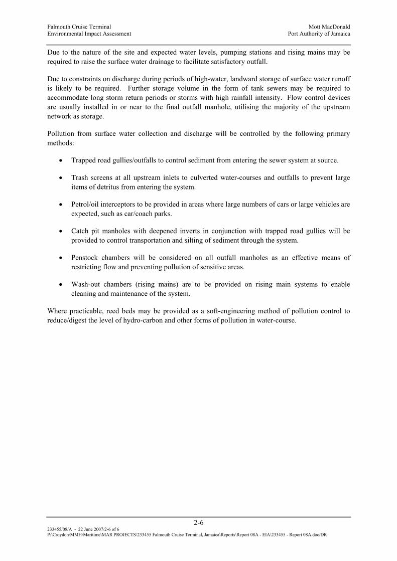
Falmouth Cruise Terminal Mott MacDonald Environmental Impact Assessment Port Authority of Jamaica
2-6 233455/08/A - 22 June 2007/2-6 of 6 P:\Croydon\MMH\Maritime\MAR PROJECTS\233455 Falmouth Cruise Terminal, Jamaica\Reports\Report 08A - EIA\233455 - Report 08A.doc/DR
Due to the nature of the site and expected water levels, pumping stations and rising mains may be required to raise the surface water drainage to facilitate satisfactory outfall.
Due to constraints on discharge during periods of high-water, landward storage of surface water runoff is likely to be required. Further storage volume in the form of tank sewers may be required to accommodate long storm return periods or storms with high rainfall intensity. Flow control devices are usually installed in or near to the final outfall manhole, utilising the majority of the upstream network as storage.
Pollution from surface water collection and discharge will be controlled by the following primary methods:
• Trapped road gullies/outfalls to control sediment from entering the sewer system at source.
• Trash screens at all upstream inlets to culverted water-courses and outfalls to prevent large items of detritus from entering the system.
• Petrol/oil interceptors to be provided in areas where large numbers of cars or large vehicles are expected, such as car/coach parks.
• Catch pit manholes with deepened inverts in conjunction with trapped road gullies will be provided to control transportation and silting of sediment through the system.
• Penstock chambers will be considered on all outfall manholes as an effective means of restricting flow and preventing pollution of sensitive areas.
• Wash-out chambers (rising mains) are to be provided on rising main systems to enable cleaning and maintenance of the system.
Where practicable, reed beds may be provided as a soft-engineering method of pollution control to reduce/digest the level of hydro-carbon and other forms of pollution in water-course.

Falmouth Cruise Terminal Mott MacDonald Environmental Impact Assessment Port Authority of Jamaica
3-1 233455/08/A - 22 June 2007/3-1 of 23 P:\Croydon\MMH\Maritime\MAR PROJECTS\233455 Falmouth Cruise Terminal, Jamaica\Reports\Report 08A - EIA\233455 - Report 08A.doc/DR
3 Methodology
3.1 Environmental Chemistry
3.1.1 3.1.1 Water Quality
A statement on water quality is required to review background levels of critical indicators as well as to identify and quantify actual and/or potential impacts associated with the implementation of the Falmouth Cruise Ship Pier Development. The Oyster Bay area has been previously studied largely due to interest in its bioluminescence and the potential impact of planned development on the ecosystem (ESL 2005, Hibbert 2005).
Based on the nature of the proposed development and in keeping with the Terms of Reference, assessment of water quality is based on an evaluation of the following indicators:
• Nitrate (NO3)
• o-Phosphate (o-PO4)
• Coliform bacteria (total and faecal)
• Biological Oxygen Demand (BOD)
• Suspended solids
• Dissolved Oxygen
• Salinity
• Conductivity
• Temperature
Water quality data from spot sampling carried out by Environmental Solutions Limited (ESL) in 2004 is shown in Table 3-1. The highlighted stations (4, 5, and 10) correspond to Stations 1, 2 and 3 established for this assessment.
The ESL data indicate nitrates and phosphates just within the Draft NEPA standard and faecal coliform elevated in three of five samples taken in Oyster Bay. Highest turbidity was indicated at the mouth of the Martha Brae. Dissolved oxygen was within the standard and close to saturation level at all sites. Oil and grease were determined to be insignificant at all sites (≤2.3mg/l).
Salinity measurements at the marine stations, Stations 1 - 4, were determined to be typical of Jamaican coastal waters being in the range 34.9 to 36.1ppt. Near the mouth of the Martha Brae conditions were brackish (salinity 6.2ppt).

Falmouth Cruise Terminal Mott MacDonald Environmental Impact Assessment Port Authority of Jamaica
3-2 233455/08/A - 22 June 2007/3-2 of 23 P:\Croydon\MMH\Maritime\MAR PROJECTS\233455 Falmouth Cruise Terminal, Jamaica\Reports\Report 08A - EIA\233455 - Report 08A.doc/DR
Table 3-1: Water Quality Data for Oyster Bay, Trelawny, Jamaica
SAMPLING STATIONS PARAMETERS
1 2 3 4 5 6 7 8 9 10
NRCA Draft
Ambient Marine
Standards
pH 8.4 8.3 8.4 8.3 8.3 8.3 8.3 8.3 8.3 8.2 8.0-8.44
Salinity (ppt) 36.1 34.9 36.1 36.0 19.5 6.0 32.2 34.9 6.8 6.2 -
Dissolved
Oxygen (mg/L)
5.6 6.0 6.6 5.8 6.1 6.5 5.2 5.9 6.2 6.4 4.5-6.8
BOD (mg/L) 2.0 6.0 1.0 1.0 1.0 7.0 1.0 1.0 1.0 1.0 0.57-1.16
Nitrate (mg/L) 0.25 0.99 0.24 0.07 2.79 1.12 0.68 1.67 4.77 2.36 0.001-
0.081
Turbidity (NTU) 0.29 0.67 0.66 0.79 4.64 4.12 6.99 4.38 4.63 31.1 -
Phosphate
(mg/L)
1.1 0.01 0.04 0.06 0.2 0.03 0.03 0.1 0.03 0.03 0.001-
0.055
Oil & Grease
(mg/L)
2.0 1.0 0.9 1.6 1.1 2.0 2.3 0.9 1.1 1.5 -
Total Coliform
(MPN/100ml)
<3 3.0 <3 <3 1100.0 460.
0
43.0 75.0 1100.0 460.0 48-256
Faecal Coliform
(MPN/100ml)
<3 <3 <3 <3 <3 240.
0
<3 7.0 21.0 43.0 <2-13
These data suggested that at the time of sampling there appeared to be no significant stress on water quality but given that the level of nutrients were at or close to the standard, there appeared to be little or no headroom for receiving of additional input of N and P without the risk of triggering eutrophication.
The Terms of Reference for this assessment requires that baseline data for the study area include:
“Water quality of any existing wells, rivers, ponds, streams or coastal waters in the vicinity of the development. Quality Indicators should include but not necessarily be limited to nitrates, phosphates, faecal coliform, and suspended solids”.

Falmouth Cruise Terminal Mott MacDonald Environmental Impact Assessment Port Authority of Jamaica
3-3 233455/08/A - 22 June 2007/3-3 of 23 P:\Croydon\MMH\Maritime\MAR PROJECTS\233455 Falmouth Cruise Terminal, Jamaica\Reports\Report 08A - EIA\233455 - Report 08A.doc/DR
“Obvious sources of pollution existing and extent of contamination”.
The scope of the water quality assessment includes Oyster Bay and main inflows, the channel and an offshore site outside the immediate influence of land based pollution sources
This assessment is based on review of available literature, site investigation and analysis of samples.
(i) Literature review
Literature reviewed included data generated by ESL, UWI and NRCA/NEPA draft ambient standards for the coastal/marine environment.
(ii) Site investigation
Fieldwork carried out on Thursday, 8th March 2007 involved the collection of samples and field measurements. Samples were collected approximately 0.3m below the surface and 0.5m from the bottom of the water column where depth was ≥ 2m. For shallower depths sampling was restricted to 0.3m below the surface. Sub-surface samples were collected using the Van Dorn sampler. The sampling sites and coordinates are presented schematically in
Figure 3-1 and Table 3-2. A duplicate sample collected at Station 1 was identified as 1A.

Falmouth Cruise Terminal Mott MacDonald Environmental Impact Assessment Port Authority of Jamaica
3-4 233455/08/A - 22 June 2007/3-4 of 23 P:\Croydon\MMH\Maritime\MAR PROJECTS\233455 Falmouth Cruise Terminal, Jamaica\Reports\Report 08A - EIA\233455 - Report 08A.doc/DR
Figure 3-1: Water Quality Sampling Stations
Table 3-2: Water Quality Sampling Stations
ID Description Coordinates N 18o
Coordinates W 77o
1 Bush Cay 29.533 38.095
2 Entrance To Glistening Waters Lagoon 29.290 38.294
3 Martha Brae River Mouth 28.972 38.367
4 Little Bridge Falmouth Near Drain Outfall 29.318 38.937
5 Between Channel Marker Buoys 29.755 38.796
6 Background (Offshore) 30.113 38.543
Station 1
Station 4
Station 5
Station 2
Station 6
Bush Cay
Station 3

Falmouth Cruise Terminal Mott MacDonald Environmental Impact Assessment Port Authority of Jamaica
3-5 233455/08/A - 22 June 2007/3-5 of 23 P:\Croydon\MMH\Maritime\MAR PROJECTS\233455 Falmouth Cruise Terminal, Jamaica\Reports\Report 08A - EIA\233455 - Report 08A.doc/DR
(iii) Analysis
Samples were analysed to determine concentration of the following parameters: Nitrate, o-Phosphate, Coliform bacteria (total and faecal), Biological Oxygen Demand (BOD) and Suspended solids. Dissolved Oxygen, Temperature, Salinity and Conductivity were determined in the field using portable instrumentation. Samples were analysed by the National Water Commission Laboratory in Montego Bay using Standard methods for the Analysis of Water and Wastewater (APHA, AWWA, and WEF). Analytical methods are summarised in Table 3-3.
Table 3-3: Summary of Analytical Methods
Parameter Method
Nitrate (NO3) Cadmium Reduction/Colorimetry
Phosphate (o-PO4) Molybdenum Method/Colorimetry
Coliform (faecal, total) Membrane Filter
BOD5 Bottle Method
Total Suspended Solids (TSS) Filtration and Gravimetry
Turbidity Photometry
Dissolved Oxygen (DO), Salinity, Temperature (oC)
YSI Model 85 Oxygen, Conductivity, Salinity, Temperature Meter
3.1.2 Air Quality and Noise
The air quality is required to characterize the local air shed in terms of specific parameters that could be impacted by the development in the construction and operational phases.
Based on the nature of the proposed development and in keeping with the Terms of Reference, assessment of air quality is based on an evaluation of ambient PM10, relative humidity, ambient temperatures and noise levels of the undeveloped site and ambient noise in the area of influence.
National ambient air quality standards are summarised in Table 3-4.

Falmouth Cruise Terminal Mott MacDonald Environmental Impact Assessment Port Authority of Jamaica
3-6 233455/08/A - 22 June 2007/3-6 of 23 P:\Croydon\MMH\Maritime\MAR PROJECTS\233455 Falmouth Cruise Terminal, Jamaica\Reports\Report 08A - EIA\233455 - Report 08A.doc/DR
Table 3-4: National Ambient Air Quality Standards, Jamaica
Pollutant Averaging time
Standard (Maximum concentration)
µg/m3
Total Suspended Particulate Matter (TSP)
Annual 24 h
60 150
PM10 Particulate matter <10µ Annual 24 h
50 150
Sulphur Dioxide Annual 24 h 1 h
80 Primary; 60 secondary 365 Primary; 280 Secondary
700
Carbon Monoxide 8 h 1 h
10,000 40,000
Nitrogen Dioxide Annual 100
There is no air quality data available for the project site. A typical commercial site would be the site in the bustling commercial centre Half Way Tree in Kingston which had an average PM10 of 41µg/cm3 between February and December 2006 (Figure 3-2) (TEMN 2007). Throughout the monitoring period air quality at the site was influenced by traffic, fugitive dust from unknown sources as well as from the construction of the Half Way Tree Transportation Depot. Dust control was achieved mainly by wetting.

Falmouth Cruise Terminal Mott MacDonald Environmental Impact Assessment Port Authority of Jamaica
3-7 233455/08/A - 22 June 2007/3-7 of 23 P:\Croydon\MMH\Maritime\MAR PROJECTS\233455 Falmouth Cruise Terminal, Jamaica\Reports\Report 08A - EIA\233455 - Report 08A.doc/DR
Figure 3-2: Half Way Tree, PM10 February to December 2006
0
20
40
60
80
100
120
140
160
1802/
11/0
6
2/23
/06
3/7/
05
3/19
/06
3/31
/06
4/12
/05
4/24
/06
5/6/
06
5/24
/06
6/19
/06
7/15
/06
8/10
/06
9/5/
06
10/1
/06
10/2
1/06
10/3
0/06
11/1
1/06
11/2
3/06
12/5
/06
12/1
7/06
12/2
9/06
Date
mc.
g/c.
m.
PM10 STD (24-hr)AVG PM10: 41 mc.g./c.m.MAX PM10: 153; MIN PM10:
Monitoring was carried out over the period Wednesday, 7th March to Thursday, 8th March 2007. Three sites were selected to determine PM10 in Falmouth and environs. These sites were Falmouth Police Station, William Knibb High School and the old main road near FDR Pebbles Hotel (Table 3-5). Approximate site coordinates were determined using the Garmin 12 GPS.
Table 3-5: PM10 Monitoring Sites
STATION ID Coordinates N 18o
Coordinates W 77o
1 Falmouth Police Station (FPS) 29.815 33.441
2 William Knibb High School (WKHS) 28.439 39.773
3 Old Main Rd. Near Pebbles (PEBBLES) 29.100 36.846
Methods used are summarised in Table 3-6. PM10 is determined using the Airmetrics Portable Minivol sampling system. Although, not a USEPA reference method, the portable sampler has demonstrated good correlation to the CA/T reference TEOM® instrument (Dolan, Schattanek, and Wan). Exposure time was 24hrs for PM10 at each site.
Noise is measured as sound pressure level (SPL) on the A weighted scale in decibels (db). Sound level was recorded minutely for 10 – 15 min along with a description of associated activities.

Falmouth Cruise Terminal Mott MacDonald Environmental Impact Assessment Port Authority of Jamaica
3-8 233455/08/A - 22 June 2007/3-8 of 23 P:\Croydon\MMH\Maritime\MAR PROJECTS\233455 Falmouth Cruise Terminal, Jamaica\Reports\Report 08A - EIA\233455 - Report 08A.doc/DR
Table 3-6: Summary of Air Quality Methods
Parameter Method Test Data
PM10 Airmetrics MiniVol ≥13.9
Noise CEL-328 Integrating Sound Level Meter
Freq Response: 3.5Hz – 28KHz
3.2 Ecology
A terrestrial and marine ecological assessment of the area surrounding the proposed ship terminal area located on the shore and extending approximately 1000m seaward was conducted in March of 2007. The objectives were to:
• Provide a baseline assessment of the biological status of the project area,
• Identify direct and indirect as well as short and long term impacts to the ecology of the area resulting from the proposed development activities,
• Assess alternative development options and suggest appropriate mitigation for the proposed development
Reference was also made to scientific literature generated by previous research activities in the area.
3.2.1 Terrestrial Ecology
(i) Item 1
For the purpose of this EIA the boundaries of the study area were determined from site maps and development plans provided. The study area was further categorized into three zones, namely the commercial district/ residential areas (Zone A), coastal area (Zone B) and mangrove wetlands (Zone C). A “walk-through” survey method was used (20th March 2007) to determine the presence or absence of ecologically or commercially important species of flora and fauna in or immediately adjacent to the site. Species of flora and fauna were identified on location and selected samples photographed for further verification at the laboratory. Nine belt transects (TA to TI) were conducted, of varying lengths (Section 4.2.1(i), Figure 4-10) and data was collected from a 2 m x 2 m belt every 20m along the line. Data recorded was used to give an indication of the dominant plant species within the study area.
Faunal community composition was recorded under the following headings:
MACROFAUNA; INSECTS; AVIFAUNA;

Falmouth Cruise Terminal Mott MacDonald Environmental Impact Assessment Port Authority of Jamaica
3-9 233455/08/A - 22 June 2007/3-9 of 23 P:\Croydon\MMH\Maritime\MAR PROJECTS\233455 Falmouth Cruise Terminal, Jamaica\Reports\Report 08A - EIA\233455 - Report 08A.doc/DR
(ii) Item 2
The avifaunal survey (27th March 2007) was based on a combination of two methods. The Line Transect Census Method provided a preliminary list of bird sightings (Section 4.2.1(ii), Figure 4-11) and entailed walking slowly for a given distance or time period along selected routes, noting all the birds seen or heard in the area. Birds were identified by both sight and call. The second, Fixed Radius Point Count Census Method, required counting birds from a defined location and determining the distance to each bird censured. A point was selected from where all bird contacts (seen and heard) were recorded, and the distance estimated (< 25m or >25m) for each contact. The procedure was repeated every 10 min (Bibby et al., 1998), before moving to another point 200m away (Section 4.2.1(ii), Figure 4-11). Avifaunal species observed between point counts were also recorded.
Advantages of this method include:
• Ease of observation of the birds and their habitats from a stationary position
• More time available to identify contacts
• Greater opportunity to identify cryptic and skulking species
• Easier to relate bird occurrence to habitat features
Avifauna identified was ranked according to the following criteria:
R = resident
E = endemic
I = introduced
W = winter migrant
S = summer migrant
Consideration was given to both the economic and ecological value of all species identified during the terrestrial survey.
3.2.2 Marine Ecology
An assessment of the marine environment was conducted between 21st and 24th February 2007. Towline swims using underwater scooters were carried out to assess the general features of the area and to obtain qualitative data of the marine community in the ship channel and within the harbor. Towline swims were used to assess the area along transects A to G, G to F, F to E, E to H, H to C, and C to B. The general characteristics of the benthos were recorded using underwater photography (Figure 3-3).

Falmouth Cruise Terminal Mott MacDonald Environmental Impact Assessment Port Authority of Jamaica
3-10 233455/08/A - 22 June 2007/3-10 of 23 P:\Croydon\MMH\Maritime\MAR PROJECTS\233455 Falmouth Cruise Terminal, Jamaica\Reports\Report 08A - EIA\233455 - Report 08A.doc/DR
Photo transects were used to quantify the benthic components at 4 representative sites in the harbour most likely to be affected by the dredging activities (A, F, G, and Chubb Castle). Three random 10 m transects (0.5m x 10m) were photographed at each location, including the sill reef systems located to the east and west of the existing ship channel. Substrate composition was determined by random dot analysis of the photographed transects using the Coral Point Count with Excel extensions (CPCe v3.1). Corals and algae were identified to the species level where possible while all other reef components were grouped into categories (e.g. sponges, anemones or gorgonians).
Figure 3-3: Satellite View of Survey Area
Fish counts were conducted along the same transect lines. The species observed were identified and ranked using the DAFOR (Dominant, Abundant, Frequent, Occasional, and Rare) scale.
(i) Phytoplankton Identification and Enumeration Methodology
Water samples were collected on the night, 13th April 2007, in 250 ml containers from nine sites in and adjacent to Falmouth Harbour (Figure 3-4).
Bushy Cay B
F
E H D C 1 2
Bushy Cay 54 3
7 8
A
B
C
D
E
F
G
H
Bush Cay

Falmouth Cruise Terminal Mott MacDonald Environmental Impact Assessment Port Authority of Jamaica
3-11 233455/08/A - 22 June 2007/3-11 of 23 P:\Croydon\MMH\Maritime\MAR PROJECTS\233455 Falmouth Cruise Terminal, Jamaica\Reports\Report 08A - EIA\233455 - Report 08A.doc/DR
Figure 3-4: Phytoplankton Sampling Stations
Each sample was preserved with 15ml Lugol’s solution (Vollenweider 1969, Steidinger 1979). Once collected the samples were returned to the lab for microscopic analysis.
The samples were gently homogenised by inversion, to randomly distribute phytoplankton cells throughout each container. Based on the visible density of the phytoplankton cells, 10 – 100 ml aliquots of each homogenised sample were used to fill settling chambers which were left to stand overnight to allow settling of the phytoplankton before examination. A Leitz Labovert (model no. 020-435.025) inverted microscope was used to examine the samples and the counting technique used was varied according to the density of the settled phytoplankton cells in each sample (Hallegraeff, 1995). Dense concentrations of phytoplankton in settled samples were counted using thirty random fields of view of the base of the settling chamber. The phytoplankton in these thirty fields were identified and enumerated using a x20 objective lens, and then the entire base of the chamber was examined using a x10 objective lens to record any phytoplankton species that were not observed during the initial enumeration process. Sparse concentrations of phytoplankton in settled samples were counted by identifying and enumerating phytoplankton species throughout the entire base of the settling chamber using a x20 objective lens.
The counting process was repeated using a pseudo-replicate sample from each initial whole water sample. The number of cells per litre of each phytoplankton species in each sample was calculated from the counts obtained.
Bush Cay
1
9
8
7
6
5
4 2
Bush Cay

Falmouth Cruise Terminal Mott MacDonald Environmental Impact Assessment Port Authority of Jamaica
3-12 233455/08/A - 22 June 2007/3-12 of 23 P:\Croydon\MMH\Maritime\MAR PROJECTS\233455 Falmouth Cruise Terminal, Jamaica\Reports\Report 08A - EIA\233455 - Report 08A.doc/DR
3.3 Socio-economic Assessment
The socioeconomic impact assessment (SIA) identifies the socioeconomic and cultural impacts of the proposed development. The study area for the SIA includes the proposed site and areas within two kilometers (2 km) of the site. Any new development in a community will have both local (micro), regional and national and (macro) impacts. For the purpose of this SIA the local impacts will include the proposed site and the area within 2 km of the site. Regional impacts will be those at the Parish level while national impacts will be island wide. The SIA included desktop research as well as a socioeconomic and public perception survey. A site reconnaissance and socioeconomic and perception survey were conducted on 3rd and 4th March 2007. The land use survey for this SIA included a review of satellite imagery of Jamaica, historic maps and a land use survey which was conducted for this study on March 4 and April 1, 2007.
3.4 Hydrogeology
This report satisfies Task #2A (i) and Task #5 TORs of the proposed Falmouth Cruise Ship Terminal. These aspects include:
• A definition of the study area, based on the drainage area of which this development is a part. These boundaries will be demarcated based on a desktop review of available topography maps and limited field reconnaissance along open and traversable access ways.
• Baseline data collection on the study area (hydrology, geology, hydrogeology, geomorphology, etc.) and review of existing reports and other information relevant to the study area.
• Review the collected data with a view to determine:
o Water demand of the terminal facilities and cruise ships which will be reconciled against the available water supply.
o Pre and post project runoff rates for 25 year return period
o Possibility for contamination of the coastal waters as a result of the proposed project.
• Identification of Potential Environmental Impacts relating to:
o Flooding of the site or to adjacent areas as a consequence of the development.
o Soil erosion to and from the site.
o Utilization of existing water supply sources and/or the development of new source(s) e.g. well source.
• Explorative Drainage Assessment to determine:
o Drainage for the site during construction, including sediment control mitigation.
o Drainage for the site during operation, including sediment control and pollution control.

Falmouth Cruise Terminal Mott MacDonald Environmental Impact Assessment Port Authority of Jamaica
3-13 233455/08/A - 22 June 2007/3-13 of 23 P:\Croydon\MMH\Maritime\MAR PROJECTS\233455 Falmouth Cruise Terminal, Jamaica\Reports\Report 08A - EIA\233455 - Report 08A.doc/DR
o Drainage control for the gully traversing the property, to include impacts that this drain will have on the aesthetics, water quality and sedimentation of the beach area, etc.
3.4.1 Background & Approach
The available data that was referenced for this study is listed below:
• Satellite Photographs western part is dated 19th April 2006 and the eastern part is 23rd September 2003
• 1: 50,000 Series Geological Sheet 8 dated April 1974
• Water Resources Authority (WRA) Data Request – Falmouth, 2007 (this was supplemented with data from the Meteorological Office of Jamaica) and 1990 Water Resources Development Master Plan
• Office of the Disaster Preparedness and Emergency Management (ODPEM)
• The National Water Commission (NWC) website and local library searches
• The archives of TEMN where pertinent to the study area
• Internet searches of NEPA and others
All issues material to the site, such as rainfall, groundwater pollution incidents, flooding incidents, mains supply facilities and other critical facilities were reviewed within a 1km radius of the site.
The hydrological assessment was made using the Rational Equation which is used around the world for peak flow estimation of small rural drainage basins and is the most widely used method for urban drainage design. This was coupled with Crystal Ball v7a simulation program that helps analyze the risks and uncertainties associated with any Excel spreadsheet models. Crystal Ball generates thousands of possible outcomes using Monte Carlo simulation.1
The comments made on groundwater conditions are based on observations made at the time that available site work was carried out or documents reviewed. It should be noted that groundwater levels will vary owing to seasonal, tidal and weather related effects.
3.4.2 Site Description
This desktop report was complied from limited field reconnaissance, current public domain reports held within various governmental and non-governmental bodies and internet searches.
The site is centred on UTM 220100mE, 2046590mN (see Figure 1, Appendix 6). The site is roughly bound by Market, Tharpe and Rodney Streets within the main town with extensions into the Winns Morass to the east and open lands near the Falmouth Hospital to the west.
1 The Monte Carlo simulation is a type of spreadsheet based simulation which randomly generates values for chosen uncertain variables over and over to simulate a model outcome as the inputs vary. Results are presented using a probability distribution frequency curve (PDF).

Falmouth Cruise Terminal Mott MacDonald Environmental Impact Assessment Port Authority of Jamaica
3-14 233455/08/A - 22 June 2007/3-14 of 23 P:\Croydon\MMH\Maritime\MAR PROJECTS\233455 Falmouth Cruise Terminal, Jamaica\Reports\Report 08A - EIA\233455 - Report 08A.doc/DR
The site walkthrough was done on 13th February 2007 by the author to visually verify the geology, ascertain the hydrogeology and investigate any scale-related events that may not have been captured in the previous studies.
The land slopes imperceptibly toward the coast which is consistent with its alluvial progeny being on the distal end of the deposition fan created by the Marta Brae River. Elevations are within a range from 1–1.20 m above mean sea level.
3.5 Coastal Dynamics
3.5.1 Site Description
The Martha Brae River Estuary (MBRE) covers a land area of over 650 hectares in size, including mangroves and wetland vegetation. The stand of mangroves is one of the few remaining tracts of virgin forest left in the island and particularly on the North Coast. The area for the most part is characterized by a low-lying relief, which leaves it particularly susceptible to flooding. To the west the estuary is bounded by the Salt Marsh mangroves and in the east by the area known as Mountain Spring.
There are two major fishing beaches along the coastline, Half Moon Bay to south and Oyster Bay to the east. Oyster Bay or Glistening Waters is especially interesting as it features bioluminescent organisms that make the bay a spectacular sight.
The area known as Oyster Bay is approximately 16.4 x 10⁵m2 (Carpenter and Seliger, 1968). The bay is shallow ranging in depths from 1.7 m to less than 0.6 m in some areas. On the eastern side is a large stand of mangroves interspersed with Caribbean pine. Also in the eastern end is a small marina, which offers fishing tours. To the west the bay is fringed by the town of Falmouth and the old sugar works. The Martha Brae River enters the southern part of the outer bay. The river is regarded as small but has a substantial discharge. Average depth at the river mouth is 3m, depth decreases to less than 0.3m across the distributary mouth bar (Burdick 1984).
3.5.2 Bathymetry
In an effort to gain an understanding of the coastal processes at work in the bay a detailed bathymetric survey of the channel was performed. Positions were collected using a Trimble GeoXT GPS receiver and an AutoHelm ST90 depth sounder and are referenced to UTM WGS 84. Depths were logged to a PSION handheld computer and time-stamped to the GPS time.
3.5.3 Currents
In order to quantify a sample of the magnitude and directions of the currents in the Harbour, a pair of INTEROCEAN S4 current meters were deployed in the inner ship’s navigational channel and also near the river mouth, for a period of 4 days (27th – 30th April 2007), i.e. over a complete tidal cycle.

Falmouth Cruise Terminal Mott MacDonald Environmental Impact Assessment Port Authority of Jamaica
3-15 233455/08/A - 22 June 2007/3-15 of 23 P:\Croydon\MMH\Maritime\MAR PROJECTS\233455 Falmouth Cruise Terminal, Jamaica\Reports\Report 08A - EIA\233455 - Report 08A.doc/DR
3.5.4 Waves
Wave modeling was previously performed by Mott MacDonald and this program examined design wave scenarios pre and post dredging.
Information gained from these exercises was correlated with water quality data of temperature and salinity, as well as an examination of the configuration of the shoreline itself. This provided an understanding of possible wave-reflection and diffraction patterns in the bay and the associated water-levels and currents that would accompany such.
Overall this examination coupled with field observations during periods of strong and weak trade winds informed the analysis of the dynamics of the bay and lead to the delineation of issues of concern.
3.5.5 Storm Surge Analysis
(i) Database of Hurricanes and Tropical Storms
A tropical cyclone is classified as a hurricane only after it has attained one-minute maximum sustained near-surface (10m) winds of 33m/s or more. Below this level, these are referred to as Tropical Storms. Hurricanes are commonly classified into categories according to the Saffir-Simpson Scale, which is shown below in Table 3-7.
Table 3-7: The Saffir-Simpson Hurricane Intensity Scale
Category 1 2 3 4 5
Vmax (knots) 64-83 84-95 96-113 114-135 >135
Vmax(km/hr) 119-154 155-178 179-210 211-250 >250
Vmax(m/s) 33-43 44-49 50-58 59-70 >70
Hurricane tracks in the North Atlantic basin can more or less be described as a parabolic sweep. They form between latitudes 5° and 25° north of the Equator. Those formed at the lower latitudes are usually pushed on a westerly track by the Northeast Trade Winds, whereas those in the higher latitudes track more to the north and northwest.

Falmouth Cruise Terminal Mott MacDonald Environmental Impact Assessment Port Authority of Jamaica
3-16 233455/08/A - 22 June 2007/3-16 of 23 P:\Croydon\MMH\Maritime\MAR PROJECTS\233455 Falmouth Cruise Terminal, Jamaica\Reports\Report 08A - EIA\233455 - Report 08A.doc/DR
For this analysis, Hurricane waves were evaluated with the aid of an in-house program, HURWave. The wave climate produced in this task is applicable to deep water adjacent to the project site. HURWave scans NOAA's database of hurricane records, which dates back to 1900, and hindcasts the waves that are produced by storms that pass within a user specified distance of the project site. In this case, all hurricanes passing within a 200km radius of the Falmouth site were selected from the larger database. Figure 3-5 summarizes all the hurricanes and tropical storms that have passed within 200km of Falmouth from 1900 – 2005. The hurricanes are listed in chronological order and their category strength is illustrated in a colour-coded manner. The values presented show the hurricane characteristics, maximum wind speed (Vmax), the hurricane category, the hurricane forward speed (Vfd) and the hurricane central pressure values, recorded when the storm was positioned closest to Falmouth (the minimum distance, showing how close the storm passed to a point close to the Falmouth cruise ship is also presented). Some storms listed in the table are shown to have a hurricane category of zero. This is because, as the storm passed the point closest to the island, it did not have hurricane strength winds, however, the storm strengthened somewhere within the 200km radius of the island and developed into a hurricane.
Figure 3-5: Category 3 - 5 Hurricanes Passing within 200km of Falmouth (1900 – 2005)

Falmouth Cruise Terminal Mott MacDonald Environmental Impact Assessment Port Authority of Jamaica
3-17 233455/08/A - 22 June 2007/3-17 of 23 P:\Croydon\MMH\Maritime\MAR PROJECTS\233455 Falmouth Cruise Terminal, Jamaica\Reports\Report 08A - EIA\233455 - Report 08A.doc/DR
Table 3-8: Hurricanes Passing Within 200 km of Falmouth (1900 - 2005)
NAME DATE LONG. LAT. mxVmax (knts)
CAT. DIST (km)
Vfd (knts)
Pc (mb)
NOT NAMED 2 1903 08/11/1903 12:00 78 18.2 100 3 51.4 17.56
NOT NAMED 6 1947 09/20/1947 06:00 78.1 18.6 35 0 51.84 6.73
NOT NAMED 3 1917 09/23/1917 18:00 77.6 19.1 95 2 67.68 8.58
NOT NAMED 2 1915 08/13/1915 12:00 78.2 18.8 100 3 70.42 13.07
NOT NAMED 4 1916 08/16/1916 00:00 77.1 18 95 2 82.53 20.36
NOT NAMED 19 1933 10/29/1933 12:00 77.9 17.8 85 2 82.7 3.63
NOT NAMED 11 1949 10/12/1949 12:00 78.6 18.1 35 0 115.21 18.86
NOT NAMED 1 1904 06/14/1904 00:00 77.4 19.5 60 0 115.51 4.5
Dennis 2005 07/08/2005 00:00 77.1 19.4 120 4 118.06 21.42 951
GERDA 1961 10/16/1961 00:00 77 17.5 30 0 132.71 9.47
NOT NAMED 7 1948 09/18/1948 06:00 78.8 18.2 50 0 132.9 10.04
LILI.2002 09/30/2002 06:00 78.7 19.1 60 0 135.53 13.55 991
ISSIDORE.2002 09/18/2002 21:05 78.8 19 50 0 140.49 11.42 999
CARMEN 1974 08/31/1974 18:00 77.9 17.2 75 1 147.48 18.99
NOT NAMED 4 1935 09/27/1935 12:00 79 18.3 100 3 152.64 8.63
NOT NAMED 6 1912 11/18/1912 00:00 78.7 17.6 130 4 154.38 3.62
CHARLEY 2004 08/11/2004 17:03 77.5 17 65 0 167.92 14.56 993
FIFI 1974 09/16/1974 18:00 77.8 17 35 0 167.97 8.98 1005
KING 1950 10/16/1950 12:00 78.7 19.6 85 2 170.37 6.39
NOT NAMED 10 1934 10/20/1934 06:00 76.6 17.3 40 0 177.6 6.73
GORDON 1994 11/13/1994 06:00 76 18.3 40 0 185.34 19.05 1001
NOT NAMED 8 1924 11/09/1924 00:00 76.5 19.7 45 0 185.8 4.49
IVAN 2004 09/11/2004 17:03 79.3 18.2 145 5 187.51 7.14 914
Wilma 2005 10/16/2005 06:00 79 17.5 30 0 187.61 2.02 1003
NOT NAMED 5 1935 10/22/1935 18:00 76.7 19.9 60 0 189.21 7.31
NOT NAMED 5 1931 09/09/1931 06:00 77.7 16.8 55 0 189.54 18.12
NOT NAMED 2 1938 08/12/1938 06:00 79.1 17.6 75 1 190.62 23.5
NOT NAMED 6 1901 09/14/1901 06:00 78.3 20.1 45 0 193.42 13.41
NOT NAMED 1 1910 08/24/1910 12:00 76.3 17.4 35 0 194.03 8.29
NOT NAMED 9 1942 10/13/1942 18:00 76.1 19.3 40 0 194.81 24.18
FLORENCE 1953 09/23/1953 18:00 78.1 16.8 40 0 196.07 21.46
NOT NAMED 3 1904 10/14/1904 00:00 79.3 17.9 35 0 196.21 7.32
ALLEN 1980 08/06/1980 06:00 75.9 18.3 115 4 196.44 23.07 955

Falmouth Cruise Terminal Mott MacDonald Environmental Impact Assessment Port Authority of Jamaica
3-18 233455/08/A - 22 June 2007/3-18 of 23 P:\Croydon\MMH\Maritime\MAR PROJECTS\233455 Falmouth Cruise Terminal, Jamaica\Reports\Report 08A - EIA\233455 - Report 08A.doc/DR
NAME DATE LONG. LAT. mxVmax (knts)
CAT. DIST (km)
Vfd (knts)
Pc (mb)
NOT NAMED 4 1911 10/24/1911 12:00 75.9 18.8 35 0 198.15 8.04
NOT NAMED 4 1942 09/18/1942 18:00 76.3 17.3 45 0 201.27 8.09
FLORA 1963 10/06/1963 06:00 77.6 20.3 95 2 201.58 3.17
NOT NAMED 1 1918 08/04/1918 00:00 77.4 16.7 50 0 202.51 21.62
NOT NAMED 3 1909 07/16/1909 12:00 76.8 16.8 45 0 211.79 11.72
NOT NAMED 5 1939 11/01/1939 12:00 79.5 19.2 65 0 221.35 4.04
Iris.2001 10/07/2001 09:05 76.1 17.1 75 1 232.81 16.65 987
CLEO 1964 08/25/1964 06:00 75.6 18.9 125 4 233.14 11.22
NOT NAMED 6 1927 10/18/1927 12:00 79.5 19.5 40 0 235.35 16.39
NOT NAMED 6 1916 08/30/1916 18:00 76.7 16.6 85 2 236.77 15.21
HILDA 1955 09/14/1955 06:00 76.2 20.1 60 0 241.35 15.06
NOT NAMED 4 1944 08/20/1944 12:00 75.6 17.8 105 3 241.58 15.45
NOT NAMED 11 1906 11/06/1906 18:00 78 16.3 35 0 248.43 14.5
CHARLIE 1951 08/17/1951 18:00 75.7 17.4 95 2 249.64 18.46 964
NOT NAMED 1 1900 09/03/1900 06:00 75.7 19.6 35 0 250.08 8.29
NOT NAMED 2 1910 09/09/1910 00:00 75.4 18.3 70 1 252.02 11.24
ELOISE 1975 09/18/1975 12:00 75.7 19.9 40 0 268.19 13.01 1000
NOT NAMED 3 1933 07/16/1933 12:00 75.2 18.1 45 0 276.96 18.56
NOT NAMED 3 1928 09/02/1928 06:00 75.4 17.4 35 0 279.32 13.24
GILBERT 1988 09/12/1988 12:00 75.3 17.6 110 3 280.69 16.44 960
NOT NAMED 7 1932 09/29/1932 00:00 75.2 17.9 45 0 281.4 13.05
NOT NAMED 5 1909 08/24/1909 00:00 75.1 18.4 90 2 284.78 22.59
DENNIS 1981 08/14/1981 00:00 75.7 16.8 15 0 288.48 14.46
NOT NAMED 6 1933 08/16/1933 00:00 76 16.4 50 0 297.8 13.05
GERDA 1958 09/15/1958 12:00 74.8 19 35 0 323.03 20.69
CLAUDETTE 1979 07/20/1979 06:00 74.7 19.2 20 0 338.52 20.18 1013

Falmouth Cruise Terminal Mott MacDonald Environmental Impact Assessment Port Authority of Jamaica
3-19 233455/08/A - 22 June 2007/3-19 of 23 P:\Croydon\MMH\Maritime\MAR PROJECTS\233455 Falmouth Cruise Terminal, Jamaica\Reports\Report 08A - EIA\233455 - Report 08A.doc/DR
(ii) Hurricane Wave and Storm Surge Analysis
The elevated water level that accompanies hurricanes and which creates flooding and causes damage to coastal infrastructure is known as storm surge. This storm surge phenomenon has both static and dynamic components.
The static surge is comprised of an inverse barometric pressure rise, wave set-up and wind set-up, while the dynamic storm surge is as a result of wave run-up. Elevated waters levels due to the static surge can remain constant for hours during a storm, whereas water levels in the wave run-up zone will fluctuate as waves run-up and down the beach profile. Therefore, this zone will not always be wet, but will go through periods of wetting and drying. A definition sketch of the static and dynamic (wave run-up) components of storm surge are provided in Figure 3-6, with some descriptive text of the various components in Table 3-9.
Figure 3-6: Definition of Storm Surge
Mean Sea Level
Static Storm Surge
Shoreline Slope
1
Inundation
Wave Run-up
vv
In the scope of this project, only static storm surge levels were predicted. Thus, it should always be noted that the values presented for static storm surge do not include run-up, and as shown in Table 3-9, this would add additional inundation to the project shoreline. Also, the anticipated duration of effect of each of the components is presented in Table 3-9. It should be noted, furthermore, that values of high tide and global sea level rise (over the next 100 years) have been incorporated into the final storm static surge values.

Falmouth Cruise Terminal Mott MacDonald Environmental Impact Assessment Port Authority of Jamaica
3-20 233455/08/A - 22 June 2007/3-20 of 23 P:\Croydon\MMH\Maritime\MAR PROJECTS\233455 Falmouth Cruise Terminal, Jamaica\Reports\Report 08A - EIA\233455 - Report 08A.doc/DR
Table 3-9: Definitions of storm surge components
Component Definition Time Scale
Static Storm Surge
Inverse barometric rise The low pressure in the “eye” of the hurricane compared with surrounding atmospheric pressure elevates the water level within the hurricane.
1 – 4 hours
Wind set-up As the wind pushes water onshore, the water surface becomes tilted to balance the wind stress.
1 – 4 hours
Wave set-up As waves break nearshore, the forward motion of wave energy halts and is balanced by an increase in the mean sea level.
Duration of high seas (4– 8 hours)
Dynamic Storm Surge
Wave Run-up As waves reach the shoreline the remaining wave energy runs up the shore.
10-15 seconds
In order to predict the storm surge values around the Falmouth cruise ship pier, the following steps were taken:
i. Deep water wave and water level conditions were assessed.
ii. A computational grid representing the bathymetry of the site was generated.
iii. The deep water conditions were transformed to the nearshore zone using the 2D numerical model SWAN (Simulating WAves in the Nearshore).
iv. Nearshore values for both waves and storm surge were plotted for each of the study areas.
These steps and the results obtained are outlined in more detail in the next sections.
3.5.6 Deep Water (Extreme) Wave Condition
Several parametric models are available to estimate the generated deep water wave conditions and water levels, given certain basic parameters of a hurricane, which can be obtained from historical data. The term “parametric” refers to models that require the input of a few specific parameters. These parametric models, in most cases, rely on the simplification or the parameterization of numerical formulations related to wind-wave generation theories in combination with results of complex spectral wave models.
The high waves experienced during a hurricane are caused by the high wind speeds associated with the hurricane. The water level increase in deep or intermediate water depths comes about largely from the phenomenon called Inverse Barometric Pressure Rise (IBR). This is a function of the low air pressure in the eye of the hurricane (the low pressure causes the water level to rise). The IBR can also be computed using a parametric model.

Falmouth Cruise Terminal Mott MacDonald Environmental Impact Assessment Port Authority of Jamaica
3-21 233455/08/A - 22 June 2007/3-21 of 23 P:\Croydon\MMH\Maritime\MAR PROJECTS\233455 Falmouth Cruise Terminal, Jamaica\Reports\Report 08A - EIA\233455 - Report 08A.doc/DR
(i) Wave Heights
The parametric model of Young was used to calculate the deep water extreme wave conditions. Resulting from the use of the parametric model and the input of historical hurricane data, a series of deep water wave heights was computed. The data was then fit to various statistical distributions. The deep water wave conditions susceptible to affect the site were filtered into the following 4 directional bins. In addition, a directional filter was used to exclude the impact of waves from the west, south and south east, due to the sheltering characteristics of the island landmass, relative to the Falmouth shoreline.
• Waves from the N (337.5 – 22.5°)
• Waves from the NE (22.5 – 67.5°)
• Waves from the E (67.5 – 112.5°)
• Waves from the NW (292.5 – 337.5°)
Resulting from the parametric model and the historical hurricane data, a series of deep water wave heights for each bin was computed. For each of these bins, a statistical analysis was carried out according to the method of Goda (1990). The data was fit to various statistical distributions, and the best fit distribution was determined from the correlation as well as the goodness of the fit to the most extreme values in the distribution. Figure 3-7 following shows a typical plot of the data fitted to the Weibull distribution for the North directional bin.
Figure 3-7: Weibull Distribution for Wave Heights from the North Directional Sector

Falmouth Cruise Terminal Mott MacDonald Environmental Impact Assessment Port Authority of Jamaica
3-22 233455/08/A - 22 June 2007/3-22 of 23 P:\Croydon\MMH\Maritime\MAR PROJECTS\233455 Falmouth Cruise Terminal, Jamaica\Reports\Report 08A - EIA\233455 - Report 08A.doc/DR
3.5.7 Nearshore Transformation of Wave and Storm Surge
The parametric models are limited to determining the conditions in deep water (greater than 200m depth). At shallower depths, the waves are affected by the seabed bathymetry. The effects are extremely complex and require equally complex numerical programs to perform proper simulations. When waves approach the shoreline, they increase in height until they reach a limiting steepness, at which point they break. During breaking, a portion of their kinetic energy is transformed to potential energy. This potential energy is manifested as an increase in water level and is known as wave set-up and, as discussed earlier, is one component of the storm surge phenomenon.
The Hurricane wave conditions were transformed to the nearshore regions using SWAN (Simulating Waves Nearshore), a third-generation wave model that computes random, short-crested wind-generated waves in coastal regions and inland waters. This model was operated in a two-dimensional mode in order to determine the wave height and storm surge when approaching the area of interest. The 50-year values from Table 4-15 were used as the design conditions.
(i) Model Set-Up and Input Conditions
To assess the transformation of waves as they move from deep water in to the nearshore regions, a computational grid was created to represent the bathymetry of the site. The grid was generated based on information collected from the bathymetric survey data from nautical charts, beach profile surveys, topographic information and satellite imagery. The grid area, its size and grid spacing is presented in Table 3-10 below. The model grid spacing was kept small (5m x 5m) in order to obtain good resolution of the bathymetric contours.
Table 3-10: Computational Grids for SWAN Runs and Applicable Input Conditions
Grid Size Grid Spacing Area
X (m) Y (m) ∆X (m) ∆Y (m)
Input
Conditions
NW
N
NE Falmouth 2800 2800 5 5
E
The deep water hurricane conditions for the four most applicable wave directions that were obtained from the parametric models (Table 4-15) were input to the SWAN model. As indicated in the previous analysis, the site will be most affected by waves coming from the north-west, north, north-east and east. Waves from any other directions would have much less of an impact on this shoreline, and as such these were not considered in the analysis.

Falmouth Cruise Terminal Mott MacDonald Environmental Impact Assessment Port Authority of Jamaica
3-23 233455/08/A - 22 June 2007/3-23 of 23 P:\Croydon\MMH\Maritime\MAR PROJECTS\233455 Falmouth Cruise Terminal, Jamaica\Reports\Report 08A - EIA\233455 - Report 08A.doc/DR
The deep water wave conditions as specified in Table 4-15 were applied to the boundaries of the rectangular grid for each direction respectively. The SWAN model then took each of the wave height, period and direction groupings and generated a JONSWAP spectrum from these input wave conditions. This spectrum presents a more complete “picture” of the likely combinations of wave height, period and direction that would be associated with each particular sea state. The model was run in a stationary mode, with no time varying inputs. A constant wind field (magnitude and direction) and static water level including IBR, high tide and global sea level rise (Table 4-16) were applied over the entire model domain. The inclusion of wind values in the computation enabled local wave generation within Falmouth Harbour to be modelled. The wind direction in a hurricane changes rapidly; therefore, the worst-case scenario for wind direction was used, with winds approaching from the same dominant direction as the waves.

Falmouth Cruise Terminal Mott MacDonald Environmental Impact Assessment Port Authority of Jamaica
4-1 233455/08/A - 22 June 2007/4-1 of 3 P:\Croydon\MMH\Maritime\MAR PROJECTS\233455 Falmouth Cruise Terminal, Jamaica\Reports\Report 08A - EIA\233455 - Report 08A.doc/DR
4 The Environmental Setting
4.1 Environmental Chemistry
4.1.1 Water Quality
Results obtained for the analysis of samples are presented in Table 4-1.
Nitrate was in the range 0.027 to 2.964mg/l for all samples taken (
Figure 4-1). The highest level was determined at the mouth of the Martha Brae River at the top of the water column (3T) while at the bottom (3B) it was 1.087mg/l. The next highest value (1.37mg/l) was determined for the sample taken approximately 2m from the mouth of the culvert at Little Bridge near the entrance to Falmouth (4T).
Ortho phosphate (o-PO4) was determined to be in the range 0.015 to 0.092 (
Figure 4-1). The highest level was determined for the sample taken at the mouth of the Martha Brae .
Figure 4-1: Phosphate and Nitrate, 8th March 2007
1A 1T 1B 2T 2B 3T 3B 4T 4B 5T 5B 6T 6B STDPO4
0
0.5
1
1.5
2
2.5
3
mg/
l
ID
PO4 NO3

Falmouth Cruise Terminal Mott MacDonald Environmental Impact Assessment Port Authority of Jamaica
4-2 233455/08/A - 22 June 2007/4-2 of 3 P:\Croydon\MMH\Maritime\MAR PROJECTS\233455 Falmouth Cruise Terminal, Jamaica\Reports\Report 08A - EIA\233455 - Report 08A.doc/DR
TSS was in the range <1 to 7mg/l for all samples taken (Figure 4-2). The highest value was determined for the sample taken from the mouth of the Martha Brae at the bottom of the water column (3B) while at the surface (3T) TSS was 5mg/l. TSS was also relatively elevated in the sample taken opposite the culvert at Little Bridge 4T). TSS was insignificant in samples taken at all other sites being in the narrow range <1 to 2mg/l.
Biological Oxygen Demand (BOD) was in the range <0.1 - 2.1 mg/l. The highest BOD was determined for the sample taken at the entrance to Oyster Bay at the surface (2T) where at the bottom of the water column (2B) BOD was 0.6mg/l. The sample taken at the mouth of the Martha Brae had a BOD of 0.6mg/l while at the bottom (3B) BOD was 1.2mg/l. For samples taken at all other sites BOD was in the narrow range <0.1 to 0.6mg/l.
Figure 4-2: TSS, 8th March 2007
1A 1T 1B 2T 2B 3T 3B 4T 4B 5T 5B 6T 6B STD
TSS (mg/l)
0
1
2
3
4
5
6
7
8
9
10
mg/
l.
ID
Dissolved Oxygen was in the range 5.1 to 12.3mg/l (Figure 4-3). At all sites, except the Martha Brae mouth and near the culvert at Little Bridge, DO was lower at the bottom of the water column. The highest level was determined for Martha Brae mouth at the bottom while at the surface (3T) the level was 7.5mg/l. The lowest level was determined at the bottom of the water column at Bush Cay (1B) where DO at the surface (1T) was 5.3mg/l. At the entrance to Oyster Bay DO was 6.8mg/l at the surface (2T) and 5.5mg/l at the bottom (2B). At Little Bridge DO was 6.2mg/l at the surface (4T) and 6.3mg/l at the bottom (4T) and in the channel DO was 7.0mg/l at surface (5T) and 5.7mg/l at the bottom (5B). At the control site offshore, DO was 5.7mg/l at the surface and 5.6mg/l at the bottom.

Falmouth Cruise Terminal Mott MacDonald Environmental Impact Assessment Port Authority of Jamaica
4-3 233455/08/A - 22 June 2007/4-3 of 3 P:\Croydon\MMH\Maritime\MAR PROJECTS\233455 Falmouth Cruise Terminal, Jamaica\Reports\Report 08A - EIA\233455 - Report 08A.doc/DR
Dissolved oxygen deficit (difference between saturation value and actual value) was insignificant at most sites with the exception of the bottom of the water column at the mouth of the Martha Brae River (3B).
Figure 4-3: BOD and DO, 8th March 2007
1A 1T 1B 2T 2B 3T 3B 4T 4B 5T 5B 6T 6BBOD (mg/l)
DO (mg/l)
-8.0-6.0
-4.0
-2.0
0.0
2.0
4.0
6.0
8.0
10.0
12.0
14.0
mg/
l.
ID
BOD (mg/l) DD DO (mg/l) DOsat
Faecal Coliform was in the range <2 - 130MPN (Figure 4-4). The highest level was determined for the sample taken at Little Bridge near Falmouth. The sample taken at the mouth of the Martha Brae had a value of 49MPN and the sample from the channel had a level of 8MPN. Faecal coliform was not detected in samples from the other sites.
Total Coliform was in the range <2 - 1400MPN. The highest level was determined for the sample taken at the mouth of the Martha Brae (3T) while at Little Bridge near Falmouth (4T) the level was 540MPN. The sample taken at the entrance to Oyster Bay (2T) had a value of 5MPN and the sample from the channel (5T) had a level of 8MPN. Total coliform was not detected in samples from the other sites.
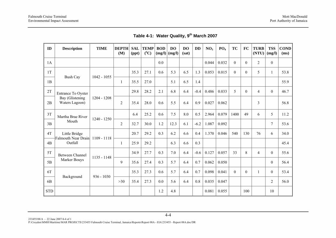
Falmouth Cruise Terminal Mott MacDonald Environmental Impact Assessment Port Authority of Jamaica
4-4 233455/08/A - 22 June 2007/4-4 of 1 P:\Croydon\MMH\Maritime\MAR PROJECTS\233455 Falmouth Cruise Terminal, Jamaica\Reports\Report 08A - EIA\233455 - Report 08A.doc/DR
Table 4-1: Water Quality, 9th March 2007
ID Description TIME DEPTH (M)
SAL (ppt)
TEMP(oC)
BOD (mg/l)
DO (mg/l)
DO (sat)
DD NO3 PO4 TC FC TURB (NTU)
TSS (mg/l)
COND (ms)
1A 0.0 0.044 0.032 0 0 2 0
1T 35.3 27.1 0.6 5.3 6.5 1.3 0.053 0.015 0 0 5 1 53.8
1B Bush Cay 1042 - 1055
1 35.5 27.0 5.1 6.5 1.4 55.9
2T 29.8 28.2 2.1 6.8 6.4 -0.4 0.486 0.033 5 0 4 0 46.7
2B
Entrance To Oyster Bay (Glistening Waters Lagoon)
1204 - 1208 2 35.4 28.0 0.6 5.5 6.4 0.9 0.027 0.062 3 56.8
3T 6.4 25.2 0.6 7.5 8.0 0.5 2.964 0.079 1400 49 6 5 11.2
3B
Martha Brae River Mouth 1240 - 1250
2 32.7 30.0 1.2 12.3 6.1 -6.2 1.087 0.092 7 53.6
4T 20.7 29.2 0.3 6.2 6.6 0.4 1.370 0.046 540 130 76 6 34.0
4B
Little Bridge Falmouth Near Drain
Outfall 1109 - 1118
1 25.9 29.2 6.3 6.6 0.3 45.4
5T 34.9 27.7 0.3 7.0 6.4 -0.6 0.127 0.057 33 8 4 0 55.6
5B
Between Channel Marker Bouys 1135 - 1148
9 35.6 27.4 0.3 5.7 6.4 0.7 0.062 0.050 0 56.4
6T 35.3 27.3 0.6 5.7 6.4 0.7 0.098 0.041 0 0 1 0 53.4
6B Background 936 - 1030
>30 35.4 27.3 0.0 5.6 6.4 0.8 0.035 0.047 2 56.0
STD 1.2 4.8 0.081 0.055 100 10

Falmouth Cruise Terminal Mott MacDonald Environmental Impact Assessment Port Authority of Jamaica
4-5 233455/08/A - 22 June 2007/4-5 of 48 P:\Croydon\MMH\Maritime\MAR PROJECTS\233455 Falmouth Cruise Terminal, Jamaica\Reports\Report 08A - EIA\233455 - Report 08A.doc/DR
Figure 4-4: Coliform Bacteria, 8th March 2007
1A 1T 1B 2T 2B 3T 3B 4T 4B 5T 5B 6T 6B STD
FC
0
200
400
600
800
1000
1200
1400
MPN
ID
FC TC
4.1.2 Air Quality and Noise
(i) Observations
Basic characteristics of each site are presented in Table 4-2.
Table 4-2: Summary of Site Characteristics
SITE COMMENTS
Station 1 Utility Pole on the compound of the Falmouth Police Station. Very little traffic. No significant sources in this area.
Station 2 Utility pole on the soft shoulder at William Knibb High School (Approx 4km south of Falmouth). Rural main road traffic (public and private transportation).
Station 3 Old main road near FDR Pebbles Hotel. Occasional traffic, vegetated soft shoulder.
Near Hampden Wharf (Noise monitoring) Falmouth town near the market. Opposite Hampden Wharf. Noise levels at this site were influenced largely by traffic and human sounds.

Falmouth Cruise Terminal Mott MacDonald Environmental Impact Assessment Port Authority of Jamaica
4-6 233455/08/A - 22 June 2007/4-6 of 48 P:\Croydon\MMH\Maritime\MAR PROJECTS\233455 Falmouth Cruise Terminal, Jamaica\Reports\Report 08A - EIA\233455 - Report 08A.doc/DR
(ii) Results
Air Quality
Air quality results are presented in Table 4-3.
Table 4-3: Results of Air Quality Monitoring, 7th - 8th March
STATION NO. ID PM10
1 Falmouth Police Station (FPS) 6.0
2 William Knibb High School (WKHS) 40.1
3 Old Main Rd. Near Pebbles (PEBBLES) 27.9
PM10 was determined to be in the range 6.0 – 40.1µg/l for all sites. The highest value was determined at William Knibb High School and the lowest at Falmouth Police Station (Figure 4-5).
Figure 4-5: PM10, 7th – 8th March 2007
0.0
20.0
40.0
60.0
80.0
100.0
120.0
140.0
160.0
mcg
/c.m
.
FPS WKHS PEBBLES 24HR. STD
ID

Falmouth Cruise Terminal Mott MacDonald Environmental Impact Assessment Port Authority of Jamaica
4-7 233455/08/A - 22 June 2007/4-7 of 48 P:\Croydon\MMH\Maritime\MAR PROJECTS\233455 Falmouth Cruise Terminal, Jamaica\Reports\Report 08A - EIA\233455 - Report 08A.doc/DR
4.1.3 Noise/Sound Pressure Level (SPL)
Minutely noise (SPL) readings in the vicinity of Hampden Wharf/Falmouth Market are shown graphically in Figure 4-3. The measured levels are compared to the permitted level at the boundary for the HWT Transportation Centre construction project (TEMN 2007). Average SPL was 71db with a maximum of 85db and a minimum of 61db. The maximum was associated with a loudspeaker system on a car. Other traffic sounds (horn, vehicles passing, engine revving), were also significant contributors to noise levels.
4.2 Ecology
4.2.1 Terrestrial Macro Flora and Fauna
A “walk-through” terrestrial survey was conducted to determine the general characteristics of the area and to examine the vegetation at or immediately adjacent to the site. The terrestrial environment surrounding Falmouth Harbour was urbanized and highly modified. Remnant stands of fringing mangroves occurred to the east, near the Martha Brae Estuary and along the shoreline leading into the town. For the purpose of the survey, the Falmouth town area was categorized in three zones - the Commercial / Residential area (Zone A), the Coastal area (Zone B) and the Mangrove wetlands (Zone C) (Figure 4-6).
Figure 4-6: Zonation of Falmouth Town for the Purpose of the Survey

Falmouth Cruise Terminal Mott MacDonald Environmental Impact Assessment Port Authority of Jamaica
4-8 233455/08/A - 22 June 2007/4-8 of 48 P:\Croydon\MMH\Maritime\MAR PROJECTS\233455 Falmouth Cruise Terminal, Jamaica\Reports\Report 08A - EIA\233455 - Report 08A.doc/DR
(i) Vegetation
Zone A: Commercial and residential areas located on the Falmouth shoreline
Zone A consists of residential and commercial buildings, which comprise most of the area surveyed. Unlike the residential area, the commercial district did not have much vegetation. The residential areas were dominated by ornamental and fruit trees that have been introduced by the residents over time. All the original vegetation has been removed (Figure 4-7 a and b).
Figure 4-7: Zone A of Falmouth Showing Commercial & Residential Buildings
a b
Zone B: Falmouth shoreline
The beach front had sparse patches of mangroves and other coastal plants including vines and grasses. Remnants of the old ship port and dock pilings found on the shore were used as a roosting area for sea birds. The narrow beach, to the west of the wharf, was littered with garbage and other debris. The area behind the beach is inhabited and the vegetation includes introduced species such as bougainvillea, banana, almond and fir trees (Figure 4-8).
Figure 4-8: Zone B of Falmouth Showing Beach Zone along Falmouth Shoreline
a b
c d

Falmouth Cruise Terminal Mott MacDonald Environmental Impact Assessment Port Authority of Jamaica
4-9 233455/08/A - 22 June 2007/4-9 of 48 P:\Croydon\MMH\Maritime\MAR PROJECTS\233455 Falmouth Cruise Terminal, Jamaica\Reports\Report 08A - EIA\233455 - Report 08A.doc/DR
Zone C: Wetland area
The area was a combination of bodies of water (ponds), herbaceous swamplands, mangroves and mudflats. The mangroves were polluted with garbage and sections of the mangrove consisted of neglected rice ponds and pig pens (Figure 4-9).
Figure 4-9: Zone C of Falmouth Showing Wetlands Adjacent to Falmouth Harbour
a b
c d
A total of ninety three different plant species were identified, none of which were endemic to the island. The relative economic or ecological importance of these species is summarized in Table 4-4 below.

Falmouth Cruise Terminal Mott MacDonald Environmental Impact Assessment Port Authority of Jamaica
4-10 233455/08/A - 22 June 2007/4-10 of 48 P:\Croydon\MMH\Maritime\MAR PROJECTS\233455 Falmouth Cruise Terminal, Jamaica\Reports\Report 08A - EIA\233455 - Report 08A.doc/DR
Table 4-4: List of Plant Species Seen.
Transects A, B, C
Scientific Name Common Name Econ/Ecol Value Habit DAFOR Thumbergia grandifloria Sky vine Beach stability Vine O Uniola peniculata Sea oats Beach stability Grass O Therminalia catappa Almond Food Tree O Cyperus sp. Razor grass Beach stability Grass A Centrosema virginianum Virgin rose Beach stability Vine A Thespecia populnea Sea cotton Medicinal Tree F Musa spp. Banana Food Tree F Morinda citrifolia Noni Medicinal Tree O Cassuarina equisetifolia Weeping willow Tree O Vinca rosea Periwinkle (pink) Medicinal / ornamental Shrub F Pomoea Learii Morning Glory Ornamental Vine O Coccoloba uvifera Sea grape Food Tree O Cortaderia selloana pampas grass Beach stability Grass O
Transect D
Scientific Name Common Name Econ/Ecol Value Habit DAFOR S. torvum Susumber Food Small Tree R Turnera ulnifolia Ram goat dash along medicinal Bush/Shrub O Cassuarina equisetifolia Weeping willow Tree O Magnifera indica Mango Food Tree F Annona muricata Sour sop Food Tree O Musa spp. Banana Food Tree F Blighia sapida Ackee Food Tree F Arundo donax Giant reed Shore stability Grass O Bidens shrevei Spanish needle Shrub F Nerium oleander Oleander Ornamental Flower. / Bush O Melicocea bijuga Guinep Food Tree O Ficus retusa Ficus Landscaping Tree O Morinda citrifolia Noni Medicinal Tree O Artocarpus communis Breadfruit Food Tree O Pittosporum crassiofolium Variegated tarata Flower / Bush R Euphorbia punicia Red head Shrub O

Falmouth Cruise Terminal Mott MacDonald Environmental Impact Assessment Port Authority of Jamaica
4-11 233455/08/A - 22 June 2007/4-11 of 48 P:\Croydon\MMH\Maritime\MAR PROJECTS\233455 Falmouth Cruise Terminal, Jamaica\Reports\Report 08A - EIA\233455 - Report 08A.doc/DR
Transect E
Scientific Name Common Name Econ/Ecol Value Habit DAFOR Rhizophora mangle Red mangrove Coastal stability Tree F Avicennia germinans Black mangrove Coastal stability Tree F Laguncularia racemosa White mangrove Coastal stability Tree F Antigonon leptopus Coral vine Vine O Devil horse whip Shrub F Thespecia populnea Sea cotton Tree F Croton Ornamental Fl. / Bush O Hibiscus sabariffa Hibiscus Ornamental Fl. / Bush O Alpinia pupurata Ginger lily Ornamental Fl. / Bush R Six months white Ornamental Fl. / Bush R Delonix regia Royal palm Tree R Cocos nucifera Coconut Food Tree O Antocarpus communis Breadfruit Food Tree F Bougainvillae spectabulus Bougainvillea Ornamental Fl. / Bush A Manilkara zapota Naseberry Food Tree O Roses (white, red) Ornamental Fl, / Bush O Grape Food Vine R Blahia sapida Ackee Food Tree F Citrus aurantifolia Lime Food medicinal Tree R Cassuarina equisetifolia Weeping willow Tree R June plum Food Tree R Mangifera indica Mango Food Tree F Musa spp. Banana Food Tree F Nicolai elatior Torch lily Ornamental Fl. / Bush R White head Medicine Shrub R Annona muricata Sour sop Food Tree R Citrus aurontium Sour orange Food Tree R J. dichotomum Night jasmine Cosmetics Fl. / Bush R Datura suaveolens Golden bells Ornamental Fl. / Bush R Purple bells Ornamental Fl. / Bush R Lantana camara Red sage Ornamental Shrub R Psidium guajava Guava Food Tree R Tiny red rose Ornamental Shrub R Monkey fiddle Shrub R Cyperus ligaloris Razor grass Grass F Sugar cane Food Tall grass R Persea Americana Pear (avocado) Food Tree R Euphobia punicea Poincettia Ornamental Fl. / Bush R Melicocea bijuga Guinep Food Tree R

Falmouth Cruise Terminal Mott MacDonald Environmental Impact Assessment Port Authority of Jamaica
4-12 233455/08/A - 22 June 2007/4-12 of 48 P:\Croydon\MMH\Maritime\MAR PROJECTS\233455 Falmouth Cruise Terminal, Jamaica\Reports\Report 08A - EIA\233455 - Report 08A.doc/DR
Scientific Name Common Name Econ/Ecol Value Habit DAFOR Morinda citrifolia Noni Medicinal Tree R Seresse Medicinal Vine R Castor oil nut Medicinal Sm. Tree R Bidens shevei Spanish needle Shrub R Lagerstroemia indica June rose Ornamental Fl. Bush R Passiflora caerulea Scarlet passion Ornamental Fl. / Bush R
Yucca Aloifolia Spanish bayonet / Needle plant O
Crescentia cujete Calabash Medicinal / craft Tree R Pyrostegia venusta Fire flower Ornamental R Polycias uilfoylei Garden aralia Medicinal / Hedging Bush R
Transect F
Scientific Name Common Name Econ/Ecol Value Habit DAFOR Gyneriun sagittatum Wild cane Tall grass F Hibiscus schizopetalus Hibiscus Ornamental Fl. / Bush R Tecoma stans Yellow elder Fl. / Bush O Morinda citrofolia Noni Medicinal Tree O Malicocoa bijiga Guinep Food Tree R Broughtonia sangisinea Orchid tree Ornamental Sm. Tree R Cyperus sp. Razor grass Coastal stability Grass F Thespesia populnea Sea cotton Medicinal / wood Tree O Turnera ulnifolia Ram goat dash along Medicinal Fl. / Bush O Bautinia galpinii Pinkie Ornamental Fl, / Bush R Aloe vera Sinkle bible Medicinal R Araucaria excelsa Norfolk island pine Lumber Tree R Cereus peruvianus Cactus Sm. Tree R Casuarina equisitefolia Seaside pine Lumber Tree R Punica granatum Pomegranate Food Fruit bush R Cocolaba uviferia Sea grapes Food Tree R Catheranthus rosens Periwinkle (white) Flower/Medicinal Shrub O Urechites lutea Night sage Poisonous Shrub R Hibiscus rosa-sinensis Hibiscus Ornamental Fl. / Shrub R Vinca rosea Periwinkle (pink) Fl. / Medicinal Shrub O Bauhinia variegate Orchid tree Ornamental Tree R Thumbergia grandifolia Sky vine Coastal stability Vine O Ixora coccinea Ixora Ornamental R Alamanda cathertica Alamanda Ornamental Fl. Bush F Heliconia sp. Lobster claw Ornamental Flower F Alpinia purpurata Fire ginge Ornamental Flower O Bouganvillea spectabulis Bouganvillae Ornamental Fl. Bush A Ipomoea learii Morning glory Coastal stability Vine O

Falmouth Cruise Terminal Mott MacDonald Environmental Impact Assessment Port Authority of Jamaica
4-13 233455/08/A - 22 June 2007/4-13 of 48 P:\Croydon\MMH\Maritime\MAR PROJECTS\233455 Falmouth Cruise Terminal, Jamaica\Reports\Report 08A - EIA\233455 - Report 08A.doc/DR
Scientific Name Common Name Econ/Ecol Value Habit DAFOR Artocarpus communis Breadfruit Food Tree O Croton Ornamental Bush O Cocos nucifera Coconut Food Tree O Mangifera indica Mango Food Tree F Terminalia catappa Almond Food Tree O Seresse Medicinal Vine A Delonix regia Poincianna Tree R Euphobia punicea Poincetta Ornamental Small tree R Grape Food Vine R Blighia sapida Ackee Food Tree O Lantana camara Wild sage Medicinal Shrub F Citrus aurantifolia Lime Food /medicine Tree R Psidium guajava Guava Food Small tree R Roystonea regia Royal palm Ornamental Tree R Bauhinia purpurea Orchid tree Ornamental Tree R Crescentia cujete Calabash Craft /medicine Tree R Spanish needle Animal feed Shrub R Pomoea carnea Morning glory Fl. bush R Lantana camara Red sage Ornamental Shrub R Roystonea princes Swamp cabbage palm Ornamental Small palm R Brya ebenus West Indian ebony Tree R Sugar cane Food Tall grass O Cordia sebestena Geranium tree Tree R Pyrostegia venusta Flame vine Ornamental Vine R Cassia fistula Shower of gold Ornamental Tree R Persea Americana Avacado (pear) Food Tree O Manilkara zapota Naseberry Food Tree O Cassuarina equisetifolia Willow Tree F Latania loddigesii Seaside thatch Craft Bush R Cycadaceae (cycas ssp.) Cycad Small tree R Antigonon leptopus Coral vine Vine O Argyreia Elephant ear Vine R

Falmouth Cruise Terminal Mott MacDonald Environmental Impact Assessment Port Authority of Jamaica
4-14 233455/08/A - 22 June 2007/4-14 of 48 P:\Croydon\MMH\Maritime\MAR PROJECTS\233455 Falmouth Cruise Terminal, Jamaica\Reports\Report 08A - EIA\233455 - Report 08A.doc/DR
Transect G
Scientific Name Common Name Econ/Ecol Value Habit DAFOR Nerium Oleander Oleander Ornamental Flower/Bush O Passion Fruit Food Vine R Cocos micifera Coconut Food Tree O Annona muricata Sour sop Food Tree R Artocarpus communis Breadfruit Food Tree O Casuarina eqqqquisitifolia
Willow Tree O
Blighia sapida Ackee Food Tree F Apple Food Tree R Terminalia catappa Almond Food Tree O Sugar cane Food Tall grass R Musa ssp. Banana Food Tree F Roystonea regia Royal palm Ornamental Tree O Hibiscus tiliaceus Sea cotton Tree A Croton Ornamental Flower/Bush F Tamarindus indica Tamarind Food Tree R Mangifera indica Mango Food Tree A
Transect H
Scientific Name Common Name Econ/Ecol Value Habit DAFOR Centrosema virginianum Virgin rose Vine O Uniola peniculata Sea grass Grass F Rhizophora mangle Red mangrove Carving (craft) Tree A Avicenna germinans Black mangrove Tree F Leucaena glauca Luciano Fl. Bush O Pampas grass Grass O Terminalia catappa Almond Food Tree O Sesuvian portulacastrum Sea purslane Vine F Thumbergia grandifloria Sky vine Vine O Popshot Medicinal Shrub R Ipomoea pes-coprae Morning glory Fl. Bush Shrub O Cyperus ligaloris Razor grass Grass A Coccothrinax fragrans Silver thatch Craft Small palm R Antigonon leptopos Coral vine (love vine) Vine D

Falmouth Cruise Terminal Mott MacDonald Environmental Impact Assessment Port Authority of Jamaica
4-15 233455/08/A - 22 June 2007/4-15 of 48 P:\Croydon\MMH\Maritime\MAR PROJECTS\233455 Falmouth Cruise Terminal, Jamaica\Reports\Report 08A - EIA\233455 - Report 08A.doc/DR
Transect I
Scientific Name Common Name Econ/Ecol Value Habit DAFOR Rhizophora mangle Red mangrove Carving (craft) Tree A Avicenna germinans Black mangrove Shoreline stability Tree F Laguncularia racemosa White mangrove Coastal stability Tree O Coccoloba uvifera Sea grape Food Tree O Cyperus ligoris Razor grass Shoreline stability Grass F Roystonea princes Swamp cabbage palm Ornamental Small palm R
Figure 4-10: Plant Transects within the Town of Falmouth
(ii) Bird Composition, Distribution and Habitat Usage
The avifauna was largely comprised of waterfowl (15 species) and other species associated with coastal and wetland ecosystems.

Falmouth Cruise Terminal Mott MacDonald Environmental Impact Assessment Port Authority of Jamaica
4-16 233455/08/A - 22 June 2007/4-16 of 48 P:\Croydon\MMH\Maritime\MAR PROJECTS\233455 Falmouth Cruise Terminal, Jamaica\Reports\Report 08A - EIA\233455 - Report 08A.doc/DR
Figure 4-11: Bird Survey Points within the Town of Falmouth
#
#
##
##
# #
##
#
#
#
#
#
##
#
##
#
#
#
#
#
##
#
Zone A
Zone C
Zone C
Zone B
Zone B
Town parametersMangroves
# Bird survey pointsRoadsTransect.River
1 0 1 2 Kilometers
N
Falmouth town exhibited low bird species diversity and abundance, which was typical of a developed area. The site was highly disturbed with little vegetation to support large numbers of birds, especially habitat specialists. Only three endemic birds were observed, all of which were all habitat generalists (

Falmouth Cruise Terminal Mott MacDonald Environmental Impact Assessment Port Authority of Jamaica
4-17 233455/08/A - 22 June 2007/4-17 of 48 P:\Croydon\MMH\Maritime\MAR PROJECTS\233455 Falmouth Cruise Terminal, Jamaica\Reports\Report 08A - EIA\233455 - Report 08A.doc/DR
Table 4-5). The Loggerhead King bird and the Northern Mocking bird were the most common species in the survey. Numerous banana quits were seen in the vicinity of ornamental and fruit trees.
Apart from the herons, only eight seabirds were observed during the survey of the coastal area. Birds such as the Laughing Gull, Magnificent Frigatebird, Piping Plover, Brown Pelican, Royal Tern, Semipalmated Plover and Sanderling were seen. The plovers, pelicans and the frigatebirds were the three most common sea birds. The development of the coast as a cruise ship pier would displace some of the sea birds such as the plovers that forage on the arthropods or submerged bivalves on the beach. However the overall displacement is not expected to be significant, since the development will only utilize a relatively small section of coastline in the area. Other minor faunal displacements would result from the loss of the vegetation in the roosting areas used by the pelicans, gulls and the frigate birds at the fishing village that is currently situated in the projected development area. The mangrove wetland surveyed contained fauna typical of wetlands - the Great Blue Heron, Cattle Egret Great Egret, Little Blue Heron, Yellow-Crowned Night Heron, Tricoloured Heron, Snowy Egret and the Northern Jacana.

Falmouth Cruise Terminal Mott MacDonald Environmental Impact Assessment Port Authority of Jamaica
4-18 233455/08/A - 22 June 2007/4-18 of 48 P:\Croydon\MMH\Maritime\MAR PROJECTS\233455 Falmouth Cruise Terminal, Jamaica\Reports\Report 08A - EIA\233455 - Report 08A.doc/DR
Table 4-5: Avifaunal Species Observed During Survey of Falmouth Town
Proper Name Scientific Name Status Habitat DAFOR Cattle Egret Bubulcus ibis * Resident Pastures and open areas D
Great Blue Heron Ardea Herodias * Migrant Common winter visitor in wetlands and shoreline areas and may stay throughout the summer
R
Great Egret Casmerodius albus * Resident / Migrant
Common wetland resident O
Laughing Gull Larus atricilla * Resident / Migrant
Coastal waters O
Little Blue Heron Egretta caerulea * Resident / Migrant
Wetlands R
Magnificent Frigatebird
Fregata magnificens * Resident Sea Shore
O
Northern Jacana Jacana spinosa * Resident Wetlands , rivers R
Brown Pelican Pelecanus occidentalis *
Resident Sea shore, coastal waters, reservoirs, fish farms & marshes
O
Piping Plover Charadrius melodus * Migrant Sea shore & mudflats F
Royal Tern Sterna maxima * Resident / Migrant
coastal waters O
Sanderling Caladris spp * Migrant Common on mudflats and beaches R
Semipalmated Plover Charadrius semipalmatus *
Resident / Migrant
Common on mudflats and beaches O
Snowy Egret Egretta thula * Resident / Migrant
Wetlands R
Tricoloured Heron Egretta tricolor * Resident / Migrant
Wetlands R
Yellow-Crowned Night Heron
Nycticorax violaceus * Resident Wetlands & coastal waters R
American Kestrel Falco sparverius Resident Ubiquitous O
American Redstart / Flycatcher
Setophaga ruticilla Migrant Woodland R
Bananaquit Coereba flaveola Resident Ubiquitous, wherever flowering plants occur
A
Common Ground Dove
Columbina passerine Resident Urban & forested areas F
Common Moorhen Gallinula chloropus Resident Marsh & wetland areas R
Common Yellow throat
Geothlypis trichas Migrant Non-forested areas low to the ground, damp brushy places, weeds or grasses along country roads or agricultural areas, swamps, freshwater, and salt-water marshes.
O
Great Antillean Grackle
Quiscalus niger Resident Cow pastures, cultivated land D
Jamaican Euphonia Euphonia Jamaica Endemic Ubiquitous O
Jamaican Vireo Vireo modestus Endemic Bushy areas, roadsides, forest edges at all elevations
R

Falmouth Cruise Terminal Mott MacDonald Environmental Impact Assessment Port Authority of Jamaica
4-19 233455/08/A - 22 June 2007/4-19 of 48 P:\Croydon\MMH\Maritime\MAR PROJECTS\233455 Falmouth Cruise Terminal, Jamaica\Reports\Report 08A - EIA\233455 - Report 08A.doc/DR
Loggerhead Kingbird Tyrannus dominicensis Resident Open wooded areas, cultivations & gardens
D
Mangrove Cuckoo Coccyzus minor Resident Woodland R
Northern Mockingbird Mimus polyglottos Resident In winter to 600m elevation but higher in summer
D
Ovenbird Seiurus aurocapillus Migrant Woodlands & forests R
Prairie Warbler Dendroica discolor Migrant Old pastures, open scrub, mangrove swamps
R
Red-Billed Streamertail
Trochilus polytmus Endemic Forested areas & flowering plants R
Smooth-billed Ani Crotophaga ani Resident Pastures, open scrub O
Turkey Vulture Carthartes aura Resident Decisuous forest, open farmland A
Vervain Hummingbird Mellisuga minima Resident Forested areas & flowering plants A
White Crowned Pigeon
Columba leucocephala Resident Woodland & forests D
White-Collared Swift Streptoprocne zonaris Resident Mountains, foothills & lowlands O
White-Winged Dove Zenaida asiatica Resident brushlands and woodlands or desert scrub and cacti, agricultural fields and residential areas throughout their range.
D
Yellow Warbler Dendroica petechia Resident edges of marshes and swamps, thickets, orchards, farmlands, forest edges, and suburban yards and gardens, areas of scattered trees, dense shrubbery, and any other moist, shady areas
O
Yellow-faced Grassquit
Tiaris olivacea Resident Gardens & open areas F
Table Note: Water birds are recorded with an * and all the endemic birds are in bold font.
Table 4-6: DAFOR Abundance Scale
Dominant Abundant Frequent Occasional Rare
Number of birds ≥ 20 15 – 19 10 – 14 5- 9 < 4
No rare or endangered animal species were observed although it is presumed that cryptic species such as the Jamaican Yellow Boa (Epicratus subflavus) or the crocodile (Crocodylus acutus) could be present in the more densely forested mangrove areas which also serve as feeding and nesting sites for migratory and resident avifauna.

Falmouth Cruise Terminal Mott MacDonald Environmental Impact Assessment Port Authority of Jamaica
4-20 233455/08/A - 22 June 2007/4-20 of 48 P:\Croydon\MMH\Maritime\MAR PROJECTS\233455 Falmouth Cruise Terminal, Jamaica\Reports\Report 08A - EIA\233455 - Report 08A.doc/DR
4.2.2 Marine Macro Flora and Fauna
(i) Falmouth Harbour
Falmouth Harbour can be described as a shallow natural harbour, sloping from a depth of 1m near the old wharf to a maximum of 12m in the ship channel. An extensive fringing coral reef can be found approximately 1000m off the Falmouth coast with a sheer drop-off common to the North coast of Jamaica. Oyster Bay bordered the harbour on eastern side, with depths ranging from 0.5 to 2 m. The survey area covered the sites in the channel and the harbour most likely to be directly impacted by the proposed dredging operation.
(ii) Eastern edge of the Channel
Site B
Site B was located on the reef system to the south-east of the channel, immediately west of Bush Cay. The community on this reef was relatively healthy although the abundant Porites rubble was indicative of the recent hurricane damage sustained by the reefs in the area. The existing coral cover was patchy and ranged between 10% and 16%. Common species found in this area included Agaricia agaricites, Siderastrea siderea, Montastrea faveolata, Montastrea cavernosa, Eusmilia and Mycetophylia species. Macroalgal cover was relatively low and was dominated by crustose coralline algae. The density of Diadema antillarum was < 2m-2 while the number of recruits was 3 m-2. Moving east toward the shore the seagrass cover was moderately dense at 300 shoots m-2 (Figure 4-12).
Figure 4-12: Benthic Substrate at Site B
Site A
On the north-east side of the ship channel a reef flat extended from the reef crest located off the shore of the Florida peninsula ending at a depth of 13 m, at the edge of the vertical reef wall. The reef flat area was 7 to 13 m in depth and can be characterized as homogeneous with little relief, dominated by Sargassum, sponges and gorgonians and boulder-type corals (Figure 4-13).

Falmouth Cruise Terminal Mott MacDonald Environmental Impact Assessment Port Authority of Jamaica
4-21 233455/08/A - 22 June 2007/4-21 of 48 P:\Croydon\MMH\Maritime\MAR PROJECTS\233455 Falmouth Cruise Terminal, Jamaica\Reports\Report 08A - EIA\233455 - Report 08A.doc/DR
Figure 4-13: Substrate Composition on Reef Flat (A) Falmouth Harbour at 7m & 13m
Site A
0.00
10.00
20.00
30.00
40.00
50.00
60.00
MACROALGAE
SPONGES
SAND, PAVEMENT, R
UBBLE
CORAL
CORALLIN
E ALG
AE
GORGONIANS
Categories
% C
over
+/-
SD
7m
13m
Scleractinian (reef-building) coral cover ranged from 11.33% (+/- 6.2 SD) at 7 m to 8.0% (+/- 3.1 SD) at 13 m. The dominant coral species at 7m were Siderastrea siderea, Diploria strigosa, Montastrea cavernosa and, Montastrea annularis and gave way to Agaricia agaricites, Montastrea faveolata and Siderastrea siderea at 13m.
The algal community at the 7-13m depth range was dominated by fleshy species including Sargassum sp., Dictyota sp. and Lobophora sp. which contributed to 48% (+/- 8 SD) of the substrate cover at 7m and 43% (+/- 3 SD) of the cover at 13m. The abundance of coralline algae cover increased with depth from 10% at 7 m to 25 % at 13m. Despite the absence of Diadema antillarum, coral recruitment was notable at 2-5 recruits m-2. Fishes observed included Damselfish, Blue and Brow Chromis, juvenile Grunt and Parrotfish.
Figure 4-14: Benthic Substrate at Site A

Falmouth Cruise Terminal Mott MacDonald Environmental Impact Assessment Port Authority of Jamaica
4-22 233455/08/A - 22 June 2007/4-22 of 48 P:\Croydon\MMH\Maritime\MAR PROJECTS\233455 Falmouth Cruise Terminal, Jamaica\Reports\Report 08A - EIA\233455 - Report 08A.doc/DR
(iii) Northern Entrance into the Channel
Chub Castle (8-13m)
The reef buttress and the vertical wall located at the mouth of the channel (north-east side of the channel) were the most diverse areas in the survey. It is a very well known diving site, popular among divers not only because of the chimney in the wall which drops from 11 m to 30 m and leads to tunnels and caves, but also because the site is teeming with fish life, especially Bermuda Chub (Kyphosus sectatrix), from which the site gets its name. The edge of the buttress at Chub Castle was quite shallow at 8m but dropped off into a vertical wall at 13m (Figure 4-15).
Figure 4-15: a) Chub Castle, b) Chimney, c) School of Bermuda Chub on Reef, d) Coral on Reef Wall
a b
c d

Falmouth Cruise Terminal Mott MacDonald Environmental Impact Assessment Port Authority of Jamaica
4-23 233455/08/A - 22 June 2007/4-23 of 48 P:\Croydon\MMH\Maritime\MAR PROJECTS\233455 Falmouth Cruise Terminal, Jamaica\Reports\Report 08A - EIA\233455 - Report 08A.doc/DR
Figure 4-16: Substrate Composition on the Reef Sill at Chubb Castle (11m depth)
Chub Castle 11m
-10.00
0.00
10.00
20.00
30.00
40.00
50.00
60.00
MACROALGAE
SPONGES
CORAL
CORALLINE ALG
AE
GORGONIANS
ZOANTHIDS
OTHER LI
VE
SAND, PAVEMENT, R
UBBL
UNKNOWNS, TAPE
Perc
ent 9
%) c
over
+/-
SD
Series1
The reef community at Chub Castle was healthy and diverse including corals, black corals, rope sponges and gorgonians. Seventeen species of scleractinian coral were identified in the photo transects, the most common of which included Agaricia agaricites, Agaricia grahamae, Montastrea faveolata and Porites astreoides. Coral cover on the buttress at Chub Castle ranges from 9% at 11, at and increases to 27% on the steep wall face. The algal community is dominated by coralline algae which constituted 43.1 (+/- 8.9 SD) of the cover, while fleshy macroalgae contributed to the remaining 38.8% (+/- 3.2 SD) of the cover.
The area is a unique habitat for Bermuda Chub schooling near the reef wall. Large schools of chub were observed darting along the wall feeding on benthic algae, including Sargassum. Adults are typically found over rocky bottoms or schooling offshore over coral reefs where they feed during the day and seek shelter in crevices at night (Eristhee & Oxenford, 2001). Other fish observed in the area included Damselfish, Squirrel Fish, Soldier Fish Bluehead, Rainbow Wrasse, Bar Jack among others. Appendix 9 contains the complete list of fish observed in the area.
(iv) Western Edge of the Channel
Sites G and F
Site G (Figure 4-17), located on the northwest side of channel was dominated by macroalgae, gorgonians and boulder-type coral, but the site had more relief. The coral cover on the western side of the channel was higher at 12.4% (+/- 5.4 SD). Diploria strigosa, Siderastrea sp. and Montastrea sp were the most commonly occurring coral species in the area. The boulder coral colonies were quite large, measuring from 50cm to 80 cm in diameter. The macroalgal cover, primarily Sargassum sp., Lobophora sp. and Dictyota sp. accounted for 50% (+/- 9 SD) of the benthic substrate. As was the case on the eastern edge of the channel, the density of coral recruits was 5/m2.

Falmouth Cruise Terminal Mott MacDonald Environmental Impact Assessment Port Authority of Jamaica
4-24 233455/08/A - 22 June 2007/4-24 of 48 P:\Croydon\MMH\Maritime\MAR PROJECTS\233455 Falmouth Cruise Terminal, Jamaica\Reports\Report 08A - EIA\233455 - Report 08A.doc/DR
Figure 4-17: Benthic Substrate at Site G
Figure 4-18: Substrate Composition at Site G on Reef Sill West of Chubb Castle – Entrance to Shipping Channel
G 8m
0.0010.0020.0030.0040.0050.0060.0070.00
MACROALGAE
SPONGES
CORAL
CORALLIN
E ALG
AE
GORGONIANS
ZOANTHID
S
OTHER LI
VE
SAND, PAVEMENT, R
UBBLE
UNKNOWNS, TAPE
Perc
ent C
over
(5) +
/- SD
Series1
The substrate at Site F (Figure 4-12) was dominated by coralline and macroalgae which accounted for 40.57% (+/- 6 SD) and 42.35% (+/- 2 SD) of the cover respectively. The coral species included Diploria strigosa, Siderastrea siderea and Montastraea annularis made up the remaining 8.84 % (+/-3 SD) of the benthic substrate.

Falmouth Cruise Terminal Mott MacDonald Environmental Impact Assessment Port Authority of Jamaica
4-25 233455/08/A - 22 June 2007/4-25 of 48 P:\Croydon\MMH\Maritime\MAR PROJECTS\233455 Falmouth Cruise Terminal, Jamaica\Reports\Report 08A - EIA\233455 - Report 08A.doc/DR
Figure 4-19: Benthic Substrate at Site F
Figure 4-20: Substrate Composition at Site F on West Side of Inner Ship Channel
F 8m
-10.00
0.00
10.00
20.00
30.00
40.00
50.00
MACROALGAE
SPONGES
CORAL
CORALLIN
E ALGAE
GORGONIANS
ZOANTHIDS
OTHER LIVE
SAND, PAVEMENT, R
UBBLE
UNKNOWNS, TAPE
Perc
ent C
over
(%) +
/-
Series1
(v) Channel Survey
Site A, G, Chub, and F
A towline survey using underwater scooters started at the edge of the north eastern point in the channel (Site A) and extended westward across the sandy channel toward Site G and then continued in the direction of the harbour, finishing near Site F. The survey zigzagged through the barren sandy ship channel revealing patch reefs in the middle of the channel. The western side of the channel was dominated by Sargassum, gorgonians large boulder coral (60-100cm), as well as stands of living and dead Acropora palmata (Figure 4-21).

Falmouth Cruise Terminal Mott MacDonald Environmental Impact Assessment Port Authority of Jamaica
4-26 233455/08/A - 22 June 2007/4-26 of 48 P:\Croydon\MMH\Maritime\MAR PROJECTS\233455 Falmouth Cruise Terminal, Jamaica\Reports\Report 08A - EIA\233455 - Report 08A.doc/DR
Figure 4-21: View of Channel Survey
(vi) Falmouth Harbour-Shallows
Moving toward the shore from Site F to E, the substrate character changed to seagrasses common to back reef (lagoon) area. These extensive seagrass beds and associated communities were restricted to the shallower regions on the west side harbour in waters that were less than 3m in depth (Figure 4-22).
Figure 4-22: Seagrass Beds in Falmouth Harbour Shallows
Site H
Moving through the harbour from site E to H, the expanse of dense seagrass tapered off nearing the reef close to shore. What was once a reef was now a mound of coral rubble overgrown with macro-algae.
Site C and D
Site C and D were located at the entrance leading into Oyster Bay. The sediment brought into the bay by the river tends to accumulate in the lagoon contributing to the flat, muddy bottom. The depth in the lagoon ranged from 1-2 m. The substrate at side D was flat and muddy. Moving north from D to C, the light brown muddy substrate gradually gave way to moderately dense growths of seagrass Thalassia testudinum (300 shoots m-2), interspersed with Halimeda sp and Dictyota sp. and urchins Lytechinus variegates (~1 m-2 ) (Figure 4-23).

Falmouth Cruise Terminal Mott MacDonald Environmental Impact Assessment Port Authority of Jamaica
4-27 233455/08/A - 22 June 2007/4-27 of 48 P:\Croydon\MMH\Maritime\MAR PROJECTS\233455 Falmouth Cruise Terminal, Jamaica\Reports\Report 08A - EIA\233455 - Report 08A.doc/DR
Figure 4-23: Substrate at the entrance to Oyster Bay
(vii) Oyster Bay
Oyster Bay, located at the east end of the Falmouth Harbour, is a shallow estuary receiving the waters from the Martha Brae River. Known also as “Glistening Waters”, the bay is one of four of its kind in the world, famous for its persistent bioluminescence (Seliger and McElroy, 1968). The phosphorescence observed in the bay is attributed to the unique characteristics of the bay’s environment which allows high concentrations of microscopic bioluminescent dinoflagellates, Pyrodinium bahamense, to flourish and accumulate in the bay. These dinoflagellates which are also associated with red tides are often found in or near mangrove areas.2
Like other bioluminescent bays, the location of Oyster Bay is such that it is sheltered from direct ocean currents. The peninsula which encloses the bay creates a narrow opening to the ocean which determines the water flow in and out of the bay. The shallow bay bottom and the narrow entrance to the bay restrict the outflow of the dinoflagellates to the sea as the tide goes out, but allow for sufficient water exchange to prevent stagnation or overheating of the bay waters. The flow of water from the Martha Brae River further contributes to the influx of nutrients in the water column, but it also introduces fresh water into the estuary, influences the temperature, the flow and the mixing of water in the bay.
The bay is surrounded by mangroves (especially red mangroves) and salt flats which are essential in supplying key nutrients to the dinoflagellates. Mangroves are an integral part of the of the Oyster Bay ecosystem contributing to the biological productivity of the estuary. The roots of the red mangrove trees release tannins which are rich in Vitamin B12, an essential nutrient for the phosphorescent dinoflagellates. The particular water chemistry of the bay waters with its high nutrient levels, along with low tidal exchanges create ideal conditions for high productivity levels observed in the bay which supports the existence of the dinoflagellates.
Pyrodinium bahamense dinoflagellates are associated with intermittent red tides observed along coastal waters, but in this bay all the factors are in perfect balance to create the ideal conditions for a constant bloom of these dinoflagellates. Concentrations of P. bahamense associated with significant luminescence have been reported to be 273,000 individuals/ L (Seliger 1968) but have been reported to be as low as 44, 0000/L (Webber et al. 1998).
2 http://www.stjohnbeachguide.com/Vieques_HTML/Bioluminescent_Bay.htm

Falmouth Cruise Terminal Mott MacDonald Environmental Impact Assessment Port Authority of Jamaica
4-28 233455/08/A - 22 June 2007/4-28 of 48 P:\Croydon\MMH\Maritime\MAR PROJECTS\233455 Falmouth Cruise Terminal, Jamaica\Reports\Report 08A - EIA\233455 - Report 08A.doc/DR
(viii) Phytoplankton Community of Oyster Bay, Falmouth
The phytoplankton community was typical of the area, dominated by marine diatoms and few species of marine dinoflagellates (Appendix 9). Some freshwater species were observed as expected for Oyster Bay, which receives freshwater inflow from the Martha Brae River. Four species of potentially toxic phytoplankton: Dinophysis caudata, Dinophysis rotundata, Pseudo-nitzschia sp. A and sp. B (Anderson, 1996) were observed in some of the whole water samples. These species may have the potential to cause fish poisonings in humans, if the cell concentrations are high enough for toxins to accumulate in shellfish and fish tissue after consumption of the cells, followed by further consumption of the toxic fish and or shellfish by man. However comparison of the cell concentrations of the potentially toxic phytoplankton species with internationally acceptable concentration limits for the species (1000 – 100,000 cells per liter; Anderson, 1996) shows that the concentrations of the toxic species in Oyster Bay are well within the acceptable limits at this time.
The most dominant phytoplankton species at most sites was the bioluminescent Dinoflagellate, Pyrodinium bahamense var bahamense. Concentrations of this species ranged from 10 – 331,560 cells per liter throughout the sampling area. The higher concentrations of cells were at stations 2, 3, 7, 8 and 9 which were located directly within the Oyster Bay area and influenced by the outflow from the Martha Brae River. Concentrations decreased for stations 1, 4, 5 and 6 located in the outer regions of the bay (Table 4-7).
Table 4-7: Phytoplankton Species Identification & Abundance in Seawater Samples from Oyster Bay, 13th April 2007
Station 1 2 3 4 5 6 7 8 9
Pyrodinium bahamense var
bahamense No./L No./L No./L No./L No./L No./L No./L No./L No./L
0.5m 8,910
290
51,840
8,100
30
-
15,120
10,800
115,020
0.5m from bottom 460
44,280
59,400
1,080
10
70
101,520 -
331,560

Falmouth Cruise Terminal Mott MacDonald Environmental Impact Assessment Port Authority of Jamaica
4-29 233455/08/A - 22 June 2007/4-29 of 48 P:\Croydon\MMH\Maritime\MAR PROJECTS\233455 Falmouth Cruise Terminal, Jamaica\Reports\Report 08A - EIA\233455 - Report 08A.doc/DR
4.3 Socio-economic Assessment
4.3.1 Land Use
(i) On Site
The site for the proposed development consists of approximately 657.99 hectares of land located along the southern portion of Falmouth’s waterfront area, including lands immediately facing the waterfront and adjacent undeveloped lands immediately south of the built-up areas of the town. The site is bordered to the north by Tharpe Street, to the west by Market Street, to the south by undeveloped swamp lands and to the east by the Caribbean Sea (Falmouth Harbour). The current land uses for the site include mixed-use, commercial/residential, commercial, residential, public uses, educational and vacant. The waterfront parcels located east of Upper Harbour Street contains (north to south) public (the historic Tharpe House), government (the National Works Agency); mixed use areas; the former Hampden Wharf, consisting of approximately four structures that are largely vacant and in various states of disrepair; At the time of the survey, two of the larger buildings were being used to temporarily house craft vendors for the ICC Cricket World Cup and as practice space for bands participating in the opening ceremony. South of the Hampden Wharf are commercial structures. The waterfront parcels of the site are separated from those referred to as facing the waterfront by Upper Harbour Street, beyond which are commercial, commercial/residential, residential and partially used/mostly vacant structures. The land uses for the adjacent parcels include public (the Falmouth Market), beyond which are residential, what appears to be an informal settlement and educational/institutional uses. The southern portion of the site consists of vacant undeveloped swamp lands. Several linear drains run along the southern portion of the site. See Appendix 8 for the Land Use Map.
(ii) Lands within 0.5km of the Site
The lands within 0.5 km of the site boundaries largely consist of a part the Historic District of Falmouth (See Appendix 8 - Letter from Jamaica Heritage Trust) and undeveloped lands south the of the town. Land uses within 0.5 km of the site boundaries are mainly commercial, residential and mixed use with some educational and partially unused/mostly vacant structures and undeveloped swamp lands. The Falmouth square (Water Square), several historic monuments (including the Courthouse, Baptist Manse and The Albert and George Market) are also located with 0.5 km of the site boundaries.
(iii) Lands within 0.5km-2km of the Site
The lands within 0.5 to 2 km of the site stretch from Rock to the east, Half Moon Bay to the west, Hague and the North Coast Highway to the south and the Caribbean Sea and Bush Cay to the north. The North Coast Highway is connected to the town Falmouth via a Class A and Class B roads. The main land uses within 0.5 and 2 km of the site are residential, commercial, educational, and public. Within the Historic District, land uses include commercial, residential, mixed-use, educational/institutional, partially used/mostly vacant, open space/landscaped lands. There are several churches within this area including the Trelawny Parish Church of St. Peter and The Knibb Memorial Baptist Church. All other lands in the area were for agricultural use and/or wooded/open space or swamp. The Martha Brae River borders the SIA study area to the east. Beyond the river are undeveloped agricultural lands.

Falmouth Cruise Terminal Mott MacDonald Environmental Impact Assessment Port Authority of Jamaica
4-30 233455/08/A - 22 June 2007/4-30 of 48 P:\Croydon\MMH\Maritime\MAR PROJECTS\233455 Falmouth Cruise Terminal, Jamaica\Reports\Report 08A - EIA\233455 - Report 08A.doc/DR
4.3.2 Demography
The population for the Parish of Trelawny is estimated as 75,100 at the end of 2006 (STATIN in ESSJ 2006). This represents a 2.7 percent growth from the 2001 population of 73,100. The Parish has been characterized by moderate growth rates illustrated by population figures of 60,500, 69,500, 71204, 73,066 for the periods 1970, 1982, 1991 and 2001 with corresponding annual growth rates of 0.76, 1.16, 0.27, 0.26 respectively (Table 4-8). Assuming an annual growth rate of 0.52, it is projected that the population of Trelawny will be 76,662 by 2010 and 80,567 by 2020. The male to female ratio in the 2001 census was 1:1.
Table 4-8: Population of the Parish of Trelawny
Census year Total Males Females Intercensal change %
Annual rate of growth %
1970
1982
1991
2001
2006
60,500
69,500
71,204
73,066
75,100
30,500
35,400
36,408
37,126
30,000
34,100
34,796
35,940
9.09
13.56
2.45
2.62
0.76
1.16
0.27
0.26
Source: STATIN, Jamaica
The population of the SIA study area falls within several Enumeration Districts (
Table 4-9). The population was approximately 7,373 with a male to female ratio 1:1 (STATIN, 2001). Assuming a growth rate of 0.52 percent, the population of the SIA study area would be 7,565 in 2006, 7,718 in 2010 and 8,168 by 2020.
The socio-economic and perception questionnaire survey results indicated that the average household size for the SIA study area was 3.3 with ranges from one to nine persons per household. This average is consistent with the national average of 3.3 in 2005 (Survey of Living Conditions [SLC] 2005). However, this average represents a decline from the Parish average in 2002 which was 3.5 (SLC 2002). Sixty seven (67) percent of the participants of the survey were the head of their households. Of this, 62 percent were males and 38 percent were females. This is consistent with the 2002 SLC Parish Report which reported that 63 percent of households in Trelawny were male headed. Twenty eight percent of the heads of households were between ages 50-59. The 30-39 and 40-49 age groups both had 25 percent, 14 percent were in the 18-29 age group and nine percent were 60 and over.

Falmouth Cruise Terminal Mott MacDonald Environmental Impact Assessment Port Authority of Jamaica
4-31 233455/08/A - 22 June 2007/4-31 of 48 P:\Croydon\MMH\Maritime\MAR PROJECTS\233455 Falmouth Cruise Terminal, Jamaica\Reports\Report 08A - EIA\233455 - Report 08A.doc/DR
Table 4-9: Population Within SIA Study Area
Enumeration Districts (ED’s)
Male Female Total
Within 0.5 km
07N015
07N016
07N022
104
276
259
126
259
270
230
535
529
Within 2 km
07N09
07N010
07N011
07N012
07N013
07N014
07N017
07N018
07N019
07N020
07N021
689
261
148
212
178
147
254
173
96
448
290
731
309
151
223
214
127
281
220
113
485
329
1420
570
299
435
392
274
535
393
209
933
619
Total 3535 3838 7373 Source: STATIN, 2001 – Jamaica
4.3.3 Employment and Income
Of the respondents interviewed 85 percent had employment outside of the home. Fifty five (55) percent were self-employed, 23 percent had full-time jobs, 4 percent had part-time employment while 15 percent were unemployed. The main occupation types included vendors, labourers, waitresses and independent contractors. There appeared to be no direct correlation between the level of income and employment type or occupation. Twenty one percent of the respondents earned $9,000-$10,000 per week, 19 percent earned $3,000 or less per week, 16 percent had no response, 14 percent earned over $10,000 per week, 12 percent earned between $3,000-$4,000 and the remainder of the respondents earned between $3,000- $9,000 per week.
Fourteen percent of the respondents interviewed indicated that they worked within one mile (0.62 Km) from their homes. Twenty three percent worked between 1-5 miles and eight percent worked over 5 miles from home. The remainder of the respondents reported that they did not work in one fixed location. The main places of employment were Falmouth and Montego Bay.
Falmouth Cruise Terminal Mott MacDonald Environmental Impact Assessment Port Authority of Jamaica
4-32 233455/08/A - 22 June 2007/4-32 of 48 P:\Croydon\MMH\Maritime\MAR PROJECTS\233455 Falmouth Cruise Terminal, Jamaica\Reports\Report 08A - EIA\233455 - Report 08A.doc/DR
4.3.4 Transportation
The survey indicated that the most frequent modes of transportation utilized within the SIA were private vehicles and taxis. Mini-buses and mid size buses were also used for travel to other urban centres such as Montego Bay (37 km east of the SIA area), Ocho Rios (70.4 km west) and Kingston (145.6 km west). Respondents also walked short distances within the SIA area.
4.3.5 Social Services
The town of Falmouth is historically known as having one of the most vibrant markets in the island with the potential for generating income. There has been some decline in recent years, however, the market continues to attract vendors from across the island offering a wide range of products (including ground provisions, clothing, foot wear etc.) and serves customers from various communities in the Parish of Trelawny (including Falmouth, Martha Brae, Duncans, Rio Bueno, Clarks Town, Wakefield and Wait-a-Bit). There are numerous retail stores, supermarkets, wholesales, furniture stores, and financial institutions within the SIA study area. The survey indicated that almost 82 percent of the respondents shopped within the Falmouth area. Nine percent shopped in Montego Bay; three percent shopped in Ocho Rios and two percent shopped in Kingston.
The respondents obtained health care in Falmouth, and a small number obtained health care in Montego Bay. The Falmouth Public Hospital which was recently renovated and was still being expanded at the time of site visits, a public health centre and several private health care facilities are located within the SIA study area. Additionally, the Cornwall Regional Hospital is located in Montego Bay, approximately 37 km from the SIA study area. Emergency services are also provided by the Jamaica Fire Brigade. At the time of recent site visits, a new fire house was being constructed within 0.5 km of the site. Based on external observations, the two-story structure will be able to house at least four fire fighting units.
4.3.6 Education
There are approximately six public schools in the SIA study area namely: Falmouth Infant, Falmouth All-Age, Hauge Primary and Infant, Salt Marsh All-Age, Holland High and William Knibb Memorial High.
The average family size within the SIA study area was 3.3 comprising an average or 1-4 adults ((98 percent) and 1-4 (98 percent) children under the age of 18 years old. Approximately 63 percent of respondents had children who attended schools that are located less than five miles from home. The main schools attended were Falmouth Infant, Falmouth Primary, Hauge Primary and Infant and Falmouth All-Age. Other schools attended included H.E.A.R.T. Vocational, Muchette High, Granville High, Montego Bay High and William Knibb High.
Two percent of the household heads interviewed attained up to primary level education, 45 percent up to the secondary/high school level and 49 percent up to college and university levels.

Falmouth Cruise Terminal Mott MacDonald Environmental Impact Assessment Port Authority of Jamaica
4-33 233455/08/A - 22 June 2007/4-33 of 48 P:\Croydon\MMH\Maritime\MAR PROJECTS\233455 Falmouth Cruise Terminal, Jamaica\Reports\Report 08A - EIA\233455 - Report 08A.doc/DR
4.3.7 Housing
The survey revealed that 57.4 percent of respondents own or lease the house in which they live. This is less than the figure recorded in the 1991 census (63 percent) and the 2002 SLC (68.7 percent). Forty percent of respondents own or lease the land on which their homes are situated. Seventy six percent of respondents’ dwellings were constructed of reinforced concrete while 23 percent were constructed of wood. The majority of the roofs of the houses were constructed of zinc (67 percent) and concrete (20%).
The majority of respondents lived in houses containing 1-2 bedrooms (60%) and bathrooms (89.3 percent). Sixty six percent of houses were equipped with indoor toilet facilities (water closets) and 22 percent had pit latrines. The majority of households had access to public piped water into their houses (63.2 percent) or their yards (33.3 percent). Approximately 87 percent of households had access to electricity. There were some residential telephones (25.5 percent of respondents) however the majority of the respondents used mobile phones.
4.3.8 Solid Waste Disposal
There was a regular solid waste disposal system. Approximately 69.1 percent of respondents had their garbage collected by public garbage trucks operated by the municipality, while 23.4 percent burned their garbage. Fifty percent (50%) responded that their garbage was collected once to twice per week.
4.3.9 Community Fabric/Cohesion
Community fabric and cohesiveness may be considered relatively strong in the study area. There were several small church groups, a Youth Inc. Youth Club, and many respondents participated in community sporting activities such as football, cricket and dominoes. Additionally, the Falmouth Heritage Renewal, a United States-based non-profit organisation (NGO) with a mission “to preserve and restore the historic buildings of Falmouth, Jamaica while making the lives of people who live there better” was fairly active in the area with collaborative efforts for vocational training, building programmes (restoration), mentorship programmes and other community resources.
4.3.10 Cultural Heritage
Falmouth is the capital of the parish of Trelawny, which is located on the Jamaica’s north coast. Falmouth became the capital in the 1790s as a result of deficiencies in the old capital Martha Brae- mainly a lack of land to facilitate expansion of the town as the population and economic activities grew. Falmouth was originally Barrett Lands named after the family who owned the lands. Barrett Lands was characterized by houses of Georgian architecture which was popular in 18th century England. As such wealthy colonials adopted the style for their homes in colonies such as Jamaica. The town was built on 150 acres of land in the gridiron plan (divided into square and rectangular blocks, separated by streets which were then subdivided into individual lots). The oldest parts of Kingston and Spanish Town were the only other towns in Jamaica to be constructed on the gridiron plan in Jamaica at that time. The name of the town was subsequently changed to Falmouth (1790s) after the birthplace (in Cornwall County, South-western England) of the then governor of Trelawny, Sir William Trelawney. (See Appendix 8)

Falmouth Cruise Terminal Mott MacDonald Environmental Impact Assessment Port Authority of Jamaica
4-34 233455/08/A - 22 June 2007/4-34 of 48 P:\Croydon\MMH\Maritime\MAR PROJECTS\233455 Falmouth Cruise Terminal, Jamaica\Reports\Report 08A - EIA\233455 - Report 08A.doc/DR
The town of Falmouth is said to have prospered after 1790. This prosperity led to various developments in the town which gave birth to many of the present day historical monuments located in the town. In 1794, the St. Peters Anglican Church (Appendix 8) located at the intersection of Duke Street and Pitt Street was constructed on lands donated by the Moulton Barrett. The first Masonic Temple in the island was built in Falmouth in 1798, with limestone blocks and stonework. The building was sold to the Baptist Missionary Society after completion and became the Baptist Manse (Appendix 8). In 1799, a water supply system to serve the town was developed by the government and Falmouth became one of the first towns in the island (notably even before New York City, U.S.A.) to enjoy piped water, which was pumped from the centre of the town (up to 1950), called Water Square (Appendix 8). The Falmouth Courthouse was built between August 1815 and April 1817 and was one of the first public buildings to be constructed in the town. In 1926, most of the courthouse was destroyed by fire, however it was restored and today houses to the offices of the Trelawny Parish Council (Appendix 8). During the 18th century Falmouth was also known to have the largest market in the island, the Albert George Market, built in 1894.
Falmouth’s prosperity in the 1800s could also be attributed to the fact that the town was operating as a free port at that time. This encouraged ships to dock at Falmouth Harbour as they would be exempt from paying tariffs collected at other ports throughout the island.
The site for the proposed development, which is located within the Historic District of Falmouth, also has a significant historical heritage. The lands in Falmouth were owned by wealthy planters and merchants and the site was owned by Mr. John Tharp, a wealthy planter. Mr. Tharp was the Custos of Trelawny until 1795. He owned several estates and assisted the Barrett Family in the sale of the lots in Falmouth. Mr. Thrap built two houses in Falmouth (the current collector of taxes is reportedly housed in one of them). He wanted to control both ends of his sugar business, so he constructed the Tharp Wharf. This made him one of the most self-sufficient and wealthiest planters in the island. After he built the wharf he also went into the slave trade and reportedly imported two batches of Ibos into the island (400 in 1782). Tharp died in 1804, however, Tharp Wharf stands to this day (a part of the site for the proposed development) and Tharp Street, a main street into Falmouth, was named after him.
Improved technology saw the entrance of steam boats on the seas and according to the Jamaica National Heritage Trust (JNHT); this signalled the end of Falmouth as a major port town. This was because the Falmouth Harbour was too shallow to accommodate these bulkier vessels, which started to arrive in Jamaica in the 1830’s, and needed deeper waters to dock in. There were reportedly several attempts to deepen the Harbour however; Falmouth never regained its former vibrancy. The decline of the town also resulted in it being bypassed (for Montego Bay) for rail transportation in the 1890’s.
Falmouth has since remained largely unchanged with its Georgian style buildings and gridiron street patterns. The historic monuments are still standing (many have been renovated and restored) and are a part of a Falmouth Heritage Walk Tour offered by Falmouth Heritage Renewal.
4.3.11 Public Consultation and Perception
In order to consult the public and obtain perception from the residents who would be directly and indirectly impacted by the proposed development, a random stratified questionnaire survey was conducted on 3rd – 4th March 2007 within the SIA study area. Additionally, a questionnaire was sent to various stakeholders for their participation. The following summarizes pertinent information obtained from the above sources:
Falmouth Cruise Terminal Mott MacDonald Environmental Impact Assessment Port Authority of Jamaica
4-35 233455/08/A - 22 June 2007/4-35 of 48 P:\Croydon\MMH\Maritime\MAR PROJECTS\233455 Falmouth Cruise Terminal, Jamaica\Reports\Report 08A - EIA\233455 - Report 08A.doc/DR
(i) Perception about the Proposed Development
Ninety six percent (96%) of respondents indicated that the Falmouth Harbour should be developed and 55.3 percent had heard of previous development plans. The majority heard by “word of mouth” (48 percent) “from a politician” (19 percent) or at local community meetings (17 percent). The remainder reported that they heard about previous development plans via the media (electronic and printed). Ninety percent of respondents indicated that the development of a cruise ship pier would be appropriate for the Falmouth Harbour. The main reasons given included the fact that Falmouth had a lot of history to offer visitors (26 percent); it would increase tourism in the area (22.9 percent); it would stimulate the development of the area and boost the economy (18.1 percent), and it would create employment (15.7 percent). Other responses included: Falmouth would get more exposure, businesses would be more profitable; and the buildings in the town would be refurbished to show the beauty of the town.
Three percent (3%) of respondents indicated that a cruise ship pier would not be appropriate for the area as traffic congestion would increase, there will be increased pollution (waste etc.) and flooding would increase.
The respondents were also asked what effects they think the proposed development will have on employment, housing, the environment and them personally. The majority indicated that the development would result in increased employment and foreign exchange earnings. There would be a need for more housing and the existing houses would be improved. Some concerns expressed were that houses might be destroyed to facilitate construction, residents would have to be relocated and that the incidence of squatting may increase. Approximately 22 percent of respondents thought that there would be no impact on housing in the area.
Respondents believed that the impacts on the environment would be both positive and negatives. The positive impacts included improvements in aesthetics of the area as the area would be kept clean for visitors. The respondent noted that the harbour would be dredged which would result in changes to the sea bed and the ecosystem would be disturbed. Respondents also noted that fishermen who depend on the sea would be adversely impacted and that there would be increased sewerage generated from larger number of persons in the area.
Most respondents thought that the proposed development would have no impact on them personally. However, others indicated that there would be more employment opportunities, increased customer base for their businesses (especially craft vendors), the parish would be developed which would in turn benefit them and they would be exposed to a wider variety of cultures.
The respondents commented that the proposed development is needed in the area to boost the economy. There were others who felt that the town needed to be modernized as the Georgian Architecture was too expensive to maintain. There were also concerns that the people would not have access to visitors and would therefore not benefit from the development and that the development would encourage prostitution in the area. However, the majority thought that the development would be good for the town if the people within the area will benefit. It was suggested that the Historic District be utilized for walk tours.

Falmouth Cruise Terminal Mott MacDonald Environmental Impact Assessment Port Authority of Jamaica
4-36 233455/08/A - 22 June 2007/4-36 of 48 P:\Croydon\MMH\Maritime\MAR PROJECTS\233455 Falmouth Cruise Terminal, Jamaica\Reports\Report 08A - EIA\233455 - Report 08A.doc/DR
4.3.12 Macro Perspectives
This section will briefly focus on information that is critical in assessing the macro perspectives or “big picture” of the proposed development namely access to land, squatting and housing stock, and tourism development.
(i) Squatting
The problem of squatting in Jamaica dates back to the 1830s to the period immediately following the abolition of slavery and the failure of the apprenticeship system. During this period ex-slaves became squatters in the unoccupied crown lands usually of the hilly interior of the island. This was mainly as a result of the high prices placed on lands by the plantation owners in an effort to deny access to land and ensure cheap labour for their plantations. Over time, the squatter problem in Jamaica has become worse. The problem has been exasperated by several factors including:
Rural/urban migration: according to Tindigarukayo (2005), the three major reasons for rural to urban migration in Jamaica are spatially imbalanced development that favour urban areas over rural areas; the lack of a strong peasantry system that encourages small farmers to remain “wedded” to the land, and rural poverty .
Housing shortage: this has been a result of rapid urban growth, unaccompanied by equal growth in housing facilities. Additionally, sale and rental prices for houses have been so high that new urban dwellers are unable to afford them, leaving them no choice but to squat.
Economic hardships: most squatters are reportedly either unemployed or underemployed. Therefore, some squatters capture land for residential purposes as well as for commercial and agricultural purposes.
Political support: Tindigarukayo reported that the vast number and concentration of squatters in certain areas have made these settlements very attractive for political entities seeking political support.
Availability of idle land: according to the Low Income Family Foundation of Jamaica (1994) prevalence of idle land, owned by either the government or absent private property owners, has enticed the needy, the landless and the homeless.
A national squatter survey of Jamaica which was conducted in August 2004 indicated that there were approximately 595 squatter communities in the island at that time. The report stated that information was obtained on 340 of these settlements, which revealed that 82 percent of the settlements were in urban areas and 18 percent in rural areas. Seventy six percent (76%) of the settlements were located on government lands, 16 percent on private lands and 8 percent with unknown tenure. Of the 595 squatter settlements identified in Jamaica, 43 were located in the parish of Trelawny. For this study 24 from the parish of Trelawny was surveyed, 6 of which were located within the SIA study area. These were identified as Hague Falmouth; Salt Marsh; Salt Marsh Falmouth P.O.; Sea Board Street Falmouth; Tharpe Street Falmouth; and Vanzie Land/Race Course (Falmouth Gardens). Squatter settlements located within the SIA study area that were not surveyed included Hague; Falmouth Cemetery; Land adjacent to Falmouth Gardens sewerage Plant; and privately owned land adjacent to the public market.

Falmouth Cruise Terminal Mott MacDonald Environmental Impact Assessment Port Authority of Jamaica
4-37 233455/08/A - 22 June 2007/4-37 of 48 P:\Croydon\MMH\Maritime\MAR PROJECTS\233455 Falmouth Cruise Terminal, Jamaica\Reports\Report 08A - EIA\233455 - Report 08A.doc/DR
In his contribution to the Sectoral Presentation on June 21, 2005, the Honourable Minister Dean Peart, the then Minister of Land and Environment, stated that squatting in Jamaica remained a “major chronic problem” and that efforts are concentrated on identifying issues relating to squatting and establishing a framework of guidelines to deal with this on-going problem. He further stated that squatting was the result of large developments proceeding without simultaneously developing housing solutions for low and middle-income earners, who will work in those developments once they are completed. A Squatter Management Unit, which has been established in the Ministry of Agriculture and Land to address the squatter problem in Jamaica, was launched in June 2006.
In recent times the problem of squatting has been proliferated by the lack of integrated planning in developments. The North Coast corridor has been bustling with new developments in the past five years; however, there have been no simultaneous developments of affordable housing for construction and post-construction employees at these developments. As a result, workers from other parts of the island (outside of the development area) erect temporary structures while working and these over time become permanent settlements with substandard housing that were poorly constructed and without the necessary infrastructure (electricity, water, roads).
The findings of the SIA revealed that there is a shortage of housing within the Falmouth city limits and respondents commented that the proposed development may increase squatting in the SIA study area. As such it is very important that the necessary planning tools and avenues be utilized to mitigate against this impact. Further, there were several informal (squatter) settlements observed during site visits and the proposed development incorporates an area (adjacent to the public market) that currently contains an informal settlement. This settlement will have to be relocated in order to facilitate the proposed development. A related concern is that the increasing need for housing would result in draining of wetlands, which act a nursery for fish and as a buffer zone against wave action and this would result in an increase in the potential for flooding in Falmouth. Therefore, planned housing developments with the necessary infrastructure and proper drainage and sanitation facilities would minimize these negative impacts.
The Government of Jamaica (GOJ) has established a set of Guidelines Dealing with Squatter Settlements. These guidelines however are for squatting on lands owned by the GOJ through its Ministries, Agencies, Statutory Bodies and companies and does not provide guidelines for squatting on private lands. The major objectives of the guidelines were to: “prevent squatting through monitoring and evicting; legalize and regularize where possible the property rights of occupants in situations of insecure tenure; prevent unplanned and unauthorized developments especially those that are detrimental to human health, the environment and the community; and promote planned developments through relocation and/or regularization by coordinating activities with other Ministries, agencies and communities and programmes such as Operation Pride.”
The guidelines indicate that “relocation (voluntary or involuntary) where feasible will be used as an alternative means of addressing the squatting issue as opposed to eviction and that the government is expected to provide land and housing for relocation as these are central to the process.” The guidelines further stipulate that “all relocation must be selected in accordance with Government site selection criteria. All relocation must include the involvement and/or approval of local planning authorities as well as the other approval agencies (such as NEPA, ODPEM, Ministry of Health and National Water Commission). Consultation with the agencies that have responsibility for the development of infrastructure, especially roads, water and sewage and electricity is required.” There is also a public awareness component to the guidelines which states that the public should be aware of the circumstances under which the relocation/eviction of squatters is being carried out. See Appendix 8 for Guidelines to deal with Squatter Settlements.

Falmouth Cruise Terminal Mott MacDonald Environmental Impact Assessment Port Authority of Jamaica
4-38 233455/08/A - 22 June 2007/4-38 of 48 P:\Croydon\MMH\Maritime\MAR PROJECTS\233455 Falmouth Cruise Terminal, Jamaica\Reports\Report 08A - EIA\233455 - Report 08A.doc/DR
(ii) Tourism Development
One of the main economic activities for the Parish of Trelawny and the SIA study area is tourism. The tourism product in the SIA study area appears to be Heritage Tourism (based on the development of heritage assets). The parish of Trelawny has a very rich heritage with 23 historical sites, eleven of which are located in Falmouth (Table 4-10). The sites included churches, monuments, public buildings and a historic district. Falmouth is also known for its historic port (used for trading molasses, rum, sugar and slaves) and has been included in the United Nations Educational, Scientific and Cultural Association (UNESCO) slave route project. In addition, Falmouth is noted to be the “gateway” to the Cockpit Country and Accompong, a Maroon Village. Based on its heritage significance, its potential to be developed as a tourism product and its accessibility, The Master Plan for Sustainable Tourism Development (the Master Plan), which was prepared for the island of Jamaica in 2002, identified Falmouth as a “major priority for the development of the built heritage for tourism purposes.”

Falmouth Cruise Terminal Mott MacDonald Environmental Impact Assessment Port Authority of Jamaica
4-39 233455/08/A - 22 June 2007/4-39 of 48 P:\Croydon\MMH\Maritime\MAR PROJECTS\233455 Falmouth Cruise Terminal, Jamaica\Reports\Report 08A - EIA\233455 - Report 08A.doc/DR
Table 4-10: Heritage Sites in Trelawny
Site Name Location City/Town Category Sub-Category
Albert Town Albert Town Albert Town Built Heritage Historic Site
Falmouth Falmouth Falmouth Venue Event
Glistening Waters Rock Falmouth Natural/Venue Water Features/Events
Town Centre Falmouth Falmouth Built Heritage Historic District
18th C Town Limits Falmouth Falmouth Built Heritage Residential
Water Square Town Centre Falmouth Built Heritage Historic District
Town Hall/Court House
Town Centre Falmouth Built Heritage Public Building
Trelawny Parish Church Town Centre Falmouth Built Heritage Church
Post Office Town Centre Falmouth Built Heritage Public Building
Waterfront Town Centre Falmouth Attraction Commercial
Fort Balcarres Falmouth Falmouth Built Heritage Military
Parish Pillars Falmouth Falmouth Built Heritage Monuments
Martha Brae Village Martha Brae Valley Martha Brae Built Heritage Historic District
Holland Sugar Estate Martha Brae Valley Martha Brae Built Heritage Industrial
Hague Show Ground Hague Show Ground
Martha Brae Venue Event
Persian Wheel Martha Brae Valley Martha Brae Built Heritage Industrial
Potosi Falls Martha Brae Valley Potosi Natural Water Feature
Potosi Ruins Martha Brae Valley Potosi Built Heritage Great House
Martha Brae River Martha Brae Valley Rafters Village Natural Water Feature
Fort Dundas Rio Bueno Rio Bueno Built Heritage Military
Village Centre Rio Bueno Rio Bueno Built Heritage Historic District
Cockpit Country Caves Cockpit Country Windsor Natural Land Feature
Windsor House Cockpit Country Windsor Built Heritage Plantation/Great House Source: Master Plan for Sustainable Tourism Development

Falmouth Cruise Terminal Mott MacDonald Environmental Impact Assessment Port Authority of Jamaica
4-40 233455/08/A - 22 June 2007/4-40 of 48 P:\Croydon\MMH\Maritime\MAR PROJECTS\233455 Falmouth Cruise Terminal, Jamaica\Reports\Report 08A - EIA\233455 - Report 08A.doc/DR
The proposed development includes the development of a cruise ship pier, shopping and transportation facilities and a beach club. Additionally, historic sites and monuments and other relevant infrastructure will be renovated. This development is very timely as cruise ship passenger arrivals to Jamaica has been increasing since 2001 with the exception of 2004 in which there was a 2.9 percent decline, possibly as a result of Hurricane Ivan (October 2004). In 2006, there were 1,336,453 cruise passenger arrivals to Jamaica, a 15.3 percent increase from arrivals in 2005 (1,135,843). This was reportedly as a result of increasing number and size of vessels to the island (ESSJ 2006). A total of 563 vessels called into ports across the island (508 calls in 2005), 219 in Montego Bay, 327 in Ocho Rios, 16 in Port Antonio. Approximately 81.8 percent of cruise passengers who arrived in Montego Bay participated in tours (pre-booked and freelance tours), 51.8 percent in Ocho Rios. Should this trend continue, it may be assumed that cruise ship passengers arriving in Falmouth after the proposed development has been completed, will tour the various attractions in the area.
Additionally, the recently completed Trelawny Multi-purpose Stadium may be added to the list of attractions in close proximity to the SIA study area. Another tourism product in the study area is culture-based tourism, which is centred on craft, music, film and dance.
There have also been new developments in the accommodations sector of the tourism product in the Parish of Trelawny. New and existing hotels in the areas surrounding the SIA study area will also provide customers for the renovated historical district and other attractions. Additionally, cruise passengers may return for stop-over visits to Jamaica and would have accommodations available in these hotels which are situated on beautiful beaches. Hotels just beyond the SIA study area include FDR Pebbles, Starfish Trelawny Beach Hotel, Fishermann’s Inn to the east and the new development at Oyster Bay to the west.
4.4 Hydrogeology
This desktop report was complied from limited field reconnaissance, current public domain reports held within various governmental and non-governmental bodies and through internet searches.
The site is centred on UTM3 220100mE, 2046590mN (see Figure 1, Appendix 6). The site is roughly bound by Market, Tharpe and Rodney Streets within the main town with extensions into the Winns Morass to the south and east and open lands near the Falmouth Hospital to the west.
The site walkthrough was done on 13th February 2007 by the author to visually verify the geology, ascertain the hydrogeology and investigate any scale-related events that may not have been captured in the previous studies.
The land slopes imperceptibly toward the coast which is consistent with its alluvial deposition history, situated on the distal end of the deposition fan created by the Martha Brae River. Ground elevations range from 1–1.20 m above mean sea level.
3 The Universal Transverse Mercator (UTM) coordinate system is a grid-based method of specifying locations on the surface of the Earth. It is used to identify locations on the earth, but differs from the traditional method of latitude and longitude in several respects.
Falmouth Cruise Terminal Mott MacDonald Environmental Impact Assessment Port Authority of Jamaica
4-41 233455/08/A - 22 June 2007/4-41 of 48 P:\Croydon\MMH\Maritime\MAR PROJECTS\233455 Falmouth Cruise Terminal, Jamaica\Reports\Report 08A - EIA\233455 - Report 08A.doc/DR
4.4.1 Geology, Topography and Soils
Published geological information (Geological Sheet 8, 1:50,000 Imperial Series, extract shown in Figure 2, Appendix 6) indicates the solid geology of the site comprises elevated reefs of the Falmouth Formation of the Pleistocene Coastal Group. These reefs can be up to 100m thick and contain well preserved fauna of corals and molluscs. Two facies are recognised, the reef proper and the open bay facies characterised by the almost complete absence of corals and abundance of molluscs. Around Falmouth two elevated platforms are distinguishable, each with an associated wave-cut notch, at 1.8m and 3.4 – 4.9 m ASL. The elevated reef levels are comparable to reef terrace levels found in other parts of the world. (Geol. Sur. Dept. Jamaica: 1962)
The overlying superficial deposits, in the vicinity of the site, comprise a combination of light yellowish brown calcareous clay to soft and plastic blue-grey to greenish brown clay. This clay is likely to have been deposited by the alluvial processes of the Marta Brae as it drained the interior to the south and created its estuary at the coast. The Geological Classification of Jamaican Rocks (1983) presumes the bearing capacity of such soils as low to very low especially if peat or organic soils are present. Given the proximity to the mouth of the Martha Brae River, and the abundance of adjacent mangrove swamps, the presence of such organic soils beneath the site should not be completely ruled out. Though no historic borings were located within the site footprint, intrusive borings at Oyster Bay (0.5km east of the site) indicate that the depth of the superficial deposits there is in excess of 30m.(Environmental Solutions: Jan. 2005) These boring logs were not reviewed as they are not public domain documents.
It is reported that in1978-9 the Rural Physical Planning Unit was requested to carry out a soil and water survey and make recommendations regarding the use of the floodplain land along the banks of the Martha Brae for farming purposes. The following soils were reported; though depths were not given (borelogs were not seen):
• Deep, poorly drained calcareous clay soils
• Deep, poorly drained calcareous coarse loamy and sandy soils
• Peat soils
• Well drained clay soils derived from limestone
(ADCP: 1983)
This corresponds closely with the regional descriptions of the Quaternary deposits that are located at the site. It should be noted that acid-sulphate conditions are also found in occasional areas along the South Polder.
The foregoing Quaternary Deposits are further underlain by Miocene Montpelier Limestone Formation of the White Limestone Group. Both the Quaternary and the older Miocene formations are lumped classified as aquicludes by the WRA (Figure 3, Appendix 6). No significant structural systems (faults etc) are indicated on the geological sheet within the site footprint. The beach sand consists of fine to coarse, moderately sorted calcareous sand derived from the existing coastal reef systems.

Falmouth Cruise Terminal Mott MacDonald Environmental Impact Assessment Port Authority of Jamaica
4-42 233455/08/A - 22 June 2007/4-42 of 48 P:\Croydon\MMH\Maritime\MAR PROJECTS\233455 Falmouth Cruise Terminal, Jamaica\Reports\Report 08A - EIA\233455 - Report 08A.doc/DR
4.4.2 Groundwater and Surface Water Resources
The nearest, named surface watercourse to the site is the Marta Brae River, which lies approximately 1km southeast of the site. Its drainage basin is approximately 756 km2 with annual surface water runoff estimates of approximately 280 x 106 m3.4 A substantial portion (>70%) of the runoff is groundwater derived. The closest stream flow gauging station is located 2.8km south of the site, as reported by the WRA, however, no figures for measured flow were provided.
No water quality records were held by the WRA. The WRA is not aware of any material groundwater or surface water contamination issues, but does suggest that groundwater quality at the coast may be impacted by the marine environment (i.e. tidal influenced) and as such may be brackish. Salinity levels of the groundwater, obtained by auger holes advanced by the Rural Physical Planning Unit in 1978-9 range from 3.4 mmho/cm to 25 mmho/cm. (ADCP: 1983) No indication of the areal extent of the marine groundwater impact was provided.
Figure 1, (Appendix 6) shows no wells or boreholes within the 1km buffer. Three non-pumping wells are indicated to the south/southeast of the site. No licensed surface or groundwater abstractions are noted within 1km of the site.
Mean annual rainfall and intensity data for the site was obtained from the Meteorological Office for Falmouth spanning fifty years 1937 – 1985 (See Appendix 6). The mean annual series of maximum one-day rainfall is recorded as 92mm (7.44in) over the half-century period. Evapo-transpiration data from the FAO indicate an annual average of 673 x 106 m3 for the entire hydrologic basin.
The tidal range near the bridge crossing the Martha Brae River is about 0.91 m. (ADCP: 1983)
Falmouth has a history of flooding, caused by a combination of extensive precipitation, flooding of the Martha Brae and inadequate drainage infrastructure. Although little information is available regarding the types and extent of drainage infrastructure in and around Falmouth, historic data held by the FAO and examination of aerial photographs indicate that the infrastructure in place is likely to be inadequate. FAO documents indicate that 1978 Hague Drainage Scheme, situated on the northern and southern banks of the Martha Brae on the coastal plain east of Falmouth, consists of polders5 known as the North and South Hague Polders. The Hague Polders comprise approximately 561 acres (or 224 ha) (gross) of low-lying, flat lands.
The FAO report states that “for both Polders, a flood protection dike along the Martha Brae was constructed. A road [was] laid out on top of this embankment. In addition to this, a catchment drain was excavated along the southern side of the South Polder to intercept surface runoff from the hills. A complete road system has been built in both Polders. In the North Polder all main drains are completed and two pumps (capacity 16,000 litres/min each, driven by two Armstrong Siddeley 16.4 hp diesel engines) have been installed in the pumping station. In the South Polder, main and field drains exist but are in a very dilapidated state. The pumping station has not yet been constructed (ADCP: 1983).
4 http://www.fao.org/ag/aglw/aquastat/countries/jamaica/index.srm accessed Apil 4, 2007 5 Polder - a low-lying tract of land that forms an artificial hydrological entity, enclosed by embankments known as dikes used mostly in the Netherlands.

Falmouth Cruise Terminal Mott MacDonald Environmental Impact Assessment Port Authority of Jamaica
4-43 233455/08/A - 22 June 2007/4-43 of 48 P:\Croydon\MMH\Maritime\MAR PROJECTS\233455 Falmouth Cruise Terminal, Jamaica\Reports\Report 08A - EIA\233455 - Report 08A.doc/DR
The details as reported above indicate that some work was done in upgrading the overall drainage infrastructure around Falmouth. Further evidence of this can also be seen from the aerial photographs which show the rice paddies/fish ponds that were the outcome of the FAO study. The town itself is drained by several open drains that seem to begin at Tharpe Street and run parallel to the coastline in a southerly direction. They are all ultimately connected to the larger perimeter collector drain that follows the southern boundary of the town. This collector drain then discharges to the harbour via a concrete culvert beneath the main road.
National Water Commission (NWC) in joint venture partnership with French company, Sogea-Satom, has implemented a $2.4 billion Martha Brae/Harmony Hall water supply project to support development along the north coast from Falmouth in Trelawny to Port Maria, St. Mary. The project involves the refurbishing of the Martha Brae treatment plant to increase output from 4 million gallons per day (mgd) to 6 mgd. There will also be the construction of over 19 kilometres of pipelines, two service reservoirs and a booster station. The project was successfully completed in 2006. Given the projected capacity of the system the proposed project will have more than adequate water supply should it be undertaken.
4.4.3 Sewerage Facilities
There is only one record of a sewage treatment facility (Figure 1, Appendix 6) located in Vanzie Lands 1km west of the site, no additional data as to the type of facility, its current capacity or otherwise is recorded. The facility serves the housing community of Falmouth Gardens.
The mega-liners will process their own sewerage and there will be no need for land disposal at the port of call. However, land based activities, such as the terminal buildings and disembarking passengers will have a requirement for sewerage disposal. Given the transient nature of the cruise passengers and that the on-hand personnel will be low the sewerage output will be small. The developer has indicated that this will either be gravity or pumped underground system linked to a common discharge point likely to be in the south-eastern end of the property. The sewerage will then undergo primary and tertiary treatments before eventual release of the treated effluent at levels suitable for irrigation purposes. The treatment process will most likely be via a series of settlement ponds and filtration systems and will be able to handle approximately 70,000 US gallons/day.
4.4.4 Flooding or other disaster incidents
The WRA has no floodplain maps of the site; but do have on record reports of two flooding incidents within 1km of the site. Both occurred in the communities east of the site. Although the ODPEM was queried regarding flooding incidents on record, no response has been forthcoming.
Given the proximity of the site to the coast, its use of portions of the Martha Brae’s North polder, shallow depth to groundwater and the low-lying nature of the land, flooding from both extreme rainfall events and storm surges should be considered a real possibility.

Falmouth Cruise Terminal Mott MacDonald Environmental Impact Assessment Port Authority of Jamaica
4-44 233455/08/A - 22 June 2007/4-44 of 48 P:\Croydon\MMH\Maritime\MAR PROJECTS\233455 Falmouth Cruise Terminal, Jamaica\Reports\Report 08A - EIA\233455 - Report 08A.doc/DR
Storm surge analysis for the proposed Oyster Bay, Hotel Development (approximately 1.5km NE of the site) indicates that the 10-yr return storm surge could produce waves “up to 2.1m”. Storm surge analysis carried out for this study (Section 4.5) shows expected surges of up to 1.7m3 at the proposed pier site. Given the sites close proximity to this development and the low-lying nature of the site it is probable that a storm surges of this magnitude could impact the site. Consequently, the final pier and facilities design should at a minimum incorporate suitable protection measures commensurate with this storm surge analysis.
To address this issue of flooding the conceptual drainage plan reports that the final drainage design will incorporate the following aspects which include flood modelling:
• Surface water drainage design to statutory requirements.
• Flood modelling of designed surface water system to eliminate flood potential. It is recommended that these include the open canals to the southeast of the site and lower reaches of the Martha Brae river system.
• Flood routing analysis of the surface water system to mitigate effects of potential flood events.
• Discharge-unit design of foul drainage system (domestic, commercial and industrial rates as applicable).
• Foul water pumping stations and rising mains.
• Surface water outfall to sea and or existing open channels, utilising proprietary flap valves.
• Surface water headwall outfalls incorporating scour protection.
• Surface water pollution control, incorporating; petrol/oil interceptors, penstock chambers, catchpit manholes (silt accumulation), reed beds, trapped gullies and trash screens.
• Surface water attenuation during times of restricted discharge.
• Surface water pumping stations and rising mains.
4.4.5 Seismic Hazard
The seismic hazard map of Jamaica shows that the project site lies in an area that can expect a Modified Mercalli Intensity of 6 with a 10% chance of exceedance in any 50 year period. Expected horizontal ground acceleration is project to be between 12 -14 cm/sec.6
4.4.6 Pollution Incidents
No major groundwater or surface water pollution incidents are recorded within 1000m of the site by the WRA.
6 http://www.oas.org/CDMP/documents/seismap/jamaica.htm accessed April 27, 2007

Falmouth Cruise Terminal Mott MacDonald Environmental Impact Assessment Port Authority of Jamaica
4-45 233455/08/A - 22 June 2007/4-45 of 48 P:\Croydon\MMH\Maritime\MAR PROJECTS\233455 Falmouth Cruise Terminal, Jamaica\Reports\Report 08A - EIA\233455 - Report 08A.doc/DR
4.4.7 Hydrological Assessment
(i) Existing and Projected Water Demand
The current mains water is obtained from the Martha Brae Water Treatment Plant which can provide up to 6 mgd (millions gallon per day). Though the specifications of this new class of cruise ships are not readily available, water demand from the site will be limited to topping up of cruise ship water holds, transient passenger landside demand and facility personnel and should not exceed 70,000 – 100,000 US gallons/day (est.) per ship. Given the throughput of the current water supply system water the site demand will be able to meet existing and projected needs.
(ii) Storm Water Runoff
The Rational equation was developed from a simplified analysis of runoff. The method assumes no temporary storage in the basin, so the ratio between the peak runoff and the rainfall intensity is then the same as the ratio of the volumes of runoff and rainfall. If a constant rainfall intensity (mm/hr) begins at time t=0 and has a duration of the time of concentration (tc) for the basin, the hydrograph will reach an instantaneous peak at Ci. The tc of the basin can be thought of as the time after rainfall excess begins to when all portions of the watershed are contributing to the peak flow at the outlet. If the duration is longer than tc, the hydrograph will remain constant after reaching a value of Ci for a time period equal to the difference of the rainfall duration and tc. In either case the time of rise and time of recession are equal to tc. The Rational Equation is defined:
Q = kCiA
where:
• Q = peak flow (cfs or m3/s).
• k = conversion factor equal to 1.008 (SI) or .00278 (metric).
• C = dimensionless runoff coefficient.
• i = rainfall intensity (in/hr, mm/hr).
• A = catchment area (acres, ha).
Time of concentration is a fundamental watershed parameter. It is used to compute the peak discharge for a watershed. The peak discharge is a function of the rainfall intensity, which is based on the time of concentration. Time of concentration is the longest time required for a particle to travel from the watershed divide to the watershed outlet. The time of concentration was determined for the Falmouth site watershed using the FAA method:
tc =1.8 (1.1 - C) L0.5 / S0.33
where:
• C = Rational method runoff coefficient
• L = Longest watercourse length in the watershed (ft)

Falmouth Cruise Terminal Mott MacDonald Environmental Impact Assessment Port Authority of Jamaica
4-46 233455/08/A - 22 June 2007/4-46 of 48 P:\Croydon\MMH\Maritime\MAR PROJECTS\233455 Falmouth Cruise Terminal, Jamaica\Reports\Report 08A - EIA\233455 - Report 08A.doc/DR
• S = Average slope of the watercourse (ft/ft or m/m)
The calculated time of concentration for the site is approximately 18 minutes. Intensity is determined from an intensity-duration-frequency (IDF) curve. Storm duration is set equal to the computed time of concentration. As no IDF curves are available for Jamaica, the Type III curve is considered applicable in the absence of alternative data. The US NOAA has a vast amount of rainfall intensity information for Puerto Rico (Bonnin G.M. et. al : 2006) and information from a similar northern coastal harbour town was compared to the intensity figures obtained from the Type III curve using the storm duration computed from the calculated time of concentration. The figure obtained was 29.2 mm (upper bound 90% confidence) in Puerto Rico and 19.4 mm from the Type III curve. Considering the accuracy of the NOAA figures and the Caribbean locale it was considered that the higher more conservative figure of 29.2mm was deemed appropriate and used in the rational equation calculations to represent the upper limit and the Type III derived figures the lower bound limit.
For determining the storm runoff in Jamaica the 24-hour, 25-year return period storm is normally accepted as the design flow period. However, instead of return period, it is more accurate to think in terms of the exceedance probability (p), where p=1/T. Thus, a "25 year storm" actually designates a rainfall event which has a 4% chance of occurring in any given year. The rainfall intensity for the Falmouth site is as follows:
Table 4-11: Falmouth, 24hr rainfall intensity (1937-85)
Exceedance Probability
100% (1yr
return)
50% (2yr return)
20% (5yr return)
10% (10yr
return)
4% (25yr
return)
2% (50yr
return)
1% (100yr return)
24-hr rainfall (mm) –
Falmouth
92 102 131 159 194 220 246
(iii) Total Catchment Storm Runoff - Martha Brae Hydrologic Basin
The upper catchment of the Martha Brae hydrologic basin is approximately 756km2 whilst the area considered for development is less than 0.04% of the total catchment.
The town of Falmouth, founded in 1769, has been substantially protected from significant runoff events associated with the Martha Brae. And this has been demonstrated by Falmouth’s survival of several intense rainfall events over the past 230 years. During that period several episodes of engineering works have been performed with the latest occurring in the early 1980’s which added the north and south polders to the lower reaches of the estuary. The polders incorporated flood protection embankments and pumping stations to allow for agricultural development within the polders.
In limestone systems, like the Martha Brae, runoff occurs from two sources. The first source is runoff generated by rainfall events from within the upper catchment. The second is water supplied by base flow from underground sources. This results in a gradual peak rise and extended runoff. Reports indicate that hydrograph peaks can occur within 10-25 hours from the start of the event.
Average hydrologic figures of flow from 1966 to 1999 from Martha Brae gauge station (2.8km south) are presented below:
Falmouth Cruise Terminal Mott MacDonald Environmental Impact Assessment Port Authority of Jamaica
4-47 233455/08/A - 22 June 2007/4-47 of 48 P:\Croydon\MMH\Maritime\MAR PROJECTS\233455 Falmouth Cruise Terminal, Jamaica\Reports\Report 08A - EIA\233455 - Report 08A.doc/DR
Table 4-12: Hydrologic Data for the Martha Brae Gauging Station Draining ~ 445km2
Station Mean Annual (m3/s) Minimum Annual (m3/s)
Maximum Annual (m3/s)
Martha Brae River at Martha Brae 13.3 4.3 40.1
Recorded high water marks observed at the Martha Brae gauging station range between 2.0 – 5.0 m above ground level (CIDA: May, 2002).
(iv) Site Storm Runoff
Given the site’s location it is more likely the case that site-derived runoff will be the major cause to site runoff. Overall site drainage direction will be toward the southeast in the direction of the open channels with localised flow towards the coast depending on slope configurations along the coast. Figure 4 (Appendix 6) shows the regional drainage of the Martha Brae Basin and detailed site drainage.
Pre-development
The current site is approximately 0.04% of the total upper catchment area at approximately 318,000m2 and as currently obtains flow from the upper basin is confined largely to the main drainage route – the Martha Brae River. It should be borne in mind that the site has been extensively modified for industrial use over the past 200 years. And if the development were to be approved, the proposed drainage arrangements would be a substantial improvement over the existing drainage infrastructure. Using the Rational Method within MS Excel and applying a probabilistic model programme Crystal Ball v7, the predicted storm runoff with a 4% chance of occurrence in any one year is 1.52m3/s at 90% confidence. Conservative land use categories and their range of runoff coefficients are presented in Table 4-13.
Table 4-13: Land Use Categories and Runoff Coefficients
Paved Areas Commercial Areas
Estuary/Landscaped areas
Pre-development 0.7 – 0.85 0.7 – 0.8 0.1 -0.3
Post-development 0.7 – 0.85 0.7 – 0.8 0.1 – 0.35
Post-development
For post development storm runoff land use determinations were kept within the same categories for ease of comparison. The area of reclaimed land (43,500 m2), as per the Falmouth Conceptual Site Plan (Figure 5, Appendix 6), is represented as commercial land. This reclamation will result in a 14% larger beach front promenade that will, on balance, add positively to the waterfront vista.
Post-development, the predicted runoff with a 4% chance of occurring in any given year is estimated to be 2.14 m3/s at 90% confidence. That is a 0.6 m3/s increase over the predicted existing condition.

Falmouth Cruise Terminal Mott MacDonald Environmental Impact Assessment Port Authority of Jamaica
4-48 233455/08/A - 22 June 2007/4-48 of 48 P:\Croydon\MMH\Maritime\MAR PROJECTS\233455 Falmouth Cruise Terminal, Jamaica\Reports\Report 08A - EIA\233455 - Report 08A.doc/DR
Table 4-14: Predicted Runoff with Pre and Post Development Comparisons
Site Catchment Area Storm Runoff with a 4% exceedance probability
Pre-development (i.e. predicted existing) 1.52 m3/s
Post-development (i.e. predicted expected) 2.14 m3/s
Increase above existing 0.62 m3/s
Percentage increase in surface area 14%
Percentage increase above existing 41%
From Table 4-14 the predicted increase in runoff above existing is largely due to the addition of extra paved parking facilities which are required to meet expected transportation demands. Although this increase is largely unavoidable, the client, through their consulting engineers, have proposed a comprehensive, operational conceptual drainage plan (see discussion below) that will ensure that drainage and flooding is adequately controlled. A method for reducing the runoff due to the increased paved parking facilities would be to utilise permeable pavements.
Additionally, it should be borne in mind that, 1) the site will not impact on any down stream operations as the development is at the coast, 2) the proposed development will substantially upgrade the existing drainage facilities in Falmouth, and, 3) the engineers will be doing a detailed flood modelling exercise to evaluate whether a 1 in 200 year event, or similar, would be more appropriate design criteria for peak flows.
Currently, storm water from Falmouth is discharged directly to the coast with little reduction in sediment load, foreign debris and polluted waste discharged to the sea. The development would make significant impact to this.
Appendix 6 presents the EXCEL/Crystal Ball reports for the reports used in this section.
4.5 Coastal Dynamics
The main forces responsible for driving coastal processes in the lagoon and outer harbour are:
• Outflow from the Martha Brae River
• Incoming swells transmitted across the barrier reef
• Wind stress on the surface layers of water
• Tidal action which creates tidal currents

Falmouth Cruise Terminal Mott MacDonald Environmental Impact Assessment Port Authority of Jamaica
4-49 233455/08/A - 22 June 2007/4-49 of 48 P:\Croydon\MMH\Maritime\MAR PROJECTS\233455 Falmouth Cruise Terminal, Jamaica\Reports\Report 08A - EIA\233455 - Report 08A.doc/DR
Outflow from the River
During periods of high river outflow, currents can be expected to move westerly out of the lagoon towards deeper water. This will no doubt have some effect on shipping dynamics. A drop in salinity will coincide with this and may have an effect on ship buoyancy.
Incoming Swells Transmitted Across the Barrier Reef
These swells are responsible for transporting marine-sediments in the harbour and maintaining the profile of the existing beaches in the area. Dredging the channel will increase the transmitted energy, as shown by preliminary numerical wave modelling.
Wind stress on the surface layers of water
Strong local sea-breezes especially from the northeast set up surface currents which will move westerly. These winds also generate local short period waves (H = 0.3m , T= 1sec) which make the harbour choppy and cause water to splash up on the western end of the coastal road leading into Falmouth. This phenomenon can only be exacerbated by the increased swell energy once the channel is dredged, and coastal protection works to prevent water from splashing into the main road may have to be implemented.
Tidal Action Which Creates Tidal Currents
In order to gain more information on the magnitude and directions of the currents in Falmouth Harbour, a pair of INTEROCEAN S4 current meters were deployed in the inner ship’s navigational channel and also near the river mouth, for a period of 4 days (27th – 30th April 27 -30 , 2007).
The collected data was tabulated (available upon request) and the Inspection of the data indicated that the currents oscillated due to the combination of tide, wind and swell influence with speeds of approximately 1.0 - 5.0 cm/sec.
These speeds can be expected to increase during periods of high rainfall as the river outflow increases, and also during more intense tidal phases (e.g. Spring Tides).
4.5.1 Storm Surge
The results of the hurricane analysis are shown in Table 4-15 following, giving the wave height (Hs), period (Tp), and IBR. Values are given for the 50 years return period. It should be noted that for marine infrastructure in the Caribbean, a minimum 50-year return period design condition is recommended.

Falmouth Cruise Terminal Mott MacDonald Environmental Impact Assessment Port Authority of Jamaica
4-50 233455/08/A - 22 June 2007/4-50 of 48 P:\Croydon\MMH\Maritime\MAR PROJECTS\233455 Falmouth Cruise Terminal, Jamaica\Reports\Report 08A - EIA\233455 - Report 08A.doc/DR
Table 4-15: Results of Statistical Hurricane Analysis (Deep Water Conditions)
Deep Water Directional Analysis for a 50 Year Return Period
North North-West North-East East
Hs (m)
Tp (sec)
IBR (m)
Wind Speed (m/s)
Hs (m)
Tp (sec)
IBR(m)
Wind Speed(m/s)
Hs (m)
Tp (sec)
IBR(m)
Wind Speed(m/s)
Hs (m)
Tp (sec)
IBR(m)
Wind Speed(m/s)
7.5 11.8 0.9 19.5 7.6 11.9 0.9 19.5 9.7 13.8 0.9 21.8 129 16.5 0.9 22. 7
Wave heights from the east, which reach values of 12.9 m for the 50 year return period, are seen to be much higher than those approaching from the other directions considered.
4.5.2 Water Levels
As with wave heights, water level rise due to inverse barometric pressure was computed from each historical storm, and the data fitted to various statistical distributions. Because of the non-directionality of this phenomenon, the analysis was not carried out on a directional basis. As with the wave data, the IBR data was fit to an external distribution (Weibull). The best-fit distribution was selected based on correlation and goodness of fit to the most extreme values, and the results for the 50 year IBR value are shown in Table 4-16.
In addition to the extreme eventualities, it is important to consider the expected long term trends on local and global water levels. The tidal variations must also be taken into account. High tide above MSL for Falmouth is 0.29m. Experts have predicted that it is expected that there could be as much as 0.25m rise in global sea levels (GSL) over the next 50 years. These effects were added to the IBR to produce final deep water levels for the 50 years return period, presented in Table 4-16.
Table 4-16: Computed Water Level Values
Return Period (years) IBR GSL (m)
Tide (m)
Water Levels (m)
50 0.37 0.25 0.29 0.91

Falmouth Cruise Terminal Mott MacDonald Environmental Impact Assessment Port Authority of Jamaica
4-51 233455/08/A - 22 June 2007/4-51 of 48 P:\Croydon\MMH\Maritime\MAR PROJECTS\233455 Falmouth Cruise Terminal, Jamaica\Reports\Report 08A - EIA\233455 - Report 08A.doc/DR
4.5.3 SWAN Modelling Results
The four applicable wave conditions were transformed from deep water in to the Falmouth nearshore region using SWAN. The results for all scenarios were plotted to show the variations in wave height and storm surge values. In Appendix 7 Figure 2.1 to Figure 2.4 show respectively the variation of wave heights for incident wave directions from the East, Northeast, North and North-west throughout the nearshore region as these waves are transformed to the shoreline. In Appendix 7 Figure 2.5 to Figure 2.8 show the storm surge levels for waves respectively approaching the shoreline from the same directions. The seabed bathymetry is also plotted in the figures. The presence of the reef system at the entrance to Falmouth Harbour is evident, with water depths being restricted to 2m along the entrance to the harbour. The exception to this is the deep channel, which breaks the reef line resulting in 5m depths within the harbour.
It should be noted that the storm surge values presented represent all components of the static surge phenomenon mentioned previously, including: the wind and wave set-up; inverse barometric pressure rise; high tide water levels; and the projected water level increase over a 50 year time span, resulting from global sea level rise.
The results show quite a variation in wave heights from the deepwater to the nearshore area. In particular, the wave heights are significantly reduced as they propagate towards the shore, due to the location of the reef.
Wave approaching from the East:
• Reduction in wave heights from 9m to 3m over a distance of 500m passing the continental shelf on to the sheltered lagoon.
• Reduction of wave heights from 3 to 1-2m in the vicinity of the proposed Falmouth Cruise Ship pier.
• A storm surge value of 1.5 to 1.6m is observed along the shoreline where the cruise ship pier is to be located.
Waves approaching from the Northeast:
• Reduction in wave heights from 9m to 4m over a distance of 500m passing the continental shelf on to the sheltered lagoon.
• Reduction of wave heights from 4m down to 1-1.7m in the vicinity of the cruise ship pier
• A storm surge value of 1.4 to 1.5m is observed along the shoreline where the cruise ship is located.
Waves approaching from the North:
• Reduction in wave heights from 7m down to 3m over a distance of 500m passing the continental shelf and on to the sheltered lagoon.
• Reduction of wave heights from 3 to 1-1.5m in the vicinity of the Falmouth Cruise ship pier.
• A storm surge value of 1 to 1.2m is observed along the shoreline where the cruise ship is to be located.

Falmouth Cruise Terminal Mott MacDonald Environmental Impact Assessment Port Authority of Jamaica
4-52 233455/08/A - 22 June 2007/4-52 of 48 P:\Croydon\MMH\Maritime\MAR PROJECTS\233455 Falmouth Cruise Terminal, Jamaica\Reports\Report 08A - EIA\233455 - Report 08A.doc/DR
Waves approaching from the North-west:
• Reduction in wave heights from 6m down to 2.5m over a distance of 500m passing the continental shelf and on to the sheltered lagoon.
• Reduction in wave heights from 2.5 to 1m in the vicinity of the Falmouth Cruise ship pier.
• A storm surge value of 1 to 1.2m is observed along the shoreline where the cruise ship is to be located.

Falmouth Cruise Terminal Mott MacDonald Environmental Impact Assessment Port Authority of Jamaica
5-1 233455/08/A - 22 June 2007/5-1 of 5 P:\Croydon\MMH\Maritime\MAR PROJECTS\233455 Falmouth Cruise Terminal, Jamaica\Reports\Report 08A - EIA\233455 - Report 08A.doc/DR
5 Stakeholders and Public Consultation
5.1 Jamaica National Heritage Trust (JNHT)
The JNHT was contacted to obtain the organizations views on the proposed development. The JNHT reported that that the SIA study area includes a Declared National Monument site and that all developments would need their approval. The approval process consists of the following four steps:
1. Applications – applications are submitted either directly to the JNHT or through the Parish Councils.
2. Pre-Evaluation – applications are evaluated by the technical staff of the Estate Management Division of the JNHT. If applications meet the required criteria, it is then passed on to the Heritage Architectural Review Board (HARB).
3. Evaluation and Approval – applications are evaluated by the HARB who meet monthly. The objectives of the HARB are to ensure that the integrity of historic sites, buildings and districts are maintained. If the application is improved, a letter granting approval and the conditions under which the approval is being granted.
4. Post-Approval Evaluation – after approval, site visits are conducted by the technical staff of the JNHT to ensure that the development is being done according to the conditions.
The process to demolish structures are similar to that of development applications, however, the documentation required is slightly different. See the Appendix 8 for the JNHT Guidelines for Obtaining Approval to Restore and Develop Historic Districts.
5.2 Trelawny Parish Council
A perception survey questionnaire was completed by Marlet Wellington, Planner in the Trelawny Parish Council (the Council). The Trelawny Parish Council indicated that the development of the Falmouth Harbour would be very important and that a cruise ship pier would be appropriate. The Council was however unaware of previous plans for its development. The Council reported that the development of a cruise ship terminal at the harbour would be appropriate at this time owing to the fact that the Parish of Trelawny is “poised for development”. The view was expressed that the construction of the Trelawny Multi-purpose Stadium would act as the catalyst for the development of the parish. A cruise ship terminal would therefore complement developments such as Harmony Cove, Oyster Bay, Amaterra Development, and White Bay Resort Complex. The Council also believed that the community would benefit from the development as it would entail employment opportunities, improvement of social and physical infrastructure, more opportunities for the craft vendors to sell their wares and the enhancement of the heritage of the town of Falmouth.
The Council believed that the development would have both positive and negative impacts on the community. Table 5-1 summarizes the Council’s responses:

Falmouth Cruise Terminal Mott MacDonald Environmental Impact Assessment Port Authority of Jamaica
5-2 233455/08/A - 22 June 2007/5-2 of 5 P:\Croydon\MMH\Maritime\MAR PROJECTS\233455 Falmouth Cruise Terminal, Jamaica\Reports\Report 08A - EIA\233455 - Report 08A.doc/DR
Table 5-1: Trelawny Parish Council’s Response to the Proposed Development
Positive Impacts Negative Impacts
Employment 1. Employment opportunities created for the residents of Trelawny especially in the hospitality field.
1. Outsourcing of jobs if residents of the parish are not qualified for the jobs that will become available.
Housing 1. Prospect of new housing.
2. The economic value of land will increase.
1. Unplanned housing development will formulate if provisions are not made for housing employees.
The Environment
1. Pollution of the sea
2. Increased generation of garbage
Trelawny Parish Council
1. Potential revenue source for the Council.
The Council further commented that should the cruise ship terminal be developed, it is hoped that the people of Trelawny have an input in it so that they can all benefit from the opportunities to be derived. Additionally, the development of the pier could be seen as the catalyst for the development of Heritage Tourism in Falmouth.
5.3 Falmouth Heritage Renewal
A survey questionnaire was also completed by Mr. James M. Parent, Executive Director of the Falmouth Heritage Renewal (FHR) organization. Mr. Parrent is also the chairman for the Falmouth Resort Board. FHR commented that:
“if the development is done with sensitivity to the importance of the historic nature of Falmouth then it could be very beneficial. However, if the historic fabric of the town, which by the way is its main asset, is not protected then development would be detrimental to the town and the nation as a whole. World wide it has been shown time and again that historic structures have intrinsic value in that they can form the base for cultural heritage tourism, which is one of the fastest growing markets in tourism. Second they offer educational benefits in that they can stimulate persons to want to know more about their past and what role the makers of these buildings played in developing Falmouth and Jamaica. In addition, old buildings, such as those in Falmouth and the parish of Trelawny, are integral parts of Jamaica’s cultural heritage. Such buildings, designed for different types of human activity at different periods of history, and built by persons of varying socioeconomic circumstances, from emancipated slaves to slave owners, serve as reminders of how people of the period lived and worked. They are monuments to people’s successes, hopes, inspirations and failures. Some of them are still being used for a purpose identical or similar to that for which they were originally constructed, while in other cases, the function has changed. A common feature of most of the buildings is that they illustrate the conditions under which they came into being and serve that purpose more clearly than any written material, painting or photograph. Buildings are a physical link with the past that enriches our everyday environment.”
Table 5-2 summarizes FHR’s responses on the potential impacts of the proposed:

Falmouth Cruise Terminal Mott MacDonald Environmental Impact Assessment Port Authority of Jamaica
5-3 233455/08/A - 22 June 2007/5-3 of 5 P:\Croydon\MMH\Maritime\MAR PROJECTS\233455 Falmouth Cruise Terminal, Jamaica\Reports\Report 08A - EIA\233455 - Report 08A.doc/DR
Table 5-2: Showing FHR’s Response to the Proposed Development
Positive Impacts Negative Impacts
Employment 1. Jobs would be created 1. The number of illegal vendors on the street may increase
Housing 1. Some of the more rundown historic houses may be restored.
1. There is currently a shortage of housing with the city limits of Falmouth. Creation of jobs will create the need for housing.
The Environment
1. Cleaner, more aesthetically pleasing beach, if development leads to a proper sewage plant,
2. Cleaner streets
3. The town’s environment would improve if the town square becomes a pedestrian only area with better sanitation service.
1. Since the Falmouth Harbour is heavily silted, dredging of the harbour and disturbance to the seafloor by large ship prop wash could be detrimental to the luminous lagoon and the nearby wet lands that serve as a nursery for fish and shellfish.
2. The need for more housing may lead to increase dumping up of wet lands to the north-east of Falmouth. As the wet lands are dumped up Falmouth becomes more prone to flooding.
FHR 1. The development could lead to more restoration opportunities for our staff and trainees.
1. The historic fabric of the town could be damaged by poor planning and management.
FHR further commented that if the developers do the proper planning, taking into account all of the considerations needed to deal with a historic city like Falmouth then everything should run smoothly. Further the organization strongly believes that “at all times the needs of Falmouth residences must be considered to prevent a backlash of pubic opinion.”
5.4 Northern Jamaica Conservation Association
A perception survey was sent to the Northern Jamaica Conservation Association (NJCA) formerly St. Ann Environment Protection Association (STAEPA). Ms. Wendy Lee, representative of NJCA, provided the following excerpt from the newsletter of STAEPA, dated June 2002 as her comments on the proposed development:
“Cruise Ships and the Environment
Cruise ships are like floating cities, carrying thousands of passengers and generating tons of waste and trash each trip. Ships generate sewage, solid waste, oily bilge water, air pollution from diesel engines and onboard burning of large volumes of trash, and other pollutants. Cruise ship impacts have skyrocketed as the industry has grown.

Falmouth Cruise Terminal Mott MacDonald Environmental Impact Assessment Port Authority of Jamaica
5-4 233455/08/A - 22 June 2007/5-4 of 5 P:\Croydon\MMH\Maritime\MAR PROJECTS\233455 Falmouth Cruise Terminal, Jamaica\Reports\Report 08A - EIA\233455 - Report 08A.doc/DR
The pollution generated in one day by one large ship can include 37,000 gallons of oily bilge water, 30,000 gallons of sewage, 255,000 gallons of non-sewage wastewater from showers, sinks, laundries, baths and galleys, 15 gallons of toxic chemicals from photo processing and dry cleaning solutions, tens of thousands of gallons of ballast water containing pathogens and invasive species from foreign ports, seven tons of garbage and solid waste, and air pollution from diesel engines at a level equal to thousands of automobiles.
The Ocean Conservancy, the Bluewater Network and 52 other environmental groups are asking the US Environmental Protection Agency (EPA) to identify and regulate cruise ship pollution. Said Roger Rufe, president of The Ocean Conservancy, “We want all discharges from cruise ships regulated with no exemptions.” (Source: “Cruise Control: How Cruise Ships Affect the Marine Environment," The Ocean Conservancy, cited by Environmental News Service, Washington, DC, May 31, 2002)”
Ms. Lee further indicated that in a previous stakeholder participatory process for the proposed expansion of the Ocho Rios cruise ship terminal NJCA had submitted comments (below). Ms. Lee stated that the comments remained the same for the proposed development in Falmouth.
“Four Mega-liners at the same time?
The Port Authority of Jamaica (PAJ) is making plans to increase the berthing capacity at the Ocho Rios cruise ship terminal to simultaneously accommodate four 300-metre vessels. They have contracted the services of Technological and Environmental Management Network (TEMN) to conduct an Environmental Impact Assessment (EIA) of the proposed project.
We would like to thank TEMN for inviting STAEPA to submit comments and/or questions about the project, and for their prompt response in which they explained that the project could involve dredging of up to 60,000 cubic metres of substrate from the seafloor at the southern end of Mallards Reef, near where the shipping beacons are currently located.
The Board of STAEPA expressed concerns not only about the physical impacts on the area that is legally designated as the Ocho Rios Marine Park, but the broader environmental and social implications of the project. We asked whether there had been any investigation of the capacity of the infrastructure of Ocho Rios to accommodate the four mega-liners and their estimated 8,000 disembarking passengers, and whether any alternative sites had been considered, such as St. Ann’s Bay; we asked how the increased number of buses and taxis would be managed, and the traffic controlled; we asked if the water requirements of the mega-liners would affect the water supply for Ocho Rios, for example, reducing the pressure or availability of water on cruise ship days.
We commented that the cruise ships currently using the port often discharge thick, black smoke from their funnels. According to a recent report on cruise shipping by The Ocean Conservancy, air pollution generated by the diesel engines of a cruise ship in one day is comparable to that of thousands of automobiles (Environmental News Service, May 31, 2002). Our letter inquired about the plans (if any) for preventing air pollution by cruise ships, and also for the disposal of their solid waste.

Falmouth Cruise Terminal Mott MacDonald Environmental Impact Assessment Port Authority of Jamaica
5-5 233455/08/A - 22 June 2007/5-5 of 5 P:\Croydon\MMH\Maritime\MAR PROJECTS\233455 Falmouth Cruise Terminal, Jamaica\Reports\Report 08A - EIA\233455 - Report 08A.doc/DR
While we recognize that an increase in cruise tourism would realise economic benefits for Ocho Rios and its environs, STAEPA is concerned about the overall costs and benefits of this strategy. Perhaps instead of bringing in more ships it would make better sense for the Ocho Rios community to focus on persuading more of the passengers from the ships currently visiting Ocho Rios to actually get off their floating hotels and visit our beautiful country?
Source: Northern Jamaica Conservation Association”

Falmouth Cruise Terminal Mott MacDonald Environmental Impact Assessment Port Authority of Jamaica
6-1 233455/08/A - 22 June 2007/6-1 of 14 P:\Croydon\MMH\Maritime\MAR PROJECTS\233455 Falmouth Cruise Terminal, Jamaica\Reports\Report 08A - EIA\233455 - Report 08A.doc/DR
6 Environmental Impact Assessment
6.1 Environmental Chemistry Impacts
6.1.1 Water Quality
(i) Present Impact
Water quality data collected on March 9 indicated that at most sites the critical parameters were within the NEPA and USEPA standards. The exceptions were at the mouth of the Martha Brae and the culvert at Little Bridge Falmouth.
The standard for nitrate was generally exceeded at the sites that had reduced salinity indicating that the fresh water inputs were significant sources of this nutrient. As indicated by the ESL investigation, the nitrate level at the marine sites were at or close to the standard indicating little or no headroom for absorbing additional input.
Data indicate slightly elevated phosphate levels at the mouth of the Martha Brae while at all other sites the level was at or close to the NEPA interim standard for marine waters indicating little or no headroom for absorbing increased input of this nutrient.
The data indicate little impact from TSS at the time of sampling. The relatively elevated levels at the mouth of the Martha Brae and the culvert at Little Bridge were below the proposed ambient standard and appeared to have little influence on the levels at the marine sites.
Impact from faecal coliform appeared to be confined to the stations in the vicinity of the Martha brae and Little Bridge (Stations 3 and 4).
Data indicate DO levels generally within the USEPA standard for marine waters. The large deficit at the bottom of the water column at the mouth of the Martha a Brae river indicates a DO level well above the saturation value (DO sat). This suggests the onset of eutrophic conditions at this site and is in keeping with the elevated nitrate level determined.
(ii) Projected Impact
The major impacts expected from the development of Port Facilities include:
• Increased sediment load associated with dredging activities and the disposal of spoil.
• Increased fresh water run off due to expansion of paved area.
• Increased nutrient input associated with increased fresh water input.
• Increased potential for oil spills.

Falmouth Cruise Terminal Mott MacDonald Environmental Impact Assessment Port Authority of Jamaica
6-2 233455/08/A - 22 June 2007/6-2 of 14 P:\Croydon\MMH\Maritime\MAR PROJECTS\233455 Falmouth Cruise Terminal, Jamaica\Reports\Report 08A - EIA\233455 - Report 08A.doc/DR
6.1.2 Air Quality/Noise
Impact from the project on air quality is likely to be of significance in the construction phase as a result of earthy moving operations and the movement of heavy-duty vehicles.
Impact on noise levels will likely be associated with the operation of construction equipment and the movement of traffic associated with construction activities. In particular extreme noise and vibration may result from pile driving operations depending on the exact procedure to be employed.
6.2 Ecological Impacts
The extent of the impacts on an ecosystem and its associated flora and fauna are a function of the magnitude of the development, the nature of the resources in question, the capacity of the environment to absorb and recover from these impacts, as well as the methodology and mitigation measures applied in relation to project activities.
The proposed cruise terminal and harbour expansion project calls for dredging in order to widen and deepen the existing entrance channel and harbour basin as well as the construction of berthing facilities, a cruise terminal, promenade, a coach/car park and sewage treatment facilities /drainage systems to accommodate the influx of tourists. The primary activities that are likely to create environmental impacts during the construction phase are the dredging activities as well as the construction of aforementioned facilities. Additional impacts anticipated for the post-construction operational phase of the project relate to the cumulative nature of impacts arising from increased numbers of tourists transiting the area.
6.2.1 Dredging impacts
(i) Loss of Habitat and Biodiversity
Port dredging and coastal development often impact negatively upon reef habitats and possibly carry with them an inherent risk of further degradation of coastal ecosystems. Such impacts are a major concern to Jamaican coastal areas where the reefs are already stressed from a number of anthropogenic and natural threats including uncontrolled/inappropriate coastal development, excessive nutrient loading from sewage and fertilizer runoff, over fishing, recreational misuse related to tourism, anchor damage, as well as hurricanes, diseases affecting corals and urchins and repeated bleaching events.
The method of dredging proposed for the project calls for the use of cutter suction dredger (CSD) as well as trailer suction hopper dredger (TSHD), if required. The dredging activities will contribute to physical, chemical and biological changes to the harbour’s ecology, with possible direct and indirect impacts on the nearby fringing coral reef, seagrass beds and bioluminescence in Oyster Bay. More specifically, the environmental impacts of dredging include the removal of living coral, alteration and removal of benthic habitats, removal of feeding and spawning areas, increased turbidity and siltation and deposition of resuspended fine sediments on nearby coral reefs. There is also the potential for changes in the bathymetry of the entrance to the harbour to change the existing wave regime and current patterns within it with resulting impacts upon dinoflagellate populations that create and support the natural bioluminescence of the area.

Falmouth Cruise Terminal Mott MacDonald Environmental Impact Assessment Port Authority of Jamaica
6-3 233455/08/A - 22 June 2007/6-3 of 14 P:\Croydon\MMH\Maritime\MAR PROJECTS\233455 Falmouth Cruise Terminal, Jamaica\Reports\Report 08A - EIA\233455 - Report 08A.doc/DR
(ii) Loss of coral cover
Direct impacts of dredging include the long term loss of benthic habitat, and the short term attenuation of light which impedes the photosynthesis of seagrasses, macroalgae and other autotrophs. The localised removal of coral reef habitat all along the existing channel will result in the permanent loss of a vibrant coral reef community at the entrance to the channel. This impact constitutes a localised, direct and significant negative impact to the marine ecosystem in the area by:
• locally removing a highly productive portion of the coral reef in the area (heavily used by fishers at present)
• exposing surrounding corals to high suspended sediment concentrations during dredging activities; and in the long run
• subjecting the corals in the area to potential long term negative impacts due to increased maritime traffic and the inherent threat of accidental groundings, repeated resuspension of bottom sediments and potential pollution.
(iii) Loss of fish habitat
Widening of the entrance of the channel will partially remove the reef wall which is a primary habitat to Bermuda Chub which school on and nearby the wall drop-off. The potential exists for disruption to fish habitat, spawning and feeding grounds and possibly fish migratory routes. This represents a direct long-term negative impact to the fish community on the reef and in the harbour.
(iv) Loss of the seagrass beds
Dredging activities in the shallows of harbour will reduce extensive seagrass coverage which serve as nursery habitats for juvenile fish and other biota. Since seagrass areas trap sediment that might otherwise drift onto the adjacent coral reefs, their localised removal from the harbour entrance could introduce a potential long-term impact contributing on adjacent coral reefs due to increased turbidity in the water column.
(v) Loss of bioluminescent phytoplankton
Deepening of the channel and the resulting changes to the bathymetry in the channel and the harbour, may alter current patterns in and out of the harbour. Changes in current speeds, directions and patterns of flow could contribute to changing the flushing rate and the water chemistry of the bay thus altering the conditions necessary to maintaining the distinctive composition of the phytoplankton community and the associated bioluminescence unique to Oyster Bay. The sensitive nature of the Oyster Bay coastal environment is one of the few such places left in Jamaica and in the world. Definitive action must be taken to ensure that this natural resource is not adversely affected by the development.
(vi) Turbidity and Sediment dispersal
The sedimentation and turbidity impacts associated with the dredging operations are expected to have short-term negative impacts on the seagrass beds and the nearby coral reefs.

Falmouth Cruise Terminal Mott MacDonald Environmental Impact Assessment Port Authority of Jamaica
6-4 233455/08/A - 22 June 2007/6-4 of 14 P:\Croydon\MMH\Maritime\MAR PROJECTS\233455 Falmouth Cruise Terminal, Jamaica\Reports\Report 08A - EIA\233455 - Report 08A.doc/DR
Specific potential environmental impacts of dredging include:
• increased turbidity causing decrease in light penetration and smothering of coral
• short-term decreases in dissolved oxygen levels
• dispersal of sediment from the dredge area onto nearby coral reefs
• release of natural and anthropogenic contaminants from sediment and the ensuing uptake by fish and other biota
• accidental leaks or spills of dredged materials from broken dredge equipment during the dredging operation.
While turbidity and sedimentation can be contained to a certain extent, consideration must be given to the direction of prevailing currents at the northern end of the channel, which could compromise the efficacy of the sediment curtains by dispersing the fine sediments over nearby coral reefs.
In contrast to the short-term impacts of sedimentation related to dredging activities, sedimentation and turbidity created by the wash from ship propellers and thrusters, presents a long-term impact which could affect the water quality in the long term due to the repeated resuspension of sediments. Sea grasses and coral recruits would suffer should chronically high sediment loads prevail.
6.2.2 Disposal of Dredge Material
(i) Offshore Disposal
Disposal of dredged materials may cause impacts similar to those associated with the dredging operation. The current proposal calls for offshore disposal of dredge material at a location to be determined and approved by appropriate regulatory bodies. The impacts associated with disposal of dredge material in the open sea include turbidity in the water column and the scattered settlement of dredge material over a large area. Inadvertent spillage or leakage of dredge material, over coral reefs during transit also presents a potential impact.
(ii) Land Disposal and Use of Dredge Material for Reclamation
Land disposal of dredge materials carries with it the possibility of significant impacts for terrestrial and/or nearby aquatic ecosystems. Improper disposal can affect the ground water, contaminate surface run-off and eventually re-enter the harbour. The use of dredge material containing large quantities fine particulate matter as fill for the land reclamation of the old harbour front presents a potential significant impact. Although the plan calls for use of bunds for containing the reclamation material and silt curtains to minimize turbidity in the harbour during the operation, an accidental rupture of the containment bund could result in spillage of the material into the harbour, with the resulting sedimentation posing a threat to nearby coral reefs.

Falmouth Cruise Terminal Mott MacDonald Environmental Impact Assessment Port Authority of Jamaica
6-5 233455/08/A - 22 June 2007/6-5 of 14 P:\Croydon\MMH\Maritime\MAR PROJECTS\233455 Falmouth Cruise Terminal, Jamaica\Reports\Report 08A - EIA\233455 - Report 08A.doc/DR
(iii) Coastal Erosion
Dredging of the reef on the eastern side of the channel, west of Bush Cay may compromise the natural protection to the southern shoreline from wave action compared to the present situation. Increased ship traffic in the harbour and waves reflecting off the hard surface of vertical shore strutures may cause erosion of the beach area on Bush Cay or decrease the stability of the shoreline on either side of the pier.
(iv) Maintenance dredging
Given the proximity of the port to the Martha Brae River it is possible that there will be a requirement for maintenance dredging to remove the sediments carried downstream in the harbour. Maintenance dredging and the resulting increase in sedimentation and turbidity present repetitive, negative impacts on nearby reefs and seagrass beds, and as such should be avoided or minimized.
6.2.3 Impacts arising from Construction of Terminal Buildings and Associated Infrastructure
The proposed development of Falmouth waterfront entails the construction of the cruise ship terminal, the construction of a finger pier and associated mooring structures. The following is a list of impacts to the ecology of the area resulting from the activities associated with the proposed landside development plan.
(i) Vegetation and Avifauna
Based on the information provided, an estimated 8.5 hectares of wetland habitat would be removed by the creation of parking lots, a water treatment plant and by future developments in the locations currently proposed. Apart from the potential effect on wetland avifauna, the importance of mangrove habitat to the maintenance of the bioluminescence in the bay cannot be over emphasized. Any clearing of woodlands, especially in the mangroves to the south of the town will further compromise an already stressed and degraded coastal area and should be avoided. Existing undisturbed mangrove areas should be left intact. The location for the aforementioned facilities could be placed in the already degraded wetland area to the east where rice ponds were previously created and abandoned due to the effects of salt water intrusion. This alternative location would allow for partial remediation and creation of a buffer zone of rehabilitated mangroves so that protection from runoff is offered to both the seashore to the north and the river and its watershed to the south.
(ii) Change in Drainage Patters and Resulting Impacts on Marine Ecology
The development of the port facilities and its environs calls for restoration of existing buildings in the town and will entail excavation activities required for upgrading the associated infrastructure (i.e. laying/modifying of water/sewage pipes, electrical cables, etc., paving of roads). Increased hard surface area from the development as well as modified drainage facilities (as per Falmouth Cruise Terminal Conceptual Drainage Scheme Drainage Philosophy, May 2007) have the potential to bypass the natural filtering process offered by mangrove habitats and release larger volumes of sediment laden water onto sensitive near shore habitats.

Falmouth Cruise Terminal Mott MacDonald Environmental Impact Assessment Port Authority of Jamaica
6-6 233455/08/A - 22 June 2007/6-6 of 14 P:\Croydon\MMH\Maritime\MAR PROJECTS\233455 Falmouth Cruise Terminal, Jamaica\Reports\Report 08A - EIA\233455 - Report 08A.doc/DR
The loss of mangroves to the south of the town from the construction of parking and water treatment facilities could decrease the filtering capacity of the ecosystem and further increase the risk of terrestrial runoff containing (contaminated) suspended solids draining directly into the harbour. Excessive runoff during heavy rains, especially during the construction phase, could lead to elevated nutrient loading into the bay. The resulting turbidity and sedimentation would negatively impact the inshore water quality and the marine ecosystem.
(iii) Airborne and Noise Pollution
The increased traffic to the area, use of heavy equipment during the construction of the port facilities, including the transportation of building materials will create noise and elevate dust levels, which could prove to be disturbing not only to the residents of Falmouth, but also to the birds in the area. Airborne pollution, especially dust from exposed piles of sand or cement may further stress the local flora and fauna, and pose a health risk to construction workers and residents in the vicinity.
(iv) Transportation and Storage of Construction Materials
Transportation of heavy machinery and building supplies/materials implies heavy traffic on the roads leading to the site with possible negative impacts to the surrounding area (dust, spillage, emissions and noise). Use of uncovered trucks for transporting building materials as well as improper storage of building materials, especially gravel, sand and cement on the construction site could lead to inadvertent dispersal of materials during heavy rains or high winds during dry periods. This could have a negative impact on the coastal waters. Improper storage or handling of hazardous or flammable materials, including fuel, paints and solvents) could result in soil contamination and eventual leaching (or direct runoff) of these substances into the harbour waters.
(v) Disposal of Construction Debris
Each phase of the development will produce solid waste, the disposal of which, if not managed properly could have negative impacts on the site and the surrounding area. Construction materials including concrete waste, wood, steel, packaging plastics could be dispersed and could end up blocking drainage channels or creating direct damage to near-shore flora/fauna if not disposed of at an approved disposal site. Construction wastes are of particular concern in the absence of adequate waste management facilities, as it is difficult to monitor discharges and ensure that hazardous wastes do not end up in sewers or landfills.
(vi) Sewage and Garbage Disposal
Inadequate provision of portable restrooms and garbage dumpsters at the construction site could lead to unsanitary conditions. Resulting impacts would vary from unsightly littering of the site, fly and vermin infestations to increased nutrient loading of coastal areas. Reliable sewage treatment systems are a long term concern for the area. It is essential for the plans to examine the carrying capacity of the existing infrastructure in Falmouth and to modify the infrastructure especially the sewage treatment systems to ensure that they can meet the town demands as well as increased demands during peak tourist season. The main objective is to ensure that the sewage treatment, garbage disposal facilities and associated services are capable of handling increases in capacity while ensuring that there is no direct discharge of untreated effluent into the watershed which drains directly into inshore marine waters.

Falmouth Cruise Terminal Mott MacDonald Environmental Impact Assessment Port Authority of Jamaica
6-7 233455/08/A - 22 June 2007/6-7 of 14 P:\Croydon\MMH\Maritime\MAR PROJECTS\233455 Falmouth Cruise Terminal, Jamaica\Reports\Report 08A - EIA\233455 - Report 08A.doc/DR
(vii) Availability of Potable Water
Requirements for potable water will increase during both the construction and operational phases of this development. Plans already underway to increase the amount of water being supplied to the town of Falmouth are regarded as being of sufficient quantity (NWA Study and letter d/d) to supply the cruise ship development as well. However, this factor remains one that should be monitored on a long term basis.
6.2.4 Environmental Impacts Arising from Cruise Ship Traffic
Environmental issues common to shipping (and the cruise industry) operations are worthy of careful consideration here. While harbour dredging may be viewed as a short term impact (possibly repeated due to maintenance dredging), it is important to note the highly repetitive impacts resulting from ships passing through shallow channels which can create plumes of resuspended sediment from the action of their propellers.
Potential damage from cruise ship groundings and the inherent risk of future accidents and environmental damage to these fragile and irreplaceable ecosystems represent a potential long-term impact.
(i) Ballast Water and Invasive Species
Cruise ships rely on quantities of ballast water to stabilize the vessel. Ballast water discharge is the leading source of non-native or invasive species in marine waters. However, there is no requirement to take on or discharge ballast at or near the terminal for the cruise ships expected at the terminal.
(ii) Cruise Ship Sewage – Black and Grey Water Discharges
Cruise ship sewage or black water generated from toilets is typically more concentrated than land based sewage and may contain bacteria, pathogens, diseases and viruses requiring treatment prior to release at sea. Grey water, which represents the largest proportion of liquid waste generated by cruise ships, includes drainage from dishwashers, showers, laundry, baths, galleys, and washbasins.
It can contain pollutants such as fecal coliform, food waste, oil and grease, detergents, shampoos, cleaners, pesticides, heavy metals, and, on some vessels, medical and dental wastes. It is estimated that a typical cruise ship carrying 3,000 passengers and crew produces up to 10 gallons of black water per person per day, or 15,000 to 30,000 gallons per day, and 30 to 85 gallons of grey water per passenger per day per person, or 90,000 to 255,000 gallons per day.

Falmouth Cruise Terminal Mott MacDonald Environmental Impact Assessment Port Authority of Jamaica
6-8 233455/08/A - 22 June 2007/6-8 of 14 P:\Croydon\MMH\Maritime\MAR PROJECTS\233455 Falmouth Cruise Terminal, Jamaica\Reports\Report 08A - EIA\233455 - Report 08A.doc/DR
Regulations prohibit the discharge within three nautical miles of shore of untreated or inadequately treated sewage with a faecal coliform bacterial count greater than 200 MPN per 100 milliliters, or total suspended solids exceeding 150 mg/100 ml. According to the cruise line industry, black and gray waters are discharged only when underway and not while in ports. These practices are difficult to monitor, thus making it challenging to confirm whether the companies are in compliance with stated industry policies or international regulations.
(iii) Contaminated Bilge Water
Bilge water may contain oil or petroleum substances resulting from oil spills and leaks occurring during the use and maintenance of on-board mechanical systems. Illegal discharge of bilge/ballast water by cruise vessels in international or coastal waters, as well as oil spills resulting from collisions and groundings have been documented extensively because they represent a serious threat to pelagic and coastal marine life.
Petroleum pollution is known to have adverse effects on coral reefs, wetlands, marshes, mangroves, as well as on marine mammals, sea birds, fish, and plankton and other invertebrates associated with these ecosystems. Juvenile and larval forms of many species are especially vulnerable to even extremely small quantities of hydrocarbons at low concentrations. Long-term exposure to low concentrations can be as harmful as short-term exposure to higher concentrations especially in harbours with poor flushing action where the marine plants or animals are continuously exposed to discharges of oil and contaminated bilge products, resulting in irreversible damage to the flora and fauna in these coastal waters.
(iv) Air Pollution
Air pollution from cruise ships is generated by diesel engines that burn high sulfur content fuel, producing sulfur dioxide, nitrogen oxide and particulate matter in addition to carbon monoxide, carbon dioxide, and hydrocarbons. Shipboard incinerators also burn large volumes of garbage, plastics, and medical waste, producing dioxin, furans, and other toxics. Large marine engines contribute substantially to local air pollution in port areas. Emissions from ships in general are a significant source of air pollution, especially in ports of call. “A single large ship visiting a port could pump out as much sulphur dioxide as 2000 cars and trucks driving all year round.” (Cruise Control, 2002).
(v) Impacts of Tourism
The current project is designed to accommodate approximately 15,000 passengers and crew at peak times, which is twice the current population of the town. The main concerns arising from this possible (worst case scenario) influx to the town relate to the capacity of the facilities to deal with the sewage and solid waste generated as well as the associated wear and tear on the surrounding environment. Exceeding the carrying capacities of marine and inland sites has the potential to further degrade the inland and marine attractions (Oyster Bay bioluminescence, diving, etc.) that make Falmouth an attractive tourist destination. Determining the actual carrying capacity of the surrounding ecosystems would require further studies since the area to be exploited by arriving cruise ship visitors and the actual number of passengers per unit time would have to be defined more precisely.

Falmouth Cruise Terminal Mott MacDonald Environmental Impact Assessment Port Authority of Jamaica
6-9 233455/08/A - 22 June 2007/6-9 of 14 P:\Croydon\MMH\Maritime\MAR PROJECTS\233455 Falmouth Cruise Terminal, Jamaica\Reports\Report 08A - EIA\233455 - Report 08A.doc/DR
6.3 Socio-economic Impacts
Socioeconomic impacts include construction and post-construction impacts. These are summarized in the Impact Matrix Table in Appendix 4.
6.3.1 Construction Impacts
The construction impacts of the proposed development include land use, employment and income, transportation and community development.
(i) Land Use
During the construction phase the proposed development will have negative impacts on land use as there will be some displacement of persons using lands for commercial, residential and public uses. The proposal includes the relocation of affected land uses to other suitable sites within the SIA study area. Additionally, during renovation of existing structures, the occupants of these structures will also be displaced.
Further, the proposed development may attract new residents to the area, which reportedly has a shortage of housing as well as several squatter settlements. Construction workers originating from outside of the SIA study area may squat on lands if adequate housing solutions are not identified and made accessible during construction of the proposed development
(ii) Employment and Income
Employment and income would be impacted both negatively and positively by the proposed development. The positive impact is represented by the creation of jobs during the construction phase of the development. The negative impact is the temporary loss of income by businesses which will be displaced.
(iii) Transportation
Proposed changes to the road network and transportation routes accessing the site will also have negative impacts as regular movement of people, goods and services will be temporarily affected. See Conceptual Site diagram in Appendix 5.
(iv) Community Development
The construction impact on the community will be a short-term negative impact as during construction and renovation activities, there might be limited or no access to certain areas of the affected areas of the Historic District. Additionally the public market would be relocated and access to goods and services offered by the facility may be temporarily lost.

Falmouth Cruise Terminal Mott MacDonald Environmental Impact Assessment Port Authority of Jamaica
6-10 233455/08/A - 22 June 2007/6-10 of 14 P:\Croydon\MMH\Maritime\MAR PROJECTS\233455 Falmouth Cruise Terminal, Jamaica\Reports\Report 08A - EIA\233455 - Report 08A.doc/DR
6.3.2 Post-Construction
The post-construction impacts of the proposed development include national/regional impacts, land use, employment, community development and recreational impacts.
(i) National/Regional Development
The proposed development includes the development of a cruise ship pier and terminal and associated infrastructure. Additionally, a large portion of the Historic District of Falmouth will be renovated and will be marketed as a heritage tourism site. This has implications for the tourism industry of the country. Increased visitor arrivals will result in increased foreign exchange earnings for the country as well as increased exposure.
The proposed development will have a significant impact on the architectural and archaeological assets of the country. Falmouth’s rich history will be enhanced and highlighted by the proposed development which will have educational benefits as there will be an increased opportunity for Jamaicans and visitors to learn more about the history of the country.
Further, the proposed development will have a significant and long-term positive impact on regional and national employment. After construction, the proposed development will generate employment for management, security and maintenance personnel, tour operators (within the SIA study area and other areas within the parish of Trelawny and neighbouring parishes) as well as personnel in the various shopping facilities. The socio-economic survey revealed a 15 percent unemployment rate among respondents. This is higher than the national average of 10.3 for 2006 (ESSJ 2006). Providing that the labour force within the SIA study area has the necessary skills and training, the development will contribute to lowering unemployment rates on a local, regional and national scale.
(ii) Land Use
The post-construction land use impact includes the potential for improving the services of the community. During the site visit, it was noted that the public market was in a deplorable condition with unclean drains, dilapidated stalls, and shops with inadequate protection for vendors and shoppers from natural elements. The proposed development will relocate the public market. The facilities will be upgraded and properly maintained to provide improved product to the population and be an attraction for visitors.
The Historical District of Falmouth will be renovated and will be a tourist attraction for trolley rides, walk tours etc. As such, old piers will be restored, buildings will be renovated and the town will get a face lift. There may also be positive changes in property values.
The proposed development incorporates an area that is currently residential with over 60 structures. This settlement appears informal with houses that are of substandard quality. These residences will need to be relocated which may be a positive impact if the new site is properly planned with the necessary infrastructure and the housing units are built according to building codes and regulations. Further, if the residents own their new homes, their socio-economic situation may change as they would now have collateral to access credit for entrepreneurial enterprises which would have a market in the expected visitors to the area.

Falmouth Cruise Terminal Mott MacDonald Environmental Impact Assessment Port Authority of Jamaica
6-11 233455/08/A - 22 June 2007/6-11 of 14 P:\Croydon\MMH\Maritime\MAR PROJECTS\233455 Falmouth Cruise Terminal, Jamaica\Reports\Report 08A - EIA\233455 - Report 08A.doc/DR
Employment opportunities that will be available after construction of the proposed development may lead to migration to the SIA study area. New immigrants workers may squat on lands if adequate housing solutions are not identified and made accessible during development of the facilities. This would be a long-term negative impact.
(iii) Employment
As mentioned above in the national/regional impacts, the post-construction phase of the proposed development will provide employment on the local, regional and national scale.
(iv) Transportation
The proposed development includes some long-term changes to transportation routes. There will be new roads constructed and traffic flows will change within the Historic District. These impacts may however, be seen as positive as the physical infrastructure of the community would improve (new roads, new trolley service), and existing routes will be refurbished. New areas of the town will be opened for development with attendant increased accessibility.
(v) Community Development/Recreational
The post-construction impacts on the community/community development and recreation are both positive and negative. The positive impact includes improved recreational facilities and infrastructure for the community. Currently, the waterfront area of the site consists of historic buildings (especially the Hampden Wharf) that are in various states of disrepair. The waterfront area will be redeveloped- the pier will be constructed, the historic piers will be restored, a trolley route is proposed along the waterfront which will provide access to a number of historic buildings, which will be renovated (Hampden Wharf, Tharpe House, Old Foundry etc.). The proposed development would improve and upgrade the access roads, and provide a clean sanitary and safe environment for the community members and visitors to enjoy.
The proposed development has the potential for increasing employment and therefore has the potential for increasing migration to the area and the population of the area. Additionally, it is assumed the attractions will attract more visitors (local, national and tourists). There will be increased vehicular traffic and the need for services (for example, banks and ATMs) will increase. The existing social services and infrastructure may not be able to facilitate the increased activities anticipated in the SIA study area.
6.4 Hydrogeology
• Water supply for the development will be more than adequate given the now competed upgrade of the Martha Brae Treatment Plant.
• Sewerage disposal can be a considerable impact if the appropriate sewerage systems are not implemented to protect coastal waters. However, this impact is completely mitigable and all precautions will be implemented by the developers to ensure that a tertiary level treatment plant is installed. Flood protection shall also be a part of the design criteria.

Falmouth Cruise Terminal Mott MacDonald Environmental Impact Assessment Port Authority of Jamaica
6-12 233455/08/A - 22 June 2007/6-12 of 14 P:\Croydon\MMH\Maritime\MAR PROJECTS\233455 Falmouth Cruise Terminal, Jamaica\Reports\Report 08A - EIA\233455 - Report 08A.doc/DR
• Being a coastal development storm surge will be an issue as it is for all piers world wide and as such design adjustments will need to be made to ensure that the pier survives anticipated storm surge events which can be up to 2.1m with a 10% chance of occurrence. The impact is mitigable with appropriate engineering measures.
• The pre and post runoff calculations indicate that the post-development runoff increase is directly the result of the additional paved area. The use permeable pavements could reduce the runoff from these paved areas and increase visual amenity. Provided the implemented drainage systems are appropriately designed to cope with the predicted 25yr return storm runoff for normal flows and a 1 in 200yr event for extreme flows it is likely that flooding on site will be of a low impact.
• As a result of the development, off site interests should see no increase beyond the usual flooding currently experienced, as no existing water courses will be degraded, only upgraded. In other words, the development will not contribute to any increased flooding in the surrounding areas than they have already become used to.
• There will be no impact downstream as the development is at the coast. Pollution control measures as outlined above will be incorporated along with flow control devices to reduce pollution and sediment loads to the receiving water bodies.
• The open channels located at the south east of the site will be culverted to allow maximisation of useable space. The culverts will be designed to accommodate the flows derived from the flood modelling exercise. During installation of the culverted sections some disturbance will occur but with the appropriate controls as outlined the impact will not persist beyond the construction phase.
• Development of portions of the North Polder for parking and mixed commercial use can be subjected to flooding during extreme events. Adequate lifting above predicted flood stages, flood control measures and pollution control measures will ensure that the expansion is protected from significant flood events. Consideration will need to be given to flood control during development of these areas.
6.5 Coastal Dynamics
The main impacts on coastal dynamics identified with this development are as follows:
1. As currents were shown to oscillate with the changing tide, rotating direction completely around the compass rose, any plume generated by dredging exercises can be expected to travel into the eastern section of the lagoon during certain phases of the tide. As such, it can be expected that uncontained sediment plumes generated during any proposed dredging exercise will at times affect the entire bay.
The use of silt screens is recommended to minimize sediment plume movement within the harbour.
If necessary, sediment-plume concentrations and movement may be predicted by collecting bore-hole data in the area proposed for dredging and numerically modeling this information to calculate the actual sediment movement and concentrations away from source.

Falmouth Cruise Terminal Mott MacDonald Environmental Impact Assessment Port Authority of Jamaica
6-13 233455/08/A - 22 June 2007/6-13 of 14 P:\Croydon\MMH\Maritime\MAR PROJECTS\233455 Falmouth Cruise Terminal, Jamaica\Reports\Report 08A - EIA\233455 - Report 08A.doc/DR
2. Large amounts of debris and silt are discharged by the Martha Brae River during periods of heavy outflow, and this may have significant implications for the maintenance of the navigational channel’s depth. Siltation and deposition rates in the turning basin should be calculated to design a proper channel maintenance program.
A maintenance program to clean the area following such episodes of heavy outflow should be considered for both aesthetic reasons and as a safety precaution regarding the increased marine traffic expected in the area.
3. The vertical faced revetment adjacent to the cruise ship pier will no doubt reflect waves transmitted through the channel. These reflected waves will combine with more incoming waves to increase wave height and produce a criss-cross interference pattern which will have implications for ship and small craft stability.
The reflected waves will also be diverted across the channel towards the tip of the Bush Cay peninsula where the change in coastal processes may alter the existing beach morphology, leading to re-alignment and possibly erosion of the peninsula’s tip. Mitigation for this process will entail detailed study and investigation, leading to the design of protective measures.
The open piling nature of the berth itself will induce eddy currents during periods of increased current speeds, and while this will modify sediment transport to a certain extent, it is not anticipated to have any adverse effects on the surrounding waters.
4. The provided wave modeling shows an increase in wave energy in the berthing area due to the deepening of the ship’s channel and turning basin. The beach area to the southeast will be affected by waves approaching through the ships channel and being diffracted towards this area. As such these waves will arrive from the northwest ( inside the channel) and may cause a longshore drift on this section of coastline from the west to the east. If these waves are not modified to approach parallel to the shoreline, erosion may occur.
The beach area to the northwest of the pier is very close to the edge of the proposed channel, and this increase in seabed slope may cause erosion on this section of coastline.
These beaches are maintained by swell action approaching through the channel, and the sediment type is composed of a mixture of riverine and coralline sources. Beach reclamations planned for these areas must take into account this modified wave-climate.
5. For the design of the planned coastal structures along this section of the shoreline, the wave height plots provide informative data regarding the extreme wave height for which the structure should be designed to withstand. The results show quite a variation in wave heights as a function of direction, which indicates that Falmouth is very well protected by an extensive reef system, and has very shallow water depths inside the reefs. The wave heights that reach the shoreline are consequently shown to be significantly reduced. The majority of the wave energy is dissipated more than 900m offshore of the proposed Falmouth Cruise Ship location.

Falmouth Cruise Terminal Mott MacDonald Environmental Impact Assessment Port Authority of Jamaica
6-14 233455/08/A - 22 June 2007/6-14 of 14 P:\Croydon\MMH\Maritime\MAR PROJECTS\233455 Falmouth Cruise Terminal, Jamaica\Reports\Report 08A - EIA\233455 - Report 08A.doc/DR
The investigations that have been carried out further show that the static storm surge is predicted to reach values of up to 1.7m at the shoreline. This finding, when considered in the context of vertical walls to be placed at the shoreline, indicated that the design process needs to consider both the predicted static surge value, plus the predicted wave height at the shoreline, amplified to account for near total reflection of this incident wave energy.

Falmouth Cruise Terminal Mott MacDonald Environmental Impact Assessment Port Authority of Jamaica
7-1 233455/08/A - 22 June 2007/7-1 of 12 P:\Croydon\MMH\Maritime\MAR PROJECTS\233455 Falmouth Cruise Terminal, Jamaica\Reports\Report 08A - EIA\233455 - Report 08A.doc/DR
7 Recommended Mitigation and Monitoring
7.1 Environmental Chemistry
7.1.1 Water Quality Impact Mitigation
The main mitigation strategy should focus on:
• Deploying sediment screens to minimise increase in sediment load to Oyster Bay as a result of the dredging;
• Control of storm water to minimise impact on the bay;
An oil spill contingency plan should be developed for the operation in order to minimise impact should an incident occur.
(i) Deployment of Sediment Screens
The deployment of sediment screens should be carried out prior to the commencement of dredging operations and should be verified by visual monitoring (aerial and ground) as well as the collection and analysis of samples.
Sediment screens should be deployed at critical points in order to prevent or control the spread of suspended sediment associated with the dredging operation. Screens should be deployed at strategic locations around the dredge site as well as at the entrance to the lagoon.
Monitoring sites should be established to provide information on water quality variation at the dredge site, nearby reefs, and the entrance to Oyster Bay.
(ii) Control of Surface Run Off
Surface drainage should be directed to minimise the impact of projected increased run off on salinity levels in Oyster Bay.
7.1.2 Air Quality/Noise
(i) Mitigation of Dust Impact
• Dust protection gear should be provided for all personnel including security personnel at sensitive locations
• Wet suppression alone, or with approved binding agents to be used on-site on a routine basis using a water truck
• Wet spray power vacuum street sweeper to be used on paved roadways
• Use of wind screen fabric or solid wood barriers around the perimeter of construction site
• Use of wheel-wash stations or crushed stone at construction ingress/egress areas

Falmouth Cruise Terminal Mott MacDonald Environmental Impact Assessment Port Authority of Jamaica
7-2 233455/08/A - 22 June 2007/7-2 of 12 P:\Croydon\MMH\Maritime\MAR PROJECTS\233455 Falmouth Cruise Terminal, Jamaica\Reports\Report 08A - EIA\233455 - Report 08A.doc/DR
• Covering active stockpiles with plastic tarps, and seeding or using approved soil stabilizers on inactive stockpiles
• Covering dump trucks during material transport on public roadways
The effectiveness of mitigation methods should be verified by carrying out of weekly monitoring of dust at sensitive sites.
(ii) Noise Impact Abatement
• Screening of activities to modulate noise impact.
• Provide notice to community concerning any possible serious impact from noise/vibration
• Scheduling of high impact activity during hours where human exposure is likely to be at a minimum.
• Provide noise protection gear to personnel at risk to exposure.
The effectiveness of mitigation methods should be verified by carrying out of weekly monitoring of noise at sensitive sites.
7.2 Ecology
The proposed mitigation measures are intended to ameliorate the magnitude of the environmental impacts that have been assessed and identified.
7.2.1 Mitigation for Dredging Activities
(i) Loss of Habitat and Biodiversity
Mitigating the loss of approximately 20 hectares of coral and seagrass cover due to dredging could be partially addressed by a carefully planned and executed relocation plan which would entail the removal of corals, gorgonians and urchins destined for removal by the dredging operation at the mouth of the channel, specifically Chub Castle and reef communities in and to either side of the channel, and relocating the designated benthic components to an appropriate recipient site. Similar measures are recommended for mitigating the loss of seagrass beds due to dredging activities in the shallows of the harbour. Mitigation measures would entail mapping of seagrass areas directly affected by dredging activities in the harbour area, harvesting seagrass prior to dredging activities and replanting 130% of area affected to compensate for possible mortality.

Falmouth Cruise Terminal Mott MacDonald Environmental Impact Assessment Port Authority of Jamaica
7-3 233455/08/A - 22 June 2007/7-3 of 12 P:\Croydon\MMH\Maritime\MAR PROJECTS\233455 Falmouth Cruise Terminal, Jamaica\Reports\Report 08A - EIA\233455 - Report 08A.doc/DR
(ii) Mitigating the Loss of Bioluminescent Phytoplankton in Oyster Bay
Given the delicate nature of Oyster Bay it is critical to understand the impacts of dredging on the Bay’s circulation patterns. Mitigation measures might involve:
i. restoring the mangrove area on the eastern side of the harbour and the watershed immediately south of the main road entering the town of Falmouth from the east. These areas were originally impacted by development activities (and subsequently abandoned) which took place in the 1960’s or
ii. placing submerged bunds across the inner entrance to the harbour to restrict the volume of water entering or leaving the bay. Further modelling studies will be required to demonstrate the feasibility and effectiveness of these options.
(iii) Mitigating impacts of dredging and disposal of dredge material:
The primary impacts related to the actual dredging include the disturbance/destruction of the substrate as well as the resulting sedimentation and turbidity. The mitigation response calls for the proper deployment of silt curtains to contain the spread of the sediment plume onto adjacent reefs or seagrasses. The following are minimal recommended mitigation measures:
• Curtains placed on dredge to trap sediments and therefore limit the lateral movement of turbid water
• Proper deployment of silt curtains such that the lower end of the curtain extends deep enough into the water column to effectively minimize sediment transport
• No dredging in periods of rapid water movements, when trade winds are strong, or during the rainy season when large influxes of fresh water could move significant volumes of sediment laden waters from the Martha Brae River into the harbour
• Maintaining the dredging equipment in proper state of repair and monitoring for ruptures and where necessary, repairing and/or replacing leaky pipes and faulty couplings of the spoil discharge pipes
• Use of appropriate dredging equipment (TSHD) for finer sediments in the harbour to minimize the level of turbidity during dredging operations
• Dredge to a slightly greater depth than absolutely necessary to reduce the need for maintenance dredging
• The connection of a conical reflective shield to the outlet as silt suppression and dispersion control mechanism
• Establish a dredging monitoring and emergency response plan for the dredging operation to: o Monitor the direction of the plume o Monitor for equipment malfunction and accidental dredge spills. Establish a protocol
which mandates the immediate cessation of dredging operations until all equipment malfunctions have been addressed
o Contain dredge spills and implement redundancy and/or back-up solutions
(iv) Mitigation of impacts from land disposal and use of dredge material for reclamation
• If dredge material is deemed to be appropriate for use in designated shore reclamation areas, appropriate containment measures including berms and silt curtains must be implemented, especially during the construction phase.

Falmouth Cruise Terminal Mott MacDonald Environmental Impact Assessment Port Authority of Jamaica
7-4 233455/08/A - 22 June 2007/7-4 of 12 P:\Croydon\MMH\Maritime\MAR PROJECTS\233455 Falmouth Cruise Terminal, Jamaica\Reports\Report 08A - EIA\233455 - Report 08A.doc/DR
7.2.2 Mitigation for Construction Impacts
(i) Mitigating impacts on vegetation from construction activities
• Removal of mangroves in currently undisturbed areas should be avoided completely
• Watershed is in need of remediation (replanting of mangroves) and careful planning regarding its future use
• Investigate the directing of drainage water into wetland areas as a means of natural filtration to remove suspended solids prior to release to inshore waters
• Incorporating green areas into the plan to facilitate drainage and offset the creation of hard surfaces during the development of the impermeable water front dock
• The following plants (Table 7-1) can be used to landscape the area post development and would serve to help increase the number of birds seen in the area. They would help to attract other habitat generalists which were not seen in the survey. Birds such as Bananaquits, Warblers, Humming birds, Orioles and Doves will be attracted by the plants recommended
Table 7-1: Recommended Plant list for Landscaping Property
Common Name Botanic Name Habit
Christmas Palm Fitches merrilli Tree
Traveler Palm Ravenala madagasscariensis Tree
Royal palm Roystonia princes Tree
Black olive Bucida buceras Tree
Poor man’s Orchid Bauhinia purpurea / Bauhinia variegate Tree
Lignum vitae Guaiacum officinale Shrub / Low growing plants
Oleander Nerium oleander Shrub / Low growing plants
Bougainvillea Bougainvillea. Sp Shrub / Low growing plants
Ixoras Ixora coccinea Shrub / Low growing plants
Hibiscus Hibiscus rosa-sinensis Shrub / Low growing plants
Lanatana Lantana camera Shrub / Low growing plants
Plumbago Plumbago auriculata Shrub / Low growing plants
Mini Ixorias Ixora. Sp Shrub / Low growing plants
Mini Bougainvillea Bougainvillea. sp Shrub / Low growing plants
Mini Oleander Nerium. Sp Shrub / Low growing plants
(ii) Mitigation of Change in Drainage Patterns and Resulting Impacts on Marine Ecology
• The creation of adequate storm water drainage channels and containment areas to compliment/augment the existing drainage channels and canalization
• Maintaining storm water drainage systems/areas and redirecting flows during periods of heavy rain are steps that can minimize erosion and surface runoff into the coastal waters

Falmouth Cruise Terminal Mott MacDonald Environmental Impact Assessment Port Authority of Jamaica
7-5 233455/08/A - 22 June 2007/7-5 of 12 P:\Croydon\MMH\Maritime\MAR PROJECTS\233455 Falmouth Cruise Terminal, Jamaica\Reports\Report 08A - EIA\233455 - Report 08A.doc/DR
• Proper storage of earth materials within enclosures or containment berms to prevent or limit sedimentation and blockage of drainage channels and containment areas
• Appropriate use of sediment traps/silt curtains during any approved land reclamation
• Proper removal and disposal of construction debris
• Creating green areas and gardens to facilitate drainage
• Use of wetland areas to filter storm water runoff before allowing it access to coastal areas
(iii) Mitigation of airborne and noise pollution
• Proper storage and covering of construction materials
• Limit operations to daylight hours
(iv) Mitigation of impacts from transportation and storage of construction materials
• Arrangements should be made with contractors and subcontractors to ensure that the vehicles used for transporting building materials to the site are appropriately covered to minimize dust.
• Dust producing building materials such as sand or cement should be stockpiled in low enclosures and covered, away from drainage areas where they could easily be dispersed by wind or washed away during heavy rains.
(v) Mitigation of impacts from disposal of construction debris
• Development and implementation of a site waste management plan should be a requirement and the responsibility of the building contractor to provide for the designation of appropriate waste storage areas on the site and a schedule be provided for the timely collection and removal of construction debris to an approved dump site.
• Organic waste produced during site clearing should be mechanically mulched and composted at the site and used for landscaping at a later date.
• Adequate provisions need to be made for the proper collection, storage and removal of hazardous waste
(vi) Mitigation measures in relation to solid wastes
The solid waste accruing from the general commissioning of the port facilities includes biodegradable and non-biodegradable components. The biodegradable components includes in large part discarded and unconsumed food from restaurants, bars and refreshment stands. The non-biodegradable component relates to packaging materials, construction wastes and damaged and abandoned equipment and equipment parts. A major component of the non-biodegradable wastes would be ‘plastics’ and Styrofoam in general in the form of bottles, cups, boxes and wrappings. Methods to ensure the separation of waste into these different constituents and subsequent disposal as appropriate need to be investigated and the most suitable implemented.

Falmouth Cruise Terminal Mott MacDonald Environmental Impact Assessment Port Authority of Jamaica
7-6 233455/08/A - 22 June 2007/7-6 of 12 P:\Croydon\MMH\Maritime\MAR PROJECTS\233455 Falmouth Cruise Terminal, Jamaica\Reports\Report 08A - EIA\233455 - Report 08A.doc/DR
(vii) Mitigation of impacts from sewage
The primary impacts associated with human wastes and domestic effluents are: eutrophication or nutrient-enrichment increases in the risks of pathogenic diseases, and increases in Biological Oxygen Demand (BOD) and Total Suspended Solids (TSS). The mitigative responses for dealing with these impacts include the application of progressive and conservative treatment options e.g. BESST (Biologically Engineered Single Sludge Treatment) Technology for the recycling and reuse of effluents. These responses reduce the levels of macro-nutrients, BOD substances and suspended solids to levels where they do not constitute a threat to human health, or a risk to the integrity of the environment.
Providing an adequate number of portable restrooms (chemical toilets or dry composting toilets) and dumpsters is essential to keeping the construction site clean and pest free.
• Arrangements need to be made for regular garbage collection and removal of sewage from the construction site. All measures must be taken to ensure that untreated sewage is not directed into the harbour/bay waters
7.2.3 Mitigation of Environmental Impacts Arising from Cruise Ship Traffic
The International Maritime Organization (IMO) is an established United Nations agency that sets standards and adopts regulations that apply to all vessels that operate internationally. IMO’s most important objectives are to improve vessel safety and to prevent marine pollution (www.imo.org).
The MARPOL Convention - The International Convention for the Prevention of Pollution from Ships (MARPOL) sets strict regulatory guidelines for the protection of the marine environment. Regulations covering the various sources of ship-generated pollution are contained in five annexes of the Convention. The annexes that govern cruise industry operations set standards to prevent pollution by oil, garbage and waste and should be used as minimal guidelines for minimizing the impact of cruise tourism in Falmouth as well as in other Jamaican cruise ship destinations.
The efficacy of proposed mitigation measures is directly linked to the capacity to monitor and enforce the international (IMO) and local laws and regulations pertaining to cruise ship waste management and operation while in Jamaican waters. It is common practice for the cruise industry to rely on Memoranda of Understanding (MOU) or “Environmental Guidelines” established between the cruise ship industry and the government of countries to be visited to define specific environmental practices to be adopted, however MOUs and guidelines do not include provisions for monitoring or for effective enforcement (Klein, 2003). Enforcement presents its own challenges however there are certain measures which ports can take to mitigate cruise related environmental impacts by establishing regulations and enforceable laws, including regular monitoring for compliance and significant penalties for non-compliance.
(i) Mitigating damage to coral reefs
• Prohibiting anchoring of cruise ships in ecological sensitive areas such as coral reefs, marine parks, etc
• Institution of a regional port fee or head tax (apart from existing passenger taxes of dockage fees) to support local tourism and environmental restoration/mitigation projects
• Environmental retribution where a designated percentage of profits generated by the cruise industry is directed specifically to the support of coral reef restoration projects in the area
Falmouth Cruise Terminal Mott MacDonald Environmental Impact Assessment Port Authority of Jamaica
7-7 233455/08/A - 22 June 2007/7-7 of 12 P:\Croydon\MMH\Maritime\MAR PROJECTS\233455 Falmouth Cruise Terminal, Jamaica\Reports\Report 08A - EIA\233455 - Report 08A.doc/DR
(ii) Mitigating loss of biodiversity
• Adopting strict measures (perhaps modeled on California’s law) (Cruise Control, 2002) which specifically prohibits dumping ballast water inside the Exclusive Economic Zone (200 miles from shore).
(iii) Mitigation for Bilge discharge
• Abiding by the strictest of either international and/or Jamaican rules and regulations which require that filtered oily wastes (< 15 ppm oil contents) are discharged at least 12 nautical miles off shore.
(iv) Mitigation for Black-Grey water discharge
• Set “No discharge zones” from 3 to 12 miles from the coast line
• Explicitly prohibit discharge of untreated sewage by cruise ships in Jamaican waters
(v) Solid waste Mitigation
• Requirement for cruise line companies to adopt and comply with MARPOL guidelines pertaining to solid waste disposal regulations
• Ensuring portside waste reception facilities and waste management strategies are adequate to accommodate the waste generated by passengers while onshore
• Providing fee-based waste disposal services (i.e. services not covered by dockage fees) would ensure proper waste disposal
(vi) Mitigating Air pollution
• Requirement for air emissions to be curtailed when within 12 miles of the port.
• Requirement for use of low sulphur fuel by visiting vessels
• Prohibiting the use of ship’s incinerators while in port
• Providing a hook up to the shore power grid for ships while in port
• Air monitoring of cruise ships, testing stack emissions---which can help uncover violations but enforcement would be difficult
• NEPA should issue regulations to reduce air emission from cruise ships visiting Jamaican harbours. Accession to Conventions to reduce air emissions from ships worldwide.
• Work with international regulatory bodies to develop and adopt air-sampling programs especially for cruise ships idling in ports of call
• Requirement for visiting cruise liners to install the latest air pollution control equipment.
7.3 Socio-economics
Mitigative measures for the socio-economic impacts are summarized in the Impact Matrix Table in Appendix 4. Mitigative measures are recommended to off-set the negative impacts of the proposed development.

Falmouth Cruise Terminal Mott MacDonald Environmental Impact Assessment Port Authority of Jamaica
7-8 233455/08/A - 22 June 2007/7-8 of 12 P:\Croydon\MMH\Maritime\MAR PROJECTS\233455 Falmouth Cruise Terminal, Jamaica\Reports\Report 08A - EIA\233455 - Report 08A.doc/DR
7.3.1 Land Use
The negative land use impacts are both short and long-term construction impacts, which include the displacement and permanent relocation of businesses and residences in the area. It is recommended that a relocation plan be developed and agreed upon by all relevant parties prior to any preparatory work for construction. Additionally, adequate notice to be given to the public regarding the expected changes to the community. The community and especially those persons who will be displaced should be included in the development activities whether in the participatory framework or by providing jobs or through compensation for loss of income.
The proposed development may lead to increased migration to the SIA study area as employment opportunities arise both in post construction phases of the development. It is therefore very important that housing solutions be developed concurrently with other developments in order to prevent the further proliferation of squatting in the area.
7.3.2 Employment
Negative employment impacts are also short-term though significant. It is recommended that the persons whose sources of income are disrupted by the proposed development be compensated through employment opportunities during and after construction or by monetary compensation.
7.3.3 Transportation
The negative impacts of transportation are short-term construction impacts. This impact may be minimized through community buy-in and sufficient and timely information on road closures and alternative routes. If the community approves the development and are benefiting from it, then the changes and resultant inconveniences will be more readily acceptable.
7.3.4 Community Development/Recreation
Mitigative measures for the negative impacts on community development include the upgrading of infrastructure and the increased provision of social services for current and future residents as well as visitors to the SIA study area. Additionally, community participation in the proposed development may increase community pride and understanding.

Falmouth Cruise Terminal Mott MacDonald Environmental Impact Assessment Port Authority of Jamaica
7-9 233455/08/A - 22 June 2007/7-9 of 12 P:\Croydon\MMH\Maritime\MAR PROJECTS\233455 Falmouth Cruise Terminal, Jamaica\Reports\Report 08A - EIA\233455 - Report 08A.doc/DR
7.4 Hydrogeology
7.4.1 Drainage Control during Construction
During construction, features such as, site access, storage of materials, site drainage during construction and protection of surfaces from erosion, sedimentation and over compaction require particular attention. To achieve a balance, construction planning has to incorporate erosion and sediment control measures together with the need for maintenance inspections. However, in Jamaica construction practices and general workmanship have made implementation of such measures difficult as it is not the norm for contractors to consider such activities. This makes their implementation and maintenance that much more difficult on any construction site due to unfamiliarity and the inherent difficulty in modifying human behaviour without appropriate punitive sanctions levied by the regulatory agencies.
Notwithstanding the foregoing, the site’s proximity to the coast, existing open drainage channels and the use of portions of the Martha Brae estuary, erosion and sediment control will be of paramount importance during construction in order to reduce discharges to nearby water bodies. In order to mitigate any deleterious impact the following guidelines are recommended in developing the erosion and sediment control plans:
• Determine the extents of clearing and grading
• Determine permanent drainage features and define the limits of buildings and roads and determine the boundaries of drainage catchments
• Determine the extent of any temporary channel diversion for the existing open channels
• Determine suitable sediment controls by investigating the requirements of each drainage sub-catchment. This would assist considerably in the reduction of final discharge volumes and flow velocity.
• Determine the staging of construction with a view to minimising the period of exposure of exposed open ground.
• Identify locations for topsoil or aggregate stockpiles and temporary construction roads.
• Select erosion controls based on the duration of soil exposure and the characteristics of its sub-catchment. These can be selected based on the construction programme.
• Consideration should be given to the potential water level rise within the existing open canals during construction due to heavy afternoon rainfall events. Options such as the construction of temporary earthen berms or similar grade elevating devices should be considered.
The objectives of the erosion controls during construction should:
• Limit or reduce soil erosion, sediment movement and deposition to water bodies of all land disturbing activities.
• Seek to establish temporary or permanent cover as soon as possible after final grading has been completed. Surface stabilisation should be considered for areas not at final grade which may remain undisturbed for more than 30 days. Given that Jamaica is prone to short intense rainfall events, especially in the afternoon, consideration should be given to controlling sediment movement through temporary covers, silt fences, and diversion ditches for areas within 30m of a water body.
• Design all temporary and permanent facilities for the conveyance of water from disturbed areas at non-erosive velocities.

Falmouth Cruise Terminal Mott MacDonald Environmental Impact Assessment Port Authority of Jamaica
7-10 233455/08/A - 22 June 2007/7-10 of 12 P:\Croydon\MMH\Maritime\MAR PROJECTS\233455 Falmouth Cruise Terminal, Jamaica\Reports\Report 08A - EIA\233455 - Report 08A.doc/DR
Erosion and Sediment Control techniques that should be considered are:
• Routing runoff through existing vegetation to control sediments and reduce downstream velocities. Manage vegetation clearance in a manner that preserves pockets of existing vegetation for use as vegetative control devices.
• Gravel diversion trenches upstream of exposed land, bearing in mind that depth to groundwater may limit vertical depth.
• Temporary sediment traps/basins to reduce velocities.
• Silt fences and grass bales placed at the toe of slopes or stockpiles.
• Geotextiles and erosion control fabrics in difficult areas.
• Construction road stabilisation with stones immediately after grading to prevent erosion during wet weather due to vehicular traffic and to reduce the need for re-grading for permanent roadbeds between initial and final stabilisation.
7.4.2 Drainage Control during Operation
This review is based solely on Mott McDonald’s “Falmouth Cruise Terminal, Conceptual Drainage Scheme – Drainage Philosophy” document dated 24th May 2007. The full report has been included in Appendix 6.
In summary, the conceptual document addresses both foul and surface water sewerage in a generic but site-focussed way. It outlines the best practices for control of drainage issues at the site based on its environmental setting and within the confines of not having final details of the re-development. Results from preliminary assessments such as these will only serve to better fine-tune the final drainage design and incorporate the concerns of all stakeholders and regulators.
(i) Foul Drainage
Foul drainage will be designed to meet the needs of the terminal facilities, a proportion of the disembarking cruise ship passengers and other patrons of the facility. It is not expected to handle direct discharge from the cruise ships as this will be handled by the cruise ship’s own comprehensive onboard sewerage facilities. Given the shallow depth to groundwater, buoyancy issues shall be incorporated into the overall design. The system will comprise suitably sized pumping mains, based on strategic use projections, lift stations to augment the gravity drained system in areas where slopes may not be sufficient to maintain suitable gravity flows, and storage areas for these lift stations. Final discharge will be to a new tertiary sewerage treatment system (STW). Specific details of the STW were not outlined in the drainage report.
However, it is understood that the STW will most likely be located in the south-eastern corner of site within the North Polder. Given that the polder is low lying and the STW’s proximity to the coast it is likely that the STW will have to be elevated above existing ground. The design invert levels, with suitable freeboard, should be the potential flood and storm surge levels pre-determined from the in-depth flood and storm surge risk analysis. Suitable flap values should be considered for its outfalls to prevent surcharging due to normal tidal surges and considered extreme events.
Falmouth Cruise Terminal Mott MacDonald Environmental Impact Assessment Port Authority of Jamaica
7-11 233455/08/A - 22 June 2007/7-11 of 12 P:\Croydon\MMH\Maritime\MAR PROJECTS\233455 Falmouth Cruise Terminal, Jamaica\Reports\Report 08A - EIA\233455 - Report 08A.doc/DR
(ii) Surface Water Drainage including existing open channels
The surface water drainage, as a minimum, will be designed for a 1 in 25 yr event for normal flows and a 1 in 200 yr, or similar event, for extreme events. Further discussion with the regulatory agencies will be done to determine the sufficiency of these return frequencies. And they will be modified if so required.
The surface water system will incorporate suitably sized gravity-fed conveyance pipes, lift pumping stations to facilitate acceptable outfall, flap-covered outfalls to prevent surcharging and landside storage/flow control devices to reduce outlet volumes. This will be implemented in three general phases:
1. The primary drainage area incorporating part of the cruise ship terminal.
2. Area of sea frontage for early or future connection to the drainage system
3. Future development areas that will be connected to the drainage system in the future.
Conveyance pipes will incorporate penstock chambers and manholes at critical junctions. All outfalls will have scour-protection using gabion mattresses or rip-rap.
The existing open channels located to the southeast of the proposed site are part of the overall drainage system of Falmouth. The drainage plan indicates that the open channels will be culverted, were appropriate, to maximise useable area. The hydraulic design capacity for the culverts will be based on existing flows estimated from hydraulic modelling exercises with sufficient freeboard to accommodate extreme rainfall events (such as a 1 in 200 yr event). The culverts will also incorporate trash screens on the up gradient inlet and scour protection on both inlets and outlets. The trash screens will have a maintenance programme that includes regular clearance before and during the expected heavy rainfall periods. Mammal berms will also be incorporated into the design to permit unrestricted movement of existing terrestrial animals which will further reduce the impact on the established natural habitats.
7.4.3 Pollution Control Measures during Operation
Pollution control measures are likely to include a mix of the following:
• Trapped road gullies to reduce foreign materials entering system from roads and prevent odours.
• Trash Screens to prevent large detritus from entering system and cause blockages. Routine maintenance will be incorporated.
• Oil/water interceptors on the car/bus/taxi parking areas to minimise hydrocarbon discharge to water course
• Catchpit manholes smaller storage areas for sediment control and flow control
• Penstock chambers to provide temporary storage/flow control and sediment settlement
• Wash-out chambers to enable cleaning and maintenance
• Reed beds for polishing of discharge at outfalls via the reduction of hydrocarbons and sediment loads.
It is further recommended that

Falmouth Cruise Terminal Mott MacDonald Environmental Impact Assessment Port Authority of Jamaica
7-12 233455/08/A - 22 June 2007/7-12 of 12 P:\Croydon\MMH\Maritime\MAR PROJECTS\233455 Falmouth Cruise Terminal, Jamaica\Reports\Report 08A - EIA\233455 - Report 08A.doc/DR
• The proposed drains are designed, at a minimum, to accommodate a rainfall event that has a 4% chance of occurring in any one year. Extreme events, such as a 1 in 200yr or similar event, should be accommodated within the design capacity. This should be agreed with the regulators.
• All storm drain outlets, if discharging to water bodies, shall have strategically placed oil/water interceptors to prevent deleterious substances discharging to these water bodies. Given the proposed site end-use, incorporating oil/water interceptors within the drainage system should be a primary design criterion. This will allow effective management of the contamination risks associated with storm runoffs. Storm water should NOT be allowed to discharge to the on-site STW as this effectively reduces the design capacity and can cause solids to be flushed out of the treatment system.
• Swales and or temporary storage devices should be incorporated into the overall drainage design to provide areas of temporary storage and settlement.
• Source control techniques such as harvesting roof runoff, permeable pavements and infiltration devices should be considered for the paved and commercial areas. Dealing with the water locally not only reduces the quantity that has to be managed at any one point, but also reduces the need for conveying the water off the site.
• Drainage interceptors, trash screens, and manholes must be checked as part of the regular maintenance to remove accumulated debris.
7.5 Coastal Dynamics
It is recommended that detailed numerical modeling and data collection, including borehole analysis, be undertaken to ensure the design of a stable coastal system, and also to predict the movement of generated plumes during proposed dredging exercises.
7.6 Monitoring Plan and Management Plan
A draft Monitoring and Environmental Management plan is located in Appendix 2 and 3.

Falmouth Cruise Terminal Mott MacDonald Environmental Impact Assessment Port Authority of Jamaica
8-1 233455/08/A - 22 June 2007/8-1 of 2 P:\Croydon\MMH\Maritime\MAR PROJECTS\233455 Falmouth Cruise Terminal, Jamaica\Reports\Report 08A - EIA\233455 - Report 08A.doc/DR
8 Assessment of Alternatives to Project
8.1 Alternative 1: Without Project Scenario
8.1.1 Ecology
Falmouth is a natural harbour which up to the early 1900s received regular ship traffic. This status changed with the advent of larger ships, in particular the large cruise ships, since the harbour was too shallow to allow safe mooring of larger vessels. Without dredging the harbour, the approach channel and developing the cruise ship terminal, Falmouth Harbour will not be able to attract the larger cruise vessels, thereby bypassing the opportunity to derive revenues from increased tourism from the cruise industry specifically. If the main objective is to attract mega cruise ship tourism to Falmouth then there is no alternative to achieving the project objective without dredging operations.
8.1.2 Socio-economics
Without the proposed development project, portions of the site would continue to be unused derelict buildings and piers with a rich archaeological and architectural legacy that would continue to be degraded with time and the opportunity to pass on this legacy to future generations and increase knowledge of its history will be lost. The upgraded and new infrastructure development will not also occur. Additionally, potential for employment during and after construction of the proposed development would also be lost. The without project scenario is therefore less favourable.
8.2 Alternative 2: With Project Scenario
8.2.1 Ecology
(i) Modified Development Plan-Reduced Scope
The increased size of cruise ships is putting competitive pressure on welcoming harbours, calling for expansion and upgrading of existing terminal facilities as well as the enlarging of harbours and approach channels to be able to accommodate such vessels. While building additional ports/harbours to attract cruise ship traffic does seem to make economic sense in the short-term, the sustainability or long-term viability of such projects must be questioned, especially given that such facilities (cruise ship berths terminals) already exist in the area. On the Jamaican north coast cruise ships can dock at the Ocho Rios Cruise Terminal, which has space for three ships, or at Montego Bay which has a modern, recently expanded cruise dock for 3 to 4 ships, with a large terminal to accommodate the large volumes of tourists. The Montego Bay terminal is also slated for upgrading activities in the near future to increase the number and size of vessels it can accommodate. The cost of upgrading cruise terminal facilities and the associated infrastructure and the ongoing maintenance represent a substantial investment, with expectations for return on the investment to the local economy which is not guaranteed, since the cruise ship companies are the first to benefit from income generated from the cruise ship mass market.

Falmouth Cruise Terminal Mott MacDonald Environmental Impact Assessment Port Authority of Jamaica
8-2 233455/08/A - 22 June 2007/8-2 of 2 P:\Croydon\MMH\Maritime\MAR PROJECTS\233455 Falmouth Cruise Terminal, Jamaica\Reports\Report 08A - EIA\233455 - Report 08A.doc/DR
The costs associated with short-term and long-term destruction and degradation of environmentally sensitive areas resulting from port construction, especially harbour dredging, represents an immediate loss with cascading long-term losses which are frequently represented by costs associated with remediation of these same areas in the future.
Replicating the same infrastructure in order to bolster the Falmouth economy is based on the perception that cruise ship tourism represent a major and certain economic value, one that should be sought out at almost any cost. This notion, however, does not address the risk of market saturation, inter-port competition, over-crowding of port facilities and the long-term commitment to ongoing waterfront improvements (upgrades as well as maintenance), which are necessary for the port to remain competitive. Many port cities are building and expanding piers and terminals in order to attract cruise ships, by looking primarily at the income projections but not at the cost of hosting cruise ship tourism nor at the resulting degradation of the environment which inevitably leads to declining tourism value.
The recommended alternative scenario to the current plan addresses the magnitude of the project by modifying the scope of the project to remove the need for dredging and to minimize other environmental impacts associated with mass tourism. Such a plan would call for the creation of a unique high-end port designated for smaller vessels (yachts, sailboats, smaller cruise ships) capable of navigating within the existing harbour waters. The alternative to the current project would include a smaller scale development of port terminal facilities, while focusing on preserving and restoring the existing ecology including the restoration of mangrove stands surrounding Oyster Bay, and using the strictest environmental practices to minimize and manage waste and pollution generated by visiting pleasure craft and the port/marina facilities. Developing Falmouth Harbour by leveraging and protecting the historical, cultural and ecological value, without exceeding the environmental threshold, is economically viable in that it addresses improvement of the existing infrastructure in a sustainable manner with reduced environmental impacts.
Restoration of the port to resemble its historical state would bring forth the cultural richness that reflects the unique past and character of the town and would make Falmouth a unique tourist attraction accessible by land and by sea, an ideal site for day tours offered to cruise ship passengers. This is a favourable alternative.
8.2.2 Socio-economics
The “with project scenario” of the proposed cruise ship pier with associated infrastructure and the renovation of historic sites and monuments would be consistent with the most recent National Physical Plan (1978-1988), which is identified Falmouth as an area for tourism development. Additionally, the restoration and renovation of the monuments would be in line with the vision of the JNHT, FHR, Parish Council and the Tourism Master Plan for the development of Heritage Tourism for the area. This alternative would also provide for the development of the area and the attendant increase in available jobs for the region. The proposed development will have a significant and long-term positive impact on regional and national employment. This alternative is the most favourable.

Falmouth Cruise Terminal Mott MacDonald Environmental Impact Assessment Port Authority of Jamaica
9-1 233455/08/A - 22 June 2007/9-1 of 3 P:\Croydon\MMH\Maritime\MAR PROJECTS\233455 Falmouth Cruise Terminal, Jamaica\Reports\Report 08A - EIA\233455 - Report 08A.doc/DR
9 Legislative and Regulatory Framework
9.1 Responsible Authorities
The responsibility for regulating and facilitating environmentally sound development lies with several authorities. The principal agency responsible for environmental matters is the National Environment and Planning Agency (NEPA) of the Ministry of Environment and Housing. This agency administers the Natural Resources Conservation Authority Act (1991), which allows the Authority, the Board to which NEPA reports, to request an environmental impact assessment in addition to the requirements of the Permit and Licensing System for development or construction considered likely to have an adverse effect on the environment. Failure or refusal to submit the documents is an offence under the law. This agency also administers the Beach Control Act under which a License is required for encroachment on the foreshore, such as the development of a pier.
The Environmental Health Division (ECD) of the Ministry of Health administers the Public Health Regulations (1976) developed under the Public Health Act of 1985, under which air; soil and water pollution control standards are established and monitored. A full application for approval of sewage treatment plans may be made to the EHD, which will input into the detailed application to be approved by the NRCA before authorizing any development. The EHD and local planning authorities monitor construction work to ensure that all development restrictions and requirements are properly adhered to.
In addition, there are Parish Acts and guidelines of local significance, including the Local Improvements Act (1944). However, whereas general approval under the Parish Councils Act is needed for building permits, the UDC Act supersedes all other legislation in the UDC designated areas. The construction of all buildings must comply with the Building Code. The Ministry of Environment and Housing (developed by ASCEND, 1996) and the Town Planning Department have manuals which provide guidelines and planning standards for housing developments. The national planning enforcement authority is the Town and Country Planning Authority (TCPA) which is now part of the NEPA.
9.2 Planning and Environmental Legislation
9.2.1 Natural Resources Conservation Authority (NRCA) Act
The Natural Resource Conservation Authority (NRCA) Act allows the Authority to request an environmental impact assessment for development or construction considered likely to have an adverse effect on the environment. A permit is required from the NRCA for the undertaking of any activity within certain prescribed categories. A permit to operate is required by any new development, construction or modification of any works enabling the discharge of trade or sewage effluent into the environment under Sections 9, 10 and 12 of the NRCA act. This Legislation referred to includes:
• The NRCA (Prescribed Areas) (Prohibition of Categories of Enterprise, Construction and Development) Order.
• The NRCA (Permit and Licence) (Forms, Processing and Fees) Regulations

Falmouth Cruise Terminal Mott MacDonald Environmental Impact Assessment Port Authority of Jamaica
9-2 233455/08/A - 22 June 2007/9-2 of 3 P:\Croydon\MMH\Maritime\MAR PROJECTS\233455 Falmouth Cruise Terminal, Jamaica\Reports\Report 08A - EIA\233455 - Report 08A.doc/DR
Failure or refusal to submit the required documentation shall constitute an offence. In general, planning permission must first be sought from the NRCA.
9.2.2 Public Health Act (Air, Soil, and Water Regulations)
The Public Health Act (1974) specifies that persons responsible for any construction, repair or alteration and grit removal facilities, treatment ponds, sludge handling and disposal, and outfalls have to seek the approval of the Ministry of Health. It also deals with issues such as emergency power facilities, fencing and appropriate signage around treatment ponds.
9.2.3 The Watershed Protection Act
The Watershed Protection Act (1963) was enacted to provide protection for watersheds and adjoining areas and by that means promote the conservation of water resources. The Ocean Pointe development is located within the Martha Brae Watershed Management Unit, one such designated watershed area. The Watershed Protection Commission, established by the Act, can make relevant regulations restricting the planting of crops, the felling and destruction of trees, and the clearing of vegetation within watershed areas.
9.2.4 The Town and Country Planning Act
The TCPA formulates and coordinates strategic plans for area development in the form of Development Orders consistent with the Town and Country Planning Act (1975). This act is now administered by NEPA, and the NRCA board functions as the Town and Country Planning Authority.
9.2.5 The Housing Act
The Housing Act (1973) requires that any proposal for the subdivision of land and the construction of houses thereon be accompanied by a plan of the area inclusive of, but not restrictive to, the following: the manner in which it is intended that the area shall be laid out, in particular, the land intended to be used for the provision respectively of houses, roads and open spaces for public and commercial purposes;
• the approximate area of the land;
• the approximate number and nature of the houses and other buildings to be provides;
• the average number of houses to be constructed per acre;
• particulars relating to water supply, drainage and sewage disposal.
9.2.6 The Beach Control Act
The Beach Control Act (1956) states that no person shall be deemed to have any rights in or over the foreshore of the island or the floor of the sea and all rights over the foreshore of the island and the floor of the sea are declared to be vested in the Crown. Additionally, no person shall encroach on or use, or permit any encroachment on or use of, the foreshore or the floor of the sea for any public purpose or for or in connection with any trade or business, or commercial enterprise without a licence granted under this Act. This act is administered by NEPA.

Falmouth Cruise Terminal Mott MacDonald Environmental Impact Assessment Port Authority of Jamaica
9-3 233455/08/A - 22 June 2007/9-3 of 3 P:\Croydon\MMH\Maritime\MAR PROJECTS\233455 Falmouth Cruise Terminal, Jamaica\Reports\Report 08A - EIA\233455 - Report 08A.doc/DR
9.2.7 The Tourist Board Act
This Act states that no person shall operate or maintain any tourism enterprise unless such person is the holder of a licence.
9.3 Other Significant Legislation and Policies
Other significant legislation includes the Tree Preservation Order which provides for the protection of all trees from destruction or mutilation of any kind, except with the express permission of the local planning authority. The Wildlife Protection Act (1981), and the Forestry Act (1983) are also relevant to the proposed undertaking.
9.3.1 National Land Policy (1996)
This policy establishes the framework to enhance the efficient planning, management, development and use of land. It is comprehensive in order to achieve complementary and compatible development which is in harmony with economic and socio-cultural factors.
Chapter 3 of the National Land Policy includes rural development and the protection of watershed and fragile areas, exploitation of mineral resources, and crop and livestock production.
Section 3.5.2 (Tourism) states that Government has adopted policies to:
#1 Improve physical planning and infrastructure development in resort areas;
#6 Ensure the preservation and or development as well as access by all to public open
spaces and recreational areas.
Section 4.2.2 (Land Access) states that Government will seek to:
#1 Reduce the incidence of squatting by eviction, relocation, regularization and upgrading
of infrastructure where necessary;
For a discussion on Environmental Policy and Protocols to which Jamaica is committed please see in Appendix 11. A Paper by Laleta Mattis-Davis entitled “Jamaica’s Commitment to the Conservation and Management of Natural Resources” (2002).

Falmouth Cruise Terminal Mott MacDonald Environmental Impact Assessment Port Authority of Jamaica
10-1 233455/08/A - 22 June 2007/10-1 of 3 P:\Croydon\MMH\Maritime\MAR PROJECTS\233455 Falmouth Cruise Terminal, Jamaica\Reports\Report 08A - EIA\233455 - Report 08A.doc/DR
10 References
1) Adams, C.D., 1972. Flowering Plants of Jamaica. University of the West Indies.
2) ADCP, 1983 A policy for development of aquaculture in Jamaica. Report of a Government of Jamaica/ADCP study group. 11 January – 24 February 1983. Rome, UNDP/FAO, ADCP/MR/83/22:115 p; accessed on the FAO website.
3) American Public Health Association, American Water Works Association, Water Environment Federation, Standard Methods for The Analysis of Water and Wastewater 20th Edition.
4) Anderson, P. Design and Implementation of some Harmful Algal Monitoring Systems. IOC Technical Series No. 44, UNESCO 1996.
5) Bibby C., M. Jones, S. Marsden. 1998. Expedition field Technique. Bird Surveys. Royal Geographical Study. London.
6) Bond, J. 1985. Birds of the West Indies. Collins.
7) Bull, J. and J. Farrand Jr. 1977. The Audubon Society Field Guide to North American Birds. Alfred A. Knopf, New York.
8) Cruise Control: A Report on How Cruise Ships affect the marine environment . The Ocean Conservancy May 2002.
9) Downer A. and R. Sutton. 1990. Birds of Jamaica – A Photographic Field Guide. Cambridge University Press.
10) Economic and Social Survey of Jamaica. PIOJ. 2005 and 2006.
11) Eristhee N., H. A. Oxenford (2001) Home range size and use of space by Bermuda chub Kyphosus sectatrix (L.) in two marine reserves in the Soufrière Marine Management Area, St Lucia, West Indies Journal of Fish Biology 59 , 129–151.
12) Hallegraeff, G.M., Anderson, D.M., Cembella, A.D. (Eds). Manual on Harmful Marine Microalgae. IOC Manuals and Guides No. 33. UNESCO 1995.
13) Humann,P., N. Delaoch. 2002 Reef creature identification: Florida, Caribbean, Bahamas. New World Publication, Inc Jacksonville, Fl, USA. pp248.
14) Humann,P.,N. Delaoch. 2002 Reef coral identification: Florida, Caribbean, Bahamas. New World Publication, Inc Jacksonville, Fl, USA. pp272.
15) Humann,P.,N. Delaoch. 2002 Reef fish identification: Florida, Caribbean, Bahamas. New World Publication, Inc Jacksonville, Fl, USA. pp512.
16) Jamaica Survey of Living Conditions. Parish Report. PIOJ and STATIN. 2002, 2004 and 2005
17) Klein, R. A. 2003 Cruising – Out of Control: The Cruise Industry, The Environment, Workers, and the Maritimes. Canadian Centre for Policy Alternatives.

Falmouth Cruise Terminal Mott MacDonald Environmental Impact Assessment Port Authority of Jamaica
10-2 233455/08/A - 22 June 2007/10-2 of 3 P:\Croydon\MMH\Maritime\MAR PROJECTS\233455 Falmouth Cruise Terminal, Jamaica\Reports\Report 08A - EIA\233455 - Report 08A.doc/DR
18) Master Plan for Sustainable Tourism Development, 2002
19) Microalgae. IOC Manuals and Guides No. 33. UNESCO 1995.
20) National Physical Plan 1978-1988 Jamaica. Town and Country Planning Department, Ministry of Finance and Planning.
21) Oyster Bay Resort Development, Falmouth, Trelawny, Jamaica EIA Report Prepared By Environmental Solutions Ltd. 2005.
22) Puerto Rico 18.455 N 66.111 W 0 feet, from "Precipitation-Frequency Atlas of the United States" NOAA Atlas 14, Volume 3, Version 3, G.M. Bonnin, D. Martin, B. Lin, T. Parzybok, M.Yekta, and D. Riley, NOAA, National Weather Service, Silver Spring, Maryland, 2006, Extracted: Fri Apr 27 2007.
23) Raffaele J. etal. 1998. A Guide to the Birds of the West Indies. Princeton University Press.
24) Seliger H.H, J.H. Carpenter, M. Loftus and W.D. McElroy: Mechanisms for the accumulation of High Concentrations of Dinoflagellates in a bioluminescent Bay: Limnology and Oceanography, 1970. Vol 15 No.2. pp 234-245.
25) Seliger H.H and W.D. McElroy, Studies at Oyster Bay in Jamaica, West Indies. I. Intensity Patterns of Bioluminescence in a Natural Environment: Journal of Marine Research Vol 26. No.3. pp 245-255.
26) Steindinger, K.A. 1979. Collection ,enumeration and identification of free living dinoflaggellates. Toxic Dinoflagellate Blooms. Taylor/Selinger(EDS).Elsevier North Holland Inc., pp. 435-442
27) Synopsis of the Geology of Jamaica, Bulletin No. 4, Geol. Sur. Dept., JA, 1962
28) Tindigarukayo, Jimmy. Squatters in Jamaica, A policy Assessment. Stephenson’s Litho press Ltd. 2005
29) Vollenweider, R.A. 1969. A manual on methods for measuring primary production in aquatic environments. IBP Handbook 12, Blackwell Scientific Publications, Oxford. pp. 213.
30) Wunderle .Jr, J.M.1994. Census methods for Caribbean land birds. Gen. Tech. rep. S0-98. New Orleans, La: U.S. Department of Agriculture, Forest Service, Southern Forest Experiment Station.
31) Webber, D.F, P.E. Edwards, M.H.Hibbert. 1998. Ecological Assessment and Baseline Data for the Martha Brae River Estuary/Wetland Management Project. Report to Trelawny Environmental Protection Agency by Dale Webber, Peter Edwards and Marlon Hibbert.
32) http://www.falmouthjamaica.org/ Falmouth Heritage Renewal. Accessed April 2007.
33) http://www.jnht.com/ Jamaica National Heritage Trust. Accessed February 2007.
34) http://www.visitjamaica.com/home/ Jamaica Tourist Board. Accessed February 2007.

Falmouth Cruise Terminal Mott MacDonald Environmental Impact Assessment Port Authority of Jamaica
10-3 233455/08/A - 22 June 2007/10-3 of 3 P:\Croydon\MMH\Maritime\MAR PROJECTS\233455 Falmouth Cruise Terminal, Jamaica\Reports\Report 08A - EIA\233455 - Report 08A.doc/DR
35) http://www.fao.org/ag/agl/aglw/aquastat/countries/jamaica/index.stm, Accessed April 04, 2007 36) http://www.oas.org/CDMP/document/seismap/jamaica.htm, Accessed April 27, 2007

Falmouth Cruise Terminal Mott MacDonald Environmental Impact Assessment Port Authority of Jamaica
233455/08/A - 22 June 2007/2-1 of 7 P:\Croydon\MMH\Maritime\MAR PROJECTS\233455 Falmouth Cruise Terminal, Jamaica\Reports\Report 08A - EIA\233455 - Report 08A.doc/DR
Appendix 1 Terms of Reference

Falmouth Cruise Terminal Mott MacDonald Environmental Impact Assessment Port Authority of Jamaica
233455/08/A - 22 June 2007/2-2 of 7 P:\Croydon\MMH\Maritime\MAR PROJECTS\233455 Falmouth Cruise Terminal, Jamaica\Reports\Report 08A - EIA\233455 - Report 08A.doc/DR
Terms of Reference – Falmouth Cruise Ship Pier Development
The Environmental Impact Assessment should:
1. Provide a complete description of the existing site proposed for development. Detail the elements of the development, highlighting areas to be reserved for construction and the areas which are to be preserved in their existing state. An introductory section should be included which provides background details on the proposed development, such as the name of the proponent, the proposed locations of sea and land based facilities, size of the landside development, capacity of the proposed berths and the extent of infrastructural development. The company or persons contracted to conduct the Environmental Impact Assessment should be identified.
2. Identify the major environmental and health issues of concern through the presentation of baseline data which should include social, cultural, environmental health and heritage considerations. Assess public perception of the proposed development.
3. Outline the Policies, Legislation and Regulations relevant to the project.
4. Predict the likely impacts of the development on the described environment, including direct, indirect and cumulative impacts, and indicate their relative importance to the design of the development’s facilities.
5. Identify mitigation action to be taken to minimise adverse impacts and quantify associated costs.
6. Design a Monitoring Plan which should ensure that the mitigation plan is adhered to.
7. Describe the alternatives to the project that could be considered at that site
8. Every feature discussed or referred to in the EIA must be represented on a map or other graphic representation at an appropriate scale.
To ensure that a thorough Environmental Impact Assessment is carried out, it is expected that the following tasks be undertaken:
Task #1: Description of the Project
Provide a comprehensive description of the project, and its existing setting including project objectives and information on the nature, location/ existing setting, timing, duration, frequency, general layout and size of facility including ancillary buildings, pre-construction activities, construction methods, works, duration, and post construction plans. Note areas to be reserved for construction, areas to be dredged, areas to be preserved in their existing state as well as activities and features which will introduce risks or generate impact (negative and positive) on the environment. This should involve the use of maps, site plans, aerial photographs and other graphic aids and images, as appropriate. It is expected that all phases of this development should be clearly defined, the relevant time schedules provided and phase maps, diagrams and appropriate visual aids be included.

Falmouth Cruise Terminal Mott MacDonald Environmental Impact Assessment Port Authority of Jamaica
233455/08/A - 22 June 2007/2-3 of 7 P:\Croydon\MMH\Maritime\MAR PROJECTS\233455 Falmouth Cruise Terminal, Jamaica\Reports\Report 08A - EIA\233455 - Report 08A.doc/DR
Details of the sewage treatment system including treated effluent disposal must be clearly outlined as well as solid waste disposal options. In addition, plans for storm water collection and disposal as well as plans for providing utilities and other services should be clearly stated.
In terms of beach and coastline modification, the proposed works on the foreshore and the floor of the sea must be clearly described including but not limited to any seagrass or coral removal and replanting.
A storm surge analysis must be conducted to inform coastal setbacks of buildings and impact mitigation structures/measures.
Task #2: Description of the Environment
Describe study area/geographical boundaries, and methodology to be utilized for gathering and analysing baseline and other data. This task involves the generation of baseline data which is used to describe the study area as follows:
1. physical environment
2. biological environment
3. socio-economic and cultural constraints.
It is expected that methodologies employed to obtain baseline and other data be clearly detailed.
The areas to be examined should include nearby estuarine areas where the Martha Brae River flows into the sea. Issues such as Coastline stability, coral reef impact, mangroves and wetlands, seagrass impacts, unique coastal environments (such as the bioluminescent lagoon), nutrient loading in the coastal waters and impact on coastal commercial fishing should be examined. As dredging will be involved, the spoil disposal site should be evaluated equally with the proposed port infrastructure sites.
Baseline data should include:
(A) Physical
1. A detailed description of the existing soil, geology, geomorphology, landscape and hydrology. Special emphasis should be placed on storm water run-off, drainage patterns, effect on groundwater by modification of the coastline, and availability of potable water. Any coastal stability issues that could arise should be thoroughly explored.
2. Water quality of any existing wells, rivers, ponds, streams or coastal waters in the vicinity of the development. Quality Indicators should include but not necessarily be limited to nitrates, phosphates, faecal coliform, and suspended solids.
3. Climatic conditions and air quality in the area of influence, including particulate emissions from stationary or mobile sources, wind speed and direction, precipitation, relative humidity and ambient temperatures,
4. Noise levels of undeveloped site and the ambient noise in the area of influence.
5. Obvious sources of pollution existing and extent of contamination.

Falmouth Cruise Terminal Mott MacDonald Environmental Impact Assessment Port Authority of Jamaica
233455/08/A - 22 June 2007/2-4 of 7 P:\Croydon\MMH\Maritime\MAR PROJECTS\233455 Falmouth Cruise Terminal, Jamaica\Reports\Report 08A - EIA\233455 - Report 08A.doc/DR
6. Availability of waste management facilities.
(B) Biological
Present a detailed description of the flora and fauna of the area (terrestrial and aquatic), with special emphasis on rare, threatened, endemic, protected or endangered species. Migratory species, wild food crop plants and the presence of invasive alien species should also be considered. There may be the need to incorporate micro-organisms to obtain an accurate baseline assessment. Generally, species dependence, niche specificity, community structure and diversity ought to be considered. Special attention should be paid to the coastal and marine ecosystem including any coral reefs, seagrass beds and mangroves proposed for modification. The analysis should include an indication of the function and value of the elements of the ecosystem in the project area.
(C) Socio-Economics & Cultural
Present and projected population; present and proposed land use; planned development activities, issues relating to squatting and relocation, community structure, employment, distribution of income, goods and services; recreation; public health and safety; community health, health facilities and medical services; cultural peculiarities, aspirations and attitudes should be explored. The historical and heritage value and importance of the area, including archaeological sites, should also be evaluated and all existing features and elements surveyed into the baseline maps. While this analysis is being conducted, it is expected that an assessment of public perception of the proposed development be conducted. This assessment may vary with community structure and may take multiple forms such as public meetings or questionnaires. The report is to include the concerns and recommendations of the neighbouring communities, groups and agencies, such as the Parish Council, National Solid Waste Management Authority, Maritime Authority of Jamaica, Parish Development Committee, National Water Commission, National Works Agency and Jamaica National Heritage Trust, etc. Also to be included is information on available institutions which would be required to support the development.
Task #3: Legislative and Regulatory Considerations
Outline the pertinent regulations and standards governing environmental quality, safety and health, protection of sensitive areas, protection of endangered species, siting and land use control at the national and local levels. The examination of the legislation should include at minimum, legislation such as the NRCA Act, the Harbours Act, The Beach Control Act, the Wildlife Protection Act, The Port Authority Act, the Town and Country Planning Act, Public Health Act, Clean Air Act, Building Codes and Standards, Development Orders and Plans and the appropriate international convention/protocol/treaty where applicable.
Task #4: Identification of Potential Impacts
Identify the major environmental and public health issues of concern and indicate their relative importance to the development. Identify the nature, severity, size and extent of potential direct, indirect and cumulative impacts (for terrestrial and aquatic environments) during the pre-construction, construction and operational phases of the development as they relate to,(but are not restricted by) the following:
• public health and safety
• change in drainage pattern

Falmouth Cruise Terminal Mott MacDonald Environmental Impact Assessment Port Authority of Jamaica
233455/08/A - 22 June 2007/2-5 of 7 P:\Croydon\MMH\Maritime\MAR PROJECTS\233455 Falmouth Cruise Terminal, Jamaica\Reports\Report 08A - EIA\233455 - Report 08A.doc/DR
• flooding potential
• aesthetics
• landscape impacts of excavation and construction
• loss of and damage to geological and palaeontological features
• loss of natural features, habitats and species by construction and operation
• loss of species and natural features
• habitat loss and fragmentation species
• biodiversity/ecosystem functions
• impact on coastal stability
• pollution of potable, coastal, surface and ground waters
• impact of dredging and spoil disposal
• air pollution
• the introduction of anti-foulants and their effects
• capacity and design parameters of proposed waste treatment facility (If any).
• socio-economic, cultural and heritage impacts.
• impacts on the archaeological, historical and built heritage of excavation and construction
• impact of flooding, loss of natural features, excavation and construction on the historic landscape, architecture and archaeology of the site
• risk assessment
• noise
• coral reef smothering, proliferation of macro algal species and
• loss of sea grass beds.
• impact on the bioluminescent lagoon.
• oil/ fuel spills and their clean-up
• solid waste management.
• soil
• access to resources such as beaches
• carrying capacity of the proposed site.
The interaction between different impacts and impacts of other projects should also be considered. In addition, the impacts that have occurred and those impacts which could still occur as a consequence of the clearing works that were conducted on the site prior to the preparation of the TORs should also be identified and analysed
Distinguish between significant positive and negative impacts, direct and indirect, long term and immediate impacts. Identify trigger, avoidable reversible and irreversible impacts. Characterise the extent and quality of the available data, explaining significant information deficiencies and any uncertainties associated with the predictions of impacts.

Falmouth Cruise Terminal Mott MacDonald Environmental Impact Assessment Port Authority of Jamaica
233455/08/A - 22 June 2007/2-6 of 7 P:\Croydon\MMH\Maritime\MAR PROJECTS\233455 Falmouth Cruise Terminal, Jamaica\Reports\Report 08A - EIA\233455 - Report 08A.doc/DR
A major environmental issue is determined after examining the impact (positive and negative) on the environment and having the negative impact significantly outweigh the positive. It is also determined by the number and magnitude of mitigation strategies which need to be employed to reduce the risk(s) introduced to the environment. Project activities and impacts should be represented in matrix form with separate matrices for pre and post mitigation scenarios. An exhaustive list of impacts including a numerical weighting based on a stated methodology should be included.
Task #5: Drainage Assessment
An assessment of Storm Water Drainage should be conducted. The
EIA Report should cover, but not limited to:
1. Drainage for the site during construction, to include mitigation for sedimentation to the aquatic environment
2. Drainage for the site during operation, to include mitigation for sedimentation to the aquatic environment
3. Drainage control for the gully traversing the property, to include impacts that this drain will have on the aesthetics, water quality and sedimentation of the beach area, etc.
Task #6: Mitigation
Prepare guidelines for avoiding, as far as possible, any adverse impacts due to proposed usage of the site and utilising of existing environmental attributes for optimum development. Quantify and assign financial and economic values to mitigating methods.
Task #7: Environmental Management and Monitoring Plan
Design a plan for the management of the natural, historical and archaeological environments of the project to monitor implementation of mitigatory or compensatory measures and project impacts during construction and occupation/operation of the units/facility. An Environmental Management Plan and Historic Preservation Plan (if necessary) for the long term operations of the site should also be prepared.
An outline monitoring programme should be included in the EIA, and a detailed version submitted to NEPA for approval after the granting of the permit and prior to the commencement of the development. At the minimum the monitoring programme and report should include:
• Introduction outlining the need for a monitoring programme and the relevant specific provisions of the permit license(s) granted.
• The activity being monitored and the parameters chosen to effectively carry out the exercise.
• The methodology to be employed and the frequency of monitoring.
• The sites being monitored. These may in instances, be pre-determined by the local authority and should incorporate a control site where no impact from the development is expected.
• Frequency of reporting to NEPA

Falmouth Cruise Terminal Mott MacDonald Environmental Impact Assessment Port Authority of Jamaica
233455/08/A - 22 June 2007/2-7 of 7 P:\Croydon\MMH\Maritime\MAR PROJECTS\233455 Falmouth Cruise Terminal, Jamaica\Reports\Report 08A - EIA\233455 - Report 08A.doc/DR
The Monitoring report should also include, at minimum:
• Raw data collected. Tables and graphs are to be used where appropriate
• Discussion of results with respect to the development in progress, highlighting any parameter(s) which exceeds the expected standard(s).
• Recommendations
• Appendices of data and photographs if necessary.
Task # 8: Project Alternatives
Examine alternatives to the project including the no-action alternative. This examination of project alternatives should incorporate the use history of the overall area in which the site is located and previous uses of the site itself. Refer to NEPA guidelines for EIA preparation and port and harbour development.
Task #9: Public Participation/Consultation Programme
Conduct a public presentation on the findings of the EIA to inform, solicit and discuss comments from the public on the proposed development.
• Document the public participation programme for the project.
• Describe the public participation methods, timing, type of information to be provided to the
public, and stakeholder target groups.
• Summarise the issues identified during the public participation process
• Discuss public input that has been incorporated into the proposed project design; and
environmental management systems
All Findings must be presented in the EIA report and must reflect the headings in the body of the TORs, as well as references. Twelve hard copies and an electronic copy of the report should be submitted to the National Environment and Planning Agency. The report should include an appendix with items such as maps, site plans, the study team, photographs, and other relevant information.

Falmouth Cruise Terminal Mott MacDonald Environmental Impact Assessment Port Authority of Jamaica
233455/08/A - 22 June 2007/2-1 of 8 P:\Croydon\MMH\Maritime\MAR PROJECTS\233455 Falmouth Cruise Terminal, Jamaica\Reports\Report 08A - EIA\233455 - Report 08A.doc/DR
Appendix 2 Monitoring Plan
Falmouth Cruise Terminal Mott MacDonald Environmental Impact Assessment Port Authority of Jamaica
233455/08/A - 22 June 2007/2-2 of 8 P:\Croydon\MMH\Maritime\MAR PROJECTS\233455 Falmouth Cruise Terminal, Jamaica\Reports\Report 08A - EIA\233455 - Report 08A.doc/DR
BACKGROUND
The Port Authority of Jamaica proposes to construct extensions to its berthing and passenger handling facilities at the Falmouth Cruise Ship Terminal. The National Environment and Planning Agency (NEPA) has approved this operation with certain conditions, one of which is the requirement that operations be monitored to their satisfaction.
The Work in question is approved by:
BCA Licence #L ………………, and NRCA Permit # ………… – Dredging, Reclamation of Coastline and the Construction and Maintenance of a Cruise Ship Pier at the Port of Falmouth, and the construction of expanded passenger handling facilities.
Technological and Environmental Management Network (TEMN) Limited has been asked by The Port Authority of Jamaica to monitor this operation, and this plan details the Monitoring Programme required by Licence #L……., and Permit #........... The programme includes periodic monitoring of construction, and dredge and fill operations, from an environmental perspective, and the submission of an environmental report on completion of each monitoring exercise.
SCOPE OF STUDY AND METHODOLOGY
The monitoring programme is designed to ensure that the requirements of the Licence and Permit granted by the NEPA are met. Monitoring and mitigation of impacts during the implementation of the project will also require co-ordinated scheduling of activities between the Port Authority of Jamaica and the consultants, as well as regular reports required by the NEPA.
Water quality and ecological parameters that may be affected by construction and operation of the development will be monitored with the necessary fieldwork component to provide the data as needed.
Field observations and measurements will be correlated simultaneously with weather prevailing conditions, so that any change in weather can be compensated for, and unwanted impacts can be avoided. In order to abide by the terms of the Licence and the Permit set by the authorities, and certify satisfactory completion of the project, it will be necessary to perform the following:
a. The monitoring of water quality parameters, specifically but not limited to, Turbidity, Total Suspended Solids (TSS), and Dissolved Oxygen (DO) during the implementation and post construction phases of the project. Samples will be collected at various locations (approved by the NEPA) twice during the first week of operation, weekly and then at weekly or fortnightly intervals, depending on the nature of the activities being carried out at the time. (See Monitoring Plan Appendix). Monitoring will be carried out more frequently as required if the results of initial monitoring suggest that there is a potential threat to the environment.
b. Random aerial photographs will be taken at regular intervals to determine whether the project is being carried out according to the stipulations of the Permit.
c. A suite of ecological observations would be required to observe any changes in the composition of marine, (benthic, pelagic) and terrestrial flora and fauna (See Monitoring Plan Appendix). If required, as above, monitoring will be carried out more frequently if the results of initial monitoring suggest that there is a potential threat to the environment.

Falmouth Cruise Terminal Mott MacDonald Environmental Impact Assessment Port Authority of Jamaica
233455/08/A - 22 June 2007/2-3 of 8 P:\Croydon\MMH\Maritime\MAR PROJECTS\233455 Falmouth Cruise Terminal, Jamaica\Reports\Report 08A - EIA\233455 - Report 08A.doc/DR
d. Final monitoring will be carried out at least three weeks after the works are complete.
It is understood that the contractor will provide the soundings noted in service (a).
OUTPUT
The information from the monitoring exercise will be used by the consultant to guide the Port Authority regarding the efficacy of the mitigation measures being implemented. Any changes required to enhance the effectiveness of existing mitigation actions would then be recommended. Monitoring reports will contain the results of water quality and ecological examinations, as well as photographic monitoring carried out, in the period preceding the report, as well as recommendations for action, if required, for improving the construction process from an Environmental perspective. Data will be presented in both tabular and spatial form on maps prepared for this purpose. Monitoring reports would be produced according to the following schedule, in hard copy and electronic format:
Monitoring Report No. 1 - within one week following commencement of construction.
1. Monitoring Reports No. 2 onwards - within one week following the monitoring period (weekly, fortnightly or monthly) as determined, unless there is an unforeseen situation which could negatively affect the environment.
2. Post Project Monitoring will take place three weeks after the works are complete and the Final Monitoring Report will be submitted within week four after completion of the post project monitoring.
Depending on the length of the construction process, the NEPA may require monitoring reports on a schedule different from the intervals proposed.

Falmouth Cruise Terminal Mott MacDonald Environmental Impact Assessment Port Authority of Jamaica
233455/08/A - 22 June 2007/2-4 of 8 P:\Croydon\MMH\Maritime\MAR PROJECTS\233455 Falmouth Cruise Terminal, Jamaica\Reports\Report 08A - EIA\233455 - Report 08A.doc/DR
WATER QUALITY
BACKGROUND
This plan is developed to satisfy the water quality monitoring component of the Port of Falmouth Development Project. The water quality component is required to evaluate impacts on critical parameters as a result of the proposed construction. In order to evaluate immediate and short term effects of the project, the monitoring plan will be carried out in two parts as follows:
• Water quality monitoring during construction
• Post development monitoring
Rationale for Selection of Water Quality Indicators
Our experience in this area has allowed us to determine that parameters of significance to the monitoring programme are Total Suspended Solids (TSS), Turbidity, Biological Oxygen Demand (BOD), and Dissolved Oxygen (DO).
METHODOLOGY
Initial sampling will be carried out prior to the commencement of construction, to compare current conditions with data previously collected in order to confirm the baseline water quality for comparison with data collected during the project. Sampling will be carried out twice during the first week of construction. If the results are satisfactory, then sampling will be done weekly thereafter. As the project progresses there may be the request to change the frequency to fortnightly. Sampling will be increased to three times per week if a potential threat to the environment is identified.
At least six sampling stations will be established to enable comparison with data collected for targeting areas slated for development ·and the closest sensitive area(s) of the Marine Park potentially affected by the development.
Sample Collection
Surface and sub-surface water samples will be collected at all sites established using a Van Dorn sampler or similar device. Sampling will be carried out on several occasions during the development project as follows: Twice in the first week after commencement of infrastructure construction and then weekly thereafter. Final monitoring will be three weeks after completion of the project.
Sample Analysis
Laboratory analyses will be carried out by local facilities in accordance with Standard Methods for the Analysis of Water and Wastewater to determine levels of TSS and BOD. Dissolved Oxygen (DO) will be determined in situ using portable instrumentation.
Total Suspended Solids (TSS) will be determined by filtration and gravimetry.

Falmouth Cruise Terminal Mott MacDonald Environmental Impact Assessment Port Authority of Jamaica
233455/08/A - 22 June 2007/2-5 of 8 P:\Croydon\MMH\Maritime\MAR PROJECTS\233455 Falmouth Cruise Terminal, Jamaica\Reports\Report 08A - EIA\233455 - Report 08A.doc/DR
Biological oxygen demand (BOD) will be determined by the bottle dilution method.
Dissolved oxygen (DO), will be determined using the YSI Model 51B Oxygen meter, and Model 5739 Field Probe. The probe uses a Clark-type gas permeable membrane that covers polarographic electrode sensors. The system has a built in thermistor for temperature compensation, and temperature measurement. Measurement range of the instrument is 0-15mg/l, and accuracy is better than 0.2mg/l when calibrated within +/- 5oC of actual sample temperature. Readability is better than 0.1mg/l.
OUTPUT
Monitoring reports will be produced according to the following schedule:
1. Monitoring Report No. 1 - within one week after commencement of construction
2. Monitoring Reports No. 2 onwards - within one week after the monitoring period (fortnightly or monthly) as determined, unless there is an unforeseen situation which could negatively affect the environment.
3. Post Project Monitoring will take place three weeks after the works are complete and the Final Monitoring Report will be submitted within week four after completion of the post project monitoring.

Falmouth Cruise Terminal Mott MacDonald Environmental Impact Assessment Port Authority of Jamaica
233455/08/A - 22 June 2007/2-6 of 8 P:\Croydon\MMH\Maritime\MAR PROJECTS\233455 Falmouth Cruise Terminal, Jamaica\Reports\Report 08A - EIA\233455 - Report 08A.doc/DR
ECOLOGY
The aim of the monitoring program is to ensure compliance with relevant legislation, implementation of the mitigation measures and long-term minimization of negative environmental impacts. The principle underlying environmental monitoring for the proposed project is to observe changes over time that may be associated with some developmental activity. The ecology component of the monitoring program for the Port of Falmouth development calls for the evaluation of the impacts of the proposed dredging and construction on the marine and terrestrial flora and fauna in the area of influence of the project. The general objective is to inspect, assess and characterize specific areas of the marine and terrestrial environments before, during and immediately following the various phases of dredging and port construction. Monitoring reports conducted during the various phases of development are intended to show the effectiveness of the mitigation measures are to be submitted to appropriate authorities.
Monitoring of Dredging Operations
It is recommended that during the dredging and disposal procedures, a monitoring program be implemented to assess pertinent environmental parameters , including but not restricted to water quality and sedimentation rates, should be carried out during the first week of the operation and then every two weeks if no adverse effects are noted. Monitoring should be more frequent during adverse weather conditions. The following represent the minimal monitoring parameters required to ensure technical integrity of the dredging operation:
Technical integrity of dredging operation to be monitored throughout the construction phase activity is to be carried out on a daily basis to:
• Inspect along the length of sediment curtains and spoil delivery pipes for overflows and leakages respectively
• Monitor current readings and assessment of sediment plumes along random spots throughout the area of impact
• Turbidity and other water quality readings should be taken at all sensitive areas outside of the area of the screens initially, and at regular intervals throughout the operation, including on coral reefs on the eastern and western side of the channel, the seagrass areas and random spots in Oyster Bay
• Aerial monitoring of the dredge operation to ensure proper containment of the sediment plumes
• The offshore dump site, if approved, should be sampled to monitor any impacts (e.g. runoff) throughout the period of deposition.
• Reports should be submitted to the NEPA every two weeks, reporting on the status of the dredging operation. Spot checks should be done on nearby reefs and seagrass areas to monitor the extent of siltation at least once per month, preferably every two weeks.

Falmouth Cruise Terminal Mott MacDonald Environmental Impact Assessment Port Authority of Jamaica
233455/08/A - 22 June 2007/2-7 of 8 P:\Croydon\MMH\Maritime\MAR PROJECTS\233455 Falmouth Cruise Terminal, Jamaica\Reports\Report 08A - EIA\233455 - Report 08A.doc/DR
Particular emphasis should be placed on impacts to coral reefs and seagrass beds during as well as following the dredging operation. Sampling of the habitat component species will be carried out by direct visual inspection and the use of transects and photo quadrats. Sediment rates and levels will be measured with appropriately sized and positioned sediment samplers while light levels will be evaluated with the aid of a secchi disc. Additional samples should be collected in Oyster Bay to determine the impact of dredging on the phytoplankton concentrations and species compositions. Initial sampling exercises are expected to occur at the commencement of the project; two weeks after commencement then at two week intervals. Final monitoring will be carried out three weeks after completion of the dredging operation.
A post-dredging monitoring plan should include:
• Coral reef cover and diversity of corals surrounding the harbour and channel to be assessed twice per year, during June and December to monitor changes in percent cover and species dominance as compared to baseline data.
• Fish populations to be monitored twice per year during June and December, and coincident with a coral reef survey. Changes in numbers and diversity to be compared to baseline data.
• Sea-grass biomass and density to be monitored twice per year during June and December. Seagrass density and biomass are to be estimated by counting rhizomes and stalk per unit area.
• Phytoplankton sampling in Oyster Bay to be done on a monthly basis for a year post-dredging and subsequently on an annual basis to track long-term impacts.
Monitoring reports will be produced according to the following schedule:
Monitoring Report No. 1 - One week after commencement of the project. Subsequent reports every two weeks. Post Project Monitoring will take place three weeks after construction is complete and the Final Monitoring Report will be submitted three weeks after completion of the post project monitoring.
Monitoring the Terminal Development
The environmental management plan must clearly identify the mitigating actions to be taken during the development of terminal buildings and infrastructure including drainage systems, dust control and waste disposal. Ecological parameters that may be affected during the construction phase will be monitored with the necessary fieldwork component to provide the data as needed. Implementing a regular schedule of sampling (every two weeks) of the area during the various phases of the development would ensure that negative impacts are identified and addressed in the earliest stages, thus preventing further deterioration of the environment. A monitoring program designed for the construction phase of the project should focus on:
• Collecting data and providing ongoing feedback on the state of the environment in the affected area
• Looking for signs of run-off especially after significant rainfall
• Monitoring the marine community, as well as sedimentation rates and water quality in the bay
• Monitoring the sourcing, transportation, storage and disposal of construction materials

Falmouth Cruise Terminal Mott MacDonald Environmental Impact Assessment Port Authority of Jamaica
233455/08/A - 22 June 2007/2-8 of 8 P:\Croydon\MMH\Maritime\MAR PROJECTS\233455 Falmouth Cruise Terminal, Jamaica\Reports\Report 08A - EIA\233455 - Report 08A.doc/DR
• Monitoring waste management practices pertaining to, construction and domestic sewage
• Implementing a long-term post-development monitoring plan
Post construction monitoring should include bird abundance data to be collected twice per year, in December and in June (i.e. winter and summer) to note population changes and diversity profile to be noted and compared with predevelopment baseline data.
Monitoring Cruise Ship operations
Monitoring cruise ships for compliance with international and Jamaican rules and regulations pertaining to discharge effluents, waste disposal, air quality, and other pertinent indicators. Monitoring should include compliance with specific mitigation measures:
• Use surprise compliance inspections to discover violations such as the illegal bypass of oil separators, illegal ballast/effluent discharge within harbour waters,
• Adopt measures that require monitoring and reporting of cruise ships waste management strategies while in Jamaican waters
Requirement for cruise ship vessels to keep and make available to port authorities a log book documenting the discharge or disposal of all oily waste, including bilge water.

Falmouth Cruise Terminal Mott MacDonald Environmental Impact Assessment Port Authority of Jamaica
233455/08/A - 22 June 2007/3-1 of 3 P:\Croydon\MMH\Maritime\MAR PROJECTS\233455 Falmouth Cruise Terminal, Jamaica\Reports\Report 08A - EIA\233455 - Report 08A.doc/DR
Appendix 3 Environmental Management Plan

Falmouth Cruise Terminal Mott MacDonald Environmental Impact Assessment Port Authority of Jamaica
233455/08/A - 22 June 2007/3-2 of 3 P:\Croydon\MMH\Maritime\MAR PROJECTS\233455 Falmouth Cruise Terminal, Jamaica\Reports\Report 08A - EIA\233455 - Report 08A.doc/DR
ENVIRONMENTAL MANAGEMENT PLAN
This plan has been prepared in accordance with the requirements of the National Environment and Planning Agency as it pertains to the Falmouth Cruise Ship Pier development... This plan is being prepared to ensure effective management of the environment during the operational phase of this project.
This plan aims to provide:
• An integrated plan for the comprehensive monitoring and control of impacts.
• Auditable commitments displaying practical, achievable strategies for management to ensure that environmental requirements are specified and complied with
The Environmental Management Plan (EMP) defines a process wherein the managers of the Cruise Ship Pier will:
1. Establish its commitment to improving the environment
To this end an Environmental Management policy must be laid out by the management
Suggested Policy:
The management of the Port Authority of Jamaica (PAJ) will work towards protecting the environment by ensuring that its activities do not contribute to its degradation. We will seek to lead by example in the national imperative of maintaining a healthy environment. To this end, The PAJ will strive to operate in a safe, responsible manner within the country’s environmental standards to secure a healthy environment for employees, visitors, and the wider society.
All employees are expected to understand, promote and assist in the implementation of this policy. This can be done by scheduling lectures, preparation of printed material etc to assist the decision makers of the management team as well as ordinary employees to be sensitive to the environmental character and vulnerabilities if the Falmouth Cruise Ship Pier Site, and the potential of their routine activities to impact on the environment.
2. Review its activities and identify those that have a significant impact on the environment.
This would involve a familiarity with the provisions of the NEPA Environmental Permit and Licences, particularly with the mitigation required and NRCA/NEPA Standards. Activities for the monitoring of the coral reef health and the health of the bioluminescent lagoon would be paramount.
3. Put programmes in place to eliminate or reduce these impacts.
A monitoring programme should be in place for the sewage effluent management as well as the quality of the coastal waters to identify changes from the background, baseline conditions.

Falmouth Cruise Terminal Mott MacDonald Environmental Impact Assessment Port Authority of Jamaica
233455/08/A - 22 June 2007/3-3 of 3 P:\Croydon\MMH\Maritime\MAR PROJECTS\233455 Falmouth Cruise Terminal, Jamaica\Reports\Report 08A - EIA\233455 - Report 08A.doc/DR
The environmental monitoring plan must clearly identify the mitigating actions to be taken, including ecological surveys of the reef, development of drainage systems, dust control and waste disposal. Retaining the services of a third party monitor to carry out regularly scheduled sampling (e.g. on a monthly basis) of the area during the various phases of the development would ensure that negative impacts are identified and addressed in the earliest stages, thus preventing further deterioration of the environment. A monitoring programme designed for the construction phase of the project should focus on:
• Collecting data and providing ongoing feedback on the state of the environment in the affected area
• Monitoring the state of the reefs, the bioluminescent lagoon, the wetland, the state of trees marked for protection (especially mangroves) and other landscape activities
• Looking for signs of soil erosion and runoff especially after significant rainfall
• Monitoring the marine community, as well as sedimentation rates and water quality in the bay
• Assessing transportation, storage and disposal of construction materials
• Assessing waste management practices
The Products of the EMP will be:
• Specific targets and actions to reduce the impact of the development’s activities on the environment;
• The establishment of a system of monitoring the activities of the development identified above.
• A data base, preferably digital, of the development’s activities and data collected to track the effect of the management programme
• An increase the awareness and knowledge of the staff at all levels of the environmental impacts of the decisions and activities that they undertake, and of the standards requited by NEPA.
• Sensitising the pilots as well as first officers of ships using the facility to the environmental fragility of the bay. Placing a requirement for ships using the facility to adhere to environmental laws .and requiring their commitment to the management plan.
• A communications programme to encourage environmental stewardship among the residents and businesses in Falmouth.
The outcome of the EMP will be an improvement of the environment in and around the development.

Falmouth Cruise Terminal Mott MacDonald Environmental Impact Assessment Port Authority of Jamaica
233455/08/A - 22 June 2007/4-4 of 2 P:\Croydon\MMH\Maritime\MAR PROJECTS\233455 Falmouth Cruise Terminal, Jamaica\Reports\Report 08A - EIA\233455 - Report 08A.doc/DR
Appendix 4 Impact Matrices

Falmouth Cruise Terminal Mott MacDonald Environmental Impact Assessment Port Authority of Jamaica
233455/08/A - 22 June 2007/4-5 of 2 P:\Croydon\MMH\Maritime\MAR PROJECTS\233455 Falmouth Cruise Terminal, Jamaica\Reports\Report 08A - EIA\233455 - Report 08A.doc/DR
WEIGHTING FOR IMPACT MATRIX +10 ] Positive, Long term, New, Very significant, Direct
+8 ] Indirect, Positive, Very significant, New, Long term
+6 ] Positive, Direct, Short term, Very significant, Incremental +4 ] Indirect, Positive, Short term, Very significant, Incremental
+2 ] Positive, Direct/Indirect, Insignificant, Short term, Incremental 0 ] Indirect, Negative, Short term, Incremental, Insignificant, Mitigatable
-2 ] Indirect, Negative, Short term, Very significant, Mitigatable, Incremental -4 ] Direct, Negative, Long term, Very significant, Mitigatable, Incremental -6 ] Indirect, Negative, Long term, Very significant, New, Immitigable -8 ] Direct, Negative, Long term, Very significant, New, Immitigable
-10

Falmouth Cruise Terminal Mott MacDonald Environmental Impact Assessment Port Authority of Jamaica
233455/08/A - 22 June 2007/6 of 4 P:\Croydon\MMH\Maritime\MAR PROJECTS\233455 Falmouth Cruise Terminal, Jamaica\Reports\Report 08A - EIA\233455 - Report 08A.doc/DR
INDICATOR TYPE EXTENT MAGNITUDE MITIGATIVE MEASURES COMMENTS Weight
COASTAL WATER QUALITY:
Organic Pollution Indicators:
BOD NEG LONG TERM SIGNIFICANT DUE TO INCREASE SEWAGE DISCHARGE -6
Nitrogen NEG LONG TERM SIGNIFICANT DUE TO INCREASE SEWAGE DISCHARGE -6
Pesticides NEG LONG TERM SIGNIFICANT USE IN PEST CONTROL AT PORT
-6
TSS NEG SHORT TERM SIGNIFICANT
DUE TO INCEASED SEWAGE DISCHARGE AND SURFACE RUN-OFF FROM CONSTRUCTION SITE
-6
Oil and Grease NEG LONG TERM SIGNIFICANT DISCHARGE OF BILGE WATER, RUN OFF FROM PORT
-6
Coliform NEG LONG TERM SIGNIFICANT DUE TO INCREASE SEWAGE DISCHARGE -4
D.O. NEG LONG TERM SIGNIFICANT DUE TO INCREASE SEWAGE DISCHARGE
-6
Inorganic Pollution Indicators:
Phosphate NEG LONG TERM SIGNIFICANT FROM INCREASED SURFACE RUN OFF
-6
Nitrate NEG LONG TERM SIGNIFICANT DUE TO BREAK DOWN OF SEWAGE,
-6
INDICATOR TYPE EXTENT MAGNITUDE MITIGATIVE MEASURES COMMENTS
Table 4.1: Environmental Chemistry, Falmouth Cruise Ship Port Development –– Impact Assessment Matrix

Falmouth Cruise Terminal Mott MacDonald Environmental Impact Assessment Port Authority of Jamaica
233455/08/A - 22 June 2007/7 of 4 P:\Croydon\MMH\Maritime\MAR PROJECTS\233455 Falmouth Cruise Terminal, Jamaica\Reports\Report 08A - EIA\233455 - Report 08A.doc/DR
Salinity NEG LONG TERM SIGNIFICANT REDUCED SALINITY OF COASTAL WATER DUE TO INCREASED FRESH WATER RUN OFF
-6
TSS NEG LONG TERM SIGNIFICANT
DUE TO INCREASED SEWAGE DISCHARGE, RUN OFF FROM SITE ESPECIALLY DURING CONSTRUCTION.
-6
AIR QUA.LITY:
SOX
NEG
SHORT TERM SIGNIFICANT IDLING IN PORT TO POWER ON BOARD EQUIPMENT AND LIGHTING
NOX
NEG SHORT TERM SIGNIFICANT
IDLING IN PORT TO POWER ON BOARD EQUIPMENT AND LIGHTING
-4
CO
NEG SHORT TERM SIGNIFICANT
IDLING IN PORT TO POWER ON BOARD EQUIPMENT AND LIGHTING
-4
CO2 NEG SHORT TERM SIGNIFICANT
IDLING IN PORT TO POWER ON- BOARD EQUIPMENT AND LIGHTING
-4
PM10 NEG SHORT TERM SIGNIFICANT LAND CLEARING, VEHICLE MOVEMENT ON HAUL ROADS
-4
NOISE NEG SHORT TERM SIGNIFICANT
VEHICLE MOVEMENT THROUGH COMMUNITY, HORNS, DEFECTIVE VEHICLES, COMPRESSION
-4
INDICATOR TYPE EXTENT MAGNITUDE MITIGATIVE MEASURES COMMENTS Weight

Falmouth Cruise Terminal Mott MacDonald Environmental Impact Assessment Port Authority of Jamaica
233455/08/A - 22 June 2007/8 of 4 P:\Croydon\MMH\Maritime\MAR PROJECTS\233455 Falmouth Cruise Terminal, Jamaica\Reports\Report 08A - EIA\233455 - Report 08A.doc/DR
POST-MITIGATION COASTAL WATER QUALITY
Organic Pollution Indicators: BOD NONE TREATMENT OF SEWAGE TO ENSURE
COMPLIANCE WITH TRADE EFF. STDS. 0
Nitrogen NEG SHORT TERM INSIGNIFICANT TREATMENT OF SEWAGE TO ENSURE COMPLIANCE WITH TRADE EFF. STDS. ROUTING OF SURFACE RUN OFF TO WETLAND
OVERFLOW MAY OCCUR IN EXTREME EVENTS
-2
TSS NEG SHORT TERM INSIGNIFICANT ROUTING OF SURFACE RUN OFF TO WETLAND, TREATMENT OF SEWAGE TO ENSURE COMPLIANCE WITH TRADE EFF. STDS
OVERFLOW MAY OCCUR IN EXTREME EVENTS
-2
Coliform NONE TREATMENT OF SEWAGE TO ENSURE COMPLIANCE WITH TRADE EFF. STDS.
0
D.O. NONE TREATMENT OF SEWAGE TO ENSURE COMPLIANCE WITH TRADE EFF. STDS.,
0
Inorganic Pollution Indicators: Phosphate NEG SHORT TERM INSIGNIFICANT ROUTING OF SURFACE RUN OFF TO
WETLAND OVERFLOW MAY OCCUR IN EXTREME EVENTS
-2
Nitrate NEG SHORT TERM INSIGNIFICANT TREATMENT OF SEWAGE TO ENSURE COMPLIANCE WITH TRADE EFF. STDS. ROUTING OF SURFACE RUN OFF TO WETLAND
OVERFLOW MAY OCCUR IN EXTREME EVENTS
-2
INDICATOR TYPE EXTENT MAGNITUDE MITIGATIVE MEASURES COMMENTS Weight

Falmouth Cruise Terminal Mott MacDonald Environmental Impact Assessment Port Authority of Jamaica
233455/08/A - 22 June 2007/9 of 4 P:\Croydon\MMH\Maritime\MAR PROJECTS\233455 Falmouth Cruise Terminal, Jamaica\Reports\Report 08A - EIA\233455 - Report 08A.doc/DR
Salinity NEG SHORT TERM INSIGNIFICANT ROUTING OF SURFACE RUN OFF TO WETLAND
OVERFLOW MAY OCCUR IN EXTREME EVENTS
-2
Conductivity NEG SHORT TERM INSIGNIFICANT ROUTING OF SURFACE RUN OFF TO WETLAND
OVERFLOW MAY OCCUR IN EXTREME EVENTS
-2
TSS NEG SHORT TERM INSIGNIFICANT ROUTING OF SURFACE RUN OFF TO WETLAND
OVERFLOW MAY OCCUR IN EXTREME EVENTS
-2
AIR QUA.LITY:
SOX
NEG USE OF LOW SULPHUR FUELS AND INSTALLATION OF EMISSION CONTROL EQUIPMENT ON SHIPS,
NOX NEG INSTALLATION OF CO NEG EMISSION CONTROL
CO2
NEG SUE OF HIGH VOLTAGE SHORE CONNECTION TO POWER SHIPS WHILE IN PORT.
0
PM10
NEG SHORT TERM INSIGNIFICANT SPRINKLING OF HAUL ROADS AND OTHER AREAS AS APPROPRIATE TO MINIMISE DUST HAZARD, USE OF GRAVEL BEDS, COVER TRUCK PAYLOAD TO PREVENT SPILLS EN ROUTE, NO OVERLOADING OF TRUCKS
-2
NOISE NEG SHORT TERM INSIGNIFICANT REGULATION OF TRAFFIC, PLANNING OF ROUTES, USE OF ONLY VEHICLES SATISFYING TRAFFIC REGS. NOTIFY PUBLIC OF SIGNIFICANT ACTIVITIES EG. PILE DRIVING.
-2

Falmouth Cruise Terminal Mott MacDonald Environmental Impact Assessment Port Authority of Jamaica
233455/08/A - 22 June 2007/10 of 4 P:\Croydon\MMH\Maritime\MAR PROJECTS\233455 Falmouth Cruise Terminal, Jamaica\Reports\Report 08A - EIA\233455 - Report 08A.doc/DR
FALMOUTH HARBOUR
ECOLOGICAL IMPACT
INDICATOR Impa
ct T
ype
Sign
ifica
nt
Not
si
gnifi
cant
Dir
ect
Indi
rect
Shor
t-te
rm
Lon
g-te
rm
Una
void
able
Irre
vers
ible
Cum
ulat
ive
Miti
gatio
n R
equi
red
Impact Mitigation
Wei
ght
Loss of coral reef NEG VERY X X X X X
The destruction of the coral reefs in and on both sides of the channel, will permanently destroy the reef community in this location.
Relocation of coral & other benthic components destined for destruction by dredging operation to a selected site in the area. -9
Loss of seagrass NEG VERY X X X X X
Dredging activities in the shallows of harbour will destroy extensive seagrass areas serving as nursery habitat for reef biota. Seagrass areas also serve to trap sediment that might otherwise drift onto the adjacent coral reefs
Harvesting seagrass prior to dredging activities and replanting 130% of area affected to compensate for possible mortality -9
Loss of bioluminescent phytoplankton NEG VERY X X X X
X X
Changes in current patterns and flow of water flow could contribute to changing the water chemistry in the bay thus altering the distinctive composition of the phytoplankton community and resulting in the loss of bioluminescence unique to Oyster Bay.
Avoiding or minimizing all dredging activities near the entrance to the bay to avoid impacts to the existing current patterns and flush rates. Restoration of mangrove areas surrounding the bay. -9
Dre
dgin
g O
pera
tion
Loss of habitat & biodiversity NEG VERY X X X X X X X
Widening of the entrance of the channel will destroy the reef wall which is one of the most productive areas of the coral reef in that area and serves as a primary habitat to Bermuda Chub which school in that location. The potential exists for severe disruption to fish habitat, spawning and feeding grounds and possibly fish migratory routes. Loss of biodiversity resulting from habitat destruction and increased/repeated ship traffic impacts.
Marine: There is no effective way of mitigating the destruction of a habitat. Relocating coral only partially mitigates the loss by saving some the corals destined for destruction. Terrestrial: Using selected species of plants and trees for landscaping to attract and encourage birds to remain in the area. Replanting mangroves and restoring nearby wetlands would also offset some of the negative impacts of the project. Landscaping selected plant species in green areas may help to maintain species diversity of flora but does not save the habitat -9

Falmouth Cruise Terminal Mott MacDonald Environmental Impact Assessment Port Authority of Jamaica
233455/08/A - 22 June 2007/11 of 4 P:\Croydon\MMH\Maritime\MAR PROJECTS\233455 Falmouth Cruise Terminal, Jamaica\Reports\Report 08A - EIA\233455 - Report 08A.doc/DR
FALMOUTH HARBOUR
ECOLOGICAL IMPACT
INDICATOR Impa
ct
Typ
e
Sign
ifica
nt
Not
si
gnifi
cant
Dir
ect
Indi
rect
Shor
t-te
rm
Lon
g-te
rm
Una
void
able
Irre
vers
ible
Cum
ulat
ive
Miti
gatio
n R
equi
red
Impact Mitigation
Wei
ght
Increased sedimentation & turbidity NEG VERY X X X X
The sedimentation and turbidity impacts associated with the dredging operations may result in decreased light penetration and photosynthetic activity, smothering of coral, decreased dissolved oxygen levels, dispersal of sediments and release of contaminants from sediment. Similar impacts from accidental leaks or spills of dredged material.
Proper deployment of silt curtains such that the lower end of the curtain is deep enough in the water column to effectively minimize sediment transport. The sedimentation and turbidity impacts associated with the dredging operations are expected to have short-term negative impacts on the seagrass beds and the nearby coral reefs if sediment curtains are deployed. -7
Dredge material disposal & land reclamation NEG X X X X
Disposal of dredged materials may cause impacts similar to those associated with the dredging operation
If dredge material is deemed appropriate, use berms and silt curtains to minimize siltation in harbour. -7
Ope
ratio
n
Maintenance dredging NEG X X X X X X
Maintenance dredging and the resulting increase in sedimentation and turbidity present a significant long-term negative impact with a likely negative effect on nearby reefs, seagrass beds.
Models to predict changes in flow patters should be used to adopt a dredging plan for the harbour that would have least impact on current flow rates and one that would diminish the need for maintenance dredging. Use of silt curtains is recommended. -7
Vegetation & avifauna NEG X
X X X X X
Any clearing of woodlands, especially on the mangrove lined shoreline will further compromise the already stressed coastal area
Prohibit removal of mangroves. Landscaping plan to use plant species to attract avifauna to the area. -4
Phas
e
Change in drainage patterns NEG X X X X X X
The proposed development has the potential to put additional strain on the existing sewage and drainage systems which can degrade the coastal area. Furthermore, the removal of mangroves along the shore will further increase the risk of runoff entering directly into the harbour and bay waters, thus degrading the environment even more.
Drainage of the proposed redevelopment site will require the construction of drainage and sewer system capably of handling additional flow from the new development as well as an efficient surface water system to protect the coastal waters from excessive runoff. -6
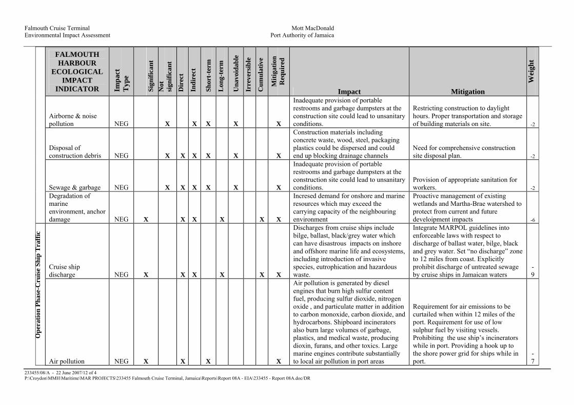
Falmouth Cruise Terminal Mott MacDonald Environmental Impact Assessment Port Authority of Jamaica
233455/08/A - 22 June 2007/12 of 4 P:\Croydon\MMH\Maritime\MAR PROJECTS\233455 Falmouth Cruise Terminal, Jamaica\Reports\Report 08A - EIA\233455 - Report 08A.doc/DR
FALMOUTH HARBOUR
ECOLOGICAL IMPACT
INDICATOR Impa
ct
Typ
e
Sign
ifica
nt
Not
si
gnifi
cant
Dir
ect
Indi
rect
Shor
t-te
rm
Lon
g-te
rm
Una
void
able
Irre
vers
ible
Cum
ulat
ive
Miti
gatio
n R
equi
red
Impact Mitigation
Wei
ght
Airborne & noise pollution NEG X X X X X
Inadequate provision of portable restrooms and garbage dumpsters at the construction site could lead to unsanitary conditions.
Restricting construction to daylight hours. Proper transportation and storage of building materials on site. -2
Disposal of construction debris NEG X X X X X X
Construction materials including concrete waste, wood, steel, packaging plastics could be dispersed and could end up blocking drainage channels
Need for comprehensive construction site disposal plan. -2
Sewage & garbage NEG X X X X X X
Inadequate provision of portable restrooms and garbage dumpsters at the construction site could lead to unsanitary conditions.
Provision of appropriate sanitation for workers. -2
Degradation of marine environment, anchor damage NEG X X X X X X
Incresed demand for onshore and marine resources which may exceed the carrying capacity of the neighbouring environment
Proactive management of existing wetlands and Martha-Brae watershed to protect from current and future develoipment impacts -6
Cruise ship discharge NEG X
X X X X X
Discharges from cruise ships include bilge, ballast, black/grey water which can have disastrous impacts on inshore and offshore marine life and ecosystems, including introduction of invasive species, eutrophication and hazardous waste.
Integrate MARPOL guidelines into enforceable laws with respect to discharge of ballast water, bilge, black and grey water. Set “no discharge” zone to 12 miles from coast. Explicitly prohibit discharge of untreated sewage by cruise ships in Jamaican waters
-9
O
pera
tion
Phas
e-C
ruis
e Sh
ip T
raff
ic
Air pollution NEG X
X X
X
Air pollution is generated by diesel engines that burn high sulfur content fuel, producing sulfur dioxide, nitrogen oxide , and particulate matter in addition to carbon monoxide, carbon dioxide, and hydrocarbons. Shipboard incinerators also burn large volumes of garbage, plastics, and medical waste, producing dioxin, furans, and other toxics. Large marine engines contribute substantially to local air pollution in port areas
Requirement for air emissions to be curtailed when within 12 miles of the port. Requirement for use of low sulphur fuel by visiting vessels. Prohibiting the use ship’s incinerators while in port. Providing a hook up to the shore power grid for ships while in port.
-7

Falmouth Cruise Terminal Mott MacDonald Environmental Impact Assessment Port Authority of Jamaica
233455/08/A - 22 June 2007/13 of 4 P:\Croydon\MMH\Maritime\MAR PROJECTS\233455 Falmouth Cruise Terminal, Jamaica\Reports\Report 08A - EIA\233455 - Report 08A.doc/DR
FALMOUTH HARBOUR
ECOLOGICAL IMPACT
INDICATOR Impa
ct T
ype
Sign
ifica
nt
Not
sign
ifica
nt
Dir
ect
Indi
rect
Shor
t-te
rm
Lon
g-te
rm
Una
void
able
Irre
vers
ible
Cum
ulat
ive
Miti
gatio
n R
equi
red
Impact Mitigation
Wei
ght
Impact of mass tourism NEG X
X X X X X X X
The main concerns arising from the projected number of tourists are related to the capacity of the onshore facilities
to deal with the acute and repeated impacts of large numbers of people in
the town and its surrounds
Adequate infrastructure and services to handle influx of tourists. Proper
garbage disposal. -8
Total Negative Impacts:
�
� -
42
Table 4.2: Falmouth Cruise Ship Port Development - Summary of ecological impact mitigation
FALMOUTH HARBOUR ECOLOGICAL IMPACT MITIGATION
Impa
ct T
ype
Sign
ifica
nt
Not
si
gnifi
cant
Dir
ect
Indi
rect
Shor
t-te
rm
Lon
g-te
rm
Incr
emen
tal
Weight
Coral relocation POS X X X X 3
Seagrass transplantation POS X X X X 3
Replanting mangroves POS X X X X 3
Use of silt curtains/berms/bunds POS X X X 2 Construction of new foul and surface water drainage systems POS X X X 3
Providing connection to power grid while in port POS X X X 2 Waste management plan for construction & operation phase POS X X X 2 Total: 18

Falmouth Cruise Terminal Mott MacDonald Environmental Impact Assessment Port Authority of Jamaica
233455/08/A - 22 June 2007/4-1 of 4 P:\Croydon\MMH\Maritime\MAR PROJECTS\233455 Falmouth Cruise Terminal, Jamaica\Reports\Report 08A - EIA\233455 - Report 08A.doc/DR
Table 4.3: Socio-Economic, Falmouth Port Development - Impact Assessment Matrix Factor Indicator Type Extent Magnitude Mitigative Measures Comments Weight
Socio-economic Construction (Micro)
Land Use Employment and Income
a)Negative, direct
Negative, indirect
a) Positive, direct b) Negative, direct
Short-term Long-term Short-term Short-term
Significant Very significant Very significant Not very significant
Include the community especially, displaced persons in activities whether by providing employment or other compensation for loss of income. Relocation plan should be developed and agreed upon by all relevant parties prior to any preparatory work for construction. Additionally, adequate notice should be given to the public regarding the expected changes to the community Develop housing solutions concurrently with other developments
N/A Compensate for loss of income and/or provide employment to affected persons to offset loss of income
Displacement and relocation of business and residences Increased squatting by migrant workers Jobs will be created during construction. Temporary loss of income for displaced businesses
-4 -6 +4 -2

Falmouth Cruise Terminal Mott MacDonald Environmental Impact Assessment Port Authority of Jamaica
233455/08/A - 22 June 2007/4-2 of 4 P:\Croydon\MMH\Maritime\MAR PROJECTS\233455 Falmouth Cruise Terminal, Jamaica\Reports\Report 08A - EIA\233455 - Report 08A.doc/DR
Factor Indicator Type Extent Magnitude Mitigative Measures Comments Weight
Transportation Community Development
Negative, indirect Negative, indirect
Short-term Short-term
Significant Very Significant
Include the residents in the planning of the development and provide sufficient and timely information on road closures and alternative routes.
Include the residents in the planning of the development to foster pride and understanding
Proposed changes to road networks will disrupt the flow of goods and services during construction Access to certain areas of the community, some services and the use of some infrastructure will be disrupted
-2 -4

Falmouth Cruise Terminal Mott MacDonald Environmental Impact Assessment Port Authority of Jamaica
233455/08/A - 22 June 2007/4-3 of 4 P:\Croydon\MMH\Maritime\MAR PROJECTS\233455 Falmouth Cruise Terminal, Jamaica\Reports\Report 08A - EIA\233455 - Report 08A.doc/DR
Factor Indicator Type Extent Magnitude Mitigative Measures Comments Weight
Socio-economic Post-Construction (Macro) (Micro)
National/Regional Land Use Employment Transportation Community
a)Positive, direct Positive, direct Positive, indirect Positive, indirect Positive direct Positive, direct a) Positive,
Long-term Long-term Long-term Long-term Long-term Long-term Long-term
Very Significant Very Significant Significant Very Significant Very Significant Significant Significant
N/A N/A N/A N/A N/A N/A N/A
Contribute to heritage tourism development, increased visitor arrival and foreign exchange earnings Contribute to employment/ reducing unemployment Contribute to enhancing historical awareness Improved infrastructure (market facilities, renovated historical monuments and buildings, upgraded and new roads) Increased property values Improved living conditions of residents of relocated squatter settlement
Employment opportunities Creation of new roads and improvement of existing roads Improved community infrastructure and recreational facilities. More
+10 +10 +4 +6 +6 +8 +6
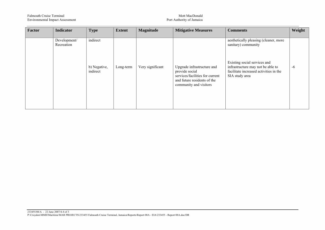
Falmouth Cruise Terminal Mott MacDonald Environmental Impact Assessment Port Authority of Jamaica
233455/08/A - 22 June 2007/4-4 of 3 P:\Croydon\MMH\Maritime\MAR PROJECTS\233455 Falmouth Cruise Terminal, Jamaica\Reports\Report 08A - EIA\233455 - Report 08A.doc/DR
Factor Indicator Type Extent Magnitude Mitigative Measures Comments Weight
Development/ Recreation
indirect b) Negative, indirect
Long-term
Very significant
Upgrade infrastructure and provide social services/facilities for current and future residents of the community and visitors
aesthetically pleasing (cleaner, more sanitary) community Existing social services and infrastructure may not be able to facilitate increased activities in the SIA study area
-6

Falmouth Cruise Terminal Mott MacDonald Environmental Impact Assessment Port Authority of Jamaica
233455/08/A - 22 June 2007/4-1 of 2 P:\Croydon\MMH\Maritime\MAR PROJECTS\233455 Falmouth Cruise Terminal, Jamaica\Reports\Report 08A - EIA\233455 - Report 08A.doc/DR
Appendix 5 Maps


Falmouth Cruise Terminal Mott MacDonald Environmental Impact Assessment Port Authority of Jamaica
233455/08/A - 22 June 2007/4-1 of 1 P:\Croydon\MMH\Maritime\MAR PROJECTS\233455 Falmouth Cruise Terminal, Jamaica\Reports\Report 08A - EIA\233455 - Report 08A.doc/DR
Figure 5.1: Falmouth Cruise Ship Port Development - Location Map of Falmouth, Trelawny, Jamaica

Falmouth Cruise Terminal Mott MacDonald Environmental Impact Assessment Port Authority of Jamaica
233455/08/A - 22 June 2007/6-1 of 13 P:\Croydon\MMH\Maritime\MAR PROJECTS\233455 Falmouth Cruise Terminal, Jamaica\Reports\Report 08A - EIA\233455 - Report 08A.doc/DR
Appendix 6 Hydrogeology
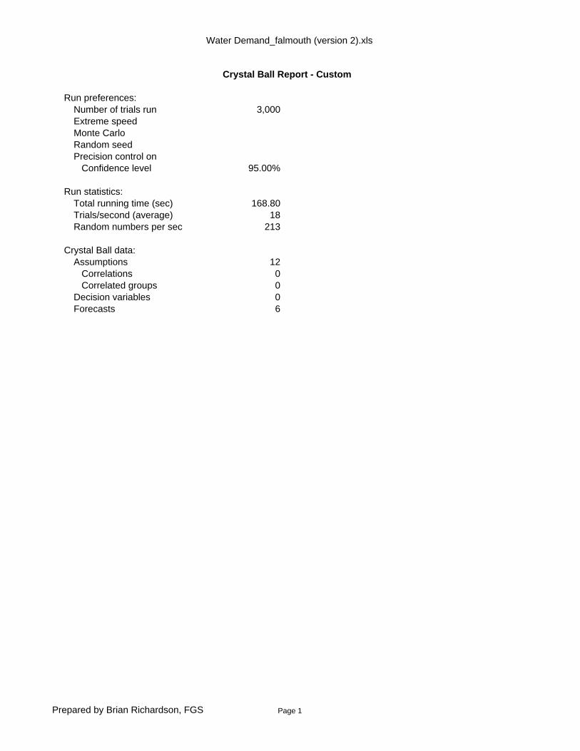
Water Demand_falmouth (version 2).xls
Crystal Ball Report - Custom
Run preferences:Number of trials run 3,000Extreme speedMonte CarloRandom seedPrecision control on Confidence level 95.00%
Run statistics:Total running time (sec) 168.80Trials/second (average) 18Random numbers per sec 213
Crystal Ball data:Assumptions 12 Correlations 0 Correlated groups 0Decision variables 0Forecasts 6
Prepared by Brian Richardson, FGS Page 1

Water Demand_falmouth (version 2).xls
Forecasts
Worksheet: [Water Demand_falmouth (version 2).xls]Rational
Forecast: Calculated Peak Discharge, Q1 Pre-Development Cell: B21
Summary:Entire range is from 0.15 to 0.25 Base case is 0.23 After 3,000 trials, the std. error of the mean is 0.00
Percentiles: Forecast values0% 0.15 10% 0.16 20% 0.17 30% 0.18 40% 0.19 50% 0.20 60% 0.21 70% 0.21 80% 0.22 90% 0.23 100% 0.25
Forecast: Calculated Peak Discharge, Q1a, Post-Development Cell: B30
Summary:Entire range is from 0.45 to 0.79 Base case is 0.71 After 3,000 trials, the std. error of the mean is 0.00
Prepared by Brian Richardson, FGS Page 2

Water Demand_falmouth (version 2).xls
Forecast: Calculated Peak Discharge, Q1a, Post-Development (cont'd) Cell: B30
Percentiles: Forecast values0% 0.45 10% 0.52 20% 0.54 30% 0.56 40% 0.59 50% 0.61 60% 0.64 70% 0.66 80% 0.69 90% 0.72 100% 0.79
Forecast: Calculated Peak Discharge, Q2 Pre-Development Cell: C21
Summary:Entire range is from 0.64 to 1.34 Base case is 1.07 After 3,000 trials, the std. error of the mean is 0.00
Prepared by Brian Richardson, FGS Page 3

Water Demand_falmouth (version 2).xls
Forecast: Calculated Peak Discharge, Q2 Pre-Development (cont'd) Cell: C21
Percentiles: Forecast values0% 0.64 10% 0.78 20% 0.83 30% 0.87 40% 0.91 50% 0.95 60% 0.98 70% 1.02 80% 1.07 90% 1.13 100% 1.34
Forecast: Calculated Peak Discharge, Q2b, Post-Development Cell: C30
Summary:Entire range is from 0.77 to 1.64 Base case is 1.30 After 3,000 trials, the std. error of the mean is 0.00
Prepared by Brian Richardson, FGS Page 4

Water Demand_falmouth (version 2).xls
Forecast: Calculated Peak Discharge, Q2b, Post-Development (cont'd) Cell: C30
Percentiles: Forecast values0% 0.77 10% 0.94 20% 1.01 30% 1.06 40% 1.11 50% 1.15 60% 1.20 70% 1.25 80% 1.31 90% 1.39 100% 1.64
Forecast: Calculated Peak Discharge, Q3 Pre-Development Cell: D21
Summary:Entire range is from 0.05 to 0.21 Base case is 0.15 After 3,000 trials, the std. error of the mean is 0.00
Prepared by Brian Richardson, FGS Page 5

Water Demand_falmouth (version 2).xls
Forecast: Calculated Peak Discharge, Q3 Pre-Development (cont'd) Cell: D21
Percentiles: Forecast values0% 0.05 10% 0.08 20% 0.09 30% 0.10 40% 0.10 50% 0.11 60% 0.12 70% 0.13 80% 0.14 90% 0.16 100% 0.21
Forecast: Calculated Peak Discharge, Q3a, Post-Development Cell: D30
Summary:Entire range is from 0.01 to 0.04 Base case is 0.03 After 3,000 trials, the std. error of the mean is 0.00
Prepared by Brian Richardson, FGS Page 6

Water Demand_falmouth (version 2).xls
Forecast: Calculated Peak Discharge, Q3a, Post-Development (cont'd) Cell: D30
Percentiles: Forecast values0% 0.01 10% 0.02 20% 0.02 30% 0.02 40% 0.02 50% 0.02 60% 0.03 70% 0.03 80% 0.03 90% 0.03 100% 0.04
End of Forecasts
Prepared by Brian Richardson, FGS Page 7
Water Demand_falmouth (version 2).xls
Assumptions
Worksheet: [Water Demand_falmouth (version 2).xls]Rational
Assumption: C Cell: B17
Triangular distribution with parameters:Minimum 0.70Likeliest 0.78Maximum 0.85
Assumption: C (B26) Cell: B26
Triangular distribution with parameters:Minimum 0.70Likeliest 0.78Maximum 0.85
Assumption: C18 Cell: C18
Uniform distribution with parameters:Minimum 19.40Maximum 29.20
Assumption: C27 Cell: C27
Uniform distribution with parameters:Minimum 19.40Maximum 29.20
Prepared by Brian Richardson, FGS Page 8
Water Demand_falmouth (version 2).xls
Assumption: Commercial Areas Cell: C17
Triangular distribution with parameters:Minimum 0.60Likeliest 0.75Maximum 0.90
Assumption: Commercial Areas (C26) Cell: C26
Triangular distribution with parameters:Minimum 0.60Likeliest 0.75Maximum 0.90
Assumption: D18 Cell: D18
Uniform distribution with parameters:Minimum 19.40Maximum 29.20
Assumption: D27 Cell: D27
Uniform distribution with parameters:Minimum 19.40Maximum 29.20
Prepared by Brian Richardson, FGS Page 9

Water Demand_falmouth (version 2).xls
Assumption: Estuary Cell: D17
Triangular distribution with parameters:Minimum 0.10Likeliest 0.15Maximum 0.30
Assumption: I Cell: B18
Uniform distribution with parameters:Minimum 19.4 Maximum 29.2
Assumption: I (B27) Cell: B27
Uniform distribution with parameters:Minimum 19.4 Maximum 29.2
Assumption: Lanscaped Areas Cell: D26
Triangular distribution with parameters:Minimum 0.10Likeliest 0.25Maximum 0.35
End of Assumptions
Prepared by Brian Richardson, FGS Page 10

Water Demand_falmouth (version 2).xls
Sensitivity Charts
End of Sensitivity Charts
Prepared by Brian Richardson, FGS Page 11

NATIONAL METEOROLOGICAL SERVICE, JAMAICA
ESTIMATES OF MAXIMUM 24-HOUR RAINFALL (MM) FOR SELECTED RETURN PERIODSAND FOR 343 RAINGUAGE LOCATIONS.
CORRECTED DATA BASED ON ORIGINAL DATA SERIES EXAMINATION
KEY
N Number of years of data used during computationn Number of years of missing data T Return periods Standard deviation of annual series of maximum one-day rainfallx Mean of annual series of maximum one-day rainfall RATIO OF
100-YEARDATA - AND
PARISH/STATION PERIOD n N x s T2 T5 T10 T25 T50 T100 C.V. 2-YEAR
TRELAWNY T2 T5 T10 T25 T50 T100
ALBERT TOWN 1931-85 24 31 109 43 122 175 211 254 287 320 0.39 2.62ALLSIDES 1950-87 28 10 110 77 108 163 199 245 279 312 0.4 2.89ARCADIA 1950-85 24 13 101 58 114 153 201 254 293 332 0.57 2.91BRACO 1950-87 23 15 89 53 101 146 186 237 274 312 0.6 3.09CLARKS TOWN 1941-85 10 35 99 41 110 140 168 203 230 256 0.41 2.33DUNCANS 1950-86 9 28 67 73 64 104 130 164 189 213 0.56 3.33ETINGDON 1959-85 4 23 97 39 95 138 166 202 228 255 0.4 2.68FALMOUTH 1937-85 10 39 92 41 102 131 159 194 220 246 0.45 2.41KENT 1950-87 22 16 108 38 118 150 173 215 242 269 0.35 2.28KINLOSS 1959-85 0 27 96 37 106 134 161 194 219 243 0.39 2.29LONG POND 1959-85 0 27 102 43 99 145 175 213 242 270 0.42 2.73LOTTERY 1959-85 5 22 106 44 117 151 183 223 253 282 0.42 2.41ORANGE VALLEY 1950-87 15 23 109 47 121 157 191 233 265 296 0.43 2.45QUICK STEP 1950-87 14 24 100 36 109 137 163 195 220 244 0.36 2.24SHERWOOD CONTENT STEWART TOWN 1941-85 12 33 96 34 94 129 153 183 205 226 0.35 2.4TROY 1937-85 17 32 114 36 112 150 175 206 229 256 0.32 2.29ULSTER SPRING 1937-85 11 38 103 40 113 142 170 205 231 257 0.39 2.27WAIT A BIT 1937-78 6 36 130 45 128 176 207 246 275 304 0.35 2.38WAKEFIELD 1937-70 9 25 97 37 95 134 160 193 220 244 0.38 2.57WALES 1950-87 27 11 108 67 106 162 200 247 282 317 0.43 2.99WARSOP 1937-85 12 37 118 48 130 164 197 239 270 301 0.41 2.32WINDSOR 1950-87 27 11 95 34 104 136 164 199 225 250 0.36 2.4

WATER RESOURCES AUTHORITY ESTABLISHED BY THE WATER RESOURCES ACT, 1995
HOPE GARDENS, P.O. BOX 91, KINGSTON 7, JAMAICA
TEL: 927-0077, 927-0293, 927-0189, 927-0302 FAX: 977-0179, 702-3937
Jamaica’s Hydrologic Agency Board: Dr. Arnoldo Ventura (Chairman), Mr. Basil Fernandez (Managing Director), Dr. Conrad Douglas, Mr. Donovan Stanberry,
Mr. Parris Lyew-Ayee, Ms. Tasha Manley, Dr. Carol Archer, Mr. Errol Gentles, Mrs. Sonia Rickards
REF: HBV111-1 February 20, 2007
Mr. Brian Richardson C/o P.O. Box 5185 Liguanea Kingston 6 Dear Mr. Richardson, Re: Information Request on Falmouth Please see attached response to data request. For further information please contact the Authority at the numbers indicated above. Yours sincerely WATER RESOURCES AUTHORITY …………………………… Natalie E. Ferguson Hydrologist For Managing Director

Re: Falmouth Cruise Ship Pier Rainfall and evapo data are to be obtained from the Met Service. The nearest stream flow gauging station is located 2.8 km south of the proposed site and measures flow of the Martha Brae River. The nearest central sewage system is located in Vanzie Lands and serves the Falmouth Gardens scheme. Falmouth has a history of flooding caused either by excessive rain coupled with inadequate drainage infrastructure or by storm surges. These risks need to be considered when developing the pier. There are no existing floodplain maps for Falmouth. The WRA is not aware of ground or surface water issues. Groundwater quality is impacted by the marine environment and it is expected that the water is of brackish character. The Martha Brae serves as a major drinking water source for northern parishes and delivers water as far as Montego Bay. The project is slated for expansion to accommodate the increasing water demand in this section of the island. The water quality apart from the usual bacteriological contamination indicates that the water is fit for human consumption. The WRA is not in the possession of any data, drawings, literature on flood control measures or surface water drainage schemes around the city. There are no wells or core holes in this area. There are no licensed surface water or groundwater sources in this area.


Figure 1 - Site Location: Showing nearby facilities, recorded flood events and existing well (obtained from WRA 14 Feb 2007)


Falmouth Cruise Terminal Mott MacDonald Environmental Impact Assessment Port Authority of Jamaica
233455/08/P1 - 8 June 2007/6-8 of 8 P:\Croydon\MMH\Maritime\MAR PROJECTS\233455 Falmouth Cruise Terminal, Jamaica\Reports\Report 08P1 - EIA\233455 - Report 08P1.doc/DR
Figure 3

Figure 4 – Regional and site drainage (solid lines show existing surface water routes, dashed lines show presumed surface water flow patterns). Hydrologic Basin VIII is drained by the Martha Brae. North at top of page.
Not to Scale

Figure 5 – Conceptual Site Plan


Project: Proposed Cruise Ship Pier & Town RedevelopmentLocation: Falmouth, TrelawnyClient: TEMN
Date: May 2007
Rational EquationQ=0.00278 CIA Metric unitsQ=1.008 CIA SI units
Where,Q = peak runoff rate (cfs, m3/s)C = runoff Coefficient from Table in Sheet 2 0.7 - 0.85 0.6 - 0.8 0.1 - 0.3 unitlessI = average rainfall intensity ( in/hr, mm/hr) 19.4 - 29.2 mm/hrA = the drainage area (acres, hectares) 31.8 hectares
Pre-development Paved Areas, Q1 Com. Areas, Q2 Estuary, Q3C 0.75 0.74 0.21 unitlessI 29.2 29.2 29.2 mm/hrA* 3.8 18.8 9.2 hectaresConversion factor 0.00278 0.00278 0.00278Calculated Peak Discharge, Q 0.23 1.13 0.16 m3/s
TOTAL 1.52 m3/s
Post-development Paved Areas, Q1a Com. Areas, Q2a Landscaped Areas, Q3aC 0.85 0.7 0.25 unitlessI 29.2 29.2 29.2 mm/hrA* 11.7 22.9 1.6 hectaresConversion factor 0.00278 0.00278 0.00278Calculated Peak Discharge, Q 0.81 1.30 0.03 m3/s
TOTAL 2.14 m3/s
*est. from Falmouth Conceptual Site Plan; 04/05/2007
Percentage change 41%
Prepared by Brian Richardson, FGS Page 1 C:\Hydro_Projects\TEMN\Falmouth\Runoff Calcs\Water Demand_falmouth (version 2).xls

Falmouth Cruise Terminal M ott M ac D onald
Conc ep tual D rainag e S c heme P ort A uthority of J amaic a
D rainag e P hilosop hy
2 3 3 4 5 5 /0 5 /P 1 - 2 4 M ay 2 0 0 7 / P :\Croy d on\M M H \M aritime\M A R P R O J E CTS \2 3 3 4 5 5 Falmouth Cruise Terminal, J amaic a\R ep orts\D rainag e\2 3 3 4 5 5 - 0 5 - P 1 .d oc /D J M
P ort A uthority of J amaic a
1 5 – 1 7 D uk e S treet
K ing ston
J amaic a
W est Ind ies
Falmouth Cruise T ermin al
Con cep tual D rain ag e Scheme
D rain ag e Philosop hy
May 2007
M ott M ac D onald
S t A nne H ouse
2 0 -2 6 W ellesley R oad
Croy d on
S urrey
CR 9 2 U L
U K
Tel : 4 4 ( 0 ) 2 0 8 7 7 4 2 0 0 0
Fax : 4 4 ( 0 ) 2 0 8 6 8 1 5 7 0 6


Falmouth Cruise Terminal Mott MacDonald
Conceptual Drainage Scheme Port Authority of Jamaica
Drainage Philosophy
i 233455/05/P1 - 24 May 2007/i of i
P:\Croydon\MMH\Maritime\MAR PROJECTS\233455 Falmouth Cruise Terminal, Jamaica\Reports\Drainage\233455-05-P1.doc/DJM
List of Contents Page
Summary S-1
Chapters and Append ices
1 Introduction 1
1.1 G eneral 1
2 Drainage 1
2.1 G eneral 1
3 Foul Drainage 2
3.1 Design 2
3.2 Trade Effluent 2
3.3 Pumping Mains 2
3.4 Attenuation 2
3.5 Sewage Treatment Works 2
4 Surface Water Drainage 3
4.1 Design 3
4.2 Outfalls 3
4.3 Pumping Mains 3
4.4 Existing Water Courses 3
4.5 Attenuation 4
4.6 Control of Pollution 4
Appendix A Conceptual Drainage Layout A-1

Falmouth Cruise Terminal Mott MacDonald
Conceptual Drainage Scheme Port Authority of Jamaica
Drainage Philosophy
S-1 233455/05/P1 - 24 May 2007/S-1 of 1
P:\Croydon\MMH\Maritime\MAR PROJECTS\233455 Falmouth Cruise Terminal, Jamaica\Reports\Drainage\233455-05-P1.doc/DJM
Summary
The Port Authority of Jamaica (PAJ) intends to redev elop the seafront area at Falmouth, to
accommodate a new “ Port of Call” cruise ship terminal. The redev elopment will prov ide a v ariety of
mixed uses and will also include the construction of berthing facilities for 2 cruise ships. N ew
terminal buildings will serv e v isiting cruise ships, handling approximately 15,000 passengers and crew
at peak times. Additional facilities for the cruise terminal will include the construction of a coach and
car park. There is also consideration for the introduction of a tram line linking the car and coach parks
to the cruise terminal and promenade.
Drainage of the proposed redev elopment will require the construction of new foul and surface water
sewers, as it is unlikely that the existing infrastructure has sufficient residual capacity to accommodate
additional flows from the new dev elopment.
It is expected that the drainage design will encompass the following aspects:
• Discharge-unit design of foul drainage system (domestic, commercial and industrial rates as
applicable).
• Foul water pumping stations and rising mains.
• Surface water drainage design to statutory requirements.
• Flood modelling of designed surface water system to eliminate flood potential.
• Flood routeing analysis of the surface water system to mitigate effects of potential flood
ev ents.
• Surface water outfall to sea and or existing open channels, utilising proprietary flap v alv es.
• Surface water headwall outfalls incorporating scour protection.
• Surface water pollution control, incorporating; petrol/oil interceptors, penstock chambers,
catchpit manholes (silt accumulation), reed beds, trapped gulleys and trash screens.
• Surface water attenuation during times of restricted discharge.
• Surface water pumping stations and rising mains.
These drainage aspects are typical considerations in respect to the location and the nature of the
proposed dev elopment. Prior to undertaking the detailed design, confirmation of the drainage
methodology will be sought from the regulatory authorities, which may require additional elements to
be incorporated in the final design.

Falmouth Cruise Terminal Mott MacDonald
Conceptual Drainage Scheme Port Authority of Jamaica
Drainage Philosophy
1233455/05/P1 - 24 May 2007/1 of 1
P:\Croydon\MMH\Maritime\MAR PROJECTS\233455 Falmouth Cruise Terminal, Jamaica\Reports\Drainage\233455-05-P1.doc/DJM
1 Introduction
1.1 G eneral
It is the intention of Port Authority of Jamaica (PAJ) to redevelop the seafront area at Falmouth, to
accommodate a new “Port of Call” cruise ship terminal.
The redevelopment will comprise a variety of mixed uses and a significant area of the redevelopment
will be the construction a new cruise ship terminal, associated buildings/facilities and berthing
structures for 2 large cruise ships. It is expected that the new terminal buildings will handle
approximately 15,000 passengers and crew at peak times during the year.
In addition to the main terminal buildings the proposed development will include the construction of a
coach and car park, and it is likely that the redevelopment will also benefit from the introduction of a
new tram line linking the car and coach parks to the cruise terminal and promenade.
2 D rainag e
2 .1 G eneral
Drainage of the proposed redevelopment will require the construction of new foul and surface water
sewers, as it is unlikely that the existing infrastructure has sufficient residual capacity to accommodate
additional flows from the new development.
At this time, the full details of the proposed redevelopment are unknown. However, schematic
drainage design has been undertaken based on the limited information currently available.
It is recommended that, prior to undertaking detailed design, dialogue with the regulatory authorities is
held to establish and agree all parameters and constraints relating to the drainage design.
Due to the location of the redevelopment, a high ground water table is expected; accordingly problems
associated with flotation/buoyancy of the drainage system will need to be considered.
The proposed conceptual drainage layout is included at Appendix A and should be referred to in
conjunction with the following section.

Falmouth Cruise Terminal Mott MacDonald
Conceptual Drainage Scheme Port Authority of Jamaica
Drainage Philosophy
2233455/05/P1 - 24 May 2007/2 of 2
P:\Croydon\MMH\Maritime\MAR PROJECTS\233455 Falmouth Cruise Terminal, Jamaica\Reports\Drainage\233455-05-P1.doc/DJM
3 Foul Drainage
3.1 Design
The foul water drainage should be designed to accommodate flows from the proposed development
with discharge to either new or existing sewage treatment works. Direct discharge from the cruise
ships is not expected. However, the system should be designed to serve a proportion of passenger
numbers using the terminal buildings in accordance with current deign guides and regulations. Where
feasible and subject to capacity and serviceability, new foul drainage might be discharged to existing
sewers.
The new foul drainage system should also be designed, from a strategic perspective, to accommodate
all future sites forming the proposed redevelopment. This approach will permit phased construction
and will facilitate servicing of future developments.
Capacity should be included in the new foul system to allow for surrounding and existing drainage
networks becoming obsolete and temporary connection being required prior to upgrading of the
surrounding systems.
3.2 T rade E ffluent
It has not been anticipated that the new foul system is expected to convey trade effluents. In terms of
sustainability, subject to confirmation of regulatory requirement, all trade effluent should be managed
at source.
3.3 P ump ing M ains
It is assumed that the majority of the new foul system will be gravity network. However, due to
ground levels/conditions and the likelihood of a high ground water table, foul pumping stations and
rising mains may be required.
3.4 A ttenuation
Other than storage volumes required for pumping stations, rising mains and emergency drain-down
points, attenuation of foul drainage flows is not expected.
3.5 Sew age T reatment W ork s
It is expected that the foul drainage network will discharge to a new sewage treatment works (STW).
Specific details relating to the STW are not considered in this report. However, it is expected that the
STW will include primary, secondary and tertiary treatment stages prior to controlled discharge to sea
outfall or existing open water-courses.

Falmouth Cruise Terminal Mott MacDonald
Conceptual Drainage Scheme Port Authority of Jamaica
Drainage Philosophy
3233455/05/P1 - 24 May 2007/3 of 3
P:\Croydon\MMH\Maritime\MAR PROJECTS\233455 Falmouth Cruise Terminal, Jamaica\Reports\Drainage\233455-05-P1.doc/DJM
4 Surface Water Drainage
4.1 Design
The surface water drainage should be designed to accommodate all surface runoff from the proposed
redevelopment and to include all future developments as necessary. The drainage network strategy
assumes discharge of all runoff to sea outfall. Further outfalls to open water-courses have also been
considered.
Due to the location of the site, the surface water drainage should also be designed, as a minimum, to
accommodate conditions commensurate with a 1-in-25 year return period, as stated in the hydrological
assessment report undertaken as part of the overall Strategic Environmental Assessment.
Flood modelling should be carried out to ensure no flooding occurs for longer return periods.
Considering the location of the site and the low-lying nature of the proposed development, the
drainage may need to be designed to accommodate at least a 1-in-200 year storm event or similar
event where high water levels are to be expected. Further dialogue with the regulatory authorities is
recommended to determine exact storm drainage parameters. Flood routeing is likely to be stipulated
as a detailed design consideration.
4.2 O utfalls
It is assumed that all new surface water sewers will outfall to sea or to existing water-courses. All
surface water runoff to sea outfall would have proprietary flap valves fitted to prevent surcharging of
the system during expected flooding of the outfalls at high water or storm surges.
To mitigate the effect of concentrated flowing water on the sea foreshore or open river banks at the
location of the proposed outfalls, and if required, anti-scour measures should be included as part of the
outfall structure. Typically these will be gabion mattresses or rip-rap.
4.3 Pumping Mains
Due to the nature of the site and the expected tidal range, pumping stations and rising mains may be
required to raise the surface water drainage to facilitate satisfactory outfall. It is likely that the surface
water drainage will be discharged to bifurcating manholes as cover to the drainage and effective depth
to outfall is likely to be severely constrained.
4.4 Ex isting Water Courses
Surface water runoff from the proposed development, where practicable, will discharge directly to the
existing open water-courses surrounding or located in the proposed site. It is likely that several of the
open water-courses may be culverted to maximise usable site area but retaining the existing
infrastructure. In this event the culverts shall be designed to accommodate existing flows and
additional flows with further capacity (freeboard) for storm events with longer return periods to
eliminate the possibility of flooding.

Falmouth Cruise Terminal Mott MacDonald
Conceptual Drainage Scheme Port Authority of Jamaica
Drainage Philosophy
4233455/05/P1 - 24 May 2007/4 of 4
P:\Croydon\MMH\Maritime\MAR PROJECTS\233455 Falmouth Cruise Terminal, Jamaica\Reports\Drainage\233455-05-P1.doc/DJM
All culverted water courses should include trash screens on the upstream inlet and scour-protection on
both inlet and outlet. Further measures are likely to require mammal berms to permit unhindered
movement of animals along the affected water-course and reducing the impact on established habitats.
4.5 Attenuation
Due to constraints on discharge during periods of high-water, landward storage of surface water runoff
is likely to be required. Further storage volume in the form of tank sewers may be required to
accommodate long storm return periods or storms with high rainfall intensity. In terms of
sustainability, flow restrictions may be stipulated by the regulatory authorities. In this event,
considerably large storage volumes may be required. Flow control devices are usually installed in or
near to the final outfall manhole, utilising the majority of the upstream network as storage.
4.6 Control of Pollution
Typical pollution control measures are likely to include:
1. Trapped road gulleys/outfalls
Trapped road gulleys control sediment from entering the sewer system at source. The
gulleys require cleaning at regular intervals to maintain effectiveness.
2. Trash screens
All upstream inlets to culverted water-courses and outfalls should be provided with trash
screens to prevent large items of detritus from entering the system and creating downstream
obstructions and or polluting sensitive areas. Routine clearance is required to remove
obstructions to the trash screen and maintain free flowing conditions, particularly following a
storm of significant duration or intensity.
3. Petrol/oil interceptors (PI)
Petrol interceptors should be provided in areas where large numbers of cars or large vehicles
are expected, such as car/coach parks. The petrol interceptors effectively remove and control
petrol and oil from entering the sewer system and being discharged to sensitive outfalls.
Routine maintenance is vital to maintain effectiveness and detergents should not be allowed
to enter the interceptor as the detergent and oil emulsify on the internal coalescers allowing
pollution to pass through the PI and into the downstream networks, rendering the PI
redundant and possibly requiring complete replacement of the PI.
4. Catchpit manholes
In conjunction with trapped road gulleys, catchpit manholes are designed with deepened
inverts to control transportation and silting of sediment through the system. Routine
cleaning is required to maintain effectiveness.
5. Penstock chambers

Falmouth Cruise Terminal Mott MacDonald
Conceptual Drainage Scheme Port Authority of Jamaica
Drainage Philosophy
5233455/05/P1 - 24 May 2007/5 of 5
P:\Croydon\MMH\Maritime\MAR PROJECTS\233455 Falmouth Cruise Terminal, Jamaica\Reports\Drainage\233455-05-P1.doc/DJM
Penstock chambers are to be considered on all outfall manholes as an effective means of
restricting flow and preventing pollution of sensitive areas. A typical storage period of 24
hours is designed for in the surface water system to allow flushing and evacuation of
pollutants from the network in the event of a pollution incident.
6. Wash-out chambers (rising mains)
Wash-out chambers are provided on rising main systems to enable cleaning and maintenance
of the system.
7. Reed beds
A soft-engineering method of pollution control as reed beds satisfactorily reduce/digest the
level of hydro-carbon and other forms of pollution that may be present in water-courses.
Reed beds can be placed in any location along the water-course, although locations of low
flow rate are preferred sites for the establishment of reed beds resulting in more effective
hydro-carbon control/removal.

Falmouth Cruise Terminal Mott MacDonald
Conceptual Drainage Scheme Port Authority of Jamaica
Drainage Philosophy
A-1 233455/05/P1 - 24 May 2007/A-1 of 1
P:\Croydon\MMH\Maritime\MAR PROJECTS\233455 Falmouth Cruise Terminal, Jamaica\Reports\Drainage\233455-05-P1.doc/DJM
Appendix A Conceptual Drainage Layout
(Mott MacDonald Drawing No 233455/100 P1)


Falmouth Cruise Terminal Mott MacDonald Environmental Impact Assessment Port Authority of Jamaica
233455/08/A - 22 June 2007/7-1 of 1 P:\Croydon\MMH\Maritime\MAR PROJECTS\233455 Falmouth Cruise Terminal, Jamaica\Reports\Report 08A - EIA\233455 - Report 08A.doc/DR
Appendix 7 Coastal Dynamics

Falmouth Cruise Terminal Mott MacDonald Environmental Impact Assessment Port Authority of Jamaica
233455/08/A - 22 June 2007/7-1 of 9 P:\Croydon\MMH\Maritime\MAR PROJECTS\233455 Falmouth Cruise Terminal, Jamaica\Reports\Report 08A - EIA\233455 - Report 08A.doc/DR
Figure 7.1: Falmouth Cruise Ship Port Development - Wave Heights for 50 year hurricane waves approaching from East
219500 220000 220500 221000 221500 222000
2046500
2047000
2047500
2048000
2048500
00.511.522.533.544.55678910111213
FALMOUTH, CRUISESHIP
DEEP WATER HURRICANE WAVE CLIMATE CONDITIONS USED IN NEARSHORE MODELLING
Wave Height (m)
SWAN
Water depth contoursshown in black (m)
1-in-50 Year Event, Hs = 12.86 m; Tp = 16.49 s; Vmax = 22.67 m/s. Waves Approaching from the East

Falmouth Cruise Terminal Mott MacDonald Environmental Impact Assessment Port Authority of Jamaica
233455/08/A - 22 June 2007/7-2 of 9 P:\Croydon\MMH\Maritime\MAR PROJECTS\233455 Falmouth Cruise Terminal, Jamaica\Reports\Report 08A - EIA\233455 - Report 08A.doc/DR
Figure 7.2: Falmouth Cruise Ship Port Development - Storm surge Levels for 50 year hurricane waves approaching from East
219500 220000 220500 221000 221500 222000
2046500
2047000
2047500
2048000
2048500
0
0.7
0.8
0.9
1
1.1
1.2
1.3
1.4
1.5
1.6
1.7
1.8
1.9
2
FALMOUTH, CRUISESHIP
DEEP WATER TO NEARSHORE STORM SURGE
Surge Level (m)
SWAN
Water depth contoursshown in black (m)
1-in-50 Year Event, Hs = 12.86 m; Tp = 16.49 s; Vmax = 22.67 m/s. Waves Approaching from the EastWater Level (GSLR+IBR+HAT)=0.91M

Falmouth Cruise Terminal Mott MacDonald Environmental Impact Assessment Port Authority of Jamaica
233455/08/A - 22 June 2007/7-3 of 9 P:\Croydon\MMH\Maritime\MAR PROJECTS\233455 Falmouth Cruise Terminal, Jamaica\Reports\Report 08A - EIA\233455 - Report 08A.doc/DR
Figure7.3: Falmouth Cruise Ship Port Development - Wave Heights for 50 year hurricane waves approaching from North East
219500 220000 220500 221000 221500 222000
2046500
2047000
2047500
2048000
2048500
0
0.5
1
1.5
2
2.5
3
3.5
4
4.5
5
6
7
8
9
10
11
FALMOUTH, CRUISESHIP
DEEP WATER HURRICANE WAVE CLIMATE CONDITIONS USED IN NEARSHORE MODELLING
Wave Height (m)
SWAN
Water depth contoursshown in black (m)
1-in-50 Year Event, Hs = 9.67 m; Tp = 13.78 s; Vmax = 21.80 m/s. Waves Approaching from the North East

Falmouth Cruise Terminal Mott MacDonald Environmental Impact Assessment Port Authority of Jamaica
233455/08/A - 22 June 2007/7-4 of 9 P:\Croydon\MMH\Maritime\MAR PROJECTS\233455 Falmouth Cruise Terminal, Jamaica\Reports\Report 08A - EIA\233455 - Report 08A.doc/DR
Figure 7.4: Falmouth Cruise Ship Port Development - Storm surge Levels for 50 year hurricane waves approaching from North East
219500 220000 220500 221000 221500 222000
2046500
2047000
2047500
2048000
2048500
0
0.7
0.8
0.9
1
1.1
1.2
1.3
1.35
1.4
1.5
1.6
1.7
1.8
FALMOUTH, CRUISESHIP
DEEP WATER TO NEARSHORE STORM SURGE
Surge Level (m)
SWAN
Water depth contoursshown in black (m)
1-in-50 Year Event, Hs = 9.67 m; Tp = 13.78 s; Vmax = 21.80 m/s. Waves Approaching from the North EastWater Level (GSLR+IBR+HAT)=0.91M

Falmouth Cruise Terminal Mott MacDonald Environmental Impact Assessment Port Authority of Jamaica
233455/08/A - 22 June 2007/7-5 of 9 P:\Croydon\MMH\Maritime\MAR PROJECTS\233455 Falmouth Cruise Terminal, Jamaica\Reports\Report 08A - EIA\233455 - Report 08A.doc/DR
Figure 7.5: Falmouth Cruise Ship Port Development - Wave Heights for 50 year hurricane waves approaching from North
219500 220000 220500 221000 221500 222000
2046500
2047000
2047500
2048000
2048500
0
0.5
1
1.5
2
2.5
3
3.5
4
4.5
5
6
7
8
FALMOUTH, CRUISESHIP
DEEP WATER HURRICANE WAVE CLIMATE CONDITIONS USED IN NEARSHORE MODELLING
Wave Height (m)
SWAN
Water depth contoursshown in black (m)
1-in-50 Year Event, Hs = 7.55 m; Tp = 11.79 s; Vmax = 19.46 m/s. Waves Approaching from the North

Falmouth Cruise Terminal Mott MacDonald Environmental Impact Assessment Port Authority of Jamaica
233455/08/A - 22 June 2007/7-6 of 9 P:\Croydon\MMH\Maritime\MAR PROJECTS\233455 Falmouth Cruise Terminal, Jamaica\Reports\Report 08A - EIA\233455 - Report 08A.doc/DR
Figure 7.6: Falmouth Cruise Ship Port Development - Storm surge Levels for 50 year hurricane waves approaching from North
219500 220000 220500 221000 221500 222000
2046500
2047000
2047500
2048000
2048500
0
0.7
0.8
0.9
1
1.1
1.2
1.3
1.4
1.5
1.6
1.7
FALMOUTH, CRUISESHIP
DEEP WATER TO NEARSHORE STORM SURGE
Surge Level (m)
SWAN
Water depth contoursshown in black (m)
1-in-50 Year Event, Hs = 7.55 m; Tp = 11.79 s; Vmax = 19.46 m/s. Waves Approaching from the NorthWater Level (GSLR+IBR+HAT)=0.91M

Falmouth Cruise Terminal Mott MacDonald Environmental Impact Assessment Port Authority of Jamaica
233455/08/A - 22 June 2007/7-7 of 9 P:\Croydon\MMH\Maritime\MAR PROJECTS\233455 Falmouth Cruise Terminal, Jamaica\Reports\Report 08A - EIA\233455 - Report 08A.doc/DR
Figure 7.7: Falmouth Cruise Ship Port Development - Wave Heights for 50 year hurricane waves approaching from North East
219500 220000 220500 221000 221500 222000
2046500
2047000
2047500
2048000
2048500
0
0.5
1
1.5
2
2.5
3
3.5
4
4.5
5
6
7
8
FALMOUTH, CRUISESHIP
DEEP WATER HURRICANE WAVE CLIMATE CONDITIONS USED IN NEARSHORE MODELLING
Wave Height (m)
SWAN
Water depth contoursshown in black (m)
1-in-50 Year Event, Hs = 7.61 m; Tp = 11.85 s; Vmax = 19.54 m/s. Waves Approaching from the North West

Falmouth Cruise Terminal Mott MacDonald Environmental Impact Assessment Port Authority of Jamaica
233455/08/A - 22 June 2007/7-8 of 9 P:\Croydon\MMH\Maritime\MAR PROJECTS\233455 Falmouth Cruise Terminal, Jamaica\Reports\Report 08A - EIA\233455 - Report 08A.doc/DR
Figure 7.8: Falmouth Cruise Ship Port Development - Storm surge Levels for 50 year hurricane waves approaching from North
219500 220000 220500 221000 221500 222000
2046500
2047000
2047500
2048000
2048500
0
0.7
0.8
0.9
1
1.1
1.2
1.3
1.35
1.4
1.5
1.6
1.7
FALMOUTH, CRUISESHIP
DEEP WATER TO NEARSHORE STORM SURGE
Surge Level (m)
SWAN
Water depth contoursshown in black (m)
1-in-50 Year Event, Hs = 7.61 m; Tp = 11.85 s; Vmax = 19.54 m/s. Waves Approaching from the North WestWater Level (GSLR+IBR+HAT)=0.91M

Falmouth Cruise Terminal Mott MacDonald Environmental Impact Assessment Port Authority of Jamaica
233455/08/A - 22 June 2007/7-9 of 9 P:\Croydon\MMH\Maritime\MAR PROJECTS\233455 Falmouth Cruise Terminal, Jamaica\Reports\Report 08A - EIA\233455 - Report 08A.doc/DR
Figure 7.9: Falmouth Cruise Ship Port Development - Storm surge Levels for 50 year hurricane waves approaching from North
219500 220000 220500 221000 221500 222000
2046500
2047000
2047500
2048000
2048500
00.511.522.533.544.55678910111213
FALMOUTH, CRUISESHIP
DEEP WATER HURRICANE WAVE CLIMATE CONDITIONS USED IN NEARSHORE MODELLING
Wave Height (m)
SWAN
Water depth contoursshown in black (m)
1-in-50 Year Event, Hs = 12.86 m; Tp = 16.49 s; Vmax = 22.67 m/s. Waves Approaching from the East

Falmouth Cruise Terminal Mott MacDonald Environmental Impact Assessment Port Authority of Jamaica
233455/08/A - 22 June 2007/7-1 of 1 P:\Croydon\MMH\Maritime\MAR PROJECTS\233455 Falmouth Cruise Terminal, Jamaica\Reports\Report 08A - EIA\233455 - Report 08A.doc/DR
Figure 7.10: Falmouth Cruise Ship Port Development – Hydrographical survey for a portion of Falmouth Bay in the vicinity of Old Hampden Wharf

Falmouth Cruise Terminal Mott MacDonald Environmental Impact Assessment Port Authority of Jamaica
233455/08/A - 22 June 2007/8-1 of 1 P:\Croydon\MMH\Maritime\MAR PROJECTS\233455 Falmouth Cruise Terminal, Jamaica\Reports\Report 08A - EIA\233455 - Report 08A.doc/DR
Appendix 8 Socio Economics

Falmouth Cruise Terminal Mott MacDonald Environmental Impact Assessment Port Authority of Jamaica
233455/08/A - 22 June 2007/8-1 of 1 P:\Croydon\MMH\Maritime\MAR PROJECTS\233455 Falmouth Cruise Terminal, Jamaica\Reports\Report 08A - EIA\233455 - Report 08A.doc/DR
Figure 8.1: Falmouth Cruise Ship Port Development – Land use map for Falmouth, Trelawny

Falmouth Cruise Terminal Mott MacDonald Environmental Impact Assessment Port Authority of Jamaica
233455/08/A - 22 June 2007/8-1 of 3 P:\Croydon\MMH\Maritime\MAR PROJECTS\233455 Falmouth Cruise Terminal, Jamaica\Reports\Report 08A - EIA\233455 - Report 08A.doc/DR
Figure 8.2: Falmouth Cruise Ship Port Development – St. Peter’s Church, Falmouth
Source: Site visit
Figure 8.3: Falmouth Cruise Ship Port Development – Baptist Manse, Falmouth

Falmouth Cruise Terminal Mott MacDonald Environmental Impact Assessment Port Authority of Jamaica
233455/08/A - 22 June 2007/8-2 of 3 P:\Croydon\MMH\Maritime\MAR PROJECTS\233455 Falmouth Cruise Terminal, Jamaica\Reports\Report 08A - EIA\233455 - Report 08A.doc/DR
Figures 8.4 a and b: Falmouth Cruise Ship Port Development – Water square, Falmouth

Falmouth Cruise Terminal Mott MacDonald Environmental Impact Assessment Port Authority of Jamaica
233455/08/A - 22 June 2007/8-3 of 3 P:\Croydon\MMH\Maritime\MAR PROJECTS\233455 Falmouth Cruise Terminal, Jamaica\Reports\Report 08A - EIA\233455 - Report 08A.doc/DR
Figure 8.5: Falmouth Cruise Ship Port Development – Falmouth Courthouse and Parish Council Offices

Falmouth Cruise Terminal Mott MacDonald Environmental Impact Assessment Port Authority of Jamaica
233455/08/A - 22 June 2007/8-4 of 7 P:\Croydon\MMH\Maritime\MAR PROJECTS\233455 Falmouth Cruise Terminal, Jamaica\Reports\Report 08A - EIA\233455 - Report 08A.doc/DR
JAMAICA NATIONAL HERITAGE TRUST
GUIDELINES FOR OBTAINING APPROVAL TO RESTORE AND DEVELOP HISTORIC SITES AND DISTRICTS
MAY 2000
Prepared and produced by: The Jamaica National Heritage Trust
79 Duke Street Kingston
Tele: (876) 922-1287-8/922-3990 e-mail: [email protected]
Website: www.jnht.com
INTRODUCTION
Jamaica’s architectural heritage is one of the most tangible and diverse examples of our people's creativity and skills. This heritage consists of buildings such as churches and courthouses, industrial structures such as factories and aqueducts, Great Houses and small vernacular houses among others. We need to protect this heritage for its historic and architectural value, as well as for its aesthetic appeal.
The responsibility for preserving the nation's heritage rests with the Jamaica National Heritage Trust (JNHT). However, to effectively carry out our mandate, we need the cooperation of everyone, especially the owners and occupiers.
The following guidelines have been prepared to assist in the preservation and development process. If the recommendations listed are carefully followed, the amount of time and money spent in seeking approval will be kept to a minimum.
THE LEGAL FRAMEWORK
The JNHT legally protects the nation’s architectural heritage in two ways: 1. Declaring a site a national monument 2. Designating a site protected
national heritage. Under the JNHT Act, a site is declared a national monument, if in the opinion of the Trust, its preservation is a matter of public interest by reason of the historic, architectural, traditional, artistic, aesthetic, scientific or archaeological value.

Falmouth Cruise Terminal Mott MacDonald Environmental Impact Assessment Port Authority of Jamaica
233455/08/A - 22 June 2007/8-5 of 7 P:\Croydon\MMH\Maritime\MAR PROJECTS\233455 Falmouth Cruise Terminal, Jamaica\Reports\Report 08A - EIA\233455 - Report 08A.doc/DR
The Act also defines Protected National Heritage as any place name, species of animal or plant life, or any place or object designated by the Trust.
THE NEED FOR APPROVAL
When a site is declared/designated or has a preservation notice placed on it, the JNHT has to give written approval for development.
It is therefore illegal for the owner or occupier of the property to demolish, remove or alter the monument without this JNHT approval.
THE HARB
To assist in the development process, the Trustees of the JNHT created an advisory body called the HERITAGE ARCHITECTURAL REVIEW BOARD (HARB). This body consists of qualified architects, archaeologists and technical support staff of the JNHT. The objectives of the HARB are to ensure that the integrity of historic sites, buildings and districts is maintained; and to see that the preservation and development of our historic sites proceeds in a systemic and careful manner. The HARB achieves its objectives by assessing development applications and making appropriate recommendations to the Trustees.
THE APPROVAL PROCESS The following four steps must be followed when seeking approval: STEP 1. THE APPLICATION An application to develop the property must be submitted either: • Directly to the JNHT Office at the same time with the application for the building approval to
the Parish Council (with two sets of accompanying documents); Or • Through the Parish Council – In this case an additional copy of your application is to be
submitted along with the Parish Council’s required number of copies. This is to be sent to the JNHT.
. DOCUMENTS TO BE SUBMITTED
• Application Form (properly filled out) • Photographs of the site and the surrounding sites and buildings. • Location plan • Working drawings showing: a) Site layout plan b) Measured survey of existing building (1:50) c) Proposed floor plan(s) d) All elevations e) Sections f) Roof framing plan and details g) Window and door schedule and details h) Foundation plan

Falmouth Cruise Terminal Mott MacDonald Environmental Impact Assessment Port Authority of Jamaica
233455/08/A - 22 June 2007/8-6 of 7 P:\Croydon\MMH\Maritime\MAR PROJECTS\233455 Falmouth Cruise Terminal, Jamaica\Reports\Report 08A - EIA\233455 - Report 08A.doc/DR
i) Electrical plan j) Plumbing plan k) Details of decorative finishes to the façade e.g. columns, handrails, eaves, architrave, mouldings,
pediments etc. (Applications will not be processed and will be returned to applicants if all documents are not submitted.)
DEMOLITION OF HISTORIC STRUCTURES The JNHT WILL NOT permit the demolition of historic structures as a first option. However, in extreme cases demolition might become necessary. The same process as described above will be used to determine whether or not to demolish the structure. In this case, the documentation required is slightly different and includes: 1. Letter requesting the demolition of the structure giving reason(s) and the history of the site 2. Measured Survey drawings showing (1:50) a) Site layout plan. b) Floor plan(s) existing building c) Four (4) Detailed Elevations d) Minimum four (4) Sections through building e) Roof framing plan and Details f) Window and Door Schedule and Details g) Details of decorative finishes to the façade e.g. columns handrails eaves, architrave mouldings
pediments etc. by drawings with measurements and photographs with details. NOTE: In designing any new work within a historic district, it is important that the work blends in with the design of the existing historic fabric. To ensure a properly designed building, it is recommended that the applicant consult a registered architect. Architects are advised to look at the buildings around the site and use design features from them to enhance the proposed building. SUBMISSIONS THAT DO NOT COMPLY WITH THIS PRINCIPLE WILL NOT BE CONSIDERED FOR APPROVAL.
Applications should be addressed to the: Heritage Architectural Review Board
Jamaica National Heritage Trust 79 Duke Street
Kingston
Tele: (876) 922-1287-8/922-3990
STEP 2. PRE-EVALUATION The technical staff of the Estate Management Division of the Trust initially assesses applications. If all the guidelines are followed then they will be sent to the HARB for evaluation and recommendation. It might be necessary at times to invite the client to a meeting with the technical team to discuss the proposal or to arrange a visit to the site.

Falmouth Cruise Terminal Mott MacDonald Environmental Impact Assessment Port Authority of Jamaica
233455/08/A - 22 June 2007/8-7 of 7 P:\Croydon\MMH\Maritime\MAR PROJECTS\233455 Falmouth Cruise Terminal, Jamaica\Reports\Report 08A - EIA\233455 - Report 08A.doc/DR
STEP 3. EVALUATION AND APPROVAL The HARB meets once per month to do its evaluation. Its recommendation is communicated to the JNHT Trustees. Project approval is then communicated from the JNHT to the client and the parish council. The approval letter will include a statement of the conditions of the permission. STEP 4. POST APPROVAL EVALUATION
Once the project commences the technical team of the JNHT will make periodic site visits to ensure that the work is being done in compliance with the stated conditions.
ENFORCEMENT
To carry out any work on a declared or preserved site without the written approval of the JNHT is a contravention of the JNHT Act 1985 Section 16
Under this section the offender is liable to summary conviction before a Resident Magistrate, the charging of a fine(s) up to $20,000.00 or imprisonment up to 2 years or both and or the payment of the cost for restoring the offended site or monument to its original state. Approval must be sought for the restoration or development of declared/preserved sites, or the erection of new building within a declared historic area/zone.

Falmouth Cruise Terminal Mott MacDonald Environmental Impact Assessment Port Authority of Jamaica
233455/08/A - 22 June 2007/9-1 of 1 P:\Croydon\MMH\Maritime\MAR PROJECTS\233455 Falmouth Cruise Terminal, Jamaica\Reports\Report 08A - EIA\233455 - Report 08A.doc/DR
Appendix 9 Ecology

Falmouth Cruise Terminal Mott MacDonald Environmental Impact Assessment Port Authority of Jamaica
233455/08/A - 22 June 2007/9-1 of 7 P:\Croydon\MMH\Maritime\MAR PROJECTS\233455 Falmouth Cruise Terminal, Jamaica\Reports\Report 08A - EIA\233455 - Report 08A.doc/DR
Figure 9.1: Falmouth Cruise Ship Port Development – Benthic marine transect records
CORAL (% of transect) A 7m A 7m A 13m A
13m Chub 11m Chub 11m G 8m G 8m F 6m F 6m
MEAN STD. DEV. MEAN
STD. DEV. MEAN STD. DEV. MEAN STD. DEV. MEAN STD. DEV.
Agaricia agaricites 0.59 0.21 2.58 0.92 1.47 1.12 0.45 0.36 - - Agaricia grahamae - - 0.38 0.66 0.24 0.27 0.14 0.25 - - Agaricia humilis 0.66 0.18 0.08 0.13 - - 0.36 0.63 - - Agaricia lamarki - - - - 0.52 0.53 - - - - Agaricia sp - - 0.30 0.52 - - - - - - Dendrogyra cylindrus 0.56 0.96 - - - - - - - - Dichocoenia stellaris 0.07 0.12 - - - - - - - - Diploria clivosa 0.08 0.14 - - - - 0.17 0.30 0.22 0.38 Diploria labyrinthiformis - - - - - - 0.14 0.25 0.19 0.32 Diploria strigosa 1.35 2.14 - - 0.13 0.22 4.05 3.32 3.98 0.49 Helioceris cucullata 0.08 0.14 - - 0.23 0.27 - - - - Madracis decactis 0.31 0.27 0.08 0.13 0.65 0.81 0.08 0.13 0.14 0.25 Madracis mirabilis - - 0.23 0.39 0.35 0.61 - - - - Meandrina meandrites 0.15 0.13 0.23 0.23 - - - - - - Millipora sp 0.08 0.14 0.08 0.13 0.13 0.22 0.23 0.22 0.07 0.13 Millipora squarrosa - - - - - - - - - - Montastraea annularis 0.55 0.77 0.08 0.13 0.75 0.89 1.30 0.77 0.21 0.22 Montastraea cavernosa 0.84 0.37 0.53 0.92 - - - - - - Montastrea faveolata 0.08 0.13 1.74 2.45 1.82 2.98 2.05 2.18 0.07 0.13 Montastrea franksi - - - - - - - - 0.22 0.22 Mycetophyllia aliciae - - 0.08 0.13 0.24 0.27 - - - - Mycetophyllia lamarckiana - - - - 0.09 0.15 0.07 0.13 - - Porites astreoides 0.37 0.13 0.23 0.23 0.96 0.55 0.39 0.27 0.06 0.11 Porites furcata - - - - - - 0.15 0.13 - - Porites porites 0.22 0.21 0.23 0.39 0.15 0.14 - - 0.08 0.13 Scolymia sp - - - - 0.06 0.10 - - - - Siderastrea radians - - 0.15 0.26 - - - - 0.19 0.32 Siderastrea siderea 5.10 2.16 0.91 0.99 0.78 0.96 2.80 2.70 3.27 3.70 Stephanocoenia sp. 0.16 0.13 - - - - - - - - Undaria purpurea - - - - - - - - 0.14 0.25 Total Percent Cover (%) 11.22 7.88 8.57 12.40 8.84

Falmouth Cruise Terminal Mott MacDonald Environmental Impact Assessment Port Authority of Jamaica
233455/08/A - 22 June 2007/9-2 of 7 P:\Croydon\MMH\Maritime\MAR PROJECTS\233455 Falmouth Cruise Terminal, Jamaica\Reports\Report 08A - EIA\233455 - Report 08A.doc/DR
CORALLINE ALGAE A 7m A 7m A 13m A
13m Chub 11m Chub 11m G 8m G 8m F 6m F 6m
MEAN STD. DEV. MEAN
STD. DEV. MEAN STD. DEV. MEAN STD. DEV. MEAN STD. DEV.
Amphiroa sp 1.12 0.39 1.14 1.42 5.05 4.18 2.34 0.63 15.37 8.14 Galaxaura sp 0.16 0.13 0.61 0.66 1.41 1.29 0.66 0.65 4.60 1.03 Jania sp 0.23 0.24 0.98 0.80 1.29 1.18 - - 10.34 2.79 Halimeda 3.19 0.50 16.06 3.49 16.91 2.78 3.70 2.66 4.23 0.84 Udotea sp 0.08 0.13 0.15 0.26 0.00 0.00 0.09 0.15 0.07 0.13 Encrusting Algae (Crustose coralline algae) 4.66 2.20 3.64 2.02 8.85 2.69 2.97 0.58 5.96 1.99 Peysonellia sp 0.49 0.67 2.73 1.20 9.61 1.36 0.67 0.79 - - Total Percent Cover (%) 9.93 25.30 43.13 10.43 40.57
MACROALGAE A 7m A 7m A 13m A
13m Chub 11m Chub 11m G 8m G 8m F 6m F 6m
MEAN STD. DEV. MEAN
STD. DEV. MEAN STD. DEV. MEAN STD. DEV. MEAN STD. DEV.
Asparagopsis sp - - 0.38 0.66 - - 0.34 0.40 1.56 0.62 Bryothamnion sp - - 0.15 0.13 - - - - 0.66 0.78 Caulerpa sp - - - - - - - - 0.15 0.26 Codium sp - - 0.08 0.13 - - - - - - Derbesia sp 1.74 1.15 0.76 0.69 1.19 0.85 0.41 0.36 - - Dictyopteris sp - - - - - - 0.08 0.13 - - Dictyota sp 9.83 2.32 19.39 4.43 18.91 1.38 11.53 4.23 18.84 1.65 Gelidiella sp 0.29 0.25 - - 0.12 0.11 0.40 0.39 0.56 0.35 Laurencia sp - - 0.08 0.13 - - - - 0.14 0.25 Liagora sp - - 0.08 0.13 - - - - - - Lobophora sp 3.25 2.25 6.59 2.84 8.45 3.89 9.69 2.34 0.33 0.19 Padina sp 0.07 0.12 - - - - 0.16 0.14 - - Sargassum sp 23.36 5.17 8.48 4.61 7.93 2.13 14.55 3.23 7.70 2.89 Schizothrix sp - - 0.08 0.13 - - - - - - Turbinaria sp - - - - - - - - 1.09 0.56 Turf algae 9.39 3.28 7.20 1.25 2.03 0.26 12.67 6.52 8.82 3.21 Valonia sp 0.08 0.13 0.08 0.13 0.12 0.11 - - - - Ventricaria sp - - - - 0.06 0.10 - - - - Wrangelia sp - - - - - - - - 0.15 0.26

Falmouth Cruise Terminal Mott MacDonald Environmental Impact Assessment Port Authority of Jamaica
233455/08/A - 22 June 2007/9-3 of 7 P:\Croydon\MMH\Maritime\MAR PROJECTS\233455 Falmouth Cruise Terminal, Jamaica\Reports\Report 08A - EIA\233455 - Report 08A.doc/DR
Wrightiella sp - - - - - - - - 2.34 1.14 Total Percent Cover (%) 48.00 42.73 38.81 49.48 39.98

Falmouth Cruise Terminal Mott MacDonald Environmental Impact Assessment Port Authority of Jamaica
233455/08/A - 22 June 2007/9-4 of 7 P:\Croydon\MMH\Maritime\MAR PROJECTS\233455 Falmouth Cruise Terminal, Jamaica\Reports\Report 08A - EIA\233455 - Report 08A.doc/DR
Figure 9.2: Falmouth Cruise Ship Port Development – Phytoplankton species identification and abundance in seawater samples from Oyster Bay, Falmouth, April 13, 2007.
1T 2T 2B 3T 3B 4T 4B 5T 5B 6T 6B 7T 7B 8T 9T 9B
SPECIES S1 T1 S4 T1 S1 B S5 B S1 B1 S4 B S6 T S1 T S7 T1 S2 B S7 B S7 T S4 T S2 T S6 B S6 T1 S3 T
Achnanthes sp. A 0 0 0 0 0 0 540 0 30 0 0 0 0 0 0 0 0
Amphiprora sp. 0 0 20 0 0 0 1,620 0 0 10 10 0 0 0 0 0 0
Amphora costata 0 0 0 0 0 2,700 0 0 0 0 0 0 540 0 0 0 0
Amphora marina 0 0 20 540 0 0 0 0 0 0 20 0 0 0 0 0 0
Amphora ventricosa 0 40 30 0 540 8,100 0 0 0 0 0 0 0 0 0 0 0
Asterionellopsis glacialis 0 0 20 540 0 0 540 0 200 90 270 40 540 0 0 0 0
Bacteriastrum delicatulum 0 0 0 0 0 0 0 1,080 0 0 10 10 0 0 0 0 0
Ceratium fusus 0 0 10 540 0 0 0 0 0 0 0 0 540 1,080 0 0 540
Ceratium hircus 2,970 40 220 540 0 0 0 1,080 0 0 0 0 2,160 2,160 3,510 540 4,860
Ceratium teres 0 0 0 0 0 0 0 0 0 0 20 10 0 0 0 0 0
Chaetoceros curvesitus 270 0 50 0 0 0 0 0 10 0 0 0 0 0 0 0 0
Chaetoceros peruvianus 0 0 0 0 0 0 0 0 0 0 0 10 0 0 0 0 0
Chaetoceros similis 0 0 0 0 0 0 0 0 0 0 0 10 0 0 0 0 0
Climacosphenia moniligera 0 160 20 540 0 0 540 1,080 10 0 10 10 0 0 0 0 0
Cocconeis disculoides 270 0 40 540 2,160 5,400 540 14,040 160 90 90 10 540 0 0 0 0
Coscinodiscus radiatus 0 0 0 0 0 0 0 1,080 0 0 10 0 0 0 0 0 0
Cylindrotheca closterium 0 140 70 1,620 1,080 18,900 101,520 83,160 150 110 130 130 1,080 0 270 540 0
Cymbella ventricosa 0 0 0 0 0 0 0 0 20 0 0 0 0 0 0 0 0
Dictyota fibula 0 0 0 0 0 0 0 0 0 0 20 0 0 0 0 0 0
Dinophysis caudata 270 60 80 540 540 0 0 0 0 0 0 0 1,080 0 0 7,560 2,160
Dinophysis rotundata 0 0 0 0 0 0 0 0 0 10 0 0 0 0 2,430 0 0
Dinophysis schuettii 0 0 0 0 0 0 0 0 0 0 10 0 0 0 0 0 0
Diploneis crabro 0 0 0 0 0 0 0 1,080 0 0 20 0 0 0 0 0 0
Donkinia recta 0 0 0 0 0 0 0 0 0 10 0 0 0 0 0 0 0
Fragilaria sp. 0 0 0 0 0 0 0 0 20 0 20 10 0 0 0 0 0
Fragilaria crotonensis 0 0 0 0 0 0 0 0 0 0 0 30 0 1,080 0 0 0
Gonyaulax sp. A 0 0 0 0 0 0 0 0 0 0 0 0 9 0 0 0 0
Grammatophora marina 0 0 0 540 0 2,700 0 0 0 0 0 0 0 0 0 0 0

Falmouth Cruise Terminal Mott MacDonald Environmental Impact Assessment Port Authority of Jamaica
233455/08/A - 22 June 2007/9-5 of 7 P:\Croydon\MMH\Maritime\MAR PROJECTS\233455 Falmouth Cruise Terminal, Jamaica\Reports\Report 08A - EIA\233455 - Report 08A.doc/DR
Gyrodinium fusiforme 270 0 50 1,080 0 0 540 0 0 20 60 20 0 0 0 0 0
Gymnodinium minor 0 0 0 0 0 0 0 0 0 10 0 0 0 0 0 0 0
Gymnodinium splendens 270 20 0 540 0 0 540 0 0 0 0 0 540 0 1,080 540 540
Gyrosigma hippocampus 270 0 0 540 540 2,700 540 3,240 0 20 0 0 0 1,080 0 0 0
Gyrosigma wansbeckii 0 80 0 540 0 0 540 4,320 0 0 0 0 0 1,080 270 0 540
Isthmia enervis 0 0 0 0 0 0 0 0 0 10 30 0 0 0 0 0 0
Leptocylindrus danicus 0 0 0 0 0 0 0 0 0 0 20 0 0 0 0 0 0
Licmophora flabellata 0 20 20 0 0 0 0 5,400 60 80 80 50 0 0 0 540 0
Merismopedia major 0 0 0 540 0 0 0 0 0 0 0 0 0 0 0 0 0
Navicula cancellata 0 20 70 2,160 540 21,600 540 2,160 40 70 90 50 0 1,080 270 540 0
Navicula cincta 540 20 30 540 1,620 2,700 540 1,080 70 80 80 10 540 1,080 270 1,080 0
Navicula cruciculoides 0 0 0 540 0 0 0 0 10 30 10 10 0 1,080 0 0 540
Navicula directa 0 0 10 0 2,160 5,400 0 0 50 30 0 20 0 1,080 0 0 0
Navicula distans 0 0 0 540 540 0 540 1,080 0 10 0 10 0 0 0 0 0
Navicula finmarchica 0 20 0 1,080 0 0 0 0 10 40 110 60 0 0 0 0 0
Navicula florinae 0 20 40 540 540 2,700 540 1,080 0 0 0 0 0 0 540 0 0
Navicula sp. B 270 0 0 0 0 0 0 0 0 0 0 0 0 0 0 0 0
Navicula lyra 0 0 0 0 0 0 0 0 0 0 0 0 0 3,240 0 0 540
Navicula sp. F 0 0 0 0 0 0 540 0 0 60 40 10 0 0 0 0 0
Nitzschia sp. A 0 0 0 0 0 0 0 0 0 0 0 10 0 0 0 0 0
Nitzschia sp. B 0 40 0 0 0 0 0 0 10 20 0 0 0 0 0 0 0
Nitzschia sp. E 0 20 0 0 0 2,700 0 0 0 0 0 0 0 0 0 0 0
Nitzschia sp. F 0 140 30 540 540 0 540 1,080 40 30 150 0 540 0 0 0 0
Nitzschia sp. G 0 0 0 0 0 0 0 0 0 10 0 0 0 0 0 0 0
Nitzschia acuminata 0 0 0 0 540 0 0 0 0 0 0 0 0 0 0 0 0
Nitzschia clausii 0 0 0 0 540 0 0 0 0 0 0 0 0 0 0 0 0
Nitzschia filiformis 0 0 0 0 0 0 540 0 0 0 0 0 0 0 0 0 0
Nitzschia linearis 0 0 0 0 540 0 0 0 0 0 0 0 0 0 0 0 0
Nitzschia macilenta 0 0 0 0 0 2,700 0 1,080 0 0 0 0 0 1,080 0 0 0
Nitzschia nana 0 0 0 540 0 2,700 540 0 0 0 30 20 0 0 0 0 0
Nitzschia sigma 0 0 0 540 0 0 0 1,080 10 10 0 0 0 1,080 0 0 540
Nitzschia valdestriata 0 0 50 0 0 0 0 1,080 0 0 0 0 0 0 0 0 0
Odontella aurita 0 0 0 0 0 0 0 1,080 0 0 0 0 0 0 0 0 0

Falmouth Cruise Terminal Mott MacDonald Environmental Impact Assessment Port Authority of Jamaica
233455/08/A - 22 June 2007/9-6 of 7 P:\Croydon\MMH\Maritime\MAR PROJECTS\233455 Falmouth Cruise Terminal, Jamaica\Reports\Report 08A - EIA\233455 - Report 08A.doc/DR
Odontella pulchella 0 0 0 0 0 2,700 0 1,080 0 0 10 0 0 0 0 0 0
Oscillatoria sp. A 0 0 0 540 0 0 540 0 0 0 10 0 0 0 0 0 0
Oxytoxum gladiolus 0 0 0 0 0 0 0 0 0 0 20 0 0 0 0 0 0
Oxytoxum pavhyderme 0 0 0 0 0 0 0 0 0 0 10 0 0 0 0 0 0
Peridinium cerasus 0 0 0 540 0 0 0 1,080 0 0 20 0 1,080 0 0 2,160 5,940
Plagiotropis sp. 0 0 0 0 0 2,700 0 2,160 0 0 0 0 0 0 0 0 0
Pleurosigma aestuarii 0 0 0 0 1,080 2,700 540 0 0 10 0 0 0 0 0 0 0
Pleurosigma angulatum 0 0 0 540 0 2,700 540 1,080 0 10 0 10 0 1,080 270 0 0
Pleurosigma normanii 0 0 0 0 0 2,700 540 0 30 0 20 0 0 0 0 0 0
Pleurosigma strigosum 0 0 10 0 0 0 0 0 0 0 0 0 0 0 0 0 0
Podocystis perrinensis 0 0 10 0 0 0 0 0 0 0 0 10 0 0 0 0 0
Prorocentrum rathymum 0 0 0 0 0 0 540 0 20 60 20 10 0 0 0 0 0
Protoperidinium breviceps 0 0 0 0 0 0 0 0 0 0 0 0 0 0 0 540 0
Protoperidinium cerasus 0 0 0 0 0 0 0 0 30 0 0 0 0 0 0 0
Protoperidinium crassipes 0 20 90 540 0 0 540 0 0 0 0 0 540 2,160 270 540 540 Protoperidinium pedunculatum 0 0 40 0 0 0 0 0 0 0 0 0 0 0 0 0 0
Protoperidinium pellucidum 1,890 0 170 540 0 0 540 0 0 50 0 0 0 1,080 0 540 540
Pseudo-nitzschia sp. A 0 0 0 0 0 0 0 0 0 180 300 0 0 1,080 0 0 0
Pseudo-nitzschia sp. B 0 0 0 0 0 0 0 0 0 0 130 170 0 0 270 0 540 Pyrodinium bahamense var bahamense 8,910 460 290 44,280 51,840 59,400 8,100 1,080 30 10 0 70 15,120 101,520 10,800 115,020 331,560
Radiofilum flavescens 0 0 0 540 0 0 0 0 0 0 0 0 0 0 540 0 0
Rhizosolenia alata 0 0 0 0 0 0 0 0 0 0 0 30 0 0 0 0 0
Rhizosolenia calcar avis 0 0 0 0 0 0 0 0 0 0 0 30 0 0 0 0 0
Rhizosolenia imbricata 270 0 0 0 0 0 0 0 0 0 0 0 0 0 0 0 0
Rhizosolenia setigera 0 0 0 0 0 0 0 0 0 0 30 20 0 0 0 0 0
Rhizosolenia stolterfothii 0 0 20 0 0 0 0 0 0 30 20 10 0 0 0 0 0
Scenedesmus abundans 0 0 0 0 0 32,400 0 0 0 0 0 80 0 0 0 0 0
Scrippsiella trochoidea 0 0 10 0 0 0 0 0 30 70 0 0 0 0 0 0 0
Striatella unipunctata 0 20 0 0 0 0 0 0 0 0 0 0 0 0 0 0
Surirella gemma 0 0 0 0 0 0 0 1,080 0 0 0 0 0 1,080 0 0 0
Surirella ovalis 0 0 0 540 0 2,700 0 0 0 0 0 0 540 1,080 0 540 540 Tedraedron trigonum var setigerum 0 0 0 0 0 2,700 0 0 0 0 0 0 0 0 0 0 0

Falmouth Cruise Terminal Mott MacDonald Environmental Impact Assessment Port Authority of Jamaica
233455/08/A - 22 June 2007/9-7 of 7 P:\Croydon\MMH\Maritime\MAR PROJECTS\233455 Falmouth Cruise Terminal, Jamaica\Reports\Report 08A - EIA\233455 - Report 08A.doc/DR
Thalassionema frauenfeldii 540 20 60 540 0 0 540 1,080 20 130 370 200 540 1,080 270 0 0
Thalassionema nitzschioides 0 0 40 0 0 0 0 0 0 0 0 0 0 0 0 0 0
Station Total 17,010 1,360 1,620 64,800 65,340 191,700 124,200 135,000 1,030 1,430 2,300 1,180 25,929 126,360 21,060 130,680 349,920

Falmouth Cruise Terminal Mott MacDonald Environmental Impact Assessment Port Authority of Jamaica
233455/08/A - 22 June 2007/9-1 of 1 P:\Croydon\MMH\Maritime\MAR PROJECTS\233455 Falmouth Cruise Terminal, Jamaica\Reports\Report 08A - EIA\233455 - Report 08A.doc/DR
Figure 9.3: Falmouth Cruise Ship Port Development – List of commercially or ecologically important fish species
Scientific Names Common Name Site A Site B Site G Site F Chubb Castle
Stegastes leucostictus Beaugregory Damselfish F F F F F Stegastes diencaeus Longfin Damselfish O O O O F Abudefduf saxatilis Sargeant Major F O O O F Stegastes fuscus Dusky Damsel A F A O A Microspathodon Yellowtail Damselfish F F O O F Thalassoma bifasciatum Bluehead F O F O F Halichoeres pictus Rainbow Wrasse F O F O F Holocentrus adscensionis Squirrel Fish A F F F A Myripristis jacobus Soldier Fish A F F F A Ocyurus chrysurus Yellow Tail Snapper O R O R F Aulostomos maculatus Trumpet Fish O R O R F Epinephelus guttatus Red Hind F O O O F Bothus lunatus Peacock Flounder O R R R O Scopaena plumieri Spotted Scorpion O R O O O Dasyatis americana Southern Ray R R O O O Lutjanus analis Mutton Snapper O R O O O Pseudupeneus maculatus Spotted Goat Fish F O F O F Haemulon flavolineatum French Grunt F O O O F Haemulon carbonarium Ceasar Grunt F O O O F Canthigaster rostrata Sharpnose Puffer O O O O O Diodon holocanthus Balloon Fish F O O O F Chrmois multilineata Brown Chromis F F F F F Chromis cyanea Blue Chromis A F F F O Chaetodon capistratus Foureye Butterfly Fish O O O O O Chaetodon aculeatus Longsnout Butterfly Fish O O O O O Acanthurus bahianus Ocean Surgeon F F F F F Acanthurus chirurgus Doctor Fish F F F F F Sphyrena barracuda Great Barracuda O O O O O Caranx ruber Bar Jack F O F O F Bodianus rufus Spanish Hogfish R R R R R Serranus tigrinus Harlequin Bass F O F O F Serranus tabacarius Tobacco Fish O O O O O Scarus taeniopterus Princess Parrotfish F F F F F Scarus croicensis Striped Parrotfish F F F F F Sparisoma aurofrenatum Redband parrotfish F F F F F Synodus intermedius Sand Diver O O O O O Kyphosus sectatrix Bermuda Chubb O R O R A
DAFOR ranking: Dominant; Abundant; Frequent; Occasional; Rare

Falmouth Cruise Terminal Mott MacDonald Environmental Impact Assessment Port Authority of Jamaica
App 10-1 233455/08/A - 22 June 2007/10-1 of 1 P:\Croydon\MMH\Maritime\MAR PROJECTS\233455 Falmouth Cruise Terminal, Jamaica\Reports\Report 08A - EIA\233455 - Report 08A.doc/DR
Appendix 10 Project Personnel
The following persons were involved in the study:
Donovan Rose MSc - Project Coordinator, Impact assessment
Peter Gayle BSc - Ecology
Paul Carroll MSc - Water Chemistry
Allison Richards MSc - Socio- Economics
Brian Richardson MSc - Hydrology
Pierre Diaz BSc - Oceanography/Coastal Dynamics
Michelle McNaught BSc - Technical Services Coordinator
Sub Contractor - Smith Warner International Ltd.

Falmouth Cruise Terminal Mott MacDonald Environmental Impact Assessment Port Authority of Jamaica
233455/08/A - 22 June 2007/11-1 of 11 P:\Croydon\MMH\Maritime\MAR PROJECTS\233455 Falmouth Cruise Terminal, Jamaica\Reports\Report 08A - EIA\233455 - Report 08A.doc/DR
Appendix 11 Environmentally Relevant Laws

Falmouth Cruise Terminal Mott MacDonald Environmental Impact Assessment Port Authority of Jamaica
233455/08/A - 22 June 2007/11-2 of 11 P:\Croydon\MMH\Maritime\MAR PROJECTS\233455 Falmouth Cruise Terminal, Jamaica\Reports\Report 08A - EIA\233455 - Report 08A.doc/DR
JAMAICA’S COMMITMENT
TO THE CONSERVATION AND MANAGEMENT
OF NATURAL RESOURCES
...ten years in retrospect
A DISCUSSION PAPER Prepared by:
Laleta Davis-Mattis Director
Legal and Regulatory Services Division National Environment and Planning Agency
Copyright © National Environmental and Planning Agency; March 2002.

Falmouth Cruise Terminal Mott MacDonald Environmental Impact Assessment Port Authority of Jamaica
233455/08/A - 22 June 2007/11-3 of 11 P:\Croydon\MMH\Maritime\MAR PROJECTS\233455 Falmouth Cruise Terminal, Jamaica\Reports\Report 08A - EIA\233455 - Report 08A.doc/DR
INTRODUCTION Over the last decade the Jamaican Government has embarked on a number of initiatives geared solely
towards the proper management conservation and protection of the natural resources within the
context of sustainable development. The Ministry of Land and the Environment is the Ministry with
the executive mandate to govern Jamaica’s natural environment. The most recent initiative of the
government was recognition that urban and rural planning must be done within the context of the
wider thrust of environmental management, and to this end government has established the National
Environment and Planning Agency. This new agency represents an amalgamation of the Natural
Resources Conservation Authority which has a statutory mandate for the conservation, protection and
proper management of the natural resources of Jamaica; the Town and Country Planning Authority
which has the statutory mandate to ensure the orderly planning of Jamaica and the Land Development
and Utilization Commission with a statutory mandate to ensure that prime agricultural lands are kept
in agricultural production in the interests of inter alia food security and self sustainability.
This report seeks to highlight some of the major initiatives undertaken during the past ten (10) years.
LEGISLATIVE INITIATIVES There is a large body of statutes that seek to address environmental protection, most being sector
based. Understandably, some are old but are mentioned here because they have undergone some level
of revision during the last decade.
The Natural Resources Conservation Authority Act, 1991 The Natural Resources Conservation Authority Act provides for the management, conservation and
protection of the natural resources of Jamaica. The Act establishes the Natural Resources Conservation
Authority, a body of persons appointed by the Minister of the Environment. The functions of the
Authority include the taking of such steps that are necessary to ensure the effective management of the
physical environment of Jamaica; and the management of marine parks and protected areas. Section 9
of the Act creates a Ministerial discretion to declare parts of or the entire island a ‘prescribed area’, in
which specified activities require a permit, and for which activities an environmental impact
assessment may be required. The Natural Resources (Prescribed Areas) (Prohibition of Categories of
Enterprise, Construction and Development) Order, 1996 and the Permits & Licensing Regulations was
passed pursuant to section 9 of the Natural Resources Conservation Authority Act, 1991. The Order
provides that the entire island of Jamaica is a prescribed area and lists specified categories of
enterprise, construction or development that require a permit.
The Act also addresses Sewage and Trade Effluent discharges as well as air emissions. Regulations
are being developed to specifically address these sources of pollution. Under the new regulations
the polluter pays principle will be incorporated.

Falmouth Cruise Terminal Mott MacDonald Environmental Impact Assessment Port Authority of Jamaica
233455/08/A - 22 June 2007/11-4 of 11 P:\Croydon\MMH\Maritime\MAR PROJECTS\233455 Falmouth Cruise Terminal, Jamaica\Reports\Report 08A - EIA\233455 - Report 08A.doc/DR
The Endangered Species (Conservation and Regulation of Trade) Act, 2000 This Act was promulgated to ensure the codification of Jamaica’s obligations under the Convention
for the International Trade in Endangered Species of Wild Fauna and Flora. The Endangered Species
Act governs international and domestic trade in endangered species in and from Jamaica. The Act
defines the functions of a Management Authority and Scientific Authority. The Natural Resources
Conservation Authority is the Management Authority. The functions of the Management Authority
include the grant of permits and certificates for the purpose of international trade, the determination of
national quotas and the monitoring the trade in endangered species. A Scientific Authority is
appointed under the Act to determine whether a species is at risk, vulnerable or threatened, to advise
on trade matters and to monitor the grant of permits and certificates in respect of limitations to
maintain species and to ensure sustained survival.
The Beach Control Act, 1956 This is an old but novel piece of legislation that was passed to ensure the proper management of
Jamaica’s coastal and marine resources by a system of licencing of activities on the foreshore and the
floor of the sea. The Act also addresses other issues such as access to the shoreline, and other rights
associated with fishing and public recreation, as well as the establishment of marine protected areas. It
is currently undergoing substantive review to address more contemporary legal and management
issues including the expansion of the Judges discretion on sentencing, an increase in fines and the
introduction of valuing natural resources based on defined criteria.
The Wildlife Protection Act This Act is primarily concerned with the protection of specified species of fauna. This Act has also
undergone review particularly in the area of increased fines and the number of animals now enjoying
protected status. Further amendments are being undertaken to address a variety of other issues relating
to the management and conservation of these natural resources, and the inclusion of flora.
The Watersheds Protection Act The Watershed Protection Act was promulgated in 1963 .The purpose of this Act is to provide for the
protection of watersheds and areas adjoining watersheds and promote the conservation of water
resources. The entire island however is considered to be one watershed, but for management purposes
is divided into smaller units. The Act makes provision for conservation of watersheds through the
implementation of provisional improvement schemes whereby soil conservation practices are carried
out on land. A Watershed Policy is now under consideration with a view to taking watershed
management to another level of greater effectiveness. This includes a review of the Act and the
development of regulations.

Falmouth Cruise Terminal Mott MacDonald Environmental Impact Assessment Port Authority of Jamaica
233455/08/A - 22 June 2007/11-5 of 11 P:\Croydon\MMH\Maritime\MAR PROJECTS\233455 Falmouth Cruise Terminal, Jamaica\Reports\Report 08A - EIA\233455 - Report 08A.doc/DR
The Natural Resources (Marine Parks) Regulations, 1992 These Regulations were enacted pursuant to Section 38 of the Natural Resources Conservation
Authority Act. The object of the regulations is the establishment of marine protected areas, primarily
for the conservation of marine resources. The Montego Bay Marine Park, the Negril Marine Park and
the Ocho Rios Marine Park, are the three marine parks to which these regulations apply.
The Natural Resources Conservation (Blue and John Crow Mountains) National
Parks Regulations This is the first declared national park in Jamaica and was so declared pursuant to Section 5 of the
Natural Resources Conservation Authority Act. The regulations speak to the establishment of a parks
management system.
The Fishing Industry Act The object of the Act is to manage the fisheries resources of Jamaica. The Act, however, has not kept
pace with the evolution of fishing and the attendant resource management issues, and in this regard, a
new Act which will provide an institutional framework for the management, planning, development
and conservation of fisheries resources in Jamaica is scheduled to be passed soon.
The Forest Act, 1995 This Act addresses the sustainable management of forests on lands in the possession of the crown and
vests management responsibility in the Conservator of Forests. The Act provides for the
establishment of forests reserves, the establishment of protected areas, the promotion of forestry
research areas, reforestation initiatives and the preparation of a forestry management plan. The latter
has been prepared and is being implemented.
The National Solid Waste Management Act, 2001 This recent enactment creates the National Solid Waste Management Authority and mandates inter
alia that the Authority take such steps as are necessary for the effective management of solid waste in
Jamaica in order to safeguard public health as well as the collection, transportation, re-use and re-
cycling of waste in an environmentally sound manner. The Act establishes a licensing regime for
operators of solid waste management facilities, and the operators of collection and transfer services.
POLICY INITIATIVES
The following are some of the policies and draft proposals related to the management of natural
resources and the promotion of sustainable development in Jamaica.

Falmouth Cruise Terminal Mott MacDonald Environmental Impact Assessment Port Authority of Jamaica
233455/08/A - 22 June 2007/11-6 of 11 P:\Croydon\MMH\Maritime\MAR PROJECTS\233455 Falmouth Cruise Terminal, Jamaica\Reports\Report 08A - EIA\233455 - Report 08A.doc/DR
Mariculture Draft Policy and Regulation The Draft Policy sees mariculture as an opportunity to provide a sustainable supplement or an
alternative to marine capture fishery. The policy has undergone some level of stakeholder
consultation, and the sentiment at this time is that the Fisheries Division in the Ministry of Agriculture
should implement the policy.
Towards A Beach Policy for Jamaica (A policy for the Use of the Foreshore and the Floor of the Sea),
November 2000
Though the policy specifically addresses the controversial issue of beach access, it addresses issues
relating to oil pollution, sewage pollution, solid waste disposal, beach erosion, coastal water quality,
mariculture and wild life protection. The document has undergone a process of public consultation and
is now with the Ministry of land and Environment for completion of the policy development process.
Coral Reef Protection and Preservation Policy and Regulation, October 1997 (Natural Resources
Conservation Authority) (Draft)
The policy recognizes that coral reefs are among the earth’s most biologically diverse, oldest and
species rich ecosystems. The aim of this policy is to ensure the conservation of coral reefs in order to
sustain their ecological and socio-economic functions. Also associated with this initiative is the
Jamaica Coral Reef Action Plan which builds on the International Coral Reef Initiative ‘Call to
Action; Framework for Action“ agreed to at Dumagete City, Philippines may 25 to June 2, 1995., and
the “Tropical Americas’ Agenda for Action, formulated in Montego Bay, July 5-8, 1995. Of the many
steps listed, chief among them are those geared towards Integrated Coastal Zone Management.
Policy for the National System of Protected Areas The Policy formulated pursuant to Section 5 of the Natural Resources Conservation Authority Act,
describes the protected areas system as having a common underlying foundation of environmental
protection purposes, and a standardized approach to planning and management. The goals of the
protected areas system are expressed as: economic development, and environmental conservation.
The Wetlands Policy Natural Resources Conservation Authority (Draft)
This document attempts to set out a management strategy for the protection of wetlands. It identifies
five goals which are aimed at the sustainable use of wetlands. These goals include the development of
guidelines regarding any development of wetlands, and the preservation of the biological diversity of
these areas.

Falmouth Cruise Terminal Mott MacDonald Environmental Impact Assessment Port Authority of Jamaica
233455/08/A - 22 June 2007/11-7 of 11 P:\Croydon\MMH\Maritime\MAR PROJECTS\233455 Falmouth Cruise Terminal, Jamaica\Reports\Report 08A - EIA\233455 - Report 08A.doc/DR
Policy on Sea Grass Beds The Policy recognizes the role of sea grass beds in the conservation and preservation of marine
ecosystems and the overall aim is to promote the conservation of Sea grasses in order to sustain their
important role in the present and future well being of all. The goals of the policy include the control
of practices which result in the destruction of sea grasses.
Land Administration and Management Project (LAMP) Government of Jamaica The Land Administration and Management Project (LAMP) was established to promote the efficient
administration and management of land resources in Jamaica in an integrated and sustainable manner.
The project recognizes that land which includes surface, aquatic, atmospheric and subsurface area is
the primary element of the natural and man made environment and establishes the framework to
enhance the efficient planning, management, development and use of land.
National Land Policy
This policy was formulated in recognition of the fact that whilst land is critical to many aspects of
human life, this finite resource must be managed in a sustainable way. It establishes a framework for
the proper planning, management and development of the use of land, and in so doing recognizes the
overlapping interests and the need to balance land use management and development with agriculture,
mining, tourism and natural resource management.
National Industrial Policy
This policy was developed against a backdrop of a changing global economy and the need for Jamaica
to rise to the attendant challenges, in this context to implement its stated commitment to a market led
economy. The policy however recognizes that industrialization carries with it economic and social
implications, that industrial activity may necessitate the exploitation of natural resources, but that the
pursuit of economic development cannot be in isolation of the need for environmental protection and
management. The sustainable use and management of the environment becomes a critical component
of the policy.
Policy on Environmental Management Systems The objectives of the policy are inter alia to articulate the government’s commitment to the promotion
and use of Environmental Management Systems; establish the roles of the government and private
sector and communities in the use of EMS and to put in place the necessary institutional, regulatory
and promotional measures to ensure successful uptake of EMS. The policy is now undergoing public
consultation.

Falmouth Cruise Terminal Mott MacDonald Environmental Impact Assessment Port Authority of Jamaica
233455/08/A - 22 June 2007/11-8 of 11 P:\Croydon\MMH\Maritime\MAR PROJECTS\233455 Falmouth Cruise Terminal, Jamaica\Reports\Report 08A - EIA\233455 - Report 08A.doc/DR
International Environmental Responsibilities The development of international environmental law and initiatives has been catalytic in the
development of domestic legislation. The Ministry of Land and the Environment and the Natural
Resources Conservation Authority are the pivotal agencies in ensuring Jamaica’s readiness for the
ratification of these international agreements. Some of these agreements are outlined below.
Convention on International Trade in Endangered Species of Wild Flora and
Fauna Jamaica's obligations under this convention are now addressed by The Endangered Species
(Conservation and Regulation of Trade) Act, 2000
The Vienna Convention on the Protection of the Ozone Layer)
Montreal Protocol (Under the Vienna Convention on the Protection of the Ozone Layer)
Jamaica became a party to the Montreal Protocol on March 31, 1993. The Convention requires State
Parties to gradually phase out the production and consumption of CFC’s and other ozone depleting
substances. Jamaica commenced implementation of its “country program” in March 1997. The
Country Program sets out the projects that need to be implemented to achieve the phase out under the
Protocol.
The Natural Resources Conservation Authority is the lead agency implementing the Montreal
Protocol. A National Ozone Commission was set up in 1995. The Commission was formed to start
Jamaica’s country program and give guidance to the National Ozone Unit housed at the Natural
Resources Conservation Authority. The Commission is comprised of representatives from the Ministry
of Land & the Environment, Bureau of Standards, the Air Conditioning Refrigeration and Ventilating
Association, the Ministry of Labour, the University of the West Indies, Department of Chemistry and a
representative from the private sector. Three Steering committees have been established under the
Commission, the Halon Steering Committee, the Freeze Committee and a newly formed Legal
Committee with representatives from government and the industry. A decision has been taken by the
Commission to implement the Convention by an overarching Act entitled the Ozone Act. Drafting
instructions are being prepared for this Act.

Falmouth Cruise Terminal Mott MacDonald Environmental Impact Assessment Port Authority of Jamaica
233455/08/A - 22 June 2007/11-9 of 11 P:\Croydon\MMH\Maritime\MAR PROJECTS\233455 Falmouth Cruise Terminal, Jamaica\Reports\Report 08A - EIA\233455 - Report 08A.doc/DR
BASEL Convention on the Transboundary Movement of Hazardous Waste and Their Disposal Jamaica is not yet a party to the Basel Convention. Regulations have however been drafted under s.
38(1)(d) of the Natural Resources Conservation Authority Act for implementation. Jamaica has a
policy of not allowing the importation of hazardous waste into the island. Hazardous waste is currently
controlled under the NRCA Permit & Licensing Regulations 1996 in terms of its storage, disposal and
transportation.
Convention for the Protection and Development of the Marine Environment of the Wider Caribbean Region (Cartagena Convention) Jamaica became a party to the Cartagena Convention on May 1, 1987. The Cartagena Convention
provides obligations on States Parties to prevent, control and reduce pollution of the Convention Area
by discharges from ships, aircraft’s, man-made structures at sea, coastal disposal or discharges
emanating from rivers, estuaries, coastal establishments, outfall structures, land based sources,
exploration of the seabed and discharges from the atmosphere. The Convention requires measures to
be taken to protect rare and fragile ecosystems as well as habitats of endangered species and to
establish protected areas. There are also obligations to co-operate in pollution emergencies, develop
contingency plans, and to institute technical and other measures to assist in the planning of major
development projects and ensure the assessment of the potential effects of such projects on marine
areas, particularly coastal areas especially to ensure the prevention of pollution of the Convention area.
There are three protocols under the convention that are of critical interest to Jamaica. These are the
Protocol on Specially Protected Areas and Wildlife (SPAW Protocol)), the Oil Spills Protocol, and the
Protocol on Land Based Sources of Marine Pollution.
Protocol on Specially Protected Areas and Wildlife (SPAW Protocol) Jamaica signed the SPAW Protocol on January 18, 1990. This Convention addresses inter alia the
sustainable use of biological resources and recognizes the need for international cooperation in
accessing Natural Resources. SPAW provides obligations on State Parties to establish protected areas
and management protection measures including buffer zones. It includes obligations for countries to
put in place national measures for the protection of wild flora and fauna, including identification of
species, establishment of recovery plans, and regulation of the introduction of non-indigenous or
genetically altered species and establish provisions for the conduct of environmental impact
assessments. There are also provisions requiring the control of wastes into nearby waters in parks from
land based sources and ships.

Falmouth Cruise Terminal Mott MacDonald Environmental Impact Assessment Port Authority of Jamaica
233455/08/A - 22 June 2007/11-10 of 11 P:\Croydon\MMH\Maritime\MAR PROJECTS\233455 Falmouth Cruise Terminal, Jamaica\Reports\Report 08A - EIA\233455 - Report 08A.doc/DR
Though Jamaica has not yet ratified the Protocol due to need to ensure the development of domestic
legislation, we are confident that as a nation we have done much to advance our obligations under the
Protocol. The National Environment and Planning Agency has adopted a comprehensive holistic
approach to the development of legislation, particularly those relating to Jamaica’s international
environmental obligations ratification. The approach includes looking at resource management in the
context of the SPAW Protocol, the Biodiversity Convention, and the Ramsar Convention and to
develop legislation along this line, which would also incorporate some issues contained in existing
legislation.
Protocol on Land Based Sources of Marine Pollution. In1999, Jamaica indicated its intention to ratify this protocol, but has not yet done so, as ratification
depends on the promulgation of domestic legislation to give effect to the state’s obligations under the
protocol. To some extent, the sewage effluent regulations mentioned above will satisfy some of the
requirements of Annex 1, but a comprehensive review of the legislative requirements is necessary.
The Oil Spill Protocol
Obligations under this protocol are being addressed primarily through administrative arrangements.
There is for example an inter agency mechanism for responding to oil spills. There is also a draft bill
on Oil Pollution to be administered by the Maritime Authority of Jamaica.
Convention on Biological Diversity Jamaica has ratified this convention. A strategy and action plan has been developed and the process of
public consultation has been completed. The Bio-Safety Protocol under this Convention is now being
addressed.
Bio-Safety Protocol to the Convention on Biological Diversity This protocol is currently being addressed by the National Commission on Science and Technology,
the Ministry of Land and Environment and NEPA. At present there is a Draft Policy on Bio-
prospecting in Jamaica. Implementation of the Protocol will be within the jurisdiction of the National
Environment and Planning Agency. A project is now being undertaken to look at the legal and
administrative framework to implement the protocol.
Ramsar Convention on the Protection of Wetlands of international Importance and Waterfowl

Falmouth Cruise Terminal Mott MacDonald Environmental Impact Assessment Port Authority of Jamaica
233455/08/A - 22 June 2007/11-11 of 11 P:\Croydon\MMH\Maritime\MAR PROJECTS\233455 Falmouth Cruise Terminal, Jamaica\Reports\Report 08A - EIA\233455 - Report 08A.doc/DR
This Convention seeks to protect wetlands and recognizes the importance of this eco-system as a
habitat for waterfowl. To date one Ramsar Site has been declared i.e. The Black River Wetlands.
Regulations are already in place, which control the cutting, clearing and reclamation of wetlands.
CONCLUSION The Government of Jamaica is committed to the cause of sustainable development and in keeping with
our national and international mandates; the country will continue to respond to this cause.
This Document may be cited as: Davis-Mattis Laleta ‘Jamaica’s Commitment To The Conservation And Management Of Natural Resources Ten Years in Retrospect ’; Unpublished Paper, National Environmental and Planning Agency; Kingston, Jamaica (March 2002)