fault evaluation study and seismic hazard assessment
TRANSCRIPT

-•i GEOMATRIX
VOLUMEI -11 APPENDIXES A- E
Fault Evaluation Study and Seismic Hazard Assessment Private Fuel Storag'e, Facility
Skull.Valley, Utah.'
Prepared for
Stone & Webster Engineering Corporation P.O. Box 5406 Denver, Colorado 80217-5406
Prepared by:
Geomatrix Consultants, Inc. 100 Pine Street, 10th IFoor San Francisco, California 94111 (415) 434-9400
February 1999
Project No. 4790
Geomatrik C nsultants

TABLE OF CONTENTS GEOMATRIX
APPENDIX A
APPENDIX B
APPENDIX C
APPENDIX D
APPENDIX E
APPENDIXES
SUPPLEMENTAL GEOPHYSICAL FEASIBILITY SURVEYS
Ground Penetrating Radar Feasibility Survey
Magnetometer Feasibility Survey
BORING LOGS
Boring Log Explanation
Boring Logs C-1 through C-30
TEST PIT AND HAND-EXCAVATED AUGER HOLE LOGS
Test Pit 1 (TP-1) through Test Pit 25 (TP-25)
Auger Hole 2 (AH-2) and Auger Hole 3 (AH-3)
GEOCHRONOLOGY REPORTS (TEPHRACHRONOLOGY
AND RADIOCARBON ANALYSIS)
GRAVITY DATA (PROPRIETARY DATA
NONREPRODUCEABLE DATA SET)
\\SF3\DEPTDATA\DOCSAFE\4790\REPORT\APX TOC.DOC i
A-1
A-1
A-2
B-1
C-1
D-1
E-1
i\\SF3\DEPTDATA\DOCSAFE\4790\REPORT\APX-TOC.DOC

GEOMATP IX
APPENDIX A
SUPPLEMENTAL GEOPHYSICAL FEASIBILITY SURVEYS

APPENDIX A
SUPPLEMENTAL GEOPHYSICAL FEASIBILITY SURVEYS
Two geophysical feasibility surveys were performed to evaluate the potential use of ground penetrating radar and magnetometer techniques to identify anomalies that may be related to capable faults at the proposed Private Fuel Storage Site (PFSF) in Skull Valley, Utah. The
results of these feasibility surveys are presented below.
GROUND PENETRATING RADAR FEASIBILITY SURVEY The purpose of this survey was to determine if ground-penetrating radar (GPR) is an appropriate tool to identify potential faults in the shallow subsurface at the PFSF site. If GPR reliably worked at the site then shallow faults might be identifiable with a superior resolution compared to S wave seismic reflection techniques. GPR surveys are commonly used to delineate subsurface targets such as shallow stratigraphy and faults.
GPR works on the principle of inducing high frequency radio waves into the earth and recording the energy that is reflected back from depth. Depth of penetration is dependent on the transmitting frequency, the dielectric constant of the subsurface material, the electrical conductivity of the subsurface material and its pore fluid. The presence of near-surface silts and clays may result in severe signal attenuation. Conversely, the presence of dry sands commonly results in excellent GPR signal propagation.
A successful GPR survey was previously performed approximately 5 miles east of the site to map the burial location of sheep. That GPR survey was performed on a gravel and sand alluvial fan on the west flank of the Stansbury Mountains.
A primary issue concerning the utility of GPR at the PFSF site is the depth of penetration of the radar energy that might be achieved. The shallow lithology of the site consists primarily of silt and clay material that attenuates the radar energy. It is possible to predict the attenuation properties of the soils if one has information concerning their electrical conductivity. An electrical conductivity greater-than approximately 10 to 20 milliSeimens/meter (mS/m) would indicate that GPR energy would not propagate to the depths necessary to image potential shallow faults at the PFSF site. If the electrical conductivity is 5 mS/m or less, then the chances of a successful GPR survey is excellent.
I:\DOCSAFE\4790\REPORTWMPX-A.DOC A-1 29-Jan-99

To assess the likelihood of success of a GPR survey, a series of electrical conductivity measurements of the sediments were made at various locations around the site. A Geonics EM31 and solid state data logger were used for this purpose. The instrument simultaneously records the quadrature and in-phase components of the electromagnetic fields generated by the device's transmitter. The quadrature-component data are measurements of the electrical conductivity of the material within the instruments depth of investigation. All readings were taken with the instrument oriented parallel to the direction of travel, in the vertical dipole mode and with the instrument at waist height. The depth of penetration with the instrument in this configuration is approximately 12 to 15 feet. Readings were automatically stored in a solid state memory data logger during the survey. The data logger was interfaced to a portable computer and the data were transferred to a floppy disk for subsequent processing and interpretation. A base station was established and was revisited at the beginning and end of the investigation to check for instrument drift and malfunction. No instrument drift or malfunction
was observed.
The electrical conductivities of the soils ranged from about 50 mS/m (Stansbury Sand Ridges) to over 400 mS/m (proposed storage site area). These conductivities are not favorable for obtaining high-resolution GPR data at depths where stratigraphy is old enough to be useful for evaluating fault capability. Therefore, additional GPR survey investigations were not pursued.
MAGNETOMETER FEASIBILITY SURVEY A magnetometer feasibility survey was performed to investigate the possibility that magnetometer data may provide useful information concerning shallow capable faults. The magnetic signature of rocks and sediments is related to the relative content of magnetic minerals they contain. If a fault creates a significant offset in a unit exhibiting a high magnetic susceptibility than a series of magnetic measurements across the fault will show a change in the magnetic field. The anomaly magnitude will decrease and the wavelength increase with increasing distance from the source of the magnetic susceptibility contrast. The USGS aeromagnetic map of Utah was reviewed and there was no magnetic expression associated with the known range bounding faults in the area of the site. The PFSF Site occupies a broad subtle regional magnetic high of approximately 80 gammas with an anomaly wavelength on the order
of 20 miles.
The stratigraphy in the vicinity of the proposed PFSF consists of an approximately 150- to 250m (500- to 800-ft) thick section of Quaternary and Tertiary basin fill overlying Paleozoic bedrock. Magnetic measurements are commonly used to identify basement faulting owing to
I:ADOC SAFE\4790\REPORThAPX-A.DOC A-2 29-Jan-99

the relatively high magnetic susceptibility of basement rocks. By comparison, unconsolidated sediments and sedimentary rocks typically exhibit a much smaller magnetic susceptibility. A fault generally can not be identified with magnetic techniques unless it creates a lateral change in the magnetic susceptibility of subsurface units. An exception to this would be the case when secondary processes cause a mineral precipitate in the fault/fracture zone.
A ground based magnetometer survey was conducted to investigate the feasibility of the magnetic technique to assist in identifying capable faults at the site. A total of 9.6 km (6 mi) of magnetic profile data were measured along three parallel profile lines. These three lines, each 3.2 km (2 mi) in length were surveyed coincident with, and parallel to, seismic line PFSF 98-A. The three profiles were approximately 200 feet apart.
A Geometrics G858 cesium vapor magnetometer was used for the survey magnetometer and a Geometrics G856 magnetometer was used for the magnetic base station. Prior to the survey, the Space Environment Services office of the NOAA was contacted to obtain a magnetic forecast for the following 12 hours. This was done to minimize the chance of a solar storm causing large natural variations in the magnetic field that would render the field survey data, even with the corrections from the base magnetometer, largely useless. There were no solar storms forecast and an examination of the base station magnetometer revealed no evidence of significant magnetic variations during the survey. The base station magnetometer data was used to drift correct the survey magnetometer data by removing small scale natural, temporal, variations in the earth's magnetic field.
The three magnetic profiles are shown in Figure A-1, A-2, and A-3. Faults that were interpreted from the s-wave seismic survey of seismic line PFSF-98-A are plotted relative to the magnetometer data on Figure A-1. A common feature exhibited on all profiles is a change in magnetic character approximately V2 way through the lines. The eastern half of the profiles exhibit a relatively uniform magnetic response interrupted by very short wavelength anomalous spikes. The magnetic field increases approximately 40 gammas along the western half of the profiles. This change in magnetic response occurs at approximately line position 5000 feet. It is interesting to note that this change in magnetic response coincides with the point of the maximum gravity gradient. The increase in magnetic response from the center of the lines towards the west may be related to a decrease in the depth to magnetic basement rocks. Both P and S wave seismic data suggest a possible bedrock block dipping towards the east in this area. This tilted bedrock block may reflect a northwestern extension of Hickman Knolls.
I-DOCSAFE\47909REPOR9IAPX-A.DOC 29-Jan-99
A-3

In general, faults are recognized on both magnetic and gravity data by the identification of gradients. A gravity profile coincident with these magnetic profiles was extracted from the gridded Edcon gravity data set. This gravity profile and the calculated gradient is shown in Figure A-4. Due to the long wavelength of both the magnetic and gravity anomalies, the source of the anomalies is interpreted to be at significant depth, certainly much deeper than the upper 100 feet where work is focused to identify capable faults. Although the source of these anomalies may be related to a fault, the determination of the spatial positioning of that hypothesized fault is only approximate. The short wavelength magnetic anomalies are thought to be associated with lateral changes in the magnetic mineral content (i.e., near surface detrital magnetite) of the soils rather than evidence of shallow faulting. A comparison of the magnetic data and the faults interpreted from the S-wave seismic survey do not reveal a consistent magnetic response signature corresponding with the interpreted fault locations.
Line 1 (Coincident with Seismic Line PFSF 98A)
West East
53320
3
F2 4 "I'
53300 •, _________,__
7 53280 kF2 D E0 E B2
C1 A3A4 I
: 53260 I izi
2 53240 _
53200 4 ' 1 _
10560 9240 7920 6600 5280 3960 2640 1320
Distance along Line (feet)
FIGURE A-I Magnetic profile for line 1.
I:\DOCSAFE\4790\REPORThAPX-.A.DOC A-4
IJDOCSAFE\47909REPOR9%APX-A.DOC 29-Jan-99
A-4

Line 2 Parallel to Seismic Line PFSF 98A, 200 feet south
9240 7920 6600 5280 3960 2640 1320
Distance along line (feet)
FIGURE A-2 Magnetic profile for line 2.
I:\DOCSAFE\479O\REPORT�APX-A.DOC A-5
I:9DOC-SAFE\47909REPORT9APX-A.DOC 29-Jan-99
WestEast
53280
E E
53260
U
S53240
53200
10560 0
A-5
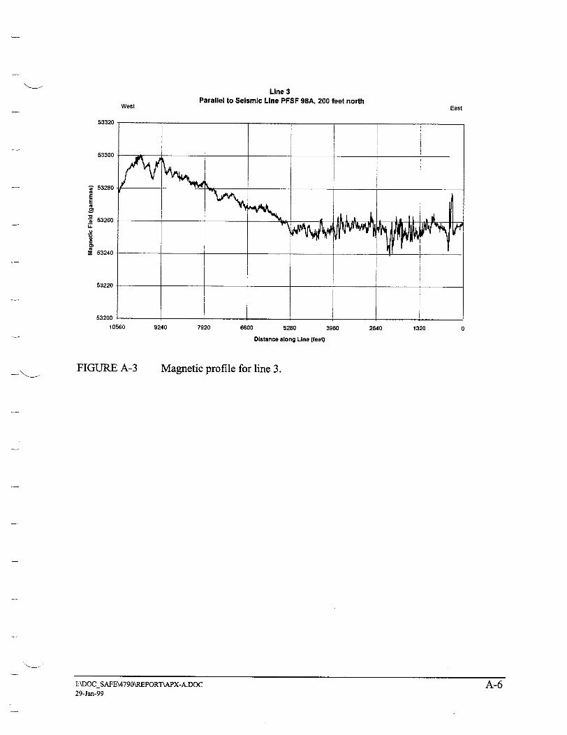
Line 3 Parallel to Seismic Line PFSF 98A, 200 feet north
East
53320
53300
7 53280
E E
S53260 LA
r
01
2 53240
53220
10560
FIGURE A-3
9240 7920 6600 5280 3960 2640 1320 0
Distance along Line (feet)
Magnetic profile for line 3.
I.\DOCSAFE\4790\REPORT\APX-A.DOC A-6
I:2DOC-SAFE\47909REPORT9PX-A.DOC 29-Jan-99
West
A-6

Gravity Data with Horizontal GradientsEast
05280
-1bb
Section 6 Section 5
-168
-170
-172 •"
-174
-176
0,
-178 M
-180
-182
-184
FIGURE A-4
Distance (feet from Beginning of Seismic Line PFSF 98A)
I- Boug Gray -u-Gradient
Comparison of gravity and magnetic anomalies.
I:\DOCSAFE\4790\REPORTPAPX-A.DOC 29-Jan-99
West
10560
"1
-0.1
F
E Z0
E
-0.3
-0.4 7
-0.6
A-7

GEOMATRIX
APPENDIX B
BORING LOGS
i['JAr_.C kl -'-lValle Go-ULLIut ARes e-AUILIoIn Skull Valley Goshute Reservation, Utah
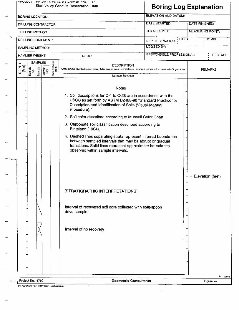
Boring Log ExplanationBORING LOCATION: ELEVATION AND DATUM:
DRILLING CONTRACTOR: DATE STARTED: DATE FINISHED:
tRILLING METHOD: TOTAL DEPTH: MEASURING POINT:
DRILLING EQUIPMENT: DEPTH TO WATER: FIRST COMPL.
SAMPLING METHOD: LOGGED BY:
HAMMER WEIGHT: 1 DROP: RESPONSIBLE PROFESSIONAL: REG. NO.
_ SAMPLES S V S v DESCRIPTION a,.. *-..• ecwH l e.itr E A K
- E o a NAME (USCS Symbol): color, moist, % by weight., plast., consistency, structure, cementation, react. wA-I. geo inter. REMARKS
Su n _ Surface Elevation
Notes
1. Soil descriptions for C-1 to C-28 are in accordance with the USCS as set forth by ASTM D2488-90 "Standard Practice for Description and Identification of Soils (Visual-Manual Procedure)."
2. Soil color described according to Munsell Color Chart.
3. Carbonate soil classification described according to Birkeland (1984).
4. Dashed lines separating strata represent inferred boundaries between sampled intervals that may be abrupt or gradual transitions. Solid lines represent approximate boundaries observed within sample intervals.
[STRATIGRAPHIC INTERPRETATIONS]
Interval of recovered soil core collected with split-spoon drive sampler
Interval of no recovery
- Elevation (feet)
I'Project No. 4790 Geomatrix ConsultantsS:A4790\UtahPFSF 981 lUogs\_LogExplan.ai
RI1 (VJ0T
I Figure --B-1 (31971
i
X

PROJECT: PRIVATE FUEL STORAGE FACILITY Skull Valley Goshute Reservation, Utah Log of Boring No. C-1
BORING LOCATION: E 1641361.537, N 755844.694 ELEVATION AND DATUM: 4491.65 feet [DRILLING CONTRACTOR: Layne Chrdstensen DTO TALRETHD: DATEFINIHED
DATE STARTED: DATE FINISHED: DRLIN ONRCTR ayeChitesn6/15/98 6/15/98
RILLING METHOD: Rotary auger with hollow stem TOTAL DEPTH: MEASURING POINT: S32.0 feet Ground stake
DRILLING EQUIPMENT: Mobile B-61 DEPTH TO WATER: FIRST COMPL. I I
SAMPLING METHOD: Hollow stem with 5-foot pitcher (I.D.=3.5 in., O.D.=4.0 in.) Richard Gillespie, Kathryn Hanson, and Don Currey Hi REVIEWED BY: REG. NO. HAMMER WEIGHT: DROP.--- Kathryn Hanson _,_ --
SAMPLES Z .- "DESCRIPTION 8.. NAME (USCS Symbol): color, moist, % by weighL, plast.. consistency, structure, cementation, react. w/HC1. geo. inter. REMARKS
S A o0. Surface Elevation: 4491.65 feet
2
3
4
5
6
7
8
9
10
11-
12
13
14-
SANDY SILT (ML) Brown, with roots
SILT (ML) Greenish gray with white calcite stringers, damp [BONNEVILLE DEEP-WATER FACIES]
T
SAND (SW) Light brown and yellowish brown, damp, fine sand, slight plasticity
Very fine sand, trace silt, light brownish gray [POST-STANSBURY TRANSGRESSIVE FACIES]
SILTY CLAY (CL) Gray with reddish brown mottling, moderate plasticity
SAND (SW) Light brown, dry, fine sand, clean [STANSBURY TRANSGRESSIVE FACIES]
SAND (SW) Light brown, fine sand [STANSBURY REGRESSIVE FACIES?]
SILTY SAND (SM) Light gray and yellowish brown, fine sand
Interbedded silt and fine sand, orange brown and gray [STANSBURY DEEP-WATER FACIES]
_ --fProject No. 4790
- 4491.15 feet
- 4487.65 feet
- 4485.85 feet - 4485.55 feet
- 4481.65 feet
- 4480.15 feet
toJ___________
8-1 (12195%
Geomatrix Consultantss:\4790\UtahPFSF_981 1\Jogs\_C_01 _01 .ai
I
I\
=lip,*

PROJECT: PRIVATE FUEL STORAGE FACILITY Skull Valley Goshute Reservation, Utah
I-
16
17
18
19
20
21
22
23
24
25
26
27
28
29
30
31
32-
SAMPLES
o LL ca Cc
•Eo
o. 01=
Log of Boring No. C-1 (cont.)
DESCRIPTION NAME (USCS Symbol): color, moist, % by weighL, plast., consistency, structure, cementation, react. w/HCI. geo. inter.
SILTY SAND (SM) Light yellowish gray, slightly damp, 10-20% nonplastic fines, uniform fine sand [STANSBURY DEEP-WATER FACIES]
SANDY SILT (ML) Yellowish gray and orange brown, damp, slightly plastic, fine sand, few thin clay interbeds
-- [STANSBURY DEEP-WATER FACIES]
SILTY SAND (SM) Light brown, 10-12% nonplastic fines, uniform fine sand
SAND (SW) Light brown, dry, uniform fine sand [STANSBURY TRANSGRESSIVE FACIES]
SAND (SW) Light brown, dry, uniform fine sand, trace fine gravel [STANSBURY TRANSGRESSIVE FACIES]
SAND (SW) Similar to above, some gravel at bottom contact with silt [STANSBURY TRANSGRESSIVE FACIES]
SILT (ML) Light gray with orange streaks, dry, slightly plastic [WEAK SOIL DEVELOPED ON EOLIAN DEPOSITS]
SANDY SILT with GRAVEL (ML-GP) Slightly plastic, coarse to fine sand, mostly fine sand, 1 large cobble to 3-inch diameter maximum, medium to fine gravel, some caliche (?), attempt to auger ahead to 30 feet to clear hole, rough augering--gravelly caliche on bit, augered to approximately 32 feet in calichified gravel, very slow, sample from center of auger [PROMONTORY SOIL DEVELOPED ON PRE-BONNEVILLE ALLUVIUM-reworked eolian] /-
Bottom of boring at 32.0 feet.
.�J.
REMARKS
4476.55 feet
-- 4472.85 feet
-- 4471.65 feet
-- 4470.65 feet
4468.65 feet
4466.65 feet
4466.25 feet
4462.65 feet
No penetration of augers, switch to drive samples
- 4459.65 feet
B-2 (12/95)
roject No. 4790 Geomatrix Consultantss:'.790\UtahPFSF_981 1\Jogs\_C_01_02.ai

PROJECT: PRIVATE FUEL STORAGE FACILITY Skull Valley Goshute Reservation, Utah Log of Boring No. C-2
BORING LOCATION: E 1641542.378, N 754439.646 ELEVATION AND DATUM: 4512.05 feet
RILLING CONTRACTOR: Lae Chrstensen DATE STARTED: DATE FINISHED: ayne 6/15/98 6/15/98
.ILLING METHOD: Rotary auger with hollow stem TOTAL DEPTH: MEASURING POINT: L M D y e hw9.2 feet Ground stake
DRILLING EQUIPMENT: Mobile B-61 DEPTH TO WATER: FIRST COMPL.
SAMPLING METHOD: Hollow stem with 5-foot pitcher (I.D.=3.5 in., O.D.=4.0 in.) LOGGED BY: ____________________________________________________Kathryn Hanson, Richard Gillespie, and Don Currey
HAMMER WEIGHT: --- DROP: --- REVIEWED BY: REG. NO. I_______ _Kathryn Hanson _ __ --SAMPLES Z1 SAMLE - DESCRIPTION
C - t" 'E NAME (USCS Symbol): color, moist, % by weight., plast., consistency, structure, cementation, react. w/HCl. geo. inter.REMARKS
•o C) .~Surface Elevation: 4512.05 feet
4
2
3
4-,
5
6
7
8
9
10
11
12
13
14-
CLAYEY SAND (SC)
SAND (SW)
"-•SILTY SAND (SM) with CALICHE (?)
SAND (SW) Sand with round pebbles
GRAVEL (GP) Tufa or carbonate cemented gravel
Bottom of boring at 9.2 feet.
- 4510.40 feet
- 4508.20 feet
- 4505.65 feet \- 4505.45 feet
- 4503.05 feet "- 4502.85 feet
R.1 f1OI��
>-VTroject No. 4790 Geomatrix ConsultantsS:4790\UtahPFSF_981 logs\,C_02.ai
a . .
B-1 IMS

PROJECI: PHIVATE FUEL S--i OAGE FACILITY Skull Valley Goshute Reservation, Utah Log of Boring No. C-3
ELEVATION AND DATUM: BORING LOCATION: E 1639960.493, N 754583.010 4503.4Efeet
DATE STARTED: DATE FINISHED: DRILLING CONTRACTOR: Layne Christensen 6/16/98 6/17/98 TOTAL DEPTH: MEASURING POINT: .LLING METHOD: Rotary auger with hollow stem 45.0 feet Ground stake
DRILLING EQUIPMENT: Mobile B-61 DEPTH TO WATER: FIRSTCOMPL.
LOGGED BY: SAMPLING METHOD: Hollow stem with 5-foot pitcher (I.D.=3.5 in., O.D.=4.0 in.) Kathryn Hanson, Richard Gillespie, and Don Currey HII REVIEWED BY: REG. NO. HAMMER WEIGHT: --- DROP:- Kathryn Hanson _,_ --
SAMPLES $5 m•I "SMPE DESCRIPTION
0- o _ NAME (USCS Symbol): color, moist, % by weight, plast., consistency. structure, cementation, react. wHOCl. geo. inter. REMARKS
CA) G- Surface Elevation: 4503.4 feet
2
3
4
5
6
7-
8-j
9
10-
12
13
14-
x
CLAYEY SILT (MH) Clayey silt with trace fine sand, scattered pebble in upper ??? 0.5 feet
-- > [BONNEVILLE or PROVO DEEP-WATER FACIES?] /
SANDY GRAVEL (GP) Loose, subrounded gravel, 1.5-inch maximum diameter clast size [STANSBURY SHORELINE FACIES?]
SAND (SW) Fine sand, finely bedded, coarsens upward [STANSBURY SHORELINE FACIES?]
No recovery
SAND (SW) Fine sand, trace fine gravel [STANSBURY REGRESSIVE FACIES?]
INTERBEDDED SANDY GRAVEL (GP) and SAND (SW) Fine to medium sandy gravel and interbedded sand
\ [STANSBURY REGRESSIVE FACIES?]
SAND (SW) Fine sand, medium sand, and a few coarse sand beds, well stratified
No recovery
SAND (SW) Sand with minor pebbly sand [STANSBURY REGRESSIVE FACIES?]
SANDY GRAVEL (GP) [STANSBURY REGRESSIVE FACIES?]
i SAND (SW) Fine sand [STANSBURY TRANSGRESSIVE FACIES?]
SAND (SW) Light greenish gray, very fine sand, very soft [STANSBURY TRANSGRESSIVE FACIES?]
'roject No. 4790
/
- 4502.10 feet
- 4501.60 feet
- 4500.40 feet
4498.40 feet
4497.30 feet
4496.70 feet
4494.60 feet
4502.40 feet
4490.90 feet
4490.30 feet
- 4488.75 feetB-1 (12/95)
Geomatrix Consultantss:\4790\UtahPFSF_981 1\logs\C_03_01 .ai
t
P
4 P

I PROJECT: PRIVATE FUEL STORAGE FACILITY Skull Valley Goshute Reservation, Utah
DESCRIPTION NAME (USCS Symbol): color, moist, % by weight., plast., consistency, structure, cementation, react. w/HOCI geo. inter.
SAND (SW) (continued)
SAND (SW) Light reddish brown, thinly layered fine sand, trace gravel [STANSBURY TRANSGRESSIVE FACIES]
SILTY SAND (SM) Light yellowish gray to white (1OYR 8/2), poorly sorted silty sand with caliche, gravelly, very dense, massive, Stage III carbonate, (all grains coated, voids filled), very slow augering [PROMONTORY SOIL DEVELOPED ON EOLIAN DEPOSIT]
SANDY SILT (ML) Light brown (10YR 7/2.5, m), poorly sorted [PRE-BONNEVILLE EOLIAN DEPOSIT-with B horizon soil] SANDY SILT (ML) k. Light gray (10YR 8/1.5, m), poorly sorted, massive (Stage 111) [PRE-BONNEVILLE EOLIAN DEPOSIT-with Cca horizon soil]
I GRAVELLY SILTY SAND (SP-SM) Poorly sorted, calcareous matrix, carbonate rinds (1-millimeter thick) on bottom of clasts [PRE-BONNEVILLE ALLUVIUM/COLLUVIUM DEPOSIT-with Cca horizon soil]
REMARKS
- 4486.50 feet
- 4481.20 feet
4473.60 feet 4473.30 feet
4471.00 feet
(oject No. 4790
:s-\4790\UtahPFSF-981 1\togs\_C_03_02.ai
Geomatrix Consultants
r
B-2 (12195)
Log of Boring No. C-3 (cont.)

PROJECT: PRIVATE FUEL STORAGE FACILITY Skull Valley Goshute Reservation, Utah
Fa_ W
34
35
36
37
38
39
40
41
42-
43
44
45
46
47
48
49
50
51
SAMPLES
0Z E Md Co ~o mz C2F
7
1T
0
Log of Boring No. C-3 (cont.)
DESCRIPTION NAME (USCS Symbol): color, moist, % by weighL, plast., consistency, structure, cementation, react. w/iHCl geo. inter.
GRAVELLY SILTY SAND (SP-SM) (continued)
No recovery
SANDY SILT (ML) Upper portion of unit: Pale brown (1 0YR 6/3, d) and brown (10OYR 5/3, m), poorly sorted Bottom portion of unit: Light brownish gray to pale brown
--/(10YR 6/2.5, m), poorly sorted, contains manganese-F [coated pellet clasts, effervesces stronglyI
i/CLAYEY SILT (MH)
Brown (1OYR 5.3/3, m), with trace fine sand; ash fragments?
J[SALT LAKEGROUP]
No recovery
SANDY SILT (ML) Brown (7.5YR 5/3, m), fine sand, finely bedded with redder silt layers "[SALT LAKE GROUP] -SANDY SILT (ML) Brown to dark brown (7.5YR 4.5/4, m), poorly sorted, up to coarse sand size, subhorizontal platey structure (plates are 5-10 millimeters thick), manganese staining and gleying on pellet faces [SALT LAKE GROUP]
Bottom of boring at 45.0 feet.
REMARKS
- 4469.40 feet
- 4464.40 feet
- 4463.40 feet
- 4462.90 feet
- 4461.30 feet
_ 4461.00 feet
4458.40 feet
(oject No. 4790 Geomatrix Consultantss:\4790\UtahPFSF_981 1Vogs\C03_03.ai
U
B-2 (12/95)
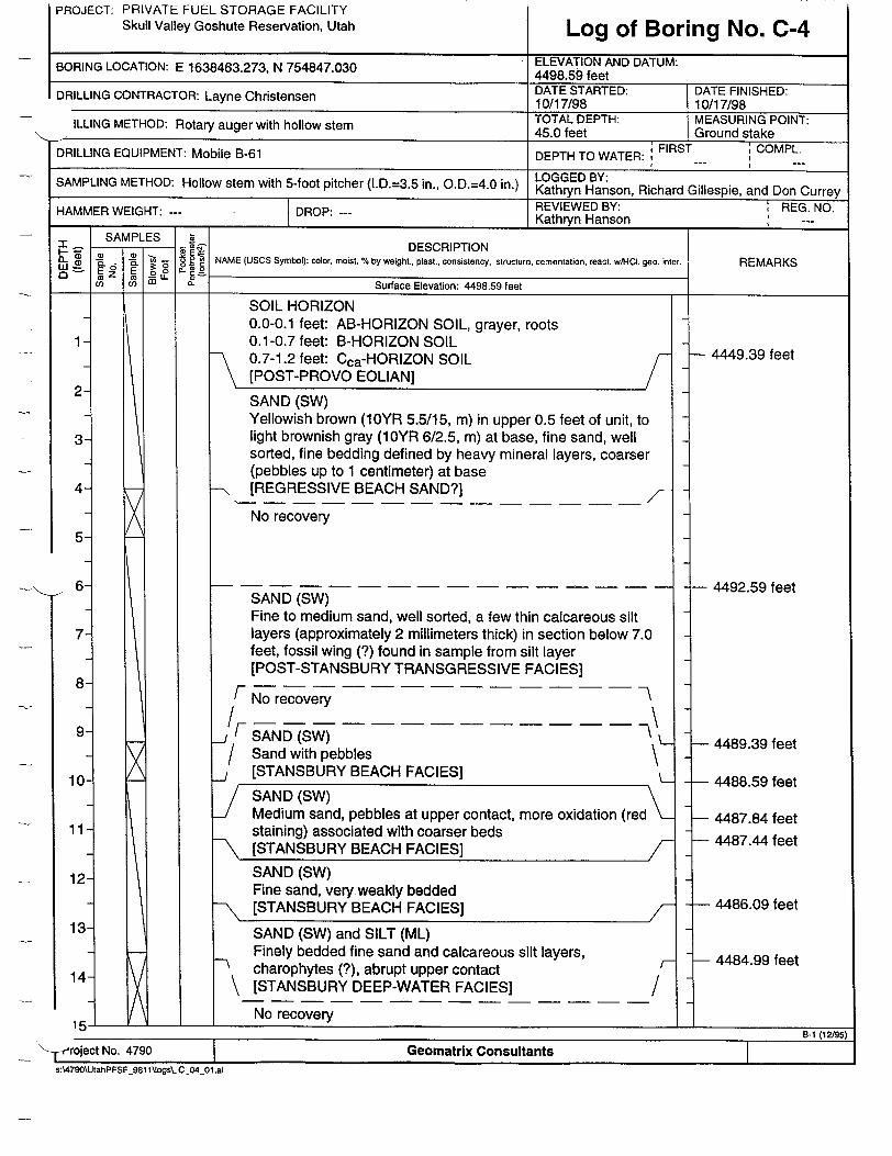
PROJECT: PRIVATE FUEL STORAGE FACILITY Skull Valley Goshute Reservation, Utah Log of Boring No. C-4
BORING LOCATION: E 1638463.273, N 754847.030 ELEVATION AND DATUM: 4498.59 feet DRILLING CONTRACTOR: a Christensen DATE STARTED: DATE FINISHED:
Layne 10/17/98 10/17/98
ILLING METHOD: Rotary auger with hollow stem TOTAL DEPTH: MEASURING POINT: L M R a t o45.0 feet Ground stake ;, FIRST '•COMPL.
DRILLING EQUIPMENT: Mobile B-61 DEPTH TO WATER: F C
METHOD: Hollow stem with 5-foot pin., O.D.=4.0 in.) LOGGED BY: SAMPLING Mt pitcher (.D.3.5 iKathryn Hanson, Richard Gillespie, and Don Currey HAMMER WEIGHT: --- DROP: REVIEWED BY: REG. NO. HAMMER I Kathryn Hanson _,_ --
SAMPLES Z SAM -PLS DESCRIPTION
i�i � � • o50° *- •) • NAME (USCS Symbol): color, moist, % by weight., plast., consistency, structure, cementation, react. wA-CI, geo. REMARKS
_5_ ___ inter. RElARKS
co co ~ a_ Surface Elevation: 4498.59 feet I_______________________________1
2
3
4
5
6-
7_
8
9-
10
11
12
13
14- 7
SOIL HORIZON 0.0-0.1 feet: AB-HORIZON SOIL, grayer, roots 0.1-0.7 feet: B-HORIZON SOIL 0.7-1.2 feet: Cca-HORIZON SOIL [POST-PROVO EOLIAN]
SAND (SW) Yellowish brown (10YR 5.5/15, m) in upper 0.5 feet of unit, to light brownish gray (10YR 6/2.5, m) at base, fine sand, well sorted, fine bedding defined by heavy mineral layers, coarser (pebbles up to 1 centimeter) at base
--\ [REGRESSIVE BEACH SAND?]
No recovery
SAND (SW) Fine to medium sand, well sorted, a few thin calcareous silt layers (approximately 2 millimeters thick) in section below 7.0 feet, fossil wing (?) found in sample from silt layer [POST-STANSBURY TRANSGRESSIVE FACIES]
/No recovery
/ANFD(Sw) Sand with pebbles [STANSBURY BEACH FACIES]
[SAND (SW) B H C Medium sand, pebbles at upper contact, more oxidation (red staining) associated with coarser beds
SAND (SW) Fine sand, very~weakly bedded
- [STANSBURY BEACH FACIES] /
SAND (SW) and SILT (ML) Finely bedded fine sand and calcareous silt layers,
Scharophytes (?), abrupt upper contact \ [STANSBURY DEEP-WATER FACIES]
No recovery
/-
/
- 4449.39 feet
- 4492.59 feet
- 4489.39 feet
4488.59 feet
- 4487.84 feet
- 4487.44 feet
- 4486.09 feet
L 4484.99 feet
In- -- - .___ - _________________
__ \-,-eroject No. 4790B-1 (12/95)
Geomatrix Consultantss:\4790\UtahPFSF_981 \Iogs.C__04_01 .ai
I
I
PROJECT: PRIVATE FUEL STORAGE FACILITY Skull Valley Goshute Reservation, Utah Log of Boring No. C-4 (cont.)
-1 t-t-�-f
DESCRIPTION NAME (USCS Symbol): color, moist, % by weight, plast., consistency, structure, cementation, react. wiHt. geo. inter.
SILTY SAND (SM) Light brownish gray to pale brown (1OYR 6/2.5, m), silty fine sand, calcareous silt layers more abundant in lower 1.5 feet of section, redder colors due to oxidation associated with some beds [STANSBURY DEEP-WATER FACIES]
16
17
18
19
20
21
22
23
24
25
26
27-
GRAVELLY SAND (SP-SW) Poorly sorted fine sand with occasional pebbles, Stage Il-Ill, (10YR 7/2, m) (?), in upper portion of section, incipient laminar or plate structure, massive with blotchy patches of greater carbonate accumulation in lower portion of section (Stage II) [PROMONTORY SOIL DEVELOPED ON PRE-BONNEVILLE EOLIAN DEPOSITS]
SAND (SW) Very pale brown (10YR 7/3M), fine sand [PROMONTORY SOIL on EOLIAN?]
I SAND (SW) Fine sand with a few pebbles up to 2.5 centimeters clast size [PROMONTORY SOIL on EOLIAN?]
SAND (SW) Pale brown (10YR 6/3M), cambric soil horizon [LITTLE VALLEY LAKE CYCLE-regressive beach facies with cambric B horizon soil] L
_/SAND (SW) Grayish brown to brown (1OYR 5/2.5, m), fine sand, clean, well sorted, fine bedding (heavy mineral beds) [LITTLE VALLEY LAKE CYCLE-regressive beach facies]
REMARKS
F No recovery -- -- I
1/SAND (SW)Fine to very fine sand, well sorted
[SANSBURY TRANGRESSIVE EAClES]
fGRAVELLY SAND (SP-SW) IILoose sand and gravel, gravel clasts are subrounded (clas
size is 1-2 centimeters) [STANSBURY TRANGRESSIVE FACIES-Beach gravel and sand]
Poorly sorted sand with pebbles (clast size up to 2.5 centimeters)
SAND (SW) Light brownish gray (10YR 6/2, m), fine sand with some silt, more poorly sorted with more rock fragments relative to sand, unit described at 20-21 feet [EOLIAN?]
0 1 _ _ __ __ _ __ _
I- 1f5roject No. 4790 Geomatrix Consultants
- sA479O\UltahPFSF_981 1\Jogs\.C 04-02.ai
"0LI
SAMPLES
a) -TýV E.6 E
CU Cts diL
0 Sg= a,
4483.59 feet
-4479.29 feet
- 4478.59 feet
-4477.59 feet
-4475.29 feet
4473.59 feet
4472.19 feet
4468.59 feet
4467.79 feet
4467.09 feet
28 -
29
30
31
32-
B-2 (12195)
I
PROJECT: PRIVATE FUEL STORAGE FACILITY Skull Valley Goshute Reservation, Utah Log of Boring No.
\ 1 Project No. 4790
DESCRIPTION NAME (USCS Symbol): color, moist, % by weight., plast., consistency, structure, cementation, react. w/HCl. geo. inter.
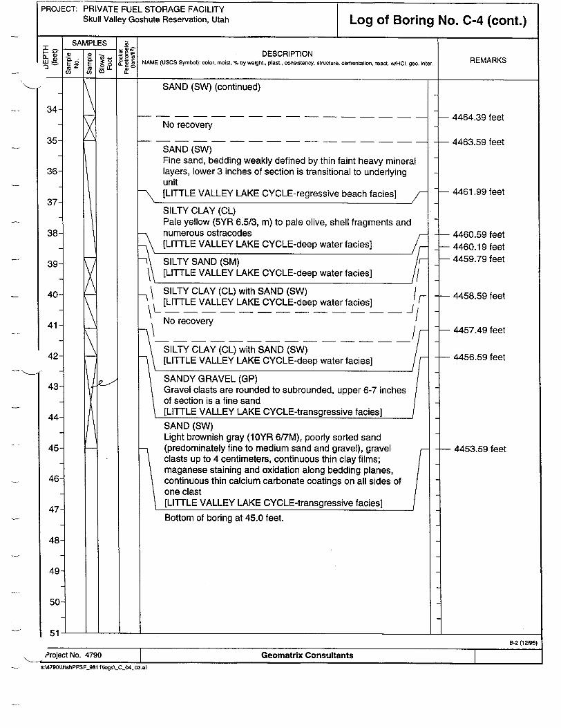
SAND (SW) (continued)
No recovery
SAND (SW) Fine sand, bedding weakly defined by thin faint heavy mineral layers, lower 3 inches of section is transitional to underlying unit [LITTLE VALLEY LAKE CYCLE-regressive beach facies]
34
35
36
37
38
39- SILTY SAND (SM) [LITTLE VALLEY LAKE CYCLE-deep water facies]
-IrSILTY CLAY (CL) with SAND (SW) [LITTLE VALLEY LAKE CYCLE-deep water facies]
No recovery
IF �1�/
SILTY CLAY (CL) with SAND (SW) [LITTLE VALLEY LAKE CYCLE-deep water facies]
SANDY GRAVEL (GP) Gravel clasts are rounded to subrounded, upper 6-7 inches of section is a fine sand [LITTLE VALLEY LAKE CYCLE-transgressive facies]
SAND (SW) Light brownish gray (10YR 6/7M), poorly sorted sand (predominately fine to medium sand and gravel), gravel clasts up to 4 centimeters, continuous thin clay films; maganese staining and oxidation along bedding planes, continuous thin calcium carbonate coatings on all sides of one clast [LITTLE VALLEY LAKE CYCLE-transgressive facies]
Bottom of boring at 45.0 feet.
. i
REMARKS
- 4464.39 feet
- 4463.59 feet
- 4461.99 feet
- 4460.59 feet - 4460.19 feet - 4459.79 feet
- 4458.59 feet
4457.49 feet
4456.59 feet
4453.59 feet
Geomatrix Consultantss:\4790\UtahPFSF_9Bl llogs\_CO4_03.ai
SILTY CLAY (CL) Pale yellow (5YR 6.5/3, m) to pale olive, shell fragments and numerous ostracodes [LITTLE VALLEY LAKE CYCLE-deep water facies]
40-
41-
42-
43-
44-
45-
46
47
48
49
50
51B-2 (12/95)
t
C-4 (cont.)
J
I

PROJECT: PRIVATE FUEL STORAGE FACILITY
Skull Valley Goshute Reservation, Utah Log of Boring No. C-5 BORING LOCATION: 5650 feet on Seismic Line A" ELEVATION AND DATUM:
E 1642780.417, N 759399.619 4469.78 feet )RILLING CONTRACTOR: Layne Christensen DATE STARTED: DATE FINISHED:
ae10/5/98 10/6/98
DRILLING METHOD: Rotary auger with hollow stem TOTAL DEPTH: MEASURING POINT: 89.0 feet Ground stake
DRILLING EQUIPMENT: Mobile B-61 DEPTH TO WATER: FIRST COMPL.
SAMPLING METHOD: Hollow stem with 5-foot pitcher (I.D.=3.5 in., O.D.=4.0 in.) LOGGED BY: Chris Hitchcock with K. Hanson and B. Swan
HAMMER WEIGHT: --- DRREVIEWED BY: REG. NO. DROP: Kathryn Hanson _,_ --SAMPLES SSAMPLES -- DESCRIPTION
E•• ( o .- NAME (USOS Symbol): color, moist. % by weight., plast., consistency, structure, cementation, react. w/HCl. geo. inter. REMARKS
oU a. 1E0 Surface Elevation: 4469.78 feet
SANDY SILT (ML) Very pale brown (1OYR 7/4), dry, soft, platey soil structure [POST-PROVO REWORKED EOLIAN/SHEETWASH-with soilj
CLAYEY SILT (MH) Upper 2 inches of unit is yellow (1OYR 7/6) platey soil [POSTPROVO SOIL] grades into light gray (10YR 7/2), damp, soft to medium stiff, ostracode-rich, breaks into horizontal partings [PROVO DEEP-WATER FACIES]
CLAYEY SILT (MH) Light gray (10YR 7/1), damp, blocky [BONNEVILLE DEEP- WATER FACIES-blocky]
2
3
4
5
6
7
8
9
10
11
12
13
14-
4466.78 feet
4464.28 feet
4461.28 feet
- 4457.58 feet
/- 4454.78 feet
0.5
1.5
0.5
2.0
0.5
CLAYEY SILT (MH) Light gray (1OYR 6/1) mottled with white (11YR), damp, soft, thin (1-4 millimeters) laminations, ostracode-rich; gradational lower contact [BONNEVILLE DEEP- WATER FACIES-laminated]
SILTY TO CLAYEY SAND (SM-SC) Yellow (1 0YR 7/6), damp, clayey interbeds to 1 inch, loose, well-bedded, minor carbonate reacts with acid
-- I![POST-STANSBURY TRANSGRESSIVE FACIES] clay-rich bed, 1 inch thick [DEEP WATER}
I B-1 (12/95)
Project No. 4790 Geomatrix Consultants
as4790\UtahPFSF_981 1'Jogs\-C-05_01 .ai
PRIVATE FUEL STORAGE FACILITY Skull Valley Goshute Reservation, Utah
1.5
1.0
<0.5
<0.5
Log of Boring No. C-5 (cont.)
DESCRIPTION NAME (USCS Symbol): color, moist, % by weight.. plast., consistency, structure, cementation, react. w/H.CI geo. inter.
CLAY (CL) Pale olive (5Y 6/3), damp [CLAY INTERBED - DEEP WATER]_
SILTY to CLAYEY SAND (SM-SC) Yellow (1OYR 7/6), damp [POST STANSBURY TRANSGRESSIVE FACIES] SILT (ML) Yellow (1OYR 8/6), soft, fine sand to silt [STANSBURY REGRESSIVE FACIES]
CLAYEY SILT (MH) Yellowish to whitish (10YR 7/6-8/2), dry, medium dense, laminar with charaphytes
Coarsens upward, top of whitish marl [STANSBURY DEEP-WATER FACIES SEQUENCE]
CLAYEY SILT (MH) Similar, yellow (1 OY 7/8), with less laminations, minor ostracodes, well-bedded [STANSBURY TRANSGRESSIVE FACIES]
SAND (SW) Pale yellow (2.5Y 7/4), dry, loose, clean, well-sorted, massive, fine [STANSBURY TRANSGRESSIVE FACIES]
SAND (SW) (same as above) Pale yellow (2.5Y 7/4), dry, loose, with interbedded medium grained layers, cross bedding [STANSBURY TRANSGRESSIVE FACIES]
-. i
REMARKS
- 4454.08 feet
- 4452.68 feet
- 4452.18 feet
- 4448.08 feet
- 4443.78 feet
- 4439.78 feet
PROJECT:
I B-2 (12/95)
Project No. 4790 Geomatrix Consultants s:\4790\UtahPFSF_981 1\logs\_C_05_02.ai
PROJECT: PRIVATE FUEL STORAGE FACILITY Skull Valley Goshute Reservation, Utah Log of Boring No. C-5 (cont.)
SAMPLES 8 M- DESCRIPTION
NAME (USCS Symbol): color, moist, % by weight., plast., consistency, structure, cementation, react WH geo interREMARKS I . suu ,e ntnr c H
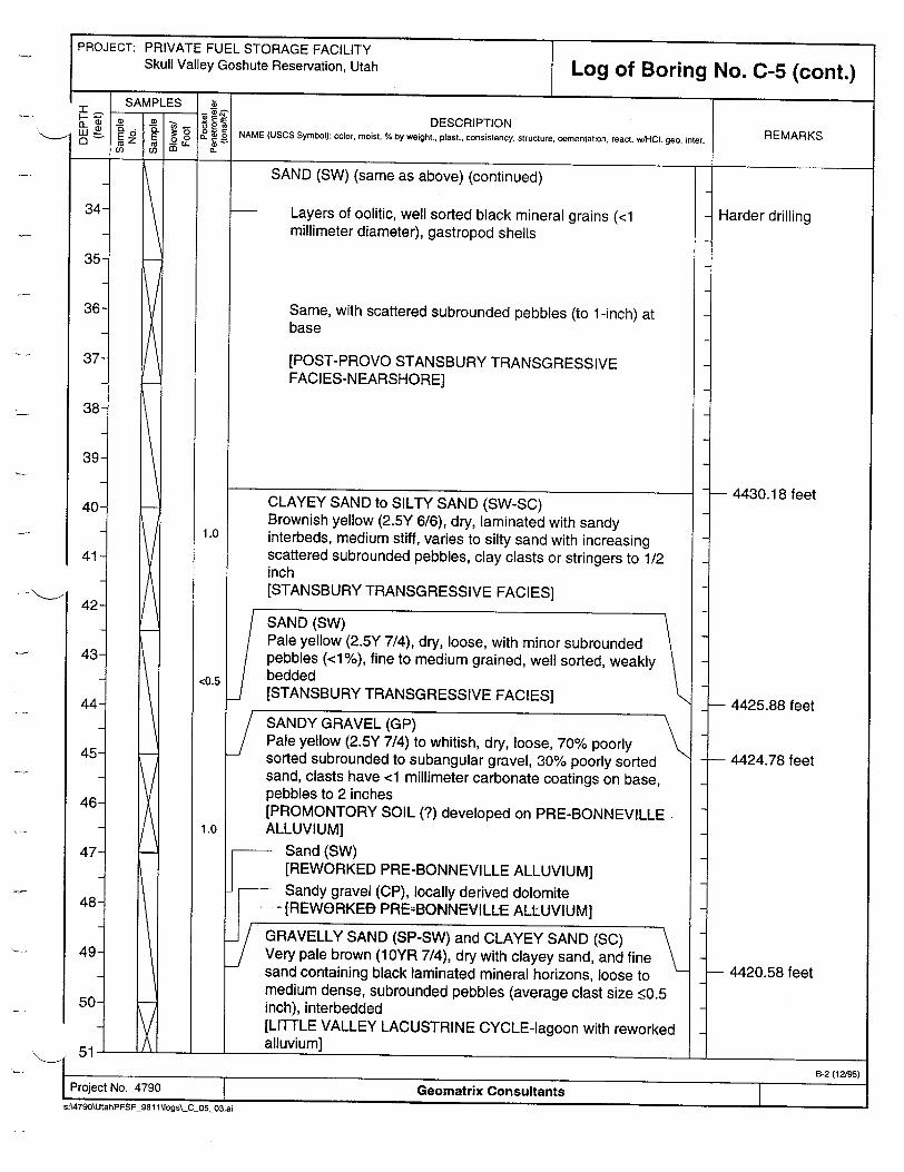
SAND (SW) (same as above) (continued)
Layers of oolitic, well sorted black mineral grains (<1 millimeter diameter), gastropod shells
Same, with scattered subrounded pebbles (to 1-inch) at base
[POST-PROVO STANSBURY TRANSGRESSIVE FACIES-NEARSHORE]
34
35
36
37
38
39
40
41
42
43
44
45
46
47
48
49
50-
SANDY GRAVEL (GP) Pale yellow (2.5Y 7/4) to whitish, dry, loose, 70% poorly sorted subrounded to subangular gravel, 30% poorly sorted sand, clasts have <1 millimeter carbonate coatings on base, pebbles to 2 inches [PROMONTORY SOIL (?) developed on PRE-BONNEVILLE ALLUVIUM]
Sand (SW) [REWORKED PRE-BONNEVILLE ALLUVIUM] Sandy gravel (CP), locally derived dolomite
-I[REWORKE- PREzBONNEVILLE ALLUVIUM]
GRAVELLY SAND (SP-SW) and CLAYEY SAND (SC) Very pale brown (10YR 7/4), dry with clayey sand, and fine sand containing black laminated mineral horizons, loose to medium dense, subrounded pebbles (average clast size •0.5 inch), interbedded [LITTLE VALLEY LACUSTRINE CYCLE-lagoon with reworked alluvium]
Harder drilling
- 4430.18 feet
- 4425.88 feet
- 4424.78 feet
1- 4420.58 feet
B-2 (11295)
Geomatrix ConsultantssA790\UtahPFSF F9811 'ogs-C 0503.ai
NCLAYEY SAND to SILTY SAND (SW-SC) Brownish yellow (2.5Y 6/6), dry, laminated with sandy interbeds, medium stiff, varies to silty sand with increasing scattered subrounded pebbles, clay clasts or stringers to 1/2 inch [STANSBURY TRANSGRESSIVE FACIES]
SAND (SW) Pale yellow (2.5Y 7/4), dry, loose, with minor subrounded
pebbles (<1%), fine to medium grained, well sorted, weakly bedded [STANSBURY TRANSGRESSIVE FACIES]
51
1.0
<0.5
1.0
I i
roFIJeC LL IN . 4"'+I W
PROJECT: PRIVATE FUEL STORAGE FACILITY Skull Valley Goshute Reservation, Utah
60
61
62
63
64
65
66
67-
68-
1.0
<0.5
1.0
<0.5
<0.5
<0.5
Log of Boring No. C-5 (cont.)
DESCRIPTION NAME (USCS Symbol): color, moist, % by weight., plast., consistency. structure, cementation, react. w/HOI. geo. inter. REMARKS
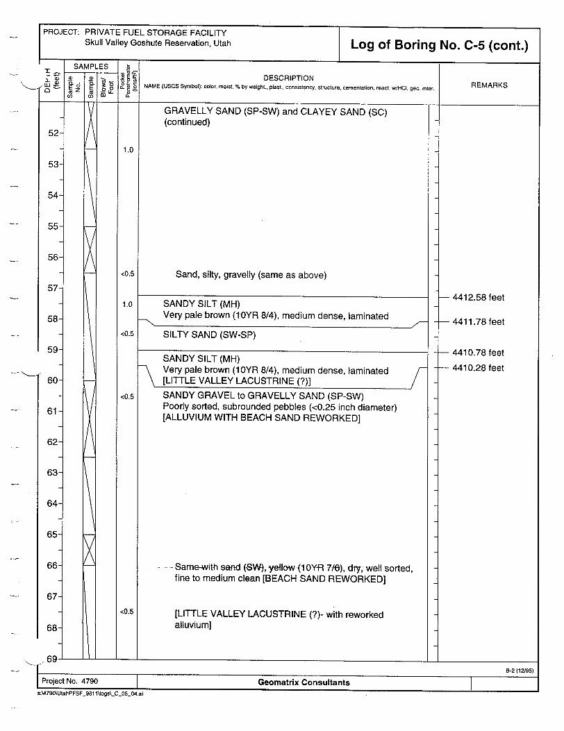
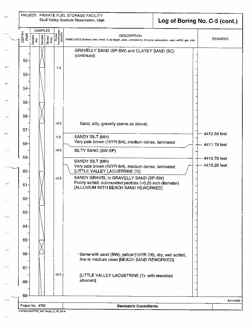
GRAVELLY SAND (SP-SW) and CLAYEY SAND (SC) (continued)
Sand, silty, gravelly (same as above)
SANDY SILT (MH) Very pale brown (10YR 8/4), medium dense, laminated
SILTY SAND (SW-SP)
SANDY SILT (MH) Very pale brown (10YR 8/4), medium dense, laminated [LITTLE VALLEY LACUSTRINE (?)]SANDY GRAVEL to GRAVELLY SAND (SP-SW) Poorly sorted, subrounded pebbles (<0.25 inch diameter) [ALLUVIUM WITH BEACH SAND REWORKED]
....Same-with sand (SW), yellow (10Y-R 7/6), dry, well sorted, fine to medium clean [BEACH SAND REWORKED]
[LITTLE VALLEY LACUSTRINE (?)- with reworked alluvium]
- 4412.58 feet
- 4411.78 feet
- 4410.78 feet
- 4410.28 feet
1I- I _ _ _ _ _ __ _ _ _ _
I B-2 (12/95)
Project No. 4790 Geomatrix Consultants s:\4790\UtahPFSF 981 1llogs\_C_05_04.ai
PROJECT: PRIVATE FUEL STORAGE FACILITY Skull Valley Goshute Reservation, Utah
60
61
62
63
64
65
66
67
68-
Log of Boring No. C-5 (cont.)- rrSAMPLES
(0D
EZ E o.0
0 1
inir r
1.0
<0.5
1.0
<0.5
<0.5
<0.5
DESCRIPTION NAME (USCS Symbol): color, moist, % by weight., plast.. consistency, structure, cementation, react. w/HOI. geo. inter.
GRAVELLY SAND (SP-SW) and CLAYEY SAND (SC) (continued)
Sand, silty, gravelly (same as above)
SANDY SILT (MH)
Very pale brown (1 0YR 8/4), medium dense, laminated
SILTY SAND (SW-SP)
SANDY SILT (MH) Very pale brown (10YR 8/4), medium dense, laminated [LITTLE VALLEY LACUSTRINE (?)]SANDY GRAVEL to GRAVELLY SAND (SP-SW) Poorly sorted, subrounded pebbles (<0.25 inch diameter) [ALLUVIUM WITH BEACH SAND REWORKED]
--Same with sand (SW), yellow'J10YR 7/6), dry, well sorted, fine to medium clean [BEACH SAND REWORKED]
[LITTLE VALLEY LACUSTRINE (?)- with reworked alluvium]
REMARKS
- 4412.58 feet
- 4411.78 feet
- 4410.78 feet
- 4410.28 feet
- - - - ___ - . i--i- ______________________
B-2 (12/95)
Project No. 4790 Geomatrix Consultants
s:\4790\UtahPFSF_981 ltJogs\-C_05_04.ai
I------------------------ -PROJECT: PRIVATE FUEL STORAGE FACILITY
Skull Valley Goshute Reservation, Utah
3.0
Log of Boring No. C-5 (cont.)
DESCRIPTION NAME (USCS Symbol): color, moist, % by weight., plast., consistency, structure, cementation, react. w/HCO. geo. inter. REMARKS
SANDY GRAVEL to GRAVELLY SAND (SP-SW) (continued)
Same, pebble size up to 2 inches diameter, 1 inch average, increasing silt content with depth
SILT (MH) Yellow (10YR 8/6), dry, inierbed within unit, medium dense
SANDY GRAVEL (SP) with SAND (SW) Medium dense, subrounded to subangular with sand, light gray (1OYR 7/2)
Top of soil at 76.5 feet, pebbles to 2 inches, calcium carbonate coatings 1-2 millimeters on pebbles
No recovery - air rotary, hard, gravel fragments with carbonate coatings [PRE-LITTLE VALLEY ALLUVIUM]
SANDY SILT (MH) Reddish brown (7.5YR 6/4), dry, scattered rounded pebbles to 3/4 inch (?-may be from upper units)
Reddish clay F- White dust
[SALT LAKE GROUP?]
79-
80
81
82
83
84
85
86-
87
- 4393.28 feet
Refusal; switched to air rotary
- 4383.78 feet
- 4382.78 feet
I B-2 (12195)
1 Project No. 4790 Geomatrix Consultants sA4790\UtahPFSF_981 1lJogs\ C_05_05.ai
I

PROJECT: PRIVATE FUEL STORAGE FACILITY Skull Valley Goshute Reservation, Utah Log of Boring No. C-5 (cont.)
DESCRIPTION NAME (USCS Symbol): color, moist, % by weight., plast., consistency, structure, cementation, react w/HCO. geo. inter.
SANDY SILT (MH) (continued) [SALT LAKE GROUP?]
Bottom of boring at 89.0 feet.
REMARKS
- 4380.78 feet
96
97
98
99
100
101
102
103
104-
10B-2 (12/95)
Project No. 4790 Geomatrix Consultants
s:\4790\UtahPFSF 981 fljogs\.C_05_06.ai
a I I

PROJECT: PRIVATE FUEL STORAGE FACILITY Skull Valley Goshute Reservation, Utah
9ORING LOCATION: 815u rees on Seismic Line A" E 1640287.621, N 759434.186
Log of Boring No. C-6ELEVATION AND DATUM:
ORILLING CONTRACTOR: La Christensen DATE STARTED: DATE FINISHED: ayne 10/6/98 10/7/98
DRILLING METHOD: Rotary auger with hollow stem TOTAL DEPTH: MEASURING POINT: 48.0 feet Ground stake
DRILLING EQUIPMENT: Mobile B-61 DEPTH TO WATER: i FIRST COMPL. I I
SAMPLING METHOD: Hollow stem with 5-foot pitcher (I.D.=3.5 in., O.D.=4.0 in.) LOGGED BY: ___________________________________________________Chris Hitchcock REVIEWED BY: REG. NO. HAMMER WEIGHT: --- DROP: Kathryn Hanson __.
SAMPLES
SAMPES -DESCRIPTION (L ý * NAME (USCS Symbol): color, moist, % by weight., plast., consistency, structure, cementation, react. w/HCI. geo- inter.
W (D`6C 3 . REMARKS o3 o- Surface Elevation: 4465.24 feet *1a
1
2
3
4-
5-
6
7-
8-
9
10
11
12
13
14-
f1
x
SANDY SILT (ML) Pale brown (10YR 6/3), dry, loose to medium dense, platey with dessimated carbonate [POST-PROVO REWORKED EOLIAN]
CLAYEY SILT (MH) Light yellowish brown (2.5Y 6/4) to olive gray (5Y 5/2), dry, carbonate stringers, blocky [BONNEVILLE DEEP-WATER FACIES-blocky]
CLAYEY SILT (MH) Yellow (2.5Y 7/6) to brownish yellow (1OYR 6/8), damp, laminated, ostracode rich, gradational lower contact [BONNEVILLE DEEP-WATER FACIES-laminated]
SILTY to CLAYEY SAND (SM-SC) Brownish yellow (10YR 6/6), dry, fine, loose to medium stiff, well bedded, grades downward into very fine sand to silt [POST-STANSBURY TRANSGRESSIVE FACIES]
/SILT (ML) Very pale brown (1 OYR 8/3), dry, soft, charaphyte-rich
/ layers _j [POST-STANSBURY REGRESSIVE FACIES grading down
to STANSBURY DEEP-WATER FACIES]L
Project No. 4790 Geomatrix Consultants
s:\4790\UtahPFSF_981 1'.logs\_C06_01 .ai
4461.84 feet
4460.24 feet
-4456.04 feet
- 4450.74 feet
PROJECT: PRIVATE FUEL STORAGE FACILITY Skull Valley Goshute Reservation, Utah
31
32-
An:-s
Log of Boring No. C-6 (cont.)
DESCRIPTION NAME (USCS Symbol): color, moist, % by weight., plast., consistency, structure, cementation, react. wIHCO. geo. inter.
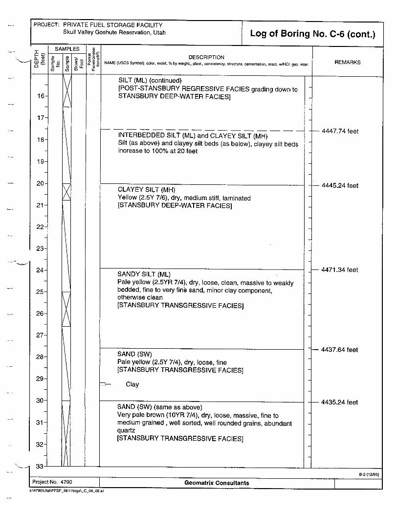
SILT (ML) (continued) [POST-STANSBURY REGRESSIVE FACIES grading down to STANSBURY DEEP-WATER FACIES]
INTERBEDDED SILT (ML) and CLAYEY SILT (MH) Silt (as above) and clayey silt beds (as below), clayey silt beds increase to 100% at 20 feet
CLAYEY SILT (MH) Yellow (2.5Y 7/6), dry, medium stiff, laminated [STANSBURY DEEP-WATER FACIES]
SANDY SILT (ML) Pale yellow (2.5YR 7/4), dry, loose, clean, massive to weakly bedded, fine to very fine sand, minor clay component, otherwise clean [STANSBURY TRANSGRESSIVE FACIES]
SAND (SW) Pale yellow (2.5Y 7/4), dry, loose, fine [STANSBURY TRANSGRESSIVE FACIES]
m- Clay
SAND (SW) (same as above) Very pale brown (10YR 7/4), dry, loose, massive, fine to medium grained, well sorted, well rounded grains, abundant quartz [STANSBURY TRANSGRESSIVE FACIES]
REMARKS
- 4447.74 feet
- 4445.24 feet
- 4471.34 feet
- 4437.64 feet
- 4435.24 feet
e-2 (12/95)
Project No. 4790 Geomatrix Consultants s:\4790\UtahPFSF 981 l'logs\_C_0602.ai
iI

PROJECT: PRIVATE FUEL STORAGE FACILITY Skull Valley Goshute Reservation, Utah
42
43
44
45
46
47
48
49-
50-
74.0
<0.5
74.0
Log of Boring No. C-6 (cont.)
DESCRIPTION NAME (USCS Symbol): color, moist, % by weight.. plast., consistency. structure, cementation, react. wHCO- geo. inter.
SAND (SW) (same as above) (continued)
Scattered (<3%) rounded pebbles at base
SANDY CLAY (CL) Yellowish brown (10YR 5/6), dry, low plasticity, laminar
SAND (SW) and SANDY GRAVEL (GP) Sand as above, grades into sandy gravel, dry, hard, calcium carbonate cemented, rinds to 1 millimeter
-•TPROMONTORY SOIL]
Bottom of boring at 48.0 feet.
REMARKS
- 4420.04 feet
- 4418.54 feet
- 4417.24 feet Refusal
SI B-2 (12/95) Project No. 4790 Geomatrix Consultants
S:\4790\UtahPFSF 981 l~logs\_C06_03.ai
I
PROJECT: PRIVATE FUEL STORAGE FACILITY Skull Valley Goshute Reservation, Utah
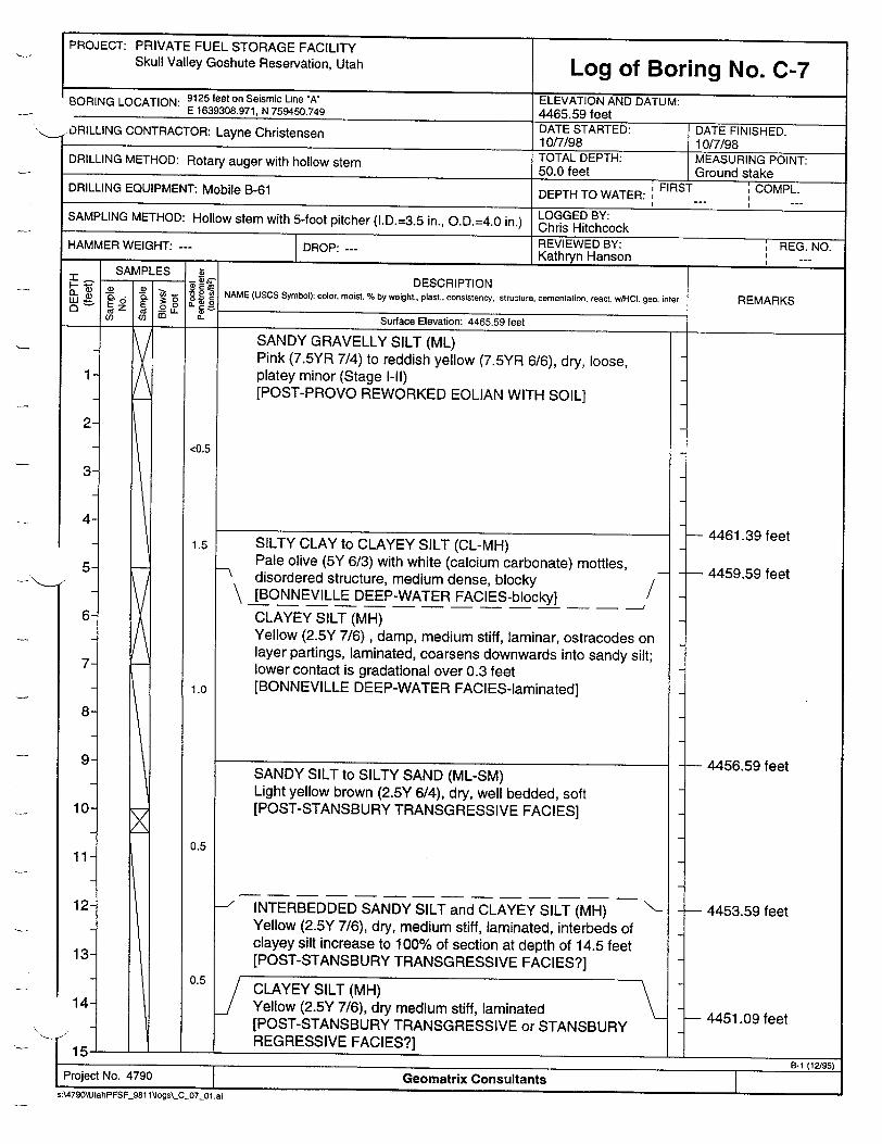
I - -- - nlort..,.,.....r..:.......:.. ,�..'. �.BORING LOCATION: e'e' on e UISIC LirOne A E 1639308.971. N 759450.749
--- ,"DRILLING CONTRACTOR: Layne Christensen
Log of Boring No. C-7ELI:VAT IUN AND DATUM: AARI S;Q f f.lAM� �O f�*
4- �,,,,, ,DATE STARTED: It Af/7inc?
ooI U/ /R1 TOTAL DEPTH: MEASURING POINT: DRILLING METHOD: Rotary auger with hollow stem 50.0 feet Ground stake
DRILLING EQUIPMENT: Mobile B-61 DEPTH TO WATER: FIRST COMPL.
SAMPLING METHOD: Hollow stem with 5-foot pitcher (I.D.=3.5 in., O.D.=4.0 in.) LOGGED BY: _______________________________Chris Hitchcock HAMMER WEIGHT: --- DROP:--REVIEWED BY: REG. NO. DROP: Kathryn Hanson _ _--
- 'I OAR I 1...![" I
DATE FINISHED:
- 1i; ý DESCRIPTION NAME (USCS Symbol): color, moist, % by weight., plast., consistency, structure, cementation, react. wtHCt. geo. inter.
Surface Elevation: 4465.59 feet
SANDY GRAVELLY SILT (ML) Pink (7.5YR 7/4) to reddish yellow (7.5YR 6/6), dry, loose, platey minor (Stage I-Il) [POST-PROVO REWORKED EOLIAN WITH SOIL]
SILTY CLAY to CLAYEY SILT (CL-MH) Pale olive (5Y 6/3) with white (calcium carbonate) mottles,
-q disordered structure, medium dense, blocky \ [BONNEVILLE DEEP-WATER FACIES-blocky] /
CLAYEY SILT (MH) Yellow (2.5Y 7/6), damp, medium stiff, laminar, ostracodes on layer partings, laminated, coarsens downwards into sandy silt; lower contact is gradational over 0.3 feet [BONNEVILLE DEEP-WATER FACIES-laminated]
SANDY SILT to SILTY SAND (ML-SM) Light yellow brown (2.5Y 6/4), dry, well bedded, soft [POST-STANSBURY TRANSGRESSIVE FACIES]
-'INTERBEDDED SANDY SILT and CLAYEY SILT (MH) Yellow (2.5Y 7/6), dry, medium stiff, laminated, interbeds of clayey silt increase to 100% of section at depth of 14.5 feet [POST-STANSBURY TRANSGRESSIVE FACIES?]
CLAYEY SILT (MH) Yellow (2.5Y 7/6), dry medium stiff, laminated [POST-STANSBURY TRANSGRESSIVE or STANSBURY REGRESSIVE FACIES?]
REMARKS
- 4461.39 feet
- 4459.59 feet
- 4456.59 feet
- 4453.59 feet
- 4451.09 feet
.1I I___________________
Project No. 4790 Geomatrix Consultants
s:4790\UtahPFSF_981 1'Jogs\_c 07 01 .ai
(La) 0-
Oi¶IVI rFLI
000
cz z~ L 33-U
2
3-
4
5-
6
7
8
9
10
11
12
13
14-
15*
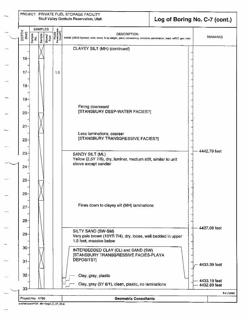
PROJECT: PRIVATE FUEL STORAGE FACILITY Skull Valley Goshute Reservation, Utah Log of Boring No. C-7 (cont.)
DESCRIPTION NAME (USCS Symbol): color, moist, % by weighL, plast.: consistency, structure, cementation, react. w/HCI. geo. inter.
CLAYEY SILT (MH) (continued)
Fining downward [STANSBURY DEEP-WATER FACIES?]
Less laminations, coarser [STANSBURY TRANSGRESSIVE FACIES?]
SANDY SILT (ML) Yellow (2.5Y 7/8), dry, laminar, medium stiff, similar to unit above except sandier
Fines down to clayey silt (MH) laminations
SILTY SAND (SW-SM) Very pale brown (1OYR 7/4), dry, loose, well bedded in upper 1.5 feet, massive below
INTERBEDDED CLAY (CL) and SAND (SW) [STANSBURY TRANSGRESSIVE FACIES-PLAYA DEPOSITS?]
Clay, gray, plastic
Clay, gray (5Y 6/1), clean, plastic, no laminationsi-i
REMARKS
- 4442.79 feet
- 4437.09 feet
4433.39 feet
-4433.19 feet - 4432.89 feet
1.0
24
25
26
27
28
29
30
31
32
33-I B-2 (12/95)
Project No. 4790 Geomatrix Consultants
s:\4790\UtahPFSF_981 \logs\_C_07_02.ai
I

PROJECT: PRIVATE FUEL STORAGE FACILITY Skull Valley Goshute Reservation, Utah
44
45
46-
47-
48-
49-
50-
51
>4
Log of Boring No. 0-7 (cont.)
DESCRIPTION NAME (USCS Symbol): color, moist, % by weight.. plast., consistency, structure, cementation, react. w/H.CI geo. inter.
S\ INTERBEDDED CLAY (CL) and SAND (SW) (continued) -[STANSBURY TRANSGRESSIVE FACIES-PLAYA DEPOSITS?]
Clay(continued) /I
Clay, gray (5Y 6/1), clean, plastic, no laminations
SAND (SW) Light gray (1OYR 7/2), dry, loose, massive
Pea gravel Subrounded pebbles to 1 inch, up to 5% of sand [STANSBURY TRANSGRESSIVE FACIES-Beach]
SANDY GRAVEL (GP) Dry, poorly sorted, subrounded to subangular pebbles to 1 inch, average 0.5 inch, well cemented with carbonate, top of soil [PROMONTARY SOIL developed on PRE-BONNEVILE ALLUVIUM]
Bottom of boring at 50.0 feet.
REMARKS
"4432.49 feet
- 4431.79 feet
- 4420.69 feet
- 4415.59 feet
I I__________________
I B-2 (12/95)
Project No. 4790 Geomatrix Consultants s:\4790\UtahPFSF_981 tlogs\_C_07-03.ai
I
I
PROJECT: PRIVATE FUEL STORAGE FACILITY
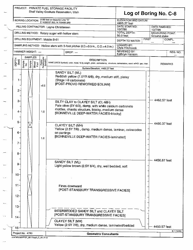
Skull ValleyGoshute Reservation, Utah Log of Boring No. C-8 BORING LOCATION: 9100 feet on Seismic Line 'A ELEVATION AND DATUM: E 1639337.563, N 759450.268 4465.37 feet iRILLING CONTRACTOR: Layne Christensen DATE STARTED: DATE FINISHED:
10/7198 10/7/98 DRILLING METHOD: Rotary auger with hollow stem TOTAL DEPTH: MEASURING POINT: 50.0 feet
Ground stake DRILLING EQUIPMENT: Mobile B-61 DEPTH TO WATER: FIRST COMPL. SAMPLING METHOD: Hollow stem with 5-foot pitcher (1.D.=3.5 in., O.D.=4.0 in.) Chris BY:
~.L,.=.5in. .D=40 i.)Chris Hitchcock HAMMER WEIGHT: --- DROP: --- REVIEWED BY: ' REG. NO. Kathryn Hanson
SAMPLES Z Iwo- DESCRIPTION •' •" •. • • 8 2 NAME (USCS Symbol): color, moist. % by weight., plast., consistency, structure, cementation, react. wAHc. geo. inter. REMARKS 0I o. Surface Elevation: 4465.37 feet
SANDY SILT (ML) Reddish yellow (7.5YR 6/6), dry, medium stiff, platey (Stage I-Il carbonate) [POST-PROVO REWORKED EOLIAN]
SILTY CLAY to CLAYEY SILT (CL-MH) Pale olive (5Y 6/3), damp, with white calcium carbonate mottles, chaotic structure, blocky, medium dense [BONNEVILLE DEEP-WATER FACIES-blocky]
CLAYEY SILT (MH) Yellow (2.5Y 7/6), damp, medium dense, laminar, ostracodes on partings [BONNEVILLE DEEP-WATER FACIES-laminated]
SANDY SILT (ML) Light yellow brown (2.5Y 6/4), dry, well bedded, soft
Fines downward [POST-STANSBURY TRANSGRESSIVE FACIES]
INTERBEDDED SANDY SILT and CLAYEY SILT [POST-STANSBURY TRANSGRESSIVE FACIES]
CLAYEY SILT (MH) Yellow (2.5Y 7/6), dry, medium dense, laminated/bedded
I - I - SL
Geomatrix ConsultantsI-roject No. 4790
4462.57 feet
-4460.37 feet
- 4456.87 feet
--4450.57 feet- 4450.57 feet
ti-i ti�I5b)
s:\479O\UtahPFSF_981 1~logs\_C_08_01 .ai
1-
<0.5
1.5
1.0
3
4-
5-
6
7
8
9
10
11
12
13
14-
7r�1 !
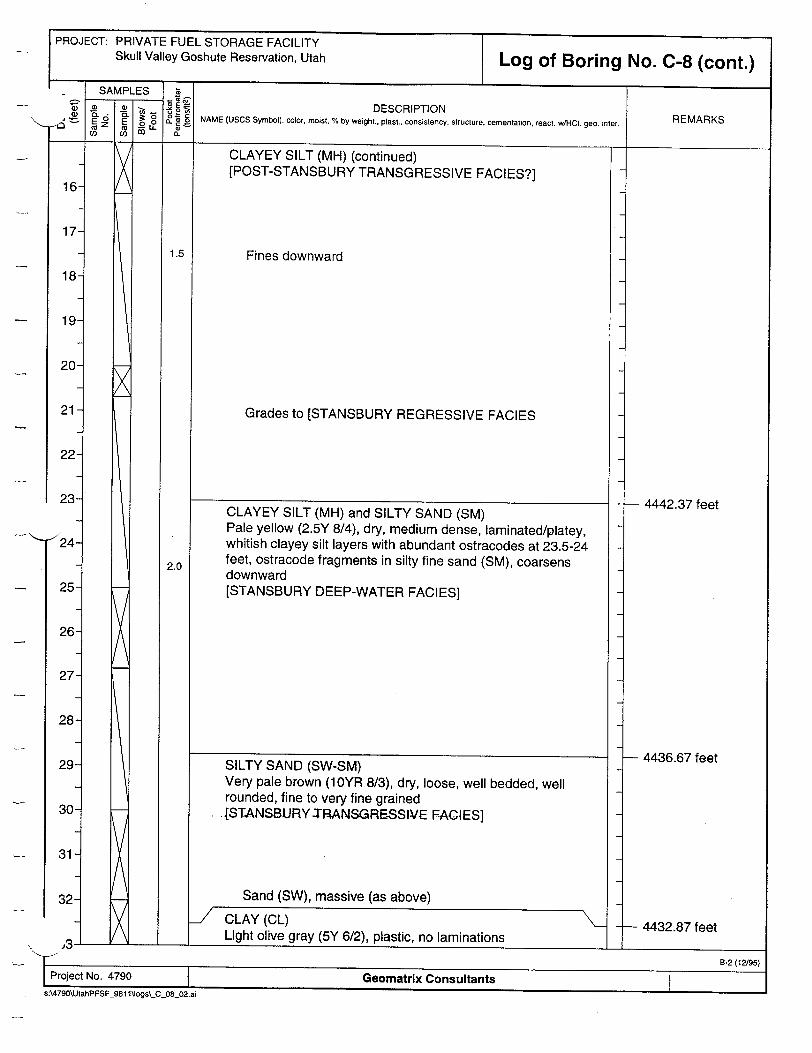
PROJECT: PRIVATE FUEL STORAGE FACILITY Skull Valley Goshute Reservation, Utah Log of Boring No. C-8 (cont.)
DESCRIPTION NAME (USCS Symbol): color, moist, % by weight., plast.. consistency, structure, cementation, react. wIHCO. geo. inter.
CLAYEY SILT (MH) (continued) [POST-STANSBURY TRANSGRESSIVE FACIES?]
Fines downward
Grades to [STANSBURY REGRESSIVE FACIES
CLAYEY SILT (MH) and SILTY SAND (SM) Pale yellow (2.5Y 8/4), dry, medium dense, laminated/platey, whitish clayey silt layers with abundant ostracodes at 23.5-24 feet, ostracode fragments in silty fine sand (SM), coarsens downward [STANSBURY DEEP-WATER FACIES]
SILTY SAND (SW-SM) Very pale brown (10YR 8/3), dry, loose, well bedded, well rounded, fine to very fine grained [STANSBURY -TRANSGRE.SSIVE FACIES]
Sand (SW), massive (as above)
CLAY (CL) Light olive gray (5Y 6/2), plastic, no laminations
REMARKS
4442.37 feet
-- 4436.67 feet
-- 4432.87 feet
2.0
25
26
27
28
29
30
31
32-
n
I B-2 (12/95) Project No. 4790 Geomatrix Consultants
s:\4790\UtahPFSF-981 ilogs\-C_08_02.ai
I II
I

PROJECT: PRIVATE FUEL STORAGE FACILITY Skull Valley Goshute Reservation, Utah Log of Boring No. C-8 (cont.)
SAMPLES 8 _ E -DESCRIPTION I a 1 o_ . NAME (USCS Symbol): color, moist, % by weight., plast., consistency, structure, cementation, react. w/HCI, geo. inter.RE
a cc.as.
CLAY (CL) (continued)
SAND (as above)
- CLAY (CL) •
SAND (SM) Massive (as above) [STANSBURY TRANSGRESSIVE FACIES]
No recovery, gravel in cuttings, carbonate coatings on pebbles to 1 inch, 0.5 inch average clast size [PROMONTORY SOIL developed on PRE-BONNEVILLE ALLUVIUM]
Bottom of boring at 50.0 feet.
x
1-i I __________
34
35
36
37
38
39
40
41
42
43
44-
- 4431.87 feet
- 4431.27 feet "- 4431.07 feet
- 4420.37 feet
Hit hard material
- 4415.37 feet
45]
46
47
48-
49-
50-
I B-2 (12W95) Project No. 4790 Geomatrix Consultants
s:\4790\UtahPFSF_981 1\logs\_C_08_03.ai
U I

PROJECT: PRIVATE FUEL STORAGE FACILITY
Skull Valley Goshute Reservation, Utah Log of Boring No. C-9 BORING LOCATION: 9075 feet on Seismic Line 'A' ELEVATION AND DATUM:
E 1639362.092, N 759449.977 4465.43 feet DRILLING CONTRACTOR: Layne Christensen DATE STARTED: DATE FINISHED: an10/8/98 10/8/98
DRILLING METHOD: Rotary auger with hollow stem TOTAL DEPTH: MEASURING POINT: 55.0 feet Ground stake
DRILLING EQUIPMENT: Mobile B-61 DEPTH TO WATER: FIRST COMPL.
SAMPLING METHOD: Hollow stem with 5-foot pitcher (1.D.=3.5 in., O.D.=4.0 in.) LOGGED BY: Chris Hitchcock
HAMMER WEIGHT: --- DROP: REVIEWED BY: REG. NO. HAMMER WEIGHT: --- DROP, Kathryn Hanson SAMPLES -" DESCRIPTION
"(L o( NAME (USCS Symbol): color, moist, % by weight., plast., consistency, structure, cementation, react. wH-ICl. geo. inter. •Z ) 8" . S REMARKS
(. Surface Elevation: 4465.43 feet
SANDY SILT (ML) Reddish yellow (7.5YR 7/6), dry, loose to medium dense, platey [POST-PROVO REWORKED EOLIAN-minor Stage I carbonate]
2
3
4-4
5
6
7
8
9
10
11
12
13
14-
4461.53 feet
- 4460.43 feet
- 4457.43 feet
- 4457.43 feet
- 4451.23 feet
j�I ______________________
Project No. 4790 Geomatrix Consultants
s:4790\UtahPFSF_981 1\logs\_C_09_01.ai
<0.5
1.5
1.5
2.0
SILTY CLAY to CLAYEY SILT (CL-MH) Pale olive (5Y 6/4), dry, with white mottling, blocky, medium dense
- [BONNEVILLE DEEP-WATER FACIES-blocky]
CLAYEY SILT (MH) Yellow (10YR 8/6), damp, medium dense, laminar, ostracods [BONNEVILLE DEEP-WATER FACIES-laminated]
SANDY SILT (ML) Pale yellow (2.5Y 7/4), dry, well bedded to laminar, soft [POST-STANSBURY TRANSG RESSIVE FACIES]
Appearance of interbeds of clayey silt (MH), brownish yellow (10YR 6/6), dry, medium dense, laminar
J CLAYEY SILT (MH) Brownish yellow (10YR 6/6), dry, medium dense, laminar [POST-STANSBURY TRANSGRESSIVE FACIES?]
7
-ý 1

PROJECT: PRIVATE FUEL STORAGE FACILITY Skull Valley Goshute Reservation, Utah Log of Boring No. C-9 (cont.)
_ SAMPLES (L - lot DESCRIPTION
" Wo_ NAME (USCS Symbol): color, moist. % by weight., plast., consistency, structure, cementation, react. w/HC geo. inter. REMARKS E E-5
; -,f[ .' - i - L -
CLAYEY SILT (MH) (continued)
Fines downward
Same (?), less laminations, minor ostracodes [POST-STANSBURY TRANSGRESSIVE FACIES and/or STANSBURY REGRESSIVE FACIES?]
CLAYEY SILT (MH) Pale yellow (2.5Y 8/2), dry, medium dense, laminar/platey, abundant ostracodes on partings, coarsens downward [STANSBURY DEEP-WATER FACIES]
SAND (SW) Light gray (2.5Y 7/2), dry, loose, fine to very fine [STANSBURY TRANSGRESSIVE FACIES]
SAND (SW) Very pale brown (1 OYR 8/4), dry, loose, massive, fine to medium grained [STANSBURY. TRANSGRESSIVE FACIES]
CLAY (CL) Light olive brown (2.5Y 5/4), plastic [PLAYA DEPOSIT?]
SAND (SW)Very pale brown (11YR 8/4), dry, loose, massive, fine to medium grained [STANSBURY TRANSGRESSIVE FACIES]
1.5
16
17
18
19
20
21
22
23-
24-
25
26
27
28
29
30
31
32-
B-2 (12,95) Project No. 4790 Geomatrix Consultants
s:\4790\UtahPFSF 981 \ltogs\_C_09_02.ai
I I
Problems with pitcher tube; depths of contacts between 15-20 feet are uncertain
- 4447.63 feet
- 4441.63 feet
- 4436.63 feet
- 4435.63 feet
- 4433.23 feet - 4433.03 feet

PROJECT: PRIVATE FUEL STORAGE FACILITY Skull Valley Goshute Reservation, Utah
35-
36
37-
38
39
40
41
42
43
44
45
46
47
48
49
50-
51
SAMPLES
ca ca mLL U)~
7
®E o0
C.
Log of Boring No. C-9 (cont.)
34ý
.• DESCRIPTION 5 NAME (USCS Symbol): color, moist, % by weight., plast., consistency. structure, cementation, react. WHCI. geo. inter.
SAND (SW) (continued) -ICLAY (CL)
Light olive brown (2.5Y 5/4), plastic [PLAYA DEPOSIT?]
SAND (SW) Very pale brown (10YR 8/4), dry, loose, massive, fine to medium grained [BEACH SAND]
[STANSBURY TRANSGRESSIVE FACIES]
[PROMONTORY SOIL ON ALLUVIAL GRAVEL] No recovery, gravel cuttings with carbonate rinds to 1 millimeter
1-I _______________________________________
B-2 (12/95)
r-oJeLI I'Jo. 4IfU0Geos aatrix Consultants s:\4790\UtahPFSF 981 1\Jogs\ C 09 Oai
I SAMPLES
u..
I ý I
REMARKS
4431.83 feet
4431.73 feet
- 4420.43 feet Hard drilling

PROJECT: PRIVATE FUEL STORAGE FACILITY Skull Valley Goshute Reservation, Utah
DESCRIPTION
[PROMONTORY SOIL ON ALLUVIAL GRAVEL] (continued)
No recovery, subangular to subrounded sandy gravel (SP)
Bottom of boring at 55.0 feet.4410.43 feet
Geomatrix Consultants_981 1 Vogs\-C_09_04.ai
61
62-

PROJECT: PRIVATE FUEL STORAGE FACILITY Skull Valley Goshute Reservation, Utah Log of Boring No. C-10
BORING LOCATION: 9150 feet on Seismic Line "A' ELEVATION AND DATUM: E 1639284.297, N 759450.206 4465.25 feet
)RILLING CONTRACTOR: Layne Christensen DATE STARTED: DATE FINISHED: -ayne 10/8/98 10/8/98
DRILLING METHOD: Rotary auger with hollow stem TOTAL DEPTH: MEASURING POINT: 50.0 feet Ground stake
DRILLING EQUIPMENT: Mobile B-61 DEPTH TO WATER: FIRST COMPL.
LOGGED BY: SAMPLING METHOD: Hollow stem with 5-foot pitcher (I.D.=3.5 in., O.D.=4.0 in.) Chris Hitchcock HAMMER WEIGHT: --- REVIEWED BY: REG. NO.
Kathryn Hanson SAMPLES • SDESCRIPTION
mE I " . "8E NAME (USCS Symbol): color, moist, % by weight., plast., consistency, structure, cementation, react. w!t-I. geo. inter. REMARKS
(L- -f E CO O u) o- Surface Elevation: 4465.25 feet
SANDY SILT (ML) Pink (7.SYR 7/4), dry, minor pebbles, loose, platey, weak Stage I carbonate [POST-PROVO REWORKED EOLIAN]
SILTY CLAY to CLAYEY SILT (CL-MH) Pale olive (5Y 6/3) with white mottles [BONNEVILLE DEEP-WATER FACIES-blocky]
CLAYEY SILT (MH) Yellow (2.5Y 7/6), medium dense, laminar, ostracodes on partings [BONNEVILLE DEEP-WATER FACIES-laminated]
2
3
4
5
6
7
8
9
10
11
12
13
141CLAYEY SILT (MH) Yellow (2.5Y 7/5), dry, medium dense, laminated, fines downward [POST-STANSBURY TRANSGRESSIVE FACIES]
- 4461.35 feet
- 4460.45 feet
- 4456.35 feet
- 4452.95 feet
- 4450.95 feet
II 'D ' I I
Project No. 4790 Geomatrix Consultants
s:\4790\UtahPFSF_981 1\logs\_C-10O01.ai
<0.5
1.5
1.0
7
SANDY SILT to SILTY SAND (ML-SM) Very pale brown (10YR 8/4), dry, well bedded, fine sand, soft [POST-STANSBURY TRANSGRESSIVE FACIES]
-' INTERBEDDED CLAYEY SILT (MH) Yellow (2.5Y 7/5), dry, medium dense, laminated clayey silt beds increases from 20% to 100% at basal contact
ýLI

PROJECT: PRIVATE FUEL STORAGE FACILITY Skull Valley Goshute Reservation, Utah
DESCRIPTION
CLAYEY SILT (MH) (continued)
Finer than above, grades to SILT (ML)
No grinding, still sandy/silt
25-
26-
27
31

PROJECT: PRIVATE FUEL STORAGE FACILITY Skull Valley Goshute Reservation, Utah Log of Boring No. C-1 0 (cont.)
SAMPLES 8i C - DESCRIPTION LU Q0 o 0 . NAME (USCS Symbol): color, moist, % by weight., plast., consistency, structure, cementation, react w/HCO. geo. inter. REMARKS
SILTY SAND (SM) Olive yellow (2.5Y 6/6), damp, very fine, massive [STANSBURY TRANSGRESSIVE FACIES, BEACH SAND WITH EOLIAN?]
SANDY GRAVEL (GP) Minor carbonate coatings on subrounded to subangular clasts (from cuttings only), <1 inch average diameter pebbles [FROM CUTTINGS ONLY-PROMONTARY SOIL developed on PRE-BONNEVILLE ALLUVIUM]
38
39
40
41
42
43
44
45
46
47
48
49
50
51
- 4421.25 feet
Gravel drilling hard at 44-45 feet
- 4415.25 feet
1-I. ___________________________________
34
35
36
37-
Bottom of boring at 50.0 feet.
4 8-2 (12/95) Project No. 4790 Geomatrix Consultants
s:\4790\UtahPFSF_981 1\logs\_C 1003.ai
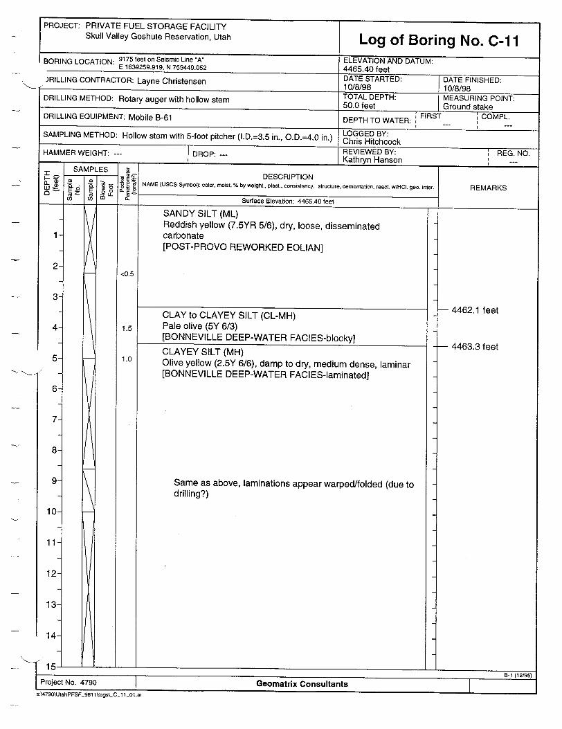
PROJECT: PRIVATE FUEL STORAGE FACILITY Skull Valley Goshute Reservation, Utah Log of Boring No. C-11
BORING LOCATION: 9175 feet on Seismic Line "A" ELEVATION AND DATUM: E 1639259.919, N 759449.052 4465.40 feet )RILLING CONTRACTOR: Layne Christensen DATE STARTED: DATE FINISHED: RRC10/8/98 10/8/98
DRILLING METHOD: Rotary auger with hollow stem TOTAL DEPTH: MEASURING POINT: 50.0 feet Ground stake
DRILLING EQUIPMENT: Mobile B-61 DEPTH TO WATER: FIRST COMPL.
LO GGED BY: SAMPLING METHOD: Hollow stem with 5-foot pitcher (I.D.=3.5 in., O.D.=4.0 in.) ris Hitchcock HAMMER WEIGHT: --- DRO REVIEWED BY: REG. NO. Kathryn Hanson
_ ._ SAMPLES i SME - DESCRIPTION
0 - % NAME(USCS Symbol): color, moist. % by weight., plast., consistency, structure, cementation, react. w/HCl. geo. inter. REMARKS a- E z E o U_ '2
U) C __ L_ Surface Elevation: 4465.40 feet IL
SANDY SILT (ML) Reddish yellow (7.5YR 5/6), dry, loose, disseminated carbonate [POST-PROVO REWORKED EOLIAN]
CLAY to CLAYEY SILT (CL-MH) Pale olive (5Y 6/3) [BONNEVILLE DEEP-WATER FACIES-blocky]
- 4462.1 feet
- 4463.3 feet
I-I ___________________________
<0.5
1.5
1.0
1
2
3
4
5
6
7
8
9
10
11
12
13
14-
I I B-1 (12/95) Project No. 4790 Geomatrix Consultants
s:\4790\UtahPFSF_981 1Mogs\_C_c 101 .ai
CLAYEY SILT (MH) Olive yellow (2.5Y 6/6), damp to dry, medium dense, laminar [BONNEVILLE DEEP-WATER FACIES-laminated]
Same as above, laminations appear warped/folded (due to drilling?)

PROJECT: PRIVATE FUEL STORAGE FACILITY Skull Valley Goshute Reservation, Utah Log of Boring No. C-11 (cont.)
SAMPLES 8 wN- - DESCRIPTION - . • 1 2c NAME (USCS Symbol): color, moist, % by weight., plast., consistency, structure, cementation, react. wHOC. geo. inter.
a~.
CLAYEY SILT (MH) (continued)
16
17
18
19
20
21
22
23
24
25
26
27
28
29
30
31
32-
I CLAY (CL) L Light olive brown (2.5Y 5/4), damp, highly plastic, clean
SAND (SW) Light gray (10YR 7/2), dry, loose, well sorted, fine to medium grained, massive
- 4434.4 feet
- 4433.2 feet Wet interval
ý- 4433.0 feet
\� 4433.0 feet - i�L _____________
z
Clayey based on cuttings, wet to damp
Sandy silt (ML), yellow (10YR 8/6), damp, laminar, medium dense, almost a fine sand (may be slop from above)
Clayey silt (MH), yellow (10YR 7/6), damp, medium dense, ostracodes on partings, laminar, coarsens down
t SAND (SW) N-Dight gray (10YR7/2), dry,Soose, well sorted, fine to medium
grained, massive
-j
B-2 (12/95)
Project No. 4790 Geomatrix Consultants s:\4790\UtahPFSF_981 l~ogs\_C_ 1 _02.ai
S. vv
PROJECT: PRIVATE FUEL STORAGE FACILITY Skull Valley Goshute Reservation, Utah
42-
43-
44-
45-
46-
47-
48-
49-
50-
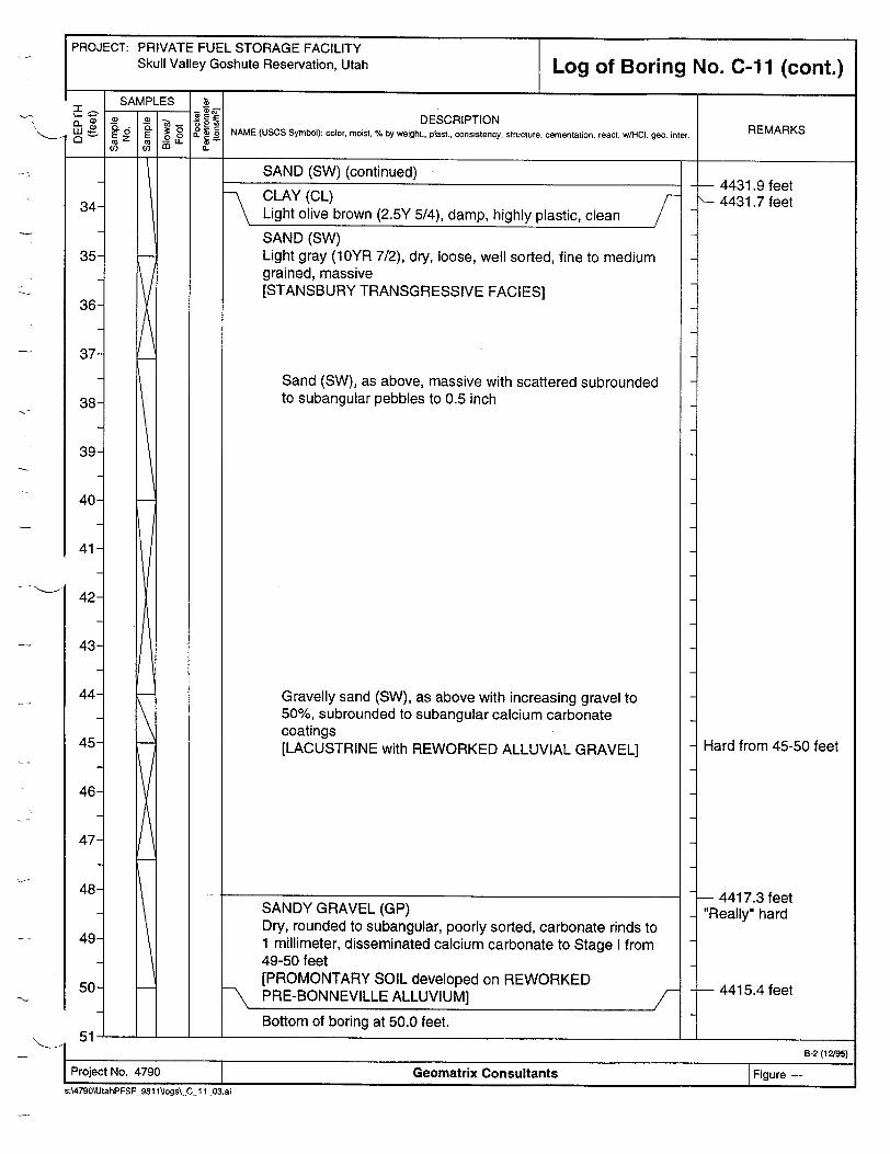
Log of Boring No. C-11 (cont.)
DESCRIPTION NAME (USCS Symbol): color, moist. % by weight.. plast., consistency, structure, cementation, react. w[HCI. geo. inter.
SAND (SW) (continued) -• CLAY (CL) /
Light olive brown (2.5Y 5/4), damp, highly plastic, clean
SAND (SW) Light gray (10YR 7/2), dry, loose, well sorted, fine to medium grained, massive [STANSBURY TRANSGRESSIVE FACIES]
Sand (SW), as above, massive with scattered subrounded to subangular pebbles to 0.5 inch
Gravelly sand (SW), as above with increasing gravel to 50%, subrounded to subangular calcium carbonate coatings [LACUSTRINE with REWORKED ALLUVIAL GRAVEL]
SANDY GRAVEL (GP) Dry, rounded to subangular, poorly sorted, carbonate rinds to 1 millimeter, disseminated calcium carbonate to Stage I from 49-50 feet [PROMONTARY SOIL developed on REWORKED B PRE-BONNEVILLE ALLUVIUM] / Bottom of boring at 50.0 feet.
REMARKS
i--I.
- 4431.9 feet 4431.7 feet
Hard from 45-50 feet
- 4417.3 feet "Really" hard
- 4415.4 feet
-'---I- _____________________
B-2 (12195)
Project No. 4790 Geomatrix Consultants Figure s:\4790\UtahPFSF_981 1\logs\.C 11_03.ai
.-"I1
PROJECT: PRIVATE FUEL STORAGE FACILITY Skull Valley Goshute Reservation, Utah
BORING LOCATION: 9162.5 feet on Seismic Line *A' E 1639272.478, N 759449.228
Log of Boring No. C-12I .- --
ELEVATION AND DATUM: 4-4RR .'• fA~f
.JRILLING CONTRACTOR: Layne Christensen DATE STARTED: DATE FINISHED: an10/9/98 10/10198 DRILLING METHOD: Rotary auger with hollow stem TOTAL DEPTH: MEASURING POINT:
50.0 feet Ground stake
DRILLING EQUIPMENT: Mobile B-61 DEPTH TO WATER: FIRST COMPL. I I
SAMPLING METHOD: Hollow stem with 5-foot pitcher (1.D.=3.5 in., O.D.=4.0 in.) Chris BY: ~l..=35 i., D.=.0 n.)Chris Hitchcock
REVIEWED BY: REG. NO. HAMMER WEIGHT: --- DROP: Kathryn Hanson _ _--
SAMPLES 1 - SAMPLES DESCRIPTION
S.• -2 NAME (USCS Symbol): color, moist, % by weight, plast., consistency, structure, cementation, react. w/HCI. geo. inter. REMARKS
(0 • . Surface Elevation: 4465.32 feet
2
3
4
5
6
7
8
9
10
11
12
13
14-
x
<0.5
1.5
1.0
<0.5
0.5
SANDY SILT (ML) Reddish yellow (7.5YR 6/6), dry, loose, platey [POST-PROVO REWORKED EOLIAN-with soil]
SILTY CLAY to CLAYEY SILT (CL-MH) Pale olive (5Y 6/4) with white mottles, blocky
-> [BONNEVILLE DEEP-WATER FACIES-blocky]
CLAYEY SILT (MH) Yellow (2.5Y 7/8), dry, medium dense,, laminar, ostracodes abundant [BONNEVILLE DEEP-WATER FACIES-laminated]
SANDY SILT (ML) to SILTY SAND (SM) Light yellow brown (2.5Y 6/4) to light gray (1 0YR 7/2) (interbedded), dry, loose to medium dense, soft [POST-STANSBURY TRANSGRESSIVE FACIES]
Appearance of interbeds of clayey silt (MH)
INTERBEDDED SANDY SILT (ML) and CLAYEY SILT (MH)
Fines upward
CLAYEY SILT (MH) Yellow (2.5Y 7/8), damp, medium dense, laminated [POST-STANSBURY TRANSGRESSIVE FACIES]
Two pervasive subplanar, irregular, fractures spaced 1 inch apart, 500 dip irregular, no offset of laminations (?)
- 4461.32 feet
- 4460.32 feet
- 4456.32 feet
- 4452.92 feet
- 4451.82 feet
1 �' **' -a-i-fl- L ___________________________ I B-i (12/951
I B-1 (12/95) Project No. 4790 Geomatrix Consultants 8:\4790\UtahPFSF 981 lkJogss\C_12-01.ai
j-

PROJECT: PRIVATE FUEL STORAGE FACILITY Skull Valley Goshute Reservation, Utah Log of Boring No. C-12 (cont.)
SAMPLES 4 • . ® E DESCRIPTION
j t9 0 , NAME (USCS Symbol): color, moist, % by weight., plast.. consistency, structure, cementation, react. w/HCI, geo. inter. REMARKS ( LL
CLAYEY SILT (MH) (continued) [POST-STANSBURY TRANSGRESSIVE FACIES]
16
17
18
19
20
21
22
23
24
25
26
27
28
29
30
31
32-
SILTY SAND (SW-SM) Very pale brown (10YR 7/4) to yellow (10YR 7/8) (stained?), well bedded to massive, loose [STANSBURY TRANSGRESSIVE FACIES]
- 4447.32 feet
- 4446.32 feet
- 4441.12 feet
- 4436.92 feet
4.�J J�i � - L J�j _________________________________
1.0
1.5
2.0
SILTY SAND (SM) Very fine, interbedded with clayey silt
-•[STANSBURY REGRESSIVE FACIES] /
CLAYEY SILT (MH) As above except fines down [STANSBURY REGRESSIVE FACIES]
Sharp well defined contact at base
CLAYEY SILT (MH) Very pale brown (10YR 8/4), damp, medium dense, thin (<1 millimeter) laminations, ostracodes few on partings [STANSBURY DEEP-WATER FACIES]
- fracture (480 dip), planar, sharp
-I B-2 (12/95) Project No. 4790 Geomatrix Consultants
s:A790\UtahPFSF_981 1\'ogs\_C_ 12_02.ai

IDDn~ tI~f'T. 1301 r II~I ~ I l r ILF I HLfii.~r~~~uValley I osh D1utMT•ee•I - ' ratoAn, Uta
Log of Boring No. C-12 (cont.)
DESCRIPTION NAME (USGS Symbol): color, moist, % by weight.. plast., consistency. structure, cementation, react. w/HCI. geo. inter.
SILTY SAND (SW-SM) (continued) [STANSBURY TRANSGRESSIVE FACIES]
SANDY CLAY (CH) Olive (5Y 5/4), damp, medium plastic
SAND (SW) Light gray (10YR 7/2), dry, loose, well sorted, clean, medium to fine sand [BEACH SAND], grades to gravelly sand (to 5% gravel), well rounded to 1/4 inch
Thin (<0.5 inch) gravel stringer, well rounded pebbles to 0.5 inch [STANSBURY TRANSGRESSIVE FACIES]
:- Sandy gravel layer, well rounded to 1 inch diameter
SANDY SILT (ML) Yellow (10YR 7/6), damp, medium denseSAND (SW) Light gray (1 0YR 7/2), dry, loose, well sorted, increasing clay with depth
Gravel cuttings [PROMONTARY SOIL developed on PRE-BONNEVILLE ALLUVIUM]
Bottom of boring at 50.0 feet.
REMARKS
I~ _______
4427.12 feet 4427.02 feet
4421.82 feet
4421.62 feet
4420.32 feet Hard drilling
- 4415.32 feet
1-I ______________________________________ I 8-2 (12195)
42-
43-
44-
45-
46-
47-
48-
49-
50-
51B-2 (12/9)
Project No. 4790 Geomatrix Consultants s:\4790\UtahPFSF_981 l1Jogs\-C_12_03.ai
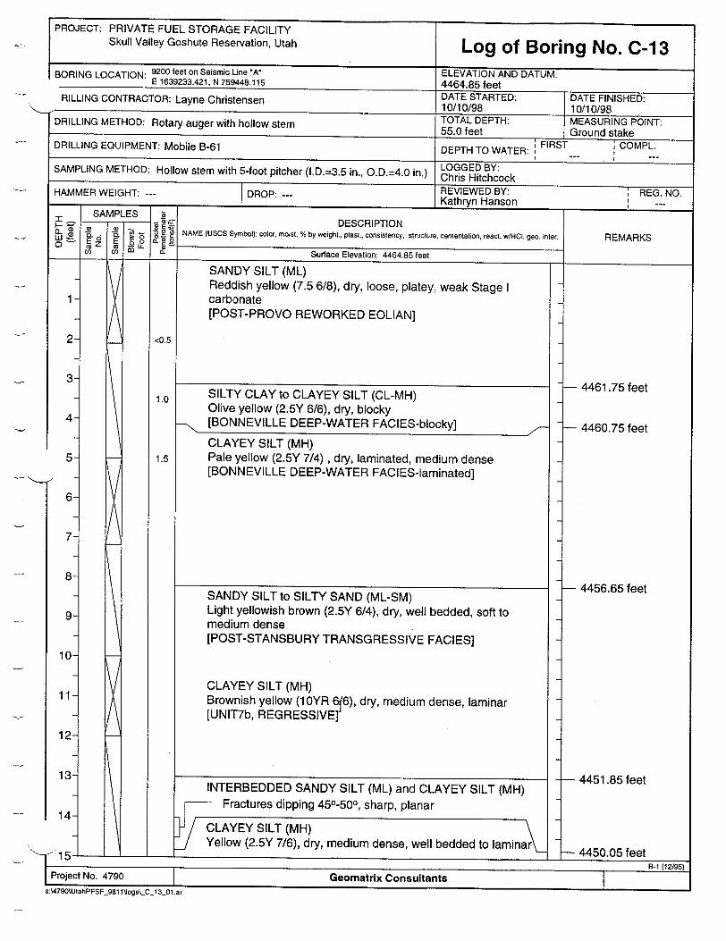
PROJECT: PRIVATE FUEL STORAGE FACILITY Skull Valley Goshute Reservation, Utah Log of Boring No. C-13
BORING LOCATION: 9200 feet on Seismic Line *A* ELEVATION AND DATUM: E 1639233.421, N 759448.115 4464.85 feet
RILLING CONTRACTOR: Layne Christensen DATE STARTED: DATE FINISHED: 10/10/98 10/10/98
DRILLING METHOD: Rotary auger with hollow stem TOTAL DEPTH: MEASURING POINT: 55.0 feet Ground stake
DRILLING EQUIPMENT: Mobile B-61 DEPTH TO WATER: FIRST COMPL.
SAMPLING METHOD: Hollow stem with 5-foot pitcher (I.D.=3.5 in., O.D.=4.0 in.) LOGGED BY: Chris Hitchcock HAMMER WEIGHT: --- DROP: REVIEWED BY: REG. NO. HAMMER HR --- Kathryn Hanson ,,_...
_ SAM LES -DESCRIPTION
S E 2i NAME (UScS Symbol): color, moist, % by weight., plast., consistency, structure, cementation, react. w/HCL. geo. inter. D m E _0 o- ESRPTO
Co -- C Surface Elevation: 4464.85 feet
SANDY SILT (ML) Reddish yellow (7.5 6/8), dry, loose, platey, weak Stage I carbonate [POST-PROVO REWORKED EOLIAN]
SILTY CLAY to CLAYEY SILT (CL-MH) Olive yellow (2.5Y 6/6), dry, blocky [BONNEVILLE DEEP-WATER FACIES-blocky]
CLAYEY SILT (MH) Pale yellow (2.5Y 7/4), dry, laminated, medium dense [BONNEVILLE DEEP-WATER FACIES-laminated]
7-
2
3
4
5
6
7
8
9
10
11
12
13
14-
INTERBEDDED SANDY SILT (ML) and CLAYEY SILT (MH) Fractures dipping 450-500, sharp, planar
CLAYEY SILT (MH) Yellow (2.5Y 7/6), dry, medium dense, well bedded to laminar
0 1 1
4461.75 feet
- 4460.75 feet
- 4456.65 feet
- 4451.85 feet
-- 4450.05 feet
- 4450.05 feet
EProject No. 4790 ! Geomatrix Consultants 8
s:\4790\UtahPFSF_981 1l'ogs\_C_ 1301 .ai
<0.5
1.0
1.5
SANDY SILT to SILTY SAND (ML-SM) Light yellowish brown (2.5Y 6/4), dry, well bedded, soft to medium dense [POST-STANSBURY TRANSGRESSIVE FACIES]
CLAYEY SILT (MH) Brownish yellow (1OYR 6ý6), dry, medium dense, laminar [UNIT7b, REGRESSIVE]
x
1]J
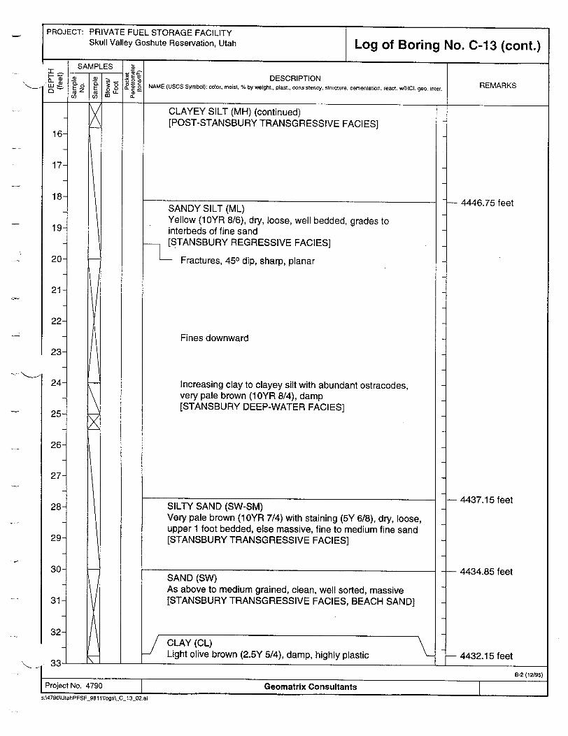
PROJECT: PRIVATE FUEL STORAGE FACILITY Skull Valley Goshute Reservation, Utah Log of Boring No. C-13 (cont.)
SAMPLES Z ý_• :ý Z~e- DESCRIPTION
w . o 6 NAME (USCS Symbol): color, moist, % by weight., plast., consistency, structure, cementation, react. w/HCIl geo. inter. cu ca F, 0 W_ U) (
CLAYEY SILT (MH) (continued) [POST-STANSBURY TRANSGRESSIVE FACIES]>2
16
17
18
19
20
21
22
23
24
25
26
27
28
29
30
31
32-
SILTY SAND (SW-SM) Very pale brown (10YR 7/4) with staining (5Y 6/8), dry, loose, upper 1 foot bedded, else massive, fine to medium fine sand [STANSBURY TRANSGRESSIVE FACIES]
SAND (SW) As above to medium grained, clean, well sorted, massive [STANSBURY TRANSGRESSIVE FACIES, BEACH SAND]
CLAY (CL) Light olive brown (2.5Y 5/4), damp, highly plastic
SANDY SILT (ML) Yellow (10YR 8/6), dry, loose, well bedded, grades to interbeds of fine sand [STANSBURY REGRESSIVE FACIES]
Fractures, 450 dip, sharp, planar
4446.75 feet
- 4437.15 feet
- 4434.85 feet
- 4432.15 feet
Fines downward
Increasing clay to clayey silt with abundant ostracodes, very pale brown (1OYR 8/4), damp [STANSBURY DEEP-WATER FACIES]
I B-2 (12./95) Project No. 4790 Geomatrix Consultants
s:\4790\UtahPFSF_981 1\logs\C-13_02.ai
a I .
PROJECT: PRIVATE FUEL STORAGE FACILITY Skull Valley Goshute Reservation, Utah Log of Boring No. C-13 (cont.)
SAMPLES 5 •E= DESCRIPTION
W"•. no .6ý ' NAME (USCS Symbol): color, moist, % by weight., plast., consistency, structure, cementation, react. w/HC geo. inter. REMARKS •0a.LL e
CLAY (CL) (continued)
SAND (SW) As above to medium grained, clean, well sorted, massive
CLAY (CL)
Light olive brown (2.5Y 5/4), damp, highly plastic
34
35
36
37
38
39
40
41
42
43
44
45
46
47
48
49
50
511
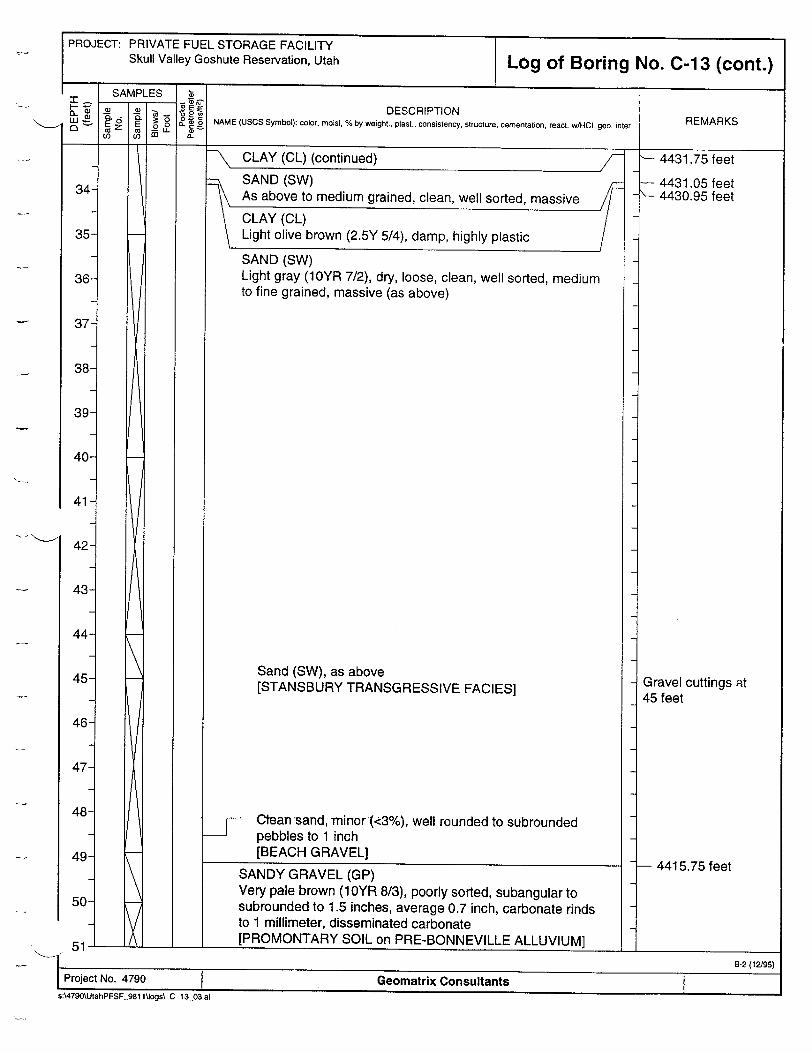
SANDY GRAVEL (GP) Very pale brown (1OYR 8/3), poorly sorted, subangular to subrounded to 1.5 inches, average 0.7 inch, carbonate rinds to 1 millimeter, disseminated carbonate [PROMONTARY SOIL on PRE-BONNEVILLE ALLUVIUM]
"- 4431.75 feet
SAND (SW) Light gray (10YR 7/2), dry, loose, clean, well sorted, medium to fine grained, massive (as above)
Sand (SW), as above [STANSBURY TRANSGRESSIVE FACIES]
C•ean sand, minor (<3%), wel rounded to subrounded pebbles to 1 inch [BEACH GRAVEL]
I B-2 (12/95) I Project No. 4790 Geomatrix Consultants s:\4790\UtahPFSF 981 1\logsC_ 13_03.ai
4431.05 feet 4430.95 feet
Gravel cuttings at 45 feet
- 4415.75 feet
I I
PROJECT: PRIVATE FUEL STORAGE FACILITY Skull Valley Goshute Reservation, Utah
DESCRIPTION
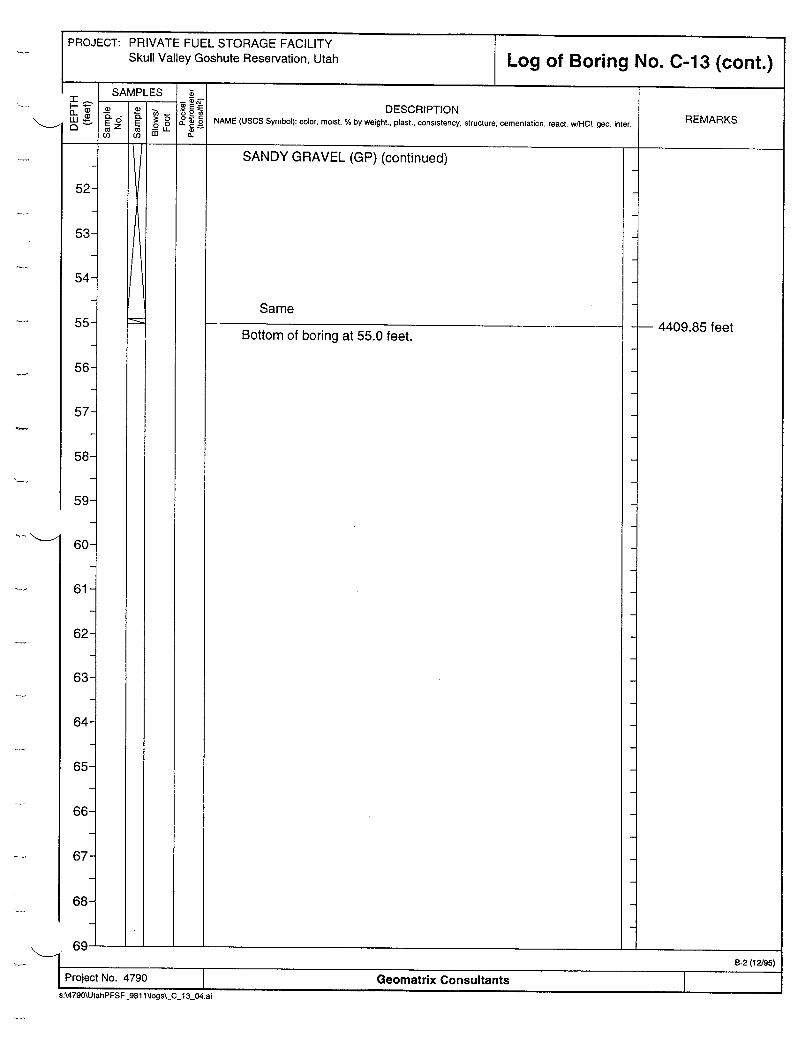
SANDY GRAVEL (GP) (continued)
Same
Bottom of boring at 55.0 feet.4409.85 feet
Geomatrix Consultants
61

PROJECT: PRIVATE FUEL STORAGE FACILITY Skull Valley Goshute Reservation, Utah Log of Boring No. C-14
BORING LOCATION: 9225 feet on Seismic Line A" ELEVATION AND DATUM: E 1639208.070, N 759450 4463.20 feet DRILLING CONTRACTOR: Layne Christensen DATE STARTED: DATE FINISHED:
10/10/98 10/10/98 DRILLING METHOD: Rotary auger with hollow stem TOTAL DEPTH: MEASURING POINT: 50.0 feet
Ground stake DRILLING EQUIPMENT: Mobile B-61 DEPTH TO WATER: FIRST COMPL.
SAMPLING METHOD: Hollow stem with 5-foot pitcher (I.D.=3.5 in., O.D.=4.0 in.) LOGGED BY: Chris Hitchcock HAMMER WEIGHT: --- DROP: -REVIEWED BY: REG. NO. HAMMER W T -Kathryn
Hanson ,_... SAMPLES DESCRIPTION
t :: - "T Z - 8 NAME (USCS Symbol): color, moist, % by weight, plast., consistency, structure, cementation, react. w/t-Cl gao. inter. REMARKS o I Surface Elevation: 4463.20 feet
SANDY SILT (ML) Reddish yellow (7.5YR 7/8), dry, medium dense, platey [POST-PROVO REWORKED EOLIAN-with weak soil]
SILTY CLAY to CLAYEY SILT (CL-CH) Light yellowish brown (2.5Y 6/4), damp, blocky [UNIT4b, [BONNEVILLE DEEP-WATER FACIES-blocky]
CLAYEY SILT (CH) Pale yellow (2.5Y 7/3), dry, laminar, medium dense [BONNEVILLE DEEP-WATER FACIES-laminated]
2
3
4
5
6
7
8
9
10
11
12
13
14
- 4460.90 feet
- 4459.60 feet
- 4455.30 feet
- 4454.20 feet
- 4450.10 feet
-I �- - - I.�j
0.5
1.0
1.5
0.5
1.0
SANDY SILT to SILTY SAND (ML-SM) Light yellow brown (2.5Y 6/9), dry, well bedded to laminar, soft to medium dense]
- [POST-STANSBURY TRANSGRESSIVE FACIES]
INTERBEDDED SANDY SILT (ML) (as above) and CLAYEY SILT (MH) (as below) [POST-STANSBURY TRANSGRESSIVE FACIES]
CLAYEY SILT (MH) Yellow (7.5Y 6/6), dry, medium dense, laminar, some sandy silt (ML)
7
Project No. 4790 T Geomatrix Consultants B-1 (12195)
s:\4790\UtahPFSF_981 1Jogs\.-C 14_01 .ai

PRIVATE FUEL STORAGE FACILITY Skull Valley Goshute Reservation, Utah Log of Boring No. C-1 4 (cont.)
DESCRIPTION NAME (USCS Symbol): color, moist, % by weight., plast., consistency, structure, cementation, react. w/HOCI geo. inter.
CLAYEY SILT (MH) (continued)
Fining down
SANDY SILT (ML) Yellow (2.5Y 7/8), dry, laminar, medium dense to loose, fines down to laminated [STANSBURY REGRESSIVE FACIES? grading down to STANSBURY DEEP-WATER FACIES?]
Increasing clay content, laminations, sharp lower contact
SAND (SW) Very pale brown (1 0YR 7/4), dry, loose, upper 1 feet well bedded with 0.1-inch clay stringer, else massive [PRE-STANSBURY TRANSGRESSIVE FACIES]
Clay (CL), light olive brown (2.5Y 5/4), highly plastic
Clay (CL), light olive brown (2.5Y 5/4), highly plastic
SAND (SW) Light gray (10YR 7/2), dry, loose, fine to medium
REMARKS
- 4442.20 feet
- 4435.90 feet
- 4431.60 feet •- 4431.50 feet
4431.10 feet
1--i- _____________________
PROJECT:
25-
26-
27-
28-
29-
30-
31-
32-
I B-2 (1M_95) Project No. 4790 Geomatrix Consultants
s:A4790\UtahPFSF_981 I\ogs\_C_14_02.ai
. I

PROJECT: PRIVATE FUEL STORAGE FACILITY Skull Valley Goshute Reservation, Utah
I -ia.--D
0
34
35
36
37
38
39
40
41
42
43
44
45
46
47
48
49]
50
SAMPLES
6it cL _CD
Log of Boring No. C-14 (cont.)
DESCRIPTION NAME (USCS Symbol): color, moist, % by weight., plast., consistency, structure, cementation, react. w/HCI, geo. inter.
SAND (SW) (continued) [STANSBURY TRANSGRESSIVE FACIES]
Large round pebble (2 inches)
Minor small (<0.2 inch) round pebbles <1%
SANDY GRAVEL (GW) Subrounded pebbles to 1 inch, beach sand (well sorted) matrix
S[STANSBURY TRANSGRESSIVE FACIES] .
SANDY GRAVEL (GP) Subrounded to subangular pebbles to 2-inch diameter, carbonate rinds on base of pebbles, medium dense, disseminated calcium carbonate [PROMONTORY SOIL? or LACUSTRINE with REWORKED GRAVEL]
GRAVELLY SAND Beach, subrounded [PROMONTORY SOIL?]
SANDY GRAVEL (GP) Subrounded, subangular, good 1-2 millimeter carbonate rinds, large (2-3 inches) clasts
Bottom of boring at 50.0 feet.
REMARKS
4425.20 feet
- 4420.60 feet
- 4419.60 feet
- 4416.60 feet
- 4415.20 feet
- 4413.20 feet
5 1 , tB-2(12/95)
Project No. 4790 Geomatrix Consultants,,JOgS'U14W.a,
I zii I I

PROJECT: PRIVATE FUEL STORAGE FACILITY
Skull Valley Goshute Reservation, Utah Log of Boring No. C-15
RORING LOCATION: 9250 feet on Seismic Line "A" E 1639181.912, N 759451.971
4ILLING CONTRACTOR: Layne Christensen
ELLVAIOIN AND DATUM: 4463.31 feet4463.1 feet
DATE STARTED: 10/1o/9R
DATE FINISHED: 10f/1 n/Qq
TOTAL DEPTH: MEASURING POINT: DRILLING METHOD: Rotary auger with hollow stem 50.0 feet Ground stake
DRILLING EQUIPMENT: Mobile B-61 DEPTH TO WATER: FIRST COMPL.
SAMPLING METHOD: Hollow stem with 5-foot pitcher (I.D.=3.5 in., O.D.=4.0 in.) LOGGED BY: Chris Hitchcock
REVIEWED BY: , REG. NO. HAMMER WEIGHT: --- DROP: --- Kathryn Hanson _,_ --SAMPLIES
SAMPLES DESCRIPTION
0" •, .E,.-NAME (USCS Symbol): color, moist, % by weight., plast., consistency, structure, cementation, react. wIHO. geo, inter. REMARKS LLC 0" Surface Elevation: 4463.31 feet
2
3
4
5
6
7
8
9
10
11
12
13
14-
Auger to 30 feet; sample from 30 feet
01 I
Project No. 4790 1 Geomatrix Consultants T s:\4790\UtahPFSF_981 1\fogs\_C_15.01.ai
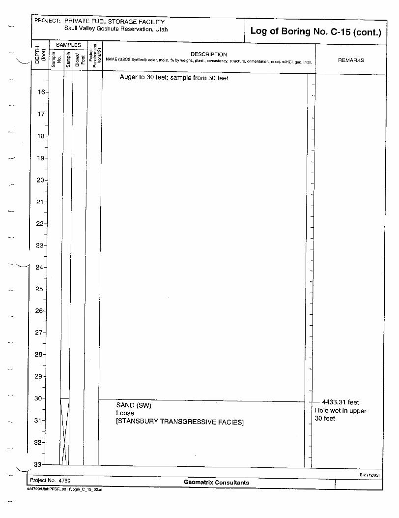
PROJECT: PRIVATE FUEL STORAGE FACILITY Skull Valley Goshute Reservation, Utah
DESCRIPTION
Auger to 30 feet; sample from 30 feet
SAND (SW) Loose [STANSBURY TRANSGRESSIVE FACIES]
- 4433.31 feet Hole wet in upper 30 feet
Geomatrix Consultants
25
26-
27-
28-
29-

PROJECT: PRIVATE FUEL STORAGE FACILITY Skull Valley Goshute Reservation, Utah
DESCRIPTION
Auger to 30 feet; sample from 30 feet
SAND (SW) Loose [STANSBURY TRANSGRESSIVE FACIES]
4433.31 feetHole wet in upper 30 feet
Geomatrix Consultants
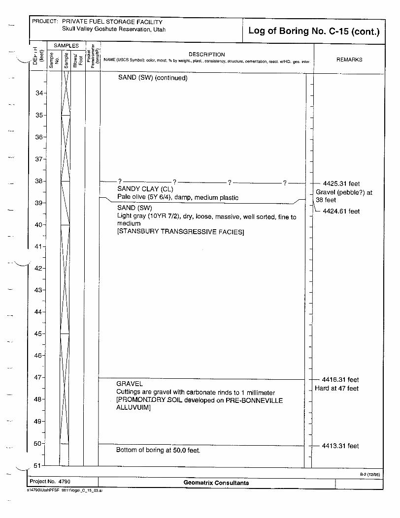
PROJECT: PRIVATE FUEL STORAGE FACILITY Skull Valley Goshute Reservation, Utah Log of Boring No. C-1 5 (cont.)
DESCRIPTION NAME (USCS Symbol): color, moist, % by weight., plast., consistency, structure, cementation, react. w/HCl. geo. inter.
SAND (SW) (continued)
SANDY CLAY (CL) - Pale olive (5Y 6/4), damp, medium plastic /
SAND (SW) Light gray (1OYR 7/2), dry, loose, massive, well sorted, fine to medium [STANSBURY TRANSGRESSIVE FACIES]
GRAVEL Cuttings are gravel with carbonate rinds to 1 millimeter [PROMOINT.DRY SOIL developed on PaRETBONNEVILLE ALLUVUIM]
Bottom of boring at 50.0 feet.
REMARKS
���1
- 4425.31 feet Gravel (pebble?) at 38 feet
4424.61 feet
- 4416.31 feet Hard at 47 feet
- 4413.31 feet
I- I___________________
45
46
47
48
49-
50-
51I B-2 (12/95)
Project No. 4790 Geomatrix Consultants S:\4790\UtahPFSF_981 1\logs\ C_15_03.ai
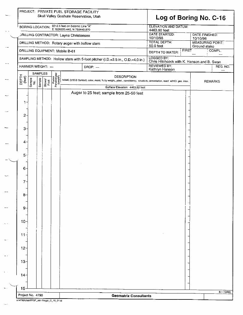
PROJECT: PRIVATE FUEL STORAGE FACILITY
Skull Valley Goshute Reservation, Utah Log of Boring No. C-16 BORING LOCATION: 9212.5 feet on Seismic Line "A" ELEVATION AND DATUM:
E 1639220.440, N 759448.870 4463.92 feet .JRILLING CONTRACTOR: Layne Christensen DATE STARTED: DATE FINISHED: ae10/10/98 10/10/98
DRILLING METHOD: Rotary auger with hollow stem TOTAL DEPTH: MEASURING POINT: 50.0 feet Ground stake ; FIRST '•COMPL. DRILLING EQUIPMENT: Mobile B-61 DEPTH TO WATER: F C I - " I -
SAMPLING METHOD: Hollow stem with 5-foot pitcher (I.D.=3.5 in., O.D.=4.0 in.) LOGGED BY: Chris Hitchcock with K. Hanson and B. Swan
HAMMER WEIGHT: --- DROP: --- REVIEWED BY: REG. NO. Kathryn Hanson _,_ ...
SAMPLES Z -- ,- IDESCRIPTION
_W _ 2 6 6 . NAME (USCS Symbol): color, moist, % by weight., plast., consistency, structure, cementation, react. wHOCl. geo. REMARKS E E 6 o an: IoR . (, 3. Surface Elevation: 4463.92 feet
Auger to 25 feet; sample from 25-50 feet
2
3
4
5
6
7
8
9
10
117
12
13
14
15-
1 8-10(2/95) Project No. 4790 Geomatrix Consultants s:\4790\UtahPFSF_981 l\"ogs\_C_16_01.ai
I. �l. ___________________________________
I

PROJECT: PRIVATE FUEL STORAGE FACILITY Skull Valley Goshute Reservation, Utah
DESCRIPTION
Auger to 25 feet; sample from 25-50 feet
- 4438.92 feet Wet from 25-30 feet
Geomatrix ConsultantsF_981 1\IogsC_ 16_02.ai

I -
PROJECT: PRIVATE FUEL STORAGE FACILITY
Skull Valley Goshute Reservation, Utah
44-
45
46
47
48-1
49
50-
51
Log of Boring No. C-16 (cont.)
DESCRIPTION NAME (USCS Symbol): color, moist, % by weight., plast.. consistency. structure, cementation, react. w/H.CI geo. inter.
SAND (SW) (continued)
SANDY GRAVEL (SP) Subrounded to subangular pebbles to 2 inches, in cuttings [PROMONTORY SOIL developed on PRE-BONNEVILLE ALLUVIUM]
Bottom of boring at 50.0 feet.
REMARKS
4425.92 feet Hard at 38 feet
4417.42 feet Hard at 46-47 feet
- 4413.92 feet
Ij I_________________
B-2 (12/95)
Project No. 4790 Geomatrix Consultants
s:\4790\UtahPFSF_981 1\logs\_C_16_03.ai
I

PROJECT: PRIVATE FUEL STORAGE FACILITY
Skull Valley Goshute Reservation, Utah Log of Boring No. C-17 BORING LOCATION: 9187.5 feet on Seismic Line "A" ELEVATION AND DATUM:
E 1639246.253, N 759450.984 4464.39 feet /-)RILLING CONTRACTOR: Layne Christensen DATE STARTED: DATE FINISHED: L i10/10/98 10/11/98
TOTAL DEPTH: MEASURING POINT: DRILLING METHOD: Rotary auger with hollow stem 55.0 feet Ground stake
DRILLING EQUIPMENT: Mobile B-61 DEPTH TO WATER: FIRST COMPL. I I
SAMPLING METHOD: Hollow stem with 5-foot pitcher (I.D.=3.5 in., O.D.=4.0 in.) LOGGED BY: Chris Hitchcock HAMMER WEIGHT: --- DR REVIEWED BY: REG. NO. HAMMERWEIGHT:_---_DROP:_---_Kathryn Hanson
SAMPLES " DESCRIPTION • " £ o8 NAME (USCS Symbol): color, moist, % by weight., plast., consistency, structure, cementation, react. wIHCO. geo. inter. REMARKS W C
0 E 0 O.S to t ~ a. Surface Elevation: 4464.39 feet
Auger to 25 feet; sample from 25-50 feet Upper 10 feet is wet
I-I ___________________________________
[Project No. 4790 Geomatrix Consultants s:\4790\UtahPFSF 981 \Jogs\_C_17 01.ai
2
3
4
5
6
7
8
9
10
11
12-
13
14-

PROJECT: PRIVATE FUEL STORAGE FACILITY Skull Valley Goshute Reservation, Utah Log of Boring No. C-17 (cont.)
SAMPLES 4 - Q) .0 DESCRIPTION
inter o•o=REMARKS i a 0 0 o : c NAME (USCS Symbol): color, moist, % by weight., plast., consistency, structure, cementation, react. w/HC geo. inter.
Auger to 25 feet; sample from 25-50 feet
16
17
18
19
20
21
22
23
24
25
26
27
28
29
30
31
32-
SILTY SAND TO SAND (SW) Light gray, loose, fine to medium grained, well sorted, well rounded grains, massive [STANSBURY TRANSGRESSIVE FACIES]]
- Bedded
- 4439.39 feet
- 4436.59 feet
013
CLAYEY SILT (MH) Very pale brown (10YR 8/3), damp, medium dense, laminated, scattered ostracodes, fines downward [STANSBURY DEEP-WATER FACIES]
7
B-2 (12/95) Project No. 4790 Geomatrix Consultants
s:\4790\UtahPFSF_981 1\logs\_C_17 02.ai
-1
m
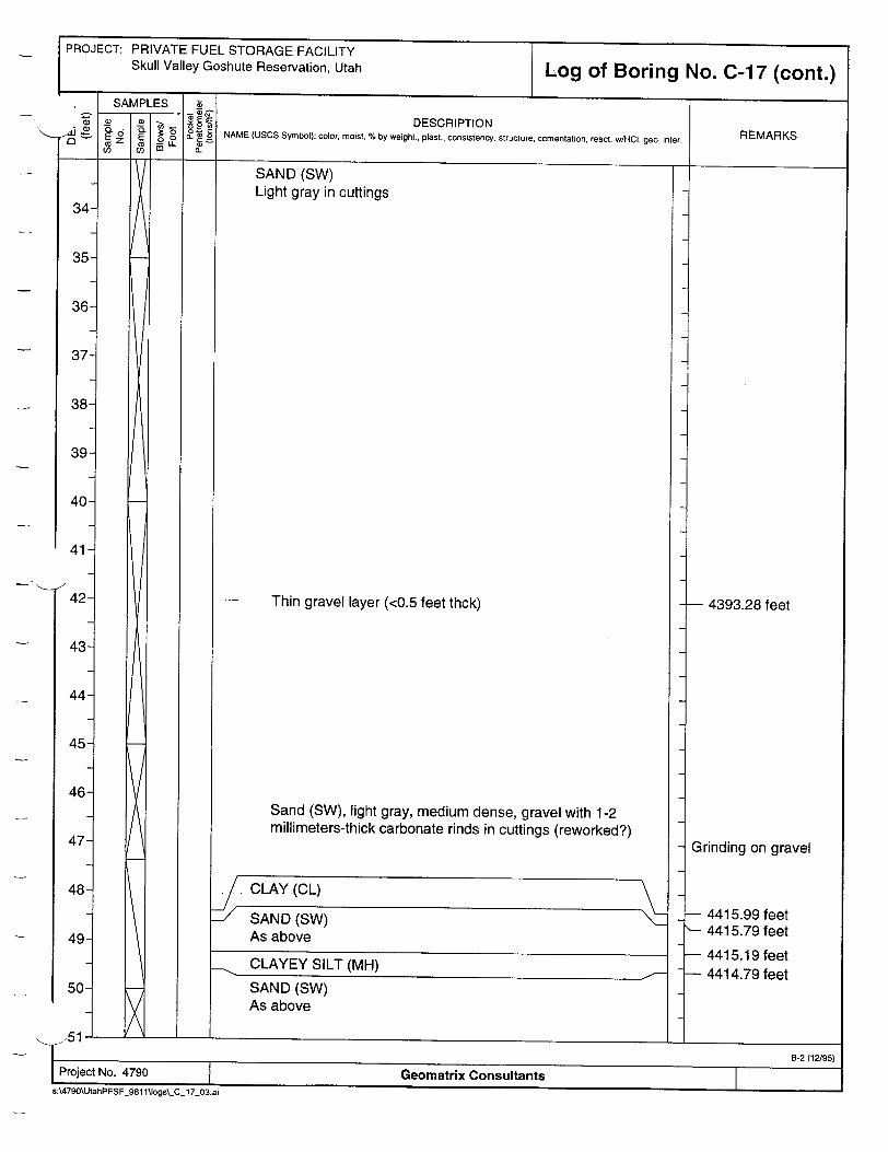
PROJECT: PRIVATE FUEL STORAGE FACILITY Skull Valley Goshute Reservation, Utah
DESCRIPTION
SAND (SW) Light gray in cuttings
Thin gravel layer (<0.5 feet thck)
Sand (SW), light gray, medium dense, gravel with 1-2 millimeters-thick carbonate rinds in cuttings (reworked?)
4393.28 feet
Grinding on gravel
4415.99 feet 4415.79 feet
4415.19 feet 4414.79 feet
Geomatrix Consultants

PROJECT: PRIVATE FUEL STORAGE FACILITY Skull Valley Goshute Reservation, Utah
60
61
62
63
64
65
66
67
68-
Log of Boring No. C-17 (cont.)
DESCRIPTION NAME (USCS Symbol): color, moist, % by weight., plast., consistency, structure, cementation, react. w/HCl. geo. inter. REMARKS
SAND (SW) (continued)
GRAVEL (GP) Poorly sorted, subangular to subrounded, clasts to 1 inch, dolomite/limestone, carbonate rinds to 2 millimeter [PROMONTORY SOIL developed on PRE-BONNEVILLE ALLUVIUM]
Bottom of boring at 55.0 feet.
- 4412.59 feet
- 4409.39 feet
1-I. _____________
B-2 (12/95)
Project No. 4790 Geomatrix Consultants s:\4790\UtahPFSF_981 l1logs\ C 17_04.ai
I -t

PROJECT: PRIVATE FUEL STORAGE FACILITY Skull Valley Goshute Reservation, Utah Log of Boring No. C-18
BORING LOCATION: 6700 feet on Seismic Line 'A' ELEVATION AND DATUM: E 1641726.610, N 759403.004 4468.20 feet . JRILLING CONTRACTOR: Layne Christensen DATE STARTED: DATE FINISHED: 10/11/98 10/11/98 DRILLING METHOD: Rotary auger with hollow stem TOTAL DEPTH: MEASURING POINT:
45.0 feet Ground stake
DRILLING EQUIPMENT: Mobile B-61 DEPTH TO WATER: FIRST COMPL. I I
SAMPLING METHOD: Hollow stem with 5-foot pitcher (I.D.=3.5 in., O.D.=4.0 in.) LOGGED BY: Chris Hitchcock
REVIEWED BY: REG. NO. HAMMER WEIGHT: --- DROP: Kathryn Hanson ,,_ ___ SAMPLES ý a S PL - DESCRIPTION o. ý o .6 NAME (USCS Symbol): color, moist, % by weight., plast., consistency, structure, cementation, react. w/HCl. geo. inter.REMARKS
E_ Sf E 00 I (D a.rnL Surface Elevation: 4468.20 feet
SANDY SILT (ML) Reddish yellow (7.5YR 6/6), dry, loose, platey [POST-PROVO REWORKED EOLIAN-with weak soil]
SILTY CLAY (CL) Pale olive (5Y 6/4), damp, with white mottles, disordered, blocky, medium dense [BONNEVILLE DEEP-WATER FACIES-blocky]
2
3
4
5
6
7
8
9
10
11
12
13
14- SANDY SILT to SILTY SAND (ML-SM) Light yellow brown (2.5Y 5/4), dry, well bedded [POST-STANSBURY TRANSGRESSIVE FACIES]
4464.30 feet
- 4458.70 feet
- 4453.90 feet
1-I_________________I .-. E-1 (12./95)I rroject No. 4790 Geomatrix Consultantss:\4790\UtahPFSF_981 1\logs\'C_18_01 .ai
x
NCLAYEY SILT (CH) Yellow (1OYR 7/6), damp, medium dense, laminar, ostracodes [[BONNEVILLE DEEP-WATER FACIES-laminated]
I
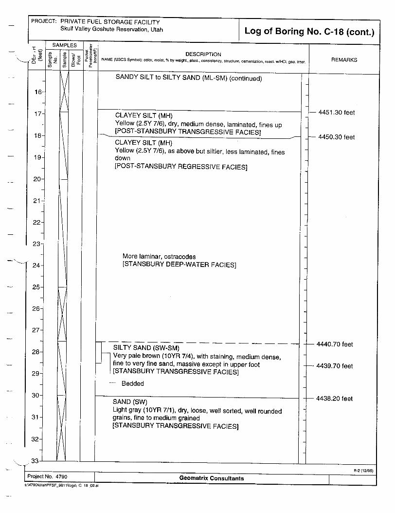
PROJECT: PRIVATE FUEL STORAGE FACILITY Skull Valley Goshute Reservation, Utah
24
25
26
27
28
29
30
31
32-
Log of Boring No. C-18 (cont.)
DESCRIPTION NAME (USCS Symbol): color, moist, % by weight., plast., consistency, structure, cementation, react. w/HCl. geo. inter. REMARKS
SANDY SILT to SILTY SAND (ML-SM) (continued)
CLAYEY SILT (MH) Yellow (2.5Y 7/6), dry, medium dense, laminated, fines up [POST-STANSBURY TRANSGRESSIVE FACIES]
CLAYEY SILT (MH) Yellow (2.5Y 7/6), as above but siltier, less laminated, fines down [POST-STANSBURY REGRESSIVE FACIES]
More laminar, ostracodes [STANSBURY DEEP-WATER FACIES]
SILTY SAND (SW-SM) Very pale brown (1OYR 7/4), with staining, medium dense, fine to very fine sand, massive except in upper foot [STANSBURY TRANSGRESSIVE FACIES]
- Bedded
SAND (SW) Light gray (10YR 7/1), dry, loose, well sorted, well rounded grains, fine to medium grained [STANSBURY TRANSGRESSIVE FACIES]
0L__3______
B-2 (12/95) Project No. 4790 Geomatrix Consultants
s:\4790\UtahPFSF 981 1\logs\_C_18_02.ai
4451.30 feet
4450.30 feet
- 4440.70 feet
- 4439.70 feet
- 4438.20 feet

PROJECT: PRIVATE FUEL STORAGE FACILITY Skull Valley Goshute Reservation, Utah Log of Boring No. C-18 (cont.)
! SAMPLES z DESCRIPTION
ýW 0 c NAME (USCS Symbol): color, moist, % by weight., plast., consistency, structure, cementation, react. w/HCI, geo. inter. REMARKS ._o E A K
SAND (SW) (continued)
34
35
36
37
38
39
40-
SAND (SW) Light gray (10YR 7/1), dry, well sorted, well rounded grains, fine to medium grained, cemented, very hard [PROMONTORY SOIL]
Bottom of boring at 45.0 feet.
- 4425.40 feet
- 4423.20 feet
L-J ______________
-r Hard (cemented)
41
42
43
44
45
46
47
48
49
50-
51
5.0
I B-2 (12195)
1 Project No. 4790 Geomatrix Consultants s:\4790\UtahPFSF 981 l1logs\_Cj_ 8_03.ai

PROJECT: PRIVATE FUEL STORAGE FACILITY Skull Valley Goshute Reservation, Utah Log of Boring No. C-19
'ORING LOCATION: 6600 feet on Seismic Line "A" ELEVATION AND DATUM: E 1641828.768, N 759401.686 4467.37 feet
,41LLING CONTRACTOR: Layne Christensen DATE STARTED: DATE FINISHED: "10/12/98 10/12/98 TOTAL DEPTH: MEASURING POINT: DRILLING METHOD: Rotary auger with hollow stem 37.0 feet Ground stake
DRILLING EQUIPMENT: Mobile B-61 DEPTH TO WATER: FIRST COMPL. I - " I - - "
SAMPLING METHOD: Hollow stem with 5-foot pitcher (I.D.=3.5 in., O.D.=4.0 in.) Chris Hitchcock HAMMER WEIGHT: --- DROP: REVIEWED BY: REG. NO.
SA PLES I Z,, IKathryn Hanson _,_ --. SAMPLES a
-E DESCRIPTION " - O• NAME (USCS Symbol): color, moist. % by weight., plast., consistency, structure, cementation, react. w/HCI. geo. inter. REMARKS Q Ez E c
U) (0 E. Surface Elevation: 4467.37 feet
SANDY SILT (ML) Reddish yellow (7.5YR 6/6), dry, loose to medium dense, platey soil [POST-PROVO REWORKED EOLIAN-with soil]
CLAYEY SILT (MH) Light olive gray (5Y 6/2), dry, blocky with disordered laminations [BONNEVILLE DEEP-WATER FACIES-blocky]
Vertical, planar fracture from 5.1 to 6.0+ feet
2
3
4
5
6
7
8
9
10
11
12
13
14-
- 4464.27 feet
- 4461.27 feet
Wet from 10-12 feet
- 4453.37 feet
to-I__ __I_ _
I Project No. 4790 1 Geomatrix Consultants SA:\4790\UtahPFSF_981 1\ogs\_C_19_01 .ai
CLAYEY SILT (CH) Yellow (1OYR 7/6), damp, medium dense, thin (1-3 millimeter) laminations, ostracodes on partings, fractured [BONNEVILLE DEEP-WATER FACIES-laminated]
Fractured, with deformed laminations [SOFT SEDIMENT DEFORMATION?]
S.ANDY SILT to SILTýYSAND(ML-SM) Light olive brown (2.5Y 5/4), damp, well bedded, soft [POST-STANSBURY TRANSGRESSIVE FACIES]
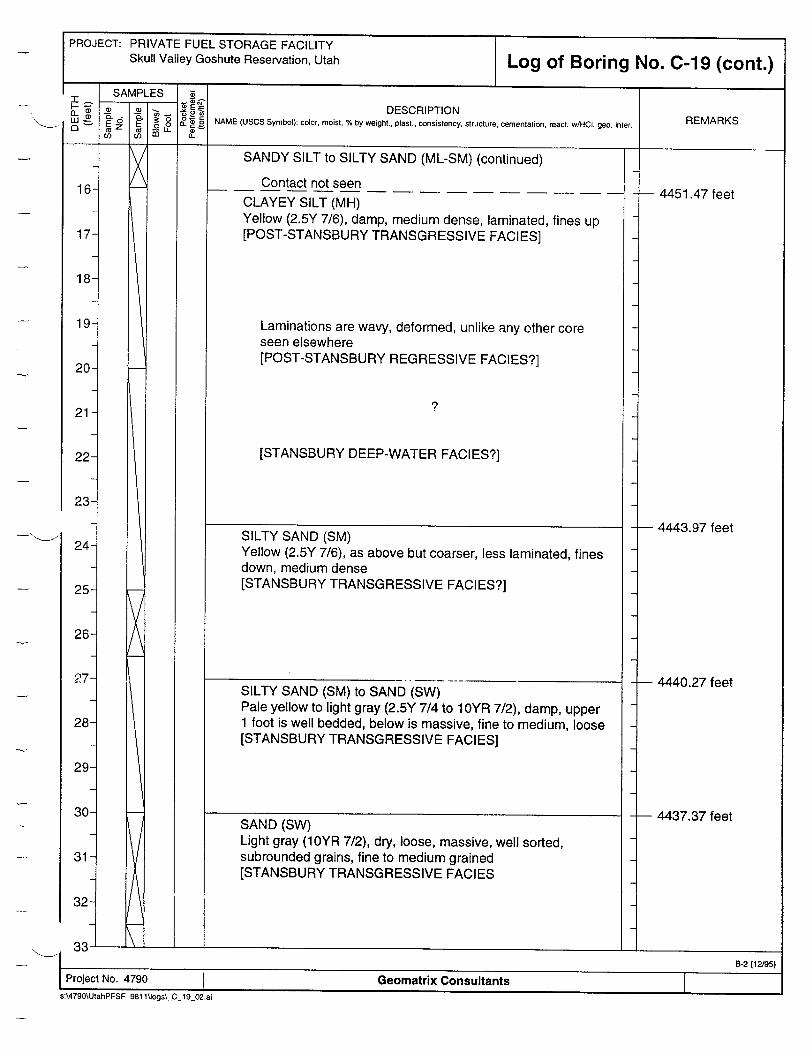
PROJECT: PRIVATE FUEL STORAGE FACILITY Skull Valley Goshute Reservation, Utah Log of Boring No. C-19 (cont.)
SAMPLES 8
DESCRIPTION t3: COL ý0= " NAME (USCS Symbol): color, moist, % by weight., plast., consistency, structure, cementation, react. w/HCI, geo. inter. REMARKS CU M 0 L -c;
SANDY SILT to SILTY SAND (ML-SM) (continued)1K16
17
18
19
20
21
22
23
24
25
26
27
28
29
30
31
32
00•
SAND (SW) Light gray (10YR 7/2), dry, loose, massive, well sorted, subrounded grains, fine to medium grained [STANSBURY TRANSGRESSIVE FACIES
Contact not seen
CLAYEY SILT (MH) Yellow (2.5Y 7/6), damp, medium dense, laminated, fines up [POST-STANSBURY TRANSGRESSIVE FACIES]
Laminations are wavy, deformed, unlike any other core seen elsewhere [POST-STANSBURY REGRESSIVE FACIES?]
[STANSBURY DEEP-WATER FACIES?]
a~. I _ __ __I_
4451.47 feet
- 4443.97 feet
- 4440.27 feet
- 4437.37 feet
SILTY SAND (SM) Yellow (2.5Y 7/6), as above but coarser, less laminated, fines down, medium dense [STANSBURY TRANSGRESSIVE FACIES?]
SILTY SAND (SM) to SAND (SW) Pale yellow to light gray (2.5Y 7/4 to 10YR 7/2), damp, upper 1 foot is well bedded, below is massive, fine to medium, loose [STANSBURY TRANSGRESSIVE FACIES]
7
7,-B-2 (12/9S)
Project No. 4790 Geomatrix Consultants
s:\4790\UtahPFSF_981 1\logs\,.C 19.02.ai

PROJECT: PRIVATE FUEL STORAGE FACILITY Skull Valley Goshute Reservation, Utah
44-
45
46
47
48
49
50-
51
Log of Boring No. C-19 (cont.)
DESCRIPTION NAME (USCS Symbol): color, moist, % by weight., plast., consistency, structure. cementation, react. w/HC. geo. inter.
SAND (SW) (continued)
SAND (SW) Light gray (10YR 7/2), dry, loose, massive, well sorted, subrounded grains, fine to medium grained, carbonate, few round pebbles to 1 inch [STANSBURY TRANSGRESSIVE FACIES/TOP OF PROMONTORY SOIL?]
Bottom of boring at 37.0 feet.
REMARKS
-- 4431.07 feet
- 4430.37 feet Refusal
L- I_________________
I B-2 (12/95) Project No. 4790 Geomatrix Consultants
s:\4790\UtahPFSF_981 1logs\_C_19_03.ai

PROJECT: PRIVATE FUEL STORAGE FACILITY
Skull Valley Goshute Reservation, Utah Log of Boring No. C-20 BORING LOCATION: 6550 feet on Seismic Line *A* ELEVATION AND DATUM: E 1641879.326, N 759401.754 4467.60 feet .)RILLING CONTRACTOR: Layne Christensen DATE STARTED: DATE FINISHED:
10/12/98 10/12/98 DRILLING METHOD: Rotary auger with hollow stem TOTAL DEPTH: MEASURING POINT: 27.7 feet
Ground stake DRILLING EQUIPMENT: Mobile B-61 DEPTH TO WATER: FIRST COMPL.
SAMPLING METHOD: Hollow stem with 5-foot pitcher (I.D.=3.5 in., O.D.=4.0 in.) Hitchcock
HAMMER WEIGHT: --- DROP: REVIEWED BY: i REG. NO. Kathryn HansonI I ýQA&RADl r:=Q
0) II)
g~ 2 cO OL
V..-
DESCRIPTION
NAME (USCS Symbol): color, moist, % by weight., plast., consistency, structure, cementation, react. w/HCl. geo. inter.
Surface Elevation: 4467.60 feet
SANDY SILT (ML) Reddish yellow (7.5YR 6/8), dry, loose, platey [POST-PROVO REWORKED EOLIAN-with soil]
SILTY CLAY to CLAYEY SILT (CL-MH) Pale olive (5Y 6/4), damp to wet, disordered, blocky, sheared (500-dipping fracture from 3.4 to 5.0 feet), medium dense [BONNEVILLE DEEP-WATER FACIES-blocky]
White (7.5YR 8/1)
CLAYEY SILT (MH) Yellow (1OYR 7/6), damp, medium dense, laminated, sheared (subvertical fracture from above unit), ostracodes on partings [BONNEVILLE DEEP-WATER FACIES-laminated]
SANDY SILT (ML) Brownish yellow (10YR 6/6), wet (saturated), well bedded, soft [POST-STANSBURY TRANSGRESSIVE FACIES]
Project No. 4790 Geomatrix Consultants sA4790\UtahPFSF_981 1\logs\_C_20_01.ai
REMARKSCL
1
2
3
4-
I F
- 4464.20 feet
Wet from 5-10 feet
- 4459.20 feet
Saturated from 1 to 15 feet
- 4454.40 feet
B-1 (12/95)
5-
6
7
8
9
10
11-
12-
13
14-
-1
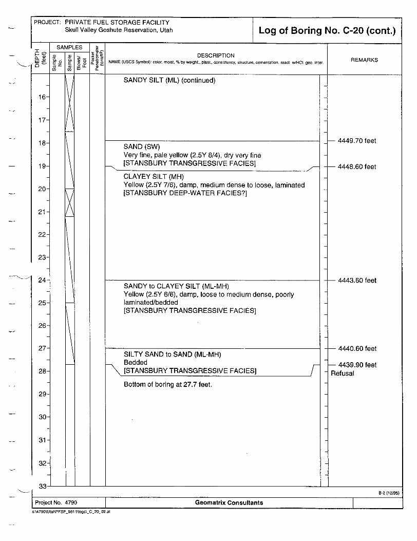
PRIVATE FUEL STORAGE FACILITY Skull Valley Goshute Reservation, Utah Log of Boring No. C-20 (cont.)
DESCRIPTION NAME (USCS Symbol): color, moist, % by weight., plast., consistency, structure. cementation, react. w/HCl. geo. inter.
SANDY SILT (ML) (continued)
SAND (SW) Very fine, pale yellow (2.5Y 8/4), dry very fine [STANSBURY TRANSGRESSIVE FACIES]
CLAYEY SILT (MH) Yellow (2.5Y 7/6), damp, medium dense to loose, laminated [STANSBURY DEEP-WATER FACIES?]
SANDY to CLAYEY SILT (ML-MH) Yellow (2.5Y 6/6), damp, loose to medium dense, poorly laminated/bedded [STANSBURY TRANSGRESSIVE FACIES]
SILTY SAND to SAND (ML-MH) Bedded [STANSBURY TRANSGRESSIVE FACIES] /-B o Bottom of boring at 27.7 feet.
REMARKS
1
1
1
1
PROJECT:
- 4449.70 feet
- 4448.60 feet
- 4443.60 feet
- 4440.60 feet
- 4439.90 feet Refusal
24-
25-
26-
27-
28-
29
30
31
32-
I B-2 (12/95)
Project No. 4790 Geomatrix Consultants
s:A4790\UtahPFSF_981 1\togs\_C_20_02.ai

PROJECT: PRIVATE FUEL STORAGE FACILITY Skull Valley Goshute Reservation, Utah Log of Boring No. C-21
BORING LOCATION: 6500 feet on Seismic Line ' ELEVATION AND DATUM: E 1641930.947, N 759399.081 4467.64 feet
JRILLING CONTRACTOR: LDATE STARTED: DATE FINISHED: Layne Christensen 10/12/98 10/12/98
TOTAL DEPTH: MEASURING POINT: DRILLING METHOD: Rotary auger with hollow stem 27.0 feet Ground stake
DRILLING EQUIPMENT: Mobile B-61 DEPTH TO WATER: FIRST COMPL.
LOGGED BY: SAMPLING METHOD: Hollow stem with 5-foot pitcher (I.D.=3.5 in., O.D.=4.0 in.) Chris Hitchcock
REVIEWED BY: REG. NO. HAMMER WEIGHT: --- DROP: Kathryn Hanson '_ _--
SAMPLES Z SAL DESCRIPTION S5:) • . NAME (USCS Symbol): color, moist,°% by weight., plast.. consistency, structure, cementation. react. w••cI. geo. inter. REMARKS E mýdE 00 d -" O. U) 0. Sutface Elevation: 4467.64 feet
SANDY SILT (ML) Reddish yellow (7.5YR 6/8), dry, loose [EOLIAN WITH SOIL]
CLAYEY SILT (MH) Pale olive (5Y 6/4), whitish mottles, damp, medium dense, blocky, highy fractured, vertical fractures [BONNEVILLE DEEP-WATER FACIES-blocky]
1
2
3
4
5
6
7
8
9
10
11
12
13
14-
SANDY SILT (ML) Brownish yellow (1OYR 6/6), wet, weakly bedded, laminated, medium dense [POST-STANSBURY TRANSGRESSIVE FACIES]
I Project No. 4790 Geomatrix Consultants B-1 (12015a
s:\4790\utahPFSF_981 1\togs\ C 21_01.ai
- 4465.24 feet
- 4458.04 feet
- 4455.24 feet
x
CLAYEY SILT (MH) Yellow (10YR 7/6), damp, medium dense, laminated (1-3 millimeters), sheared, ostracodes [BONNEVILLE DEEP-WATER FACIES-laminated]]
in . IB-1 I121QF•

PRIVATE FUEL STORAGE FACILITY Skull Valley Goshute Reservation, Utah Log of Boring No. C-21 (cont.)
DESCRIPTION NAME (USCS Symbol): color, moist, % by weight., plast., consistency, structure, cementation, react. w/HCI geo. inter. REMARKS
CLAYEY SILT (MH) (continued)
1 inch clay seam
CLAYEY SILT (MH) Pale yellow (2.5Y 8/4), well bedded, laminar, fines down
SAND (SW) Very fine to fine [STANSBURY REGRESSIVE FACIES?]
CLAYEY SILT (MH) Yellow (2.5Y 7/6), damp, medium dense, laminated, ostracodes [STANSBURY DEEP-WATER FACIES]
Fractured, 500-dipping planar fractures
Large round pebble (3 inch diameter)
SAND to SILTY SAND (SW-MH) Olive yellow (2.5Y 6/6), bedded [STANSBURY TRANSGRESSIVE FACIES]
SAND (SW) White (10YR 8/1), massive [STANSBURY TRANSGRESSIVE FACIES]
Bottom of boring at 27.0 feet.
-- 4451.04 feet
- 4448.64 feet - 4448.24 feet
-- 4441.84 feet
- 4440.64 feet
Refusal
I I i.__________________
PROJECT:
1
1
1
26
27
28
29
30
31
32-
I B-2 (12/95)
Project No. 4790 Geomatrix Consultants S:\4790\UtahPFSF_981 V\logs_C 21 .02.ai
PROJECT:
/

PROJECT: PRIVATE FUEL STORAGE FACILITY Skull Valley Goshute Reservation, Utah Log of Boring No. C-22
BORING LOCATION: 6650 feet on Seismic Line "A" ELEVATION AND DATUM: E 1641778.451, N 759400.239 4467.43 feet RILLING CONTRACTOR: Layne Christensen DATE STARTED: DATE FINISHED:
10/12/98 10/12/98 DRILLING METHOD: Rotary auger with hollow stem TOTAL DEPTH: MEASURING POINT: 27.0 feet
Ground stake DRILLING EQUIPMENT: Mobile B-61 DEPTH TO WATER: FIRST COMPL.
I I
SAMPLING METHOD: Hollow stem with 5-foot pitcher (I.D.=3.5 in., O.D.=4.0 in.) LOGGED BY: ___________________________________________________Chris Hitchcock REVIEWED BY: rREG. NO. HAMMER WEIGHT: --- DROP: --- aRE n Hno '__REG._NO_ F Kathryn Hanson
DESCRIPTION NAME (USCS Symbol): color, moist, % by weight., plast., consistency, structure. cementation, react. w/HCI. geo. inter.
Surface Elevation: 4467 431 fee~t
REMARKS
SANDY SILT (ML) Reddish yellow (7.5YR 6/8), dry, loose to medium dense [POST-PROVO EOLIAN-with soil]
CLAYEY SILT (ML) Pale olive (5Y 6/4), dry, whitish mottling, blocky, fractured, medium dense to loose [BONNEVILLE DEEP-WATER FACIES-blocky]
- Wet
CLAYEY SILT (MH) Yellow (1OYR 7/6), damp, medium dense, laminated, ostracodes [BONNEVILLE DEEP-WATER FACIES-laminated]
SANDY SILT (ML) Brownish yellow (11 YR 6/6), damp, weakly bedded/laminated [POST-STANSBURY TRANSGRESSIVE FACIES]
- 4464.03 feet
- 4458.43 feet
- 4454.93 feet
Project No. 4790 _ Geomatrix Consultants B-1 (12195)
s:\4790\UtahPFSF 9811\ogs\-C_22_01 .ai
r
0 E,
A? . _ý5 -6L zE 03 5 cu co r 1Lj
(0 U
2
3
4
5
6-=
7-
8
9-
10
11
12
13-
Surface Elevation: 44R7 4•1 f•,•t
14-

I � � -Fj.JEA��I. UnIV,-'E F TI RAG FACILITY
Skull Valley Goshute Reservation, Utah Log of Boring No. C-22 (cont.)
DESCRIPTION NAME (USCS Symbol): color, moist, % by weight., plast.. consistency, structure, cementation, react. w/HCl. geo. inter.
CLAYEY SILT (MH) (continued)
1 inch clay seam at contact
CLAYEY SILT (MH) Brownish yellow (2.5Y 8/4), damp, well bedded, laminations [STANSBURY TRANSGRESSIVE FACIES]
SAND (SW) SGray (10YR 7/2), dry, very fine, soft TANSBURYRE [SASUYREGRESSIVE FACIES]/
CLAYEY SILT (MH) Yellow (2.5Y 7/6), damp, medium dense, charaphytes in upper foot [STANSBURY DEEP-WATER FACIES]
SANDY SILT (ML) Olive yellow (2.5Y 6/6), damp, bedded coarsely [STANSBURY TRANSGRESSIVE FACIES]
SAND (SW) Light gray (1OYR 7/2), dry, well sorted, fine grained, massive [STANSBURY TRANSG RESSIVE FACIES]
Bottom of boring at 27.0 feet.
REMARKS
- 4451.13 feet
- 4448.43 feet
- 4448.23 feet
- 4443.63 feet
- 4441.43 feet
- 4440.43 feet Refusal
__~~~~~ I ~~_ _ _ _ _ _ _
SJ 'B -2 (12/95)
f�ieomatrix ConsuItant� s:\4790\UIahPFSF 981 1\Iogs\.C.2202.ai
rIUIt:•UL I•IU. R,•':dU Geomatrix Consultants

PROJECT: PRIVATE FUEL STORAGE FACILITY Skull Valley Goshute Reservation, Utah Log of Boring No. C-23
BORING LOCATION: 7200 feet on Seismic Line "A" ELEVATION AND DATUM: E 1641232.004, N 759400.676 4467.63 feet
4ILLING CONTRACTOR: Layne Christensen DATE STARTED: DATE FINISHED: Layne 10/12/98 10/12/98
TOTAL DEPTH: MEASURING POINT: DRILLING METHOD: Rotary auger with hollow stem 45.0 feet Ground stake
DRILLING EQUIPMENT: Mobile B-61 DEPTH TO WATER: FIRST COMPL.
LOGGED BY: SAMPLING METHOD: Hollow stem with 5-foot pitcher (I.D.=3.5 in., O.D.=4.0 in.) Chris Hitchcock
HAMMER WEIGHT: --- DROP: -REVIEWED BY: i REG. NO. HAMRWIGT_- __ _ _ _ _ _ __ _ Kathryn Hanson _,_ --SAMPLES Z
a-- DESCRIPTION a - -" 5 • 2 o NAME (USCS Symbol): color, moist, % by weight., plast., consistency, structure, cementation, react. w1HC,. geo. inter. REMARKS
o ,,* Surface Elevation: 4467.63 feet
SANDY SILT (ML) Reddish yellow (7.5YR 6/6), dry, loose to medium dense, platey [POST-PROVO EOLIAN-with soil]
SILTY CLAY (CL) Pale olive (5Y 6/4), wet, with white mottling, disordered, blocky, medium dense, abundant vertical fractures [BONNEVILLE DEEP-WATER FACIES-blocky]
CLAYEY SILT (MH) Yellow (1OYR 7/6), damp, medium dense, laminar, ostracodes, vertical fractures [BONNEVILLE DEEP-WATER FACIES-laminated]
2
3
4
5
6
7
8
9
10
11
12
13
14-
- 4464.63 feet
-4459.13 feet
L 4455.33 feet
g.1 (1"I•
Project No. 4790 Geomatrix Consultants s:\4790\UtahPFSF_981 l \ogs\_Q 23_01 .ai
1-
SANDY SILT to SILTY SAND (ML-SM) Light olive brown (2.5Y 5/4), wet, laminated to weakly bedded, soft, vertical fractures [POST-STANSBURY TRANSGRESSIVE FACIES]

PROJECT: PRIVATE FUEL STORAGE FACILITY Skull Valley Goshute Reservation, Utah Log of Boring No. C-23 (cont.)
DESCRIPTION NAME (USCS Symbol): color, moist, % by weight., plast., consistency, structure. cementation, react. w/HCI. geo. inter.
SANDY SILT to SILTY SAND (ML-SM) (continued)
CLAYEY SILT (MH) Yellow (2.5Y 7/6), damp, medium dense, finely laminated (<1-2 millimeters), laminations in lower portion dip 5°-100 from horizontal (tilted or drilling induced?) [STANSBURY DEEP-WATER FACIES]
CLAYEY SILT (MH) Yellow (2.5Y 7/6), damp, medium dense, as above but less clayey, less laminated, fines down [STANSBURY TRANSGRESSIVE FACIES]
SILTY SAND to SAND (SW-SM) Pale gray (10YR 7/2), dry, massive, well sorted [STANSBURY TRANSGRESSIVE FACIES]
Very pale brown (10YR 7/4), bedded Refusal, switch to air rotary
SAND (SW) Light gray (1OYR 7/2), cuttings only [STANSBURY TRANSGRESSIVE FACIES]
REMARKS
'-4
- 4451.43 feet
- 4448.03 feet
- 4442.63 feet
- 4441.13 feet
Refusal; switched to air rotary
- 4437.63 feet
I-i- ______________________
B-2 (12195)
Project No. 4790 Geomatrix Consultants s:\4790\UtahPFSF_981 1\logs\_C_23_02.ai

PROJECT: PRIVATE FUEL STORAGE FACILITY Skull Valley Goshute Reservation, Utah
DESCRIPTION
SAND (SW) (continued)
Bottom of boring at 45.0 feet.- 4422.63 feet Refusal
Geomatrix Consultants
45-
46-
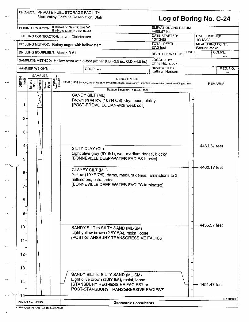
PROJECT: PRIVATE FUEL STORAGE FACILITY Skull Valley Goshute Reservation, Utah Log of Boring No. C-24
BORING LOCATION: 8000 feet on Seismic Line"A" ELEVATION AND DATUM: E 1640433.189, N 759415.964 4465.57 feet RILLING CONTRACTOR: Layne Christensen DATE STARTED: DATE FINISHED: La ye10/13/98 10/13/98
DRILLING METHOD: Rotary auger with hollow stem TOTAL DEPTH: MEASURING POINT: 27.0 feet Ground stake
DRILLING EQUIPMENT: Mobile B-61 DEPTH TO WATER: FIRST COMPL.
LOGGED BY: SAMPLING METHOD: Hollow stem with 5-foot pitcher (I.D.=3.5 in., O.D.=4.0 in.) Chris Hitchcock HAMMER WEIGHT: --- DROP -- REVIEWED BY: REG. NO. -M WEIGHT: -- I --- Kathryn Hanson ',_... SAMPLES
Z Z E DESCRIPTION "W 2-6" g2 NAME (USCS Symbol): color, moist, % by weight., plast., consistency, structure, cementation, react. wiHO. geo. inter. REMARKS
a. &Surface Elevation: 4465.57 feet
SANDY SILT (ML) Brownish yellow (10YR 6/8), dry, loose, platey [POST-PROVO EOLIAN-with weak soil]
SILTY CLAY (CL) Light olive gray (5Y 6/1), wet, medium dense, blocky [BONNEVILLE DEEP-WATER FACIES-blocky]
CLAYEY SILT (MH) Yellow (1OYR 7/5), damp, medium dense, laminations to 2 millimeters, ostracodes [BONNEVILLE DEEP-WATER FACIES-laminated]
2
3
4
5
7
8
9
10
11
12
13
14-
SANDY SILT to SILTY SAND (ML-SM) Light olive brown (2.5Y 5/5), moist, loose
[STANSBURY REGRESSIVE FACIES? or POST-STANSBURY TRANSGRESSIVE FACIES?]
4461.67 feet
4460.17 feet
4455.57 feet
- 4451.47 feet
Project No. 4790 Geomatrix Consultants B '19
s:\4790\UtahPFSF_981 1\logs\_C_24_01.ai
SANDY SILT to SILTY SAND (ML-SM) Light yellow brown (2.5Y 5/4), moist, loose [POST-STANSBURY TRANSGRESSIVE FACIES]
], a_ _aI I _ _ _ _ __ _ _ _ _ _
d- 'ý'_ 1
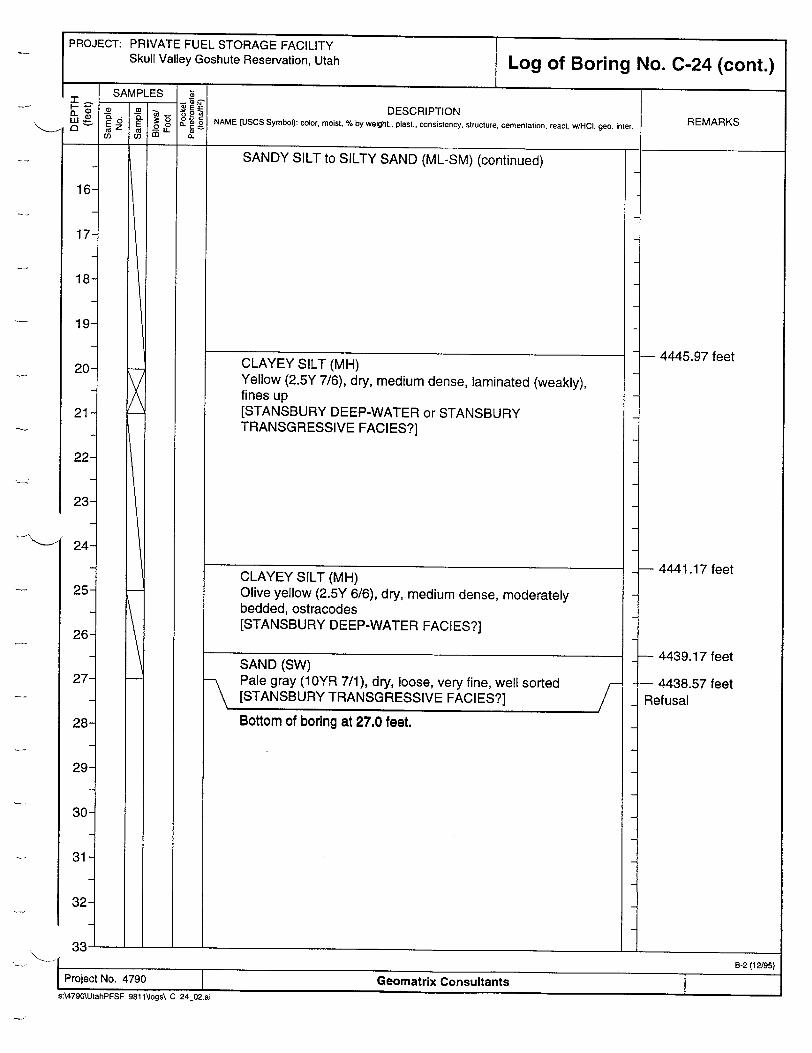
PROJECT: PRIVATE FUEL STORAGE FACILITY Skull Valley Goshute Reservation, Utah Log of Boring No. C-24 (cont.)
SAMPLES
-. - DESCRIPTION E 0 " ' • NAME (USCS Symbol): color, moist, % by weight., plast.. consistency, structure. cementation, react. w/HOC. geo. inter. j__ EZ 01.
SANDY SILT to SILTY SAND (ML-SM) (continued)
CLAYEY SILT (MH) Yellow (2.5Y 7/6), dry, medium dense, laminated (weakly), fines up [STANSBURY DEEP-WATER or STANSBURY TRANSGRESSIVE FACIES?]
CLAYEY SILT (MH) Olive yellow (2.5Y 6/6), dry, medium dense, moderately bedded, ostracodes [STANSBURY DEEP-WATER FACIES?]
SAND (SW) Pale gray (10YR 7/1), dry, loose, very fine, well sorted [STANSBURY TRANSGRESSIVE FACIES?]
Bottom of boring at 27.0 feet.
4445.97 feet
- 4441.17 feet
- 4439.17 feet
-- 4438.57 feet Refusal
133.I-i_______
16
17
18
19-
20
21
22
23
24
25
26
27
28
29
30
31
32-
B-2 (12J95) Project No. 4790 Geomatrix Consultants
SA4790\UtahPFSF_981 fItogs\_C_24_02.ai

I m,.,r, s,,-- - - - - -n ~ :~IiMItt t M (ttULl -HIVAl E FUL G•sUte Re AtILITY
Skull Valley Goshute Reservation, UtahLog of Boring No. C-24 (cont.)
DESCRIPTION NAME (USCS Symbol): color, moist, % by weight., plast., consistency, structure, cementation, react. w/HCl. geo. inter.
SANDY SILT to SILTY SAND (ML-SM) (continued)
CLAYEY SILT (MH) Yellow (2.5Y 7/6), dry, medium dense, laminated (weakly), fines up [STANSBURY DEEP-WATER or STANSBURY TRANSGRESSIVE FACIES?]
CLAYEY SILT (MH) Olive yellow (2.5Y 6/6), dry, medium dense, moderately bedded, ostracodes [STANSBURY DEEP-WATER FACIES?]
SAND (SW) Pale gray (10YR 7/1), dry, loose, ver" fine, well sorted [STANSBURY TRANSGRESSIVE FACIES?]
Bottom of boring at 27.0 feet,
REMARKS
��1
- 4445.97 feet
- 4441.17 feet
- 4439.17 feet
- 4438.57 feet Refusal
- C - C - U - J L1_________________ I 8-2 (12195)
26
27
28
29
30
31
32-
I i B-2 (12/95) Project No. 4790 Geomatrix Consultants s:\4790\UtahPFSF_981 1\logs\_C_24_02.ai

PROJECT: PRIVATE FUEL STORAGE FACILITY Skull Valley Goshute Reservation, Utah Log of Boring No. C-25
BORING LOCATION: 7500 feet on Seismic Line "A" ELEVATION AND DATUM: E 1640917.067, N 759410.004 4467.29 feet ,'RILLING CONTRACTOR: Layne Christensen DATE STARTED: DATE FINISHED: Lane10/14/98 10/14/98
TOTAL DEPTH: MEASURING POINT: DRILLING METHOD: Rotary auger with hollow stem 28.0 feet Ground stake
DRILLING EQUIPMENT: Mobile B-61 DEPTH TO WATER: FIRST COMPL. I I
LO GGED BY: SAMPLING METHOD: Hollow stem with 5-foot pitcher (l.D.=3.5 in., O.D.=4.0 in.) ris Hitchcock
HAMMER WEIGHT: --- DROP: --- REVIEWED BY: , REG. NO. Kathryn Hanson _ .. SSAMPLES Z
SAMPES -DESCRIPTION _ " °E • NAME (USCS Symbol): color, moist. % by weight., plast., consistency, structure, cementation, react. wHCI, geo. inter. REMARKS
0 E 0.0 o) , r. E L Surface Elevation: 4467.29 feet
SANDY SILT (ML) Reddish yellow (7.5YR 7/6), dry, loose to medium dense, platey in lower 2 feet [POST-PROVO EOLIAN-with weak soil]
SILTY CLAY (CL) Pale olive (5Y 6/4), damp to dry with white mottling, blocky, fractured, medium dense [BONNEVILLE DEEP-WATER FACIES-blocky]
CLAYEY SILT (MH) Brownish yellow (1OYR 6/6), damp, medium dense, laminated (1-2 millimeters), ostracodes on partings [BONNEVILLE DEEP-WATER FACIES-laminated]
SANDY SILT to SILTY SAND (ML-SM) Light yellowish brown (2.5Y 6/4), damp, well bedded, soft [POST-STANSBURY TRANSGRESSIVE FACIES]
2
3
4
5
6
7-
4. ___________
Project No. 4790 ' Geomatrix Consultants B-1 (12/95)
sA4790\UtahPFSF981 1llogs\_C_25_01 .ai
7
7- 4462.59 feet
- 4458.59 feet
- 4455.09 feet
8
9
10
11
12
13
14-
- 1

PROJECT: PRIVATE FUEL STORAGE FACILITY
Skull Valley Goshute Reservation, Utah Log of Boring No. C-25 (cont.) *1~ I--- T
DESCRIPTION NAME (USCS Symbol): color, moist, % by weight., plast., consistency, structure, cementation, react w/HCI. geo. inter. REMARKS
111t r ---4-SANDY SILT to SILTY SAND (ML-SM) (continued)
CLAYEY SILT (MH) Yellow (10YR 7/8), dry, medium dense, laminated, fines up, abundant ostracodes on partings, lower contact not obvious [STANSBURY DEEP-WATER FACIES]
CLAYEY SILT (MH) Brownish yellow (10YR 6/8), dry, medium dense, ostracodes [STANSBURY DEEP-WATER FACIES]
16
17
18
19
20
21
22
23
-'24
25
26
27
28
29
30
31
32-
L�L _____________________
SAMPLES
L a mo m
E iE o2• 0-C 0o
a_
SAND (SW) Light gray (10YR 7/2), dry, loose, well sorted [STANSBURY TRANSGRESSIVE FACIES]
Bottom of boring at 28.0 feet.
S"-ý B -2 (12/95) 1 Project No. 4790 Geomatrix Consultants s:\4790\UtahPFSF 981 1\logs\_C_25_02.ai
- 4450.09 feet
- 4446.79 feet
- 4440.89 feet
- 4439.29 feet
Refusal
I
/

PROJECT: PRIVATE FUEL STORAGE FACILITY Skull Valley Goshute Reservation, Utah Log of Boring No. C-26
BORING LOCATION: 7800 feet on Seismic Line "A" ELEVATION AND DATUM: E 1640627.805, N 759399.410 4467.00 feet AILLING CONTRACTOR: Layne Christensen DATE STARTED: DATE FINISHED: -yne 10/14/98 10/14/98
DRILLING METHOD: Rotary auger with hollow stem TOTAL DEPTH: MEASURING POINT: 27.4 feet Ground stake
DRILLING EQUIPMENT: Mobile B-61 DEPTH TO WATER: FIRST COMPL.
SAMPLING METHOD: Hollow stem with 5-foot pitcher (I.D.=3.5 in., O.D.=4.0 in.) LOGGED BY: Chris Hitchcock REVIEWED BY: REG. NO. HAMMER WEIGHT: -R-PDROP: Kathryn Hanson
SAMPLES Z - DESCRIPTION ""32 8 i NAME (USCS Symbol): color, moist, % by weight., plast., consistency, structure, cementation, react. wHCI, geo. inter. (L
c" oe-t Sufc Eeto 4467.0 REMARKS (L Surface Elevation: 4467.00 feet
SANDY SILT (ML) Brownish yellow (10YR 6/8), dry, loose, soft, platey soil structure [POST-PROVO REWORKED EOLIAN-with weak soil]
SILTY CLAY (CL) Light olive gray (5Y 6/2), wet, medium dense, blocky, disordered - [BONNEVILLE DEEP-WATER EAClES-blocky]
CLAYEY SILT (MH) Yellow (1OYR 7/6), damp, medium dense, laminated (1-2 millimeters), ostracodes abundant [BONNEVILLE DEEP-WATER FACIES-laminated]
SANDY SILT to SILTY SAND (ML-SM) Light olive brown (2.5Y 5/4), dry, loose to medium dense [POST-STANSBURY TRANSGRESSIVE FACIES]
- 4462.00 feet
- 4460.80 feet
- 4456.50 feet
i 1 B-1 112/95 Project No. 4790 Geomatrix Consultants
s:\4790\UtahPFSF_981 1\~ogs\_ C_26_01 .ai
2
3
4
57
6
7-
8
9
10-
11
12
13
14-

PRIVATE FUEL STORAGE FACILITY Skull Valley Goshute Reservation, Utah Log of Boring No. C-26 (cont.)
DESCRIPTION NAME (USCS Symbol): color, moist, % by weight., plast., consistency, structure. cementation, react. w/HC. geo. inter.
SANDY SILT to SILTY SAND (ML-SM) (continued)
- Sand (SW), light gray (10YR 7/2), loose [STANSBURY REGRESSIVE FACIES]
CLAYEY SILT (MH) Brownish yellow (10YR 6/8), dry, medium dense, poorly laminated to weakly bedded [STANSBURY DEEP-WATER FACIES]
CLAYEY SILT (MH) Yellow (1OYR 7/6), dry to damp, laminar, ostracodes [STANSBURY DEEP-WATER FACIES]
SAND (SW) Light gray (10YR 7/1), dry, loose, very fine, clean, well sorted [STANSBURY TRANSGRESSIVE FACIES]
Bottom of boring at 27.4 feet.
REMARKS
--I__________
- 4448.50 feet
-- 4448.00 feet
4445.80 feet
-- 4440.80 feet
-- 4439.60 feet Refusal
- J L��L ______________________________
PROJECT:
24
25
26
27
28
29
30
31
32-
I B-2 (12/95) I Project No. 4790 Geomatrix Consultants
s:\4790\UtahPFSF_981 1\Jogs\_C_26_02.ai

PROJECT: PRIVATE FUEL STORAGE FACILITY Skull Valley Goshute Reservation, Utah Log of Boring No. C-27
9ORING LOCATION: 7900 feet on Seismic Line "A" ELEVATION AND DATUM: E 1640526.746, N 759419.631 4465.74 feet _ RILLING CONTRACTOR: Layne Christensen DATE STARTED: DATE FINISHED:
10/14/98 10/14/98 DRILLING METHOD: Rotary auger with hollow stem TOTAL DEPTH: MEASURING POINT: 27.6 feet
Ground stake DRILLING EQUIPMENT: Mobile B-61 DEPTH TO WATER: FIRST COMPL.
I LOG EDBY SAMPLING METHOD: Hollow stem with 5-foot pitcher (I.D.=3.5 in., O.D.=4.0 in.) Chris Hitchcock
REVIEWED BY: REfG. NO. HAMMER WEIGHT: --- DROP: --- aRyE Hno _,_REG._NO. Kathryn Hanson
DESCRIPTION NAME (USCS Symbol): color, moist, % by weight., plast., consistency, structure, cementation, react. w/HCl. geo. inter.
Surface Elevation: 4465.74 feet
SANDY SILT (ML) Reddish yellow (7.5YR 6/8), dry loose, platey [POST-PROVO EOLiAN-with soil]
U) , F
0.
SILTY SAND to SANDY SILT (ML-SM) Yellow (2.5Y 7/6), dry, loose, soft, moderately well bedded [POST-STANSBURY TRANSGRESSIVE FACIES]
CLAYEY SILT (MH) Yellow (2.5Y 7/6), dry, loose to medium dense, laminations 1-4 millimeters, fines up [POST-STANSBURY TRANSGRESSIVE FACIES]
REMARKS
I-.
I-I
1
2
3
4-
L ......L ______________________________
SILTY CLAY (CL) Pale olive (5Y 6/4), damp with white mottling, blocky, medium dense [BONNEVILLE DEEP-WATER FACIES-blocky]
CLAYEY SILT (MH) Pale yellow (2.5Y 7/4), damp, medium dense, fractured, laminated, ostracodes on partings [BONNEVILLE DEEP-WATER FACIES-laminated]
o.
4462.04 feet
-- 4460.24 feet
- 4456.54 feet
- 4454.24 feet
5-
6
7
8
9
10
11
12
13
14-
1 T[Project No. 4790 Geomatrix Consultants B-1 (12/95)
s:\4790\UtahPFSF_981 1\iogs\_C 27 01.ai
Surface Elevation: 4465.74 feet
,b

PRIVATE FUEL STORAGE FACILITY Skull Valley Goshute Reservation, Utah Log of Boring No. C-27 (cont.)
DESCRIPTION NAME (USCS Symbol): color, moist, % by weight., plast., consistency, structure, cementation, react. w/HIO. geo. inter.
CLAYEY SILT (MH) (continued)
CLAYEY SILT to SANDY SILT (MH-ML) Yellow (2.5Y 7/6), damp, medium dense, weakly bedded, fines down to laminated [POST-STANSBURY TRANSGRESSIVE FACIES? STANSBURY DEEP-WATER FACIES]
CLAYEY SILT (MH) Yellow (2.5Y 7/6), dry, laminar (less than above), ostracodes [STANSBURY DEEP-WATER FACIES]
SAND (SW) Light gray (1OYR 7/2), dry, loose, very fine, well sorted [STANSBURY TRANSGRESSIVE FACIES]
Bottom of boring at 27.6 feet.
REMARKS
4449.94 feet
- 4442.54 feet
- 4439.74 feet
- 4438.14 feet Refusal
1�I ____________ I 8-2(12/95)
24
25
26
27-
28-
29
30
31
32-
13-2 (12/95)
Project No. 4790 Geomatrix Consultants s:.4790\UtahPFSF_9811\logs\_C_27_02.ai
PROJECT:
;5;.1

PROJECT: PRIVATE FUEL STORAGE FACILITY Skull Valley Goshute Reservation, Utah Log of Boring No. C-28
BORING LOCATION: 8400 feet on Seismic Line *A* ELEVATION AND DATUM: E 1640030.760, N 759429.377 4465.95 feet
JRILLING CONTRACTOR: Layne Christensen DATE STARTED: DATE FINISHED: aye10/14/98 10/14/98
DRILLING METHOD: Rotary auger with hollow stem TOTAL DEPTH: MEASURING POINT: 30.0 feet Ground stake
DRILLING EQUIPMENT: Mobile B-61 DEPTH TO WATER: FIRST COMPL.
LOGGED BY SAMPLING METHOD: Hollow stem with 5-foot pitcher (l.D.=3.5 in., O.D.=4.0 in.) Chris Hitchcock
HAMMER WEIGHT: DROP: --- REVIEWED BY: REG. NO. Kathryn Hanson
SAMPLES k SAMPL -EDESCRIPTION L 2 .2 NAME (USCS Symbol): color, moist, % by weight., plast., consistency, structure, cementation, react. wiHCI. geo. inter. REMARKS
0) )Surface Elevation: 4465.95 feet
SANDY SILT (ML) Reddish yellow (7.5YR 6/6), dry loose, platey [POST-PROVO REWORKED EOLIAN-with weak soil]
SILTY CLAY (CL) Pale olive (5Y 6/4), damp, with white mottling, blocky, medium dense [BONNEVILLE DEEP-WATER FACIES-blocky]
CLAYEY SILT (MH) Brownish yellow (10YR 6/6), damp, medium dense, laminations (1-2 millimeters), ostracodes [BONNEVILLE DEEP-WATER FACIES-laminated]
1
2
3
4
5
6
7
8
9
10-•
11
12
13
14-
- 4461.55 feet
- 4459.35 feet
- 4456.15 feet
- 4454.15 feet
___ a ____ a LL _____________________
I Project No. 4790 1 Geomatrix Consultants
s:\4790\UtahPFSF_981 1\logs\_C_28_01.ai
SANDY SILT to SILTY SAND (ML-SM) Light olive brown (2.5Y 5/4), damp, unbedded, soft [POST-STANSBURY TRANSGRESSIVE FACIES]
SANDY SILT (ML) Light olive brown (2.5Y 5/4), loose to medium dense, weakly bedded
Iid J,,•
R-111919•'•
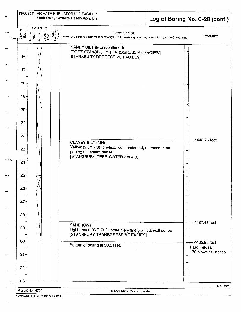
PROJECT: PRIVATE FUEL STORAGE FACILITY Skull Valley Goshute Reservation, Utah Log of Boring No. C-28 (cont.)
SAMPLES 5
- . DESCRIPTION Wt 1' 2. Z o NAME (USCS Symbol): color, moist, % by weight., plast., consistency, structure. cementation, react. w/HCI geo. inter. REMARKS <~t~ ~ m L e_
SANDY SILT (ML) (continued) [POST-STANSBURY TRANSGRESSIVE FACIES/] STANSBURY REGRESSIVE FACIES?]16
17
18
19
20
21
22
23
247
25-
SAND (SW) Light gray (10YR 7/1), loose, very fine grained, well sorted [STANSBURY TRANSGRESSIVE FACIES]
Bottom of boring at 30.0 feet.
- 4443.75 feet
- 4437.45 feet
- 4435.95 feet Hard, refusal 170 blows / 5 inches
ti', .. ±...............L ___________________________________
I - B-2 (12/95)I Project No. 4790 Geomatrix Consultantss:\479O\UlahPFSF_981 V\ogs\_Q_28_02.ai
CLAYEY SILT (MH) Yellow (2.5Y 7/6) to white, wet, laminated, ostracodes on partings, medium dense [STANSBURY DEEP-WATER FACIES]
26-
27
28
29
30
31
32-
7

PROJECT: PRIVATE FUEL STORAGE FACILITY Skull Valley Goshute Reservation, Utah Log of Boring No. C-29
RORING LOCATION: 8600 feet on Seismic Line "A" ELEVATION AND DATUM: E 1639831.026, N 759429.123 4465.41 feet AILLING CONTRACTOR: Layne Christensen DATE STARTED: DATE FINISHED: -ane10/14/98 10/14/98
TOTAL DEPTH: MEASURING POINT: DRILLING METHOD: Rotary auger with hollow stem 27.7 feet Ground stake
DRILLING EQUIPMENT: Mobile B-61 DEPTH TO WATER: FIRST COMPL.
SAMPLING METHOD: Hollow stem with 5-foot pitcher (I.D.=3.5 in., O.D.=4.0 in.) LOGGED BY: Chris Hitchcock
HAMMER WEIGHT: --- DROP: --- REVIEWED BY: ' REG. NO. Kathryn Hanson .._
DESCRIPTION NAME (USCS Symbol): color, moist, % by weight., plast., consistency, structure, cementation, react. w/HCI. geo. inter.
-I. -Surface Elevation: 4465.41 feet
SANDY SILT (ML) Reddish yellow (7.5YR 7/8), dry loose, platey [POST-PROVO EOLIAN-with soil]
SILTY CLAY (CL) Pale olive (5Y 6/4), dry, blocky, medium dense, white mottles [BONNEVILLE DEEP-WATER FACIES-blocky]
CLAYEY SILT (MH) Yellow (1OYR 7/8), medium dense, laminated (1-2 millimeters), ostracodes on partings [BONNEVILLE DEEP-WATER FACIES-laminated]
SANDY SILT (ML) Yellow (1OYR 7/6), dry, medium dense to loose, minor bedding [POST-STANSBURY TRANSGRESSIVE FACIES]
REMARKS
- 4462.41 feet
- 4460.11 feet
- 4455.61 feet
i-i ______________
SAMPLES
E z cE o LL ca ca
-c a
IL 0.
if
0'~
- 15-Project No. 4790 Geomatrix Consultants
sA4790\UtahPFSF_981 1\logs\_C_29_01 .ai
v

PROJECT: PRIVATE FUEL STORAGE FACILITY Skull Valley Goshute Reservation, Utah
24-
25
26
27
28
29
30
31
32-
Log of Boring No. C-29 (cont.)
DESCRIPTION NAME (USCS Symbol): color, moist, % by weight., plast., consistency, structure, cementation, react. w/HCI. geo. inter. REMARKS
SANDY SILT (ML) (continued)
SANDY SILT to CLAYEY SILT (ML-MH) Yellow (10YR 7/8), dry, medium dense, laminated, fines down [POST-STANSBURY TRANSGRESSIVE FACIES/STANSBURY REGRESSIVE FACIES?]
CLAYEY SILT (MH) Very pale brown (10YR 8/3), dry, medium dense, ostracodes [STANSBURY DEEP-WATER FACIES]
SAND (SW) Light gray (1OYR 7/1), dry, loose, very fine, with interbeds of clayey silt (MH) [STANSBURY TRANSGRESSIVE FACIES]
Bottom of boring at 27.7 feet.
- 4448.01 feet
- 4443.71 feet
- 4439.31 feet
- 4437.71 feet
;j-�j. .�- - - -i-I ________________________________________________________________ [�L ______________________
I B-2 (12/95) Project No. 4790 Geomatrix Consultants Figure --
s:4790\UtahPFSF 981 1Vogs\_C_29._02.ai

PROJECT: PRIVATE FUEL STORAGE FACILITY Skull Valley Goshute Reservation, Utah Log of Boring No. C-30
'ORING LOCATION: 6900 feet on Seismic Line "A* ELEVATION AND DATUM: E 1641522.947, N 759406.837 4468.10 feet
AILLING CONTRACTOR: Layne Christensen DATE STARTED: DATE FINISHED: ayne 10/19/98 10/19/98
DRILLING METHOD: Rotary auger with hollow stem TOTAL DEPTH: MEASURING POINT: 51.0 feet Ground stake
DRILLING EQUIPMENT: Mobile B-61 DEPTH TO WATER: FIRST COMPL. LOGGED I BY
SAMPLING METHOD: Hollow stem with 5-foot pitcher (I.D.=3.5 in., O.D.=4.0 in.) LGChandler
HAMMER WEIGHT: --- DROP -REVIEWED BY: , REG. NO. -M WEIGHT: -R--- Kathryn Hanson ',_--SAMPLES k
-®E• DESCRIPTION 4) NAME (USCS Symbol): color, moist, % by weight, plast., consistency, structure, cementation, react. w/HCl. geo. inter. REMARKS
(0 ( _ " _. Surface Elevation: 4468.10 feet
S15-1 -1.
Project No. 4790
SANDY SILT (ML) Reddish yellow (7.5YR 6/6), dry, loose, medium dense
SILTY CLAY (CL) Pale olive (5Y 6/4), moist, with white mottling, blocky, medium dense [BONNEVILLE DEEP-WATER FACIES-blocky]
2
3
4
5
6
7
8
9
10
11
12
13
14-
SILTY SAND to SANDY SILT (ML-SM) Light olive brown (2.5Y 5/4), moist, laminated, soft very fine sand interbeds
- 4465.10 feet
- 4459.50 feet
- 4456.10 feet
I-I ______________________________________Geomatrix Consultants
s:WA790\UtahPFSF_981 \lIogs\_C_30_01 .ai
x
CLAYEY SILT (MH) Yellow (10YR 7/6), moist, medium dense, laminar, ostracodes [BONNEVILLE DEEP-WATER FACIES-laminated]
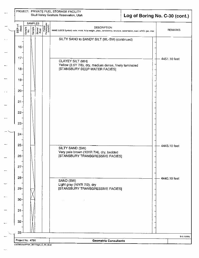
PROJECT: PRIVATE FUEL STORAGE FACILITY Skull Valley Goshute Reservation, Utah Log of Boring No. C-30 (cont.)
DESCRIPTION NAME (USCS Symbol): color, moist, % by weight.. plast., consistency, structure, cementation, react. wHCI. geo. inter.
SILTY SAND to SANDY SILT (ML-SM) (continued)
CLAYEY SILT (MH) Yellow (2.5Y 7/6), dry, medium dense, finely laminated [STANSBURY DEEP-WATER FACIES]
SILTY SAND (SW) Very pale brown (1 0YR 7/4), dry, bedded [STANSBURY TRANSGRESSIVE FACIES]
SAND (SW) Light gray (1OYR 7/2), dry [STANSBURY TRANSGRESSIVE FACIES]
REMARKS
L13.... I________________
25
26
27
28
29
30
31
32-
I B-2 (12195)
Project No. 4790 Geomatrix Consultants
s:\4790\UtahPFSF_981 1\logs\_C_30_02.ai
-- 4451.10 feet
- 4443.10 feet
-- 4440.10 feet

PROJECT: PRIVATE FUEL STORAGE FACILITY Skull Valley Goshute Reservation, Utah
DESCRIPTION
SAND (SW) (continued)
WELL-GRADED GRAVEL with SAND (GW) Light gray (IOYR 7/2), subangular to subrounded [PRE-BONNEVILLE ALLUVIUM]
4423.10 feet
4417.10 feet
Geomatrix Consultants
GEOMATRIX
APPENDIX C
TEST PIT AND HAND-EXCAVATED AUGER HOLE LOGS
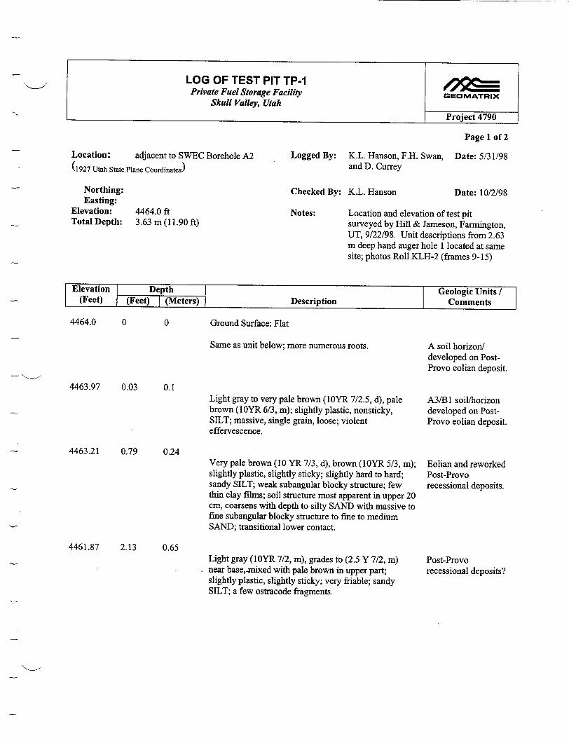
LOG OF TEST PIT TP-1 Private Fuel Storage Facility GEOMATRIX
Skull Valley, Utah
Project 4790
Page 1 of 2
Location: adjacent to SWEC Borehole A2 Logged By: K.L. Hanson, F.H. Swan, Date: 5/31/98 (1927 Utah State Plane Coordinates) and D. Currey
Northing: Checked By: K.L. Hanson Date: 10/2/98 Easting:
Elevation: 4464.0 ft Notes: Location and elevation of test pit Total Depth: 3.63 m (11.90 ft) surveyed by Hill & Jameson, Farmington,
UT, 9/22/98. Unit descriptions from 2.63 m deep hand auger hole 1 located at same site; photos Roll KLH-2 (frames 9-15)
Elevation Depth Geologic Units / (Feet) (Feet) I(Meters) Description Comments
4464.0 0 0 Ground Surface: Flat
Same as unit below; more numerous roots.
4463.97 0.03 0.1
4463.21 0.79 0.24
4461.87 2.13 0.65
Light gray to very pale brown (1OYR 7/2.5, d), pale brown (1OYR 6/3, m); slightly plastic, nonsticky, SILT; massive, single grain, loose; violent effervescence.
Very pale brown (10 YR 7/3, d), brown (1OYR 5/3, in); slightly plastic, slightly sticky; slightly hard to hard; sandy SILT; weak subangular blocky structure; few thin clay films; soil structure most apparent in upper 20 cm, coarsens with depth to silty SAND with massive to fine subangular blocky structure to fine to medium SAND; transitional lower contact.
Light gray (1OYR 7/2, m), grades to (2.5 Y 7/2, m) near base,-nmixed with pale brown in upper part; slightly plastic, slightly sticky; very friable; sandy SILT; a few ostracode fragments.
A soil horizon/ developed on PostProvo eolian deposit.
A3/B 1 soil/horizon developed on PostProvo eolian deposit.
Eolian and reworked Post-Provo recessional deposits.
Post-Provo recessional deposits?
__ 1ý

Page 2 of 2
4460.92 3.08 0.94Light brownish gray to light olive gray (3Y 6/2, m) mottled mixed light reddish brown to reddish brown (5YR 6/4 and 5/4, m) to yellowish red (5YR 5/6, m) most prominent on ped faces (up to 30 to 70%), -5% white mottles (salt precipitates) throughout unit but more prominent in upper part; slightly plastic, sticky; very friable; SILT, calcareous micrite matrix; massive breaking into weak medium blocky structure; numerous ostracodes (whole) noted at depth of 1.18 to 1.51 m.
Cambic B soil horizon (upper part) developed on Provo deep-water facies
4458.62 5.37
4458.03 5.97
4454.75 9.24
1.82
2.82
Light gray to light brownish gray (2.5Y 6.5/2, m) <5% white mottles (salt precipitates); slightly plastic, sticky; very friable: very fine to fine sandy SILT; massive breaking into weak fine subangular blocky structure; ice-rafted pebble 1 cm long at depth of-2 m; at 2.14 m light yellowish brown (2.5 Y 6/4, m) SILT mottled gray and light yellowish brown (10 YR 6/4, m) to yellowish brown (1 OYR 5/6 m), more apparent bedding; ostracodes.
Similar to unit above, but weakly laminated; drop stone at depth of 3.18 m.
4453.57 10.43 3.18Fine SAND.
4452.1
Transition zone (Bonneville flood?)
Bonneville deepwater facies (blocky)
Bonneville deepwater facies (laminated)
Post-Stansbury transgressive facies.
11.90 3.63 TDBase of test pit
Note: north-trending fractures and infilled fractures present, some extend to lower sand; east-trending fractures subparallel to test pit also observed.
LOG OF TEST PIT TP-1 Private Fuel Storage Facility GEOMATRIX
Skull Valley, Utah Project 4790
1.64
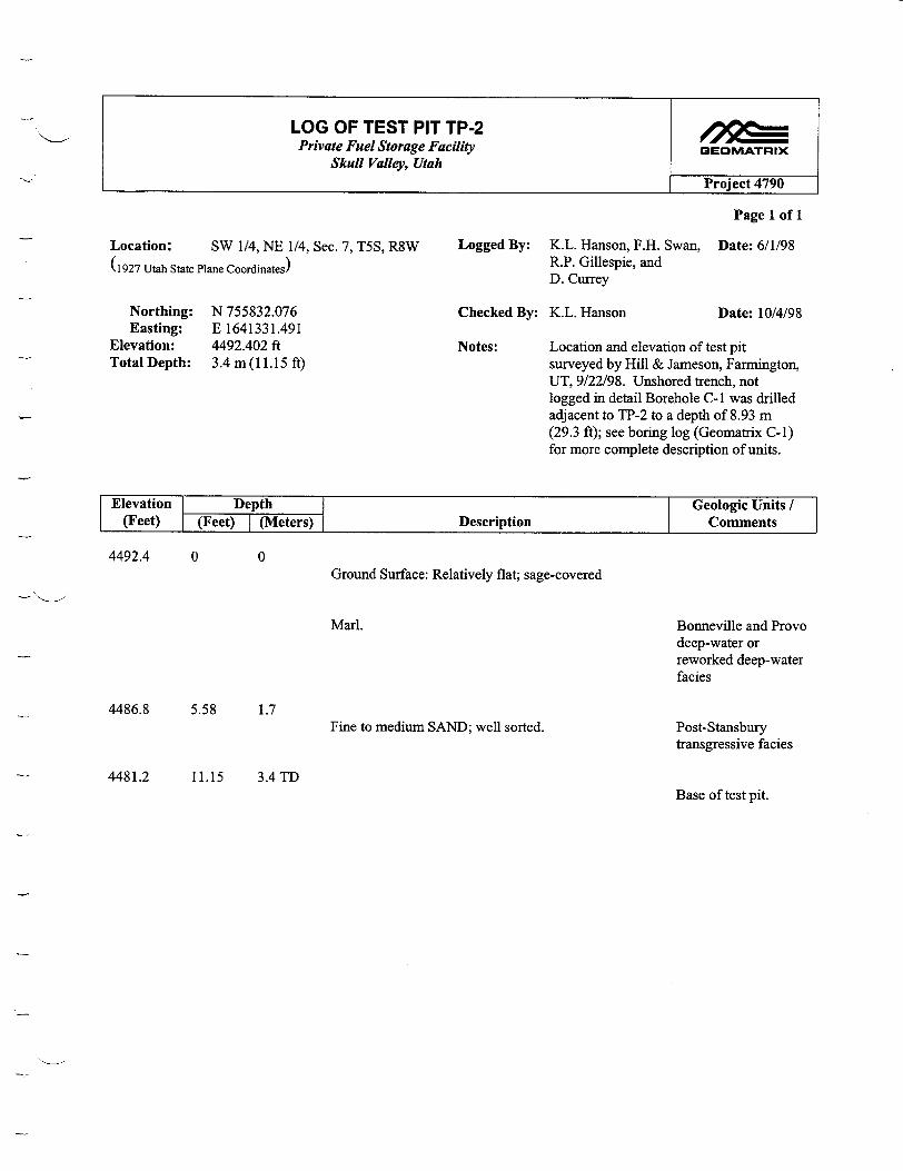
LOG OF TEST PIT TP-2 Private Fuel Storage Facility GEOMATRIX
Skull Valley, Utah
Project 4790
Page 1 of 1
Location: SW 1/4, NE 1/4, Sec. 7, T5S, R8W Logged By: K.L. Hanson, F.H. Swan, Date: 6/1/98
(1927 Utah State Plane Coordinates) R.P. Gillespie, and D. Currey
Northing: N 755832.076 Checked By: K.L. Hanson Date: 10/4/98 Easting: E 1641331.491
Elevation: 4492.402 ft Notes: Location and elevation of test pit Total Depth: 3.4 m (11.15 ft) surveyed by Hill & Jameson, Farmington,
UT, 9/22/98. Unshored trench, not logged in detail Borehole C-I was drilled adjacent to TP-2 to a depth of 8.93 m (29.3 ft); see boring log (Geomatrix C-I) for more complete description of units.
Elevation Depth Geologic Units / (Feet) (Feet) (Meters) Description Comments
4492.4 0 0Ground Surface: Relatively flat; sage-covered
Marl.
4486.8 5.58 1.7Fine to medium SAND; well sorted.
Bonneville and Provo deep-water or reworked deep-water facies
Post-Stansbury transgressive facies
4481.2 11.15 3.4TDBase of test pit.

LOG OF TEST PIT TP-6 Private Fuel Storage Facility GEOMATRIX
Skull Valley, Utah Project 4790
Page 1 of 1
Location: NW 1/4 comer of Sec. 6, T5S, R8W Logged By: K.L. Hanson, F.H. Swan, Date: 6/1/98 60 ft E, 20 ft S of Section comer R.P. Gillespie, and
D. Currey
(1927 Utah State Plane Coordinates)
Northing: Checked By: K.L. Hanson Date: 10/4/98 Easting:
Elevation: --4446 ft (at section comer, from Notes: Photos: KLH 3, frames 5 and 6 1:24,000 Hickman Knolls 7 1/2' (fracture/burrow); frames 7 and 8 (view quad.) W and view E, respectively).
Total Depth: 4.0 m (13.12 ft)
Elevation Depth Geologic Units / (Feet) (Feet) I(Meters) Description Comments
-4446 0 0Ground Surface: flat, sage-covered Eolian
-4443.05 2.95 0.9
-4436.82 9.18 2.8
-4434.85 11.15 3.4
White MARL at base, grades upward to pale brown with more silt.
MARL; grayer than above with -5% iron-stained tubules that tend to follow bedding; abundant ostracodes, some along bedding; gradational lower contact.
MARL; finely bedded, abundant ostracodes.
-4432.88 13.12 4.0 TD
Provo deep-water facies
Bonneville deepwater (blocky) facies
Bonneville deepwater (laminated) facies
Base of test pit.
Note: Fissures present, infilled and modified by burrowing animals; no vertical displacement of beds across fissures.
Samples taken from all units.

LOG OF TEST PIT TP-3 Private Fuel Storage Facility GEOMATRIX
Skull Valley, Utah Project 4790
Page 1 of 1
Location: SW 1/4, NE 1/4, Sec. 7, T5S, R8W Logged By: K.L. Hanson, F.H. Swan, Date: 6/1/98 R.P. Gillespie, and
(1927 Utah State Plane Coordinates) D. Currey
Northing: N 755366.116 Checked By: K.L. Hanson Date: 10/4/98 Easting: E 1641317.741
Elevation: 4495.891 Notes: Location and elevation of test pit Total Depth: 4.1 m (13.45 ft) surveyed by Hill & Jameson, Farmington,
UT, 9/22/98. Unshored test pit, not logged in detail. Photos: KLH 3, frames 3 to 6
Elevation Depth Geologic Units / (Feet) (Feet) I (Meters) Description Comments
4495.9 0 0 Ground Surface: Relatively flat, sage-covered
SAND and interbedded SILT layers; silt beds range in Stansbury shoreline thickness from -0.5 to 1.0 cm; sand beds exhibit (nearshore) and Postprominent cross bedding. Stansbury
transgressive facies).
4485.4 10.5 3.2 Alternating clean SAND and 0.5 to 3-cm-thick CLAY Stansbury regressive beds. facies
4484.6 11.32 3.45 Silty SAND; well bedded, kerophytes. Stansbury deep-water
facies
4482.4 13.45 4.1 TD Base of test pit
Sample -3.65 m

LOG OF TEST PIT TP-4 Private Fuel Storage Facility GEOMATRIX
Skull Valley, Utah Project 4790
Page 1 of 1
Location: SW 1/4, NE 1/4, Sec. 7, T5S, R8W Logged By: K.L. Hanson, F.H. Swan, Date: 6/1/98 R.P. Gillespie, and
(1927 Utah State Plane Coordinates) D. Currey
Northing: N 755201.865 Checked By: K.L. Hanson Date: 10/4/98 Easting: E 1640165.980
Elevation: 4496.261 ft Notes: Location and elevation of test pit Total Depth: 4.3 m (14.10 ft) surveyed by Hill & Jameson, Farmington,
UT, 9/22/98. Unshored test pit, not logged in detail.
Elevation Depth Geologic Units / (Feet) (Feet) I (Meters) Description Comments
4496.3 0 0
4492.43 3.87
Ground Surface: flat, sage-covered
Silty SAND; well bedded, ostracodes.
1.18Fine to medium SAND with SILT lenses spaced approximately 10 to 20 cm apart; clean, well sorted.
4486.46 9.84 3.0Silty SAND; ostracodes.
Bonneville deepwater facies
Stansbury shoreline and Post-Stansbury transgressive facies
Stansbury deep-water facies
Base of test pit4482.2 14.1 4.3 TD

LOG OF TEST PIT TP-5 Private Fuel Storage Facility GEOMATRIIX
Skull Valley, Utah Project 4790
Page 1 of 1
Location: SW 1/4, NE 1/4, Sec. 7, T5S, R8W Logged By: K.L. Hanson, F.H. Swan, Date: 6/1/98 R.P. Gillespie, and
(1927 Utah State Plane Coordinates) D. Currey
Northing: N 755129.868 Checked By: K.L. Hanson Date: 10/4/98 Easting: E 1640474.080
Elevation: 4497.927 Notes: Location and elevation of test pit Total Depth: -4.0 m (13.12 ft) surveyed by Hill & Jameson, Farmington,
UT, 9/22/98. Stratigraphy exposed in TP5 appeared comparable to TP-4. TP-5 caved in to about half the original depth before it could be described.
Elevation Depth Geologic Units / (Feet) (Feet) I (Meters) Description Comments
Not described in detail due to cave-in.
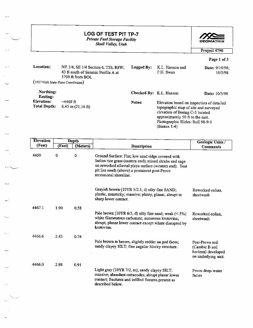
LOG OF TEST PIT TP-7 Private Fuel Storage Facility GEOMATRIX
Skull Valley, Utah
Project 4790
Page 1 of 3
Location: NE 1/4, SE 1/4 Section 6, T5S, R8W; Logged By: K.L. Hanson and Date: 9/19/98; 43 ft south of Seismic Profile A at F.H. Swan 10/5/98 5700 ft from BOL
(1927 Utah State Plane Coordinates)
Northing: Checked By: K.L. Hanson Date: 10/5/98 Easting:
Elevation: -4469 ft Notes: Elevation based on inspection of detailed Total Depth: 6.45 m (21.16 ft) topographic map of site and surveyed
elevation of Boring C-5 located approximately 50 ft to the east. Photographic Slides: Roll 98-9-1 (frames 1-4)
Elevation Depth ] Geologic Units / (Feet) (Feet) 7(Meters) DescriptionComments
0 0
1.90 0.58
4466.6 2.43 0.74
Ground Surface: Flat; low sand ridge covered with Indian rice grass (eastern end); mixed shrubs and sage on reworked alluvial playa surface (western end). Test pit lies south (above) a prominent post-Provo recessional shoreline.
Grayish brown (10YR 5/2.5, d) silty fine SAND; plastic, nonsticky; massive; platey, planar, abrupt to sharp lower contact.
Pale brown (10YR 6/3, d) silty fine sand; weak (< 5%) white filamentous carbonate; numerous krotovina; abrupt, planar lower contact except where disrupted by krotovina.
Pale brown to brown, slightly redder on ped faces; sandy clayey SILT; fine angular blocky structure.
4466.0 2.98 0.91Light gray (10YR 7/2, in); sandy clayey SILT; massive; abundant ostracodes; abrupt planar lower contact; fractures and infilled fissures present as described below.
Reworked eolian, sheetwash
Reworked eolian, sheetwash
Post-Provo soil (Cambic B soil horizon) developed on underlying unit.
Provo deep-water facies
4469
4467.1

LOG OF TEST PIT TP-7 Private Fuel Storage Facility GEOMATRIX
Skull Valley, Utah
Project 4790
Page 2 of 3
4464.6 4.36 1.33
4461.59 7.41 2.26
4457.36 11.64 3.55
4454.96- [14.04 - [4.28 4454.5 14.50] 4.42]
4454.21- [14.79 - [4.51 4453.32 15.68] 4.78]
4452.24 16.76 5.11
Light gray to gray (1OYR 6/1, m) mottled with white; plastic, sticky; very fine sandy clayey SILT; irregular coarse angular blocky structure; ostracode-rich; manganese or iron-oxide staining along root tubules; fractures and infilled fissures present as described below; abrupt smooth lower contact.
Pale brown (10YR 6/3, m); fine sandy SILT (sandy marl); fines upwards; well bedded, thinly laminated, laminae commonly < 1mm; abundant ostracodes.
Alternating light yellowish brown and brownish gray silty to clayey SAND, well bedded. Beds are generally 2 to 5 cm thick; gradational lower contact.
Thinly bedded (up to 1 mm thick) marly SAND; some ostracodes.
[Bed of gray clay that contain lenses and discontinuous beds of sand; gypsum present; appears to be some slumping or disruption of the bed.]
Coarsening upward from thinly bedded marly sand with thin (< lmm) white layers that appear to have diatoms, aragonite, small ostracodes, and abundant kerophytes.
Bonneville deepwater (blocky) facies
Bonneville deepwater (laminated) facies
Post-Stansbury transgressive facies
[Possible Interbed of deeper water sediment, secondary fluctuation]
Stansbury regression - intertidal mudflat environment?
Stansbury deep-water and regressive facies
4447.84 21.16 6.45 TDBase of test pit.
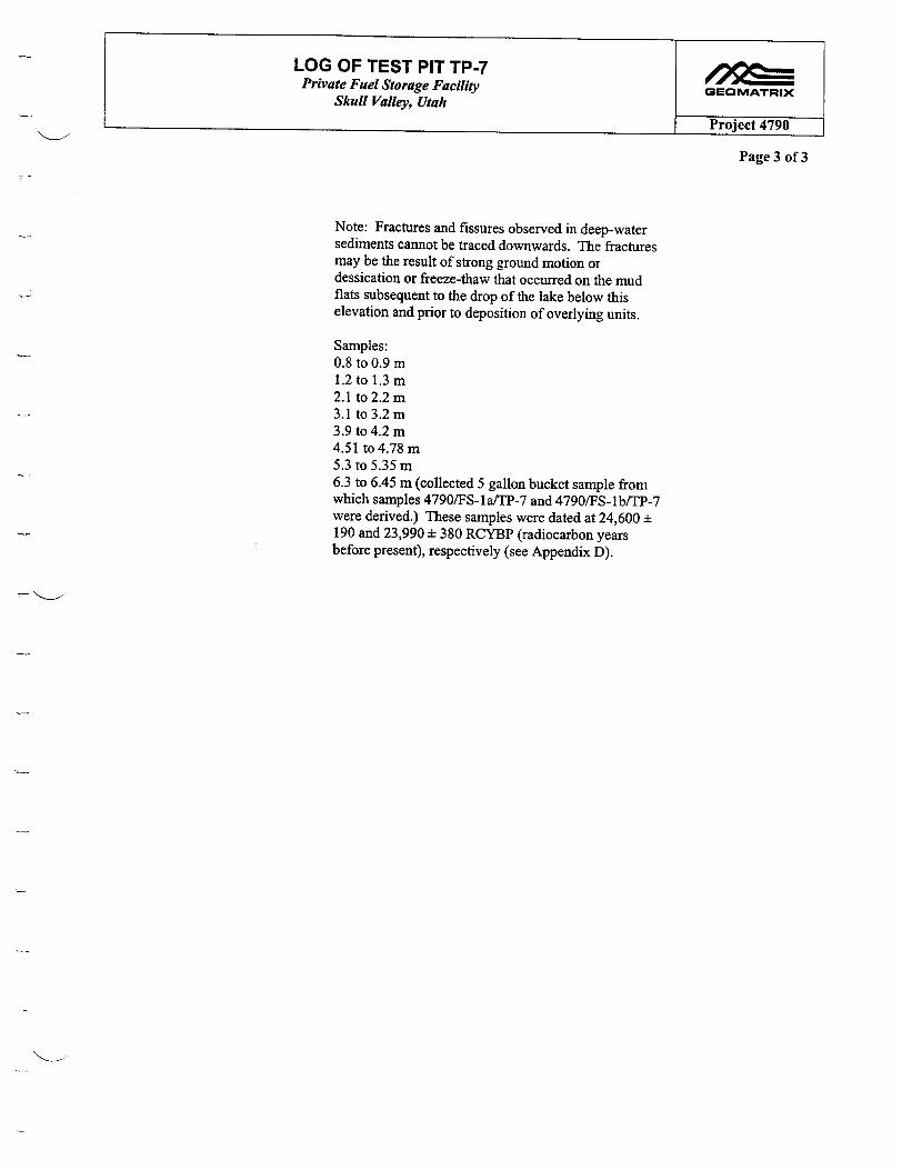
LOG OF TEST PIT TP-7 Private Fuel Storage Facility GEOMATRIX
Skull Valley, Utah
Project 4790
Page 3 of 3
Note: Fractures and fissures observed in deep-water sediments cannot be traced downwards. The fractures may be the result of strong ground motion or dessication or freeze-thaw that occurred on the mud flats subsequent to the drop of the lake below this elevation and prior to deposition of overlying units.
Samples: 0. 8 to 0.9 m 1.2 to 1.3 m 2.1 to 2.2 m 3.1 to 3.2 m 3.9 to 4.2 m 4.51 to 4.78 m 5.3 to 5.35 m 6.3 to 6.45 m (collected 5 gallon bucket sample from which samples 4790/FS-la/TP-7 and 4790/FS-lb/TP-7 were derived.) These samples were dated at 24,600 ± 190 and 23,990 ± 380 RCYBP (radiocarbon years before present), respectively (see Appendix D).
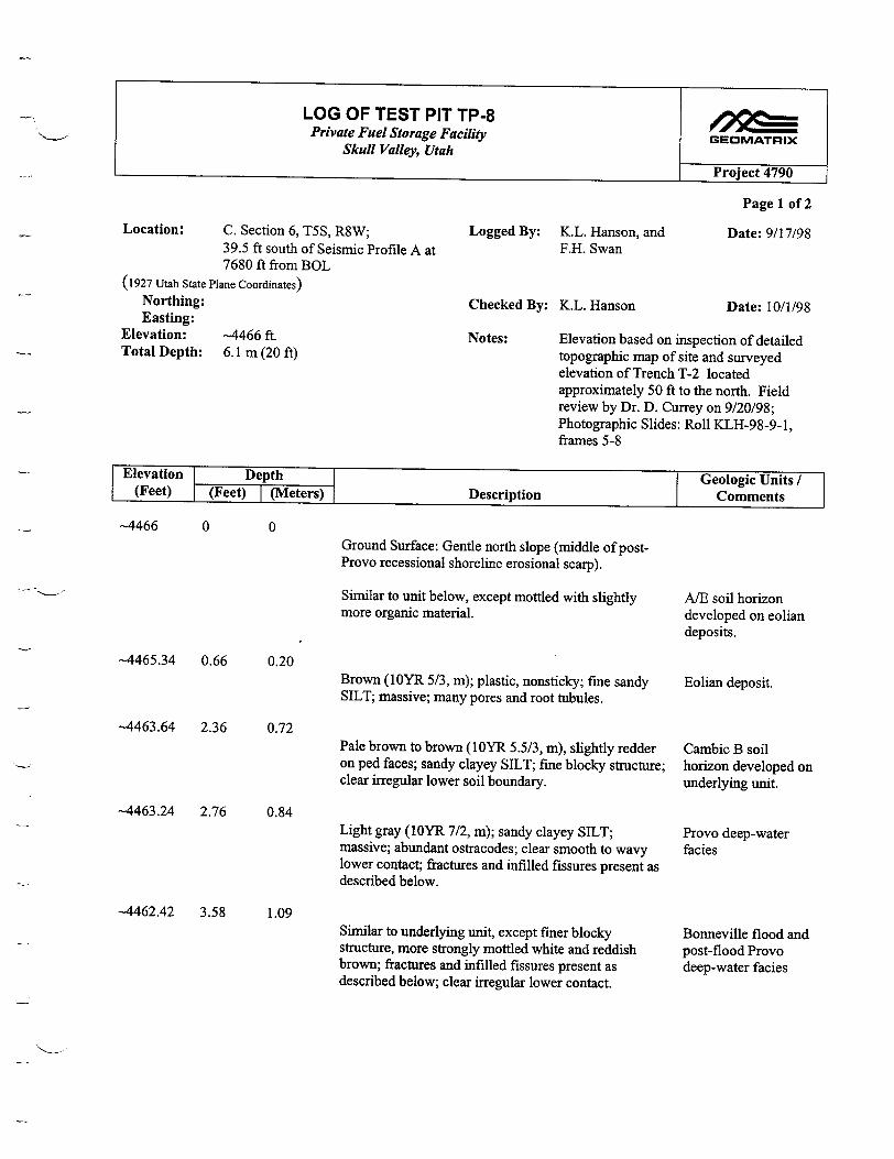
LOG OF TEST PIT TP-8 /Jv I Private Fuel Storage Facility GEOMATRIX
Skull Valley, Utah
P-roj-ect 4790
Page 1 of 2
Location: C. Section 6, T5S, R8W; Logged By: K.L. Hanson, and Date: 9/17/98 39.5 ft south of Seismic Profile A at F.H. Swan 7680 ft from BOL
(1927 Utah State Plane Coordinates) Northing: Checked By: K.L. Hanson Date: 10/1/98 Easting:
Elevation: -4466 ft. Notes: Elevation based on inspection of detailed Total Depth: 6.1 m (20 ft) topographic map of site and surveyed
elevation of Trench T-2 located approximately 50 ft to the north. Field review by Dr. D. Currey on 9/20/98; Photographic Slides: Roll KLH-98-9-1, frames 5-8
Elevation Depth Geologic Units (Feet) (Feet) (Meters) Description Comments
-4466 0 0 Ground Surface: Gentle north slope (middle of postProvo recessional shoreline erosional scarp).
Similar to unit below, except mottled with slightly A/E soil horizon more organic material, developed on eolian
deposits.
-4465.34 0.66 0.20 Brown (1OYR 5/3, in); plastic, nonsticky; fine sandy Eolian deposit. SILT; massive; many pores and root tubules.
-4463.64 2.36 0.72 Pale brown to brown (1OYR 5.5/3, in), slightly redder Cambic B soil on ped faces; sandy clayey SILT; fine blocky structure; horizon developed on clear irregular lower soil boundary. underlying unit.
-4463.24 2.76 0.84 Light gray (10YR 7/2, in); sandy clayey SILT; Provo deep-water massive; abundant ostracodes; clear smooth to wavy facies lower contact; fractures and infilled fissures present as described below.
-4462.42 3.58 1.09 Similar to underlying unit, except finer blocky Bonneville flood and structure, more strongly mottled white and reddish post-flood Provo brown; fractures and infilled fissures present as deep-water facies described below; clear irregular lower contact.

GEOMATRIX
Project 4790
Page 2 of 2
-4461.74 4.26 1.3
-4459.77 6.23
-4455.08 10.92
1.9
3.33
[15.12- [4.6115.48] 4.72]
Light gray to gray (10YR 6/1, m) mottled with white; plastic, sticky; very fine sandy clayey SILT; irregular coarse angular blocky structure; ostracode-rich; manganese or iron-oxide staining along root tubules; fractures and infilled fissures present as described below; clear lower contact.
Pale brown (10YR 6/3, m); fine sandy SILT (sandy marl); fines upwards; well bedded, thinly laminated, laminae commonly < lmm; abundant ostracodes.
Alternating light yellowish brown and light brownish gray silty to clayey SAND, well bedded. Beds are generally 2 to 5 cm. thick; gradational lower contact at depth of 16.40 ft (5.0 in).
[Thinly bedded (up to 1mm thick) marly SAND, some ostracodes.]
-4449.60 16.40 5.0
-4447.63 18.37 5.6
Interbedded very fine and fine SAND; lower contact is sharp, irregular unconformity that suggests subaerial or more likely sublacustrine erosion.
White (10YR 8/1, m), light gray (10YR 7/2, m), grayish brown (1OYR 5/2, in), and yellowish brown (10 YR 5/8, in); very fine SAND and calcareous SILT beds with ostracodes; finely bedded.
Bonneville deepwater facies (blocky)
Bonneville deepwater (laminated) facies
Post-Stansbury transgressive facies
[Interbed of deeperwater sediment (possible secondary fluctuation).]
Stansbury regressive (near-shore) facies
Stansbury deep-water facies
-4445.99 20.01
Base of test pit
Note: Fractures observed in deep-water sediments cannot be traced downward; prominent infilled fissure in deep-water, sediments widens upward to a few centimenters and can be traced to base of soil formed on Provo deep-water sediments. The fissure appears to have formed prior to significant soil formation as the redder color does not extend into the fissure infill. The fissure may be the result of strong ground motion or dessication or freeze-thaw that occurred on the mud flats subsequent to the drop of the lake below this elevation and prior to deposition of overlying deposits. A thin, dark, silty laminae at a depth of 3.8 m can be traced unbroken across the entire length of test pit.
6.1 TD
LOG OF TEST PIT TP-8 Private Fuel Storage Facility
Skull Valley, Utah
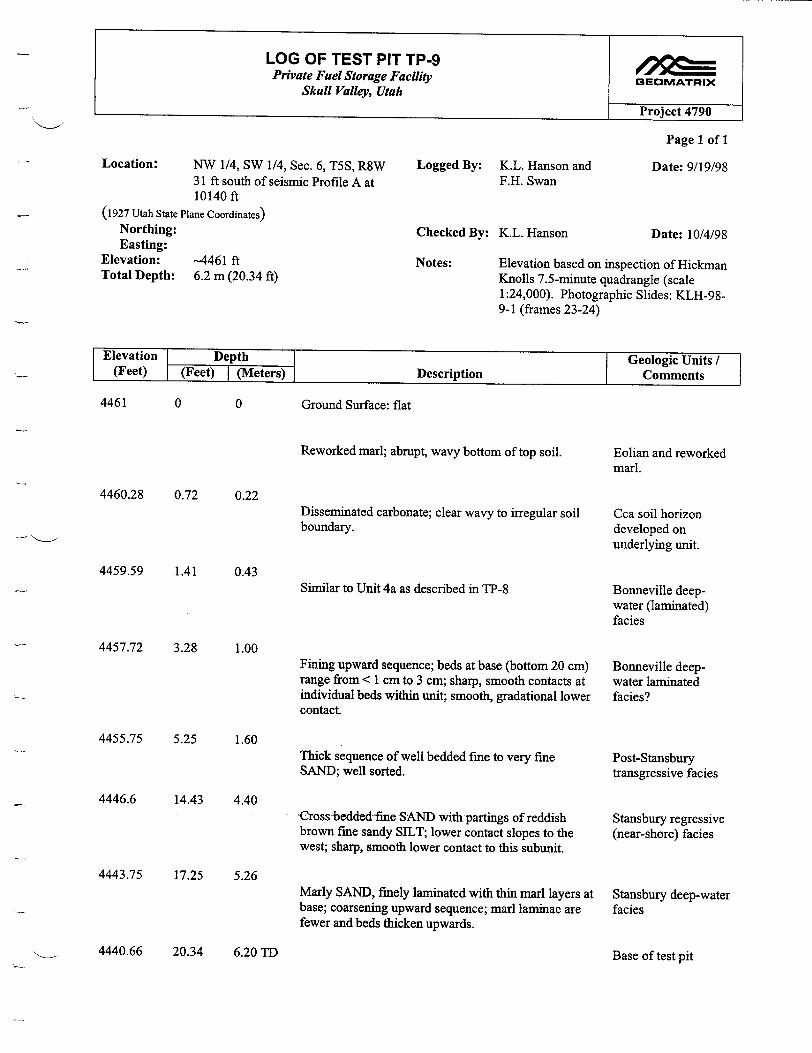
LOG OF TEST PIT TP-9 Private Fuel Storage Facility GEOMATRIX
Skull Valley, Utah
Project 4790
Page 1 of 1
Location: NW 1/4, SW 1/4, Sec. 6, T5S, R8W Logged By: K.L. Hanson and Date: 9/19/98 31 ft south of seismic Profile A at F.H. Swan 10140 ft
(1927 Utah State Plane Coordinates) Northing: Checked By: K.L. Hanson Date: 10/4/98 Easting:
Elevation: -4461 ft Notes: Elevation based on inspection of Hickman Total Depth: 6.2 m (20.34 ft) Knolls 7.5-minute quadrangle (scale
1:24,000). Photographic Slides: KLH-989-1 (frames 23-24)
Elevation Depth Geologic Units/ (Feet) (Feet) I(Meters) Description Comments
4461 0 0 Ground Surface: flat
4460.28 0.72 0.22
4459.59 1.41
4457.72 3.28
4455.75 5.25
0.43
Reworked marl; abrupt, wavy bottom of top soil.
Disseminated carbonate; clear wavy to irregular soil boundary.
Similar to Unit 4a as described in TP-8
1.00
1.60
4446.6 14.43 4.40
4443.75 17.25 5.26
Fining upward sequence; beds at base (bottom 20 cm) range from < 1 cm to 3 cm; sharp, smooth contacts at individual beds within unit; smooth, gradational lower contact.
Thick sequence of well bedded fine to very fine SAND; well sorted.
Cross bedded-fine SAND with partings of reddish brown fine sandy SILT; lower contact slopes to the west; sharp, smooth lower contact to this subunit.
Marly SAND, finely laminated with thin marl layers at base; coarsening upward sequence; marl laminae are fewer and beds thicken upwards.
Eolian and reworked marl.
Cca soil horizon developed on underlying unit.
Bonneville deepwater (laminated) facies
Bonneville deepwater laminated facies?
Post-Stansbury transgressive facies
Stansbury regressive (near-shore) facies
Stansbury deep-water facies
4440.66 20.34 6.20 TD Base of test pit
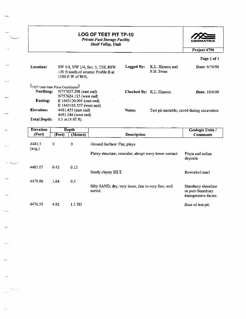
LOG OF TEST PIT TP-1O Private Fuel Storage Facility GEOMATRIX
Skull Valley, Utah
Project 4790
Page 1 of I
Location: SW 1/4, NW 1/4, Sec. 5, T5S, R8W Logged By: K.L. Hanson and Date: 9/19/98 -30 ft south of seismic Profile B at F.H. Swan 1500 ft W of BOL
(1927 Utah State Plane Coordinates) Northing: N757637.298 (east end) Checked By: K.L. Hanson Date: 10/4/98
N757624.115 (west end) Easting: E 1643120.091 (east end)
E 1643105.557 (west end) Elevation: 4481.455 (east end) Notes: Test pit unstable, caved during excavation
4481.544 (west end) Total Depth: 1.5 m (4.92 ft)
ElevationI Depth Geologic Units (Feet) (Feet) I(Meters) Description Comments
4481.5 (avg.)
0 0 Ground Surface: Flat, playa
Platey structure; vesicular; abrupt wavy lower contact Playa and eolian deposits
4481.07 0.43 0.13
4479.86 1.64 0.5
Sandy clayey SILT. Reworked marl
Silty SAND; dry, very loose, fine to very fine; well sorted.
Stansbury shoreline or post-Stansbury transgressive facies.
4476.58 4.92 1.5 TD Base of test pit.
Page 1 of 1
See Figure C-1
LOG OF TEST PIT TP-1 I Private Fuel Storage Facility GEOMATRIX
Skull Valley, Utah
Project 4790

Page 1 of 1
See Figure C-2
LOG OF TEST PIT TP-12 Private Fuel Storage Facility GEOMATRIX
Skull Valley, Utah
Project 4790

LOG OF TEST PIT TP-13 Private Fuel Storage Facility GEOMATRIX
Skull Valley, Utah
Project 4790
Page 1 of 1
Location: North flank of Hickman Knolls Logged By: K.L. Hanson and Date: 9/23/98 SW 1/4 of Section T5S, R8W C. Hitchcock
(1927 Utah State Plane Coordinates) Northing: N 75393.237 (east end) Checked By: K.L. Hanson Date: 10/1/98
N 753980.148 (west end) Easting: E 1643157.746 (east end)
E 1643132.498 (west end) Elevation: 4516.259 (east end) Notes: Location and elevation of test pit
4516.364 (west end) surveyed by Hill & Jameson, Farmington, Total Depth: 3.0 m (measured -2 m from west end UT, 9/22/98; Photographic slides: Roll
of test pit) KLH-98-9-1 (frames 9-11); KLH-98-9-2 (frames 19-20).
Elevation Depth Geologic Units (Feet) (Feet) I(Meters) Description Comments
4516.3 (average)
0 0
4513.3 2.98 0.91
4512.36 3.94 1.2
4509.5 6.89 2.1
Ground Surface: Grass covered gently north-sloping surface.
Very pale brown (10YR 8/3, d); sandy SILT; stage I+ carbonate in upper 30 cm, carbonate decreases with depth, carbonate (Cca soil horizon) extends to depth of 65 cm; sharp lower contact with underlying unit.
Very fine to fine SAND; well sorted, moderately bedded; contains scattered reworked gravel from underlying unit; sharp lower contact.
Sandy GRAVEL; clast supported; loose; well sorted medium sand matrix; subrounded to rounded gravel clasts; mode 5 cm; flattened discoidal) gravel clasts; thin continuous carbonate coating on bottoms of clasts in upper 30 cm; incipient tufa in gravel and overlying sand near upper contact.
SAND; well bedded; appears to contain thin beds of finer silt/clay (unshored test pit, too deep to observe directly)
Post-Provo Eolian (minor alluvium)
Stansbury (?) shoreline (shallow water), transgressive facies
Stansbury (?) shoreline facies (gravel bar) (upper)
Stansbury regressive facies
4506.44 9.864 3.0 TDTotal depth to deepest part of test pit.
- I---

LOG OF TEST PIT TP-14 Private Fuel Storage Facility GEOMATRIX
Skull Valley, Utah
Project 4790
Page 1 of 1
Location: NW 1/4, SW 1/4, Sec. 7, T5S, R8W Logged By: K. L. Hanson and Date: 9/23/98 Hickman Knolls 7 1/2' Quad. C. Hitchcock
(1927 Utah State Plane Coordinates) Northing: N753469.355 (north) Checked By: K. L. Hanson Date: 10/4/98 Easting: E1637770.441 (north)
Elevation: 4518.524 (north) Notes: Location and elevation of test pit Total Depth: 3.2 m (10.5 ft) surveyed by Hill & Jameson, Farmington,
UT, 9/22/98; Photographic Slides: KLH98-9-1 (frames 12-13)
Elevation Depth I Geologic Units / (Feet) (Feet) I(Meters) Description Comments
4518.52 0 0 Ground Surface: Crest of gravel bar
(1OYR 7/6,d) (1OYR 6/4, m) sandy SILT; sand is predominantly fine to medium, some coarse; scattered rounded pebbles; massive; stage I carbonate in upper 25 cm.
Sandy GRAVEL; 80 % gravel; 20% sand; clastsupported; well bedded, prominent foreset beds dip approximately 30 degrees south; gravel clasts are subrounded to rounded; mode 2 to 3 cm; range <1 to 10 cm; pebble clasts are discoidal; moderately to well sorted; stage I+ carbonate in upper 15 cm, carbonate on clast bottoms down to 40 cm in upper part of gravel.
Post-Provo eolian with minor reworked gravel
Stansbury shoreline facies (cross-valley barrier beach bar (upper))
4509.34 9.18 2.8Fine SAND; massive Stansbury (regressive
facies)
4508.02 10.5 3.2 TDBase of test pit
4515.24 3.28 1.0
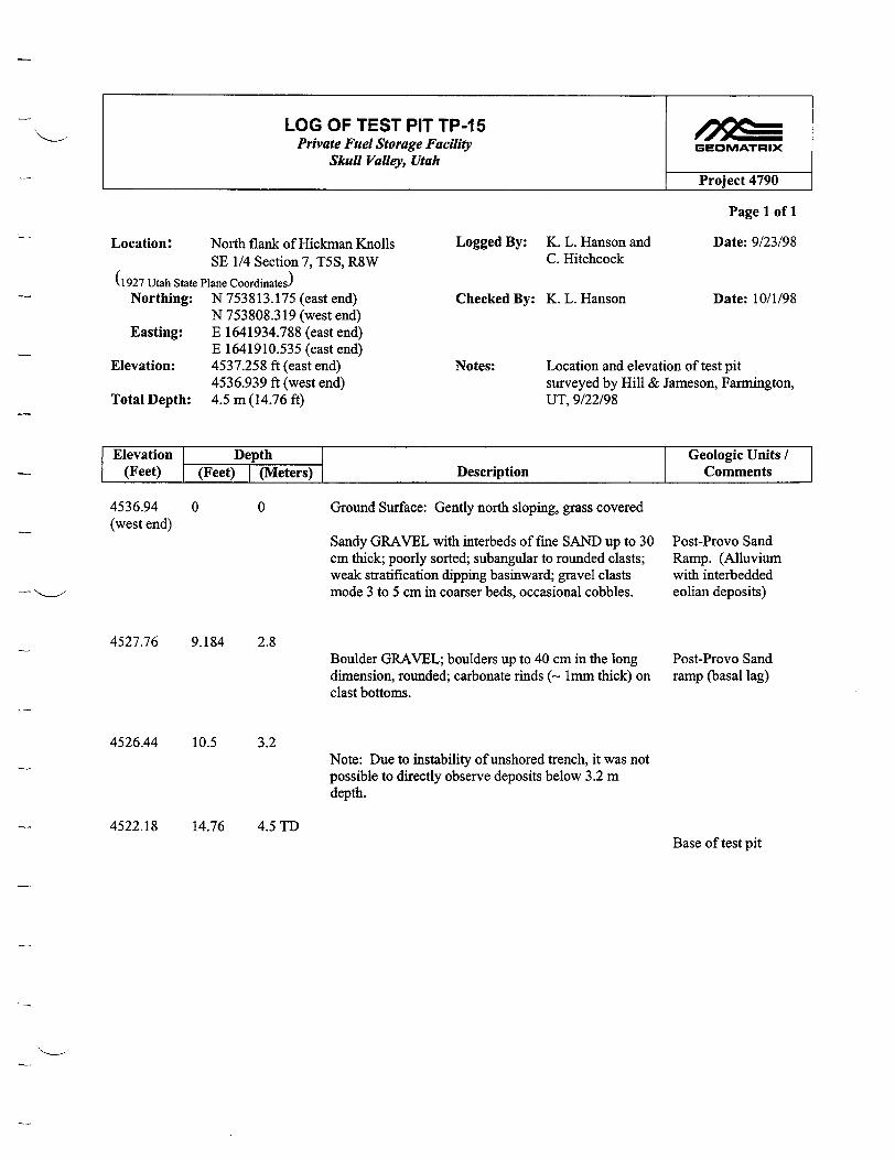
LOG OF TEST PIT TP-15 Private Fuel Storage Facility GEOMATRIX
Skull Valley, Utah Project 4790
Page 1 of 1
Location: North flank of Hickman Knolls Logged By: K. L. Hanson and Date: 9/23/98 SE 1/4 Section 7, T5S, R8W C. Hitchcock
(1927 Utah State Plane Coordinates) Northing: N 753813.175 (east end) Checked By: K. L. Hanson Date: 10/1/98
N 753808.319 (west end) Easting: E 1641934.788 (east end)
E 1641910.535 (east end) Elevation: 4537.258 ft (east end) Notes: Location and elevation of test pit
4536.939 ft (west end) surveyed by Hill & Jameson, Farmington, Total Depth: 4.5 m (14.76 ft) UT, 9/22/98
Elevation Depth Geologic Units / (Feet) (Feet) I (Meters) Description Comments
4536.94 (west end)
0 0
4527.76 9.184 2.8
Ground Surface: Gently north sloping, grass covered
Sandy GRAVEL with interbeds of fine SAND up to 30 cm thick; poorly sorted; subangular to rounded clasts; weak stratification dipping basinward; gravel clasts mode 3 to 5 cm in coarser beds, occasional cobbles.
Boulder GRAVEL; boulders up to 40 cm in the long dimension, rounded; carbonate rinds (- 1mm thick) on clast bottoms.
Post-Provo Sand Ramp. (Alluvium with interbedded eolian deposits)
Post-Provo Sand ramp (basal lag)
4526.44 10.5 3.2Note: Due to instability of unshored trench, it was not possible to directly observe deposits below 3.2 m depth.
4522.18 14.76 4.5 TDBase of test pit

LOG OF TEST PIT TP-16 Private Fuel Storage Facility GEOMATRIX
Skull Valley, Utah
Project 4790
Page 1 of 1
Location: North flank of Hickman Knolls Logged By: K. L. Hanson and Date: 9/23/98 SE 1/4 Section 7, T5S, R8W C. Hitchcock
(1927 Utah State Plane Coordinates) Northing: N 754018.665 (west end) Checked By: K. L. Hanson Date: 10/1/98
N 754015.400 (east end) Easting: E 1641907.036 (west end)
E 1641928.598 (east end) Notes: Location and elevation of test pit Elevation: 4528.645 ft (west end) surveyed by Hill & Jameson, Farmington,
4529.009 ft (east end) UT, 9/22/98. Photographic Slides: KLHTotal Depth: 3.5 m (11.48 ft); 2.3 m (7.54 ft) after 98-9-2 (frame 8)
backfilling
Elevation Depth Geologic Units/ (Feet) (Feet) I (Meters) Description Comments
4528.82 0 0 (avg.)
4521.28 7.54 2.3
4517.34 11.48 3.5 TD
Ground Surface: Gently north dipping, grass covered.
Similar to upper 2.8 m in TP-15: Sandy GRAVEL with interbeds of fine SAND; poorly sorted; subangular to rounded clasts.
Rock too hard to penetrate with backhoe; Fragments of hard, dark gray dolomite breccia in spoil from bottom of test pit.
Post-Provo sand ramp (Alluvium interbedded with eolian deposits)
Bedrock contact? Base of test pit.
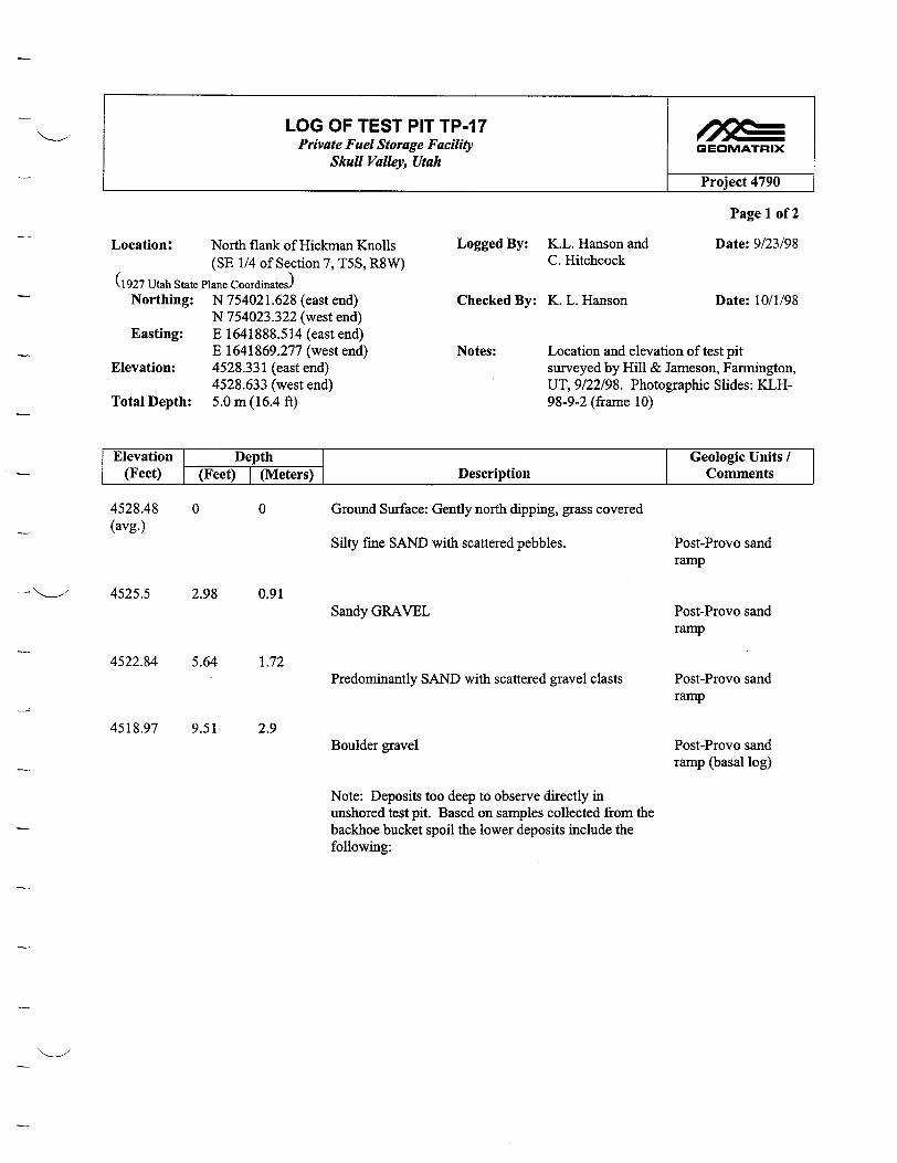
LOG OF TEST PIT TP-17 Private Fuel Storage Facility GEOMATRIX
Skull Valley, Utah Project 4790
Page 1 of 2
Location: North flank of Hickman Knolls Logged By: K.L. Hanson and Date: 9/23/98 (SE 1/4 of Section 7, T5S, R8W) C. Hitchcock
(1927 Utah State Plane Coordinates) Northing: N 754021.628 (east end) Checked By: K. L. Hanson Date: 10/1/98
N 754023.322 (west end) Easting: E 1641888.514 (east end)
E 1641869.277 (west end) Notes: Location and elevation of test pit Elevation: 4528.331 (east end) surveyed by Hill & Jameson, Farmington,
4528.633 (west end) UT, 9/22/98. Photographic Slides: KLHTotal Depth: 5.0 m (16.4 ft) 98-9-2 (frame 10)
Elevation Depth Geologic Units / (Feet) (Feet) I (Meters) Description Comments
4528.48 0 0 (avg.)
Ground Surface: Gently north dipping, grass covered
Silty fine SAND with scattered pebbles.
4525.5 2.98 0.91Sandy GRAVEL
4522.84 5.64 1.72Predominantly SAND with scattered gravel clasts
4518.97 9.51 2.9Boulder gravel
Post-Provo sand ramp
Post-Provo sand ramp
Post-Provo sand ramp
Post-Provo sand ramp (basal log)
Note: Deposits too deep to observe directly in unshored test pit. Based on samples collected from the backhoe bucket spoil the lower deposits include the following:
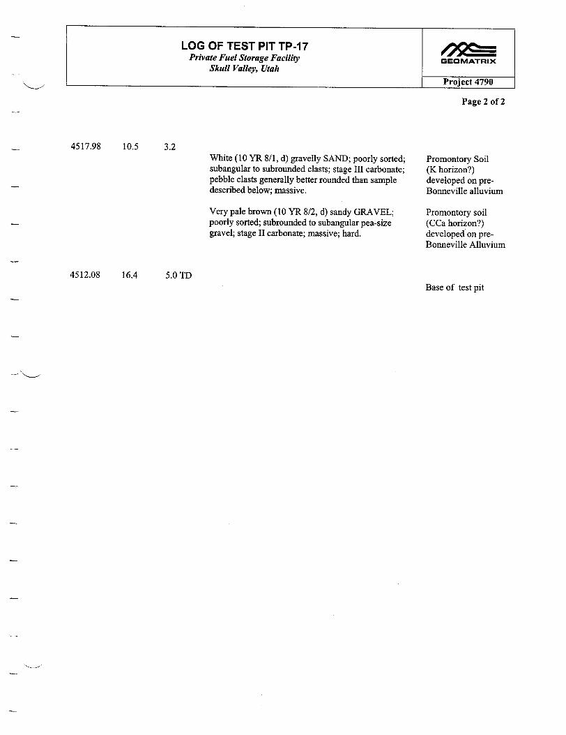
LOG OF TEST PIT TP-17 Private Fuel Storage Facility GEOMATRIX
Skull Valley, Utah
Project 4790
Page 2 of 2
4517.98 10.5 3.2White (10 YR 8/1, d) gravelly SAND; poorly sorted; subangular to subrounded clasts; stage HI carbonate; pebble clasts generally better rounded than sample described below; massive.
Very pale brown (10 YR 8/2, d) sandy GRAVEL; poorly sorted; subrounded to subangular pea-size gravel; stage II carbonate; massive; hard.
Promontory Soil (K horizon?) developed on preBonneville alluvium
Promontory soil (CCa horizon?) developed on preBonneville Alluvium
4512.08 16.4Base of test pit
5.0TD
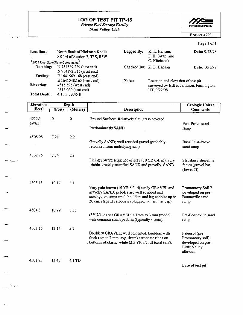
LOG OF TEST PIT TP-18 Private Fuel Storage Facility GEOMATRIX
Skull Valley, Utah
Project 4790
Page 1 of 1
Location: North flank of Hickman Knolls Logged By: K. L. Hanson, Date: 9/23/98 SE 1/4 of Section 7, T5S, R8W F. H. Swan, and
(1927 Utah State Plane Coordinates) C. Hitchcock Northing: N 754369.229 (east end) Checked By: K. L. Hanson Date: 10/1/98
N 754372.516 (west end) Easting: E 1641569.168 (east end)
E 1641548.165 (west end) Notes: Location and elevation of test pit Elevation: 4515.595 (west end) surveyed by Hill & Jameson, Farmington,
4515.060 (east end) UT, 9/22/98 Total Depth: 4.1 m (13.45 ft)
ElevationI Depth Geologic Units / (Feet) (Feet) I (Meters) Description Comments
0 0 Ground Surface: Relatively flat; grass covered
Predominantly SAND
4508.08 7.21 2.2
4507.76 7.54 2.3
Gravelly SAND; well rounded gravel (probably reworked from underlying unit)
Fining upward sequence of gray (10 YR 6.4, m), very friable, crudely stratified SAND and gravelly SAND
4505.13 10.17 3.1
10.99 3.35
4503.16 12.14 3.7
Very pale brown (10 YR 8/3, d) sandy GRAVEL and gravelly SAND; pebbles are well rounded and subangular, some small boulders and lag cobbles up to 20 cm; stage II carbonate (plugged, no laminar cap).
(5Y 7/4, d) pea GRAVEL; < 1mm to 3 mm (mode) with common small pebbles (typically < 5cm).
Bouldery GRAVEL; well cemented; boulders with thick ( up to 7 mm, avg. 4mm) carbonate rinds on bottoms of clasts; white (2.5 YR 8/I, d).basal tufa?.
Post-Provo sand ramp
Basal Post-Provo sand ramp
Stansbury shoreline facies (gravel bar (lower ?))
Promontory Soil ? developed on preBonneville sand ramp.
Pre-Bonneville sand ramp
Paleosol (prePromontory soil) developed on preLittle Valley alluvium
4501.85 13.45 4.1TDBase of test pit
4515.3 (avg.)
4504.3

LOG OF TEST PIT TP-19 4 SE Private Fuel Storage Facility GEOMATRIX
Skull Valley, Utah
Project 4790
Page 1 of 2
Location: North flank of Hickman Knolls Logged By: K.L. Hanson, and Date: 9/24/98 SW 1/4 of Section 8, T5S, R8W F.H. Swan
(1927 Utah State Plane Coordinates) Northing: N 753836.176 Checked By: K.L. Hanson Date: 10/1/98 Easting: E 1643967.632
Elevation: 4514.762 ft Notes: Location and elevation of test pit Total Depth: 4.3 to 4.5 m (14.10 to 14.76 ft) prior surveyed by Hill & Jameson, Farmington,
to cave-in; 3.71 m (12.17 ft) post UT, 9/22/98; Photographic slides: Roll cave-in KLH 98-9-2 (frames 16 to 18)
Elevation Depth Geologic Units / (Feet) (Feet) I(Meters) Description Comments
4514.76 0 0
4514.53 0.23 0.07
Ground Surface-Playa at margin of eolian sand ramp
Light brownish gray (1 OYR 6/2, d) to grayish brown (10 YR 5/2, d) very fine SANDY LOAM; vesicular structure in upper 5 cm; fine to medium platey structure in lower part; clear wavy lower boundary.
Very pale brown (10 YR 7/3.5, d) silty very fine SAND; well sorted; stage I carbonate; clear wavy lower contact.
4513.81 0.95 0.29
4512.76 2.00 0.61
4512.46 2.30 0.70
Light gray to very pale brown (10 YR 7/2.5, d) very fine SAND interbedded with silty fine SAND; beds are < 1 cm to 3 to 5 cm; well sorted; sharp lower contact.
Fine to medium SAND; well sorted; discontinuous incipient tufa; abundant filamentous white salts; ironoxide staining locally; abrupt smooth lower contact.
Sandy GRAVEL; clast supported; well rounded; mode of gravel clasts is 2 to 3 cm, 10 cm (max.); flattened (discoidal) clasts; iron-oxide staining and mottles <5%; abrupt smooth lower contact.
A soil horizon developed on PostProvo eolianrplaya deposit
Cca soil horizon developed on PostProvo eolian/playa deposit
Bonneville transgressive facies (shallow water)
Stansbury (?) shoreline facies
Stansbury (?) shoreline facies (gravel bar)

LOG OF TEST PIT TP-19 Private Fuel Storage Facility GEOMATRIX
Skull Valley Utah
Project 4790
Page 2 of 2
4511.74 3.02 0.92
4510.69 4.07 1.24
Interbedded fine sand, very fine sand, and silty fine SAND; alternating layers <1 cm to 5 cm thick; sharp lower contact.
Very pale brown (10 YR 7/3, d) in upper 1.5 m; light gray to light grayish brown (1OYR 6.5/2, d) in lower part; medium SAND; very well sorted; subrounded grains; iron-oxide staining along distinct beds and roots in upper 1.5 m; cross bedding; occasional pebble (< 1 cm) and stringers of pebbles.
Stansbury regressive facies
Stansbury regressive facies
4502.59 12.17 3.71Post cave-in base of test pit
Note: From material coming out of backhoe bucket from deeper parts of the test pit prior to the cave, we infer that the test pit originally exposed two lower units as described below.
Light olive gray (5Y 6/2, d) and white; interbedded marly SAND and sandy MARL; ostracodes; massive breaking into irregular coarse angular blocky structure; some laminar bedding observed.
Subangular carbonate-coated locally derived gravel clasts; mode 2 to 3 cm; poorly sorted sand matrix
Stansbury deep-water facies
Promontory soil developed on PreBonneville subaerial alluvium or colluvium
4500.66 to 14.10 to 4.3 to 4500 14.76 ft. 4.5 m TD
Pre-cave-in base of test pit
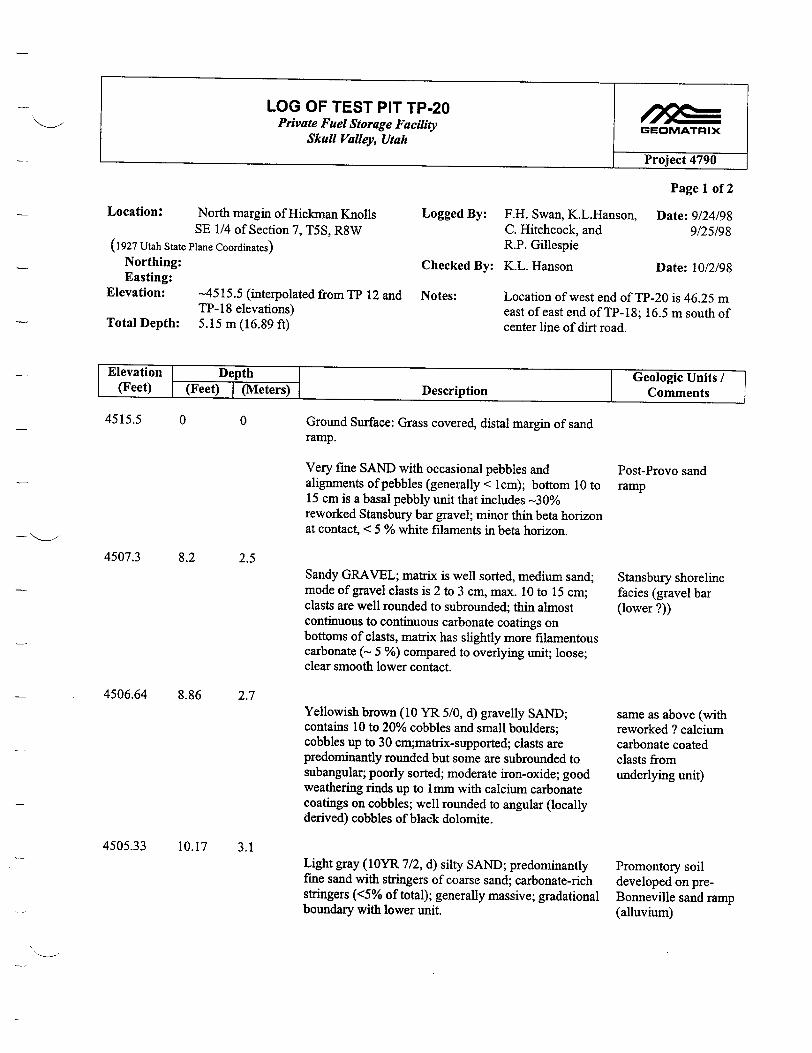
LOG OF TEST PIT TP-20 Private Fuel Storage Facility
Skull Valley, Utah
Location: North margin of Hickman Knolls SE 1/4 of Section 7, T5S, R8W
(1927 Utah State Plane Coordinates)
Northing: Easting:
Elevation: -4515.5 (internolated from TP 11
Total Depth:TP- 18 elevations)
a5 1 Nnta9f
5.15 m (16.89 ft)
GEOMATRIX
Project 4790
Logged By: F.H. Swan, K.L.Hanson, C. Hitchcock, and R.P. Gillespie
Checked By: K.L. Hanson
Page 1 of 2
Date: 9/24/98 9/25/98
Date: 10/2/98
Location of west end of TP-20 is 46.25 m east of east end of TP-18; 16.5 m south of center line of dirt road.
Elevation Depth I Geologic Units I (Feet) (Feet) I(Meters) Description Comments
4515.5 0
4507.3
0
8.2 2.5
4506.64 8.86 2.7
4505.33 10.17 3.1
Ground Surface: Grass covered, distal margin of sand ramp.
Very fine SAND with occasional pebbles and alignments of pebbles (generally < 1cm); bottom 10 to 15 cm is a basal pebbly unit that includes -30% reworked Stansbury bar gravel; minor thin beta horizon at contact, < 5 % white filaments in beta horizon.
Sandy GRAVEL; matrix is well sorted, medium sand; mode of gravel clasts is 2 to 3 cm, max. 10 to 15 cm; clasts are well rounded to subrounded; thin almost continuous to continuous carbonate coatings on bottoms of clasts, matrix has slightly more filamentous carbonate (- 5 %) compared to overlying unit; loose; clear smooth lower contact.
Yellowish brown (10 YR 5/0, d) gravelly SAND; contains 10 to 20% cobbles and small boulders; cobbles up to 30 cm;matrix-supported; clasts are predominantly rounded but some are subrounded to subangular; poorly sorted; moderate iron-oxide; good weathering rinds up to 1mm with calcium carbonate coatings on cobbles; well rounded to angular (locally derived) cobbles of blacik dolomite.
Light gray (1OYR 7/2, d) silty SAND; predominantly fine sand with stringers of coarse sand; carbonate-rich stringers (<5% of total); generally massive; gradational boundary with lower unit.
Post-Provo sand ramp
Stansbury shoreline facies (gravel bar (lower ?))
same as above (with reworked ? calcium carbonate coated clasts from underlying unit)
Promontory soil developed on preBonneville sand ramp (alluvium)
•nH NAt•.
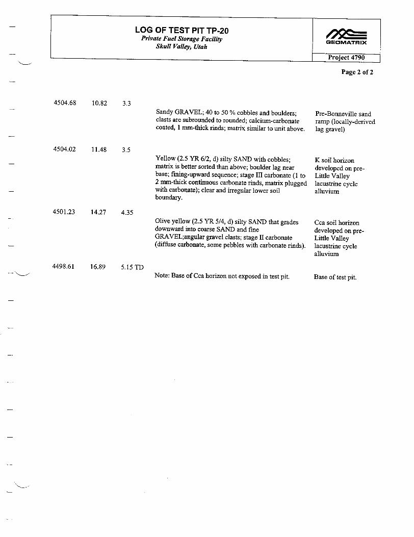
LOG OF TEST PIT TP-20 4 l Private Fuel Storage Facility GEOMATRIX
Skull Valley, Utah
Project 4790
Page 2 of 2
4504.68 10.82 3.3
4504.02 11.48 3.5
4501.23 14.27 4.35
4498.61 16.89 5.15TD
Sandy GRAVEL; 40 to 50 % cobbles and boulders; clasts are subrounded to rounded; calcium-carbonate coated, 1 mm-thick rinds; matrix similar to unit above.
Yellow (2.5 YR 6/2, d) silty SAND with cobbles; matrix is better sorted than above; boulder lag near base; fining-upward sequence; stage III carbonate (1 to 2 mm-thick continuous carbonate rinds, matrix plugged with carbonate); clear and irregular lower soil boundary.
Olive yellow (2.5 YR 5/4, d) silty SAND that grades downward into coarse SAND and fine GRAVEL;angular gravel clasts; stage II carbonate (diffuse carbonate, some pebbles with carbonate rinds).
Note: Base of Cca horizon not exposed in test pit.
Pre-Bonneville sand ramp (locally-derived lag gravel)
K soil horizon developed on preLittle Valley lacustrine cycle alluvium
Cca soil horizon developed on preLittle Valley lacustrine cycle alluvium
Base of test pit.
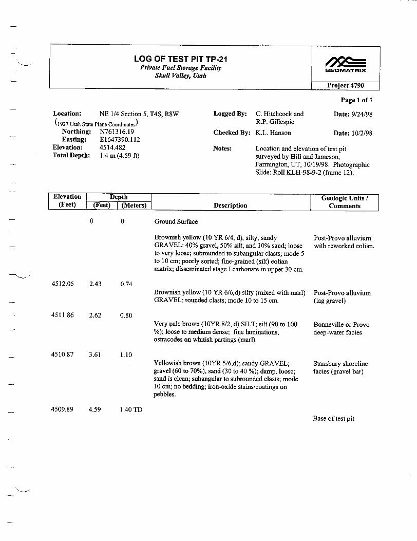
LOG OF TEST PIT TP-21 I ? = Private Fuel Storage Facility GEOMATRIX Skull Valley, Utah
Project 4790
Page 1 of 1
Location: NE 1/4 Section 5, T4S, R8W Logged By: C. Hitchcock and Date: 9/24/98 (1927 Utah State Plane Coordinates) R.P. Gillespie
Northing: N761316.19 Checked By: K.L. Hanson Date: 10/2/98 Easting: E1647390.112
Elevation: 4514.482 Notes: Location and elevation of test pit Total Depth: 1.4 m (4.59 ft) surveyed by Hill and Jameson,
Farmington, UT, 10/19/98. Photographic Slide: Roll KLH-98-9-2 (frame 12).
Elevation Depth Geologic Units (Feet) j(Feet) I(Metersý) Description - I Comments
0 0 Ground Surface
4512.05 2.43 0.74
4511.86 2.62 0.80
4510.87 3.61 1.10
Brownish yellow (10 YR 6/4, d), silty, sandy GRAVEL: 40% gravel, 50% silt, and 10% sand; loose to very loose; subrounded to subangular clasts; mode 5 to 10 cm; poorly sorted; fime-grained (silt) eolian matrix; disseminated stage I carbonate in upper 30 cm.
Brownish yellow (10 YR 6/6,d) silty (mixed with marl) GRAVEL; rounded clasts; mode 10 to 15 cm.
Very pale brown (1OYR 8/2, d) SILT; silt (90 to 100 %); loose to medium dense; fine laminations, ostracodes on whitish partings (marl).
Yellowish brown (IOYR 5/6,d); sandy GRAVEL; gravel (60 to 70%), sand (30 to 40 %); damp, loose; sand is clean; subangular to subrounded clasts; mode 10 cm; no bedding; iron-oxide stains/coatings on pebbles.
Post-Provo alluvium with reworked eolian.
Post-Provo alluvium (lag gravel)
Bonneville or Provo deep-water facies
Stansbury shoreline facies (gravel bar)
4509.89 4.59Base of test pit
1.40 TD

LOG OF TEST PIT TP-22 Private Fuel Storage Facility GEOMATRIX
Skull Valley, Utah
Project 4790
Page 1 of 1
Location: NE 1/4 Section 5, T4S, R8W Logged By: C. Hitchcock and Date: 9/24/98
(1927 Utah State Plane Coordinates) R.P. Gillespie
Northing: N761469.809 Checked By: K.L. Hanson Date: 10/2/98 Easting: E1647300.711
Elevation: 4512.137 Notes: Location and elevation of test pit Total Depth: 3.1 m (10.17 ft) surveyed by Hill and Jameson,
Farmington, UT, 10/19/98. Photographic Slide: Roll KLH-98-9-2 (frame 12).
Elevation Depth Geologic Units (Feet) (Feet) I (Meters) Description Comments
0 0 Ground Surface:
4510.107 2.03 0.62
4509.187 2.95 0.90
4507.377 4.76 1.45
Brownish yellow (10 YR 6/4,d) silty sandy GRAVEL; gravel (35%), silt ( 60 %), sand (5 %); subangular to subrounded clasts up to 10 cm; mode 7 cm; poorly sorted; irregular development of stage I carbonate in upper 30 cm.
Very pale brown (10YR 7/3, d) SILT; loose to medium dense; fine laminations; ostracodes on partings (marl).
Yellowish brown (10 YR 5/6, d) sandy GRAVEL; gravel (60 %), sand (40 %); poorly sorted with subrounded clasts to 20 cm, mode 10 %; sand is very clean with subrounded grains (beach sand); no bedding except hint of coarser layers.
Grayish brown (multi-colored) gravelly SAND; sand (80%), gravel (10 to 5 %), fines <3%,; subrounded clasts to 5 cm (pea-gravel); loose to very loose.
Alluvium and PostProvo eolian deposits
Bonneville or Provo deep-water facies
Stansbury shoreline facies (gravel bar)
Stansbury shoreline facies (Beach sand)
4506.757 5.38 1.64 TDBase of test pit

LOG OF TEST PIT TP-23 Private Fuel Storage Facility GBEOMATRIX
Skull Valley, Utah Project 4790
Page 1 of 1
Location: Hickman Knolls 7.5-minute Logged By: R.P. Gillespie Date: 10/19/98 quadrangle; NE 1/4, SW 1/4, Section 7, T5S, R8W
(1927 Utah State Plane Coordinates) Northing: N 753848.340 Checked By: K. L. Hanson Date: 11/27/98 Easting: E 1639488.617
Elevation: 4517.475 ft Notes: Location and elevation of test pit Total Depth: 2.79+m surveyed by Hill & Jameson, Farmington,
UT 10/19/98
Elevation Depth Geologic Units / (Feet) (Feet) I (Meters) Description Comments
4517.47 0 0
4514.31 3.16 0.96
Ground surface
Gravel; clean; bed appears to slope south Stansbury shoreline facies (cross valley gravel bar, upper)
4508.31 9.16+ 2.79+ Walls caved, exact depth not measured prior to caving Base of test pit TD

LOG OF TEST PIT TP-24 Private Fuel Storage Facility GEOMATRIX
Skull Valley, Utah Project 4790
Page 1 of 1
Location: Hickman Knolls 7.5-minute Logged By: R. P. Gillespie Date: 10/19/98
quadrangle NW 1/4, SE 1/4, Section 7, T5S, R8W
(1927 Utah State Plane Coordinates)
Northing: N 754012.158 Checked By: K. L. Hanson Date: 11/27/98 Easting: E 1640594.605
Elevation: 4518.184 ft Notes: Location and elevation of test pit Total Depth: >2.16 m (not measured) surveyed by Hill & Jameson, Farmington,
UT 10/19/98
Elevation Depth Geologic Units / (Feet) (Feet) I(Meters) Description Comments
4518.184 0
4516.024 2.16
0
0.66
Ground surface
Top of gravel Stansbury shoreline facies (cross valley gravel bar, upper)
Test pit was not deepened to determine the bottom of Base of test pit the gravel.
2.16+ 0.66+ TD
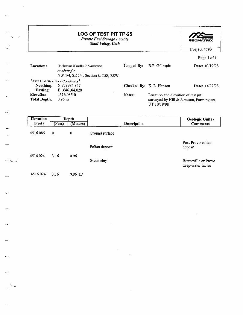
LOG OF TEST PIT TP-25 Private Fuel Storage Facility GEOMATRIX
Skull Valley, Utah
Project 4790
Page I of 1
Location: Hickman Knolls 7.5-minute Logged By: R.P. Gillespie Date: 10/19/98 quadrangle NW 1/4, SE 1/4, Section 8, T5S, R8W
(1927 Utah State Plane Coordinates) Northing: N 753984.847 Checked By: K. L. Hanson Date: 11/27/98 Easting: E 1646104.028
Elevation: 4516.085 ft Notes: Location and elevation of test pit Total Depth: 0.96 m surveyed by Hill & Jameson, Farmington,
UT 10/19/98
Elevation Depth Geologic Units / (Feet) (Feet) I (Meters) Description Comments
4516.085 0
4516.024 3.16
0 Ground surface
Eolian depositPost-Provo eolian deposit
Bonneville or Provo deep-water facies
0.96Green clay
4516.024 3.16 0.96 TD
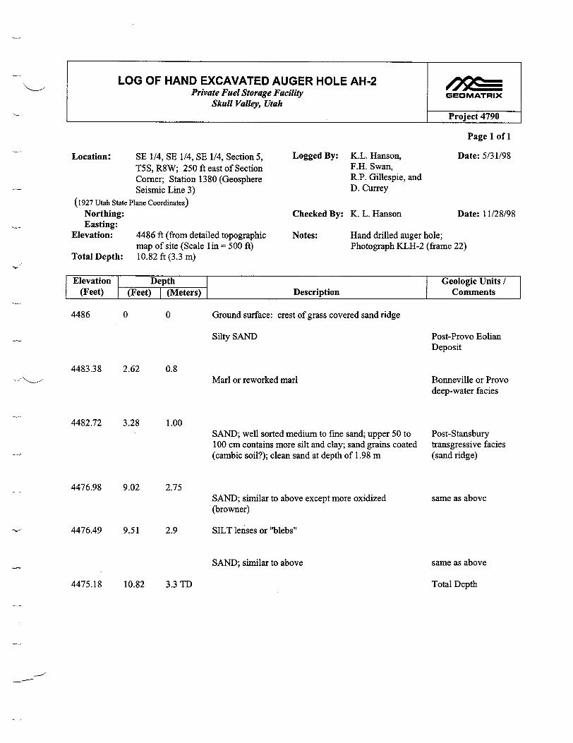
LOG OF HAND EXCAVATED AUGER HOLE AH-2 Private Fuel Storage Facility GEOMATRIX
Skull Valley, Utah Project 4790
Page 1 of 1
Location: SE 1/4, SE 1/4, SE 1/4, Section 5, Logged By: K.L. Hanson, Date: 5/31/98 T5S, R8W; 250 ft east of Section F.H. Swan, Comer; Station 1380 (Geosphere R.P. Gillespie, and Seismic Line 3) D. Currey
(1927 Utah State Plane Coordinates)
Northing: Checked By: K. L. Hanson Date: 11/28/98 Easting:
Elevation: 4486 ft (from detailed topographic Notes: Hand drilled auger hole; map of site (Scale lin = 500 ft) Photograph KLH-2 (frame 22)
Total Depth: 10.82 ft (3.3 m)
Elevation Depth Geologic Units / (Feet) (Feet) I (Meters) Description Comments
4486 0 0 Ground surface: crest of grass covered sand ridge
Silty SAND
4483.38 2.62 0.8Marl or reworked marl
4482.72 3.28 1.00
4476.98 9.02 2.75
SAND; well sorted medium to fine sand; upper 50 to 100 cm contains more silt and clay; sand grains coated (cambic soil?); clean sand at depth of 1.98 m
SAND; similar to above except more oxidized (browner)
Post-Provo Eolian Deposit
Bonneville or Provo deep-water facies
Post-Stansbury transgressive facies (sand ridge)
same as above
4476.49 9.51 2.9 SILT lenses or "blebs"
SAND; similar to above same as above
Total Depth4475.18 10.82 3.3TD
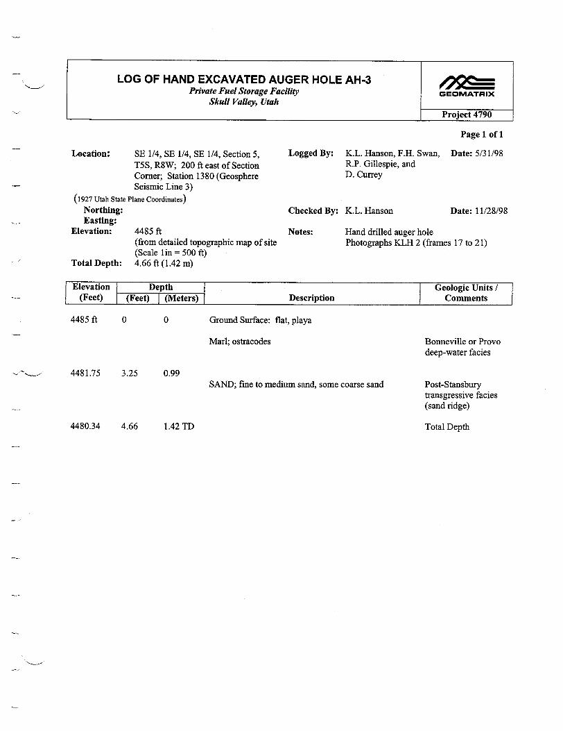
LOG OF HAND EXCAVATED AUGER HOLE AH-3 Private Fuel Storage Facility GEOMATRIX
Skull Valley, Utah
Project 4790
Page 1 of 1
Location: SE 1/4, SE 1/4, SE 1/4, Section 5, Logged By: K.L. Hanson, F.H. Swan, Date: 5/31/98 T5S, R8W; 200 ft east of Section R.P. Gillespie, and Comer; Station 1380 (Geosphere D. Currey Seismic Line 3)
(1927 Utah State Plane Coordinates)
Northing: Checked By: K.L. Hanson Date: 11/28/98 Easting:
Elevation: 4485 ft Notes: Hand drilled auger hole (from detailed topographic map of site Photographs KLH 2 (frames 17 to 21) (Scale 1in = 500 ft)
Total Depth: 4.66 ft (1.42 m)
Elevation I Depth Geologic Units (Feet) (Feet) I(Meters) Description Comments
4485 ft 0 0 Ground Surface: flat, playa
Marl; ostracodes
4481.75 3.25 0.99SAND; fine to medium sand, some coarse sand
Bonneville or Provo deep-water facies
Post-Stansbury transgressive facies (sand ridge)
4480.34 4.66 1.42 TD Total Depth

East
3 4 5 6 7 8
D Distance (meters)
9 10 I
11 12 1
13 1
14 1
15 1
16 1
APERTURE CARD
17 1
1369- 4490
'-.
0 E
13681367
1366
1365
1364
1363
1362
1361-
4480
Q)
SC
4470 .2
w
1360+ 4460
1359
1358-
1357-L 44501357--- 4450
EXPLANATION
UNIT DESCRIPTIONS
POST-PROVO PLAYA DEPOSIT Brownish yellow (10yr 6/6) with (gley 5g 8/1) mottles; clayey silt(ml); damp; carbonate;
soft; silt (90 %), clay (10 %); fine laminations (1 to 4 mm thick)
I I SOIL FORMED ON POST-PROVO EOLIAN DEPOSIT Pale yellow (2.5y 8/4) silty sand similar to underlying unit; stage I to I1? carbonate; blocky structure, platey
II POST-PROVO EOLIAN DEPOSIT Brownish yellow (10yr 6/6) silty sand (ml); dry; loose; sand (85%), silt (15 %); fine to very fine, minor mafics, quartz; well-sorted?
I I SHORELINE PROVO RECESSIONAL (?) DEPOSIT Very pale brown (10yr 8/2) silty sand (sm); dry; very loose; sand (80%), silt (20%); subrounded; fine to very fine; well sorted
BONNEVILLE OR PROVO DEEP-WATER FACIES Yellow (10yr 7/8) sandy, clayey silt (ml); dry; loose to medium dense; varying sand
and clay content; laminations; small gastropod shells
I I STANSBURY SHORELINE OR POST-STANSBURY TRANSGRESSIVE FACIES (SAND RIDGE) Very pale brown (10yr 8/2) silty sand (ml); dry; very loose; sand (95%), <5% clastics and clay; fine to very fine; well sorted; >75% shell fragments
-- !5ýr Cross bedding
K Krotovina (filled animal burrows)
9c0 222004 6 -01
Note:
Location of test pit shown on Plate 1.
MAP OF NORTH WALL TEST PIT TP-1 1
Private Fuel Storage Facility Skull Valley, Utah
GEOMATRIX
Project No. 4790
Figure C-1
West
0 I
1369 -F4490
2
4480
4470 .2
1368
1367
1366
1365
1364
1363
1362
1361
1360-
F
E 0) t0
C)w
- 4460fine thin beds
1359-
1358-
O LC)
0,0�
0) 0) 04���
40 'Co.
Location: Hickman Knolls 7.5-minute quadrangle Lcgged By: C. Hitchcock and Date: 9/21/98 SE 1/4, SE 1/4, SE 1/4, T5S, R8W R. P. Gillespie
(1927 Utah State Plane Coordinates) Checked By: K. L. Hanson Date: 9/23/98
Lat: N 757280 (east end) Notes: Location and elevation of test pit
Long: E 1642708 (east end) surveyed by Hill & Jameson, Farmington, UT 9/22/98
Elevation: 4486 ft (east end)
Total Depth: see log
I
}
==

-4---- N85*E A E 01 2 3 4 5 6 7 IIII I II
Distance (meters) EXPLANATION Ab b"11
1377 UNIT DESCRIPTIONS
_Projected ground surface
I I POST-PROVE SAND RAMP DEPOSITS 4515 Brownish yellow (10yr 6/6 dry) silty fine sand; occasional subrounded to rounded
pebbles up to 2 to 3 cm; a few discontinuous pebbly sand lenses; gravelly near base with cobbles and boulders up to 10 to 20 cm common
-1376
STANSBURY NEAR-SHORE BAR/BEACH DEPOSIT ~ Sandy gravel; poorly sorted; subangular to well-rounded pebbles in a sandy matrix;
carbonate rinds up to 1 mm on the bottoms of clasts; elevation 4508 ft. (1374.4 m)
bE I PRE-STANSBURY BURIED PALEOSOL (PROMONTORY SOIL?) o450 1375 c
4510.17 DEVELOPED ON SHEAR ZONE
Very pale brown (10yr 8/3 dry) stage II to III carbonate; weak platey strcture locally; ,-C> nearly continuous rinds on clasts and matrix plugged with carbonate
II SHEAR ZONE 1374 Sheared and brecciated dolomite (paleozoic) includes blocks of tuffaceous siltstone
1374 '•. (indicated by T); derived from Tertiary Salt Lake Formation; more numerous and
larger blocks (up to 0.5m in width) observed in north wall of test pit. Numerous silica-carbonate filled fractures
4505N5W to N10E;85
BEDROCK (PALEOZOIC)
1373[Very dark gray to black brecciated dolomite; similar to rocks that crop out in
Hickman Knolls to the east of TP-1 2
- - - - Sharp lithologic contact
Clear soil boundary (gradational over a 2.5- to 6-cm-wide interval)
Prominent silica-carbonate filled fracture
Notes: Location: Hickman Knolls 7.5-minute quadrangle Logged By: K.L. Hanson and Date: 9/21/98 9 9 02 22 0O4•---D
NW 1/4, NE 1/4, SW1/4 F. H. Swan Section 7, T5S, P8W n1 Detached dolomite boulder.
(1927 Utah State Plane Coordinates) Date: 9/25/98 n2 Mullion structure and grqove lineations plunging steeply south. SZ, •o(1927Utah tate lane oordiates)Checked By: M. AngellDae 9258
o Let: N 754383 Notes: Location and elevation of test pit Location of test pit shown on Plate 1. Long: E 1641960 surveyed by Hill & Jameson,
Farmington, UT 9/22/98 F, Elevation: 4516.2 ft (east end) 00-a
Total Depth: 7 m (23 ft) MAP OF SOUTH WALL 7M oTEST PIT 12
Private Fuel Storage Facility "Skull Valley, Utah
Project No. Figure
GEOMATRIX 4790 C-2

GEOMATRIX
APPENDIX D
GEOCHRONOLOGY REPORTS (TEPHRACHRONOLOGY AND RADIOCARBON ANALYSIS)

Michael E. Perkins Dept. of Geology and Geophysics
135 S. 1460 E. Room 719 University of Utah
Salt Lake City, UT 84112-0111
7 December 1998
Katheryn Hanson Principal Geologist Geomatrix Consultants 100 Pine Street, 10th Floor San Francisco, CA 94111
Dear Katheryn:
As requested, I analyzed glass shards from four samples of vitric tuffs collected from Skull Valley, UT. Sample ID's are trl-i, 2, 3 and 4. The samples were analyzed on the Cameca SX-50 microprobe at the Dept. of Geology and Geophysics, University of Utah. General procedures for sample preparation and analyses are described in Perkins et al. (1995). The analyses for these samples were compared with those in an extensive database of analyses/stratigraphic data/age dates for late Cenozoic vitric tephra layers (•16 Ma) in the Western U. S. This database has been assembled by myself and several colleagues at the Department of Geology and Geophysics. Some of the key tephra layers in this database are described in published papers (Perkins et al., 1995 and 1998; Williams, 1994). The analyses of your samples and those of the most similar samples in the Univ. of Utah tephra database are given in enclosed tables. The correlations of the four samples are discussed below.
Samples trl-l, 2, and 3 gray vitric tuffs. These three samples are compositionally identical (within measurement error) as is clear from both the analyses of individual shards (Table 1) and the mean composition of the shards from each sample (Table 2). The trl-1/2/3 ash bed, here termed the Skull Valley ash bed, does not match to any sample in our database. It most closely resembles a tuff in the Salt Lake Fm in the Cache Valley, UT area (Table 3a). An analysis of this ash bed (cvl 2 -20-6pg) is included in Table 2 for reference. The Salt Lake Fm. in the Cache Valley area was deposited in the interval 11-5 Ma (Perkins, unpublished data). The Skull Valley ash does not closely resemble any Quaternary ash bed in our database (Table 3a) so, I conclude that the Skull Valley ash bed is most likely an ash bed in the Salt Lake Fm. Regionally the Salt Lake Formation ranges in age from -16 to 4 Ma.
Sample trl-4 is white biotite bearing ash bed. It is a good compositional match to two -15.4 Ma ash beds in the Rio Grande Rift north of Santa Fe, New Mexico (samples rg-18 and rg-143), as well as several other similar, middle Miocene ash beds in the Rio Grande Rift. The match between trl-4 and both rg-18 and rg-143 is clear by the visual comparison of the analyses (Table'2), the plot of Fe vs. Ca (Fig. 1), and the value of the distance function, D, between these two samples (Tables 3b). As discussed in Perkins et al. (1995; 1998) we expect DR3.8 (for a seven element comparison) between two compositionally identical samples.
The possible match of a sample with two or more different ash beds is not uncommon when using probe analyses for correlations. As noted by Perkins et al. (1998) such correlations are not definitive. However, the results discussed above are consistent with the conclusion that samples tr- 1, 2, 3, and 4 are middle to late Miocene in age and are part of the Salt Lake Fm. Furthermore, there is no reason to believe that they are Quaternary tuffs.
If it is important to more precisely delimit the age of these tuffs, I can analyze tr 1-4 together with its likely correlatives by the XRF method. This would provide a more definitive test the possible correlation between these two samples (Perkins et al., 1998). Note however, that three or more samples need to be analyzed (at least trl-4, rg-18, and rg-143). Since sample preparation for XRF analyses are laborious, and my time for such work is limited, I will be unable to do them until after the first of next year. If you have questions concerning any of the above or the enclosed invoice for the electron probe analyses, please contact me at your convenience.
Regards,
Michael E. Perkins 801-581-6552 (office) [email protected]
2
Table 1. Electron probe microanalyses of individual glass shards from Skull Valley ash bed samples'.
Samples SiO2 TiO2 A120, Fe2032 MnO MgO CaO BaO Na.O K(O Cl F -0 H20 Sum
tM-1 71.3 0.17 12.5 1.73 .103 0.04 0.47 0.00 3.4 5.3 0.20 0.23 0.14 5.0 100.3 trl-1 70.6 0.12 12.4 1.67 .110 0.03 0.47 0.00 3.4 5.1 0.18 0.26 0.15 5.8 100.0 trl-1 70.4 0.10 12.3 1.70 .071 0.04 0.45 0.01 3.4 5.1 0.16 0.27 0.15 6.1 99.9 tr-1i 70.9 0.10 12.4 1.73 .081 0.05 0.47 0.00 3.2 5.3 0.17 0.26 0.15 5.4 99.9 trl-1 71.1 0.09 12.4 1.70 .071 0.05 0.47 0.00 3.3 5.2 0.15 0.29 0.16 5.2 99.9 tri-1 70.9 0.17 12.3 1.67 .072 0.04 0.44 0.00 3.5 5.2 0.14 0.28 0.15 5.6 100.2 tri-1 70.7 0.08 12.5 1.66 .069 0.04 0.46 0.00 3.4 4.9 0.14 0.31 0.16 7.2 101.3 tri-1 70.9 0.05 12.2 1.59 .092 0.04 0.47 0.04 3.4 4.8 0.17 0.24 0.14 6.0 99.9 tri-1 70.8 0.09 12.3 1.60 .077 0.05 0.49 0.00 3.5 4.9 0.18 0.33 0.18 6.3 100.4 tri-1 71.3 0.08 12.3 1.69 .074 0.05 0.47 0.03 3.1 5.4 0.16 0.23 0.13 5.7 100.5 trl-1 70.9 0.11 12.6 1.69 .081 0.03 0.44 0.02 3.4 5.7 0.19 0.32 0.18 5.0 100.3 trl-1 70.6 0.06 12.5 1.64 .099 0.05 0.47 0.00 3.3 4.9 0.18 0.33 0.18 6.8 100.7 trl-1 70.6 0.06 12.3 1.74 .111 0.05 0.46 0.00 3.3 5.0 0.16 0.25 0.14 7.1 101.0 tri-1 70.7 0.14 12.3 1.70 .096 0.04 0.45 0.00 3.8 5.2 0.19 0.29 0.17 5.5 100.2 tri-1 71.1 0.11 12.3 1.82 .089 0.03 0.44 0.00 3.2 5.4 0.17 0.30 0.16 5.1 99.9 1r0-1 70.8 0.10 12.3 1.68 .062 0.04 0.47 0.04 3.0 5.5 0.18 0.24 0.14 5.3 99.6 tri-1 70.7 0.09 12.4 1.63 .076 0.04 0.46 0.00 3.1 5.4 0.18 0.22 0.13 6.1 100.3 trl-1 70.9 0.11 12.4 1.72 .053 0.03 0.45 0.00 3.5 4.6 0.18 0.20 0.12 6.9 100.9 tri-1 71.1 0.14 12.4 1.66 .086 0.03 0.46 0.00 3.7 4.9 0.17 0.25 0.14 5.3 100.1 tri-1 70.9 0.12 12.3 1.67 .082 0.05 0.49 0.00 3.5 5.2 0.18 0.35 0.19 5.0 99.6 tri-1 70.5 0.12 12.4 1.73 .077 0.03 0.47 0.00 3.2 5.0 0.18 0.24 0.14 5.9 99.7 tri-1 70.7 0.07 12.2 1.58 .107 0.05 0.47 0.02 3.6 5.1 0.17 0.33 0.18 5.8 100.0 tr1l-2 71.1 0.07 12.4 1.68 .047 0.05 0.45 0.00 3.4 5.1 0.16 0.33 0.18 5.2 99.8 trl-2 70.9 0.12 12.3 1.65 .076 0.05 0.45 0.04 3.4 5.2 0.16 0.31 0.17 5.4 99.9 trl-2 71.1 0.07 12.3 1.70 .066 0.04 0.50 0.00 3.4 5.1 0.18 0.29 0.16 4.0 98.6 trl-2 70.8 0.09 12.2 1.71 .085 0.04 0.46 0.00 3.4 5.0 0.18 0.32 0.18 6.3 100.4 trl-2 70.6 0.13 12.3 1.51 .101 0.03 0.46 0.00 3.3 4.9 0.18 0.28 0.16 7.1 100.7 trl-2 70.8 0.09 12.3 1.73 .086 0.04 0.45 0.00 3.4 5.0 0.17 0.35 0.19 7.0 101.2 trl-2 70.5 0.12 12.4 1.65 .067 0.04 0.46 0.00 3.4 5.1 0.18 0.31 0.17 6.9 101.0 trl-2 70.8 0.12 12.4 1.64 .085 0.04 0.52 0.00 3.4 5.2 0.18 0.34 0.18 5.9 100.4 trl-2 70.9 0.12 12.4 1.71 .054 0.04 0.49 0.00 3.8 4.9 0.14 0.34 0.18 5.5 100.2 Irl-2 70.4 0.08 12.3 1.73 .074 0.05 0.46 0.00 3.5 5.0 0.18 0.32 0.17 6.8 100.7 trl-2 71.1 0.11 12.3 1.60 .074 0.05 0.48 0.00 3.3 5.0 0.17 0.26 0.15 6.7 101.0 trl-2 71.1 0.08 12.3 1.70 .053 0.04 0.49 0.00 3.4 5.2 0.17 0.25 0.14 5.6 100.2 trl-2 71.1 0.09 12.5 1.73 .090 0.04 0.47 0.00 3.3 5.1 0.19 0.31 0.17 5.3 100.0 trl-2 70.7 0.10 12.3 1.65 .048 0.05 0.46 0.00 3.3 4.9 0.18 0.28 0.16 6.6 100.4 tr1l-2 70.9 0.12 12.4 1.61 .069 0.01 0.46 0.00 3.7 4.9 0.16 0.26 0.15 5.1 99.5 trl-2 70.8 0.07 12.4 1.61 .098 0.04 0.48 0.00 3.5 5.1 0.17 0.31 0.17 6.3 100.7 trl-2 71.1 0.08 12.5 1.72 .083 0.05 0.47 0.00 3.3 5.5 0.19 0.30 0.17 4.4 99.5 trl-2 70.7 0.13 12.3 1.64 .098 0.04 0.48 0.00 3.2 4.7 0.19 0.32 0.18 7.1 100.7 tr1l-2 71.0 0.05 12.3 1.63 .085 0.05 0.47 0.00 3.4 5.2 0.17 0.30 0.16 5.7 100.2 trl-2 71.4 0.08 12.3 1.58 .149 0.04 0.49 0.02 3.4 5.2 0.19 0.29 0.16 4.7 99.7 trl-2 70.8 0.12 12.3 1.67 .063 0.04 0.49 0.00 3.4 4.9 0.16 0.28 0.15 7.0 101.1 tr1l-2 70.4 0.07 12.3 1.62 .088 0.05 0.46 0.07 3.5 5.0 0.18 0.26 0.15 6.3 100.2 trl-3 70.6 0.15 12.2 1.63 .066 0.05 0.46 0.00 3.4 4.9 0.18 0.19 0.12 5.1 98.8 trl-3 70.4 0.13 12.2 1.61 .086 0.03 0.47 0.00 3.4 5.6 0.16 0.17 0.11 5.5 99.6 trl-3 70.7 0.12 12.3 1.67 .075 0.03 0.46 0.00 3.3 5.1 0.17 0.23 0.14 5.4 99.4 trl-3 70.6 0.08 12.3 1.65 .105 0.05 0.48 0.00 3.3 5.4 0.14 0.30 0.16 6.2 100.4 trl-3 70.3 0.06 12.2 1.71 .073 0.05 0.46 0.00 3.3 5.3 0.18 0.24 0.14 6.3 100.0 tr1l-3 71.4 0.10 12.3 1.74 .076 0.06 0.49 0.00 3.5 4.7 0.19 0.26 0.15 5.5 100.2 trl-3 71.2 0.06 12.3 1.65 .096 0.07 0.46 0.00 3.3 5.1 0.18 0.33 0.18 5.5 100.1 trl-3 71.5 0.06 12.4 1.61 .080 0.05 0.45 0.00 3.6 5.0 0.19 0.31 0.17 4.9 100.0 trl-3 70.8 0.05 12.4 1.74 .081 0.05 0.47 0.02 3.4 5.2 0.15 0.29 0.16 5.7 100.2 trl-3 71.3 0.09 12.5 1.69 .044 0.03 0.45 0.00 3.6 5.1 0.18 0.30 0.17 5.3 100.4 tr1-3 71.0 0.11 12.2 1.66 .066 0.03 0.45 0.00 3.0 5.3 0.17 0.28 0.16 5.7 99.8 trl-3 71.6 0.15 12.4 1.55 .061 0.04 0.46 0.00 3.2 5.3 0.18 0.25 0.15 4.6 99.6 tr1-3 70.9 0.11 12.3 1.74 .066 0.05 0.49 0.00 3.5 5.1 0.19 0.25 0.15 5.0 99.5 tr1-3 71.2 0.08 12.4 1.74 .063 0.05 0.46 0.00 3.5 5.2 0.16 0.34 0.18 5.7 100.7 trl-3 71.3 0.10 12.3 1.60 .048 0.04 0.48 0.02 3.6 5.3 0.20 0.26 0.15 5.0 100.1 trl-3 71.3 0.11 12.3 1.67 .053 0.07 0.46 0.00 3.3 5.2 0.18 0.19 0.12 4.8 99.5 trl-3 70.9 0.13 12.4 1.65 .087 0.05 0.46 0.00 3.4 5.2 0.18 0.31 0.17 5.3 99.9 trl-3 71.0 0.10 12.3 1.74 .076 0.04 0.47 0.00 3.6 4.6 0.15 0.31 0.16 6.4 100.6 tr1l-3 70.7 0.12 12.4 1.68 .091 0.04 0.47 0.00 3.5 5.0 0.20 0.27 0.16 5.1 99.4 tr1l-3 71.0 0.10 12.3 1.63 .097 0.05 0.48 0.01 3.5 4.8 0.19 0.28 0.16 6.5 100.8 trl-3 71.0 0.06 12.3 1.71 .051 0.07 0.46 0.03 3.4 5.0 0.16 0.35 0.18 4.6 99.0 trtl-3 70.9 0.10 12.3 1.72 .119 0.05 0.48 0.00 3.5 4.9 0.17 0.37 0.19 5.8 100.2 trl-4 72.3 0.19 11.6 0.79 .019 0.06 0.50 0.00 3.0 5.4 0.16 0.33 0.18 5.2 99.4 trl-4 72.6 0.15 11.8 0.76 .061 0.05 0.52 0.00 2.8 5.2 0.12 0.38 0.19 5.7 100.0 tr1-4 72.7 0.15 11.6 0.78 .084 0.06 0.48 0.01 2.9 5.2 0.13 0.36 0.18 4.8 99.1 trl-4 72.7 0.07 11.8 0.82 .042 0.07 0.49 0.00 2.8 5.5 0.14 0.34 0.17 4.9 99.5 trl-4 73.4 0.14 11.8 0.71 .058 0.05 0.50 0.00 2.8 5.3 0.13 0.39 0.19 5.0 100.1 tr1l-4 72.9 0.17 11.7 0.74 .019 0.06 0.49 0.00 2.9 5.4 0.13 0.44 0.21 4.9 99.6 trl-4 72.9 0.10 11.7 0.76 .043 0.06 0.49 0.00 2.8 5.3 0.13 0.36 0.18 5.6 100.1 tr1-4 72.8 0.11 11.7 0.77 .108 0.04 0.52 0.00 2.8 5.5 0.16 0.31 0.17 4.6 99.3 trl-4 73.3 0.09 11.8 0.75 .058 0.04 0.51 0.00 2.9 5.0 0.14 0.36 0.18 5.7 100.5 Irl-4 73.4 0.12 11.9 0.83 .051 0.04 0.49 0.00 3.0 5.1 0.13 0.35 0.18 4.7 99.9 trl-4 72.9 0.07 11.6 0.81 .075 0.06 0.51 0.00 2.7 5.1 0.15 0.40 0.20 5.7 99.9 trl-4 73.5 0.11 11.7 0.75 .056 0.03 0.47 0.00 3.1 5.1 . 0.14 0.44 0.22 5.0 100.2 trl-4 73.2 0.12 11:9 0.75 .025 0.05 0.51 0.00 3.1 5.4 0.15 0.32 0.17 3.7 99.1 trl-4 72.8 0.16 11.8 0.75 .042 0.06 0.50 0.00 3.0 5.3 0.13 0.37 0.19 5.4 100.1 tr1-4 72.7 0.13 11.9 0.74 .090 0.04 0.49 0.03 2.8 5.1 0.13 0.40 0.20 5.5 99.8 tr1-4 73.1 0.14 11.9 0.78 .079 0.05 0.49 0.01 2.8 5.3 0.16 0.42 0.21 5.7 100.7 trl-4 73.0 0.09 11.7 0.77 .081 0.04 0.49 0.00 2.8 5.3 0.13 0.41 0.20 5.9 100.5 rl -4 72.6 0.09 11.7 0.82 .016 0.08 0.49 0.00 2.8 5.4 0.13 0.30 0.16 5.5 99.8 trl-4 73.0 0.14 11.8 0.82 .033 0.04 0.51 0.00 2.8 5.0 0.15 0.40 0.20 5.1 99.6 trl-4 72.9 0.14 11.7 0.84 .099 0.06 0.51 0.01 2.8 5.0 0.15 0.41 0.21 4.9 99.3 trl-4 72.9 0.13 11.8 0.74 .084 0.05 0.51 0.00 3.0 5.2 0.14 0.30 0.16 4.8 99.5 trl-4 73.1 0.11 11.7 0.81 .053 0.04 0.48 0.00 2.8 5.3 0.14 0.35 0.18 5.4 100.1 1. All analytical concentrations In wt%. 2. Total Fe as Fe2O3.
Table 2. Averages of electron probe microanalyses of glass shards from Skull Valley, UT ash bed samples and some similar ash bed samples from other areas
Samples' n2
SiC 2 "10,' AI10 Fe2O04 MnO MgO CaO BaO Na2O K20 Cl F H20 -0 Sum
[.5r [.011 [.2] [.03] [.005] [.01] [.02] [.02] [.2] [.3] [.004] [.03] [1.0] [.03] [1.0]
tr1-1 22 70.8 0.10 12.4 1.68 0.083 0.04 0.46 0.01 3.4 5.1 0.17 0.27 5.8 0.15 100.2 trl-2 22 70.9 0.10 12.3 1.66 0.079 0.04 0.47 0.01 3.4 5.0 0.17 0.30 6.0 0.17 100.3 trl-3 22 71.0 0.10 12.3 1.67 0.075 0.05 0.47 0.00 3.4 5.1 0.17 0.28 5.5 0.16 100.0 cv 12-20-6pg 20 70.9 0.11 12.5 1.56 0.076 0.05 0.53 0.00 2.9 5.7 0.18 0.31 5.0 0.18 99.64 trl-4 22 72.9 0.12 11.8 0.78 0.058 0.05 0.50 0.00 2.9 5.2 0.14 0.37 5.2 0.19 99.8 rg- 18 20 72.5 0.12 11.7 0.77 0.054 0.06 0.48 0.04 2.4 6.3 0.14 0.11 5.4 0.08 100.0 rg-143 20 73.3 0.12 11.8 0.83 0.050 0.06 0.51 0.03 2.3 6.0 0.14 0.13 4.6 0.09 99.8 Walcott ash bed 20 74.1 0.18 11.5 1.21 0.040 0.08 0.48 0.10 3.3 5.1 0.10 0.09 3.3 0.06 99.3
1. The "trl" samples are from Skull Valley, UT. The "cv' sample is from the Cache Valley, UT area. The "rg" samples are from the Rio Grande Rift, New Mexico. The Walcott ash bed sample Is from the type section near American Falls, ID. 2. Number of analyzed glass shards. Analyses are average concentrations. 3. Oxides/elements highlighted with bold font are used in comparison of samples and calculation of D values. 4. Total Fe as Fe,03. 5. Alkalies are subject to cation exchange with groundwater so measured concentrations do not reflect original concentrations. 6. Estimated precision of average concentrations.
Table 3a. Comparison of sample tr 1-I with other database samples
Sample' D Age
trl-I3 0.0
trl-2 1.3 trl-3 1.5 cv12-20-6pg 6.0 L-Miocene
I. All database samples with D<6.0 are listed in table.
2. D is a measure of the compositional distance between comparison sample (trl-l) and listed samples (Perkins ct al., 1995). TiO2, Al203' FeO3 MnO, MgO, CaO, and CI used for comparisons. D = 0 indicates exactly identical composition. Samples with D ! 3.8 are statistically identical.
3. Samples with D 5 3.8 are highlighted with boldface font.
Table 3b. Comparison of Sample trl-4 with other database samples
Sample D Age
trl-4 0.0 rg- 18 1.5 m. Miocene rg-143 2.2 m. Miocene rg-139 2.5 m. Miocene don95-769 3.5 Oligocene cov95-852 3.5 m. Miocene cmt-4 4.1 m. Miocene cmt-64 4.1 m. Miocene rg-135 4.2 m. Miocene rg-164 4.3 m. Miocene rg-151 4.6 m. Miocene rg- 42 4.7 m. Miocene rg- 20 4.7 m. Miocene sor2850-11 4.8 Pliocene bur94-622 4.9 m. Miocene rg- 62white 5.0 m. Miocene rg- 40whlte 5.1 m. Miocene r9- 15 5.4 m. Miocene 971005A 5.5 m. Miocene as89-40 5.6 m. Miocene cov95-842 5.7 I. Miocene sv93-290 5.9 m. Miocene 190-7 5.9 m. Miocene JPUNM-1O-dac 6.0 Pliocene
Note: Explanation as in footnotes of Table 3a.

Figure la. Fe vs. Ca for Skull Valley ash bed and similar ash bed in Cache Valley, UT
0.5 1.0
0
A E3
0
cv 12-20-6pg
trl-3
trl-2
trl-1
1.5
Fe
Figure lb. Fe vs. Ca for ash bed trl-4 and compositionally similar ash beds.
1.0
0 rg-18
A rg-143 ° trl-4
+ cov95-852
1.5
0.6
0.4
tC
0.2
0.0 0.0
0.
0.
0
3+ 6-!
4-4 4.
2
0
0.
0.0.0 0.5
Fe

BETA ANALYTIC INC. RADIOCARBON DATING SERVICES
Mr. DARDEN G. HOOD RONALD E. HATFIELD rector Laboratory Manager
CHRISTOPHER PATRICK TERESA A. ZILKO-MILLER
Associate ManaQers
January 4, 1999
Mr. Donald L. Wells/F. Swan Geomatrix Consultants 100 Pine Street, 10th Floor San Francisco, CA 94111
Dear Mr. Wells and Mr. Swan:
Please find enclosed the radiocarbon dating results for two samples of carbonate sediment (4790/FS-1aITP-7 and 4790/FS-lb/TP-7) which were submitted on December 17 for analysis on the ADVANCE delivery basis. They were both very small, requiring us to convert the sample carbon to graphite and then to count the radiocarbon atomically using an accelerator mass
-- spectrometer (AMS). They each provided plenty of carbon for reliable measurements and all analytical steps went normally. The quoted errors represent 1 sigma statistics. Since these errors cannot include uncertainties outside of those which can be quantified during measurement, it is best to consider them as minimum quotes.
Literature discussing the generalities of analysis and calendar calibration are enclosed. The "Analytical Procedures and Final Report" discussion should answer most questions about the report and results. If you have any specific questions, please do not hesitate to contact us.
When reporting the results, you should designate the radiocarbon "BP" ages as the "Conventional Radiocarbon Age", quote the measured C13/C12 ratios and note that the dates were done at Beta Analytic. Calendar calibrated results are not enclosed as the results were beyond the calendar calibration range.
Our invoice is enclosed. Please, immediately give it to the appropriate office for prompt payment or send VISA charge authorization. Thank you.
Snerely, 4 0P)
4985 S.W. 74 COURT, MIAMI, FL 33155 U.S.A. "TELEPHONE: 305-667-5167 / FAX: 305-663-0964 / INTERNET: [email protected]
WEB SITE: http://www.radiocarbon.com
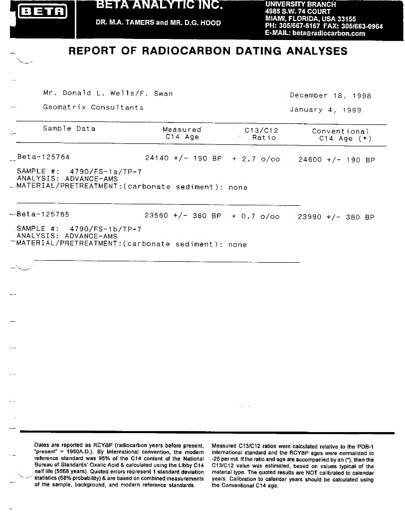
ýBETR-j
REPORT OF RADIOCARBON DATING ANALYSES
Mr. Donald L. Wells/F. Swan
Geomat r i x Consultants
December 18, 1998
January 4, 1999
Sample Data Measured C13/C12 Conventional C14 Age Ratio C14 Age (*)
Beta-125764 24140 +/- 190 BP + 2.7 o/oo 24600 +/- 190 BP
SAMPLE #: 4790/FS-la/TP-7 ANALYSIS: ADVANCE-AMS MATERIAL/PRETREATMENT:(carbonate sediment): none
-Beta-1 25765 23560 +/- 380 BP + 0.7 o/oo 23990 +/- 380 BP
SAMPLE #: 4790/FS-lb/TP-7 ANALYSIS: ADVANCE-AMS -MATERIAL/PRETREATMENT:(carbonate sediment):
Dates are reported as RCYBP (radiocarbon years before present, "present" = 1950A.D.). By International convention, the modern reference standard was 95% of the C14 content of the National Bureau of Standards' Oxalic Acid & calculated using the Libby C14 nalf life (5568 years). Quoted errors represent 1 standard deviation "statistics (68% probability) & are based on combined measurements of the sample, background, and modern reference standards.
Measured C13/C12 ratios were calculated relative to the PDB-1 international standard and the RCYBP ages were normalized to -25 per mil. If the ratio and age are accompanied by an (*), then the C13/C12 value was estimated, based on values typical of the material type. The quoted results are NOT calibrated to calendar years. Calibration to calendar years should be calculated using the Conventional C14 age.
none
-1 -=A A NIP - INC-. 495SW 7OR
DR. M.. TAM RS an MR. .G. H OD PH 301 756 FAX 35 /66306
BETA ANALYTIC INC. RADIOCARBON DATING SERVICES
Mr. DARDEN G. HOOD RONALD E. HATFIELD Director Laboratory Manager
CHRISTOPHER PATRICK ANALYTICAL PROCEDURES AND FINAL REPORT TERESA A. ZILKO-MILLER
Associate Managlers
FINAL REPORT
This package includes the final date report, this statement outlining our analytical procedures, a glossary of pretreatment terms, calendar calibration information, billing documents (containing balance/credit information and the number of samples submitted within the yearly discount period), and peripheral items to use with future submittals. The final report includes the individual analysis method, the delivery basis, the material type and the individual pretreatments applied. Please recall any correspondences or communications we may have had regarding sample integrity, size, special considerations or conversions from one analytical technique to another (e.g. radiometric to AMS). The final report has also been sent by fax or e-mail, where available.
PRETREATMENT
Results were obtained on the portion of suitable carbon remaining after any necessary chemical and mechanical pretreatments of the submitted material. Pretreatments were applied, where necessary, to isolate 4̀C which may best represent the time event of interest. Individual pretreatments are listed on the report next to each result and are defined in the enclosed glossary. When interpreting the results, it is important to consider the pretreatments. Some samples cannot be fully pretreated making their 14C ages more subjective than samples which can be fully pretreated. Some materials receive no pretreatments. Please read the pretreatment glossary.
ANALYSIS
Materials measured by the radiometric technique were analyzed by synthesizing sample carbon to benzene (92% C), measuring for "4C content in a scintillation spectrometer, and then calculating for radiocarbon age. If the Extended Counting Service was used, the '4C content was measured for a greatly extended period of time. AMS results were derived from reduction of sample carbon to graphite (100 %C), along with standards and backgrounds. The graphite was then sent for 14C measurement in an accelerator-mass-spectrometer located at one of six collaborating research facilities, who return the results to us for verification, isotopic fractionation correction, calendar calibration, and reporting.
THE RADIOCARBON AGE AND CALENDAR CALIBRATION
The "Conventional C14 Age (*)" is the-result after applying C13/C12 corrections to the measured age and is the most appropriate radiocarbon age (the "*" is discussed at the bottom of the final report). Applicable calendar calibrations are included for organic materials and fresh water carbonates between 0 and 10,000 BP and for marine carbonates between 0 and 8,300 BP. If certain calibrations are not included with this report, the results were either too young, too old, or inappropriate for calibration.
4985 S.W. 74 COURT, MIAMI, FL 33155 U.S.A. TELEPHONE: 305-667-5167 / FAX: 305-663-0964 / INTERNET: [email protected]
WEB SITE: http://www.radiocarbon.com

GEOMATRIX
APPENDIX E
PROPRIETARY INDUSTRY GRAVITY DATA
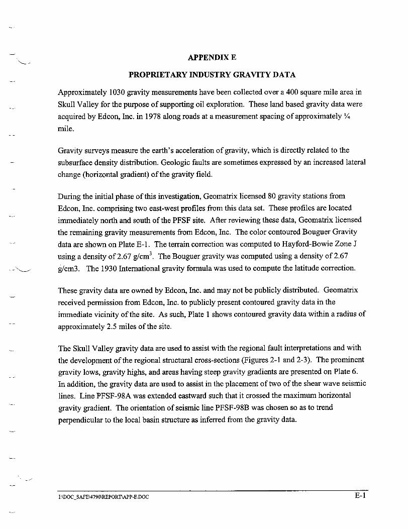
APPENDIX E
PROPRIETARY INDUSTRY GRAVITY DATA
Approximately 1030 gravity measurements have been collected over a 400 square mile area in
Skull Valley for the purpose of supporting oil exploration. These land based gravity data were
acquired by Edcon, Inc. in 1978 along roads at a measurement spacing of approximately ¼
mile.
Gravity surveys measure the earth's acceleration of gravity, which is directly related to the
subsurface density distribution. Geologic faults are sometimes expressed by an increased lateral
change (horizontal gradient) of the gravity field.
During the initial phase of this investigation, Geomatrix licensed 80 gravity stations from
Edcon, Inc. comprising two east-west profiles from this data set. These profiles are located
immediately north and south of the PFSF site. After reviewing these data, Geomatrix licensed
the remaining gravity measurements from Edcon, Inc. The color contoured Bouguer Gravity
data are shown on Plate E-1. The terrain correction was computed to Hayford-Bowie Zone J
using a density of 2.67 g/cm 3. The Bouguer gravity was computed using a density of 2.67
g/cm3. The 1930 International gravity formula was used to compute the latitude correction.
These gravity data are owned by Edcon, Inc. and may not be publicly distributed. Geomatrix
received permission from Edcon, Inc. to publicly present contoured gravity data in the
immediate vicinity of the site. As such, Plate 1 shows contoured gravity data within a radius of
approximately 2.5 miles of the site.
The Skull Valley gravity data are used to assist with the regional fault interpretations and with
the development of the regional structural cross-sections (Figures 2-1 and 2-3). The prominent
gravity lows, gravity highs, and areas having steep gravity gradients are presented on Plate 6.
In addition, the gravity data are used to assist in the placement of two of the shear wave seismic
lines. Line PFSF-98A was extended eastward such that it crossed the maximum horizontal
gravity gradient. The orientation of seismic line PFSF-98B was chosen so as to trend
perpendicular to the local basin structure as inferred from the gravity data.
I:\DOC_5AFE\4790\REPORT\APP-E.DOC E-lE-1IAkDOCSAFE\4790\R.EPORT\APP-E.DOC
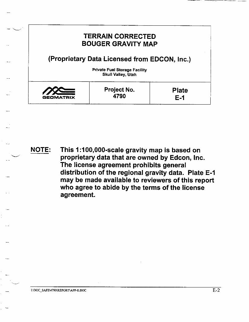
TERRAIN CORRECTED BOUGER GRAVITY MAP
(Proprietary Data Licensed from EDCON, Inc.) Private Fuel Storage Facility
Skull Valley, Utah
Project No. Plate GEOMATRIX 4790 E-1
NOTE: This 1:100,000-scale gravity map is based on proprietary data that are owned by Edcon, Inc. The license agreement prohibits general distribution of the regional gravity data. Plate E-1 may be made available to reviewers of this report who agree to abide by the terms of the license agreement.
I:\DOCSAFE\4790\RBPORThAPP-E.DOC E-2E-2I:\DOCSAFE\4790\R.EPORTrAPP-E.ID)C
GEOMATRIX
VOLUME III- APPENDIX F
Fault Evaluation Study and Seismic Hazard Assessment Private Fuel Storage Facility
Skull Valley, Utah
Prepared for:
Stone & Webster Engineering Corporation
P.O. Box 5406
Denver, Colorado 80217-5406
Prepared by:
Geomatrix Consultants, Inc. 100 Pine Street, 10th Floor San Francisco, California 94111 (415) 434-9400
February 1999
Project No. 4790
Geomatrix Consultants

GEOMATRIX
APPENDIX F
ASSESSMENT OF APPROPRIATE GROUND MOTION ATTENUATION RELATIONSHIPS

GEOMATRIX
APPENDIX F ASSESSMENT OF APPROPRIATE GROUND MOTION
ATTENUATION RELATIONSHIPS
INTRODUCTION
At present, strong motion data recorded in Utah are very limited. In the past, evaluations of seismic hazard, (e.g. Youngs and others, 1987) have typically concluded from examination of the limited strong and weak motion (i.e. seismographic network recordings) that strong ground motion attenuation relationships developed from analysis of California earthquake recordings can be used for Basin and Range sites. However, more recent studies have used examinations of world-wide normal faulting earthquake data together with a variety of modeling techniques to infer that there may be significant differences between strong ground motions in California and those from normal faulting earthquakes in extensional tectonic regimes, such as the Basin and Range region of north-central Utah. Much of this work was reviewed as part of the seismic hazard assessment for the proposed nuclear waste repository at Yucca Mountain, Nevada (CRWMS M&O, 1998). As part of that study, a panel of seven ground motion experts was assembled to provide assessments of the appropriate ground motion models for the Basin and Range region of southern Nevada. In that study, two basic approaches were used to develop ground motion attenuation relationships, one based on modifications to empirical California strong motion attenuation relationships and one based on numerical modeling. For this study, we utilize the results of the Yucca mountain study to modify California empirical ground motions to the conditions at Skull Valley, Utah. These modifications account for the effects of the characteristics of the earthquake source, the crustal wave propagation path, and the local site geology.
MODIFICATIONS FOR EARTHQUAKE SOURCE EFFECTS
The ground motion expert panel for the Yucca Mountain study selected seven alternative empirical attenuation relationships for use in estimating strong ground motions from normal faulting earthquakes. These relationships are listed in Table F-1. Five alternative scaling relationships were developed for the project to scale the relationships for the difference between the earthquake sources of California strike-slip earthquakes and normal faulting earthquakes (see column 2 of Table F-I). The first is the assumption that there is no significant difference (no scaling). The second scaling method is a set of empirical adjustment factors derived by Dr. N. Abrahamson to adjust the Abrahamson and Silva (1997) attenuation relationships from strike-slip to normal faulting (designated A-E in Table F-i). The third
I:\DOCSAFE\4000S\4790\REPORINAPX-F.DOC F-1
GEOMATRIX
scaling method used by the expert panel is one-half of the empirical adjustment factors developed by Dr. N. Abrahamson (designated 1/2A-E in Table F-I). The fourth and fifth scaling factors were developed by Drs. K. Campbell and W. Silva using the point source stochastic ground motion model and the difference in stress drop between California strike-slip and extensional normal faulting earthquakes (designated KCSC and WSSC, respectively in Table F-i).
The amount of scaling as a function of earthquake magnitude and ground motion period is shown on Figure F-1. The empirical scaling relationship developed by Dr. Abrahamson was only defined for the period range of PGA to 2.0 seconds. For this study we assume that the scaling factor he obtained for 2.0 second spectral acceleration also applies to longer periods.
The third column of Table F-1 lists the relative weights applied to each of the scaled empirical attenuation relationships. These weights are an average of the weights assigned by the seven ground motion panel experts. We propose to use this assessment to select appropriate scaled empirical attenuation relationships to apply to normal faulting earthquakes in Utah. The assessments for the Yucca Mountain project were for rock site conditions, while the Skull Valley site is located on alluvial soils. Five of the rock site attenuation relationships listed in Table F-I have companion alluvial soil site attenuation relationships. The fourth column of Table F-I lists the re-normalized weights for these five relationships scaled with the indicated earthquake source scaling factors. The relationship developed by Sabetta and Pugliese (1996) was not included because it was given a low weight by only one expert, resulting in a combined average relative weight of less that one percent.
As indicated on Figure F-i, the scaling factors developed by Drs. Campbell (KCSC) and Silva (WSSC) are very similar. Therefore, for this study, we used Dr. Silva's scaling factors for both KCSC and WSSC scaling because they have a convenient numerical expression that can be used to adjust the coefficients of the selected empirical attenuation relationships. As a result, 17 alternative scaled empirical attenuation relationships were used to model horizontal ground motions at the site.
A similar process was used to specify empirical attenuation relationships for vertical motions. Table F-2 lists the empirical attenuation relationships for vertical motions considered by the Yucca Mountain Ground Motion Expert Panel. There are fewer relationships available for vertical motions. One panel member chose to apply a vertical/horizontal ground motion ratio
F-2I:\DOCSAFE\4000 S\4790\REPOR1'\APX.F.DOC
GEOMATRIX
for rock sites to the Boore and others (1997) attenuation relationship as one option for specifying vertical motions.
The second column of Table F-2 lists the scaling relationships to adjust the empirical models to normal faulting conditions. Dr. Abrahamson developed a separate set of empirical adjustment factors for vertical motions. The stress drop scaling factors for horizontal motions developed by Drs. Campbell and Silva were assumed by the panel members to also apply to vertical motions. Figure F-2 compares the resulting scaling relationships for vertical motions.
The third column of Table F-2 lists the relative weights applied to each of the scaled empirical attenuation relationships averaged over the seven ground motion panel experts. The fourth column of Table F-1 lists the re-normalized weights for those relationships that have companion soil site attenuation relationships. No vertical/horizontal ratio for soil sites was developed by the expert panel and the Sadigh and others (1997) relationships do not contain coefficients for vertical motions on soil sites. As a result, nine alternative attenuation relationships were used to evaluate ground motions for vertical sites.
MODIFICATIONS FOR CRUSTAL PATH EFFECTS
The rate of attenuation of ground motion level with distance from the source is controlled by geometric spreading of the wave front and anelastic energy absorption by the crustal rocks along the travel path. Given that the earthquakes of interest to the Skull Valley site are expected to occur in the upper portion of the earth's crust in similar geometries to California earthquakes, we assume that similar geometric spreading effects occur in both regions. The energy absorption along the travel path is usually represented by the quality factor, Q. Crustal rocks in California generally have a relatively low value of Q, that is often modeled by the relationship Q = 150f °6, wheref is the frequency of the seismic wave. Singh and Herrmann (1983) assessed Q for the Utah region to be Q = 500f 02. This higher value of Q may result in less attenuation of seismic waves with distance compared to California. The difference in Q is expected to have no significant effect for nearby sources because the travel path is only a few kilometers. However, the most active source of large earthquakes in the region is the Wasatch fault, located approximately 80 km to the east of the site. For this source, the effects of differences in crustal attenuation may be important.
The effect of differences in Q between California and Utah was assessed using the technique applied for the Yucca Mountain study. The point source stochastic ground motion model (Hanks, 1979; Hanks and McGuire, 1981; Boore, 1983, 1986). was used to simulate spectral
l:\DOCSAFE\4000S\4790\REPORT\APX-F.DOC F-3
GEOMATRIX
accelerations for a magnitude 7 earthquake at a range of distances using the Q expressions for
California and Utah (a magnitude 7 earthquake was chosen as the likely size of earthquakes on
the Wasatch fault that may have a significant contribution to hazard at the site. All other
parameters were set at appropriate values for California earthquakes. Figure F-3 shows the
results of these simulations.
The difference between the ground motion levels as a function of distance, r, can be modeled
by the expression (Youngs and others, 1987):
SA(Utah Q)/SA(California Q) = 1.0 + yr (F-1)
The values of parameter y' obtained from the simulations are:
Period y (sec)
PGA 0.0046 0.075 0.0036
0.1 0.0042 0.2 0.0052 0.3 0.0053 0.5 0.0050 1.0 0.0044 2.0 0.0036 4.0 0.0028
These values, together with Equation (F-i) were used to adjust the selected empirical
attenuation relationships to account for the expected difference in crustal attenuation between
California and north-central Utah.
MODIFICATIONS FOR LOCAL SITE CONDITIONS
Soil profile at the Skull Valley site consist of approximately 45 feet of latest Pleistocene
alluvium (silts, clays and dense sands) underlain by Pleistocene silts and clays. These are, in
turn, underlain by partially consolidated Tertiary sediments of the Salt Lake group to a depth of
400 to 800 ft. The shallow refraction surveys (Geosphere Midwest, 1997) indicate a shear
wave velocity of approximately 750 ft/sec for the latest Pleistocene sediments and 2000 ft/sec
for the Pleistocene sediments. These velocities are consistent with the average velocities
estimated by Bay Geophysics (1999) of 800 ft/sec for the soil above the Pleistocene boundary
and 1,100 ft/sec for soil above the Tertiary boundary. Shear wave velocity data from the Salt
C:\MY DOCUMENTS\PFSF\SEISMIC\APX-F.DOC F-4
GEOMATRIX
Lake Valley suggests velocities in the range of 1,000 to 1,750 m/sec (3,280 to 5,741 ft/sec) for
the Tertiary Salt Lake group (Tinsley and others, 1991; Williams and others, 1993; Wong and
Silva, 1993).
On the basis of the depth to rock and the general soil conditions, one would classify the Skull
Valley site as a deep alluvial soil site. However, the available shear wave velocity data
suggests that the materials are somewhat stiffer than typically associated with alluvial soil sites
representative of the empirical ground motion data base used to develop the California soil site
attenuation relationships. Figure F-4 compares the estimated velocity profile for the Skull
Valley site with the velocity profile developed by Silva and others (1998) to represent alluvial
soils typical of California soil site strong motion recording stations. The velocities for the
deeper sediments in Skull Valley are much higher that the corresponding velocities in typical
California deep soil deposits.
In order to evaluate the effect of the different velocity profiles on ground motions, a analysis of
the relative response of the Skull Valley soil profile compared to the generic California deep
soil profile was performed. These analyses were performed using the following approach:
1. Select a set of rock site recordings from earthquakes within the appropriate magnitude range and scale the recordings to ground motion levels relevant to evaluating the site hazard.
2. Deconvolve the recordings to a depth where the crustal velocities in California and Utah are similar, removing the rock site amplification.
3. Compute the response of the California generic deep soil and Skull Valley profiles using the deconvolved rock motions from step 2.
4. Compute the ratio of the response spectra for the surface motions obtained from the site response analyses of step 3. Use the statistics of these response spectral ratios to assess the expected difference between the response of California deep soil sites and the Skull Valley site.
SELECTION OF ROCK SITE RECORDINGS
It is expected that the major contributions to the hazard will be from large magnitude
earthquakes occurring on the nearby Skull Valley and Stansbury faults. Therefore, twelve rock
recordings from magnitude -6.5 to 7 earthquakes were selected for the site response analyses.
Table F-3 lists the selected recordings. Six of the recordings are from California earthquakes
and six are from large normal faulting earthquakes recorded in Italy.
F-5C:\MY DOCUMENTS\PFSF\SEI SMIC\APX-F.DOC
GEOMATRIX
The recordings were scaled to ground motion levels corresponding to maximum magnitude events on the two nearby faults. The mean maximum magnitude for the Stansbury fault is M 7. Using the rock-site attenuation relationship developed by Abrahamson and Silva (1997) scaled to normal faulting conditions, the resulting median peak ground acceleration is 0.32g. Figure F-5 shows the corresponding response spectrum. Each of the rock recordings were scaled so that their response spectrum matches the target spectrum on average by minimizing the area between the two spectrum. The mean maximum magnitude for the East fault is M 6.5. Using the rock-site attenuation relationship developed by Abrahamson and Silva (1997) scaled to normal faulting conditions, the resulting median peak ground acceleration is 0.57g. Figure F-6 shows the corresponding response spectrum and the rock recordings scaled to match.
DECONVOLUTION OF ROCK MOTIONS
The recorded rock surface motions were deconvolved to a depth where the crustal velocities are comparable in California and Utah. Figure F-7 shows crustal shear wave velocity profiles developed for northern and southern California by Wald and others (1991) and Magistrale and others (1992), respectively. Also shown on Figure F-7 are shear wave velocity profiles for the site region. The crustal velocity profile used for earthquake location in north-central Utah consists of the following (J. Pechmann, Univ. of Utah, pers. comm., 1999):
Utah Crustal Velocity Profile
Depth Range P-Velocity S-Velocity (km) (kmilsec) (kmisec)
0-1.4 3.4 1.95 1.4-15.5 5.9 3.39
The three-layer Skull Valley model shown on Figure F-7 represents 500 ft of Tertiary basin fill with a velocity of 1.375 km/sec over the above crustal velocity profile. Also shown on Figure F-7 is a two-layer profile consisting of 500 ft of Tertiary basin fill with a velocity of 1.375 km/sec over a uniform crustal velocity of 3 km/sec. This velocity was used by Wong and Silva (1993) to represent the upper crustal velocity in north-central Utah and was used for sensitivity analyses in this study. It was judged that the three profiles reached sufficiently similar velocities at a depth of 3 km to use this depth as the appropriate base point for site response analyses.
The near-surface shear wave velocities at rock site recording stations typically exhibit a strong velocity gradient. Figure F-8 shows an average shear wave velocity profile developed by Silva and others (1998) to represent the near-surface velocities at California strong motion stations.
I:\DOCSAFE\400S\4790\R EPORTNAX-F.DOC F-6
GEOMATRIX
This 100-m profile was placed at the top of the two California crustal velocity profiles to represent near-surface conditions.
The deconvolution calculation were performed using the one-dimensional wave propagation computer program SHAKE (Schnable and others, 1972). Figure F-9 shows the normalized shear modulus and damping curves recommended by Silva and others (1998) for use at shallow depths in weathered and fractured rock typical of the velocity profile shown on Figure F-8. Once the rock velocity reaches 3,000 ftl/sec (at a depth of about 50 ft), the rock is assumed to behave linearly (no modulus reduction).
The material damping in the rock below a depth of 50 ft was estimated using the observed high frequency attenuation at rock site recording stations. This is modeled by the attenuation parameter developed by Anderson and Hough (1984) have show that the high frequency attenuation of ground motions in the near surface can be modeled by the attenuation parameter Silva and Darragh (1996) indicate that is related to the near surface shear wave quality factor, Q, by the expression:
H K =H(F-2) QVI
where H is the portion of the crust over which the energy loss occurs and V, is the average shear wave velocity over H. The appropriate value of H is 1 to 2 km (Silva and Darragh, 1992).
Q, is, in turn, related to the material damping, 2, used in liner viscoelastic wave propagation modeling (such as the site response analyses performed for this study using the program SHAKE) by the expression:
1 (F-3)
2Qs
Silva and Darragh (1992) found that Q. for WUS rocks is proportional to shear wave velocity and that a average value of K = 0.04 sec is appropriate for California rock site strong motion recording stations. Using the assumption that Q, 0C Vs, material damping values were computed for each of the layers in the upper 2 km of the California crustal models using Equations (F-2) and (F-3) to produce a composite K of 0.04 sec. The resulting Qs values and
I:\DOCSAFE•4000S\,4790\REPORTxAPX.F.DOC F-7
GEOMATRIX
equivalent damping values for the upper 2 km of the northern and southern California velocity
models are given in Table F-4. Damping in the rock below a depth of 2 km was set to zero.
The deconvolution analysis assumes that all of the surface rock motions are a result of
vertically propagating shear waves. However, Silva (1986) found that some of the surface
motions consist of higher mode surface waves. He recommended that motions for frequencies
higher than about 15 Hz be filtered out of the surface motions before deconvolution to reduce
the potential for overestimation of the motions at depth. He also indicated that the motions
should be removed using an anti-aliasing filter rather than the abrupt frequency cut-off
employed in program SHAKE. Accordingly, the rock recordings were low-pass filtered with a
Butterworth filter prior to being input into the deconvolution analysis. The filtering was
preformed prior to scaling the records to the target rock motion response spectra shown on
Figures F-4 and F-5. The records were also high-pass filtered above a frequency of 0.14 Hz (a
period of 7.0 sec.) and base-line corrected to remove spurious low frequency motions. Twenty
four base motions were then computed at a depth of 3 km, twelve for the northern California
crust and 12 for the southern California crust.
Site Response Analyses
The twenty-four base motions were used to compute the response of the soil profiles shown on
Figure F-4. Silva and others (1998) used two alternative sets of soil modulus and damping
relationships for California alluvial soils. One set, designated herein as Set A, was developed
by EPRI (1993) and is shown on Figure F-I Oa. A second, somewhat stiffer set was found to
work well for some sites. These curves , designated herein as Set B, are shown on Figure F
10b. Both sets were used to compute the soil profile responses.
Because only limited shear wave velocity data are available for the Skull Valley sediments,
sensitivity analyses were performed using a range of shear wave velocities.
As indicated above, the average velocity for the Holocene and Pleistocene sediments are
estimated to be 750 and 2,000 ft/sec, respectively. The range in velocities reported by
Geosphere Midwest (1997) was from about 700 to 790 ft/sec for the latest Pleistocene soils and
1,700 to 2,400 for the Pleistocene soils. Analyses were conducted using the upper and lower
limits of these velocity ranges as well as the midpoint. Analyses were conducted using both
Set A and Set B modulus and damping relationships (Figures F-Oa and F-0Ob).
C \MY DOCUMENT5\PF5F\5EISMIC\APX-F DOC F-8F-8C:\MY DOCUMENTS\PFSF\SEISMIC\APX-F.DOC

GEOMATRIX
Analyses were also conducted using the lower limit, the midpoint and the upper limit of the shear wave velocity for the Tertiary sediments. An additional set of analyses was also conducted assuming that the velocity of the sediments varies linearly from the lower limit at the top of the Tertiary layer to the upper limit at the bottom. The Tertiary sediments and underlying rock were assumed to behave linearly. The damping in the Tertiary sediments and rock to a depth of 2 km was computed using the same technique outlined above for the California crustal models. Wong and Silva (1993) used a Kof 0.04 sec for Utah sites, similar to California rock sites. However, the higher near-surface rock velocities in Utah suggest that the Kevalues may be somewhat lower. Accordingly, Kevalues of 0.02, 0.03, and 0.04 sec were used in the analyses. Table F-5 lists the resulting Q, values and equivalent damping values for the upper 2 km of the Utah crustal models. Damping in the rock below a depth of 2 km was set to zero.
Relative Site Response
The relative response of the Skull Valley sediments compared to typical California deep soil sites was evaluated by computing the ratio of the response spectra for the computed surface motions for each individual input base rock motion. Figure F-11 shows an example of one such set of spectral ratios. Each plot shows the ratio of surface response spectra computed using the rock motion indicated. The rock motions in this example were scaled to the M 6.5 rock spectra (0.57g PGA) and deconvolved through the southern California crustal model. The California soil motions were computed using the deep soil velocity profile shown on Figure F-4 placed on top of the southern California crust and using Set A soil modulus and damping relationships. The Skull Valley sediment motions were computed using the median sediment velocities on the three-layer crustal model with a Kof 0.03 sec and Set A soil modulus and damping relationships. The individual rock input motions produce variations in the relative response reflecting differences in the frequency content of the records. Because we are interested in the average differences in the relative response of the two profiles and because ground motions are typically assumed to be lognormally distributed, we use the geometric mean (average of the logs) of the spectral ratios to evaluate the relative response and assume that this represents the median relative response.
Figure F-12 shows examples of the statistics of the individual spectral ratios. Each curve on part (a) is the geometric mean of twelve spectral ratios. The curve labeled "So. CA crust, Set A is the geometric mean of the twelve spectral ratios shown on Figure F-11. The curves four curves shown on part (a) indicate the effect of the two California crustal models and the
I:'\DOCSAFE"A000S\4790\REPORT'•AX-F.DOC F-9
GEOMATRIX
alternative soil modulus and damping relationships. As indicated, the two crustal models
produce very similar spectral ratios. The alternative sets of soil properties produce a greater
difference in the spectral ratios. Set B properties produce lower spectral ratios because the
stiffer modulus reduction and lower damping values produce higher response for the California
deep soil profiles. Because the empirical attenuation relationships use data from both northern
and southern California and because Silva and others (1998) found both sets of soil properties
to be appropriate for California sites, we compute the average relative response over all four
California conditions (48 spectral ratios).
Part (b) of Figure F-12 shows the effect of the level of motion on the median spectral ratio.
[The curve labeled 0.57g PGA rock motions is the geometric mean of the four curves shown on
Part (a).] Slightly lower spectral ratios are computed using the higher level rock input motions,
indicating that the shaking level has a somewhat greater effect on the Skull Valley sediment
response than on the California deep soil response.
Figure F-13 shows the effect of variations in the properties of the Pleistocene soils on the
median spectral ratios. Part (a) shows the effect of the alternative sets of shear modulus and
damping relationships (Figures F- 1 Oa and F-Ob) and part be shows the effect of varying the
soil velocity over the range in reported velocities. The alternative sets of modulus and damping
curves have a greater effect than the range of low-strain shear wave velocities on the relative
response.
Figure F-14 shows addition effects of variations in the velocities of the Skull Valley sediments.
Part (a) shows the effect of varying the Tertiary sediment velocity, including a gradational
velocity model. The effect of the velocity variations is relatively small. Comparison of part (a)
of Figure F- 14 with part (b) of Figure F- 13 indicates the frequency range controlled by the
various sediments. The relative response for ground motion periods less than about 0.5 sec
(frequencies greater than 2 Hz) are affected by the velocities assigned to the Holocene and
Pleistocene soils while the relative response for periods greater than about 0.5 sec are affected
by the velocities assigned to the Tertiary sediments. Part (b) of Figure F-14 combines the
velocity variations of the previous two cases, shown the effect of varying the velocities of all of
the sediments over the ranges indicated above.
Figure F-15 shows the effect of the alternative crustal properties on the median relative
response. Part (a) shows the effect of varying K from 0.02 to 0.04 sec and part (b) shows the
effect of using the two-layer versus the three-layer velocity profiles shown on Figure F-7.
F-10C:\MY DOCUM ENTS\PFSF\SEISMIC'APX-F.DOC

GEOMATRIX
Varying K-has only a minor effect on the relative response at high frequencies and the alternative crustal velocity profile only has a significant effect at periods longer than 2 seconds.
The results of the relative response calculations are summarized on Figure F-16. Part (a) shows the median relative response curves for the cases discussed above using rock motions scaled to both M 7.0 and M 6.5 input levels. The variations in the relative response reflect uncertainties in the velocity of the sediments, the appropriate modulus and damping relationships, and the properties of the upper crust in Skull Valley. Part (b) shows the median relative response computed over the uncertainty in the site properties for the two input motion levels. These results indicate that the response of the Skull Valley site is slightly higher for high frequency motions and is lower for low frequency motions.
The exact peaks and valleys in the curves shown on part (b) arise in part because only a single average profile was used to represent the response of California deep soil sites. It is expected that if the variation in California soil profile velocities and depths was incorporated into the relative response analysis through the use of Monte Carlo simulation, then the relative spectral ratios will be smoothed out [see EPRI (1993) for an example of this approach]. Accordingly, a smooth relative response curve was constructed through the computed median spectral ratios as shown on part (b) of Figure F-16. Greater smoothing was applied to the long period spectral ratios because it is likely that considering a range of depths for the California profiles would tend to fill in the large "valley" in the median spectral ratios. The resulting site response adjustment factors
are:
!:\DOC_5AFE\4OOO5\479O\REpOR�j\&yXFDOC F-i 1I:\DOCSAFE\4000S\4790\REPORTkAPX-F.DOC F-1II

GEOMATRIX
Period Site Adjustment (sec) Factor
PGA 1.05 0.05 1.05
0.075 1.05 0.1 1.10
0.15 1.15 0.2 1.15 0.3 1.125 0.5 1.10
0.75 1.00 1.0 0.85 1.5 0.75 2.0 0.75 3.0 0.75 4.0 0.80
These factors were used to scale the empirical deep soil attenuation relationships to the Skull Valley site conditions.
I:\DOCSAFE\40005\4790\REPORT\APX-F.DOC F- 12
1:\lOCSAFE\4000S\4790"\REPORTNA.PX-F.ID)C F-12
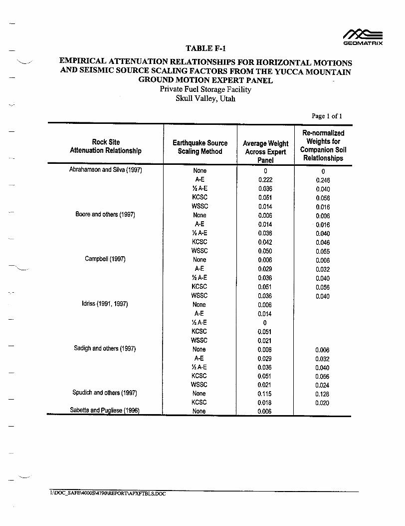
GEOMATRIX
TABLE F-1 EMPIRICAL ATTENUATION RELATIONSHIPS FOR HORIZONTAL MOTIONS AND SEISMIC SOURCE SCALING FACTORS FROM THE YUCCA MOUNTAIN
GROUND MOTION EXPERT PANEL Private Fuel Storage Facility
Skull Valley, Utah
Page 1 of 1
Re-normalized Rock Site Earthquake Source Average Weight Weights for
Attenuation Relationship Scaling Method Across Expert Companion Soil Panel Relationships
Abrahamson and Silva (1997) None 0 0 A-E 0.222 0.246
½ A-E 0.036 0.040 KCSC 0.051 0.056 WSSC 0.014 0.016
Boore and others (1997) None 0.006 0.006 A-E 0.014 0.016 2 A-E 0.036 0.040
KCSC 0.042 0.046 WSSC 0.050 0.055
Campbell (1997) None 0.006 0.006 A-E 0.029 0.032
% A-E 0.036 0.040 KCSC 0.051 0.056 WSSC 0.036 0.040
Idriss (1991, 1997) None 0.006 A-E 0.014
½2A-E 0 KCSC 0.051 WSSC 0.021
Sadigh and others (1997) None 0.006 0.006 A-E 0.029 0.032
Y2A-E 0.036 0.040 KCSC 0.051 0.056 WSSC 0.021 0.024
Spudich and others (1997) None 0.115 0.128 KCSC 0.018 0.020
Sabetta and Pugliese (1996) None 0.006
I:\DOCSAFE\4000S\4790\REPORTAPXFrBLS.DOC
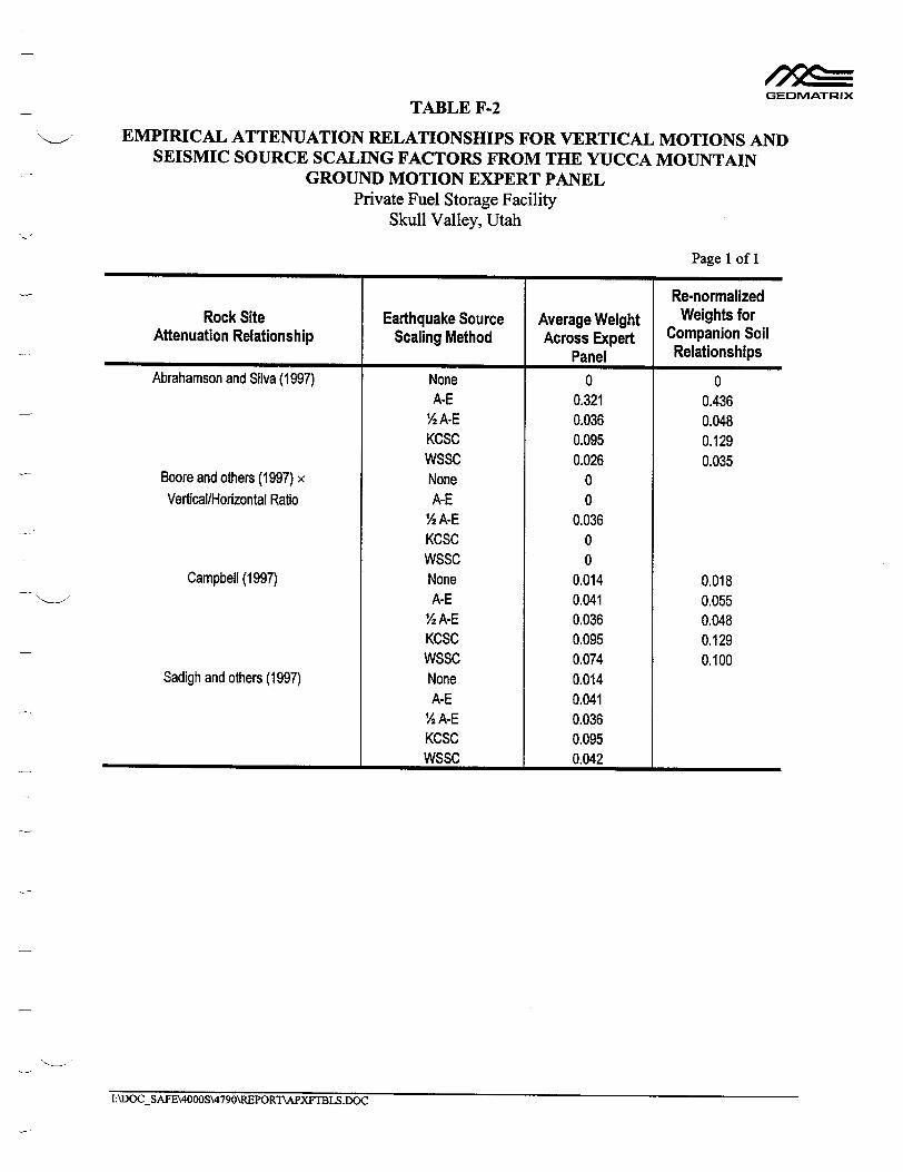
GEOMATRIX TABLE F-2
EMPIRICAL ATTENUATION RELATIONSHIPS FOR VERTICAL MOTIONS AND SEISMIC SOURCE SCALING FACTORS FROM THE YUCCA MOUNTAIN
GROUND MOTION EXPERT PANEL Private Fuel Storage Facility
Skull Valley, Utah
Page 1 of 1
Re-normalized Rock Site Earthquake Source Average Weight Weights for
Attenuation Relationship Scaling Method Across Expert Companion Soil Panel Relationships
Abrahamson and Silva (1997) None 0 0 A-E 0.321 0.436
½ A-E 0.036 0.048 KCSC 0.095 0.129 WSSC 0.026 0.035
Boore and others (1997) x None 0 Vertical/Horizontal Ratio A-E 0
% A-E 0.036 KCSC 0 WSSC 0
Campbell (1997) None 0.014 0.018 A-E 0.041 0.055 2 A-E 0.036 0.048
KCSC 0.095 0.129 WSSC 0.074 0.100
Sadigh and others (1997) None 0.014 A-E 0.041 2 A-E 0.036
KCSC 0.095 WSSC 0.042
I:\DOCSAFE\4000S\4790\REPORT\APXFTBLS.DOC

TABLE F-3
ROCK RECORDINGS USED IN SITE RESPONSE ANALYSES Private Fuel Storage Facility
Skull Valley, Utah
GEOMATRIX
Page 1 of 1
Record Earthquake M Station Comp Distance PGA (0) (kmn) (g)
1 San Fernando, CA 6.6 Pacoima Dam [279] 254 2.8 1.16 2 1971/02/09 Lake Hughs #12 [128] 021 20.3 0.37 3 Victoria, Mexico 6.4 Cerro Prieto 045 34.8 0.62
1980/06/09 4 Irpinia, Italy 6.9 Bagnoli Irpinio 000 10.9 0.14 5 1980111/23 Bagnoli Irpinio 270 0.20 6 Stumo 000 16.2 0.25 7 Stumo 270 0.36 8 Irpinia, Italy aftershock 6.2 Calitri 000 8.4 0.18 9 1980/11/23 Calitri 270 0.17 10 Loma Prieta, CA 7.0 Gilroy#1 090 11.2 0.47 11 1989/10/17 Corratilos 000 5.1 0.64 12 Corratilos 090 0.48
I:\DOCSAFE\4000S\4790\REPORThAPXFTBLS.DOC
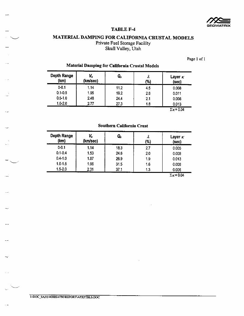
GEOMATRIX
TABLE F-4
MATERIAL DAMPING FOR CALIFORNIA CRUSTAL MODELS Private Fuel Storage Facility
Skull Valley, Utah
Page I of 1
Material Damping for California Crustal Models
Depth Range VS Q$ 2 Layer ic (kmn) (kmnsec) N()(% (se 0-0.1 1.14 11.2 4.5 0.008
0.1-0.5 1.95 19.2 2.6 0.011 0.5-1.0 2.48 24.4 2.1 0.008 1.0-2.0 2.77 27.3 1.8 0.013
DK: 0.04
Southern California Crust
Depth Range V. Qs 2 Layer i(kin) (kmn/sec) N_/o) (sec) 0-0.1 1.14 18.3 2.7 0.005
0.1-0.4 1.53 24.6 2.0 0.008 0.4-1.0 1.67 26.9 1.9 0.013 1.0-1.5 1.96 31.5 1.6 0.008 1.5-2.0 2.31 37.1 1.3 0.006
EK= 0.04
I:\DOC_SAFE\4000S\4790\REPORTýAPXF'BLS.DOC

TABLE F-5
MATERIAL DAMPING FOR SKULL VALLEY CRUSTAL PROFILES Private Fuel Storage Facility
Skull Valley, Utah
Page 1 of 3
Three Crustal Layers, x= 0.02 sec, Low Tertiary V,
Depth Range VS Q. A Layer K (kin) (km/sec) N%) (sec) 0-0.2 1.0 28.4 1.8 0.007
0.2-1.4 1.95 55.4 0.9 0.011 1.4-2.0 3.39 96.2 0.5 0.002
ZK= 0.02
Three Crustal Layers, K= 0.03 sec, Low Tertiary V,
Depth Range V2 QS A Layer Kc (km) (km/sec) N%) (sec)
0-0.2 1.0 18.9 2.6 0.011 0.2-1.4 1.95 36.9 1.4 0.016 1.4-2.0 3.39 64.2 0.8 0.003
Y-K= 0.03
Three Crustal Layers, i= 0.04 sec, Low Tertiary V,
Depth Range VS Qs 2 Layer K
(km) (km/sec) N_/__ (sec)
0-0.2 1.0 14.2 3.5 0.014 0.2-1.4 1.95 27.7 1.8 0.022 1.4-2.0 3.39 48.1 1.0 0.004
lyc= 0.04
Three Crustal Layers, K= 0.02 sec, Midrange Tertiary V,
Depth Range Vs Q$ A Layer K
(km) (kmisec) N%) (sec) 0-0.2 1.375 32.6 1.5 0.004
0.2-1.4 1.95 46.2 1.1 0.014 1.4-2.0 3.39 80.3 0.6 0.002
ZK= 0.02
GEOMATRIX
I:\DOCSAFE\4000S\4790\REPORT1'APXFTBLS.DOC
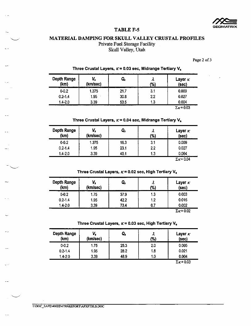
GEOMATRIX TABLE F-5
MATERIAL DAMPING FOR SKULL VALLEY CRUSTAL PROFILES Private Fuel Storage Facility
Skull Valley, Utah
Page 2 of 3
Three Crustal Layers, K= 0.03 sea, Midrange Tertiary V,
Depth Range VS Q2 A Layer K
(km) (km/sec) NL (see) 0-0.2 1.375 21.7 3.1 0.009
0.2-1.4 1.95 30.8 2.2 0.027 1.4-2.0 3.39 53.5 1.3 0.004
EK= 0.03
Three Crustal Layers, K= 0.04 sec, Midrange Tertiary V.
Depth Range V8 Q2 A Layer K (kin) (km/sec) N%) (see) 0-0.2 1.375 16.3 3.1 0.009
0.2-1.4 1.95 23.1 2.2 0.027 1.4-2.0 3.39 40.1 1.3 0.004
Zic= 0.04
Three Crustal Layers, K= 0.02 sec, High Tertiary V.
Depth Range Vs Qs 2 Layer K
(km) (km/sec) N%) (sec) 0-0.2 1.75 37.9 1.3 0.003
0.2-1.4 1.95 42.2 1.2 0.015 1.4-2.0 3.39 73.4 0.7 0.002
EK= 0.02
Three Crustal Layers, K= 0.03 sec, High Tertiary V,
Depth Range VS Q2 A Layer K
(km) (kinlsec) o%) (sec) 0-0.2 1.75 25.3 2.0 0.005
0.2-1.4 1.95 28.2 1.8 0.021 1.4-2.0 3.39 48.9 1.0 0.004
Z= 0.03
I:\DOCSAFE\4000S\4790\REPORTIAPXFTBLS.DOC

GEOMATRIX TABLE F-5
MATERIAL DAMPING FOR SKULL VALLEY CRUSTAL PROFILES Private Fuel Storage Facility
Skull Valley, Utah
Page 3 of 3
Three Crustal Layers, K'= 0.04 see, High Tertiary V,
Depth Range V, Q. A Layer K (km) (km/sec) 0(%) (see) 0-0.2 1.75 18.9 2.6 0.006
0.2-1.4 1.95 21.1 2.4 0.029 1.4-2.0 3.39 36.7 1.4 0.005
Zx= 0.04
Three Crustal Layers, K= 0.03 sec, Gradational Tertiary V,
Depth Range Vs Q2 A Layer K (kin) (kmi/sec) N%) (sec) 0-0.05 1.0 16.3 3.1 0.003
0.05-0.1 1.25 20.3 2.5 0.002 0.1-0.15 1.5 24.4 2.1 0.001 0.15-02 1.75 28.5 1.8 0.001 0.2-1.4 1.95 31.7 1.6 0.020 1.4-2.0 3.39 55.2 0.9 0.003
Dc= 0.03
Two Crustal Layers, K= 0.03 sec, Low Tertiary V,
Depth Range VS J S 2 Layer K (kin) (krlsec) N%) (see) 0-0.2 1.0 13.3 3.8 0.015
0.2-2.0 3.0 40.0 1.3 0.015 Dc= 0.03
I:\DOCSAFE\4000S\4790\REPORTWAPXtTBLS.DOC

0 KCSC
-• WSSc
C/)
C..)
1.1
1
.9
.8
.7
.6
' I I
4--- - - - ---- o- - _- - ___-
I I I5 5.5 6 6.5 7 7.5 5 5.5 6 6.5 7 7.5
Magnitude Magnitude
C', 0 'p
z
'\.j .
A-E 1/2 A-E
PGA
•1--•--------- •--O--------•--
0.05 sec SA S i I I I i r i I
0. I I seI c
-0.1 sec SA
I I
_ " 0--- 7 7 1 "•0.5 sec SA
S I I I I
I
4w--.-.
1.0 sec SA
IF4
2.0 9 _-C
I I I I I
1.1 Cl) 1
o .8
.6
00 co1.1
1
.9
.8
.7
.6 1.1
1
.9
.8
.7
.6
4.' I ' I I I '
-. -• ----- - --- --- --
0.2 sec SA , I , I , I I ,
SCALING RELATIONSHIPS DEVELOPED FOR THE YUCCA MOUNTAIN Project No. ' PROJECT (CRWMS M&O, 1998) FOR TRANSLATING HORIZONTAL GROUND
MOTIONS FROM CALIFORNIA STRIKE-SLIP EARTHQUAKES TO Figure GEOMATRIX EXTENSIONAL TECTONICS NORMAL FAULTING EARTHQUAKE MOTIONS. F-i : 2F -1

A-E - - - - 1/2 A-E
1.1
.9
.8
.7
.6
1.1 1
.9
.8
.7
.6 1 .1
.9
.8
.7
.6 1.1
.9
.8
.7
.6
5 5.5 6 6.5 7
Magnitude
0 KCSC - • WSSC
S I ' I ' I ' I
-- -
1 .0 sec SA
2.I I I c S
2.0 sec SA
7.5 5 5.5 6 6.5 7 7.5
Magnitude
0
' I I ' I - I -
0.5 sec SAPGA
I I t I I
' ' I ' I ' I
0.05 sec SA I t i i I I
' i ' I ' i I
----- - ----- -- --- --
0.1 sec SA . I Ise I I
' ' i I ' I
0.2 sec SA
Cl)
cil)
(.
a.
3.0 sec SA I I I I I I I I
SCALING RELATIONSHIPS DEVELOPED FOR THE YUCCA MOUNTAIN Project No. SPROJECT (CRWMS M&O, 1998) FOR TRANSLATING VERTICAL GROUND 4790 je ý MOTIONS FROM CALIFORNIA STRIKE-SLIP EARTHQUAKES TO Figure GIEOMATRIX EXTENSIONAL TECTONICS NORMAL FAULTING EARTHQUAKE MOTIONS. F-2
I I I I I I I I i
I
I

( I f
5 10 20 50
Distance (km)
100 200 5 10 20 50
Distance (kin)
100 200 5 10 20 50
Distance (kin)
GEOMATRIX
(
2
Non-GDS
0
0
0•
Cg
.5
.2
.1
.05
.02
.01
.005
.002100 200
ATTENUATION OF GROUND MOTION COMPUTED USING THE STOCHASTIC GROUND MOTION MODEL WITH Q = 150f 0.6 FOR CALIFORNIA AND Q = 500f 0.2 FOR UTAH.
1

I I 
I.
1000
-- Skull Valley sediments - - - - California deep soil
2000 3000 4000TI
5000
Shear Wave Velocity (ft/sec)
C
0
1001-
200[
R
0)
3001-
400!-
5000
COMPARISON OF THE SHEAR WAVE VELOCITY PROFILE FOR THE SKULL Project No.
SVALLEY SEDIMENTS USING THE MIDPOINT OF THE VELOCITY RANGE FOR 4790 THE SALT LAKE GROUP TO THE GENERIC CALIFORNIA DEEP SOIL Figure GEOMATRIX PROFILE DEVELOPED BY SILVA AND OTHERS (1998). F-4
01
t
I
I
I

C,
.02 .05 .1 .2 .5 1 2 5 .02 .05 .1 .2 .5 1 2 5 .02 .05 .1 .2 .5 1 2 5 .02 .05 .1 .2 .5 1
Period (sec) Period (sec) Period (sec) Period (sec)
C H:\vhnrden•Fio45.doc
.Non-GDS
4
2
1 ,5
.2
.1
.05
.02
4
2
S.2
.1
.05
.02
4
2 1
S.5
S.2
.1
.05
.02
KProject No. SROCK SITE MOTIONS SCALED TO MEDIAN RESPONSE SPECTRUM FOR A M 7 EARTHQUAKE ON THE 4790
GEOMATRIX STANSBURY FAULT. Figure F-5
2 5

.02 .05 .1 .2 .5 1 2 5 .02 .05 .1 .2 .5 1 2 5 .02 .05 .1 .2 .5 1 2 5 .02 .05 .1 .2 .5 1 2 5
Period (sec) Period (sec) Period (sec) Period (sec)
GEOMATRIXROCK SITE MOTIONS SCALED TO MEDIAN RESPONSE SPECTRUM FOR A M 6.5
EARTHQUAKE ON THE EAST FAULT.
4
2
1 .5
.2
.1
.05
.02
4
2
1 .5
C')
3 C')
.2
.1
.05
.02
4
2
1 .5
.2
.1
.05
.02
(
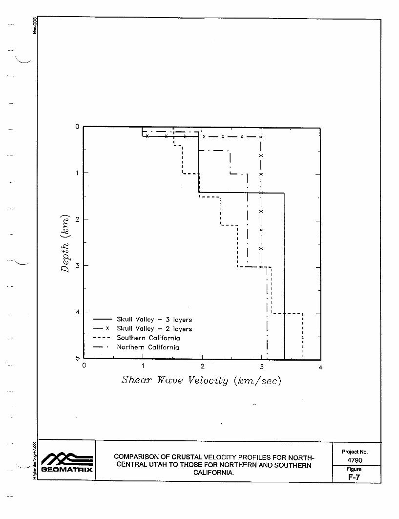
1 2
Shear Wave Velocity
3
(kim/sec)
1z
' ) ) , )( X X X x
!! I
!X
Skul Vale -3 ayr
, I ' * 1
I
SI - [
!* I
Skul Vlle - laersI K
!' I
0 4
COMPARISON OF CRUSTAL VELOCITY PROFILES FOR NORTH- Project No. S4790 CENTRAL UTAH TO THOSE FOR NORTHERN AND SOUTHERN Figure GEOMATRIX CALl FORN IA. Fiu ti - 1 1 F-7
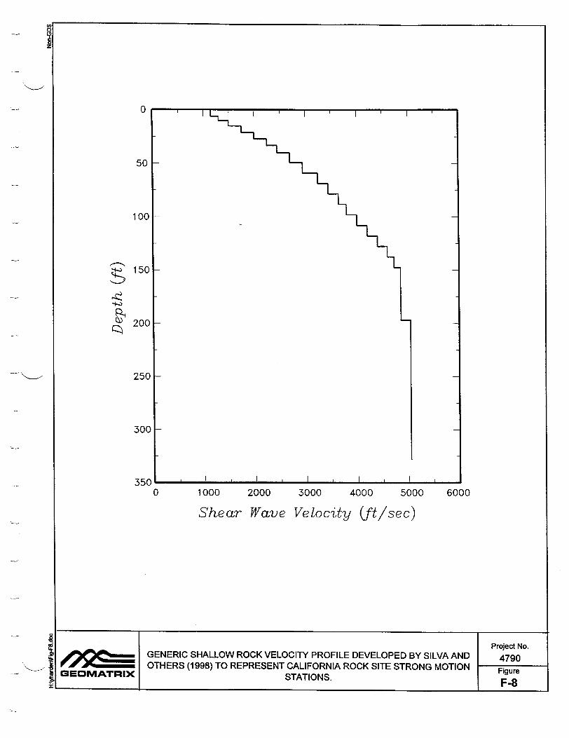
0
g 0)
0 1000 2000 3000 4000 5000 6000
Shear Wave Velocity (f"/sec)
0
L�.
=
Project No. GENERIC SHALLOW ROCK VELOCITY PROFILE DEVELOPED BY SILVA AND 4790 OTHERS (1998) TO REPRESENT CALIFORNIA ROCK SITE STRONG MOTION Figure
GEOMATRIX STATIONS. F-8

1 0-3 10-2 10-1 1
Shear Strain (%)
GEOMATRIX
T
MODULUS REDUCTION AND DAMPING RELATIONSHIPS FOR WEATHERED ROCK (SILVA AND OTHERS, 1998).
F-9
(0 0
3)
~ 8
.6
• .4
S.2
0 30
25
'-' 20 20
15
10
5
0
Project No. 4790 Figure
o -4

-41
Crb
N•
.8
.6
.4
.2
0
30
25
S20 20
15
10
10-3 10-2 10-1 1
Shear Strain (%)
9 Project No. let. SET A MODULUS REDUCTION AND DAMPING RELATIONSHIPS FOR DEEP 4790
ALLUVIAL SOIL DEVELOPED BY EPRI (1993). Figure _ __OMATRIX Figur t I IF-10a
C
zC
1
5
0 1 0-4

-41
rcr
cN
.8
.6
.2
0
0
30
25
20
15
10
10-3 10-2 10-1 1
Shear Strain (%)
9 Project No. SET B MODULUS REDUCTION AND DAMPING RELATIONSHIPS FOR DEEP 4790 GEOMATRI ALLUVIAL SOIL DEVELOPED BY SILVA AND OTHERS (1998). Figure QE: MATR IX F-iuOb
F-10
1
5
0 1 0-4

f
.02 .05 .1 .2 .5 1 2 5 .02 .05 .1 .2
Period (Sec)
.5 1 2 5 .02 .05 .1 .2
Period (Sec)
.5 1 2
Period (Sec)
GEOMATRIX
( (
0 5
2
.5
.3
5
2
0
Cl).5
.3
5
2
()
Cg.5
.3
0
0
Cl)
5
2
.5
.35
INDIVIDUAL RESPONSE SPECTRAL RATIOS COMPUTED USING ROCK MOTIONS FROM FIGURE F-6 DECONVOLVED THROUGH THE SOUTHERN CALIFORNIA CRUST. THE CURVES SHOW THE RATIO OF SKULL VALLEY SEDIMENT RESPONSE (THREE
LAYER CRUSTAL MODEL, MEDIAN SEDIMENT VELOCITY, K= 0.03 SEC, SET A PROPERTIES) TO CALIFORNIA DEEP SOIL RESPONSE (SOUTHERN CALIFORNIA CRUSTAL MODEL, SET A PROPERTIES).
Non-GOS
A-BAGO00
L- 1 1 1 1 '" 1 1 1 1 1 '1 1 1 ' SF279254 A-BAG270
A-STUO00
, , , , ,,,I ' I I I l lI i l IT ]I
A-STU270
B-CALO00
B-CAL270
LPG 1-090
LPCORO00
I I t i l I f II~ l I I I
I
1
1
1
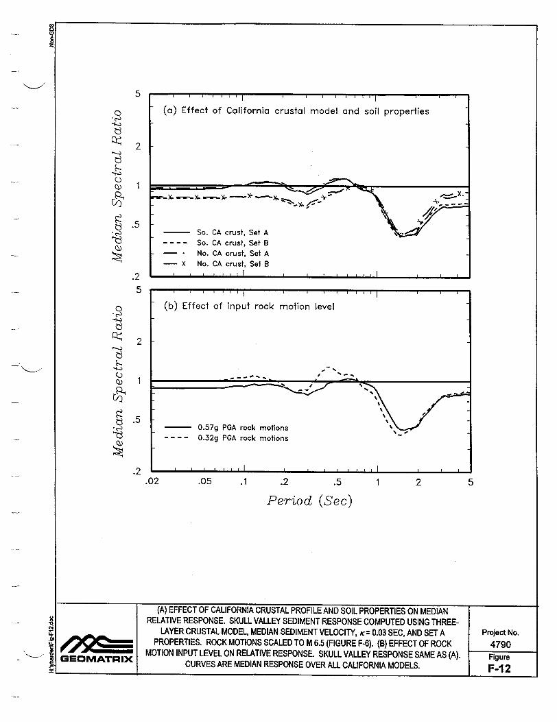
5
0/)
Cg
2
1
.5
.2 5
0
Q.)
::2)
2
1
.5
.2.02 .05 .1 .2 .5 1 2 5
Period (Sec)
(A) EFFECT OF CALIFORNIA CRUSTAL PROFILE AND SOIL PROPERTIES ON MEDIAN RELATIVE RESPONSE. SKULL VALLEY SEDIMENT RESPONSE COMPUTED USING THREE
LAYER CRUSTAL MODEL, MEDIAN SEDIMENT VELOCITY, K= 0.03 SEC, AND SET A Project No. SPROPERTIES. ROCK MOTIONS SCALED TO M 6.5 (FIGURE F-6). (B) EFFECT OF ROCK 4790
MOTION INPUT LEVEL ON RELATIVE RESPONSE. SKULL VALLEY RESPONSE SAME AS (A). Figure GEOMATRIX CURVES ARE MEDIAN RESPONSE OVER ALL CALIFORNIA MODELS. F-1 2 t _____I______
0
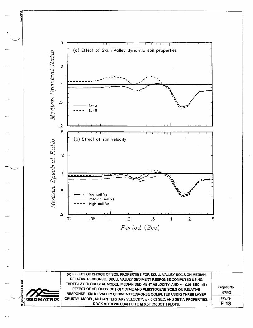
5
0 I.
(.)
Cl)
2
1
.5
.2 5
4
Cl)
2
1
.5
.2.02 .05 .1 .2 .5 1 2 5
Period (Sec)
(A) EFFECT OF CHOICE OF SOIL PROPERTIES FOR SKULL VALLEY SOILS ON MEDIAN RELATIVE RESPONSE. SKULL VALLEY SEDIMENT RESPONSE COMPUTED USING
THREE-LAYER CRUSTAL MODEL, MEDIAN SEDIMENT VELOCITY, AND K= 0.03 SEC. (B) Project No. SEFFECT OF VELOCITY OF HOLOCENE AND PLEISTOCENE SOILS ON RELATIVE 4790
RESPONSE. SKULL VALLEY SEDIMENT RESPONSE COMPUTED USING THREE-LAYER 4790 GEOMATRIX CRUSTAL MODEL, MEDIAN TERTIARY VELOCITY, K= 0.03 SEC, AND SET A PROPERTIES. Figure
ROCK MOTIONS SCALED TO M 6.5 FOR BOTH PLOTS. F-1 3
8

5
"322
1
.5
.2 5
0
0
2
1
.5
.2.02 .05 .1 .2 .5 1 2
Period (Sec)
5
(A) EFFECT OF VELOCITY OF TERTIARY SEDIMENTS ON RELATIVE RESPONSE. SKULL VALLEY SEDIMENT RESPONSE COMPUTED USING THREE-LAYER
CRUSTAL MODEL, MEDIAN SOIL VELOCITIES, K= 0.03 sec, AND SET A Project No. SPROPERTIES. (B) EFFECT OF VARYING VELOCITY OF ALL OF THE
SEDIMENTS ON RELATIVE RESPONSE. SKULL VALLEY SEDIMENT RESPONSE 4790
IGEOMATRIX COMPUTED USING THREE-LAYER CRUSTAL MODEL, K = 0.03 SEC, AND SET A Figure
t_ PROPERTIES. ROCK MOTIONS SCALED TO M 6.5 FOR BOTH PLOTS. F-14
0,
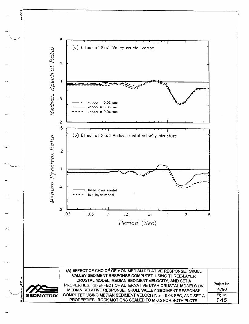
5
C
2
1
.5
.2 5
0
p9
2
1
.5
.2.02 .05 .1 .2 .5 1
Period (Sec)
2 5
(A) EFFECT OF CHOICE OF icON MEDIAN RELATIVE RESPONSE. SKULL VALLEY SEDIMENT RESPONSE COMPUTED USING THREE-LAYER
CRUSTAL MODEL, MEDIAN SEDIMENT VELOCITY, AND SET A PROPERTIES. (B) EFFECT OF ALTERNATIVE UTAH CRUSTAL MODELS ON Project No.
MEDIAN RELATIVE RESPONSE. SKULL VALLEY SEDIMENT RESPONSE 4790 -. GEOMATRIX COMPUTED USING MEDIAN SEDIMENT VELOCITY, tr= 0.03 SEC, AND SET A Figure
_!_I_ I_ PROPERTIES. ROCK MOTIONS SCALED TO M 6.5 FOR BOTH PLOTS. F-I 5
(b) Effect of Skull Valley crustal velocity structure
- three layer model - - - - two layer model
, , I I , ,I I , 1 1 , , l,

5
0 I'
C) 0)
2
1
.5
.2 5
0
C) 0)
2
.5
.2.02 .05 .1 .2 .5 1 2
Period (Sec)
5
SUMMARY OF RELATIVE RESPONSE ANALYSES. (A) MEDIAN RELATIVE RESPONSE
CURVES FROM PREVIOUS CASES (VARIATIONS IN SEDIMENT VELOCITY, SOIL MODULUS AND DAMPING CURVES, K, AND INPUT ROCK MOTION LEVEL). (B) MEDIAN
SRELATIVE RESPONSE FOR ALL CASES FOR INPUT ROCK MOTIONS SCALED TO 0.32 G Project No. (M 7 EARTHQUAKE) AND 0.57G (M 6.5 EARTHQUAKE). ALSO SHOWN IS AVERAGE SITE 4790
J GEOMATRIX CORRECTION FACTOR USED TO ADJUST CALIFORNIA DEEP SOIL EMPIRICAL Figure id I ATTENUATION RELATIONSHIPS TO SOIL CONDITIONS AT THE SKULL VALLEY SITE. F-1 6