final report – activity 8 finnish pilot
TRANSCRIPT

The sole responsibility of this publication lies with the author.
The European Union is not responsible for any use that may be made of the
information contained herein.
Final report – Activity 8 Finnish Pilot
NordicWay 2
Version 1.0
Date: 22 December 2020

Final report – Activity 8 Finnish Pilot Ver 0.9.1 Page 2 of 16
Document Information
Authors
NAME ORGANISATION
Juha Laakso Infotripla
Marjo Kauppinen EEE Innovations Oy
Markus Melander Vaisala Oyj
Johan Scholliers VTT
Michaela Sannholm The Finnish Transport and Communications Agency
Anna Schirokoff The Finnish Transport and Communications Agency
Ilkka Kotilainen The Finnish Transport and Communications Agency
Distribution
DATE VERSION DISSEMINATION
11.12.2020 0.9 PMB for comments
18.12.2020 0.9.1 PMB for approval
22.12.2020 1.0 public
Final report – Activity 8 Finnish Pilot Ver 0.9.1 Page 3 of 16
Content
1 INTRODUCTION ........................................................................................................................................ 4
1.1 THE AIM AND CONTENT OF THE C-ITS DEPLOYMENT PILOT ................................................................................... 4 1.2 SERVICES AND USE CASES PILOTED IN FINLAND ................................................................................................... 4
2 OVERVIEW OF THE NORDICWAY 2 INTERCHANGE NODE ARCHITECTURE ................................................. 5
3 DESCRIPTION OF THE PILOT ...................................................................................................................... 5
3.1 OBJECTIVES AND PILOT SET-UP ........................................................................................................................ 5 3.2 OVERVIEW OF THE THREE ECOSYSTEMS ............................................................................................................. 6
3.2.1 Ecosystem 1: EEE Innovations ......................................................................................................... 6 3.2.2 Ecosystem 2: Infotripla .................................................................................................................... 7 3.2.3 Ecosystem 3: Posti-Vaisala .............................................................................................................. 7
3.3 END USER APPLICATIONS IN THE PILOT .............................................................................................................. 8
4 TECHNICAL SET-UP.................................................................................................................................. 11
5 SUMMARY OF EVALUATION RESULTS ..................................................................................................... 12
5.1 QUALITY OF SERVICE ................................................................................................................................... 12 5.1.1 Method .......................................................................................................................................... 12 5.1.2 Results ........................................................................................................................................... 12
5.2 SERVICE ECOSYSTEM ................................................................................................................................... 12 5.2.1 Method .......................................................................................................................................... 12 5.2.2 Results ........................................................................................................................................... 13
6 OTHER RESULTS ...................................................................................................................................... 13
6.1 PRIVACY AND DATA PROTECTION IN THE PILOT .................................................................................................. 13 6.2 EFFECTS OF COVID-19 TO THE PILOT ............................................................................................................ 14
7 DISSEMINATION ..................................................................................................................................... 14
8 FINAL REMARKS AND CONCLUSIONS ...................................................................................................... 15
9 REFERENCES ........................................................................................................................................... 16

Final report – Activity 8 Finnish Pilot Ver 0.9.1 Page 4 of 16
1 Introduction
1.1 The aim and content of the C-ITS deployment pilot
The results from the first NordicWay project (2014-2017) showed that large-scale interoperability of co-operative ITS (C-ITS) services, mainly using cellular communication, are socio-economically beneficial and improve traffic safety. To continue the work done in that project, the Finnish road authorities did a procurement for a Finnish C-ITS deployment pilot at the end of 2018 as part of the NordicWay2 project.
The main aim of the procurement was to promote the technical and organisational interoperability be-tween existing C-ITS services. Therefore, the aim was to set up a C-ITS deployment pilot fleet from existing fleets, services and users in the market and include both in-vehicle displays and nomadic smart devices.
After the procurement, three suppliers were contracted: Posti, Infotripla, and EEE Innovations. These three suppliers had 15 subcontractors (service providers) in total, so altogether 18 companies were involved in the Finnish C-ITS deployment pilot. The aim of the pilot was to enhance traffic safety and fluency by creating a new way to share C-ITS messages between traffic information suppliers so that end users would get more information of better quality. The involved companies tried to find models for sharing C-ITS messages in a way that was technically functional, economically beneficial and legal, especially concerning data privacy and data protection. The pilot aimed at establishing ecosystems that would eventually be fully market-based.
The starting point for the technical solution of the pilots was the architecture to share C-ITS messages through a central cloud, developed in NordicWay (2014-2017). The three suppliers were obliged to set up a NordicWay2 interchange node and exchange their ecosystem’s C-ITS messages with other sup-pliers via the interchange nodes.
The term C-ITS used in this report refers mainly to long-range cellular and vehicle-to-network (V2N) communication. C-ITS messages refer to the ITS directive (2010/40/EU), Commission Delegated Reg-ulation (EU) 886/2013 of Safety-Related Traffic Information (SRTI). Although DATEX2 messages were used in the pilot, the interoperability of the C-ITS backend communication was tested and confirmed in collaboration with the NordicWay2 partners. The NordicWay2 project and its relation to C-Roads Plat-form is reported in the NordicWay2 final report on NordicWay architecture and service definitions / Ac-tivity 2 Interoperability and Technical Coordination Report (www.nordicway.net).
The services piloted in Finland were based on cellular networks. Therefore, the physical coverage of almost all services was the whole main road network in Finland (80,000 km). However, one service provider collected (weather) data only from ring roads and major incoming roads in the Helsinki region and from E18 between Helsinki and Turku. The three interchange nodes exchanged their ecosystem’s C-ITS messages during 02/2020-05/2020.
1.2 Services and use cases piloted in Finland
The Finnish pilot deployed following Day 1 and Day 1.5 services and use cases:
- Slow and stationary vehicle(s) & Traffic ahead warning o Use case: Traffic jam ahead
- Road works warning o Use case: Road and lane closure
- Weather and road condition o Use case: Weather conditions, Reduced visibility, Temporary slippery road
- Other hazardous location notifications (OHLN) o Use cases: Accident zone description, Emergency vehicle approaching, Animal or per-
son on the road, Obstacle on the road - In-vehicle signage
o Use case: In-vehicle speed limits - Probe vehicle data
o Use case: Single-vehicle data - Traffic information and smart routing
The plan was to also deploy following services and use cases in the pilot:
- Use case: Signal violation / intersection safety - Use case: Green light optimal speed advisory (GLOSA)

Final report – Activity 8 Finnish Pilot Ver 0.9.1 Page 5 of 16
- Use case: Traffic signal priority request
These were not part of the pilot due to the circumstance that the participant responsible for providing the data was unable to provide it in time for piloting.
The piloted services and use cases are described in detail in the NordicWay service definition report [2].
2 Overview of the NordicWay 2 interchange node architecture
The NordicWay2 architecture is described in detail in the NordicWay2 architecture report [1]. The Nor-dicWay2 architecture is based on the NordicWay architecture, but instead of using a central interchange node, the NordicWay2 update includes federation aspects of multiple interchange nodes as well as new use cases, such as signalised intersection use cases.
The use of federation allows for building up a distributed and therefore resilient (European) network of message interchanges, allowing for all possible exchange of information between providers of and sub-scribers to information, accounting for all possible business relations.
Two different protocols have been developed:
- The “Basic Interface” which transmits C-ITS messages (including DATEX II messages) over AMQP 1.0. This protocol was developed in NordicWay, and was used in the Finnish pilots. The protocol was the basis for the C-Roads basic interface, where the Application Field properties, which are used for filtering the messages, were adapted.
- The Federation protocol, which defines rules for the forwarding of messages between inter-change nodes, and the protocol for establishing the connections needed. The Federation pro-tocol is the basis for the C-Roads “Improved Interface”.
3 Description of the pilot
3.1 Objectives and pilot set-up
The overall objective of the pilot was to accelerate the development of C-ITS services in Finland so that the end users would get more information of better quality, which would eventually enhance traffic safety and fluency. The pilot aimed to create new ways to share C-ITS messages between different traffic information suppliers in a way that was technically functional, economically beneficial and legal, espe-cially concerning data privacy and data protection. The pilot aimed at establishing ecosystems that would eventually be fully market-based.
The Finnish pilot created three interchange nodes for exchanging information, one node per ecosystem. All of the ecosystems were obliged to exchange their ecosystem’s C-ITS messages with the other two ecosystems through the nodes. The technical set-up is described in Chapter 4.
The involved partners can be found in Table 1.
Table 1. The Finnish ecosystems. The partners in brackets were not involved during the whole pilot period.
Ecosystem 1
Lead: EEE Innovations
Participants: TraffICT, Tietoevry, Driveco, (Swarco), Sensible4, Defensec, (WhereOS), (LähiTapiola and LooperIT)
Ecosystem 2
Lead: Infotripla
Participants: Ficonic, RoadCloud, Arctic Machine, Finnish Meteorological Institute, Sitowise
Ecosystem 3
Lead: Vaisala
Participants: Posti, Metsäteho, Ahola Transport

Final report – Activity 8 Finnish Pilot Ver 0.9.1 Page 6 of 16
3.2 Overview of the three ecosystems
3.2.1 Ecosystem 1: EEE Innovations
The ecosystem was led by EEE Innovations Oy. It involved ten different companies throughout the piloting period. In the beginning there were nine companies, of which two decided not to commit to provide authorisation for GDPR counselling by external lawyers. One company was added later for vis-ualisation purposes. The involved companies and their roles in the ecosystem were:
- EEE Innovations Oy (administration, data exchange system and APIs, system architecture, end user application for Android, E3 ForeC)
- Tietoevry Oy (interchange node) - TraffICT Oy (data exchange system and APIs, end user application for iOS, Aindata Nopra) - Driveco Oy (device provider) - Swarco Oy (data provider – VMS and speed limit information and data from signalised intersec-
tion, VMS and speed limit data was later replaced by open data for reliability reasons, data from signalised intersections was never provided)
- Sensible4 Oy (data provider – automated vehicles) - Defensec Oy (cyber security, information security and data protection) - WhereOS (visualisations – was not needed as intended due to COVID-19)
The data for the C-ITS messages in this ecosystem was data from an ecosystem partner, vehicle-gen-erated data (including automated vehicles), data entered by the road users (both manually and auto-matically) or data from open sources such as Digiroad and Digitraffic. The ecosystem partner providing data from automated vehicles also intended to test how automated vehicles could use Day 1 services such as Weather and road condition and Other hazardous location notification. The implementation was delayed because of the required data protection clarification and there was no time to implement it later.
The ecosystem involved originally two mobile apps (ForeC for Android and Aindata Nopra for iOS), where the provided use cases were displayed. A third app (Telkkä for Android) was added later, but it opted out at the time of GDPR counselling deciding not to risk using data which could be defined as personal information.
The goal in creating the EEE Innovations ecosystem was to form a functional and marketable ecosystem that is based on affordable and scalable solutions and which can be used by a great number of end users. The companies chosen in the ecosystem had experience in the research and development of information on road conditions and traffic safety for years. They were also able to cover the agreed Day 1 services extensively. The ecosystem also aimed to create new solutions to create Day 1 services, to commercialise new technical solutions, and to combine new data sources, thus creating new business models to be piloted in the project.
The co-operation within the ecosystem was mainly smooth, although there were problems with one member of the ecosystem in delivering the data and in the quality of the delivered data.
The combination of the companies forming the ecosystem was changed a couple of times during the pilot. The first change was when two companies decided not to authorise external legal help with GDPR and left the ecosystem. This was due to a change of leading personnel in one of the companies and its legal department, and the new management was not as keen on participating in the pilot as the previous management had been. Since the companies were closely linked, they both decided to leave.
The second change occurred relatively late in the pilot, when it became apparent that a participant was not going to provide the data promised in time for piloting. The invoicing grounds were interpreted dif-ferently by this participant than in a similar contract with the subscriber. Unfortunately, the agreement had no definitions for terms which would have helped make a difference in the event that the data was due or of a sanction clause. That is a lesson learned in this project: prepare for the situations when things will not advance as planned.
The third change was adding a new member into the ecosystem for visualisation of the EEE pilot in the fair of the TRA2020 conference. The fair was cancelled due to COVID-19, and as a result this kind of visualisation was no longer needed in demonstrating the EEE pilot virtually.

Final report – Activity 8 Finnish Pilot Ver 0.9.1 Page 7 of 16
3.2.2 Ecosystem 2: Infotripla
The ecosystem involved six companies. The ecosystem was led by Infotripla Oy, which was responsible for the interchange node and had a role as integrator. The other involved companies and their roles in the ecosystem were:
- Sitowise (collection of data, app provider) - Ficonic (collection of data, app provider) - RoadCloud (collection of data) - Arctic Machine (collection of data) - The Finnish Meteorological Institute (FMI) (collection of data)
RoadCloud and Arctic Machine collected and shared data automatically from vehicles (e.g. road mainte-nance vehicles). Ficonic and Sitowise collected data from road users manually, i.e. by their mobile ap-plications. FMI provided observation and alert data based on local weather and road weather observa-tions and forecasts.
When the company group was constructed, the approach was to utilise as much existing technologies as possible. The main objective was to improve, integrate and test the solutions together to see if there were opportunities for economically viable business co-operation - instead of putting up another tech-nology development project.
The group planned and implemented the communication solutions in co-operation with each other and the international NordicWay2 partners. The companies did the necessary development tasks according to the original schedule to start the pilot as planned.
There were no major technological setbacks or problems in the group’s deployment and integration work. During the pilot phase everything worked mostly as planned. Based on the feedback from the VTT testing group, the companies found and corrected some issues related to the latencies on message exchange.
The group worked together during the project with no changes; all were able to execute their technolog-ical tasks as planned. There were also some issues that could have gone better. Because the pilot phase was significantly shorter than planned, it was not possible to recruit as many mobile application users as expected. Also, the time period to test data provision related to winter road conditions was very short. Hence, the companies did not gain as much real-life data and experiences as planned. However, the integrated concept including the federated data exchange was tested, and it was found to be a functioning entity. The possibilities to conduct business together ultimately depend on the ecosystem as a whole, including e.g. the share of the work between the public sector and companies as well as regu-lation.
3.2.3 Ecosystem 3: Posti-Vaisala
The ecosystem involved four companies. Vaisala Oy led the ecosystem, acted as integrator and was responsible for the ecosystem’s ICT solutions and the message delivery architecture. Vaisala was also responsible for the interchange node used by partners. The other involved companies and their roles in the ecosystem were:
- Posti (Data harvesting fleet. National post organisation) - Metsäteho (Data harvesting fleet. Represents forest industry parties in Finland) - Ahola Transport (Co-operation did not materialise)
The Vaisala RoadAI system formed the technical structure for the fleet operating companies. The sys-tem had the technology for all the activities needed for full implementation. There was a mobile app for sending data from vehicles, a backend system forming the interchange node, and API. The interface enabled the user to receive messages and monitor the fleet and sensors. This group of partners was formed based on the idea of providing excellent coverage from the whole network from parties who drive systematically in all areas of the network.
The motivations among the different parties were the following:
- The forest industry (Metsäteho Oy) was particularly interested in C-ITS communication and ser-vices, as the logistical problems might cause serious problems for the logistical chain on lower-class roads. Traditionally ITS initiatives have focused on highways and cities instead of rural areas. The industry as a whole is potentially providing excellent coverage of enhanced night-

Final report – Activity 8 Finnish Pilot Ver 0.9.1 Page 8 of 16
time road information and covering areas where road information is not good. This has the po-tential to significantly improve traffic control and road maintenance activities if the concept is taken into operational use.
- Posti sought to learn about technology and the business potential of providing their fleet to serve road information production. Posti has more than 4,000 vehicles in Finland, and these drivers and cars are a potential and interesting data source for traffic management to improve safety. Vehicle-to-vehicle messaging is something that has been thought to have value also from the labour safety perspective. Posti was also interested in validating the assumption of the cost-benefit ratio being negative for vehicle-based C-ITS system implementation. It was also inter-ested in collecting evidence of mechanisms for generating some revenue to cover the invest-ments for this activity.Vaisala has provided weather-related road information for almost 30 years. C-ITS messages from vehicles and stationary road weather stations is a core business for Vaisala. The motivation behind the NordicWay2 project was showcasing nationwide imple-mentation where utility vehicles provide road safety related information. Vaisala believes that interchange node development and co-operation with national traffic control and technical de-velopment together with other ecosystems is paving the way for future business opportunities. Vaisala was also studying how road maintenance could benefit from vehicle-based information, and whether there could be additional revenue streams supporting the implementation of C-ITS systems.
From a technical perspective everything did go basically as planned in the ecosystem. However, invest-ment in a fully integrated android app did not happen. This was mainly because the fleet partners did not identify the value, as this was only a pilot and there are as yet no existing operational ecosystems or fully functional services. The key assumption right from the beginning was that data needs to have a market; otherwise there is no interest in investing in vehicle technology to generate or share vehicle notifications.
In any case, trucking companies were researching C-ITS information as part of their own fleets’ routing and re-routing. There are aims to utilise platooning in the future, and C-ITS information is considered an important part for making the convoying safer. Before getting to convoying, regular transport collects information on conditions on their routes and smart routing to support the whole transport system in addition to improving their own efficiency and common safety.
The technical interest in data collection was in computer vision technology. Vaisala´s solution forms C-ITS messages using machine vision based on vehicle cameras (in the pilot, smartphone cameras). More complex C-ITS messages were still based on human judgment and the manual wheel button, enabling the driver to make a C-ITS message e.g. in case of obstacles in the route or humans walking on the narrow road shoulder. C-ITS messages were communicated through smartphone applications and com-munication took place in a 4G network.
3.3 End user applications in the pilot
The EEE Innovations ecosystem had two end user applications: one for Android (ForeC, Figure 1) and another for iOS (Aindata Nopra, Figure 2). Both applications are still available in Play Store and App Store, although they might not provide C-ITS services to the extent they did during the pilot phase since the interchange node has not been in use after June 2020.
Final report – Activity 8 Finnish Pilot Ver 0.9.1 Page 9 of 16
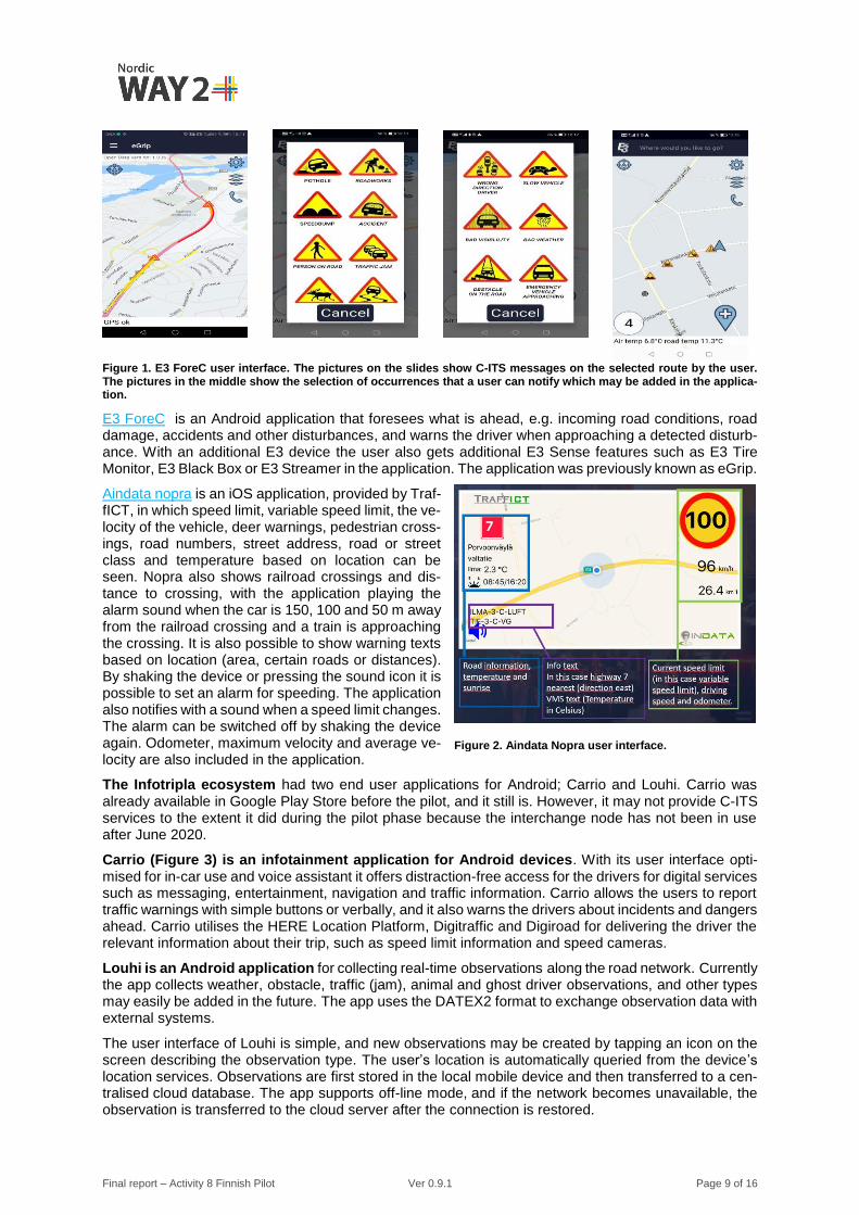
Figure 1. E3 ForeC user interface. The pictures on the slides show C-ITS messages on the selected route by the user. The pictures in the middle show the selection of occurrences that a user can notify which may be added in the applica-tion.
E3 ForeC is an Android application that foresees what is ahead, e.g. incoming road conditions, road damage, accidents and other disturbances, and warns the driver when approaching a detected disturb-ance. With an additional E3 device the user also gets additional E3 Sense features such as E3 Tire Monitor, E3 Black Box or E3 Streamer in the application. The application was previously known as eGrip.
Aindata nopra is an iOS application, provided by Traf-fICT, in which speed limit, variable speed limit, the ve-locity of the vehicle, deer warnings, pedestrian cross-ings, road numbers, street address, road or street class and temperature based on location can be seen. Nopra also shows railroad crossings and dis-tance to crossing, with the application playing the alarm sound when the car is 150, 100 and 50 m away from the railroad crossing and a train is approaching the crossing. It is also possible to show warning texts based on location (area, certain roads or distances). By shaking the device or pressing the sound icon it is possible to set an alarm for speeding. The application also notifies with a sound when a speed limit changes. The alarm can be switched off by shaking the device again. Odometer, maximum velocity and average ve-locity are also included in the application.
The Infotripla ecosystem had two end user applications for Android; Carrio and Louhi. Carrio was already available in Google Play Store before the pilot, and it still is. However, it may not provide C-ITS services to the extent it did during the pilot phase because the interchange node has not been in use after June 2020.
Carrio (Figure 3) is an infotainment application for Android devices. With its user interface opti-mised for in-car use and voice assistant it offers distraction-free access for the drivers for digital services such as messaging, entertainment, navigation and traffic information. Carrio allows the users to report traffic warnings with simple buttons or verbally, and it also warns the drivers about incidents and dangers ahead. Carrio utilises the HERE Location Platform, Digitraffic and Digiroad for delivering the driver the relevant information about their trip, such as speed limit information and speed cameras.
Louhi is an Android application for collecting real-time observations along the road network. Currently the app collects weather, obstacle, traffic (jam), animal and ghost driver observations, and other types may easily be added in the future. The app uses the DATEX2 format to exchange observation data with external systems.
The user interface of Louhi is simple, and new observations may be created by tapping an icon on the screen describing the observation type. The user’s location is automatically queried from the device’s location services. Observations are first stored in the local mobile device and then transferred to a cen-tralised cloud database. The app supports off-line mode, and if the network becomes unavailable, the observation is transferred to the cloud server after the connection is restored.
Figure 2. Aindata Nopra user interface.

Final report – Activity 8 Finnish Pilot Ver 0.9.1 Page 10 of 16
The Louhi app has a map display on which the users are able to see each other’s observations as long as the observation remains active (different observations have a different lifespan). Observations from external sources, e.g. from weather stations or road condition, may be shown on the map display as well, using the available online interfaces.
In addition to the mobile app, Louhi has a browser-based desktop view which may be used e.g. to show larger amounts of data, filter the results with search conditions, export the results to different for-mats and combine the observation data with other data sources.
Figure 3 Carrio user interface
The Posti-Vaisala ecosystem partners activated the national traffic control company (TMFG, Traffic Management Finland Group) to accept and share C-ITS messages into their operational system. The created messages were accessed through Vaisala´s system (Figure 4) as the interchange node did not yet exist in the TMFG architecture. The implementation was encouraging, as the vehicle data created by all three parties was shared with a huge amount of users using TMFG´s mobile app (Figure 5).
Data harvesting and C-ITS message creation in vehicles used two technological solutions. First, the automated one used computer vision analysis from a front-facing camera. Vaisala has had a road state detection model in operational use for a couple of years. Traditionally, this has been used to provide road state information for the maintenance perspective to help decision-making in planning winter maintenance operations. In the pilot the same technology was used to create automated notifications of slipperiness. Second, the manual notification concept was based on the notification button. Drivers were able to use the button when noticing an OHLN point of interest. The system also provided an image from the street view camera, which helps e.g. the traffic control centre or road maintenance contractor to evaluate the situation before approving the notification and including it in their official information.
The same application could have been used for push notifications, but the consortium decided to use TMFG´s existing application, “Liikennetilanne”, for that purpose in the piloting phase.

Final report – Activity 8 Finnish Pilot Ver 0.9.1 Page 11 of 16
Figure 4. Vaisala´s system in data production.
Figure 5. TMFG´s Liikennetilanne app was used for distributing notifications to the audience.
4 Technical set-up
Figure 6 gives an overview of the Finnish pilot architecture. All three ecosystems had the following similar components:
- mobile apps, through which drivers were informed about events and could also inform events. The apps were connected to an app backend, which interacted between the service provider and the app, and assured that the information was provided to the relevant users;
- data sources, such as instrumented vehicles; - integrator, which validated the information from the data sources and the app, and converted it
to a DATEX II message, publishing it over AMQP, as well as subscribed to the messages of the other interchanges. For each of the ecosystems, there was a single integrator;
- an interchange, routing the message of the integrators to other interchanges.
In the Finnish pilot, event data were published in a DATEX II 3.0 format. A profile was agreed between the different providers, and published in the “NordicWay Finnish DATEX II 3.0 profile” document [3].

Final report – Activity 8 Finnish Pilot Ver 0.9.1 Page 12 of 16
The BI protocol, developed in the NordicWay project, was used. NordicWay2 took the C-Roads version, which uses slightly different Application Field identifiers than the NordicWay version on which it is based, during 2020 into operation, but the Finnish pilot did not make this update, as the pilot was already in operation.
The federation (or II) protocol, which allows to forward messages between interchange nodes, instead of requiring all service providers to connect to the different interchange nodes, was taken into use in the Finnish pilot.
Figure 6. Architecture of the Finnish pilot.
5 Summary of evaluation results
5.1 Quality of service
5.1.1 Method
The quality of the Finnish services was studied by focusing on the overall functionality and performance of the services. The technical testing of the services was done by utilising the logs collected from the interchange nodes in Finland. In addition, controlled technical tests were conducted to test the perfor-mance of the selected services in the real world.
The method is described in detail in the NordicWay2 evaluation results report [4].
5.1.2 Results
The functionality of the services, which was studied in the Finnish technical evaluation, was found to work as expected. The data sharing between three nodes was successfully verified. The measurement session was affected by the Coronavirus COVID-19 pandemic, which certainly limited the traffic volume during the pilot period in spring 2020.Therefore, the use of traffic-related mobile applications, traffic disturbances and events were also limited in Finland during this period.
More detailed results can be found in the NordicWay2 evaluation results report [4].
5.2 Service ecosystem
5.2.1 Method
Practical implementation of the ecosystem evaluation included workshops and data collection rounds that invited C-ITS service providers to define the ideal ecosystem based on their own ecosystem that they see as the most sensible and feasible to provide such services. This included the definition of roles (including the roles of public authorities) and the necessary agreements between the ecosystem part-ners (who pays whom - without going into actual monetary prices, however). C-ITS service providers
Final report – Activity 8 Finnish Pilot Ver 0.9.1 Page 13 of 16
were also invited to assess and express their views on the business potential of the various services as well as on the key deployment issues that had risen or were foreseen in the service build-up and in the short- and medium-term future.
In Finland the first workshop was held in spring 2019 and the second workshop in spring 2020. The method is described in more detail inVirhe. Viitteen lähdettä ei löytynyt. [4].
5.2.2 Results
C-ITS services are being deployed at increasing rates, but many initiatives have been characterised by a technology push where things are developed with a focus on the concepts and technology from the very start, and with limited attention to the value and actual business viability at the end.
During the ramp-up phase, the main challenges include contracting issues (especially GDPR), data quality issues and service coverage issues. The initial pains relate to attracting a user base in the harshly competitive climate, thin revenue streams from private users, product development investments and lack of experienced work force. The expected gains from being involved in such ecosystems include revenue, clientele growth, product portfolio expansion, international partnerships and operational gains. The companies are committed to such piloting efforts due to wanting to be in the forefront in the R&D&I field and such activities strongly supporting the companies’ strategic choices and performance objec-tives.
As viable or potential scaling-up strategies, the most prominent was the “single side strategy,” and the others highlighted were “follow that rabbit,” “big bang” and “piggyback.” The most prominent and prom-ising scale-up partner candidates were the automotive sector, navigation device manufacturers and large fleet owners.
Business model (feasibility, scalability, long-term sustainability, profit) issues and concerns include a recurring comment that, regardless of the service, some public involvement, intervention, funding or investment is also going to be needed in the longer term if a large-scale roll-out and adoption of C-ITS is aspired to. For C-ITS, it holds true that if there is no data, there will be no services either. To extend from that, the businesses feel that if there is no investment from e.g. road authorities, there will be no data and hence no services. It is in other words an interaction between different actors, which gives the end user and society the beneficial services.
The detailed results from the ecosystem evaluation can be found inVirhe. Viitteen lähdettä ei löytynyt. [4].
6 Other results
6.1 Privacy and data protection in the pilot
Location data is a core part of the piloted services; therefore, privacy experts from the Finnish Transport and Communications Agency Traficom raised questions about privacy and the handling of it already in the beginning of the pilot work. It was required that before the launch of the pilot the handling of personal data needed to be solved in a legal manner in regard to the GDPR. As the pilot involved 18 different companies in the beginning with different roles, with some of them having several roles, several services with existing users (around 7,000 users) and a large variety in how the service providers collected data, the task of getting the whole picture of the data handling procedures was complex.
Different roles
The Finnish Transport and Communications Agency Traficom funded the pilot and acted as project management of the whole pilot. All the collected and distributed data during the pilot was in the hands of the involved companies and Traficom neither received nor distributed any data. Therefore, the in-volved companies acted as data controllers and/or data processors. Nevertheless, as Traficom was funding the pilot with public funds, Traficom wanted to get a good understanding of how the involved companies handled their personal data and make sure that they were acting in accordance with the GDPR.
The process
For the companies, Traficom prepared a form with information about the piloted C-ITS services and the handling of personal data in the various services. However, because of the lack of personal data expert resources in spring 2019, Traficom was unable to analyse the forms in a sufficient manner. Also, some

Final report – Activity 8 Finnish Pilot Ver 0.9.1 Page 14 of 16
of the filled forms needed to be updated or improved, and the companies were incapable of that task without support. Traficom decided to tackle the lack of resources by procuring an external law firm to support the work. The procurement took longer than expected, which delayed the process even more.
The law firm gathered previous legal case results of similar types of cases and assessed how personal data should be interpreted in the pilot. With the help of the material that the law firm produced, Traficom made a decision on how the companies should interpret personal data in the pilot. According to Trafi-com’s view, whenever a company participating in the pilot was aware that a third party was in possession of additional data that could identify the individual, and legal means existed to obtain such information, the data should be considered personal data. After this, Traficom in collaboration with the law firm in-structed and supported the service providers to act according to the previous interpretation.
The data sharing between the companies began several months later than planned because of this vagueness in privacy questions. During the data sharing period (in spring 2020), no privacy or data protection issues were raised from the users.
Lessons learned
Traficom did an anonymous questionnaire to all the involved companies after the pilot. A summary of the collected opinions is listed below:
- The authorities’ reaction was slow and uncertain, but as privacy is important and crowdsourced message sharing is complicated, it was necessary to review together.
- Uncertainty caused harm to business. - Common rules and recommendations would ease and speed C-ITS data privacy deployment.
At the moment, authorities or regulators did not provide clear instructions in advance to help the C-ITS deployment.
- Authorities need to trust industry competence to solve data privacy. - Data privacy should already be included in the beginning of the service design. - It is difficult to interpret law in different use cases, as legal pre-case studies do not exist, and a
lot is left to the data controller’s responsibility. The main question is usually: exactly which data should be considered personal data in different cases?
- There is a need for national and European continuity to solve C-ITS data privacy issues.
6.2 Effects of COVID-19 to the pilot
The COVID-19 pandemic started to spread and hit Finland in early March 2020. The borders of the Uusimaa region, which includes the Helsinki Metropolitan Area, were closed in March; no one was al-lowed to travel in or out of the Uusimaa region without a relevant reason. As the pilot had just started in February 2020, the traffic volumes fell. This had a negative impact on service trials and the evaluation of the pilot.
Also during 2020, several conferences and other large gatherings were cancelled because of the re-strictions in organising public events. One of the cancelled events was the Transport Research Arena (TRA) 2020 fair, where the Finnish pilot was meant to be demonstrated. The pandemic restricted the possibilities to demonstrate and talk about the pilot as the amount of social gatherings was minimised.
7 Dissemination
The Finnish pilot was presented in the 13th ITS Europe Congress in 2019; the presentation can be found here. The preliminary results of the ecosystem evaluation and some learnings from the privacy work in the pilot were presented in a workshop (C-ITS deployment and evaluation workshop) organised by Eu-ropean ITS Platform and C-Roads Platform in November 2019. The presented material can be found here, here and here.
The launch of the pilot occurred in February 2020 with a press release, which also started the data sharing between the ecosystems. The plan was to demonstrate the pilot in the Transport Research Arena 2020 (TRA2020) fair, but as the conference was cancelled because of the COVID-19 situation, the demonstration had to be done in a different way. The Finnish pilot was demonstrated on 6 May 2020 in a webinar organised by the Finnish ITS Factory, with more than 100 participants. The presented material can be found here, here and here. A video was also produced, and it can be found here: The road to safer and smoother traffic flows (opens in YouTube).

Final report – Activity 8 Finnish Pilot Ver 0.9.1 Page 15 of 16
The results of the pilot evaluations were presented in a webinar in December 2020. The presented material can be found here.
8 Final remarks and conclusions
The pilots were technically successful, and worked as expected. Due to the short duration of the pilot, not all objectives, such as the desired number of participants, were achieved. Privacy, and doubt re-garding the correct handling of GDPR, remains an issue, which during the pilot prevented some com-panies from participating. An important fact to consider in future projects is that privacy and data pro-tection should be part of the project already in the planning phase. Sufficient resources with the right know-how in this question are also important.
The roles of the authorities and business logistics remain open after the end of the pilot. The ecosys-tems, piloted in the NordicWay2 project, can only be deployed commercially if there are customers willing to pay for the information, such as the national authorities.
The future deployment of the solutions, developed and piloted by the ecosystem partners, and the eco-systems hence depends on deployment decisions by the Finnish authorities and potential tendering.
Part of the technical solutions developed in the project, e.g. exchange of information between different backends, will be used by technical providers in their own solutions.
The work in NordicWay2 will continue in the CEF-funded NordicWay3 project, in which the cities and Traffic Management Finland will also participate more actively. The services that were not deployed in NordicWay2 will be addressed in NordicWay3.
During the NordicWay3 project, interoperability with C-Roads is targeted for selected use cases through the implementation of ETSI standardised messages. The Nordic countries will cooperate in cross-border testing of the implemented C-Roads use cases with the C-Roads members. In NordicWay3, the scala-bility and service availability of the solutions will also be addressed.

Final report – Activity 8 Finnish Pilot Ver 0.9.1 Page 16 of 16
9 References
[1] NordicWay2, NordicWay 2 Architecture, Version 1.0, 22.2.2019 [2] NordicWay2, NordicWay Service Definitions, Services and Use Cases, Version 1.1.0, 4.9.2020 [3] NordicWay2, NordicWay Finnish DATEX II 3.0 Profile, version 1.0, 3.4.2019 [4] NordicWay2, Evaluation Results, Version 1.0, 16.12.2020