flood maps - home | fema.gov 1 may 1, 2011 i. overview the federal emergency management agency...
TRANSCRIPT
MAP1 May 1, 2011
I. OVERVIEW
The Federal Emergency Management Agency (FEMA) provides all participating communities with copies of their flood maps. The maps are generally kept in community planning or building permit departments where they should be available for review.
Additional information about flood maps can be obtained at the FEMA Map Service Center (MSC) website (http://msc.fema.gov).
A. TypesofFloodMaps
FEMA produces 2 types of maps for rating flood insurance. For detailed information, refer to Answers to Questions About the NFIP (F-084).
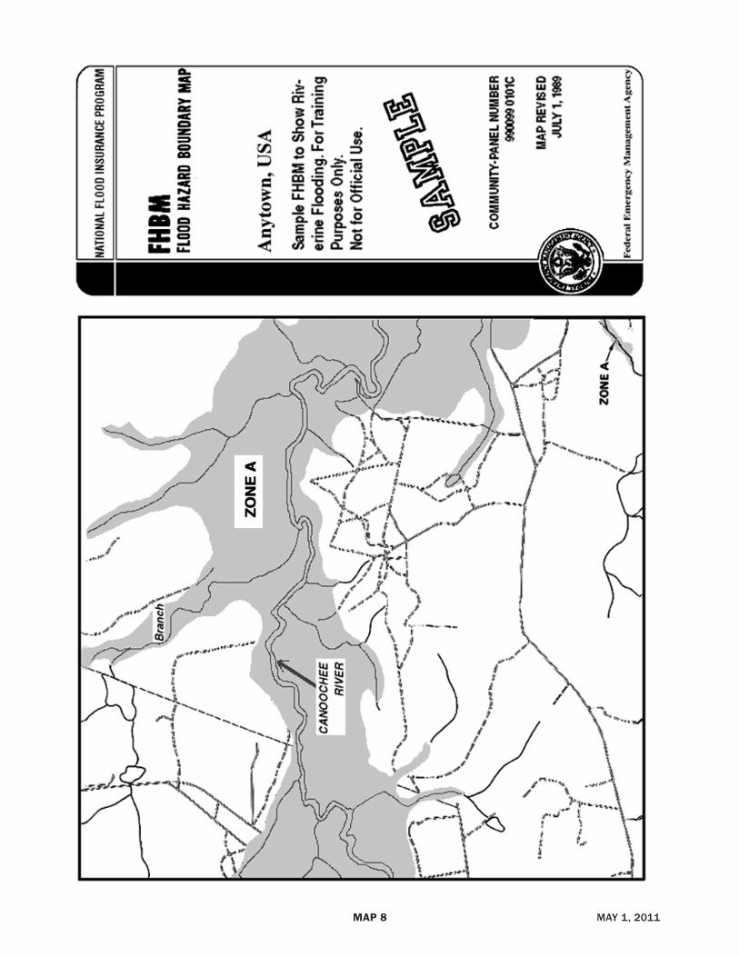
1. Flood Hazard Boundary Map (FHBM) – Initial flood hazard identification generally used for Emergency Program communities.
2. Flood Insurance Rate Map (FIRM) – Generally used for Regular Program communities. Some Regular Program communities may use a map originally published as an FHBM; however, a letter will accompany the map in conjunction with conversion to the Regular Program stating that the map is to be considered a FIRM.
Countywide FIRMs are official sources of flood risk data for several communities that supersede all previous versions of the FEMA flood hazard maps for the communities covered. Countywide FIRMs show flooding information for the entire geographic area of a county, including the incorporated communities within the county.
B. MapInformation
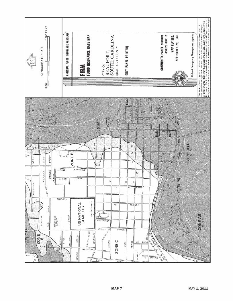
The date of the current effective map version for a community can be obtained by calling the appropriate community official or by calling the National Flood Insurance Program (NFIP) office at the toll-free number. Maps provide community name, community number, suffix, panel number, map type, and the map effective date. (See FIRM panel example and FHBM panel sample at the end of this section.)
1. The maps may have 1 panel or multiple panels. Most Z-fold maps have multiple panels. Flat maps generally consist of only 1 panel.
2. For multiple-panel maps, individual panels are identified on a community map index.
3. Panel numbers are listed for that community’s map in numerical sequence. FHBMs and FIRMs are drawn to show:
• Community boundaries;
• Special Flood Hazard Areas (SFHAs); and
• Areas not included in a community’s map. A community may be physically located within the overall geographical area, but actually stand on its own as a separate community. Therefore, this community would be shown on a separate map.
4. Each panel has a panel number and community number. When there is only 1 panel (i.e., a flat map), the community number will consist of only 6 digits.
Example: Monterey County, CA 060195-1025 (The first 2 digits of the number identify the state and the next 4 digits identify the community. The last 4 digits identify the map panel.)
5. Most FIRMs also show:
• Rate Zones;
• Base Flood Elevations; and/or
• Base Flood Depths.
C. CommunitieswithUnpublishedMaps
These are communities without formally identified SFHAs that chose to have flood insurance coverage available even though the local flooding problems are too small to map. For any such community in the Regular Program, all areas within that community are treated as Zone C or X.
D. UnmappedAreasinCommunitieswithMaps
The flood hazards for some areas within mapped communities remain undetermined and are unmapped. These unmapped areas are to be treated as Zone D. The designation of Zone D can also be used for rating when a community incorporates portions of another community’s area where no map has been prepared.
II. MAPZONES
A. SpecialFloodHazardAreas
1. Zone A
The lowest floor elevation is required and the Base Flood Elevations (BFEs) are not provided.
FLOODMAPS
PreviousSection NextSectionMainMenu TableofContents
PreviousSection NextSectionMainMenu TableofContents

MAP2 May 1, 2011
2. Zones A1–A30
The lowest floor elevation is required and the BFEs are provided.
3. Zone AE
Used in place of A1–A30 on some maps.
4. Zone AH
Shallow water depths (ponding) and/or unpredictable flow paths between 1 and 3 feet occur. BFEs are provided.
5. Zone AO
Shallow water paths (sheet flow) and/or unpredictable flow paths between 1 and 3 feet occur. BFEs are not provided. Base flood depths may be provided.
6. Zone A99
Enough progress has been made on a protective system such as dikes, dams, and levees to consider it complete for insurance rating purposes. BFEs are not provided. For the purpose of determining Community Rating System (CRS) premium discounts, all AR and A99 Zones are treated as non-SFHAs.
7. Zone AR
Area that results from the decertification of a previously accredited flood protection system that is determined to be in the process of being restored to provide base flood protection. For the purpose of determining CRS premium discounts, all AR and A99 Zones are treated as non-SFHAs.
8. Zones AR/AE, AR/AH, AR/AO, AR/A1–A30, AR/A
Dual flood zones that, because of flooding from other water sources that the flood protection system does not contain, will continue to be subject to flooding after the flood protection system is adequately restored. For the purpose of determining CRS premium discounts, all AR and A99 Zones are treated as non-SFHAs.
9. Zone V
An area that is inundated by tidal floods with velocity (coastal high hazard area). BFEs are not provided.
10. Zones V1–V30
Identical to V Zone, but BFEs are provided.
11. Zone VE
Used in place of V1–V30 on some maps.
B. Moderate,MinimalHazardAreas
1. Zones B, C, and X
Areas of moderate or minimal hazard subject to flooding from severe storm activity or local drainage problems. These zones may be lightly shaded or unshaded on the FIRM. Zone X is the designation for B and C Zones and is used in place of these zones on some maps.
2. Zone D
An area where the flood hazard is undetermined and which usually is very sparsely populated. The designation of Zone D can also be used for rating when a community incorporates portions of another community’s area where no map has been prepared. In addition, if the map shows an area as being unmapped, use Zone D.
III. LOCATINGASPECIFICPROPERTYONAMAP
• Check the map index to identify the correct map panel.
• Directly locate the property by the address or other information. It may help to compare the FHBM or FIRM to a more detailed map, such as an assessor’s map or a community street map.
• Note the map color where the property is located. On FHBMs and FIRMs, areas darkly shaded are the SFHAs. On an FHBM, no other zone data may be given. On a FIRM, zones are also given an alpha designation. The entire area within the boundaries indicated for a zone carries that specific zone designation.
• BFEs in SFHA zones (A1–A30 [or AE], AH, V1–V30 [or VE]) are shown within wavy lines. In some SFHA zones, where the BFE does not vary within the entire zone, the BFE is indicated in parentheses. If required by terrain, a BFE for the property may be interpolated using the closest BFE indicators. In this case, it is important to document the finding.
IV. CHANGINGORCORRECTINGAFLOODMAP
There are 3 procedures:
A. LetterofMapAmendment(LOMA)
If the applicant/insured believes that the requirement to purchase flood insurance was made in error and there is evidence that the building is not in the SFHA on the effective FIRM, the applicant/insured may apply for a LOMA.
MAP3 OctOber 1, 2011
A LOMA is a determination made by FEMA for property and/or building as to whether it is located within the SFHA. LOMA determinations are based on the following:
• Comparing the location of the property to the SFHA.
• Comparing the elevation of the property to the 1-percent-annual-chance flood elevation.
If, after plotting the location on the FIRM, the FEMA examiner finds that the property and/or building is not shown in the SFHA, then the Determination will be “Out As Shown” rather than “Removed.” The FEMA Out-As-Shown Determination will state that the property or building is correctly shown outside the SFHA and, therefore, the mandatory flood insurance requirement does not apply.
An Out-As-Shown Determination does not require elevations. The minimum requirements to make an Out-As-Shown Determination are as follows:
• A photocopy of the FIRM panel (including the title block) that shows the area in which the property is located.
• Section A of the MT-EZ form, which is found in the MT-EZ application package and can be obtained from the FEMA website at http://www.fema.gov/plan/prevent/fhm/dl_mt-ez.shtm, or by calling the toll-free number listed below.
• A copy of the subdivision Plat Map of the area, showing the recordation data (i.e., Book/Volume and Page numbers) and containing the recorder’s seal.
OR
• A copy of the deed for the property, showing the recordation information (i.e., Book/Volume and Page numbers) and containing the recorder’s seal, accompanied by a tax assessor’s or other suitable map showing the surveyed location of the property and at least 2 street intersections that are also shown on FEMA’s FIRM.
In some cases, additional information may be required to make a determination.
Questions about LOMAs may be directed to the FEMA Map Information eXchange (FMIX) toll-free information line at 1-877-FEMA-MAP (1-877-336-2627).
B. LetterofMapRevision(LOMR)
A LOMR is an official revision to the currently effective FEMA map. It is used to change flood zones, floodplain and floodway delineations, flood elevations, and planimetric features. All requests for LOMRs must be made to FEMA through the chief executive officer of the community, since it is the community that must
adopt any changes and revisions to the map. A LOMR is usually followed by a physical map revision.
C. PhysicalMapRevision
A physical map revision is an official republication of a map to effect changes to flood insurance zones, floodplain delineations, flood elevations, floodways, and planimetric features.
The community’s chief executive officer can submit scientific and technical data to FEMA to support the request for a map revision. The data will be analyzed, and the map will be revised if warranted.
NOTE: To verify past rating determinations and to establish floodplain management compliance requirements, old maps should be retained.
V. ORDERINGFLOODMAPS
Flood maps and related products may be ordered by writing to the FEMA MSC at P.O. Box 1038, Jessup, MD 20794-1038. Orders also may be placed by calling the FEMA Map Information eXchange (FMIX) toll-free number, 1-877-336-2627, from 8:00 a.m. to 8:00 p.m., Monday through Friday.
Information about flood maps and other products also is available at the MSC’s website (http://msc.fema.gov). Visitors to the site now can download and print free “FIRMettes” – user-selected portions of official FEMA FIRMs. Regular visitors may set up accounts to order and pay for fee-based products online.
The MSC distributes FHBMs, FIRMs, and Flood Insurance Studies in hardcopy format. Digital flood data, known as Q3, are available on CD-ROM for approximately 900 counties nationwide. The Q3 data require GIS software for use. Call the FEMA Map Information eXchange (FMIX) at 1-877-336-2627 for Q3 information for specific areas.
A. OrderingInstructions
Z-fold maps may be ordered by community number and panel number. Flat map orders require a 6-digit community number. When ordering maps, be sure to identify specific map panels needed.
B. Prices
There is a $4 charge for each hardcopy map panel, including index maps, plus shipping. Q3 data are $50 per CD-ROM. Federal, state, and local governments are exempt from the fees for hardcopy maps. However, they must pay for Q3 CD-ROMs.

MAP4 OctOber 1, 2011
A chart showing MSC products, services, and fees is provided on pages MAP 5–6. Orders must be prepaid, and all sales are final. Overpayments of less than $3 are not refunded.
The MSC accepts VISA, MasterCard, American Express, and Discover; deposit accounts (see “C. Map Revisions,” following); and checks. Credit card and deposit account orders can be faxed to 1-800-358-9620. Checks should be made payable to “NFIP” and mailed to the address shown at the beginning of “V. Ordering Flood Maps.”
C. MapRevisions
To automatically receive map revisions, an account must be set up by either check or credit card. Accounts are established with a check of $1,500 minimum. The check must be sent to the MSC at the address on the previous page, along with a list of the required map areas. As revised maps become available, they will be sent automatically, and the appropriate fees will be deducted from the deposit account.
Revised map information also may be obtained from the Flood Map Status Information Service or the Community Status Book. For more information, call the FEMA Map Information eXchange (FMIX) at 1-877-336-2627.
MAP5 May 1, 2011
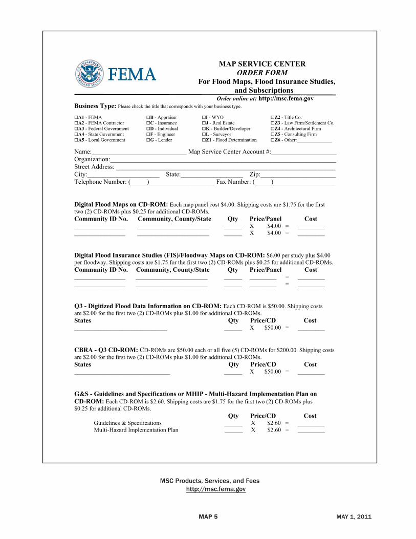
MAP SERVICE CENTER ORDER FORM
For Flood Maps, Flood Insurance Studies, and Subscriptions
Order online at: http://msc.fema.govBusiness Type: Please check the title that corresponds with your business type.
A1 - FEMA B - Appraiser I - WYO Z2 - Title Co. A2 - FEMA Contractor C - Insurance J - Real Estate Z3 - Law Firm/Settlement Co. A3 - Federal Government D - Individual K - Builder/Developer Z4 - Architectural Firm A4 - State Government F - Engineer L - Surveyor Z5 - Consulting Firm A5 - Local Government G - Lender Z1 - Flood Determination Z6 - Other:________________
Name:_____________________________ Map Service Center Account #:____________________ Organization:_____________________________________________________________________ Street Address: ___________________________________________________________________ City:______________________ State:___________________ Zip:_______________________ Telephone Number: (_____)____________________ Fax Number: (_____)___________________ Digital Flood Maps on CD-ROM: Each map panel cost $4.00. Shipping costs are $1.75 for the first two (2) CD-ROMs plus $0.25 for additional CD-ROMs. Community ID No. Community, County/State Qty Price/Panel Cost _________________ ________________________ ______ X $4.00 = _________ _________________ ________________________ ______ X $4.00 = _________ Digital Flood Insurance Studies (FIS)/Floodway Maps on CD-ROM: $6.00 per study plus $4.00 per floodway. Shipping costs are $1.75 for the first two (2) CD-ROMs plus $0.25 for additional CD-ROMs. Community ID No. Community, County/State Qty Price/Panel Cost _________________ ________________________ ______ _________ = _________ _________________ ________________________ ______ _________ = _________ Q3 - Digitized Flood Data Information on CD-ROM: Each CD-ROM is $50.00. Shipping costs are $2.00 for the first two (2) CD-ROMs plus $1.00 for additional CD-ROMs.States Qty Price/CD Cost _______________________________ ______ X $50.00 = _________ CBRA - Q3 CD-ROM: CD-ROMs are $50.00 each or all five (5) CD-ROMs for $200.00. Shipping costs are $2.00 for the first two (2) CD-ROMs plus $1.00 for additional CD-ROMs.States Qty Price/CD Cost________________________________ ______ X $50.00 = _________
G&S - Guidelines and Specifications or MHIP - Multi-Hazard Implementation Plan on CD-ROM: Each CD-ROM is $2.60. Shipping costs are $1.75 for the first two (2) CD-ROMs plus $0.25 for additional CD-ROMs.
Qty Price/CD Cost Guidelines & Specifications ______ X $2.60 = _________ Multi-Hazard Implementation Plan ______ X $2.60 = _________
MSc Products, Services, and Fees http://msc.fema.gov
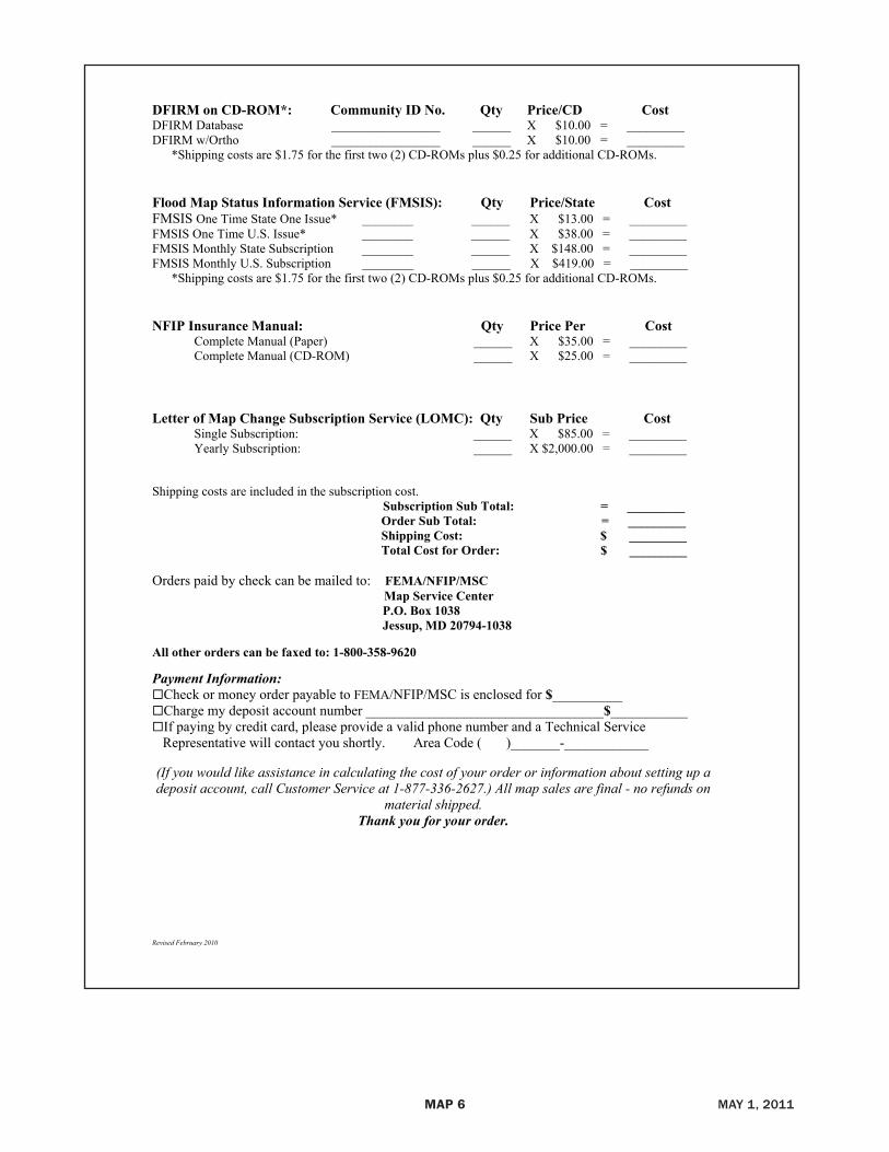
MAP6 May 1, 2011
Revised February 2010
DFIRM on CD-ROM*: Community ID No. Qty Price/CD CostDFIRM Database _________________ ______ X $10.00 = _________ DFIRM w/Ortho _________________ ______ X $10.00 = _________ *Shipping costs are $1.75 for the first two (2) CD-ROMs plus $0.25 for additional CD-ROMs.
Flood Map Status Information Service (FMSIS): Qty Price/State Cost FMSIS One Time State One Issue* ________ ______ X $13.00 = _________ FMSIS One Time U.S. Issue* ________ ______ X $38.00 = _________ FMSIS Monthly State Subscription ________ ______ X $148.00 = _________ FMSIS Monthly U.S. Subscription ________ ______ X $419.00 = _________ *Shipping costs are $1.75 for the first two (2) CD-ROMs plus $0.25 for additional CD-ROMs.
NFIP Insurance Manual: Qty Price Per Cost Complete Manual (Paper) ______ X $35.00 = _________ Complete Manual (CD-ROM) ______ X $25.00 = _________
Letter of Map Change Subscription Service (LOMC): Qty Sub Price Cost Single Subscription: ______ X $85.00 = _________
Yearly Subscription: ______ X $2,000.00 = _________ Shipping costs are included in the subscription cost. Subscription Sub Total: = _________ Order Sub Total: = _________ Shipping Cost: $ _________ Total Cost for Order: $ _________ Orders paid by check can be mailed to: FEMA/NFIP/MSC Map Service Center P.O. Box 1038 Jessup, MD 20794-1038
All other orders can be faxed to: 1-800-358-9620
Payment Information: Check or money order payable to FEMA/NFIP/MSC is enclosed for $__________ Charge my deposit account number __________________________________$___________ If paying by credit card, please provide a valid phone number and a Technical Service
Representative will contact you shortly. Area Code ( )_______-____________ (If you would like assistance in calculating the cost of your order or information about setting up a deposit account, call Customer Service at 1-877-336-2627.) All map sales are final - no refunds on
material shipped.Thank you for your order.
MAP7 May 1, 2011
MAP8 May 1, 2011