fpt 2093 soil_science_week_10_soil_taxonomy
TRANSCRIPT
SOIL SCIENCEFPT 2093
Lecture Week 10:Soil Taxonomy
En Mohd Fauzie JusohLecturer
Agrotechnology ProgrammeFaculty of Agro-Based Industry
Universiti Malaysia Kelantan (Jeli Campus) Locked Bag No.100, 17600 Jeli, Kelantan.
014-2903025/[email protected]/
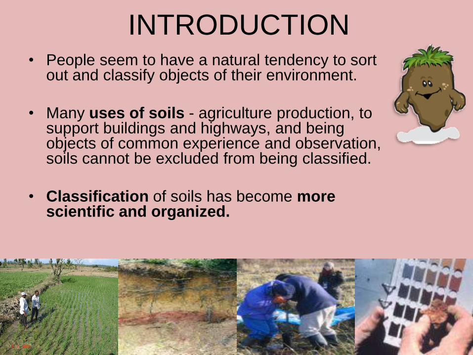
INTRODUCTION• People seem to have a natural tendency to sort
out and classify objects of their environment.
• Many uses of soils - agriculture production, to support buildings and highways, and being objects of common experience and observation, soils cannot be excluded from being classified.
• Classification of soils has become more scientific and organized.
28-May-15 2
Purpose of Classification
• Classes of the objects under study in amanner useful for practical and appliedpurposes.
• We classify soils to predict their behavior, identify their best uses, and estimate their productivity.
28-May-15 3
The US Comprehensive Soil
Classification System
• Differentiating characteristics selected are the properties of the soils (including soil temperature and moisture).
• A formative element from each of the higher categories, the family, and the series form the soil name.
• One can make several statements about soil properties simply from analyzing the name of the soil.
28-May-15 4
Structure of the US system
• Six categories from the highest to the
lowest level of generalization.
• The categories include the order,
suborder, great group, subgroup,
family, and series
28-May-15 5

COMPREHENSIVE CLASSIFICATION SYSTEM: SOIL TAXONOMY
• Soil Taxonomy provides a hierarchical grouping of natural soil bodies.
• The system is based on soil properties that can be objectively observed or measured rather than on presumed mechanisms of soil formation.
– Its unique international nomenclature gives a definite connotation of the major characteristics of the soils in question.
CATEGORIES AND NOMENCLATURE OF SOIL TAXONOMY
• Nomenclature of Soil Taxonomy– The names of suborders automatically identify the
order of which they are a part.
– For example, soils of the suborder Aquolls are the wetter soils (from the Latin aqua, “water”) of the Mollisols order.
– Likewise, the name of the great group identifies the suborder and order of which it is a part.
– Argiaquolls are Aquolls with clay or argillic (Latin argilla, “white clay”) horizons.
CATEGORIES AND NOMENCLATURE OF SOIL TAXONOMY
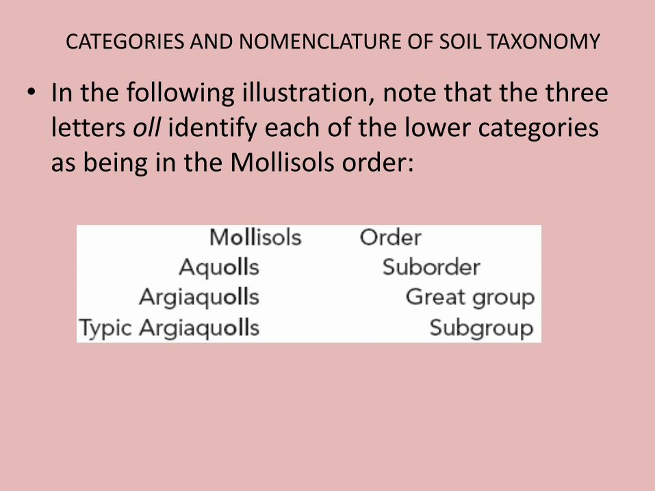
• In the following illustration, note that the three letters oll identify each of the lower categories as being in the Mollisols order:
SOIL ORDERS
• Each of the world’s soils is assigned to one of 12 orders, largely on the basis of soil properties that reflect a major course of development, with considerable emphasis placed on the presence or absence of major diagnostic horizons.
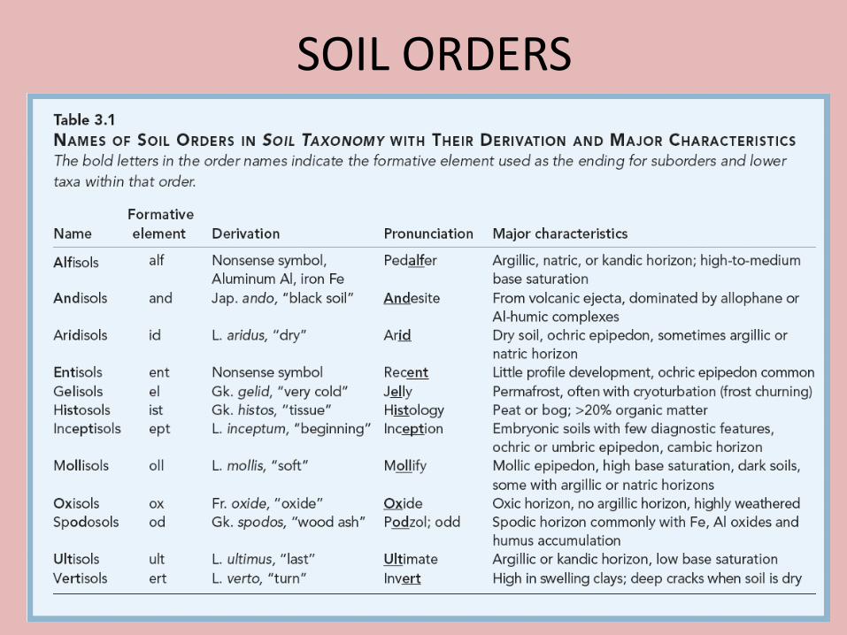
SOIL ORDERS
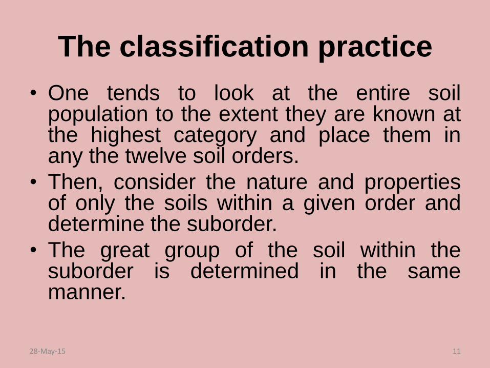
The classification practice
• One tends to look at the entire soilpopulation to the extent they are known atthe highest category and place them inany the twelve soil orders.
• Then, consider the nature and propertiesof only the soils within a given order anddetermine the suborder.
• The great group of the soil within thesuborder is determined in the samemanner.
28-May-15 11
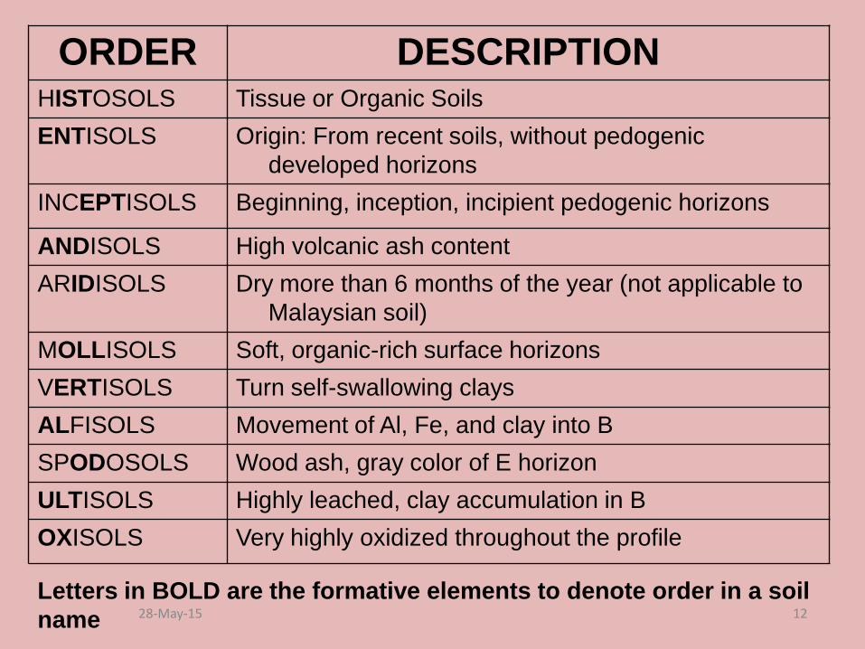
ORDER DESCRIPTIONHISTOSOLS Tissue or Organic Soils
ENTISOLS Origin: From recent soils, without pedogenic
developed horizons
INCEPTISOLS Beginning, inception, incipient pedogenic horizons
ANDISOLS High volcanic ash content
ARIDISOLS Dry more than 6 months of the year (not applicable to
Malaysian soil)
MOLLISOLS Soft, organic-rich surface horizons
VERTISOLS Turn self-swallowing clays
ALFISOLS Movement of Al, Fe, and clay into B
SPODOSOLS Wood ash, gray color of E horizon
ULTISOLS Highly leached, clay accumulation in B
OXISOLS Very highly oxidized throughout the profile
Letters in BOLD are the formative elements to denote order in a soil
name 28-May-15 12
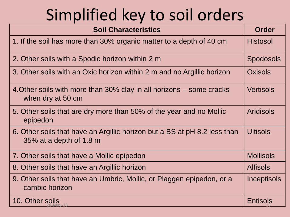
Simplified key to soil ordersSoil Characteristics Order
1. If the soil has more than 30% organic matter to a depth of 40 cm Histosol
2. Other soils with a Spodic horizon within 2 m Spodosols
3. Other soils with an Oxic horizon within 2 m and no Argillic horizon Oxisols
4.Other soils with more than 30% clay in all horizons – some cracks
when dry at 50 cm
Vertisols
5. Other soils that are dry more than 50% of the year and no Mollic
epipedon
Aridisols
6. Other soils that have an Argillic horizon but a BS at pH 8.2 less than
35% at a depth of 1.8 m
Ultisols
7. Other soils that have a Mollic epipedon Mollisols
8. Other soils that have an Argillic horizon Alfisols
9. Other soils that have an Umbric, Mollic, or Plaggen epipedon, or a
cambic horizon
Inceptisols
10. Other soils Entisols28-May-15 13

Figure 3.6 Diagram showing general degree of weathering and soil development in the different soil orders classified in Soil Taxonomy. Also shown are the general climatic and vegetative conditions under which soils in each order are formed.
SOIL ORDERS
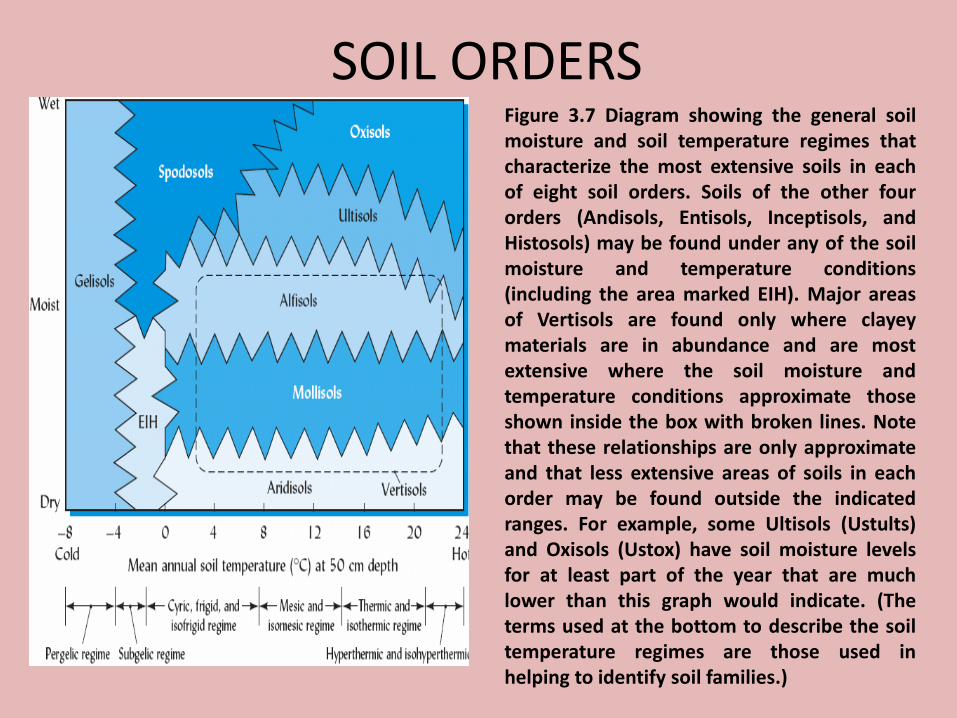
SOIL ORDERSFigure 3.7 Diagram showing the general soilmoisture and soil temperature regimes thatcharacterize the most extensive soils in eachof eight soil orders. Soils of the other fourorders (Andisols, Entisols, Inceptisols, andHistosols) may be found under any of the soilmoisture and temperature conditions(including the area marked EIH). Major areasof Vertisols are found only where clayeymaterials are in abundance and are mostextensive where the soil moisture andtemperature conditions approximate thoseshown inside the box with broken lines. Notethat these relationships are only approximateand that less extensive areas of soils in eachorder may be found outside the indicatedranges. For example, some Ultisols (Ustults)and Oxisols (Ustox) have soil moisture levelsfor at least part of the year that are muchlower than this graph would indicate. (Theterms used at the bottom to describe the soiltemperature regimes are those used inhelping to identify soil families.)
SOIL ORDERS
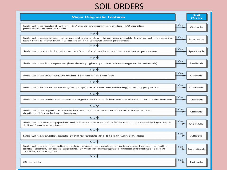
Figure 3.8 A simplified key to the 12 soil orders in Soil Taxonomy. In using the key, always begin at the top. Note how diagnostic horizons and other profile features are used to distinguish each soil order from the remaining orders. Entisols, having no such special diagnostic features, key out last. Also note that the sequence of soil orders in this key bears no relationship to the degree of profile development and adjacent soil orders may not be more similar than nonadjacent ones.
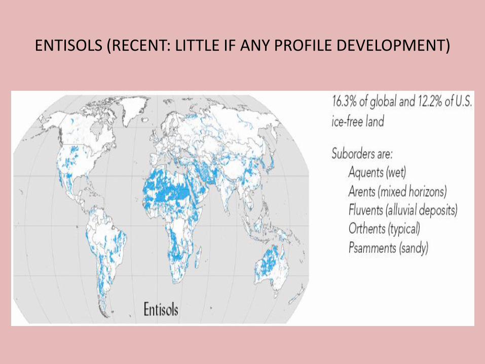
ENTISOLS (RECENT: LITTLE IF ANY PROFILE DEVELOPMENT)

ENTISOLS (RECENT: LITTLE IF ANY PROFILE DEVELOPMENT)
Figure 3.9 Profile of a Psamment formed on sandy alluvium in Virginia. Note the accumulation of organic matter in the A horizon but no other evidence of profile development. The A horizon is 30 cm thick. (Photo courtesy of R. Weil)
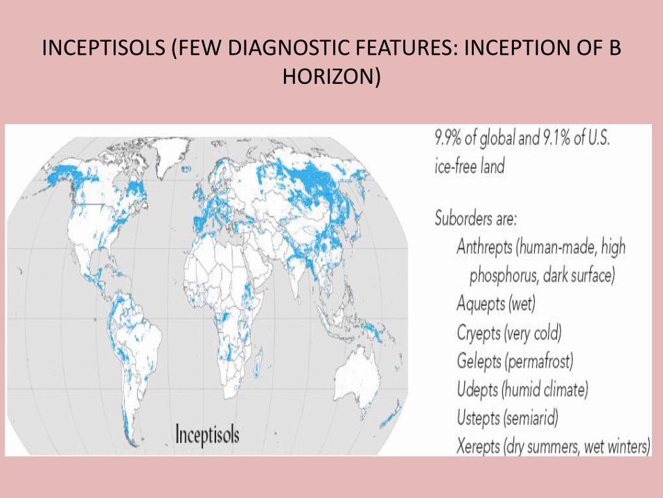
INCEPTISOLS (FEW DIAGNOSTIC FEATURES: INCEPTION OF B HORIZON)
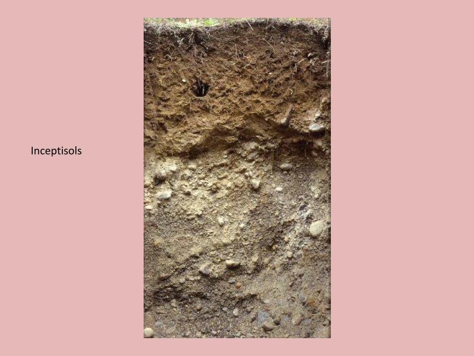
Inceptisols
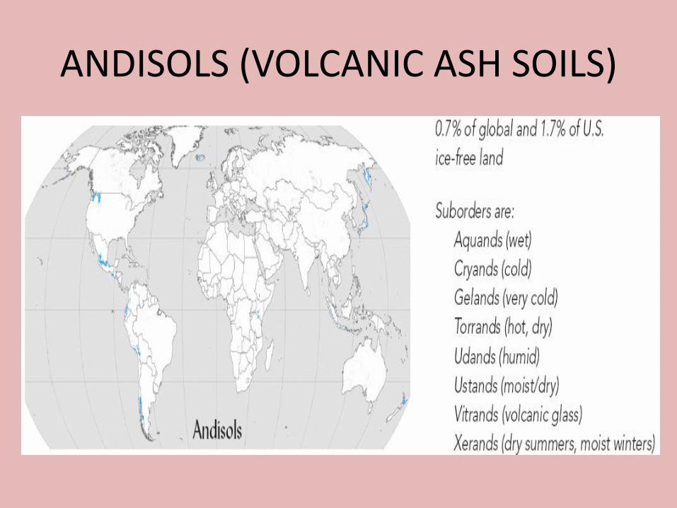
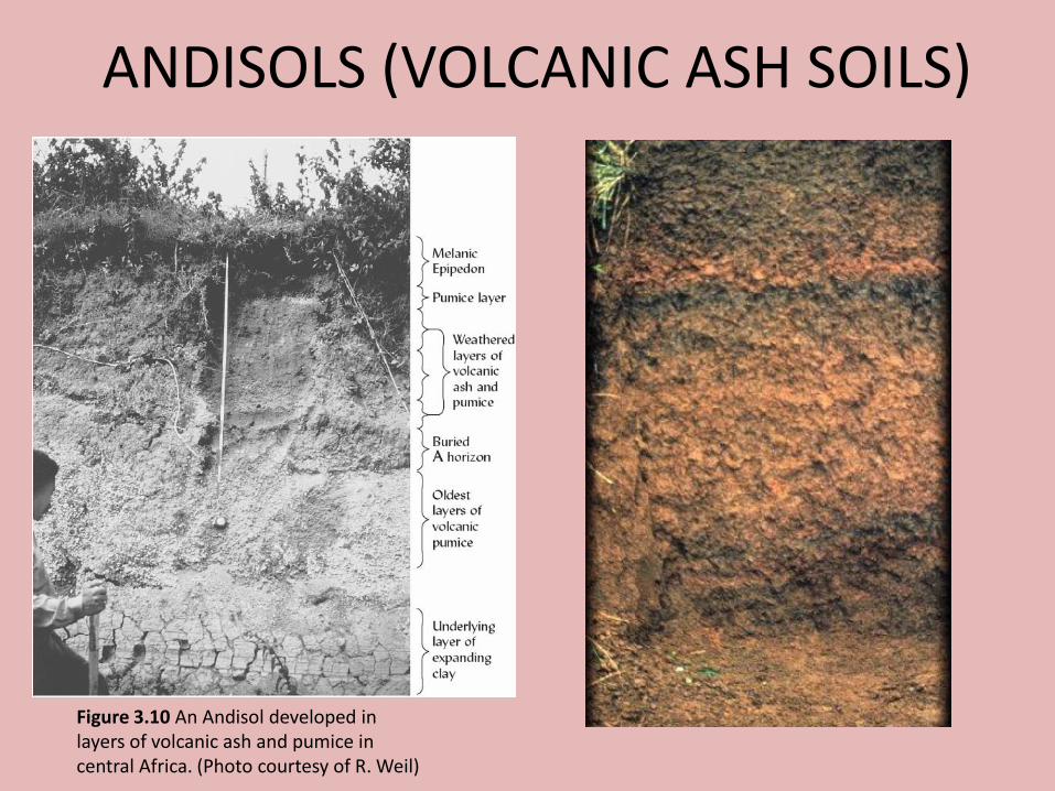
ANDISOLS (VOLCANIC ASH SOILS)
ANDISOLS (VOLCANIC ASH SOILS)
Figure 3.10 An Andisol developed in layers of volcanic ash and pumice in central Africa. (Photo courtesy of R. Weil)

GELISOLS (PERMAFROST AND FROST CHURNING)
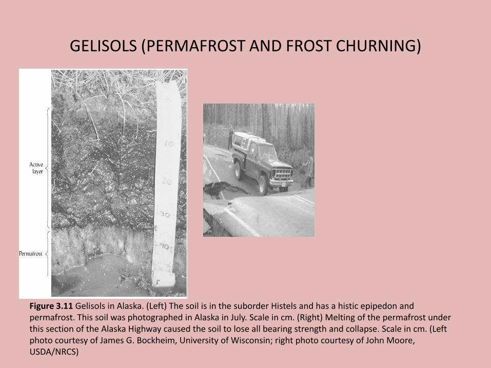
GELISOLS (PERMAFROST AND FROST CHURNING)
Figure 3.11 Gelisols in Alaska. (Left) The soil is in the suborder Histels and has a histic epipedon and permafrost. This soil was photographed in Alaska in July. Scale in cm. (Right) Melting of the permafrost under this section of the Alaska Highway caused the soil to lose all bearing strength and collapse. Scale in cm. (Left photo courtesy of James G. Bockheim, University of Wisconsin; right photo courtesy of John Moore, USDA/NRCS)
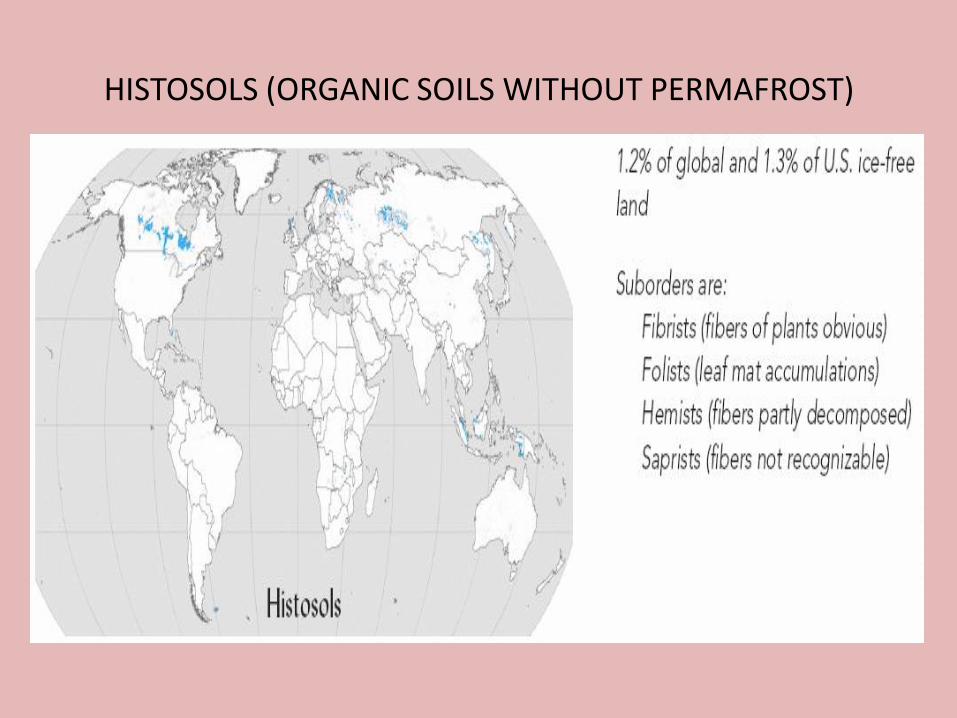
HISTOSOLS (ORGANIC SOILS WITHOUT PERMAFROST)
HISTOSOLS (ORGANIC SOILS WITHOUT PERMAFROST)
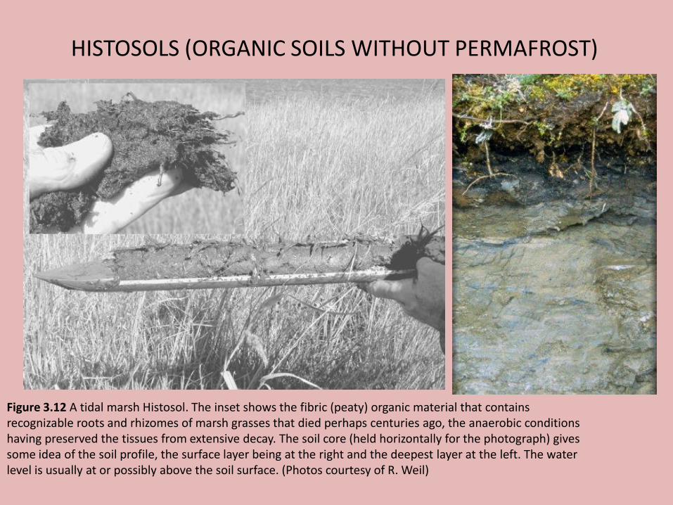
Figure 3.12 A tidal marsh Histosol. The inset shows the fibric (peaty) organic material that contains recognizable roots and rhizomes of marsh grasses that died perhaps centuries ago, the anaerobic conditions having preserved the tissues from extensive decay. The soil core (held horizontally for the photograph) gives some idea of the soil profile, the surface layer being at the right and the deepest layer at the left. The water level is usually at or possibly above the soil surface. (Photos courtesy of R. Weil)
HISTOSOLS (ORGANIC SOILS WITHOUT PERMAFROST)
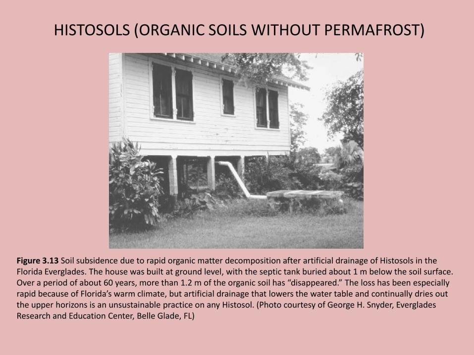
Figure 3.13 Soil subsidence due to rapid organic matter decomposition after artificial drainage of Histosols in the Florida Everglades. The house was built at ground level, with the septic tank buried about 1 m below the soil surface. Over a period of about 60 years, more than 1.2 m of the organic soil has “disappeared.” The loss has been especially rapid because of Florida’s warm climate, but artificial drainage that lowers the water table and continually dries out the upper horizons is an unsustainable practice on any Histosol. (Photo courtesy of George H. Snyder, Everglades Research and Education Center, Belle Glade, FL)
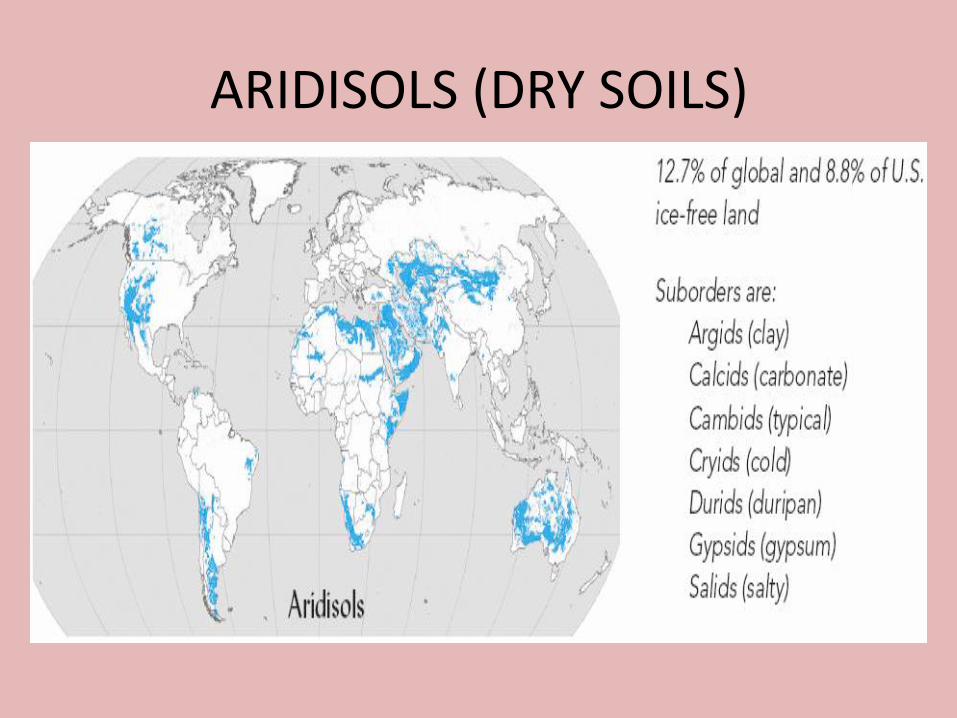
ARIDISOLS (DRY SOILS)
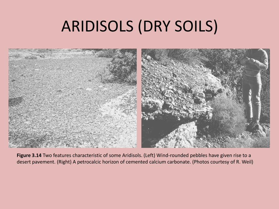
ARIDISOLS (DRY SOILS)
Figure 3.14 Two features characteristic of some Aridisols. (Left) Wind-rounded pebbles have given rise to a desert pavement. (Right) A petrocalcic horizon of cemented calcium carbonate. (Photos courtesy of R. Weil)
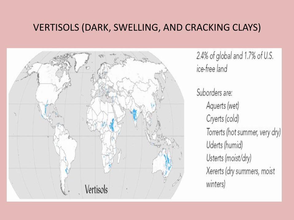
VERTISOLS (DARK, SWELLING, AND CRACKING CLAYS)
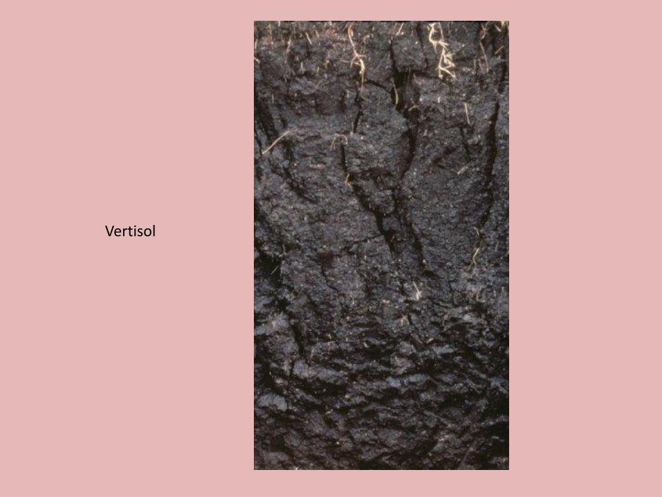
Vertisol

VERTISOLS (DARK, SWELLING, AND CRACKING CLAYS)
Figure 3.15 (a)Wide cracks formed during the dry season in the surface layers of this Vertisol in India. Surface debris can slough off into these cracks and move to subsoil. When the rains come, water can move quickly to the lower horizons, but the cracks are soon sealed, making the soils relatively impervious to the water. (b) Once the cracks have sealed, water may collect in the “microlows,” making the gilgai relief easily visible as in this Texas vertisol. (Photo (a) courtesy of N. C. Brady; (b) courtesy of K. N. Potter, USDA/ARS, Temple, Texas)
VERTISOLS (DARK, SWELLING, AND CRACKING CLAYS)
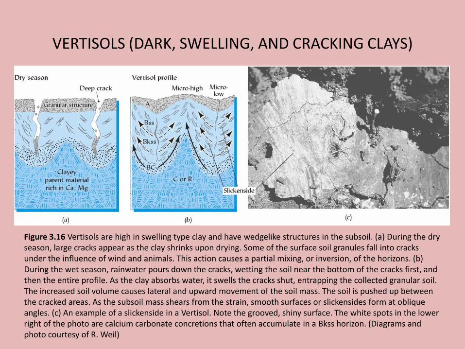
Figure 3.16 Vertisols are high in swelling type clay and have wedgelike structures in the subsoil. (a) During the dry season, large cracks appear as the clay shrinks upon drying. Some of the surface soil granules fall into cracks under the influence of wind and animals. This action causes a partial mixing, or inversion, of the horizons. (b) During the wet season, rainwater pours down the cracks, wetting the soil near the bottom of the cracks first, and then the entire profile. As the clay absorbs water, it swells the cracks shut, entrapping the collected granular soil. The increased soil volume causes lateral and upward movement of the soil mass. The soil is pushed up between the cracked areas. As the subsoil mass shears from the strain, smooth surfaces or slickensides form at oblique angles. (c) An example of a slickenside in a Vertisol. Note the grooved, shiny surface. The white spots in the lower right of the photo are calcium carbonate concretions that often accumulate in a Bkss horizon. (Diagrams and photo courtesy of R. Weil)
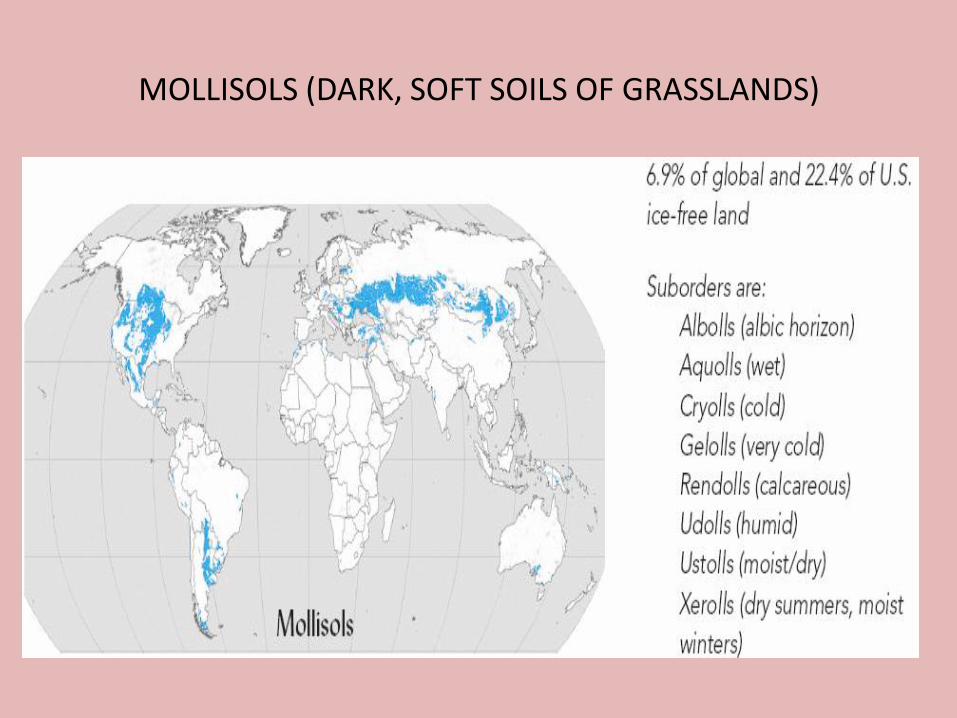
MOLLISOLS (DARK, SOFT SOILS OF GRASSLANDS)
MOLLISOLS (DARK, SOFT SOILS OF GRASSLANDS)
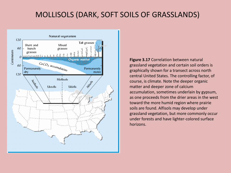
Figure 3.17 Correlation between natural grassland vegetation and certain soil orders is graphically shown for a transect across north central United States. The controlling factor, of course, is climate. Note the deeper organic matter and deeper zone of calcium accumulation, sometimes underlain by gypsum, as one proceeds from the drier areas in the west toward the more humid region where prairie soils are found. Alfisols may develop under grassland vegetation, but more commonly occur under forests and have lighter-colored surface horizons.
MOLLISOLS (DARK, SOFT SOILS OF GRASSLANDS)
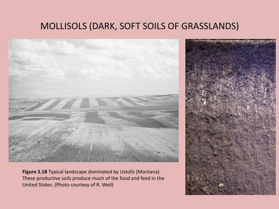
Figure 3.18 Typical landscape dominated by Ustolls (Montana). These productive soils produce much of the food and feed in the United States. (Photo courtesy of R. Weil)

MOLLISOLS (DARK, SOFT SOILS OF GRASSLANDS)
Figure 3.19 Monoliths of profiles representing three soil orders. The suborder names are in parentheses. Genetic (not diagnostic) horizon designations are also shown. Note the spodic horizons in the Spodosol characterized by humus (Bh) and iron (Bs) accumulation. In the Alfisol is found the illuvial clay horizon (Bt), and the structural B horizon (Bw) is indicated in the Mollisols. The thick dark surface horizon (mollic epipedon) characterizes both Mollisols. Note that the zone of calcium carbonate accumulation (Bk) is near the surface in the Ustoll, which has developed in a dry climate. The E/B horizon in the Alfisol has characteristics of both E and B horizons.
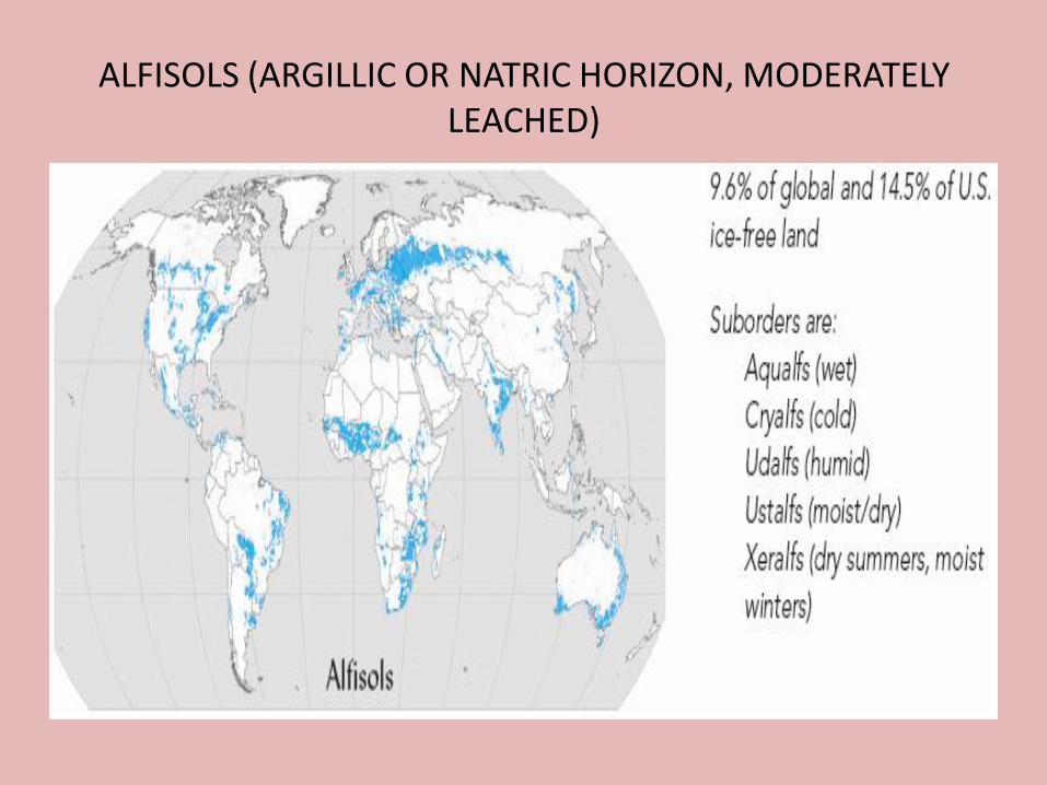
ALFISOLS (ARGILLIC OR NATRIC HORIZON, MODERATELY LEACHED)
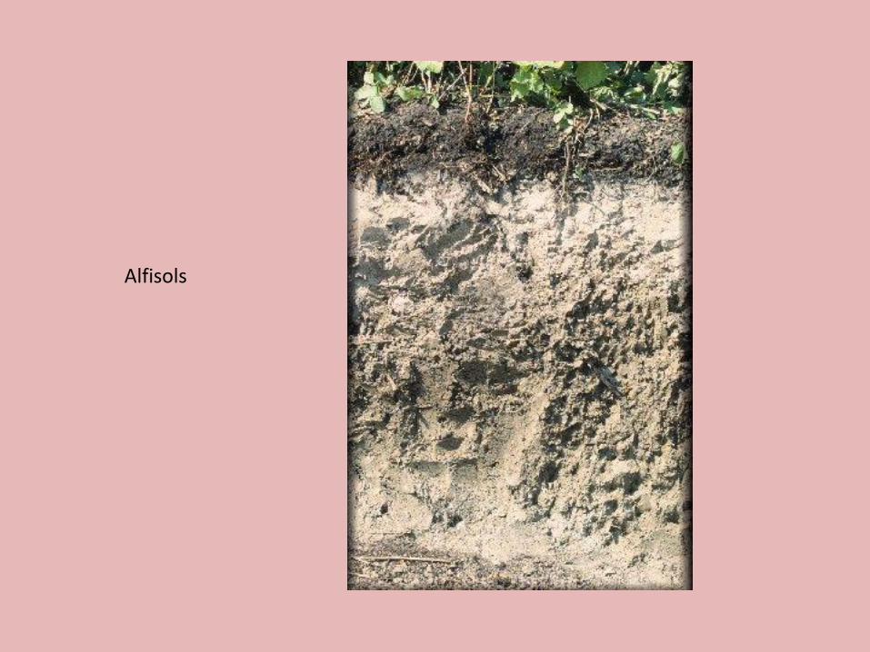
Alfisols
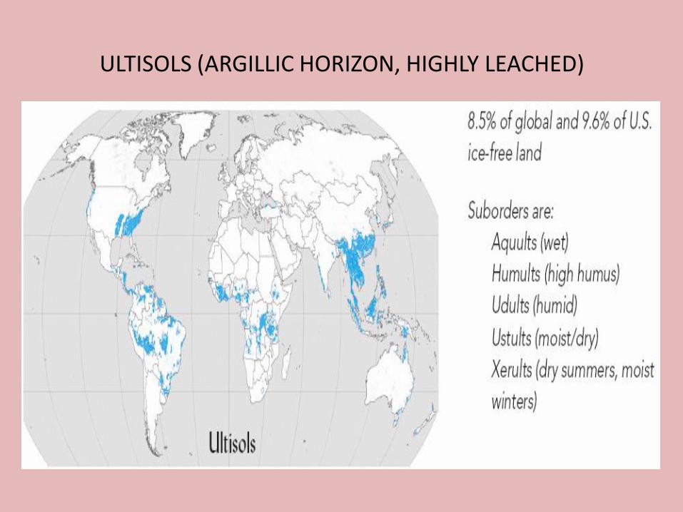
ULTISOLS (ARGILLIC HORIZON, HIGHLY LEACHED)
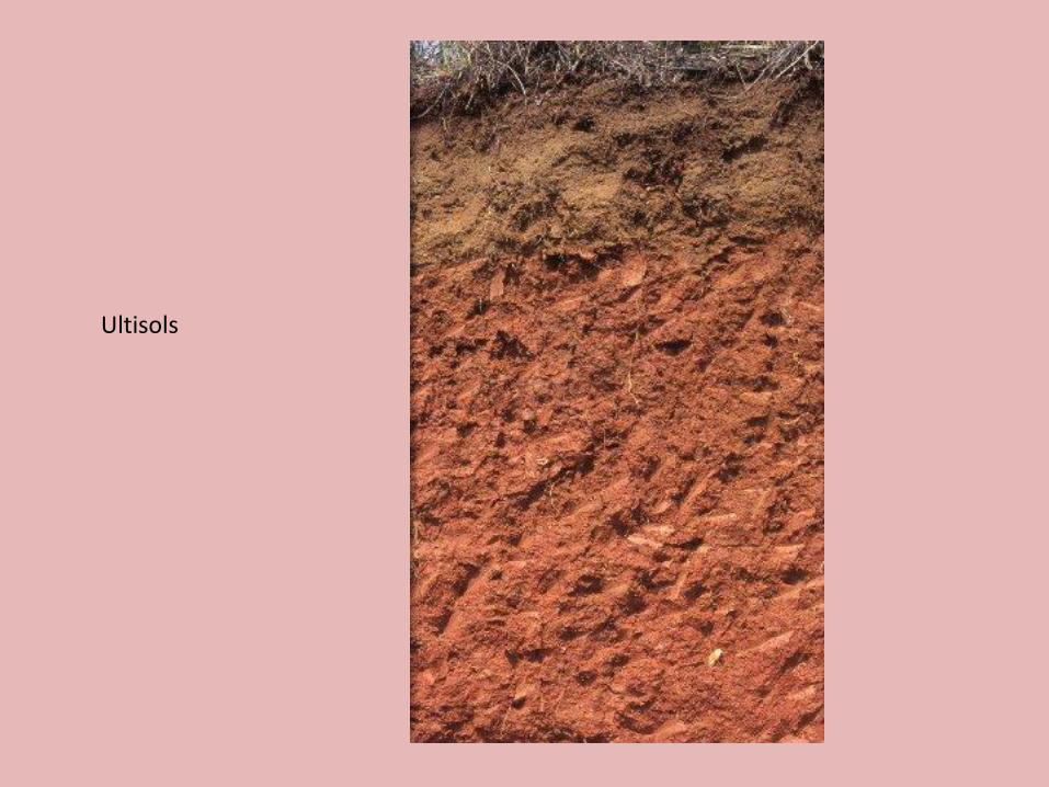
Ultisols

SPODOSOLS (ACID, SANDY, FOREST SOILS, HIGHLY LEACHED)

Spadosols
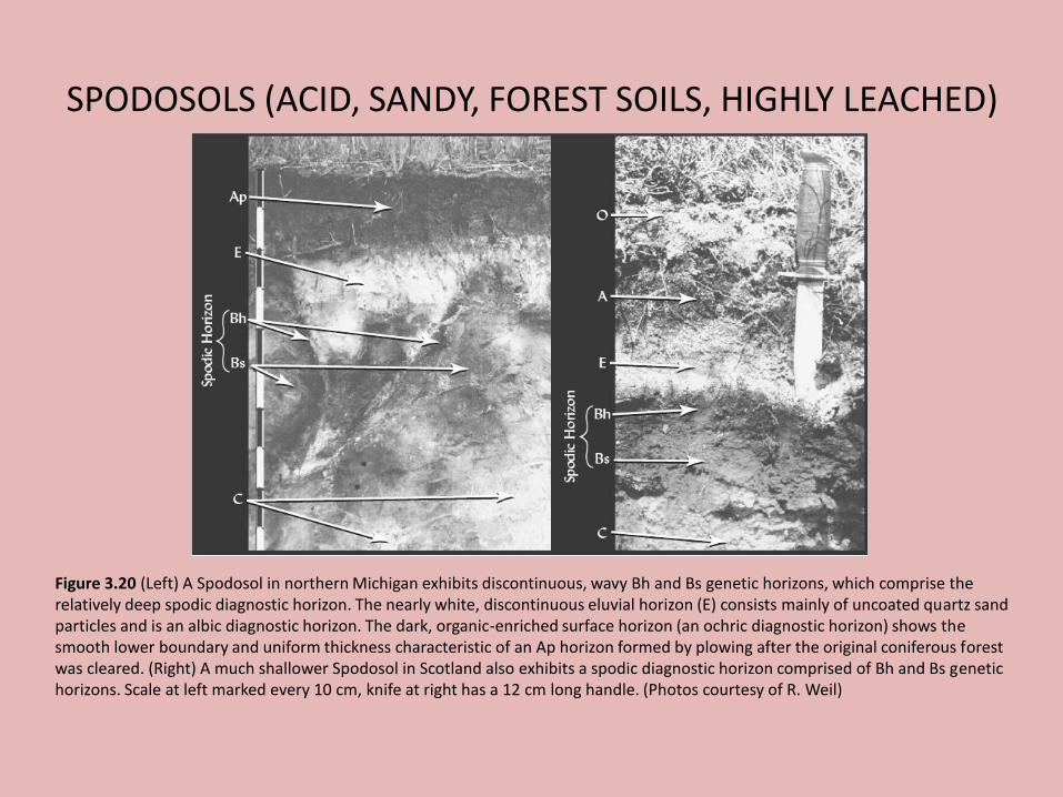
SPODOSOLS (ACID, SANDY, FOREST SOILS, HIGHLY LEACHED)
Figure 3.20 (Left) A Spodosol in northern Michigan exhibits discontinuous, wavy Bh and Bs genetic horizons, which comprise the relatively deep spodic diagnostic horizon. The nearly white, discontinuous eluvial horizon (E) consists mainly of uncoated quartz sand particles and is an albic diagnostic horizon. The dark, organic-enriched surface horizon (an ochric diagnostic horizon) shows the smooth lower boundary and uniform thickness characteristic of an Ap horizon formed by plowing after the original coniferous forest was cleared. (Right) A much shallower Spodosol in Scotland also exhibits a spodic diagnostic horizon comprised of Bh and Bs genetic horizons. Scale at left marked every 10 cm, knife at right has a 12 cm long handle. (Photos courtesy of R. Weil)

OXISOLS (OXIC HORIZON, HIGHLY WEATHERED)
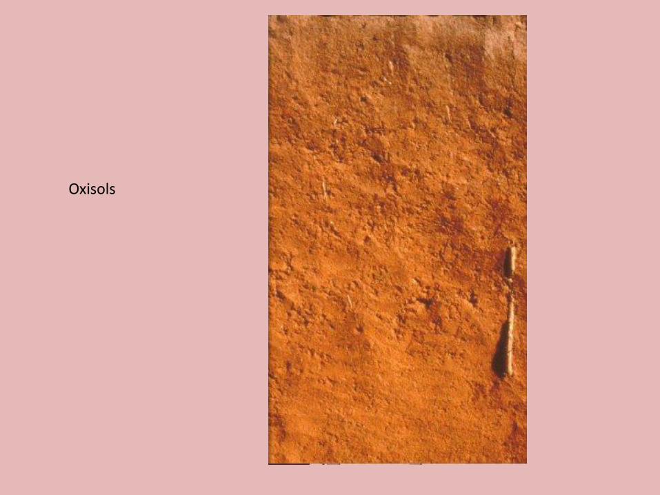
Oxisols

• Diagnostic horizons are used to differentiate among soil orders, suborders, great groups, and subgroups.
i. Surface horizon (A): Epipedonii. Subsurface (B): Endopedon
• Combination of specific soil characteristics that are indicative of certain classes of soils.
• Those which occur at the soil surface are called epipedons, those below the surface is diagnostic subsurface horizons (endopedons).
Epipedon & Endopedon
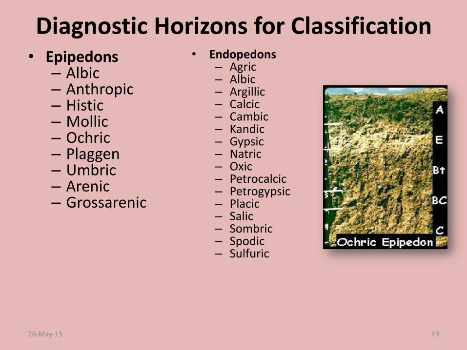
Diagnostic Horizons for Classification• Epipedons
– Albic – Anthropic– Histic – Mollic– Ochric– Plaggen– Umbric– Arenic – Grossarenic
• Endopedons– Agric – Albic– Argillic– Calcic– Cambic– Kandic– Gypsic – Natric– Oxic– Petrocalcic– Petrogypsic– Placic– Salic– Sombric– Spodic– Sulfuric
28-May-15 49
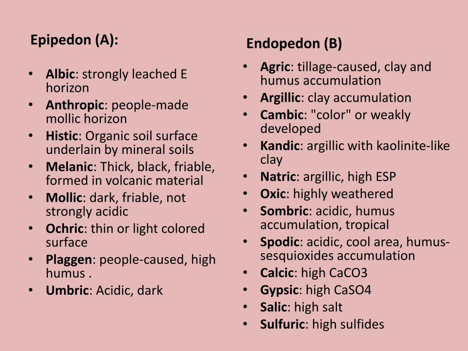
Epipedon (A):
• Albic: strongly leached E horizon
• Anthropic: people-made mollic horizon
• Histic: Organic soil surface underlain by mineral soils
• Melanic: Thick, black, friable, formed in volcanic material
• Mollic: dark, friable, not strongly acidic
• Ochric: thin or light colored surface
• Plaggen: people-caused, high humus .
• Umbric: Acidic, dark
Endopedon (B)
• Agric: tillage-caused, clay and humus accumulation
• Argillic: clay accumulation• Cambic: "color" or weakly
developed• Kandic: argillic with kaolinite-like
clay• Natric: argillic, high ESP• Oxic: highly weathered• Sombric: acidic, humus
accumulation, tropical• Spodic: acidic, cool area, humus-
sesquioxides accumulation• Calcic: high CaCO3• Gypsic: high CaSO4• Salic: high salt• Sulfuric: high sulfides

SOIL TEMPERATURE REGIME & SOIL MOISTURE REGIME
• Soil Moisture Regimes (SMR)
– SMR refers to the presence or absence of either water-saturated conditions (usually groundwater) or plant-available soil water during specified periods in the year.
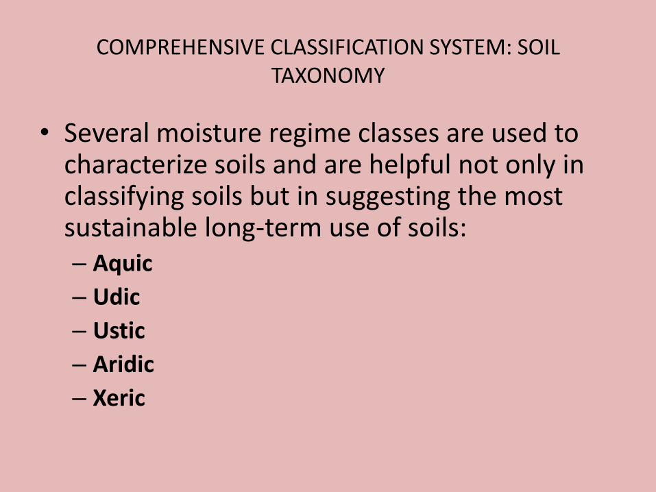
COMPREHENSIVE CLASSIFICATION SYSTEM: SOIL TAXONOMY
• Several moisture regime classes are used to characterize soils and are helpful not only in classifying soils but in suggesting the most sustainable long-term use of soils:– Aquic
– Udic
– Ustic
– Aridic
– Xeric
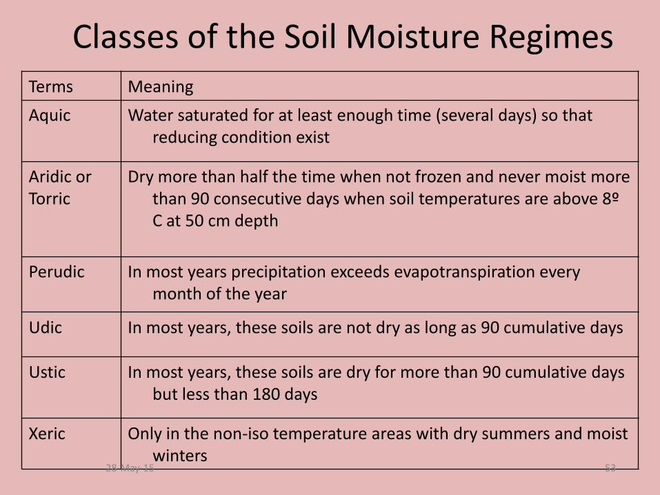
Classes of the Soil Moisture RegimesTerms Meaning
Aquic Water saturated for at least enough time (several days) so that reducing condition exist
Aridic or Torric
Dry more than half the time when not frozen and never moist more than 90 consecutive days when soil temperatures are above 8º C at 50 cm depth
Perudic In most years precipitation exceeds evapotranspiration every month of the year
Udic In most years, these soils are not dry as long as 90 cumulative days
Ustic In most years, these soils are dry for more than 90 cumulative days but less than 180 days
Xeric Only in the non-iso temperature areas with dry summers and moist winters
28-May-15 53
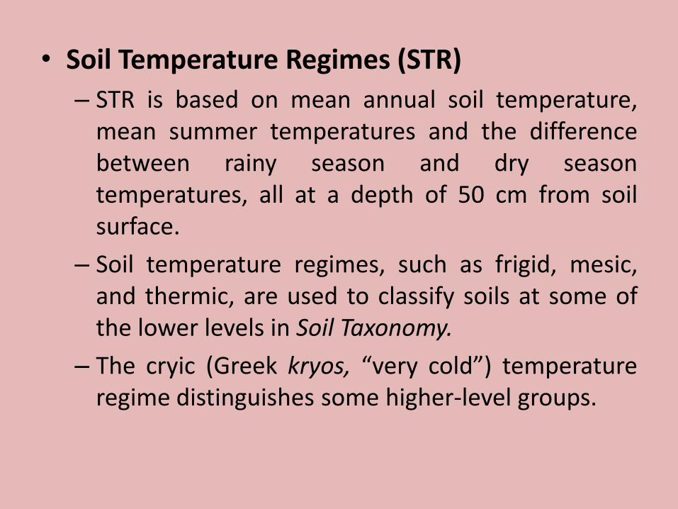
• Soil Temperature Regimes (STR)
– STR is based on mean annual soil temperature,mean summer temperatures and the differencebetween rainy season and dry seasontemperatures, all at a depth of 50 cm from soilsurface.
– Soil temperature regimes, such as frigid, mesic,and thermic, are used to classify soils at some ofthe lower levels in Soil Taxonomy.
– The cryic (Greek kryos, “very cold”) temperatureregime distinguishes some higher-level groups.
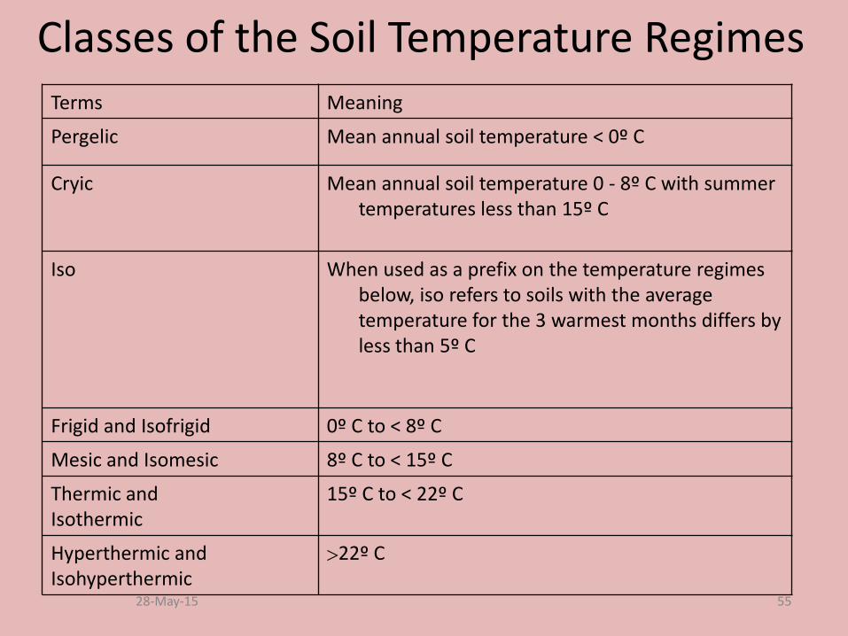
Classes of the Soil Temperature Regimes Terms Meaning
Pergelic Mean annual soil temperature < 0º C
Cryic Mean annual soil temperature 0 - 8º C with summer temperatures less than 15º C
Iso When used as a prefix on the temperature regimes below, iso refers to soils with the average temperature for the 3 warmest months differs by less than 5º C
Frigid and Isofrigid 0º C to < 8º C
Mesic and Isomesic 8º C to < 15º C
Thermic and Isothermic
15º C to < 22º C
Hyperthermic and Isohyperthermic
22º C
28-May-15 55
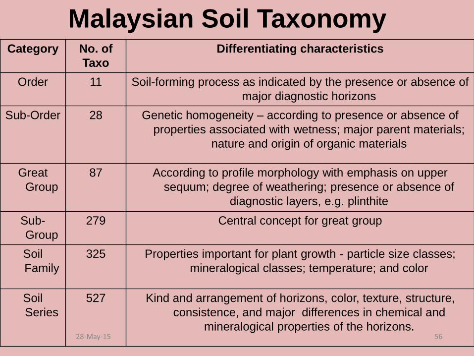
Malaysian Soil TaxonomyCategory No. of
Taxo
Differentiating characteristics
Order 11 Soil-forming process as indicated by the presence or absence of
major diagnostic horizons
Sub-Order 28 Genetic homogeneity – according to presence or absence of
properties associated with wetness; major parent materials;
nature and origin of organic materials
Great
Group
87 According to profile morphology with emphasis on upper
sequum; degree of weathering; presence or absence of
diagnostic layers, e.g. plinthite
Sub-
Group
279 Central concept for great group
Soil
Family
325 Properties important for plant growth - particle size classes;
mineralogical classes; temperature; and color
Soil
Series
527 Kind and arrangement of horizons, color, texture, structure,
consistence, and major differences in chemical and
mineralogical properties of the horizons.28-May-15 56

Malaysian soil orders VS the US systemOrder
Malaysian US System
Organah Histosol
Dankanah Lithosol [shallow soil over hard rock]
Hitanah Spodosol
Abuanah Andisol [volcanic ash]
Oksanah Oxisol
Balanah Vertisol
Kutanah Ultisol
Butanah Mollisol
Jenanah Alfisol
Lahanah Inceptisol
Baranah Entisol28-May-15 57

Questions… Thank You

Sample Questions
1. Soil is classified into categories in order to understand relationship between soils and to determine the usefulness of soil for particular soil. Explain how to classify soils based on the soil taxonomy List the categories or stage in soil taxonomy classifications based on USDA.
2. List 12 orders of soil and mention it main characteristic for each order.
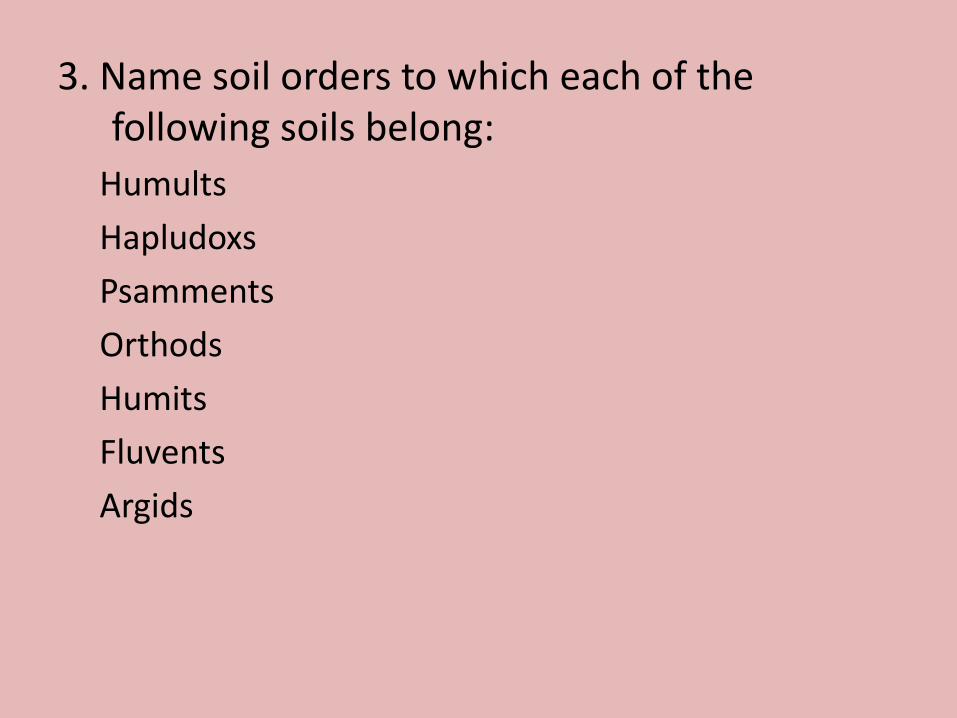
3. Name soil orders to which each of the following soils belong:
Humults
Hapludoxs
Psamments
Orthods
Humits
Fluvents
Argids
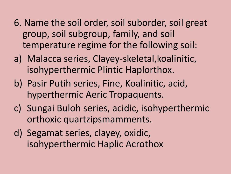
6. Name the soil order, soil suborder, soil great group, soil subgroup, family, and soil temperature regime for the following soil:
a) Malacca series, Clayey-skeletal,koalinitic, isohyperthermic Plintic Haplorthox.
b) Pasir Putih series, Fine, Koalinitic, acid, hyperthermic Aeric Tropaquents.
c) Sungai Buloh series, acidic, isohyperthermicorthoxic quartzipsmamments.
d) Segamat series, clayey, oxidic, isohyperthermic Haplic Acrothox