freshwater mussels of the big muddy...
TRANSCRIPT
Freshwater Mussels of the Big Muddy River
Diane K. Shasteen, Alison L. Price, Sarah A. Bales
INHS Technical Report 2012 (11)
Prepared for:
Illinois Department of Natural Resources: Office of Resource Conservation
U.S. Fish & Wildlife Service
Illinois Natural History Survey
Issued March 7, 2012
Prairie Research Institute, University of Illinois at Urbana Champaign William Shilts, Executive Director Illinois Natural History Survey Brian D. Anderson, Director 1816 South Oak Street Champaign, IL 61820 217-333-6830

Freshwater Mussels of the Big Muddy River
2012 Illinois Natural History Survey, Prairie Research Institute, University of Illinois Illinois Department of Natural Resources Diane Shasteen, Alison Price, Sarah Bales

Preface
While broad geographic information is available on the distribution and abundance of mussels
in Illinois, systematically collected mussel-community data sets required to integrate mussels
into aquatic community assessments do not exist. In 2009, a project funded by a US Fish and
Wildlife Service State Wildlife Grant was undertaken to survey and assess the freshwater
mussel populations at wadeable sites from 33 stream basins in conjunction with the Illinois
Department of Natural Resources (IDNR)/Illinois Environmental Protection Agency (IEPA) basin
surveys. Inclusion of mussels into these basin surveys contributes to the comprehensive basin
monitoring programs that include water and sediment chemistry, instream habitat,
macroinvertebrate, and fish, which reflect a broad spectrum of abiotic and biotic stream
resources. These mussel surveys will provide reliable and repeatable techniques for assessing
the freshwater mussel community in sampled streams. These surveys also provide data for
future monitoring of freshwater mussel populations on a local, regional, and watershed basis.
Agency Contacts Kevin S. Cummings, INHS, [email protected] (217) 333-1623 Bob Szafoni, IDNR, [email protected], (217) 348-0175 Ann Marie Holtrop, IDNR, [email protected], (217) 785-4325 Suggested Citation Shasteen, D.K., A.L. Price, and S.A. Bales. 2012. Freshwater Mussels of the Big Muddy River. Illinois Natural History Survey Technical Report 2012 (11). Champaign, Illinois, 15 pp. + appendix. Acknowledgements
This study was supported by funding from the US Fish and Wildlife Service, State Wildlife Grant
(T-53-D-1, Investigating Mussel Communities in Illinois Streams), the IDNR, and the Illinois
Natural History Survey (INHS). Our extreme gratitude goes to the primary investigators for the
project: Ann Holtrop, Kevin Cummings, Robert Szafoni, and Dr. Yong Cao, who served as our
mentors and made this project possible. We would like to thank all people involved in our
surveys, especially our field assistants (A.J. Berger, Otis Foster, Colleen McLean, Hunter Ray, Jen
Schwab, and Rachel Vinsel), IDNR fisheries biologists, IEPA water monitoring biologists, and
volunteers from other agencies. We would like to extend gratitude to all the land owners, both
public and private, who allowed us access to their properties. We would like to thank Andrew
Hulin for the creation of maps for this report and Christine Mayer for INHS Collection database
support.
1
Introduction
Freshwater mussel populations have been declining for decades and are among the most
seriously impacted aquatic animals worldwide (Bogan 1993, Williams et al. 1993). It is
estimated that nearly 70% of the approximately 300 North American mussel taxa are extinct,
federally-listed as endangered or threatened, or in need of conservation status (Williams et al.
1993, Strayer et al. 2004). In Illinois, 25 of the 62 extant species (44%) are listed as threatened
or endangered (Illinois Endangered Species Protection Board 2011). While broad geographic
information is available on the distribution and abundance of mussels in Illinois, systematically
collected mussel-community data sets required to integrate mussels into aquatic community
assessments do not exist. Sampling of mussels has been very sporadic and limited in the Big
Muddy River basin and no known reports pertaining to mussel communities of the basin have
been published. This report summarizes the mussel survey conducted in the Big Muddy River
basin in 2009-2010 in conjunction with IDNR and IEPA basin surveys.
The Big Muddy River basin drains 3798 km2 (2360 mi2) in the southern part of Illinois and
contains principal tributaries of Casey Fork, Middle Fork Big Muddy, Beaucoup Creek, Little
Muddy River, and Crab Orchard Creek (Page et al. 1992). Originating near Cravat in Jefferson
County, the Big Muddy River basin drains through the counties of Jefferson, Washington, Perry,
Franklin, Williamson, and Jackson. The river mainstem forms the Jackson /Union county line
and joins the Mississippi River south of Grand Tower (Figure 1). The Big Muddy River basin
flows through four natural divisions, including the Lower Mississippi River Bottomlands, Ozark,
Shawnee Hills, and Southern Till Plain (Schwegman 1973). The Southern Till Plain comprises the
majority of the basin which is characterized by hilly upland topography and a broad flood plain
(Forbes and Richardson 1908).
Land-use and Instream Habitat
In the Big Muddy River basin, land use varies slightly by county with approximately 50 to 75% of
the area in agriculture. Forested lands account for 8 to nearly 25% of the landscape with the
larger forested areas being located in Jackson and Williamson counties (IDA 2000). Three of the
largest cities in southern Illinois with populations between 15,000 and 28,000 (Marion, Mt.
Vernon, and Carbondale) are also located in this basin (IEPA 1996, US Census Bureau 2010). In
1965, the Big Muddy River was dammed near Benton and thus Rend Lake, the second largest
inland impoundment in the state, was created (Page et al. 1992, USACE 2005). This reservoir
provides over 15 million gallons of water per day to approximately 300,000 people in over 60
communities throughout the basin. It is also used extensively for recreational activities
including boating, fishing, waterfowl hunting and camping (USACE 2005). These recreational
activities are also popular in the Shawnee National Forest, Giant City State Park, Lake Kinkaid
and Murphysboro, Crab Orchard National Wildlife Refuge, and LaRue Pine Hills Ecological Area,
2
which are all located within the Big Muddy River basin. In the southwestern part of this basin,
especially near the Murphysboro area, strip mining for coal was prevalent during the early 20th
century and pollution from the remaining spoil banks continues to be a problem in the basin
(Page et al. 1992).
During glacial activity in the region, the Mississippi River exceeded its sediment transporting
capacity thus closing off the mouths of its tributary streams, including the Big Muddy River. The
Big Muddy River temporarily formed a lake; once the natural process of removing sediment
returned to the Mississippi River a deeper channel emerged. As the Big Muddy River drained,
soils typical of a lake bed were left behind (LeTellier 1971). Today, the soils of the Big Muddy
basin consist of impervious clays, silt and fine sand. The substrates in all of the streams of this
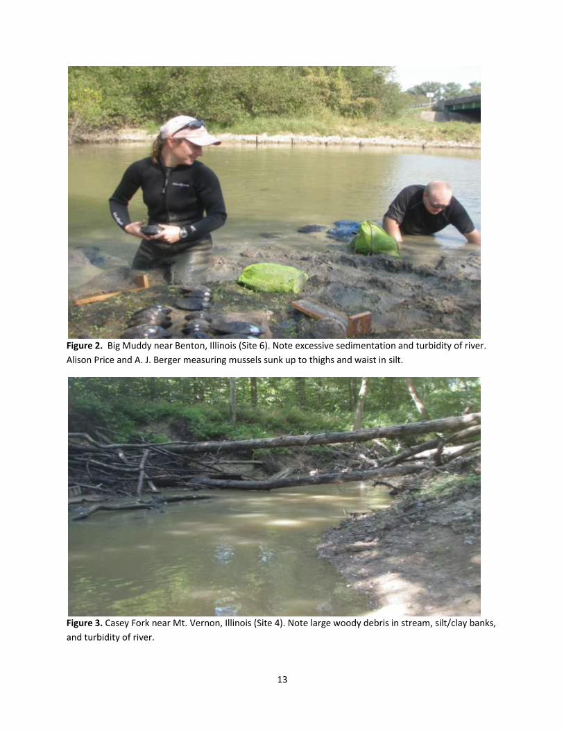
basin were dominated by some combination of sand, silt, and clay. Excessive siltation along
with large woody debris was common at many sites within the basin (Figure 2 and 3). Most of
the sites in the basin had wadeable water depths; however sampling sites were limited on the
mainstem of the Big Muddy and on Beaucoup Creek due to non-wadeable water depths (e.g.,
depth>1m).
Methods
During the 2009/2010 surveys, freshwater mussel data were collected at 30 sites: 3 mainstem
and 27 tributary sites in the Big Muddy River basin (Figure 1, Table 1). Locations of sampling
sites are listed in Table 1 along with information regarding IDNR/IEPA sampling at the site. In
most cases, mussel survey locations were the same as IDNR/IEPA sites.
Live mussels and shells were collected at each sample site to assess past and current freshwater
mussel occurrences. Live mussels were surveyed by hand grabbing and visual detection (e.g.
trails, siphons, exposed shell) when water conditions permitted. Efforts were made to cover all
available habitat types present at a site including riffles, pools, slack water, and areas of
differing substrates. A four-hour timed search method was implemented at each site. Live
mussels were held in the stream until processing.
Following the timed search, all live mussels and shells were identified to species and recorded
(Table 2). For each live individual, shell length (mm), gender, and an estimate of the number of
growth rings were recorded. Shell material was classified as recent dead (periostracum present,
nacre pearly, and soft tissue may be present) or relict (periostracum eroded, nacre faded, shell
chalky) based on condition of the best shell found. A species was considered extant at a site if it
was represented by live or recently dead shell material (Szafoni 2001). The nomenclature
employed in this report (Appendix 1) follows Turgeon et al. (1998) except for recent taxonomic
changes to the gender ending of lilliput (Toxolasma parvum), which follows Williams et al.
(2008). Voucher specimens were retained and deposited in the Illinois Natural History Survey
3
Mollusk Collection. All non-vouchered live mussels were returned to the stream reach where
they were collected.
Parameters recorded included extant and total species richness, presence of rare or listed
species, and individuals collected, expressed as catch-per-unit-effort (CPUE; Table 2). A
population was considered to indicate recent recruitment if individuals less than 30 mm in
length or with 3 or fewer growth rings were recorded. Finally, mussel resources were classified
as Unique, Highly Valued, Moderate, Limited, or Restricted (Table 2) based on the above
parameters (Table 3) and following criteria outlined in Table 4 (Szafoni 2001).
Results
Species Richness
A total of 19 species of freshwater mussels were observed in the Big Muddy River basin, all of
which were collected live (Table 2). Across all sites, the number of live species collected, the
number of extant species collected (live + dead), and the total number of species collected (live
+ dead + relict) ranged from 0 to 13. The giant floater (Pyganodon grandis) had the most
occurrences across sites sampled with live mussels present (11 of 30 sites; 37%; Figure 4). The
lilliput (Toxolasma parvum), paper pondshell (Utterbackia imbecillis), pondhorn (Uniomerus
tetralasmus) and white heelsplitter (Lasmigona complanata) were other commonly occurring
species (Figure 4), occupying 17% of these sites. Site 6, the Big Muddy River near Benton, had
the greatest species richness with 12 live species.
Abundance and Recruitment
A total of 358 individuals were collected across 30 sites. The number of live specimens collected
at a given site ranged from 0 to 133, with an average of 16 mussels per site where live mussels
were collected (22 of 30 sites; Table 2). A total of 120 collector-hours were spent sampling with
an average of three mussels collected per hour. Nine sites yielded more than 10 live individuals
and 2 of the 9 sites (sites 6 and 15) yielded more than 45 live individuals. The most common
species collected in the Big Muddy basin were giant floater (n=131), mapleleaf (Quadrula
quadrula; n=37), white heelsplitter (n=34), lilliput (n=24), and pink papershell (Potamilus
ohiensis; n=20), which together comprised approximately 70% of the individuals collected.
Recruitment for each species was determined by the presence of individuals less than 30mm or
with 3 or fewer growth rings. Smaller (i.e., younger) mussels are harder to locate by hand grab
methods and large sample sizes can be needed to accurately assess population reproduction.
However, a small sample size can provide evidence of recruitment if it includes individuals that
are small or possess few growth rings. Alternatively, a sample consisting of very large (for the
species) individuals with numerous growth rings suggests a senescent population.
4
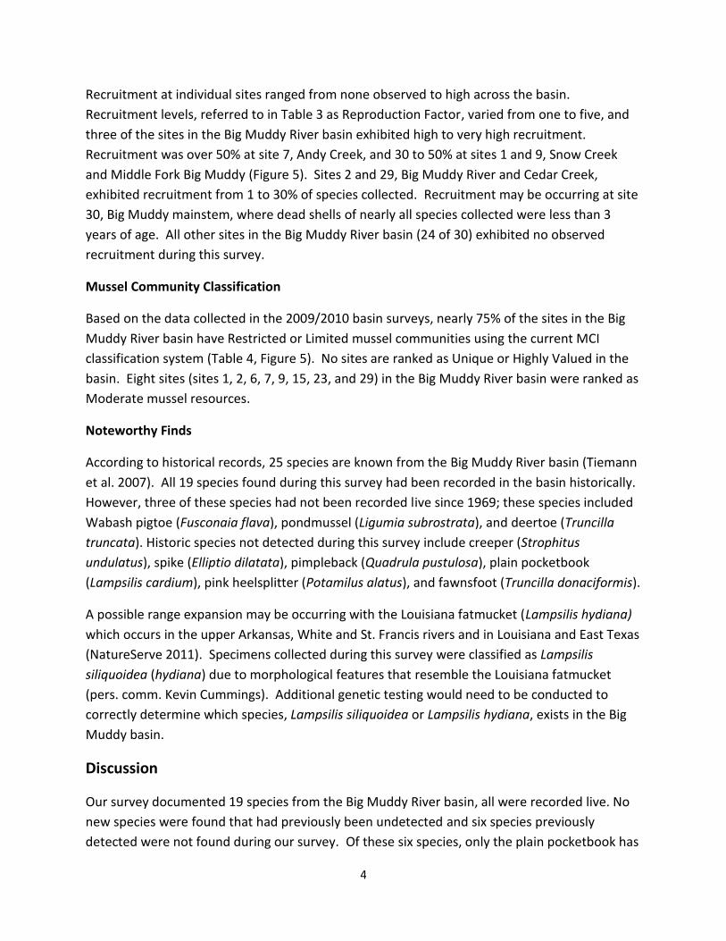
Recruitment at individual sites ranged from none observed to high across the basin.
Recruitment levels, referred to in Table 3 as Reproduction Factor, varied from one to five, and
three of the sites in the Big Muddy River basin exhibited high to very high recruitment.
Recruitment was over 50% at site 7, Andy Creek, and 30 to 50% at sites 1 and 9, Snow Creek
and Middle Fork Big Muddy (Figure 5). Sites 2 and 29, Big Muddy River and Cedar Creek,
exhibited recruitment from 1 to 30% of species collected. Recruitment may be occurring at site
30, Big Muddy mainstem, where dead shells of nearly all species collected were less than 3
years of age. All other sites in the Big Muddy River basin (24 of 30) exhibited no observed
recruitment during this survey.
Mussel Community Classification
Based on the data collected in the 2009/2010 basin surveys, nearly 75% of the sites in the Big
Muddy River basin have Restricted or Limited mussel communities using the current MCI
classification system (Table 4, Figure 5). No sites are ranked as Unique or Highly Valued in the
basin. Eight sites (sites 1, 2, 6, 7, 9, 15, 23, and 29) in the Big Muddy River basin were ranked as
Moderate mussel resources.
Noteworthy Finds
According to historical records, 25 species are known from the Big Muddy River basin (Tiemann
et al. 2007). All 19 species found during this survey had been recorded in the basin historically.
However, three of these species had not been recorded live since 1969; these species included
Wabash pigtoe (Fusconaia flava), pondmussel (Ligumia subrostrata), and deertoe (Truncilla
truncata). Historic species not detected during this survey include creeper (Strophitus
undulatus), spike (Elliptio dilatata), pimpleback (Quadrula pustulosa), plain pocketbook
(Lampsilis cardium), pink heelsplitter (Potamilus alatus), and fawnsfoot (Truncilla donaciformis).
A possible range expansion may be occurring with the Louisiana fatmucket (Lampsilis hydiana)
which occurs in the upper Arkansas, White and St. Francis rivers and in Louisiana and East Texas
(NatureServe 2011). Specimens collected during this survey were classified as Lampsilis
siliquoidea (hydiana) due to morphological features that resemble the Louisiana fatmucket
(pers. comm. Kevin Cummings). Additional genetic testing would need to be conducted to
correctly determine which species, Lampsilis siliquoidea or Lampsilis hydiana, exists in the Big
Muddy basin.
Discussion
Our survey documented 19 species from the Big Muddy River basin, all were recorded live. No
new species were found that had previously been undetected and six species previously
detected were not found during our survey. Of these six species, only the plain pocketbook has

5
been documented as live in the basin. This species was found at three tributaries in the late
1990’s to early 2000’s; however these streams were not sampled during our survey. These sites
would need to be surveyed to determine if this species is still present in the basin. Of the
remaining five species not collected, deertoe and creeper have been documented only by relict
shell, and the pink heelsplitter, pimpleback, and spike have not been documented since the late
1800’s, early 1900’s. All of these species were collected from the Big Muddy mainstem. These
particular species, except for spike, are widespread and common throughout most of Illinois
(Cummings and Mayer 1992) and all of these species are known from other major Mississippi
River tributaries including the Rock, Illinois, and Kaskaskia Rivers (INHS Mollusk Collection
Database). Sampling the mainstem of the Big Muddy was hindered by non-wadeable water
depths; therefore additional sampling by alternative means would need to be conducted to
determine if these species have indeed been extirpated from the basin.
Recruitment
Data collected during this survey indicate that very recent recruitment may not be occurring at
most (25 of 30) sites in the Big Muddy basin. Only 3 of the 30 sites exhibited high to very high
recruitment and 2 other sites had moderate recruitment noted. This finding suggests that most
mussel communities of the Big Muddy may not be viable and self-maintaining. Although very
few mussels collected during this basin survey fell into the category of 3 age rings or younger,
many of them ranged from 4 to 10 years of age. This would indicate that the populations
observed in most streams are within the age range thought to be reproductively active (Haag
and Staton 2003). Therefore, we cannot conclusively state that the mussel communities of this
system are void of recruitment. Recruitment may also be occurring on the Big Muddy
mainstem near the Mississippi as nearly all of the dead shells found at site 30 were less than 3
years of age. Sampling methods to target juvenile mussels would be necessary to better assess
the reproductive status of these populations.
Mussel community of the Big Muddy River basin
There is limited mussel community information relating to this basin from past surveys and
reports. Nearly 90% of the sites sampled had no historical data available (Table 2), and there is
no known intensive survey for mussels in this basin. Our surveys documented the existence of
19 species in the Big Muddy River basin from which 25 species were known historically.
Additionally, our surveys found that all 19 species were represented by live individuals. Five of
the six species not collected during this survey are represented by either relict shell or pre-1930
collections.
Other major Mississippi tributaries such as the Kaskaskia, Rock, and Illinois Rivers have a larger
mussel fauna base according to historical records and recent surveys. Historically, these basins
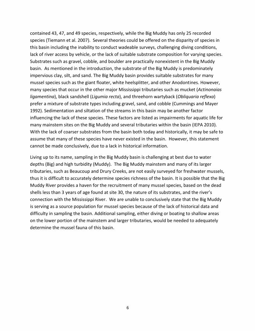
6
contained 43, 47, and 49 species, respectively, while the Big Muddy has only 25 recorded
species (Tiemann et al. 2007). Several theories could be offered on the disparity of species in
this basin including the inability to conduct wadeable surveys, challenging diving conditions,
lack of river access by vehicle, or the lack of suitable substrate composition for varying species.
Substrates such as gravel, cobble, and boulder are practically nonexistent in the Big Muddy
basin. As mentioned in the introduction, the substrate of the Big Muddy is predominately
impervious clay, silt, and sand. The Big Muddy basin provides suitable substrates for many
mussel species such as the giant floater, white heelsplitter, and other Anodontines. However,
many species that occur in the other major Mississippi tributaries such as mucket (Actinonaias
ligamentina), black sandshell (Ligumia recta), and threehorn wartyback (Obliquaria reflexa)
prefer a mixture of substrate types including gravel, sand, and cobble (Cummings and Mayer
1992). Sedimentation and siltation of the streams in this basin may be another factor
influencing the lack of these species. These factors are listed as impairments for aquatic life for
many mainstem sites on the Big Muddy and several tributaries within the basin (IEPA 2010).
With the lack of coarser substrates from the basin both today and historically, it may be safe to
assume that many of these species have never existed in the basin. However, this statement
cannot be made conclusively, due to a lack in historical information.
Living up to its name, sampling in the Big Muddy basin is challenging at best due to water
depths (Big) and high turbidity (Muddy). The Big Muddy mainstem and many of its larger
tributaries, such as Beaucoup and Drury Creeks, are not easily surveyed for freshwater mussels,
thus it is difficult to accurately determine species richness of the basin. It is possible that the Big
Muddy River provides a haven for the recruitment of many mussel species, based on the dead
shells less than 3 years of age found at site 30, the nature of its substrates, and the river’s
connection with the Mississippi River. We are unable to conclusively state that the Big Muddy
is serving as a source population for mussel species because of the lack of historical data and
difficulty in sampling the basin. Additional sampling, either diving or boating to shallow areas
on the lower portion of the mainstem and larger tributaries, would be needed to adequately
determine the mussel fauna of this basin.
7
Literature Cited
Bogan, A.E. 1993. Freshwater bivalve extinctions (Mollusca: Unionoida): a search for causes.
American Zoologist 33(6):599-609.
Cummings, K.S., and C. A. Mayer. 1992. Field Guide to Freshwater Mussels of the Midwest.
Illinois Natural History Survey, Champaign. 194 pp.
Forbes, S.A., and R.E. Richardson. 1908. The fishes of Illinois. Illinois State Laboratory of Natural History, Danville. cxxxvi + 357 pp. Haag, W. R. and J.L. Staton. 2003. Variation in fecundity and other reproductive traits in freshwater mussels. Freshwater Biology 48(12):2118-2130. Illinois Endangered Species Protection Board. 2011. Checklist of endangered and threatened animals and plants of Illinois. http://dnr.state.il.us/ESPB/pdf/2011_Checklist.pdf Illinois Department of Agriculture. 2000. Land Cover of Illinois Statistical Summary 1999-2000. http://www.agr.state.il.us/gis/stats/landcover99-00.html Illinois Environmental Protection Agency. Illinois Water Quality Fact Sheet-1996. http://www.epa.state.il.us/water/water-quality/report-1996/fact-sheets/index.html Illinois Environmental Protection Agency. 2010. Illinois Integrated Water Quality Report and Section 303(d) List. http://www.epa.state.il.us/water/tmdl/303d-list.html NatureServe. 2011. NatureServe Explorer: An online encyclopedia of life [web application]. Version 7.1. NatureServe, Arlington, Virginia. http://www.natureserve.org/explorer/servlet/NatureServe?searchSciOrCommonName=lampsilis+hydiana. Page, L.M., K.S. Cummings, C.A. Mayer, S.L. Post, and M.E. Retzer. 1992. Biologically significant Illinois streams, an evaluation of the streams of Illinois based on aquatic biodiversity. Technical Report. Illinois Department of Conservation and Illinois Department of Energy and Natural Resources, Springfield, Illinois. 498 pp. Schwegman, J.E. 1973. Comprehensive plan for the Illinois nature preserves system. Part 2. The
natural divisions of Illinois. Illinois Nature Preserves Commission, Springfield, Illinois.
Strayer, D.L., J.A. Downing, W.R. Haag, T.L. King, J.B. Layzer, T.J. Newton, and S.J. Nichols. 2004.
Changing perspective on pearlymussels, North America’s most imperiled animals. BioScience
54(5):429-439.
Szafoni, R. E. 2001. Protocol for integrating freshwater mussel surveys into IDNR / IEPA stream

8
basin surveys. Version 2.0. IDNR/ORC/Natural Heritage, Charleston, IL. 5pp.
Tiemann, J.S., K.S. Cummings, C.A. Mayer. 2007. Updates to the distributional checklist and
status of Illinois freshwater mussels (Mollusca: Unionacea). Transactions of the Illinois State
Academy of Science 100 (1):107-123.
Turgeon, D.D., A.E. Bogan, E.V. Coan, F.G. Hochberg, W.G. Lyons, P.M. Mikkelsen, J.F. Quinn, Jr.,
C.F.E. Roper, G. Rosenberg, B. Roth, A. Scheltema, M.J. Sweeney, F.G. Thompson, M. Vecchione,
and J.D. Williams. 1998. Common and scientific names of aquatic invertebrates from the
United States and Canada: Mollusks. 2nd Edition. American Fisheries Society, Special
Publication 26:ix-526.
U. S. Army Corps of Engineers, St. Louis District, Rend Lake. 2005. History of Rend Lake.
http://www.mvs.usace.army.mil//Rend/History/HistRL_05.html
Williams, J.D., M.L. Warren, Jr., K.S. Cummings, J.L. Harris, and R.J. Neves. 1993. Conservation
status of freshwater mussels of the United States and Canada. Fisheries 18(9):6-22.
Williams, J.D., A.E. Bogan, and J.T. Garner. 2008. The freshwater mussels of Alabama and the
Mobile Basin of Georgia, Mississippi, and Tennessee. University of Alabama Press, Tuscaloosa,
Alabama. 908 pp.

Table1. 2009/2010 Big Muddy River Intensive Basin Survey. Types of samples include MU-mussel sampling, BE-boat electrofishing, ES-electric fish seine, SH-fish
seine hauls, FF-fish flesh contaminate, H-habitat, M-macroinvertebrate, S-sediment, W-water chemistry. *Drury Creek Survey not completed due to water depth >3m.

10
Table 2. Mussel data for sites sampled during 2009/2010 surveys (Table 1). Numbers in columns are live individuals collected; "D" and "R" indicates dead or relict shells collected. Shaded boxes are historic collections at the specific site location obtained from the INHS Mollusk Collection records. Species in bold are federally or state-listed species or species in Greatest Need of Conservation by IL DNR. Proportion of total is number of individuals of a species divided by total number of individuals at all sites. Extant species is live + dead shell and total species is live + dead + relict shell. NDA represents no historical data available. MCI scores and Resource Classification are based on values in Tables 3 and 4 (R= Restricted, L= Limited, M= Moderate, HV= Highly Valued, and U= Unique). *Includes Strophitus undulatus, Elliptio dilatata, Quadrula pustulosa, Lampsilis cardium, Potamilus alatus, and Truncilla donaciformis, historical species not collected during this survey.

11
Table 3. Mussel Community Index (MCI) parameters and scores.
Extant species Species Catch per Unit Abundance (AB)
in sample Richness Effort (CPUE) Factor
0 1 0 0
1-3 2 1-10 2
4-6 3 >10-30 3
7-9 4 >30-60 410+ 5 >60 5
% live species with Reproduction # of Intolerant Intolerant species
recent recruitment Factor species Factor
0 1 0 1
1-30 3 1 3
>30-50 4 2+ 5
>50 5
Table 4. Freshwater mussel resource categories based on species richness, abundance,
and population structure. MCI = Mussel Community Index Score
Unique Resource
MCI ≥ 16
Very high species richness (10 + species) &/or abundance (CPUE
> 80); intolerant species typically present; recruitment noted for
most species
Highly Valued Resource
MCI = 12- 15
High species richness (7-9 species) &/or abundance (CPUE 51-
80); intolerant species likely present; recruitment noted for
several species
Moderate Resource
MCI = 8 - 11
Moderate species richness (4-6 species) &/or abundance (CPUE
11-50) typical for stream of given location and order; intolerant
species likely not present; recruitment noted for a few species
Limited Resource
MCI = 5 - 7
Low species richness (1-3 species) &/or abundance (CPUE 1-10);
lack of intolerant species; no evidence of recent recruitment (all
individuals old or large for the species)
Restricted Resource
MCI = 0 - 4
No live mussels present; only weathered dead, sub-fossil, or no
shell material found
12
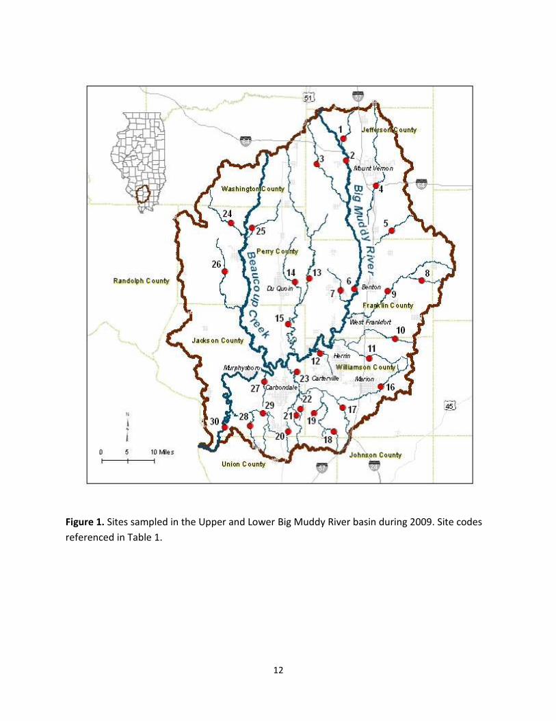
Figure 1. Sites sampled in the Upper and Lower Big Muddy River basin during 2009. Site codes
referenced in Table 1.
13
Figure 2. Big Muddy near Benton, Illinois (Site 6). Note excessive sedimentation and turbidity of river.
Alison Price and A. J. Berger measuring mussels sunk up to thighs and waist in silt.
Figure 3. Casey Fork near Mt. Vernon, Illinois (Site 4). Note large woody debris in stream, silt/clay banks,
and turbidity of river.

14
Figure 4. Number of sites where a species was collected live compared to the number of total sites sampled (30 total sites).
0% 5% 10% 15% 20% 25% 30% 35% 40%
Arcidens confragosus
Fusconaia flava
Tritogonia verrucosa
Lampsilis siliquoidea (hydiana)
Anodonta suborbiculata
Megalonaias nervosa
Potamilus ohiensis
Truncilla truncata
Toxolasma texasiensis
Amblema plicata
Quadrula quadrula
Lampsilis teres
Leptodea fragilis
Ligumia subrostrata
Lasmigona complanata
Utterbackia imbecillis
Uniomerus tetralasmus
Toxolasma parvum
Pyganodon grandis
sites collected live/total sites

15
Figure 5. Comparison of Mussel Community Index (MCI) and MCI component scores for Big Muddy River basin sites based on factor
values from Table 3.
2
2
2
2
2
3
3
3
4
3
3
4
2
3
5
5
1
1
1
1
1
1
1
1
1
1
1
1
1
1
1
1
0
0
0
0
2
2
2
2
2
2
2
2
2
2
3
4
1
1
1
1
1
1
1
1
1
3
4
3
5
4
1
1
0 2 4 6 8 10 12
Site 11 (NGA-02)
Site 25 (NCI-01)
Site 27 (NZL-01)
Site 28 (NAC-02)
Site 19 (NDDA-01)
Site 3 (NK-02)
Site 13 (NE-04)
Site 14 (NEB-02)
Site 23 (ND-01)
Site 29 (NA-03)
Site 1 (NL-01)
Site 2 (N-05)
Site 7 (NZN-15)
Site 9 (NH-23)
Site 15 (NE-05)
Site 6 (N-06)
Total MCI Score
Site
nu
mb
er
(IEP
A c
od
e)
Species Richness Intolerant Species Abundance (CPUE) Reproduction

Appendix 1. Scientific and common names of species. ST= state threatened.
Scientific Name
Common Name Status
Subfamily Anodontinae
Anodonta suborbiculata
flat floater Arcidens confragosus
rock pocketbook
Lasmigona complanata
white heelsplitter Pyganodon grandis
giant floater
Strophitus undulatus
creeper Utterbackia imbecillis
paper pondshell
Subfamily Ambleminae
Amblema plicata
threeridge Elliptio dilatata
spike ST
Fusconaia flava
Wabash pigtoe Megalonaias nervosa
washboard
Quadrula pustulosa
pimpleback Quadrula quadrula
mapleleaf
Tritogonia verrucosa
pistolgrip Uniomerus tetralasmus
pondhorn
Subfamily Lampsilinae
Lampsilis cardium
plain pocketbook Lampsilis siliquoidea hydiana Louisiana fatmucket Lampsilis teres
yellow sandshell
Leptodea fragilis
fragile papershell Ligumia subrostrata
pondmussel
Potamilus alatus
pink heelsplitter Potamilus ohiensis
pink papershell
Toxolasma parvum
lilliput Toxolasma texasiensis
Texas lilliput
Truncilla donaciformis
fawnsfoot Truncilla truncata
deertoe