getting there - ubwp.buffalo.edu
TRANSCRIPT

How do we get around?
Getting There
How do we get around?
Can I ride my bike to work quickly and safely?
policybRIef
The mobility network in Erie and Niagara Counties is a very visible, expensive and important part of the region’s physical infrastructure and public services. Although commutes are relatively short and getting around is easy for most, deficiencies constrain quality of life and travel options for many. Expanding options through creative initiatives and long-term planning can help fill critical gaps.
Can I take the bus to church?
Despite the growing list of tasks one can perform from the comforts of home, the systems that enable the movement of people and goods—facilitating economic and social transactions—are as important as ever. The most visible parts of this mobility network are roadways, nearly 6,200 miles of which connect every square mile of Erie and Niagara Counties. Of that mileage, 85% is owned by counties, cities, towns or villages, which collectively spent $231 million in 2005 on roadway upkeep, construction and related costs, compared, for example, to $389 million spent on police protection. At the same time, school districts in the two counties spent $149 million on transportation services—$874 per pupil—an amount greater than total spending on NFTA’s bus and rail system.
Travel behaviors within this mobility network have changed over time. Despite population loss, vehicle miles traveled in Erie and Niagara Counties have steadily risen for decades, including a 9% rise since 2001. This increase reflects the shift of people and activities to vehicle-dependent areas as well as travel-spurring demographic and economic changes, such as the rise of the service economy, multiple wage-earner households and smaller household sizes. At the same time, transit ridership has stagnated—down 9% since 2001, though rising since 2004. While congestion poses problems in some areas, commute times in the region remain among the nation’s lowest, with 81% of commuters driving alone.
Will I be able to reach that job?
N o v e m b e r 2 0 0 7
How do I get to Niagara Falls?
How can we fill our mobility gaps?
Regional Institute
Mobility Snapshot of Erie and Niagara Counties
R e g i o n a l I n s t i t u t e P O L I C Y B R I E F
policybRIef
Sources: (1) NYS Department of Transportation, 2004 Highway Mileage Report, local control defined as county-level and below; (2) U.S. Census Bureau, 2006 American Community Survey; (3) Greater Buffalo-Niagara Regional Transportation Council, 2005 VMT estimate; (4) NYS Department of Motor Vehicles, 2006 standard series registrations (5) National Transit Database, 2006, average weekday unlinked trips and total expenditures (operating and capital) for NFTA-Metro; (6) Office of the NYS Comptroller, 2005 Financial Data for Local Governments, total transportation expenditures (operating and capital) by levels of local government.
$61 m 2 counties
4% of county spending$52 per capita
$63 m 6 cities
10% of city spending$143 per capita
$92 m 37 towns
21% of town spending$126 per capita
$15 m 21 villages
17% of village spending$148 per capita
$149 m 39 school districts
6% of district spending$874 per pupil
$116 m NFTA-Metro
$4.90 per ride
Transportation Spending at the Local Level
6,181Miles of Roadway85% under local control
21 minutesAverage Commute Time81% drive alone9% carpool4% take transit
20,514,008Daily Vehicle Miles Traveled17.5 miles per capitaUp 9% since 2001
672,641Registered Passenger Vehicles0.6 vehicles per capitaUp 0.5% since 2001
85,106Weekday Transit Rides73 rides/1,000 residentsDown 9% since 2001
Key Statistics
(1)
(2)
(3)
(4)
(6)
(5)
3% walk2% work at home
(5)
alo
AAAAkkrrrrooo
Loockkport
Spppppppppprriingggville
Newffaff ne
NiagaraFalls
44440005555
444000666
Buffalo Niagara InternationalAirport
ternarport
Fort Erie
BBBuIntIntAir
�2
1
3
999999999999999999999999999999999999990
9999999999999900000000000
90000000000
2000200
2020 2191919
62626262
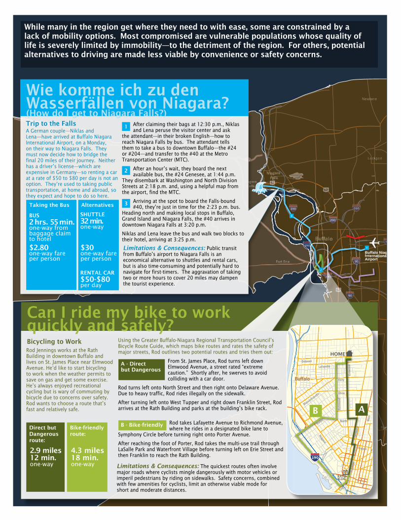
While many in the region get where they need to with ease, some are constrained by a lack of mobility options. Most compromised are vulnerable populations whose quality of life is severely limited by immobility—to the detriment of the region. For others, potential alternatives to driving are made less viable by convenience or safety concerns.
Bicycling to WorkRod Jennings works at the Rath Building in downtown Buffalo and lives on St. James Place near Elmwood Avenue. He’d like to start bicycling to work when the weather permits to save on gas and get some exercise. He’s always enjoyed recreational cycling but is wary of commuting by bicycle due to concerns over safety. Rod wants to choose a route that’s fast and relatively safe.
From St. James Place, Rod turns left down Elmwood Avenue, a street rated “extreme caution.” Shortly after, he swerves to avoid colliding with a car door.
Rod turns left onto North Street and then right onto Delaware Avenue. Due to heavy traffic, Rod rides illegally on the sidewalk.
After turning left onto West Tupper and right down Franklin Street, Rod arrives at the Rath Building and parks at the building’s bike rack.
Rod takes Lafayette Avenue to Richmond Avenue, where he rides in a designated bike lane to
Symphony Circle before turning right onto Porter Avenue.
After reaching the foot of Porter, Rod takes the multi-use trail through LaSalle Park and Waterfront Village before turning left on Erie Street and then Franklin to reach the Rath Building.
Can I ride my bike to work quickly and safely?
Limitations & Consequences: The quickest routes often involve major roads where cyclists mingle dangerously with motor vehicles or imperil pedestrians by riding on sidewalks. Safety concerns, combined with few amenities for cyclists, limit an otherwise viable mode for short and moderate distances.
A - Direct but Dangerous
B - Bike-friendly
TupperTTTTuuu
BuffaloBuffalo
1
Main
Niagara
Elmwood
Utica
Delaware
Delavan
Ferry
Franklin
Porter
Richmond
Erie
North
Massachusetts
Lafayette
B A
HOME
RATHBLDG
190
Using the Greater Buffalo-Niagara Regional Transportation Council’s Bicycle Route Guide, which maps bike routes and rates the safety of major streets, Rod outlines two potential routes and tries them out:
Trip to the FallsA German couple—Niklas and Lena—have arrived at Buffalo Niagara International Airport, on a Monday, on their way to Niagara Falls. They must now decide how to bridge the final 20 miles of their journey. Neither has a driver’s license—which are expensive in Germany—so renting a car at a rate of $50 to $80 per day is not an option. They’re used to taking public transportation, at home and abroad, so they expect and hope to do so here.
After claiming their bags at 12:30 p.m., Niklas and Lena peruse the visitor center and ask
the attendant—in their broken English—how to reach Niagara Falls by bus. The attendant tells them to take a bus to downtown Buffalo—the #24 or #204—and transfer to the #40 at the Metro Transportation Center (MTC).
After an hour’s wait, they board the next available bus, the #24 Genesee, at 1:44 p.m.
They disembark at Washington and North Division Streets at 2:18 p.m. and, using a helpful map from the airport, find the MTC.
Arriving at the spot to board the Falls-bound #40, they’re just in time for the 2:23 p.m. bus.
Heading north and making local stops in Buffalo, Grand Island and Niagara Falls, the #40 arrives in downtown Niagara Falls at 3:20 p.m.
Niklas and Lena leave the bus and walk two blocks to their hotel, arriving at 3:25 p.m.
Limitations & Consequences: Public transit from Buffalo’s airport to Niagara Falls is an economical alternative to shuttles and rental cars, but is also time-consuming and potentially hard to navigate for first-timers. The aggravation of taking two or more hours to cover 20 miles may dampen the tourist experience.
1
2
3
Wie komme ich zu den Wasserfällen von Niagara? (How do I get to Niagara Falls?)
Taking the Bus
BUS 2 hrs. 55 min.one-way from baggage claim to hotel
$2.80one-way fare per person
Alternatives
SHUTTLE 32 min. one-way
RENTAL CAR $50-$80 per day
$30one-way fare per person
Direct but Dangerous route:
2.9 miles12 min.one-way
Bike-friendly route:
4.3 miles18 min.one-way

NiiaagaraaFFFaalllls
ffalo
RRRRRRoocchheesssssttteeeeerrr
errryyPeeerreerrrrrrrryyrryyyy
Albbbbion
AAAA
Loockkport
MMMeedddiiiinnnnnaa
AAttttttttiiiccaaAAAAAAAttttttAAAAtttttttttttttttttttttttttttttiiiiittttccccccacccaa
Holllley
ennesseoeeennnnnenneesseessss oeeoo
Spppppprriingville
Mount MMoooorrrrriissMMMoMMoouuunnntntt MMMMMMooooooooorroooorrrrrrrrrrrrrrriirrrrssiiiissss
CCaaalleeddoooniaCCCCCCaaCCCCaaaalllaaaaaaeelllleeeedeeddooddoooonnniaaa
Newffaff ne
4444444999000
399990
NiaFa
44440005555
Buffalo Niagara InternationalAirport
ternarport
BBuff
Fort Erie
BBuIntIntAir
�
2
1
3
9999999999999900000000000
99999999999999990
2000200
2020 2191919
Note: Scenarios developed using fall 2007 transit timetables and fares from NFTA-Metro, Greater Buffalo-Niagara Regional Transportation Council’s Bicycle Route Guide, and approximated taxi fares.
The outbound #48 bus begins its first Sunday run along Main Street at 10:23 a.m. from University Station. Marie leaves home at 10:15
a.m. for the 10-minute walk to the stop at Main and Getzville Road.
The bus arrives at 10:29 a.m. and continues east along Main Street, reaching the corner of Main and South Youngs Road at 10:43 a.m.
On weekdays and Saturdays, select buses leave Main Street to serve the ECC campus—but not on Sundays. Marie disembarks at Main and South
Youngs.
Crossing to the east side of South Youngs due to the absence of sidewalks on the west side, Marie walks ¼ mile south to reach her church. She enters at 10:53 a.m., more than twenty minutes late for 10:30 a.m. worship—the church’s only weekly service.
Can I take the bus to church on Sunday?
Limitations & Consequences: With a high proportion of the region’s aging population in first-ring suburbs poorly served by public transportation—especially on weekends—an inability to drive can lead to a withdrawal from social activities, especially for seniors used to a high degree of independence.
1
2
3
Mobility for an Aging PopulationMarie Fravel has lived on Ruskin Road in Amherst for 46 years, the last seven as a widow. After some close calls recently, she no longer feels comfortable driving her car. She’s a short walk from Main Street and is now using Metro Bus for trips to the supermarket and drugstore. Marie hasn’t been to her church—on South Youngs Road next to ECC’s North Campus—in a few weeks and would like to take the bus.
Taking the Bus
BUS 38 min.one-way, door-to-door
$1.50round-trip fare(senior rate)
Alternatives
TAXI10 min. one-way
$26 round-trip fare
To catch the only weekday morning bus providing service to the Wegmans at Transit and Losson in Depew—the #2C—Denise would leave her home at
6:05 a.m. and walk to the corner of Northampton and Jefferson.
At 6:10 a.m., Denise would board the #18 southbound, getting off at the corner of Jefferson and Clinton at 6:18 a.m.
The #2C bus would arrive at Jefferson and Clinton at 6:30 a.m., picking up Denise and then traveling eastward, past the city line—where the regular #2
bus ends—and into the suburbs. Denise would disembark at Transit and Losson at 7:04 a.m., well before the start of her 8:00 a.m. shift.
Getting home on weekday afternoons, Denise would have three #2C buses to choose from: 5:57 p.m., 6:12 p.m. and 11:51 p.m. There are no #2C buses on weekends, requiring a one mile walk from the #2B route on Saturdays. There is no bus service within one mile on Sundays.
Will I be able to reach that job?
Limitations & Consequences: Transit service past the city line is spotty on weekdays and often nonexistent on weekends. As a result, many entry-level jobs at suburban locations are inaccessible to city residents without cars, especially service-sector jobs requiring flexible or non-traditional work hours.
1
2
3
Making the Reverse CommuteDenise Wilkerson has an apartment on Northampton Street in Buffalo. She’s been unemployed for a month since the end of a temporary job downtown. After searching the classified ads, she found a posting for a full-time job at a Wegmans on Transit Road in Depew. It looks like a good fit, but the location poses a problem. Denise doesn’t have a car and would have to rely on transit. The job requires a flexible schedule, especially on nights and weekends.
oungs
Main
CheektowagaCheektowaga
Buffalo NiagaraInternational Airport
MUnion
Transit
Harlem
Eggert
B
Kensington
fferson
Indian Church
gs
MMMMMM
BBBBBBBBBB
Indiann CCCCCChhhhhuuuurrrrccchhhh
gggggssssssss
HOME
2
1
3
HOME1
2
3 20
62
62
290
90
90
190
Taking the Bus Alternatives
TAXI 28 min. one-way
$56round-trip fare
BUS60 min.one-way, door-to-door
$4.10round-trip fare

Regional Institute
For More Information
The Regional Institute
University at Buffalo
The State University of New York
Beck Hall
Buffalo, NY 14214-8010
Regional Institute Policy Briefs provide key data and analysis to frame issues, inform decisions and guide policy action.
©2007 The Regional Institute
For the elderly, the poor and others with mobility challenges, having more and better options for getting around can improve quality of life. In the long-term, the Erie-Niagara Framework for Regional Growth prioritizes the promotion of denser land use patterns that provide greater mobility options. However, the durability of the built environment and the region’s slow pace of growth limit the speed with which land use patterns adjust to policy changes. While Framework policies may improve mobility years from now, they do little to address current needs.
An option for a more immediate mobility boost is better public transit. Transit expansion, however, is burdened by issues of inflexibility and cost, especially in hard-to-serve suburban and rural areas. The region’s 2030 Long Range Transportation Plan from the Greater Buffalo-Niagara Regional Transportation Council (GBNRTC), which largely complements the Framework for Regional Growth, calls for transit improvements in key high-traffic corridors, including Amherst, Tonawanda and Buffalo-to-Niagara Falls. These projects, though, hinge on the availability of local funding to subsidize their operation, making bus rapid transit—and other less expensive alternatives to rail—appealing.
Some recently launched efforts have brought less expensive approaches to filling today’s mobility gaps. GBNRTC’s new online tool, “Good Going WNY,” gives commuters a chance to connect with carpoolers and review their transit options, while the Niagara Frontier Transportation Authority’s Unlimited Access program encourages students of participating colleges to use transit. Also, the steady expansion of bikeways, a new bike-lending program (Buffalo Blue Bicycle) and more amenities such as bike lanes and parking are making bicycle travel more safe and convenient. And the Center for Transportation Excellence is working to improve the efficiency and quality of health and human services
Buffalo Blue Bicycle, online at http://www.buffalobluebicycle.org
Center for Transportation Excellence, online at http://www.cteny.com
Erie-Niagara Framework for Regional Growth, online at http://www.regionalframework.com
Good Going WNY, online at http://www.goodgoingwny.com
Greater Buffalo-Niagara Regional Transportation Council, online at http://www.gbnrtc.org
Niagara Frontier Transportation Authority, online at http://www.nfta.com
transportation, whose many suppliers assist elderly and disabled clients with trips to doctors’ offices and senior centers.
Efforts catching on in other regions include car sharing programs—such as the soon-to-merge Flexcar and Zipcar companies—as well as “cars to work” initiatives that fix used cars and give them to qualified recipients who can then reach otherwise inaccessible workplaces. Such small-scale and flexible initiatives—combined with smart, longer-term investments in key corridors—are likely the best ways to fill short- and long-term gaps while positioning the region to respond to energy-related mobility challenges.
Phone: 716 829-3777 Fax: 716 829-3776
Web: regional-institute.buffalo.edu
E-mail: [email protected]
How can we fill our mobility gaps?