gis 1 attribute tables. gis 2 data table format rectangular table with one value per cell - columns...
TRANSCRIPT

GIS 1
Attribute Tables

GIS 2
Data table format
•Rectangular table with one value per cell-Columns (fields) are attributes -Rows are observations (data)

GIS 3
Data table format
•First row must have column names that are self-documenting labels-e.g., Pop5To17, Area-First character is a letter-Remaining characters can be any letter, digit, or the underscore character (but no blanks)
•All additional rows of a data table must contain only attribute values-None of the rows can be sums, averages, or other statistics for other rows
•Sometimes columns can be functions of other columns (sums, averages, etc.)
GIS 4
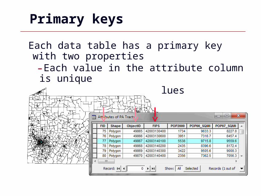
Primary keys
Each data table has a primary key with two properties-Each value in the attribute column is unique-There are no null values

GIS 5
FIPS Geocodes
•Federal Information Processing Standards-Developed by the National Institute of Standards and Technology-Codes for place names throughout the world
– countries– states/provinces– counties– metropolitan statistical areas (MSA’s)– cities– places - Indian reservations, airports, and post offices in the
US
See http://www.genesys-sampling.com/pages/Template2/site2/61/default.aspx for additional geocodes.

GIS 6
FIPS Geo codes: Hierarchy
Country: US
FIPS codes
County: 003 (Allegheny)
State: 42 (Pennsylvania)
Tract: 0501
Block: 12 (US420030501312)
Block Group: 3Census codes
Minor Civil Division: 85188 (Wilkinsburg)
Parcel (Block & Lot#)Local government cadastral data

GIS 7
ANSI Codes
American National Standards Institute (ANSI)
Codes
www.census.gov/geo/www/ansi/ansi.html
Replaces FIPS codes
In many cases, the codes are the same (e.g. Pennsylvania, Allegheny County =
42003)

GIS 8
External table file formats for import to ArcGIS
•Plain ASCII text with comma separated values (.csv)-Very transportable format, very large files-Each table record is a row terminated with a line-break character-Has values separated by a delimiter, usually a comma-For data values that contain the delimiter, enclose the value in double quotes-Sometimes columns get wrong data type on import (use double quotes to force text data type for digits, say for house numbers)

GIS 9
External table file formats for import to ArcGIS
•Excel (.xls, .xlsx)-Excel 2003, up to 65,000 rows and 256 columns-Excel 2007, up to 1,048,576 rows and 16,384 columns
•dBase database table(.dbf)-Legacy format-ArcMap truncates field names to 1st 10 characters-dBase IV has max of 255 columns-Can open dBase file in Excel but cannot save Dbase from Excel
•Microsoft Access database (.mdb)-Up to 2GB file size-See following for other limits: http://www.databasedev.co.uk/access_specifications.html

GIS 10
Field calculator (numeric)
GIS 11
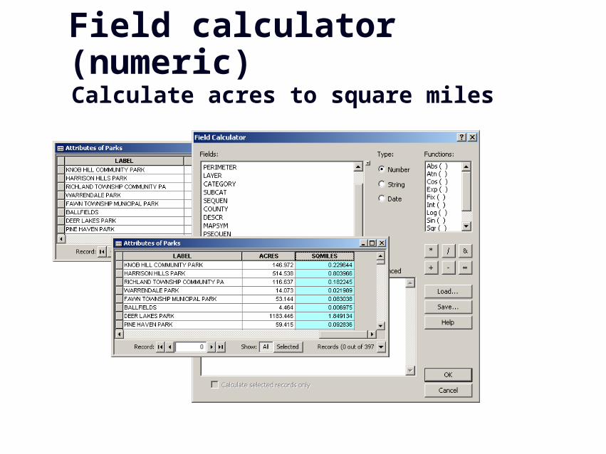
Field calculator (numeric) Calculate acres to square miles

GIS 12
Field calculator (text)
Concatenate house number and street fields

GIS 13
Field calculator (text) Populate field with county name

GIS 14
Data Table Joins

GIS 15
Joins
•Feature attribute tables, data tables•Puts two tables together, on the fly, to make one table-One-to-one join-One-to-many join

GIS 16
Example join
=
U.S. Counties GIS layer
Unemployment databases +

GIS 17
Determine Fields to Join

GIS 18
Create New Field

GIS 19
Columns Ready to Join

GIS 20
Join Data• Right-click Counties layer > Joins and Relates > Join

GIS 21
Resultant Attribute Table

GIS 22
Classifying Unemployment
•Values will only appear with number fields

GIS 23
Final MapPercentage Unemployment by U.S. Counties, 2005

GIS 24
Problems with Joins
• Field types are different (e.g. one is numeric and one is text)

GIS 25
Problems with Joins
• Data is different
Must remove dashes!

GIS 26
Problems with Joins
• Too much formatting in Excel• Keep it simple!

GIS 27
Spatial Joins

GIS 28
Spatial Joins
•Joins using shape (not attribute field)•Enables data aggregation (counting or summing points by polygon)
•Common Spatial Joins-Points to Polygons (counts)-Polygons to Points (adds text)-Points to points (distances)

GIS 29
Points to polygons
How many convenience stores are in each neighborhood?
•Start with:-Store points-Neighborhoodpolygons

GIS 30
Points to polygons
• Right-click neighborhoods > Joins and Relates > Join

GIS 31
Spatial join result
New polygon layer with count of points (number of stores)

GIS 32
Spatial join result
Show as a choropleth map, with labels, or tableNeighborhood Store CountBloomfield 22Central Business District 12Strip District 10Brookline 10Central Lawrenceville 8Larimer 8Middle Hill 7Central Oakland 7Squirrel Hill South 7South Oakland 7Carrick 7Highland Park 6Garfield 6North Oakland 6Terrace Village 6Brighton Heights 5Shadyside 5Morningside 4Marshall-Shadeland 4East Liberty 4Friendship 4Sheraden 4Homewood South 4Greenfield 4

GIS 33
Polygons to points
What neighborhood is a store in?
•Start with:-Store points-Neighborhoodpolygons

GIS 34
Polygons to points
•Right-click business points> Joins and Relates > Join

GIS 35
Spatial join result
Point shapefile with neighborhood data on each store

GIS 36
Points to points
How close is a school to a store?
•Start with:-Store points-School points

GIS 37
Points to points
Right-click school points> Joins and Relates > Join

GIS 38
Result Join

GIS 39
Geodatabases

GIS 40
Geodatabases
A geodatabase is a container used to hold a collection of datasets (GIS features, tables, raster images, and other objects).
Country layer
Graticule layer
World.gdb

GIS 41
Geodatabase types
File geodatabase (.gdb) •stores datasets in a folder of files
•each dataset a file up to 1 TB in size
•can be used across platforms
•can be compressed and encrypted for read-only, secure use
•ESRI’s recommended choice

GIS 42
Geodatabase types
Personal geodatabase (.mdb)•stores datasets in a Microsoft Access format
•storage sizes between 250 and 500 MB
• limited to 2GB
•only supported on Windows
ArcSDE geodatabase•stores datasets in a number of optional DBMSs:-IBM DB2, IBM Informix , Microsoft SQL Server , Oracle, or PostgreSQL
•unlimited size and users

GIS 43
New file geodatabase
ArcCatalog

GIS 44
Import into geodatabase
Shapefile features

GIS 45
Import into geodatabase
Tables

GIS 46
Export from geodatabase

GIS 47
View geodatabases Cannot identify names in Windows Explorer
Must use ArcCatalog

GIS 48
Compact geodatabases
File and personal geodatabases•Reduces size and improves performance
•Compact personal geodatabases > 250 MB.
•Geodatabases with frequent data entry, deletion, or general editing
•Open geodatabases in ArcMap cannot be compacted-remove any layers with a source table or feature class in that database from the TOC

GIS 49
Compress geodatabases
File geodatabases•Once compressed, a feature class or table is read-only and cannot be edited
•Compression is ideally suited to mature datasets that do not require further editing
•Compressed dataset can be uncompressed to return it to its original, read-write format
GIS 50
ArcCatalog

GIS 51
ArcCatalog utility program
Like Windows Explorer but for Esri-format data•Copy, delete, rename, move, search files, view metadata•Import/export popular spatial data format files•Create new shapefiles, file geodatabases, etc. for input in ArcMap

GIS 52
Basic functions Copy, paste, rename, etc.

GIS 53
View and edit properties Projections, fields, etc.

GIS 54
View metadata

GIS 55
Edit metadata
GIS 56
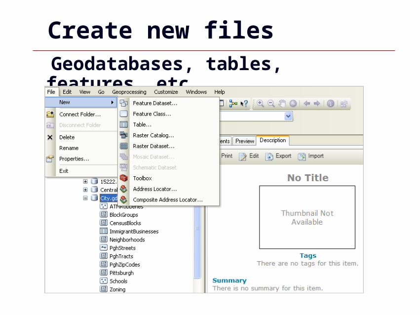
Create new files Geodatabases, tables, features, etc.

GIS 57
Calculating Geometry

GIS 58
Point Centroids
Used to display and calculate data

GIS 59
Point centroids
When displaying or analyzing small polygons it is often better to use point centroids

GIS 60
Calculate XY fields
Add new X and Y fields in the attribute table

GIS 61
Calculate XY fields
Calculate geometry for X field, repeat for Y

GIS 62
XY field results
Results are X and Y values based on map properties (e.g. Long/Lat or XY feet)

GIS 63
Export XY coordinates

GIS 64
Add XY data table

GIS 65
Export as shapefile
XY events should be exported as permanent shapefile or feature class
GIS 66
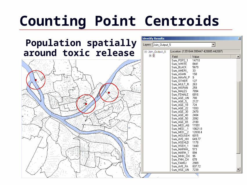
Counting Point Centroids
Population spatially joined to buffer around toxic release sites

GIS 67
Calculate area
Add area field and calculate geometry

GIS 68
Calculate perimeter
Add perimeter field and calculate script

GIS 69
Calculate length
Add length field and calculate script