gis and governing anchorage gis...gis and governing anchorage • gis critical for efficient,...
TRANSCRIPT

GIS and Governing Anchorage
• GIS Critical for Efficient, Transparent
Government
• How is GIS Program Doing
• Where can GIS Program Take us

Municipality of Anchorage
Office of Economic And Community Development
Geographic Data and Information Center
Tina Miller, P.E.
Geographic Information Officer
Municipality of Anchorage

An Informed &TransparentApproach
• Smart City
• What Works City
• Asset Management

Smart City
A smart city is an urban development vision to integrate information and communication technology and Internet of things technology in a secure fashion to manage a city's assets. These assets include local departments' information systems, schools, libraries, transportation systems, hospitals, power plants, water supply networks, waste management, law enforcement, and other community services.
What Works Cities
• “….reflects a set of aspirations and activities that create a strong foundation for the effective use of data and evidence within city governments.

Asset Management
PORTLAND ASSET MANAGEMENT

Implementing GIS – Requires more than Technology

Leveraging GIS Program – Cost Effective
• High ROI – some as high as 14 to 1 in early stages like MOA
• Fast and Agile
• Creates Culture of Sharing
We can’t afford not to have mature GIS program

Anchorage’s GIS Challenge ESRI – October 2016

GIS - The Science of Where

GIS – Efficient, Accessible Data Management

The Approach
• Governance• People• Infrastructure• Data

The Approach: Governance

The ApproachGovernance

The Approach: Governance

The Approach: People
Access to Current Tools! Training, Mentoring!

The Approach: Infrastructure

Web GIS Deployment Patterns

The Approach: Data
Authoritative Data Source

GIS & Local Government –Data is an Asset

GIS & Local Government – Lots of Data
Services
Fire
Police
Code
Votes

• Data Owner for Each “Restricted” Dataset
• Open Data Policy – to public by default
• Rebuild Trust – It is “Your Data”
• Department Authority and Business Knowledge Leads –Central GIS is service not authority
• GDIC Home Page
The Approach – Authoritative Data

Data Maturation
Data Maturation

“Auto-mation”

Authoritative Data
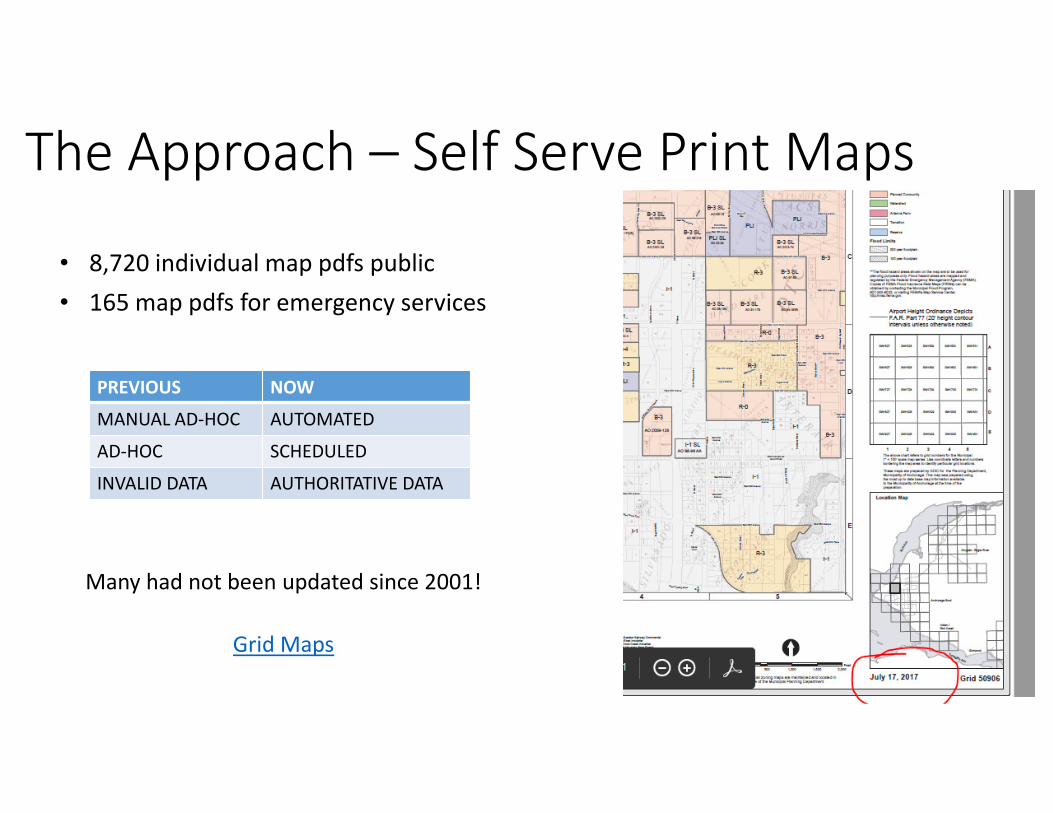
Many had not been updated since 2001!
Grid Maps
• 8,720 individual map pdfs public
• 165 map pdfs for emergency services
The Approach – Self Serve Print Maps
PREVIOUS NOW
MANUAL AD-HOC AUTOMATED
AD-HOC SCHEDULED
INVALID DATA AUTHORITATIVE DATA

The Approach – Start from the Problem

GIS & MOA– Data Case Studies
Data Maturation
Show on
MAP

Anchorage Governed by Where - Voting
• What is a Municipality?
• How do we Vote?
AFD, Property Appraisal, Land Records,
City Clerk, Legal, Public

Data Maturation
Show on
MAP
Vote By Mail
Voting- Data MaturationDeveloping…

Tackling Homelessness
Anecdotal
Spatial
Worklist
(Collector –
Mobile)
More Data
on Where
Homeless
Population
Is
Live Metrics on
Cleanup, Abatement,
Public Reports
(Dashboard –
WebAppBuilder)
Spatial
Survey
Homeless
Census
(Survey123)
Sh
are
d
Public
Reporting
(GeoForm)

Census Homeless PITC
ParksRec Camp Worklist
Public Homeless Reporting
Homelessness – Developing the data
APD - Camp Worklist
1
2
3

Homelessness – Keeping it Running

Measuring Success…
Data - Authoritative Data Source
Infrastructure Reliability Usage –
People
Governance
Authoritative Data
Governance - Participation

Web GIS Is the Modern GIS Pattern

Users by Department
Addressing AFD APD AWWU Building Safety
contractor GDIC HHS ITD Library
Mayor Merrill Field ML&P OECD OEM
Parks and Rec Planning PME Port Property Appraisal
Real Estate ROW and Land Enforcement Street Maintenance Traffic Transit
GIS| Users By Dept

0
50
100
150
200
250
300
2014-10 2014-11 2014-12 2015-5 2015-8 2015-9 2015-10 2016-2 2016-3 2016-4 2016-5 2016-7 2016-8 2016-9 2016-10 2016-11 2016-12 2017-1 2017-2 2017-3 2017-4 2017-5 2017-6 2017-7
Total Number Items Web Mapping
GIS| Total Web Items

0
50
100
150
200
250
300
2014-10 2014-11 2014-12 2015-5 2015-8 2015-9 2015-10 2016-2 2016-3 2016-4 2016-5 2016-7 2016-8 2016-9 2016-10 2016-11 2016-12 2017-1 2017-2 2017-3 2017-4 2017-5 2017-6 2017-7
Total Number of Items
GISCOE
by Depts
MOA GDIC
GIS Infrastructure
Foundation BuiltGIS Deployment
Starts
2nd Q 2016 3rd Q 2016 2nd Q 2017
2014
GIS| Web Timeline

US Local
Governments
GIS| Maturity - October 2016
MOA
(October 2016)
MOA(Future)
Da
taM
ap
sA
na
lysi
s
none
(recognized)
Departmental spatial
data silos
Ad-hoc spatial data
creation
Authoritative location data -
governed for the enterprise
Ad-hoc “Dots on a Map”;
mostly static
Broader use of mapping
(dynamic); niche audience
Maps are easily made, used,
discovered and shared to all
employees and contractors
Spatial analysis is central to
operational workflows & decision
making
Little knowledge/use of spatial
analysis, focus on data
management
none
nonenone
Geographically
Advantaged
Geographically
Enabled
Geographically
AwareBlind

GIS| Maturity - July 2017
MOA(October 2016)
MOA(Future)
Da
taM
ap
sA
na
lysi
s
none
(recognized)
Departmental spatial
data silos
Ad-hoc spatial data
creation
Authoritative location data -
governed for the enterprise
Ad-hoc “Dots on a Map”;
mostly static
Broader use of mapping
(dynamic); niche audience
Maps are easily made, used,
discovered and shared to all
employees and contractors
Spatial analysis is central to
operational workflows & decision
making
Little knowledge/use of spatial
analysis, focus on data
management
none
nonenone
Geographically
Advantaged
Geographically
Enabled
Geographically
AwareBlind
US Local
Governments

DronesThe Approach – Keep Learning


The Approach – Keep LearningDrones
Land History
Unitized Service Costs by Providor (Roads)
Initiative Based Mapping – the “Hub”
Cemetery
Merrill Field
Dog Friendly Anchorage Companies
Living Land Use – State Business License
Coordination with Other Agencies
Unified 511 System
Easy Record Drawing Lookup
Latest Business opening
Historic Buildings
Groomed Ski Trail Status
Imagery Renewal – Base Map
Easier Parcel Data Management
Citizen Reporting – Crime Tips, Trail Watch
Predictive Crime States
New Computer Aided Dispatch System
Updated Trails

Tree down in my RoadWho do I call….

Tina Miller, P.E.
Geographic Information Officer
Municipality of Anchorage
343-8163
Questions or Ideas?