guidance for flood risk analysis and mapping€¦ · zone a areas. this document will address the...
TRANSCRIPT

Guidance for Flood Risk Analysis and Mapping
Base Level Engineering (BLE) Analyses and Mapping
February 2018
Base Level Engineering Analyses and Mapping February 2018 Guidance Document 99 Page i
Requirements for the Federal Emergency Management Agency (FEMA) Risk Mapping, Assessment, and Planning (Risk MAP) Program are specified separately by statute, regulation, or FEMA policy (primarily the Standards for Flood Risk Analysis and Mapping). This document provides guidance to support the requirements and recommends approaches for effective and efficient implementation. Alternate approaches that comply with all requirements are acceptable.
For more information, please visit the FEMA Guidelines and Standards for Flood Risk Analysis and Mapping webpage (www.fema.gov/guidelines-and-standards-flood-risk-analysis-and-mapping). Copies of the Standards for Flood Risk Analysis and Mapping policy, related guidance, technical references, and other information about the guidelines and standards development process are all available here. You can also search directly by document title at www.fema.gov/library.

Base Level Engineering Analyses and Mapping February 2018 Guidance Document 99 Page ii
Table of Revisions
Affected Section or Subsection Date Description
First Publication
February 2018
Initial version of new transformed guidance. The content was derived from the Guidelines and Specifications for Flood Hazard Mapping Partners, Procedure Memoranda, and/or Operating Guidance documents. It has been reorganized and is being published separately from the standards.

Base Level Engineering Analyses and Mapping February 2018 Guidance Document 99 Page iii
Table of Contents 1.0 Introduction ..................................................................................................................... 1
1.1 Background.................................................................................................................. 2
1.2 Need for BLE Definition and Standardization ............................................................... 3
1.3 Model Backed BLE, Zone A or Zone AE ...................................................................... 4
2.0 BLE Data Use.................................................................................................................. 6
2.1 Floodplain Management Purposes ............................................................................... 6
2.2 . Discussion data for Discovery .................................................................................... 7
2.3 BLE data on Elevation Certificates ............................................................................... 8
2.4 BLE Data on Floodproofing Certificates ....................................................................... 8
2.5 BLE Data for LOMC (Amendment or Revision) BFE determination .............................. 8
2.6 FEMA Floodplain Inventory (NVUE) validation for Zone A ........................................... 9
3.0 Stakeholder Engagement ................................................................................................ 9
4.0 Decision Tree .................................................................................................................10
5.0 Data Deliverables ...........................................................................................................11
6.0 Data Storage and Sharing ..............................................................................................12
7.0 Data Maintenance ..........................................................................................................12
8.0 Related Topics Covered by Other/Future Guidance .......................................................13
9.0 Minimum BLE Considerations ........................................................................................13
List of Figures Figure 1: Span of Riverine Flood Mapping Accuracy .................................................................. 3
List of Tables Table 1: Hydraulic Analysis Options – Base Level Engineering.................................................... 5
Table 2: Hydraulic Refinement Opportunities to create Enhanced Study (Zone AE) modeling ... 6

Base Level Engineering Analyses and Mapping February 2018 Guidance Document 99 Page 1
1.0 Introduction Base Level Engineering (BLE) provides technically credible flood data for various geographies - community, county, watershed and/or state level. BLE data can be shared with Federal, State, local and tribal governments, this data sharing provides stakeholders at all levels the necessary data to make informed decisions to reduce future flood losses. Without the mapping of flood prone areas, there can be a lack of information to effectively communicate flood risk to community officials, citizens, and businesses.
BLE is an automated riverine hydrologic and hydraulic modeling approach that builds on lessons learned to produce a base line understanding of flood risk to communities, produced to support the assessment and maintenance of the national flood hazard inventory. Engineering models are created during a Base Level Engineering assessment, producing information that meets the mapping Standards for Flood Risk Projects (FEMA Policy Memo FP 204-078-1) to produce Zone A (1-percent-annual-chance flood) information. BLE data is intended to represent the base level of investment needed for all flood study efforts FEMA will undertake.
BLE practices leverage high-resolution topography that meets or exceeds the United States Geological Survey (USGS) 3-D Elevation Program standards and often applies flood engineering at a large scale as opposed to targeting stream reaches within a watershed. BLE can be conducted at any scale but is often conducted for larger areas (HUC-8 watershed), but may be produced at the county or local level too. It is encouraged to do BLE for wider areas in order to build on efficiencies in modeling and ensure cost efficiency. Using current technologies, multiple watersheds or watersheds with large land areas can be analyzed at a more efficient rate to produce water-surface elevations and site-specific hazard data replacing outdated flood studies shown in existing Flood Insurance Rate Maps (FIRMs). All flood prone areas within a watershed will have an engineering model calculating multiple flood recurrence intervals and defining floodplains with elevation grids using high-resolution topography. Please refer to section 9.0 of this document regarding the minimum considerations for BLE data production.
For floodplain management purposes, BLE data shall be used as best available information in areas that are designated as Zone A floodplain. It may also be used to regulate development in areas where no Special Flood Hazard Area (SFHA) has been mapped before. Communities should be encouraged to adopt BLE data to support local regulations. Adoption of BLE data facilitates use of the data in local floodplain management activities, including in the post disaster environment where a need for updated and/or enhanced flood hazard information may be necessary.
Per standards #84 and #133, BLE will include all recurrence intervals (0.2-percent, 1-percent, 1-percent plus, 1-percent minus, 2-percent, 4-percent, and 10-percent-annual-chance floods). As such, hydologic and hydraulic analysis should be performed to determine the expected water surface elevations for each of the seven recurrence intervals previously identified.
The intent of BLE is to provide communities technically credible flood hazard information in a cost efficient and timely manner. Additionally, BLE provides communities a chance to review draft modeling information, reflecting the potential changes in risk within their community. Providing additional flood risk datasets, like water surface elevation grids and flood depth grids, delivers alternative information that reinforces the variability of flood risk within a designated floodplain

Base Level Engineering Analyses and Mapping February 2018 Guidance Document 99 Page 2
and supports historic community requests for a source to determine a Base Flood Elevation in Zone A areas. This document will address the usability guidelines, stakeholder communication, technical issues, feasibility, and data deliverables for BLE.
BLE provides information to communities who are currently unmapped and provides a digital entry to communities that are currently un-modernized. BLE acts as a measuring tool to allow FEMA to assess the current Zone A inventory identified as unknown or unverified in FEMA’s Coordinated Needs Management Strategy (CNMS). BLE modeling is intended to be scalable, meaning that the model produced during the BLE assessment may be refined to produce a more enhanced model with additional manual correction and on the ground survey. If BLE modeling exists, FEMA will recommend that it be used as the base model for any detailed studies performed in those areas.
Base Level Engineering benefits Federal, State, local and tribal governments by providing an expansive stream network of available modeling, and providing a range of flood risk data that can broaden and expand risk awareness conversations with local communities.
1.1 Background BLE is building on and replacing the concepts of First Order Approximation (FOA) and Large Scale Automated Engineering (LSAE). FOA was first officially defined in November 2014 in the First Order Approximation Guidance document. FOA was intended to take advantage of technology improvements in hydrologic and hydraulic modeling of large areas. FOA was to be used to estimate floodplain boundaries in areas with no existing flood mapping and to estimate floodplain boundary changes in areas with outdated mapping. FOA was also widely used as the Coordinated Needs Management Strategy (CNMS) validation technique. FOA standards were noticeably less stringent than regulatory floodplain mapping standards, especially for topographic data, where 10-meter and 30-meter USGS Digital Elevation models (DEMs) were allowed.
FOA was widely procured by FEMA between 2014 and 2016. As the deliverables of FOA became more familiar to a larger group of people, some concerns arose. These included:
• FOA was too coarse to show critical changes in floodplain limits.
• It was difficult and not cost effective to scale up FOA to a regulatory flood map, especially where USGS DEM topography was used.
• FOA was not perceived as credible data by stakeholders.
In 2016, the term FOA was phased out and replaced with “Large Scale Automated Engineering (LSAE)”. Notably, LSAE was only to be developed in areas that have Light Detection and Ranging (LiDAR) topography or with topography with a resolution greater than 5 meters. While stakeholders were pleased with the requirement to use LiDAR higher resolution topography in LSAE, there continued to be concern about the overall quality and technical credibility of the work, the lack of guidelines and standards and the ease of conversion to a full regulatory floodplain mapping product.
In FY2015 FEMA piloted several BLE assessments to explore the technological advances in hydraulic modeling to produce useable flood hazard information in a cost-efficient manner. These
Base Level Engineering Analyses and Mapping February 2018 Guidance Document 99 Page 3
initial large scale BLE pilot projects were made in watersheds within the states of Arkansas, Oklahoma, North Dakota, South Dakota and Texas.
In 2016 and early 2017, the concept of BLE as an improvement to LSAE gained traction. BLE is still intended to be highly automated, but with several key features that make it more accurate, technically credible, and suitable for easily scaled up (See Tables 1 and 2 below) to an enhanced study, based on stakeholder requirements. On the continuum, FOA has been replaced by LSAE and now BLE is a new way to complete both the first investigatory flood mapping of an area as well as traditional Zone A regulatory mapping, where desired by the mapping partners.
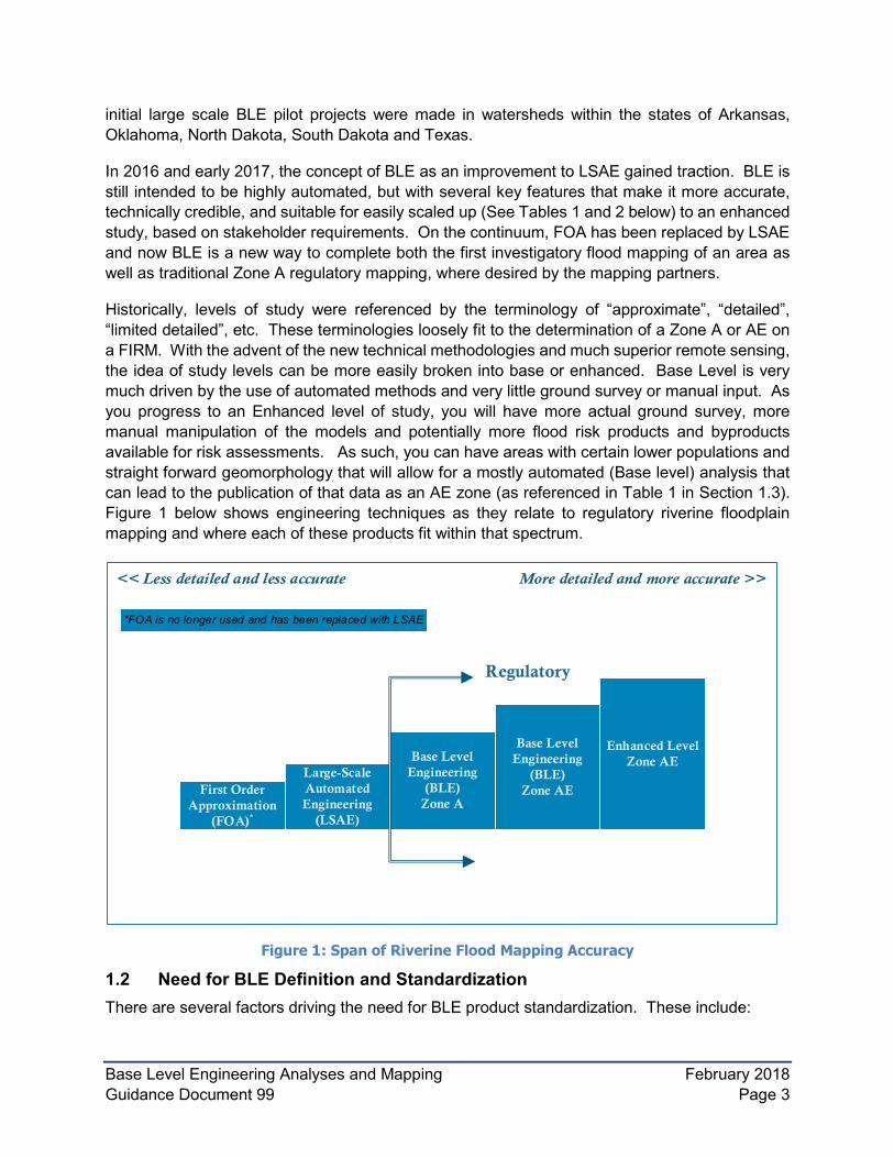
Historically, levels of study were referenced by the terminology of “approximate”, “detailed”, “limited detailed”, etc. These terminologies loosely fit to the determination of a Zone A or AE on a FIRM. With the advent of the new technical methodologies and much superior remote sensing, the idea of study levels can be more easily broken into base or enhanced. Base Level is very much driven by the use of automated methods and very little ground survey or manual input. As you progress to an Enhanced level of study, you will have more actual ground survey, more manual manipulation of the models and potentially more flood risk products and byproducts available for risk assessments. As such, you can have areas with certain lower populations and straight forward geomorphology that will allow for a mostly automated (Base level) analysis that can lead to the publication of that data as an AE zone (as referenced in Table 1 in Section 1.3). Figure 1 below shows engineering techniques as they relate to regulatory riverine floodplain mapping and where each of these products fit within that spectrum.
Large-Scale Automated Engineering
(LSAE)
First Order Approximation
(FOA)*
*FOA is no longer used and has been replaced with LSAE
Base Level Engineering
(BLE)Zone A
Regulatory
Base Level Engineering
(BLE)Zone AE
Enhanced Level Zone AE
Figure 1: Span of Riverine Flood Mapping Accuracy
1.2 Need for BLE Definition and Standardization There are several factors driving the need for BLE product standardization. These include:

Base Level Engineering Analyses and Mapping February 2018 Guidance Document 99 Page 4
• Consistent engineering model approach and preparation consistent with the Standards for Flood Risk Projects (FEMA Policy Memo FP 204-078-1), resulting in Zone A floodplain information.
• Preparation of engineering models that can be further updated and refined prior to the release of preliminary FIRMs, as identified and required by the community.
• Identification of the minimum delivery items available to communities near a Base Level Engineering watershed assessment.
• Definition of the minimum level of quality and coverage, so products built from the Base Level Engineering watershed assessment may be delivered consistently.
If a Regional office has previously documented their Regional procedures and guidance, they should be reviewed against this national document for consistency. Regions may choose to make additional flood risk dataset purchases. Mapping Partners and Cooperating Technical Partners should consult the Regional Office to determine if additional guidance related to BLE is available. Where more stringent BLE guidance is available, Mapping Partners should follow the Regional approaches provided, but should not reduce the scope of BLE any further than outlined in this guidance document.
1.3 Model Backed BLE, Zone A or Zone AE The level of effort expended in developing a floodplain analysis is generally related to the complexity of the flood hazard type (e.g., riverine split flows, levees, and alluvial fans), the study methodology, the cost and time of acquiring necessary input data (e.g., LiDAR, bathymetry, and survey) and the type of study that may or may not exist. Typically, at a minimum, the effective study, where applicable, will be the baseline for any future update to the regulatory FIRMs within a community. In contrast, if a FIRM has quite old “enhanced quality” data, BLE methods may still be used in certain conditions. As you look at the options in the table below, the replacement study will have to at least be of a level to match the output on the current FIRMs. For example, if the current study is AE with floodways, at a minimum the D option of study would need to be developed to replace it.
The cost for developing BLE data will vary based on the degree of automation and extent of the manual manipulation required in the modeling effort. Automation process, technological advancements, preparation of BLE on high resolution ground data increases the efficiency and accuracy of the modeling effort. The BLE models shall be developed in agreement with the current FEMA guidelines and standards to support the future production of regulatory products and flood risk datasets and products. The BLE models shall be prepared to encourage future model refinement, allowing the scalable nature of this approach to continue to yield cost effective modeling to create more detailed studies, as deemed necessary.
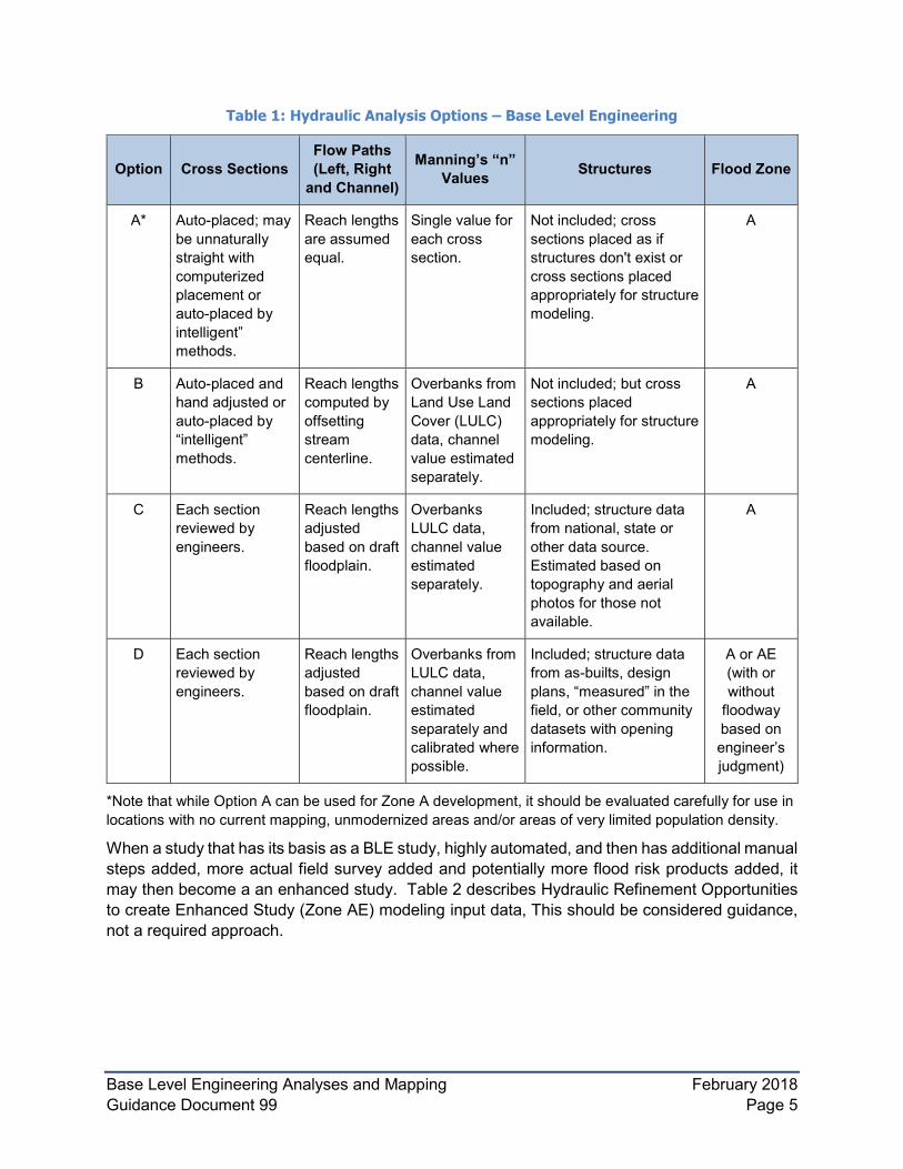
BLE may be produced with minimal automation, but may also include some manual adjustments where deemed necessary by the Region. Mapping Partners should consult the Regional Office to determine the appropriate methodology for BLE modeling efforts. The following tables presents a set of approaches and assumptions for various levels of base level analysis and the typical flood zone designation that may be mapped on a FIRM. Table 1 describes various options of developing hydraulic modeling input data, but should be considered guidance, not a required approach.
Base Level Engineering Analyses and Mapping February 2018 Guidance Document 99 Page 5
Table 1: Hydraulic Analysis Options – Base Level Engineering
Option Cross Sections Flow Paths (Left, Right
and Channel)
Manning’s “n” Values Structures Flood Zone
A* Auto-placed; may be unnaturally straight with computerized placement or auto-placed by intelligent” methods.
Reach lengths are assumed equal.
Single value for each cross section.
Not included; cross sections placed as if structures don't exist or cross sections placed appropriately for structure modeling.
A
B Auto-placed and hand adjusted or auto-placed by “intelligent” methods.
Reach lengths computed by offsetting stream centerline.
Overbanks from Land Use Land Cover (LULC) data, channel value estimated separately.
Not included; but cross sections placed appropriately for structure modeling.
A
C Each section reviewed by engineers.
Reach lengths adjusted based on draft floodplain.
Overbanks LULC data, channel value estimated separately.
Included; structure data from national, state or other data source. Estimated based on topography and aerial photos for those not available.
A
D Each section reviewed by engineers.
Reach lengths adjusted based on draft floodplain.
Overbanks from LULC data, channel value estimated separately and calibrated where possible.
Included; structure data from as-builts, design plans, “measured” in the field, or other community datasets with opening information.
A or AE (with or without
floodway based on engineer’s judgment)
*Note that while Option A can be used for Zone A development, it should be evaluated carefully for use in locations with no current mapping, unmodernized areas and/or areas of very limited population density.
When a study that has its basis as a BLE study, highly automated, and then has additional manual steps added, more actual field survey added and potentially more flood risk products added, it may then become a an enhanced study. Table 2 describes Hydraulic Refinement Opportunities to create Enhanced Study (Zone AE) modeling input data, This should be considered guidance, not a required approach.

Base Level Engineering Analyses and Mapping February 2018 Guidance Document 99 Page 6
Table 2: Hydraulic Refinement Opportunities to Create Enhanced Study (Zone AE) Modeling
Option Cross Sections
Flow Paths (Left, Right and
Channel)
Manning’s “n” Values Structures Flood
Zone
E Each section Reach lengths Overbanks from Included; structure AE (with reviewed by adjusted based LULC data and data from field survey, floodway) engineers, on draft field data, channel as-builts, design Channel floodplain. value estimated plans, “measured” in bathymetry separately from the field. included in field data and sections. calibrated where
possible.
BLE models, once completed provide a broad and consistent set of engineering models for the geography that was studied. BLE models may be further refined through a future FEMA investment or by local communities and the development industry. BLE models can also be leveraged by local comunities and the development industry to update and maintain effective FIRMs through the Letter of Map Revison (LOMR) process. The final approach should be selected considering the needs and flood risk within the community, availability of input data, and project funding.
An appropriately licensed and Registered Professional Engineer must certify that the study meets the standards as described in this guidance for the study to qualify as BLE for use as described herein.
For additional details, refer to Guidance for Flood Risk Analysis and Mapping - General Hydraulics Considerations Guidance document.
2.0 BLE Data Use Please note, it is highly likely that BLE information may be released to a community for use in local floodplain management activities prior to the release of the preliminary and then effective FIRM. It is important to note that BLE information does not replace the current FIRM until proper due process and adoption by the community has been completed. Proper due process would require the BLE information to be released on a set of preliminary FIRM panels with accompanying Flood Insurance Study Report. Following the preliminary release, FEMA would need to administer the formal appeal/comment period, and issue a Letter of Final Determination prior to the effective FIRM issuance. Potential uses for the Base Level Engineering results are explained below in sections 2.1 – 2.8. The items included below are not inclusive of all opportunities that exist for the use of BLE results and datasets. This section guides all stakeholders on the potential uses of the data generated by BLE analysis results prior to a future update of the FIRMs.
2.1 Floodplain Management Purposes For floodplain management purposes, BLE data shall be used as best available information in areas that are designated as Zone A floodplain. A community is allowed discretion in using this

Base Level Engineering Analyses and Mapping February 2018 Guidance Document 99 Page 7
data only to the extent that the technical or scientific validity of this data is in question. BLE data may also be used to regulate in areas where no SFHA has been mapped earlier.
The guidance for use of the BLE data prior to FIRM release are listed below. This guidance should be referred for local use prior to any preliminary or effective FIRM issuance:
• Floodplain Management Bulletin 1-98, Use of Flood Insurance Study (FIS) Data as Available Data, - provides guidance on the use of either FEMA draft or preliminary Flood Insurance Study data as "available data" for regulating floodplain development.
• FEMA Policy: Guidance on the Use of Available Flood Hazard Information, FEMA Policy #104-008-2
• Communities should be encouraged to adopt BLE data to support local regulations. Adoption of BLE data facilitates use of the data in local floodplain management activities, including in the post disaster environment where a need for updated and/or enhanced flood hazard information may be necessary.
FEMA 265: Managing Floodplain Development in Approximate Zone A Areas (April 1995) shall be used only in areas where BLE data is not available
2.2 Discussion Data for Discovery If BLE data is completed prior to Discovery that meets the standards of the Discovery effort, it will be used to assess the current flood hazard inventory and made available to communities during the Discovery phase of the Flood Risk Project. BLE data can provide cursory flood hazard analysis results and support data visualization to better engage community stakeholders. The availability of BLE data supports engagement and productive communication.
• To identify potential future investment projects within the BLE project area. Potential projects may include local training sessions, data development activities, outreach support to local communities wanting to step up their efforts, or the development of flood risk datasets within areas of concern to allow a more in-depth discussion of risk.
• To provide an early look at how a community’s flood risk may have changed since the last flood study was performed, allowing communities to review their historic floodplain management activities and identify where potential mitigation projects may be warranted.
• To initiate discussions with local communities related to the use of BLE eningeering data in advance of information becoming effective on a FIRM.
• Mapping partner could offer draft BLE exhibits with estimated 1-percent -annual-chance floodplain extent and/or estimated Base Flood Elevations (BFEs). Exhibits of this nature could highlight areas where a change in the flood risk is suggested (e.g., an increase or decrease in depth or spatial extent of the 1-percent-annual-chance floodplain boundary) allowing communities to review BLE results comparing them to their local knowledge and the effective mapping, if available
• BLE can act as a catalyst to unearth available community technical data and hydraulic structure information (e.g., bridges and culverts), that may be incorporated in any future model refinement efforts.

Base Level Engineering Analyses and Mapping February 2018 Guidance Document 99 Page 8
For additional details, refer to the Discovery Guidance.
2.3 BLE data on Elevation Certificates An Elevation Certificate (EC) is an administrative tool of the National Flood Insurance Program (NFIP) which is to be used to provide elevation information necessary to ensure compliance with community floodplain management ordinances, to determine the proper insurance premium rate, or support a request for a Letter of Map Amendment (LOMA) or a Letter of Map Revision based on fill (LOMR-F).
In instances where no modeling information exists for Zone A areas or unmapped areas (see FPM bulletin 1-98), stakeholders can use the 1-percent-annual-chance floodplain data and WSEL produced as part of the BLE. BFEs certified on elevation certificates have historically been required to meet the standards of FEMA 265: Managing Floodplain Development in Approximate Zone A Areas (April 1995). The estimated 1-percent-annual-chance elevations prepared in accordance with this guidance document would exceed the FEMA 265 requirements described for elevation certificate BFE development.
2.4 BLE Data on Floodproofing Certificates Floodproofing Certification is documentation by a registered professional engineer or architect that the design and methods of construction of a non-residential building are in accordance with accepted practices for meeting the floodproofing requirements in the community's floodplain management ordinance. For insurance rating purposes, a building’s floodproofed design elevation must be at least one foot above the BFE to receive full insurance rating credit for the floodproofing. If the building is floodproofed only to the BFE, the flood insurance rates will be considerably higher. BFE and/or WSEL generated by BLE can be used in instances where no modeling information exists for Zone A areas or unmapped areas on the floodproofing certificate.
BFEs certified on floodproofing certificates have been required to meet the standards of Technical Bulletin 3-93: Non-Residential Floodproofing-Requirements and Certification for Buildings Located in Special Flood Hazard Areas in accordance with the National Flood Insurance Program (April 1993).
BLE data prepared in accordance with this guidance document will meet the Technical Bulletin 3-93 requirements for floodproofing certificate BFE development.
2.5 BLE Data for LOMC (Amendment or Revision) BFE determination BLE data can provide estimated 1-percent-annual-chance elevations and modeling information which is required for various types of Letter of Map Change (LOMC) requests (LOMA, LOMR-F) where such data is not already published on a FIRM. In instances where no modeling information exists for Zone A areas, the BFE and/or WSEL generated by BLE can be used for LOMC applications. However, the SFHA boundaries on the current effective FIRM still dictate whether a structure could be considered in/out of a SFHA, therefore it is recommended that the BLE data be used in coordination with the current effective flood zone designation per the Floodplain Management Bulletin 1-98.

Base Level Engineering Analyses and Mapping February 2018 Guidance Document 99 Page 9
If a BLE dataset is used to determine a BFE for submittal through the LOMA process, the appropriate MT-1 documentation including a reference of where to find and/or how the 1-percent-annual-chance estimated elevation was determined should be submitted. A reference to a FEMA website with the BLE data published should suffice.
BFEs certified on elevation certificates for requesting a LOMC, have historically been required to meet the standards of FEMA 265: Managing Floodplain Development in Approximate Zone A Areas (April 1995). The estimated 1-percent-annual chance elevations prepared in accordance with this guidance document would exceed the FEMA 265 requirements described for elevation certificate BFE development.
If a community or stakeholder wishes to make an update or change the draft FEMA data through a LOMR, they would need to submit newer or refined modeling which would produce a more enhanced model (resulting in Zone AE or Zone AE with floodway).
2.6 FEMA Floodplain Inventory (NVUE) validation for Zone A During CNMS assessments of existing effective Zone A studies, BLE data should support directly Refined Zone A Engineering study (A5) validation. For additional details about the A5 validation process, refer to Appendix C in the Coordinated Needs Management Strategy (CNMS) Technical Reference. BLE data prepared in accordance with this guidance document will meet the standards for comparison against effective floodplains as described in the CNMS technical reference.
3.0 Stakeholder Engagement Stakeholder engagement is vital to the acceptance of the BLE analysis, which in turn is essential to the development of successful Flood Risk Projects. If BLE data is available and will be used, it is critical for the stakeholders to understand the future path to be followed that will meet their expectations for the Flood Risk Project. Section 4 of this guidance provides additional details about the scenarios based on the current effective floodplain analysis inventory.
BLE data supports FEMA standard #29 that requires flood risk data to be provided in the early stages of a Flood Risk Project.
SID #620 requires that, if the model or models that will be used to update the flood hazard information shown on the FIRM are known at this stage, then each community affected by the update must be notified of the planned model(s) to be used and provided with: (1) An explanation of the appropriateness of using the model(s) and (2) A 30-day period beginning upon notification to consult with FEMA regarding the appropriateness of the mapping model(s) to be used.
BLE data prepared in accordance with this guidance document will meet SID #29 and SID #620 requirements. If this data is produced prior to Discovery, then notification should be made to the community of the modeling being prepared and providing the opportunities under SID #620 at that time. (i.e., The mapping partner could send a letter to the communities letting them know that an evaluation of their flooding is underway that may or may not result in a new FIRM update, but the study methodology being used is as follows and they have 30 days to comment on that methodology. It can go on to tell the community that if the area is investigated for a FIRM update based on the results, they will be contacted about setting up a Discovery Meeting).

Base Level Engineering Analyses and Mapping February 2018 Guidance Document 99 Page 10
For additional details about this, refer to the Stakeholder Engagement – Discovery Phase Guidance document.
If BLE data development is planned during the “Data and Product Development” phase of the Risk MAP Project lifecycle, rather than during Planning or Discovery phases, additional stakeholder engagement may be necessary. The Mapping Partner should evaluate the need to have additional outreach to establish clear expectations and build stakeholder understanding and ownership of the BLE data.
For additional details, refer to the Stakeholder Engagement - Data and Product Development Phase Guidance document.
If a Regional office has previously documented their Regional procedures and requirements for stakeholder engagement and BLE, the Regional documents, shall be reviewed by Mapping Partners active in that Region. Where Regional messaging, release procedures, training materials and more advanced guidance is available, Mapping Partners shall coordination with the FEMA POC at the Region and follow the Regional approaches provided. Mapping Partners may not reduce the delivery scope of BLE delivery if it has been established by a Regional office.
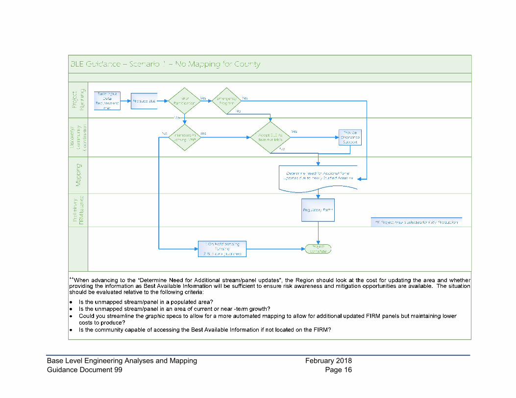
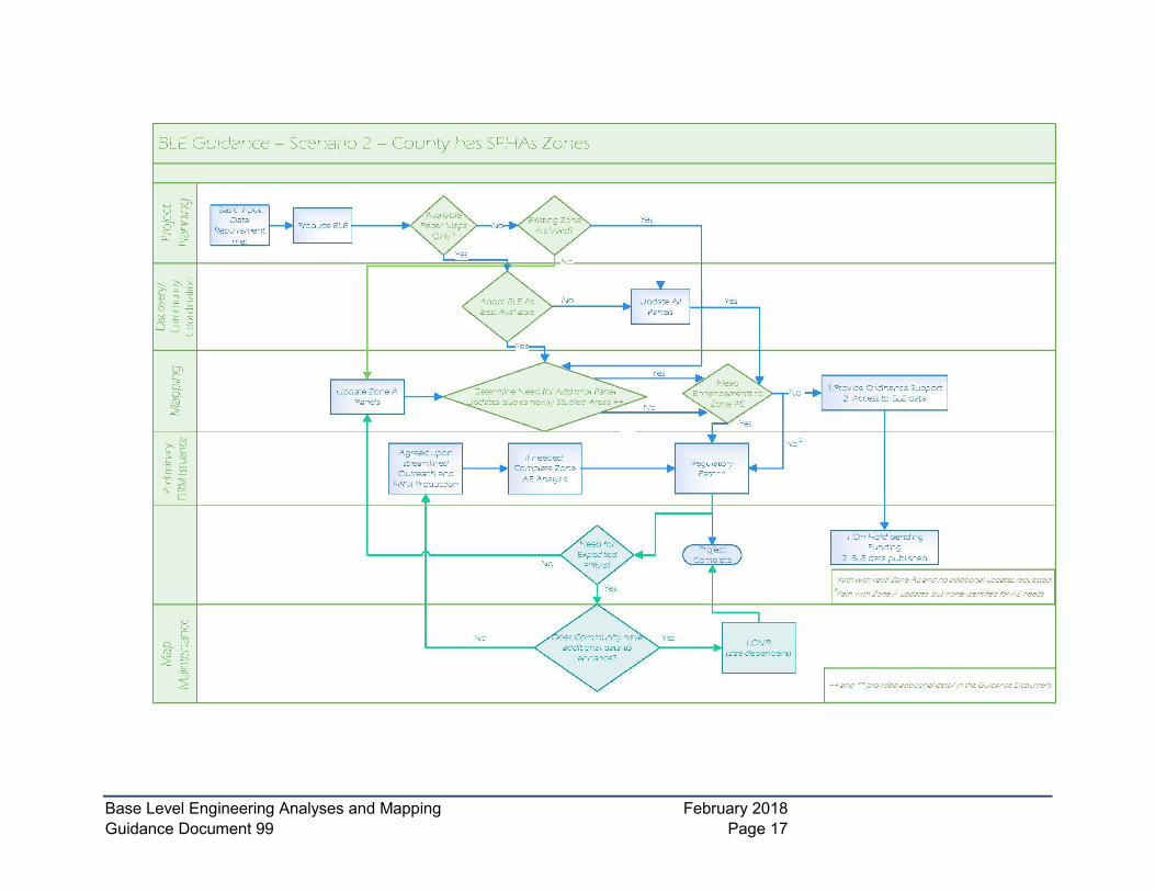
4.0 Decision Tree This section provides guidance for two common scenarios as to how to use BLE data from the early stages of the BLE project to final data delivery. As referred in the introductory section of this guidance, BLE analysis is often conducted for larger areas (HUC-8 watershed or county level) to take advantage of economies of scale, irrespective of communities’ current NFIP participation status. Below are the main scenarios based on the current effective floodplain inventory (Decision Trees are provided at the end of this document):
• Scenario 1 – No current mapping for county (subset NFIP participating versus not).
• Scenario 2 – County has SFHA Zones (subset digital maps versus paper).
If a community and FEMA decide to attempt to streamline the floodplain mapping process (outlined in scenarios above), there must be close coordination with all affected local governments prior to this decision. A decision may be made based on low risk or minimal community impacts to utilize more automated techniques when it comes to the graphical specifications to ensure a quicker and less expensive path to final FIRM products. Additionally, a county and the communities within it, may provide in writing a request to streamline outreach activities to accelerate the delivery of their final floodplain mapping product. Regions should coordinate with their FEMA HQ POC if these streamlined processes are to be requested.
When advancing to the= “Determine Need for Additional Stream/Panel Updates” shown in Scenario 2, the Region should look at the cost for updating the area and whether providing the information as Best Available Information will be sufficient to ensure risk awareness and mitigation opportunities are available. The situation should be evaluated relative to the following criteria:
1. Is the unmapped stream/panel in a populated area?
2. Is the unmapped stream/panel in an area of current or near-term growth?
Base Level Engineering Analyses and Mapping February 2018 Guidance Document 99 Page 11
3. Could you streamline the graphic specs to allow for a more automated mapping to allow for additional updated FIRM panels but maintaining lower costs to produce?
4. Is the community capable of accessing the Best Available Information if not located on the FIRM?
When a project reaches the “Regulatory Path”, it can advance as a full Risk MAP project with the identified flood risk products or it can continue as a Paper Inventory Reduction as discussed and approved during Regional allocation process.
It should be noted that the intention of BLE data production is to deliver a FIRM update, with the understanding that the FIRM update timeline will be dependent upon resource allocation and available funding – Federal, State and local. Some BLE data may need to go “on hold” if priorities for the community are low or if risk is low in the given area. BLE data can still be leveraged by the community while “on hold”.
5.0 Data Deliverables The Flood Risk Database (FRD) provides a standard, systematic method for FEMA to collect, store, and distribute comprehensive flood risk data to the public and others in a digital format. The FRD contains geospatial data layers, attribute lookup tables, supporting files, and other information necessary to create all the flood risk datasets. Using the existing standards for FRD will alleviate the need to have a separate data deliverable standard for BLE.
The current version of the FRD standard does not have all the necessary geospatial data layers to differentiate BLE-generated flood risk products. However, minimum revisions to the existing FRD data structure should support consistent data deliverables. BLE Data delivery through the existing FRD database is currently under review. The FRD Technical Reference will be updated in the future to reflect this addition. In the meantime, it is important that all modeling data collected for BLE (similar to historic “detailed” studies or full scale studies producing AE zones) should be captured in the Technical Support Data Notebook (TSDN) and submitted during a study process. If no FIRM update is planned in the short term based on the results of the BLE analysis, then mapping partner should coordinate with the Region on how the data should be stored until the FRD Technical Reference is updated or other means of data maintenance are provided.
BLE generated stream centerlines, cross-sections, and floodplain mapping can be stored and maintained in FRD. An example of database scheme for 1-D is shown below, and this should support future FIRM production with a minimum of effort. The database scheme for BLE is currently under development and all optional datasets referenced in this guidance will be included.
• BLE_Datasets
o BLE_S_XS
o BLE_S_Str_Ln
o BLE_S_Fld_Mapping (1-percent and 0.2-percent-chance events)
For additional details, refer to Guidance for Flood Risk Analysis and Mapping – Flood Risk Database, and Flood Risk Database (FRD) Technical Reference Guidance document.

Base Level Engineering Analyses and Mapping February 2018 Guidance Document 99 Page 12
6.0 Data Storage and Sharing One of the major objectives of the BLE process is to make the data accessible to stakeholders for use. Below are some possible solutions to sharing the data.
• Standalone GIS databases
• Workmap format with minimal graphic standards
• Community meetings and training
• FEMA’s Geo-platform
• ArcGIS Story Maps
• State/Local Data Portals
Regional Risk Analysis Branches should coordinate closely and early (preferably during scoping) with their Floodplain Management divisions to determine the appropriate distribution and data formats for a specific community.
7.0 Data Maintenance To take full advantage of the BLE data generated, it is important to document and share the BLE inventory so that all stakeholders are aware of the data availability. As of the February 2018 issuance of the CNMS Technical Reference, the CNMS Inventory now includes fields for tracking location and status of BLE. Further explanation of the BLE tracking fields, business rules, and touchpoints can be found in the CNMS Technical Reference.
Consideration should be given to the capabilities of communities and other land owners or lessees in a community to appeal or request Letters of Map Change based on the BLE data. When developing grids for the BLE, ensuring that there is a way to break out smaller subsets of the modeling to deliver to communities for map maintenance should be considered.
Once BLE data is available for communities, there are several ways that the data will progress through the regulatory process. Draft BLE data in the stages prior to Preliminary FIRM issuance may be used to make changes as follows:
• If a community wishes to make update or change the draft FEMA data to submit the newer or changed data as a LOMR, that is acceptable.
• All other FEMA generated data will follow the standard mapping timelines. Communities may provide concurrence on data and request an expedited outreach process to get through the regulatory process sooner; this will be coordinated with the Regional POC.
Based on the scenarios outlined in Section 4 of this document, FEMA can attempt to expedite portions of the process such as graphical specifications or outreach depending on community specifics. The community should use the BLE data in accordance with the criteria set out in the FPM Bulletin 1-98 and other floodplain management guidance as with any “newer data” until it becomes effective data on the FIRM.
Base Level Engineering Analyses and Mapping February 2018 Guidance Document 99 Page 13
8.0 Related Topics Covered by Other/Future Guidance The following is a list of related topics that have been developed or are planned to be developed to provide additional guidance related to hydrologic and hydraulic modeling riverine flooding analyses and mapping.
• Cross Sections - Planned
• Hydrology: Regression Equation Analyses - November 2017
• Hydraulics: One-Dimensional Analyses – November 2016
• Hydraulics: Two-Dimensional Modeling Analyses - November 2016
• Floodway Analysis and Mapping - November 2016
• Riverine Mapping & Floodplain Boundaries - November 2016
• Base Flood Elevations - Planned
• Water-Surface Profiles – Planned
9.0 Minimum BLE Considerations Based on the “Options” from Table 1 and Table 2, the following minimum considerations for BLE are recommended nationwide. In addition, common “buy up” or additional data options have been listed, so users can choose to upgrade the BLE beyond minimum considerations if desired.
The considerations below have also considered that there are some tasks in hydraulic modeling that are more difficult to complete or revise later in the modeling process. Thus, the BLE considerations listed below are designed to minimize the following:
• Revising the network, model structure, or layout of the underlying hydraulic model.
• Adding additional cross-sections to model areas more precisely to add structures in future.
• Modifying Manning’s n values at the cross-section level.
• Modifying the hydraulic model to accept additional flows (where the flows are substantially smaller or bigger than the modeled values).
The national minimum considerations stated below includes guidance that helps ensure a credible and costs effective BLE product when conisdered. The optional additional data products that require more manual work during the analysis process and may be specific to certain geographies. These optional components provide Regions with flexibility to meet the stakeholder expectations and usability of the BLE datasets.
The national minimum BLE considerations as defined below will meet the requirements to be used “as-is” for regulatory flood mapping per current FEMA standards. Be sure to review all standards as they are updated based on the biannual Policy Memo update to ensure you are addressing all the required standards for flood hazard mapping.
Minimum considerations to ensure cost effective BLE data development derived directly form Regulatory Mapping Standards:
• Use topography meeting SID #43 (LiDAR) with NAVD88 vertical datum.

Base Level Engineering Analyses and Mapping February 2018 Guidance Document 99 Page 14
• Flow profile baseline created from topography, visually compared against aerial imagery, falling within all mapped floodplains, and meeting SID #312.
• Use USGS regression equations for flow rates (with urban adjustments, where equations and data are available).
• Use HEC-RAS or other FEMA approved hydraulic models as the 1-D or 2-D base hydraulic model, meeting SID #62
• Model 0.2-, 1-, 1 minus, 1 plus, 2-, 4-, and 10-percent annual chance flows, meeting SID #84. The “1 minus“-percent annual chance flow is added to aid in future comparisons and CNMS validation.
• Produce floodplains for the 0.2-, and 1-percent annual chance floodplains, meeting SID#133.
• Develop Water surface elevation grids to allow for easier access by communities to the data.
Additional considerations based on common user preferences:
• Place cross-sections upstream and downstream of flow structures1.
• Develop Manning’s n values for each cross-section from a pre-determined table linking land cover types in the National Land Cover Database (NLCD) to Manning’s n values in the model.
• Use multiple or composite Manning’s n values per cross-section.
• Identify areas that do not meet 1-D modeling assumptions (split flows, sheet flow, etc.), but do not attempt to resolve.
• Incorporation of bathymetric cross section data.
Additional considerations based on efficient modeling practice:
• Create XS perpendicular to flow and with some degree of bend or curve to simulate manually-drawn XS.
• Starting water surface elevation of tributary streams based on normal or critical flow depth.
• For areas beyond the applicability ranges of the USGS regression equations, use gage-derived flows interpolated by drainage area.
Additional considerations based on usability needs for the data:
• Produce a report documenting the project, including the necessary parts of the TSDN.
• Upload all data to the relevant Mapping Information Portal (MIP) areas.
• Upload digital floodplain data to an appropriate publicly-accessible location for use by floodplain managers and other stakeholders.
1 A FEMA research paper published in February 2016 (Impact of Flood Hazard Modeling Parameters on Base Flood Elevation (BFE) and Floodplain Top Width, Including Calculation of Return on Investment (ROI) for Selected Input Variables), found that the following hydraulic model improvements have the highest return on investment, in terms of improving the accuracy of losses modeled.

Base Level Engineering Analyses and Mapping February 2018 Guidance Document 99 Page 15
Additional BLE preparation options
• Supplement modeling with additional structure data, either upgrading from structures “as-weirs” or inserting actual structure data where only upstream and downstream XS exists.
• Adjust regression equation values (within the range of applicability) to more accurately match gage flows and/or high-water marks for past flood events, or to modify flows to account for local meteorological effects.
• Generate Flood Risk Datasets.
• Flood Risk Assessment.
• Identification of Areas of Mitigation Interests (AoMI) targets based on the BLE analysis results.
Base Level Engineering Analyses and Mapping February 2018 Guidance Document 99 Page 16
Base Level Engineering Analyses and Mapping February 2018 Guidance Document 99 Page 17