hungarian national report on international union … · hungarian national report on international...
TRANSCRIPT

VOLUME XVIII/1 2015 Évfolyam
HUNGARIAN NATIONAL REPORT ON INTERNATIONAL UNION OF
GEODESY AND GEOPHYSICS
2011-2014
PUBLICATIONS IN GEOMATICS Geomat ika i Köz lemények
EDITOR IN CHIEF PAPP G Főszerkesztő
GUEST EDITOR ÁDÁM J Vendégszerkesztő
ADVISORY BOARD ÁDÁM J ( chair/ elnök) Tanácsadó testület BIRÓ P BOZÓ L MÁRTON P
ISBN 978-963-8381-38-5 HU ISSN 1419-6492
MTA CSFK GEODETIC AND GEOPHYSICAL INSTITUTE GEODÉZIAI ÉS GEOFIZIKAI INTÉZET
H-9400 SOPRON, CSATKAI STR.. 6-8.HUNGARY

Hungarian National Report on International Union of Geodesy and Geophysics
2011-2014
PUBLICATIONS IN GEOMATICS Geomatikai Közlemények
kiadja az
MTA CSFK GEODÉZIAI ÉS GEOFIZIKAI INTÉZETE
9400 Sopron, Csatkai E. u. 6-8. Pf. 5. tel.: +3699 / 508-340 fax.: +3699 / 508-355
e-mail: [email protected] web: www.geomatika.ggki.hu
web programozó: Lovranits Tamás
felelős kiadó:
Ábrahám Péter főigazgató
főszerkesztő:
Papp Gábor
vendégszerkesztő:
Ádám József
angol nyelvi szerkesztő:
Eperné Pápai Ildikó
technikai szerkesztő:
Bischof Annamária
készült a LŐVÉR PRINT Kft. nyomdájában
9400 Sopron, Ady Endre u. 5. tel.: +3699 / 329-977
megjelent 150 példányban Sopron, 2015
ISBN 978-963-8381-38-5 HU ISSN 1419-6492

HUNGARIAN NATIONAL REPORT
ON INTERNATIONAL UNION OF
GEODESY AND GEOPHYSICS
2011-2014
PUBLICATIONS IN GEOMATICS
Geomatikai Közlemények
XVIII/1.

"Minden nemzet a maga nyelvén lett tudós,
de idegenen sohasem."
(Bessenyei György)

GENERAL INFORMATION
Publications in Geomatics is a periodical journal since 1998 issuing generally one number a year. The purpose of the journal is to provide the home researchers and experts a forum to publish, mainly in Hungarian language, their new scientific results in the field of geosciences (geodesy, photogrammetry, geoinformatics, physical geodesy, geophysics, Earth magnetism, geodynamics, research of the inner structure of the Earth and the physics of its troposphere and solar-terrestrial environment) obtained from the analysis of spatial-temporal data using the methods of geomatics. The submitted papers are subject to an editorial procedure which is in compliance with the present-day standards, namely two independent referees form opinion about the manuscript. By default the names of the referees are known only to the editorial board, but their identity can be disclosed according to their wish. On the basis of reviews the editorial board decides whether it meets the requirements of the form, and content of the Publications in Geomatics and whether the eventual errors and shortcomings can be corrected and complemented by revision. The expert work of the editorial board is supported by an advisory board.
Editors, accomplishing the Journal's editing as a voluntary work, place emphases on rapid and high quality work. Therefore both the authors and the referees are expected to make efforts which are appreciated by the Editorial Board in advance. For this to do, it is suggested to peruse the instructions for authors and reviewers
Geomatikai_Közlemények_instrukciók_szerzőknek.doc, Geomatikai_Közlemények_instrukciók_bírálóknak.pdf.
These files provide basic information for the use of the editorial system and for maintaining the high professional standards.
Publications in Geomatics is published by the Geodetic and Geophysical Institute of the Research Centre for Astronomy and Earth Sciences, Hung. Acad. Sci. Publishing costs are covered from grant money, the sponsorship of scientific organizations (e.g. Soproni Tudós Társaság) and from subsidy of the Seminar Series on Geomatics organized by the GGI in every two years.
The recent volume of Publications on Geomatics was sponsored by the Hungarian Academy of Sciences.

PREFACE
The Hungarian National Committee of the International Union of Geodesy and Geophysics (IUGG, http://www.iugg.org) is pleased to present the 2011-2014 quadrennial Hungarian report to the membership of the IUGG. This report reviews the work accomplished in Hungary during the past four years and provides the record of the Hungarian contributions to the geodetic and geophysical research.
The Report covers the research and development performed by Universities, Scientific Institutions, and Government Agencies, subdivided by subjects in agreement with the following International Associations of IUGG: a) IACS (International Association of Cryospheric Sciences), b) IAG (International Association of Geodesy), c) IAGA (International Association of Geomagnetism and Aeronomy), d) IAHS (International Association of Hydrological Sciences), e) IAMAS (International Association of Meteorological and Atmospheric Sciences), f) IAPSO (International Association for the Physical Sciences of the Oceans), g) IASPEI (International Association of Seismology and Physics of the Earth’s Interior) and h) IAVCEI (International Association of Volcanology and Chemistry of the Earth’s Interior).
Since the last XXVth General Assembly in Melbourne, Australia, June 27-July 8, 2011 there have been some minor changes in the list of members of the Hungarian National Committee for IUGG. The members of the Hungarian National Committee for IUGG in the period of 2012-2015 are as follows. (National Correspondents of the Associations are indicated in brackets.) President: József Ádám (IAG); Secretary: László Bozó (IAMAS); Members: Antal Ádám, Péter Bakonyi, Judit Bartholy (IACS), Gábor Bálint, László Bányai, Péter Biró, Gábor Dobosi (IAVCEI), Attila Galsa, Zoltán Gribovszki (IAHS), Szabolcs Harangi, Balázs Heilig, László Horváth (IAPSO), Péter Márton, Gabriella Sátori (IAGA), László Szarka, József Szilágyi, Tamás Weidinger, Zoltán Wéber (IASPEI), Viktor Wesztergom and József Závoti.
In the past period the Hungarian National Committee for IUGG held three business meetings in Budapest on the following dates: a) 24 January 2012, b) 21 January 2014 and c) 20 January 2015.
This quadrennial Report is published by the Geomatikai Közlemények (Publications in Geomatics), a journal issued by the Geodetic and Geophysical Institute of the Research Centre for Astronomy and Earth Sciences of the Hungarian Academy of Sciences, in Volume XVIII, Number 1, 2015. Different parts of the Report are prepared by different Sections of the Hungarian National Committee for IUGG, and written and compiled by different authors. Therefore they are not quite balanced in size and the arrangements of the texts are not similar to each other. This Report would not be possible without the unselfish service of authors and editors.
We hope that this Report can provide a fairly clear picture of the development and measures what has been done in the past four years in the field of geodesy and geophysics in Hungary for our foreign Colleagues.
On behalf of the Hungarian National Committee for IUGG:
József Ádám President

CONTENTS Tartalomjegyzék
Judit Bartholy, Rita Pongrácz, Krisztina Gulyás, Katalin Hadobács, Bálint Hirling, Eszter Krisztina Koczor, Zoltán Kern, Kornél Kollát h, Annamária Lehocky, Szilvia Molnár, Katalin Somfalvi-Tóth, Csaba Szegedi, János Tordai, Kornélia Viola ......................................................................................................................... 9 Hungarian National Report on IACS 2011–2014
József Ádám ..................................................................................................................................... 11 Hungarian National Report on IAG 2011-2014
Ambrus Kenyeres, Gyula Grenerczy, Sándor Frey, Tivadar Horváth ....................................... 13 Hungarian contribution to the research of reference frames - IAG Commission 1
Lajos Völgyesi, Gyula Tóth, Zita Ultmann, Csaba Égető, Nikolett Rehány, Eszter Szűcs, Gábor Papp, Judit Benedek, Márta Kis, András Koppán, Péter Kovács, László Merényi, Gergely Vadász, Ambrus Kenyeres ........................................................ 19 Hungarian contribution to the research in gravimetry, gravity field modelling and geoid determination - IAG Commission 2
Péter Varga, Bálint Süle .................................................................................................................. 29 Hungarian contribution to the research of Earth orientation, Earth rotation, polar motion, nutation and precession – IAG Commission 3
Gyula Mentes, Ildikó Eperné Pápai, Katalin Gribovszki, Márta Kis, András Koppán ............ 33 Hungarian contribution to the research on Earth tides and tectonic movements observed by extensometers – IAG Commission 3
Gyula Mentes, Ildikó Bán, László Bányai, Virág Bereniké Bódis, Ildikó Eperné Pápai, János Kalmár, Katalin Gribovszki, Gábor Újvári, Eszter Szűcs, Gábor Papp .............. 37 Hungarian contribution to the research on Positioning and applications - IAG Commission 4
Szabolcs Rózsa, András Zénó Gyöngyösi, Ambrus Kenyeres, Tamás Weidinger ..................... 41 Hungarian contribution to the research on Remote sensing the atmosphere using GNSS - IAG Commission 4
László Bányai, József Závoti, László Bácsatyai, Kornél Czimber, Lóránt Földváry, János Kalmár, Davaadorzsin Monhor, Béla Paláncz, Lajos Völgyesi, Erik Papp, Balázs Somodi ....................................................................................................................... 43 Hungarian contribution to the research on Numerical theories and solutions in mathematical geodesy – IAG Inter-commission committee
József Ádám, Szabolcs Rózsa, Gyula Tóth .................................................................................... 47 Report of the communication and outreach branch of IAG
Károly Kis, Patrick T Taylor, Géza Wittmann ............................................................................. 51 Satellite-altitude magnetic gradient anomalies and inversion of satellite-altitude mag-netic anomalies – IAGA Division 1. Internal magnetic fields

Antal Ádám, Attila Novák, László Szarka, Viktor Wesztergom ................................................. 53 Electromagnetic induction (EM) studies by magnetotellurics – IAGA Division 1. Internal Magnetic Fields
Gábor Pethő ..................................................................................................................................... 55 Activity of the Department of Geophysics, University of Miskolc – IAGA Division 1. Internal Magnetic Fields
Viktor Wesztergom, Ernő Prácser, Veronika Barta, Dóra Bán, László Bányai, József Bór, Árpád Kis, Dávid Koronczay, István Lemperger, János Lichtenberger, Tamás Nagy, Attila Novák, Sándor Szalai, László Szarka, Judit Szendrői, Eszter Szűcs ................................................................................................ 57 EURHOM – Induction model of the European lithospheric plate – IAGA Division 1. Internal Magnetic Fields
Gabriella Sátori, József Bór, Veronika Barta, Károly Kovács, Tamás Nagy ............................. 59 Coupling machanisms between the thunderstorms/lightning and the upper atmosohere/ionosphere system – IAGA Division 2. Aeronomic phenomena
László Haszpra, Tímea Taligás ....................................................................................................... 61 Studying green house gases – IAGA Division 2. Aeronomic phenomena
János Lichtenberger, Csaba Ferencz, Péter Steinbach, Orsolya Erhardtné Ferencz, Dániel Hamar, Dávid Koronczay ........................................................................................ 63 Space weather investigations using in-situ and ground measurements – IAGA Divi-sion 3. Magnetospheric phenomena
Zoltán Németh, Károly Szegő, Mariella Tátrallyay ...................................................................... 67 Magnetospheric phenomena – IAGA Division 3. Magnetospheric phenomena
Balázs Heilig ..................................................................................................................................... 71 ULF waves in the magnetosphere – IAGA Division 3. Magnetospheric phenomena
Balázs Heilig, Gergely Vadász ........................................................................................................ 73 Monitoring of the dynamic plasmasphere – IAGA Division 3. Magnetospheric phenomena
Péter Kovács, Balázs Heilig, Gergely Vadász ................................................................................ 75 Nonlinear study of Solar wind-magnetosphere dynamics – IAGA Division 3. Magnetospheric phenomena
Géza Erdős, Antal Juhász, Károly Kecskeméty ............................................................................ 79 Solar wind and interplanetary field studied in the Wigner Research Centre for Physics, Hungarian Academy of sciences – IAGA Division 4. Solar wind and interplanetary field
Árpád Kis, Viktor Wesztergom, Veronika Barta, Dóra Bán, László Bányai, József Bór, Dávid Koronczay, István Lemperger, János Lichtenberger, Tamás Nagy, Attila Novák, Sándor Szalai, Judit Szendrői, Eszter Szűcs ............................................... 83 Energetic ions and related physical process at Earth’s bow shock - ION acceleration at the Eath’s quasi-parallel bow shock – IAGA Division 4. Solar wind and interplanetary field

Viktor Wesztergom, VeronikaBarta, Dóra Bán, László Bányai, József Bór, Árpád Kis, Dávid Koronczay, István Lemperger, János Lichtenberger, Tamás Nagy, Attila Novák, Sándor Szalai, Judit Szendrői, Eszter Szűcs ......................................................... 85 Geomagnetic observation and monitoring of geomagnetic induction at Nagycenk Geophysical Observatory (NCK) – IAGA Division 5. Observatory, instruments, surveys and analyses
Tamás Nagy, Orsolya Baillie, Árpád Kis, Károly Kovács, Dávid Koronczay, István Lemperger, Viktória Németh, Attila Novák, Ernő Prácser, Judit Szendrői, Eszter Szűcs, Viktor Wesztergom ....................................................................................... 87 Digitisation of Telluric Recordings of the Széchenyi István Geophysical Observatory of the Hungarian Academy of Sciences – IAGA Division 5. Observatory, instruments, surveys and analyses
Vilmos Gorócz, József Szabó, László Csurgai Horváth, István Lemperger, Dániel Piri, Judit Szendrői, Eszter Szűcs, Viktor Wesztergom ............................................................ 89 Development of Telluric Recording System at the Széchenyi István Geophysical Observatory of the Hungarian Academy of Sciences – IAGA Division 5. Observatory, instruments, surveys and analyses
István Lemperger, Veronika Barta, Dóra Bán, László Bányai, József Bór, Árpád Kis, Dávid Koronczay, János Lichtenberger, Tamás Nagy, Attila Novák, Sándor Sza-lai, Judit Szendrői, Eszter Szűcs, Viktor Wesztergom ...................................................... 91 The long turn behavior of the electromagnetic impedance tensor at Nagycenk Geophysical Observatory – IAGA Division 5. Observatory, instruments, surveys and analyses
Dániel Piri, Tamás Nagy, Veronika Barta, Dóra Bán, László Bányai, József Bór, Árpád Kis, Dávid Koronczay, István Lemperger, János Lichtenberger, Attila Novák, Sándor Szalai, Judit Szendrői, Eszter Szűcs, Viktor Wesztergom ........... 93 Universal Raspberry pi based data logger developed for the NCK geophysical observatory – IAGA Division 5. Observatory, instruments, surveys and analyses
András Csontos, Balázs Heilig, László Merényi, László Szabados .............................................. 95 Tihany Geophysical Observatory – IAGA Division 5. Observatory, instruments, surveys and analyses
Balázs Heilig, László Merényi, László Szabados, András Csontos, Péter Kovács ..................... 97 EMMA - the European quasi Meridional Magnetometer Array – IAGA Division 5. Observatory, instruments, surveys and analyses
András Csontos, Balázs Heilig, András Koppán, Péter Kovács, László Szabados, Gergely Vadász ..................................................................................................................... 99 Repeat station surveys – IAGA Division 5. Observatory, instruments, surveys and analyses
András Csontos, Balázs Heilig, László Merényi .......................................................................... 101 Development of a suspended fast dIdD – IAGA Division 5. Observatory, instruments, surveys and analyses
András Ludmány ........................................................................................................................... 103 Activity of MTA CSFK Heliospherical Observatory, Debrecen – IAGA Division 5. Observatory, instruments, surveys and analyses

Zoltán Gribovszki .......................................................................................................................... 105 Hungarian National Report on IAHS (2011-2014)
László Bozó ..................................................................................................................................... 115 Hungarian National Report on IAMAS (2011-2014)
Tamás Weidinger, László Horváth .............................................................................................. 121 Hungarian National Report on IAPSO (2011-2014)
Zoltán Wéber, Attila Galsa, Zoltán Gráczer, Katalin Gribovszki, Erzsébet Győri, Márta Kiszely, István János Kovács, Gyöngyvér Szanyi, Bálint Süle, Péter Varga ..... 125 Hungarian National Report on IASPEI (2011-2014)
Gábor Dobosi, Szabolcs Harangi .................................................................................................. 137 Hungarian National Report on IAVCEI (2011-2014)

Hungarian National Report on IUGG 2011-2014
1Eötvös Loránd University, Department of Meteorology
E-mail: [email protected] 2MTA CSFK Institute for Geological and Geochemical Research
3Hungarian Meteorological Service
HUNGARIAN NATIONAL REPORT ON IACS 2011–2014
Judit Bartholy1, Rita Pongrácz1, Krisztina Gulyás1, Katalin Hadobács1, Bálint Hirling1, Eszter Krisztina Koczor1, Zoltán Kern2, Kornél Kolláth3,
Annamária Lehocky1, Szilvia Molnár1, Katalin Somfalvi-Tóth3, Csaba Szegedi1, János Tordai1, Kornélia Viola1
In Hungary the majority of the scientific activities related to the cryosphere in the 2011-2014 period was carried out in the form of student research under the supervision of the academic staff of the Department of Meteorology at the Eötvös Loránd University, and the Hungarian Meteorological Service. Hence, during the reported period several BSc and MSc theses focused on cryosphere-related topics. They include snow and/or ice appearances in the atmosphere, near the surface, in rivers and in glaciers. The variety of the special topics is manifested also in the temporal and spatial scales, from microscale to synoptic and climatological scales. For instance, atmospheric conditions in the presence of hails are analyzed using dual-polarized meteorological radar measurements by Szegedi (2012). The ultimate goal of the study was to summarize the detecting techniques of hails with radar measurements. Hadobács (2011) and Koczor (2011) investigated icing as a major hazard to airplanes, and forecasting potentials of weather conditions resulting in icing. Gulyás (2012) and Tordai (2012) discussed adhesive snow and blowing snow, respectively, from a forecaster point of view. They both carried out detailed statistical analysis of past snow events in Hungary (e.g., Gulyás et al. 2012), and then, on the basis of these detected events, statistical models were developed for operative forecasting purposes. Tordai (2012) carried out in-situ snow density measurements in southern Hungary, as well as adapted the Blowing Snow Index for Hungary using air temperature, surface temperature, wind speed, wind gust, snow depth, and snow density observations. Statistical analyses of Molnár (2013) and Viola (2014) focused on early warning systems related to the spring freezing risk in agriculture, and cold, freezing events in general. Hirling (2011) used a hydrological model to simulate river’s water temperature with special emphasis on freezing conditions and ice formation along the river Danube. The study evaluated the projected effects of regional climate change on Hungarian rivers’ ice-related phenomena, mainly in case of the rivers Danube and Tisza.
Lehoczky (2014) analyzed glaciers from the Caucasus Mountains in the southeastern edge of Europe, the Polar Ural and Svalbard from Northern Europe. The study evaluated relationships be-tween the seasonal mass balance components, regional climatic conditions and distant atmospheric forcing represented by various indices of teleconnection patterns (e.g., North Atlantic Oscillation, NAO, Pacific Decadal Oscillation, PDO). The specific objectives of the research were (i) to exam-ine the variability and the integrative climatic signal in the averaged mass balance records of the selected regions; (ii) to analyse the possible coupling between the mass balance and climatic varia-bles, including the dominant patterns of the Northern Hemisphere climate variability; (iii) to com-pare the main characteristics of the glacier regions; and (iv) to discuss the significant decreasing trend of the cumulative annual mass balances in every region under the detected climatic changes in the second half of the 20th century. The research and the results were presented both at national and international conferences (Lehoczky et al. 2014a, 2014b, http://meetingorganizer.copernicus.org/ EGU2014/EGU2014-6301.pdf). According to the results the strongest teleconnection links are be-tween winter mass balance and winter NAO for the Polar Ural, and between annual mass balance and PDO for Svalbard. Neither seasonal, nor annual mass balance records showed significant corre-lation with any of the examined circulation indices for the Caucasus.
The list of publications appended to this report provides more information on these activities.

BARTHOLY ET AL.
Geomatikai Közlemények XVIII(1), 2015
10
References
Gulyás K (2012): Statistical climatological analysis and forecasting potentials of adhesive snow (in Hungarian). MSc Diplomawork, Department of Meteorology, Eötvös Loránd University, Budapest. Supervisors: Kolláth K, Somfalvi-Tóth K, Havasi Á, 60.
Gulyás K, Somfalvi-Tóth K, Kolláth K (2012): Statistical climatological analysis of adhesive snow in Hungary (in Hungar-ian). 11th International Conference on Applications of Natural, Technological and Economic Sciences – Presenta-tions (ed.: Mesterházy B) University of West Hungary, Szombathely, 43-49.
Hadobács K (2011): Potential use of reconstructing aviation hazardous weather conditions – Estimation of surface icing and preparation of corresponding simulation environment (in Hungarian). MSc Diplomawork. Department of Meteorol-ogy, Eötvös Loránd University, Budapest. Supervisors: Bottyán Zs, Weidinger T, Gyöngyösi AZ, 84.
Hirling B (2011): Simulation analysis of water temperature and ice formation on the Hungarian part of river Danube (in Hungarian). MSc Diplomawork. Department of Meteorology, Eötvös Loránd University, Budapest. Supervisors: Bálint G, Pongrácz R, 46.
Koczor EK (2011): Icing of airplanes: a case study (in Hungarian). BSc Diplomawork. Department of Meteorology, Eötvös Loránd University, Budapest. Supervisors: Wantuch F, Simon S, Ács F, 40.
Lehoczky A (2014): Climatological relationships of glacier mass balance variability at the geographical margin of Europe (in Hungarian). MSc Diplomawork, Department of Meteorology, Eötvös Loránd University, Budapest. Supervisors: Pongrácz R, Kern Z, 74.
Lehoczky A, Kern Z, Pongracz R (2014a): Comparative glacio-climatological analysis of mass balance variability along the geographical margin of Europe. Geophysical Research Abstracts, 16, EGU2014-6301
Lehoczky A, Pongrácz R, Kern Z (2014b): Climatic effects appearing in glacier mass balance located at the geographical margin of Europe (in Hungarian). Poster presented at the XXXVth Assembly of the Hungarian Meteorogical Society focusing on actual meteorological problems, Keszthely, 28-29 August 2014.
Molnár Sz (2013): Analysis of spring freezing risk and potential early warning (in Hungarian). MSc Diplomawork. Depart-ment of Meteorology, Eötvös Loránd University, Budapest. Supervisors: Lakatos M, Matyasovszky I, 50.
Szegedi Cs (2012): Analysis of polarized characteristics of processes related to hails with the HMS DWSR 2501C meteoro-logical radar (in Hungarian). MSc Diplomawork, Department of Meteorology, Eötvös Loránd University, Budapest. Supervisors: Dombai F, Mészáros R, 78.
Tordai J (2012): Forecast of blowing snow for Hungary (in Hungarian). MSc Diplomawork, Department of Meteorology, Eötvös Loránd University, Budapest. Supervisors: Kolláth K, Tóth T, Pongrácz R, 53.
Viola K (2014): Cold warning systems in the world and their potential use in Hungary (in Hungarian). BSc Diplomawork. Department of Meteorology, Eötvös Loránd University, Budapest. Supervisors: Pongrácz R, Németh Á, 50.

Hungarian National Report on IUGG 2011-2014
Department of Geodesy and Surveying, Budapest University of Technology and Economics, E-mail: [email protected]
HUNGARIAN NATIONAL REPORT ON IAG 2011-2014
József Ádám
This report outlines the activities of Hungary in the field of geodesy for the period from January 2011 to December 2014. It has been prepared for submission to the International Association of Geodesy (IAG) at its General Assembly in Prague, Czech Republic during the XXVIth General As-sembly of the International Union of Geodesy and Geophysics (IUGG) on 22 June – 2 July, 2015. It is issued on behalf of the IAG Section of the Hungarian National Committee for IUGG.
Since the last XXVth General Assembly in Melbourne, Australia, July 27-July 8, 2011 there have been some minor changes in the list of members of the IAG Section of the Hungarian National Committee for IUGG. Currently the National Correspondent to the IAG is also the Chairman of the IAG Section. The members of the IAG Section for the period of 2012-2015 are as follows: J. Ádám (Chairman), L. Bányai (Secretary), Á. Barsi, P Biró, G. Csapó (passed away in 2014), S. Frey, Gy. Grenerczy, A. Kenyeres, Gy. Mentes, G. Papp, Sz. Rózsa, Gy. Tóth, P. Varga, L. Völgye-si, and J. Závoti.
Cooperating institutions in the field of IAG in Hungary are as follows:
- Department of Geodesy and Surveying, Budapest University of Technology and Econom-ics (BME) (http://www.geod.bme.hu),
- Satellite Geodetic Observatory of the Institute of Geodesy, Cartography and Remote Sens-ing, Budapest-Penc (http://www.sgo.fomi.hu),
- Geodetic and Geophysical Institute of the Research Centre for Astronomy and Earth Sci-ences of the Hungarian Academy of Sciences, Sopron (http://www.ggki.hu),
- Institute of Geoinformatics of the Alba Regia Technical Faculty of the Óbuda University at Székesfehérvár (http://www.geo.amk.uni-obuda.hu),
- Hungarian Geological and Geophysical Institute (MFGI), Budapest (http://www.mfgi.hu), - Geoinformation Service of the Hungarian Defence Forces, Budapest
(http://www.honvedelem.hu/szervezet/mh_geosz).
The national report has been divided into commissions in accordance with the new structure of IAG. The commission reports are compiled by the authors indicated in brackets, who are responsible for the content of their corresponding reports, namely I. Commission “Reference Frames” (A. Kenyeres, Gy. Grenerczy, S. Frey and T. Horváth), II. Commission “Gravity Field” (L. Völgyesi, G. Papp and Gy. Tóth), III. Commission “Earth Rotation and Geodynamics” (P. Varga and Gy. Mentes), IV. Commission „Positioning and Applications” (Gy. Mentes and Sz. Rózsa), V. Inter-Commission Committee “Theory” (L. Bányai and J. Závoti) and VI. Communication and Outreach Branch (J. Ádám, Sz. Rózsa and Gy. Tóth). This report would not be possible without their efforts.

Geomatikai Közlemények XVIII(1), 2015
12

Hungarian National Report on IUGG 2011-2014
Satellite Geodetic Observatory, Institute of Geodesy, Cartogrpahy and Remote Sensing E-mail: [email protected]
HUNGARIAN CONTRIBUTION TO THE RESEARCH OF REFERENCE FRAMES - IAG COMMISSION 1
Ambrus Kenyeres, Gyula Grenerczy, Sándor Frey, Tivadar Horváth
1 Geodetic infrastructure
1.1 Active GNSS network and related services
The Hungarian GNSS reference station infrastructure and services have been established by the GNSS Service Centre (GSC) of the Institute of Geodesy, Cartography and Remote Sensing (FÖMI). The network consists of 35 Hungarian GNSS stations (Figure 1). In addition to these, observation data of 19 stations from the neighbouring countries are collected and processed in real time to pro-vide nationwide homogeneous coverage with cm-accuracy services. The average inter-station dis-tance is less than 60 km, enabling accurate modelling of distance-dependent errors like ionosphere, troposphere and orbits. All of the Hungarian stations and most of the integrated external sites are equipped with state-of-the-art GPS+GLONASS hybrid sensors and individually calibrated chok-ering antennas. Seven units are also Galileo-ready.
During this 4-year period the following station re-positionings had been performed:
- NYLE had been moved in 2011 few meters away to provide more stable monumentation; - PENC had been doubled in May 2013, a new monument (PEN2) had been established on
an elevated part of the main building of the SGO. At PEN2 a Galileo-capable receiver had been installed, which also became part of IGS and EPN. PEN2 as part of the IGS MGEX project provides RINEX 3.02 data;
- due to site-maintenance difficulties SUME station had been moved to TPOL (Tapolca) in November 2013.
The GNSS Service Centre uses the GNSMART network RTK software package (Geo++ GmbH) to provide reference data for both real-time and post-processing applications. Real-time data is provided via the Ntrip protocol in various formats:
- single station DGNSS data in RTCM 2.1 and RTCM 3.0 formats, - single station RTK data in RTCM 2.3, RTCM 3.0 and CMR formats, - network RTK data in RTCM 2.3, RTCM 3.1 and CMR formats.
All major network RTK concepts (PRS, FKP and MAC) are supported. RINEX and virtual RINEX data is provided for post-processing via the GSC website in RINEX
version 2.11 format. Since January 2013 we are running a new service (autopostGNSS) supporting users who want to
run the post-processing of their own field measurements in our dedicated server using the SSRPOST module of GNSMART.
As of December 2014 more than 1200 organisations registered for FÖMI’s GNSS services and the number of registered user account exceeded 2100. The majority of land surveying tasks in Hun-gary are carried out using real-time GNSS technique, but the most dramatically growing user seg-ment is the precision agriculture (Figure 2).

KENYERES ET AL.
Geomatikai Közlemények XVIII(1), 2015
14
Figure 1. Sites of Hungarian Active GNSS Network
GNSSnet.hu reference station coordinates are determined in ETRF2000 reference frame. Transfor-mation to the Hungarian local grid (EOV) is supported in both real-time and post-processing mode. A new online transformation service (EHT) is provided at the GSC website and a significantly im-proved real-time version (VITEL) is available for most receiver brands as an extension of the RTK rover receivers’ controller software. The transmission of transformation information via RTCM messages is also supported.
The GSC concentrates its efforts on service quality improvements. Besides the automatic quality control of the GNSMART software the GSC developed a number of real-time and post-processing quality monitoring tools for both internal use and information dissemination to the clients. The cur-rent status of the service can be monitored online via the GSC website: http://www.gnssnet.hu. A special monitoring tool has been developed for mobile phones. This enables users working on field to judge whether the system performs according to the expectations.
1.2 Integrated Geodetic Network (INGA)
In 2008 FÖMI, in agreement with the academic institutions, initiated the realization of the Integrat-ed Geodetic Network, called INGA. At the INGA benchmarks GPS, levelling and gravimetric measurements are performed and their coordinates are expressed in all geodetic reference frames available in Hungary (EOV, ETRS89, EOMA). The points are primarily selected from levelling benchmarks, where undisturbed GNSS measurement is possible. The MGGA (National GPS Geo-dynamic Network) sites are part of INGA by default and also the suitable markers of the Hungarian Gravity Base Network are incorporated. New markers are only installed where the network geome-try could be guaranteed from existing sites. The INGA site separation is about 15-20 km, the coun-try will be covered by some 1000 benchmarks. The INGA sites will have enhanced physical and legal protection to ensure the long term existence of the network and the represented reference frames. This work was started in 2007 at the NE part of Hungary and by 2014 the network estab-lishment had been completed east from the river Danube. Further continuation of the network reali-zation is pending.

HUNGARIAN CONTRIBUTION TO THE RESEARCH OF REFERENCE FRAMES…
Geomatikai Közlemények XVIII(1), 2015
15
Figure 2. Coverage of the agriculture users in 2014
2 SGO GNSS Analysis Centre
Since December 2001 the FÖMI Satellite Geodetic Observatory (SGO) is running a EUREF Local Analysis Centre (LAC). The SGO LAC is routinely processing the GNSS data of 22 EPN (EUREF Permanent Network), 35 GNSSnet.hu sites and 41 additional permanent stations from the neighbouring countries. The processed sub-network concentrates on the Central and East European region. The daily and weekly EPN sub-network solutions are submitted to the EPN Combination Centre.
FÖMI SGO is also contributing to the maintenance of the ETRS89 using the periodically updat-ed EPN cumulative solution. The EPN Reference Frame Coordinator is acting at the SGO and pro-vides the official EPN coordinate and velocity estimates, which are updated in every 15 weeks. In addition, SGO as initiator of the EPN Densification has started the integration of all European active GNSS network products to provide a high quality, homogeneous and dense position and velocity product in close cooperation with all national data providers and relevant initiatives as EUPOS and EPOS.
3 GPS geodynamics and PS InSAR
We continued our investigation in the framework of the GPS crustal deformation monitoring pro-gram -commenced in 1991. Horizontal crustal motions have been better constrained and the vertical tectonic signals have been detected, the main crustal blocks and faults and their present-day kine-matics were also investigated. To archive this it was necessary to continue high-precision GPS measurements within the MGGA (Hungarian GPS Geodynamics Network) and the CEGRN (Cen-tral European GPS Geodynamic Reference Network) networks (Grenerczy 2012, Caporali et al. 2011). In addition, we performed geodynamic applicability tests of the OGPSH (National GPS Network) to significantly increase spatial resolution. After tests had been successful, we organised and performed nationwide high-precision GPS measurement campaigns of the OGPSH increasing the geodynamic site density by a factor of five. More than two-decade-long observation history of

KENYERES ET AL.
Geomatikai Közlemények XVIII(1), 2015
16
the MGGA enabled us to construct the 3D crustal deformation map of the Pannonian Basin provid-ing significant new knowledge for geosciences.
We developed and refined the reference frame motion monitoring, and took part in relevant in-ternational co-operations. Significantly increased spatial and temporal resolution of geokinematic information in the Pannonian Basin (Grenerczy 2012). We achieved major scientific results with the creation of the first ever three-dimensional crustal deformation map of the Pannonian Basin and with the first high-rate GPS deformation studies and the most distant dynamic deformation detection in the world using space geodesy. Tectonic results has indirect social impact and serves valuable input for seismology e.g. in assessing hazards, for geomechanics, geomorphology, river dynamics e.g. in Quaternary river evolution, geodesy e.g. in celestial and terrestrial reference frames, basin analysis, rock physics e.g. in assessing pore pressure, and tectonics related topics in geology and geophysics as well.
We continued introduction of Synthetic Aperture Radar Interferometry (InSAR) technique to Hungary and performed the first applications and major demonstrations about its capability (Gre-nerczy 2012, Grenerczy and Wegmüller 2011). We have been carrying out InSAR related research for more than a decade supported also by the European Space Agency since 2005. Our current re-search topic is InSAR Integration: common referencing and combined three-dimensional hazard mapping with Sentinel-1. Major tasks involve multi-technique hazard monitoring in various envi-ronments. It also includes study of active and passive SAR point targets, design and establishment of collocation of techniques including SAR reflectors, common referencing with other geodetic networks, techniques, and also Sentinel-1 wide area mapping, tests and demonstrations of geodetic integration.
Beside our major tasks we are performing anthropogenic motion monitoring and study of the anatomy and dynamics of surface instabilities related to various human activities. We compare land and space-based techniques, methodologies, and their effectiveness and work out best-practice ap-proach. Technological development possibilities are also studied especially in relation to state sur-veying. Information dissemination, university lectures, student consultations, employment of young scientist and InSAR related supervisions and reviews of related works are also among our activities.
4 VLBI activities
The International Celestial Reference Frame (ICRF) is defined by the positions of selected radio-loud active galactic nuclei (quasars) measured by Very Long Baseline Interferometry (VLBI). Some of these positions appear variable based on long-term geodetic/astrometric VLBI monitoring obser-vations. The apparent proper motions can reach several hundred microarcseconds per year in some cases. We continued to study the possible relation between the quasars' apparent proper motion and their radio structure imaged with VLBI. The analysis of a sample of 62 objects with significant and reliable proper motion values, and their 8-GHz VLBI imaging observations and brightness distribu-tion models revealed a general correlation between the characteristic directions of the proper mo-tions and the extended radio jet structure on ~1 to 10 milliarcsecond scales. However, there are no-table cases where quasar jets are significantly misaligned with respect to the apparent proper motion direction (Moór et al. 2011).
With the successful launch of the Gaia optical astrometry mission (2013) by the European Space Agency (ESA), it will soon become possible to directly link the most accurate radio reference frame with the Gaia optical reference frame using a large number of common extragalactic objects. We performed a case study to test the level of coincidence between the radio and optical positions of compact active galactic nuclei, using the best catalogues available at present. We found that ~4% of the sample of nearly 1300 objects common in the ICRF2 catalogue and the Sloan Digital Sky Sur-vey Data Release 9 are significantly offset (by more than 3 sigma positional uncertainty), as ex-plained mostly by astrophysical reasons. Since the optical and radio centroids of quasars do not nec-essarily coincide at the level of accuracy to be achieved, a reliable Gaia-VLBI reference frame link will require a careful selection of a common set of objects by eliminating the outliers (Orosz and Frey 2012, 2013).

HUNGARIAN CONTRIBUTION TO THE RESEARCH OF REFERENCE FRAMES…
Geomatikai Közlemények XVIII(1), 2015
17
References
Caporali A, Barlik M, Becker M, Grenerczy Gy, Hausleitner W, Hefty J, Medak D, Milev G, Mojzes M, Mulic M, Odalovic O, Rus T, Simek J, Sledzinski J, Stangl G, Stopar B, Vassileva K, Vespe F, Zablotskyj F (2011): New challenges for the CEGRN. Reports on Geodesy, 9-18.
Grenerczy Gy (2012): A concept for the optimal mapping of present-day surface motions of Hungary (in Hungarian with English abstract), Geomatika Közlemények, 15, 109-119.
Grenerczy Gy, Wegmüller U (2011): Persistent scatterer interferometry analysis of the embankment failure of a red mud reservoir using ENVISAT ASAR data. Natural Hazards, 59(2), 1047-1053, DOI: 10.1007/s11069-011-9816-6
Grenerczy Gy, Wegmüller U (2013): Deformation analysis of a burst red mud reservoir using combined descending and ascending pass ENVISAT ASAR data. Natural Hazards, 65(3), 2205-2214, DOI: 10.1007/s11069-012-0470-4
Ihde J, Habrich H, Sacher M, Söhne W, Altamimi Z, Brockmann E, Bruyninx C, Caporali A, Dousa J, Fernandes R, Hornik H, Kenyeres A, Lidberg M, Mäkinen J, Poutanen M, Stangl G, Torres JA, Völksen C (2011): EUREF's Contribution to National, European and Global Geodetic Infrastructures. IUGG XV General Assembly, June 28–July 7 2011 – Melbourne, Australia. In Rizos C – Willis P (Eds.), "Earth on the Edge: Science for a Susta-naible Planet", IAG Symposia, 139, DOI: 10.1007/978-3-642-37222-3_15
Kenyeres A (2011): Categorizaton of permanent GNSS reference stations. Bolletino di Geodesia e Scienze Affini, 69(2–3), 375–390.
Moór A, Frey S, Lambert SB, Titov OA, Bakos J (2011): On the Connection of the Apparent Proper Motion and the VLBI Structure of Compact Radio Sources. Astronomical Journal, 141-178.
Orosz G, Frey S (2012): Radio-optical outlier quasars - a case study with ICRF2 and SDSS. Memorie della Società Astro-nomica Italiana, 83, 990-993.
Orosz G, Frey S (2013): Optical-radio positional offsets for active galactic nuclei. Astronomy and Astrophysics, 553, A13. Poutanen M, Ihde J, Bruyninx C, Francis O, Kallio U, Kenyeres A, Liebsch G, Mäkinen J, Shipman S, Simek J, Wil-
liams S, Wilmes H (2011): Future and development of the European Combined Geodetic Network ECGN. IUGG XV General Assembly, June 28–July 7 2011 – Melbourne, Australia. In: Rizos C – Willis P (Eds.), "Earth on the Edge: Science for a Sustanaible Planet", IAG Symposia, 139, 121–127, DOI:. 10.1007/978-3-642-37222-3_15
Rózsa Sz, Weidinger T, Gyöngyösi AZ, Kenyeres A (2012): The role of GNSS infrastructure in the monitoring of atmos-pheric water vapor. Időjárás, 116(1–2), 1–21.

Geomatikai Közlemények XVIII(1), 2015
18

Hungarian National Report on IUGG 2011-2014
1Department of Geodesy and Surveying, Budapest University of Technology and Economics E-mail: [email protected]
2Geodetic and Geophysical Institute, MTA CSFK 3Geological and Geophysical Institute of Hungary
4Satellite Geodetic Observatory, Institute of Geodesy, Cartography and Remote Sensing
HUNGARIAN CONTRIBUTION TO THE RESEARCH IN GRAVIMETRY, GRAVITY FIELD MODELLING AND
GEOID DETERMINATION - IAG COMMISSION 2
Lajos Völgyesi1, Gyula Tóth1, Zita Ultmann1, Csaba Égető1, Nikolett Rehány1, Eszter Szűcs2, Gábor Papp2, Judit Benedek2, Márta Kis3, András Koppán3, Péter
Kovács3, László Merényi3, Gergely Vadász3, Ambrus Kenyeres4
The gravity field related research has relevant tradition and history in Hungary. Nowadays the most important instruments of the modern gravimetry are the absolute gravimeters, which measure the gravity based on the law of free fall. Our study gives a short summary about the related main re-search fields and applications, where an absolute gravimeter will provide essential contribution. Beyond some theoretical introduction the possible causes of the time-variable gravity are summa-rized, the importance of the equipment ingravimetric and geodetic networks is emphasized (Csapó et al, 2011a), and its applications in the geodynamical studies are described. The parameters and capabilities of the A10 absolute gravimeter are also shown (Csapó et al. 2011b).
The Hungarian Gravimetric Network (MGH) is maintained by the Geological and Geophysical Institute of Hungary (the former Eötvös Loránd Geophysical Institute). According to its condition in 2014, the MGH contains 20 absolute stations and 446 1st or 2nd order base points. The maintenance work includes checking the status of base points as well as substitution or installation of destroyed or new base points (Csapó and Koppán 2013). Between 2011 and 2014, 8 base points and one abso-lute station were reinstalled, and one base point was newly installed. These stations were linked to the 3 nearest MGH base points through relative measurements.
In order to improve the reliability and accuracy of the network, the gravity acceleration was re-determined on 11 absolute stations between 2011 and 2014. The measurements were carried out by using the AXIS FG-5 No. 215 absolute gravimeter operated by the staff of Výzkumný ústav geo-detický, topografický a kartografický, v.v.i. (VÚGTK, Czech Republic). Before the absolute meas-urements, vertical gravity gradient (VG) was determined on every station by LCR-G gravimeters, using a 3-level arrangement and at least 6 series of measurements.
Whereas the VG can deviate significantly from the normal value (-0.3086 mGal/m) in Hungary, vertical gradients were determined on further 24 base points between 2011 and 2014.
To utilize the results of the latest absolute and relative measurements, a new adjustment of the MGH was carried out in 2013. The RMS error (µ0) of the network was ±0.0137 mGal (Csapó 2013).
A gravimeter calibration facility exists in the Mátyáshegy Gravity and Geodynamical Observa-tory of Geological and Geophysical Institute in Hungary. During the calibration a cylindrical ring of 3200 kg mass is vertically moving around the equipment, generating gravity variations. The effect of the moving mass can be precisely calculated from the known mass and geometrical parameters. The main target of the calibration device was to reach a relative accuracy of 0.1-0.2% for the cali-bration of Earth tide recording gravimeters. The maximum theoretical gravity variation produced by the vertical movement of the mass is ab. 110 µGal, so it provides excellent possibility for the fine calibration of LCR gravimeters in the tidal range.
The instrument was out of order for many years and in 2012 and 2013 it was renovated and au-tomatized. The calibration process is aided by intelligent controller electronics. A new PLC-based system has been developed to allow easy control of the movement of the calibrating mass and to measure the mass position. It enables also programmed steps of movements (waiting positions and waiting times) for refined gravity changes. All parameters (position of the mass, CPI data, X/Y leveling positions) are recorded with 1 Hz sampling rate. The system can be controlled remotely through the internet.

VÖLGYESI ET AL.
Geomatikai Közlemények XVIII(1), 2015
20
As it is well known, variations of the magnetic field can influence the measurements of metal-spring gravimeters, therefore magnetic experiments were carried out on the pillar of the calibration device as well, in order to analyze the magnetic effect of the moving stainless steel mass. During the movements of the mass, the observed magnetic field changes significantly. According to the mag-netic measurements and modelling, a correction for the magnetic effect can be applied on the meas-ured gravimetric data series (Kis et al. 2014, Koppán et al. 2014).
An experimental development of a computer controlled photoelectric ocular system applied for the LaCoste and Romberg G949 gravimeter made the continuous observation of time variation of gravity possible. The system was operated for half a year in the Sopronbánfalva Geodynamical Ob-servatory to test its capabilities. The primary aim of this development was to provide an alternative and self-manageable solution instead of the standard electronic (Capacitive Position Indicator) read-ing of this type of gravimeter and to use it for the monitoring of Earth tides. It, however, turned out (Papp et al, 2012) that this system is sensitive enough to observe the effect of variable seismic noise (microseisms) due to the changes of ocean weather in the North Atlantic and North Sea regions at microGal level (1 µGal = 10−8 m/s2). Up to now little attention was paid to its influence on the quality and accuracy of gravity observations due to the large distance (>1000 km) between the ob-servation site (generally the Carpathian–Pannonian Basin) and the locations (centres of storm zones of the northern hydrosphere) of triggering events. Based on an elementary harmonic surface defor-mation model the noise level of gravity observations was compared to the spectral characteristics of seismic time series recorded at the same time in the observatory. Although the sampling rate of gravity records was 120 s, the daily variation of gravity noise level showed significant correlation with the variation of spectral amplitude distribution of the analysed high pass filtered (cut-off fre-quency = 0.005 Hz) seismograms up to 10 Hz. Available daily maps of ocean weather parameters were also used to support both the correlation analysis and the parameterization of the triggering events of microseisms for further statistical investigations. These maps, which were processed by standard image processing algorithms, provide numerical data about geometrical (distance and azi-muth of the storm centres relative to the observation point) and physical (mass of swelling water) quantities. The information can be applied for characterizing the state of ocean weather at a given day which may help the prediction of its influence on gravity measurements in the future. Probably it is the first attempt to analyse quantitatively the effect of ocean weather on gravity observations in this specific area of the Carpathian–Pannonian region.
Based on the results described above an Austrian-Hungarian cooperation started to coordinate the Earth tide monitoring in the Alps-Carpathians-Pannonian Basin region to provide the best fitting tidal models for high precision absolute gravimetry on this specific area (Benedek et al. 2014).
In the 20th century, a large amount of torsion balance measurements have been made in Hunga-ry mainly for geophysical purposes. Only the horizontal gradients were used for geophysical pro-specting, the curvature gradients measured by torsion balance remained unused. The knowledge of the figure of the Earth, i.e. the geoid is an important problem from many scientific and practical aspects. The gravity data provide the essential basis for the study of the geoid. In the framework of a collaboration between the Geological and Geophysical Institute of Hungary and the Budapest Uni-versity of Technology and Economics, the collection of past project reports on Eötvös torsion bal-ance measurements has been started for more than a decade. The torsion balance data reported ei-ther in report sheets or on maps have been digitized and collected in uniform databases. Recently, the torsion balance database includes about 45000 records containing the curvature and/or gradient data of Eötvös measurements carried out on the historical territory of Hungary.
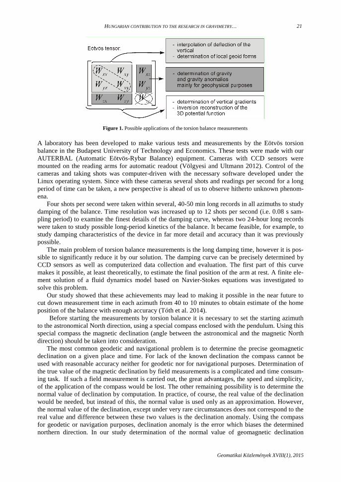
Gravity gradients are very important and useful data in geodesy. With the help of the gradients precise vertical deflections can be calculated by interpolation and the fine structure of the geoid can be derived. Based on the horizontal and the curvature gradients of gravity the full Eötvös tensor (including the vertical gradients) can be derived (Völgyesi 2012a, 2012b). A summary of the possi-ble applications of torsion balance measurements can be seen on Figure 1.
HUNGARIAN CONTRIBUTION TO THE RESEARCH IN GRAVIMETRY…
Geomatikai Közlemények XVIII(1), 2015
21
Figure 1. Possible applications of the torsion balance measurements
A laboratory has been developed to make various tests and measurements by the Eötvös torsion balance in the Budapest University of Technology and Economics. These tests were made with our AUTERBAL (Automatic Eötvös-Rybar Balance) equipment. Cameras with CCD sensors were mounted on the reading arms for automatic readout (Völgyesi and Ultmann 2012). Control of the cameras and taking shots was computer-driven with the necessary software developed under the Linux operating system. Since with these cameras several shots and readings per second for a long period of time can be taken, a new perspective is ahead of us to observe hitherto unknown phenom-ena.
Four shots per second were taken within several, 40-50 min long records in all azimuths to study damping of the balance. Time resolution was increased up to 12 shots per second (i.e. 0.08 s sam-pling period) to examine the finest details of the damping curve, whereas two 24-hour long records were taken to study possible long-period kinetics of the balance. It became feasible, for example, to study damping characteristics of the device in far more detail and accuracy than it was previously possible.
The main problem of torsion balance measurements is the long damping time, however it is pos-sible to significantly reduce it by our solution. The damping curve can be precisely determined by CCD sensors as well as computerized data collection and evaluation. The first part of this curve makes it possible, at least theoretically, to estimate the final position of the arm at rest. A finite ele-ment solution of a fluid dynamics model based on Navier-Stokes equations was investigated to solve this problem.
Our study showed that these achievements may lead to making it possible in the near future to cut down measurement time in each azimuth from 40 to 10 minutes to obtain estimate of the home position of the balance with enough accuracy (Tóth et al. 2014).
Before starting the measurements by torsion balance it is necessary to set the starting azimuth to the astronomical North direction, using a special compass enclosed with the pendulum. Using this special compass the magnetic declination (angle between the astronomical and the magnetic North direction) should be taken into consideration.
The most common geodetic and navigational problem is to determine the precise geomagnetic declination on a given place and time. For lack of the known declination the compass cannot be used with reasonable accuracy neither for geodetic nor for navigational purposes. Determination of the true value of the magnetic declination by field measurements is a complicated and time consum-ing task. If such a field measurement is carried out, the great advantages, the speed and simplicity, of the application of the compass would be lost. The other remaining possibility is to determine the normal value of declination by computation. In practice, of course, the real value of the declination would be needed, but instead of this, the normal value is used only as an approximation. However, the normal value of the declination, except under very rare circumstances does not correspond to the real value and difference between these two values is the declination anomaly. Using the compass for geodetic or navigation purposes, declination anomaly is the error which biases the determined northern direction. In our study determination of the normal value of geomagnetic declination

VÖLGYESI ET AL.
Geomatikai Közlemények XVIII(1), 2015
22
D(ϕ, λ, t) is discussed and the possible error sources of the determination is attempted to estimate (Völgyesi and Csontos 2014a, 2014b).
Linear variation of the gravity gradients between the adjoining network points is an important demand for different interpolation methods in geodesy (e.g. interpolation of the vertical deflection, geoid computations, and interpolation of the gravity values or the vertical gradients of gravity). To study the linearity of gravity gradients, torsion balance measurements were made both at the field and in a laboratory: one is at the southern part of the Csepel Island, and the other in the Geodynam-ical Laboratory of Loránd Eötvös Geophysical Institute in the Mátyás Cave.
On Figure 2 the results of the computations are summarized for the 7 points of the earlier torsion balance measurements E220, E218, E238, E208, E206, E204, E207 with and without topographic reduction respectively, and the results for the new torsion balance measurements 3.a-3.b-3.c-3.d-3.e between the points E238 and E208 can be seen.
Based on our results, decreasing the length of the measuring line improves the linearity of gravi-ty gradients (since it increases the values of R2). Data comparison shows that decreasing distances between the torsion balance points from 1000-1500 m to 150-300 m does not increase significantly the improvement of linearity (Völgyesi and Ultmann 2014).
Finally, it is concluded that the mean point density of the earlier torsion balance measurements does not meet the requirement of linear variation of gravity gradients between neighbouring net-work points.
Moreover the problem could not be solved even applying topographic reduction. The results of our investigations show that the linearity of the gravity gradients mainly depends on the given point density and the geological fine structure of rocks and shallow subsurface density. It seems the given point density of the earlier torsion balance stations may not be enough for some geodetic purposes, moreover the problem could not be solved applying topographic reduction of gravity gradients (Völgyesi and Ultmann 2014).
Figure 2. Linearity test of the torsion balance measurements: changing of the horizontal gradient Wzx on the original points (upper part of the figure) and on the denser net (lower part of the figure)

HUNGARIAN CONTRIBUTION TO THE RESEARCH IN GRAVIMETRY…
Geomatikai Közlemények XVIII(1), 2015
23
Further investigations are planned to study the effects of the nonlinearity on geodetic quantities, regarding e.g. the deflection of the vertical and precise geoid computation. Investigations would be important to study the connection between the spatial structure of the gradients of gravity field and the geological fine structure of rocks near-surface inhomogeneities and shallow subsurface density.
All the elements of the Eötvös tensor can be measured by torsion balance, except the vertical gradient. The knowledge of the real value of the vertical gradient is more and more important in gra-vimetry and geodesy (Völgyesi et al. 2012).
Determination of the 3D gravity potential W(x,y,z) can be produced by inversion reconstruction based on each of the gravity data Wz (= g) measured by gravimeters and gravity gradients Wzx, Wzy, W∆, Wxy measured by torsion balance. Moreover, vertical gradients Wzz measured directly by gravim-eters have to be used as reference values at some points. First derivatives of the potential Wx, Wy (it can be derived from the components of deflection of the vertical) may be useful for the joint inver-sion, too. Determination of the potential function has a great importance because all components of the gravity vector and the elements of the full Eötvös tensor can be derived from it as the first and the second derivatives of this function. The second derivatives of the potential function give the ele-ments of the full Eötvös tensor including the vertical gradients, and all these elements can be deter-mined not only at the torsion balance stations, but anywhere in the surroundings of these points.
For checking the 3D inversion algorithm, test computations were performed at the south part of the Csepel Island where torsion balance and vertical gradient measurements are available. There were about 30 torsion balance, 21 gravity and 27 vertical gradient measurements on our test area. Only a part of the 27 vertical gradient values was used as initial data for the inversion and the re-maining part of these points were used for controlling the computation (Völgyesi et al. 2012).
The 27 vertical gradient measurement points can be seen on Figure 3, the structure and the spatial distribution of the values of vertical gradients is illustrated by isolines. The values of the isolines on the Figure 2 is in mGal/m (1 mGal/m = 10-5 1/s2 = 10 000 E =10 000 Eötvös Unit), coordinates are in meters in the Hungarian Unified National Projections (EOV) system.
Comparing the measured vertical gradient data to the computed value at the 6 controlling points the root mean square of the differences is ±11.6 µGal/m which is the order of magnitude of the measurements of the vertical gradient.
Figure 3. Computed vertical gradients Wzz from the joint inversion, values are in mGal/m

VÖLGYESI ET AL.
Geomatikai Közlemények XVIII(1), 2015
24
So this is a strong demonstration of the applicability of the inversion reconstruction of the gravity potential for the determination of the vertical gradients based on torsion balance data.
Creating the optimal geometry of the interpolation net is an important part of the computation of deflection of the vertical based on torsion balance measurements. The triangle network fitted to the torsion balance stations should be designed to be adequate for the interpolation, namely the distanc-es between the adjacent points should be minimal and the curvature gradients between that selected torsion balance points should be as linear as possible. So far this task has been performed manually with huge efforts furthermore it has not always succeeded in finding the optimal geometry. Delau-nay triangulation offers a new opportunity to solve the problem by computer. Selecting the most suitable pairs of points, the automatic creation of the interpolation network is successful by an ap-propriate modification of the Delaunay triangulation (Ultmann and Völgyesi 2013).
Global gravity field models are most recently refined by GOCE data. As GOCE presents band limited observations, an efficient spectral filtering method for eliminating the unreliable content of the observations is of high relevance. Polgár et al. (2013) has derived an appropriate filter for the purpose. Földváry et al. (2014a) has derived the errors of the filtered gravity gradients using the classical error propagation laws. Földváry et al. (2014b) then implemented the semi-analytical ap-proach for the band-limited GOCE gravity gradient observations.
The unprecedently low altitude of the GOCE satellite (demonstrated by Figure 1 of Somodi and Földváry 2011) is also challenging from the orbit determination point of view. Considering purely dynamic orbits, error estimate of GOCE orbit determination has been performed by Somodi and Földváry (2011, 2012). The studies analyzed the “ever” effect of the near surface mass variations by inclusion of high degree gravity field information, an ocean tide model, a reliable estimate of solid earth tides and of polar motion. The investigation has been extended to GPS satellites (at altitude of 20200 km or so) as well, as they serve as the basis of the orbit determination of the GOCE satellite.
The GRACE satellites delivers monthly resolution gravity models enabling the determination of annual or longer periodic mass variations. In a warming climate, it is critical to accurately estimate ice-sheet mass balance to quantify its contribution to present-day sea level rise. In Földváry (2012) temporal mass variations in Antarctica are investigated based on monthly GRACE gravity solutions. In order to diminish the effect of large uncertainties in glacial isostatic adjustment models, an ap-proach is developed to estimate the acceleration of the ice-sheet mass, assuming the presence of accelerated melt signal in the GRACE data. Though the estimate of accelerated melt does not pro-vide an absolute value for the volume of the melting ice, it was found to be a viable tool for charac-terizing the present-day ice sheet mass balance. The method has been refined by separation of dif-ferent regions of melt rates by Földváry et al. (2014).
A new quasigeoid model for Hungary was determined by combining gravity data, GPS/levelling and vertical deflections (Tóth and Szűcs 2011). Reduction of the measurements was performed by using Earth Gravitational Model 2008 (EGM2008) and Shuttle Radar Topographic Mission (SRTM) elevation data sets. Calculation method was Least Squares Collocation (LSC) with Forsberg’s self-consistent planar logarithmic covariance model. In the computations the weights of GPS/levelling data were large, in this way normal heights obtained from levelling are consistent with GPS heights and with the quasigeoid model. Astrogeodetic-gravimetric, pure astrogeodetic and pure gravimetric solutions have been calculated besides the combined solution to investigate the discrepancies among the different models. The combined quasigeoid model fits to the GPS/levelling data with standard deviation of ±4.9 cm, nevertheless at some GPS/levelling sites large differences were indicated. Comparison of the astrogeodetic-gravimetric and combined quasigeoid solutions shows a mean bias of -2.74 cm and a standard deviation of ±3.04 cm. These two solutions are very close to each other in most parts of the country (Figure 4.), except for the region in southeast, where the GPS/levelling observations do not fit well to the other observation types. This region is located in the Great Hun-garian Plains, which is covered by young, unconsolidated sediments. In this context the main prob-lem is that levelling and GPS measurements do not refer to the same epoch. First-order polygons of the Unified National Vertical Network (EOMA) were measured in the 1970s, the OGPSH network was established in the 1990s.

HUNGARIAN CONTRIBUTION TO THE RESEARCH IN GRAVIMETRY…
Geomatikai Közlemények XVIII(1), 2015
25
Figure 4. Differences of astrogeodetic-gravimetric quasi-geoid heights at OGPSH sites (bias removed)
Furthermore, levelling of the GPS/levelling sites was achieved using the third order levelling net-work of the country, not the first order one and besides of this GPS observations were carried out using rapid measurement technology. Processing of re-measurement data of part of the EOMA lev-elling network confirms a suspected recent subsidence.
Recent high degree geopotential models and certain computational procedures in physical geod-esy require the evaluation of integrals (truncation coefficients) that are products of very high degree Legendre polinomials (or functions) with various kernels over a given domain. The oscillating char-acter of integrands (more than 10,000 zeros) makes it difficult to evaluate such integrals. A highly accurate quadrature has been developed for fast computation of these integrals based on the Glaser-Liu-Rokhlin root finding algorithm and Gauss-Lobatto quadrature between the roots (Tóth and Fáncsikné 2013). Our procedure successfully eliminates the instability of the recursive algorithm developed by MK Paul for the solution of Stokes’ integral at very high degrees. It can be applied in several fields of physical geodesy, e.g. for gravity field modelling based on surface or satellite grav-ity gradients.
Szűcs (2012) presents the validation of the first and second generation GOCE-only models using terrestrial data sets in Hungary. Besides GOCE-based GGMs satellite only GRACE models were evaluated to assess the improvements by GOCE observations with respect to GRACE in gravity field determination. EGM2008 as the state-of-the-art model and SRTM3 elevation model were ap-plied to provide that measurements involving Hungarian data sets and model derived gravity field functionals have almost the same spectral content. Results with GPS-levelling and gravity data sup-port that there is an improvement in the determination of medium-wavelength parts (200 < λ < 250 km) of the gravitational field with GOCE models. Although vertical deflections characterize the short-wave part of the gravity field, they are also capable of sensing the advancement of SGG ob-servations.
Szűcs et al. (2014) investigated the spectral characteristics of terrestrial data sets mentioned above. They estimated the spectral contribution of gravity anomalies, vertical deflections and gravi-ty gradients using both Fourier PSD and covariance analysis depending on the spatial distribution of data points. From the spectral characteristics of terrestrial measurements weights for spectral com-bination of a global gravity field model, gravity and gravity gradient data were derived. Besides the

VÖLGYESI ET AL.
Geomatikai Közlemények XVIII(1), 2015
26
frequency domain investigations the information content regarding the different wavelength struc-ture comprised in terrestrial and EGM2008 model was investigated also in the space domain based on covariance analysis. As a combined validation process the gravity degree variances were trans-formed to the necessary auto- and cross covariance functions to predict geoid height from gravity anomaly, which ensures an independent validation process of the computed spectrum.
Special attention was paid to the evaluation of SRTM3 surface model which has been extensive-ly used for residual terrain modelling recently. On a well surveyed local, partly forest-clad area Papp and Szűcs (2011) determined its deviation from a digital terrain model digitized from 1:10 000 topographic maps and found close correlation between the deviations and canopy heights reaching sometimes 10 m – 15 m. They transformed the height differences to a 3D mass density model dis-cretized by rectangular prisms to derive gravity anomalies, geoid heights and second derivatives by forward gravitational modelling. The direct gravitational effect of the differences between surface and terrain models is insignificant (< 1 mm) on geoid heights but it is considerable if terrain correc-tions for gravity anomalies and torsion balance measurements are required for geophysical interpre-tation.
Szűcs and Benedek (2014) extensively investigated in which frequency band gravity gradients measured by Eötvös torsion balance could contribute to the refinement of gravity field features. They used different kernel modifications of the gradiometric boundary value problems in the nu-merical evaluation of integral transforms, especially the integrals transforming horizontal gravity gradients to vertical gravity gradient, to gravity anomaly and to potential. Closed-loop differences between gravity field quantities derived from integral transforms and their “true” value obtained from EGM2008 GGM were synthetically analysed for various wavelength bands both in space and in frequency domain.
In order to support the evaluation of different geoid solutions based on physical approaches (e.g. gravimetric geoid) the development of a digital zenith camera system (DZCS) has been started in the Research Centre for Astronomy and Earth Sciences, Hungarian Academy of Sciences. DZCS-s are astronomical-geodetic measurement systems for the observation of the direction of the plumb line. The DZCS key component is a pair of tiltmeters for the determination of the instrumental tilt with respect to the plumb line. Highest accuracy (i.e., 0.1 arc-seconds or better) is achieved in prac-tice through observation with precision tiltmeters in opposite faces (180° instrumental rotation), and through application of rigorous tilt reduction models. A novel concept proposes the development of a hexapod- (Stewart platform)-based DZCS. However, hexapod-based total rotations are limited to about 30°-60° in azimuth (equivalent to ±15° and to ±30° yaw rotation), which raises the question of the impact of the rotation angle between the two faces on the accuracy of the tilt measurement. Hirt et al. (2014) investigated the expected accuracy of tilt measurements to be carried out on future hexapod-based DZCS, with special focus placed on the role of the limited rotation angle. A Monte-Carlo simulation study is carried out in order to derive accuracy estimates for the tilt determination as a function of several input parameters, and the results are validated against analytical error prop-agation. As main result of the study, limitation of the instrumental rotation to 60° (30°) deteriorates the tilt accuracy by a factor of about 2 (4) compared to a 180° rotation between the faces. None the less, a tilt accuracy at the 0.1 arc-second level is expected when the rotation is at least 45°, and 0.05 arc-second (about 0.25 microradian) accurate tilt meters are deployed. Consequently a hexapod-based DZCS can be expected to allow sufficiently accurate determination of the instrumental tilt. This provides supporting evidence for the feasibility of such a novel instrumentation.
In view of the recent re-measurement campaign of the Hungarian Levelling Base Network the role of gravimetric observations was studied (Kratochvilla et al. 2011). Adjustment of the network was performed using geopotential numbers, which can be converted into an equivalent metric quan-tity, the normal heights. The normal heights can also be derived directly from raw observed height differences by adding two normal correction terms, K1 and K2. Both of them have been determined based on an earlier network adjustment. The second term, K2 is a function of ∆g along the levelling line, which is implicitly an estimate of the effect of long-wavelength gravity field. The accuracy demand of gravimetric data for normal correction under different terrain conditions was discussed.

HUNGARIAN CONTRIBUTION TO THE RESEARCH IN GRAVIMETRY…
Geomatikai Közlemények XVIII(1), 2015
27
In the recent years several investigations have been performed on the newly constructed subway line of Budapest, line no. 4 (Metro 4). From the physical geodetic aspect the effect of the excavation on the gravity field (potential surfaces, plumb lines) is of interest. In fact, the change of the gravity field may affect the monitoring of the vertical deformation during the construction, as the method of repeated leveling assumes the local horizontal and vertical to be constant in time (Égető and Földváry 2011). In the study of Égető et al. (2014) the direct effect of the mass loss on leveling measurements due to the excavation of the two tunnels and of the stations of Metro 4 has been con-sidered. The corresponding numerical accuracy issues are presented by Égető and Földváry (2013). The method has been refined by inclusion of the indirect effect of the actual vertical deformations (subsidence) of the physical surface on the leveling in Égető et al. (2013). According to the results, under certain arrangements of the leveling line, the direct effect can reach the 5 µm order of magni-tude, which is equivalent to the precision of the precise leveling, while the indirect effect due to subsidence is below 0.1 µm, thus negligible.
References
Benedek J, Kis M, Koppán A, Meurers B, Papp G, Szűcs E, Blaumoser N (2014): Comparative measurement of 3 rela-tive spring gravimeters and the GWR SG025 for calibration purposes. COBS Journal, 2014(3), 19.
Csapó G, Kenyeres A, Papp G, Völgyesi L (2011a): Analysis of the influential effects of the absolute gravity measure-ments (In Hungarian). Geodézia és Kartográfia, 63(1), 8-13.
Csapó G, Kenyeres A, Papp G, Völgyesi L (2011b): Plans and works of the applications of the absolute gravimetry in Hungary (In Hungarian). Geodézia és Kartográfia, 63(2), 4-9.
Csapó G (2013): Az országos gravimetriai hálózat (MGH) 2013. évi kiegyenlítése és a hálózat megbízhatósági vizsgálata. Geodézia és Kartográfia, 65(11-12), 4-6.
Csapó G, Koppán A (2013): The results and works of the latest adjustment of Hungarian Gravimetric Network (MGH-2010). Acta Geod. Geoph. Hung., 48(1), 9-16, DOI: 10.1007/s40328-012-0001-5
Égető Cs, Földváry L (2011): The effect of the Metro 4 tunnel system on the gravity field (in Hungarian with English ab-stract), Geomatikai Közlemények, 14(1), 17-26.
Égető Cs, Földváry L (2013): Numerical accuracy analysis of modelling excavation induced gravity field variations, In: Proceedings in Global Virtual Conference, GV-CONF 2013, 8-12 April 2013, Žilina, Slovak Republic, Editors: Z. V. Sovreski, M. Mokryš, Š. Badura, A. Lieskovský, EDIS - Publishing Institution of the University of Zilina.
Égető Cs, Földváry L, Huszák T (2013): The effect of tunnelling on repeated precise levelling measurements for vertical deformation control of the Metro 4 project (In Hungarian). Journal of Geodetic Science, 3(2), 95-102.
Égető Cs, Rehány N, Földváry L (2014): Variations of the gravity field due to excavations of the Budapest Metro 4 subway line. Periodica Polytechnica Civil Engineering, 58(2), 131-136.
Földváry L (2012): Antarctica accelerated melting from GRACE monthly gravity field solutions. In: Geodesy for Planet Earth, Proceedings of IAG Symposium in Buenos Aires, IAG Symposia, 131, 591-597.
Földváry L, Kiss A, Su ZX, Wang GC, Wang L (2014): Accuracy investigations of GRACE-borne ice mass variations in Antarctica, Earth Science Frontiers, (in print).
Földváry L, Sujbert L, Polgár Zs (2014a): On the filtering of GOCE gravitational gradients and related accuracy aspects (in Hungarian with English abstract). Geomatikai Közlemények, 17, 33-45.
Földváry L, Kemény M, Asbóth P (2014b): Semi-analytical approach for adjusting GOCE SGG observations. 9th Interna-tional Symposium on Applied Informatics and Related Areas - AIS2014, Székesfehérvár, 12 November 2014, 31-36.
Hirt C, Papp G, Pál A, Benedek J, Szűcs E (2014): Expected accuracy of tilt measurements on a novel hexapod-based digital zenith camera system: a Monte-Carlo simulation study. Meas. Sci. Technol., 25(8), DOI: 10.1088/0957-0233/25/8/085004
Kis M, Koppán A, Kovács P, Merényi L (2014): Moving-mass gravimeter calibration in the Mátyáshegy Gravity and Geo-dynamical Observatory (Budapest). Geophysical Research Abstracts, 16, EGU2014-14816.
Koppán A, Kis M, Kovács P, Merényi L. Vadász G (2014): Observatory gravimeter calibration results with magnetic correction. Conference papers of 6th Croatian-Hungarian and 17th Hungarian Geomathematical Congress, 145-150.
Kratochvilla K, Földváry L, Tóth Gy (2011): Effect of long-wavelength gravity field on the normal correction of first order Uniform National Height System (in Hungarian with English abstract). Geomatikai Közlemények, 14(1), 7-16.
Papp G, Szűcs E. (2011): Effect of the difference between surface and terrain models on gravity field related quantities. Acta Geod. Geoph. Hung., 46 (4), 441-456, DOI: 10.1556/AGeod.46.2011.4.6
Papp G, Szűcs E, Battha L (2012): Preliminary analysis of the connection between ocean dynamics and the noise of gravity tide observed at the Sopronbánfalva Geodynamical Observatory, Hungary. Journal of Geodynamics, 61, 47-56, DOI: 10.1016/j.jog.2012.07.004
Polgár Z, Sujbert L, Földváry L, Asbóth P, Ádám J (2013): Filter design for GOCE gravity gradients. Geocarto Interna-tional, 28(1), 28-36, DOI:10.1080/10106049.2012.687401
Somodi B, Földváry L (2011): Application of numerical integration techniques for orbit determination of state-of-the-art LEO satellites. Periodica Polytechnika Civil Engineering, 55(2), 99-106.

VÖLGYESI ET AL.
Geomatikai Közlemények XVIII(1), 2015
28
Somodi B, Földváry L (2012): Accuracy of numerical integration techniques for GOCE orbit determination. In: Mokryš M, Lieskovský A (Eds.), Proceedings in Advanced Research in Scientific Fields: The 1st Virtual International Confer-ence, Zilina, Slovakia, 03-07 December 2012, EDIS Zilina University Publishers, Zilina, 1578-1583.
Szűcs E (2012): Validation of GOCE time-wise gravity field models using GPS-levelling, gravity, vertical deflections and gravity gradient measurements in Hungary. Periodica Polytechnika Civil Engineering, 56(1), 3-11.
Szűcs E, Benedek J (2014): Possible applications of Eötvös torsion balance measurements in the practical evaluation of gradiometric boundary value problems (in Hungarian with English abstract). Geomatikai Közlemények, 17, 45-58.
Szűcs E, Papp G, Benedek J (2014): A study of different wavelength spectral components of the gravity field derived from various terrestrial data sets. Acta Geodaetica et Geophysica, 49(3), 327-342.
Tóth Gy, Szűcs E (2011): On the determination of a new combined EGM2008 based quasi-geoid model for Hungary. Acta Geodaetica et Geophysica Hungarica, 46(4), 417-430.
Tóth Gy, Fáncsikné HÉ (2013): Fast computation of truncation coefficients for the extended Stokes function (in Hungarian with English abstract). Geomatikai Közlemények, 16, 51-62.
Ultmann Z, Völgyesi L (2013): Creating optimal geometry by Delaunay triangulation for interpolation of deflection of the vertical (in Hungarian with English abstract). Geomatikai Közlemények, 16, 63-72.
Völgyesi L (2012a): A gravimetria mai jelentősége és helyzete Magyarországon. Magyar Tudomány, 173(6), 706-723. Völgyesi L (2012b): Application and importance of the torsion balance measurements in geodesy (in Hungarian with English
abstract). Geomatikai Közlemények, 15, 9-26. Völgyesi L, Dobróka M, Ultmann Z (2012): Determination of vertical gradients of gravity by series expansion based
inversion. Acta Geodaetica et Geophysica Hungarica, 47(2), 233-234, DOI: 10.1556/AGeod.47.2012.2.11 Völgyesi L, Laky S (2014): Reducing the Measurement Time of the Torsion Balance. Earth on the Edge: Science for a
Sustainable Planet (Eds: Rizos C, Willis P) International Association of Geodesy Symposia, Vol. 139, Springer Ver-lag, Berlin, Heidelberg, 341-347.
Völgyesi L, Ultmann Z (2012): Reconstruction of a torsion balance, and the results of the test measurements. In: Kenyon S, Pacino MC, Marti U (Eds.): Geodesy for Planet Earth, Buenos Aires, Argentina. 2009. International Association of Geodesy Symposia, Vol. 136, Springer Verlag, Berlin, Heidelberg, 289.
Völgyesi L, Ultmann Z (2014): High-Resolution Measurements of Non-Linear Spatial Distribution of Gravity Gradients in Hungary. Earth on the Edge: Science for a Sustainable Planet (Eds: Rizos C, Willis P) International Association of Geodesy Symposia, Vol. 139, Springer Verlag, Berlin, Heidelberg, 435-444.
Völgyesi L, Csontos A (2014a): Importance of the geomagnetic field in geodesy and navigation (in Hungarian). Geodézia és Kartográfia, 66(5-6), 4-9.
Völgyesi L, Csontos A (2014b): Determination of the geomagnetic North for geodesy and navigation (in Hungarian). Geodézia és Kartográfia, 66(7-8), 4-7.

Hungarian National Report on IUGG 2011-2014
MTA CSFK Geodetic and Geophysical Institute E-mail: [email protected]
HUNGARIAN CONTRIBUTION TO THE RESEARCH OF EARTH ORIENTATION, EARTH ROTATION, POLAR
MOTION, NUTATION AND PRECESSION – IAG COMMISSION 3
Péter Varga, Bálint Süle
The absence of long series of complete earthquake data is a serious difficulty in seismic hazard research as well as in preparation of the worst-case models for the location, size, and peak ground acceleration (PGA) of potential future earthquakes. That is why predictions based on probabilistic and to a lesser extent on deterministic principia do not fit in aptly with observed reality and do not help to determine reliable design parameters even in the comparatively well-known past occurrenc-es, despite their evidently serious mathematical foundations (Varga 2011a). By means of combined use of geodetic strain rate data and the seismic moment data set, the probable recurrence time was determined for past seismic events. This combination represents a new and independent approach to estimate the order of magnitude of future seismic activity. Using a modified version of Kostrov’s equation and the catalogue of seismic moments, the recurrence of the strongest earthquakes of a source area was estimated. It was found in Varga (2011b) that the recurrences in a given source zone in case of earthquakes MW ≥ 9.0 are of the order of some hundred years. For the large and medium earthquakes the expected ∆t is well above some 103 years.
The geographical locations of great (M ≥ 7) earthquakes, first of all the shallow ones, delineate the lithospheric plates, among them primarily the lithospheric slabs penetrating into the mantle. Only a part of subduction zones are marked beside shallow by deep earthquake zones too. The esti-mated global length of subduction zones is 6.7·104 km, while length of those which are related to deep events – according to our calculations carried out with a methodology based on inverse map-ping equations and applied to a given map projection – is only 1.9·104 km (28%). For the aims of the present study maps completed with Mollweide projection were in use. Examination of the seven source zones circumscribed in Varga and Süle (2014), aside from one (Honsu-Kamchatka), in which both shallow and deep M ≥ 7.0 earthquakes occur, shows that linear distribution of deep earthquakes is considerably shorter than that found for the shallow earthquakes, which determine the length of the zone (Figure 1). The distribution of earthquake energy release along latitudes has no correlation with the number of earthquakes and with the distribution of topographic structures usually interpret-ed as subduction zones. At the same time a clear axial co-ordination of radiated seismic energy is demonstrated with maxima at latitudes close to critical values (±45°).The radiated energy has the highest peak close to 0°±5°, with respect to the tectonic equator, which is inclined about 30° with respect to the geographic equator.
Figure 1. The geographical locations of deep M ≥ 7 earthquakes. The epicentres are marked with dotes, the boundaries of investigated source zones are shown with thick straight lines

VARGA P, SÜLE B
Geomatikai Közlemények XVIII(1), 2015
30
This fact indicates the presence of external forces that influence seismicity and it is consistent with the fact that Gutenberg-Richter law is linear, for events with M > 5, only when the whole Earth’s seismicity is considered, and it points at an astronomical control on plate tectonics. This external factor is most probably the despinning (reduction of the Earth’s angular rotation) of the Earth axial rotation caused primarily by tidal friction due to the Moon (Varga et al. 2012b, Varga and Süle 2014).
Examining variations in the Earth's rotation during the geological history the relationship be-tween the axial despinning and changes in the structure of the planetary interior was investigated. It was found that for the present epoch a growth rate of the core comprised between 1 and 10 mm/cy seems to be plausible guess, leading to a relative decrease of LOD comprised roughly between 10 and 100 µs/cy. Such values do not affect significantly the observed secular increase of LOD caused by tidal braking, which amounts to about 1.79 ms/cy. However, in the remote geological past, be-fore Phanerozoic, the effect of the core growth may have been much more important, because the total change of LOD associated with core formation has been estimated to be 2.4 hours for an ini-tially undifferentiated old Earth, and 3.1 hours for an initially undifferentiated hot Earth. Paleo-LOD measurements see to far slow core formation during the Proterozoic contrarily to the now largely prevailing hypothesis that the iron core formed very early in the Earth’s history and during a geo-logically short time interval. From recent estimates of the age of the inner core based on the theory of thermal evolution of the core, it was estimated that nowadays the growth of the inner core gener-ates a relative decrease of 2 to 7 µs/cy, what may contribute to the observed overall secular increase of LOD caused mainly by tidal friction (i.e., 1.72 ms/cy) by a relative decrease of 2 to 7 µs/cy, what does not produce any detectable change of length of day (Denis et al. 2011).
From the study of palaeogeographical maps for the last 600 Ma it was concluded that during this time-interval of Earth’s history the tectonic activity had a significant change: increase occurred in the lengths of mid-ocean ridges (spreading centres) and subduction zones. In the same time there has been a large change of the length of the shelf zones. This change can explain contemporary change of the despinning rate from about 0.35 ms/cy to about 1.79 ms/cy (Varga et al. 2012c). The mechanisms that move plates are not entirely understood. In order to clarify the issue the compila-tion of palaeogeographical maps in the time span 0.6 Ga BP to Present in terms of (a) the ratio be-tween continental to oceanic crust areas in order to estimate the speed of continental growth, and (b) the surface motion of continental plates under the influence of global forces of tidal friction and Eötvös force (“pole-fleeing”) was investigated. It was concluded that the area of the continents during the Phanerozoic was continuously growing and it exhibited a rate ~0.5 km3/yr. On the other hand, it was found that beside the westward oriented tidal frictional forces the Eötvös force can possibly play also a role in the plate tectonic processes. In Figure 2 it is shown that the continental plates on average tend to find a position close to the equator during the whole investigated 600 Ma time-interval (Varga et al. 2014a).
Figure 2. Areas (in %) of latitudinal zones covered by continental crust in different epochs of
Late Proterozoic and Phanerozoic and the average distribution

HUNGARIAN CONTRIBUTION TO THE RESEARCH OF EARTH ORIENTATION…
Geomatikai Közlemények XVIII(1), 2015
31
Based on mathematical considerations an extension of the MacCullagh formulae was derived. In particular, for excitation functions with a vanishing harmonic coefficient of degree zero, the diago-nal incremental moments of inertia can be expressed by excitation coefficients. Four types of excita-tion functions are considered: (i) tidal excitation, (ii) loading potential, (iii) centrifugal potential, and (iv) transverse surface stress. One application of the results could be a model computation of the length-of-day variations and polar motion, which depend on the moments of inertia (Varga et al. 2012a).
In order to study theoretically the geodynamic behaviour of the Earth on a short (elastic Earth) and on a long scale of geological periodic variations (for an almost perfectly liquid Earth), the changes of the moment of inertia are decomposed into two parts: the first, described by a volume integral, explains the effect of the density variations, while the second gives the impact of the sur-face variations using a surface integral. Based on mathematical considerations it was concluded that only minor changes occurred during time interval from 2.5 to 0.5 Ga BP in the main features of the inner structure of our planet which was practically finished at the very beginning of the history of the Earth. This conclusion coincides with recent results of geochemists who concluded that the formation of the core and of the main features of the mantle was completed 3.5-4.0 billion years ago (Varga et al. 2014b).
References
Denis C, Rybicki KR, Schreider AA, Tomecka-Suchon S, Varga P (2011): Length of the day and evolution of the Earth’s core in the geological past. Astronomisches Nachrichten, 332(1), 24-35.
Varga P (2011a): Earthquake prediction (in Hungarian). Hungarian Science, 7, 826-843. Varga P (2011b): Geodetic strain observations and return period of strongest earthquakes of a given seismic source zone.
Pure and Applied Geophysics, 168(1-2), 289-296, DOI: 10.1007/s00024-010-0112-2 Varga P, Grafarend E, Engels J (2012a): From Gravitostatics to Gravitodynamics:The space-time dependent gravity field
by Eulerian versus Lagrangean force fields: Examples. Geophysical Research Abstracts, Vol.14, EGU2012-14247, EGUGeneral Assembly 2012.
Varga P, Krumm F, Riguzzi F, Doglioni C, Süle B, Wang K, Panza GF (2012b): Global pattern of earthquakes and seismic energy distributions: insights for the mechanisms of plate tectonics. Tectonophysics, 530-531, 80-86, DOI:10.1016/j.tecto.2011.10.014
Varga P, Krumm FW, Doglioni C, Grafarend EW, Panza G, Riguzzi F, Schreider A, Sneeuw N (2012c): Did a change in tectonic regime occur between the Phanerozoic and earlier Epochs? Rendiconti Lincei, 23(2), 139-148, DOI 10.1007/s12210-012-0172-6
Varga P, Süle B (2014): Great deep earthquakes (in Hungarian). World of Science, 145(5), 202-206. Varga P, Krumm FW, Grafarend EW, Sneeuw N, Schreider AA, Horváth F (2014a): Evolution of the oceanic and
continental crust during Neo Proterozoic and Phanerozoic. Rendiconti Lincei, 25(2), 255-263, DOI: 10.1007/s12210-014-0298-9
Varga P, Grafarend E, Engels J (2014b): Temporal variations of the polar moment of inertia and the second-degree geopo-tential. Geophysical Research Abstracts Vol.16, EGU2014-1745, 2014 EGU General Assembly 2014.

Geomatikai Közlemények XVIII(1), 2015
32
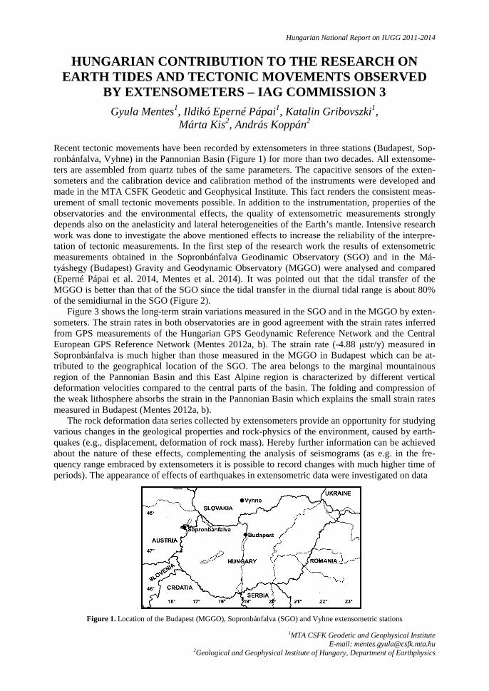
Hungarian National Report on IUGG 2011-2014
1MTA CSFK Geodetic and Geophysical Institute E-mail: [email protected]
2Geological and Geophysical Institute of Hungary, Department of Earthphysics
HUNGARIAN CONTRIBUTION TO THE RESEARCH ON EARTH TIDES AND TECTONIC MOVEMENTS OBSERVED
BY EXTENSOMETERS – IAG COMMISSION 3 Gyula Mentes1, Ildikó Eperné Pápai1, Katalin Gribovszki1,
Márta Kis2, András Koppán2
Recent tectonic movements have been recorded by extensometers in three stations (Budapest, Sop-ronbánfalva, Vyhne) in the Pannonian Basin (Figure 1) for more than two decades. All extensome-ters are assembled from quartz tubes of the same parameters. The capacitive sensors of the exten-someters and the calibration device and calibration method of the instruments were developed and made in the MTA CSFK Geodetic and Geophysical Institute. This fact renders the consistent meas-urement of small tectonic movements possible. In addition to the instrumentation, properties of the observatories and the environmental effects, the quality of extensometric measurements strongly depends also on the anelasticity and lateral heterogeneities of the Earth’s mantle. Intensive research work was done to investigate the above mentioned effects to increase the reliability of the interpre-tation of tectonic measurements. In the first step of the research work the results of extensometric measurements obtained in the Sopronbánfalva Geodinamic Observatory (SGO) and in the Má-tyáshegy (Budapest) Gravity and Geodynamic Observatory (MGGO) were analysed and compared (Eperné Pápai et al. 2014, Mentes et al. 2014). It was pointed out that the tidal transfer of the MGGO is better than that of the SGO since the tidal transfer in the diurnal tidal range is about 80% of the semidiurnal in the SGO (Figure 2).
Figure 3 shows the long-term strain variations measured in the SGO and in the MGGO by exten-someters. The strain rates in both observatories are in good agreement with the strain rates inferred from GPS measurements of the Hungarian GPS Geodynamic Reference Network and the Central European GPS Reference Network (Mentes 2012a, b). The strain rate (-4.88 µstr/y) measured in Sopronbánfalva is much higher than those measured in the MGGO in Budapest which can be at-tributed to the geographical location of the SGO. The area belongs to the marginal mountainous region of the Pannonian Basin and this East Alpine region is characterized by different vertical deformation velocities compared to the central parts of the basin. The folding and compression of the weak lithosphere absorbs the strain in the Pannonian Basin which explains the small strain rates measured in Budapest (Mentes 2012a, b).
The rock deformation data series collected by extensometers provide an opportunity for studying various changes in the geological properties and rock-physics of the environment, caused by earth-quakes (e.g., displacement, deformation of rock mass). Hereby further information can be achieved about the nature of these effects, complementing the analysis of seismograms (as e.g. in the fre-quency range embraced by extensometers it is possible to record changes with much higher time of periods). The appearance of effects of earthquakes in extensometric data were investigated on data
Figure 1. Location of the Budapest (MGGO), Sopronbánfalva (SGO) and Vyhne extensometric stations

MENTES ET AL.
Geomatikai Közlemények XVIII(1), 2015
34
Figure 2. Tidal frequency transfer function of the Budapest (MGGO), and Sopronbánfalva (SGO) extensometric stations
series collected in the Matyashegy Gravity and Geodynamical Observatory in Budapest in the time of significant (M > 7) earthquakes, and spectral analysis was carried out (Kis et al. 2014). Results of the examinations were compared to the spectrum of records of a typical, undisturbed lapse of time, as well as to the spectrum calculated from seismograms of Kövesligethy Radó Seismological Ob-servatory in Budapest, nearby the gravity observatory.
In the Sopronbánfalva Geodynamic Observatory the natural radon concentration is very high and it depend on meteorological parameters (indoor and outdoor temperature, barometric pressure), ventilation of the observatory, etc. Simultaneous strain measurement by extensometer and radon concentration measurement by an ALPHAGuardTM instrument is a unique possibility to study the relationship between rock strain and radon concentration variations in this observatory. The long-periodic part and seasonal variations of the signals were examined by cross-correlation and regres-sion analysis. It was found that the strain induced radon concentration variations are in the order of 10-1 – 10-2 kBq nstr-1, while the concentration variations bear more considerable similarity and rela-tion to the temperature and air pressure variations (Mentes 2012a). The theoretical tidal potential at the location of the measurement site and tidal components computed from strain, meteorological and radon concentration data were compared with each other. The tidal evaluation proved the lack of the principal lunar semidiurnal M2 and diurnal O1 tidal waves, which have the strongest effect on the deformation of the solid Earth, but they are explicit components in the theoretical tidal and rock strain variations. These results does not reveal any connection between radon concentration varia-tions and Earth’s tide induced rock strain at the measurement site and the tidal components appear-ing around the noise level in the radon concentration are presumably due to the random variation of the weather (Figure 4).
a) b) c)
Figure 3. Long-term strain variations measured a) in the SGO (azimuth of the instrument: 116°) and in the MGGO by the extensometers b) E1 (azimuth of the instrument: 114°) and c) E2 (azimuth of the instrument: 38°)

HUNGARIAN CONTRIBUTION TO THE RESEARCH ON EARTH TIDES AND TECTONIC MOVEMENTS…
Geomatikai Közlemények XVIII(1), 2015
35
Figure 4. Theoretical tidal potential (Pot.), tidal components calculated from the extensometric (Ext.) barometric pressure (p), temperature (Temp.) and radon concentration (Rn) data
References
Eperné Pápai I, Mentes Gy, Kis M, Koppán A (2014): Comparison of two extensometric stations in Hungary. Journal of Geodynamics, 80, 3-11. SI: Understand the Earth, DOI: 10.1016/j.jog.2014.02.007
Kis M, Gribovszki K, Kiszely M, Koppán A (2014): Analysis of an earthquake based on extensometric and seismological measurements. In: Cvetkovic M, Zelenika KN, Geiger J (eds.): Proceedings of 6th Croatian-Hungarian and 17th Hun-garian Geomathematical Congress. Croatian Geological Society, 129-134.
Mentes Gy (2012a): Observation of local tectonic movements by a quartz-tube extensometer in the Sopronbánfalva Geody-namic Observatory, in Hungary-Validation of extensometric data by tidal analysis and simultaneous radon concen-tration measurements. Journal of Geodynamics, 58, 38– 43, DOI: 10.1016/j.jog.2012.01.004
Mentes Gy (2012b): Observation of strain rate variations by a quartz-tube extensometer in the Sopronbánfalva Geodynamic Observatory, Hungary. 16th General Assembly of Wegener, Earthquake geodesy and geodynamics: from giant to small scale events. Volume of Abstracts. University of Strasbourg Collège Doctoral Européen, 17-20 September 2012, Université de Strasbourg, France, 74. http://wegener2012.sciencesconf.org
Mentes Gy, Eperné Pápai I, Kis M, Koppán A (2014): Analysis of long-term extensometric data of Sopron and Budapest geodynamical observatories. In: Cvetkovic M, Zelenika KN, Geiger J (Eds): Proceedings of 6th Croatian-Hungarian and 17th Hungarian Geomathematical Congress, 135-136.

Geomatikai Közlemények XVIII(1), 2015
36

Hungarian National Report on IUGG 2011-2014
MTA CSFK Geodetic and Geophysical Institute E-mail: [email protected]
HUNGARIAN CONTRIBUTION TO THE RESEARCH ON POSITIONING AND APPLICATIONS - IAG COMMISSION 4
Gyula Mentes, Ildikó Bán, László Bányai, Virág Bereniké Bódis, Ildikó Eperné Pápai, János Kalmár, Katalin Gribovszki, Gábor Újvári,
Eszter Szűcs, Gábor Papp
According to the research objectives of the international IAG WG 4.2.4: Monitoring of Landslides & System Analysis (chair of the working group: Gyula Mentes) the Geodetic and Geophysical Insti-tute was working:
- on development of dynamic monitoring and data evaluation systems for landslide prone ar-eas,
- on study of the interactions between landslides and geophysical, geological, geomorpho-logical, hydrological, geomechanical, meteorological, etc. processes,
- on study of the relationships between landslide movements and vital processes of vegeta-tion.
For the investigations three test sites were used in Hungary (high banks of river Danube at Duna-földvár and Dunaszekcső and a wooded slope in the Hidegvízvölgy-valley in the vicinity of the town Sopron). On the high bank in Dunaszekcső a geodetic network was established for GPS, elec-tronic distance measurements and precise levelling. The intermittent geodetic measurements were repeated in time intervals according to the rate of the movements (Bányai et al. 2013a, b, Mentes et al. 2012). On both high banks continuous tilt measurements were also carried out by highly sensi-tive borehole tiltmeters (Mentes and Bányai 2014). In Dunaföldvár, in addition to the continuous tilt measurements the vertical movements of the high bank were measured by a borehole extensometer developed in the Geodetic and Geophysical Institute (Mentes 2011a, 2012). At both test sites the precipitation, the ground water level and the water stage of the River Danube were also recorded. This complete measurement system is very suitable for the investigation of the kinematic behaviour of landslides and together with other (e.g. hydrological, meteorological, etc.) parameters for the study of dynamics of landslides. On these test sites the influence of geological, geomorphological, hydrological, meteorological, etc. factors and their role in triggering landslides were investigated.
New method was developed for the integrated evaluation of different geodetic measurements (Bányai 2011) and a new dynamic model was developed for a better understanding of the recurring landslides in Dunaszekcső (Újvári et al. 2011, Mentes et al. 2012, Bányai et al. 2013b, Bányai et al. 2014a).
In this period new measurement methods applying accelerometers (Mentes, 2011b) and their mathematical background for detecting very small displacements were developed for early detection of landslides. An instrument for calibration of accelerometers was also developed (Mentes, 2011b). According to the results of the research, the acceleration measurements can be used for stability assessment of landslide prone areas. The InSAR technology was intensively studied and scattering surfaces (passive reflectors) were developed for increasing the accuracy of this technology for land-slide and tectonic observation (Bányai et al. 2014b).
The results of the investigation of the relationships between high bank tilts and vital processes of the vegetation demonstrate that the daily tilt amplitudes show a clear seasonal characteristic which coincide with the active (from April till October) and passive (from November till March) periods of the vegetation. Figure 7 shows the relationships between PET, and the monthly averages of the precipitation and tilt amplitudes at the two test sites. Figure 1 demonstrates very clearly that during higher potential evapotranspiration (PET) the tilt amplitudes are also high. It can also be observed that in dry periods, when the amount of the precipitation is small, the tilt amplitudes are higher than in the rainy seasons. The effect of precipitation on the seasonal variations of the tilt amplitudes is of minor importance which means that the vegetation has much more important role in the water bal-ance of the upper layer of the soil than the precipitation (Mentes and Bódis 2011, 2012, Bódis and Mentes 2012).

MENTES ET AL.
Geomatikai Közlemények XVIII(1), 2015
38
On the test site in the Hidegvíz-valley (Figure 2) beside the ground tilt (EW and NS directions) the following meteorological and hydrological parameters were measured:
- direction and velocity of the wind: at heights of 30, 23, 19, 14 and 2 m; - air temperature and humidity: at heights of 30, 23, 19, 14 and 2 m; - total solar radiation: at heights of 30, 23 and 2 m; - precipitation: at a height of 20 m; - soil temperature: at heights of 0.05, 0 m and at depths of: 0.05, 0.1, 0.2, 0.5, 1 m; - soil moisture content: at depths of 0.1, 0.2, 0.3, 0.4, 0.6, 1 m.
Quantitative relationships were determined between the measured tilt values and the above men-tioned parameters (Mentes et al. 2014). It was pointed out that under unfavourable conditions, the common effect of the investigated parameters can trigger slope slides. The complex study of these effects can contribute to the identification of different ground processes and can provide useful information for development of early warning systems and mitigation of landslide hazards.
a)
b)
Figure 1. Relationships between PET (potential evapotranspiration), monthly averages of the precipitation and tilt amplitudes on the Dunaföldvár (a) and Dunaszekcső (b) test site
a)
b)
Figure 2. The Hidegvíz-valley test site. a) Instruments for hydrologic measurements, b) tower for the measurement meteorological parameters

HUNGARIAN CONTRIBUTION TO THE RESEARCH ON POSITIONING AND APPLICATIONS…
Geomatikai Közlemények XVIII(1), 2015
39
References
Bányai L (2011): 3D integrated adjustment of geodetic measurements (in Hungarian with English abstract). Geomatikai Közlemények, 14, 45-54.
Bányai L, Mentes Gy, Újvári G (2013a): Geodetic Observation of High Bank Failures at Dunaszekcső (in Hungarian). Geodézia és Kartográfia, 65(11-12), 7-11.
Bányai L, Mentes Gy, Újvári G, Gribovszki K, Papp G (2013b): The motion tendency and model of the landslide in Dunaszekcső deduced from coordinate time series (in Hungarian with English abstract). Geomatikai Közle-mények, 16, 73-82.
Bányai L, Mentes Gy, Újvári G, Kovács M, Czap Z, Gribovszki K, Papp G (2014a): Recurrent landsliding of a high bank at Dunaszekcső, Hungary: Geodetic deformation monitoring and finite element modelling. Geomorphology, 210, 1-13.
Bányai L, Szűcs E, Kalmár J, Eperné Pápai I, Bán D (2014b): The basics of InSAR technology and the characteristics of scattering surfaces (in Hungarian with English abstract). Geomatikai Közlemények, 17, 59-67.
Bányai L, Újvári G, Mentes Gy (2012): Kinematics and dynamics of a river bank failure determined by integrated geodetic observations. Case study of Dunaszekcső landslide, Hungary. In: Pandian MS (Ed.): Proceedings of the Annual In-ternational Conference on Geological and Earth Sciences (GEOS 2012), Singapore, 3-4 December 2012. Organized and Published by Global Science and Technology Forum (GSTF).
Bódis VB, Mentes Gy (2012): The role of vegetation in the daily and yearly small tilt variations of the Danube’s high bank, Hungary. Zeitschrift für Geomorphologie, 56(2), 133-141, DOI: 10.1127/0372-8854/2012/S-00095
Mentes Gy (2011a): Borehole Wire Extensometer for Measurement of Small Displacements. In: Kopáčik A, Kyrinovič P, Roič M (Eds): INGEO 2011 Proceedings of the 5th International Conference on Engineering Surveying 2011, 307-314.
Mentes Gy (2011b): Apparatus for producing small displacements with different time functions and for calibration of accel-erometers (in Hungarian with English abstract). Geomatikai Közlemények, 14(1), 97-104.
Mentes Gy (2012): A new borehole wire extensometer with high accuracy and stability for observation of local geodynamic processes. Rev. Sci. Instrum. 83, 015109, DOI: 10.1063/1.3676652
Mentes Gy, Bányai L (2014): Observation of Landslide Movements by Geodetic and Borehole Tilt Measurements. In: Kopáčik A, Kyrinovič P, Štroner M (Eds.): Proceedings of the 6th International Conference on Engineering Sur-veying INGEO 2014, Czech Technical University Prague, Faculty of Civil Engineering, 2014. Prague, Czech Re-public, 3-4 April 2014. TS2-4 Networks and GNSS application. 53-58.
Mentes Gy, Bányai L, Újvári G, Papp G, Gribovszki K, Bódis VB (2012): Recurring mass movements on the Danube’s bank at Dunaszekcső (Hungary) observed by geodetic methods. Journal of Applied Geodesy, 6(3-4), 203-208, DOI 10.1515/jag-2012-0011
Mentes Gy, Bódis VB (2011): Relationships between short periodic slope tilt variations and vital processes of the vegeta-tion. Proceedings on the Joint International Symposium on Deformation Monitoring. Hong Kong, China, 2-4 No-vember 2011. Session 3I: Natural Effects (Groundwater, Erosion, etc). 3I-02. 158.
Mentes Gy, Bódis VB (2012): Relationships between short periodic slope tilt variations and vital processes of the vegeta-tion. Journal of Applied Geodesy, 6(2), 83-88, DOI: 10.1515/jag-2012-0009
Mentes Gy, Bódis VB, Vig P (2014): Small slope tilts caused by meteorological effects and vital processes of trees on a wooded slope in Hidegvíz Valley, Hungary. Geomorphology, 206, 239–249. http://dx.doi.org/10.1016/j.geomorph.2013.09.027
Újvári G, Bányai L, Mentes Gy, Papp G, Gribovszki K, Bódis VB, Bokor Zs (2011): Post-event movements on the high bank at Dunaszekcső (in Hungarian with English abstract). Geomatikai Közlemények, 14(1), 105-110.

Geomatikai Közlemények XVIII(1), 2015
40

Hungarian National Report on IUGG 2011-2014
1Budapest University of Technology and Economics, Department of Geodesy and Surveying. E-mail:[email protected]
2Eötvös Loránd University, Department of Meteorology, 3Institute of Geodesy, Cartography and Remote Sensing, Satellite Geodetic Observatory
HUNGARIAN CONTRIBUTION TO THE RESEARCH ON REMOTE SENSING THE ATMOSPHERE USING GNSS - IAG
COMMISSION 4 Szabolcs Rózsa1, András Zénó Gyöngyösi2,
Ambrus Kenyeres3, Tamás Weidinger2
In the reporting period, a group of Hungarian scientists was active in the field of remote sensing the atmosphere using GNSS techniques, too.
Since the active GNSS network had reached the spatial resolution of ca. 60 km, therefore the ap-plication of this network for monitoring the atmospheric water vapour became feasible. A research project funded by the National Research Fund (OTKA) was initiated to realize a near real-time processing facility to estimate the zenith tropospheric delays (ZTD) and the integrated water vapour (IWV) in the atmosphere using ground based GNSS observations (Rózsa et al. 2012, Rózsa 2012, Rózsa et al. 2013). The observations are routinely processed and the results are disseminated to the EUMETNET E-GVAP programme. The Hungarian Meteorological Service is currently investigat-ing the effect of the assimilation of ZTDs to the numerical weather prediction models.
GNSS based ZTD estimates are usually evaluated with radiosonde comparisons. Since the esti-mation of the uncertainties of ZTDs and IWV values stemming from radiosonde profiles is neces-sary for a rigorous comparison and evaluation of the results, Rózsa (2013) developed a rigorous method to estimate these uncertainties from the atmospheric profiles. The results showed that the interlayer correlations of the water vapour content cannot be neglected to achieve correct results. The estimated uncertainties agreed remarkable well with the results obtained during the WMO radi-osonde intercomparison campaigns.
1 Establishment of an Observatory for GNSS Meteorology
The cooperation of the Department of Geodesy and Surveying of the Budapest University of Tech-nology (BME) and the Hungarian Meteorological Service (HMS) helped to establish a collocated permanent GNSS station in the Meteorological Observatory of the HMS in Szeged, where radio-sonde facilities as well as microwave radiometer observations are available.
This facility provides important observations to study the accuracy of GNSS based ZTD estima-tions and to develop the optimal data filtering techniques for the assimilation of ZTDs in numerical weather prediction models.
2 Evaluation and development of troposphere models for ground based augmentation systems
The Department of Geodesy and Surveying of the BME participated in an international project aiming the development of a new troposphere model for ground based augmentation systems. BME’s task was to evaluate the state-of-the-art troposphere models using radiosonde observations and to introduce a modelling approach for a troposphere model derived from local radiosonde ob-servations (Rózsa, 2014). The results showed that the locally derived troposphere model improved the modelling bias by 95% with respect to the RTCA-MOPS model.

RÓZSA ET AL.
Geomatikai Közlemények XVIII(1), 2015
42
References
Rózsa Sz, Weidinger T, Gyönygösi AZ, Kenyeres A (2012): The role of GNSS infrastructure in the monitoring of atmos-pheric water vapour. Időjárás (Quartely journal of the Hungarian Meteorological Service), 116(1), 1-20.
Rózsa Sz (2012): Estimation of integrated water vapour from GPS observations using local models in Hungary. International Association of Geodesy Symposia, 136, 817-823.
Rózsa Sz, Kenyeres A, Weidinger T, Gyöngyösi AZ (2013): Near real-time estimation of integrated water vapour from GNSS observations in Hungary. International Association of Geodesy Symposia, 139, 31-41.
Rózsa Sz (2014) Modelling Tropospheric Delays Using the Global Surface Meteorological Parameter Model: GPT2. Peri-odica Polytechnica Civil Engineering 58(4), 301-308.

Hungarian National Report on IUGG 2011-2014
1MTA CSFK Geodetic and Geophysical Institute, E-mail: [email protected],
2University of West Hungary, Faculty of Geoinformatics, 3University of West Hungary, Department of Geodesy and Remote Sensing,
4Budapest University of Technology and Economics, Department of Geodesy and Surveying, 5Budapest University of Technology and Economics, Department of Photogrammetry and Geoinformatics,
6Szent István University, Institute of Engineering
HUNGARIAN CONTRIBUTION TO THE RESEARCH ON NUMERICAL THEORIES AND SOLUTIONS IN
MATHEMATICAL GEODESY – IAG INTER-COMMISSION COMMITTEE
László Bányai1, József Závoti1, László Bácsatyai2, Kornél Czimber3, Lóránt Földváry4, János Kalmár1, Davaadorzsin Monhor2, Béla Paláncz5,
Lajos Völgyesi4, Erik Papp6, Balázs Somodi4
The theoretical and practical background of the similarity transformation together with the simulta-neous estimation of local geoid undulations is presented in Bányai (2011). The mean features of the traditional network adjustment on the local ellipsoids are summarized and the different Hungarian networks and known geoid solutions are shortly described as the basic data of the test computations. The eigenvalue and eigenvector decomposition revealed that the seven parameter similarity trans-formation cannot be applied together with the simultaneous local geoid estimation because the rota-tions about the X and Y axes significantly destroy the condition of the normal equations. However, the replacement of the rotations about the X, Y and Z axes by the rotation about the ellipsoidal nor-mal of the datum point can provide a very well-conditioned solution, which takes into account the special role of the datum point of the astro-geodetic network adjustment. Based on the unit weights of the input data an optimal adjustment strategy is demonstrated from a computational point of view, where the five transformation parameters can be estimated together with a very large number of local geoid undulations. The geoid has to be known in the global reference system. The geoid unknowns describe only the relative position of this known geoid with respect to the local reference system. The application of the available and the simultaneously estimated local geoid solutions proved that neglecting local geoid heights has a most significant impact on the scale parameter, while it has no significant effects on the horizontal residuals from the statistical point of view. The small scale difference (1 ppm) and the small rotation (−0.5 arc sec) about the datum point and its ellipsoidal normal of the Hungarian local system with respect to the global GPS system demonstrate the high quality of the traditional measurements as well.
Classical numerical integration methods were tested for determining the orbits of most recent Low Earth Orbiter (LEO) satellites. In general, numerical integration techniques for orbit determi-nation are commonly used to fill the gap between two discrete, observed epochs. In Somodi and Földváry (2011, 2012) orbits were determined using the EGM96 gravity model by the Euler, Runge-Kutta, Bulirsch-Stoer and Adams-Moulton numerical integration techniques among others. These analyses were performed for LEO satellite GOCE and for one medium altitude GPS satellites. The orbits were integrated under different assumptions on the roughness of the force model, consid-ering effects of elasticity, high order gravity and non-static Earth generated accelerations on the orbits.
Subdivision surfaces are widely used in computer aided design and animation, but rarely in geoinformatics. In the paper of Czimber (2011) the most important subdivision methods are dis-cussed and a new procedure is presented, which is able to control the interpolation or approximation by points and the adaptive subdivision of the triangles in geoinformation systems.
The exterior orientation of sensors (e.g. camera-systems) is one of the basic tasks of the photo-grammetry. The parameters for exterior orientation can be determined from the mathematical equa-tions between the image coordinates and the corresponding object or ground coordinates. The math-ematical models for this problem have been available since decades; huge program packages utilize the methods which have proved to be successful in practice. In Závoti and Fritsch (2011) a new

BÁNYAI ET AL.
Geomatikai Közlemények XVIII(1), 2015
44
alternative solution is given. This paper proposes an alternative solution, which does not use itera-tion and approximate data. The equations in this work are in coherence with the photogrammetric theory of exterior orientation; the only difference is in the mathematical solution. This kind of mathematical treatment of the problem can be considered as novelty.
In Bányai (2012) the exact least-square line fit with errors in both coordinates is investigated to-gether with the approximate solution based on the formalism of the linear Gauss-Helmert model or the unified adjustment approach of the classical textbooks. The similarities and the differences are described in details. In spite of the small differences the exact solution is preferable and the calcula-tions are simpler. This paper does not deal with the errors-in-variables (EIV) models solved by the total least-squares (TLS) principle, since the exact line fit solution is used to validate this general approach, which is basically designed to solve more sophisticated nonlinear tasks. In the most gen-eral case the fit of Person’s data with York’s weights is iteratively solved starting with the arbitrary zero initial value of the slope. The test computation with different but systematically chosen weights proved that in special cases – e.g. the weighted least-square sum of the distances between the data points and the estimated line is minimised – there is no need for iterations at all. It is shown that the methods described by Závoti (2012b) are special cases of the general exact solutions. The simple linear estimation of variance-covariance matrix of the exact solution is also demonstrated. The im-portance of the stochastic models coupled with exact solution is also demonstrated.
In Paláncz (2012) the algebraic solution of the geometric model of photogrammetric exterior orientation is presented by a system of multivariate polynomial equations. Employing Dixon result-ant, the determination of the roots of this system can be reduced to the computation of the roots of a single variable polynomial of fourth order. In this case the Dixon matrix does not have full rank; therefore the standard Nakos-Williams algorithm cannot compute the resultant of the polynomial system.
The laws of nature in general and the relations and laws, particularly in geodesy, can be ex-pressed in most cases by nonlinear equations, which are generally solved by transforming them to linear form and applying iteration. The process of bringing the equations to linear form implies negligence and approximations. In certain cases it is possible to obtain exact, correct solutions for nonlinear problems. In Závoti (2012a) rotation matrix parameters are introduced and used for the solutions of 2D and 3D similarity transformations. This method involves no iteration, and it does not require the transformation of equations into linear form. The scale parameter is determined in both cases by solving a polynomial equation of second degree. This solution is already known, but this derivation is worth to be considered because of its simple nature.
In the last ten years the application of computer algebra systems to special basic tasks has be-come one of the most rapidly developing branches of geodetic research. The conventional methods for solving problems involve approximation and iteration; and because of the lack of proper innova-tion, this is the general approach even today. Computer algebra systems have led to the construction of models, which give exact, analytical solutions. In many cases these models can’t be applied, because increasing the number of the data leads to a combinatorial explosion, that is, a general solu-tion can’t be computed even with today’s modern computers. The paper of Závoti (2012b) describes some basic geodetic tasks, for which new, stable solutions already exist.
The demand for integrated adjustment of different geodetic observables arose from practical rea-sons. The popular basic concept of the seventies and sixties was reconsidered in Bányai (2013). A new procedure was developed for the adjustment of precise geodetic observables, by which the astro-gravimetric data – geoid undulations and deflections of the vertical – can be taken into account in different ways. New “quasi-linear” observation equations were introduced for geodetic total sta-tion measurement, which have a more convenient numerical advantage with respect to traditional approach. The method is tested and demonstrated by field measurements. Rotational residuals and additional parameters – scale differences and antenna phase centre offsets – can be used to handle the outliers of GNSS baseline components aided by proper statistical tests. The common application of GNSS baselines and levelled height differences proved to be an efficient tool to improve the height component of local 3D networks. If the deflections of the vertical are comparable to the accu-racy of geodetic total station measurements the integrated adjustment is preferable.

HUNGARIAN CONTRIBUTION TO THE RESERCH ON NUMERICAL THEORIES AND SOLUTIONS…
Geomatikai Közlemények XVIII(1), 2015
45
Datum transformation has been widely used in geodesy and a number of different algorithms have been known and applied. However, many of them are based on the assumption of small rotations, and linearization is needed in order to derive the datum transformation parameters. In Papp (2013) the concept of quaternions is described to represent the rotation and scale parameters in Bursa-Wolf geodetic transformation model. The main advantage of this algorithm is that it can be applied in case of arbitrary size rotation; it does not need linearization and iteration for computation of the datum transformation parameters for a non-linear transformation model.
The Dirichlet distribution is one of the most important multivariate probability distributions with wide range of applications in various areas of statistics, probabilistic modelling, engineering and geosciences. The paper of Monhor (2013) is an application-driven short and simplified introduction to the fundamental issues of the Dirichlet distribution and gives some useful representations of bounds on the Dirichlet distribution function. A new polynomial representation for the bivariate Dirichlet distribution is established. The potential possibility of geodetic and geophysical applica-tions of the Dirichlet distribution is briefly described within the framework of recent developments and trends of statistical science and applied probability.
In the paper of Paláncz et al. (2013) the Pareto optimality method is applied to the parameter es-timation of the Gauss-Helmert weighted 2D similarity transformation assuming that there are meas-urement errors and/or modeling inconsistencies. In some cases of parametric modeling, the residuals to be minimized can be expressed in different forms resulting in different values for the estimated parameters. Sometimes these objectives may compete in the Pareto sense, namely a small change in the parameters can result in an increase in one of the objectives on the one hand, and a decrease of another objective on the other hand. In this study, the Pareto optimality approach was employed to find the optimal trade-off solution between the conflicting objectives and the results compared to those from ordinary least squares (OLS), total least squares (TLS) techniques and the least geomet-ric mean deviation (LGMD) approach. The results indicate that the Pareto optimality can be consid-ered as their generalization since the Pareto optimal solution produces a set of optimal parameters represented by the Pareto-set containing the solutions of these techniques (error models). From the Pareto-set, a single optimal solution can be selected on the basis of the decision maker's criteria. The application of Pareto optimality needs nonlinear multi-objective optimization, which can be easily achieved concurrently via hybrid genetic algorithms built-in engineering software systems such as Matlab. A real-word problem is investigated to illustrate the effectiveness of this approach.
In Földváry and Csapó (2014) the role and the suitability of point data for describing analytical surfaces in surveying and geodesy is discussed. Within the frame of this study no overall analysis is presented, but rather the relevance of the problem is emphasized through an actual case study; i.e. the reliability of describing the gravity field by gravimetric networks. All in all, the conclusion is that as long as the points are not capturing precisely the extremes with suitable point distribution, the surface may fail. In the case of several quantities, such as gravity, the extremes cannot be locat-ed uniquely based purely on observed data. In such cases contour lines of the quantity of interest derived on the point-wise data may drastically differ from the real shape of the surface, as it is expe-rienced by the unrealistically high alteration of two different epochs of the Hungarian gravity net-work (based on notably different point distribution), MGH-50 and MGH-2000.
There are continuous observations, which are carried out with varying sampling rates, however, their processing needs high resolution. To solve the problem different approximation and interpola-tion methods were investigated in Kalmár (2014). It was experienced that the trigonometric poly-nomials can be applied very efficiently to interpolate geomagnetic baseline measurements and to derive the measurement errors. This procedure can be easily implemented even in Excel spread-sheet.
In Mohamed et al (2014) integrated baseline adjustment and similarity transformation method is proposed as an alternative strategy for the regional size Cairo Network to estimate intra-plate de-formations using GPS observations. The proposed method is demonstrated to estimate coordinate changes, global rotations and scale parameters in one computational step. The proposed method is used to investigate the significance of the impact of global plate motions on regional crustal move-ment network. Simulated data of the regional Cairo network is used for this evaluation. The estimat-

BÁNYAI ET AL.
Geomatikai Közlemények XVIII(1), 2015
46
ed plate motions, simulated scale bias (due to miss-modelling of troposphere effect on GPS data) and baseline noise proved that the impact of plate motions have to be taken into account in the case of Cairo network if the investigation period is near or larger than ten years.
In Bácsatyai (2014) the description of the HUGAPRO program system is given, which was cre-ated for transformation between all the projections and reference systems used in Hungary for prac-tical, educational and research purposes. It can be applied to compute the transformation parame-ters, projection reductions, standard deviations and maximum discrepancies in any combination between two chosen projection, reference or auxiliary systems. Between arbitrary projections the parameters of 7 parameter similarity or polynomial transformations can be determined and can be used to carry out the necessary transformations.
The paper of Závoti (2014) presents an important theoretical problem of geodesy: we are look-ing for a mathematical dependency between two spatial coordinate systems utilizing common pairs of points whose coordinates are given in both systems. In geodesy and photogrammetry the most often used procedure to move from one coordinate system to the other is the 3D, 7 parameter (Helmert) transformation. Up to recent times this task was solved either by iteration, or by applying the Bursa-Wolf model. Producers of GPS/GNSS receivers install these algorithms in their systems to achieve a quick processing of data. But nowadays algebraic methods of mathematics give closed form solutions of this problem, which require high level computer technology background. In eve-ryday usage, the closed form solutions are much simpler and have a higher precision than earlier procedures and thus it can be predicted that these new solutions will find their place in the practice.
References
Bácsatyai L (2014): Projection transformations by means of software HUNGAPRO V5.13. (in Hungarian with English abstract). Geomatikai Közlemények, 17, 19-31.
Bányai L (2011): The relationship between the Hungarian local and global geodetic reference frames estimated together with local geoid undulations. Acta Geod. Geoph. Hung., 46(1), 50-70.
Bányai L (2012): Some remarks on linear least-squares fits with errors in both coordinates. Acta Geod. Geoph. Hung., 47(4), 441-451.
Bányai L (2013): Three-dimensional adjustment of integrated geodetic observables in Earth-centred and Earth-fixed coordi-nate system. Acta Geod. Geoph., 48(2), 163-177.
Czimber K (2011): Subdivision surfaces in geoinformatics (in Hungarian with English abstract). Geomatikai Közlemé-nyek, 14, 71-79.
Földváry L, Csapó G (2014): On characterization of continuous surfaces with point data (in Hungarian). 20 Éves a Térin-formatika Tanszék, Székesfehérvár, 2014 december 15, 327-336.
Kalmar J (2014): Estimation of trigonometric polynomials in practice (in Hungarian). Dimenziók, Matematikai Közle-mények, 2, 27-34.
Mohamed AS, Mousa A, Bányai L, Nadia AA, Ali R, Khalil H (2014): Impact of the plate motion on the deformation analyses of Cairo Network: Case study with simulated data. A Scientific International Journal, Published by The Egyptian Geophysical Society, 12(1), 41-48.
Monhor D (2013): Dirichlet distribution with views on geodesy and geophysics. Acta Geod. Geoph., 48(2), 235-245. Paláncz B (2012): Solution of the exterior orientation in photogrammetry applying Dixon resultant. (in Hungarian with
English abstract). Geomatikai Közlemények, 15, 85-94. Paláncz B, Awange JL, Völgyesi L (2013): Pareto optimality solution of the Gauss-Helmert model. Acta Geodaetica et
Geophysica, (48)3, 293-304. Papp E (2013): Geodetic datum transformation by quaternion (in Hungarian with English abstract). Geomatika Közlemé-
nyek, 16, 17-28. Somodi B, Földváry L (2011): Application of numerical integration techniques for orbit determination of state-of-the-art
LEO satellites. Periodica Polytechnika Civil Engineering 55(2), 99-106. Somodi B, Földváry L (2012): Accuracy of numerical integration techniques for GOCE orbit determination. In: Mokryš M,
Lieskovský A (Eds.), Proceedingsin Advanced Research in Scientific Fields: The 1st Virtual International Confer-ence. Zilina, Slovakia, 2012.12.03-2012.12.07, EDIS Zilina University Publishers, 1578-1583.
Závoti J, Fritsch D (2011): A first attempt at a new algebraic solution of the exterior orientation of photogrammetry. Acta Geod. Geoph. Hung., 46, 317-325.
Závoti J (2012a): A simple proof of the solutions of the Helmert- and the overdetermined nonlinear 7-parameter datum transformation. Acta Geod. Geoph. Hung., 47(4), 453-464.
Závoti J (2012b): Application possibilities of computer algebraic systems in geodesy (in Hungarian with English abstract). Geomatikai Közlemények, 15, 27-42.
Závoti J, Kalmár J (2014): Some alternative possibilities for the solution of 3D non-linear similarity datum transformation compared to the Bursa-Wolf model (in Hungarian with English abstract). Geomatika Közlemények, 17, 7-18.

Hungarian National Report on IUGG 2011-2014
Budapest University of Technology and Economics, Department of Geodesy and Surveying E-mail: [email protected]
REPORT OF THE COMMUNICATION AND OUTREACH BRANCH OF IAG
József Ádám, Szabolcs Rózsa, Gyula Tóth
1 Introduction
The period of 2011-2015 is the third term in the operation of the Communication and Outreach Branch (COB) hosted at the Department of Geodesy and Surveying of the Budapest University of Technology and Economics (BME).
The Communication and Outreach Branch is one of the components of the Association. Accord-ing to the new Statues (§5) of the IAG, the COB is the office responsible for the promotional activi-ties of the IAG and the communication with its members.
The Terms of Reference and program of activities of the COB, and a short report on the IAG website (“IAG on the Internet”), were published in The Geodesist’s Handbook 2012 (Ádám and Rózsa, 2012; Rózsa, 2012), respectively.
In the past period of the third term (since the 2011 IUGG General Assembly in Melbourne till June, 2015 in Prague IUGG GA) the COB’s President attended the Executive Committee (EC) meeting in four cases (Singapore, 15 August 2012; Vienna, 7 April 2013; Potsdam, 1 September 2013 and Vienna, 26 April 2014), while COB’s Secretary represented COB on the EC meeting in San Francisco, 5 December 2011. A joint meeting of the IAG Office (H. Drewes and H. Hornik) and the COB (J. Ádám, Sz. Rózsa and Gy. Tóth) was organized in Budapest in 22-23 November 2012, where the following topics were discussed:
- the structure and operation of the website; - IAG gifts/merchandising during the 150th anniversary year at the SA in Potsdam.
Another joint meeting of the IAG Office (H. Drewes and H. Hornik) and the COB (J. Ádám and Sz. Rózsa) was organized in Melk, Austria in 21 August 2013 just before of the IAG Scientific Assem-bly (SA) in Potsdam, Germany, 2-6 September 2013. At this steering committee meeting the above two topics were again discussed and improved.
Note that the COB (J. Ádám, Sz. Rózsa and Gy. Tóth) organized a special meeting with Profes-sor Ivan I. Mueller, Past President of the IAG in 12 June 2012 at the Budapest University of Tech-nology and Economics, Hungary. During this discussion we outlined the possibilities how to im-prove the COB activities and the celebration of the 150th anniversary of IAG in Potsdam IAG SA meeting in 2013.
2 The IAG Website
The Communication and Outreach Branch maintained the IAG Website. The website has been op-erational, no significant downtime has been experienced in the service. A regular update of the con-tent has been carried out using the material provided by Association and Commission leaders, con-ference organizers and other members of the Association. The website has been redesigned in 2012/2013 introducing some new features like the section of the „hot topics”, a slide-show introduc-ing the most important information on the IAG website, according to the decision of the joint meet-ings of the IAG Office and COB. In the new section of „Hot topics” the actual topics in Geodesy can be highlighted. Moreover a separate section is devoted to the history of the association celebrat-ing the 150 years anniversary of IAG. The updated website was available for the SA in Potsdam.
Since the submission of the last quadrennial report the following features have been also added to the website:
- Facebook integration: all the pages of the website can be ’liked’ on FB. - Regenerating forgotten passwords automatically for the IAG Forum and the Members’ Ar-
ea.

ÁDÁM ET AL.
Geomatikai Közlemények XVIII(1), 2015
48
Note that the number of visitors of the IAG Homepage is about 1500 visitors/month (in daily aver-age approx. 50 visitors) during the past four years (Figure 1).
3 The IAG Newsletters
Altogether 48 IAG Newsletters have been published from June 2011 till June 2015 and can be ac-cessed on the IAG website in HTML, HTML print version and in PDF formats. Each issue of the IAG Newsletter in 2012, 2013 and 2014 contains a special IAG logo designed for the 150th anni-versary of the IAG. We strive to publish only relevant information by keeping the Newsletter updat-ed on a per-monthly basis. The IAG Officers, Individual Members, IUGG and JB GIS Presidents and Secretaries as well as interested persons mainly in developing countries received it each month in PDF and/or text attachments, with a link in the e-mail message to access the actual HTML News-letter on the IAG website. Selected contents of the electronic Newsletters were compiled and have been sent regularly to Springer for publication for 46 issues of the Journal of Geodesy (Vol 85(9) – 89(8)). Starting from the double issue 82(11-12) the volume of the Springer IAG Newsletters is limited to 3-4 pages due to a change in the editorial policy to improve the impact factor of the jour-nal. We try to publish only new and/or relevant material here as well.
4 Outreach Activities
The COB has been active in the publishing of information material in the reporting period. A new version of the IAG brochure has been published (16 coloured pages), which targets the wider public and decision makers by introducing Geodesy in general as well as the role of the Association to the readers (Ádám and Rózsa 2013). It has a chapter on the Global Geodetic Observing System, and provides information on the IAG components (Commissions, Inter-Commission Committee, Ser-vices, etc.). The brochure can be downloaded from the opening page of the IAG website, together with the updated IAG leaflet (Ádám and Rózsa 2013). Ádám and Drewes (2012) prepared a sum-mary on “The International Association of Geodesy (IAG) – Historical Overview”.
Naturally, the task of the COB is the IAG public relation in particular by maintaining the IAG Homepage and publishing the monthly Newsletter online and in the Journal of Geodesy. It also keeps track of all IAG related events by the meetings calendar.
Furthermore, various examples for IAG gifts were prepared (badges in 1000 pieces, key rings in 600 pieces, wooden pencils in 1000 pieces, caps with 5 segments in 200 pieces, muslin scarfs in 200 pieces and bag hook in 200 pieces, etc.) and merchandised during the 150th anniversary year at the SA in Potsdam in 2013.
5 Summary
To sum it up, the following activities were done:
1) the IAG website was updated, improved and continuously maintained, 2) the IAG Newsletter was regularly issued monthly and distributed electronically, and 3) selected parts of them were prepared to publish in the Journal of Geodesy as IAG News, 4) new version of the IAG Leaflet was prepared, printed in 1000 copies and distributed at
different IAG meetings,
Figure 1. Monthly visitors from May 2011 to April 2015

REPORT OF THE COMMUNICATION AND OUTREACH BRANCH OF IAG
Geomatikai Közlemények XVIII(1), 2015
49
5) the large IAG Brochure was reprinted in 1000 copies and distributed at different IAG meetings,
6) some works were made in preparation and for finalizing The Geodesist’s Handbook 2012 (Drewes et al., 2012),
7) various examples for IAG presents (badges, key rings, caps, wooden pencils, scarfs, bag hook, etc.) were prepared to be distributed before, during and after IAG Scientific Assembly/150 Years Celebration, and
8) many e-mail correspondences to the community as part of the outreach activities.
References
Ádám J, Drewes H (2012): The International Association of Geodesy – A Historical Overview. The Geodesist’s Handbook 2012. J. Geod., 86 (10), 793-799.
Ádám J, Rózsa Sz (2013): Advancing Geodesy – a Leaflet of the International Association of Geodesy (IAG). IAG Communication and Outreach Branch (COB), 4th Edition, Budapest (1st Edition in 2004, 2nd Edition in 2006 and 3rd Edition in 2007).
Ádám J, Rózsa Sz (2012): Communication and Outreach Branch (COB). The Geodesist’s Handbook 2012. J. Geod., 86(10), 958-959.
Ádám J, Rózsa Sz (2013): International Association of Geodesy (IAG). Brochure, 2nd Edition, p.20, IAGCommunication and Outreach Branch, Budapest, August. (1st edition in 2009).
Ádám J, Rózsa Sz, Tóth Gy (2013): Communication and Outreach Branch (COB). IAG Travaux, Report of the Internatio-nal Association of Geodesy 2011-2013, 38, 3.
Drewes H, Hornik H, Ádám J, Rózsa Sz (Editors) (2012): The Geodesist’s Handbook 2012. J. Geod., 86(10), 787-974. Rózsa Sz (2012): IAG on the Internet. The Geodesist’s Handbook 2012. J. Geod., 86 (10), 965-967.

Geomatikai Közlemények XVIII(1), 2015
50

Hungarian National Report on IUGG 2011-2014
1Geophysics and Space Sciences Department, Loránd Eötvös University E-mail: [email protected]
2Planetary Geophysics Laboratory NASA/GSFC 3MOL Hungarian Oil and Gas Co
SATELLITE-ALTITUDE MAGNETIC GRADIENT ANOMAILES AND INVERSION OF SATELLITE-ALTITUDE
MAGNETIC ANOMALIES – IAGA DIVISION 1. INTERNAL MAGNETIC FIELDS
Károly Kis1, Patrick T Taylor 2, Géza Wittmann3
Recent satellite magnetic missions provide global mapping of the Earth’s magnetic field. We fo-cused on the magnetic crustal field. Utilizing CHAMP data we interpreted the tectonic features over the Pannonian Basin and Kursk region. CHAMP data were selected to serve as a proxy for the new multi-satellite ESA/Swarm mission
Formation of the Pannonian Basin as a deep intra-continental basin occurred during the Alpine orogeny. In order to study the nature of the crustal basement we used the long-wavelength and low-er altitude magnetic anomalies acquired by CHAMP between January 1st and December 31st, 2008. These data (8553 ascending and 9911 descending orbits) were plotted on a spherical shell, some 107,927 data points. They covered the Pannonian Basin and its vicinity. These anomaly data were interpolated into a spherical grid of 0.5°×0.5° at the elevation of 324 km using a Gaussian weight function.
The Kursk Magnetic Anomaly, Russia represents one of the largest banded-iron ore formations in the world. Such large anomalies can be detected at satellite altitude. We selected 106 orbits with total number of 18,464 data points to produce our anomaly map. These data was plotted on a spheri-cal grid of 0.5°×0.5° at the elevation of 324 km with a Gaussian weight function. The East, North and vertical gradients are determined for both research areas from the CHAMP anomalies. The East direction gradient was computed a by simple approximation; East, North and vertical gradients are derived from their theoretical transfer function; vertical gradient was calculat-ed using the Hilbert transform. There are two objectives of our calculations: the first to determine the outline of the source body of the KMA from the gradients. Another is to reproduce the horizon-tal (East) gradient magnetic anomaly data that will be measured directly by the Swarm satellites.
Bayesian inference is an effective tool of the geophysical inversion. In case of the Pannonian Basin the forward model of the inversion was a triangular polygonal prism with horizontal top and bottom surfaces. The forward model of the Kursk magnetic anomalies was a polygonal quadrangle with horizontal top and bottom surfaces. In the Bayesian equation multivariate Gaussian and La-place distributions were applied. The numerical optimum problem was solved by the Simplex and Simulated Annealing procedures. The results of the inversion were to produce the coordinates of the forward models triangle/quadrangle shape and depths of the top and bottom.
References
Kis KI, Taylor PT, Wittmann G (2015): A földi mágneses tér gradienseinek meghatározása mesterséges holdak méréseiből és a kurszki mágneses anomália inverziója. Magyar Geofizika (in press).
Taylor PT, KisKI, Wittmann G (2014): Satellite-altitude horizontal magnetic gradient anomalies used to define the Kursk Magnetic anomaly. J. Appl. Geophys., 109, 133–139.
Taylor PT, Kis KI, Wittmann G (2013): Interpretation of CHAMP magnetic anomaly data over the Pannonian Basin region using lower altitude horizontal gradient data. Acta Geod.Geoph., 48, 275–280.
Kis KI,Taylor PT, Wittmann G, Toronyi B, Puszta S (2012): Interpretation of the total magnetic field anomalies measured by the CHAMP satellite over a part of Europe and the Pannonian Basin. Acta Geod. Geop. Hung., 47, 130–140.
Kis KI, Taylor PT, Wittmann G, Toronyi B, Puszta S (2011): Inversion of magnetic measurements of the CHAMP satel-lite over the Pannonian Basin. J. Appl. Geophys.,75, 412–418.
Kis KI, Wittmann G (2011): A CHAMP mesterséges hold tízévesműködése. Magyar Geofizika, 52, 28–31. Kis KI, Wittmann G, Taylor PT (2011): Interpretation of the magnetic anomalies measured by the CHAMP satellite over
the Pannonian Basin. Acta Geod. Geoph., 46, 159–161.

Geomatikai Közlemények XVIII(1), 2015
52

Hungarian National Report on IUGG 2011-2014
MTA CSFK Geodetic and Geophysical Institute E-mail: [email protected]
ELECTROMAGNETIC INDUCTION (EM) STUDIES BY MAGNETOTELLURICS –
IAGA DIVISION 1. INTERNAL MAGNETIC FIELDS Antal Ádám, Attila Novák, László Szarka, Viktor Wesztergom
The researches focused on the study of the Kőszeg-Rechnitz Penninic window, the Late Pleistocene Ciomadul volcano (SE Carpathians) and the construction and application of the EURHOM map. The main results are summarized in the following:
− One of the Penninic Nappes is the Kőszeg-Rechnitz (K-R) tectonic window at the Eastern end of the Eastern Alps. It has a complicated metamorphic history from the Jurassic time. The organic material of the Penninic Ocean was transformed to electrically conductive me-ta-anthracite. Its amount in the calcophyllite is estimated by geochemists to 0.2 per cent. Taking this conducting structure as a test area pilot deep magnetotelluric (MT) soundings have been carried out and determined: the structure of the conductivity anomaly due to 0.2 per cent meta anthracite in the K-R window and its surroundings, the different kinds of MT distortions as lateral (side) effect of the conductor appearing in the crust and mantle, the most probable depth of the conductive asthenosphere at the border of the Pannonian Basin (having extreme shallow asthenosphere). The obtained ∼140 km depth is in correlation with value of the asthenospheric map based mainly on seismic data (Ádám et al. 2013).
− The Ciomadul is the youngest volcano of the Carpathian–Pannonian region, which erupted last time at 32 ka. It produced high-K dacitic lava domes and pumiceous pyroclastic rocks. A magnetotelluric survey was performed to reveal whether any melt-bearing magma body could presently reside beneath the volcano. Both the 2D and 3D inversion modeling calcu-lations indicate low electric resistivity values in the depth interval of 5–25 km, just beneath the volcanic centers. This can be interpreted as implying a partially melted zone, i.e. a crys-tal mush body containing about 5–15% melt fraction. In addition, the 2D modeling calcula-tion indicates also a deeper low resistivity anomaly at 30–40 km depth. The consistent pet-rologic and magnetotelluric constrains on the magma storage beneath Ciomadul are cor-roborated by the recent seismic tomography result, which pointed out a low-velocity anomaly at 8–20 km depth zone. Thus, results of independent models suggest the presence of a melt-bearing crystal mush body beneath the seemingly inactive volcano (Harangi et al. 2015).
− In connection with the EURISGIC WP2 (European Risk from Geomagnetically Induced Currents (GIS)) project the authors present those procedures which have been used to con-struct a map in cells on the electrical resistivity distribution in Europe at least till to the as-thenosphere. The data are based on the deep magnetotelluric soundings published in the in-ternational literature. This map is the basis of the calculation of the induction risk endan-gering the electric network and communication systems. These data of the EURHOM pro-ject are partly used in the report of Viljanen et al. (2012). It has been giving how GIC modeling can be conveniently performed on a spherical surface, too (Ádám et al. 2012).
− In the Encyclopedia of Solid Earth Geophysics (edited by Harsh K. Gupta, 2011) includes the chapter “ Geoelectromagnetism” (Ádám and Szarka, 2011) summarizing the theory of the EM Induction methods and their efficiency in the study of the Earth interior with spe-cial attention to the deep geoelectric structure of the Carphatian-Pannonian Region.
References
Ádám A, Szarka L (2011): Geoelectromagnetism in Harsh K Gupta (ed.) Encyclopedia of Solid Earth Geophysics. Spring-er, 241-253.
Ádám A, Prácser E, Wesztergom V (2012): Estimation of the electric resistivity distribution (EURHOM) in the European lithosphere in the frame of the EURISGIC WP2 project. Acta Geod. Geoph. Hung., 47(4), 377-387.

ÁDÁM ET AL.
Geomatikai Közlemények XVIII(1), 2015
54
Ádám A, Novák A, Prácser E, Szarka L, Wesztergom V (2013): Indication of meta-anthracite by magnetotellurics in the Kőszeg-Rechnitz Penninic window: a test area. Acta Geod. Geoph., 48(3), 281-292.
Harangi S, Novák A, Kiss B, Seghedi I, Lukács R, Szarka L, Wesztergom V, Metwaly M, Gribovszki K (2015): Com-bined magnetotelluric and petrologic constrains for the nature of the magma storage system beneath the Late Pleisto-cene Ciomadul volcano (SE Carpathians). Journal of Volcanology and Geothermal Research, 290, 82-96.
Viljanen A, Pirjola R, Wik M, Ádám A, Prácser E, Sakharov Y, Katkalov J (2012): Continental scale modelling of geomagnetically induced currents. Journal of Space Weather and Space Climate, 2, Paper A17.

Hungarian National Report on IUGG 2011-2014
MTA CSFK Geodetic and Geophysical Institute E-mail: gfpg@uni- miskolc.hu
ACTIVITY OF THE DEPARTMENT OF GEOPHYSICS, UNIVERSITY OF MISKOLC – IAGA DIVISION 1.
INTERNAL MAGNETIC FIELDS Gábor Pethő
1 Near-surface and environmental studies
The activity of the Department of Geophysics at University of Miskolc covers both methodological and interpretational method developments of mainly near-surface geophysics and geo-environmental issues.
For time domain IP data processing the theoretical basis of TAU-transformation was given by Turai and Dobróka (2011) and the interpretation of IP field data by Turai (2011, 2012a). Additional IP application possibilities (including environmental protection as well) are presented by Turai (2012b). Mineral and thermal water resources in the Tokaj mountains were characterized by Szűcs et al (2014). For archaeological exploration multielectrode geoelectrical measurements were applied and interpreted with 2D conductivity distribution assumption by Turai and Hursán (2012). A new petrophysical model describing the pressure dependence of acoustic wave propagation characteris-tics was established by Dobróka and Somogyiné Molnár (2012a, 2012b, 2013), Dobróka et al. (2014), Somogyiné Molnár et al. (2013, 2014) and Somogyiné Molnár and Kiss (2014). The validity of the new petrophysical model was also investigated by them in the course of lab measurements. Dobróka et al. (2013) applied an approximate inversion for quick imaging of MT data. Some geo-logical applications of VLF resistivity method are presented by Pethő (2012a). Three dimensional DC numerical modelling was done by Baracza and Gyulai (2012) for selecting the best array to detect failures of modern landfills. Frequency domain numerical modelling results for 2.5D iso-tropic and the bases of EM underground transillumination for anisotropic 2.5D case are given by Pethő (2012b, 2013). Gyulai et al. (2013) carried out in-mine geoelectric investigations to detect tectonic disturbances in coal seam beds. For the interpretation of field geophysical data new, high resolution, inversion methods were developed. All inversion methods developed in geoelectric sur-vey were tested via field data and the main characteristics of them are described by Gyulai et al. (2014).
2 Inversion and additional interpretation techniques
New, automated joint inversion method was developed by Drahos et al. (2011) for 2D geologic structure. An overview is presented by Gyulai et al. (2013) on the geophysical applications of joint inversion. The series expansion-based inversion method - which relies on the assumption that the variations of formation boundaries and physical parameters along the investigated profile can be described by continuous functions - was applied by Gyulai and Tolnai (2012), Völgyesi et al. (2012), Paripás and Ormos (2012), Gyulai and Szabó (2013). In the course of 2D CGI (Combined Geoelectric Inversion) the combination of the 2D finite difference geoelectric forward modeling and the series expansion-based inversion method is applied and this method was further developed by automatically weighting the individual geoelectric data sets to improve the inversion results by Gyulai et al. (2014). New inversion methods were elaborated by Ormos and Paripás (2012) and Paripás and Ormos (2013) to receive reliable seismic refraction interpretation results. Interval inver-sion methods were further developed and applied by Dobróka and Szabó (2011, 2012), Dobróka et al. (2012a) for formation boundaries determination, textural and petrophysical characterization in the course of log analysis. Improved algorithm was elaborated by Dobróka et al. (2012b) for the Fourier transform as an inverse problem and new inversion algorithm for the computation of Fourier transform was developed by Szegedi et al. (2013). Robust Fourier- transform method for the case of outlier data was elaborated by Dobróka and Szegedi (2013). Szegedi and Dobróka (2014) presented a paper on the role of Steiner’s weights in the inversion-based Fourier transformation. Dobróka et

PETHŐ G
Geomatikai Közlemények XVIII(1), 2015
56
al. (2014) investigated the reduced noise sensitivity of a new Fourier transformation algorithm. Szegedi (2014) developed a new aspect of the inversion-based robust Fourier-transform. Paper was presented by Dobróka and Szegedi (2014) on the generalization of seismic tomography algorithms. Factor analysis was applied by Szabó (2011), Szabó and Dobróka (2013) and Szabó et al. (2014) for the interpretation of well log data putting emphasis on shale volume determination. Additional fac-tor analysis investigations were made by Szabó (2012) and Szabó et al. (2012) to assist the interpre-tation of engineering geophysical sounding data and a cluster analysis procedure was developed by Szabó et al. (2013) for a more automated characterization of hydrocarbon reservoirs.
References
Baracza MK, Gyulai Á (2012): 3 Dimensional Model Studies of Modern Landfills. Geosciences and Engineering, 1(1), 21-28.
Dobróka M, Prácser E, Kavanda R, Turai E (2013): Quick imaging of MT data using an approximate inversion algorithm. Acta Geodaetica et Geophysica Hungarica, 48(1), 17-25.
Dobróka M, Somogyi Molnár J (2012a): New petrophysical model describing the pressure dependence of seismic velocity. Acta Geophysica, 60(2), 371-383.
Dobróka M, Somogyiné Molnár J (2012b): The pressure dependence of acoustic velocity and quality factor - New petro-physical models. Acta Geodaetica et Geophysica Hungarica, 47(2), 149-160.
Dobróka M, Somogyiné Molnár J (2013): New petrophysical model for describing pressure dependence of acoustic veloci-ty based on the change of pore volume. International Scientific Herald, 6(25), 57-65.
Dobróka M, Somogyiné Molnár J, Szűcs P, Turai E (2014): Pressure dependence of seismic Q - a microcrack-based petrophysical model. Near Surface Geophysics, 12(3), 427-436.
Dobróka M, Szabó NP (2011): Interval inversion of well-logging data for objective determination of textural parameters. Acta Geophysica, 59(5), 907-934.
Dobróka M, Szabó NP (2012): Interval inversion of well-logging data for automatic determination of formation boundaries by using a float-encoded genetic algorithm. Journal of Petroleum Science and Engineering, 86-87, 144-152.
Dobróka M, Szabó NP, Turai E (2012a): Interval inversion of borehole data for petrophysical characterization of complex reservoirs. Acta Geodaetica et Geophysica Hungarica, 47(2), 172-184.
Dobróka M, Szegedi H (2013): Investigation of Robust Fourier-transform method in case of outliers. International Scientific Herald, 6(25), 306-313.
Dobróka M, Szegedi H (2014): On the generalization of seismic tomography algorithms. American Journal of Computa-tional Mathematics, 4(1), 37-46.
Dobróka M, Szegedi H, Somogyi Molnár J, Szűcs P (2014): On the reduced noise sensitivity of a new Fourier transfor-mation algorithm. Mathematical Geosciences, 46(11004), 1-19.
Dobróka M, Szegedi H, Vass P, Turai E (2012b): Fourier transformation as inverse problem - an improved algorithm. Acta Geodaetica et Geophysica Hungarica, 47(2), 185-196.
Drahos D, Gyulai Á, Ormos T, Dobróka M (2011): Automated weighting joint inversion of geoelectric data over a two dimensional geologic structure. Acta Geodaetica et Geophysica Hungarica, 46(3), 309-316.
Gyulai Á, Baracza MK, Szabó NP (2014): On the application of combined geoelectric weighted inversion in environmental exploration. Environmental Earth Sciences, 71, 383-392.
Gyulai Á, Baracza MK, Tolnai ÉE (2013): The application of joint inversion in geophysical exploration. International Journal of Geosciences, 4(2), 283-289.
Gyulai Á, Ormos T, Dobróka M, Turai E, Sasvári T (2013): In-mine geoelectric investigations for detecting tectonic disturbances in coal seam structures. Acta Geophysica, 61(5), 1184-1195.
Gyulai Á, Szabó NP (2013): Series expansion-based geoelectric inversion methodology used for geoenvironmental investi-gations. Frontiers in Geosciences, 2(1), 11-17.
Gyulai Á, Tolnai ÉE (2012): 2.5D geoelectric inversion method using series expansion. Acta Geodaetica et Geophysica Hungarica, 47(2), 210-222.
Ormos T, Paripás AN (2012): Traveltime differences in seismic refraction inversion. Geosciences and Engineering, 1(2), 123-128.
Paripás AN, Ormos T (2012): Resolution and ambiguity studies for a series expansion based multilayer refraction inversion method. Acta Geodaetica et Geophysica Hungarica, 47(2), 28-41.
Paripás AN, Ormos T (2013): New inversion techniques for the elimination of trigger errors in seismic refraction data. Geosciences and Engineering, 2(3), 73-82.
Pethő G (2012a): Geological applications of VLF method. Geosciences and Engineering, 1(2), 129-136. Pethő G (2012b): Frequency domain electromagnetic investigation on elongated conductivity structures. Geosciences and
Engineering, 1(1), 271-282. Pethő G (2013): Bases of FD modelling for EM underground transillumination with vertical electric dipoles in 2D aniso-
tropic conductivity structures. Geosciences and Engineering, 2(3), 51-62.

Hungarian National Report on IUGG 2011-2014
MTA CSFK Geodetic and Geophysical Institute E-mail: [email protected]
EURHOM – INDUCTION MODEL OF THE EUROPEAN LITHOSPHERIC PLATE – IAGA DIVISION 1.
INTERNAL MAGNETIC FIELDS Viktor Wesztergom, Ernő Prácser, Veronika Barta, Dóra Bán,
László Bányai, József Bór, Árpád Kis, Dávid Koronczay, István Lemperger, János Lichtenberger, Tamás Nagy, Attila Novák, Sándor Szalai,
László Szarka, Judit Szendrői, Eszter Szűcs
1 Introduction
Surface geomagnetic variations ultimately origin from the complex interaction of the solar wind and the Earth magnetosphere. The temporal variation of the geomagnetic field induces currents in the conductive subsurface.
The induced currents' magnetic field contributes to the total surface field, superimposed on the primary field variations arose from the ionospheric-magnetospheric electric currents. These so-called telluric currents enhanced by strong specific resistance may find their way into transformers and transmission lines where they can do significant damage. Essential infrastructure in Europe, including telecommunication systems, has become so complex that even a minor malfunction at any point is bound to have an effect on the entire network. Within the framework of the EU supported EURISGIC (European Risk on Geomagnetically Induced Currents) project the GGI has been participating in an international co-operation aiming to identify the most vulnerable areas of the continent. The Institute has conceived a model of the electric conductivity of the European continental plate named EURHOM to identify and localize areas most vulnerable to geomagnetic storms caused by major solar eruptions.
2 Discussion
In the EURHOM (EUropean RHO Model) the 1D layered conductivity structure is given for rectangular blocks of different size both in horizontal and vertical directions. Blocks are limited horizontally by latitude and longitude for computational reasons. Horizontal size depends on the data availability, spatial representativeness of MT soundings, topography and a priori geological information (eg tectonic lines, asthenosphere upwelling etc.).
Blocks extentends vertically from the surface down, at least, to the Lithosphere-Asthenosphere Boundary (LAB). The LAB represents a boundary where the conductivity increases remarkably. Its depth varies from 60 km (at the Pannonian Basin to 200 km at the fennoscandinavian Shield. Magnetovariation (MV) and magnetotelluric (MT) data had been taken from data archives, different literature and former MT deep soundigs carried out by the Geodetic and Geophysical Institute of the Hungarian Academy of Sciences. Results of former regional studies were also utilised, The electric asthenospheric depth determination of Jones et al. (2010), and Korja (2007). Arhive analogue data we digitised by a special digitising method (NTD method), and inverteted by Pracser’s inversion algorithm. Although many small scale conductivity anomaly are knovn within the European lithosphere plate like the Transdanubian Conductivity Anomaly, (Ádám et al. 2001) small scale anomalies are out of interest in GIC calculations. The potential difference between the earthing points of the long conductors like power transmission lines, pipelens is determined by the integration of the electric field along the line, which is a smoothing operation. Spatial scale of 100 km of the conductivity anomalies prooved to be perfect. The EURHOM has been validated by comparision of direct GIC measurement in Finland, an Russia, and continuous induced electric field measurements at the Széchenyi István geophysical Observatory of he Hungarian Academy of Sciences.

WESZTERGOM ET AL.
Geomatikai Közlemények XVIII(1), 2015
58
Figure 1. This figure depicts the specific resistance of the European plate at a depth of 80 kms.
Blue colour indicates large specific resistance, the most vulnerable areas
Acknowledgements. The research leading to these results has received funding from the European Community’s Seventh Framework Programme (FP7 / 2007–2013) under grant agreement 260330. This study was supported by the TAMOP-4.2.2.C-11/1/KONV-2012-0015 (Earth System) project sponsored by the EU and European Social Foundation.
Development of the research infrastructure was also sponsored by the Infrastructure Develop-ment Fund of the Hungarian Academy of Sciences.
References
Ádám A , Lemperger I , Novák A , Prácser E , Szarka L , Wesztergom V (2012): Geoelectric Lithosphere Model of the Continental Europe: EUropean RHO Model (EURHOM) i.e. spatial distribution of resistivity (ohmm) in the European lithosphere plate.
Ádám A, Szarka L, Verő J (2001): Electric field of the Earth. In: Lastovicka J (szerk.) Encyclopedia of life support systems. New York: EOLSS Publishers Co. Ltd, p. on-line.
Ádám A, Wesztergom V (2001): An attempt to map the depth of the electrical asthensophere by deep magnetotelluric measurements in the Pannonian Basin (Hungary). Acta Geologica Hungarica, 44, 167-192.
Viljanen A, Pirjola R, Honkonen I, Thomson A, Clarke E, Wik M, Wintoft P, Wesztergom V, Pracser E, Sakharov Ya, Katkalov Yu, Pulkkinen A (2012): EURISGIC: European Risk from Geomagnetically Induced Currents. In: European Commision (Ed.) Let's Embrace Space, Luxembourg: Publications Office of the European Union, 2, 482-485.

Hungarian National Report on IUGG 2011-2014
MTA CSFK Geodetic and Geophysical Institute E-mail: [email protected]
COUPLING MECHANISMS BETWEEN THE THUNDERSTORMS/LIGHTNING AND THE UPPER
ATMOSPHERE/IONOSPHERE SYSTEM – IAGA DIVISION 2. AERONOMIC PHENOMENA
Gabriella Sátori, József Bór, Veronika Barta, Károly Kovács, Tamás Nagy
Connection related to the 11-year solar cycle was found in the areal variation of global lightning activity based on background Schumann resonance (SR) observations in the Széchenyi István Geo-physical Observatory at Nagycenk (Sátori et al. 2013). Thunderstorms occupy larger area at solar minima and are more confined just at solar maxima.
A northward shift of the position of the centroid of global lightning activity in the years from the solar minimum of 1996 to the deeper solar minimum of 2008/2009 resulted from a more marked warming in the northern hemisphere than in the South. The frequency of the fundamental SR mode (f1) of the vertical electric field in summer was found to be higher in 2008 than in 1996, whereas f1 for the north-south magnetic field component was lower. That signature was responsible for the conclusion of a northward shift (Sátori et al. 2013)
Five gigantic jets (GJs) have been recorded with video and photograph cameras on 7 March 2010 above an isolated tropical storm east of Réunion Island (Soula et al. 2011). Extremely low frequency (ELF, 3-3000 Hz) radiation produced by the GJs had been recorded at Nagycenk and was used to find out that these enormous troposphere-ionosphere discharges raised negative charge to-wards the lower ionosphere and possessed charge moment changes (CMCs) of 2000-8000 Ckm.
ISUAL unit of the FORMOSAT-2 satellite captured numerous „sprite-halo” events in 2004-2007. SR-transients belonging to these events were identified at Nagycenk. It was concluded that the larger part of the „sprite-halo” events relates to impulsive lightning strokes with negative polari-ty. These were mainly observed above the oceans and seas while the sprite-halo”-s with positive parent strokes rather occurred above the lands (Williams et al. 2012). Sprites observed from Sopron above Central Europe were classified on the base of their optically perceptible characteristics (Bór, 2013). Time sequences of streamer propagation directions can be associated with characteristic sprite types. It was found that the average optical lifetime of events in which sprites of different shapes occur is longer than the average optical lifetime of events of a single sprite shape. Additionally, sprite events with many sprite elements don’t seem to have very long duration.
The impact of two consecutive intensive positive lightning discharges on the atmosphere has been investigated using simultaneous optical observations and multi-site electromagnetic (EM) wave recordings in the overall frequency range ~4 Hz to 66 MHz (Füllekrug et al. 2014). ELF band EM records from Nagycenk were utilized to deduce the CMCs of the discharges and contributed to inferring that electron acceleration processes above the thundercloud due to the lightning strokes have caused a sprite and a subsequent relativistic electron beam.
Atmospheric EM signals due to a cosmic gamma flare were observed in distant SR stations, among others at Nagycenk, and were modeled by a parametric current pulse (Nickolaenko et al. 2013).
ELF band EM records from NCK were utilized also in investigating a thunderstorm in the north-western region of Mediterranean Sea which has produced several large sprite events in Sep-tember, 2009 (Soula et al. 2014). CMCs associated with the sprite events ranged from ~400 to 2100 Ckm. It was found that other sprites occurred before all very large carrot sprite events within a few tens of milliseconds. Preceding sprites can enhance subsequent sprite initiation when a new +CG stroke follows the previous one rapidly.
It was shown by SEA (Superposed Epoch Analysis) that the critical frequency of sporadic E-layer (foEs) significantly decreased after the maximum lightning activity (zero hour) based on iono-sonde measurements in Rome and lightning observations in the vicinity of Rome (Barta et al. 2013).

SÁTORI ET AL.
Geomatikai Közlemények XVIII(1), 2015
60
The sporadic E-layer has in fact disappeared during the time red sprites were observed above the thunderstorm as it was indicated by ionosonde records at Pruhonice near Prague. Either gravity waves generated by the thunderstorm or electrons accelerated by a huge static field above the thun-derstorm and attaching to the dust particles of Es-layer can cause electron density decrease of Es-layer.
A new electric field mill, Boltek EMF-100 was installed in 2012 and started measurements to get experience with the equipment. The potential gradient (PG) measurement was upgraded in the Széchenyi István Geophysical Observatory applying new automatisms
A computer code was written for finding SR-transients automatically and implemented it for real data sets and tested the results. The importance of the code is the automatism. It would require more than one day to find SR-transients visually for a single day. The daily distribution of back-ground SR and SR-transients were compared.
References
Barta V., C. Scotto, M. Pietrella, V. Sgrigna, L Conti, G. Sátori (2013): A statistical analysis on the relationship between thunderstorms and the sporadic E Layer over Rome. Astronomische Nachrichten, 334(9), 968-971.
Bór J (2013): Optically perceptible characteristics of sprites observed in Central Europe in 2007-2009. Journal of Atmos-pheric and Solar-Terrestrial Physics, 92, 151-177.
Füllekrug M, Kolmasova I, Santolik O, Farges T, Bór J, Bennett A, Parrot M, Rison W, Zanotti F, Arnone E, Me-zentsev A, Lan R, Uhlir L, Harrison G, Soula S, van der Velde O, Pinçon JL, Helling C, Diver D (2013): Elec-tron acceleration above thunderclouds. Environmental Research Letters, 8 (Open Access) Focus on High Energy Particles and Atmospheric Processes, 035027
Nickolaenko AP, Schekotov AYu, Hayakawa M, Hobara Y, Sátori G, Bór J, Neska M (2014): Multi-point detection of the elf transient caused by the gamma flare of december 27, 2004. Radiophysics and Quantum Electronics, 57(2),. 125-140.
Sátori G, Rycroft M, Bencze P, Märcz F, Bór J, Barta V, Nagy T, Kovács K (2013): An Overview of Thunderstorm-Related Research on the Atmospheric Electric Field, Schumann Resonances, Sprites, and the Ionosphere at Sopron, Hungary. Surveys in Geophysics, 34, 1-38.
Soula S, van der Velde O, Montanya J, Huet P, Barthe C, Bór J (2011): Gigantic jets produced by an isolated tropical thunderstorm near Réunion Island. Journal of Geophysical Research Atmospheres, 116, D19103.
Soula S, Iacovella F, van der Velde O, Montanya J, Füllekrug M, Farges T, Bór J, Georgis JF, Nait Amor S, Mar-tin JM (2014): Multi-instrumental analysis of large sprite events and their producing storm in southern France. At-mospheric Research, 135-136, 415-431.
Williams E, Kuo CL, Bór J, Sátori G, Newsome R, Adachi T, Boldi R, Chen A, Downes E, Hsu RR, Lyons W, Saba MMF, Taylor M, Su HT (2012): Resolution of the sprite polarity paradox: The role of halos. Radio Science, 47(2), 1-12.

Hungarian National Report on IUGG 2011-2014
MTA CSFK Geodetic and Geophysical Institute E-mail: [email protected]
STUDYING GREEN HOUSE GASES – IAGA DIVISION 2. AERONOMIC PHENOMENA
László Haszpra, Tímea Taligás
Measuring green house gases helps understanding the relation between the climate and the natural greenhouse gas emission, which is one of the most important and yet poorly understood feedbacks in the climate system. With these measurements, we can join international research programs aim-ing at the determination of the European and global budget of major greenhouse gases as well as that of the yields and locations of their anthropogenic sources. This work is based on the equipments and recording devices installed on the tower of radio transmitter of the company of „Antenna Hungária” at Hegyhátsál (Haszpra et al. 2012, Broquet et al. 2013)
References
Haszpra L, Ramonet M, Schmidt M, Barcza Z, Patkai Z, Tarczay K, Yver C, Tarniewicz J, Ciais P (2012): Variation of CO2 mole fraction in the lower free troposphere, in the boundary layer and at the surface. Atmospheric Chemistry and Physics, 12(18), 8865-8875.
Broquet G, Chevallier F, Breon FM, Kadygrov N, Alemanno M, Apadula F, Hammer S, Haszpra L, Meinhardt F, Morgui JA, Necki J, Piacentino S, Ramonet M, Schmidt M, Thompson RL, Vermeulen AT, Yver C, Ciais P (2013): Regional inversion of CO2 ecosystem fluxes from atmospheric measurements: reliability of the uncertainty estimates. Atmospheric Chemistry and Physics, 13(17), 9039-9056.

Geomatikai Közlemények XVIII(1), 2015
62

Hungarian National Report on IUGG 2011-2014
1Space Research Group, Institute for Geography and Earth Sciences, Eötvös University E-mail: [email protected]
2 MTA CSFK Geodetic and Geophysical Institute 3HAS-ELTE Research Group for Geology, Geophysics and Space Sciences
SPACE WEATHER INVESTIGATIONS USING IN-SITU AND GROUND MEASUREMENTS –
IAGA DIVISION 3. MAGNETOSPHERIC PHENOMENA
János Lichtenberger1,2, Csaba Ferencz1, Péter Steinbach3, Orsolya Erhardtné Ferencz1,2, Dániel Hamar1, Dávid Koronczay2
1 Theoretical results on monochromatic and UWB propagation in wave guides and in moving inhomogeneous media
In the field of the theoretical model development of the full wave solutions of the Mawell’s equa-tions, beside the applications of the models developed earlier, several new results were achieved:
1) The general solution of the electromagnetic wave propagation in inhomogeneus moving media inside the validity of the special relativity was published in Radio Science (Ferencz 2011)
2) The general solution of the electromagnetic wave propagation in general relativistic situations was published in Radio Science (Cs. Ferencz, Radio Science, Vol.47, RS1014).
3) The application of this method for finding non-radiating, but propagating solutions which can affect the space-time structure is under way.
4) The application of the earlier UWB solutions is successful in the POPDAT and PLASMON EU FP7 projects and in the Chibis-M satellite mission.
5) Application of the new, fully analytical inhomogeneous model of transient propagation in the ionosphere for simultaneous terrestrial and onboard recordings, more exact determination of the profile of the inhomogeneity of the traversed medium.
6) Application of the Methods of Inhomogeneous Basic Modes solving method of the Max-well’s equations for elastic problems (generalization of the transient solution for seismic problems) is also under way.
7) Development of a new approach for numerical Laplace transformation for more complicated propagation problems (i.e. curved wave guides, curved geomagnetic field lines, etc.) continued.
2 Space Weather investigations using in-situ measurements by DEMETER, CHIBIS-M and RELEK satellites
Systematic investigation in archived DEMETER wave recordings were continued. Compartive study of one-hop whistlers, occurred simultaneously in ground stations, detected automatically by the AWDANet, and identified in on-board LEO satellite recordings, during nearby passes was per-formed. Preliminary results draw the probable extent whistler wavefront in the topside ionosphere, and confirm the picture of local guided propagation. New detection algorithm, optimized for light-ning generated fractional-hop whistlers, recorded on-board was developed, and applied in 6.5 years of burst wave data.
The Russian-Hungarian-Ukrainian Chibis-M microsatellite, with SAS3 ULF-VLF experiment on board has been properly operated since its successful launch to circular LEO orbit in February 2012. Detailed analysis of wave recordings is in progress, including time domain waveforms and VLF monitoring spectra, as well as in data sets of on board event-counting routine. Recordings of the Chibis-M satellite, being the sole ionospheric spacecraft currently performing regular wave recordings in the topside ionosphere, represent unique database in space weather research.
Systematic investigation of the recordings, obtained by the SAS3 ULF-VLF wave experiment on board of the Russian-Hungarian-Ukrainian Chibis-M LEO micro satellite (2012-2014) has been
LICHTENBERGER ET AL.
Geomatikai Közlemények XVIII(1), 2015
64
performed. Occurrence rates and intensities, temporal and spatial distribution of natural wave emis-sion in the recorded 0-40kHz monitoring data were compared to space weather indices. TLE events and intense storms were analyzed by UWB prop code using source lightning data and waveform (burst) records.
After the successful launch in July 2014 of the Russian RELEK (Relativistic Electrons) micro satellite with our SAS3 on board, autonomous signal detection software module (ISDM), detection and first order analysis of pre-defined wave classes has been started to operate. ISDM has been designed according to much limited on-board CPU and TM resources, emulating and testing the conditions of the near future BepiColombo Mercury magnetosphere orbiter plasma wave experi-ment. RELEC polar orbit allows to follow and monitor wave activity globally, RELEK LEO record-ings in 0-40kHz band fills a gap in current ionospheric wave data base.
3 Monitoring the plasmasphere by Automatic Whistler Detector and Analyzer Network (AWDANet) for space weather purposes - the PLASMON FP7-Space project
In the PLASMON EU FP7-Space project – a new, ground based data-assimilative model of the Earth's Plasmasphere – a critical contribution to Radiation Belt modeling for Space Weather pur-poses (2011-2014), we have installed 15 stations in the Automatic Whistler Detector and Analyzer Network. These stations have been enhanced with Automatic Whistler Analyzer (AWA) units and these nodes are now capable not only for detecting but analyzing the whistler events in quasi real-time since mid-2014. Parallel to the real time analysis, the processing of the archive whistlers col-lected by AWDANet since 2002 has also been started. The calibration of equatorial electron densi-ties obtained from whistler inversion with in-situ cold plasma measurements has been done, the electron densities derived from upper hybrid measurements on RBSP satellites were used to cali-brate with densities from whistlers recorded at Rothera. The results show excellent agreement be-tween the data from two sources, confirming the validity of the physical models (wave propagation, field-aligned density distribution, equatorial electron density distribution and magnetic field) used in the inversion procedure.
The equatorial electron densities obtained by AWDANet - together with plasma mass densities inferred from the European Magnetic Meridian Array, also extended and enhanced in PALSMON project – are fed to the data assimiliative model of the plasmasphere developed in the project (http://plasmon.elte.hu).
4 Ionospheric Wave Catalogue for Space Weather investigations in the POPDAT FP7-Space
In the POPDAT – Problem-oriented Processing and Database Creation for Ionosphere Exploration project we have created a ionospheric wave catalogue. This catalog is based on systematic pro-cessing of typical wave-like phenomena of historic and active wave data of ten ionospheric satellites to create a thematic database. The wave-like phenomena include atmospheric gravity waves, mov-ing plasma inhomogeneities, natural ELF-VLF emissions (chorus, hiss, whistler). The thematic database is integrated into the Ionospheric Wave Service developed in the project (http://popdat.org). The searchable database contains ~24 million whistler event processed, includ-ing date and time, satellite position, event type and primary wavform characteristics.
References
Antel C, Collier AB, Lichtenberger J, Rodger CJ (2014): Investigating Dunedin whistlers using volcanic lightning. Geo-physical Research Letters, 41(13), 4420-4426.
Briess K, Bankov L, Crespon F, Sterenharz A, Ferencz Cs, Rothkaehl H, Korepanov V, Lizunov G, Piankova O (2012): POPDAT: Problem-oriented data processing and ionospheric wave catalogues creation. In: Let's embrace space (eds. Schulte-Braucks R, Breger P, Bischoff H, Borowiecka S, Sadiq S), Publications Office of the European Union, Luxembourg, 352-357, DOI: 10.2769/31208
Collier AB, Lichtenberger J, Clilverd MA, Rodger CJ, Steinbach P (2011): Source region for whistlers detected at Rothera, Antarctica. Journal of Geophysical Research, 116, A03219.

SPACE WEATHER INVESTIGATIONS USING IN-SITU AND GROUND MEASUREMENTS
Geomatikai Közlemények XVIII(1), 2015
65
Delport B, Collier AB, Lichtenberger J, Rodger CJ, Parrot M, Clilverd MA, Friedel RHW (2012): Simultaneous ob-servation of chorus and hiss near the plasmapause. Journal of Geophysical Research, 117, A12218.
Ferencz Cs (2011): Electromagnetic wave propagation in inhomogeneous, moving media: A general solution of the prob-lem. Radio Sci., 46, RS5006, DOI: 10.1029/2011RS004686
Ferencz Cs (2012): Electromagnetic wave propagation in general relativistic situations: A general solution of the problem. Radio Sci., 47, RS1014, DOI: 10.1029/2011RS004905
Ferencz Cs, Dudkin FL, Korepanov VE, Lizunov GV, Lichtenberger J (2013): Study of whistler waves propagation in "Ionosat-Micro" project. In: Zasuhi SA, Fedorova OP (eds.) Space Project "Ionosat-Micro". Academperiodika, Ki-ev. 46-52.

Geomatikai Közlemények XVIII(1), 2015
66

Hungarian National Report on IUGG 2011-2014
Wigner Research Centre for Physics, Hungarian Academy of Sciences E-mail: [email protected]
MAGNETOSPHERIC PHENOMENA – IAGA DIVISION 3. MAGNETOSPHERIC PHENOMENA
Zoltán Németh, Károly Szegő, Mariella Tátrallyay
1 Solar wind interaction with Venus
Venus Express (VEX) was set to an orbit around Venus on April 11, 2006; on 16 December 2014 VEX has ended its eight-year mission, far exceeding its planned life. The spacecraft exhausted its propellant. Our institute participated primarily in the analysis of the ASPERA-4 plasma instrument suite and the magnetometer flown onboard VEX. The science objectives of our study were:
- the comparative study of induced magnetospheres of non-magnetic solar system objects; this topic includes research concerning Venus, Mars, Titan, and comets;
- to investigate ion heating/acceleration processes near the tail/magnetopause boundary; - to investigate planetary space weather effects, especially the effects of extreme solar events
on the induced magnetosphere of Venus.
The technical objective was participation in mission planning at instrument level. This was realized during the regular team meetings, where planning issues were on the agenda.
At the beginning of this project we focused on the comparison of non-magnetic solar system ob-jects (especially Venus and Titan, the moon of Saturn). Most of the results on the comparative study of induced magnetospheres of non-magnetic solar system objects (including Venus, Mars, Titan, and comets) were published in the book “The Plasma Environment of Venus, Mars and Titan” as Volume 37 of the Space Science Series of the International Space Science Institute, Bern, Switzer-land. The editor of the book was the PI of this contract, dr. K. Szego. This book on one hand is a summary of past results, but it also establishes the new direction of research to be followed. Recent studies revealed many similarities between these solar system bodies, and several international ac-tivities were initiated to carry out these studies.
A major part of our activity was devoted to make operational an older code developed to inves-tigate ion acceleration near the magnetic barrier of Venus and Titan; this effort was successful. We focus on ion heating near the boundary layer above the ionopause of Venus. Earlier it was proposed that modified two stream instabilities (MTSI) excited there (Dobe et al. 1999) might explain the 100 Hz waves observed by the electric field detector (OEFD) on board Pioneer Venus Orbiter (PVO) in the dayside of Venus. The instability also heats the ions. PVO data covered only partially the energy range of the particles in question. Using the much better 3-D energy and spatial coverage of the Analyser of Space Plasmas and Energetic Atoms (ASPERA-4) instrument suite on board VEX, we compare here with data the charged particle heating due to the MTSI. We investigated both average solar wind conditions, and cases when a strong solar storm hit Venus. The results show that MTSI is really an effective mechanism, but accounts only for the lower energy part of the heavy ion energy spectra. These studies have led to a paper submitted to Planetary and Space Sciences (currently under review), and presentations at the EGU General Assembly 2014.
A new study to investigate planetary space weather effects was initiated, among others how so-lar eruptions influence the magnetosphere of Venus. In the reporting period it was especially inves-tigated how the May 2007 solar eruption affected the induced magnetosphere of Venus, and these studies were extended to other solar events leading to a presentation at the EGU General Assembly 2014. Several coronal mass-ejections (CMEs) were identified which were interacting with the in-duced magnetosphere of Venus during 2010 and 2011 using STEREO mission observations and simulations. The response of the bow shock and the induced magnetosphere to these extreme condi-tions were analysed based on measurements made by the ASPERA-4 and MAG instruments on Venus Express. The parameters of the interplanetary magnetic field (IMF) during these solar events were also discussed.

NÉMETH ET AL.
Geomatikai Közlemények XVIII(1), 2015
68
2 The environment of the Earth
The terrestrial magnetopause separates the magnetospheric plasma from the solar wind, its continu-ously changing location determines the size of the magnetosphere. Three events were discussed by Tátrallyay et al. (2012) from the declining phase of solar cycle 23 when the magnetopause and the bow shock were observed unusually close to the Earth due to major interplanetary disturbances. The observed extreme locations of the discontinuities were compared with the predictions of three mag-netopause and four bow shock models which describe them in considerably different ways using statistical methods based on observations. A new 2D magnetopause model was introduced by Tátrallyay et al. (2012) which takes into account the pressure of the compressed magnetosheath field raised by the interplanetary magnetic field component transverse to the solar wind flow. For geosynchronous magnetopause crossings observed by the GOES satellites, the new model provided the best predictionswhen the IMF was extremely large having a large negative Bz component. How-ever, the predictions of the model of Shue et al. (1998) agreed best with the GOES observations when solar wind dynamic pressure was extremely large. The magnetopause crossings observed by the Cluster spacecraft close to the cusp were best predicted by the 3D model of Lin et al. (2010). The applied empirical models, including a 3D semi-empiric bow shock model combined with MHD solution, proved to be insufficient for predicting the observed unusual bow shock locations during large interplanetary disturbances.
Thefour identically equipped Cluster spacecraft of the European Space Agency have been study-ing the small-scale spatial and temporal characteristics of the terrestrial plasma environment in three dimensions since February 2001. Ten of the eleven experiments are still collecting data, several of them aboard all four satellites. Processes of different scales can be studied by changing the separa-tion distances between the spacecraft. The originally polar orbit is now slowly evolving.This way different regions of the terrestrial plasma environment can be studied which were not sampled earli-er in the mission. The Cluster mission is extended until the end of 2016.
Since the beginning of the Cluster mission, our institute (earlier name: KFKI Research Institute for Particle and Nuclear Physics) has been providing the infrastructure and management of the Hungarian Data Centre. The HDC (http://hdc.rmki.kfki.hu/cdms/, 2015-06-04) is preparing the Auxiliary parameters for the Cluster Science Data System and it is storing 1 min and 4 sec resolu-tionplasmaphysical parameters measured by the different instruments and processed by the other national Data Centres. Auxiliary parameters prepared by the HDC are also available at the Cluster Science Archive (http://cosmos.esa.int/web/csa/, 2015-06-04) which has been the public interface of the Cluster mission since November 2013.The archive provides online access to high quality, vali-dated, high-resolution data from the Cluster instruments together with auxiliary and support data products (e.g. orbit information).
3 The structure of the magnetosphere of Saturn
Plasma data from the Cassini Plasma Spectrometer experiment were used to investigate the proper-ties of the variable plasma environment of Titan's orbit (Németh et al. 2011). The characteristics of this plasma environment play a crucial role in the plasma-moon interaction and also have a strong influence on the ionosphere of Titan. Using dynamic energy spectra of ions within ±3 h of the Titan flybys, different ambient plasma environments were identified, similar to those proposed earlier based on electron measurements. Expanding the time interval to 12 h to cover full SKR periods and taking into account the composition of the ions, it was shown that the longer intervals include all the previous categories, and a special one, a short event, rich in heavy ions. Detailed study of the vicini-ty of these events revealed the fine structure of the magnetodisk of Saturn: having a narrow central sheet of very high heavy ion content, heavy rich events occurring when the spacecraft crosses this central sheet. These heavy rich events appear periodically in longitude.
Similar investigations were carried out using ion densities derived from the data of the Cassini Plasma Spectrometer for the time period of the prime mission till the end of May 2008, in the low latitude outer magnetosphere near Titan encounters (Szego et al. 2011). It was found that the central

MAGNETOSPHERIC PHENOMENA
Geomatikai Közlemények XVIII(1), 2015
69
line of the magnetodisk is surrounded by a structured plasma sheet, a smooth, broad ion layer com-posed of light ions, and a heavy ion layer displaying narrow substructures. The heavy ion densities are spiky; the co-location of the observed enhanced ion plasma densities with the change of sign of the radial component of the magnetic field is demonstrated. At these locations the heavy ion density is the highest. The plasma sheet is denser and wider on the dayside of Saturn than on the nightside; in the lobes the protons were dominant. Periodic variation of the proton density was found in the plasma sheet, the proton density is nearly constant in the lobes.
This highly variable plasma environment has a significant effect on the induced magnetosphere of Saturn's largest moon, Titan. The field and particle conditions upstream of Titan are important in controlling the plasma-moon interaction and also play a strong role in modulating the chemistry of the ionosphere. The properties of this interaction and the most important upstream parameters were discussed in a review paper by Arridge et al. (2011b).
Investigations of the ion densities derived from measurements by the Cassini Plasma Spectrome-ter, revealed how these ions are distributed around the magnetodisk of Saturn (Szego et al. 2012). This study covered the time range around Saturnian equinox. Its main findings are:
a) The simple structural model of the magnetodisk (Arridge et al. 2011a) agrees well with the thermal ion density observations and works well in the equinox season of Saturn.
b) In this data set the locations of the central sheet of the magnetodisk are identified by the change of sign of BR. At those locations we observed higher heavy ion densities and narrower confinement to the equator than those of protons. The heavy ion and proton layers exhibited the same structure that was found during the primary mission.
c) The observed flapping amplitudes of the magnetosheet relative to the spacecraft were high, reaching 5 RS.
d) The relative phase of the magnetic field components were different in the equatorial regions and in the lobes (>5 RS).
Slight deviations from the simple structural model led to a thorough examination of the spatial and temporal structure of the central sheet of the magnetodisk (Szego et al. 2013). It was found that the plasma densities exhibit dual periodicities. A modified structural model was proposed to describe the shape of the magnetodisk of Saturn and its north-south oscillations near the planetary rotation period. The modification is based on recent results showing that the magnetic modulations near the current sheet exhibit dual periodicities (Andrews et al. 2012). Using the modified model in which the effects of both modulations are included, specifically related to the modulations of the radial component of the magnetic field, we show that the oscillations can be modeled without the use of an arbitrarily assigned oscillation phase value as employed in the previous work of Szego et al. (2012). In addition, the best fit amplitudes of the two oscillations are found to be nearly constant for a ma-jority of the magnetodisk data analyzed, such that a single model with one fixed parameter fits well to the data for a majority of the passes.
4 Electron drop-outs in the upper atmosphere of Titan
High energy electron absorption signatures at Titan during the Cassini dayside magnetospheric encounters were investigated based on the electron measurements of the Low Energy Measurement System of the Magnetospheric Imaging Instrument (Bebesi et al. 2012). The dynamic motion of the Kronian magnetopause and the periodic charged particle flux and magnetic field variations - asso-ciated with the magnetodisk of Saturn - of the subcorotating magnetospheric plasma creates a unique and complex environment at Titan. Most of the analyzed flybys (like T25-T33 and T35-T51) cluster at similar Saturn Local Time positions. However the instantaneous direction of the incoming magnetospheric particles may change significantly from flyby to flyby due to the very different magnetospheric field conditions which are found upstream of Titan within the sets of encounters. The energetic magnetospheric electrons gyrate along the magnetic field lines of Saturn, and at the same time bounce between the mirror points of the magnetosphere. This motion is combined with the drift of the magnetic field lines. When these flux tubes interact with the upper atmosphere of

NÉMETH ET AL.
Geomatikai Közlemények XVIII(1), 2015
70
Titan, their content is depleted over approximately an electron bounce period. These depletion sig-natures are observed as sudden drop-outs of the electron fluxes. We examined the altitude distribu-tion of these drop-outs and concluded that these are mostly detected in the exo-ionosphere of Titan and sometimes within the ionosphere. However there is a significant scatter in the orbit to orbit data, which can be attributed to the variability of the plasma environment and as a consequence, the in-duced magnetosphere of Titan. A weak trend between the incoming electron fluxes and the meas-ured drop-out altitudes has also been observed.
References
Andrews DJ, Cowley SWH, Dougherty MK, Lamy L, Provan G, Southwood DJ (2012): Planetary period oscillations in Saturn's magnetosphere: Evolution of magnetic oscillation properties from southern summer to post-equinox. J. Ge-oph. Res., 117, A04224, DOI: 10.1029/2011JA017444
Arridge CS, André N, Khurana KK, Russell CT, Cowley SWH, Provan G, Andrews DJ, Jackman CM, Coates AJ, Sittler EC, Dougherty MK, Young DT (2011a): Periodic motion of Saturn's nightside plasma sheet. J. Geoph. Res., 116, A11205, DOI: 10.1029/2011JA016827
Arridge CS, André N, Bertucci CL, Garnier P, Jackman CM, Németh Z, Rymer AM, Sergis N, Szego K, Coates AJ, Crary FJ (2011b): Upstream of Saturn and Titan. Space Science Reviews, 162(1-4),. 25-83, DOI: 10.1007/s11214-011-9849-x
Bebesi Z, Krupp N, Szego K, Fränz M, Nemeth Z, Krimigis SM, Mitchell DG, Erdos G, Young DT, Dougherty MK (2012): Analysis of energetic electron drop-outs in the upper atmosphere of Titan during flybys in the dayside mag-netosphere of Saturn. Icarus, 218(2), 1020-1027, http://dx.doi.org/10.1016/j.icarus.2012.01.009
Coates AJ, Wellbrock A, Lewis GR, Arridge CS, Crary FJ, Young DT, Thomsen MF, Reisenfeld DB, Sittler Jr. EC, Johnson RE, Szego K, Bebesi Z, Jones GH (2012): Cassini in Titan’s tail: CAPS observations of plasma escape. J. Geophys. Res., 117, A05324, DOI: 10.1029/2012JA017595
Dobe Z, Quest KB, Shapiro VD, Szego K, Huba JD (1999): Interaction of the Solar Wind with Unmagnetized Planets. Phys. Rev. Lett., 83, 260-263.
Lin RL, Zhang XX, Liu SQ, Wang YL, Gong JC (2010): A three-dimensional asymmetric magnetopause model. J. Ge-ophys. Res., 115, A04207, DOI: 10.1029/2009JA014235
Németh Z, Szego K, Bebesi Z, Erdős G, Foldy L, Rymer A, Sittler EC, Coates AJ, Wellbrock A (2011): Ion distribu-tions of different Kronian plasma regions. J. Geophys. Res., 116, A09212, DOI: 10.1029/2011JA016585
Shue JH, Song P, Russel CT, Steinberg JT, Chao JK, Zastenker G, Vaisberg OL, Kokubun S, Singer HJ, Detman TR, Kawano II (1998): Magnetopause location under extreme solar wind conditions. J. Geophys. Res., 103(A8), 17691-17700.
Szego K, Nemeth Z, Erdos G, Foldy L, Thomsen M, Delapp D (2011): The plasma environment of Titan: The magne-todisk of Saturn near the encounters as derived from ion densities measured by the Cassini/CAPS plasma spectrome-ter. J. Geophys. Res., 116, A10219, DOI: 10.1029/2011JA016629
Szego K, Nemeth Z, Erdos G, Foldy L, Bebesi Z, Thomsen M, Delapp D (2012): Location of the magnetodisk in the nightside outer magnetosphere of Saturn near equinox based on ion densities. J. Geophys. Res., 117, A09225, DOI: 10.1029/2012JA017817
Szego K, Nemeth Z, Foldy L, Cowley SWH, Provan G (2013): Dual periodicities in the flapping of Saturn's magnetodisk. J. Geophys. Res. Space Physics, 118, 2883–2887, DOI: 10.1002/jgra.50316
Szego K (ed.) (2012): The Plasma Environment of Venus, Mars and Titan. Space Science Series of the International Space Science Institute, Bern, Switzerland, Vol. 37.
Tátrallyay M, Erd ős G, Németh Z, Verigin MI, Vennerstrom S (2012): Multispacecraft observations of the terrestrial bow shock and magnetopause during extreme solar wind disturbances. Ann. Geophys., 30, 1675-1692, DOI: 10.5194/angeo-30-1675-2012

Hungarian National Report on IUGG 2011-2014
Geological and Geophysical Institute of Hungary E-mail: [email protected]
ULF WAVES IN THE MAGNETOSPHERE – IAGA DIVISION 3. MAGNETOSPHERIC PHENOMENA
Balázs Heilig
ULF wave research is one of the most important fields in the space research activities at GGIH. The predominant source of dayside Pc3 pulsations (ULF waves in the 22-100 mHz frequency range) is foreshock upstream waves (UWs). Under favourable conditions UWs can enter the magnetosphere and propagate through geomagnetic field lines in isotropic way as fast magnetosonic (FMS) waves. In the highly inhomogeneous magnetosphere FMS waves couple to shear Alfvén (A) mode waves, which in turn, propagate guided along geomagnetic field lines. Both modes can develop standing waves, of which field line resonances (FLRs) and plasmaspheric cavity mode (FMR) are the most known phenomena.
The first high time resolution (5 min) empirical models of the ground Pc3 wave activity were developed in a cooperation with SANSA (South Africa) (Lotz et al. 2015). The models are tasked to predict pulsation intensity at Tihany, Hungary, from the OMNI solar wind data set. The SANSA model is based on artificial neural networks and the GGIH model on multiple linear regression. Input parameters to the models are iteratively selected from a larger set of candidate inputs. The optimal set of inputs are solar wind speed, interplanetary magnetic field orientation (via cone angle), solar wind proton density and solar zenith angle (representing local time). Solar wind measurements are shifted in time with respect to Pc3 data to account for the propagation time of ULF perturbations from upstream of the bow shock. Both models achieve correlation of about 70% between measured and predicted Pc3 wave intensity. The timescales at which the most important solar wind parameters influence pulsation intensity were calculated for the first time. It was shown that solar wind speed influences pulsation intensity at much longer timescales (about 2 days) than cone angle (about 1 h). The observations of the low-Earth orbiting (at cca. 400 km altitude) German CHAMP (CHAlleng-ing Minisatellite Payload) satellite combined with ground observatory data yielded a unique oppor-tunity for the investigation of the spatial structure of ULF phenomena (Sutcliffe et al. 2011) and the interaction of the incoming ULF waves with the underlying ionosphere (Pilipenko et al. 2011).
The spectra of Pc2-3 pulsations recorded in the F layer by CHAMP were found to be enriched with frequencies above 50 mHz in comparison to the ground Pc2-3 spectra (Yagova et al. 2015). These frequencies are higher than the fundamental harmonics of the field line resonances in the magnetosphere. High quality signals with dominant frequencies 70–200 mHz were found a regular phenomenon in the F layer and in the magnetosphere. The mean latitude of the maximum Pc2-3 occurrence rate lies at L≈3.5 in the F layer, i.e., inside the plasmasphere. Day-to-day variations of the latitude of the Pc2-3 occurrence rate maximum seem to follow the plasmapause day-to-day variations. Polarization and amplitude of Pc2-3s in the magnetosphere, in the ionosphere, and on the ground allow us to suggest that they are generated as FMS waves in the outer magnetosphere and are partly converted into shear Alfven waves near the plasmapause. The observed ground-to-ionosphere amplitude ratio during the night is interpreted as a result of the Alfven wave transmis-sion through the ionosphere. The problem of wave transmission through the ionosphere is solved theoretically by means of a numerical solution of the full-wave equation for the Alfven wave reflec-tion from and transmission through a horizontally stratified ionosphere. The best agreement between the calculated and measured values of the ground-to-ionosphere amplitude ratio was found for k = 5×10⁻³ km−1, i.e., the observed ground-to-ionosphere amplitude ratio corresponds to a wave spatial scale which could provide a Doppler shift within a few percent of the apparent frequency of the Pc2-3 pulsations as recorded by a low- orbiting spacecraft.
We also compared ULF activity observed in the Pi2 and Pc3 bands at near-equatorial magnetic stations in South America from SAMBA and MAGDAS arrays and by the low-orbiting CHAMP satellite during its passage over this meridional network (Cuturrufo et al. 2014). At the nighttime, both Pi2 and Pc3 waves in the upper ionosphere and on the ground are nearly of the same magni-tude and in-phase. At the same time, the daytime Pc3 pulsations on the ground and in space are

HEILIG B
Geomatikai Közlemények XVIII(1), 2015
72
nearly out-of-phase. Comparison of observational results with the theoretical notions on the MHD wave interaction with the system ionosphere–atmosphere–ground suggests that nighttime low-latitude Pi2 and Pc3 wave signatures are produced by FMS mode. The daytime near-equatorial Pc3 waves still resist a quantitative interpretation. These waves may be produced by a combination of two mechanisms: FMS mode leakage through the ionosphere, and by oscillatory ionospheric current spreading towards equatorial latitudes.
The first statistical investigation (Heilig et al. 2013) of the features of Pc3 pulsation FLRs as ob-served by CHAMP and on the ground confirmed the Doppler shifts to higher or lower frequencies relative to the ground FLR frequencies for equatorward or poleward passes of CHAMP over the ground station. Our statistical investigation shows the amount of rotation of the FLR polarization ellipses between the ionosphere and the ground to be ~100° on average, rather than the theoretically predicted 90°. This is explained by the polarization ellipses on the ground being oriented close to N-S irrespective of the orientation above the ionosphere, which is -13° on average. No evidence of ionospheric conductivity gradients associated with sunrise and sunset affecting the amount of rota-tion of the polarization ellipses as predicted by more recent theoretical advances was found.
In a study, based on ground-based magnetometer data recorded at the EMMA stations in Europe and at two low latitude stations in South Africa, the spectral structure of Pc3–4 pulsations observed at low and midlatitudes were investigated (Sutcliffe at al. 2013). In addition, fluxgate magnetometer data from the CHAMP satellite were used. The results of the analysis suggest that at least three mechanisms contribute to the spectral content of Pc3–4 pulsations typically observed at these lati-tudes. It was confirmed that a typical Pc3–4 pulsation contains a FLR contribution, with latitude dependent frequency, and an UW contribution, with frequency proportional to the IMF (interplane-tary magnetic field) magnitude Bimf. Besides the FLR and UW contributions, the Pc3–4 pulsations consistently contain signals at other frequencies that are independent of both latitude and Bimf. As the most likely explanation for these additional frequency contributions the FMR related to cavity, waveguide, or virtual mode was proposed. Although the above contributions to the pulsation spec-tral structure have been reported previously, this was the first time where evidence was presented showing that they are all present simultaneously in both ground-based and satellite data.
Acknowledgements. The research leading to these results has received funding from the European Community’s Seventh Framework Programme (FP7/2007–2013) under grant agreement number 263218. This work was partially funded by a grant from the Hungarian Scientific Research Fund (OTKA K 75640). We also acknowledge the use of NASA/GSFC’s Space Physics Data Facility’s OMNIWEB service, and OMNI data.
References
Cuturrufo F, Pilipenko V, Heilig B, Stepanova M, Lühr H, Vega P, Yoshikawa A. (2014): Near-equatorial Pi2 and Pc3 waves observed by CHAMP and on SAMBA/MAGDAS stations. Advances in Space Research, 55(2015), 1180–1189.
Heilig B, Lühr H (2013): New plasmapause model derived from CHAMP field-aligned current signatures. Ann. Geophys., 31, 529-539, DOI: 10.5194/angeo-31-529-2013
Heilig B, Sutcliffe PR, Ndiitwani DC, Collier A (2013): Statistical study of geomagnetic field line resonances observed by CHAMP and on the ground. J. Geophys. Res. Space Physics, 118, 1934-1947, DOI: 10.1002/jgra.50215
Yagova NV, Heilig B, Fedorov EN (2014): Pc2-3 geomagnetic pulsations on the ground in the magnetosphere, and in the ionosphere. MM100, CHAMP and THEMIS observations. Ann. Geophys., 33, 117-128, DOI: 10.5194/angeo-33-117-2015.
Lotz SI, Heilig B, Sutcliffe PR (2014): A solar wind driven empirical model of Pc3 wave activity at a mid-latitude location. Ann. Geophys., 33, 225-234, DOI: 10.5194/angeo-33-225-2015
Pilipenko V, Fedorov E, Heilig B, Engebretson MJ, Sutcliffe P, Lühr H (2011): ULF waves in the topside ionosphere: satellite observations and modeling. In Liu, William; Fujimoto, Masaki (Eds.): „The Dynamic Magnetosphere”, IAGA Special Sopron book series, Vol. 3, Springer, 257-269, DOI: 10.1007/978-94-007-0501-2.
Sutcliffe PR, Ndiitwani DC, Lühr H, Heilig B (2011): Studies of geomagnetic pulsations using magnetometer data from the CHAMP low-earth-orbit satellite and ground-based stations. A review, Proceedings of the XIV IAGA Workshop on Geomagnetic Observatory Instruments, Data Acquisition, and Processing, Changchun. 14-22 September 2010, Data Science Journal, 10, IAGA10-18, 30 August 2011.
Sutcliffe PR, Heilig B, Lotz S (2013): Spectral structure of Pc3-4 pulsations: possible signatures of cavity modes. Ann. Geophys., 31, 725-743, DOI: 10.5194/angeo-31-725-2013.

Hungarian National Report on IUGG 2011-2014
Geological and Geophysical Institute of Hungary E-mail: [email protected]
MONITORING OF THE DYNAMIC PLASMASPHERE – IAGA DIVISION 3. MAGNETOSPHERIC PHENOMENA
Balázs Heilig, Gergely Vadász
Thanks to recent developments in magnetometry and the theory of magnetohydrodynamic (MHD) waves, the routine monitoring of the cold plasma mass density of the plasmasphere has become possible. The European quasi-Meridional Magnetometer Array (EMMA) was established in 2012 within the frame of PLASMON EU FP7 project with the main goal to monitor the plasmaspheric mass density based on the detection of field line resonances (FLRs) (Lichtenberger et al. 2013). This is done by applying the phase gradient technique on magnetic data recorded at two closely spaced (100–300 km) stations located along nearly the same magnetic meridian. An automated algorithm, FLRID (Field Line Resonance Identification) was developed at GGIH to do this job (Heilig at al. 2013). The inferred wave parameters also allow to estimate the uncertainty in the detected FLR frequency and the resonance width. The inversion of the FLRs is possible if the magnetic field and the density distribution along the field line are known. The inversion code, FLRINV, which solves the MHD wave equation of the resonance in an arbitrary magnetic field topology (e.g. given by one of the Tsyganenko models) was developed at the University of L’Aquila. The typical uncertainties in the inferred equatorial plasma mass densities, which derive from the uncertainty in determining the FLR frequency, are of the order of 15–20%. Additional uncertainties, which might be of the same order, can derive from the adopted field-aligned mass density distribution at low ( < 2) L-shells, and from the magnetic field model used at high L-shells (Vellante et al. 2014).
None of the earlier monitoring systems were ‘‘space weather’’ operational in the sense that they never produced quasi-real-time products. Before EMMA the latitude coverage of stations in Europe was also not sufficient to monitor the whole plasmasphere. In contrast to the whistler method the FLR method can be used to infer the plasma mass density during daytime, not only in the plasmas-phere but also in the plasmatrough and to also identify the location of the plasmapause. Equatorial plasma mass density in the range L = 1.6 – 6.1 is being monitored continuously in real time.
A new model for the plasmapause location in the equatorial plane was introduced by Heilig and Lühr (2012). The determination of the L-shell bounding the plasmasphere is based on magnetic field observations made by the CHAMP satellite in the topside ionosphere. Related signals are medium-scale field-aligned currents (MSFAC) (some 10 km scale size). The mid-latitude boundary of these MSFACs is used for determining the plasmapause. Reliable values are obtained on the night side, while the boundary is not determined well in the 08:00 to 16:00 magnetic local time (MLT) sector. The radial distance of the boundary is closely controlled by the magnetic activity index Kp. Over the Kp range 0 to 9, the L-value varies from 6 to 2 RE. Conversely, the dependence on solar flux is insignificant. For a fixed Kp level, the obtained L-values of the boundary form a ring on an MLT dial plot with a centre somewhat offset from the geomagnetic pole. This Kp and local time depend-ent feature is used for predicting the location of the MSFAC boundary at all MLTs based on a single L-value determination by CHAMP. We compared the location of the MSFAC boundary during the years 2001–2002 with the L-value of the plasmapause, determined from in situ observations by the IMAGE spacecraft. The mean difference in radial distance is within a 1 RE range for all local times and Kp values. The plasmapause is generally found earthward of the FAC boundary, except for the duskside. By considering this systematic displacement and by taking into account the diurnal varia-tion and Kp-dependence of the residuals, we were able to construct an empirical model of the plas-mapause location that is based on MSFAC measurements from CHAMP. Our new model PPCH-2012 agrees with IMAGE in situ observations within a standard deviation of 0.79 RE. The same technique is being applied to the observations of ESA’s three SWARM satellites. PLASMON densi-ty observations and SWARM PP locations will be validated/calibrated by in-situ electron density observations of NASA’s Van Allen Probes.

HEILIG B, VADÁSZ G
Geomatikai Közlemények XVIII(1), 2015
74
Acknowledgements. The research leading to these results has received funding from the European Community’s Seventh Framework Programme (FP7/2007–2013) under grant agreement number 263218. SWARM data are provided by ESA through the project entitled “The study of MHD waves, turbulence and the plasmasphere based on SWARM observations” (id. 10242, PI.: B. Heilig). This work was partially funded by a grant from the Hungarian Scientific Research Fund (OTKA K 75640). We also acknowledge the use of NASA/GSFC’s Space Physics Data Facility’s OMNIWEB service, and OMNI data.
References
Heilig B, Lühr H (2013) New plasmapause model derived from CHAMP field-aligned current signatures. Ann. Geophys., 31, 529-539, DOI: 10.5194/angeo-31-529-2013
Heilig B, Lichtenberger J, Vellante M, Reda J, Raita T, Sutcliffe P, Váczyová M, Herak D, Neska M, Merényi L, Csontos A, Kovács P, Srbecky M, Mandic I.(2013): EMMA for near real time Monitoring of the Plasmasphere. Proceedings of the XVth IAGA Workshop on Geomagnetic Observatory Instruments, Data Acquisition, and Pro-cessing, San Fernando, Spain, 127-130.
Lichtenberger J, Clilverd M, Heilig B, Vellante M, Manninen J, Rodger C, Collier A, Jørgensen A, Reda J, Holzworth R, Friedel R (2013): The plasmasphere during a space weather event: first results from the PLASMON project. J. Space Weather Space Clim., 2013, 3, A23.
Vellante M, Piersanti M, Heilig B, Reda J, Del Corpo A (2014): Magnetospheric Plasma Density Inferred from Field Line Resonances: Effects of Using Different Magnetic Field Models. General Assembly and Scientific Symposium (URSI GASS), 2014 XXXIth URSI, At China National Convention Center, Beijing, DOI: 10.1109/ URSIGASS.2014.6929941.

Hungarian National Report on IUGG 2011-2014
Geological and Geophysical Institute of Hungary E-mail: [email protected]
NONLINEAR STUDY OF SOLAR WIND - MAGNETOSPHERE DYNAMICS –
IAGA DIVISION 3. MAGNETOSPHERIC PHENOMENA
Péter Kovács, Balázs Heilig, Gergely Vadász
Several studies evidence the nonlinear and turbulent behaviour of fluctuations of physical parame-ters in the space regions (e.g. solar wind or the different regions of magnetosphere). In most of the cases, turbulence is accompanied with intermittent structures related to the non-uniform energy dissipation in the 3D space. Intermittency involves the non-Gaussian probability density function of the incremental magnetic time-series.
In our analyses the nonlinear fluctuations recorded by space missions and by ground based ob-servatories were investigated. Records of the Cluster spacecraft and the EMMA network of ground observatories were specially considered. The turbulent structures were studied by power-spectral density function analysis of the time-series, and via the computations of higher order moments (i.e. flatness and structure function) of the fluctuations. It was argued that the level of intermittency could be adequately measured by computing the fourth statistical moments of the temporal differ-ences of the time-series, i.e. their flatness. For the case of the multi-spacecraft Cluster mission, the fluctuations and their higher order moment statistics could be investigated not only in temporal but also in spatial scales. In this case the Taylor hypothesis had not to be invoked in the interpretation of the obtained results.
In the analyses, it had to be taken into account that the dynamics of several space regions was governed not only by turbulent fluctuations but also by wave phenomena occurring in certain fre-quencies. It was shown through synthetic data that the wave activities could strongly complicate the interpretation of the results of the turbulent analyses (Kovács et al. 2014). For this reason, we intro-duced a dynamic wavelet filter technique for discriminating between wave and turbulent compo-nents of the analysed time records.
In the following, the results of turbulent studies of different spaceborne and ground-based obser-vations are summarized. Some of our analyses were carried out in the framework of the STORM EU FP7 project.
Terrestrial foreshock; The intermittent properties of the quasi-parallel foreshock region have been investigated with the use of the 5 Hz FGM magnetic records of the Cluster spacecraft from the years of 2001-2010. A data base containing the fourth statistical moments, i.e. the flatness of the foreshock magnetic fluctuations at different temporal scales have been built. The flatness observa-tions were referenced to the spacecraft positions determined in terms of their distance from the ter-restrial bow shock (BS) as well as of the angle of the solar wind magnetic field direction compared to the BS normal (angle of incidence). The BS geometry was determined according to the model of Farris and Russell (1994) using the solar wind parameters (SW bulk velocity, proton density) meas-ured by Cluster CIS-HIA instrument or obtained from the OMNI2 database. According to the de-fined coordinates, the strongest intermittency was observed in the vicinity of the BS at angles of incidence (35-50°) belonging to the region of the electron foreshock. Similar result was obtained with the time-series of spatial field differences measured among the four Cluster spacecraft. At smaller angles of incidence, i.e. in the ion foreshock region, the turbulent fluctuations are over-whelmed by wave activities (upstream waves), therefore the turbulent dynamics in the ion foreshock could be evidenced only by the high-pass filtered time-series. Strong correlation was found between the intensity of the intermittent dynamics and the SW bulk speed or SW Alfvén Mach number. This relation was similar to that of obtained for Pc3 pulsation activities observed in ground-based ob-servatories and the solar wind parameters (Heilig et al. 2010). It indirectly supported the close corre-lation between wave and turbulent activities in the foreshock region where the Pc3 magnetic pulsa-tions of upstream wave origin emerge.

KOVÁCS ET AL.
Geomatikai Közlemények XVIII(1), 2015
76
Terrestrial polar cusps; The weak magnetic field in the polar cusps enables the direct entry of shocked magnetosheath (MS) plasma to low altitudes in the magnetosphere. The streaming of MS particles in the funnel like cusp regions and their encounters with ionosphere plasma beams infers the generation of waves and turbulence.
We have statistically analysed the turbulent properties of 5 Hz FGM magnetic time-series of Cluster spacecraft recorded in 379 cusp encounters between 2001 and 2005. The cusp encounters were selected in periods where the magnetic field decreased considerably in comparison with the field predicted by the Tsyganenko T01 magnetosphere model. It was found that the spectra of the cusp magnetic time-series exhibited power-law character that could refer to the energy cascade of turbulent dynamics. The mean scaling range was between 0.02 and 0.2 Hz, for which the most probable slope values were between -2.1 and -1.4. It was shown by probability density function (PDF) analyses that the magnetic fluctuations in the cusps were non self-similar, but intermittent. The flatness vs. temporal scale empirical function showed that the temporal scales of intermittent fluctuations were below 80 s, in agreement with the finding of Echim et al. (2007). With the use of the four contemporary Cluster records the spatial coherency among the plasma fluctuations at dis-tant points was also studied. The results affirmed the intermittent behaviour of the plasma fluctua-tions in spatial scales, below 4000 km. The flatness vs. spatial scale relation plotted for different geomagnetic conditions evidenced that the storm or substorm periods are more favorable for the evolution of turbulent cascade processes than the quiescent periods, in the polar cusp regions.
Hot flow anomalies (HFA); HFAs are transient high-energy plasma populations that evolve along the interaction line of the shock and a tangential discontinuity (TD) plane embedded in the solar wind. We have studied the turbulent properties of the magnetic fluctuations inside a hot flow anomaly observed by the Cluster mission. It was shown that the turbulent fluctuations of time-series (if exist) could remain hidden by HFA wave activities. Therefore we applied the dynamical high-pass filtering for the Cluster signals. We showed that the studied HFA cavity exhibited a well-defined power-law magnetic spectrum. Moreover, sliding-window probability density function analyses evidenced the scale-dependent non-Gaussian statistics of the HFA magnetic fluctuations as well as the spatial coherency of the magnetic variations inside the HFA cavity. All of these findings referred to the joint occurrence of turbulent noise and wave activity in the HFA dynamics (Kovács et al. 2014). On the basis of the ion velocity distribution and electron spectrum inside the HFA it was however claimed that the investigated anomaly event was young, i.e. belonged to the early stage of its development. Since the different evolutionary phases of the HFAs are associated with different wave activities, it is suggested that the turbulent processes may also exhibit variation be-tween the young and mature stages of the anomalies. The variation of turbulent properties in terms of the age of the HFAs will therefore need further studies.
Geomagnetic data; We investigated the nonlinear properties of geomagnetic variations recorded in different geomagnetic latitudes, in the years of solar maximum (2001, 2002, 2003) and minimum (2007, 2008). For the study, we used the geomagnetic time-series recorded by some of the stations of the MM100 (now part of EMMA) quasi-meridional magnetometer network, established for pul-sation study, in September 2001 (Heilig et al. 2007). The stations are located approx. along the magnetic meridian of 100 degree, and the sampling frequency of the series is 1 Hz. With the use of probability density function (PDF) analysis it was argued that the geomagnetic increment time-series were non-Gaussian and intermittent in the temporal scale-range of 10-20000 s, irrespectively of the solar cycle period and of the geomagnetic latitude of the observations. It was emphasized that the temporal scales of intermittency corresponded to the typical duration of substorms and of the main phase of geomagnetic storms. Below the scale of 300 s, the geomagnetic fluctuations were more intermittent during solar maximum than minimum. It was also shown that the level of geo-magnetic intermittency decreased with the geomagnetic latitude, though this trend was less apparent in mid-latitude observatories.

NONLINEAR STUDY OF SOLAR WIND - MAGNETOSPHERE DYNAMICS
Geomatikai Közlemények XVIII(1), 2015
77
Acknowledgments. The work was supported by the Hungarian Scientific Research Fund (OTKA, project umber K 75640) and has received funding from the European Community's Seventh Frame-work Programme ([FP7/2007-2013]) under grant agreement n° 313038/STORM. For the Cluster magnetic data we are thankful to ESA Cluster Active Archive and the PI of the FGM instrument, E. Lucek. We also acknowledge the use of NASA/GSFC’s Space Physics Data Facility’s OMNIWEB service, and OMNI data.
References
Echim M, Lamy H, Chang T (2007): Multi-point observations of intermittency in the cusp regions, Nonlin. Processes Geophys., 14, 525–534.
Farris MH, Russell CT (1994): Determining the standoff distance of the bow shock: Mach number dependence and use of models. J. Geophys. Res., 99, 17681-17689.
Heilig B, Csontos A, Pankratz L, Pajunpää K, Kultima J, Raita T, Reda J, Váczyová M (2007): Upstream wave related Pc3 pulsations observed by the MM100 meridional magnetometer array. Publs. Inst. Geophys. Pol. Acad. Sc. C-99(398), 339-346.
Heilig B, Lotz S, Verő J, Sutcliffe P, Reda J, Pajunpää K, Raita T (2010): Empirically modelled Pc3 activity based on solar wind parameters. Ann. Geophys., 28, 1703-1722, DOI: 10.5194/angeo-28-1703-2010
Kovács P, Facskó G, Dandouras I (2014): Turbulent dynamics inside the cavity of hot flow anomaly. Planetary and Space Sciences, 92, 24–33, DOI: 10.1016/j.pss.2014.01.001

Geomatikai Közlemények XVIII(1), 2015
78

Hungarian National Report on IUGG 2011-2014
Wigner Research Centre for Physics, Hungarian Academy of Sciences E-mail: [email protected]
SOLAR WIND AND INTERPLANETARY FIELD STUDIED IN THE WIGNER RESEARCH CENTRE FOR PHYSICS, HUNGARIAN ACADEMY OF SCIENCES –
IAGA DIVISION 4. SOLAR WIND AND INTERPLANETARY FIELD
Géza Erdős, Antal Juhász, Károly Kecskeméty
1 Heliosphere
Erdős and Balogh (2012, 2014) studied the open magnetic flux of the Sun, which is number of the magnetic field lines frozen into the solar wind and carried into the heliosphere. The radial compo-nent of the heliospheric magnetic field vector has been calculated using observations from the Ulys-ses mission that covered heliolatitudes from 80°S to 80°N, from 1990 to 2009 and distances from 1 to 5.4 AU, the Advanced Composition Explorer mission at 1 AU from 1997 to 2010, the OMNI interplanetary database from 1971, and the Helios 1 and 2 missions that covered the distance range from 0.3 to 1 AU. The magnetic flux density was found to be much affected by fluctuations in the magnetic field which make its calculated value dependent on heliospheric location, type of solar wind (fast or slow), and the level of solar activity. They showed that at larger distances from the Sun, the fluctuations of the magnetic field around the average Parker field line distort the distribu-tion of BR to such an extent that the determination of the unsigned, open solar magnetic flux density from the average |BR| is no longer justified. Two methods were suggested to reduce the effect of fluctuations. The methods were tested using magnetic field and plasma velocity measurements in the OMNI database and in the Ulysses observations, normalized to 1 AU. It was shown that without such corrections for the fluctuations, the magnetic flux density measured by Ulysses around the aphelion phase of the orbit is significantly overestimated. However, the matching between the in-ecliptic magnetic flux density at 1 AU (OMNI data) and the off-ecliptic, more distant, normalized flux density by Ulysses is remarkably good if corrections are made for the fluctuations using either method. The main finding of the analysis is that the magnetic flux in the heliosphere is fairly uni-form, with no significant variations having been observed either in heliocentric distance or helio-graphic latitude.
The short- and long term changes in the heliospheric magnetic field was reviewed by Balogh and Erdős (2013). Since the magnetic field is the physical framework in which energetic particles and cosmic rays propagate, changes in the large scale structure of the field lead to changes in cos-mic ray intensities, in particular in anti-phase with solar activity. The origin of the HMF in the coro-na is well understood and inner heliospheric observations can generally be linked to their coronal sources. The structure of heliospheric magnetic polarities and the heliospheric current sheet separat-ing the dominant solar polarities are reviewed here over longer than a solar cycle, using the three dimensional heliospheric observations by Ulysses. The dynamics of the HMF around solar mini-mum activity is reviewed and the development of stream interaction regions following the stable flow patterns of fast and slow solar wind in the inner heliosphere is described. Around solar maxi-mum, solar activity is dominated by frequent transients, resulting in the interplanetary counterparts of Coronal Mass Ejections (ICMEs). These produce a complex aperiodic pattern of structures in the inner heliosphere, at all heliolatitudes. These structures continue to interact and evolve as they travel to the outer heliosphere. For the transport of energetic particles and cosmic rays, the fluctuations in the magnetic field and their description in alternative turbulent models remains a very important research topic.

ERDŐS ET AL.
Geomatikai Közlemények XVIII(1), 2015
80
2 Energetic particles
Energy spectra and relative abundances of low-energy (0.04-1 MeV/n) 3He, 4He, C, O, Fe ions were investigated using ACE, WIND, and SOHO data in suprathermal particle fluxes between 1998 and 2014 (Ishkov et al. 2011). During quiet time periods of solar activity the fluxes of suprathermal ions with low first ionization potential (FIP) < 10 eV were found to exhibit higher variability than those with high FIP (above 10 eV). The background fluxes split into three types according to the value Fe/O in the energy range of ~40-320 keV/nucleon. Throughout solar cycle 23 except for the mini-mum the Fe/O ratio was comparable with those of impulsive SEP events or near the mean abun-dance in solar corona. During solar minimum this ratio was close to the solar wind values. These 3 groups suggest different seed particle populations: ions of the upper solar corona, those accelerated in impulsive micro SEP events, ions of quiet corona and solar wind ions, respectively. The unique prolonged solar activity minimum in 2007-2009 allowed observing suprathermal ion fluxes from near equatorial coronal holes. The values of the C/O and Fe/O ratio from coronal holes at solar minimum and maximum are found to correlate with bulk solar wind values C/O and Fe/O. This suggests that the bulk solar wind appears to be the source of ions further accelerated forming the high energy tail (Zeldovich et al. 2014).
Jovian electrons in Earth orbit can be regarded as probes of the inner heliosphere as they readily penetrate into the inner heliosphere during periods of optimum magnetic connection between Earth and Jupiter (Daibog et al. 2013a, b). Such penetration is also occasionally observed at apparently unfavourable Earth–Jupiter conditions. This was explained by the occurrence of long-living magnet-ic traps extending from the Sun to Jupiter and rotating along with the Sun. We showed that co-rotating interaction regions (CIRs) can act as magnetic traps for energetic Jovian electrons. When such a trap passes by Earth, enhanced electron fluxes are observed. A particularly long series was observed in the SOHO>0.25 MeV electron data during the last solar minimum in 2007-2009. The structure of the solar wind allowed the formation of such traps, existing for about a year (14 solar rotations) with an average period of about 26 days. By performing numerical simulations a com-bined effect of the CIR and magnetic connection was obtained and successfully fitted to the obser-vations at SOHO and STEREO (Kecskeméty et al. 2013a).
3 Dust particles
A linear time-of-flight mass spectrometer was developed at LASP (Boulder, Colorado) for the de-tection and chemical analysis of nanometer-sized particles originating near the Sun. The Nano Dust Analyzer (NDA) concept is derived from previously developed detectors. The NDA instrument is designed to reliably detect and analyze nanometer-sized dust particles while being pointed close to the Sun’s direction, from where they are expected to arrive. Measurements by such an instrument will determine the size-dependent flux of the nano-dust particles and its variations, it will character-ize the composition of the nano-dust and, ultimately, it may determine their source. A. Juhász per-formed dynamical simulations for this project ( L. O’Brien et al. 2014).
Dust particles in the approximate mass range of 10–22 < m < 10–20 kg produced near the Sun, due to collisions and breakup of larger interplanetary dust particles, have been shown to become en-trained in the solar wind plasma flow. When these so-called nano-dust particles (NDPs) impact a spacecraft, they have been suggested to produce sufficiently large plasma clouds to cause a detecta-ble signal in the onboard electric antennas. NDPs have been identified on the twin STEREO space-craft, and the observed intermittent nature of their fluxes were suggested to represent the stochastic nature of their sources near the Sun. Juhász and Horányi (2013) modeled the dynamics of NDPs and showed that even if the generation of NDPs remains a constant in time, their detectability near the ecliptic plane becomes intermittent due their interaction with the interplanetary magnetic fields.
Nanodust particles are ubiquitous in the solar system; we may expect that comet 67P/Churyumov–Gerasimenko, the target of the ROSETTA mission, is also a source of nanodust, that is dust particles of nanometer size. Due to their small size and mass, the dust detectors can not observe them directly neither on the orbiter nor on the Philae lander. However,if nanodust grains get

SOLAR WIND AND INTERPLANETARY FIELD STUDIED IN THE WIGNER RESEARCH CENTRE…
Geomatikai Közlemények XVIII(1), 2015
81
charged, the ion and electron sensors on-board of the orbiter might detect them. Szego et al. (2014) investigated whether this was a realistic option. They showed that when the comet activity is low between 3.25 and 2.7AU, the cometary surface and a part of the dust particles get charged and can be accelerated upwards from the nucleus surface. They found that if the energy of this charged nanodust is higher than 4 eV, it can be detected not far from the subsolar region by the ion and elec-tron sensor (IES) of the Rosetta Plasma Package.
References
Balogh A, Erdős G (2013): The Heliospheric Magnetic Field. Space Science Reviews, 176(1-4), 177-215. Daibog EI, Kecskeméty K, Logachev YI (2013a): Jovian electrons and the solar wind during the minimum of the 23rd-24th
solar activity cycle. Bull. Russian Acad. of Sci.: Physics, 77, 551-553. Daibog EI, Kecskeméty K, Logachev YI (2013b): Jovian electrons and the structure of interplanetary space during solar
activity minimum 2007-2008. J. Phys. Conf. Ser. 409, A012162, DOI: 10.1088/1742-6596/409/1/012162 Erdős G, Balogh A (2012): Magnetic Flux Density Measured in Fast and Slow Solar Wind Streams. Astrophys. J., 753(2),
A130, 9. Erdős G, Balogh A (2014): Magnetic Flux Density in the Heliosphere through Several Solar Cycles. Astrophys. J., 781(1),
A50, 12. Juhász A, Horányi M (2013): Dynamics and distribution of nano-dust particles in the inner solar system. Geophys. Res.
Letters, 40(1–5), DOI: 10.1002/grl.50535 Ishkov VN, Zeldovich MA, Kecskeméty K, Logachev YI (2012): Relative ion Fe, C and O abundances in quiet time
particle fluxes in the 23 SC. Adv. Space Res., 50, 757-761, DOI: 10.1016/j.asr.2011.06.034 Kecskeméty K, Zeldovich MA, Logachev YI (2011): Relative abundances of quiet-time suprathermal ions at 1 AU.Proc. of
32th Int. Cosmic Ray Conference, Beijing, 2011, paper no. 397. Kecskeméty K, Zeldovich MA, Logachev YI, Kóta J (2011): Modulation of the Galactic Low-Energy Proton Spectrum in
the Inner Heliosphere. Astrophys. J.,738, A173, DOI: 10.1088/0004-637X/738/2/173 Kecskeméty K, Daibog E I, Kóta J, Logachev YI, Kudela K (2013a): Jovian electrons in the vicinity of the Earth.Proc. of
the 33rd ICRC. Rio de Janeiro, Brasil, #0327. Kecskeméty K, ZeldovichMA, Logachev YI (2013b):Quiet-time low-energy ion fluxes in the 23rd and 24th solar cycles at
1 AU. Proc. of the 33rd ICRC, Rio de Janeiro, Brasil, #0197. O’Brien L, Auer S, Gemer A, Grün E, Horányi M, Juhász A, Kempf S, Malaspina D, Mocker A, Moebius E, Srama
R,Sternovsky Z (2014): Development of the nano-dust analyzer (NDA) for detection and compositional analysis of nanometer-size dust particles originating in the inner heliosphere. Rev. Scientific Instruments, 85, 035113.
SzegoK, Juhasz A, Bebesi Z (2014): Possible observation of charged nanodust from comet 67P/Churyumov–Gerasimenko: An analysis for the ROSETTA mission. Planet. Space Sci., 99, 48–54.
Zeldovich MA, Kecskeméty K, Logachev YI (2013):The energy dependence of relative ion abundances during quiet-time periods in the 23rd solar cycle. J. Phys.: Conf. Ser. 409, A012168, DOI:10.1088/1742-6596/409/1/012168
Zeldovich MA, LogachevYI, Surova GM, Kecskeméty K (2013): Low-energy 3He and 4He ions in interplanetary space during quiet periods of the 23rd solar cycle. Astronomy Reports, 57, 562-565.
Zeldovich MA, Logachev YI, Surova GM, Kecskeméty K (2014): Suprathermal Ions in Quiescent Periods at 1 AU in the 23rd and 24th Solar-Activity Cycles. Astronomy Reports, 58, 399-405.

Geomatikai Közlemények XVIII(1), 2015
82
Hungarian National Report on IUGG 2011-2014
MTA CSFK Geodetic and Geophysical Institute E-mail: [email protected]
ENERGETIC IONS AND RELATED PHYSICAL PROCESSES AT EARTH'S BOW SHOCK - ION ACCELERATION
AT THE EARTH'S QUASI-PARALLEL BOW SHOCK – IAGA DIVISION 4. SOLAR WIND AND
INTERPLANETARY FIELD
Árpád Kis, Viktor Wesztergom, Veronika Barta, Dóra Bán, László Bányai, József Bór, Dávid Koronczay, István Lemperger, János Lichtenberger, Tamás Nagy, Attila Novák, Sándor Szalai, Judit Szendrői, Eszter Szűcs
Collisionless shocks in space plasmas have a great scientific importance in their own right, but also because they are involve in a very wide range of physical phenomena from planetary bow shocks to supernova explosions. It also known that shock waves can accelerate particles to high energies through the so-called Diffusive Shock Acceleration (DSA) mechanism or first-order Fermi acceleration. We report on observations of energetic ions upstream of the Earth's quasi-parallel bow shock by Cluster at times of large inter-spacecraft separation distance of about 1-1.5 Earth radius distance. We analyzed several individual upstream ion events under various solar wind and plasma conditions in order to demonstrate how these different conditions influence the physical process of energetic ion scattering. The method of the analysis is the same in all cases: using a bow shock model we determine the distance of SC1 and SC3 from the bow shock surface parallel to the magnetic field. The CIS-HIA instrument onboard Cluster provides partial energetic ion densities in 4 energy channels between 10 and 32 keV. Using the differences of the partial energetic ion densities observed on SC1 and SC3 and the distances of the spacecraft from the bow shock, we determined the spatial gradient of partial energetic ion densities at various distances from the bow shock. The gradient in all energy channels decreases exponentially with distance and the e-folding distance of the gradients depends approximately linearly on energy but there is a non-negligable difference in their values obtained at the analysed upstream ion events.
Our study provides an in-depth explanation of the cause of differences in the e-folding distance and diffusion coefficient values. We demonstrate for the first time that under specific interplanetary conditions the mechanism of the diffuse ion scattering can change significantly and results in a much stronger diffusive process charactized by an unusually small e-folding distance.
It is well known that shocks in space plasmas can accelerate particles to high energies. On the other hand, many details of the shock acceleration mechanism are still unknown. A critical element of shock acceleration is the injection problem; i.e. the presence of a so-called seed particle population that is needed for the acceleration to work efficiently. For our analysis we use simultaneous multi-spacecraft measurement data provided by the Cluster spacecraft ion (CIS), magnetic (FGM) and electric field and wave instrument (EFW) during a time period of large inter-spacecraft separation distance. In our case study we present for the first time observational evidence of gyroresonant surfing acceleration in front of the Earth’s quasi-parallel bow shock resulting in the appearance of the long-suspected seed particle population. Our results show that the gyroresonance surfing acceleration takes place as a consequence of interaction between circularly polarized monochromatic (or quasi-monochromatic) transversal electromagnetic plasma waves and short large amplitude magnetic structures (SLAMS). The magnetic field inhomogenity mirror force provides the resonant conditions for the ions trapped by the waves and results in increasing efficiently the particle velocity. Since monochromatic wave packets with circular polarization and different kinds of magnetic structures are very commonly observed in the front of the Earth’s quasi-parallel bow shock the gyroresonant surfing acceleration proves to be an important particle injection mechanism resulting in the formation of the seed particle population.

KIS ET AL.
Geomatikai Közlemények XVIII(1), 2015
84
Acknowledgments. This work was partially funded by a grant from the Hungarian Scientific Research Fund (OTKA PD 78674). We also acknowledge the use of Clweb software and of the Cluster database.
References
Kis A, Scholer M, Klecker B, Dandouras I (2014): On diffusion of upstream particles at Earth’s quasi-parallel bow shock (submitted to JGR_Space Physics).
Kis A, Agapitov O, Krasnoselskikh V, Khotyaintsev YV, Dandouras I, Lemperger I, Wesztergom V (2013): Gyrosurfing acceleration of IONS in front of Earth's Quasi-parallel Bow. shock. Astrophysical Journal, 771(1), Paper 4., 8.

Hungarian National Report on IUGG 2011-2014
MTA CSFK Geodetic and Geophysical Institute E-mail: [email protected]
GEOMAGNETIC OBSERVATION AND MONITORING OF GEOMAGNETIC INDUCTION AT NAGYCENK
GEOPHYSICAL OBSERVATORY (NCK) – IAGA DIVISION 5. OBSERVATORY, INSTRUMENTS,
SURVEYS AND ANALYSES
Viktor Wesztergom, VeronikaBarta, Dóra Bán, László Bányai, József Bór, Árpád Kis, Dávid Koronczay, István Lemperger, János Lichtenberger, Tamás Nagy, Attila Novák, Sándor Szalai, Judit Szendrői, Eszter Szűcs
1 Introduction
Besides regular geomagnetic observations and continuous data services for IGRF and main field modelling, the main objectives of the ground based electric and magnetic observations are monitor-ing the solar-terrestrial environment and development of models to specify and predict the state of the Sun-Earth system (space weather and climate). Measurements include the monitoring of geo-magnetic field variation, ionospheric parameters, solar emissions and determination of solar wind and radiation environment parameters. Model developments are required for the propagation of coronal mass ejection and energetic particle radiation, interaction between the interplanetary medi-um and the Earth’s magnetosphere, the filling and depleting of the radiation belts, ionospheric com-position, density, diffusion and convection, induced electric fields.
2 Geomagnetic observations
Continuous observation of geomagnetic elements with control of the absolute observations started in 1961.
The observatory equipped with 3 sets of triaxial fluxgate magnetometers. The temperature varia-tions of the triaxial fluxgates are maintained within 0.5oC between the weekly absolute observa-tions. The fluxgate variometer sensors are aligned in X, Y, Z directions. For better time resolution one of them is run with 1 second sampling rate. Simultaneous low altitude satellite and meridional magnetometer array (1.56<L<1.88) measurements were used to interpret the controversial relation between space and ground ULF signal, evaluate the effect of the ionosphere on the transmission and study the field line resonance phenomenon and study the expected ULF precursors of seismic activi-ty.
In the frame of the INTERMAGNET data service 10 second samples are used to provide minute values centred on the minute, by means of a 7-point cosine filter. Geomagnetic indices and transient events are also scaled from these data.
Protonmagnetometer (Overhauser- effect magnetometer) in ∆I/∆D configuration consists of two orthogonal sets of coils (proton head is mounted at the centre). Coils orientated so that one provides bias fields approximately perpendicular to F vector in the magnetic meridian and the other provides bias fields approximately perpendicular to F in the horizontal plane. ∆D and ∆I relative to the initial values (D0, I0) are calculated. ∆D/∆I proton magnetometer (DIDD) samples at 1Hz from which F (total force) and quasi absolute values of D and I are obtained. To ensure continuous recording a high stability torsion photoelectric magnetometer (type PSM-8711) is run as backup system. Data along with telluric data are logged by a DR-02 type digital recording system. The PSM magnetome-ter records the H, D and Z component with exceptionally high parameter stability. The baseline variation never exceeds 1.5 nT/year. Maximum resolution is 3 pT, sampling rate applied is 10°s, frequency response: 0.3 Hz to DC, sensitivity to tilting: less than 10 nT/'.
Baselines of the variometer systems are derived from absolute observations of F, D I. The stand-ard instrument for absolute measurements are the proton magnetometer (type: GSM 19 of GEM

WESZTERGOM ET AL.
Geomatikai Közlemények XVIII(1), 2015
86
Systems) and the new fluxgate theodolite. To determine the momentary angle of declination four observations (four null positions in the horizontal plane) are taken and it is repeated at least twice. Inclination angle is determined in the plain of the momentary magnetic meridian in the same way as D. Total intensity is measured simultaneously with I-measurements on the next (F) pillar with an Overhauser magnetometer. Absolute values of all geomagnetic elements are referred to the same pillar of the absolute hut. Observations are made weekly, occasionally more often. Baseline deter-mination was improved by new Overhauser effect protonmagnetometer, a Theo 020A based DI fluxgate theodolite.
3 GIC recording
Continuous measurement of the geomagnetically induced currents (telluric currents) started in 1957. The value of the telluric data of the observatory lies in the exceptional length of data series. The long-term stability of the observations had been ensured by the reconstruction of the electrode sys-tem. This nearly sixty year long telluric recording forms an unique data set for statistical analysis of the long-term variation of the geomagnetic activity and its induction effect. Occurrence of high geomagnetically induced electric fields and their coincidence with the phases of solar activity is less clear than that of maximum magnetic activity. As the weights of variations with different periods are rather different in geomagnetic and earth-current indices, there are also differences between the two kinds of activities.
Acknowledgements. The research leading to these results has received funding from the European Community’s Seventh Framework Programme (FP7 / 2007–2013) under grant agreement 260330. This study was supported by the TAMOP-4.2.2.C-11/1/KONV-2012-0015 (Earth System) project sponsored by the EU and European Social Foundation.
Development of the research infrastructure was also sponsored by the Infrastructure Develop-ment Fund of th Hungarian Academy of Sciences.
References
Baillie O, Thomson A, Nagy T, Dawson E, Kelly G, Wesztergom V, ClarkeE (2013): Extreme value statistics applied to geoelectric activity in Europe. European Space Weather Week 10, Antwerpen, 18-22nd November 2013 (S1: Poster #7)
Schwingenschuh K , Rozhnoi A , Solovieva M , Vellante M , Villante U , Nenovski P , Wesztergom V (2011): Biagi PF, SEM Team Coordinated ground-based ULF and sub-ionospheric VLF seismo-electromagnetic investigations in Eu-rope. Geophysical Research Abstracts, 13, EGU2011-PREVIEW
Lemperger I, Menvielle M, Wesztergom V, Bencze P, Szendrői J, Novák A, Kis Á, Szalai S (2014): Surface electromag-netic impedance and geomagnetic activity: results of long term observation. In: EGU General Assembly 2014. Wien, Austria , 2014.04.27 -2014.05.02. Geophysical Research Abstracts, 1, EGU2014-12967
Lemperger I, Menvielle M, Wesztergom V, Bencze P, Szendrői J, Novak A, Kis Á, Szalai S, Lethy A (2014): Modula-tion of the surface impedance: effect of geomagnetic activity. In: 22nd EM Induction Workshop, Weimar, Germany, 2014.08.24 -2014.08.30. Paper x. 1 p.
Lemperger I, Wesztergom V, Menvielle M, Bencze P, Szendrői J, Novak A, Kis Á, Lethy A, Szalai S (2014): Geomag-netic activity and source effect – results of long term observation. In: AGU, Fall Meeting, 2014, San Francisco, USA, 2014.12.15 -2014.12.19. GP33A-3694. 1 p.
Lemperger I, Wesztergom V, Menvielle M, Bencze P, Szendrői J, Novak A, Kis Á, Szalai S, Lethy A (2014): Theoreti-cal electromagnetic impedance as function of ionospheric pulsation source geometry. In: 22nd EM Induction Work-shop, Weimar, Germany, 2014.08.24 -2014.08.30. p. 1.
Ádám A, Lemperger I, Novák A, Prácser E, Szarka L, Wesztergom V (2012): Geoelectric lithosphere model of the Continental Europe: EUropean RHO Model (EURHOM) i.e. spatial distribution of resistivity (ohmm) in the Euro-pean lithosphere plate.

Hungarian National Report on IUGG 2011-2014
1 MTA CSFK Geodetic and Geophysical Institute E-mail: [email protected]
2British Geological Survey, Geomagnetism Group, Edinburgh
DIGITISATION OF TELLURIC RECORDINGS OF THE SZÉCHENYI ISTVÁN GEOPHYSICAL OBSERVATORY OF
THE HUNGARIAN ACADEMY OF SCIENCES – IAGA DIVISION 5. OBSERVATORY, INSTRUMENTS,
SURVEYS AND ANALYSES
Tamás Nagy1, Orsolya Baillie2, Árpád Kis1, Károly Kovács1, Dávid Koronczay1, István Lemperger1, Viktória Németh1, Attila Novák1, Ernő Prácser1,
Judit Szendrői1, Eszter Szűcs1, Viktor Wesztergom1
1 Intoduction
Earth current measurement with high temporal resolution started at the Nagycenk Observatory (also known as Széchenyi István Geophysical Observatory of the Hungarian Academy of Sciences) in late 1957. This is a representative, homogeneous and unique data set for statistical analysis of the long-term variation of the geomagnetic induction effect which represents a real space weather relat-ed risk. In the frame of the EURISGIC FP-7 Space project a special semi-automatic digitizing method and workflow had been proposed and elaborated (Nagy Telluric Digitiser – NTD method) to digitize the historical telluric recordings. Altogether 4539 film rolls (with a total length of ap-proximately 8 km) has been digitized, covering data from the year 1957 to 1997. During the process a best practice has been developed about how to split the project into multiple stages allowing col-laborative work of a group of people, how to store data in a secure and easily accessible way, how to control the quality of the resulting data product and how to make it available to the public.
2 Discussion
There are essentially five different layers of the digitization process. The first layer holds the ana-logue data stored on a transparent material comparable to film rolls. This serves as the initial input to the entire process. The second layer holds static (or rarely changing) files which are the digitized (scanned) versions of the film rolls in the first layer. The result of vectorising the files on the second layer gives the files on the third layer. During the process of vectorization these files get updated very frequently, therefore the files associated to this layer are under version control. Additional to the vectorised data, on this layer an another type of file collection, the so-called reference time cata-logue exists also in the form of version controlled files. On top of that, there is also a film roll cata-logue here which holds textual data collected from the film rolls. All information contained on this layer is then loaded into a relational database, which serves as our fourth layer. The fifth layer con-sists of collection of server side programs and SQL views which serves data to the clients from the relational database (fourth layer) or from the image repositories (second layer). Analogue film rolls were digitized using an ordinary long-format paper scanner in the resolution of 118.18pixels/cm, which corresponds to 300dpi. 5cm on the film roll covers 2 hours of registration. A typical length of a film roll varied somewhere between 0.5 and 1m, but some of them where as long as 4.5m. These latter ones were too large to scan them in a single shot due to the limitations of our device, leading to the need of further post-processing on the resulted digital images. Altogether 4539 files were created by a group of 5 people, but to reduce their dimensions we cut them into smaller segments, therefore the total number of files in our final image repository was 22055. The film roll catalogue (which is a single plain text file containing tabular information) of layer3 were created during the scanning process and the reference time catalogue (which is a hierarchical collection of plain text files containing tabular information) was created during the cutting process.
Engauge Digitizer (ED) to vectorise the curves which were present on our digital images. The vectorization involved 2 steps: first we defined a coordinate system on each image by specifying the

NAGY ET AL.
Geomatikai Közlemények XVIII(1), 2015
88
actual coordinates of three reference points (this step defines the transformation between pixel coor-dinates and actual coordinates), then we traced the point of the curve with a digitizing tablet using either the semi-automatic or the manual sampling mode offered by ED. This step also resulted in a hierarchical collection of plain text files containing information about the vectorised curves in a tabular format.
So as to facilitate the data access all of the information contained in the files of layer 3 is loaded into a PostgreSQL database. In this database there is a separate table for the film roll catalogue and another one for the reference time catalogue. In order to speed up queries, the vectorised point sets are sorted into smaller tables each of which containing nearly one year of registration. The end users communicate only with this relational database, either directly via a database view or via a web service wrapped around a certain view. A graphical user interface for exploring our data is available at: http://geodata.ggki.hu/tellurics
Acknowledgements. The research leading to these results has received funding from the European Community’s Seventh Framework Programme (FP7 / 2007–2013) under grant agreement 260330. This study was supported by the TAMOP-4.2.2.C-11/1/KONV-2012-0015 (Earth System) project sponsored by the EU and European Social Foundation.
Development of the research infrastructure was also sponsored by the Infrastructure Develop-ment Fund of the Hungarian Academy of Sciences.
References
Baillie O, Thomson A, Nagy T, Dawson E, Kelly G, Wesztergom V, Clarke E (2013): Extreme value statistics applied to geoelectric activity in Europe. European Space Weather Week 10, Antwerpen, 18-22nd November 2013 (S1: Poster #7)
Nagy T, Wesztergom V, Lemperger I, Kis Á, Prácser E, Kovács K (2014): The digitization of historical telluric record-ings. In: Kovács J, Szabó Gy M (Eds.): New challenges in astro- and environmental informatics in the Big Data era, Proceedings of the workshop, Szombathely, ELTE Gothard Asztrofizikai Obszervatórium, 2014. 91-95.

Hungarian National Report on IUGG 2011-2014
1Department of Broadband Infocommunications and Electromagnetic Theory, Budapest University of Technology and Economics
E-mail: [email protected] 2 MTA CSFK Geodetic and Geophysical Institute
DEVELOPMENT OF TELLURIC RECORDING SYSTEM AT THE SZÉCHENYI ISTVÁN GEOPHYSICAL OBSERVATORY
OF THE HUNGARIAN ACADEMY OF SCIENCES – IAGA DIVISION 5. OBSERVATORY, INSTRUMENTS,
SURVEYS AND ANALYSES
Vilmos Gorócz1, József Szabó1, László Csurgai Horváth1, István Lemperger2, Dániel Piri2, Judit Szendrői2, Eszter Szűcs2, Viktor Wesztergom2
1 Introduction
Since 1957 the Széchenyi István Geophysical Observatory (IAGA code: NCK), Hungary, has pro-vided continuous Earth current and geomagnetic observations. NCK lies on thick conductive sedi-ment and is situated within a National Park, which helps reduce the effects of man-made electro-magnetic noise. General analysis of the man-made ULF noise was carried out by Villante et al (2004) at several European observatories. From this analysis it was concluded that the man-made noise amplitude at NCK is orders of magnitude lower than the variations caused by natural effects, however the spectral analysis of long time data series might be influenced by working days of stronger effects and reduced weekend noise levels. Potential differences are measured between low-polarisation lead electrodes (buried at the depth of 1.5 m) in the North-South (Ex) and East-West (Ey) directions, with an electrode spacing of 500m. Potential differences and recorded at 1 sec and 10 sec sampling intervals with a voltage resolution of 6.1 µV/km.
2 Description of new Telluric Amplifier and Data Logger
In frame of a general instrumental development campaign a new telluric measurement instrumenta-tion has been developed and installed in the Observatory. The development has been performed in cooperation with the Faculty of Electrical Engineering and Informatics of the Budapest University of Technology and Economics with the intention to increase the resolution of the earth current sig-nal recordings (24 bit A/D converter), to extend the dynamic range of the operation (10 µV/km – 10 V/km) and to increase the sampling rate even to 3.6 kHz. For detailed description see Gorócz (2014). The data is available real-time via ftp, backup of daily binary data files is regularly saved on two separate local storages. The synchronization of the measurement data with an absolute refer-ence time is guaranteed by a standard DCF77 module. To ensure the wide operation range each channel consist two decoupled amplifier circuit: Two amplifier channels per input are used in order to split the measurement range into two parts: one for low level signals and the another is for meas-uring signal components higher than 1V. For low level signals, increased CMRR (Common Mode Reject Ratio) and a 5th order filter is applied. By increasing the gain of the first amplifier, the max-imum amplitude of the applicable measurement signal decreases significantly due to the input common mode signal. The common mode signals are coupled to the wires of the electrodes: elec-tromagnetic noise above 100 kHz is eliminated by the input analogue filters that also protect the instrument from high voltage input levels. The secondary analogue channel is dedicated for measur-ing relative high levels (over 1 V) depending on the amplitude of the common mode noise. During the measurement the ADC is oversampling the four analogue signals. It allows applying a high order digital filter during the data process instead of implementing a high order analogue filter. By applying a high order (more than 100) filter enables to set the appropriate upper frequency. By ap-plying the high sampling frequency the low order analogue filter is more effective, because the antialiasing effect is greatly reduced, which is especially important in the voltage range under 1 mV.

GORÓCZ ET AL.
Geomatikai Közlemények XVIII(1), 2015
90
Given such a long continuous measurement record, the NCK data are ideal for estimating electric field extremes that could be observed at ground level due to space weather and also to characterise the long term behaviour of the geoeffective solar activity.
Acknowledgements. The research leading to these results has received funding from the European Community’s Seventh Framework Programme (FP7 / 2007–2013) under grant agreement 260330. This study was supported by the TAMOP-4.2.2.C-11/1/KONV-2012-0015 (Earth System) project sponsored by the EU and European Social Foundation.
Development of the research infrastructure was also sponsored by the Infrastructure Develop-ment Fund of th Hungarian Academy of Sciences.
References
Baillie O, Thomson A, Nagy T, Dawson E, Kelly G, Wesztergom V, Clarke E (2013): Extreme value statistics applied to geoelectric activity. European Weather Week 10, Antwerpen, 18-22nd November 2013, S1: Poster #7.
Gorócz V (2013): Obszervatóriumi műszer tervezése és építése tellurikus áramok méréséhez, MSc szakdolgozat, 2013. BMGE, Budapest.

Hungarian National Report on IUGG 2011-2014
MTA CSFK Geodetic and Geophysical Institute E-mail:[email protected]
THE LONG TURN BEHAVIOR OF THE ELECTROMAGNETIC IMPEDANCE TENSOR AT NAGYCENK GEOPHYSICAL OBSERVATORY –
IAGA DIVISION 5. OBSERVATORY, INSTRUMENTS, SURVEYS AND ANALYSES
István Lemperger, Veronika Barta, Dóra Bán, László Bányai, József Bór, Árpád Kis, Dávid Koronczay, János Lichtenberger, Tamás Nagy, Attila Novák,
Sándor Szalai, Judit Szendrői, Eszter Szűcs, Viktor Wesztergom
1 Introduction
Transient electromagnetic variations, observed at the surface of the Earth are direct signatures of MHD waves and electric currents in the ionized environment of the planet. At the same time, the temporal variation of the surface geomagnetic field induces currents in the conductive subsurface. The secondary magnetic field related to the induced currents is superimposed on the external origin field variations. The analysis of the temporal and spatial character of the natural electromagnetic field variations at the surface of the Earth therefore provide a unique tool for investigating and un-derstanding physical phenomena arise in the ionosphere and magnetosphere, Pilipenko and Fedorov (1993), as well as for probing the structure of the Earth interior, Vellante (1997).
In the Széchenyi István Geophysical Observatory at Nagycenk, a parallel monitoring and regis-tration of geomagnetic and telluric variations has been carried out for more than fifty years. The unique long continuous time series allows to study the long term behaviour of the source field and the subsurface anisotropy by means of the observation based surface electromagnetic impedance tensor.
2 Data processing, analysis and results
Conventional electromagnetic investigation techniques, like the magnetotellurics are based on the simplifying assumption that the characteristics of the external field can be eliminated from the esti-mated transfer function, namely the ratio of the geoelectric and the geomagnetic spectral compo-nents by a least-square method. This assumption has been examined in details by Beamish (1979). Based on the analysis of three station geomagnetic time series he confirmed that source field charac-teristics do affect the estimated response function at mid-latitude. It also has been evidenced that significance of the effects increase with both latitude and period. To identify and investigate the characteristics of the ionospheric origin source current filed a comprehensive study of the theoreti-cal and observation based surface electromagnetic impedance function has been carried out in the GGI.
Four year of continuous recording has been subjected for the analysis covering a solar maximum phase (2000-2004). Individual response funcions has been computed for each overlapping 128 mi-nute long time windows of telluric and geomagnetic recordings. To get rid of the low power local source electromagnetic noise which often results outliers in the transfer function statistics power thresholds has been set for both fields. The thresholds has been determined based on a detailed analysis of the statistical distribution functions of the individual transfer function values in each frequency class. The distance of the mean and the median of the whole set and the iqr (inter-quartile range) has been computed in each iteration step. By increasing the threshold power, the less indi-vidual data is accepted, the statistical distribution function of the impedance modulus as stochastic variable becomes sharper and more localized.

LEMPERGER ET AL.
Geomatikai Közlemények XVIII(1), 2015
92
The rejected individual impedance modulus values have been replaced by 2D interpolation (above the frequency-time space). The recovered impedance function series' (one function series for each tensor element) has been subjected for Fourier analysis. Long term variation of the response func-tions at each frequency class of the studied range has been investigated. Spectral components related to the Earth rotation and orbiting around the Sun has been demonstrated, so as the harmonics. The distribution of the modulation amplitude at each characteristic spectral peak has also been analysed.
The effects of the subsurface anisotropy and the source field characteristics has been identified in the estimation process of the response function.
Acknowledgements. The research leading to these results has received funding from the European Community’s Seventh Framework Programme (FP7 / 2007–2013) under grant agreement 260330. This study was supported by the TAMOP-4.2.2.C-11/1/KONV-2012-0015 (Earth System) project sponsored by the EU and European Social Foundation.
Development of the research infrastructure was also sponsored by the Infrastructure Develop-ment Fund of the Hungarian Academy of Sciences.
References
Lemperger I, Menvielle M, Wesztergom V, Bencze P, Szendrői J, Novák A, Kis Á, Szalai S (2014): Surface electromag-netic impedance and geomagnetic activity: results of long term observation. In: EGU General Assembly 2014. Kon-ferencia helye, ideje: Bécs, Ausztria, 2014.04.27 -2014.05.02. Paper EGU2014-12967.
Lemperger I, Menvielle M, Wesztergom V, Bencze P, Szendrői J, Novák A, Kis Á, Szalai S, Lethy A (2014): Modula-tion of the surface impedance: effect of geomagnetic activity. In: 22nd EM Induction Workshop, Weimar, Germany, 2014.08.24-2014.08.30. Paper x. 1 p.
Lemperger I, Wesztergom V, Menvielle M, Bencze P, Szendrői J, Novak A, Kis Á, Szalai S, Lethy A (2014): Theoreti-cal electromagnetic impedance as function of ionospheric pulsation source geometry. In: 22nd EM Induction Work-shop, Weimar, Germany, 2014.08.24-2014.08.30. 1.
Lemperger I, Wesztergom V, Menvielle M, Bencze P, Szendrői J, Novak A, Kis Á, Lethy A, Szalai S (2014): Geomag-netic activity and source effect – results of long term observation. In: AGU, Fall Meeting, 2014, San Francisco, USA, 2014.12.15-2014.12.19. Paper GP33A-3694, 1.
Pilipenko VA, Fedorov EN (1993): Magnetotelluric sounding of the crust and hydromagnetic monitoring of the magneto-sphere with the use of ULF waves. Annali di Geofisica, 83, 943.
Vellante M (1997): Some theoretical aspect of the two-level magnetovariational method. Annali di Geofisica, 40, 1445. Beamish D (1979): Source field effects on transfer functions at mid-latitudes. Geophysical Journal, 58, 117–134,
DOI: 10.1111/j.1365-246X.1979.tb01013.x

Hungarian National Report on IUGG 2011-2014
MTA CSFK Geodetic and Geophysical Institute E-mail: [email protected]
UNIVERSAL RASPBERRY PI BASED DATA LOGGER DEVELOPED FOR THE NCK GEOPHYSICAL
OBSERVATORY – IAGA DIVISION 5. OBSERVATORY, INSTRUMENTS, SURVEYS AND ANALYSES
Dániel Piri, Tamás Nagy, Veronika Barta, Dóra Bán, László Bányai, József Bór, Árpád Kis, Dávid Koronczay, István Lemperger, János Lichtenberger,
Attila Novák, Sándor Szalai, Judit Szendrői, Eszter Szűcs, Viktor Wesztergom
A single-board computer (SBC) is a complete computer built on a single circuit board, with micro-processor(s), memory, input/output (I/O) and other features required of a functional computer. Alt-hough the first appearance of a SBC dates back to as early as 1976, they became widely used in the field of electrical engineering and automation only in the past few years thanks to the emerge of low cost, well-supported models such as the Raspberry Pi (Raspberry Pi Foundation UK, http://www.raspberrypi.org/, http://lemi.nck.ggki.hu, 2015-06-04).
This technological breakthrough opened the door also towards scientific applications especially in the field of continuous data acquisition. Due to their small size and low power consumption, SBCs are ideally suited for running most of the services that arise in a modern-age digital observa-tory: they can act as a time server, a data server, a web server or a data logger – just to mention a few. Another useful property of SBCs is that instead of a hard drive they boot from a SD memory card which makes it easy to create backup systems only by mirroring the content of the SD card. In other words, the same hardware is capable of booting two different systems – tailored to possibly two completely different objectives – only by switching SD cards. For these reasons, we made the strategic decision to gradually replace all of our conventional PCs with SBCs.
In a conventional setup, the measured analogue signal is amplified and then forwarded into an analogue-to-digital (A/D) converter which is connected (in our case mostly externally) to an ordi-nary PC which runs some software for data collection. This approach has many limitations. E.g. due to economic reasons, in some cases the same PC runs the data logging software of two different measurements, which increases the risk of obtaining an unnecessary gap in one of the recordings while we carry out maintenance on the other. Another drawback is that the data logging PCs often-times carry out (too many) additional tasks such as data conversion, processing or visualization which reduces the transparency of the system and makes it poorly scalable. With SBCs in mind, however, the number of PCs we can insert into the system is practically unlimited so we can dedi-cate a separate SBC to each objective. This led us to the idea of developing a custom, general-purpose data-logger by equipping an SBC with an A/D converter module and integrating them into a compact case.
Our first prototype uses a Raspberry Pi (RPi) as an SBC (http://geodata.ggki.hu/rpilogger, 2015-06-04). The RPi has USB and Ethernet interfaces and other low-level interfaces for communication with analog-to-digital converters (ADCs) like SPI, I2C, UART, etc. Its power consumption (3-5 W in total) is very adventurous compared to e.g. a notebook or a desktop computer (40-400 W approx-imately). It can be equipped with a full-fledged Linux operating system which makes the whole construction very reliable and configurable for individual tasks. The current design uses the ADS1115 chip from Analog Devices (http://www.ti.com/product/ads1115, 2015-06-04). This is a pseudo-differential ADC with 16 bits resolution (65536) and a programmable gain in 5 steps (as if the reference voltage could be selected by software to be one of 5 possibilities). It also contains a built-in multiplexer (4 channels single ended or 2 differential) and it is capable to sample a channel (either single ended or differential) up to 860 Hz. It has a high impedance pseudo differential input measuring in reference to a floating potential which is useful to avoid ground loops. The extensibil-ity of the RPi makes is possible to insert more ADC instances, further increasing the number of channels that can be sampled. The resolution and maximal sampling rate also can be increased for instance by replacing the ADS1115 with a more expensive chip. In our current construction the
PIRI ET AL.
Geomatikai Közlemények XVIII(1), 2015
94
input range is configured to +/- 10 V. Originally, the RPi is powered by 5 V via a micro USB inter-face. In the casing of our prototype we replaced this with a more robust USB-B connector and we also added POE (power over Ethernet support), which makes it possible to operate the device also far from a power supply.
Currently, 3 different means are offered for user interaction:
1) The data-logger is equipped with a 4x20 character LED display to show basic information (such as current date, IP address and disk usage) and a rotary switch for sample rate selection and basic user input.
2) The data-logger can be configured to act also as a web server, so we developed a web-based graphical configuration interface similar to what is shipped with most of the routers.
3) A further option is logging in into the device via secure shell (SSH). It is intended for power users with expertise in Linux system administration. This last option however gives total control over the device to the user due to the fact that we use only open source software.
The core of our data logging software is written in ANSI C. By default, the program starts automati-cally as a standard Linux system daemon which ensures continuous operation. The program outputs files which are already in the widely used and supperted netCDF binary format. The frequency of file output operations is quite high in order to minimize the possibility of a data loss due to unex-pected events such as a power failure. These files are then concatenated into regular, 1 hour long pieces by a separate background process, so normally the end-user does not have to cope with small files stored in a chaotic structure. Besides that the data logging software also sends its data in real-time via websocket communication which is consumed by other applications such as our online data visualization tool.
References
Detrekői Á (1991): Kiegyenlítő számítások. Tankönyvkiadó, Budapest. 685. Hirt C, Featherstone WE, Claessens SJ (2011): On the accurate numerical evaluation of geodetic convolution integrals.
Journal of Geodesy, 85(8), 519-538, DOI: 10.1007/s00190-011-0451-5 Horváth R, Németh L, Szalay L, Závoti J (1999): Introduction to fractal geometry (in Hungarian with English abstract).
Geomatikai Közlemények, 1, 185-188. Märcz F, Sátori G (2005): Long-term changes in atmospheric electricity and the multivariate ENSO index. Acta Geod.
Geoph. Hung., 40(3-4), 379-390. Schwarz KP (1984): Data types and their spectral properties. In: KP Schwarz (ed.): Proceedings of the Beijing International
summer school on local gravity field approximation, China, 1-66. Schwarz KP, Sideris MG, Forsberg R (1990): The use of FFT techniques in physical geodesy. Geophys. J. Int., 100,
485-514.
Hungarian National Report on IUGG 2011-2014
Geological and Geophysical Institute of Hungary E-mail: [email protected]
TIHANY GEOPHYSICAL OBSERVATORY – IAGA DIVISION 5. OBSERVATORY, INSTRUMENTS,
SURVEYS AND ANALYSES
András Csontos, Balázs Heilig, László Merényi, László Szabados
1 Introduction
The Tihany Geophysical Observatory (IAGA code: THY) is maintained by the Geological and Ge-ophysical Institute of Hungary (MFGI). Our Institute was established by the Hungarian Government in April 2012, uniting the Geological Institute of Hungary and the Eötvös Loránd Geophysical Insti-tute (ELGI). The observatory is situated in a national park on the Tihany peninsula of Lake Balaton. Since 1955 the observatory has continuously recorded geomagnetic data. Tihany is a founding member of the INTERMAGNET. The geomagnetic data gathered here are published yearly on the INTERMAGNET CD-ROMs and on the DVDs.
2 Instrumentation and data acquisition
During the last IAGA period two fluxgate variometers and two Overhauser effect based magnetom-eters were operating for continuous recording at the observatory: a suspended DMI FGE triaxial fluxgate magnetometer with XYZ orientation, a Narod triaxial ring-core fluxgate magnetometer installed in HDZ orientation, a GSM-19 Overhauser magnetometer (GEM-Systems) for recording the total field and a dIdD (delta inclination delta declination vector Overhauser magnetometer) sys-tem. The fluxgate magnetometers are installed in the variation pavilion of the observatory. The temperature in this hut is being controlled within ±0.2◦C. Nevertheless the temperature of the sensor and the electronics is monitored by the built-in temperature sensors of the FGE magnetometer.
The GSM-19 Overhauser magnetometer is installed in the absolute house of the observatory. The distance between the absolute pillar and the sensor of the magnetometer is about five meters. The dIdD system is installed in the old variation house. This building is a cellar that is why the yearly temperature variation is attenuated there.
The FGE magnetometer is equipped with an ADAM 4017 type, 16-bit A/D converter. Its output signal is transmitted to the recorder through a 120 m long optical cable. Optical cable is applied for protection against lightning hazard. Accuracy of time synchronizing to GPS time is ±2 msec. The 1-second resolution data are also recorded in addition to the 1-minute mean values required by INTERMAGNET. This instrument is the main recording system of the observatory since 1999. The high resolution NAROD fluxgate magnetometer belongs to the EMMA geomagnetic pulsation re-cording array.
The dIdD system registers inclination and declination, as well as total field data in every five seconds. When these data are used as input to a task-oriented digital acquisition (DAQ), they pro-duce real-time XYZF 1-minute means. Of course, all the original readings are stored, as well. Thus, the dIdD instrument can serve as back-up systems for our base FGE magnetic recording system.
The observatory has two absolute instruments: a Zeiss 20A theodolite and a Zeiss 10A theodo-lite equipped with a DMI D&I sensor. The absolute measurements are taken weekly according to the null reading method. A set of absolute observations consists of two independent measurements of D and I. Total field is continuously recorded by a GSM-19 and even by the dIdD. All the base-lines are derived from standard absolute observations.
In order to apply some convenient networking technologies (i.e. remote control, file transfer, se-cured connections, etc.) a Linux based data logger was developed. The DAQ in THY (realized by DIMARK family) is able to acquire magnetic data and housekeeping data from one or more differ-ent instruments, including fluxgate, Overhauser, dIdD magnetometers or temperature sensors

CSONTOS ET AL.
Geomatikai Közlemények XVIII(1), 2015
96
(through A/D converters or RS-232 protocol). GPS PPS is used for sample triggering and time la-belling of magnetic data.
All of our data acquisition units are linked into a local network, while communication between the observation site and the office is realized by a microwave (2.4 GHz) transmitter. For data securi-ty reasons, the recorded data are stored parallel on three different computers located in different buildings.
3 Observatory data and database
Since 2013 data from the main observatory system have been quasi real time transmitted to Edin-burg GIN server instead the previously used e-mail transmission. The data are also available to partner researchers through a real time ftp server. The observatory developed a website where the recordings of all instruments are plotted near real time. Since 2005 the second sampled XYZ varia-tion data have been real time transmitted to National Institute of Information and Communication Technology (Japan) Space Environment Information Service. The preliminary minute mean data of the observatory is available on the INTERMAGNET website. Since 2009, the metadata base of the definitive data sets of the observatory is available on the GEOMIND (www.geomind.it, 2015-06-04) and KINGA (kinga.elgi.hu, 2015-06-04) Internet information services.
4 Additional measurements and activities in Tihany Geophysical Observatory
– Since 1968 onwards whistlers have been detected in the Observatory as a joint project with the Space Research Group of Eötvös Loránd University (ELTE), Budapest.
– Seismological recording is performed using Guralp CMG3T seismometer. The instrument belongs to University of Leeds.
– Temperature gradient observation for geothermal studies has been started in 2010. – Nonmagnetic temperature test hut was built in the observatory in order to study the most
important source of temperature effect on magnetometers by using high amplitude thermal change.
– Checks of UXO detectors are performed from time to time in the observatory. – A new site for measurement of absolute gravity was established in 2013.
References
Kovács P, Csontos A, Heilig B, Hegymegi L, Merényi L, Vadász G, Koppán A (2012): Földmágnesség: Tihanyi Geofizi-kai Obszervatórium, Magyar Geofizika, 53, 3, 2012.
Csontos A (2012): Methods for measuring the gradient of the magnetic field using standard observatory instrumentation, Proceedings of the XVth IAGA Workshop on Geomagnetic Observatory Instruments, Data Acquisition, and Pro-cessing, San Fernando, Spain, 38-41.

Hungarian National Report on IUGG 2011-2014
Geological and Geophysical Institute of Hungary E-mail: [email protected]
EMMA - THE EUROPEAN QUASI MERIDIONAL MAGNETOMETER ARRAY –
IAGA DIVISION 5. OBSERVATORY, INSTRUMENTS, SURVEYS AND ANALYSES
Balázs Heilig, László Merényi, László Szabados, András Csontos, Péter Kovács
In 2012 a new magnetometer network, the European quasi Meridional Magnetometer Array (EMMA) was established based on pre-existing facilities, such as IMAGE, MM100 and SEGMA. EMMA is the fruit of the joint effort of Finnish Meteorological Institute, the University of Oulu (Finland), Institute of Geophysics (Poland), University of L’Aquila (Italy) and GGIH (Hungary), the latter being the coordinator of the array (visit http://geofizika.canet.hu/plasmon/emmapsd.php).The array was completed in 2014. New stations were setup at Birzai (Lithuania), Szczechowo, Zagorzice (Poland), Vyhne (Slovakia), Lonjsko Polje (Croatia) (Mandić et al. 2013) to fill the gap between the northern and southern networks, as well as in the conjugated Southern African region: Tsumeb, Waterberg Plateau (Namibia). All new stations are equipped with low noise NAROD STE and LEMI-025, LEMI-035, GEOMAG-02M fluxgate magnetometers sampled at 64Hz or higher rate by 24-bit A/D converters and synchronized by GPS receiver's with an overall time stamping accuracy of about ±1.0 ms. (At Vyhne the instrument is installed in an old drift mine tunnel where GPS signal is not available. Here Network Time Synchronization is used instead, yielding an accuracy of about ±3ms.) The filter is designed to fulfil the requirements of the INTERMAGNET standard for 1 Hz data (Heilig et al. 2013). The data acquisition system developed at GGIH (Merényi et al. 2013) can be remotely checked and serviced through Internet, in case of necessity. Data files are stored local-ly, but are also automatically transferred every 10 minutes to an EMMA server through the Internet.
The primary scientific mission of EMMA is the near real time monitoring of the plasmasphere density by detecting and inverting ULF field line resonances (Heilig et al. 2013, Lichtenberger et al. 2012, 2013, http://www.swsc-journal.org/articles/swsc/pdf/2013/01/swsc120062.pdf, 2015-06-04).
Acknowledgements. The research leading to these results has received funding from the European Community’s Seventh Framework Programme (FP7/2007–2013) under grant agreement number 263218.
References
Heilig B, Lichtenberger J, Vellante M, Reda J, Raita T, Sutcliffe P, Váczyová M, Herak D, Neska M, Merényi L, Csontos A, Kovács P, Srbecky M, Mandić I (2013): EMMA for near real time Monitoring of the Plasmasphere. Proceedings of the XVth IAGA Workshop on Geomagnetic Observatory Instruments, Data Acquisition, and Pro-cessing, San Fernando, Spain, 127-130.
Lichtenberger J, Clilverd M, Heilig B, Vellante M, Ulich T, Rodger C, Collier A, Jorgensen A, Reda J, Holzworth R, Friedel R. (2012): PLASMON: A new, ground based data-assimilative model of the Earth's Plasmasphere - a criti-cal contribution to Radiation Belt modelling for Space Weather purposes. In Schulte-Braucks R, Breger P, Bischoff H, Borowiecka S, Sadiq S (Eds.) Let's embrace space, Publications Office of the European Union, Luxembourg, 488-494, DOI: 10.2769/31208
Lichtenberger J, Clilverd M, Heilig B, Vellante M, Manninen J, Rodger C, Collier A, Jørgensen A, Reda J, Holzworth R, Friedel R (2013): The plasmasphere during a space weather event: first results from the PLASMON project, J. Space Weather Space Clim., 3, A23.
Mandić I, Csontos A, Heilig B (2013):A new geomagnetic Observatory in Croatia. Proceedings of the XVth IAGA Work-shop on Geomagnetic Observatory Instruments, Data Acquisition, and Processing, San Fernando, Spain, 111-114.
Merényi L, Heilig B, Szabados L (2013): Geomagnetic Data Acquisition System developed for the PLASMON project, Proceedings of the XVth IAGA Workshop on Geomagnetic Observatory Instruments, Data Acquisition, and Pro-cessing, San Fernando, Spain, 54-56.
Vellante M, Piersanti M, Heilig B, Reda J, Del Corpo A, (2014): Magnetospheric Plasma Density Inferred from Field Line Resonances: Effects of Using Different Magnetic Field Models. General Assembly and Scientific Symposium (URSI GASS), 2014 XXXIth URSI, At China National Convention Center, Beijing, DOI: 10.1109/URSIGASS.2014.6929941

Geomatikai Közlemények XVIII(1), 2015
98

Hungarian National Report on IUGG 2011-2014
Geological and Geophysical Institute of Hungary E-mail: [email protected]
REPEAT STATION SURVEYS – IAGA DIVISION 5. OBSERVATORY, INSTRUMENTS,
SURVEYS AND ANALYSES
András Csontos, Balázs Heilig, András Koppán, Péter Kovács, László Szabados, Gergely Vadász
The repeat station (RS) network of Hungary was established in 1966 to monitor the secular change of the geomagnetic field in the country. The network is maintained and surveyed by MFGI. In 2003, MFGI became the founding member of the MagNetE European co-operation, which was initiated to unify the geomagnetic repeat station surveys of the European countries at comparable and high standards. In 2010, the Hungarian Repeat Station Network became the member of the Strategic National Research Infrastructures compiled by the National Office for Research and Technology according to the initiative of the European Strategy Forum on Research Infrastructure. This status was approved again by National Research, Development and Innovation Office, in 2014.
During the last four years, the 13 stations of the network were reoccupied in 2012-13 and 2014, according to the standards introduced by MagNetE. The observed magnetic components were re-duced to the epochs of 2012.5 and 2014.5, using the continuous records of the Tihany Geophysical Observatory. In the last campaigns, as in 2010 (Kovács et al. 2012), on-site dIdD variometer was also installed near the Aggtelek repeat station in the Baradla cave in order to increase the accuracy of the temporal reduction of the easternmost sites. To fulfil the recommendation of MagNetE, the results of the campaigns, i.e. the 2012.5 and 2014.5 magnetic elements of the sites were and will be submitted to the World Data Centre node in Edinburgh. On the basis of the measured spatial and temporal variation of the geomagnetic field, the normal model and the model of the annual variation of the field elements were expressed for Hungary by first-order polynomials of the geographic co-ordinates. Additionally, the method of the adjusted spherical cap harmonic analysis (ASHA) intro-duced by De Santis (1992) has also been adopted for the modelling of the geomagnetic field.
In 2013, a new station was installed in the close vicinity of the Nyirád station in order to avoid the artificial noise caused by a power transmission line located near to the original site.
In the framework of a Croatian-Hungarian bilateral project we used the ASHA method to model the local geomagnetic core field on the basis of repeat station measurements carried out in the two countries in 2008 (Kovács et al. 2011, Vujić et al. 2015). The model was improved by the inclusion of EMM2010 Extended Magnetic Model (Maus 2010) values in areas of sparse coverage of RS observations. The project also supported joint repeat station measurements in both countries with the installation of on-site dIdD variometer maintained by MFGI (Csontos et al. 2012).
Acknowledgements. The work was supported by the Hungarian–Croatian Intergovernmental Scien-tific and Technological cooperation Programme.
References
Csontos A, Šugar D, Brkić M, Kovács P, Hegymegi L (2012): How to control a temporary dIdD based observatory in the field? Annals of Geophysics, 55(6), 1086-1094, DOI: 10.4401/ag-5447
De Santis A (1992): Conventional spherical harmonic analysis for regional modelling of the geomagnetic field. Geophys. Res. Lett., 19(10), 1065-1067.
Kovács P, Vujic E, Csontos A, Brkic M, Heilig B, Koppán A (2011): Regional Magnetic Field Model for Croatia and Hungary. 6th Congress of Balkan Geophysical Society, ext. abstract published in earthdoc.org.
Kovács P, Csontos A, Heilig B, Koppán A (2012): Hungarian repeat station survey. Annals of Geophysics, 55(6), 1113-1119, DOI: 10.4401/ag-54502010
Maus S (2010): An ellipsoidal harmonic representation of Earth’s lithospheric magnetic field to degree and order 720. Geo-chem. Geophys. Geosyst., 11, Q06015, DOI: 10.1029/2010GC003026
Vuji ć E, Brki ć M, Kovács P (2015): Regional geomagnetic field model for Croatia. Accepted, (Acta Geophysica).

Geomatikai Közlemények XVIII(1), 2015
100

Hungarian National Report on IUGG 2011-2014
Geological and Geophysical Institute of Hungary E-mail: [email protected]
DEVELOPMENT OF A SUSPENDED FAST DIDD – IAGA DIVISION 5. OBSERVATORY, INSTRUMENTS,
SURVEYS AND ANALYSES
András Csontos, Balázs Heilig, László Merényi
Since the beginning of the 1990’s fast dIdD magnetometers have been also applied to record the geomagnetic variation as an “INTERMAGNET standard” instrument following that GEM Systems developed an Overhauser sensor with 15 cm in diameter. For this sensor ELGI designed a spherical coil system which has a diameter of 20 cm. The instrument and its operation were repeatedly pre-sented before.
Cooperation between MFGI, USGS, GEM Systems and MINGEO Ltd. (L. Hegymegi as project coordinator) continued. The aim of the collaboration is to develop new technical solution in order to determine and monitor the reference frame of the coil system. For the description of the reference frame only four parameters are needed: The angle between the two magnetic axes of the coil system (εID) and the three orientation angles of the instrument (I0, D0 and ε0). We introduced and tested simple method to estimate the measure of non-orthogonality of the dIdD directly from dIdD measurements without any additional instruments (Heilig 2012; Heilig et al. 2013). The same method can be applied to estimate the orthogonality of any (e.g. calibration) coil system.
During normal operation the instrument gives quasi definite magnetic variation data with high baseline stability. In order to benefit the advances of the magnetometer, we applied the dIdD device during repeat station measurements as on site variometer. We offered a method based on the dIdD technology for the determination of the reference frame of a portable recording station with the help of absolute instrument (Csontos et al. 2012).
References
Csontos A, Sugar D, Brkić M, Kovács P, Hegymegi L (2012): How to control a temporary DIDD based observatory in the field? Special issue of “Annals of Geophysics” on 5th MagNetE Worksphop on European Geomagnetic Station Sur-vey, Rome, Italy pp. 1085.-1094., 2012.
Heilig, B (2012): Determining the orthogonality error of coil systems by means of a scalar magnetometer: application to delta inclination-delta declination (dIdD) magnetometers, Measurement Science and Technology. 23, 37001, DOI: 10.1088/0957-0233/23/3/037001 (IF: 1.435, IC: 2, C: 3).
Heilig B, Csontos A, Pajunpää K, Gouws D, White T, St-Louis B, Calp D (2013): Measuring the Orthogonality Error of Coil Systems. Proceedings of the XVth IAGA Workshop on Geomagnetic Observatory Instruments, Data Acquisi-tion, and Processing, San Fernando, Spain, 42-45.

Geomatikai Közlemények XVIII(1), 2015
102
Hungarian National Report on IUGG 2011-2014
Heliophysical Observatory, Konkoly Thege Miklós Astronomical Institute, Research Centre for Astronomy and Earth Sciences, Hungarian Academy of Sciences
E-mail: [email protected]
ACTIVITY OF MTA CSFK HELIOSPHERICAL OBSERVATORY, DEBRECEN –
IAGA DIVISION 5. OBSERVATORY, INSTRUMENTS, SURVEYS AND ANALYSES
András Ludmány
The sunspot catalogue work has been further extended. The recent set of sunspot databases are the most detailed and complete documentations of the sunspot acivity. Besides the Debrecen Photoheli-ographic Data (DPD), the next generation of sunspot databases have been produced by using space-born observations of SOHO/MDI and SDO/HMI, they also contain the magnetic data in high tem-poral resolution. Recently a backward extension has also been made from the revised Greenwich sunspot data and the Hungarian historical observations. The presentation of the materials is user-friendly, it contains all relevant images and MySQL query tools. The most recent progress is the set of sunspot group tilt angle databases appended to the above catalogues.
The research works were primarily based on our own sunspot datasets. A long-term variation of the phase lags of the hemispheric solar cycles has been pointed out. The sunspot group development has been studied with unprecedented detailedness, time resolution and statistical sample. The behav-iour of the non-axisymmetric solar activity has been described. The pre-flare dynamical properties of active regions were studied. The latitudinal distribution of active tilt angles (the Joy's law) has been revisited. Several comparative analyses have been made on sunspot databases.
The works were supported by FP7 projects SOTERIA (2008-2011) and eHEROES (2012-2015) addressing space weather forecast and nowcast methods.
References
Balázs LG, Gyenge N, Korsós MB, Baranyi T, Forgács-Dajka E, Ballai I (2014): Statistical relationship between the succeeding solar flares detected by the RHESSI satellite. MNRAS, 441, 1157.
Baranyi T, Király S, Coffey HE (2013): Indirect comparison of Debrecen and Greenwich daily sums of sunspot areas. Monthly Notices of RAS, 434(2), 1713-1720.
Baranyi T (2015): Comparison of Debrecen and Mount Wilson/Kodaikanal sunspot group tilt angles and the Joy's law. Monthly Notices of RAS, 447, 1857.
Gyenge N, Baranyi T, Ludmány A (2012): Distribution of activity at the solar active longitudes between 1979 - 2011 in the northern hemisphere. Cent. Eur. Astrophys. Bull., 36, 9-16.
Gyenge N, Baranyi T, Ludmány A (2013): Variations of solar non-axisymmetric activity. Cent. Eur. Astrophys. Bull., 37, 417-424.
Gyenge N, Baranyi T, Ludmány A (2014a): Migration and extension of solar active longitudinal zones. Solar Phys., 289, 579-591.
Gyenge N, Bennett S, Erdélyi R (2014b): Non-homogeneous Behaviour of the Spatial Distribution of Macrospicules. J. Astrophys. Astr., (in press).
Győri L (2012): Study of differences between sunspot and white light facular area data determined from SDO/HMI and SOHO/MDI observations. Solar Physics, 280, 365.
Korsós MB, Baranyi T, Ludmány A (2013): Study of sunspot group morphological variations leading to flaring events. Cent. Eur. Astrophys. Bull., 37, 425-434.
Korsós MB, Baranyi T, Ludmány A (2014a): Pre-flare dynamics of sunspot groups. Ap. J, 789, 107. Korsós MB, Gyenge N, Baranyi T, Ludmány A (2014b): Dynamic Precursors of Flares in Active Region NOAA 10486.
J. Astrophys. Astr., (in press). Korsós MB, Ludmány A, Erdélyi R, Baranyi T (2015): On flare predictability based on sunspot group evolution. Astro-
phys. J. Letters, (accepted).

LUDMÁNY A
Geomatikai Közlemények XVIII(1), 2015
104
Lefèvre L, Clette F, Baranyi T (2011): In-depth survey of sunspot and active region catalogs. IAU Symp., 273, August 2010, 221-225.
Muraközy J, Ludmány A (2011): Phase-lags of solar hemispheric cycles. MNRAS, 419, 3624. Muraközy J, Baranyi T, Ludmány A (2012): Development and morphology of leading-following parts of sunspot groups.
Cent. Eur. Astrophys. Bull., 36, 1-8. Muraközy J, Baranyi T, Ludmány A (2014): Sunspot group development in high temporal resolution. Solar Phys., 289,
563-577. Wang YM, Colaninno RC, Baranyi T, Li J (2015): Active-Region Tilt Angles: Magnetic Versus White-Light Determina-
tions of Joy's Law. Astrophys. J., 798, 50.
Hungarian National Report on IUGG 2011-2014
Institute of Geomatics and Civil Engineering, Faculty of Forestry, University of West Hungary
E-mail: [email protected]
HUNGARIAN NATIONAL REPORT ON IAHS (2011-2014)
Zoltán Gribovszki
1 Introduction
In Hungary hydrological research was carried out traditionally by Environmental Protection and WaterResources Research Institute (in Hungarian by the old acronim of VITUKI). Because of reor-ganization VITUKI has been dissolved in 2013 and its main research tasks and projects have been taken over by the General Directorate of Water Management (in Hungarian by the old acronim of OVF). Several other organizations also have continued research activities, such as the Budapest University of Technology (BUTE), the Eötvös József College (EJF), the Geological and Geophysi-cal Institute of Hungary (MGFI), the Pannon University (PU), the Széchényi István University (SZE), the University of Miskolc (UM), the University of Pécs (UP) and the University of West Hungary (UWH), among others.
The aim of this report is to list (without being exhaustive) hydrology related research activities that took place in the 2010-2014 period by the above mentioned istitutions.
2 Selected research and development activities in Hungary
2.1 Budapest University of Technology (BUTE)
The following important research activities were carried out at Budapest University of Technology and Economics, Department of Hydraulic and Water Resources Engineering.
River confluences produce intricate three-dimensional flow and sediment conditions. Research-ers of the Budapest University of Technology and Economics investigated the junction of two low-land rivers using Reynolds-averaged Navier-Stokes models (Baranya et al. 2013). Nesting a locally refined grid for the near field within the coarser far-field grid could reproduce vortex shedding at a moderate computational cost, whereas a uniform grid resolution was found to be insufficient to reveal this unsteady behaviour of the shear zone with comparable simulation times. Thanks to de-tailed field surveys including acoustic Doppler current profilers (ADCP) and aerial survey of a mud plume, the accuracy of the modelled helical flow structure and large-scale vortices could be validat-ed. A related recent research project focused on a novel method that derives the spatial distribution of suspended sediment fluxes from the backscattered signal of ADCPs. Based on detailed moving and stationary ADCP measurements together with sediment sampling, the estimation method was calibrated for a reach of the Hungarian Danube (Baranya and Józsa 2013).
In the topic of shallow lakes, the aerodynamic and hydrodynamic interactions between the reed-covered and open waters in Lake Fertő (Neusiedlersee) were investigated through field measure-ments. Atmospheric eddy-covariance measurements (Kiss and Józsa 2014a) indicated that at short fetches, the aerodynamic roughness of the water surface is better estimated from wave age relations rather than assuming a logarithmic wind profile along the vertical. Based on observed high-frequency distributions 3D flow, the damping of turbulence moving toward and into the reed zone, and the consequent bed evolution tendencies were quantified (Kiss and Józsa 2014b). These local studies provided further confirmation about the role of atmospheric internal boundary layers in generating horizontal gyres in the lake at short fetches (Józsa 2014). Using the validated internal boundary layer model, a simple diagnostic algorithm was proposed to improve wind forcing of lake models by estimating the spatial distribution of wind shear stress from wind station data around the lake (Torma and Krámer 2015).
Actual evapotranspiration (ET) rates in monthly resolution over Hungary are mapped at a 1-km spatial resolution for 2000–2008 with the help of MODIS daytime land surface temperature as well as sunshine duration, air temperature and humidity data. Mapping is derived by a linear transfor-mation of MODIS daytime land surface temperature values using the complementary relationship of

GRIBOVSZKI Z
Geomatikai Közlemények XVIII(1), 2015
106
evaporation. Validation of the ET rates has been performed successfully at spatial scales spanning almost three magnitudes from a few hundred meters to about a hundred kilometers employing eddy-covariance (EC) measurements and catchment water balance closures. Typically the unbiased ET estimates are within 15 % of EC values at a monthly basis, within 7 % at an annual, and within only a few percent at a multi-year basis. The CREMAP method is very simple, easy to implement, re-quires minimal data, calibration-free, and works accurately when conditions for the complementary relationship are met (Szilagyi and Kovacs 2011).
Recharge (mean annual) was estimated in the Danube-Tisza sand plateau region of Hungary over the 2000–2008 period in spatially distributed mode (1-km resolution) as the difference of mean annual precipitation (P) and evapotranspiration (ET). The ET maps were derived from linear trans-formations of the MODIS daytime land surface temperature values using air temperature, humidity, and sunshine duration data as well. The groundwater under the sand plateau receives about 75 mm of recharge annually, which is about 14 % of the regional mean annual P value (550 mm). The larg-est continuous region with elevated recharge rates (about 180 mm) occur in the south-western part of the plateau due to more abundant precipitation (around 580 mm), while recharge is the smallest (about 40 mm) under forested areas. Typically, lakes, wetlands, river valleys and certain afforested areas in the north-central part of the region act as discharge areas for groundwater (Szilagyi et al. 2012).
Linear relationship between the land surface temperature (Ts) and the corresponding evapotran-spiration (ET) rate was indicated by theoretical considerations and empirical evidence under spatial-ly constant wind and net energy conditions at a homogeneous vegetated surface. Popular surface energy balance algorithm (SEBAL) and the satellite-based energy balance approach for mapping evapotranspiration with internalized calibration (METRIC) use similar relationship. Such a relation-ship was used also by the lesser known calibration-free evapotranspiration mapping (CREMAP) technique. These findings are based on analytical solutions of the coupled turbulent heat and vapor transport equations and further corroborated by monthly reanalysis data of Ts, ET, and sensible heat transfer rates over some areas North America and Europe (Hungary), where the CREMAP method has previously been applied (Szilagyi 2015).
2.2 Eötvös József College (EJF)
The following important water research-related projects were carried out by Eötvös József College. The „Higher education for the water sector” TÁMOP-4.1.1.C-12/1/KONV-2012-0015T project
supports the main tasks of water sector important for national economy. Such fields are: water quality protection and monitoring, irrigation, ensuring waterways, water supply, sewage disposal, treatment services and flood protection. This project works out strategies and educational offers for more practice-oriented experiences of future graduated students.
Sediment analysis study under the project of “Dráva morphological monitoring” REFERENCE: HUHR/1001/1.1.2/0009 (Koch et al. 2014).
Co-operation in education: environmental-hydraulics field training on the Danube river HUSRB/0901/221/001, DANUBE-EHT-2010 project was a 18-months co-operation (in 2010-2011) between EJF and the Civil Engineering Faculty of the Novi Sad University in Subotica, on the de-velopment of field data collection methodology on hydrometry and hydrogeodesy in order to gain more precise and up-to-date datasets for 1D, 2D and 3D numerical modeling of water, sediment and chemical constituent flow of the river Danube. New bilingual measurement protocols were devel-oped for students and teachers of both institutions, and the results of data collection and modeling were presented at various conferences (Tamás et al. 2014, Tamás et al. 2012).
Component B of „Nutrient Reduction Project” (no. GEF #055 978) was carried out in 2009-2011 – on the technical design and the substantiation of wetland reconstruction of the floodplains in the Danube-Drava National Park, Hungary.

HUNGARIAN NATIONAL REPORT ON IAHS (2011-2014)
Geomatikai Közlemények XVIII(1), 2015
107
2.3 Geological and Geophysical Institute of Hungary
The Hungarian Geological and Geophysical Institute had several international projects to promote the sustainable utilization and management of geothermal resources.
T-JAM project (Screening of the geothermal utilization, evaluation of the thermal groundwater bodies and preparation of the joint aquifer management plan in the Mura-Zala basin) contributes to establish a harmonized and sustainable joint management and monitoring of geothermal aquifers, which is of strategic importance to the neighboring countries in the transboundary area of north-east Slovenia and west Hungary. The final goal of the T-JAM project was to promote the sustainable utilization of thermal aquifers (divided by the Slovenian-Hungarian border but officially not deline-ated yet) and geothermal energy in the region (Nádor and Lapanje 2010). Transbundary thermal groundwater body was proposed for delineation (Szocs et al 2013).
Based on the experience of T-JAM another transboundary cooperation was developed between 2010-2013. The TRANSENERGY project – “Transboundary Geothermal Energy Resources of Slovenia, Austria, Hungary and Slovakia” – aims to provide implementation tools based on different geoscientific models for enhanced and sustainable use of geothermal resources (Nádor et al 2011). The project focuses on decision makers’ and stakeholders’ needs by providing a user friendly web-based decision supporting tool, a methodology for joint groundwater management and utilization maps, and a best practice on geothermal use, as core outputs.
The aim of GeoDH project (“Promoting Geothermal District Heating Systems in Europe”) was to increas awareness on the potential applications and benefits of DH&C with geothermal energy, in a set of recommendations for removing barriers and improving regulatory frameworks, in a better understanding of related technologies, costs and financing, as well as in a transfer of best practices to national and local authorities. A database was created of some of the Geothermal District Heating Projects in Europe (in 14 partner countries), to help users understand how systems work in practice.
The ThermoMap project (“Area mapping of superficial geothermic resources by soil and groundwater data”) aimed to collate and harmonise existing data sets in order to calculate the shal-low geothermal potential across Europe on a large to medium scale. To achieve this objective, ThermoMap developed a strategy to combine already existing data sets for an area-wide visualiza-tion of shallow geothermic resources by soil, climatological, topographical, geological, groundwater and administrative data. All these data were then used to build an open source web GIS service.
2.4 Pannon University (PU)
Two important research activities were carried out at the Pannon University, Georgikon Faculty:
1) Analyzing of Kis-Balaton regional evapotranspiration in the frame of project TÁMOP-4.2.2.A-11/1/KONV-2012-0064 (Regional effects of weather extremes resulting from climate change and potential mitigation measures in the coming decades),
2) the study in water–crop relation of contaminated environment (TÁMOP-4.2.2/B-10/1-2010-0025 project – Mobility and Environment).
The aim of the first project was two-fold, the first goal was a complete overview of earlier methods of Western-Danubian Water Authority to assess evapotranspiration of Kis-Balaton. Second purpose was to obtain a new method in calculation and projection of wetland’s regional evapotranspiration. On-site measured crop coefficients were identified for different wetland’s crop species (Anda et al. 2014, Kovács et al. 2014). These measurements, which cover a six-year period, may be more relia-ble than earlier studies published in the literature thus far, all of which reported a shorter investiga-tion time period.
The second project was devoted to impact assessment of heavy metal contaminated crops grow-ing close to busy highways. On the course of this observation we focused on crop-water relationship using Thornthwaite-Matter type compensation evapotranspirometers (Anda et al. 2013b, Anda and Soós 2012a). Pioneer work was carried out on studying polluted crop-water impacts under field

GRIBOVSZKI Z
Geomatikai Közlemények XVIII(1), 2015
108
conditions (Anda 2012b, Jakusch et al. 2011). Irrigation seemed to be the only mitigation option in polluted crop canopies (Anda et al. 2013a, Anda 2012a).
2.5 Széchényi István University (SZE)
At the Széchényi István University research is conducted in three areas. First research area is to develop and compare three hydrological analyses methods for the Aggtelek karst region, and to evaluate climate change impact on spring discharge using the selected modelling method. The three methods evaluated are water balance methods (Koch et al. 2013), the Hydrologic Modeling System (HMS) (Koch et al. 2012), and a neural network model. Parameters were studied with respect to sensitivity in generating baseline outflows for the watershed. The models were calibrated and vali-dated using a nineteen-year span of data and five different statistical measures to determine good-ness-of-fit.
The second research area is hydrological modeling of an industrial park in Győr, Hungary using the Storm Sewer Analysis (SSA) program. The university with the design engineer will develop a computer model to better understand the complex hydrological processes that interact with the storm sewer network, and evaluate the applicability of the hydrologic models offered in the SSA model. The Autodesk Civil 3D program was used to design the roads, and the Storm Sewer Analy-sis (SSA) program, an add-in program to Civil 3D was selected to model the storm water system.
The third research topic is evaluation of protective layers railroad embankment with Hydrus 2D. Recently, the technical requirements for railroad ballast design for protective layers were evaluated by MAV Zrt, the Hungarian railroad company. In this research the protective layer capacity to re-duce infiltration into the sublayers is evaluated, the distribution of moisture in the embankment is modeled, and the operation of the protective layer is assessed.
2.6 University of Miskolc (UM)
The Faculty of Earth Science and Engineering of the University of Miskolc is dedicated to find solution to regional issues of the global sustainable water resource management challenges. The development concept is support the regional employment of approximately 20 young researchers and improve regional groundwater management practices in the frame of TÁMOP-4.2.2/A-11/1-KONV-2012-0049 „WELL aHEAD”project (A source of fresh thoughts in groundwater manage-ment). The research lead by the Institute of Environmental Management includes the setting up and calibration of a regional scale flow and heat transport model at a selected location in North East Hungary. The model shall be capable to give accurate information on mineral-, cure-, and thermal water resource characterization, the simulation of real and assumed consumption scenarios, and the fine tuning water balance equations.
The Bükk karst system monitoring network has been operated for 20 years, playing an important role in forecasting water resource quantities for Miskolc and several other stakeholders of the sys-tem. The monitoring system can also contribute to the better understanding of cold-warm water body interaction. Lots of settlements are impacted by abandoned mining sites, mining wastes piles and tailings where the impact of infiltrating water and the compatibility of tailings material and groundwater resources were not assessed. There is a demanding need to find new solutions to de-crease the impact of open pit mines on shallow and deeper groundwater resources, by decreasing the amount of dewatering volumes.
Special behavior of contaminants in the subsurface must be better understood by more advanced modeling tools and new type of laboratory analysis. The project is also dedicated to testing new methods for modeling, measuring and monitoring (Szűcs et al. 2015). The research team shall inves-tigate the impact of extreme weather conditions (e.g. intense precipitation events) on the recharge of shallow groundwater bodies. They evaluate the possible use environmental isotopes as calibration for contaminant transport models.

HUNGARIAN NATIONAL REPORT ON IAHS (2011-2014)
Geomatikai Közlemények XVIII(1), 2015
109
2.7 University of Pécs (UP)
Research topics and major projects were the following in University of Pécs, Faculty of Sciences, Institute of Geography.
The objectives of TÁMOP/SROP 422C, Well-Being in the Informational society, Flood Risk management subproject at UP was complex analysis of databases and development of technologies for well-being in the modern societies (Pirkhoffer et al. 2014).
Water budget of floodplain soil horizons (data evaluation of two monitoring stations along the River Drava) project included two hydrological monitoring stations on the River Drava’s floodplain between Szaporca and Cún, South Baranya County. Measured environmental parameters included: Precipitation, soil moisture, water potential and groundwater table elevation (Ortmann-Ajkai et al. 2014, Lóczy et al. 2014).
Monitoring of the elements of the hydrologic cycle in Pécs project, in collaboration with the BIOKOM (Urban Management Company of Pécs) and the Tettye Forrásház (Water Supplier com-pany of Pécs) aims to study the hydrologic balance of Pécs and to prevent catastrophic floods in the lowland area of the city. The monitoring network develop here includes 13 rain gages, 5 stream level gages, 7 soil moisture monitoring stations, snow gage and a groundwater table tracking gage.
In the Environmental impacts of atmospheric precipitation formation project (TÁMOP-4.2.1/B-10/1-2010-0002) the participant/applicant’s task is the establishment of an environmental monitor-ing system in selected watersheds in SW Hungary. The monitoring network provided data for a real-time experimental flash flood forecasting/guidance and early warning (FFG) system and constitutes of soil moisture sensors, rain gages, stream gages, leaf wetness sensors, lysimeters and data loggers.
In the Integrated Approach to Flood Risk Management on small Catchments (INARMA) Central Europe Operational Programme UP was in charge for the determination of critical risk locations and on-site monitoring system-based complex hydrometeorological characterization of the sub- and tributary catchments of the Bükkösd Stream (SW Hungary). For hydrometeorological characteriza-tion the HEC-HMS runoff and the HEC-RAS flood mapping softwares were used (Hegedüs et al. 2013a, Hegedüs et al. 2013b).
Monitoring of soil thickness in small mountainous watersheds based on geoelectric resistance measurements (Baross Gábor Grant, REG-DD-KFI-09/PTE-TM09) project aimed to (i) elaborate a rapid and simple method for watershed-scale soil and unconsolidated depth technology and (ii) studied the impact of soil depth and soil moisture content on the magnitude of runoff in a 1.7 km2 forested experimental watershed in the Mecsek Hills, Southwest Hungary. Soil depth values were determined with vertical electric sounding (VES)-technique in 50 m x 50 m grids, borehole drilling and dynamic probing. Runoff was then simulated with the HEC-HMS runoff model, while model verification was carried out by observed (measured) flow time series at the outflow points of the pilot catchment.
Forecast of the severe thunderstorms and their environmental effects was carried out in the frame of National Program for Research and Development (NKFP3-00022/2005, OMSZ-VITUKI-UP Collaboration).
The theme of the Environment and Energy Operative Programme (KEOP-2.5.0.B/2009) project was the determination of threshold precipitation and discharge values for the low-mountain and hilly catchments of Hungary.
Landscape geographical evaluation of landscape pattern and land use in the floodplains of Transdanubia was carried out in the frame of OTKA K 68903 project (Lóczy et al. 2012, 2013a, 2013b).
2.8 University of West Hungary (UWH)
The following important research activities were carried out at the University of West Hungary, Faculty of Forestry, Institute of Geomatics and Civil Engineering.
Analyzing of forest groundwater use in the frame of project OTKA NN79835 (Statistical and hydrological modelling of soil and subsoil salt-accumulation caused by tree plantations established

GRIBOVSZKI Z
Geomatikai Közlemények XVIII(1), 2015
110
above shallow saline groundwater) in collaboration with TAKI (Institute for Soil Sciences and Ag-ricultural Chemistry, Centre for Agricultural Research, Hungarian Academy of Sciences). The re-sults of this project was that groundwater uptake of forest was positively correlated with soil salini-zation rates following tree planting (Gribovszki et al. 2014), being also affected by species (poplar > common oak > black locust) and stand age. Differences among tree species effects appeared to be related to their growth rates. Due to downward deep percolation and salt leaching episodes during the Hungarian winters, the observed salt accumulation rates were not dangerous for forest vegeta-tion (Tóth et al. 2014).
Hydrological characteristics of natural and urbanized catchments were compared in the project TÁMOP 4.2.1/B-09/KONV-2010-0006. The changes of the water status of a small stream are ex-amined in the urban environment on the stream system of Rák brook in Sopron connecting the hy-drological and water quality monitoring expediently (Gribovszki et al. 2013). The results demon-strate the effects of urbanisation, furthermore that different types of settlements have divergent impact on runoff and water quality. The new aspect of load based calculation gives surplus infor-mation regarding the sedimentation and contamination processes in the catchment (Csáfordi et al. 2012).
Hydrological characteristics of forest gaps in the frame of project TÁMOP-4.2.2.A-11/1/KONV-2012-0004 (Silva naturalis - Investigation of continuous forest cover in ecological, conservational biological, public welfare and nature conservational aspects). The purpose of this project was to characterize hydrology of forest gaps which should be useful for sustainable forest ecosystem man-agement. This study represents the results of two-year-long (2013-2014) measurements at different study sites (Hidegvíz Valley and Dalos Hill near Sopron, as well as a forest stand in Vajszló in Baranya County). This research focuses on throughfall, effective precipitation, soil moisture and groundwater in a gap and in a broadleaf forest stand near the gap (Zagyvainé Kiss et al. 2014).
In the frame of a GOP-1.1.2-07/1-2008-0002 project the HYDRUS/CW2D model package was used to simulate the treatment performance of a horizontal flow constructed wetland. The modelling based on a very detailed experimental study focused on the polishing possibilities of wastewater treatment plant effluent at Balf (Gribovszki et al. 2009). The goal of this study was to provide de-sign-supportive information about the suitability of the proposed wetland and prove the applicability of the used computational tool to gain that information. The simulations showed that the wetland with the proposed layout could not tackle peaks in ammonium. Using a tool of such complexity for designing has an excessive work demand and involves a lot of uncertainties. The simulation study pointed out that the used model could still facilitate the design of an effective system by showing weaknesses of a test-scenario as it was demonstrated (Pálfy 2015).
Hydrological conditions were analysed in the context of climate change in TAMOP-4.2.2.A-11/1/KONV-2012-0013 (Agroclimate - Impact assessment of the projected climate change and the possibilities of adaptation in forestry and agriculture) project. In the frame of the project the water balance of Zala County (Southwest Hungary) was analyzed. For climate change impact analysis an extended Budyko-model was developed in spatially-distributed mode. The parameter of the Budy-ko-model (α) was calculated for pixels without surplus water. For the extra-water affected pixels a linear model with β-parameter (actual evapotranspiration / pan-evapotranspiration) was used. These parameters (α and β) can be used for evaluating future actual evapotranspiration and runoff in spa-tially-distributed mode. According to the predictions, the mean annual evapotranspiration may in-crease about 5% while the runoff may decrease to the one third to the present amount by end of the century (Csáki et al. 2014).
A new technique for water uptake estimation was elaborated on the basis of high frequency soil moisture profile data taking into account diurnally changing replenishment rate in the frame of the TÁMOP 4.2.4. A/2-11-1-2012-0001 'National Excellence Program'. The method is of great benefit to provide sufficient accuracy without soil specific calibration. The method was tested on the soil moisture dataset of a riparian alder forest in Hidegvíz Valley experimental catchment. Using this new method significantly higher and more realistic water uptake can be calculated compared to the traditional soil moisture method. The method is taking into account soil moisture replenishment from groundwater, which can provide high portion (up to 90%) of evapotranspiration in dry periods.

HUNGARIAN NATIONAL REPORT ON IAHS (2011-2014)
Geomatikai Közlemények XVIII(1), 2015
111
For the above mentioned reason the new technique is recommended to be used for evapotranspira-tion estimation in groundwater discharge areas, where the traditional methods and simple one-dimensional hydrological models generally work inaccurate (Gribovszki 2014).
2.9 VITUKI involvement in international co-operation and projects
In the frame of the EnviroGRIDS (building capacity for a black sea catchment observation and assessment system supporting sustainable development) project web based Global Observing Sys-tem was developed for the watershed of the Black Sea (more than 15 countries). The main tasks of the VITUKI were the surveying of hydro-meteorological observing system and databases, which provide the input of hydrological forecasting models. The main development was the extension of the snow evaluating module of models in the upper and middle part of Danube river basin.
In the frame of the ECCONET – climate change effect on Waterways (EU7) project the effi-ciency of Regional Circulation Models (RCM) was evaluated in the context of climate change im-pact on Waterways. For rainfall-runoff modelling and for flood propagation a VITUKI OVSZ/NHFS modelling tool was used. The calibration dataset of the model was the discharge time series of the year 2009 with characteristic floods by which the efficiency of streambed transport capacity was evaluated.
The main aim of the DMCSEE (South East Europe Program - SEE/A/091/2.2/X) project was the evaluation of the drought-risk and coordinated development of methods for drought manage-ment. Another purpose of the project was the development of a remote sensing based snow cover estimation tool.
GIS and hydraulic model based flood warning system was elaborated for Drava river in the fame of the EU IPA HUHR/0901/1.1.2/0003 project.
The objectives of the NEVADA (Network of Danube Waterway Administrations) project were increasing the efficiency of Danube as waterway with improvement of cooperation between the responsible authorities.
In the frame of the ClimateWater project tried to bridge the gap between adaptation strategies of climate change impacts and European water policies in the following topics: floods, droughts, water quality problems, water supply and management, nature and aquatic ecosystems, indirect impacts on agriculture, industry, waterways and hydropower.
The main aim of the PSI-Connect (Policy Science Interactions, Connecting Science and Policy) project was the utilization of the scientific analyzes of the climate change impacts on river systems.
The objective of the WETwin project was strengthening the role of wetland functions in inte-grated water resources management with conservation of good ecological status. Pilot study areas of the project were African, South American and European wetlands.
The main objective of the DANUBE FLOODRISK project was the flood risk mapping of the Danube valley. The task of the VITUKI was the development and publication of uniform methodol-ogy for flood risk mapping.
References
Anda A, da Silva JAT, Soós G (2014): Evapotranspiration and crop coefficient of common reed at the surroundings of Lake Balaton, Hungary. Aquatic Botany, 116, 53-59, DOI: 10.1016/j.aquabot.2014.01.008
Anda A, Illés B, Soós G (2013a): Effect of cadmium pollution of atmospheric origin on field-grown maize in two consecu-tive years with diverse weather conditions. Acta Biol. Hungarica, 64(4), 476–489, DOI: 10.1556/ABiol.64.2013.4.7
Anda A, Jakusch P, Kocsis T (2013b): Effect of black carbon on the growth, development and evapotranspiration of maize. Applied Ecol. Environ. Research, 11(4), 541-555, DOI: 10.15666/aeer/1104_541555
Anda A (2012a): Impact of atmospheric black carbon on some members of the heat and water balances. Időjárás, 116(3), 221-236.
Anda A (2012b): Radiation and water balance properties of cadmium-polluted maize in a wet year. Acta Agron. Hungarica, 60(3), 191-200.
Anda A, Soós G (2012a): Validation of an automated compensation evapotranspirometer with cadmium polluted maize. Georgikon for Agric., 15(1), 33-48.
Anda A, Soós G (2012b): Evapotranspiration of cadmium treated maize. Növénytermelés, 61(4), 369-372, DOI: 10.1556/Novenyterm.61.2012.Suppl.4

GRIBOVSZKI Z
Geomatikai Közlemények XVIII(1), 2015
112
Baranya S, Olsen NRB, Józsa J (2013): Flow analysis of a river confluence with field measurements and RANS model with nested grid approach. River research and applications, Paper RRA-12-0203.
Baranya S, Józsa J (2013): Estimation of suspended sediment concentrations with ADCP in River Danube. Journal of Hydrology and Hydromechanics, 61(3), 232-240, DOI: 10.2478/johh-2013-0030
Csáfordi P, Pődör A, Bug J, Gribovszki Z (2012): Soil erosion analysis in a small forested catchment supported by ArcGIS Model Builder. Acta Sylv. Lign. Hung., 8, 39-55, DOI: 10.2478/v10303-012-0004-5
Csáki P, Kalicz P, Brolly GB, Csóka G, Czimber K, Gribovszki Z (2014): Hydrological impacts of various land cover types in the context of climate change for Zala county. Acta Silv. Lign. Hung., 10(2), 117-131, DOI: 10.2478/aslh-2014-0009
Gribovszki Z, Kalicz P, Kucsara M (2009): Extending the treatment chain by a CW for Balf WWTP: Necessity and possi-bilities. Case study, Institute of Geomatics and Civil Engineering, Sopron, 47.
Gribovszki Z, Kalicz P, Szilágyi J (2013): Does the accuracy of fine-scale water level measurements by vented pressure transducers permit for diurnal evapotranspiration estimation? Journal of Hydrology, 488, 166-169, DOI: 10.1016/j.jhydrol.2013.03.001
Gribovszki Z (2014): Diurnal Method for Evapotranspiration Estimation from Soil Moisture Profile Acta Silv. Lign. Hung., 10(1), 67–75, DOI: 10.2478/aslh-2014-0005
Gribovszki Z, Kalicz P, Balog K, Szabó A, Tóth T (2014): Comparison of groundwater uptake and salt dynamics of an oak forest and of a pasture on the Hungarian Great Plain. Acta Silv. Lign. Hung., 10(1), 103–114, DOI: 10.2478/aslh-2014-0008
Hegedüs P, Czigány Sz, Balatonyi L, Pirkhoffer E (2013a): Analysis of Soil Boundary Conditions of Flash Floods in a Small Basin in SW Hungary. Central European Journal of Geosciences, 5(1), 97-111, DOI: 10.2478/s13533-012-0119-6
Hegedüs P, Czigány Sz, Pirkhoffer E, Balatonyi L, Ronczyk L (2013b): Estimation of flow rate calculation errors on the example of five rapid response catchments in the Mecsek Hills. Hungarian Geographical Bulletin, 62(4), 331-350.
Jakusch P, Anda A, Földes T, Tokai R, Hatvani I, Kocsis T (2011): Effect of heavy metals on the water balance of cu-cumber detected by MRI measurement. Georgikon for Agric., 14(1), 21-31.
Józsa J (2014): On the internal boundary related wind stress curl and its role in generating shallow lake circulations. Journal of Hydrology and Hydromechanics, 62(1), 16-23, DOI: 10.2478/johh-2014-0004
Kiss M, Józsa J (2014a): Wind profile and shear stress at reed-open water interface: recent research achievements in Lake Fertő. Pollack Periodica (manuscript accepted).
Kiss M, Józsa J (2014b): Measurement-based hydrodynamic characterisation of reed – open water interface zones in shal-low lake environment. Periodica Polytechnica – Civil Engineering, 58(3), 229-241, DOI: 10.3311/PPci.7569
Koch R, Bene K, Hajnal G (2012): Hydrological Characterization of the Aggtelek Karst Springs. In: Kalicz P, Hlavcova K, Kohnova S, Gribovszi Z (ed.) Proceedings of Hydrocarpath International Conference, Catchment Processes in Re-gional Hydrology: Experiments, Modeling and Predictions in Carpathian Drainage Basins (CD), Sopron, 9.
Koch R, Bene K, Hajnal G (2013): Hydrological Study of the Aggtelek Karst Springs. Pollack Periodica, 8(2), 107- 116. Koch D, Vas LT, Tamás EA (2014): Experiences of sediment transport research. In: Proceedings of the Faculty of Civil
Engineering Subotica 25, 10. Kovács J, Kovács S, Magyar N, Tanos P, Hatvani IG, Anda A (2014): Classification into homogeneous groups using
combined cluster and discriminant analysis (CCDA). Environ Modelling & Software, 57, 52-59, DOI: 10.1016/j.envsoft.2014.01.010
Lóczy D, Pirkhoffer E, Gyenizse P (2012): Geomorphometric floodplain classification in a hill region of Hungary. Geo-morphology, 147-148 (Special Issue), 61-72, DOI: 10.1016/j.geomorph.2011.06.040
Lóczy D (2013a): Hydromorphological-geoecological foundations of floodplain management. Case study from Hungary Saarbrücken: LAP Lambert Academic Publishing, 392.
Lóczy D, Dezső J. (2013b): Groundwater flooding hazard in river valleys of hill regions: Example of the Kapos River, Southwest-Hungary. Hungarian Geographical Bulletin, 62(2), 157-174.
Lóczy D, Mátrai I, Fehér G, Váradi Z (2014): Ecological Evaluation of the Baja-Bezdan Canal (Hungary-Serbia) for Reconstruction Planning. Water Resources Management, 28(3), 815-831, DOI: 10.1007/s11269-014-0517-2
Nádor A, Lapanje A (2010): Transboundary geothermal resources of the Mura-Zala basin – Joint thermal aquifer manage-ment of Slovenia and Hungary. European Geologist, 29, 24-27.
Nádor A, Lapanje A, Schubert G, Cernak R (2011): Transenergy: transboundary geothermal energy resources of Slove-nia, Austria, Hungary and Slovakia. European Geologist, 31, 27-31.
Ortmann-Ajkai A, Lóczy D, Gyenizse P, Pirkhoffer E (2014): Wetland habitat patches as ecological components of landscape memory in a highly modified floodplain. River Research and Applications, 30(7), 874-886, DOI: 10.1002/rra.2685
Pálfy TG, Gribovszki Z, Langergraber G (2015): Design-support and performance estimation using HYDRUS/CW2D: a horizontal flow constructed wetland for polishing SBR effluent. Water Science and Technology (in press), DOI: 10.2166/wst.2015.052
Pirkhoffer E, Halmai Á, Czigány Sz, Bugya T, Rábay A, Bötkös T, Nagy G, Balassa B, Anweiler IJ, Lóczy D (2014): New opportunities for experiments in fluvial geomorphology: the flume Ptethys. Hungarian Geographical Bulletin, 63(4), 1-12, DOI: 10.15201/hungeobull.63.4.4
Székely F, Szűcs P, Zákányi B, Cserny T, Fejes Z (2015): Comparative analysis of pumping tests conducted in layered rhyolitic volcanic formations. Journal of Hydrology, 520, 180-185, DOI:10.1016/j.jhydrol.2014.11.038

HUNGARIAN NATIONAL REPORT ON IAHS (2011-2014)
Geomatikai Közlemények XVIII(1), 2015
113
Szilagyi J, Kovacs A (2011): A calibration-free evapotranspiration mapping technique for spatially-distributed regional-scale hydrologic modeling. Journal of Hydrology and Hydromechanics, 59(2), 118-130, DOI: 10.2478/v10098-011-0010-z
Szilagyi J, Kovacs A, Jozsa J (2012): Estimation of spatially distributed mean annual recharge rates in the Danube-Tisza interfluvial region of Hungary. Journal of Hydrology and Hydromechanics, 60(1), 64-72, DOI: 10.2478/v10098-012-0006-3
Szilagyi J (2015): Testing the rationale behind an assumed linear relationship between evapotranspiration and land surface temperature. Journal of Hydrologic Engineering, DOI: 10.1061/(ASCE)HE.1943-5584.0001091, 04014073
Szocs T, Rman N, Suveges M, Palcsu L, Toth Gy, Lapanje A (2013): The application of isotope and chemical analyses in managing transboundary groundwater resources. Applied Geochemistry, 32, 95-107.
Tamás EA, Mátrai I (2014): Importance and methodology of simultaneous data collection on morphology, hydrology and water quality, In: 2nd Caspian International Aqua Technologies Conference, Baku, Azerbaijani, 444-453.
Tamás EA, Varga A, Sziebert J, Mátrai I, Lengyel VA, Spasojević M (2012): The Danube River simultaneous bathymet-ric, flow, sediment and water quality data collection. In: Ivetić M, Kapor R, Plavšić J (ed.), Proceedings of 16th Conference SDHI and SDH, Serbia, 204-216.
Torma P, Krámer T (2015): Incorporating the internal boundary layer into wind shear stress interpolation over lakes using routine weather data. Periodica Polytechnica – Civil Engineering (manuscript accepted).
Tóth T, Balog K, Szabó A, Pásztor L, Jobbagy EG, Nosetto MD, Gribovszki Z (2014): Influence of lowland forests on subsurface salt accumulation in shallow groundwater areas. AOB PLANTS, plu054, 1-39, DOI: 10.1093/aobpla/plu054
Zagyvainé Kiss KA, Kalicz P, Csáfordi P, Gribovszki Z (2014): Forest Litter Interception Model for a Sessile Oak Forest. Acta Silv. Lign. Hung., 10(1), 91-101, DOI: 10.2478/aslh-2014-0007

Geomatikai Közlemények XVIII(1), 2015
114

Hungarian National Report on IUGG 2011-2014
Faculty of Horticultural Science, Corvinus University of Budapest E-mail: [email protected]
HUNGARIAN NATIONAL REPORT ON IAMAS (2011-2014)
László Bozó
1 Meteorological Observations – Surface monitoring and remote sensing
Ground-based monitoring network of the Hungarian Meteorological Service (HMS) consists of 102 automatic weather stations, 15 observer-staffed weather stations and 465 precipitation monitoring stations. One of the biggest tasks in the last period was co-operation in deployment of the hydro-meteorological network of General Directorate of Water Management (OVF). The network consist-ing of 141 automatic stations – equipped with temperature and moisture sensors at 118 plots, with soil temperature and soil moisture sensors at 25 plots and at 2 plots with anemometers – was im-plemented from a targetted EU fund. HMS took over operation of the station network at the end of 2013. A large number of new data, which HMS also can directly benefit from, may increase the accuracy of precipitation monitoring contributing to the development of the flood risk warnings and forecasts as well as the agrometeorological services. Operation and development of the meteorolog-ical monitoring systems at the military airports are also tasks of HMS. In this framework all meteor-ological devices at the military airports were replaced for reliable and precise VAISALA measuring instruments by 2012. By the end of 2013 a new ceilometer was installed in Kecskemét. In the framework of optimization and reorganization of our surface observation network the conventional climatological stations were phased out by the 1st of January 2013. Further rationalization required termination of sunshine duration measurements with the effect of 31st March 2013. These data can be derived from global radiation values so lack of data will not be generated. Reorganizing the ob-servation network a dedicated monitoring system is planned to establish, which in addition to the automatic data will provide a large amount of visual observation information, when the weather conditions warrant it.
At the beginning of 2013 total upgrade of the meteorological radar in Budapest was finally im-plemented so it became a radar of higher technical level than those operating in Napkor and Pogányvár, although these latter ones were deployed later. It is also a good progress that opportunity presented itself for the purchase of spare parts, thus due to lack of spare parts there will not be sig-nificant disturbances in the future. Upgrade of the radar in Budapest enabled several long-awaited developments in the field of processing and visualization of radar data. We managed to compress the previous measuring cycle from 15 minutes to 5 minutes by introducing new scanning method. A new procedure has been developed for correction of radar rainfall amounts. Creation and display of the 1x1x1 km resolution 3D radar matrix in the HAWK system can be considered as a big step for-ward in the weather forecasting. The biggest professional challenge of the last period was imple-mentation of the technical and administrative tasks of the targetted EU project titled “Enlargement of the weather radar network in Hungary and qualitative improvement of its rainfall measurement data”. In the project a new radar station is established in the South Plains region near Szentes, which enables to improve the coverage of the region and outside of the immediate border areas of the country. The new radar can more accurately localize and monitor the weather extremes threatening the region. Establishment of a new nationwide disdrometer network is implemented that can refine the precipitation information measured by radars. In the present phase of the project the tower of radar has already been accomplished, testing and installation of the 14 disdrometers on their final location have been performed. The installation and set-up of the new radar will take place in 2014. Beyond the regular operational activities we faced other tasks as well in radio sounding. We were looking for other radiosondes instead of the reliable, good quality VAISALA radiosondes for eco-nomic reason. Radiosondes of the German GRAW company have been tested, evaluations brought promising results. There are two lightning detection networks in Hungary: SAFIR and LINET.

BOZÓ L
Geomatikai Közlemények XVIII(1), 2015
116
Stations of SAFIR operated by HMS were relocated to the premises of HMS for saving reasons. LINET system works reliably, in order to access to the data and their utilization a contract was signed with the maintainer of the system.
2 Weather forecasts
Weather forecasts at HMS are aimed to provide different sectors of population, media and national economy. The most substantial forecasts are the nowcasting, short- and medium-range, and long-term forecasts for the sectors connecting to protection of life and property, traffic, agriculture and water damage prevention. Hydrological information about the catchment basins of the Danube and Tisza located outside of Hungary is also provided. Short- and medium-range forecasts are produced using data from land-based, upper air and remote sensing (e.g. satellite, radar) measurements from the North Atlantic, furthermore the ever growing amount of data from those limited area weather prediction models, which run on supercomputers and make forecasts for the region of Hungary, are applied too. The most important model forecasts of all arrive from the European Centre for Medi-um-Range Weather Forecasts (ECMWF – Reading, UK), as well as the model forecasts of ALADIN, AROME and WRF. These limited area, high resolution models run on the supercomput-ers of HMS. The probability (EPS) products have obtained bigger influence specifically on medi-um-range forecasts in our Department of Weather Forecasting year by year. The enormous amount of observed and forecast data can be interpreted on the latest version of the visualization system.
3 Nowcasting and Short-range Forecasting
One of the major tasks at Storm Warning Observatory is the development of a nowcasting weather prediction system (MEANDER) and its background numerical model, WRF. The WRF has run in two steps. The WRF-ALFA runs with 2.5 km resolution +36 hours ahead 4 times a day facilitates the storm warning for Lake Balaton. The WRF-BETA uses the results of WRF-ALFA as boundary condition. This version of WRF model runs in every 3 hours with 1.2 km resolution +6 hours ahead. These forecasts are made specifically for MEANDER. The ALADIN/AROME model system serves as a basis for short-range forecasting at HMS. The models run operationally four times a day (00, 06, 12, 18 UTC) providing 48 hour forecasts at 8 km resolution for Europe and at 2.5 km resolution for the Carpathian basin. The main focus of the developments regarding the ALADIN/AROME system is the improvement of the initial conditions using remote sensing observations (including satellite, radar and GPS measurements). Another area of research regarding the AROME model is the use and development of advanced physical parameterisations (turbulence, microphysics and land-surface processes), which aims at improving forecasts of severe thunderstorms, screen level parameters and low stratus situations typical for the Carpathian basin. Aiming at the more accurate forecast of severe weather events research related to the horizontal resolution increase (to 1 km) of the AROME model has also begun in the framework of a PhD studentship. A probabilistic 11 mem-ber ensemble prediction system (LAMEPS) is also based on the ALADIN model, which runs once a day at 18 UTC providing 48 hour forecasts. Using the probabilistic forecasts of the LAMEPS sys-tem, information about the forecast uncertainty can be provided to the users besides the expected value of the forecast. The use of the forecast uncertainty may be very useful to take into account for most applications depending on weather forecasts. Additionally we have started to develop an AROME based ensemble system which can hopefully add useful probability information about small-scale processes like convection. In connection with this research we have tested methods for better estimation of initial condition uncertainty and model error. In the framework of the Geoland2 and the succeeding ImagineS EU funded projects a quasi real time monitoring system of soil state and vegetation has been developed.

HUNGARIAN NATIONAL REPORT ON IAMAS (2011-2014)
Geomatikai Közlemények XVIII(1), 2015
117
4 Climate modeling
To quantify the simulation uncertainties, climate dynamics activities at HMS are based on two adapted regional climate models (RCMs): ALADIN-Climate and REMO. Their climate change (CC) simulations are achieved for Central-Eastern Europe at 50, 25 and 10 km resolutions for 1951–2100. The recent model runs are using the newest emission scenarios in the frame of the interna-tional Euro-CORDEX co-operation. For a comprehensive overview of the uncertainties, the investi-gation is extended with RCM results of the ENSEMBLES EU project. The RCM outputs serve inputs for the objective assessment of the CC impacts. Some selected studies from the last two years are as follows: In the second National Climate Change Strategy (NÉS-2), the description of future CC is based on the RCM results of HMS. ALADIN and REMO results provided input for the stud-ies on future extension of the Nuclear Power Station at Paks. In the framework of the ECCONET EU FP7 project (2010–2012), the CC impacts on shipping along the Danube and Rhine rivers were estimated based on RCM results. The increasing need for the detailed description of local processes motivated the research for Veszprém county in the ORIENTGATE SEE project and dynamic inves-tigations started to study the climatemodifying impact of an urbanized area with the SURFEX/TEB surface model.
5 Climatology
Development of the interpolating MISH (Meteorological Interpolation based on Surface Homoge-nized Data Basis) and the homogenising MASH (Multiple Analysis of Series for Homogenization) systems continued within the climatological research activities. Gridded data series produced by these methods form the base of several scientific and operational climatological tasks of the Service. HMS actively participated in the work of DMCSEE (Drought Management Centre in South-Eastern Europe) project, finished in 2012. Applying the MASH and MISH methods we developed an SPI drought index gridding software, prepared the drought vulnerability map of Hungary. Our results can be read in the final publication of the project (www.met.hu/doc/DMCSEE/DMCSEE_final_ publication.pdf, 2015-06-04). In CARPATCLIM project led by HMS and ended in 2013 we pre-pared gridded database of 16 meteorological elements for the period 1961-2010, in a 0.1° resolution grid. Beside the daily values numerous derived drought and extreme climate indices can be down-loaded from the homepage of the project (www.carpatclim-eu.org, 2015-06-04). We participate in a governmental operational project (http://agro.met.hu/, 2015-06-04) dealing with reducing agricul-tural damage. In the frame of this project HMS develops a procedure with the aim to give the value of those weather events on a 0.05° resolution grid that are the most dangerous for the agriculture (drought, frost, storm, rainstorm). In addition we participated in the work of other national and in-ternational projects, prepared numerous climatological studies, contributed to the preparation of the environmental impact assessment, which is necessary to the expansion of the nuclear power plant in Paks. In the field of human biometeorology we continued the evaluation of changing thermal com-fort. These results provide input data for the tourism climatological studies as well. Considering the increasing needs we started researches exploring the relationships between the weather and ischem-ic stroke or blood sugar level.
6 Air quality
The responsibilities of HMS related to air quality analysis and forecasting are basically organized around four main themes: measurement of background air pollution, dispersion modelling of pollu-tants, performance of duties of Air Quality Reference Centre as well as preparation of inventories of greenhouse gases and other air pollutants. Outcomes produced by models are presented in chapter Research and Development.
Background air pollution has been being measured at our Service for decades. The monitoring network consists of four stations (K-puszta, Farkasfa, Nyírjes, Hortobágy), where daily precipitation and 24-hour air pollution samplings are performed. There is an additional station with one-

BOZÓ L
Geomatikai Közlemények XVIII(1), 2015
118
component protocol: at Siófok only precipitation samples are collected. K-puszta is our most im-portant background station. Its position is privileged, since data measured here get annually in the international data centres. It is one of the oldest members of WMO-GAW (Global Atmosphere Watch) and EMEP (Co-operative Programme for Monitoring and Evaluation of the Long-Range Transmission of Air Pollutants in Europe) monitoring networks. Air quality data after verification are published on the HMS website in a report called Information on Air Quality.
Air Quality Reference Centre (AQRC) carries out field and laboratory calibrations of gas ana-lysers of the Hungarian air quality network. To comply with the tasks of national reference laborato-ry, we have an EN ISO 17025 accredited calibration laboratory. We organise intercomparisons for working groups measuring ambient air quality and emission. We execute reference as well as demonstrative measurements with our mobile car. This division sustains national standards and primary reference materials. The AQRC as Hungarian National Reference Laboratory is represented at EU institutes and participates in international interlaboratory comparisons. The department de-termines and verifies the quality aims related to the Hungarian Air Quality Network (OLM), fur-thermore it inspects their implementation and coordinates the operation of the measurement net-work. Our statutory task is the type approval and equivalence check of the automatic air quality measurement instruments. AQRC fulfils the national data centre tasks: verifies the data flow, vali-dates the incoming data, makes the annual reports, and complies with the Hungarian and interna-tional data services task. AQRC is the national and international air-quality data supplier, cooperates with other EU institutes and overviews the airquality public information systems.
7 Air pollution dispersion modellig
One regional and two local scale meteorological-chemical models are run at Hungarian Meteorolog-ical Service. Using the regional scale FLEXPART model, the transport and dispersion of air pollu-tants can be calculated in case of industrial (e.g. nuclear) catastrophes or volcano eruptions. The local scale AERMOD model is applied for regulatory purposes for the longterm effects of industrial point sources. With the results of the dispersion model, the impacts of an already working or just planned industrial plant on the air quality of its surrounding areas can be evaluated. Affected area is calculated according to the prevailing laws. Based on the CHIMERE chemical transport model, an air quality prediction model system forecasts the concentration of air pollutants for two days in advance for the area of Budapest. The prediction system can help decision makers when the differ-ent alarm levels must be introduced.
8 Inventories of Greenhouse gases and other pollutants
Hungary as Party to the UN Climate Change Convention and its Kyoto Protocol has to compile and yearly submit an official inventory of greenhouse gases in order to monitor progress and prove compliance with its emission reduction commitments. Basically, these inventories contain emission estimates of sources and removals by sinks of anthropogenic carbon dioxide (CO2), methane (CH4), nitrous oxide (N2O), hydrofluorocarbons (HFCs), perfluorocarbons (PFCs) and sulphur hexafluoride (SF6). Compliance with the commitments of our country is not in question: the current level of emissions of 6-7 tonnes per capita (expressed in CO2 equivalent) corresponds to an emission reduc-tion of 42-46 percent which has to be compared, with our commitment of six percent.
Human induced GHG emissions originate basically from energy production and consumption, transport, industrial processes and solvent use, from agriculture, waste management and wastewater treatment. In contrast, domestic practices of forest management are favourable for CO2 removal. Looking at recent trends in emissions, the effect of the global economic crisis that started in 2008 seems to be obvious. Cement production fell by more than half. Natural gas consumption of the residential sector decreased significantly.
The growth in transport related emissions stopped, and gasoline consumption fell to the lowest level since 1985. Domestic electricity production decreased as well whereas electricity import grew. Moreover, the growing share ofrenewable energy sources and a decreasing share of fossil fuels in

HUNGARIAN NATIONAL REPORT ON IAMAS (2011-2014)
Geomatikai Közlemények XVIII(1), 2015
119
electricity production contributed to decreased emission levels. HMS has been playing a leading role in compilation of the inventory since 2007 in co-operation with several national and interna-tional organizations. As a new task, HMS started compiling emission inventories of pollutants in accordance with the Geneva Convention on Long-range Transboundary Air Pollution, too. Emis-sions of air pollutants (e.g. nitrogen oxides, sulphur dioxide, ammonia, carbon monoxide, particu-late matters, heavy metals, persistent organic pollutants) depend to a great extent on the technolo-gies used therefore the beneficial effects of recent environmental investments especially in the ener-gy, industrial and transport sectors can easily be demonstrated in the time series of the inventories. Though, it has to be noted, that growing consumption of low quality lignite and biomass by house-holds led to increasing emissions of sulphur dioxide and particulate matter (PM10) in the last years, which may result in adverse health effects.
The national emission ceilings for 2010 set by Gothenburg Protocol of UNECE CLRTAP Con-vention and NEC Directive of the European Union for the main pollutants have been met. New commitments for 2020 aim for further reduction of emissions. The whole time series of the invento-ries are updated frequently in order to continuously improve the accuracy and maintain the con-sistency of estimation of emissions. The quality of the inventories is annually inspected by interna-tional experts, as the data presented should prove compliance with international treaties, and where appropriate, those can entail economic consequences as well.
9 Education and research at Eötvös Loránd University of Budapest (ELTE)
ELTE is the only University in Hungary carrying out high level education aiming at providing MSc and PhD in Meteorology. The professional plan of education involves subjects on mathematics, physics, chemistry as well as statistical and dynamic modelling of atmospheric processes. The De-partment of Meteorology of ELTE has long tradition in research activity as well. During the past period, the experts of the Department focused on the following research areas: climatology, regional climate change, dispersion modelling, surface-atmosphere energy and mass flow processes and boundary layer meteorology. Research activities are performed with close cooperation with HMS and international research institutes and universities.
References
Bartholy J, Pongrácz R, Hollósi B (2013): Analysis of projected drought hazards for Hungary. Advances in Geosciences, 35, 61-66.
Bozó L (2011): Global Climate Change: Consequences and Challenges in Europe. Proceedings of the Conference: Chinese-European Cooperation for Long-Term Sustainability. Paper 4.
Breuer H, Ács F, Laza B, Horváth Á, Matyasovszky I, Rajkai K (2012): Sensitivity of MM5-simulated planetary bounda-ry layer height to soil dataset: comparison of soil and atmospheric effects. Theoretical and Applied Climatology, 109(3-4), 577-590.
Breuer H, Ács F, Horváth Á, Németh P, Rajkai K (2014): Diurnal course analysis of the WRF-simulated and observation-based planetary boundary layer height. Advances in Sciences and Research, 11, 83-88.
Hungarian Meteorological Service (2014): Activity Report of Hungarian Meteorological Service 2012-2013. HMS Budapest.
Kugler Sz, Horváth L, Weidinger T (2014): Modeling dry flux of ammonia and nitric acid between the atmosphere and Lake Balaton. Időjárás, 118, 93-118.
Leelossy A, Ludanyi EL, Kohlmann M, Lagzi I, Mészáros R (2013): Comparison of two Lagrangian dispersion models: a case study for the chemical accident in Rouen, January 21-22, 2013. Időjárás, 117, 435-450.
Machon A, Horváth L, Weidinger T, Grosz B, Móring, A Führer E (2015): Measurement and Modeling of N Balance Between Atmosphere and Biosphere over a Grazed Grassland (Bugacpuszta) in Hungary. Water, Air and Soil Pollu-tion, 226, 27-36.
Mesterházy I, Mészáros R, Pongrácz R (2014): The effects of climate change on grape production in Hungary. Időjárás, 118, 193-206.
Mészáros R, Leelossy A, Vincze C, Szucs M, Kovács T, Lagzi I (2012): Estimation of the dispersion of an accidental release of radionuclides and toxic materials based on weather type classification. Theoretical and Applied Climatol-ogy, 107, 375-387.

BOZÓ L
Geomatikai Közlemények XVIII(1), 2015
120
Németh Z, Salma I (2014): Spatial extension of nucleating air masses in the Carpathian Basin. Atmospheric Chemistry and Physics, 14, 8841–8848.
Nyitrai L, Tóth R (2014): Global Aerological Database from the Last 40 Years Radio Sounding. Air and Water Components of the Environment, 6, 256-263.
Péliné NCs, Bartholy J, Pongrácz R (2014): Homogenization of Hungarian daily wind speed data series. Időjárás, 118, 119-132.
Salma I, Borsós T, Németh Z, Weidinger T, Aalto P, Kulmala M (2014): Comparative study of ultrafine atmospheric aerosol within a city. Atmospheric Environment, 92, 154-161.
Spinoni J, Szalai S, Szentimrey T, Lakatos M, Bihari Z, Nagy A, Németh Á, Kovács T, Mihic D, Dacic M, Petrovic P, Krži č A, Hiebl J, Auer I, Milkovic J, Štepánek P, Zahradnícek P, Kilar P, Limanowka D, Pyrc R, Cheval S, Birsan M V, Dumitrescu A, Deak G, Matei M, Antolovic I, Nejedlík P, Štastný P, Kajaba P, Bochnícek O, Ga-lo D, Mikulová K, Nabyvanets Y, Skrynyk O, Krakovska S, Gnatiuk N, Tolasz R, Antofie T, Vogt J (2014): Climate of the Carpathian Region in the period 1961–2010: climatologies and trends of 10 variables. International Journal of Climatology, DOI: 10.1002/joc.4059
Hungarian National Report on IUGG 2011-2014
1Department of Meteorology, Institute of Geography and Earth Sciences, Eötövös Loránd University
E-mail: [email protected] 2Hungarian Meteorological Service
HUNGARIAN NATIONAL REPORT ON IAPSO (2011-2014)
Tamás Weidinger1, László Horváth2
1 E-books for education in Hungarian
In the reported period some e-books have appeared partly or fully dealing with aspects of oceanog-raphy. In connection with global climate change Bartholy and Pongrácz (2013) described the At-mosphere-Ocean Global Circulation Model (AOGCM). In another e-book Gelencsér et al. (2012) described ocean-climate interactions in the chapter “Causes and consequences of climate change”. Farkas (2013) edited a book for students to help marine biology field practices at the Adriatic Sea. In the book of Jánosi and Tél (2012) beside the detailed theoretical description of transport process-es in environmental flows they dealt with the chemical composition and stratification of oceans and the coupled ocean-atmosphere processes. The book of Práger and Pieczka I. (2013) titled by “Oceanography” begins with history of World Ocean followed by the physical characteristics and description of marine processes including the heat balance, the undulation of and the tidal phenom-enon of seas.
2 Scientific researches
Márton (2012) published a comprehensive study titled by “The World Ocean in topographer’s as-pect” in Hungarian language. He overviewed the history of the development of exploration and topographical representation of sees. Then he described in detail the theoretical model of the depth charts. In the next chapter he described the partitioning of World Ocean in detail. In the appendix he dealt with the standardization of undersea feature names.
Lehoczky et al. (2014) performed a comparative glacio-climatological analysis of mass balance variability along the geographical margin of Europe. In summary: “Glacio-climatological studies recognize glacier mass balance changes as high-confident climate indicators. The climatic sensitivi-ty of a glacier does not simply depend on regional climate variability but also influenced via large- and mesoscale atmospheric circulation patterns. Their study focused on recent changes in the mass balance using records from three border regions of Europe, and investigated the relationships be-tween the seasonal mass balance components, regional climatic conditions, and distant atmospheric forcing. Since glaciers in different macro-climatological conditions (i.e., mid-latitudes or high-latitudes, dry-continental or maritime regions) may present strongly diverse mass balance character-istics, the three analyzed regions were selected from different glacierised macroregions (using the database of the World Glacier Monitoring Service). These regions belong to the Caucasus Moun-tains (Central Europe macroregion), the Polar Ural (Northern Asia macroregion), and Svalbard (Arctic Islands macroregion). The analysis focused on winter, summer, and annual mass balance series of eight glaciers. The climatic variables (atmospheric pressure, air temperature, precipitation) and indices of teleconnection patterns (e.g., North Atlantic Oscillation, Pacific Decadal Oscillation) were used from the gridded databases of the University of East Anglia, Climatic Research Unit and the National Oceanic and Atmospheric Administration, National Center for Environmental Predic-tion. However, the period and length of available mass balance data in the selected regions vary greatly (the first full record is in 1958, Polar Ural; the last is in 2010, Caucasus Mountains), a com-parative analysis can be carried out for the period of 1968-1981.
WEIDINGER T, HORVÁTH L
Geomatikai Közlemények XVIII(1), 2015
122
Since glaciers from different regions respond to large- and mesoscale climatic forcings differently, and because the mass balance of glaciers within a region often co-vary, our specific objectives were
- to examine the variability and the integrative climatic signal in the averaged mass balance records of the selected regions,
- to analyze the possible coupling between the mass balance and climatic variables, including the dominant patterns of Northern Hemisphere climate variability, and
- to compare the main characteristics of the three regions. Furthermore, - a short discussion is given considering the significant decreasing trend of the cumulative
annual mass balances in every region under the detected climatic changes in the second half of the 20th century.
Preliminary results suggest that the strongest teleconnection links could be between winter mass balance and winter NAO for the Polar Ural (r = 0.46, p < 0.05), and between annual mass balance and PDO for Svalbard (r = -0.43, p < 0.05). Neither seasonal, nor annual mass balance records showed significant correlation with any of the examined circulation indices for the Caucasus.”
Matyasovszky (2013) estimated red noise spectra of climatological time series. He summarized as: “Spectral densities of climatological time series can be generally well approximated by red noise spectra. A common way of the spectral analysis is therefore based on a comparison of the periodo-gram with a red noise spectrum model. The red noise spectrum is described with the spectral density of a first order autoregressive model. However, red noise characterized by spectral densities mono-tone increasing to low frequencies represents a much wider class of processes. He provided a con-cept of estimating red noise spectra without assuming any analytical form of the spectral density. The method, called isotonic regression, is based on robust regression of periodogram elements against frequencies under monotonic constraint of the regression curve. The technique is applied to SOI (Southern Oscillation Index) data from 1866 to 2011, reconstructed NAO (North Atlantic Os-cillation) index data from 1659 to 2000, and the Northern Hemisphere temperature proxy data, AD 200–1995. The question of how the isotonic regression performs compared to the traditional AR(1) modeling is discussed.”
Vincze and Jánosi (2011) published a study regarding to a question: is the Atlantic Multidecadal Oscillation (AMO) a statistical phantom? “In this work they critically compare the consequences of two assumptions on the physical nature of the AMO index signal. First, they show that the widely used approach based on red noise statistics cannot fully reproduce the empirical correlation proper-ties of the record. Second, they consider a process of long range power-law correlations and demon-strate its better fit to the AMO signal. They showed that in the latter case, the multidecadal oscillato-ry mode of the smoothed AMO index with an assigned period length of 50–70 years can be a simple statistical artifact, a consequence of limited record length. In this respect, a better term to describe the observed fluctuations of a smooth power-law spectrum is Atlantic Multidecadal Variability (AMV).”
Vincze et al. (2011) examined the effect of a localized geothermal heat source on deep water formation. “In a simplified two-dimensional model of a buoyancy-driven overturning circulation, they numerically studied the response of the flow to a small localized heat source at the bottom. The flow is driven by differential thermal forcing applied along the top surface boundary. They evaluat-ed the steady state solutions versus the temperature difference between the two ends of the water surface in terms of different characteristic parameters that properly describe the transition from a weak upper-layer convection state to a robust full depth deep convection. They concluded that a small additional bottom heat flux underneath the “cold” end of the basin is able to initiate full-depth convection even when the surface heat forcing alone is not sufficient to maintain this state.”
Vincze et al. (2012) published an experimental study of the Atlantic variability on interdecadal timescales. “A series of laboratory experiments has been carried out to model the basic dynamics of the multidecadal variability observed in North Atlantic sea surface temperature (SST) records. Ac-cording to a minimal numerical sector model the three key components to excite such a low-frequency variability are rotation, meridional temperature gradient and additive thermal noise in the surface heat forcing. If these components are present, periodic perturbations of the overturning

HUNGARIAN NATIONAL REPORT ON IAPSO (2011-2014)
Geomatikai Közlemények XVIII(1), 2015
123
background flow are excited, leading to thermal Rossby mode like propagation of anomalous patch-es in the SST field. They tabletop scale setup was built to capture this phenomenon, and to test whether the aforementioned three components are indeed sufficient to generate a low-frequency variability in the system. The results were compared to those of the numerical models, as well as to oceanic SST reanalysis records. To the best of knowledge, the experiment described is the very first to investigate the dynamics of the North Atlantic multidecadal variability in a laboratory-scale set-up.”
Vincze (2012) summarized in PhD theses his results in the field of experimental and numerical modeling of large-scale phenomena in physical oceanography. His work deals with:
1) The study of deep water formation (DWF). “In a numerical minimal model he studied whether the inhomogeneous distribution of geothermal heat flux at the seafloor may be responsible for the compactness of DWF regions He demonstrated that, as the “meridional” surface temperature difference exceeds a critical value, a full-depth circulation mode is initiated, involving DWF at the “Northern” end of the basin (i.e. where cooling occurs at the surface). He showed that a small “geothermal” heat source located underneath the “cold” end of the basin is able to initiate full-depth convection at a significantly smaller critical “meridional” surface temperature difference. Besides the simulation he also performed laboratory experiments in a similar setup. Here too, he demonstrated that the penetration depth of the upper-layer convection increases as a small additional bottom heat flux is present. This result underlines that DWF can be triggered by a localized bottom heat source even if the surface heat forcing alone is not sufficient to maintain this state.”
2) The study of internal wave-bottom topography interactions. “In a laboratory experiment of a two-layer fluid he studied how the internal waves, propagating along the interface between the two layers interact with bottom obstacles. He observed that the amplitudes of internal standing waves between two thin bottom sills can be largely amplified via resonant interaction with small amplitude surface waves. Because of their large amplitudes, the excited internal waves were then apparently nonlinear. He discussed the conditions of the observed resonance and measured the parameters of the resonance curve as a function of sill distance. He found and analyzed the same phenomenon in a numerical model. He found the appropriate theoretical framework that is consistent with the experimental and numerical results. This mathematical approach is based on the periodic solutions (cnoidal waves) of the two-layer KdV equation.”
3) The study of Atlantic Multidecadal Variability (AMV). “He has built the experimental equivalent of a widely used numerical minimal ocean model to investigate the dynamics of the 20-30 year AMV mode. He verified the earlier numerical results on the necessary and sufficient conditions for the excitation of an AMV-type low-frequency temperature oscillation. These conditions are: the rotation of Earth, meridional temperature gradient and the presence of a spatially and temporally correlated thermal noise, representing atmosphere-ocean interactions. He showed that – in agreement with earlier numerical findings – the characteristic period of the AMV-like variability gradually decreases with the increase of meridional temperature difference. He observed and described a specific spatial pattern in the surface temperature fields in the setup, associated with the low-frequency variability. Comparing his experimental results to Atlantic Sea Surface Temperature (SST) reanalysis data he demonstrated the dynamical similarity of the two systems and gave the appropriate non-dimensional parameters for the rescaling. He analyzed the AMOI (Atlantic Multidecadal Oscillation Index) time series and the significance levels of its consistency with traditional AR(m) time series models and long-range correlated (lrc) processes as null hypotheses. He showed that according to instrumental records of the past 150 years the 50-70 year mode of AMV rather seems to be consistent with an lrc process, which also fits fairly well to the SST variabilities observed on smaller (monthly-annual) timescales.”

WEIDINGER T, HORVÁTH L
Geomatikai Közlemények XVIII(1), 2015
124
Specific interdisciplinary aspects of oceanography and atmospheric optics (polarimetric navigation by Viking seafarers) were studied by Horváth et al. (2011) and Farkas et al. (2014).
Hungarian scientists are also active at European research institutes e.g. investigation of warm oceanic cloud structure and wind vector calculations based on satellite information (Horváth 2013; Horváth et al. 2014).
References
Bartholy J, Pongrácz R (eds.) (2013): Climate change (in Hungarian). E-book, Eötvös Loránd University, Budapest. http://elte.prompt.hu/sites/default/files/tananyagok/klimavaltozas/book.pdf
Farkas J (ed.) (2013): Marine biology field practices (in Hungarian). E-book, Eötvös Loránd University, Budapest. http://www.eltereader.hu/media/2014/05/Tengerbiologiai_READER.pdf
Farkas A, Száz D, Egri, Á, Blahó M, Barta, A, Nehéz D, Bernáth B, Horváth G (2014) Accuracy of sun localization in the second step of sky-polarimetric Viking navigation for north determination: a planetarium experiment. J. Opt. Soc. Am. A, 31, 1645-1656.
Gelencsér A, Molnár Á, Imre K (2012): Causes and consequences of climate change (in Hungarian). E-book. Pannon University, Veszprém. http://mkweb.uni-pannon.hu/tudastar/ff/02-eghajlat/Eghajlat.xhtml
Horváth Á (2013): Improvements to MISR stereo motion vectors. J. Geophys. Res. Atmos., 118, 5600-5620. http://onlinelibrary.wiley.com/doi/10.1002/jgrd.50466/full
Horváth G, Barta A, Pomozi, I, Suhai, B, Hegedüs R, Åkesson S, Meyer-Rochow B, Wehner R (2011): On the trail of Vikings with polarized skylight: experimental study of the atmospheric optical prerequisites allowing polarimetric navigation by Viking seafarers. Phil. Trans. R. Soc. B, 366, 772–782. http://rstb.royalsocietypublishing.org/content/366/1565/772
Horváth Á, Seethala C, Deneke H (2014): View angle dependence of MODIS liquid water path retrievals in warm oceanic clouds. J. Geophis. Res. Atmos., 119, 8304-8328. http://onlinelibrary.wiley.com/doi/10.1002/2013JD021355/full
Jánosi I, Tél T (2012): Introduction into physics of environmental flows. Atmospheric and oceanic processes and climate effects (in Hungarian). Typotex, Budapest, 1-199. http://etananyag.ttk.elte.hu/FiLeS/downloads/EJ-Janosi-Tel_kornyaram.pdf
Lehoczky A, Kern Z, Pongrácz R (2014): Comparative glacio-climatological analysis of mass balance variability along the geographical margin of Europe. Abstract, EGU General Assembly 2014, held 27 April - 2 May, 2014 in Vienna, Austria, id.6301. http://adsabs.harvard.edu/abs/2014EGUGA..16.6301L
Matyasovszky I (2013): Estimating red noise spectra of climatological time series. Időjárás, 117, 187–200. http://www.met.hu/ismeret-tar/kiadvanyok/idojaras/index.php?id=97
Márton M (2012): The World Ocean in topographer’s aspect (in Hungarian). Eötvös Loránd University, Budapest, 1-358. Práger T, Pieczka I (2013): Oceanography. E-book, Eötvös Loránd University, Budapest (in Hungarian).
http://www.eltereader.hu/media/2014/05/Oceanografia_READER.pdf Vincze M P (2012): Experimental and numerical modelling of large-scale phenomena in physical oceanography. PhD theses.
Eötvös Loránd University, Faculty of Sciences, PhD School of Physics. http://teo.elte.hu/minosites/tezis2012_angol/m_p_vincze.pdf
Vincze M, Jánosi IM (2011): Is the Atlantic Multidecadal Oscillation (AMO) a statistical phantom? Nonlinear Processes in Geophysics, 18, 469-475. http://www.nonlin-processes-geophys.net/18/469/2011/npg-18-469-2011.pdf
Vincze M, Várai A, Barsy E, Jánosi IM (2011): The effect of a localized geothermal heat source on deep water formation. Nonlin. Proc. Geophys., 18, 841-847. http://www.nonlin-processes-geophys.net/18/841/2011/npg-18-841-2011.pdf
Vincze M, Jánosi I, Barsy E, Tél T, Várai A (2012): An experimental study of the Atlantic variability on interdecadal timescales. Nonlin. Proc. Geophys., 19, 335-343. http://www.nonlin-processes-geophys.net/19/335/2012/npg-19-335-2012.pdf
Hungarian National Report on IUGG 2011-2014
1Kövesligethy Radó Seismological Observatora, MTA CSFK Geodetic and Geophysical Institute E-mail: [email protected]
2Department of Geophysics and Space Science, Eötvös Loránd University 3Geological and Geophysical Institute of Hungary
HUNGARIAN NATIONAL REPORT ON IASPEI (2011-2014)
Zoltán Wéber1, Attila Galsa2, Zoltán Gráczer1, Katalin Gribovszki1, Erzsébet Győri 1, Márta Kiszely1, István János Kovács3, Gyöngyvér Szanyi1,
Bálint Süle2, Péter Varga1
1 History of seismological research in Hungary
1.1 The 150th anniversary of the birth of Radó Kövesligethy (1862-1934)
The Hungarian geophysicists in 2012 commemorated the 150th anniversary of the birth of Radó Kövesligethy, the secretary general of the International Seismological Association – ISA (the offi-cial name in German and French was International Seismologische Assoziation and Association Internationale de Sismologie, respectively) between 1906 and 1921. Kövesligethy’s earthquake theory was related to the problem of propagation of seismic effects within the Earth. This issue was new during the last years of the nineteenth century, practically not addressed earlier. It should be mentioned that his student Jenő Egerváry (who became later on a worldwide famous mathemati-cian) mathematically proved that Kövesligethy’s theory provides results which agree with data obtained from the works of Gustav Herglotz and Emil Wiechert (Varga 2012, Varga and Gráczer 2013).
On the 17th of October 2012, the Hungarian Academy of Sciences held a conference in com-memoration of Radó Kövesligethy's scientific work (Mónus and Tóth 2013, Wéber 2013).
2 Observational seismology
2.1 Developments in the Hungarian National Seismological Network since 2011
The MTA CSFK Kövesligethy Radó Seismological Observatory operates the Hungarian National Seismological Network (HNSN). Between 2011 and 2014, the HNSN were extended by six Streckeisen STS-2 and Guralp CMG-3T based broadband stations thanks to the support of the Paks Nuclear Power Plant (AMBH, BSZH, EGYH, MORH, MPLH, TIH) and the Humboldt Foundation (LTVH). With the new deployments, at the end of the year 2014 the HNSN consisted of 12 broad-band stations and one short period station.
All the station data is streamed through online connection to the observatory. The data centre of the observatory has been running a SeisComp3 (http://www.seiscomp3.org, 2015-06-04) based automatic hypocentre location service whose results are published on the web (http://www.seismology.hu, 2015-06-04) and simultaneously email alerts are sent to the Hungarian National Directorate General for Disaster Management. The manual phase picking and magnitude determination has been carried out using the Seismic Handler software package (Stammler 1993). The hypocentre location has been performed by the HYPO71PC computer program (Lee and Lahr 1975). In order to increase the quality of earthquake location, data from selected stations of the neighbouring countries are collected, as well.
The annual Hungarian National Seismological Bulletin has been published since 2012. It con-tains the focal parameters and phase data of the earthquakes occurred in Hungary and its surround-ings, the focal mechanism of several earthquakes, the macroseismic characteristics of the felt earth-quakes, and the phase data of teleseismic events detected by the stations of the HNSN (Gráczer et al. 2012, 2013, 2014).

WÉBER ET AL.
Geomatikai Közlemények XVIII(1), 2015
126
3 Deep structure of the Pannonian basin
3.1 One-dimensional velocity model for Hungary
Based on the first arrival times of local earthquakes, a new one-dimensional P-wave velocity model has been determined for the territory of Hungary (Gráczer and Wéber 2012). During the computa-tions 910 P-wave arrival data of 86 events from the time period between 1985 and 2010 have been used. The applied methodology was a combination of a genetic algorithm based procedure and an iterative linearized joint inversion technique. The preferred velocity profile has been chosen from the best models based on the data of a series of controlled explosions.
The resulting flat-layered model consists of three crustal layers and a half-space representing the uppermost mantle. Its main characteristics are the relatively thick upper crust (16 km, Vp=5.74 km/s) with a 3 km thick sedimentary layer (Vp = 5.30 km/s), and a significantly thinner lower crust (7 km, Vp = 6.29 km/s). The Moho can be found at a shallow depth of 26 km. Additionally, the Vp/Vs ratio was calculated by the Wadati-method, which gave a value of 1.74±0.05.
3.2 Ambient seismic noise tomography
The Rayleigh wave group velocities beneath Hungary were studied by ambient seismic noise tomography (Szanyi et al. 2013). Seismic noise data recorded at 17 broadband seismological stations in and around the Pannonian basin were used during the computations. In order to determine the Green’s functions for the station pairs, cross-correlation functions were calculated in daily segments and stacked over several months. Group velocities belonging to the fundamental mode Rayleigh waves were determined by multiple filter technique.
The dispersion curves for each station pair were measured in a period range of 7–28 s and group velocity distribution maps were computed using a 2D tomography method. Group velocity maps of 7–14 s periods correlate well with regional geology. High group velocities can be observed in the mountains, whereas low velocities can be seen beneath the sedimentary basins. Velocity anomalies observed at 18–28 s reflect the effect of the lower crust and uppermost mantle.
3.3 Complex geophysical probing of the lithosphere beneath the Carpathian-Pannonia Region
The majority of our activities covered the complex geophysical probing of the lithosphere beneath the Carpathian Pannonian region (CPR) by various means of methodologies also in international collaboration. Posgay et al. (2011) demonstrated that there may be lithospheric scale, narrow nappes transacted by the PGT-1 seismic traverse. The integrated interpretation involving geological, geochemical and magnetotelluric results lead to the conclusions that these SSE dipping, lithospheric-scale structures may have formed in the lower Cretaceous by the subduction of one of the Vardar’s oceanic branches beneath the Tisza Megaunit.
Kiss and Madarasi (2012) found also SSE dipping structures along the PGT-1 profile many of which penetrated the entire lithospheric column. The authors related some of these structures to magmatic impregnation of possible Cretaceous or younger age.
Janik et al. (2011) investigated the Celebration profiles intersecting the Western Carpathians. The main findings were that the lower sub-Moho velocities in the Pannonian Basin are lower than those beneath the Trans-European suture zone, East European Craton and the Western Carpathians. Sub-parallel reflectors were identified 10-20 km beneath the Moho.
Starostenko et al. (2013) studied the PANCAKE seismic wide angle survey from the Pannonian Basin to the East European Craton through the Carpathians. This study also revealed that the sub-Moho velocities are lower beneath the Pannonian Basin than beneath the Carpathians and the East European Craton. Sub-Moho reflectors were also identified beneath the Pannonian Basin at depths of ~45 and 75 km. The latter of which is attributed to the lithosphere-asthenosphere boundary (LAB).

HUNGARIAN NATIONAL REPORT ON IASPEI (2011-2014)
Geomatikai Közlemények XVIII(1), 2015
127
Oeberseder et al. (2011) revealed the presence of sub-Moho reflectors as well beneath the junction of the Eastern Alps, Western Carpathians and Pannonian Basin at ~55 km average depth dipping toward the mountain belt. The authors attributed the presence of this reflector to layering in the present lithospheric mantle. The shallower layer presumably represents a less anisotropic and more depleted mantle than the deeper part, which may have been added to the lithosphere in the thermal relaxation stage following the Miocene extension. This may be a plausible scenario for the explanation of sub-Moho seismic reflectors found elsewhere in the Pannonian basin.
Kiss (2012, 2013) give a comprehensive gravity and geomagnetic summary of the CPR with special respect to identify the links between anomalies and geological structures. These anomalies were found to correlate rather well with major tectonic lines and the (supposed) distribution of volcanic centres/rocks.
3.4 Studying experimentally the composition of the upper mantle and its geophysical implication
Kovács et al. (2012b) and Green et al. (2014) studied experimentally the effect of water on the phase assemblage of upper mantle peridotites. They showed that the stability of pargasitic amphibole below 3 GPa and 1100°C and instability above may have a drastic effect on the rheological properties of the upper mantle which should be also reflected in geophysical properties. The instability of pargasitic amphibole leads to melting, which could result in lower seismic velocities and higher conductivity. It seems that there is indeed a horizon at ~90 km depth globally (which is called the mid lithospheric reflector) and similar anomalies at shallower depth (referred to as generally the LAB) in tectonically more active areas with higher heat flow ( > 60-70 mW/m2). These may be explained by the instability of pargasitic amphibole and the onset of partial melting at these depths.
4 Earthquake source seismology
4.1 Spectral estimation of source parameters for local earthquakes in Hungary
Source parameters have been estimated for 74 local earthquakes (0.8 < ML < 4.5) occurred in Hungary in the period of 1995-2011 (Süle and Wéber 2013, Wéber and Süle 2014). The displacement spectra for P- and S-waves were analyzed according to Brune’s source model. Observed spectra were corrected for path-dependent attenuation effects using an independent regional estimate of the quality factor QS. To correct spectra for near-surface attenuation, the κ parameter was calculated, obtaining it from waveforms recorded at short epicentral distances. The values of the κ parameter vary between 0.01 and 0.06 s with a mean of 0.03 s for P-waves and between 0.01 and 0.09 s with a mean of 0.04 s for SH-waves. After correction for attenuation effects, spectral parameters (corner frequency and low-frequency spectral level) were estimated by a grid search algorithm. The obtained seismic moments range from 1.34·1011 to 3.68·1015 Nm (1.5 < MW < 4.3). The source radii are between 115 and 1343 m and stress drop spans from 0.14 to 32.4 bars. From the results, a linear relationship of Mw = 0.73·ML + 0.86 has been established between local and moment magnitudes. The obtained scaling relations show slight evidence of self-similarity violation. However, due to the high scatter of our data, the existence of self-similarity cannot be excluded.
4.2 Source properties of the 2011 ML 4.5 Oroszlány mainshock and its aftershocks
In the most seismically active region of Hungary, an earthquake of ML 4.5 occurred near the town of Oroszlány on 29 January 2011. The mainshock was followed by more than 200 aftershocks. This event is the first earthquake in the country above ML 4 that was recorded on a significant number of three-component digital seismic stations. The source properties of this earthquake sequence have been thoroughly studied by Wéber and Süle (2014).

WÉBER ET AL.
Geomatikai Közlemények XVIII(1), 2015
128
According to the inversion of arrival times, the hypocenter of the mainshock was at a depth of about 5 km near Oroszlány with horizontal errors of about 1.5 km. The aftershocks were confined to a small region next to the mainshock.
For the main event, we obtained an average moment magnitude of Mw = 4.2, P- and S-wave source radii of rP = 970 m and rS = 972 m, and static stress drops of σP=6.67·105 Pa and σS=17.60·105 Pa from the analysis of P- and S-wave displacement spectra, respectively. The retrieved spectral source parameters for the investigated events agree well with the results of earlier research.
We have also shown that our local waveform inversion method (Wéber 2006, 2009) applied in this study is suitable to estimate the earthquake source mechanism for low-magnitude events using local waveforms exclusively. The moment tensor computed for the mainshock from local waveform data shows a strike-slip mechanism with a NS-striking and an EW-striking nodal plane, agreeing well with regional moment tensor solutions of other agencies.
The source mechanisms of four aftershocks with ML ≥ 2 were also successfully estimated. Three of them had strike-slip mechanism very similar to that of the mainshock, whereas the fourth one was a thrust faulting event with some strike-slip component. The sub-horizontal P-axis struck about NE-SW for both the mainshock and all the analyzed aftershocks, coinciding with the general trend of the compressional stress field in the epicentral region.
5 Seismicity and earthquake hazard
5.1 Macroseismic study of the 2013 ML 4.8 Tenk earthquake
On 22 April 2013, an earthquake of magnitude 4.8 occurred near the village of Tenk (Hungary), which was the strongest Hungarian earthquake since the 4.9 magnitude event near Berhida in 1985. The earthquake was felt in approximately third of the territory of Hungary. The number of incoming macroseismic questionnaires was over eight hundred and damage descriptions for the epicentral area reached almost one thousand. Intensity evaluation was carried out following the European Macroseismic Scale guidelines. Intensities were assigned to 211 places. The earthquake caused non-structural building damages, the epicentral intensity was estimated as VI on the EMS-98 scale. The area of the highest seismic intensities (V or more) is elliptical in shape elongated in the E–W direction. The intensity distribution of the event is very asymmetric, it was widely felt west to the epicentre, but it was much less observed in the east direction (Szanyi et al. 2014).
5.2 Liquefaction occurrences and hazard assessment
Most part of Hungary is low-lying plains covered by young Holocene fluvial sediments with high ground water level. Consequently, the area is disposed to development of soil liquefaction. Despite the moderate seismicity, liquefaction have been observed and documented at least eight times during moderate to larger magnitude historical earthquakes. Their surface manifestations were reported from the Komárom (1763, 1783, 1822), Mór (1810), Érmellék (1829, 1834), Kecskemét (1911) and Dunaharaszti (1956) earthquakes. We have studied contemporary macroseismic observations that demonstrate the occurrence of soil liquefaction. Local subsoil conditions and information regarding ground water level were also studied.
Magnitude of these earthquakes were in the range of 5.4-6.3. The liquefaction was typically confined to the vicinity of the epicenter, and its intensity was mostly small. The exceptions are the two earthquakes stronger than magnitude 6. According to the reports, the 1763 Komárom and the 1834 Érmellék earthquakes caused soil liquefaction which could be extended to a greater extent and a large area. Building or structural damage caused by the phenomenon is proven only in the case of the 1763 Komárom earthquake (Győri 2013). Based on the descriptions, the old castle near to the firth of Danube and river Vágh has suffered severe damage due to lateral spreading. The numerous occurrences of liquefaction in Csallóköz (Žitný ostrov in Slovakia) support the assumption that the epicenter of the earthquake was located probably NW of Komárom.

HUNGARIAN NATIONAL REPORT ON IASPEI (2011-2014)
Geomatikai Közlemények XVIII(1), 2015
129
Because of the lack of strong motion recordings, macroseismic data and analogues of recently recorded earthquakes can be used to estimate the surface motion caused by these earthquakes. Distribution of horizontal ground accelerations possibly caused by these historical earthquakes has been modelled by ShakeMap program. Simulations indicate horizontal PGA of 0.2-0.3 g in areas where liquefaction occurred (Győri et al. 2014b).
Although the seismicity of Hungary is moderate, liquefaction and post-liquefaction settlement as a secondary earthquake effect is one of the main concerns during site characterization of major industrial/nuclear installations. Pore pressure increase and so the liquefaction and surface settlements depend on the characteristics of seismic loading and soil parameters. To quantify the extent of these phenomena is rather difficult. Uncertainties arise both from the probabilistic nature of the earthquake loading and from the simplifications of soil models as well. Significant part of epistemic uncertainties in evaluation of liquefaction and post liquefaction settlement arise from the application of different methods. Therefore we have compared the most important semi-empirical SPT, CPT and Vs based as well as dynamical effective stress methods. Most significant contributors to the uncertainties have been highlighted and particular examples through the investigation of Paks NPP site were given (Győri et al. 2014a). To take into account the uncertainties, a probabilistic procedure has been proposed where the uncertainties are taken into account by applying a logic tree methodology (Győri et al. 2011).
5.3 Seismic microzonation
In 2013, we have started a project about the seismic hazard assessment and microzonation of Budapest. Geological and engineering geological maps necessary for microzonation have been collected and computer programs have been developed to process the map data. Geotechnical data from Budapest and surroundings were collected. We have re-evaluated the intensity distribution of Dunaharaszti earthquake for the whole country and Budapest. We have studied the correlation with geological structures, local soil conditions, built in of the area and with the quality of the buildings.
Vulnerability of building stock largely affects the seismic risk in the capital. The vast majority of buildings in the center of Budapest were built in the 19-20th century according to the architectural (mainly neo-classical and eclectic) styles of that time and to the given technical, civil engineering knowledge and practice. As people did not have experiences in previous earthquakes, the structures were not designed to take into account the earthquake safety. We have studied the older brick buildings in the downtown, and we have found that beside structural problems characterizing a lot of buildings, the lack of maintenance can cause serious problems during a possible earthquake occurring near the city (Völgyesi et al. 2014).
On the basis of different types of geological maps of Budapest, we have delineated areas that were estimated to be liable to resonance. Besides, we have selected some areas where larger damages were experienced during Dunaharaszti earthquake. We have begun microseismic noise measurements in the selected areas, for example in Városliget, Rákospalota, Angyalföld, Kőbánya, Lágymányos, Csepel Island, Gazdagrét, Hűvösvölgy, Óbuda. We could identify areas in Kőbánya, Hűvösvölgy, Óbuda, where soil-structure resonance can occur during earthquakes.
We have performed microseismic noise, active and passive seismic measurements in some parts of the city to determine the S wave velocities of the upper sedimentary layers. We have made MASW and ReMi measurements and we have begun to study the local applicability of the noise cross correlation method.
5.4 Speleoseismology
Suitably shaped (tall, slim and more or less cylindriform), vulnerable, intact stalagmites (STM) in Domica cave were examined in 2011, 2012 and 2013. Some of these STMs are suitable to estimate the upper limit for horizontal peak ground acceleration generated by paleoearthquakes. This research has been the continuation of our previous examination of STMs in Baradla cave, north-east Hungary (Szeidovitz et al. 2008).

WÉBER ET AL.
Geomatikai Közlemények XVIII(1), 2015
130
The density, the Young’s modulus and the tensile failure stress of broken STM samples have been measured in mechanical laboratory, whereas the natural frequency and the heights and diameters of intact STMs were determined by in-situ observation. The value of horizontal ground acceleration resulting in failure and the theoretical natural frequency of STM have been assessed by theoretical calculations.
The age of the samples taken from the STM(2.26m) standing in show part of Domica cave has been determined by Multi Collector – Inductively Coupled Plasma Mass Spectrometry analysis (MC-ICPMS).
The ag value (the upper limit for horizontal peak ground acceleration) needed to break STM (5 m) in Čertova diera (Ördög-lik) hall coming from theoretical calculation is almost the same (~ 0.059 g) as in case of STM (5.1 m) in Olimposz hall (~0.055 g) of Baradla cave.
According to our measurements and theoretical calculations, in the last 2-5 kyears the geological structures close to Baradla and Domica caves have not generated paleoearthquakes which would have produced horizontal ground acceleration larger than 0.061g. This value can be reached even in moderate size earthquakes. Our result has to be taken into account when calculating the seismic potential of faults near to Domica cave (e.g. Darnó, Plešivec (Pelsőc) and Rožňava (Rozsnyó) lines) (Gribovszki et al. 2013b).
A comprehensive study has also been presented about the non-intrusive in-situ measurements in caves in Hungary, Bulgaria and Slovakia carried out in the last ten years in order to determine the fundamental frequencies and horizontal ground accelerations (HGA) resulting in failure of intact, slim, vulnerable stalagmites (Gribovszki et al. 2013a).
Since the geological structures close to the investigated caves did not excite paleoearthquakes in the determined time period with HGA larger than the determined ag values, the results of our investigation should be taken into account in seismic hazard assessments of the investigated areas.
5.5 Discrimination of earthquakes and explosions
Recently, due to the increasing number of modern seismological stations, more and more earthquakes and explosions have been recorded and located in Hungary. In the determination of tectonic parameters for different regions, earthquakes should be separated from explosions. This needs to analyse and identify the separation parameters of earthquakes and explosions. The North Hungarian Mountains and the Vértes Hills are typical, where microearthquakes (aftershock sequences) and blasts originated from different quarries are detected regularly. The waveform and spectral properties and diurnal distributions of these seismic events have been analyzed comprehensively (Kiszely 2014).
Most of the explosions in the North Hungarian Mountains and every explosion in the Vértes Hills were executed at workdays. For both areas a time window could be defined when most of the explosions happened. A significant part of the earthquakes (36% for the North Hungarian Mountains and 15% for the area of Vértes) occurred in this time window. The origin time of the event does not provide sufficient information to filter out the explosions from catalogues.
The scalloping of spectra and the time-independent modulations on the spectrograms – caused by the delayed fired technique – were observed in the most case of explosions. The presence of these signs in spectra has proven to be a good indication parameter of quarry blasts.
Based on the correlation waveforms analysis, the explosions of different quarries and aftershocks formed different cluster(s). The clusters of earthquakes and explosions were not mixed with each other. Creating waveform database for each quarry and continuously adding the new blasts, high portion of the explosions will be possible to filter out. The waveform correlation analysis is suitable for classification of several events without calculable hypocentre parameters, due to the few registering stations. We can get more accurate time distribution of aftershocks connecting these events to them (Kiszely 2012, Kiszely and Győri 2013a, 2013b, 2014a, 2014b).

HUNGARIAN NATIONAL REPORT ON IASPEI (2011-2014)
Geomatikai Közlemények XVIII(1), 2015
131
The Fisher-Shannon method was applied to discriminate the quarry blasts from earthquakes based on the informational content of seismograms for the seismic events originated from Vértes Hills (Telesca et al. 2011).
5.6 Spatial and temporal distribution of earthquakes
The aim of the studies by Pődör and Kiszely (2013) and Pődör and Kiszely (2014) were to find possible solutions to represent earthquake catalogue data and design maps. The goal was to visualize all available catalogue data sets in a complex way on a single map, displaying the long-term recurrence times of earthquakes. Therefore, raw data and aggregated data were combined with different cartographic visualization techniques to test the applicability of earthquake maps. Preliminary research demonstrates that aggregation can improve the process of retrieving information from earthquake maps and 3D visualization is useful to find the places of earthquakes of highest magnitude. A second result is that 3D visualization is not effective in the comparison of quantities of released energy and the number of earthquakes.
5.7 Recurrence time of earthquakes
For major earthquakes over the past decades, several significant differences were detected between the predicted and observed PGA values. This is primarily so because Probabilistic Seismic Hazard Assessment (PSHA) and Deterministic Seismic Hazard Assessment (DSHA) suffer from a limited knowledge of seismic prehistory. A further weakness of PSHA is its requirement of homogeneous seismic activity within a seismic zone. Moreover, PSHA and DSHA were developed for seismically active areas and, thus, cannot reliably be used in areas of medium and low activity (Varga 2011a). To overcome this problem an alternative methodology – based on a modified version of Kostrov’s equation and the catalogue of seismic moments – was outlined which provides the recurrence time estimate on the basis of common use of geodetic and seismological information. It was found that the recurrence time in a given source zone in case of earthquakes MW≥9.0 are of the order of some hundred years. For the large and medium earthquakes the expected time is well above some 103 years (Varga 2011b).
6 Geodynamics and tectonophysics
6.1 Mantle dynamics
There has been a long history of studying the endothermic phase change at a depth of 660 km in the Earth's mantle. The goal of our research was to determine the transition between one-layered and two-layered convection and to analyze the dynamics of mantle avalanches using simple two-dimensional numerical models (Herein et al. 2013). A series of numerical calculations have been investigated using different Rayleigh numbers (Ra) and Clapeyron slopes (γd). We established that the Rayleigh number effectively influences the dynamics of the phase transition. At higher Rayleigh numbers (more vigorous convection) the hindering effect is stronger; at γd < 0 mantle convection is shifted from one-layered towards a partially layered flow system. From calculating the vertical mass flux at 660 km and analyzing its time series three types of mantle flow were found. The first type is whole mantle convection (one-layered), namely below Ra=105 and for γd = -3, -4.5, -6, -9 MPa/K. The second type is an intermittently layered mantle convection, where the convection is mainly layered but there is a significant, episodically huge mass transfer between the two layers, i.e. above Ra = 5×10⁵ and for γd = -3, -4.5, -6 MPa/K. The third type covers isolated upper and lower mantle convection at γd = -9 MPa/K and from Ra = 105, within which range all of the simulations resulted in two-layered convection. Systematic investigation has been carried out to map the region in the second group where avalanche events can appear. Mantle avalanches have been detected in 12 models from Ra = 5×10⁵ to Ra = 107 and at γd = -3, -4.5, -6 MPa/K. As a result of a Fourier analysis the characteristic time periods of mantle avalanches have been calculated. Analyzing the amplitude

WÉBER ET AL.
Geomatikai Közlemények XVIII(1), 2015
132
spectrum of the vertical mass flux at a depth of 660 km two specific time periods were determined. The larger one, at about 580 Myr, may correspond to the large mantle overturns related to Wilson-cycle. The shorter period represents smaller, more frequent mantle avalanches. Studying the influence of the Rayleigh number and the Clapeyron slopes systematically, it has been shown that the characteristic time period of these smaller avalanches depends on Ra, but is independent of γd. As Ra increases the time period decreases; the relationship can be well described with a power function. The characteristic time period of small avalanches for mantle-like parameters (Ra∼107, γd = -3 MPa/K) is about 80-150 Myr, which can be compared to the average time period of episodic flood basalt activity.
In another numerical study the effect of the temperature-dependent viscosity was investigated on the pattern and the characteristic parameters of the thermal convection occurring in the Earth's mantle in two-dimensional cylindrical shell geometry (Kuslits et al. 2014). Systematic model runs established that the viscosity decreasing with the temperature is reduced around the hot core-mantle boundary (CMB) which facilitates the heat transport from the core to the mantle. On the other hand, the viscosity increases near the cold surface which hinders the heat outcome and results in higher mantle temperature and lower surface velocity. A power law relation was revealed between the strength of the temperature-dependence and the observed parameters, such as the velocity, surface mobility, heat flow, average temperature and viscosity. Two additional 'mantle-like' models were built up with extra strong temperature-dependent viscosity to imitate the flow in the Earth's mantle. In model 1, in which the viscosity decreases seven orders of magnitude with the temperature increase, a highly viscous stagnant lid evolves along the cold surface which does not participate in the convection. The existence of the stagnant surface lid reduces the surface heat flow and generates a low viscosity asthenosphere beneath the lid with vigorous small-scale convection. In model 2, in which the viscosity decreases only six orders of magnitude with the temperature and the pressure-dependent viscosity is stronger, does not form a surface stagnant lid, highly viscous 'slabs' submerge to the CMB and effectively influence the hot upwelling plumes. Based on our numerical results it is necessary to implicate the yield stress into the simulations in order to obtain a highly viscous, 'rigid' surface lid, the lithosphere which can be broken up and subduct down to the mantle.
6.2 Tertiary geodynamics of the Carpathian-Pannonian Region
Kovács et al. (2011, 2012a) presented a new geodynamic model to explain the Tertiary geodynamics of the Carpathian-Pannnonian region (CPR). Using data from mantle xenoliths, geology and seismic anisotropy the authors proposed that the extension and extrusion of lithospheric blocks (not just crustal slices) was driven by an eastward directed asthenospheric flow which was generated by the collision in the Alps.
Kiss (2014) in his summary investigated the interrelations of plate tectonics, volcanism and geomagnetic anomalies in the CPR: His results implied that there is a strong link among these geological phenomena which could be, indeed, put into the context of an asthenospheric flow driving the Tertiary geodynamics of the CPR.
6.3 Problems related to geodynamics
For the study of distribution of great seismic events M ≥ 7.0 (and consequently the released seismic energy) a catalogue for the time interval 01.01.1900 – 30.09.2014 was completed. It is likely that stresses accummulated deeper than 500 km and released by deep M ≥ 7 earthquakes are connected with resistance due to transition of downward moving plate toward and through the 660 km boundary. When the accurate geographical dimensions of seismic zones on the earth ellipsoid were calculated with use of a software developped for case of different map projections, it was found that the length of the zone of deep events is significantly shorter than that of the shallow ones. The position of very deep (≥ 500 km) earthquake foci indicates where the down-going lithospheric plates conflict with the upper boundary of lower mantle, and where they in some cases cross it. This passage generates compression – elongation inside the slab. This phenomenon is similar to the

HUNGARIAN NATIONAL REPORT ON IASPEI (2011-2014)
Geomatikai Közlemények XVIII(1), 2015
133
Venturi effect known from hydrodynamics. For the study of the fairly uncommon deep earthquakes important additional information was provided by the largest of deep earthquakes, the May 24, 2013 Mw 8.3 event under the Sea of Okhotsk. Based on records of Russian and Hungarian national seismological networks it was found that this seismic event was preceded by an earthquake swarm, which consists 58 M ≥ 5 events and occurred between May 15 and 24, 2013 in the higher part of the sinking slab east of Kamchatka in an area of increased historical seismicity. Most probably interaction of two distinct active source zones area took place (Varga et al. 2014).
As a result of investigation of the Earth's inner structure and dynamics, a clear axial co-ordination of radiated seismic energy with maxima at latitudes close to critical (±45°) was detected. This speaks about the presence of external forces that influence seismicity. This external factor is most probably the despinning (reduction of the Earth’s angular rotation) of the Earth axial rotation caused primarily by tidal friction due to the Moon (Varga et al. 2012b).
Studies connected to history of development of planetary structure detected that at the present epoch the growth rate of the core comprised between 1 and 10 mm/cy seems to be a plausible guess, leading to a relative decrease of LOD comprised roughly between 10 and 100 µs/cy. Such values do not affect significantly the observed secular increase of LOD caused by tidal braking, which amounts to about 1.79 ms/cy. However, in the remote geological past, before Phanerozoic, the effect of the core growth may have been much more important, because the total change of LOD associated with core formation has been estimated to be 2.4 hours for an initially undifferentiated Earth, and 3.1 hours for an initially undifferentiated hot Earth (Denis et al. 2011).
In order to interpret the change in planetary dynamics close to the border between Proterozoic (Ptz) and Phanerozoic (Pz) a compilation of palaeogeographical maps from the 0.6 Ga BP to Present was analyzed in terms of the (a) ratio between continental to oceanic crust areas (in short continent-to-ocean ratio), (b) length of spreading centres and (c) length of subduction zones. From the constancy of the continent-to-ocean ratio through Pz and from the small size of the continental area above sea level in Ptz it follows that at the border between Ptz and Pz there has been a large change of the length of the shelf zones. This change can explain contemporary change of the despinning rate from about 0.35 ms/century to about 1.79 ms/century. In general this results suggest a change in tectonic regime at the border between Ptz and Pz (Varga et al. 2012a). Similar change in dynamical properties of the Earth was detected when the strength of the geomagnetic field, characterized by the Virtual Dipole Moment (VDM) was investigated. The data bank of virtual dipole moment (VDM) data served as a basis for the analysis. The VDM distribution obtained by the method of a moving average exhibits a positive linear trend from 3.7 × 10²² Am2 2.6 Ga ago to 5.8 × 10²² Am2 ~0.6 GaBP, while during the phanerozoic there was no linear trend recognized (Schreider et al. 2011, 2012).
An additional investigation of palaeogeographical maps for the time interval 0.6 Ga BP to Present was carried out for a study of the surface motion of continental plates under the influence of global forces of tidal friction and Eötvös force (“pole-fleeing”). It was concluded that the area of the continents during the Phanerozoic was growing and it exhibited a rate ~0.5 km3/yr with an average continental crust thickness of 40 km. It was also found that beside the westward oriented tidal frictional forces, the Eötvös force can also play a role in tectonic processes. It was shown that the continental plates on average tend to find a position close to the equator during the whole investigated 600 Ma time Interval (Varga et al. 2014).
References
Denis C, Rybicki KR, Schreider AA, Tomecka-Suchon S, Varga P (2011): Length of the day and evolution of the Earth’s core in the geological past. Astronomisches Nachrichten, 332(1), 24-35.
Gráczer Z, Czanik Cs, Czifra T , Győri E , Kiszely M, Mónus P, Süle B, Szanyi Gy, Tóth L , Varga P, Wesztergom V, Wéber Z (2014): Hungarian National Seismological Bulletin 2013. MTA CSFK GGI Kövesligethy Radó Seismological Observatory, Budapest. 466.
Gráczer Z, Czanik Cs, Czifra T , Győri E , Kiszely M, Mónus P, Süle B, Szanyi Gy, Tóth L , Varga P, Wesztergom V, Zsíros T, Wéber Z (2013): Hungarian National Seismological Bulletin 2012. MTA CSFK GGI Kövesligethy Radó Seismological Observatory, Budapest. 260.

WÉBER ET AL.
Geomatikai Közlemények XVIII(1), 2015
134
Gráczer Z, Czifra T, Kiszely M, Mónus P, Zsíros T (2012): Hungarian National Seismological Bulletin 2011. MTA CSFK GGI Kövesligethy Radó Seismological Observatory, Budapest. 357.
Gráczer Z, Wéber Z (2012): One-dimensional P-wave velocity model for the territory of Hungary from local earthquake data. Acta Geod. Geoph. Hung., 47(3), 344-357.
Green HD, Hibberson WO, Rosenthal A, Kovács I, Yaxley G, Fallon T, Brink F (2014): Experimental study of the influence of water on melting and phase assemblages in the upper mantle. Journal of Petrology, 55, 2067-2096.
Gribovszki K, Bokelmann G, Szeidovitz Gy, Varga P, Paskaleva I, Brimich L, Kovacs, K (2013a): Comprehensive investigation of intact, vulnerable stalagmites to estimate an upper limit on prehistoric horizontal ground acceleration. In: Adam C, HeuercW, Lenhardt W, Schranz C (eds.): Vienna Congress on Recent Advanced in Earthquake Engineering and Structural Dynamics, Paper No. 445, 10.
Gribovszki K, Kovács K, Mónus P, Shen CC, Török Á, Ladislav B (2013b): Estimation of an upper limit on prehistoric peak ground acceleration using the parameters of intact stalagmites and the mechanical properties of broken stalagmites in Domica Cave, Slovakia. Slovensky Kras, 51(1), 5-14.
Győri E (2013): Soil liquefaction and lessons learned from the 1763 Komárom earthquake (in Hungarian). In: Kasalová O, Csütörtöky J (ed.): Zemetrasenie v meste Komárno v roku 1763. Ministerstvo Vnútra Slovenskej Republiky Státny Archív V Nitre, Pobocka Komárno, Slovakia, 62-65.
Győri E, Katona TJ, Bán Z, Tóth L (2014a): Methods and uncertainties in liquefaction hazard assessment for nuclear power plants. In: Proceedings of 2ECEES, Turkey, Paper No. 1234, 1-12.
Győri E, Tóth L, Gráczer Z, Katona TJ (2011): Liquefaction and post-liquefaction settlement assessment - A probabilistic approach. Acta Geod. Geoph. Hung., 46(3), 347-369.
Győri E, Tóth L, Mónus P (2014b): Secondary effects generated by earthquakes: Liquefaction occurrences in and around Hungary. Acta Geod. Geophys., 50(1), 79-95, DOI: 10.1007/s40328-014-0079-z
Herein M, Galsa A, Lenkey L (2013): Impact of the Rayleigh number and endothermic phase transition on the time behaviour of mantle avalanches. J. Geodyn., 66, 103–113.
Janik T, Grad M, Guterch A, Vozár J, Bielik M, Vozárova A, Hegedűs E, Kovács CsA, Kovács I, Keller GR (2011): Crustal structure of the Western Carpathians and Pannonian Basin: seismic models from CELEBRATION 2000 data and geological implications. Journal of Geodynamics, 52, 97-113.
Kiss J (2012): Investigation in spectral domain, and interpretation of Bouguer anomaly map of the Carpathian-Pannonian Region (in Hungarian with English abstract). Magyar Geofizika, 53, 236–257.
Kiss J (2013): Hungarian geomagnetic data set and data processing: spectral analysis and grid data processing (in Hungarian with English abstract). Magyar Geofizika, 54, 89–114.
Kiss J (2014): Plate tectonics, volcanism and the magnetic anomaly map of the Carpathian-Pannonian Region (in Hungarian with English abstract). Magyar Geofizika, 55, 51–81.
Kiss J, Madarasi A (2012): Complex geophysical examination along the PGT-1 profile (in Hungarian with English abstract). Magyar Geofizika, 53, 29–54.
Kiszely M (2012): Application of the waveform correlation method in the analysis of micro-earthquakes sequence – April 2012, Vértes (in Hungarian with English abstract). Geomatikai Közlemények 15(1), 119-127.
Kiszely M (2014): Comparative analysis of natural and artificial seismic events (in Hungarian). PhD dissertation, University of West Hungary, 162.
Kiszely M, Győri E (2013a): Comparative analysis of earthquakes and explosions occurred in the Northern Mountains, Hungary and the southern part of Slovakia (in Hungarian with English abstract). Magyar Geofizika 54(4), 185-203.
Kiszely M, Győri E (2013b): Discrimination of earthquakes and quarry blasts in the Vértes Hills, Hungary. Geophysical Research Abstracts, 15, EGU2013-10596.
Kiszely M, Győri E (2014a): Discriminating methods between microearthquakes and quarry blasts – a case study in Hungary. In: Second European Conference on Earthquake Engineering and Seismology, Turkey 2014.08.25-2014.08.29. Paper 2441.
Kiszely M, Győri E (2014b): Discrimination of earthquakes and quarry blasts using Mahalanobis distances calculated from different parameters (in Hungarian with English abstract). Geomatikai Közlemények, 15(1), 101-120.
Kovács I, Falus Gy, Stuart G, Hidas K, Szabó Cs, Flower M, Hegedűs E, Posgay K, Zilahi-Sebess L, Fancsik T (2011): Asthenospheric flow as a driving force for Tertiary extrusion and extension (in Hungarian with English abstract). Magyar Geofizika, 52, 79-87.
Kovács I, Falus Gy, Stuart G, Hidas K, Szabó Cs, Flower M, Hegedűs E, Posgay K, Zilahi-Sebess L (2012a): Seismic anisotropy and deformation patterns in upper mantle xenoliths from the central Carpathian-Pannonian region: asthenospheric flow as a driving force for Cenozoic extension and extrusion? Tectonophysics, 514–517, 168–179.
Kovács I, Green DH, Rosenthal A, Hermann J, O’Neill HStC, Hibberson WO, Udvardi B (2012b): An experimental study of water in nominally anhydrous minerals in the upper mantle near the water saturated solidus. Journal of Petrology, 53, 2067-2093.
Kuslits LB, Farkas MP, Galsa A (2014): Effect of temperature-dependent viscosity on mantle convection. Acta Geod. Geophys., 49(3), 249–263, DOI 10.1007/s40328-014-0055-7
Lee WHK, Lahr JC (1975): HYPO71 (Revised): A computer program for determining hypocenter, magnitude, and first motion pattern of local earthquakes. U. S. Geological Survey, Open-file report, 75-311.
Mónus P, Tóth L (2013): History and present state of the Hungarian Seismological Station Network (in Hungarian). Magyar Tudomány, 174(1), 53-64.
Oeberseder T, Behm M, Kovács I, Falus G (2011): A seismic discontinuity in the upper mantle between the Eastern Alps and the Western Carpathians: Constraints from wide angle reflections and 3 geological implications. Tectonophysics, 504, 122-134.

HUNGARIAN NATIONAL REPORT ON IASPEI (2011-2014)
Geomatikai Közlemények XVIII(1), 2015
135
Posgay K, Bodoky T, Falus G, Kovács I, Madarasi A, Gúthy T, Hegedűs E, Kovács ACs (2011): Structural formation of Tisza and Száva–Bükk units in the Lower Cretaceous period (in Hungarian with English abstract). Magyar Geofizika, 52, 135-150.
Pődör A, Kiszely M (2013): Analyses of visualization methods of the earthquake catalog mapping for educational purposes. Proceedings of the 26th International Cartographic Conference, Dresden, 647.
Pődör A, Kiszely M (2014): Experimental investigation of visualization methods of earthquake catalogue maps. Geodesy and Cartography, 40(4), 1-5.
Schreider AA, Schreider AlA, Varga P, Denis C (2011): Variations of the Earth’s magnetic field in the Phanerozoic. Oceanology, 51(3), 505–509.
Schreider AA, Schreider AlA, Varga P, Denis C (2012): Virtual dipole moment variations through the Proterozoic-Phanerozoic eons. Oceanologia, 52(4), 545-549.
Stammler K (1993): Seismic-Handler – Programmable multichannel data handler for interactive and automatic processing of seismological analyses. Comput. Geosci., 19(2), 135-140.
Starostenko V, Janik T, Kolomiyets K, Czuba W, Środa P, Grad M, Kovács I, Stephenson R, Lysynchuk D, Thybo H, Artemieva IM, Omelchenko, Gintov O, Kutas R, Gryn D, Guterch A, Hegedűs E, Komminaho K, Legostaeva O, Tiira T, Tolkunov A (2013) Seismic velocity model of the crust and upper mantle along profile PANCAKE across the Carpathians between the Pannonian Basin and the East European Craton. Tectonophysics, 608, 1049-1072.
Süle B, Wéber Z (2013): Earthquake source parameters and scaling relationships in Hungary (central Pannonian basin). Journal of Seismology, 17(2), 507-521.
Szanyi Gy, Gráczer Z, Győri E (2013): Ambient seismic noise Rayleigh wave tomography for the Pannonian basin. Acta Geod. Geoph. Hung., 48(2), 209-220.
Szanyi Gy, Gráczer Z, Győri E (2014): Macroseismic intensity data of the 22 April 2013 Tenk (Hungary) earthquake. Acta Geod. Geoph. Hung., 49(3), 283-294.
Szeidovitz Gy, Surányi G, Gribovszki K, Bus Z, Leél-Őssy Sz, Varga Zs (2008): Estimation of an upper limit on prehistoric peak ground acceleration using the parameters of intact speleothems in Hungarian caves. Journal of Seismology, 12(1), 21-33.
Telesca L, Lovallo M, Kiszely M, Tóth L (2011): Discriminating quarry blasts from earthquakes in Vértes Hills (Hungary) by using the Fisher-Shannon method. Acta Geophysica, 59(5), 858-871.
Varga P (2011a): Earthquake prediction (in Hungarian). Magyar Tudomány, 172(7), 843-860. Varga P (2011b): Geodetic strain observations and return period of strongest earthquakes of a given seismic source zone.
Pure and Applied Geophysics, 168(1-2), 289-296. Varga P (2012): Rado Kövesligethy (1862-1934), 150th Anniversary. IASPEI Newsletter, November 2012, 2-4. Varga P, Gráczer Z (2013): Radó Kövesligethy and the Hungarian earthquake research (in Hungarian). Magyar Tudomány,
174(1), 29-52. Varga P, Krumm FW, Doglioni C, Grafarend EW, Panza G, Riguzzi F, Schreider AA, Sneeuw N (2012a): Did a change
in tectonic regime occur between the Phanerozoic and earlier Epochs? Rendiconti Lincei, 23(2), 139-148. Varga P, Krumm FW, Grafarend EW, Sneeuw N, Schreider AA, Horváth F (2014): Evolution of the oceanic and
continental crust during Neo Proterozoic and Phanerozoic. Rendiconti Lincei, 25(2), 255-263. Varga P, Krumm F, Riguzzi F, Doglioni C, Süle B, Wang K, Panza GF (2012b): Global pattern of earthquakes and
seismic energy distributions: insights for the mechanisms of plate tectonics. Tectonophysics, 530-531, 80-86. Varga P, Rogozhin EA , Süle B, Andreeva NV (2014): Global study of great (M ≥ 7) deep focus seismic events having
regard to the May 24, 2013 Mw 8.3 earthquake under the Sea of Okhotsk, Russia. Geophysical Research Abstracts, 16, EGU2014-3940
Völgyesi L, Tóth L, Győri E, Mónus P (2014): Seismic safety of the old buildings in Budapest downtown (in Hungarian). Építés-Építészettudomány, 42(1-2), 1-22.
Wéber Z (2006): Probabilistic local waveform inversion for moment tensor and hypocentral location. Geophys. J. Int., 165, 607-621.
Wéber Z (2009): Estimating source time function and moment tensor from moment tensor rate functions by constrained L1 norm minimization. Geophys. J. Int., 178, 889-900.
Wéber Z (2013): Role of seismology in investigating the internal structure of the Earth and other celestial bodies (in Hungarian). Magyar Tudomány, 174(1), 65-72.
Wéber Z, Süle B (2014): Source properties of the 29 January 2011 ML 4.5 Oroszlány (Hungary) mainshock and its aftershocks. Bull. Seismol. Soc. Am., 104(1), 113-127.

Geomatikai Közlemények XVIII(1), 2015
136

Hungarian National Report on IUGG 2011-2014
1Department of Mineralogy and Geology, University of Debrecen 2Hungarian Academy of Sciences, Research Centre for Astronomy and Earth Sciences
E-mail: [email protected] 3Department of Petrology and Geochemistry, Institute of Geography and Earth Sciences, Eötvös Loránd University
4MTA-ELTE Volcanology Research Group
HUNGARIAN NATIONAL REPORT ON IAVCEI (2011-2014)
Gábor Dobosi1,2, Szabolcs Harangi3,4
This report covers the research activity between 2011 and 2014 which belong to the topics of IAVCEI. The most significant results have been obtained in the volcanological, petrological and geochemical investigation of the Miocene and Plio-Pleistocene calc-alkaline and alkali volcanism of the Carpathian-Pannonian Region and in the study of upper mantle xenoliths found in alkali basalts. The research topics and new results will be presented in the following order:
1) Palaeozoic and Mesozoic intrusive magmatism in the Carpathian-Pannonian Region including the Variscan granitoids and the Mesozoic Ditrau alkaline complex.
2) Neogene to Quaternary volcanism in the Carpathian-Pannonian Region. 3) Plio-Pleistocene alkali basalt volcanism and their upper mantle xenoliths. 4) Most significant studies based on international collaboration.
1 Palaeozoic and Mesozoic intrusive magmatism in the Carpathian-Pannonian Region
1.1 Variscan granitoids
The study of the Variscan granitoids occurring in Tisza Mega-Unit (South Hungary) was carried out between 2011 and 2014 (Buda Gy. in Eötvös University and Pál-Molnár E. in University of Szeged). Two main Variscan granitoid areas can be found in the Tisza Mega-Unit: the older plutons (~340-354 Ma) are situated in the western part (Mórágy Unit in the Mecsek Mts.), while the younger plutons (300–325 Ma) occur in the southeast part of the Tisza Mega-Unit (Battonya Unit). Mafic enclaves in peraluminous Variscan granitoid in the Battonya Unit were studied by Buda et al. (2012). Based on mineral compositions a mixed I-S type origin was suggested for the mafic enclaves. According to thermobarometric calculations the depth of the intrusion was a minimum of 15 km. Accessory apatite crystals were studied in the granitoids of the two different Units (Buda and Pál-Molnár 2012). The contrasting chemistry, texture and crystal habit of the apatites in the two different suites of granitoids have been explained by the different origin and crystallization conditions of the granitoid melts. The study of the accessory minerals were continued by the microprobe investigation of allanite and monazite in Mórágy granitoids (Buda et al. 2014), and crystallization conditions and hydrothermal alteration of the rare earth minerals were discussed.
1.2 Mesozoic Ditrau Alkaline Massif (DAM)
At the University of Szeged new mineralogical, geochemical and petrological studies were carried out on the Ditrău Alkaline Massif (DAM) during the last decades. The DAM is a Mesozoic alkaline igneous complex situated in the SSW part of the Giurgeu Alps belonging to the Eastern Carpathians (Romania).
Camptonite dykes intruded the rift-related Mesozoic igneous body of the Ditrău Alkaline Massif were studied by Batki el al. (2014). New major and trace element data, Nd isotope ratios and mineral compositions were presented in order to define the nature and origin of the lamprophyre dykes. The dykes are classified as the clinopyroxene-bearing (camptonite-I) and clinopyroxene-free (camptonite-II) varieties. Camptonite-I consists of aluminian–ferroan diopside phenocrysts accompanied by kaersutite, subordinate Ti-rich annite, albite to oligoclase and abundant calcite–albite ocelli. Camptonite-II comprises K-rich hastingsite to magnesiohastingsite, Ti-rich annite, albite to andesine, abundant accessory titanite and apatite, and silicate ocelli filled mainly with plagioclase (An4–34). Age-corrected 143Nd/144Nd ratios vary from 0.51258 to 0.51269. The high εNd values of + 4.0 to + 6.1 which are consistent with intra-plate composition, together with light rare

DOBOSI G, HARANGI SZ
Geomatikai Közlemények XVIII(1), 2015
138
earth element (LREE), large ion lithophile element (LILE) and high field strength element (HFSE) enrichment in the camptonites is ascribed to the formation of small melt batches of a metasomatised sub-lithospheric mantle source. The presence of an asthenospheric ‘high µ’ ocean island basalt (HIMU-OIB)-type mantle component in the source region has also been revealed. A 1–4% degree of partial melting of an enriched garnet lherzolite mantle source containing pargasitic amphibole followed by fractionation is inferred to have been involved in the generation of the camptonites. They are deduced to be parental melts to the Ditrău Alkaline Massif.
Besides camptonites, other types of alkaline dykes including tinguaites and alkali feldspar syenites cut the whole complex. Tinguaite dykes contain small discrete rounded ijolite aggregates. The clinopyroxene compositions and fractionation trends were studied by Batki et al. (2012). According to their results, the diopsides in ijolite have the same composition as clinopyroxenes in camptonites and hornblendites of the massif, which suggests the same initial basanitic magma source for these rocks. The sodic fractionation trend towards aegirine in the clinopyroxenes of ijolite approaches the aegirine composition in the nepheline syenites of the massif, which is probably a result of mixing between basanitic and nepheline syenitic magmas.
2 Neogene to Quaternary calc-alkaline volcanism in the Carpathian-Pannonian Region
2.1 Ignimbites and other calc-alkaline volcanic rocks in North Hungary
Outcrops of the Miocene ignimbrite flare-up episode are found in the Bükkalja Volcanic Field, northern Hungary. This volcanism was fed by large volume silicic magmas. Lukács et al. (2014) presented high-precision in-situ zircon U-Pb dating by LA-ICP-MS using selected samples collected from continuous stratigraphic sections, comprising pyroclastic flow and fall deposits of the entire volcanism. At least 50 spot analyses were conducted for each samples and strict selection procedure was applied to use only concordant data. According to these age data, the volcanism lasted from 18.2 Ma to 14.0 Ma. Based on the evaluation of the whole data set, 10 zircon crystallization peak-periods can be clearly distinguished. This is consistent with a model involving a long-lasting silicic crystal mush system with periodic rejuvenation of zircon crystallization and withdrawal of medium to large volume eruptible magmas. This requires elevated heat-flux and thermally prepared upper crust during the Middle Miocene continental rifting period.
The petrogenesis of the 16.4 Ma old Bogács Ignimbrite, one outcrop of the Miocene silicic ignimbrite flare-up in Bükk Mountains was investigated by Czuppon et al. (2012). Bulk chemistry of the juvenile clasts indicates a gradual change of geochemical character with an upward decreasing SiO2 content through the stratigraphic section. A detailed in-situ major and trace element investigation of the main mineral phases and glasses combined with petrogenetic model calculations reveals complex magma reservoir processes. Wide ranges of compositional variations could be detected in plagioclases and orthopyroxenes in the juvenile clasts, sometimes even within a single crystal. This extreme geochemical variability can be explained by mixing of crystal mush bodies evolved from both basaltic and more silicic magmas. The role of primitive mafic magmas in the growth of the silicic magma reservoir is clearly indicated, even though no basaltic volcanic activity was associated with the Miocene silicic volcanism in the Pannonian basin. Intermittent intrusions of mafic and intermediate magmas into this silicic magma system could have resulted in thorough stirring of the crystal mush bodies and the melt pods, leading to eruptive products having compositionally heterogeneous glass and mineral assemblage.
A detailed statistical analysis has been carried out on the volcanic rocks of Tokaj Mts. (NE Hungary) in order to identify the essential magmatic and post-magmatic processes (Tóth et al. 2012). Major element data of about 400 carefully selected samples were used for factor, cluster and discriminant function analyses. Calculations suggest that beside igneous differentiation different post-magmatic processes significantly determine bulk composition of the studied intermediate rocks. Interpolated maps of the identified magmatic and post-magmatic processes indicate that alteration coincides to late dacitic activity.

HUNGARIAN NATIONAL REPORT ON IAVCEI (2011-2014)
Geomatikai Közlemények XVIII(1), 2015
139
2.2 Ciomadul (Csomád) volcano
Ciomadul (Csomád) is the youngest volcano in the Carpathian–Pannonian region. Major and trace element composition and zoning of amphibol phenocrysts were studied by Kiss et al. (2014) in order to reconstruct the origin and pre-eruptional evolution of the magma system. Two amphibole populations were observed in the dacite: low-Al hornblendes represent a cold (<800°C) silicic crystal mush, whereas the high-Al pargasites crystallized in a hot (>900°C) mafic magma. Amphibole thermobarometry suggests that the silicic crystal mush was stored in an upper crustal storage. The dacitic magma was formed by the remobilization of the crystal mush by hot mafic magma. Amphibole breakdown textures imply that pre-eruptive heating and mixing could take place within days or weeks before the eruption. This study provides evidence that significant compositional variations (including changes in Al-content) of amphiboles do not necessarily mean variation in the pressure of crystallization.
The timing of Late Pleistocene volcanic activity of the Ciomadul (Csomád) dacitic lava dome complex has been constrained by morphometric analysis and radiometric chronology. A comparative digital elevation model (DEM)-based morphometric analysis of lava domes shows that it is the mean slope of the upper dome flank that correlates best with 10–100 ka age. These young ages are supported by ongoing U–Pb and (U–Th)/He zircon dating. The latter methods constrain the whole volcanic activity to the past 250 ka and the emplacement of most lava domes within the period of 150–100 ka. The volcanism at Ciomadul produced alternating effusive and explosive eruptions including lava dome collapses and successive crater formations (Karátson et al. 2013).
New geochronological data for the Ciomadul volcano presented by Harangi et al. (2014). The eruption ages of the Ciomadul are constrained by (U-Th)/He zircon dating corrected for U-series disequilibrium and this suggests that the volcanic activity occurred from 150 ka to 32 ka. Although 32 ka has elapsed since the last eruption, the prolonged lifetime of the magma system and the presence of partial melt still beneath the volcano suggests that rejuvenation of volcanic activity cannot be dismissed.
2.3 Geochronology
A systematic K/Ar dating of the Miocene calc-alkaline rocks from the Carpathian-Pannonian Region have been carried out in the Institute of Nuclear Research (Hungarian Academy of Sciences) in Debrecen. Between 2011 and 2014 the chronological studies focused mainly on the intrusive and extrusive rocks of the Eastern Carpathians (Romania). The geochronology of the subvolcanic intrusions and the dome-building volcanic rocks in the Oas-Gutai Neogene Volcanic Area is presented by Kovács et al. (2013, 2014). A complex dome-building volcanic activity developed during a 5 Myr time interval (13.2- 8.0 Ma), while the whole-rock samples of intrusions yielded ages between 11.9 Ma and 7.0 Ma.
The Dej Tuff is an important stratigraphic marker in the Transylvanian Basin, however, its age was known only on biostratigraphical grounds. A number of radiometric dating techniques including K-Ar, Ar-Ar and fission-track have been used in order to constrain more precisely its age, allowing the calibration of the Transylvanian Basin’s evolutionary models. Comparison and evaluation of multiple methods provided 14.8–15.1 Ma as the most likely formation age of the Dej Tuff (Szakács et al. 2012).
3 Plio-Pleistocene alkali basalt volcanism and their upper mantle xenoliths
3.1 Alkali basalt volcanism
The last eruptions of the monogenetic Bakony-Balaton Highland Volcanic Field (Western Hungary) produced unusually crystal- and xenolith-rich alkaline basalts in Bondoró-hegy and Füzes-tó which are unique among the alkaline basalts of the Carpathian–Pannonian Region. Their uncommon enrichment in diverse crystals produced unique rock textures and modified original magma

DOBOSI G, HARANGI SZ
Geomatikai Közlemények XVIII(1), 2015
140
compositions very rich in MgO, Cr, and Ni. A detailed mineral-scale textural and chemical investigaton was carried out by Jankovics et al. (2012, 2013) that revealed that the alkaline basaltic magmas have a complex ascent history, and that most of their minerals are xenocrysts from different levels of the underlying lithosphere. The most abundant xenocrysts, olivine, orthopyroxene, clinopyroxene, and spinel, were incorporated from different regions and rock types of the subcontinental lithospheric mantle. Megacrysts of clinopyroxene and spinel could have originated from pegmatitic veins/sills which probably represent magmas crystallized near the crust–mantle boundary. Green clinopyroxene xenocrysts could have been derived from lower crustal mafic granulites. According to the estimated ascent rates, the Bondoró-hegy and Füzes-tó alkaline basaltic magmas could have reached the surface within hours to few days, similarly to the estimates for other eruptive centres in the Pannonian Basin which were fed by “normal” (crystal and xenoliths poor) alkaline basalts. Silicate melt veins were studied in a spinel peridotite xenolith from the Füzes-tó scoria cone. Magmatic chromian spinels and clinopyroxenes in the host basalt of Füzes-tó and in the silicate melt veins of the peridotite xenolith show two compositionally distinct populations that could have been originated from two different magmas. The occurrence and interaction of two distinct magma batches suggest a complex magma evolution for this otherwise simple, monogenetic volcano and imply that open-system processes operated during the evolution of the Füzes-tó alkaline basaltic magma (Jankovics et al. 2012).
Alkali basalts from the Perşani volcanic field were investigated for major and trace element contents and mineral compositions (Harangi et al. 2013). Volcanic activity occurred intermittently from 1200 ka to 600 ka, forming lava flow fields, scoria cones and maars. Melt generation occurred in the depth range from 85–90 km to 60 km, and the estimated mantle potential temperature is the lowest in the Pannonian Basin which suggests that no thermal anomaly exists in the upper mantle beneath the Perşani area and that the mafic magmas were formed by decompression melting. The mantle source of the magmas could be slightly heterogeneous, but is dominantly variously depleted MORB-source peridotite, as suggested by the olivine and spinel composition. Rapid magma ascent rate (only 4–5 days) was is estimated based on Ca-profile across olivine xenocrysts. The tectonic background of the alkaline mafic volcanism in the Perşani volcanic field is discussed in the paper.
3.2 Volcanology
Late Miocene to Pleistocene monogenetic basalt volcanoes were investigated in the Bakony-Balaton Highland Volcanic Field by Kereszturi et al. (2011). A detailed study of the changes in eruption styles recorded in the pyroclastic sequences suggested a change from a conventional phreatomagmatic to a magmatic fragmentation style during the activity of the volcanic field. Low magma-flux and output rates for the entire volcanic field suggest that volcanism was largely tectonically-controlled rather than magmatically-controlled. Topographic differences between the northern (“elevated”) and southern (“basin-like”) parts of the volcanic field are also important in local differences in dominant fragmentation style. A clear correlation has been identified between the long-term environmental changes of the region (e.g. aridification) and the shifting fragmentation style from phreatomagmatic to more magmatic ones.
In the same area the monogenetic, nested volcanic complex of Kopasz-hegy was investigated in details. This type of monogenetic volcano is usually evolved in a slightly different way than their “simple” counterparts. The paper of Kereszturi and Németh (2011) describes how change in eruption styles together with lateral migration of the volcanism forms an amalgamated vent complex.
Morphometric analysis of seven scoria cones were carried out in the Bakony-Balaton Highland Volcanic Field. The morphometric data were either derived by manual measurement on topographic maps and by Digital Elevation Model-based calculations. Based on the results, three main controlling conditions have been identified that are together responsible for the preservation and erosion of the scoria cones: (1) age of the cone, (2) climate during the degradation and the (3) inner architecture of the edifice (Kereszturi and Németh 2012).

HUNGARIAN NATIONAL REPORT ON IAVCEI (2011-2014)
Geomatikai Közlemények XVIII(1), 2015
141
3.3 Upper mantle xenoliths in alkali basalts
The investigation of the upper mantle xenoliths in the Carpathian-Pannonian Region have been in the focus for several years. Between 2011 and 2014 important new results were obtained especially in the study of fluid inclusions, xenolith deformation and in the origin of a special xenolith group, the poikilitic xenoliths.
Pyroxene-hosted CO2-rich fluid inclusions were studied in upper mantle derived peridotite xenoliths from the Tihany Maar Volcanic Complex, Bakony–Balaton Highland Volcanic Field. FIB-SEM (focused ion beam-scanning electron microscopy) exposure technique revealed a thin glass film, covering the wall of the fluid inclusions, which provides direct evidence that the silicate components were formerly dissolved in the CO2-rich fluid phase. This means that at upper mantle conditions CO2-rich fluids are capable of transporting trace and major elements, and are the agents responsible for cryptic metasomatism of the peridotite wall rock (Berkesi et al. 2012).
The incorporation of water in nominally anhydrous minerals (NAMs), as olivine and pyroxenes in the upper mantle peridotites were investigated experimentally near the wet solidus of lherzolite at 2·5 and 4 GPa. The water content in NAMs was determined by Fourier-transform infrared (FTIR) spectroscopy. The storage capacity in NAMs in a model mantle composition close to the vapour-saturated solidus (water-rich vapour) is ~190 ppm at both 2·5 and 4 GPa. Pargasite is the most important phase accommodating significant amounts of water in the uppermost mantle. Its breakdown with increasing pressure at 3 GPa at the vapour-saturated solidus results in a sharp drop in the water storage capacity of peridotite from ~1000 ppm to ~190 ppm H2O (Kovács et al. 2012).
The textural, petrological and geochemical features of the worldwide rare, but in the Pannonian Basin relatively abundant, poikilitic xenoliths were investigated by Embey-Isztin et al. (2014). It has been argued that the origin of the peculiar texture and chemistry may be intimately linked to melt/rock reactions at successively decreasing liquid volumes in a porous melt flow system at the asthenosphere–lithosphere boundary. Poikilitic xenoliths provide evidence for reactions between magmatic liquids issued from the uprising asthenosphere and the solid mantle rocks of the lithosphere. These reactions are important agents of the thermal erosion of the lithosphere; thus, they could have considerably contributed to the thinning of the lithosphere in the Pannonian region.
Stable isotope and trace element compositions of igneous amphiboles from different tectonic settings (including the Carpathian-Pannonian Region) were compiled to help understand the role of fluids and melts in subduction-related mantle metasomatism. Stable H and O isotope compositions and trace element ratios of amphiboles from subduction-related calc-alkaline andesitic series (Carpathian–Pannonian Region, CPR) indicate the migration of fluids and melts derived from subducted crustal slabs and such fluids could have been responsible for the mantle metasomatism beneath the CPR (Demény et al. 2012).
Kovács et al. (2012) reviewed deformation fabrics in mantle xenoliths from the central part of the Carpathian–Pannonian Region (CPR) and, in combination with seismic shear wave splitting data, attempt to define patterns of upper mantle anisotropy. Their interpretations from both lines of evidence support a model for east–west oriented asthenospheric flow, decoupled (at least in part) from the overlying lithosphere. According to this model, opening of the Pannonian Basin, rather than being exclusively driven by ‘slab pull’ and gravitational instability, could have been resulted, at least in part, from mantle flow associated with the Adria–European collision and ensuing Alpine orogeny.
Falus and his co-authors studied spinel peridotite xenoliths from Persani Mountains (Southeastern Carpathians, Romania) which were submitted to deformation by dislocation creep accompanied by dynamic recrystallization under variable stress and temperature conditions. Comparison of olivine CPO (crystallographic preferred orientation) in coarse- and fine-grained porphyroclastic peridotites shows that deviatoric stress and temperature conditions play, nevertheless, a role on the CPO evolution during recrystallization; selective grain growth, which is favored at high temperature and low stresses, does counteract the dispersion produced by the nucleation processes (Falus et al. 2011).
DOBOSI G, HARANGI SZ
Geomatikai Közlemények XVIII(1), 2015
142
4 International collaboration
4.1 Carbonatite and alkaline volcanism
Guzmics and his co-authors (Guzmics et al. 2011) studied calciocarbonatites and its melt inclusions from the Kerimasi volcano (Tanzania). Based on this study, the compositions of carbonatite melt inclusions are considered as being better representatives of parental magma composition than those of any bulk rock. In another study, Guzmics and his co-authors studied the evolution of a carbonated nephelinitic magma by the analysis of statistically significant number of melt inclusions, entrapped in coprecipitated minerals (perovskite, nepheline and magnetite) in a clinopyroxene- and nepheline-rich rock (afrikandite) from Kerimasi volcano. Based on the study magmatic evolution resulted in immiscibility at crustal pressures with the formation of three fluid-saturated melts: an alkali silicate melt, a P2O5-rich carbonate melt, and a sulfide melt. The distribution of major elements between the silicate and carbonate melts suggests that immiscibility plays a significant role in explaining the dominance of calciocarbonatites (sövites) relative to dolomitic or sideritic carbonatites (Guzmics et al. 2012).
Stable isotope composition of metacarbonatites from the Basal Complex of Fuerteventura (Canary Islands) was investigated by Demény et al. (2011). Most of the metacarbonatites show significant C and O isotope deviations as compared with the primary isotopic compositions, due to fluid/rock interactions. The circulation of hot meteoric water fluids heated by the pyroxenite intrusion was responsible for the metamorphic-metasomatic reactions that caused the mineralogical, chemical and isotopic changes in the carbonatitic rocks.
Czuppon et al. (2014) has published a new method by which it is possible to determine the hydrogen and oxygen isotopic composition of inclusion hosted water found in minerals formed in hydrothermal-magmatic system. Czuppon and his co-authors applied this method the trace the origin of the fluid that produced a calcite-fluorite mineral association in Speewah Dome, Western Australia. The geochemical data (including H-O isotopic composition and noble gas elemental and isotopic composition) suggest mixing of a CO2-dominated mantle fluid and a H2O-dominated crustal brine.
4.2 Fluid and melt inclusion studies
Havancsák and her co-authors studied spinel-hosted melt inclusions in basaltic dykes from the Stravaj ophiolite complex (Western Mirdita ophiolite belt, Albania). Major and trace element content of the silicate melt inclusions suggests that the chromite-bearing basalt dykes represent extreme primitive MORB related melts in the upper part of the pillow lava section (Havancsák et al. 2012).
Sharygin and his co-authors studied silicate melt inclusions containing rhönite in olivine phenocrysts from alkali basalts of six different volcanic regions, including two from Hungary (Bakony-Balaton-Highland and Nógrád-Gömör). In general, the presence and chemistry of rhönite may be used for rough estimation of temperature, pressure and oxygen fugacity during crystallization of alkali basalts (Sharygin et al. 2011).
4.3 Upper mantle xenoliths
Konc et al (2012) presented new data on spinel peridotite xenoliths hosted in Agardag alkaline lamprophyres from the Sangilen Plateau (Tuva, South Siberia, Russia), sampling at ~450 Ma the subcontinental lithospheric mantle of the Tuva-Mongolian micro-continent. The observed compositional variations are better accounted by depleted lithosphere variably metasomatized along a network of percolating alkaline mafic melts heterogeneously distributed throughout the Sangilen lithospheric mantle section.
Yang et al. (in co-operation with Csaba Szabó) have studied Group-II (Al-augite) mantle xenoliths which occur in Pleisto-Holocene alkali basalts from Jeju Island, South Korea (Yang et al.

HUNGARIAN NATIONAL REPORT ON IAVCEI (2011-2014)
Geomatikai Közlemények XVIII(1), 2015
143
2012). The result of this study indicates that relatively young olivine-bearing cumulates could have been metasomatized by a silica-enriched melt within underplates, suggesting that silica enrichment can occur in intraplate Moho-related rocks as well as in the upper mantle of the subarc area.
The abundances and isotopic compositions of He and Ar have been analyzed in a suite of fresh spinel peridotite xenoliths in Cenozoic basalts from the eastern North China Craton (NCC) by Tang and his co-workers including György Czuppon from the Hungarian Academy of Sciences (Tang et al. 2014). He and Ar isotopic systematics of the xenoliths suggests that the mantle reservoirs beneath the NCC is a mixture of at least three end-members including MORB-like, radiogenic and atmospheric components. The MORB-like noble gases were derived from the underlying asthenosphere during mantle upwelling, whereas the radiogenic and recycled components probably were incorporated into the lithospheric mantle during circum-craton subduction of oceanic crust.
4.4 Polycrystalline diamonds
Mikhail et al. (in co-operation with Gábor Dobosi) investigated the coupled δ13C–δ15N values and N-concentrations in 20 samples diamondite (polycrystalline diamond intergrown with garnet and minor clinopyroxene) xenoliths. The isotope data suggest that the source of the 13C-depleted carbon and 15N-enriched nitrogen is crustal in origin. The REE patterns of garnet intergrowths can be explained by mixing between a volatile saturated eclogitic melt and mantle peridotite. The authors propose that diamondites represent distinct diamond-forming event(s) related to mantle melting in the sub-cratonic mantle. Diamondite formation events are proposed to be unrelated to most monocrystalline and coated diamonds formed by metasomatic processes involving little to no mantle melting (Mikhail et al. 2013).
The first hydrogen isotope composition analyses on carbonado diamond were reported by Demény et al. (2011) along with cathodoluminescence and scanning electron microscopic imaging, electron microprobe analyses, and stable (H and C) and radiogenic (Sr) isotope measurements. Based on the data and observations, a terrestrial formation during interaction of mantle rocks/melts or subducted crustal materials and reduced C-H fluids seems to be more plausible than an extraterrestrial origin.
4.5 Geochronology
Systematic collaborative geochronological studies have been carried out in the Institute of Nuclear Research in Debrecen (Hungarian Academy of Sciences). These studies include: monogenetic Pliocene-Quaternary basaltic volcanism in northern Patagonia (Massaferro et al. 2014), Plio-Pleistocene basanitic and melilititic series of the Bohemian Massif (Ulrych et al. 2014), Tertiary volcanics in lower Silesia, Poland (Birkenmajer et al. 2011), and Sithonia Plutonic Complex, Chalkidiki, Greece (Pipera et al. 2013).
4.6 Volcanology
The 2010 Eyjafjallajökull lasted 39 days and had 4 different phases, of which the first and third (14-18 April and 5–6 May) were most intense. Most of this period was dominated by winds with a northerly component that carried tephra toward Europe, where it was deposited in a number of locations and was sampled by rain gauges or buckets, surface swabs, sticky-tape samples and air filtering (Stevenson et al. 2012). Tephra was collected from roofs and vehicles in the Faroe Islands (mean grain size 40 µm, but 100 µm common), from rainwater in Bergen in Norway (23–91 µm) and in air filters in Budapest, Hungary (2–6 µm). Tephra was collected on an air filter in Budapest, Hungary (~3000 km from the volcano) on 17 April, which coincided with the detection of volcanic ash above Hungary in Eumetsat data. The grains were identified by SEM and were 2–4 µm in diameter. Under SEM-EDS analysis, the spectrum had the same peaks for Si, Al, Ca, Fe, K that are found with proximal samples. During the Eyjafjallajökull 2010 eruption, air quality monitoring equipment at ground level allowed collection of tephra grains from much more distal locations such

DOBOSI G, HARANGI SZ
Geomatikai Közlemények XVIII(1), 2015
144
as Hungary, southern Germany, Switzerland, Slovenia and Italy at distances of >3000 km from Iceland, thus extending the known range of Icelandic tephras. A map is presented summarizing these and other recently published examples of distal tephra deposition from the Eyjafjallajökull eruption. It demonstrates that most tephra deposited on mainland Europe was produced in the highly explosive Phase 1 and was carried there in 2–3 days.
References
Batki A, Pál-Molnár E, Dobosi G, Skelton A (2014): Petrogenetic significance of ocellar camptonite dykes in the Ditrău Alkaline Massif, Romania. Lithos, 200-201, 181-196.
Batki A, Pál-Molnár E, Markl G, Wenzel T (2012): Compositional variations of clinopyroxene from Ijolite, Ditrău Alkaline Massif, Romania. Acta Mineralogica Petrographica, Abstract Series, 7, 12.
Berkesi M, Guzmics T, Szabó C, Dubessy J, Bodnar RJ, Hidas K, Ratter K. (2012): The role of CO2-rich fluids in trace element transport and metasomatism in the lithospheric mantle beneath the Central Pannonian Basin, Hungary, based on fluid inclusions in mantle xenoliths. Earth and Planetary Science Letters, 331, 8-20.
Birkenmajer K, Pécskay Z, Grabowski J, Lorenc MW, Zagozdzon PP (2011): Radiometric dating of the Tertiary volcanics in lower Silesia, Poland. VI. K-Ar and palaeomagnetic data from basaltic rocks of the West Sudety Mountains and their northern foreland. Annales Societatis Geologorum Poloniae, 81, 115-131.
Buda Gy, Nagy G, Pál-Molnár E (2014): Allanite and monazite occurrences in variscan granitoids of Tisza Mega-Unit (South Hungary). Carpathian Journal of Earth and Environmental Sciences, 9, 57-68.
Buda Gy, Pál-Molnár E, Koller F (2012): Mafic enclaves in peraluminous Variscan granitoid in the Battonya Unit from Southeast Hungary. Geologica Croatica, 65, 243-253.
Buda Gy, Pál-Molnár E (2012): Apatite as a petrogenetic indicator of Variscan granitoids in Tisza Mega-Unit (South Hungary). Carpathian Journal of Earth and Environmental Sciences, 7, 47-60.
Casillas R, Demény A, Nagy G, Ahijado A, Fernandez C (2011): Metacarbonatites in the Basal Complex of Fuerteventura (Canary Islands). The role of fluid/rock interactions during contact metamorphism and anatexis. Lithos, 125, 503-520.
Czuppon Gy, Lukács R, Harangi Sz, Mason PRD, Ntaflos T (2012): Mixing of crystal mushes and melts in the genesis of the Bogács Ignimbrite suite, northern Hungary: an integrated geochemical investigation of mineral phases and glasses. Lithos, 148, 71-85.
Czuppon Gy, Ramsay RR, Özgenc I, Demény A, Gwalani LG, Rogers K, Eves A, Papp L, Palcsu L, Berkesi M, Downes PJ (2014): Stable (H, O, C) and noble-gas (He and Ar) isotopic compositions from calcite and fluorite in the Speewah Dome, Kimberley Region, Western Australia: implications for the conditions of crystallization and evidence for the influence of crustal-mantle fluid mixing. Mineralogy and Petrology, 108, 759-775.
Demény A, Harangi S, Vennemann TW, Casillas R, Horváth P, Milton AJ, Mason PRD, Ulianov A (2012): Amphiboles as indicators of mantle source contamination: Combined evaluation of stable H and O isotope compositions and trace element ratios. Lithos, 152, 141-156.
Demény A, Garai J, Nagy G, Bajnóczi B, Németh T, Drozd V, Hegner E (2011): Hydrogen isotope compositions in carbonado diamond: constrains on terrestrial formation. Central European Geology, 54, 51-74.
Embey-Isztin A, Dobosi G, Bodinier JL, Bosch D, Jenner GA, Pourtales S, Bruguier O (2014): Origin and significance of poikilitic and mosaic peridotite xenoliths in the western Pannonian Basin: geochemical and petrological evidences. Contributions to Mineralogy and Petrology, 168, Article 1054, 16.
Falus G, Tommasi A, Soustelle V (2011): The effect of dynamic recrystallization on olivine crystal preferred orientations in mantle xenoliths deformed under varied stress conditions. Journal of Structural Geology, 33, 1528-1540.
Guzmics T, Mitchell RH, Szabó Cs, Berkesi M, Milke R, Abart R (2011): Carbonatite melt inclusions in coexisting magnetite, apatite and monticellite in Kerimasicalciocarbonatite, Tanzania: melt evolution and petrogenesis. Contributions to Mineralogy and Petrology, 161, 177-196.
Guzmics T, Mitchell RH, Szabó Cs, Berkesi M, Milke R, Ratter K (2012): Liquid immiscibility between silicate, carbonate and sulfide melts in melt inclusions hosted in co-precipitated minerals from Kerimasi volcano (Tanzania): evolution of carbonated nephelinitic magma. Contributions to Mineralogy and Petrology, 164, 101-122.
Havancsak I, Koller F, Kodolanyi J, Szabó Cs, Hoeck V, Onuzi K (2012): Chromite-hosted Silicate Melt Inclusions from Basalts in the Stravaj Complex, Southern Mirdita Ophiolite Belt (Albania). Turkish Journal of Earth Sciences, 21(1), 79-96.
Harangi Sz, Lukács R, Dunkl I, Molnár K, Schmitt A, Kiss B (2014): Constrains on the Latest Volcanic Eruptions in Eastern-Central Europe: Zircon Geochronology and Magma Residence Time at the Ciomadul Volcano. AGU Fall Meeting (San Francisco), V53D-07.
Harangi Sz, Sági T, Seghedi I, Ntaflos T (2013): Origin of basaltic magmas of Perşani volcanic field, Romania: A combined whole rock and mineral scale investigation. Lithos, 180–181, 43-57.
Jankovics MÉ, Harangi S, Kiss B, Ntaflos T (2012): Open-system evolution of the Fuzes-to alkaline basaltic magma, western Pannonian Basin: Constraints from mineral textures and compositions. Lithos, 140, 25-37.
Jankovics MÉ, Dobosi G, Embey-Isztin A, Kiss B, Sági T, Harangi Sz, Ntaflos T (2013): Origin and ascent history of unusually crystal-rich alkaline basaltic magmas from the western Pannonian Basin. Bulletin of Volcanology, 75, 1-23.
HUNGARIAN NATIONAL REPORT ON IAVCEI (2011-2014)
Geomatikai Közlemények XVIII(1), 2015
145
Karátson D, Telbisz T, Harangi Sz, Magyari E, Dunkl, Kiss B, Jánosi Cs, Veres D, Braun M, Fodor E, Biró T, Kósik Sz, von Eynatten H, Lin D (2013): Morphometrical and geochronological constraints on the youngest eruptive activity in East-Central Europe at the Ciomadul (Csomád) lava dome complex, East Carpathians. Journal of Volcanology and Geothermal Research, 255, 43-56.
Kereszturi G, Németh K, Csillag G, Balogh K, Kovács J (2011): The role of external environmental factors in changing eruption styles of monogenetic volcanoes in a Mio/Pleistocene continental volcanic field in western Hungary. Journal of Volcanology and Geothermal Research, 201, 227-240.
Kereszturi G, Németh K (2011): Shallow-seated controls on the evolution of the Upper Pliocene Kopasz-hegy nested monogenetic volcanic chain in the Western Pannonian Basin (Hungary). Geologica Carpathica, 62, 535-546.
Kereszturi G, Németh K (2012): Structural and morphometric irregularities of eroded Pliocene scoria cones at the Bakony-Balaton Highland Volcanic Field, Hungary. Geomorphology, 136, 45-58.
Kiss B, Harangi Sz, Ntaflos T, Mason PRD, Pál-Molnár E (2014): Amphibole perspective to unravel pre-eruptive processes and conditions in volcanic plumbing systems beneath intermediate arc volcanoes: a case study from Ciomadul volcano (SE Carpathians). Contributions to Mineralogy and Petrology, 167, Article 986. 28 p.
Konc Z, Marchesi C, Hidas K, Garrido CJ, Szabó C, Sharygin VV (2012): Structure and composition of the subcontinental lithospheric mantle beneath the Sangilen Plateau (Tuva, southern Siberia, Russia): Evidence from lamprophyre-hosted spinel peridotite xenoliths. Lithos, 146, 253-263.
Kovács I, Falus G, Stuart G, Hidas K, Szabó Cs, Flower MFJ, Zilahi-Sebess L (2012): Seismic anisotropy and deformation patterns in upper mantle xenoliths from the central Carpathian–Pannonian region: Asthenospheric flow as a driving force for Cenozoic extension and extrusion? Tectonophysics, 514, 168-179.
Kovács I, Green H D, Rosenthal A, Hermann J, O’Neill H St C, Hibberson W O, Udvardi B (2012): An experimental study of water in nominally anhydrous minerals in the upper mantle near the water-saturated solidus. Journal of Petrology, 53, 2067-2093.
Kovács M, Fülöp A, Pécskay Z (2014): Dome-building volcanic activity in the Oas-Gutai Neogene Volcanic Area, Eastern Carpathians, Romania. Buletini i Shkenca Gjeologjike, 2014, 230-233.
Kovács M, Pécskay Z, Fülöp A, Jurje M, Edelstein O (2013): Geochronology of the Neogene intrusive magmatism of the Oaş–Gutâi Mountains, Eastern Carpathians. Geologica Carpathica, 64, 483-496.
Lukács R, Harangi Sz, Bachmann O, Guillong M, Fodor L (2014): Evidences for Long Residence Time for the Miocene Silicic Ignimbrites of the Pannonian Basin, Eastern-Central Europe: Constrains from In-Situ U-Pb Zircon Dating. AGU Fall Meeting (San Francisco), 2014, V51A-4714.
Massaferro GI, Haller MJ, Dostal J, Pécskay Z, Prez H, Meister C, Alric V (2014): Possible sources for monogenetic Pliocene-Quaternary basaltic volcanism in northern Patagonia. Journal of South American Earth Sciences 55, 29-42.
Mikhail S, Dobosi G, Verchovsky AB, Kurat G, Jones AP (2013): Peridotitic and websteritic diamondites provide new information regarding mantle melting and metasomatism induced through the subduction of crustal volatiles. Geochimica et Cosmochimica Acta, 107, 1-11.
M Tóth T, Rózsa P, Szanyi J, Csámer Á (2012): Magmatic and post-magmatic evolution of the Tokaj Mts. intermediate lava rocks: statistical evaluation of major element data. Carpathian Journal of Earth and Environmental Sciences, 7, 197-210.
Pipera K, Koroneos A, Soldatos T, Pécskay Z, Christofides G (2013): K/Ar mineral geochronology of the northern part of the Sithonia Plutonic Complex (Chalkidiki, Greece): Implications for its thermal history and geodynamic interpretation. Geologica Carpathica, 64, 133-140.
Sharygin VV, Kóthay K, Szabó Cs, Timina TJ, Török K, Vapnik Y, Kuzmin DV (2011): Rhönite in alkali basalts: silicate melt inclusions in olivine phenocrysts. Russian Geology and Geophysics, 52(11), 1334-1352.
Stevenson JA, Loughlin S, Rae C, Thordarson T, Milodowski AE, Gilbert JS, Harangi Sz, Lukács R, Hřjgaard B, Árting U, Pyne-O'Donnell S, MacLeod A, Whitney B, Cassidy M (2012): Distal deposition of tephra from the Eyjafjallajökull 2010 summit eruption. Journal of Geophysical Research, 117, B00C10.
Szakács A, Pécskay Z, Silye L, Balogh K, Vlad D, Fülöp A (2012): On the age of the Dej Tuff, Transylvanian Basin (Romania). Geologica Carpathica, 63, 139-148.
Tang H, Matsumoto T, Zheng J, Czuppon G, Yu C, Miyakawa C, Ping X (2014): Heterogeneous lithospheric mantle metasomatism in the eastern North China Craton: He-Ar isotopes in peridotite xenoliths from Cenozoic basalts. Journal of Asian Earth Sciences, 80, 185-196.
Ulrych J, Ackerman L, Balogh K, Hegner E, Jelínek E, Pécskay Z, Přichystal A, Upton BGJ, Zimák J, Foltýnová R (2013): Plio-Pleistocene basanitic and melilititic series of the Bohemian Massif: K-Ar ages, major/trace element and Sr-Nd isotopic data. Chemie der Erde – Geochemistry, 73, 429-450.
Yang K, Szabó Cs, Arai S, Yu JE, Jung H (2012): Silica enrichment of Group II xenoliths by evolved alkali basalt from Jeju Island, South Korea: implication for modification of intraplate deep-seated rocks. Mineralogy and Petrology, 106, 107-130.