i-435 south corridor study - missouri department of ... i-435 south corridor study limits, but i-435...
TRANSCRIPT

I-435 South Corridor StudyMoDOT Job No. J4I2337 — Jackson County(State Line Road to Grandview Road)
Prepared for:Missouri Department of Transportation
Prepared by:HNTB Corporation
In association with:TREKK DesignHG Consult
Final — August 21, 2015
J4I2337 - I-435 South Corridor Study
Grandview Road to State Line Road in Jackson County
FINAL – August 21, 2015 Page TOC-1
Executive Summary ES-1
1.0 Project Overview 1
2.0 Problem Definition 3
2.1 Project Purpose and Goals
2.2 Existing Conditions
2.2.1 Bridge
2.2.2 Mobility
2.2.3 Roadway
2.2.4 Environment
2.3 Future No-Build
2.3.1 Bridge
2.3.2 Mobility
3.0 Alternatives Development & Evaluation 19
3.1 Universe of Alternatives (Steps 1 & 2)
3.2 Initial Mainline, Interchange, Arterial & Complementary Alternatives (Step 3)
3.2.1 Initial Mainline Alternatives (Primary)
3.2.2 Initial Interchanges & Arterials (Secondary)
3.2.3 Initial Complementary Alternatives (Secondary)
3.3 Reasonable Mainline, Interchange, Arterial & Complementary Alternatives (Step 4)
3.3.1 Reasonable I-435 Mainline Improvements (Primary)
3.3.2 Reasonable Interchange & Arterial Improvements (Secondary)
3.3.3 Reasonable Complementary Improvements (Secondary)
4.0 Preferred Concept 30
4.1 Preferred Concept
4.1.1 I-435 Mainline
4.1.2 Interchanges and Arterials
4.1.3 Other Considerations
4.1.4 Traffic Operations
4.1.5 Bridges
4.1.6 Complementary Strategies
4.1.7 Summary of Preferred Concept
4.2 Implementation Options
4.3 Maintenance of Traffic
5.0 Stakeholders 40

J4I2337 - I-435 South Corridor Study
Grandview Road to State Line Road in Jackson County
FINAL – August 21, 2015 Page TOC-2
Tables
Table 1 – Existing Weaving Lengths between Interchanges 6
Table 2 – Historical I-435 Daily Traffic Demand 6
Table 3 – I-435 Crash Severity (2011-2013) 10
Table 4 – Future 2040 No-Build Crash Projections 17
Table 5 – Universe of Improvement Categories and Alternatives 20
Table 6 – Recommended Initial Alternatives 21
Table 7 – Complementary Alternatives 36
Figures
Figure 1 – I-435 South Corridor Study (State Line Road to Grandview Road) 1
Figure 2 – Existing (2013) I-435 Average Daily Traffic (ADT) 7
Figure 3 – Existing Transit in the I-435 Corridor 7
Figure 4 – 2014 Existing Operations 8-9
Figure 5 – I-435 Crash Rate (2011 – 2013) 11
Figure 6 – Future No-Build (2020 and 2040) I-435 Average Daily Traffic (ADT) 15
Figure 7 – 2020 Future No-Build Operations 16
Figure 8 – Alternatives Development & Evaluation Process 19
Figure 9 – Existing, Reasonable Alternatives 1 & 2 I-435 Lane Configurations 26
Figure 10 – 2020 Future Preferred Concept Operations 34
Electronic Appendix
1.0 Background
A. Study Methodology (Bridge, Roadway, Traffic)
B. Existing Bridge Assessment and Recommendations
C. Traffic Data & Results (folder)
D. Meeting Presentations (folder)
E. Previous Studies
F. Safety (folder)
G. Engineering Issues Plan Plates
H. Design Criteria
I. Existing Environmental Conditions
J. Initial Screening Matrix
K. Reasonable Alternatives Strip Map
L. Highway improvement Screening Matrix
M. Reasonable Alternative MOT Plans
N. Complementary Strategies Memo
O. March 5, 2015 Meeting Minutes (Preferred Alternative Workshop)
J4I2337 - I-435 South Corridor Study
Grandview Road to State Line Road in Jackson County
FINAL – August 21, 2015 Page TOC-3
P. March 27, 2015 Meeting Minutes (Complimentary Strategy Workshop)
2.0 Preferred Concept
Q. I-435 Optional Lane Widths
R. Cost Estimates
S. Strip Map
T. Plan Plates
U. Crash Investigation Sites
V. Guide Sign Revisions
W. Bridge Cost Summary
X. Preferred Concept MOT Plans
Y. Design Exceptions

J4I2337 - I-435 South Corridor Study
Grandview Road to State Line Road in Jackson County
FINAL – August 21, 2015 Page ES-1
Executive Summary
Study Purpose and Goals
Improvements to the I-435 south corridor in Kansas and Missouri have been made over the last
20 years by both Kansas Department of Transportation (KDOT) and MoDOT on both sides of
the I-435 South Corridor study limits, but I-435 from State Line Road to the Three-Trails
Memorial Crossing Interchange has been left virtually unchanged. MoDOT originally
constructed this section of I-435 in 1966 with three through lanes in each direction.
Improvements to the study corridor were made between 1984 and 1993, including adding a
fourth lane in each direction. Today, I-435 has the highest traffic volume of any MoDOT facility
in Kansas City and the second highest traffic volume in the metropolitan area.
The purpose of this study is to evaluate what types of improvements are needed in this section
of the I-435 corridor to provide a safe and efficient transportation corridor for all modes. To
accomplish the study purpose, the following prioritized study goals were developed.
1. Address the bridge needs along the corridor. 2. Develop practical operational and safety solutions for the I-435 mainline that remove
bottlenecks and improve weaving movements. 3. Develop operational and safety improvements at interchanges and arterial cross streets.
Problem Definition
In order to evaluate the corridor’s needs, mobility, safety and roadway and bridge conditions
were analyzed. The Wornall Road and Holmes Road bridges were identified to be replaced in
the near future as a result of their low bridge rating and high maintenance costs. Severe
congestion during the AM and PM peak periods was identified as a key issue, as speeds drop to
20 to 40 miles per hour (mph). Future no-build traffic congestion is expected to spread the peak
period out from its current conditions to multiple hours as traffic volumes increase from 135,000
ADT in 2013 to 184,000 ADT in 2040. Additionally, with an I-435 mainline and interchange ramp
crash every 1.4 days on average over the last three years, crash rates are higher than the
statewide average for other urban interstates.
Alternatives Development & Evaluation
Due to the nature of the built environment surrounding the I-435 study corridor and funding
constraints to address corridor needs, there is no “silver bullet” to address the I-435 corridor’s
problems. Practical solutions must include a combination of improvement strategies and be
multimodal. Solutions must also address I-435 mainline, interchange and arterial mobility and
safety needs as an integrated system and focus on both recurring and non-recurring
congestion.
For the I-435 mainline, a universe of solutions was identified for the corridor, screened to a set
of initial alternatives through a qualitative screening process and then narrowed down to two

J4I2337 - I-435 South Corridor Study
Grandview Road to State Line Road in Jackson County
FINAL – August 21, 2015 Page ES-2
reasonable alternatives through a quantitative screening process. The two reasonable mainline
alternatives included adding a fifth general purpose lane in each direction and adding a
collector/distributor roadway in each direction.
In addition to the mainline improvements, complementary improvements of bus on shoulder,
hard running shoulder and managed lanes were identified as potential strategies, which have an
impact on the ultimate I-435 typical section.
Preferred Concept
After thorough evaluation, discussions with the MoDOT/FHWA core team and discussions with
stakeholders, the preferred concept is to add a fifth general purpose lane in each direction. This
alternative was selected because it provides the best traffic operations compared to the no-build
and collector/distributor roadway option, provides the lowest cost, improves safety and
maximizes the future flexibility of the corridor (i.e. does not preclude a collector/distributor
system from being constructed in the future, if KDOT expands I-435 to the west to provide 5
through lanes west of the Roe/Nall interchange).
Upon review of the widening needed, it became apparent that an additional three-foot width
would accommodate most of the complementary strategies including managed lanes, hard
shoulder running and bus on shoulder. Any of the optional alternatives could be accommodated
if the through lanes were narrowed to a minimum of 11 feet. Additionally, widening the base
typical section three feet would provide for a normal left shoulder width of 10 feet, which would
address a concern that FHWA has expressed concerning the median shoulder width where
three or more lanes are present.
Other complementary strategies of bicycle/pedestrian improvements, ramp metering
enhancements, roadside motorist assist and crash investigation sites, traffic signal coordination,
alternative route improvements and other Intelligent Transportation System and Integrated
Corridor Management solutions are also part of the preferred concept.
Interchange and arterial improvements at the three major study area interchanges and arterials
include the following:
At State Line Road, add turn lanes at the existing ramp terminals.
At Wornall, restripe northbound and southbound lanes to convert a northbound through
lane to a dedicated southbound right turn lane at 103rd Street.
At Holmes, introduce northbound and southbound left turn lanes to replace the loop
ramps.
Due to funding constraints, it is unlikely that the preferred strategies will be implemented in the near term. Construction of the preferred solution has been prioritized to maximize flexibility to account for variable levels of funding. The Wornall Road and Holmes Road bridges are the highest priority due to their age and condition. The second priority for the corridor is improvements to the I-435 mainline and a third priority is the improvement of the interchanges

J4I2337 - I-435 South Corridor Study
Grandview Road to State Line Road in Jackson County
FINAL – August 21, 2015 Page ES-3
and arterial streets. The fifth lane on I-435 would be added in phases, from east to west as funding becomes available.

J4I2337 - I-435 South Corridor Study
Grandview Road to State Line Road in Jackson County
FINAL – August 21, 2015 Page 1
1.0 Project Overview
Interstate 435 (I-435) on the south side of the metropolitan area has the highest traffic volume of
any Missouri Department of Transportation (MoDOT) facility in Kansas City and the second
highest traffic volume in the metropolitan area behind I-35, north of US 69 in Kansas.
Improvements to the I-435 corridor in Kansas and Missouri have been made over the last 20
years by both Kansas Department of Transportation (KDOT) and MoDOT on both sides of the I-
435 South Corridor but this corridor has been left virtually unchanged. The I-435 corridor was
originally constructed in 1966 as a six-lane freeway and an additional lane was added in phases
from 1983 to 1994. This segment of freeway provides an important link between residents and
jobs on the south side of the metropolitan area. Increased corridor maintenance expenditures,
safety problems and traffic congestion have led MoDOT to develop a transportation master plan
for this segment of interstate.
The I-435 South Corridor Study limits are from State Line Road to Grandview Road in Jackson
County. The study area includes the local service interchanges of State Line Road, Wornall
Road, Holmes Road and 104th Street. The study area also includes the arterial roadway
network north and south of the I-435 freeway corridor. The study builds on work previously
performed by MoDOT and will culminate in a master plan for this section of I-435.
Figure 1 - I-435 South Corridor Study (State Line Road to Grandview Road)
Source: HNTB
This corridor study represents the initial Phase 1 – Discovery Phase. MoDOT will move into
Phase 2 – Preliminary and Final Design at a later date as funding becomes available. Phase
1 – Discovery Phase includes three (3) primary stages of work that are documented in this
report, consisting of the Problem Definition, Alternatives Development & Evaluation and
Preferred Concept.

J4I2337 - I-435 South Corridor Study
Grandview Road to State Line Road in Jackson County
FINAL – August 21, 2015 Page 2
Stage 1 - Problem Definition: The purpose of the problem definition was to: 1) identify
project purpose and goals, 2) assess the existing conditions and constraints of the
corridor and 3) assess existing and future no-build traffic operations and safety.
Stage 2 - Alternatives Development & Evaluation: After an initial alternatives workshop, initial alternatives that incorporated bridge, mainline, interchange and arterial improvements were developed. Based on a high level screening process, reasonable alternatives were identified and evaluated using 2020 traffic demand and AM & PM peak period micro-simulation model operational analysis. In addition to the operational analysis, the alternatives were evaluated based on safety, geometrics, maintenance of traffic, right of way impacts, potential environmental impacts and construction cost to identify a preferred concept.
Stage 3 - Preferred Concept: The preferred concept was evaluated using the 2020 traffic demand and refinements were made to the horizontal and vertical geometry.
For each of the major study categories of Bridges, Roadway, Mobility (Traffic and Safety), the
study team developed an approach and methodology that was coordinated with MoDOT at the
beginning of the study. The study methodology is documented in Appendix A.

J4I2337 - I-435 South Corridor Study
Grandview Road to State Line Road in Jackson County
FINAL – August 21, 2015 Page 3
2.0 Problem Definition
The Stage 1 - Problem Definition identified the project’s purpose and goals, assessed the existing conditions and constraints of the corridor and assessed future no-build traffic operations and safety.
2.1 Study Purpose & Goals
The purpose of the I-435 South Corridor Study was to improve the I-435 corridor to provide a
safe and efficient transportation corridor for all modes. To accomplish the study purpose, the
following prioritized study goals were developed.
1. Address the bridge needs along the corridor. 2. Develop operational and safety improvements of I-435 mainline that remove bottlenecks
and improve weaving movements. 3. Develop operational and safety improvements at interchanges and arterial cross streets.
Additionally, the study team established the goal that any proposed improvements should not
relocate safety or operational problems to another location on I-435 in Kansas or the Three-
Trails Memorial Crossing system-to-system interchange.
2.2 Existing Conditions
The evaluation of existing conditions for the I-435 study corridor was divided into bridge, mobility
and roadway categories. Detailed information on each category is found in the various
appendices. A summary of the findings is included in the following sections.
2.2.1 Bridge
The following is a summary of information provided in Appendix B - Existing Bridge Assessment
and Recommendations.
I-435 over State Line Road – The original bridges constructed in 1967 have been
replaced. The existing bridges over State Line Road were built in 1994 and are
composed of 4-span (45’-75’-75’-45’) continuous composite rolled steel beams. The
paint system is twenty years old and is near the end of anticipated paint life. However,
the existing paint does not have significant areas of deterioration. No re-work is
recommended.
I-435 over Wornall – The existing bridges constructed in 1967 consists of twin 3-span
(62’-80’-62’) continuous concrete box girder bridges. In 1993, both the eastbound and
westbound bridges were widened 16’-0” to the inside closing the gap between the two
bridges. Later, a third lane in each direction was added to Wornall Road (under the
bridge) to the outside of the intermediate piers. The vertical clearance at the southeast
corner over the outside lane is posted at 14’-6”. The most recent existing plans show a

J4I2337 - I-435 South Corridor Study
Grandview Road to State Line Road in Jackson County
FINAL – August 21, 2015 Page 4
vertical clearance of 15’-7½” at the center of the bridge. The plans do not show the
outer third lanes where the 14’-6” vertical clearance is currently posted. Numerous
patches in the deck and water stains in the bottom of the box girders indicate water and
chlorides have saturated the concrete. Generally, maintenance and repair costs
accelerate rapidly when chlorides have permeated the structure. Replacing the concrete
deck would be costly and the new concrete may not participate fully in resisting the
loads. Bridge replacement is recommended.
I-435 over Holmes Road - The original structure, built in 1966, consisted of 4-span (43’-
55’-52’-38’) continuous voided slab spans. In 1984, both EB and WB bridges were
widened by 8’-6” to the outside. A longitudinal joint was placed between the existing and
widened structures. In 1994, the bridges were widened by 14’-7½” to the inside closing
the gap between the two bridges. The longitudinal joints between the widening and the
existing deck are deteriorated and have significant spalling. There is significant erosion
damage of the concrete slope protection at the west abutment. Numerous patches in
the deck and water stains in the bottom of the slab indicate water and chlorides have
saturated the concrete. Generally, maintenance and repair costs accelerate rapidly
when chlorides have permeated the structure. Even with deck repairs, maintenance
activities will escalate with time and new concrete may not participate fully in resisting
the loads. Bridge replacement is recommended.
I-435 over Union Pacific Railroad and 104th Street - The original structure, built in
1966, consisted of 5-span composite continuous rolled steel beam bridges. The
eastbound structure has spans of 45’-72’-72’-58’-46’; the westbound structure has spans
of 45’-72’-72’-72’-54’. In 1995, the bridges were widened to the inside and outside of the
existing bridges. The existing vertical clearance is 23’-0” does not meet the current
requirements of 23’-4” for railroads. The deck over the existing girders is original
concrete with uncoated reinforcing steel. The reinforcing steel was cathodically
protected for a portion of the life of the structure, but has not been protected for several
years since the wiring was vandalized and is now missing. Deterioration accelerates
quickly in uncoated reinforcing steel and may pose problems in the near future. In
addition, the paint is twenty years old and is near the end of anticipated paint life.
Expansion joint and deck replacement as well as repainting structural steel is
recommended. Because the existing beams will remain in place, the substandard
vertical clearance will not be addressed.
I-435 over Blue River and Blue River Road – The original bridges were constructed in
1966 and were composed of continuous composite haunched steel plate girders of
spans 113’-5”, 144’-10 5/8”, 144’-10 5/8” and 113’-11 5/8”. In 1994, the existing bridges
were widened to the outside and to the inside and the original deck was removed and
replaced. The structural steel has several fatigue sensitive details. The paint is thirty
years old and is at the end of anticipated paint life. The north end of the west abutment
is slightly undermined with piling exposed and voids under paved slope protection are
apparent. The east abutment expansion joint elastomer is worn and torn in several

J4I2337 - I-435 South Corridor Study
Grandview Road to State Line Road in Jackson County
FINAL – August 21, 2015 Page 5
locations. The median barriers have longitudinal cracks at the top and bottom.
Repainting of the steel superstructure, repair of erosion damage, replacement of the
expansion joints and replacement of the median barriers is recommended. Analysis of
fatigue sensitive details and mitigation, if necessary, is also recommended.
2.2.2 Mobility
The following is a summary of information provided in Appendix C - Traffic Results and
Appendix D - Meeting Presentations unless otherwise noted.
Traffic and safety was analyzed for a 6.5-mile I-435 study corridor from the east facing ramps at
Metcalf Avenue in Kansas to the Three Trails Memorial Crossing. This larger area was
analyzed in order to include mobility in Kansas adjacent to the study area. Mobility analysis
also included the interchanges and arterial cross streets of State Line Road, Wornall Road,
Holmes Road and 104th Street. While the model included I-435 mainline, interchanges and
arterials, more effort was spent on mainline I-435. Further optimization of the arterials could
be done prior to more advanced stages.
A number of studies have been completed in the last 10-years that help inform the mobility of
the corridor. Each of these studies was reviewed as they relate to the I-435 South Corridor
Study and summarized in Appendix E - Previous Studies.
MARC Long-Range Transportation Plan (2010)
Grandview Triangle Traffic Study (1999)
I-435 and Roe Avenue Bridge Replacement (2011-2013)
Cerner Traffic Study (Sep 2013)
Red Bridge NW Land Use Plan (2006-2010)
Medical Office Building & Senior Living Center (Feb 2006)
Wornall-Carondelet Connector (Apr 2007)
Carondelet Ophthalmology (Sep 2010)
QuikTrip Store (Feb 2012)
Project Apple, LLC Traffic Impact Study (July 2012)
Santa Fe Trail Business Park (Jun 2005)
In conclusion, there are several planned and committed development projects that will add
traffic, therefore affecting the I-435 study corridor, but there are no planned improvements in the
regions long-range transportation plan.
Existing Transportation System
I-435 is posted at 65 miles per hour. The number of travel lanes changes throughout the 6.5-
mile study length from Metcalf Avenue to the Three Trails Memorial Crossing Interchange, as
shown Figure 9 (page 26) of this report. Generally the corridor has 4 lanes in each direction

J4I2337 - I-435 South Corridor Study
Grandview Road to State Line Road in Jackson County
FINAL – August 21, 2015 Page 6
with auxiliary lanes between Metcalf Avenue and 104th Street interchange. East of 104th Street,
the corridor has a wider footprint. From 104th Street interchange to Grandview Road the lane
configuration is:
Westbound – 6 lanes at Grandview Road is narrowed down to 5 lanes approximately 0.4
miles west of Grandview Road and a lane is dropped at the 104th Street interchange,
leaving 4 lanes over 104th Street.
Eastbound – east of the Blue River Bridge an additional lane is added for a total of 5
lanes. Approximately 0.5 miles east, an additional lane is added for a total of 6 lanes to
Grandview Road.
The four local service interchanges of State Line Road, Wornall Road, Holmes Road and 104th
Street are closely spaced which presents merging, weaving and diverging problems. Ideal
interchange spacing in an urban area would have 1-mile spacing between interchanges. In
addition, 104th Street is a partial diamond interchange, only providing access to and from the
east. Table 1 shows the existing weaving lengths between interchanges.
Table 1 – Existing Weaving Lengths between Interchanges
Nall/Roe Interchange
4,730 foot weave
State Line Interchange
1,500 foot weave
Wornall Interchange
1,980 foot weave
Holmes Interchange
Transportation Demand
I-435 traffic volumes along the study corridor are the highest on the Missouri side of the
metropolitan area and the second highest of the entire metropolitan area behind I-35 north of
US 69 Highway. Arterial cross street volumes on State Line Road, Wornall Road and Holmes
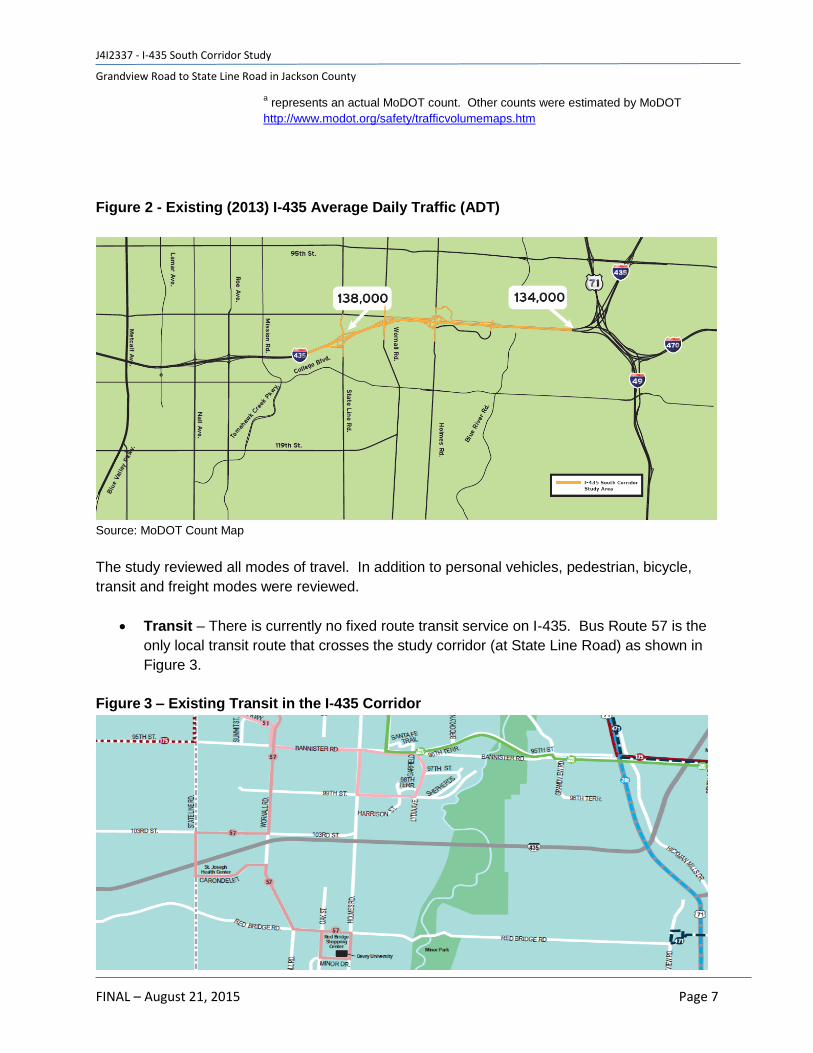
Road are also very high. Table 2 shows the historical daily traffic demand in the I-435 Corridor.
Existing (2013) daily traffic volumes are 138,000 east of State Line and 134,000 west of Three
Trails Crossing. These volumes are reduced from a peak in 2010 of 153,000 east of State Line
Road, but still remain significant. Figure 2 shows the existing study corridor average daily
traffic. More detailed traffic data is provided in the Appendix C - Traffic Results.
Table 2 – Historical I-435 Daily Traffic Demand
Year
State Line Road to Wornall
Road
Blue River Road to
Holmes Road
2014 153,303a 135,533a
2010 152,856 129,464a
2005 133,829a 113,259a
2000 114,980 117,680 Source: MoDOT Count Maps.
J4I2337 - I-435 South Corridor Study
Grandview Road to State Line Road in Jackson County
FINAL – August 21, 2015 Page 7
a represents an actual MoDOT count. Other counts were estimated by MoDOT
http://www.modot.org/safety/trafficvolumemaps.htm
Figure 2 - Existing (2013) I-435 Average Daily Traffic (ADT)
Source: MoDOT Count Map
The study reviewed all modes of travel. In addition to personal vehicles, pedestrian, bicycle,
transit and freight modes were reviewed.
Transit – There is currently no fixed route transit service on I-435. Bus Route 57 is the
only local transit route that crosses the study corridor (at State Line Road) as shown in
Figure 3.
Figure 3 – Existing Transit in the I-435 Corridor

J4I2337 - I-435 South Corridor Study
Grandview Road to State Line Road in Jackson County
FINAL – August 21, 2015 Page 8
Source: KCATA System Route Map along the I-435 Study Corridor
Freight – I-435 is an important east-west freight corridor connecting to other north/south
and east/west national interstate corridors. Just west of the State Line interchange there
were 6,780 daily trucks representing 4.7% of the daily traffic total. The CenterPoint
International Center is located in Kansas City, MO, 6.5 miles south of the project corridor
on I-49 and the BNSF Intermodal Facility is located in Edgerton, KS, 25 miles southwest
of the study corridor. Both of these facilities are large truck generators.
Pedestrian & Bicycle – Indian Creek Bike Trail is an off-road paved trail that crosses I-
435 west of State Line Road and crosses State Line Road and Wornall Road north of I-
435. There are no sidewalks along State Line Road or 104th Street. Sidewalks cross
under I-435 at the following locations:
o Wornall Road – Sidewalk east side only
o Holmes Road – Sidewalk East side only. Holmes Road is identified as a bike
route in Kansas City, Missouri’s Bicycle Plan
Traffic Operations
Existing peak hour traffic operational analysis was performed using a VISSIM micro-simulation
model to analyze AM and PM peak periods. The model analyzed a 6:00 AM – 9:00 AM peak
period and a 3:00 PM – 7:00 PM peak period. Detailed traffic operational data and results are
provided in Appendix C - Traffic Results and Appendix D - Meeting Presentations. The figures
below show the existing peak direction congestion in the study corridor. The speed profile
shows the location of the speed along the X-axis and the time of speed along the Y-axis. Speed
thresholds are represented in the legend. The peak directions are westbound in the AM peak
period and eastbound in the PM peak period. Figure 4 shows the existing AM and PM peak
period speed profiles.
Figure 4 - 2014 Existing Operations
Westbound Speed Profile, AM Peak Period (6:00 – 9:00 A.M.)
Source: I-435 South Corridor VISSIM Model

J4I2337 - I-435 South Corridor Study
Grandview Road to State Line Road in Jackson County
FINAL – August 21, 2015 Page 9
Eastbound Speed Profile, PM Peak Period (3:00 – 7:00 P.M.)
Source: I-435 South Corridor VISSIM Model
As shown in the figures, I-435 congestion is more severe in the eastbound direction within the
PM peak period than the westbound direction. Both I-435 mainline directions are summarized
below. Arterial results are summarized, while more detailed information is provided in the
Appendix C - Traffic Results.
Westbound – Congestion during the morning peak period is determined by the amount
of traffic coming from the Three Trails Memorial Crossing system interchange.
Bottlenecks occur at the State Line interchange and back up to the Three Trails
Memorial Crossing system interchange. Some of this is related to demand exceeding
highway capacity and some of this congestion is related to closely spaced interchanges
and the high degree of weaving to position from the Three Trails interchange
movements of US 71, I-435, I-470 and I-49 to either the service interchanges in Missouri
or Kansas.
Eastbound – Congestion during the afternoon peak period is metered in Kansas at the
Roe/Nall collector/distributor interchange. Bottlenecks and congestion extend to the
Blue River Bridge and back up into Kansas. Some of this is related to demand
exceeding highway capacity and some of this congestion is related to closely spaced
interchanges and the high degree of weaving to position for the Three Trails interchange
movements to US 71, I-435, I-470 and I-49.
Interchanges and Arterials – Arterials experience slow travel speeds as a result of
congestion near the I-435 service interchanges. AM peak period intersection delay is
minimal with no signalized intersections performing at LOS F and only one stop
controlled intersection operating at LOS F at Holmes Road and 101st Terrace. The
afternoon peak period experiences much greater congestion and slower speeds along
the arterials. Two signalized intersections operated at LOS F. These two intersections
were State Line Road and 103rd Street and State Line Road and Carondelet Drive.
J4I2337 - I-435 South Corridor Study
Grandview Road to State Line Road in Jackson County
FINAL – August 21, 2015 Page 10
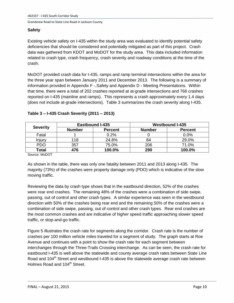
Safety
Existing vehicle safety on I-435 within the study area was evaluated to identify potential safety
deficiencies that should be considered and potentially mitigated as part of this project. Crash
data was gathered from KDOT and MoDOT for the study area. This data included information
related to crash type, crash frequency, crash severity and roadway conditions at the time of the
crash.
MoDOT provided crash data for I-435, ramps and ramp terminal intersections within the area for
the three year span between January 2011 and December 2013. The following is a summary of
information provided in Appendix F -,Safety and Appendix D - Meeting Presentations. Within
that time, there were a total of 202 crashes reported at at-grade intersections and 766 crashes
reported on I-435 (mainline and ramps). This represents a crash approximately every 1.4 days
(does not include at-grade intersections). Table 3 summarizes the crash severity along I-435.
Table 3 – I-435 Crash Severity (2011 – 2013)
Severity Eastbound I-435 Westbound I-435
Number Percent Number Percent
Fatal 1 0.2% 0 0.0%
Injury 118 24.8% 84 29.0%
PDO 357 75.0% 206 71.0%
Total 476 100.0% 290 100.0% Source: MoDOT
As shown in the table, there was only one fatality between 2011 and 2013 along I-435. The
majority (73%) of the crashes were property damage only (PDO) which is indicative of the slow
moving traffic.
Reviewing the data by crash type shows that in the eastbound direction, 52% of the crashes
were rear end crashes. The remaining 48% of the crashes were a combination of side swipe,
passing, out of control and other crash types. A similar experience was seen in the westbound
direction with 50% of the crashes being rear end and the remaining 50% of the crashes were a
combination of side swipe, passing, out of control and other crash types. Rear end crashes are
the most common crashes and are indicative of higher speed traffic approaching slower speed
traffic, or stop-and-go traffic.
Figure 5 illustrates the crash rate for segments along the corridor. Crash rate is the number of
crashes per 100 million vehicle miles traveled for a segment of study. The graph starts at Roe
Avenue and continues with a point to show the crash rate for each segment between
interchanges through the Three-Trails Crossing interchange. As can be seen, the crash rate for
eastbound I-435 is well above the statewide and county average crash rates between State Line
Road and 104th Street and westbound I-435 is above the statewide average crash rate between
Holmes Road and 104th Street.

J4I2337 - I-435 South Corridor Study
Grandview Road to State Line Road in Jackson County
FINAL – August 21, 2015 Page 11
Figure 5 – I-435 Crash Rate (2011 – 2013)
Source: Missouri Department of Transportation, 2011-2013; Kansas Department of Transportation, 2011 - 2013
Crash rate is the number of crashes per 100 million vehicle miles traveled for a segment of study.
2.2.3 Roadway
The existing I-435 corridor has numerous geometric deficiencies. A graphical representation of
these existing geometric issues is included in Appendix G - Engineering Issues Plan Plates.
Mainline I-435 - Mainline I-435 contains five main geometric concerns.
1. Non-standard horizontal geometry for the mainline at Wornall Road, paired with
the super elevation rate does not meet the 65 mph design speed. The existing
design speed is 50 mph.
2. Non-standard stopping sight distance east of State Line Road. The sag vertical
curve meets 50 mph instead of the 65 mph standard design speed.
3. Non-standard stopping sight distance east of Wornall Road. The sag vertical
curve meets 55 mph instead of the 65 mph standard design speed.
4. Non-standard stopping sight distance east of the 104th Street bridge. The sag
vertical curve meets 55 mph instead of the 65 mph standard design speed.
5. The existing median shoulder, both eastbound and westbound is only 7’ wide.
The standard shoulder width is 10’ for mainline for section with 3 or more lanes
and a 12’ shoulder is preferred in urban area with high volumes of truck traffic.
138.2
98.33
0.00
50.00
100.00
150.00
200.00
250.00
300.00
1.75 2.40 3.15 3.99 5.19
Cra
sh R
ate
Position on the Corridor (Miles) EB WB 2011 Jackson County Average Rate 2011 Statewide Average Rate
Wo
rnal
l
Ho
lme
s
10
4th
Ro
e/N
all
Stat
e L
ine
3-T
rails

J4I2337 - I-435 South Corridor Study
Grandview Road to State Line Road in Jackson County
FINAL – August 21, 2015 Page 12
There are also vertical clearance issues under two of the bridges in the corridor. The
bridge crossing over Wornall Road has an existing 14’6” clearance; the minimum
standard clearance over an arterial road is 16’6”. The EB mainline bridge over 104th
street and the railroad also has vertical clearance issues. The minimum standard
vertical clearance is 23’-4” over all railroads and the existing clearance is 23’-0”.
Along the side streets there are numerous existing locations that do not meet Project Design
Criteria (Appendix H). A summary of these locations is below.
State Line Road – The State Line Road interchange has many locations that are
currently not meeting Project Design Criteria. The southbound State Line Road to
eastbound I-435 entrance ramp has a super elevation and radius combination that is
valid for 20 mph, today’s design criteria is 35 mph and the lower speed represents a
safety hazard. The northbound State Line Road to eastbound I-435 ramp has a 35 mph
design speed at the gore and a 50 mph speed is required. This represents a safety
hazard for entering and merging traffic. The westbound I-435 to State Line Road off
ramp has a 45 mph design speed at the gore of the ramp and as previously mentioned a
required minimum speed is 50 mph. The southbound State Line Road to westbound I-
435 ramp terminal has a 15 mph radius for the free right turning movement and the
required radius needs to meet a speed of 25 mph.
Wornall Road – The Wornall Road interchange encompasses multiple locations that are
currently not meeting the Project Design Criteria established as a part of this study. In
the eastbound direction, both the entrance and exit ramps are geometrically deficient at
the gore point where the ramp ties to I-435. The existing speeds at the eastbound
entrance and exit gore are 20 mph and 30 mph respectively and the required design
speed is 50 mph. In the westbound direction, both the entrance and exit ramps on to I-
435 are geometrically deficient. The existing speeds at the westbound entrance and exit
gore are 20 mph and 30 mph respectively and the required design speed is 50 mph.
The westbound entrance ramp from Wornall Road to westbound I-435 also has a vertical
curve deficiency. Wornall road also has two locations where the grade exceeds the
maximum allowable; the first being along Wornall Road and the second being along the
entrance ramp to westbound I-435. The bridge crossing over Wornall Road has an
existing 14’-6” clearance; the minimum standard clearance over an arterial road is 16’-6”.
Holmes Road – The Holmes Road interchange encompasses multiple locations where
the Project Design Criteria is not met. In the eastbound direction the exit ramp and both
entrance ramps have gore geometry that violates the Project Design Criteria. The
eastbound loop ramp is designed for a 25 mph speed on the ramp proper and 20 mph at
the gore. The ramp proper should be designed for a minimum of 35 mph and the gore
area should be designed for 50 mph. The gore area for the entrance ramp from Holmes
Road to eastbound I-435 is designed for a 35 mph speed limit, but the design criteria
requires 50 mph. In the westbound direction the entrance ramp and both exit ramps do

J4I2337 - I-435 South Corridor Study
Grandview Road to State Line Road in Jackson County
FINAL – August 21, 2015 Page 13
not meet the required design speed at the gore. The westbound loop ramp gore is set at
25 mph and the loop ramp proper is designed for a 20 mph speed. The gore area
should be designed for 50 mph and the loop ramp proper should be designed for a 30
mph design speed. The westbound entrance ramp gore is designed for a 30 mph and
the design speed should be 50 mph. There are also multiple vertical geometric
deficiencies in this interchange. The first is located on the road going under I-435, which
has a vertical curve that is designed for 35 mph. There are also sag vertical curve
issues on the northbound to eastbound entrance ramp, the westbound off ramp and the
westbound entrance ramp. All of these sag curve violations mean that the interchange
must be designed as using comfort control, or lighting to the area must be increased..
104th Street – The half diamond at 104th street has two main geometric design issues.
The eastbound on ramp has an acceleration distance that when coupled with the grade
does not meet the minimum acceleration length. The westbound off ramp also has a 15
mph sag curve near the ramp terminal that requires that the intersection be designed
using comfort control. The eastbound mainline bridge over 104th street and the railroad
also has vertical clearance issues. The required clearance is 23’-4” over all railroads and
the existing clearance is 23’-0”.
2.2.4 Environment
Potential environmental issues and constraints associated with the I-435 South Corridor Study were evaluated at a high level. A desktop review and cursory in-field windshield survey of the project corridor was undertaken. Environmental issues reviewed included:
Noise Sensitive Receptors
Environmental Justice Areas
Water Resources and Floodplains
Public Parks & Recreation Areas (Section 4(f) Property)
Hazardous Material Sites
National Register of Historic Places
Threatened and Endangered Species In summary, there are environmental constraints within the study corridor but there are no fatal flaws and no environmental issues that cannot be mitigated, since all proposed improvements are within the existing MoDOT right-of-way. A more detailed discussion of each of the environmental factors reviewed is provided in Appendix I - Existing Environmental Conditions.
2.3 Future No-Build Conditions
Future no-build represents retaining the corridor within its existing configuration with normal
operations and maintenance through the design year 2020. As a result of the significant
existing traffic volumes, safety considerations and bridge conditions, 2020 was used as the
future design year. The following section provides a summary of the future no-build bridge and
mobility conditions.

J4I2337 - I-435 South Corridor Study
Grandview Road to State Line Road in Jackson County
FINAL – August 21, 2015 Page 14
2.3.1 Bridge
The no-build option would result in escalating costs for the maintenance and repair of the
bridges along this corridor. The annual bridge maintenance cost are approximately $80,000 for
the bridges at Wornall Road and Holmes. The other bridges on this corridor are also starting to
incur additional maintenance costs as well. Driver inconvenience is an additional cost. These
costs are expected to grow as deterioration of the bridges accelerates.
2.3.2 Mobility
The future no-build transportation system was analyzed in 2020 rather than 2040 because
benefits of proposed improvements would not have been seen with the extreme demand
predicted in 2040. 2030 traffic demand was used to analyze the eastbound I-435 mainline
reasonable alternatives and severe congestion was seen in the results as shown in Appendix C
- Traffic Results. By using 2020, proposed improvements in the study corridor could be seen.
Also, 2040 was not required because an access justification request is not being sought at this
time. Also, KDOT is not planning any improvements to I-435 in the future and funding is
uncertain for MoDOT at this time.
Transportation Demand
I-435 traffic volumes along the study corridor are expected to increase as a result of both local
and regional land use growth. Local projects such as Cerner’s new campus headquarters at I-
435 and Bannister is expected to have 16,000 employees at full build out. Background growth
in jobs and houses in Johnson County and Jackson County will also increase traffic on I-435.
However, as a result of capacity constraints in the corridor, traffic volumes are nearly at capacity
today and will continue to spread out over a longer time period during the peak periods of travel.
Figure 6 shows the future no-build study corridor average daily traffic. More detailed traffic data
is provided in Appendix C - Traffic Results.

J4I2337 - I-435 South Corridor Study
Grandview Road to State Line Road in Jackson County
FINAL – August 21, 2015 Page 15
Figure 6 – Future No-Build (2020 and 2040) I-435 Average Daily Traffic (ADT)
Source: HNTB
Traffic Operations
Future no-build peak period traffic operations analysis was performed using the same VISSIM
simulation models used during the existing analysis. The model analyzed the 6:00 AM – 9:00
AM peak period and the 3:00 PM – 7:00 PM peak period in 2020. The figures below show the
future no-build congestion in the study corridor. Detailed level of service and other mobility
measures are provided in Appendix C - Traffic Results.

J4I2337 - I-435 South Corridor Study
Grandview Road to State Line Road in Jackson County
FINAL – August 21, 2015 Page 16
Figure 7 – 2020 Future No-Build Operations
Westbound Speed Profile, AM Peak Period (6:00 – 9:00 A.M.)
Source: I-435 South Corridor VISSIM Model
Eastbound Speed Profile, PM Peak Period (3:00 – 7:00 P.M.)
Source: I-435 South Corridor VISSIM Model
As shown in Figure 7, I-435 congestion continues to experience more severe and longer
durations of congestion than under the existing conditions as shown in Figure 4. These speed
profiles represent only a six-year increase in traffic demand from 2014 to 2020, but it can be
seen that traffic operations are declining over this timeframe. Detailed traffic results for the
freeway and arterials are provided in Appendix C - Traffic Results.
Westbound – Congestion during the morning peak period is metered by the Three
Trails Crossing interchange and would be expected to back up on the corridors of I-435,
I-470 and I-49 before entering the study corridor. Congestion is apparent directly west of
the Three Trails Memorial Crossing and near the 104th, Holmes and Wornall
interchanges as a result of high weaving conditions and the reduction in lane capacity.
Eastbound – Congestion during the afternoon peak period continues to be metered in
Kansas but congestion increases in duration and length along the study corridor as a
result of increased traffic accessing the study corridor from the study interchanges.

J4I2337 - I-435 South Corridor Study
Grandview Road to State Line Road in Jackson County
FINAL – August 21, 2015 Page 17
Interchanges and Arterials – Arterials experience increased congestion near the I-435
service interchanges. AM peak period arterial congestion and intersection delay is high
along the State Line Road corridor with four signals operating at LOS F. Wornall and
Holmes Road corridors operate mostly at an acceptable level during the AM peak
period. During the PM peak period, both the State Line Road four signalized
intersections and two additional signalized intersections along Wornall Road experience
high congestion LOS F.
Safety
The crashes for I-435 were projected to the year 2040. This was performed by using the
existing crash rate and the forecasted daily traffic to calculate the number of crashes assuming
the crash rate stayed constant. Table 4 shows the number of crashes by roadway segment and
direction on an annual basis.
Table 4 - Future 2040 No-Build Crash Projections
Source: HNTB Corporation
As shown in Table 4, the 2040 no-build crashes are projected using the current crash rate, due
to no geometric changes and the future daily traffic. The annual number of crashes is projected
to increase by 69 (27 percent) as the Average Annual Daily Traffic (AADT) increases. It was
assumed that existing crash rates would stay constant and traffic volumes would increase over
time.
Conclusion
In conclusion, existing conditions are deteriorating in the study corridor for bridges, mobility and
roadway conditions. The Holmes Road and Wornall Road bridges are currently being
maintained at a level where bridge replacement is recommended. I-435 mainline traffic
operational conditions are below MoDOT standards for a sustained amount of time during the
From To AADT Annual Crashes AADT Annual Crashes Increase
Roe State Line 72,000 8 91,117 10 2
State Line Wornall 67,719 30 92,226 40 11
Wornall Holmes 67,367 46 86,689 60 13
Holmes 104th 65,451 45 83,843 58 13
104th Grandview 66,818 30 77,170 34 5
Roe State Line 72,000 32 91,117 41 9
State Line Wornall 67,719 9 92,226 12 3
Wornall Holmes 67,367 17 86,689 22 5
Holmes 104th 65,451 22 83,843 29 6
104th Grandview 66,818 16 77,170 18 2
255 324 69Total
Direction
EB
WB
Future No-BuildSegment Existing

J4I2337 - I-435 South Corridor Study
Grandview Road to State Line Road in Jackson County
FINAL – August 21, 2015 Page 18
peak period in the peak direction and safety conditions are above the statewide average for a
similar facility. Interchanges and arterials are also experiencing operational and safety
conditions below statewide standards as described in Appendix H. By 2020, with no planned
improvements, bridge, mobility and roadway conditions continue to worsen from existing
conditions and continue to put a significant strain on this section of transportation infrastructure,
which has regional significance.

J4I2337 - I-435 South Corridor Study
Grandview Road to State Line Road in Jackson County
FINAL – August 21, 2015 Page 19
3.0 Alternatives Development & Evaluation
Alternatives that incorporated bridge, mainline, interchange and arterial improvements were developed to address issues identified in the Problem Definition and evaluated in Stage 2 of the study. The alternatives development and evaluation was performed in five steps as shown in Figure 8. The evaluation of the alternatives is based on 2020 traffic demand during the AM and PM peak periods. The alternatives were primarily evaluated based on safety, mobility, geometrics, maintenance of traffic, right of way impacts, potential environmental impacts and construction costs to identify a preferred concept. Figure 8 – Alternatives Development & Evaluation Process
The following section provides a summary of each of the five steps and their conclusions that
moved the decision-making for the study team to the next step in the process.
3.1 Universe of Alternatives (Steps 1 & 2)
A universe of alternatives was considered to address the issues identified in the Problem
Definition section of this report (Step 1). According to FHWA, approximately 50% of all national
interstate delay is caused by non-recurring congestion; therefore, the list of alternatives was
organized by recurring and non-recurring congestion into improvement categories and shared
with the study’s core team. The improvement categories for the universe of alternatives are
listed in Table 5.
Step 1 Step 2 Step 3 Step 4 Step 5
Universe of Corridor
Alternatives
Interchanges & Arterials
Interchanges & Arterials
Interchanges & Arterials
I-435 Mainline Initial Mainline
Alternatives (5-EB & 3-WB)
Reasonable Mainline
(2-EB & 2 WB)
Preferred Concept
Complementary Mainline &
Arterial
Initial Complementary
Reasonable Complementary

J4I2337 - I-435 South Corridor Study
Grandview Road to State Line Road in Jackson County
FINAL – August 21, 2015 Page 20
Table 5 – Universe of Improvement Categories and Alternatives
Recurring Congestion Non-Recurring Congestion
Highway
Transit
Bicycle and Pedestrian
Travel Demand Management (TDM)
Intelligent Transportation Systems
Transportation System Management (TSM)
Access Management
Crash Investigation Sites
Roadside/Motorist Assist Enhancements
Improvements to Detour Routes
Variable Speed Limits
Queue Warning
Weatherizing/Winter Maintenance Systems
Hard Shoulder Running
Source: HNTB
The universe of alternatives underwent a qualitative screening based on performance goals that
were derived from the Problem Definition, including the following:
Safety benefits – Improvements to all modes of travel (personal vehicles, freight,
transit, pedestrian and bicycle).
Mobility benefits – Improvements to all modes of travel (personal vehicles, freight,
transit, pedestrian and bicycle).
Geometric design improvements – Ability to address existing geometric design
deficiencies.
Construction costs – Cost of construction including structures, pavement and grading.
Stakeholder buy-in – Core team assessment of stakeholder buy-in based on initial
stakeholder meeting.
Qualitative ratings of high, medium and low were assigned, as defined by the alternative’s ability
to address the performance goals that were assigned. Appendix J - Initial Screening Matrix
shows the results of the initial screening of the universe of alternatives. Table 6 shows a
summary of which alternatives were recommended to be advanced into Step 2 of the study
screening.

J4I2337 - I-435 South Corridor Study
Grandview Road to State Line Road in Jackson County
FINAL – August 21, 2015 Page 21
Table 6 – Recommended Initial Alternatives
Recurring Congestion
Highway TSM
Geometric Design Improvements Traffic Signal Coordination
Highway Widening Access Management
General Interchange Modifications
Collector/Distributor (C/D) Cross Street Access Management
Hard shoulder running Frontage Roads and Parallel Roads (Alternative Routes)
Transit Non-Recurring Congestion
New Bus Transit Service Crash Investigation Sites
Alternative Transit Service (Bus On Shoulder) Roadside/Motorist Assist Enhancements
Bicycle and Pedestrian Improvements to Detour Routes
Improved and/or new sidewalks and bike lanes on cross streets
Hard Shoulder Running
Intelligent Transportation Systems
Ramp Metering (enhancements)
Information Systems (enroute)
Advanced Traveler Information (pre-trip)
Source: HNTB
Note: Hard Shoulder Running appears in both the recurring and non-recurring congestion sections because the
application can be used during recurring AM and PM peak travel times and during non-recurring off-peak events of
incidents and in work zones.
Recurring congestion alternatives that were not advanced to the initial alternatives stage
included managed lanes (note: this alternative was brought back in the reasonable alternatives
stage after further analysis and refinement of study), travel demand management and reversible
lanes. Non-recurring congestion alternatives that were not advanced to the reasonable
alternatives stage included variable speed limits, queue warning and weatherizing systems.
After the universe of alternatives were screened to the initial list of alternatives, the mainline
alternatives were split into two groups consisting of Primary - I-435 Mainline improvements and
Secondary - I-435 Mainline and Complementary improvements (Step 2).
Primary – I-435 Mainline Improvements - I-435 mainline improvements address the
primary problem definition issues of capacity, operations and safety. These
improvements could stand on their own and address problem definition issues.

J4I2337 - I-435 South Corridor Study
Grandview Road to State Line Road in Jackson County
FINAL – August 21, 2015 Page 22
Secondary – I-435 Mainline, Interchanges, Arterials and Complementary
Improvements – Solutions were aimed at complementing the I-435 mainline
improvements by incrementally improving the capacity, operations and safety as well as
providing other important corridor enhancements such as mode choice, mobility and
environmental impact. These mainline and arterial improvements are meant to be
paired with the mainline improvements, rather than standalone alternatives.
3.2 Initial Alternatives (Step 3)
The following section summarizes the initial mainline, interchange/arterial and complementary
alternatives screening.
3.2.1 Initial Mainline Alternatives (Primary)
Eastbound – the following eastbound initial alternatives were developed in partnership with the
core team.
No-build – This alternative consists of doing nothing to the corridor, other than required
maintenance work
Alternative A – Maximize Weaves – This alternative folded interchanges away from
nearby adjacent interchanges to maximize weave distances. The Holmes Road
interchange was a folded diamond to the east and the State Line Road interchange was
a folded diamond to the west.
Alternative B – Split Diamond – In the eastbound direction, this alternative included an
off-ramp at State Line Road, a frontage road connecting State Line Road to Wornall
Road and Wornall Road to Holmes Road and an on-ramp at Holmes Road.
Alternative C – C/D Road Light
o Alternative C (v1)_EB – This alternative would leave State Line untouched and
add a Collector/Distributer (CD) road system between Wornall and Holmes
o Alternative C (v2)_EB – This alternative is a slight modification to alternative C
(v1), it adds a slip ramp between Wornall and Holmes from the CD road system
on to mainline I-435. The two interchanges would still share an exit ramp.
Alternative D – C/D Road
o Alternative D_EB – This alternative includes a full CD road system from State
Line to Holmes. State Line Road would still have a dedicated off ramp, but the
loop on ramp would tie into a CD road system. The CD road system has its own
dedicated exit ramp from I-435.
o Full CD (v2)_EB – This alternative is a slight modification to alternative D. In this
alternative State Line Road is fully incorporated into the CD road system.
5th Lane
o 5 lanes_E. of Wornall_EB – This alternative did not include any CD road; it is the
addition of a fifth lane from Wornall heading eastbound to tie in to the lane
addition just east of the Blue River Bridge. This was the alternative that was
included in the Preferred Concept.

J4I2337 - I-435 South Corridor Study
Grandview Road to State Line Road in Jackson County
FINAL – August 21, 2015 Page 23
Westbound - the following westbound initial alternatives were developed in partnership with the
core team.
No-build – This alternative consists of doing nothing to the corridor, other than required
maintenance work.
Alternative A – Maximize Weaves – This alternative folded interchanges away from
nearby adjacent interchanges to maximize weave distances. The Holmes Road
interchange was a folded diamond to the east but the Wornall Road and State Line Road
interchanges remained in their existing configuration due to geometric restrictions.
Alternative B – Split Diamond – In the westbound direction, this alternative included
an off-ramp at Holmes Road, a frontage road connecting Holmes Road to Wornall Road
and Wornall Road to State Line Road and an on-ramp from State Line Road.
Alternative C – C/D Road Light
o Alternative C (v2)_WB – This alternative included a partial CD road system from
Wornall to State Line road. The entrance weave between Wornall and State Line
Road were combined and pulled off of mainline I-435.
Alternative D – C/D Road
o Full CD (v2)_WB – This alternative included a full CD road system from Holmes
to State Line road.
5th Lane
o T17 Alt. 8_WB – This alternative did not include any CD road; it is the addition of
a fifth lane from eastbound I-435 heading westbound to exit at State Line Road.
This was the alternative that was included in the Preferred Concept.
3.2.2 Initial Interchanges & Arterial Alternatives (Secondary)
The following interchange and arterial initial alternatives were developed with assistance from
the core team.
State Line Road – For reasonable alternative 1, the southbound State Line loop on-
ramp to eastbound I-435 is removed and access is provided on the existing northbound
State Line on-ramp to eastbound I-435, requiring a left turn bay onto the existing
eastbound entrance ramp. For reasonable alternative 2, the interchange configuration is
unchanged from the existing condition. A detailed graphic depicting these improvements
are included in Appendix K.
Wornall Road – For each alternative this interchange is a modified version of the
existing diamond. The lanes along Wornall Road were modified slightly for each
alternative, but the overall interchange type remains constant. A detailed graphic
depicting these improvements are included in Appendix K.
Holmes Road – For reasonable alternative 1 this interchange is modified from the
existing partial clover in to a Tight Urban Diamond. With this alternative signals would

J4I2337 - I-435 South Corridor Study
Grandview Road to State Line Road in Jackson County
FINAL – August 21, 2015 Page 24
need to be added along Holmes Road and these signals would need to be timed
correctly with the existing signals to the outer road. In reasonable alternative 2 this
interchange is changed to a modified double cross-over diamond interchange. A
detailed graphic depicting these improvements are included in Appendix K.
104th Street – The existing half diamond interchange will remain in place regardless of
the alternative. Minor ramp modifications will be included in the Preferred Concept, but
the interchange will remain a half diamond.
3.2.3 Initial Complementary Alternatives (Secondary)
Early in the study, the core team realized that there is no single solution for improving the I-435
South Corridor. The I-435 solution was likely to be a comprehensive set of complementary
multimodal solutions that address the safety and operational needs of I-435, during recurring
and non-recurring time periods for all modes of travel. The core team concluded that a highway
build alternative along with complementary alternatives was warranted. The highway build and
complementary alternatives were analyzed independently, then combined as a package of
solutions for the project.
Below are the initial complementary alternatives that were evaluated. Appendix N - I-435 South
Corridor Complementary Strategies Memo, provides a full description and evaluation of each
complementary alternative.
Bus On Shoulder (BOS) Accomodation (see note below)
Bike/Pedestrian
Ramp Metering Enhancements
Crash Investigation Sites
Roadside/Motorist Assist Enhancements
Managed Lane
Hard Running Shoulder
Traffic Signal Coordination
Alternate Route Improvements
Other ITS
(Note: A 10 foot shoulder is provided on the outside of the travel lanes in the Preferred
Concept to allow for BOS within the study segment. Actual operation of BOS will be
dependent on further study.)
Five of the complementary alternatives were found to have positive benefits to the corridor’s
issues and needs and were recommended to be included in the preferred concept. The
remaining five alternatives were determined to have positive benefits to the corridor’s issues
and needs but further detailed study outside of the I-435 Corridor Study was warranted to
coordinate with other stakeholders and develop more detailed analysis.

J4I2337 - I-435 South Corridor Study
Grandview Road to State Line Road in Jackson County
FINAL – August 21, 2015 Page 25
3.3 Reasonable Alternatives (Step 4)
Based on the previous Step 3 assessment the team chose two alternatives to move forward.
Each of the reasonable alternatives are interchangeable by direction. A detailed analysis is
included in Appendix L.
The two reasonable alternatives identified to move forward below were not necessarily the
alternatives that scored the highest in Appendix L. Other factors such as cost and traffic
demand were discussed with the project team. Discussions with KDOT concluded that KDOT
has no plans for capacity improvements to I-435 in Kansas. As a result, eastbound PM peak
period traffic is constrained in Kansas and metered into Missouri. Therefore, there is no need
for MoDOT to add capacity that is not needed to I-435 in Missouri with this bottleneck in place.
Should KDOT decided to add capacity to I-435 in the future, other eastbound improvements
may be considered.
Reasonable Alternative 1 – This alternative combines the Alternative C in the
eastbound direction and alternative T17 Alt.8_WB in the westbound direction. This
alternative includes modifications to both State Line and Wornall (Appendix K) as well as
a Tight Urban Diamond Interchange at Holmes (Appendix K). The anticipated
construction cost of this alternative is $60.8 million (2015 dollars).
Reasonable Alternative 2 – This alternative combines the 5th lane East of Wornall
option in the eastbound direction along with the Alternative C (v2) option in the
westbound alternative. This alternative includes modifications to both State Line and
Wornall (Appendix K) as well as the modified Continuous Flow Interchange at Holmes
(Appendix K). The anticipated construction cost for this alternative is $53.3 million (2015
dollars).
Constructability for each alternative was reviewed and analyzed. A phasing and MOT plan for
each reasonable alternative is provided in Appendix M.
3.3.1 Reasonable I-435 Mainline Improvements (Primary)
On March 5, 2015, a workshop was held with MoDOT to review the traffic analysis for
Reasonable Alternatives 1 & 2 and to select the preferred concept. The meeting minutes are
provided in the Appendix O - March 5, 2015 Meeting Minute and Exhibits.
A sketch was provided as a reference when comparing the no-build option with the Reasonable
Alternatives (RA) #1 and #2 (Figure 9). RA #1 is generally described as the C/D option in the
eastbound direction and the 5th lane option in the westbound direction. RA #2 is generally
described as the 5th lane option in the eastbound direction and the C/D option in the westbound
direction. Figure 9 is a graphical representation of existing RA #1 and RA #2, whereas the
numbers inside of the circles are the number of lanes at each location.

J4I2337 - I-435 South Corridor Study
Grandview Road to State Line Road in Jackson County
FINAL – August 21, 2015 Page 26
Figure 9 – Existing, Reasonable Alternatives 1 & 2 I-435 Lane Configurations
Source: HNTB

J4I2337 - I-435 South Corridor Study
Grandview Road to State Line Road in Jackson County
FINAL – August 21, 2015 Page 27
If implemented, complementary alternatives such as Hard Running Shoulder (HRS) and Bus on
Shoulder (BOS) could be located on the median shoulder or outside shoulder. Managed lanes
(HOV/HOT) would only be practical on the median shoulder of the general purpose lanes.
Although this study is not recommending implementation of any of these three complementary
alternatives without a more regional study to include KDOT, the selection of the preferred
concept considered the potential to accommodate any or a combination of these
complementary alternatives if determined to be feasible upon future study.
A discussion of how Bus on Shoulder, Hard Running Shoulder and Managed Lanes affect the
median shoulder and outside shoulder is provided in Appendix P - March 27, 2015 Meeting
Minute and Exhibits.
Westbound I-435
As shown, the following reasonable alternatives were analyzed in the westbound direction. A
full evaluation of the Westbound I-435 scenarios can be found in Appendix O - March 5, 2015
Meeting Minute Exhibits.
1. Existing (2014)
2. Future No-Build (2020)
3. Reasonable Alternative 1 (2020) – 5th Lane Option
4. Reasonable Alternative 2 (2020) – C/D Option
Based on the analysis, the Reasonable Alternative 1 scenario (5th Lane) is the preferred
alternative for westbound I-435 for the following reasons:
Better traffic operations for Reasonable Alternative 1 versus Reasonable Alternative 2.
Reasonable Alternative 1 provides a significant improvement in traffic operations
compared to the no-build alternative.
The capital cost for Reasonable Alternative 1 is about 14% less than Reasonable
Alternative 2.
Reasonable Alternative 1 improves safety by eliminating the loop entrance ramp from
Holmes, which also eliminates one access point as compared to the no-build alternative.
Reasonable Alternative 1 does not impact the bridge over State Line, while Reasonable
Alternative 2 does.
The impact to traffic during construction is the same for Reasonable Alternative 1 and 2.
Reasonable Alternative 1 provides future flexibility in that it does not preclude
Reasonable Alternative 2 in the future, if KDOT expands I-435 to the west to provide 5-
lanes west of the Roe/Nall exit.

J4I2337 - I-435 South Corridor Study
Grandview Road to State Line Road in Jackson County
FINAL – August 21, 2015 Page 28
Eastbound I-435
As shown, the following scenarios were analyzed in the eastbound direction. A full evaluation of
the Eastbound I-435 scenarios can be found in Appendix O - March 5, 2015 Meeting Minute
Exhibits.
1. Existing (2014)
2. Future No-Build (2020)
3. Reasonable Alternative 1 (2020) – C/D Option
4. Reasonable Alternative 2 (2020) – 5th Lane Option
Based on the analysis, the Reasonable Alternative 2 scenario (5th Lane) is the preferred
alternative for eastbound I-435 for the following reasons:
Similar traffic operations for Reasonable Alternative 1 Improved (see note below) versus
Reasonable Alternative 2 under constrained traffic volumes due to the bottleneck in
Kansas.
Reasonable Alternative 2 provides a significant improvement in traffic operations
compared to the no-build alternative. Travel time in the peak 15 minutes is almost cut in
half, from 6:26 to 3:34 minutes.
The capital cost for Reasonable Alternative 2 is about 35% less than Reasonable
Alternative 1 Improved (see note below).
Reasonable Alternative 2 improves safety by eliminating the loop entrance ramp from
Holmes, which also eliminates one access point as compared to the no-build alternative.
The impact to traffic during construction is the same for Reasonable Alternative 1 and 2.
Reasonable Alternative 2 provides future flexibility as it does not preclude Reasonable
Alternative 1 in the future, if KDOT improves I-435 to the west.
(Note: The C/D option considered multiple locations to open access back up to the I-435
mainline. Locations were considered before, after and between the ramp gores of
Holmes Road. Reasonable Alternative “Improved” represents the optimal location from
a traffic operations point, which was between the Holmes Road ramp gores.)
Due to funding constraints, it is unlikely that the preferred concept will be implemented in the
near-term. The most likely scenario is that that the bridges at Wornall Road and Holmes Road
will be replaced first due to disrepair. The 5th lane would be added in phases, from east to west
as funding becomes available. Infrastructure for the preferred strategies can ultimately be re-
purposed if necessary to provide for a managed lane on the inside instead of a 5th lane on the
outside if MoDOT/KDOT determine that a managed lane is justified from a regional standpoint
at some point in the future.

J4I2337 - I-435 South Corridor Study
Grandview Road to State Line Road in Jackson County
FINAL – August 21, 2015 Page 29
3.3.2 Reasonable Interchange & Arterial Improvements (Secondary)
Interchange and arterial improvements were tested in both the C/D and 5th Lane Options. In
summary, the following configurations are recommended at the three major study area
interchanges and arterials:
At State Line Road, add turn lanes at the existing ramp terminals.
At Wornall, restripe northbound and southbound lanes to convert a northbound through
lane to a dedicated southbound right turn lane at 103rd Street.
At Holmes, introduce northbound and southbound left turn lanes to replace the loop
ramps and realign exit ramps to create a tight urban diamond.
3.3.3 Reasonable Complementary Alternatives (Secondary)
On March 23, 2015, a workshop was held with MoDOT to review the complementary
alternatives in more detail. The meeting minutes are provided in Appendix P - March 27, 2015
Meeting Minute Exhibits. Three of the complementary alternatives would have a direct impact
on the I-435 mainline preferred concept as described above. Below is a list of these
complementary improvements:
Bus on Shoulder (BOS) – On median or outside shoulder
Hard Running Shoulder (HRS) – On median or outside shoulder
High Occupancy Vehicle (HOV) or Managed Lane (HOT)
Upon review of the “widening needed” for each option, it became apparent that an additional
three foot width would accommodate most of the complementary strategies and all of the
optional alternatives would be accommodated if the through lanes were narrowed to a minimum
of11 foot lanes as well. Additionally, widening the base typical section three feet would also
provide for a normal left shoulder width of 10 feet which would address a concern that FHWA
has expressed concerning the median shoulder width where three or more lanes are present.
Therefore, the recommendation is to widen the preferred alternative three feet to provide for a
normal 10 foot median shoulder which will also accommodate complementary alternatives of
Bus on Shoulder (BOS), Hard Running Shoulder (HRS) and/or High Occupancy Vehicle (HOV)
or Managed Lane (HOT). If determine by a future regional study that one , or a combination of,
complementary alternatives is to be implemented, the infrastructure impacted by this project will
then be a suitable width to avoid additional widening in the future.
Other complementary improvements shown in Table 7 besides, BOS, HRS and HOV/HOT are
also recommended as part of the preferred concept. These improvements do not impact the
width of the I-435 mainline.

J4I2337 - I-435 South Corridor Study
Grandview Road to State Line Road in Jackson County
FINAL – August 21, 2015 Page 30
4.0 Preferred Concept
Based on the findings of the Problem Definition and the Alternatives Development & Evaluation,
the Preferred Concept is presented in this section. This section summarizes the Preferred
Concept and provides a phased implementation plan.
4.1 Preferred Concept
The Preferred Concept supplementary information is shown in Appendix 2.0. The Preferred
Concept provides the best improvements for today while providing a practical design solution
that maximizes the flexibility for future conditions. The width of pavement proposed on I-435 will
allow flexibility of lanes to be used for varying options as detailed in Appendix Q.
4.1.1 Mainline I-435
I-435 Eastbound - The improvements to eastbound mainline I-435 consist of adding a
5th lane from the Wornall entrance ramp and continuing the 5th lane until it ties in with the
existing added 5th lane on the east side of the Blue River bridge. This addition would
include the maintaining the existing auxiliary lanes and it would continue across all
bridges. The improvements would also include widening the median shoulder three feet
throughout the corridor. This widening would allow for the median shoulder to be used
for future hard shoulder running (sometimes referred to as a flexible or flex lane as well).
The outside shoulder will be widened to the design standard established by the study.
This will allow for bus on shoulder to be used during the peak periods if a regional transit
study identifies this need. Currently, there is no transit along I-435, but this solution
allows for bus routing expansions in the future. This solution allows for minimal phased
work to be done in the near term, while allowing for the flexibility of added improvements
in the future, without forcing a major capital improvement in the current fiscal year. The
anticipated construction cost of the Preferred Concept in the eastbound direction is
$30,250,000 in 2015 dollars. A detailed cost estimate is included as Appendix R. If in
the future a C/D road is desired, the 5th lane could be utilized as a portion of that
Preferred Concept improvement. A strip map is provided in Appendix S and plan plates
are provided in Appendix T.
I-435 Westbound - The improvements to westbound mainline I-435 consist of adding a
5th lane from where the existing 5th lane terminates at 104th street and continuing it
through the corridor to immediately downstream of the exit ramp at the State Line Road
interchange. While several configurations were tested, a single-lane ramp at State Line
Road followed by the 5th through lane drop was chosen because it operated better than
a two-lane drop at the State Line Road off-ramp and was better able to be signed than a
two-lane exit to State Line Road with a choice lane, followed by a through lane drop. The
addition of the 5th lane would also include the widening of the median shoulder by three
feet. This would allow for a future flexible lane to be used on the inside lane. The
outside shoulder will be widened to the design standard established by the study. This

J4I2337 - I-435 South Corridor Study
Grandview Road to State Line Road in Jackson County
FINAL – August 21, 2015 Page 31
will allow for bus on shoulder to be used during the peak periods if a regional transit
study identifies this need. There is no widening planned for the 104th Street Bridge in
the westbound direction. The existing bridge width allows for the addition of a 5th lane,
but will then have a reduced shoulder width. If a bus on shoulder lane is required in the
future the widening of the 104th Street Bridge will be required or the bus would have to
use the adjacent general purpose lane in that section of I-435 (this would also occur at
westbound Blue River Bridge). The anticipated construction cost of the Preferred
Concept in the westbound direction is $31,490,000 in 2015 dollars. A detailed cost
estimate is included as Appendix R. A strip map is provided in Appendix S and plan
plates are provided in Appendix T.
4.1.2 Interchanges and Arterials
State Line Road – At State Line Road the ultimate alternative will modify the
interchange slightly at the ramp terminals and increase capacity of some movements,
but the bridge will be left in its current condition. A dedicated right turn lane will be
added to the eastbound exit ramp. There will also be capacity improvements to the
westbound movements at Carondelet Drive, as well as increased storage of the turn bay
for northbound State Line Road to access the entrance ramp. The proposed
configuration is shown in Appendix T - Plan Plates.
Bike and Pedestrian facilities are not provided in the existing or proposed condition. If
sidewalk is desired in the future, it can be incorporated behind the bridge columns, under
the end span of the bridge.
Wornall Road – At Wornall Road the ultimate alternative will add capacity to the
westbound exit ramp, by adding an additional dedicated westbound to northbound lane.
There are also modifications to the median islands and the lane configuration under the
bridge. Since the bridge will be fully removed and replaced, the most notable change is
that all lanes on Wornall will be on the inside of the bridge bents; there will be no lane
outside of the columns, as in the existing condition. Another notable difference is that
the westbound exit ramp access to westbound 103rd will be physically prohibited using a
raised median. Currently the movement is prohibited by signage, but vehicles have
been observed using this access frequently. The proposed configuration for Wornall
Road is shown in Appendix T - Plan Plates.
Wornall Road has an existing sidewalk on the east side of the interchange. In the
Preferred Concept a 5 foot sidewalk will be placed on the east side of the interchange.
On the west side due to existing bridge bent locations there will be a 12’-6” space
between the back of curb and the face of the abutment along Wornall Road in the
ultimate condition. This could be used as a future location for a sidewalk.
Holmes Road - At Holmes Road the ultimate alternative will remove the loop ramps and
reconfigure the existing eastbound and westbound entrance ramps to accept left turns

J4I2337 - I-435 South Corridor Study
Grandview Road to State Line Road in Jackson County
FINAL – August 21, 2015 Page 32
form Holmes Road. This may require the addition of two traffic signals along Holmes
Road that will need to be closely coordinated and timed with the existing signals and the
existing exit ramps. There will be modifications to the existing ramp terminals to allow
for the left turns, but overall Holmes Road will be left in a similar condition to today. The
bridge over Holmes Road will be fully removed and replaced, but the changes to Holmes
Road will be minimal. The proposed configuration for Holmes Road is shown in
Appendix T - Plan Plates.
Holmes Road has an existing sidewalk on the east side of the road. In the Preferred
Concept, a 5 foot sidewalk will be included on the east side of the interchange. On the
west side of the interchange, due to existing bent locations, there will be 6’-6” width from
the back of curb to the face of the abutment in the ultimate condition. This would allow
for a future sidewalk if desired. Holmes Road will remain a signed bike route.
104th Street - At 104th Street the ultimate alternative will not change from the existing
configuration. There will be improvements made to both ramps but the interchange will
not change from its existing half diamond configuration. The proposed configuration at
104th Street is shown in Appendix T - Plan Plates.
Currently 104th Street does not have any bicycle or pedestrian improvements. In the
ultimate condition no bicycle or pedestrian improvements are included at this
interchange.
4.1.3 Other Considerations
Sound Walls – Based on a preliminary assessment of noise abatement requirements,
sound walls may be required on the south side of the project. The walls would start at
the midpoint between Holmes Road and Wornall Road and continue to the west to State
Line Road. Final justification for sound walls and the exact limits will have to be
determined as part of the final NEPA evaluation.
ITS – As the ultimate condition is implemented in the corridor, there are ITS related
relocations that will need to take place. Each ramp that is modified that currently has
ramp metering in place will need to have the ramp metering removed and replaced.
The two dynamic message signs in the corridor are impacted by the widening, therefore
will have to be relocated for the Preferred Concept.
Emergency Pull Off (Crash Investigation Sites) – In the Preferred Concept
emergency pull offs (crash investigation sites) will be included in order to help reduce
non-reoccurring congestion. These pull off locations are approximately 100 feet long, 20
feet wide and are located outside of the shoulder, preferably located near exit ramps. A
complete picture of the emergency pull off locations is shown in Appendix U. There are
seven locations where an emergency pull off site could be located and these are shown
J4I2337 - I-435 South Corridor Study
Grandview Road to State Line Road in Jackson County
FINAL – August 21, 2015 Page 33
in the appendix. It is recommended that the Preferred Concept include a minimum of
two locations in the corridor. Further study is needed to prioritize the location.
Conceptual Signing Layout – The Preferred Concept will require minor changes to the
signing throughout the corridor. The addition of the 5th lane allows a majority of the
signs to have minor changes and provides an opportunity to update the signing in the
corridor with the design criteria signing, as well as route designations that have taken
place (US 71 conversion to I-49). A detailed layout of the signing can be seen in
Appendix V.
Design Exceptions – The Preferred Concept will include design exceptions. A majority
of the design exceptions required are due to existing conditions that will be untouched in
the preferred concept. There are a few instances where we are improving the area and
becoming closer to the project design criteria, but will still require a design exception
(Wornall Road vertical clearance). A detailed list of the required design exceptions is
listed in Appendix Y.
4.1.4 Traffic Operations
Future 2020 peak period traffic analysis was performed for the Preferred Concept configuration.
Detailed traffic operational data and results are provided in Appendix C - Traffic Results,
Appendix E - Meeting Presentations and Appendix O - March 5, 2015 Meeting Minutes.
(Note: Within the Appendix O meeting minutes it says “A VISSIM simulation will be
performed on the preferred alternative using 2030 or 2040 traffic projections and the
results will be summarized in the final report.” Discussions led to not repeating the
models for 2020 with the Preferred Alternatives of westbound Reasonable Alternative
and eastbound Reasonable Alternative 2. The team decided that the 2030/2040 VISSIM
analysis was not required during Core Team Meeting No. 5 on April 22, 2015. The
reason was that an AJR is not being sought by MoDOT at this time and the analysis
would not provide additional information that would change the Preferred Alternatives.
The Core Team also agreed at the Core Team Meeting No. 5 that the VISSIM model for
westbound Reasonable Alternative 1 and eastbound Reasonable Alternative 2 would not
be combined into a single model representing the overall preferred alternative. The
models with 2020 traffic used to determine the preferred option was sufficient.)
Figure 10 below shows the Preferred Concept congestion in the study corridor with a speed
profile that maps corridor congestion along the corridor by time.

J4I2337 - I-435 South Corridor Study
Grandview Road to State Line Road in Jackson County
FINAL – August 21, 2015 Page 34
Figure 10 - 2020 Future Preferred Concept Operations
Westbound Speed Profile, AM Peak Period (6:00 – 9:00 A.M.)
Source: I-435 South Corridor VISSIM Model
Eastbound Speed Profile, PM Peak Period (3:00 – 7:00 P.M.)
Source: I-435 South Corridor VISSIM Model
As shown in the figures, I-435 congestion is less severe in both directions than existing and
future no-build conditions. Both I-435 mainline directions and arterial conditions are summarized
below.
Westbound – 2020 AM peak period congestion for the Preferred Concept is
concentrated at the westbound merge of State Line Road and I-435. This congestion
causes some minor speed reduction in this area, but the duration and location are
limited for the design year. This congestion would be expected to worsen as traffic
volumes increase in the corridor.
Eastbound – 2020 PM peak period congestion for the Preferred Concept in the
eastbound direction is limited to the Roe/Nall C/D entrance ramp. This location is
expected to meter the amount of traffic that is able to advance into Missouri. East of the
Roe/Nall interchange, travel speeds are generally 55 mph and higher until the Three-
Trails Crossing interchange.
0
900
1800
2700
3600
4500
5400
6300
7200
8100
9000
9900
-3600 -3400 -3200 -3000 -2800 -2600 -2400 -2200 -2000 -1800 -1600 -1400 -1200 -1000 -800 -600 -400 -200 0 200 400 600 800 1000 1200 1400 1600 1800 2000 2200 2400 2600 2800 3000 3200 3400 3600 3800 4000 4200 4400 4600 4800 5000 5200 5400 5600 5800 6000 6200 6400 6600
VISSIM 2020 AM Build 2 - 5th lane through SLR; SLR merge
65-70
60-65
55-60
50-55
45-50
40-45
35-40
30-35
25-30
20-25
Met
calf
Ave
Nal
l Ave
Ro
e A
ve
Stat
e Li
ne
Rd
Wo
rnal
l Rd
Ho
lmes
Rd
10
4th
St
I-4
35
WB
& U
S 5
0 M
erge 8:00
7:00
6:00
0
900
1800
2700
3600
4500
5400
6300
7200
8100
9000
9900
10800
11700
12600
13500
-3600 -3400 -3200 -3000 -2800 -2600 -2400 -2200 -2000 -1800 -1600 -1400 -1200 -1000 -800 -600 -400 -200 0 200 400 600 800 1000 1200 1400 1600 1800 2000 2200 2400 2600 2800 3000 3200 3400 3600 3800 4000 4200 4400 4600 4800 5000 5200 5400 5600 5800 6000 6200 6400
VISSIM 2020 PM Build 1
60-65
55-60
50-55
45-50
40-45
35-40
30-35
25-30
20-25
15-20
Met
calf
Ave
Nal
l Ave
Roe
Ave
Stat
e Li
ne R
d
Wor
nall
Rd
Hol
mes
Rd
104t
h St
4:00
7:00
6:00
5:00

J4I2337 - I-435 South Corridor Study
Grandview Road to State Line Road in Jackson County
FINAL – August 21, 2015 Page 35
Interchanges and Arterials – Arterials and interchanges experience improved traffic
operations with reduced intersection delay and increased arterial speeds with the
proposed improvements. The Preferred Concept has only one signalized intersection
performing at LOS F during the AM and PM peak hours, the intersection of State Line
Road and 103rd Street. This is a significant improvement over existing and future no-
build conditions.
4.1.5 Bridges
I-435 over State Line Road – No modifications to these bridges will be required for the
preferred alternative.
I-435 over Wornall Road – Both the eastbound and westbound bridges will be replaced
with widened structures in order to accommodate an additional lane in each direction.
I-435 over Holmes Road – Both the eastbound and westbound bridges will be replaced
with widened structures in order to accommodate an additional lane in each direction.
I-435 over 104th Street and UPRR – Both the eastbound and westbound bridges will be
re-decked and the eastbound bridge will be widened to accommodate an additional lane.
It is recommended that the existing steel be repainted and the expansion joints be
replaced in order to extend the life of these bridges.
I-435 over the Blue River and Blue River Road – The eastbound bridge will be
widened to accommodate an additional lane. It is recommended that the existing steel
be repainted, median barrier replaced and the expansion joints be replaced in order to
extend the life of these bridges. The remaining fatigue sensitive details on the existing
girders should be analyzed to identify any necessary retrofitting as well. An analysis of
the hydraulics of the Blue River bridge was completed. Since the existing piers are
outside of the river bank, a widening of the Blue River bridge does not affect the flood
plan.
Additional information including the existing bridge assessment, methodology used to determine
the preferred structure types and a cost estimate of the recommended bridge work can be found
in the Appendices A, B and W.
4.1.6 Complementary Strategies
Early in the study it was determined that there is no single solution for the I-435 South Corridor and that a solution was likely to be a comprehensive set of multimodal solutions that address the safety and operational needs of I-435, during recurring and non-recurring time periods for all modes of travel. The following complementary strategies are part of the Preferred Concept.

J4I2337 - I-435 South Corridor Study
Grandview Road to State Line Road in Jackson County
FINAL – August 21, 2015 Page 36
Table 7 – Complementary Alternatives
Complementary Alternative Recommendation
1. Bus On Shoulder (BOS) Accommodation
The Preferred Concept will provide a 10-foot shoulder to both the inside and outside to allow for BOS. A regional study is being undertaken by KCATA and MARC to determine if transit and BOS are viable solutions in this corridor from a regional perspective.
2. Bike/Pedestrian
Bike and pedestrian improvements are included in the arterial improvements to allow for a sidewalk on at least one side of State Line, Wornall and Holmes crossings of I-435.
3. Ramp Metering Enhancements Widening on-ramps at the ramp meter to accommodate 2-lanes at the ramp meter.
4. Crash Investigation Sites Potential crash investigation sites have been identified at 7 locations. It is recommended that 1 to 2 sites in each direction be identified after further review by MoDOT.
5. Roadside/Motorist Assist Enhancements
The study indicated that approximately 50% of all interstate congestion in the US is non-recurring (FHWA) such as incidents. Therefore, additional funding should be set aside to address roadside motorist assist enhancements. Some examples are providing LiDAR to roadside motorist assist to improve incident survey and clean-up time. Another example would be strategically placed motorist assist vehicles and personnel at high crash locations along the corridor during peak periods.
6. Managed Lane
The Preferred Concept typical section accommodates a managed lane in the future by converting the added 5th lane to a managed lane. This should be considered after further regional study.
7. Hard Running Shoulder The Preferred Concept typical section accommodates hard shoulder running. This should be considered after further regional study.
8. Traffic Signal Coordination
State Line, Wornall and Holmes are all on the Operation GreenLight system. Other parallel corridors would benefit from traffic signal coordination such as 95th Street/Bannister Road and College Blvd./Red Bridge.
9. Alternate Route Improvements
In addition to traffic signal improvements, alternative routes may benefit from other improvements to encourage their use. These improvements could include additional signage, geometry improvements or traffic signal improvements.
10. Other ITS
Other ITS solutions could be explored in more detail to better understand their benefits in the corridor. These improvements are related to Integrated Corridor Management solutions.
Source: HNTB

J4I2337 - I-435 South Corridor Study
Grandview Road to State Line Road in Jackson County
FINAL – August 21, 2015 Page 37
4.1.7 Summary of Preferred Concept
The Preferred Concept improvements provide safety and mobility enhancements over existing
and future no-build conditions but do not fully address long-term needs in the I-435 corridor.
One emerging area in transportation that may provide long-term safety and mobility needs are
connected and autonomous vehicles (CV/AV). CV/AV vehicle technologies are already present
in today’s infrastructure (e.g. KC SCOUT) and are rapidly growing. Technologies in private
automobiles that have a substantial benefit to safety and mobility are expected to transition into
the national vehicle fleet network over the next 15 years. It is believed that as these
technologies emerge, MoDOT will take full advantage of these to maximize the long-term
investment in the I-435 corridor.
4.2 Implementation Options
The Wornall Road and Holmes Road bridges are the highest priority for implementation due to
their age and condition. Secondary to the bridge improvements are improvements to the
mainline and a third priority for the project is the improvement to the arterial streets.
There are three ways to implement the Preferred Concept. The first would be to construct the
entire project at one time. A second option would be to construct the bridges only, since they
are the highest priority item. Finally a third option would be to implement a phased approach
that would build the project in phases, as funding became available. This would not focus on
the bridges or the mainline, but it would provide a logical implementation of the Preferred
Concept, while maximizing the usage of the constructed portion.
Full Build Option
If the Preferred Concept is construction as one project then the MOT plan for the preferred
concept could be implemented in two different alternatives. These alternatives are discussed in
more detail below and are included in Appendix X.
Bridge Only Option
If the funding for the entire Preferred Concept is not available and the funding for a phase
approach is not available, then a bridge only option of construction could be implemented. In
this option only the bridges would be constructed while the mainline pavement and the
interchanges would be left untouched. The MOT for this option is the same as the Full Build
Option, but the mainline construction portions would not be needed. The MOT alternatives are
discussed in more detail below and are included in Appendix X.
Phased Implementation Option
Along with each bridge replacement, there are sections of the mainline improvements that
coordinate well with the bridge improvements. The Preferred Concept would best be

J4I2337 - I-435 South Corridor Study
Grandview Road to State Line Road in Jackson County
FINAL – August 21, 2015 Page 38
implemented in four phases from the east to the west and mainline included with each additional
bridge improvement project.
Phase 1 - As improvements are made to the Blue River Bridge, mainline pavement
would be added on the east side of the Blue River Bridge to allow for a continuous fifth
lane to be added to the corridor in the eastbound direction. In the westbound direction,
no changes would need to be made.
Phase 2 – Once Phase 1 is completed, the 104th Street Bridge could be re-decked and
allow for additional mainline pavement to be constructed from the Holmes Road
entrance ramp (in the eastbound direction) and the Holmes Road exit ramp (in the
westbound direction). This would complete the Preferred Concept from the Three
Trails Memorial Crossing interchange to the Holmes Road interchange. This phase
would also require construction of mainline pavement and reconstruction of the ramps at
the 104th Street half diamond interchange.
Phase 3 – Once Phase 2 is completed, construction to the Holmes Road Bridge could
begin. This construction phase would also require the arterial improvements at Holmes
Road due to the removal of the loop ramps. This construction project would also include
the mainline pavement between the Holmes Road interchange and the Wornall Road
interchange.
Phase 4 – Once Phase 3 is completed, the construction of the Wornall Bridge as well as
the arterial improvements at Wornall Road would be constructed. This phase would also
include the extension of mainline pavement to State Line Road in the westbound
direction. At this point the Preferred Concept would be completed.
The arterial improvements for both Wornall Road and Holmes Road need to be closely
coordinated with mainline improvements because both interchanges have a direct interaction
with the bridge replacement. At Wornall Road, due to the existing location of the bridge bents
and the locations of the existing lanes, it requires that the bridge be replaced prior to any lane
relocation. At Holmes Road, due to the removal of the loop ramps and the addition of traffic
signals, the arterial improvements cannot be made until the bridge has been replaced and the
signals added.
4.3 Maintenance of Traffic
For the Preferred Concept there are two maintenance of traffic (MOT) options. Each option
provides a minimum of three lanes of traffic in each direction and will require a reduction in lane
width from 12 feet to 11 feet.
MOT Option 1
For the first MOT option, the existing four through lanes will be reduced by one lane in each
direction; a minimum of three lanes will be maintained. Once the bridge work is completed the

J4I2337 - I-435 South Corridor Study
Grandview Road to State Line Road in Jackson County
FINAL – August 21, 2015 Page 39
mainline can be opened up to a four through lane section in each direction. Lanes will need to
be closed again during the mainline widening. For MOT Option 1, each bridge can be let as an
individual project, or combined as funding allows. For this option the eastbound Wornall Road
ramps must be closed to traffic during the construction of the eastbound mainline bridge. A
detailed graphic of this MOT option is listed in Appendix X.
MOT Option 2
For the second MOT option the existing four through lanes will be reduced to a minimum of
three lanes in each direction. A temporary CD road in the EB direction will provide access to
Wornall and Holmes during Stage 3 construction. Once the bridge work is completed the
mainline can be opened up to a four through lane section in each direction. Lanes will need to
be closed again during the mainline widening. For this option both Holmes Road and Wornall
Road must be let in the same project, but the deck widening over 104th Street could be let in a
separate project. A detailed graphic of this MOT option is listed in Appendix X.

J4I2337 - I-435 South Corridor Study
Grandview Road to State Line Road in Jackson County
FINAL – August 21, 2015 Page 40
5.0 Stakeholder Coordination
In addition to the MoDOT core team meetings, three meetings with project stakeholders were
held throughout the study process. Stakeholders that were part of these meetings included the
following:
- Kansas City Area Transportation Authority
- Kansas Department of Transportation
- Mid-America Regional Council
- Operation Green Light
- City of Kansas City, MO
- KC Scout
- City of Leawood
The following section provides a summary of the stakeholder meetings:
Stakeholder Meeting #1 – The purpose of the meeting was to present an overview of the
project, project purpose & goals, scope/workflow/schedule and solicit discussion from the
Stakeholders on the primary concerns in the corridor. The meeting was held on June 14,
2014.
Stakeholder Meeting #2 – The purpose of the meeting was to present the draft initial
alternatives being considered. The alternatives included I-435 mainline and complementary
improvements and arterial improvements. The core team solicited feedback from the
stakeholders on the alternatives being evaluated. The meeting was held on November 12,
2014.
Stakeholder Meeting #3 – The purpose of the meeting was to present the draft Preferred
Concept and solicit feedback from the stakeholders. The meeting was held on June 10,
2015.

J4I2337 - I-435 South Corridor Study
Grandview Road to State Line Road in Jackson County
FINAL – August 21, 2015 Page 41
Electronic Appendix
1.0 Background
A. Study Methodology (Bridge, Roadway, Traffic)
B. Existing Bridge Assessment and Recommendations
C. Traffic Data & Results (folder)
D. Meeting Presentations (folder)
E. Previous Studies
F. Safety (folder)
G. Engineering Issues Plan Plates
H. Design Criteria
I. Existing Environmental Conditions
J. Initial Screening Matrix
K. Reasonable Alternatives Strip Map
L. Highway improvement Screening Matrix
M. Reasonable Alternative MOT Plans
N. Complementary Strategies Memo
O. March 5, 2015 Meeting Minutes (Preferred Alternative Workshop)
P. March 27, 2015 Meeting Minutes (Complimentary Strategy Workshop)
2.0 Preferred Concept
Q. I-435 Optional Lane Widths
R. Cost Estimates
S. Strip Map
T. Plan Plates
U. Crash Investigation Sites
V. Guide Sign Revisions
W. Bridge Cost Summary
X. Preferred Concept MOT Plans
Y. Design Exceptions