identification document eni australia identification · eni australia company document...
TRANSCRIPT

eni australia
Company document identification
000105_DV_PR.HSE.1052.000
Owner document
identification
Rev. index. Sheet of sheets
2 / 44
Validity Status
Rev. No.
PR-DE 01
This document is the property of Eni Australia Ltd Confidentiality shall be maintained at all times. This document will be deemed uncontrolled when printed.
REVISION HISTORY
Rev. Date Nr. of sheets
Description
00 01/03/17 24 First Issue
01 20/03/17 44 Revised based on NOPSEMA guidance Final Issue

eni australia
Company document identification
000105_DV_PR.HSE.1052.000
Owner document
identification
Rev. index. Sheet of sheets
3 / 44
Validity Status
Rev. No.
PR-DE 01
This document is the property of Eni Australia Ltd Confidentiality shall be maintained at all times. This document will be deemed uncontrolled when printed.
TABLE OF CONTENTS
1. INTRODUCTION .................................................................................................. 5
2. LOCATION OF ACTIVITY ..................................................................................... 6
3. DESCRIPTION OF ACTIVITY ................................................................................ 9
4. DESCRIPTION OF RECEIVING ENVIRONMENT ................................................... 10
4.1 Physical Environment .................................................................................. 10
4.2 Biological Environment ................................................................................ 10
4.3 Values and Sensitivities ............................................................................... 11 4.4 Socio-economic environment ........................................................................ 15
5. ENVIRONMENTAL IMPACTS AND RISKS ............................................................ 17
6. ONGOING MONITORING OF ENVIRONMENTAL PERFORMANCE ......................... 34
7. OIL POLLUTION EMERGENCY PLAN (OPEP) ...................................................... 36
8. CONSULTATION ................................................................................................ 40
9. CONTACT DETAILS ............................................................................................ 42
10. REFERENCES ..................................................................................................... 43
TABLES Table 2.1: Woollybutt production well coordinates ........................................................... 6 Table 3.1: Proposed field management activities with indicative frequencies and
durations .................................................................................................... 9 Table 5.1: Likelihood scale .......................................................................................... 17 Table 5.2: Environmental consequence descriptors ......................................................... 18 Table 5.3: Risk management actions ............................................................................ 19 Table 5.4: Eni ALARP factors ....................................................................................... 19 Table 5.5: Eni acceptability factors ............................................................................... 19 Table 5.6: Summary of environmental risks and control measures of field
management activities ................................................................................ 21 Table 7.1: OPEP Testing requirements and arrangements ............................................... 37 Table 7.2: Operational Monitoring Programs .................................................................. 38 Table 7.3 Scientific Monitoring Programs...................................................................... 39 Table 8.1: Consultation summary and assessment ......................................................... 40
eni australia
Company document identification
000105_DV_PR.HSE.1052.000
Owner document
identification
Rev. index. Sheet of sheets
4 / 44
Validity Status
Rev. No.
PR-DE 01
This document is the property of Eni Australia Ltd Confidentiality shall be maintained at all times. This document will be deemed uncontrolled when printed.
FIGURES Figure 2.1: Location of the Woollybutt Field in WA-25-L .................................................... 6 Figure 2.2: Woollybutt Field layout ................................................................................. 8 Figure 4.1: Marine Reserves in the vicinity of the ZPI ...................................................... 12 Figure 5.1: Eni risk matrix ............................................................................................ 18
eni australia
Company document identification
000105_DV_PR.HSE.1052.000
Owner document
identification
Rev. index. Sheet of sheets
5 / 44
Validity Status
Rev. No.
PR-DE 01
This document is the property of Eni Australia Ltd Confidentiality shall be maintained at all times. This document will be deemed uncontrolled when printed.
1. INTRODUCTION
The Woollybutt Field is located approximately 65 km off the northwest coast of Western Australia in Lease Area WA-25-L. During production, the field development consisted of four subsea wells (WB1, WB2A, SB1 and WB4) that produced through subsea wellheads and flexible flowlines to a Floating Production, Storage and Offloading (FPSO) facility. Production at the field ceased in May 2012 with the FPSO departing from the field in June 2012. The field is now being prepared for decommissioning.
Asset ownership in the field is divided between:
• The Woollybutt Joint Venture (WJV); and
• Four Vanguard Services E Navegacao (FVSN) (formerly known as Australian FPSO Management (AFM).
The WJV comprises of:
• Eni (Operator, 65%);
• Mobil Oil Australia Pty Ltd (ExxonMobil) (20%); and
• Tap Oil Limited (15%).
Eni Australia Limited (Eni) proposes to undertake ongoing passive field management activities in the field. Wellhead and remaining WJV subsea equipment will be subject to plug and abandonment (P&A) and final decommissioning, which will be covered under future EP submissions.
An EP for field management activities was prepared in accordance with the requirements of the Offshore Petroleum & Greenhouse Gas (Environment) Regulations 2009 (OPGGS(E) Regulations). The EP was reviewed and accepted by the National Offshore Petroleum Safety and Environmental Management Authority (NOPSEMA) on 20 February 2017. This EP summary document has been prepared and submitted to NOPSEMA in accordance with Regulation 11(7) of the OPGGS(E) Regulations.
eni australia
Company document identification
000105_DV_PR.HSE.1052.000
Owner document
identification
Rev. index. Sheet of sheets
6 / 44
Validity Status
Rev. No.
PR-DE 01
This document is the property of Eni Australia Ltd Confidentiality shall be maintained at all times. This document will be deemed uncontrolled when printed.
2. LOCATION OF ACTIVITY
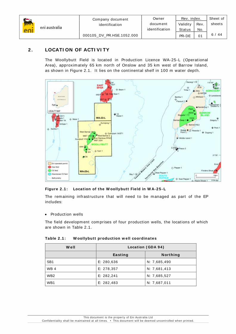
The Woollybutt Field is located in Production Licence WA-25-L (Operational Area), approximately 65 km north of Onslow and 35 km west of Barrow Island, as shown in Figure 2.1. It lies on the continental shelf in 100 m water depth.
Figure 2.1: Location of the Woollybutt Field in WA-25-L
The remaining infrastructure that will need to be managed as part of the EP includes:
• Production wells
The field development comprises of four production wells, the locations of which are shown in Table 2.1.
Table 2.1: Woollybutt production well coordinates
Well Location (GDA 94)
Easting Northing
SB1 E: 280,636 N: 7,685,490
WB 4 E: 278,357 N: 7,681,413
WB2 E: 282,241 N: 7,685,527
WB1 E: 282,483 N: 7,687,011

eni australia
Company document identification
000105_DV_PR.HSE.1052.000
Owner document
identification
Rev. index. Sheet of sheets
7 / 44
Validity Status
Rev. No.
PR-DE 01
This document is the property of Eni Australia Ltd Confidentiality shall be maintained at all times. This document will be deemed uncontrolled when printed.
Following cessation of production in May 2012, the wells were shut in at the Surface Controlled Sub Surface Safety Valve (SCSSSVs) and Xmas Tree valves. The Xmas Tree valves were leak tested, forming two independent and tested well barriers.
• Control Modules, Umbilicals and Manifolds;
Wells are controlled via Subsea Control Modules (SCM) located on the Scalybutt and Woollybutt Manifolds.
Control umbilicals run from the disconnectable single point mooring (DSPM) to the manifolds and to the wells. There are two umbilical baskets with approximate dimensions of 3.6 m x 2.5 m x 1.4 m. These are skid structures where the end of the infield umbilical is terminated to a Subsea Umbilical Termination Unit (SUTU).
• Subsea Infrastructure.
Flowlines have been flushed with sea water and remain isolated between the Xmas Tree valves and the DSPM buoy. The FPSO was disconnected from the DSPM buoy, which was lowered to an approximate water depth of 35 m prior to the FPSO departing the field.
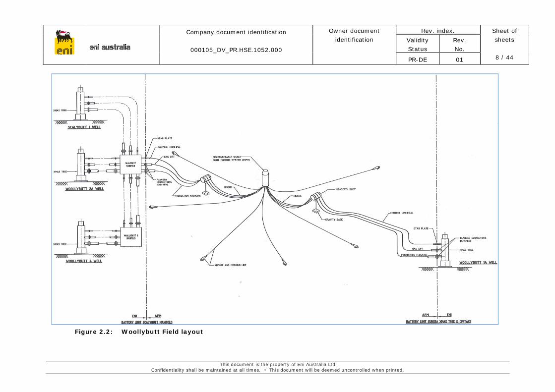
Figure 2.2 shows the asset ownership boundaries and the Woollybutt Field Layout.
A 500 m exclusion zone will also be maintained around Woollybutt infrastructure until field abandonment.
eni australia
Company document identification
000105_DV_PR.HSE.1052.000
Owner document identification
Rev. index. Sheet of sheets
8 / 44
Validity Status
Rev. No.
PR-DE 01
This document is the property of Eni Australia Ltd Confidentiality shall be maintained at all times. This document will be deemed uncontrolled when printed.
Figure 2.2: Woollybutt Field layout
eni australia
Company document identification
000105_DV_PR.HSE.1052.000
Owner document identification
Rev. index. Sheet of sheets
9 / 44
Validity Status
Rev. No.
PR-DE 00
This document is the property of Eni Australia Ltd Confidentiality shall be maintained at all times. This document will be deemed uncontrolled when printed.
3. DESCRIPTION OF ACTIVITY
The Woollybutt Field is presently shut-in and will continue to be shut-in during field management activities.
Field management activities that may be undertaken include Cathodic Protection (CP) surveys, visual inspections and anode maintenance using remotely operated vehicles (ROV). Only one vessel will be in the Operational Area at any one time undertaking field management activities.
Table 3.1: Proposed field management activities with indicative frequencies and durations
Activity Frequency Approx. Duration (days)
ROV survey 4 yearly basis 3-7 days
Anode maintenance As required 3-7 days
CP surveys and visual inspections of subsea structures will be undertaken using ROVs deployed from a project vessel, to evaluate infrastructure integrity.
Full ROV inspection of all accessible subsea infrastructure and equipment, including CP testing and visual inspection, will be conducted at 4-yearly intervals. The frequency has been determined based on the consistent trend observed in the cathodic protection readings, with the most recent survey being conducted in 2016.
Equipment and infrastructure integrity evaluations and fitness for service assessments will be conducted upon receipt of survey data.
If the survey data indicates a decrease in cathodic protection such that new anodes need to be installed to maintain infrastructure integrity, this shall be undertaken by ROV with a similar project vessel to that undertaking the ROV surveys.
Project vessels will be selected based on the activity that will be undertaken. All project vessels will be commercial vessels with a suitable survey class for activities in the Operational Area. The maximum credible spill scenario for all project vessels is 100 m³ (volume of largest tank) (AMSA, 2015). All project vessels will run on marine diesel; no intermediate or heavy fuel oils will be used. Vessel specifications for the typical vessel to be used for undertaking field management activities have a Draft (max) of 3.25m and Gross tonnage of 1475Gt. Only one vessel will be in the Operational Area at any one time undertaking field management activities.
eni australia
Company document identification
000105_DV_PR.HSE.1052.000
Owner document identification
Rev. index. Sheet of sheets
10 / 44
Validity Status
Rev. No.
PR-DE 00
This document is the property of Eni Australia Ltd Confidentiality shall be maintained at all times. This document will be deemed uncontrolled when printed.
4. DESCRIPTION OF RECEIVING ENVIRONMENT
4.1 Physical Environment
WA-25-L lies on the continental shelf within the North-west marine region, which covers the Commonwealth Marine Area extending from the Western Australian–Northern Territory (NT) border to Kalbarri, south of Shark Bay in Western Australia. The North West Commonwealth Marine Area covers approximately 1.07 million square kilometres and is characterised by tropical and sub-tropical marine areas and includes shallow waters on the continental shelf at the state water’s boundary 3 nautical miles (5.5 kilometres) from shore, to deep ocean habitat 200 nautical miles (370 kilometres) from shore (Commonwealth of Australia, 2012).
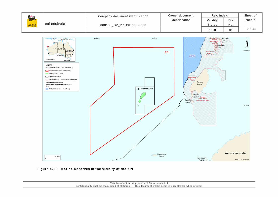
The Zone of Potential Impact (ZPI) beyond the Operational Area (Figure 4.1) has been conservatively estimated utilising the worst case impact footprint associated with a vessel diesel spill.
4.2 Biological Environment
The marine habitat within the Operational Area and ZPI mainly consists of soft sediment and epibenthic flora and fauna. The broader region contains a diverse range of habitats, including, seagrasses, hard corals, mangroves, intertidal mudflats and sandflats, sandy beaches and rocky shores. None of these habitats are present within the Operational Area and ZPI.
The Operational Area comprises of soft sediment habitat in deep water. Unconsolidated sediments support benthic fauna living both in the sediments (infauna) and on the surface (epifauna). In shallow areas soft sediments also support seagrass. However, there is no seagrass habitat in the Operational Area due to its depth. Predominant infauna species in soft sediment habitats are mobile burrowing species including molluscs, crustaceans (crabs, shrimps and smaller related species), polychaetes, sipunculid and platyhelminth worms, asteroids (sea stars), echinoids (sea urchins) and other small animals. Surface species include small crustaceans and molluscs, echinoderms and larger sessile organisms such as sponges, corals, sea whips and sea squirts (DEC, 2006).
A recent survey in 2014 (Neptune, 2014) focused on marine growth on the subsea infrastructure. Sparse to patchy coverage was found on the WB1A, WB2A and WB4 Xmas trees, consisting of hydroid/bryozoan turf, barnacles and encrusting sponges. Growth on SB1 was denser, consisting of moderate to dense coverage of hydroids and bryozoans and included barnacles, sponges and gorgonians (sea fans). The diversity of marine growth observed on or adjacent to the subsea flow-lines was similar across all locations with varying densities observed along the length of individual flow-lines. Marine growth was observed to occur on buried, partially buried and exposed sections of the subsea flow-lines. Growth observed on or adjacent to the subsea flow-lines of the Woollybutt Field included hydroids, bryozoans, soft corals, sponges, gorgonians (sea whips and sea fans), ascidians and other filter feeders.
eni australia
Company document identification
000105_DV_PR.HSE.1052.000
Owner document identification
Rev. index. Sheet of sheets
11 / 44
Validity Status
Rev. No.
PR-DE 00
This document is the property of Eni Australia Ltd Confidentiality shall be maintained at all times. This document will be deemed uncontrolled when printed.
4.3 Values and Sensitivities
There are no World Heritage Areas (WHA) within the Operational Area or ZPI, as shown in Figure 4.1. The closest WHA to the ZPI is the Ningaloo Coast World Heritage Area, which is also a National Heritage area and State Marine Protected Area. The Ningaloo Coast World Heritage Area lies approximately 30 km south west of the southern extent of the ZPI (DoEE, 2016; UNESCO, 2016).
There are no wetlands of international or national importance within the Operational Area or the ZPI, according to a search undertaken using the EPBC Protected Matters Search Tool (DotE, 2016).
The ZPI, including the Operational Area, is not located within any Commonwealth Marine Reserves or conservation zones. Marine parks and reserves in the vicinity of the Woollybutt field are shown in Figure 4.1. The closest Commonwealth marine reserves to the field are the Commonwealth Marine Reserves Network International Union for Conservation of Nature and Natural Resources (IUCN) VI Multiple Use Zone, Barrow Island Marine Management Area and Barrow Island Marine Park.
There are also a number of existing and proposed State Marine Protected Areas which include the Ningaloo Marine Park (State), the Montebello Islands Marine Park and the Rowley Shoals Marine Park in the wider region. Of these, the closest to the ZPI is the Barrow Island Marine Management Area, located approximately 25 km east of the Operational Area. The proposed Montebello Commonwealth Island Marine reserve is located more than 50 km to the north east, covering an area of approximately 3,413 km².
eni australia
Company document identification
000105_DV_PR.HSE.1052.000
Owner document identification
Rev. index. Sheet of sheets
12 / 44
Validity Status
Rev. No.
PR-DE 01
This document is the property of Eni Australia Ltd Confidentiality shall be maintained at all times. This document will be deemed uncontrolled when printed.
Figure 4.1: Marine Reserves in the vicinity of the ZPI
eni australia
Company document identification
000105_DV_PR.HSE.1052.000
Owner document identification
Rev. index. Sheet of sheets
13 / 44
Validity Status
Rev. No.
PR-DE 01
This document is the property of Eni Australia Ltd Confidentiality shall be maintained at all times. This document will be deemed uncontrolled when printed.
There are no listed threatened ecological communities within the Operational Area or the ZPI, according to a search undertaken using the EPBC Protected Matters Search Tool (DotE, 2016).
An EPBC Protected Matters Search shows that the ZPI contains three listed Key Ecological Features (KEFs), which have been identified in the in the North-West Marine Bioregional Plan (Commonwealth of Australia, 2012). The KEFs identified are:
• The Ancient Coastline at 125 m Depth Contour;
The ancient coastline presents a unique portion of the seafloor with ecological features of regional importance (Commonwealth of Australia, 2012). Although the ancient coastline adds additional habitat types to a representative system, the habitat types would not be unique to the coastline as they are widespread on the upper shelf (Falkner et al., 2009).
• Continental Slope Demersal Fish Communities;
The demersal fish assemblages on the continental slope in the Timor Province, the Northwest Transition and the Northwest Province are highly diverse and contain a number of endemic species (Commonwealth of Australia, 2012). The Timor Province and Northwest Transition bioregions are the second-richest areas for demersal fish across the entire continental slope. The region is valued for its high levels of endemism (Commonwealth of Australia, 2012).
• Canyons linking the Cuvier Abyssal Plain and the Commonwealth waters adjacent to Ningaloo Reef.
These canyons, occurring at water depths between 1800 m and 4800 m, may provide regionally significant ecological properties (Falkner et al., 2009, Commonwealth of Australia, 2012). It is a known aggregation area for sharks, large predatory fish, manta rays, sea snakes, whale sharks and seabirds (Commonwealth of Australia, 2012).
Biologically important areas (BIAs) are those locations where aggregations of members of a species are known to undertake biologically important behaviours, such as breeding, resting, foraging or migration (DoEE, 2016b). BIAs have been identified using expert scientific knowledge about species abundance, distribution and behaviours (DoEE, 2016b).
BIAs for the following species have been identified within the Operational Area or ZPI:
• Pygmy blue whale – distribution;
• Humpback whale – migration;
• Flatback turtle – internesting buffer;
• Green turtle – internesting buffer;
eni australia
Company document identification
000105_DV_PR.HSE.1052.000
Owner document identification
Rev. index. Sheet of sheets
14 / 44
Validity Status
Rev. No.
PR-DE 01
This document is the property of Eni Australia Ltd Confidentiality shall be maintained at all times. This document will be deemed uncontrolled when printed.
• Hawksbill turtle – internesting buffer, suitable nesting habitat;
• Loggerhead turtle – internesting buffer;
• Whale shark – foraging;
• Wedge tailed shearwater – breeding and foraging;
• Fairy tern – breeding and foraging;
• Lesser crested tern – breeding and foraging;
• Roseate tern – breeding and foraging;
A search for protected species listed under the EPBC Act was undertaken on 15 September 2016 (DotE, 2016) using an area that covered the full extent of the ZPI. Through this search thirty one species listed as ‘Migratory’ were identified to occur in the ZPI. Twenty threatened species were also identified in the ZPI, three of which had a critically endangered status. Of these twenty threatened species, fifteen were also listed as migratory species. All of the species listed as ‘Threatened’ under the EPBC Act are also ‘Protected’ under State legislation under the Wildlife Conservation Act 1950.
A review of the Environment Protection and Biodiversity Conservation Act 1999 (EPBC Act) database (Protected Matters Search Tool) identified a number of listed threatened and migratory species that could occur in the offshore waters surrounding the Field, including:
• Four marine birds, with one listed as Endangered (Southern giant-petrel);
• Three wetland birds, with two listed as Critically Endangered (Curlew Sandpiper, Eastern Curlew);
• Twelve marine mammals, including nine whale and two dolphin species, with two listed as Endangered (Blue whale, Southern right whale) and two Vulnerable (Humpback Whale, Sei Whale);
• One seasnake, the Short-nosed seasnake, which is listed as Critically Endangered
• Five turtles, with two listed as Endangered (Loggerhead, Leatherback) and three listed as Vulnerable (Hawksbill, Flatback, Green Turtle); and
• Nine fish and shark species, with five listed as vulnerable (Whale Shark, Great White Shark, Grey Nurse Shark, Dwarf Sawfish and Green Sawfish).
Each of the species listed may occur in the ZPI at various times of the year, generally as transient visitors to the area during migration and feeding. No known breeding grounds or sensitive habitat environments critical to the species outlined are known to exist within the Operational Area. There are breeding grounds for turtles within the ZPI.
eni australia
Company document identification
000105_DV_PR.HSE.1052.000
Owner document identification
Rev. index. Sheet of sheets
15 / 44
Validity Status
Rev. No.
PR-DE 01
This document is the property of Eni Australia Ltd Confidentiality shall be maintained at all times. This document will be deemed uncontrolled when printed.
4.4 Socio-economic environment
Given the offshore nature of the location the level of human activity in the vicinity of the field is low. Most shipping that occurs in the vicinity of the Field is associated with the oil and gas industry.
The Operational Area is located inshore of major shipping lanes between Australia and Asia. Automatic Identification System (AIS) data from AMSA suggests that most traffic that could be encountered within the Operational Area and ZPI would be offshore support vessels (AMSA 2016). The vast majority of this traffic lies to the south east of the Woollybutt Oil Field.
The field exists within Sectors R852A and R852B of the North West Australia Exercise Area (NWXA), a Defence Practice Area. Each of these is declared as a military flying training area activated by NOTAM (Notice to Airmen), existing in height blocks from 10,000ft to 28,000ft and 28,000ft to 60,000ft, respectively.
There are no tourism operations within the Operational Area or ZPI. Ningaloo is the most significant area in NWS region for nature based tourism. Occasional tourist and fishing charter vessels may however pass through the ZPI in transit between Exmouth and the Montebello Islands.
Recreational fishing mainly occurs near coastal islands including Thevenard island located approximately 40 km south of the Operational Area and ZPI. No recreational fishing is known to occur in the deep waters around the Operational Area and ZPI.
Commercial fisheries that operate in the waters of the NWS are centred in Onslow, 65 km to the south of the field; Exmouth, 120 km to the southwest, and Dampier, approximately 180 km to the east. The focus of commercial fishing activity is mainly the inner continental shelf and waters surrounding the offshore islands to depths of about 30 m. Commonwealth and State Managed Fisheries that overlap the ZPI are summarised below.
Commonwealth fisheries within the ZPI include:
• Western Tuna and Billfish Fishery (Commonwealth – Australian Fisheries Management Authority (AFMA));
• North West Slope Trawl Fishery;
• Southern Bluefin Tuna Fishery;
• Skipjack Tuna Fishery.
State managed fisheries within the ZPI include:
• Onslow Prawn Managed Fishery;
eni australia
Company document identification
000105_DV_PR.HSE.1052.000
Owner document identification
Rev. index. Sheet of sheets
16 / 44
Validity Status
Rev. No.
PR-DE 01
This document is the property of Eni Australia Ltd Confidentiality shall be maintained at all times. This document will be deemed uncontrolled when printed.
• Pilbara Demersal Scalefish Fisheries:
• Mackerel Managed Fishery;
• Specimen Shell Managed Fishery;
• Marine Aquarium Managed Fishery;
• West Coast Deep Sea Crustacean Managed Fishery;
• Pearl Oyster Fishery;
• Beche-de-mer Fishery.
eni australia
Company document identification
000105_DV_PR.HSE.1052.000
Owner document identification
Rev. index. Sheet of sheets
17 / 44
Validity Status
Rev. No.
PR-DE 01
This document is the property of Eni Australia Ltd Confidentiality shall be maintained at all times. This document will be deemed uncontrolled when printed.
5. ENVIRONMENTAL IMPACTS AND RISKS
The Eni philosophy to manage environmental risks is to eliminate or mitigate the risk during the planning phase. Managing risks through design is contingent upon identifying, at an early stage in the project, the sources and pathways by which environmental impacts can occur and the sensitivities of the receiving environment in which the project is situated.
The expected or potential impacts associated with the Activity were assessed using the Eni procedure for Risk Management and Hazard Identification. This procedure is consistent with the Australian Standard for Risk Management: AS/NZS ISO 31000:2009 Risk management – Principles and guidelines and provides a systematic process for:
1. Identifying each project activity and its associated environmental aspects.
2. Identifying the environmental values within and adjacent to the area.
3. Defining the potential environmental effects (impacts) of aspects identified in Step 1 above on the values identified in Step 2 above.
4. Identifying the potential environmental consequences and severity of the impact (Table 5.2).
5. Identifying the likelihood of occurrence of the consequence, according to a 6-level scale (Table 5.1).
6. Evaluating overall environmental risk levels.
7. Identifying mitigation measures, assigning management actions and further recommended risk reduction measures according to risk levels (Table 5.3) in order to reduce the risk to ALARP.
Table 5.1: Likelihood scale
ID Likelihood Description
0 Non-credible Theoretically possible but not known / reasonably expected to have occurred in the exploration and production industry.
(A) Rare Known or reasonably expected to have occurred in the exploration and production industry under similar circumstances.
(B) Unlikely Known or reasonably expected to have occurred in the company under similar circumstances.
(C) Credible Known or reasonably expected to have occurred in the company more than once under similar circumstances.
(D) Probable Known or reasonably expected to have occurred in the company more than once a year under similar circumstances.
(E) Almost certain / will occur
Known or reasonably expected to have occurred at the considered location, more than once a year under similar circumstances.
eni australia
Company document identification
000105_DV_PR.HSE.1052.000
Owner document identification
Rev. index. Sheet of sheets
18 / 44
Validity Status
Rev. No.
PR-DE 01
This document is the property of Eni Australia Ltd Confidentiality shall be maintained at all times. This document will be deemed uncontrolled when printed.
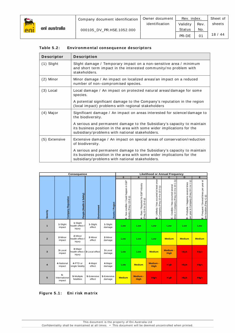
Table 5.2: Environmental consequence descriptors
Descriptor Description
(1) Slight Slight damage / Temporary impact on a non-sensitive area / minimum and short term impact in the interested community/no problem with stakeholders.
(2) Minor Minor damage / An impact on localized areas/an impact on a reduced number of non–compromised species.
(3) Local Local damage / An impact on protected natural areas/damage for some species.
A potential significant damage to the Company’s reputation in the region (local impact) problems with regional stakeholders
(4) Major Significant damage / An impact on areas interested for science/damage to the biodiversity.
A serious and permanent damage to the Subsidiary’s capacity to maintain its business position in the area with some wider implications for the subsidiary/problems with national stakeholders.
(5) Extensive Extensive damage / An impact on special areas of conservation/reduction of biodiversity.
A serious and permanent damage to the Subsidiary’s capacity to maintain its business position in the area with some wider implications for the subsidiary/problems with national stakeholders.
Consequence Likelihood or Annual Frequency0 A B C D E
0 - N
on c
redi
ble
/ Cou
ld h
appe
n in
E&P
in
dust
ry (F
req
<10-
6 /y
)
A - R
are
/ Rep
orte
d fo
r E&P
indu
stry
(F
req
10-6
to 1
0-4
/y)
B - U
nlik
ely
/ Has
occ
urre
d at
leas
t onc
e in
Com
pany
(Fre
q 10
-4 to
10-
3 /y
)
C - C
redi
ble
/ Has
occ
urre
d se
vera
l tim
es in
Com
pany
(Fre
q 10
-3 to
10-
1 /y
)
D - P
roba
ble
/ Hap
pens
sev
eral
tim
es
per y
ear i
n C
ompa
ny (F
req
10-1
to 1
/y)
E - F
requ
ent /
Sev
eral
tim
es p
er y
ear a
t on
e lo
catio
n (F
req
>1 /y
)
1 1-Slight impact
1-Slight health effect /
injury
1-Slight effect
1-Slight damage Low Low Low Low Low Low
2 2-Minor impact
2-Minor health effect /
injury
2-Minor effect
2-Minor damage Low Low Low Medium Medium Medium
3 3-Local impact
3-Major health effect /
injury3-Local effect 3-Local
damage Low Low Medium Medium - High High High
4 4-National impact
4-PTD or single fatality
4-Major effect
4-Major damage Low Medium Medium -
High High High High
55-
International impact
5-Multiple fatalities
5-Extensive effect
5-Extensive damage Medium Medium -
High High High High High
Asse
ts /
Proj
ect
Seve
rity
Peop
le (H
ealth
& S
afet
y)
Envi
ronm
ent
Com
pany
Rep
utat
ion
Figure 5.1: Eni risk matrix
eni australia
Company document identification
000105_DV_PR.HSE.1052.000
Owner document identification
Rev. index. Sheet of sheets
19 / 44
Validity Status
Rev. No.
PR-DE 01
This document is the property of Eni Australia Ltd Confidentiality shall be maintained at all times. This document will be deemed uncontrolled when printed.
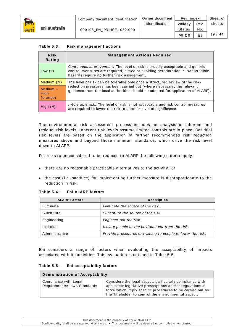
Table 5.3: Risk management actions
Risk Rating
Management Actions Required
Low (L) Continuous improvement: The level of risk is broadly acceptable and generic control measures are required, aimed at avoiding deterioration. * Non-credible hazards require no further risk assessment.
Medium (M) The level of risk can be tolerable only once a structured review of the risk-reduction measures has been carried out (where necessary, the relevant guidance from the local authorities should be adopted for application of ALARP). Medium –
High (orange)
High (H) Intolerable risk: The level of risk is not acceptable and risk control measures are required to lower the risk to another level of significance.
The environmental risk assessment process includes an analysis of inherent and residual risk levels. Inherent risk levels assume limited controls are in place. Residual risk levels are based on the application of further recommended risk reduction measures above and beyond those minimum standards, which drive the risk level down to ALARP.
For risks to be considered to be reduced to ALARP the following criteria apply:
• there are no reasonable practicable alternatives to the activity; or
• the cost (i.e. sacrifice) for implementing further measure is disproportionate to the reduction in risk.
Table 5.4: Eni ALARP factors
ALARP Factors Description
Eliminate Eliminate the source of the risk.
Substitute Substitute the source of the risk
Engineering Engineer out the risk.
Isolation Isolate people or the environment from the risk.
Administrative Provide procedures or training to people to lower the risk.
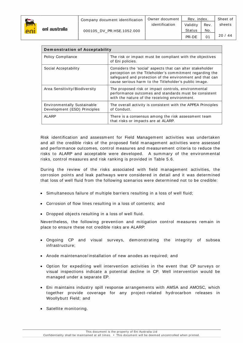
Eni considers a range of factors when evaluating the acceptability of impacts associated with its activities. This evaluation is outlined in Table 5.5.
Table 5.5: Eni acceptability factors
Demonstration of Acceptability
Compliance with Legal Requirements/Laws/Standards
Considers the legal aspect, particularly compliance with applicable legislative prescriptions and/or regulations in force which imply specific procedures to be carried out by the Titleholder to control the environmental aspect.
eni australia
Company document identification
000105_DV_PR.HSE.1052.000
Owner document identification
Rev. index. Sheet of sheets
20 / 44
Validity Status
Rev. No.
PR-DE 01
This document is the property of Eni Australia Ltd Confidentiality shall be maintained at all times. This document will be deemed uncontrolled when printed.
Demonstration of Acceptability
Policy Compliance The risk or impact must be compliant with the objectives of Eni policies.
Social Acceptability Considers the ‘social’ aspects that can alter stakeholder perception on the Titleholder’s commitment regarding the safeguard and protection of the environment and that can cause serious harm to the Titleholder’s public image.
Area Sensitivity/Biodiversity The proposed risk or impact controls, environmental performance outcomes and standards must be consistent with the nature of the receiving environment.
Environmentally Sustainable Development (ESD) Principles
The overall activity is consistent with the APPEA Principles of Conduct.
ALARP There is a consensus among the risk assessment team that risks or impacts are at ALARP.
Risk identification and assessment for Field Management activities was undertaken and all the credible risks of the proposed field management activities were assessed and performance outcomes, control measures and measurement criteria to reduce the risks to ALARP and acceptable were developed. A summary of the environmental risks, control measures and risk ranking is provided in Table 5.6.
During the review of the risks associated with field management activities, the corrosion points and leak pathways were considered in detail and it was determined that loss of well fluid from the following scenarios were determined not to be credible:
• Simultaneous failure of multiple barriers resulting in a loss of well fluid;
• Corrosion of flow lines resulting in a loss of contents; and
• Dropped objects resulting in a loss of well fluid.
Nevertheless, the following prevention and mitigation control measures remain in place to ensure these not credible risks are ALARP:
• Ongoing CP and visual surveys, demonstrating the integrity of subsea infrastructure;
• Anode maintenance/installation of new anodes as required; and
• Option for expediting well intervention activities in the event that CP surveys or visual inspections indicate a potential decline in CP. Well intervention would be managed under a separate EP.
• Eni maintains industry spill response arrangements with AMSA and AMOSC, which together provide coverage for any project-related hydrocarbon releases in Woollybutt Field; and
• Satellite monitoring.
eni australia
Company document identification
000105_DV_PR.HSE.1052.000
Owner document identification
Rev.index Sheet of sheets
21 / 44
Validity Status
Rev. No.
PR-DE 01
This document is the property of Eni Australia Ltd Confidentiality shall be maintained at all times. This document will be deemed uncontrolled when printed.
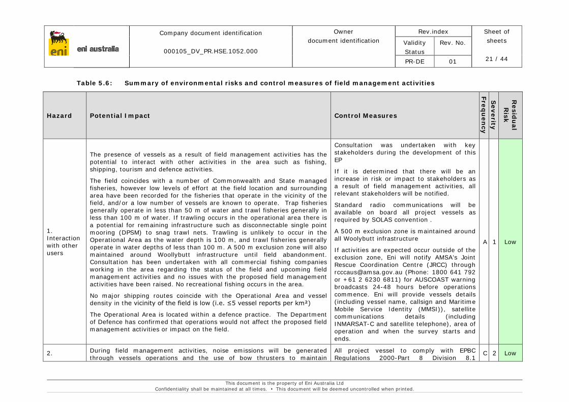
Table 5.6: Summary of environmental risks and control measures of field management activities
Hazard Potential Impact Control Measures
Frequ
ency
Severity
Resid
ual
Risk
1. Interaction with other users
The presence of vessels as a result of field management activities has the potential to interact with other activities in the area such as fishing, shipping, tourism and defence activities.
The field coincides with a number of Commonwealth and State managed fisheries, however low levels of effort at the field location and surrounding area have been recorded for the fisheries that operate in the vicinity of the field, and/or a low number of vessels are known to operate. Trap fisheries generally operate in less than 50 m of water and trawl fisheries generally in less than 100 m of water. If trawling occurs in the operational area there is a potential for remaining infrastructure such as disconnectable single point mooring (DPSM) to snag trawl nets. Trawling is unlikely to occur in the Operational Area as the water depth is 100 m, and trawl fisheries generally operate in water depths of less than 100 m. A 500 m exclusion zone will also maintained around Woollybutt infrastructure until field abandonment. Consultation has been undertaken with all commercial fishing companies working in the area regarding the status of the field and upcoming field management activities and no issues with the proposed field management activities have been raised. No recreational fishing occurs in the area.
No major shipping routes coincide with the Operational Area and vessel density in the vicinity of the field is low (i.e. ≤5 vessel reports per km²)
The Operational Area is located within a defence practice. The Department of Defence has confirmed that operations would not affect the proposed field management activities or impact on the field.
Consultation was undertaken with key stakeholders during the development of this EP
If it is determined that there will be an increase in risk or impact to stakeholders as a result of field management activities, all relevant stakeholders will be notified.
Standard radio communications will be available on board all project vessels as required by SOLAS convention .
A 500 m exclusion zone is maintained around all Woolybutt infrastructure
If activities are expected occur outside of the exclusion zone, Eni will notify AMSA’s Joint Rescue Coordination Centre (JRCC) through [email protected] (Phone: 1800 641 792 or +61 2 6230 6811) for AUSCOAST warning broadcasts 24-48 hours before operations commence. Eni will provide vessels details (including vessel name, callsign and Maritime Mobile Service Identity (MMSI)), satellite communications details (including INMARSAT-C and satellite telephone), area of operation and when the survey starts and ends.
A 1 Low
2. During field management activities, noise emissions will be generated through vessels operations and the use of bow thrusters to maintain
All project vessel to comply with EPBC Regulations 2000-Part 8 Division 8.1
C 2 Low

eni australia
Company document identification
000105_DV_PR.HSE.1052.000
Owner document identification
Rev.index Sheet of sheets
22 / 44
Validity Status
Rev. No.
PR-DE 01
This document is the property of Eni Australia Ltd Confidentiality shall be maintained at all times. This document will be deemed uncontrolled when printed.
Under water noise and vibrations
position. Under normal conditions (i.e. when vessels are idling or moving between sites), source levels would be between 160-180 dB re 1 µPa at 1 m (Hatch & Southhall, 2009). Highest noise levels are likely to occur during the use of bow thrusters to maintain position. McCauley (1998) measured underwater noise from a support vessel holding its position using bow-thrusters and strong thrust from its main engines as 182 dB (re: 1 µPa) at 1 m and 137 dB (re: 1 µPa) at 405 m. Levels of 120 dB (re 1 µPa) extended for a distance of approximately 3-5 km from the source.
Potential environmental impacts from underwater noise include:
• behavioural change in marine fauna (localised avoidance/attraction);
• hearing impairment and pathological damage to marine fauna;
• increase stress levels in marine fauna;
• disruption to marine fauna underwater acoustic cues; and
• secondary ecological effects – alteration of predator prey relationship.
Underwater noise generated through vessel positioning and movement does not have the intensity and characteristics likely to cause physiological damage in marine fauna (Nedwell & Edwards, 2004; Hatch & Southall, 2009). The sound energy levels generated from project vessels are considered to be relatively low intensity when compared to natural noise sources
In the Operational Area the marine fauna most at risk from acoustic disturbance are cetaceans, particularly baleen whales, as the auditory bandwidth of these large whales overlap with the low frequency broadband noise produced by thrusters during vessel positioning and movement. Impacts are likely to be limited to behavioural disturbance, as the noise levels likely to be produced by operations are well below proposed injury criteria for low frequency cetaceans (estimated at 230 dB re 1 µPa) (Southall et al., 2007).
(interacting with cetaceans).
– A vessel will not travel greater than 6 knots within 300 m of a whale (caution zone) and not approach closer than 100 m from a whale; and
– A vessel will not approach closer than 50 m or a dolphin and/or 100 m for a whale (with the exception of animals bow riding).
Vessels are required to have valid documentation including:
An International Marine Contractors Association (IMCA) Common Marine Inspection Document (CMID);
An Oil Companies International Marine Forum (OCIMF) Offshore Vessel Inspection Database (OVID); and/or
An Eni offshore support vessels inspection report.
Project vessels have inspection maintenance and repair program to show they are kept in good working order.
3.
Light emissions
Artificial lighting can cause a change in the behaviour of fauna, particularly nesting turtles and birds. The main implication of artificial lighting from offshore vessels for marine turtles is the disruption of hatchling sea-finding behaviour, as hatchlings can be disoriented if lights or atmospheric glow occur away from the sea. Artificial lighting may also attract seabirds or
Lighting kept to a minimum required to satisfy safety and navigational requirements in accordance with requirements of the Navigation Act 2012 (Marine Orders Part 30 [Prevention of Collisions]), the Vessel
C 1 Low
eni australia
Company document identification
000105_DV_PR.HSE.1052.000
Owner document identification
Rev.index Sheet of sheets
23 / 44
Validity Status
Rev. No.
PR-DE 01
This document is the property of Eni Australia Ltd Confidentiality shall be maintained at all times. This document will be deemed uncontrolled when printed.
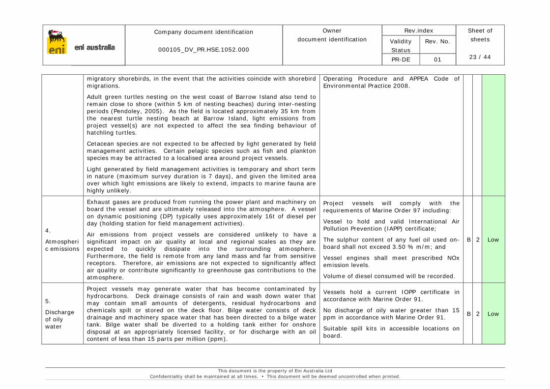
migratory shorebirds, in the event that the activities coincide with shorebird migrations.
Adult green turtles nesting on the west coast of Barrow Island also tend to remain close to shore (within 5 km of nesting beaches) during inter-nesting periods (Pendoley, 2005). As the field is located approximately 35 km from the nearest turtle nesting beach at Barrow Island, light emissions from project vessel(s) are not expected to affect the sea finding behaviour of hatchling turtles.
Cetacean species are not expected to be affected by light generated by field management activities. Certain pelagic species such as fish and plankton species may be attracted to a localised area around project vessels.
Light generated by field management activities is temporary and short term in nature (maximum survey duration is 7 days), and given the limited area over which light emissions are likely to extend, impacts to marine fauna are highly unlikely.
Operating Procedure and APPEA Code of Environmental Practice 2008.
4.
Atmospheric emissions
Exhaust gases are produced from running the power plant and machinery on board the vessel and are ultimately released into the atmosphere. A vessel on dynamic positioning (DP) typically uses approximately 16t of diesel per day (holding station for field management activities).
Air emissions from project vessels are considered unlikely to have a significant impact on air quality at local and regional scales as they are expected to quickly dissipate into the surrounding atmosphere. Furthermore, the field is remote from any land mass and far from sensitive receptors. Therefore, air emissions are not expected to significantly affect air quality or contribute significantly to greenhouse gas contributions to the atmosphere.
Project vessels will comply with the requirements of Marine Order 97 including:
Vessel to hold and valid International Air Pollution Prevention (IAPP) certificate;
The sulphur content of any fuel oil used on-board shall not exceed 3.50 % m/m; and
Vessel engines shall meet prescribed NOx emission levels.
Volume of diesel consumed will be recorded.
B 2 Low
5.
Discharge of oily water
Project vessels may generate water that has become contaminated by hydrocarbons. Deck drainage consists of rain and wash down water that may contain small amounts of detergents, residual hydrocarbons and chemicals spilt or stored on the deck floor. Bilge water consists of deck drainage and machinery space water that has been directed to a bilge water tank. Bilge water shall be diverted to a holding tank either for onshore disposal at an appropriately licensed facility, or for discharge with an oil content of less than 15 parts per million (ppm).
Vessels hold a current IOPP certificate in accordance with Marine Order 91.
No discharge of oily water greater than 15 ppm in accordance with Marine Order 91.
Suitable spill kits in accessible locations on board.
B 2 Low
eni australia
Company document identification
000105_DV_PR.HSE.1052.000
Owner document identification
Rev.index Sheet of sheets
24 / 44
Validity Status
Rev. No.
PR-DE 01
This document is the property of Eni Australia Ltd Confidentiality shall be maintained at all times. This document will be deemed uncontrolled when printed.
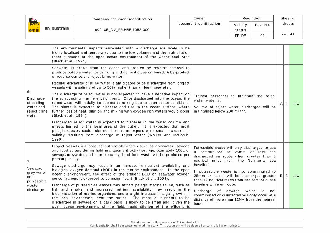
The environmental impacts associated with a discharge are likely to be highly localised and temporary, due to the low volumes and the high dilution rates expected at the open ocean environment of the Operational Area (Black et al., 1994).
6.
Discharge of cooling water and reject brine water
Seawater is drawn from the ocean and treated by reverse osmosis to produce potable water for drinking and domestic use on board. A by-product of reverse osmosis is reject brine water.
Regular discharge of brine water is anticipated to be discharged from project vessels with a salinity of up to 50% higher than ambient seawater.
The discharge of reject water is not expected to have a negative impact on the surrounding marine environment. Once discharged into the ocean, the reject water will initially be subject to mixing due to open ocean conditions. The plume is expected to disperse and rise to the ocean surface, where further loss of heat, dilution and mixing with oxygen rich waters would occur (Black et al., 1994).
Discharged reject water is expected to disperse in the water column and effects limited to the local area of the outlet. It is expected that most pelagic species could tolerate short term exposure to small increases in salinity resulting from discharge of reject water (Walker and McComb, 1990).
Trained personnel to maintain the reject water systems.
Volume of reject water discharged will be maintained below 200 m³/hr.
A 1 Low
7.
Sewage, grey water and putrescible waste discharge
Project vessels will produce putrescible wastes such as greywater, sewage and food scraps during field management activities. Approximately 100L of sewage/greywater and approximately 1L of food waste will be produced per person per day.
Sewage discharge may result in an increase in nutrient availability and biological oxygen demand (BOD) in the marine environment. In the open oceanic environment, the effect of the effluent BOD on seawater oxygen concentrations is expected to be insignificant (Black et al., 1994).
Discharge of putrescibles wastes may attract pelagic marine fauna, such as fish and sharks, and increased nutrient availability may result in the biostimulation of marine organisms and a slight increase in algal growth in the local environment near the outlet. The mass of nutrients to be discharged in sewage on a daily basis is likely to be small and, given the open ocean environment of the field, rapid dilution of the effluent is
Putrescible waste will only discharged to sea if comminuted to 25mm or less and discharged en route when greater than 3 nautical miles from the 'territorial sea baseline'.
If putrescible waste is not comminuted to 25mm or less it will be discharged greater than 12 nautical miles from the territorial sea baseline while en route.
Discharge of sewage which is not comminuted or disinfected will only occur at a distance of more than 12NM from the nearest land.
B 1 Low
eni australia
Company document identification
000105_DV_PR.HSE.1052.000
Owner document identification
Rev.index Sheet of sheets
25 / 44
Validity Status
Rev. No.
PR-DE 01
This document is the property of Eni Australia Ltd Confidentiality shall be maintained at all times. This document will be deemed uncontrolled when printed.
expected, resulting in highly localised effects (Black et al., 1994).
The discharge of sewage, grey water and putrescible wastes is considered unlikely to have any significant adverse effects on the marine environment.
Discharge of sewage which is comminuted or disinfected using a certified approved sewage treatment plant will only occur at a distance of more than 3NM from the nearest land.
Discharge of sewage will occur at a moderate rate while vessel is moving (greater than 4 knots) with no visible floating solids or discolouration of the surrounding water.
Vessel will hold a valid International Sewage Pollution Prevention (ISPP) certificate.
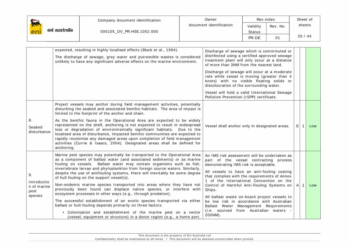
8.
Seabed disturbance
Project vessels may anchor during field management activities, potentially disturbing the seabed and associated benthic habitats. The area of impact is limited to the footprint of the anchor and chain.
As the benthic fauna in the Operational Area are expected to be widely represented on the shelf, anchoring is not expected to result in widespread loss or degradation of environmentally significant habitats. Due to the localised area of disturbance, impacted benthic communities are expected to rapidly recolonise any damaged areas upon completion of field management activities (Currie & Isaacs, 2004). Designated areas shall be defined for anchoring.
Vessel shall anchor only in designated areas. E 1 Low
9.
Introduction of marine pest species
Marine pest species may potentially be transported to the Operational Area as a component of ballast water (and associated sediments) or as marine fouling on vessels. Ballast water may contain organisms such as fish, invertebrate larvae and phytoplankton from foreign source waters. Similarly, despite the use of antifouling systems, there will inevitably be some degree of hull fouling on the support vessel(s).
Non-endemic marine species transported into areas where they have not previously been found can displace native species, or interfere with ecosystem processes in other ways (e.g., through predation).
The successful establishment of an exotic species transported via either ballast or hull-fouling depends primarily on three factors:
• Colonisation and establishment of the marine pest on a vector (vessel, equipment or structure) in a donor region (e.g., a home port,
An IMS risk assessment will be undertaken as part of the vessel contracting process demonstrating IMS risk is acceptable.
All vessels to have an anti-fouling coating that complies with the requirements of Annex 1 of the International Convention on the Control of Harmful Anti-Fouling Systems on Ships.
All ballast waste on-board project vessels to be low risk in accordance with Australian Ballast Water Management Requirements (i.e. sourced from Australian waters -200NM).
A 1 Low
eni australia
Company document identification
000105_DV_PR.HSE.1052.000
Owner document identification
Rev.index Sheet of sheets
26 / 44
Validity Status
Rev. No.
PR-DE 01
This document is the property of Eni Australia Ltd Confidentiality shall be maintained at all times. This document will be deemed uncontrolled when printed.
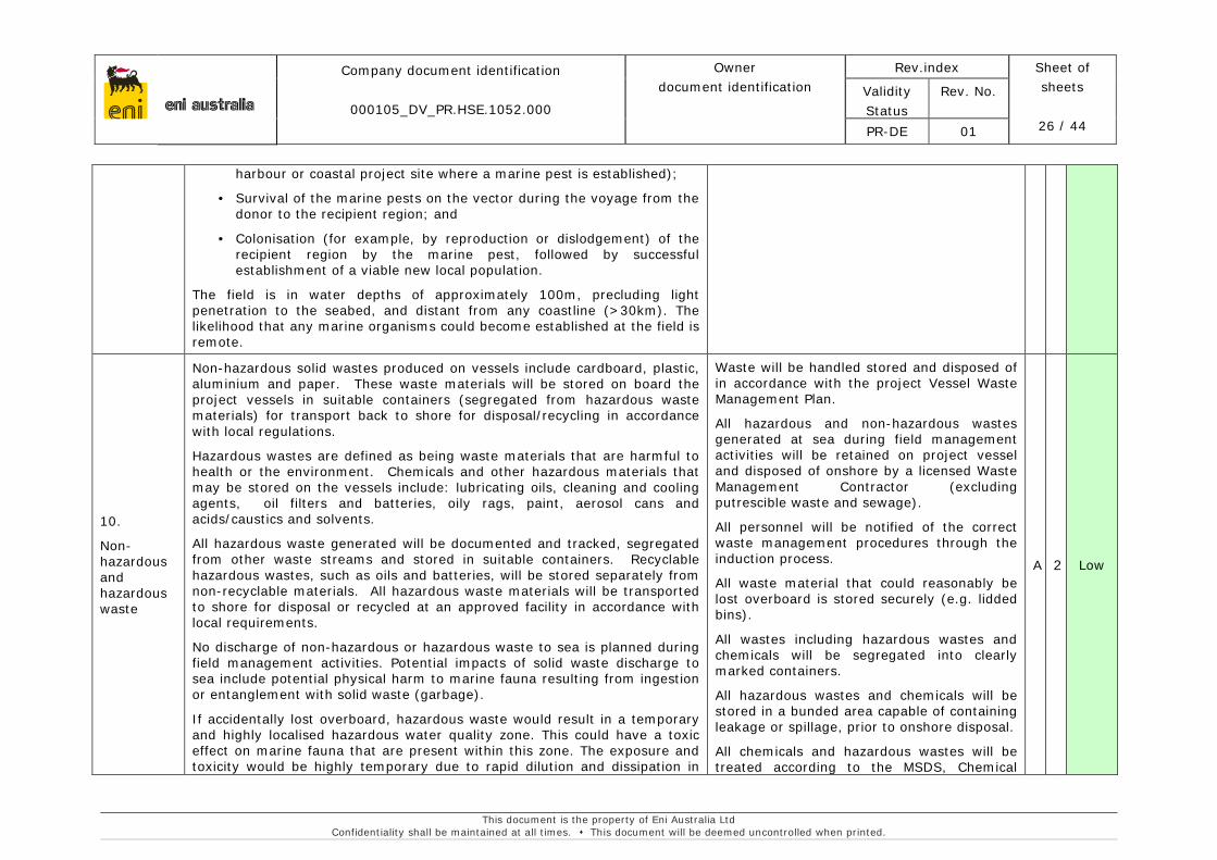
harbour or coastal project site where a marine pest is established);
• Survival of the marine pests on the vector during the voyage from the donor to the recipient region; and
• Colonisation (for example, by reproduction or dislodgement) of the recipient region by the marine pest, followed by successful establishment of a viable new local population.
The field is in water depths of approximately 100m, precluding light penetration to the seabed, and distant from any coastline (>30km). The likelihood that any marine organisms could become established at the field is remote.
10.
Non-hazardous and hazardous waste
Non-hazardous solid wastes produced on vessels include cardboard, plastic, aluminium and paper. These waste materials will be stored on board the project vessels in suitable containers (segregated from hazardous waste materials) for transport back to shore for disposal/recycling in accordance with local regulations.
Hazardous wastes are defined as being waste materials that are harmful to health or the environment. Chemicals and other hazardous materials that may be stored on the vessels include: lubricating oils, cleaning and cooling agents, oil filters and batteries, oily rags, paint, aerosol cans and acids/caustics and solvents.
All hazardous waste generated will be documented and tracked, segregated from other waste streams and stored in suitable containers. Recyclable hazardous wastes, such as oils and batteries, will be stored separately from non-recyclable materials. All hazardous waste materials will be transported to shore for disposal or recycled at an approved facility in accordance with local requirements.
No discharge of non-hazardous or hazardous waste to sea is planned during field management activities. Potential impacts of solid waste discharge to sea include potential physical harm to marine fauna resulting from ingestion or entanglement with solid waste (garbage).
If accidentally lost overboard, hazardous waste would result in a temporary and highly localised hazardous water quality zone. This could have a toxic effect on marine fauna that are present within this zone. The exposure and toxicity would be highly temporary due to rapid dilution and dissipation in
Waste will be handled stored and disposed of in accordance with the project Vessel Waste Management Plan.
All hazardous and non-hazardous wastes generated at sea during field management activities will be retained on project vessel and disposed of onshore by a licensed Waste Management Contractor (excluding putrescible waste and sewage).
All personnel will be notified of the correct waste management procedures through the induction process.
All waste material that could reasonably be lost overboard is stored securely (e.g. lidded bins).
All wastes including hazardous wastes and chemicals will be segregated into clearly marked containers.
All hazardous wastes and chemicals will be stored in a bunded area capable of containing leakage or spillage, prior to onshore disposal.
All chemicals and hazardous wastes will be treated according to the MSDS, Chemical
A 2 Low

eni australia
Company document identification
000105_DV_PR.HSE.1052.000
Owner document identification
Rev.index Sheet of sheets
27 / 44
Validity Status
Rev. No.
PR-DE 01
This document is the property of Eni Australia Ltd Confidentiality shall be maintained at all times. This document will be deemed uncontrolled when printed.
the marine environment expected on the NWS. Potential impacts are likely to be limited to one or a few individual marine animals in the immediate vicinity of the accidental release site, with the most likely fauna affected those within the surface waters.
Handling Procedures and the Vessel Waste Management Plan.
MSDS are present on board for each hazardous chemical.
Any release of solid and hazardous wastes into the marine environment would be recorded as an environmental incident and treated accordingly by Eni’s incident investigation and corrective and preventative action processes.
11.
Vessel collision with marine fauna
Project vessels will transit from Dampier to and from the Operational Area no more than once per year to undertake field management activities.
Vessel collision with marine fauna may result in injury or death of marine fauna. Marine fauna that are present in surface waters such as marine turtle and cetaceans are most susceptible to vessel strikes due to their proximity to the vessel (hull, propeller or equipment). Marine turtles on the sea surface or in shallow coastal waters have been observed avoiding approaching vessels by typically moving away from the vessels track (Hazel et al. 2007). Cetaceans including humpback whales demonstrate a variety of behaviours in response to approaching vessels (attributed to vessel noise), including longer dive times and moving away from the vessel’s path with increased speed (Baker & Herman, 1989; Meike et al., 2004). These behaviours may contribute to reducing the likelihood of a vessel strike. Other marine fauna species including seabirds and fish species (including whale sharks) are likely to avoid any moving vessels and are considered at low risk of potential vessel strike.
The Operational Area does not support any critical breeding, feeding or calving areas for EPBC listed species. However, the area is within the northern migration route for humpback whales.
Given that cetaceans, marine turtles and other marine fauna exhibit avoidance behaviour, the likelihood of vessel collision with marine fauna is low. During movements into or out of the Operational Area, vessel will move slowly (5 knots or less), this also reduces the risk of collision allowing time for any marine fauna to move out of the immediate area. Management controls will also be implemented for further reduced the potential risk of
All project vessel to comply with EPBC Regulations 2000-Part 8 Division 8.1 (interacting with cetaceans).
– A vessel will not travel greater than 6 knots within 300 m of a whale (caution zone) and not approach closer than 100 m from a whale; and
– A vessel will not approach closer than 50m for a dolphin and/or 100m for a whale (with the exception of animals bow riding).
0 1 Low
eni australia
Company document identification
000105_DV_PR.HSE.1052.000
Owner document identification
Rev.index Sheet of sheets
28 / 44
Validity Status
Rev. No.
PR-DE 01
This document is the property of Eni Australia Ltd Confidentiality shall be maintained at all times. This document will be deemed uncontrolled when printed.
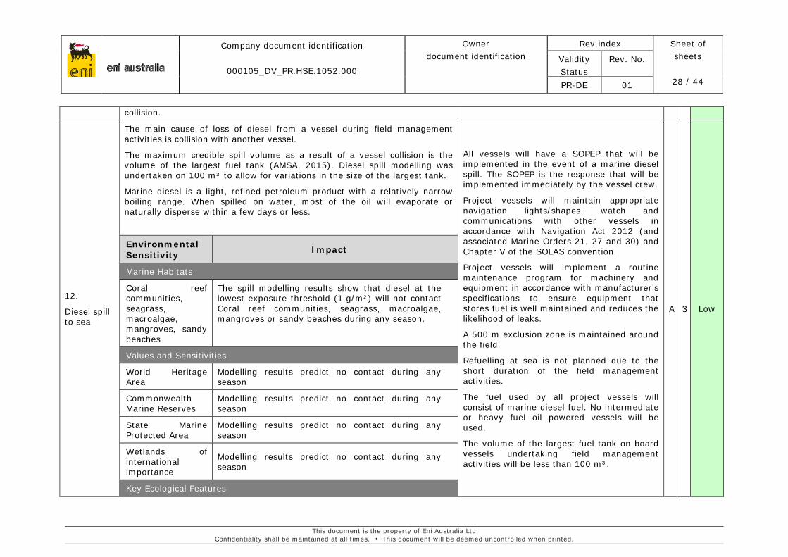
collision.
12.
Diesel spill to sea
The main cause of loss of diesel from a vessel during field management activities is collision with another vessel.
The maximum credible spill volume as a result of a vessel collision is the volume of the largest fuel tank (AMSA, 2015). Diesel spill modelling was undertaken on 100 m³ to allow for variations in the size of the largest tank.
Marine diesel is a light, refined petroleum product with a relatively narrow boiling range. When spilled on water, most of the oil will evaporate or naturally disperse within a few days or less.
Environmental Sensitivity Impact
Marine Habitats
Coral reef communities, seagrass, macroalgae, mangroves, sandy beaches
The spill modelling results show that diesel at the lowest exposure threshold (1 g/m²) will not contact Coral reef communities, seagrass, macroalgae, mangroves or sandy beaches during any season.
Values and Sensitivities
World Heritage Area
Modelling results predict no contact during any season
Commonwealth Marine Reserves
Modelling results predict no contact during any season
State Marine Protected Area
Modelling results predict no contact during any season
Wetlands of international importance
Modelling results predict no contact during any season
Key Ecological Features
All vessels will have a SOPEP that will be implemented in the event of a marine diesel spill. The SOPEP is the response that will be implemented immediately by the vessel crew.
Project vessels will maintain appropriate navigation lights/shapes, watch and communications with other vessels in accordance with Navigation Act 2012 (and associated Marine Orders 21, 27 and 30) and Chapter V of the SOLAS convention.
Project vessels will implement a routine maintenance program for machinery and equipment in accordance with manufacturer’s specifications to ensure equipment that stores fuel is well maintained and reduces the likelihood of leaks.
A 500 m exclusion zone is maintained around the field.
Refuelling at sea is not planned due to the short duration of the field management activities.
The fuel used by all project vessels will consist of marine diesel fuel. No intermediate or heavy fuel oil powered vessels will be used.
The volume of the largest fuel tank on board vessels undertaking field management activities will be less than 100 m³.
A 3 Low
eni australia
Company document identification
000105_DV_PR.HSE.1052.000
Owner document identification
Rev.index Sheet of sheets
29 / 44
Validity Status
Rev. No.
PR-DE 01
This document is the property of Eni Australia Ltd Confidentiality shall be maintained at all times. This document will be deemed uncontrolled when printed.
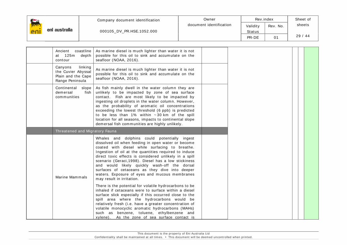
Ancient coastline at 125m depth contour
As marine diesel is much lighter than water it is not possible for this oil to sink and accumulate on the seafloor (NOAA, 2016).
Canyons linking the Cuvier Abyssal Plain and the Cape Range Peninsula
As marine diesel is much lighter than water it is not possible for this oil to sink and accumulate on the seafloor (NOAA, 2016).
Continental slope demersal fish communities
As fish mainly dwell in the water column they are unlikely to be impacted by zone of sea surface contact. Fish are most likely to be impacted by ingesting oil droplets in the water column. However, as the probability of aromatic oil concentrations exceeding the lowest threshold (6 ppb) is predicted to be less than 1% within ~30 km of the spill location for all seasons, impacts to continental slope demersal fish communities are highly unlikely.
Threatened and Migratory Fauna
Marine Mammals
Whales and dolphins could potentially ingest dissolved oil when feeding in open water or become coated with diesel while surfacing to breathe. Ingestion of oil at the quantities required to induce direct toxic effects is considered unlikely in a spill scenario (Geraci,1998). Diesel has a low stickiness and would likely quickly wash-off the dorsal surfaces of cetaceans as they dive into deeper waters. Exposure of eyes and mucous membranes may result in irritation.
There is the potential for volatile hydrocarbons to be inhaled if cetaceans were to surface within a diesel surface slick especially if this occurred close to the spill area where the hydrocarbons would be relatively fresh (i.e. have a greater concentration of volatile monocyclic aromatic hydrocarbons (MAHs) such as benzene, toluene, ethylbenzene and xylene). As the zone of sea surface contact is

eni australia
Company document identification
000105_DV_PR.HSE.1052.000
Owner document identification
Rev.index Sheet of sheets
30 / 44
Validity Status
Rev. No.
PR-DE 01
This document is the property of Eni Australia Ltd Confidentiality shall be maintained at all times. This document will be deemed uncontrolled when printed.
relatively small and diesel undergoes rapid dispersion and evaporation, impacts to marine mammals as a result of hydrocarbon inhalation are highly unlikely.
Any risk for dugongs would be related to direct ingestion of seagrass. However, diesel is not predicted to contact any seagrass habitat and undergoes rapid dispersion and evaporation, therefore significant impacts to dugongs are unlikely.
Marine Reptiles
Harmful effects may occur through ingestion of oil, inhalation of toxic vapours (e.g. close to the spill source) or irritation to the head, neck and flippers due to oil contact with the skin. Diesel is unlikely to stick to turtles since it has a low stickiness and would likely wash off skin surfaces.
Ingestion and inhalation of hydrocarbons is only expected to occur to animals in the immediate vicinity of the release location given the weathering characteristics of marine diesel. Given the very small predicted spill area, rapid weathering of diesel and the mobile nature of turtles this is unlikely to affect significant numbers.
The modelling results predict that no nesting beaches will be exposed to hydrocarbons in the event of a marine diesel spill.
Fish and Sharks
As fish and sharks dwell in the water column, the receptor pathway would most likely be through ingestion of or the coating of gill structures by the WAF. This could lead to respiratory problems or accumulation of hydrocarbons in tissues. In the worst instance this could lead to mortality, or sub-lethal stress.
As the predicted zone of exposure as a result of dissolved hydrocarbons is small, rapid weathering
eni australia
Company document identification
000105_DV_PR.HSE.1052.000
Owner document identification
Rev.index Sheet of sheets
31 / 44
Validity Status
Rev. No.
PR-DE 01
This document is the property of Eni Australia Ltd Confidentiality shall be maintained at all times. This document will be deemed uncontrolled when printed.
and dilution of diesel in the open ocean, and given the highly mobile nature of fish and sharks; any impacts would be acute and limited to small numbers in the immediate vicinity of the spill.
Seabirds and Shorebirds
Oil spills can have a variety of effects including fouling of the plumage, ingestion of oil, effects on reproduction and physical disturbance. Many of the species that occur offshore are surface-feeding or plunge-diving pelagic birds, so that oil slicks would potentially interfere with feeding and increase exposure risk.
Seabirds are expected to be present within the Operational Area and the ZPI but their presence is transient and sporadic. Hence population level impacts are unlikely.
Given the dispersive nature of diesel, the small predicted spill area and the fact that the majority of bird species are highly mobile, significant impacts as a result of an diesel spill are unlikely.
Socio-Economic Receptors
Commercial Fisheries
Temporary disruption to fishing activities may occur if the surface hydrocarbon plume or WAF moves through fishing areas. In the worst instance entrained oil could lead to loss of (or loss of function of) coastal intertidal habitat (e.g. seagrass meadows, mangrove communities, intertidal mudflats) which may provide nursery habitat for fishery species (e.g. fish and crustaceans). Given the low persistence of diesel and low volumes that could be released, any significant loss of function is highly unlikely.
Fisheries could be impacted through the contact of oil droplets on fish/invertebrate gill structures, the ingestion of oil by target species and/or the potential for entrained oil to interfere with the
eni australia
Company document identification
000105_DV_PR.HSE.1052.000
Owner document identification
Rev.index Sheet of sheets
32 / 44
Validity Status
Rev. No.
PR-DE 01
This document is the property of Eni Australia Ltd Confidentiality shall be maintained at all times. This document will be deemed uncontrolled when printed.
development of fish eggs and larvae. Given the low persistence and low potential volume of diesel released, any impacts would be unlikely and limited to a small number of fish in the immediate vicinity of the spill. No impacts are foreseen on a fish population or fisheries scale.
Interference to fishing operations may occur through damage to vessels and fishing gear, exclusion to areas during clean-up operations and any follow up monitoring and surveillance activities.
Commercial Shipping
The impact on shipping is the potential modification of shipping routes to avoid the area affected. These are not expected to be significant due to the expected rapid dispersion of diesel.
Other users
There is no tourism or recreational activities in the area.
Disruption of oil and gas activities is not expected, as the nearest gas production plant is 35 km west of the Operational Area and the modelling result predict that it will not be affected.
13.
Leaks from fittings and connections
Outboard fittings and connections on vessels include equipment control lines and ROV control hoses. In the event of a rupture, hydraulic fluid would be released. The maximum release volume is 20 litres; this is based on the hydraulic cylinder capacity of a heavy duty working class ROV.
The hydraulic fluid used during vessel operations is a water-based hydraulic fluid and has been classified under the Offshore Chemical Notification Scheme (OCNS) as Class D, which represents a low toxicity (CEFAS, 2016).
The release of hydraulic fluid from control lines or the ROV control hose during field management activities has the potential to result in a localised temporary reduction in water quality. Given the low predicted release volume, the low toxicity and rapid dilution of hydraulic oil in the marine environment, toxicity impacts to marine fauna are highly unlikely. Marine fauna in the open water environment are also highly mobile transient species, therefore it is highly unlikely they will be exposed to the spill for
ROV equipment shall be maintained in accordance with manufacturer’s instructions; and
Pre-dive ROV checks are undertaken prior to activity to ensure equipment is deemed acceptable for deployment.
B 2 Low
eni australia
Company document identification
000105_DV_PR.HSE.1052.000
Owner document identification
Rev.index Sheet of sheets
33 / 44
Validity Status
Rev. No.
PR-DE 01
This document is the property of Eni Australia Ltd Confidentiality shall be maintained at all times. This document will be deemed uncontrolled when printed.
periods long enough to cause toxicity impacts. Give the low volumes that may be released no impacts to commercial fisheries are predicted.
There are no significant marine habitats, or matters of NES in the predicted localised spill area.
14.
Oil spill response
While spill response activities are intended to reduce the potential environmental consequences of a hydrocarbon spill, response activities could potentially exacerbate or cause further environmental harm. Decisions regarding spill response activities need to consider both the potential environmental impacts associated with taking no action and the potential environmental impacts associated with a response activity or combination of spill response activities.
In the event of a hydrocarbon spill, the vessel master will implement available controls and resources of the Shipboard Oil Pollution Emergency Plan (SOPEP).
The Vessel Master is responsible for undertaking the initial SOPEP reporting requirements and immediate reporting to Eni Perth.
External notifications in the event of a level 1 or level 2 spills will be carried.
An oil spill response drill will be undertaken in accordance with SOPEP requirements on all vessels prior to conducting the activity and will be in accordance with testing requirements (including frequency) of the response arrangements.
In the event of a level 2 or 3 oil spill, Eni will initiate KSAT to collect satellite imagery of the slick on a daily basis.
In the event of a level 2 or 3 oil spill, Eni will mobilise aerial surveillance within 24 hours.
0 1 Low
eni australia
Company document identification
000105_DV_PR.HSE.1052.000
Owner document
identification
Rev. index. Sheet of
sheets 34 / 44
Validity Status
Rev. No.
PR-DE 01
This document is the property of Eni Australia Ltd Confidentiality shall be maintained at all times. This document will be deemed uncontrolled when printed.
6. ONGOING MONITORING OF ENVIRONMENTAL PERFORMANCE
Eni operates under an HSE Integrated Management System (IMS). This system provides a structured framework for applying corporate principles into a regional workable management system. The HSE IMS structure is based on five key elements: policy, planning, implementation and operation, monitoring and review.
Eni’s HSE IMS has achieved certification with ISO14001:2004 Environmental Management Systems. This certification provides audited assurance of a best practice environmental management system based on continual improvement.
Specific responsibilities identified with respect to environmental management arrangements (i.e. control implementation) are assigned in the accepted EP’s implementation strategy. This will help ensure that the environmental risks associated with the Activity are maintained at a level which is ALARP.
All Eni and contractor personnel will receive training on their environmental responsibilities in connection with the Activity. The environmental induction will instruct personnel on the issues and management actions identified in the EP.
Environmental performance outcomes have been defined for each environmental aspect; these are monitored and reviewed against key control measures, as evidenced in Table 5.6, to ensure environmental outcomes are achieved.
Monitoring of environmental performance will be undertaken in a number of ways, including the use of the following tools and systems:
• Risks and hazard registers will be reviewed on a regular basis including when there are significant changes in operations, in response to an incident or breach of the EP, and in any case at least annually.
Environmental incidents will be investigated to identify prevention measures. Incidents will be reviewed to promote on-going environmental awareness. The relevant Regulator (i.e. NOPSEMA or AMSA) will be notified of all reportable incidents.
Eni’s Management of Change (MoC) control process ensures changes to critical process or systems are properly and fully evaluated, planned, approved and documented, prior to implementation. This ensures changes have no detrimental effect on Health, Safety and Environment (HSE) and business risks.
The Eni Risk Management process will be applied to all MoC. Any new risk exposures identified will be added to the risk register and will go through the risk management process to put in place sufficient controls are in place to ensure risks are ALARP.
• Internal reporting, including daily (e.g. inspection logs) and as required (e.g. waste manifest, incident reports etc.);
Data on the routine emissions and discharges of the Activity will be collected by Eni to ensure that the control measures in place for the activity are met. Records will be stored by Eni for at least five years, in accordance with the OPGGS (E) Regulations.

eni australia
Company document identification
000105_DV_PR.HSE.1052.000
Owner document
identification
Rev. index. Sheet of
sheets 35 / 44
Validity Status
Rev. No.
PR-DE 01
This document is the property of Eni Australia Ltd Confidentiality shall be maintained at all times. This document will be deemed uncontrolled when printed.
• External reporting, such as regulatory reporting (e.g. Environmental Compliance Report);
An annual environmental report shall be submitted to NOPSEMA year. This will include all the information necessary to enable NOPSEMA to determine whether environmental performance outcomes and standards have been met, including monitoring data, compliance against the performance outcomes and control measures in this EP.
• Inspections;
The vessel for field management activities will be chosen in accordance with the Eni tendering process, which includes HSE qualification of the contractor and compliance with their HSE Plan which has been reviewed and considered acceptable by Eni. All vessels will comply with relevant Australian Maritime laws and regulations, including MARPOL 73/78.
Eni will undertake a vessel inspection prior to commencement of the field management activities The primary objective of the inspection is to ensure the requirements of this EP are being met.
• Auditing and assurance of operating facilities.
Non-conformances are managed to ensure the recording of the full nature and impact of the non-conformance, the preventative or corrective action required for its resolution (and to prevent future reoccurrence), the priority of the preventative / corrective actions, the most appropriate person is assigned the action, a suitable target completion date and any additional requirements to ensure the preventative or corrective action is effective.
Eni will also complete an annual compliance audit against the EP; the EP will be revised:
• Before the commencement of a new activity that is not provided for in this EP;
• Before the commencement of a significant modification to or new stage of the activity that is not provided for in this EP;
• Before or as soon as practicable after the occurrence if any new environmental impact or risk or any increase in environmental impact or risk not provided for in this EP;
• If a change in title holder will result in a change in the manner in which the environmental impacts and risks of an activity are managed, the new titleholder must submit a proposed revision of the environment plan for the activity as soon as practicable;
• If the regulator requests the titleholder to do so; or
• At least 14 days before the end of each period of 5 years.
eni australia
Company document identification
000105_DV_PR.HSE.1052.000
Owner document
identification
Rev. index. Sheet of
sheets 36 / 44
Validity Status
Rev. No.
PR-DE 01
This document is the property of Eni Australia Ltd Confidentiality shall be maintained at all times. This document will be deemed uncontrolled when printed.
7. OIL POLLUTION EMERGENCY PLAN (OPEP)
The environmental risk assessment for field management activities identified two potential spill scenarios:
• Vessel collision resulting in fuel tank rupture and release of diesel – (volume of largest fuel tank-maximum volume 100 m³); and
• Outboard leaks of hydraulic fluids (e.g. ROVs) Hydraulic fluid spill – maximum volume of 5 L.
All project vessels greater than 400 gross tonnes will carry a Shipboard Oil Pollution Emergency Plan as required by the International Maritime Organisation (IMO) under MARPOL 73/78 Annex I/ Marine Order 91. The SOPEP is the principal working document for the vessel crew in the event of a marine oil spill, and provides for the following specific management response provisions to mitigate and combat oil spills originating from vessels.
• The procedure to be followed by the Vessel Master to report an oil spill incident, the list of authorities to be contacted (i.e. AMSA Rescue Coordination Centre (RCC) and the oil spill details to be provided (i.e. forms).
• A detailed description of actions to be taken by the personnel onboard to reduce or control the discharge (actual or probable) following the incident (i.e. operational spill prevention);
• Roles and responsibilities of all personnel (Vessel Master, Radio Officer, Chief Officer, Chief Engineer, etc.) with respect to the particular oil spill incident;
• Procedures and point of contact on the vessel for coordinating shipboard activities with National and Local Authorities;
• Details of hydrocarbon spill response equipment held onboard the vessel;
• Vessel drawings (drainage and layout); and
• SOPEP testing and drill requirements.
The proposed vessel will have an IMO certified SOPEP.
If a ship-sourced hydrocarbon spill occurs within Commonwealth waters, AMSA is the designated Control Agency and will assume control of the incident and respond in accordance with the National Plan; and Eni will assume a Support Agency role and provide all available support to AMSA in AMSA’s performance of their Control Agency responsibilities.
A master services agreement is in place between Australian Marine Oil Spill Centre (AMOSC) and AMSA, enabling AMSA to hire equipment and personnel from AMOSC on in accordance with the National Plan. As a member company of AMOSC, Eni also has access to AMOSC’s oil spill recovery and response equipment, training, technical capabilities along with those resources held by member companies.
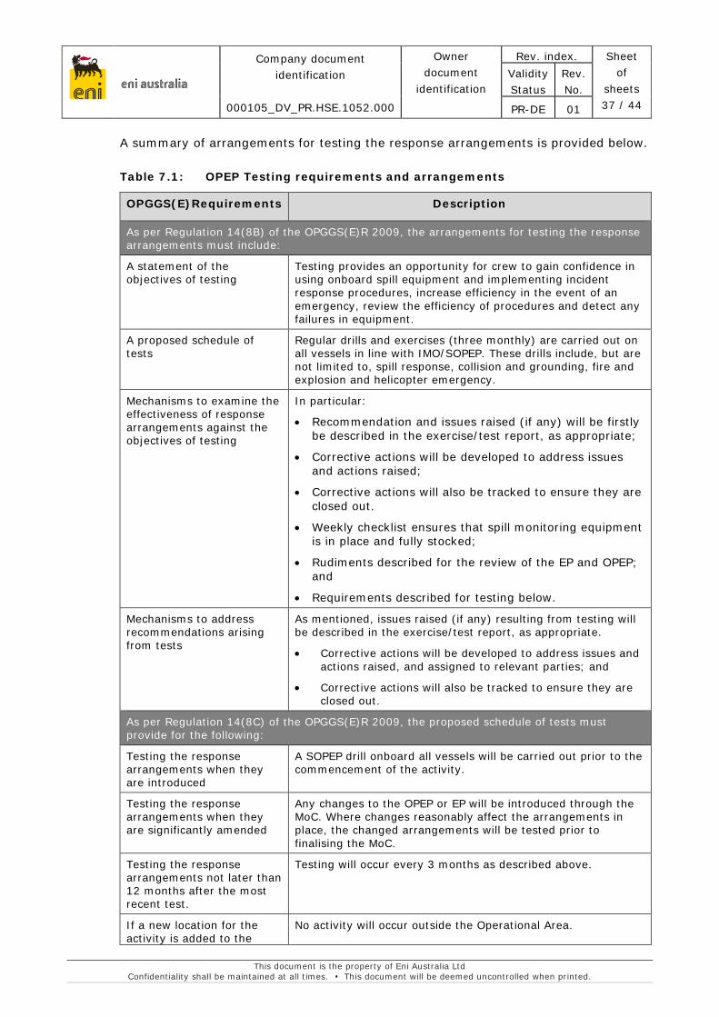
eni australia
Company document identification
000105_DV_PR.HSE.1052.000
Owner document
identification
Rev. index. Sheet of
sheets 37 / 44
Validity Status
Rev. No.
PR-DE 01
This document is the property of Eni Australia Ltd Confidentiality shall be maintained at all times. This document will be deemed uncontrolled when printed.
A summary of arrangements for testing the response arrangements is provided below.
Table 7.1: OPEP Testing requirements and arrangements
OPGGS(E)Requirements Description
As per Regulation 14(8B) of the OPGGS(E)R 2009, the arrangements for testing the response arrangements must include:
A statement of the objectives of testing
Testing provides an opportunity for crew to gain confidence in using onboard spill equipment and implementing incident response procedures, increase efficiency in the event of an emergency, review the efficiency of procedures and detect any failures in equipment.
A proposed schedule of tests
Regular drills and exercises (three monthly) are carried out on all vessels in line with IMO/SOPEP. These drills include, but are not limited to, spill response, collision and grounding, fire and explosion and helicopter emergency.
Mechanisms to examine the effectiveness of response arrangements against the objectives of testing
In particular:
• Recommendation and issues raised (if any) will be firstly be described in the exercise/test report, as appropriate;
• Corrective actions will be developed to address issues and actions raised;
• Corrective actions will also be tracked to ensure they are closed out.
• Weekly checklist ensures that spill monitoring equipment is in place and fully stocked;
• Rudiments described for the review of the EP and OPEP; and
• Requirements described for testing below.
Mechanisms to address recommendations arising from tests
As mentioned, issues raised (if any) resulting from testing will be described in the exercise/test report, as appropriate.
• Corrective actions will be developed to address issues and actions raised, and assigned to relevant parties; and
• Corrective actions will also be tracked to ensure they are closed out.
As per Regulation 14(8C) of the OPGGS(E)R 2009, the proposed schedule of tests must provide for the following:
Testing the response arrangements when they are introduced
A SOPEP drill onboard all vessels will be carried out prior to the commencement of the activity.
Testing the response arrangements when they are significantly amended
Any changes to the OPEP or EP will be introduced through the MoC. Where changes reasonably affect the arrangements in place, the changed arrangements will be tested prior to finalising the MoC.
Testing the response arrangements not later than 12 months after the most recent test.
Testing will occur every 3 months as described above.
If a new location for the activity is added to the
No activity will occur outside the Operational Area.
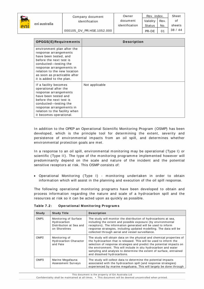
eni australia
Company document identification
000105_DV_PR.HSE.1052.000
Owner document
identification
Rev. index. Sheet of
sheets 38 / 44
Validity Status
Rev. No.
PR-DE 01
This document is the property of Eni Australia Ltd Confidentiality shall be maintained at all times. This document will be deemed uncontrolled when printed.
OPGGS(E)Requirements Description
environment plan after the response arrangements have been tested, and before the next test is conducted—testing the response arrangements in relation to the new location as soon as practicable after it is added to the plan.
If a facility becomes operational after the response arrangements have been tested and before the next test is conducted—testing the response arrangements in relation to the facility when it becomes operational.
Not applicable
In addition to the OPEP an Operational Scientific Monitoring Program (OSMP) has been developed, which is the principle tool for determining the extent, severity and persistence of environmental impacts from an oil spill, and determines whether environmental protection goals are met.
In a response to an oil spill, environmental monitoring may be operational (Type I) or scientific (Type II). The type of the monitoring programme implemented however will predominantly depend on the scale and nature of the incident and the potential sensitive receptors at risk. This OSMP consists of:
• Operational Monitoring (Type I) - monitoring undertaken in order to obtain information which will assist in the planning and execution of the oil spill response.
The following operational monitoring programs have been developed to obtain and process information regarding the nature and scale of a hydrocarbon spill and the resources at risk so it can be acted upon as quickly as possible.
Table 7.2: Operational Monitoring Programs
Study Study Title Description
OMP1 Monitoring of Surface Hydrocarbon Distribution at Sea and on Shorelines
The study will monitor the distribution of hydrocarbons at sea, including the extent and possible exposure (by environmental receptors). The information generated will be used to inform response strategies, including updated modelling. The data will be collected through aerial and vessel surveillance.
OMP2 Monitoring of Hydrocarbon Character and Fate
The study will obtain data on the physical and chemical properties of the hydrocarbon that is released. This will be used to inform the selection of response strategies and predict the potential impacts on the environment. This will include in situ hydrocarbon and water sampling and analysis to determine the extent of surface, entrained and dissolved hydrocarbons.
OMP3 Marine Megafauna Assessment Surveys
The study will collect data to determine the potential impacts associated with the hydrocarbon spill (and response strategies) experienced by marine megafuana. This will largely be done through
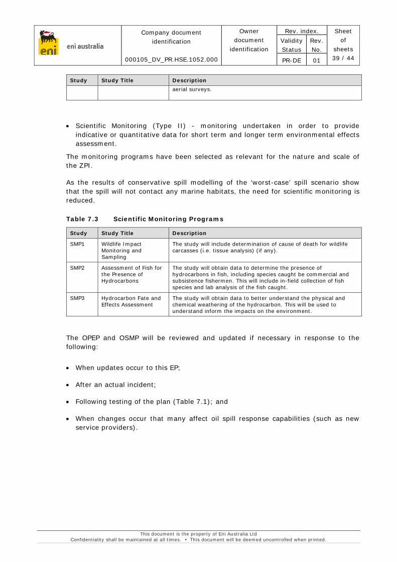
eni australia
Company document identification
000105_DV_PR.HSE.1052.000
Owner document
identification
Rev. index. Sheet of
sheets 39 / 44
Validity Status
Rev. No.
PR-DE 01
This document is the property of Eni Australia Ltd Confidentiality shall be maintained at all times. This document will be deemed uncontrolled when printed.
Study Study Title Description aerial surveys.
• Scientific Monitoring (Type II) - monitoring undertaken in order to provide indicative or quantitative data for short term and longer term environmental effects assessment.
The monitoring programs have been selected as relevant for the nature and scale of the ZPI.
As the results of conservative spill modelling of the ‘worst-case’ spill scenario show that the spill will not contact any marine habitats, the need for scientific monitoring is reduced.
Table 7.3 Scientific Monitoring Programs
Study Study Title Description
SMP1 Wildlife Impact Monitoring and Sampling
The study will include determination of cause of death for wildlife carcasses (i.e. tissue analysis) (if any).
SMP2 Assessment of Fish for the Presence of Hydrocarbons
The study will obtain data to determine the presence of hydrocarbons in fish, including species caught be commercial and subsistence fishermen. This will include in-field collection of fish species and lab analysis of the fish caught.
SMP3 Hydrocarbon Fate and Effects Assessment
The study will obtain data to better understand the physical and chemical weathering of the hydrocarbon. This will be used to understand inform the impacts on the environment.
The OPEP and OSMP will be reviewed and updated if necessary in response to the following:
• When updates occur to this EP;
• After an actual incident;
• Following testing of the plan (Table 7.1); and
• When changes occur that many affect oil spill response capabilities (such as new service providers).
eni australia
Company document identification
000105_DV_PR.HSE.1052.000
Owner document
identification
Rev. index. Sheet of
sheets 40 / 44
Validity Status
Rev. No.
PR-DE 01
This document is the property of Eni Australia Ltd Confidentiality shall be maintained at all times. This document will be deemed uncontrolled when printed.
8. CONSULTATION
Eni have undertaken petroleum activities in the Woollybutt field since 2002, therefore Eni considers stakeholders, including marine users, well informed regarding the location of the field and associated infrastructure. On assessment of activities covered by this EP, Eni believes there will be no increased risk or impact to stakeholders as a result of field management activities.
Eni has consulted with relevant stakeholders regarding planned field management activities as part of larger scale consultation regarding the Woollybutt Field Plug and Abandonment and decommissioning activities. This will assist in combating stakeholder fatigue and ensuring stakeholders are well informed of the wider scope of activities at the location.
Eni has allowed each relevant person a reasonable period for assessing consultation material provided. No concerns or objections were received from stakeholders in relation to the proposed field management activities.
Table 8.1: Consultation summary and assessment
Stakeholder Consultation assessment AFMA No objection or concern has been raised by AFMA in relation to field
management activities such as ROV surveys. However, in 2015 AFMA expressed a preference for the complete removal of subsea equipment and requested that industry operators in the area are consulted with respect to insitu abandonment. Eni recognises that a response had not been provided to in response to the AFMA email expressing a preference for complete removal. As Eni is continuing to assess decommissioning options and the eventual fate of the infrastructure, Eni will continue conversations with AFMA and other interested parties regarding removal of subsea equipment when planning final decommissioning.
AMSA AMSA has requested notification for promulgation of Auscoast warnings only when activities exceed four weeks duration or will occur outside the 500m exclusion zone. Activities will not exceed four weeks in duration. If activities are expected occur outside of the exclusion zone, Eni will notify AMSA’s Joint Rescue Coordination Centre (JRCC). No objection or concern has been raised by AMSA in relation to field management activities such as ROV surveys.
DOF As Eni is continuing to assess decommissioning options and the eventual fate of the infrastructure, Eni will continue conversations with DoF regarding removal of subsea equipment for future approvals. Key issues raised by DoF include fish spawning and aggregation times in the area, pollution emergency plans, biosecurity. Eni has responded to consultation addressing each of these key issues in the EP.
eni australia
Company document identification
000105_DV_PR.HSE.1052.000
Owner document
identification
Rev. index. Sheet of
sheets 41 / 44
Validity Status
Rev. No.
PR-DE 01
This document is the property of Eni Australia Ltd Confidentiality shall be maintained at all times. This document will be deemed uncontrolled when printed.
Stakeholder Consultation assessment Western Australian Fishing Industry Council (WAFIC)
WAFIC has been kept well informed regarding activities in the Woollybutt Field in permit WA-25-L. No objection or concern has been raised by WAFIC in relation to field management activities such as ROV surveys. Eni will continue conversations with WAFIC regarding decommissioning activities.
The following additional stakeholders have been kept well informed regarding activities in the Woollybutt Field in permit WA-25-L and no objection or concern has been raised in relation to field management activities: Australian Hydrographic Survey (AHS), Austral Fisheries, Commonwealth Fisheries Association (CFA), Department of Mines and Petroleum (DMP), Department of Defence (DOD), Department of the Environment (DotE), Department of Parks and Wildlife (DPaW), Recfishwest, Kailis Bros., A Raptis and Sons, Westmore Seafoods (Seafresh Holdings), Mackerel Managed Fishery, Onslow Prawn Fishery, Pilbara Trawl Fishery, Pilbara Line Fishery, Pilbara Trap Fishery.
Eni concludes all relevant stakeholders have been well informed of upcoming activities in the Woollybutt field through ongoing discussions regarding decommissioning and field management activities.
Given the five year duration of this EP, if it is determined as part of the MOC process that there will be a change to risk or impact to stakeholders as a result of field management activities, Eni commits to keeping stakeholders informed by distributing updated consultation material or notifications.

eni australia
Company document identification
000105_DV_PR.HSE.1052.000
Owner document
identification
Rev. index. Sheet of
sheets 42 / 44
Validity Status
Rev. No.
PR-DE 01
This document is the property of Eni Australia Ltd Confidentiality shall be maintained at all times. This document will be deemed uncontrolled when printed.
9. CONTACT DETAILS
The nominated contact person for this proposal is:
Tom Coolican
Deputy Operations and Production Manager
Eni Australia Ltd
Tel: (08) 9320 2639
Email: [email protected]

eni australia
Company document identification
000105_DV_PR.HSE.1052.000
Owner document
identification
Rev. index. Sheet of
sheets 43 / 44
Validity Status
Rev. No.
PR-DE 01
This document is the property of Eni Australia Ltd Confidentiality shall be maintained at all times. This document will be deemed uncontrolled when printed.
10. REFERENCES
Australian Maritime Safety Authority (AMSA) (2015). Technical guidelines for preparing contingency plans for marine and coastal facilities
Baker, C.S., and Herman, L.M. (1989). Behavioural responses of summering humpback whales to vessel traffic: experimental and opportunistic observations. Final Report to the National Park Service. US Department of the Interior, Anchorage, AK.
Black, K.P., G.W. Brand, H. Grynberg, D. Gwythe, L.S. Hammond, S. Mourtikas, B.J. Richardson and J.A. Wardrop (1994). Production Activities. Pages 209-407 In: J.M. Swan, J.M. Neff, and P.C. Young, eds., Environmental Implications of Offshore Oil and Gas Development In Australia Findings of an Independent Scientific Review. Australian Petroleum Production and Exploration Association, Canberra, Australia.
Centre for Environment, Fisheries and Aquaculture Science (CEFAS). (2016). Offshore Chemical Notification Scheme (OCNS). Chemical Hazard and Risk Management (CHARM). Online resource, accessed on 19 September 2016 at: https://www.cefas.co.uk/cefas-data-hub/offshore-chemical-notification-scheme/
Commonwealth of Australia (2012). Marine bioregional plan for the North-west Marine Region, prepared under the Environment Protection and Biodiversity Conservation Act 1999, Department of Sustainability, Environment, Water, Population and Communities.
Currie, D.R., Isaacs, L.R., (2004). Impact of exploratory offshore drilling on benthic communities in the Minerva gas field, Port Campbell, Australia.
Department of the Environment and Energy (DoEE) (2016). World Heritage Places – The Ningaloo Coast – World Heritage Values. Australian Government. <https://www.environment.gov.au/heritage/places/world/ningaloo/values> Viewed online 15 September 2016.
Department of the Environment and Energy (DoEE) (2016b). Biologically important areas of regionally significant marine species. < https://www.environment.gov.au/marine/marine-species/bias > viewed online: 18 September 2016.
Department of the Environment (DotE) (2016). EPBC Act Protected Matters Report. Australian Government. Report Created 15/09/16 16:52:00, Commonwealth of Australia.
Falkner, I., Whiteway, T., Przeslawski, R. and Heap, A.D. (2009). Review of Ten Key Ecological Features (KEFs) in the North-west Marine Region. Geoscience Australia, Record 2009/13. Geoscience Australia, Canberra. 117pp
Geraci, J. (1998) Physiological and toxicological effects of cetaceans, in:Geraci J., St Aubin, D. (Eds.) Synthesis of Effect of Oil on Marine Mammals , OCS Study, Department of Interior, Ventura, pp.168-202
eni australia
Company document identification
000105_DV_PR.HSE.1052.000
Owner document
identification
Rev. index. Sheet of
sheets 44 / 44
Validity Status
Rev. No.
PR-DE 01
This document is the property of Eni Australia Ltd Confidentiality shall be maintained at all times. This document will be deemed uncontrolled when printed.
Hatch, L.T. and Southall, B.L. (2009). Module 5: Shipping. In: Overview of the impacts of anthropogenic underwater sound in the marine environment. OSPAR Commission, OSPAR Secretariat, London.
Hazel J, Lawler IR, Marsh H and Robson S (2007). Vessel speed increases collision risk for the green turtle Chelonia mydas. Endangered Species Research, 3: 105–113.
Meike, S., Castro, C., Gonzalez, J., and Williams, R. (2004). Behavioural responses of humpback whales (Megaptera novaeangliae) to whale watching boats near Isla de la Plata, Machalilla National Park, Ecuador, Journal of Cetacean Research and Management, vol. 6, no. 1, pp. 63-68.
McCauley, R.D. (1998) Radiated underwater noise measured from the drilling rig Ocean General, rig tenders Pacific Ariki and Pacific Frontier, fishing vessel Reef Venture and natural sources in the Timor Sea, Northern Australia. Report to Shell Australia.
Nedwell, J.R and Edwards, B. (2004). A review of underwater man-made noise carried out by Subacoustech Ltd., 1993 – 2003. Subacoustech Report Ref: 543R0109.
Neptune (2014). Woollybutt Decommissioning Bathymetric and NORMs Survey Results Report. Unpublished report Prepared for Eni. RepORt No.: J1922-RR-001 Rev 0 Date: 12/11/2104.
NOAA (2016) Office of Response and Restoration; Characteristics of Small Diesel Spills http://response.restoration.noaa.gov/oil-and-chemical-spills/oil-spills/resources/small-diesel-spills.html viewed online 21 September 2016
Pendoley, K.L. (2005). Sea turtles and the environmental management of industrial activities in north-west Western Australia. Ph.D. Thesis. PhD Thesis, Murdoch University: Perth.
Southall, B. L., A. E. Bowles, W. T. Ellison, J. J. Finneran, R. L. Gentry, C. R. Greene Jr., D. Kastak, D. R. Ketten, J. H. Miller, P. E. Nachtigall, W. J. Richardson, J. A. Thomas, and P. L. Tyack. (2007). Marine mammal noise exposure criteria: Initial scientific recommendations. Aquatic Mammals 33: 411-521.
United Nations Educational, Scientific and Cultural Organisation (UNESCOb) (2016). Komodo National Park. <http://whc.unesco.org/en/list/609> Viewed online 20 September 2016.
Walker, D.I., and McComb, A.J. (1990). Salinity response of the seagrass Amphibolus Antarctica: an experimental validation of field results. Aquatic Botany 36:359-366.