induced seismicity report
TRANSCRIPT

POTENTIAL FOR INDUCED SEISMICITY RELATED TO THE NORTHERN CALIFORNIA CO2 REDUCTION PROJECT PILOT TEST,
SOLANO COUNTY, CALIFORNIA
Larry Myer1, Laura Chiaramonte2, Thomas M. Daley1, Daniel Wilson3, William Foxall2, and John Henry Beyer1
1 Lawrence Berkeley National Laboratory, Berkeley, CA 94720 2 Lawrence Livermore National Laboratory, Livermore, CA
3 Daniel Wilson & Associates, Houston, TX
June 15, 2010
Contact:
John Henry Beyer Lawrence Berkeley National Laboratory
Earth Sciences Division One Cyclotron Road, MS 90-1116
Berkeley, CA 94720 Tel: 510-486-7954
Email: [email protected]
POTENTIAL FOR INDUCED SEISMICITY RELATED TO THE NORTHERN CALIFORNIA CO2 REDUCTION PROJECT PILOT TEST,
SOLANO COUNTY, CALIFORNIA
Larry Myer1, Laura Chiaramonte2, Thomas M. Daley1, Daniel Wilson3, William Foxall2, and John Henry Beyer1*
1 Lawrence Berkeley National Laboratory, Berkeley, CA 94720
2 Lawrence Livermore National Laboratory, Livermore, CA 3 Daniel Wilson & Associates, Houston, TX
June 15, 2010
Executive Summary
The objective of this technical report is to analyze the potential for induced seismicity due to a proposed small-scale CO2 injection project in the Montezuma Hills. We reviewed currently available public information, including 32 years of recorded seismic events, locations of mapped faults, and estimates of the stress state of the region. We also reviewed proprietary geological information acquired by Shell, including seismic reflection imaging in the area, and found that the data and interpretations used by Shell are appropriate and satisfactory for the purpose of this report.
The closest known fault to the proposed injection site is the Kirby Hills Fault. It appears to be active, and microearthquakes as large as magnitude 3.7 have been associated with the fault near the site over the past 32 years. Most of these small events occurred 9-17 miles (15-28 km) below the surface, which is deep for this part of California. However, the geographic locations of the many events in the standard seismicity catalog for the area are subject to considerable uncertainty because of the lack of nearby seismic stations; so attributing the recorded earthquakes to motion along any specific fault is also uncertain. Nonetheless, the Kirby Hills Fault is the closest to the proposed injection site and is therefore our primary consideration for evaluating the potential seismic impacts, if any, from injection. Our planned installation of seismic monitoring stations near the site will greatly improve earthquake location accuracy.
Shell seismic data also indicate two unnamed faults more than 3 miles east of the project site. These faults do not reach the surface as they are truncated by an unconformity at a depth of about 2,000 feet (610 m). The unconformity is identified as occurring during the Oligocene Epoch, 33.9–23.03 million years ago, which indicates that these faults are not currently active. Farther east are the Rio Vista Fault and Midland Fault at distances of about 6 miles (10 km) and 10 miles (16 km), respectively. These faults have been identified as active during the Quaternary (last 1.6 million years), but without evidence of displacement during the Holocene (the last 11,700 years).
* Short biographies of authors are provided in Appendix 1.
1

The stress state (both magnitude and direction) in the region is an important parameter in assessing earthquake potential. Although the available information regarding the stress state is limited in the area surrounding the injection well, the azimuth of the mean maximum horizontal stress is estimated at 41° and it is consistent with strike-slip faulting on the Kirby Hills Fault, unnamed fault segments to the south, and the Rio Vista Fault. However, there are large variations (uncertainty) in stress estimates, leading to low confidence in these conclusions regarding which fault segments are optimally oriented for potential slip induced by pressure changes. Uncertainty in the stress state can be substantially reduced by measurements planned when wells are drilled at the site.
Injection of CO2 at about two miles depth will result in a reservoir fluid pressure increase, which is greatest at the well and decreases with distance from the well. After the injection stops, reservoir fluid pressures will decrease rapidly. Pressure changes have been predicted quantitatively by numerical simulation models of the injection. Based on these models, the pressure increase on the Kirby Hills Fault at its closest approach to the well due to the injection of 6,000 metric tons of CO2 would be a few pounds per square inch (psi), which is a tiny fraction of the natural pressure of approximately 5,000 psi at that depth. The likelihood of such a small pressure increase triggering a slip event is very small. It is even more unlikely that events would be induced at the significantly greater depths where most of the recorded earthquakes are concentrated, because it is unlikely that such a small pressure pulse would propagate downwards any appreciable distance.
Therefore, in response to the specific question of the likelihood of the CO2 injection causing a magnitude 3.0 (or larger) event, this preliminary analysis suggests that no such induced or triggered events would be expected. However, it is possible that a fault, too small to be detected by the existing seismic data, yet sufficiently large to cause a magnitude 3 event, could exist in close proximity to the injection point where the pressure increase could cause slippage. However, the existence of such a fault would be detectable in the data planned for collection from the well prior to injection. We do note that natural earthquake events of up to 3.7 in magnitude have occurred in this area and would be expected to occur again regardless of the proposed CO2 injection.
To reduce the uncertainties discussed above, we recommend (1) installing a seismic monitoring network to record natural and possible induced seismic activity before, during, and after CO2 injection; (2) collecting well log data and core samples from the wells to assess the in-situ stress state and fracturing near the wells; (3) using this information to refine operating procedures to minimize the risk of significant induced seismicity and develop a protocol for mitigation should it occur; (4) conducting geomechanical analyses and developing a probabilistic seismic hazard analysis (PSHA) during and after injection; (5) as the project progresses, relocating microearthquakes in the Northern California Seismic Network catalog, calculating focal mechanisms where possible, and improving characterization of the Kirby Hills Fault; and (6) evaluating PSHA results for the Montezuma Hills area.
2

Introduction
The objective of this report is to analyze the potential for induced seismicity due to a proposed small-scale CO2 injection project in the Montezuma Hills. To address this question, it is necessary to understand the present-day stress state, its relationship with the preexisting faults in the area, and the effects of pressure changes resulting from injection activities. Therefore, currently available information on faults and the stress state in this region has been assembled and used in conjunction with preliminary simulation data to assess the potential for slip on the preexisting faults. Finally, recommendations are made for specific actions to address the potential for induced seismicity due to injection operations.
Faults in the Vicinity of the Montezuma Hills
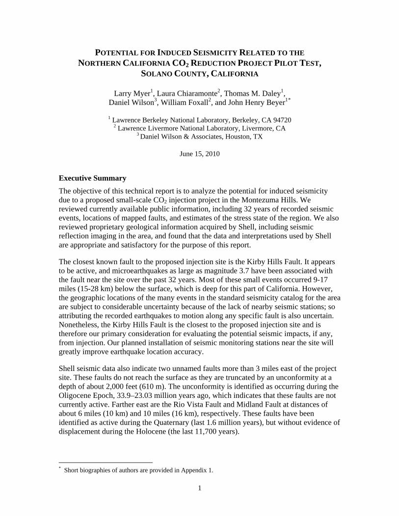
Figure 1 shows mapped faults in the vicinity of the proposed small-scale injection project. Information is reproduced from the California fault map compiled by the California Geological Survey (CGS) (Jennings and Bryant, 2010; http://www.consrv.ca.gov/cgs/cgs_history/Pages/2010_faultmap.aspx), which is the state agency responsible for assessing the natural seismic hazard potential throughout California. Also shown are a small subsurface fault, the Sherman Island Fault, and the blind Midland fault, both identified in a report on the probabilistic seismic hazard analysis (PSHA) supporting the California Department of Water Resources Delta Risk Management Strategy (DRMS) (URS Corporation/Jack R. Benjamin & Associates, 2007).
Kirby Hills Fault
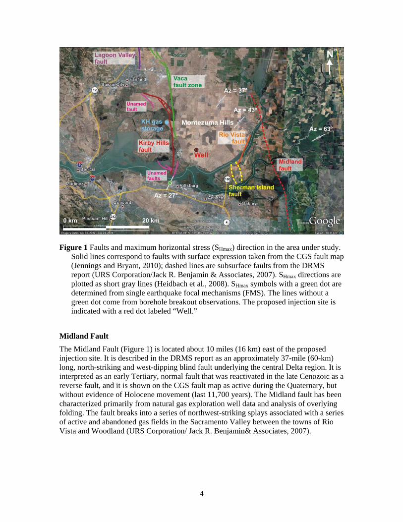
The trace of the Kirby Hills Fault (KHF) on the CGS fault map is located approximately 3 miles (5 km) west of the proposed injection site (Figure 1). The CGS map characterizes the KHF as active during the Quaternary (last 1.6 million years), but finds no evidence of surface displacement along the fault trace since the early Quaternary period (at least 700,000 years ago) (Jennings and Bryant, 2010). (The Vaca fault immediately to the north is shown as active during the last 700,000 years.) However, based on seismic reflection data along the Sacramento River and on microseismicity, Parsons et al. (2002) concluded that the KHF zone has been recently active at depth, predominantly in a strike-slip (SS) direction, and along a fault plane that dips 80º–85º east. The DRMS report characterizes the KHF as active in the Holocene (last 11,700 years). Figure 2 shows the earthquakes recorded by the USGS/UC Berkeley Northern California Seismic Network (NCSN) between 1974 and 2001, relocated by Parsons et al. and assumed to be associated with the KHF zone. Microearthquake focal mechanisms presented by Parsons et al. (2002) reveal both strike-slip and reverse components of fault slip, with the reverse component increasing to the north of the proposed injection well location. The majority of the earthquake hypocenters located by Parsons et al. lie between 9 and 17 miles (15 and 28 km) in depth, which is unusually deep for this region of California.
3
Montezuma Hills
Figure 1 Faults and maximum horizontal stress (SHmax) direction in the area under study. Solid lines correspond to faults with surface expression taken from the CGS fault map (Jennings and Bryant, 2010); dashed lines are subsurface faults from the DRMS report (URS Corporation/Jack R. Benjamin & Associates, 2007). SHmax directions are plotted as short gray lines (Heidbach et al., 2008). SHmax symbols with a green dot are determined from single earthquake focal mechanisms (FMS). The lines without a green dot come from borehole breakout observations. The proposed injection site is indicated with a red dot labeled “Well.”
Midland Fault
The Midland Fault (Figure 1) is located about 10 miles (16 km) east of the proposed injection site. It is described in the DRMS report as an approximately 37-mile (60-km) long, north-striking and west-dipping blind fault underlying the central Delta region. It is interpreted as an early Tertiary, normal fault that was reactivated in the late Cenozoic as a reverse fault, and it is shown on the CGS fault map as active during the Quaternary, but without evidence of Holocene movement (last 11,700 years). The Midland fault has been characterized primarily from natural gas exploration well data and analysis of overlying folding. The fault breaks into a series of northwest-striking splays associated with a series of active and abandoned gas fields in the Sacramento Valley between the towns of Rio Vista and Woodland (URS Corporation/ Jack R. Benjamin& Associates, 2007).
4

Figure 2: Kirby Hills Fault zone and associated seismicity from 1974–2001, recorded by
the Northern California Seismic Network and relocated by Parsons et al. (2002). The proposed well site is shown by a green square.
Sherman Island/Rio Vista Fault Zone
The Sherman Island fault zone, at its closest point, is located approximately 5 miles (8 km) southeast of the proposed injection site (Figure 1). According to the DRMS report, this fault has been identified only in the subsurface and was active in late Cretaceous-early Tertiary time. To date, the fault has not been studied for evidence of Quaternary reactivation. The CGS fault map shows the Rio Vista fault at the same location as the Sherman Island fault, but the Rio Vista fault appears to have a different strike than that of the Sherman Island fault. CGS identifies the Rio Vista fault as active during the Quaternary, but without evidence of Holocene movement (last 11,700 years).
Montezuma Hills Fault
A geomorphic feature trending NNW-SSE along the southwestern edge of the Montezuma Hills is identified as the “Montezuma Hills Fault” in a California Division of Mines and Geology (DMG) report (1983). However, DMG Fault Evaluation Report FER-136 (1982) cites evidence from geophysical surveys, boreholes, and trench excavations that the feature is likely erosional, resulting from a meander of the Sacramento River. As a result of this evidence, William A. Bryant, a lead author of both reports, said that the feature is not shown on subsequent CGS fault maps. Upon seeing the seismic profile shown in Figure 4 below, Bryant said that this corroborates the interpretation that the Montezuma Hills “Fault” is, in fact, an erosional feature (Bryant, 2010).
5
Unnamed Buried Faults
As discussed in the Seismic Data Interpretation section below, two faults were detected at least 3 miles east of the project area by Shell’s east-west trending 2D seismic line. They are not shown on geologic maps because they do not reach the surface.
Natural Seismicity in the Project Area
The microearthquakes relocated by Parsons et al. (2002) and assumed to be associated with the KHF zone (Figure 2) were discussed above. Figure 3 shows the NCSN catalog locations of magnitude 2.5 and greater earthquakes within the area immediately surrounding the project site for the period January 1, 1978, through January 28, 2010. The largest event recorded within the area during this period has a catalog magnitude of 3.7 and depth of 22 km (14 miles). Preliminary examination of the recorded NCSN data indicates that the uncertainties in many of the catalog locations may be relatively large, due primarily to the scarcity of recording stations in the surrounding area, particularly to the east of the injection site (Figure 3). Therefore, a focused study of the locations and mechanisms of the better recorded events should be carried out to better define the relationship of the microearthquakes to the KHF in the immediate vicinity of the site. The largest earthquake recorded in the larger area considered by Parsons et al. (Figure 2) was M 4.3. This event was located at a depth of 20 km (12 miles) below the confluence of the San Joaquin and Sacramento Rivers.
Figure 3. Seismicity with magnitude of at least 2.5 for the period 1/1/78-1/28/10 (red dots) in the area surrounding the injection site (green square) from the NCSN catalog. The largest event had a magnitude of 3.7. Blue triangles are NCSN recording stations.
6
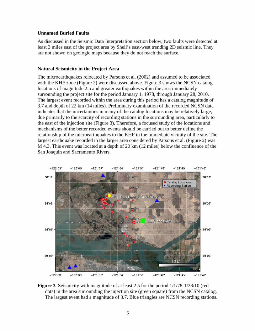
Seismic Data Interpretation
Shell developed an initial model of the subsurface geologic structure in the vicinity of the project based in part on an internal interpretation of twenty 2D seismic lines. LBNL has carried out an independent analysis of the seismic data and concurs with the Shell interpretation. As shown in Figure 4, the seismic data indicate that the structures closest to the proposed injection well are two unnamed faults (labeled Fault A and Fault B), and the Kirby Hills Fault.
Figure 4: Top: Views of Shell’s 3-D geologic model based on offset well log data and twenty 2-D seismic lines showing the Kirby Hills Fault, buried Fault A and Fault B, and site of proposed well. Bottom: Shell’s east-west 2D seismic line, which passes about 1,700 feet (520 m) south of the proposed well location, showing interpreted Kirby Hills Fault Zone and buried Faults A and B. This model and all the seismic data were reviewed by Daniel Wilson, one of the report authors; he concurs with Shell’s analysis and interpretation of the data.
7

Fault A is more than 3 miles (5 km) from the proposed injection well at reservoir depth. Neither Fault A nor Fault B reach the surface as they are truncated by an unconformity at a depth of about 2,000 feet (610 m). The unconformity is identified as occurring during the Oligocene Epoch, 33.9–23.03 million years ago. Since the faults do not extend into the formations overlying the unconformity, it indicates that these faults have not been active since the Oligocene. Both faults trend toward the Sherman Island fault, but further work is required to evaluate their possible relationship to the Sherman Island Fault. The seismic data also show that the Kirby Hills Fault is about 3 miles (5 km) from the proposed injection well at reservoir depth. The primary indicator of the Kirby Hills Fault in the seismic data is a “wash-out” of the seismic signals (similar to the expression of the fault in the seismic data along the Sacramento River presented by Parsons et al. [2002]). Improved delineation would require acquisition of additional seismic data.
Stress State
Limited information on the present day stress state was found for this area. Orientations of the maximum horizontal stress were compiled from the World Stress Map (Heidbach et al., 2008). The mean maximum horizontal stress (SHmax) azimuth is 41°. Measured values (Figure 1) near the proposed pilot well are 20°, 27°, 37°, 43°, 54° and 63°. These orientations were estimated from single focal mechanisms (FMS) (short gray lines with green dot in Figure 1) and borehole breakouts (short gray lines). The FMS analyses also indicated a strike slip (SS) stress regime. Dr. Haibin Xu from Shell performed a Fracture Pressure Prediction study and found indications from leak-off tests and seismic observations of offsets on the faults that the stress state could accommodate reverse faulting (RF regime) at the surface and strike slip (SS regime) at depth (Xu, 2010). The limited available information regarding the stress state indicates that the area surrounding the injection well could be an oblique faulting SS/RF environment, consistent with the focal mechanism solutions reported by Parsons et al. (2002). Uncertainty in the stress state can be substantially reduced by measurements made when the proposed well is drilled.
Relationship Between Faults and In situ Stress
Knowledge of the orientation of the in situ stresses enables identification of faults that are most prone to movement under that stress regime. This is the first step in evaluating the likelihood of fault movement, which also requires an analysis of the magnitude of stress change required to cause movement on a fault. Under a strike slip (SS) stress state, faults oriented approximately ±30° from the SHmax direction are most prone to slip. Under a reverse faulting (RF) environment, the optimal fault orientation for movement is sub-perpendicular to the SHmax direction (Zoback, 2007). However, there are certain values of the in situ stress tensor that correspond to both SS and RF regimes. If a region is characterized by an SS/RF state of stress, then faults having multiple orientations could be prone to movement at the same time.
8
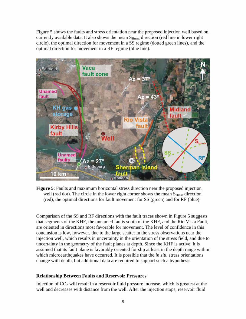
Figure 5 shows the faults and stress orientation near the proposed injection well based on currently available data. It also shows the mean SHmax direction (red line in lower right circle), the optimal direction for movement in a SS regime (dotted green lines), and the optimal direction for movement in a RF regime (blue line).
Figure 5: Faults and maximum horizontal stress direction near the proposed injection well (red dot). The circle in the lower right corner shows the mean SHmax direction (red), the optimal directions for fault movement for SS (green) and for RF (blue).
Comparison of the SS and RF directions with the fault traces shown in Figure 5 suggests that segments of the KHF, the unnamed faults south of the KHF, and the Rio Vista Fault, are oriented in directions most favorable for movement. The level of confidence in this conclusion is low, however, due to the large scatter in the stress observations near the injection well, which results in uncertainty in the orientation of the stress field, and due to uncertainty in the geometry of the fault planes at depth. Since the KHF is active, it is assumed that its fault plane is favorably oriented for slip at least in the depth range within which microearthquakes have occurred. It is possible that the in situ stress orientations change with depth, but additional data are required to support such a hypothesis.
Relationship Between Faults and Reservoir Pressures
Injection of CO2 will result in a reservoir fluid pressure increase, which is greatest at the well and decreases with distance from the well. After the injection stops, reservoir fluid
9
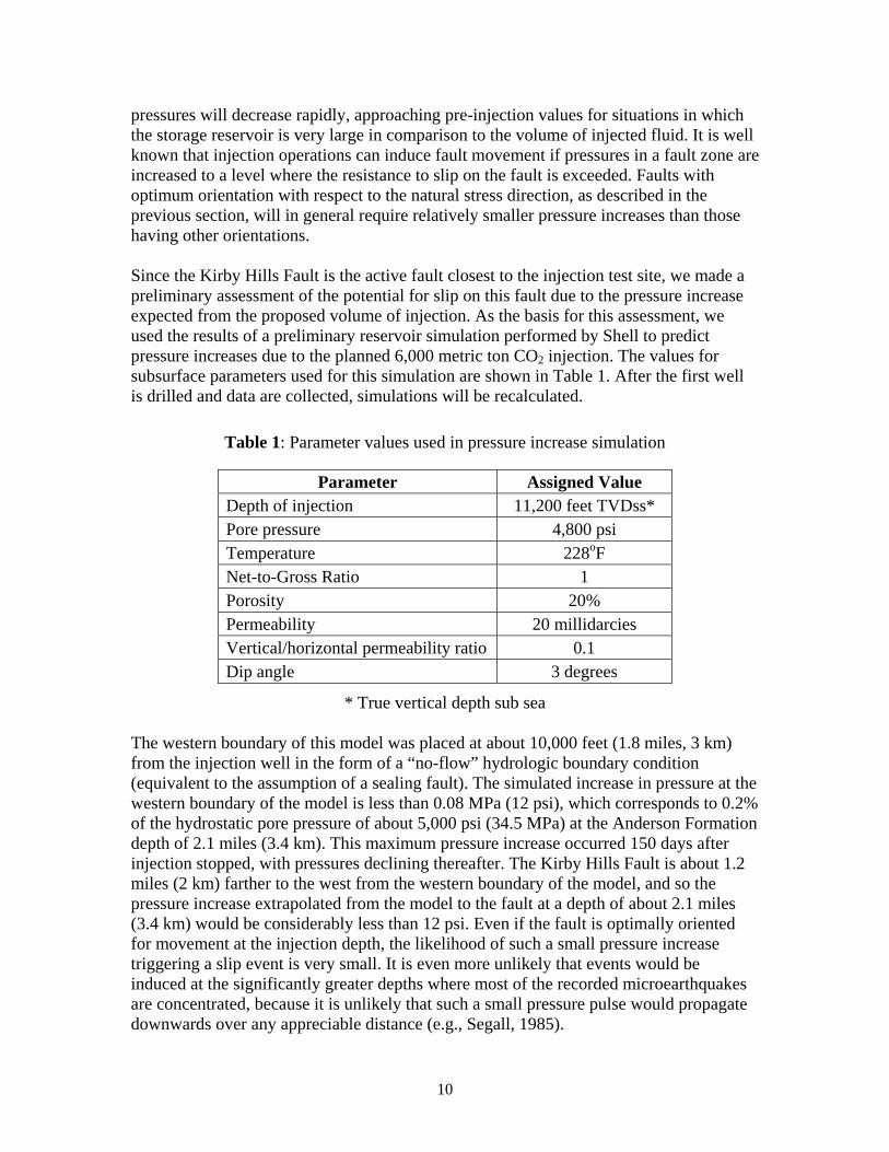
pressures will decrease rapidly, approaching pre-injection values for situations in which the storage reservoir is very large in comparison to the volume of injected fluid. It is well known that injection operations can induce fault movement if pressures in a fault zone are increased to a level where the resistance to slip on the fault is exceeded. Faults with optimum orientation with respect to the natural stress direction, as described in the previous section, will in general require relatively smaller pressure increases than those having other orientations. Since the Kirby Hills Fault is the active fault closest to the injection test site, we made a preliminary assessment of the potential for slip on this fault due to the pressure increase expected from the proposed volume of injection. As the basis for this assessment, we used the results of a preliminary reservoir simulation performed by Shell to predict pressure increases due to the planned 6,000 metric ton CO2 injection. The values for subsurface parameters used for this simulation are shown in Table 1. After the first well is drilled and data are collected, simulations will be recalculated.
Table 1: Parameter values used in pressure increase simulation
Parameter Assigned Value Depth of injection 11,200 feet TVDss* Pore pressure 4,800 psi Temperature 228oF Net-to-Gross Ratio 1 Porosity 20% Permeability 20 millidarcies Vertical/horizontal permeability ratio 0.1 Dip angle 3 degrees
* True vertical depth sub sea The western boundary of this model was placed at about 10,000 feet (1.8 miles, 3 km) from the injection well in the form of a “no-flow” hydrologic boundary condition (equivalent to the assumption of a sealing fault). The simulated increase in pressure at the western boundary of the model is less than 0.08 MPa (12 psi), which corresponds to 0.2% of the hydrostatic pore pressure of about 5,000 psi (34.5 MPa) at the Anderson Formation depth of 2.1 miles (3.4 km). This maximum pressure increase occurred 150 days after injection stopped, with pressures declining thereafter. The Kirby Hills Fault is about 1.2 miles (2 km) farther to the west from the western boundary of the model, and so the pressure increase extrapolated from the model to the fault at a depth of about 2.1 miles (3.4 km) would be considerably less than 12 psi. Even if the fault is optimally oriented for movement at the injection depth, the likelihood of such a small pressure increase triggering a slip event is very small. It is even more unlikely that events would be induced at the significantly greater depths where most of the recorded microearthquakes are concentrated, because it is unlikely that such a small pressure pulse would propagate downwards over any appreciable distance (e.g., Segall, 1985).
10
Discussion
To understand what size of fault can produce a magnitude 3 earthquake, we can use one of the numerous scaling relationships for the magnitude of an earthquake versus the area of slip (e.g., Shaw, 2009; Kanamori, 1977). Using Kanamori (1977), a 250-m (820-ft) radius fault is needed to produce a magnitude 3 earthquake, which would correspond to a circular fault area of ~0.2 km2 (~0.08 mi2). This could easily be accommodated by any of the faults discussed above. However, as discussed in previous sections, multiple factors influence the potential for slip on any particular fault. Based on Shell’s preliminary reservoir modeling, the faults near the injection well would experience, at most, a very small increase in fluid pressure. Therefore, this preliminary analysis suggests that no slip events would be expected due to the proposed injection. In general, the greatest increase in storage reservoir fluid pressure occurs in a limited volume around the injection well; for example, Shell’s reservoir simulations showed that the region of pressure increase in excess of 30 psi (0.21 MPa) will extend for about 0.6 mile (1 km) in all lateral directions from the well. Review of the seismic reflection data did not reveal any faults within this area. However, if a fault or fracture with a radius of 820 feet (250 m) does exist this close to the CO2 injection point, the resolution of the existing seismic data is probably not sufficient to detect it. Therefore, based on currently available data, it is not possible to say whether or not a fault or fracture of 250-m radius is present near the proposed well. However, a stress increase of even 30 psi is relatively insignificant compared to the estimated natural pressure of about 5,000 psi at the injection depth, so the likelihood of triggering an event is also relatively small. Once the well is drilled, information will be available to reduce this uncertainty significantly. As discussed above, the injection operation is not expected to cause slip on the Kirby Hills Fault. However, review of the natural seismicity reveals several naturally occurring earthquakes having magnitudes greater than 3 since the late 1970s. A recurrence analysis has not yet been carried out, but a natural earthquake greater than magnitude 3 will certainly occur eventually in the area, independent of any possible effects of the injection project. If future injection projects involving larger volumes are considered for this site, a site-specific probabilistic seismic hazard analysis (PSHA) is recommended. PSHA is the calculation of the probability that a particular ground-motion measure (acceleration or velocity) will exceed given amplitude thresholds at one or more places of interest during a specified time period (e.g., Hanks and Cornell, 2008). The first step would be to refine the PSHA for the naturally-occurring seismicity in the area published by CGS/USGS by carrying out more detailed characterization of the local active faults. The second step would be to assess the influence on the seismic hazard of potential induced seismicity associated with a large-scale injection project. At present, definitive, quantitative statements about the likelihood of induced seismicity are difficult to make because of the present lack of data and uncertainty in the subsurface structure. To improve risk assessment and to begin acquiring the data necessary for analysis, a high-resolution microseismic monitoring network should be installed to detect and locate seismic events that might occur in the site region. This local network would be
11

capable of detecting smaller events than the USGS regional network and provide improved event location accuracy. The network should be integrated into the regional seismic network and installed as soon as possible, in order to record the maximum number of naturally occurring events as a baseline before injection of CO2 begins.
Conclusions and Recommendations
Initial geologic characterization studies performed to date have identified mapped and unmapped faults and other structural features in the area surrounding the proposed injection well. From an analysis of the available data on in situ stresses and preliminary reservoir simulations, the likelihood of slip on these faults resulting from the proposed 6,000 metric ton injection is judged to be very low. Examination of the local seismicity shows that natural earthquakes having magnitudes greater than 3 have occurred in the past and consequently are likely to recur in the area regardless of injection operations. To reduce the uncertainties discussed above (including uncertainties about fault locations and in situ stress directions), we recommend several actions:
1. Prior to well drilling and injection: Install a microseismic network as soon as possible to begin to compile a high-resolution baseline of natural seismicity and seismicity induced by human activities in the area. The network will remain in place to monitor for natural seismicity and any induced seismicity that may occur during injection operations.†
2. Once wells are drilled: Collect information on the in situ stress state and natural faulting or fracturing near the wells.
3. After drilling and prior to injection: Reassess the potential for operating conditions during injection to induce significant seismicity and develop a protocol for responding to any significant natural or induced events recorded by the network.
4. During and after injection: Carry out additional geomechanical analyses using information obtained during the small scale injection, and develop a PSHA which includes potential induced seismicity at the site.
5. Simultaneously with field work: Carry out focused studies to relocate the better recorded microearthquakes listed in the NCSN catalog for the site area and to calculate focal mechanism solutions for selected events. Evaluate the relationship of the relocated earthquakes to the KHF to improve characterization of the fault.
6. Simultaneously with field work: Evaluate PSHA results for the Montezuma Hills area in the DRMS report (URS Corporation/Jack R. Benjamin & Associates, 2007).
† Two temporary seismic stations have been installed to collect initial data. Additional details are provided in Appendix 2.
12
References
Bryant, W.A., 2010, California Geological Survey, personal communication
California Division of Mines and Geology, 1982, Fault Evaluation Report FER-136
California Division of Mines and Geology, 1983, Summary Report: Fault Evaluation Program, 1981-1982 Area – Northern Coast Ranges Region, California, DMG Open-File Report 83-10
Hanks, T. and C.A. Cornell, 2008, Probabilistic Seismic Hazard Analysis: A Beginner’s Guide, Unpublished Report
Heidbach, O., M. Tingay, A. Barth, J. Reinecker, D. Kurfeß, and B. Müller, 2008, The World Stress Map database release 2008, doi:10.1594/GFZ.WSM.Rel2008
Jennings, C.W. and W.A. Bryant, 2010, Fault Activity Map of California: California Geological Survey, Geologic Data Map No. 6, map scale 1:750,000.
Kanamori, H., 1977, The energy release in great earthquakes, Journal of Geophysical Research, Vol. 82, No. 20
Parsons, T., J. McCarthy, P.E. Hart, J.A. Hole, J. Childs, D.H. Oppenheimer, and M.L. Zoback, 2002, A review of faults and crustal structure in the San Francisco Bay Area as revealed by seismic studies: 1991-97, in Crustal structure of the coastal and marine San Francisco Bay region: USGS Professional Paper 1658, http://geopubs.wr.usgs.gov/prof-paper/pp1658/ch8.pdf
Segall, P., 1985, Stress and subsidence resulting from subsurface fluid withdrawal in the epicentral region of the 1983 Coalinga earthquake, J. Geophys. Res. 90, 6801-6816
Shaw, B., 2009, Constant stress drop from small to great earthquakes in magnitude-area scaling, Bulletin of the Seismological Society of America, vol. 99, no. 2A
URS Corporation/Jack R. Benjamin & Associates, Inc., 2007, Delta Risk Management Strategy (DRMS) Phase 1: Topical Area Seismology, Draft 2, 187 pp
Xu, H., 2010, Shell Oil Company, personal communication
Zoback, M.D., 2007, Reservoir Geomechanics: Earth Stress and Rock Mechanics Applied to Exploration, Production and Wellbore Stability, Cambridge Press, Cambridge Press, 449 pp
13
Appendix 1 Biographies of Authors
Larry Myer is a retired Staff Scientist at Lawrence Berkeley National Laboratory, Earth Sciences Division (ESD), where he has conducted research in geophysics and geomechanics since 1981. He has a Ph.D. in Geological Engineering from the University of California, Berkeley. Dr. Myer’s research experience spans a wide range from basic theoretical and laboratory investigations of rock properties and processes to field measurements of rock behavior and instrumentation development. Basic research activities have been directed at understanding the microprocesses associated with deformation and failure of rock, seismic wave propagation, and fluid flow in fractured porous media. A particular focus has been the mechanical, hydrologic and seismic properties of single fractures and faults with the development of new theoretical concepts accompanied by laboratory and field validation experiments. Dr. Myer has been leading research activities in geologic sequestration since 1999. He co-directed the DOE funded QEO-SEQ project, an applied R&D effort focused on monitoring and verification, and subsurface flow and transport in geologic sequestration. As part of the GEO-SEQ project, he led the development of the monitoring program for the Frio CO2 injection pilot. The Frio pilot was the first saline formation CO2 pilot in the United States. As Geologic Sequestration Program Head, he was responsible for programmatic leadership of the ESD geologic sequestration research program, a multidisciplinary effort focused on monitoring, risk, and reservoir performance of sequestration projects. The ESD Geologic Sequestration Program includes research conducted as part of major international sequestration projects, including Weyburn, Canada, Otway, Australia, and In Salah, Algeria. Most recently, until his retirement, Dr. Myer was Technical Director of the West Coast Regional Carbon Sequestration Partnership (WESTCARB), which is evaluating CO2 sequestration options and opportunities for the west coast of North America. Laura Chiaramonte is in the Computational Geosciences Group at Lawrence Livermore National Laboratory (LLNL). She holds a Ph.D. in Geophysics from Stanford University (2008), an M.S. in Structural Geology and Geomechanics from Stanford University (2003) and a B.S. in Geological Sciences from the Universidad de Buenos Aires (1996). Prior to joining LLNL in 2010, she was a postdoctoral fellow at Lawrence Berkeley National Laboratory (LBNL). From 1997-2001, she worked for REPSOL-YPF in Argentina as a structural and reservoir geologist. Tom Daley works as a research scientist in the Earth Sciences Division of Lawrence Berkeley National Laboratory. He has been with Berkeley Lab since 1987. He received a Bachelors degree in Geophysics from the University of California, Berkeley in 1980 and a Masters degree in Engineering Geoscience from UC Berkeley in 1987. He worked from 1980 to 1985 with Seismograph Service Corporation performing borehole seismic surveys and managing a district office in Ventura, CA. Tom's research work is focused on the acquisition and analysis of borehole seismic data from field scale experiments. Problems addressed have included continuous travel time monitoring to detect stress changes, monitoring of geologic sequestration of CO2, characterization of fracture content and dominant fracture orientation in geothermal and oil fields, high resolution imaging of shallow surface materials, imaging fracture flow zones in contaminated
14
aquifers, and geophysical characterization of volcanic tuff flows for nuclear waste isolation at Yucca Mountain. Tom is a member of AGU since 1987 and has been a member of SEG since 1980, and is currently on the SEG CO2 research subcommittee. Daniel Wilson is the principal at Daniel Wilson & Associates, Inc., a geophysical consultancy near Houston, Texas. Mr. Wilson has 40 years of experience interpreting seismic data for the evaluation and development of oil and gas prospects. From 2003-2009 he consulted for Davis Petroleum Corp. and Stephen Production Co. analyzing and reprocessing 3D seismic data for several prospects in Louisiana and Oklahoma. From 1992-2003 he worked as a Geophysical Advisor for Anadarko Petroleum interpreting 2D and 3D seismic data, evaluating oil and gas prospects, and/or overseeing geophysical activities on domestic projects in Texas, Louisiana, Mississippi, Kansas, Oklahoma, and Alaska; and international projects in Venezuela, Brazil, Jordan, and near the South Caspian Sea. In prior years Mr. Wilson held positions of Senior Staff Geophysicist at Anadarko Petroleum Corporation in Oklahoma City; Project Leader/Division Geophysicist at Tenneco Oil in Oklahoma City; and Geophysicist at Texaco in New Orleans. He earned a B.S. in Geology from Lamar University in Beaumont, Texas, in 1969. William Foxall is a seismologist with over 30 years of experience in seismic hazard analysis. He earned an M.S. in geophysics from the University of Washington in 1976 and his Ph.D. in geophysics from the University of California, Berkeley, in 1992. He has been employed at the Lawrence Livermore National Laboratory since 1996, and was at the Lawrence Berkeley Laboratory from 1992 to 1996. His work at the Laboratories has included probabilistic seismic hazard analysis, seismic source physics, nuclear forensics, and interferometric synthetic aperture radar analysis of ground deformation related to CO2 sequestration, enhanced oil recovery and geothermal. Prior to attending UC Berkeley, Dr. Foxall was a Senior Project Seismologist at Woodward-Clyde Consultants in San Francisco. John Henry Beyer is a Geophysicist in the Earth Sciences Division at Lawrence Berkeley National Laboratory, and is the Program Manager for the West Coast Regional Carbon Sequestration Partnership (WESTCARB) projects in California and Arizona. Dr. Beyer earned a Ph.D. in Engineering Geoscience from the University of California at Berkeley in 1977, an M.A. in Geophysics from Washington University in St. Louis, and a B.S. in Physics from Lafayette College in Pennsylvania. Before returning to Berkeley Lab in 2007, he spent seven years at the California Energy Commission managing energy-related research projects funded by the Public Interest Energy Research (PIER) Program. As an independent consultant he managed geophysical exploration surveys of geothermal areas in Indonesia, the Azores, and Japan. He was the General Manager of a 50-employee company that developed innovative geophysical capabilities and performed magnetotelluric surveys to explore for geothermal and oil resources. This company was a spin-off from Woodward-Clyde Consultants in San Francisco, where he worked as a Senior Project Scientist developing geophysical data analysis techniques and managing geothermal resource exploration.
15

Appendix 2
Seismic Monitoring Stations
This map shows the proposed injection well location (near MH1); locations of two temporary seismic monitoring stations, MH1 and MH2 (yellow pins); and very tentative locations for four permanent seismic monitoring stations (green and red pins). The two temporary stations were installed by LBNL on May 18, 2010, for the purpose of measuring seismic noise (vibrations) from the windmills and other local sources, and to see if any microearthquake events are recorded at the gain settings used. The intent is to leave the instruments in the field for about two months to acquire data that will help to determine specifications for a permanent microseismic monitoring array. The final locations for permanent seismic monitoring stations will depend on several factors, including an appropriate distribution around the well site, low vibration noise from cultural sources, line-of-sight radio telemetry for data transmission, land owner agreements, ease of access, security, and avoidance of interference with farmers, ranchers, and wind turbine operators.
16

17
Acknowledgment/Auspices This work was partially supported by the U.S. Department of Energy and LBNL under Contract No. DE-AC02-05CH11231 This work performed under the auspices of the U.S. Department of Energy by Lawrence Livermore National Laboratory under Contract DE-AC52-07NA27344. Disclaimers This document was prepared as an account of work sponsored by the United States Government. While this document is believed to contain correct information, neither the United States Government nor any agency thereof, nor The Regents of the University of California, nor any of their employees, makes any warranty, express or implied, or assumes any legal responsibility for the accuracy, completeness, or usefulness of any information, apparatus, product, or process disclosed, or represents that its use would not infringe privately owned rights. Reference herein to any specific commercial product, process, or service by its trade name, trademark, manufacturer, or otherwise, does not necessarily constitute or imply its endorsement, recommendation, or favoring by the United States Government or any agency thereof, or The Regents of the University of California. The views and opinions of authors expressed herein do not necessarily state or reflect those of the United States Government or any agency thereof or The Regents of the University of California. Ernest Orlando Lawrence Berkeley National Laboratory is an equal opportunity employer. This document was prepared as an account of work sponsored by an agency of the United States government. Neither the United States government nor Lawrence Livermore National Security, LLC, nor any of their employees makes any warranty, expressed or implied, or assumes any legal liability or responsibility for the accuracy, completeness, or usefulness of any information, apparatus, product, or process disclosed, or represents that its use would not infringe privately owned rights. Reference herein to any specific commercial product, process, or service by trade name, trademark, manufacturer, or otherwise does not necessarily constitute or imply its endorsement, recommendation, or favoring by the United States government or Lawrence Livermore National Security, LLC. The views and opinions of authors expressed herein do not necessarily state or reflect those of the United States government or Lawrence Livermore National Security, LLC, and shall not be used for advertising or product endorsement purposes.