investigation of sedimentology, sedimentary environment ...1)_p_1060-1071.pdf · current world...
TRANSCRIPT

Current World Environment Vol. 10(Special Issue 1), 1060-1071 (2015)
Investigation of Sedimentology, SedimentaryEnvironment and Facies of Late Cretaceous in
Farahzad Zone North of Mojen Shahroud
GhodratoLLah MohaMMadI1, ELINa BatMaNGhELICh2 and aLIrEZa aShoFtEh3*
1Assistant Professor of Mining Engineerng Department,Islamic Azad University South Tehran Branch, Tehran, Iran.
2Department of Geology Sedimentary Faculty of Technical & Engineering,Islamic Azad University Science and Research Branch Tehran, Tehran, Iran.
3Department of Mining Engineering Faculty of Technical & Engineering,Islamic Azad University South Tehran Branch, Tehran, Iran.
http://dx.doi.org/10.12944/CWE.10.Special-Issue1.126
(Received: November, 2014; Accepted: April, 2015)
aBStraCt
On this research, farahzad area, on north of Mojen, Shahroud and Darkhaniab on east of Mojen of late cretaceous age, in order to identify the sedimentary environment and facies is mentioned as field and laboratory research. After selecting two sections for studing and get 110 samples, 18 facies which were deposited through facies belt of tidal zone, lagoon, barrier islands and open marine were found such as: 1.Spicule bioclast wackestone/packstone 2.Bioclast wackestone 3.Bioclast packstone 4.Echinoderm bioclast packstone 5.Echinoderm intraclast packstone 6.Intraclast grainstone 7.Echinoderm intraclast grainstone 8.Echinoderm bioclast grainstone 9.Intraclast bioclast grainstone 10.Red algal echinoderm grainstone 11.Mixed grainstone 12.Red algal packstone/grainstone 13.Pelloid bioclast packstone/grainstone 14.Intraclast bioclast packstone 15.Pelloid miliolidae wackestone/packstone 16.Pelloid grainstone 17.Lime mudstone 18.Calcareous sandstone. Finally, by mention of variety, categories and survey of identified facies sedimentation environment of studied carbonate sediments zone can be named as a carbonate rimmed shelf.
Key words: Mojen area, Sedimentary environment, Facies, Facies belt.
INtroduCtIoN
Mojen province, in the southern slopes of eastern alborz, is located within 35th kilometer of north western area of shahroud in bastam, in semnan province, with a height of 2060 meter from sea level. The graphical scale is located between from 36/22/30 to 36/30/00, northern and height of 54/37/30 to 54/45/00, eastern. According to the records from the national weather forecast, the weather of this area, overall it is cold in winters and has mildly warm summers. Mojen is a mountainainous area in the eastern alborz mountains. Lithologic units available in the area from the past until present are
as below: Lar limestones, volcanic rocks formed from late cretaceous, limestones, from later cretaceous, conglomerate fajan, formation of ziarat and formation of karaj(125000 page of mojen geology report). Graphical characteristics of the farahzad cut, in the northern mojen, shahroud as followed: 36 31 06 northern and 54 41 15 eastern. And the cut in the darkhaniab in the east of Mojen are as followed: 36 29 18 northern and 54 41 41 eastern.
aim of this survey On this research, the aim is to identifying facies, and renovates an old depositional environment, with also considering geographic status of this

1061 MOhAMMADI et al., Curr. World Environ., Vol. 10(Special Issue 1), 1060-1071 (2015)
situated area in the precipitation of late cretaceous will be known from now on.
Method of research The study of sedimentary rocks mostly starts from the desert. To achieve the aim mentioned, desert investigations have been established. Sampling with an average distance of two meters and some with a change of facies for laboratory experiments has been collected. In the studied area, from the base of the cut to the top, in the vertical direction, along layers, slopes, along stratification measures, real thickness of all the cuts have been calculated and measured. In the desert studies, 110 samples of thin sections from the farahzad and darkhaniab area had been collected. All the 65 samples from the farahzad area(first cut). (Fig. 3,2) with a thickness of roughly 152 meters, and the rest which are 45 samples are from darkhaniab area(second cut). ( Fig. 4,5) with a thickness of roughly 170/93 meters with a polarizing microscope for identifying facies have been used. For interpretation of facies and representing sedimentary models, Flugel 2004 for naming carbonated stones from a method of Dunham 1962 have been used.
Work and discussion Macroscopic and microscopic survey of the samples taken from the mojen area shows the presentation of 18 facies belonging to 4 belt facies of tidal flat, lagoon, barrier island and open marine(Fig. 6). All the facies are formed from a micritic matrix and aspray cement background.
areas and the Identified Facies are as Below open Marine area These areas have characteristics which in reality are the differentiation of continental area; • Theexistenceofavarietyofplansandanimal
fossils.• Lackofexistenceofexternalexitsapartfrom
the tidal flat of intertidal zone.• The existence of an old, permanent and
sustainable salinity.• The existence of chemical sediments and
biochemical(specially carbonate) which are clastic sediments and disruptive.
• Existenceofhorizontallinkageoflayersunderbroad mass and continued water.
• Existence of sedimentary units, mostlyshallow, presence of cross bedding in a
horizontal direction compared to a variety of curved and concaved plate.
• Lackofpresenceofredcolorrelatingtotheiron oxides.
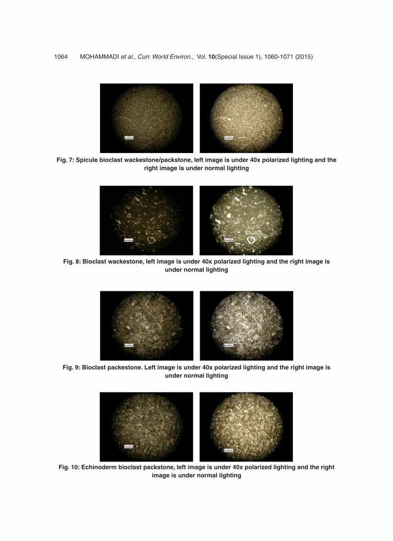
Spicule bioclast wackestone/packstone These facies mostly contain small skeletal and crystalline parts and non identifiable crystalline along some silica speculate bioclast which are from mud supported to grain supported. With no to little doubt, these skeletal parts above are related to foraminifera plagic and are continued thin plagic surface which is next to spicule shows how deep the open marines are. The template of spicule is mostly filled with aspary and this indicates the presence of silica in their main mixture(Flugel, 2004).
Bioclast wackstone These facies also contain small skeletal and crystalline parts. This is very clear when they are next to the following items and compared: echinodern, red algae, bryozoa, bivalve, small sand parts which are placed with fabric mud support. The overall characteristic of the facies, tells us about the deposited material in the open marine bottom parts of continental slope. With a knowledge that the jolbakhaye ahaki are easily transportable(Flugel, 2004). They can along with other material, from lagoon area shifted and find their way to open marines so they can spread(Schlagintweit & Gawlick, 2007).
Bioclast packstone Overall characteristics of this facies from the containing parts, it is similar fabric to the second facies, with a difference that contains grain supported and the mean size of the small skeletal parts are bigger which some of these are bigger than 2 milimeter and we can call these, rudstones. With considerations, we can distinguish that this facies was placed in a higher part of the ocean and shallower parts compared to the second facies in the carbonate slope.
Echinoderm bioclast packstone This facies includes a variety of skeletal parts which between all of them, echinoderm has the most presence and it is their main material. Other bits are including, bits of algae, birozioa, bivalve, berachiopoda and foraminifera like miloid. The background of this facies is micritic matrix and its

1062MOhAMMADI et al., Curr. World Environ., Vol. 10(Special Issue 1), 1060-1071 (2015)
Fig. 1: Situation with limits under studying on the maps of roads of iran 1:1000000 scale
Fig. 2: Situation of the study area map first cut, in aliabad 1:100000 scale
Fig. 3: the base section of the first cut, look to the north
tissue is grain supported. With tendency to how much echinoderm is available in this facies, the area that created this piece can be related to the carbonated slope.
Echinoderm intraclast packstone The main parts of this facies includes pieces of echinoderm and intraclast which has been placed a grain supported tissue inside the mud micritic. For subparts we can point to little bits of sand
and berachiopod. The area that this was created can be related to the carbonated facies slope has been considered.
Barrier island area Barrier islands are long sandy islands, straight or with some curves placed along the beach and separates parts of water from the shore. These barriers may look like a continued series of small islands or in a form of a long island which has been separated through channels. The width of these islands may even each a few kilometers. The beaches for these barrier islands are straight towards the sea and irregular towards the shore towards the lagoon. The thickness of sediments has always been different and they mostly change

1063 MOhAMMADI et al., Curr. World Environ., Vol. 10(Special Issue 1), 1060-1071 (2015)
Fig. 4: Situation of the study area on the second, cut on the maps of shahroud 1:100000 scale
Fig. 5: overview of the second cut, look to the north east
Fig. 6: the three dimensional model of sedimentary facies in the late cretaceous in farahzad zone, north of Mojen Shahroud
between 5 to 25 meters. The slope of these islands towards the sea often is sharper than the continental shelf. The source of these barrier island sediments is from the sea or they are sediments that have been carried from the rivers and then moved to the sea. The beaches that are suitable for formation of these
islands should include slopes, mean tides and with sort of strong waves(Mousavi harami, 1377).
Intraclast grainstone This facies chiefly includes intraclast grains with various dimension which lies with grain supported
inside cement aspray. As a result of turbulency and high energy atmosphere, these grains will lose their corners and have formed a perfect rounding. Also some of them became more erosion and scalewise, they look closer to pelloids which referring to these sources(erosion and shrinkage of interaclast). These pelloids, can be placed as the lithic pellet category. Minor components of this facies except above pelloid in forms of rare facies and includes some retailers’ fossils such as miliolidae. According to these features we considered the barrier formation of these facies.
1064 MOhAMMADI et al., Curr. World Environ., Vol. 10(Special Issue 1), 1060-1071 (2015)
Fig. 7: Spicule bioclast wackestone/packstone, left image is under 40x polarized lighting and the right image is under normal lighting
Fig. 8: Bioclast wackestone, left image is under 40x polarized lighting and the right image is under normal lighting
Fig. 9: Bioclast packestone. Left image is under 40x polarized lighting and the right image is under normal lighting
Fig. 10: Echinoderm bioclast packstone, left image is under 40x polarized lighting and the right image is under normal lighting

1065MOhAMMADI et al., Curr. World Environ., Vol. 10(Special Issue 1), 1060-1071 (2015)
Fig. 11: Echinoderm intraclast packstone, left image is under 40x polarized lighting and the right image is under normal lighting
Fig. 12: Intraclast grainstone, left image is under 40x polarized lighting and the right image is under normal lighting
Fig. 13: Intraclast grainstone, left image is under 40x polarized lighting and the right image is under normal lighting
Fig. 14: Echinoderm bioclast grainstone, left image is under 40x polarized lighting and the right image is under normal lighting

1066 MOhAMMADI et al., Curr. World Environ., Vol. 10(Special Issue 1), 1060-1071 (2015)
Fig. 15: Intraclast bioclast grainstone, left image is under 40x polarized lighting and the right image is under normal lighting
Fig. 16: red algal echinoderm grainstone, left image is under 40x polarized lighting and the right image is under normal lighting
Fig. 17: Mixed grainstone, left image is under 40x polarized lighting and the right image is under normal lighting
Fig. 18: red algal packstone/grainstone, left image is under 40x polarized lighting and the right image is under normal lighting
1067MOhAMMADI et al., Curr. World Environ., Vol. 10(Special Issue 1), 1060-1071 (2015)
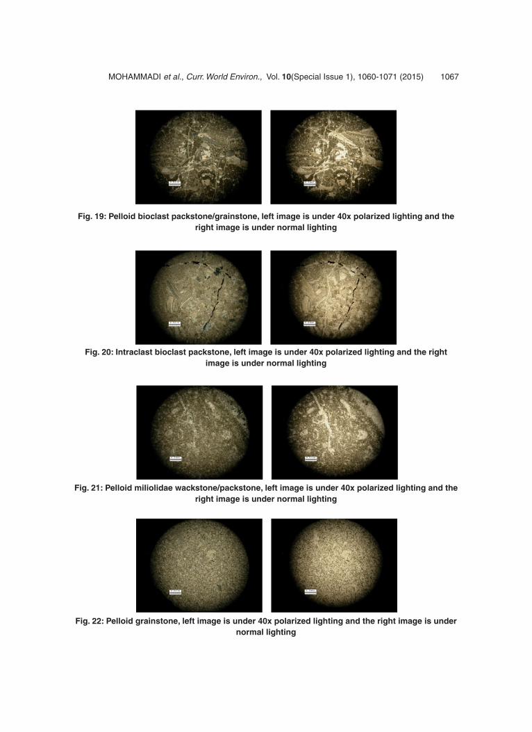
Fig. 19: Pelloid bioclast packstone/grainstone, left image is under 40x polarized lighting and the right image is under normal lighting
Fig. 20: Intraclast bioclast packstone, left image is under 40x polarized lighting and the right image is under normal lighting
Fig. 21: Pelloid miliolidae wackstone/packstone, left image is under 40x polarized lighting and the right image is under normal lighting
Fig. 22: Pelloid grainstone, left image is under 40x polarized lighting and the right image is under normal lighting

1068MOhAMMADI et al., Curr. World Environ., Vol. 10(Special Issue 1), 1060-1071 (2015)
Fig. 23: Lime mudstone, left image is under 40x polarized lighting and the right image is under normal lighting
Fig. 24: Calcareous sandstone, left image is under 40x polarized lighting and the right image is under normal lighting
Echinoderm intraclast grainstone This facies have a lot of similarities to the last facies expect comparing to the other one, have more components which in general, contains parts of echinoderm, not majorly and includes minor splinters of brachiopoda, bryozoa, ooids and sand. Also like before, some of these intraclasts because of erosion becomes pelloid. This facies formed in the barriers.
Echinoderm bioclast grainstone This facies from a point of components has a lot of similarities to the 4th facies of open marine. Therefore the background of this facies is from the aspray cement. With tendency to these bullet points, a barrier area for this dam has been considered.
Intraclast bioclast grainstone The main creational parts of this facies are included skeletal parts such as (red algae, echinoderm, berachiopoda, bivalve, foraminifera and bryozoa) and intraclast and some sub allochems like pelloid and sand with fabric grain supported has been placed related to aspray cement. This facies is created in dam area.
red algal echinoderm grainstone The main components of this facies include echinoderm and then the red algae. In subparts pieces of bryozoa, brachiopoda, bivalve, sand and intraclast is also seen. These parts with fabric supported grainstone have been placed related to aspray cement. Characteristics of this facies is from deposition of materials in the dam area.
Mixed grainstone This facies is somehow a mixture of most of these barrier facies above and is included a mixture of skeletal parts like echinoderm, brachiopoda, bryozoa, bivalve, red algae, and also intraclast, pelloid, sand and cortoids which, with a variety of fabric grainstone have been placed in a creation of aspray cement. Therefore the name of mixed grainstone has been chosen which can be relarted to tidal channels. The continued movements of water in these channels has caused these allochem to be mixed.
Lagoon Pools are the moderate area. The coral reefs mostly divide the shallow parts of the water from the beach which separates that part from the

1069 MOhAMMADI et al., Curr. World Environ., Vol. 10(Special Issue 1), 1060-1071 (2015)
open marine. This divided water is called the pool. The sediments from this area are mostly destructive that has been carried from the shore and mostly included lime muds. The sources for growth of species there are quite high and that’s why there is a high density of species in that area(Khosro Tehrani 1381).
red algal packstone/grainstone This facies are mostly includes little pieces of red algae in different sizes which its sub-allochems like echinoderm, bivalve, bryozoa, miliolidae, pelloid in little bits are along. The fabric tissue of this facies is grain supported and its mixture from mud mictric and aspray cement. The main characteristics of this material is from deposition of different material in the external lagoon area(behind the dam) which from the change the pace of its energy, it has caused to be washed away from a non complete micritic from the between grains and the rest have remained in the area.
Pelloid bioclast packstone/grainstone This facies mostly includes skeletal parts such as bivalve, red algae, echinoderm, and bryozoa which along pelloid with fabric grain supported which has been places in between mictric and apsray. Just like facies number 12, the overall charactaristics shows that they have been created in the lagoon area, far from the shore or behind the dam.
Intraclast bioclast packstone The charactaristics of this facies is quite similar to the facies number 13 and we can only say instead of pelloid, pieces of intraclast is seen, with also considering the amount of washed mictric from the between grains has been less and it can be called, packtsone. Therefore the area that this facies was created can be related to the inside lagoon area.
Pelloid miliolidae wackstone/packstone The most important part of this facies, is the miliolidaes which next to the pelloid from the mudd supported to grain supported fabric been placed in a mud micritic. In the sub skeletal parts, other parts such as pieces of ostracod, gastropod, bivalve also is seen. Overall charactaristics shows that they have been created in the lagoon area.
tidal flat This is one of the intermediate fields. These fields are found in the low energy lithoral area and most of the sediments are in small pieces, like silt and clay, lime mudstone, and disruptive sediments along the high land are placed. With considerations that the lime mudstones are originated from dolomite and lime and in the warmer points, because of the lack of sediments, it has been filled and formed a mud stone which keeps its shape even in harsh times.
Pelloid grainstone Overall this facies includes pieces of pelloid with a aspray cement background. Pelloids are well formed and most of them are seen as a same size. In rare cases the small sand pieces are seen in some of the samples. This kind of facies have been created in the tidal flat and intertidal area.
Lime mudstone This facies contains carbonate mud which has a lack of pieces of allochem or rarely contains tiny pieces of sand or tiny skeletal parts. Of its characteristics are fenestral and in some cases these holes are the templates of mineralogy evaporation. These characteristics have a source from the supertidal area.
Calcareous sandstone This facies contains sandstones which its pieces mostly are mono crystalline and poly crystalline quartz(less) chert and felspar with considerations that these pieces are placed inside the carbonated micrit mud is placed and small pieces of fossils like bivalve, brachiopoda, ostracoda are seen inside and they are known as calcareous sandstone and the place formed are quite close to the lagoon area.
CoNCLuSIoN
The deposits studied shows the black volcanic rocks are places on the bottom of the late cretaceous. The upper contact, which is conglomerate Fajan. The majority of the Farahzad’s cut(first cut) with a true thickness of 152 meter, are made from gray coloured micrit lime stone with oxidized thin cream coloured to thick layers(continued), lime stone has been developed(shape 1-6). The major lithologey

1070MOhAMMADI et al., Curr. World Environ., Vol. 10(Special Issue 1), 1060-1071 (2015)
of darkhaniab’s cut(second cut) with a true thickness of 171 meters, are made from gray colored mictritic lime stone with oxidized thin cream colored to thick layers(continued), lime stone, marly limestone, marl has been developed. According to laboratory and desert studies on the decided area, 18 facies
belonging to 4 facies’ belt, deposits of tidal zones, lagoon, barrier islands and open marine has been discovered. According to this research by mention of variety, categories and survey of identified facies sedimentation environment of studied carbonate sediments zone can be named as a Carbonate Rimmed Shelf.
rEFErENCES
1. Ghodratollah Mohammadi and Alireza Ashofteh, Facies and sedimentary environment of cretaceous units at north west of dihuk – tabas region(shotori mountain range), Journal of Middle East Applied Science and Technology(JMEAST), ISSN2305-0225, 6(6), Pages: 148-152(2014)
2. Ghodratollah Mohammadi and Alireza Ashofteh, Determining of source rock and its characteristics using organic geo-chemistry derived from parent rock evaluation, separation and columnar and gaseous chromatography on cretaceous units in central iran at khor-biyabanak, European Online Journal of Natural and Social Science(ES), ISSN1805-3602, 3(3), (2014) Special Issue on Environmental, Agricultural, and Energy Science, Pages: 151-160
3. Ghodratollah Mohammadi and Alireza Ashof teh, Invest igat ion and usage sedimentary and depositioal environment of creataceous in south, east of golpayegan area, European Online Journal of Natural and Social Science(ES), ISSN1805-3602, 3(3). Special Issue on Environmental, Agricultural, and Energy Science, Pages: 151-160 (2014)
4. Ghodratollah Mohammadi and Marzieh Pursafari and Alireza Ashofteh, The eocene – oligocene facieses and sedimentary environments in sardarreh area, garmsar, European Online Journal of Natural and Social Science(ES), ISSN1805-3602, 3(3); Special Issue on Environmental, Agricultural, and Energy Science, Pages: 86-94 (2014).
5. Ghodratollah Mohammadi and Mehran Gho l i ne jad and A l i r eza Asho f teh , Sedimentology and sedimentary environment
of mobarak formation in haraz area - mobarakabad village, iran, Journal of Environmental Treatment Techniques(JETT), ISSN2309-1185; 1(3), Pages: 165-167 (2013).
6. Amodio,S., Foraminifera diversity changes and paleoenvironmental analysis: the lower Cretacous shallow-water carbonates of San Lorenzello,Campaninan Apennines,southern Italy, Facies, 52: 53-67 (2006).
7. Dunhum,R.t., Classification of carbonate rocks according to depositional texture:Classification of Carbonate Rock Mem.Am.Ass.Pet.Geol.I, p108-121 (1962)
8. Flugel,E, Microfacies Analysis of Limestone:Analysis,interpretation and application,Springer-verlog,Berlin, 976p (2004)
9. Salehi M.A & Adabi M.h, Depositional environments, diagenesis and geochemical Fahliyan Formation,in section (Fahliyan Anticline) and oil field of Gachsaran, Journal of Earth Sciences, No. 76 ((2008))
10. Schlagintweit,F. & Gawlick,h.J, Analysis of Late Jurassic to Early Cretaceous algal debris-facies of the Plassen carbonate platform in the northern Calcarous Alps(Germany, Austria) and in the Kurbunesh area of the Mirdita zone(Albania): a tool to reconstruct tectonics and paleogeography of eroded platforms,Facies,53:209-227 (2007)
11. Tucker,M.E(1991-2001), Sedimentary Petrology,Third edition, Blackwell, Oxford, p272
12. Khosrotehrani,Kh, Stratigraphy of Iran, Tehran University,p582 (2007)
13. K h o s r o t e h r a n i , K h , S t r a t i g r a p h y applications,Kelidar,p20- 80 ,(2002)
14. Geological Survey of iran, Geological map

1071MOhAMMADI et al., Curr. World Environ., Vol. 10(Special Issue 1), 1060-1071 (2015)
1:100000 Aliabads sheet (2006)15. Geological Survey of iran, Geological map
1:100000 Shahrouds sheet(2001)16. Mousavi h, R, Sedimentology, Astan Quds
Razavi, p 474 (1998)17. Gitashenasi geographical & cartogeraphi
institute, maps of roads of iran 1:1000000, Gitashenasi(2001).