joint center for satellite data assimilation …€¦ · · 2017-07-062 jcsda quarterly no 56...
TRANSCRIPT

NO. 56, SUMMER 2017
IN THIS ISSUE 1 NEWS IN THIS QUARTER
All-sky Microwave Imager Data Assimilation at NASA GMAO
Introducing Object-Oriented Concepts into GSI
15 DEVELOPMENT EFFORTS
CRTM User and Developer Workshop
Meeting Summary: 15th Annual JCSDA Science Workshop
18 PEOPLE
Welcome Dr. Guillaume Vernieres
18 CAREER OPPORTUNITIES
19 SCIENCE CALENDAR
NEWS IN THIS QUARTER SCIENCE UPDATE
All-sky Microwave Imager Data Assimilation at NASA GMAOSatellite radiance observations combine global coverage with high temporal and spatial resolution and bring vital information to numerical weather prediction (NWP) analyses, especially in areas where conventional data are sparse. However, most satellite observations that are actively assimilated have been limited to clear-sky conditions due to difficulties as-sociated with accounting for non-Gaussian error characteristics, nonlinearity, and the devel-opment of appropriate observation operators. To expand existing capabilities in satellite ra-diance assimilation, operational centers including the European Centre for Medium-range Weather Forecasts (ECMWF), United Kingdom’s MetOffice, Japan Meteorological Agency (JMA), and National Centers for Environmental Prediction (NCEP) have been pursuing ef-forts to assimilate radiances affected by clouds and precipitation from microwave sensors. The expectation is that these data can provide critical constraints on meteorological param-eters in dynamically sensitive regions and have positive impact on forecasts of precipitation.
As described in the previous issue of the JCSDA Quarterly Newsletter, NCEP’s efforts to assimilate all-sky data in the Gridpoint Statistical Interpolation (GSI) system have been focused on temperature sounding data from the Advanced Microwave Sounding Unit-A (AMSU-A) and Advanced Technology Microwave Sounder (ATMS) in non-precipitating cloudy conditions. Efforts in all-sky satellite data assimilation at the Global Modeling and Assimilation Office (GMAO) at NASA Goddard Space Flight Center have been focused on the development of GSI configurations to assimilate all-sky data from microwave imag-ers such as the GPM Microwave Imager (GMI) and Global Change Observation Mission-Water (GCOM-W) Advanced Microwave Scanning Radiometer 2 (AMSR-2). Electromag-netic characteristics associated with their wavelengths allow microwave imager data to
(continued on page 2)
JCSDA QuarterlyJOINT CENTER FOR SATELLITE DATA ASSIMILATION
NOAA | NASA | US NAVY | US AIR FORCE
https://doi.org/10.7289/V54J0C9F

2 JCSDA QUARTERLY NO. 56, SUMMER 2017
be relatively transparent to atmospheric gases and thin ice clouds, and highly sen-sitive to precipitation. Therefore, GMAO’s all-sky data assimilation efforts are primar-ily focused on utilizing these data in pre-cipitating regions. The all-sky framework being tested at GMAO employs the GSI in a hybrid 4D-EnVar configuration of the Goddard Earth Observing System (GEOS) data assimilation system, which will be in-cluded in the next formal update of GEOS. This article provides an overview of the de-velopment of all-sky radiance assimilation in GEOS, including some performance met-rics. In addition, various projects underway at GMAO designed to enhance the all-sky implementation will be introduced.
Highlights of all-sky satellite data configuration in GEOS
Various components of the GEOS system have been modified to assimilate cloud- and precipitation-affected microwave ra-diance data (Table 1). To utilize data in cloudy and precipitating regions, state and analysis variables have been added for ice cloud (qi), liquid cloud (ql), rain (qr) and snow (qs). This required enhancing the ob-servation operator to simulate radiances in heavy precipitation, including frozen precipitation. Background error covari-ances in both the central analysis and EnKF analysis in hybrid 4D-EnVAR system have been expanded to include hydrometeors.
CLEAR-SKY ALL-SKY
State variables T, q, Ps, oz, Tskin, u, and v T, q, Ps, oz, Tskin, u, v, ql, qi, qr, and qs
Analysis variables Ψ, Χunblanced, Tunblanced, Psunbalanced, RH, oz, and Tskin
Ψ, Χunblanced, Tunblanced, Psunbalanced, RH, oz, Tskin, ql, qi, qr, and qs
Background Error Ψ, Χunblanced, Tunblanced, Psunbalanced, RH, oz, and Tskin
Ψ, Χunblanced, Tunblanced, Psunbalanced, RH, oz, Tskin, ql, qi, qr, and qs (See Section 4.4)
Observation operator CRTM (Version 2.2.3) CRTM (Version 2.2.3) with a reconstructed cloud coefficient file of this study
Observation Error Constant (and inflated during quality control process)
Symmetric error model (Geer and Bauer 2011)
Quality control Screen out cloud affected radiance Keep cloud and precipitation affected radiance
Screen out data over ocean if SST < 278K
Bias correction predictors in VarBC
Constant, lapse rate, square of lapse rate, cosine of the zenith angle, and cloud liquid water path
Constant, lapse rate, lapse rate2, cos (zenith angle),
CIavg, CIavg2
(continued on page 3)
JOINT CENTER FOR SATELLITE DATA ASSIMILATION
5830 University Research Court College Park, Maryland 20740
Website: wwws.jcsda.noaa.gov
EDITORIAL BOARD
Editor: James Yoe
Assistant Editor: Biljana Orescanin
Director: Thomas Auligné
Chief Administrative Officer:James Yoe
Table 1: Comparison of clear-sky and all-sky microwave TB assimilation framework in GEOS-5 ADAS. (T: atmospheric temperature, q: specific humidity, Tskin: skin temperature, Ps: surface pressure, oz: ozone mixing ratio, u: u-wind, v: v-wind, ql: liquid cloud mixing ratio, qi: ice cloud mixing ratio, qr: rain water mixing ratio, and qs: snow water mixing ratio, Ψ: stramfunction, Χunblanced: unbalanced velocity potential, Tunblanced: unbalanced temperature, Psunbalanced: unbalanced surface pressure, RH: relative humidity)
3 JCSDA QUARTERLY NO. 56, SUMMER 2017
In addition, the bias correction scheme was enhanced to reduce biases associated with thick clouds and precipitation.
a. Cloud scattering coefficients in CRTM
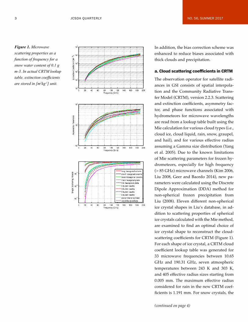
The observation operator for satellite radi-ances in GSI consists of spatial interpola-tion and the Community Radiative Trans-fer Model (CRTM), version 2.2.3. Scattering and extinction coefficients, asymmetry fac-tor, and phase functions associated with hydrometeors for microwave wavelengths are read from a lookup table built using the Mie calculation for various cloud types (i.e., cloud ice, cloud liquid, rain, snow, graupel, and hail), and for various effective radius assuming a Gamma size distribution (Yang et al. 2005). Due to the known limitations of Mie scattering parameters for frozen hy-drometeors, especially for high frequency (> 85 GHz) microwave channels (Kim 2006, Liu 2008, Geer and Baordo 2014), new pa-rameters were calculated using the Discrete Dipole Approximation (DDA) method for non-spherical frozen precipitation from Liu (2008). Eleven different non-spherical ice crystal shapes in Liu’s database, in ad-dition to scattering properties of spherical ice crystals calculated with the Mie method, are examined to find an optimal choice of ice crystal shape to reconstruct the cloud-scattering coefficients for CRTM (Figure 1). For each shape of ice crystal, a CRTM cloud coefficient lookup table was generated for 33 microwave frequencies between 10.65 GHz and 190.31 GHz, seven atmospheric temperatures between 243 K and 303 K, and 405 effective radius sizes starting from 0.005 mm. The maximum effective radius considered for rain in the new CRTM coef-ficients is 1.191 mm. For snow crystals, the
(continued on page 4)
Figure 1. Microwave scattering properties as a function of frequency for a snow water content of 0.1 g m-3. In actual CRTM lookup table, extinction coefficients are stored in [m2kg-1] unit.

4 JCSDA QUARTERLY NO. 56, SUMMER 2017
maximum effective radius considered rang-es from 0.664 mm to 1.278 mm, depending on snow crystal shape. Field et al. (2007) particle size distribution was assumed for frozen hydrometeors and Marshall-Palm-er size distribution (Marshall and Palmer 1948) was assumed for liquid hydrome-teors. After replacing original cloud coef-ficients with new cloud coefficients con-structed with DDA scattering parameters, Simulated GMI brightness temperatures based on the new cloud coefficients are found to be closer to the observations and exhibit less first-guess departure bias in precipitating regions than those based on the original coefficients (Figure 2).
b. Enhanced bias correction
As with clear-sky radiances in the GEOS, bias correction for all-sky microwave radi-ances is performed using a variational bias correction scheme (VarBC, Dee 2004, Au-ligné et al. 2007) which estimates bias cor-rection coefficients as part of the variational assimilation. For clear-sky microwave radi-ance data from microwave sensors such as AMSU-A, SSMIS, and ATMS, the bias pre-dictors include a constant, the scan angle, a second-order polynomial of the atmospheric temperature lapse rate weighted by the radi-ance weighting function, and the retrieved cloud water path.
For the all-sky implementation, three chang-es were made to the original VarBC: First, the retrieved cloud liquid water path was removed as a predictor. Second, only near-clear sky observations with near-clear sky background are used in updating bias correc-tion coefficients for pre-existing predictors. Third, the mean of the observed and calcu-
(continued on page 5)
Figure 2. Comparisons of simulated GMI 166 GHz vertically polarized brightness temperatures (TB) with the observations near Hurricane Celia on July 12, 2016 00Z: (a) Observed TBs, (b) CRTM simulated TBs with original scattering coefficients based on Mie method, and (c) CRTM simulated TBs with the DDA method calculated scattering properties of 3-bullet rosette snow crystals. The color bar shown in (c) works for (a) and (b) as well.
a)
b)
c)

5 JCSDA QUARTERLY NO. 56, SUMMER 2017
lated cloud index based on 37-GHz bright-ness temperatures, (CIavg), and its square, are used as two additional bias-correction pre-dictors to correct the cloud amount-depen-dent first-guess biases. Results indicate that the modified VarBC scheme removes most of the bias in the first-guess departures, as indicated in Figure 3. The magnitude of re-maining biases associated with thick cloud and heavy precipitation are reduced to less than 2 K in all CI ranges. Similar results are obtained for all GMI channels (not shown).
c. Background error covariance matrix
The analysis-control vector in the current GEOS analysis scheme includes stream function, unbalanced velocity potential, un-balanced virtual temperature, unbalanced surface pressure, relative humidity, ozone mixing ratio, and skin temperature (Rieneck-
er et al. 2008). With the newly added control variables, the corresponding static and flow-dependent background error covariances must be generated. Climatological statistics were estimated following the NMC method (Parrish and Derber 1992) using pairs of 24-hour and 48-hour GEOS forecasts between June 1, 2016 and January 16, 2017. Ensemble covariances are based on the spread of the 32 ensemble forecasts from the GEOS hybrid scheme during each analysis cycle.
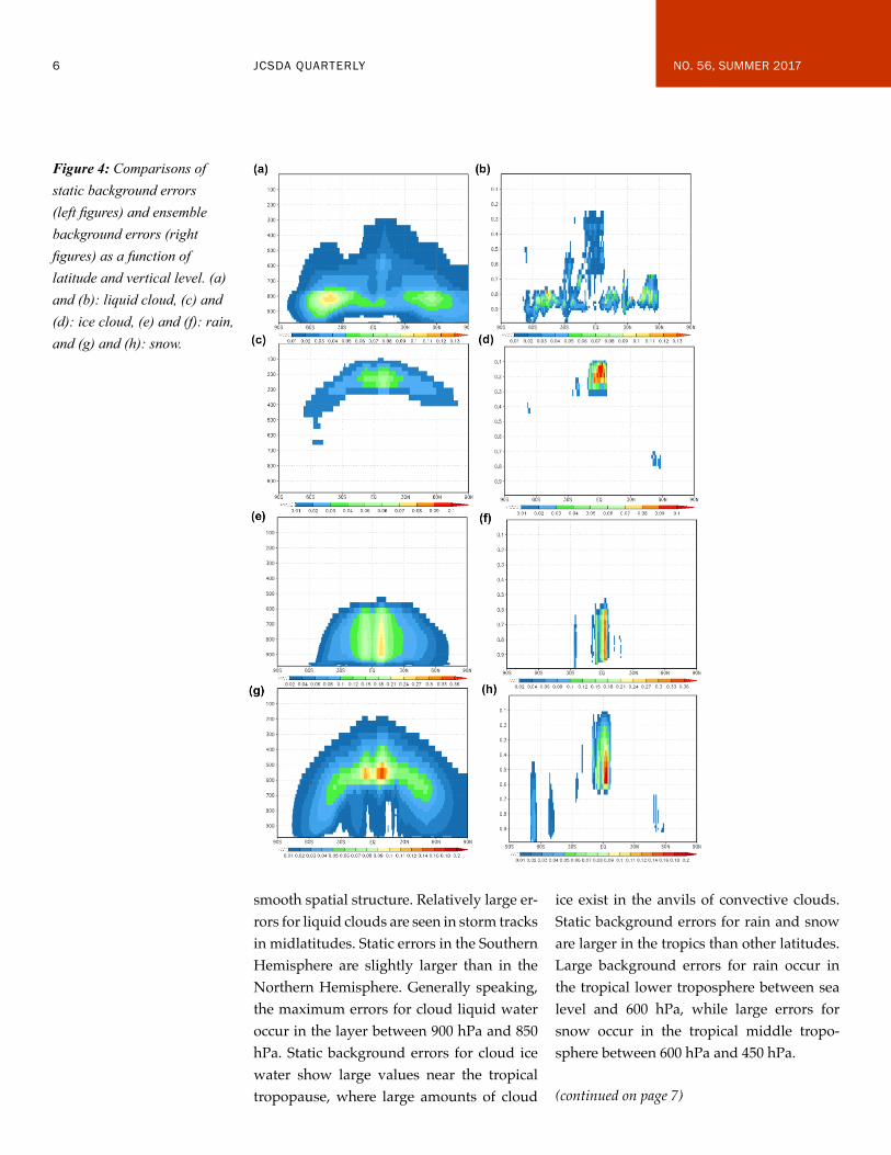
The panels on the left side of Figure 4 show the vertical distribution of the static back-ground errors for cloud liquid, cloud ice, rain, and snow water. Aside from the fact that the estimated errors are by construc-tion zonally invariant, they have generally
(continued on page 6)
Figure 3. Bias of first-guess departures of GMI channel 13 as a function of CIavg. Thin solid line shows the biases before, while thick solid line shows biases after, using CIavg as additional predictors in VarBC. All assimilated data points between 12/01–12/31/2015 were used. Results only in the bins that have the number of data points greater than 5 are shown in this figure.
6 JCSDA QUARTERLY NO. 56, SUMMER 2017
smooth spatial structure. Relatively large er-rors for liquid clouds are seen in storm tracks in midlatitudes. Static errors in the Southern Hemisphere are slightly larger than in the Northern Hemisphere. Generally speaking, the maximum errors for cloud liquid water occur in the layer between 900 hPa and 850 hPa. Static background errors for cloud ice water show large values near the tropical tropopause, where large amounts of cloud
ice exist in the anvils of convective clouds. Static background errors for rain and snow are larger in the tropics than other latitudes. Large background errors for rain occur in the tropical lower troposphere between sea level and 600 hPa, while large errors for snow occur in the tropical middle tropo-sphere between 600 hPa and 450 hPa.
Figure 4: Comparisons of static background errors (left figures) and ensemble background errors (right figures) as a function of latitude and vertical level. (a) and (b): liquid cloud, (c) and (d): ice cloud, (e) and (f): rain, and (g) and (h): snow.
(continued on page 7)
7 JCSDA QUARTERLY NO. 56, SUMMER 2017
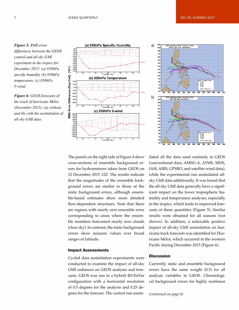
The panels on the right side of Figure 4 show cross-sections of ensemble background er-rors for hydrometeors taken from GEOS on 12 December 2015 12Z. The results indicate that the magnitudes of the ensemble back-ground errors are similar to those of the static background errors, although ensem-ble-based estimates show more detailed flow-dependent structures. Note that there are regions with nearly zero ensemble error corresponding to areas where the ensem-ble members forecasted nearly zero clouds (clear sky). In contrast, the static background errors show nonzero values over broad ranges of latitude.
Impact Assessments
Cycled data assimilation experiments were conducted to examine the impact of all-sky GMI radiances on GEOS analyses and fore-casts. GEOS was run in a hybrid 4D-EnVar configuration with a horizontal resolution of 0.5 degrees for the analysis and 0.25 de-grees for the forecast. The control run assim-
ilated all the data used routinely in GEOS (conventional data, AMSU-A, ATMS, MHS, IASI, AIRS, GPSRO, and satellite wind data), while the experimental run assimilated all-sky GMI data additionally. It was found that the all-sky GMI data generally have a signif-icant impact on the lower tropospheric hu-midity and temperature analyses, especially in the tropics, which leads to improved fore-casts of these quantities (Figure 5). Similar results were obtained for all seasons (not shown). In addition, a noticeable positive impact of all-sky GMI assimilation on hur-ricane track forecasts was identified for Hur-ricane Melor, which occurred in the western Pacific during December 2015 (Figure 6).
Discussion
Currently, static and ensemble background errors have the same weight (0.5) for all analysis variables in GEOS. Climatologi-cal background errors for highly nonlinear
Figure 5: RMS error differences between the GEOS control and all-sky GMI experiment in the tropics for December 2015: (a) 850hPa specific humidity (b) 850hPa temperature, (c) 850hPa V-wind.
Figure 6: GEOS forecasts of the track of hurricane Melor (December 2015): (a) without and (b) with the assimilation of all-sky GMI data.
a)
b)
(continued on page 8)
8 JCSDA QUARTERLY NO. 56, SUMMER 2017
and situation-dependent clouds and pre-cipitation may be less meaningful compared with other dynamical variables. To assign much larger weight to the ensemble-based background errors for hydrometeors, the capability to assign different weights for hy-drometeors versus other dynamic variables is under development. The current all-sky framework will be enhanced by various up-dates both in the forecast model and analy-sis scheme. For example, the inclusion of a two-moment microphysics scheme (Bara-hona et al. 2014) in the GEOS forecast model will provide estimates of cloud particle size distributions to the all-sky observation op-erator. Future versions of the CRTM will ac-count for cloud fraction in calculating radi-ances. This should improve the simulation of brightness temperature compared with the current version of CRTM, which consid-ers only clear-sky or completely overcast conditions. In addition, we are testing vari-ous dynamic thinning approaches in order to use more data in cloudy and precipitating regions. All these enhancements are expect-ed to extend the scope of all-sky radiance as-similation to include more microwave mea-surements and lead, in turn, to improved analyses and forecasts.
Min-Jeong Kim, Jianjun Jin, Will McCarty, Amal El Akkaroui, Ricardo Todling, Wei Gu, and Ron Gelaro (NASA Global Modeling and Assimilation Office)
ReferencesAuligné, T., A.P. McNally, and D.P. Dee, 2007: Adaptive bias correction for satellite data in a numerical weather prediction sys-tem. Q.J.R. Meteorol. Soc., 133, 631–642.
Barahona, D., A. Molod, J. Bacmeister, A. Nenes, A. Gettelman, H. Morrison, V. Phil-
lips, and A. Eichmann, 2014: Development of two-moment cloud microphysics for liq-uid and ice within the NASA Goddard Earth Observing System Model (GEOS-5), Geosci. Model Dev., 7, 1733–1766.
Dee, D.P., 2004: Variational bias correction of radiance data in the ECMWF system. Proceedings of the ECMWF Workshop on As-similation of High Spectral Resolution Sounders in NWP, Reading, UK, 28 June to 1 July 2004. 97–112.
Field, P.R., A.J. Heymsfield, and A. Banse-mer, A., 2007: Snow size distribution param-eterization for midlatitude and tropical ice clouds, J. Atmos. Sci., 64, 4346–4365.
Geer, A.J., and F. Baordo, 2014: Improved scattering radiative transfer for frozen hy-drometeors at microwave frequencies. At-mos. Meas. Tech. 7, 1839–1860.
Geer, A. J., and P. Bauer, 2011: Observation errors in all-sky data assimilation. Q.J.R. Me-terol. Soc., 137, 2024–2037. DOI:10.1002/qj.830
Kim, M.-J., 2006: Comparisons of single scattering approximations of randomly ori-ented ice crystals at microwave frequen-cies. J. Geophys. Research, 111 (D14201): [doi:10.1029/2005JD006892].;
Liu, G., 2008: A database of microwave sin-gle-scattering properties for nonspherical ice particles. Bulletin of the American Meteor. Soc., Vol. 89, 1563–1570.
Marshall, J.S., and W.M.K. Palmer, 1948: The distribution of raindrops with size. J. Mete-or., 5, 165–166.
(continued on page 9)
9 JCSDA QUARTERLY NO. 56, SUMMER 2017
Parrish, D.F., and J.C. Derber, 1992: The Na-tional Meteorological Center’s spectral sta-tistical interpolation analysis system. Mon. Wea. Rev., 120, 1747–1763.
Rienecker, M.M., M. J. Suarez, R. Todling, J. Bacmeister, L. Takacs, H.-C. Liu, W. Gu, M. Sienkiewicz, R. D. Koster, R. Gelaro, I. Stajner, and J. E. Nielsen, 2008. The GEOS-5 Data Assimilation System—documentation
of versions 5.0.1, 5.1.0, and 5.2.0. Technical Report Series on Global Modeling and Data As-similation, Vol. 27, 1–118 pp.
Yang, P., H. Wei, H. Huang, B.A. Baum, Y.X. Hu, G.W. Kattawar, M.I. Mishchenko, and Q. Fu, 2005: Scattering and absorption prop-erty database for nonspherical ice particles in the near- through far-infrared spectral re-gion. Applied Optics, 44, 5512–5523.
Enhancements are now being made to the Grid-point Statistical Interpolation (GSI) data assimilation system to expand its ca-pabilities and open the way for broadening the scope of its applications. These represent a starting point for the so-called GSI refac-toring, which is to take shape as part of the Joint Effort for Data-assimilation Integration (JEDI) project coordinated by Thomas Au-ligné and Yannick Trémolet of the JCSDA.
Our initial contribution amounts to introduc-ing object-oriented concepts to: (1) improve the GSI handling and expandability of the various observation types associated with the forward observation operators (FOO), (2) generalize the interface to the background (guess) states interpolations needed by the FOO, and (3) provide a framework to allow for addition of user-specific subcomponents without need of changes to the actual GSI software. These implementations follow a bottom-up strategy so the refactored soft-ware never loses operability, thus remaining ready for use all along in currently supported GSI applications. A top-down approach to develop a Unified Forward Operator is con-
currently underway, benefiting from contri-butions from many other collaborators; this, however, is not part of the present discussion.
Concepts of object-oriented (OO) program-ming have been around for a while and are supported by languages such as C++, Java, and many others. In general, OO program-ming enforces three main concepts: (1) ab-straction; (2) encapsulation; and (3) polymor-phism. From a scientific developer’s point of view, abstraction allows for high-level code components to look simple, mimicking ge-neric algorithmic concepts, similar to using mathematical symbols in equations; encapsu-lation allows the symbols to be defined in full details with separate expressions; and poly-morphism allows for use of a single abstract entity with generic interfaces to represent specific entities of different types, while si-multaneously managing encapsulated imple-mentation differences between types as ex-tensions. Fortran, the programming language of most codes used by our community, and in particular GSI, has slowly incorporated
Introducing Object-Oriented Concepts into GSI
(continued on page 10)

10 JCSDA QUARTERLY NO. 56, SUMMER 2017
OO functionalities: Fortran 90 has supported abstraction and encapsulation since its initial stages. More recently, Fortran 2003 and 2008 bring in polymorphism, thus expanding the OO capabilities in the language.
The path we chose to introduce advanced programming concepts in GSI represents a mild version of refactoring, where, to a large extent, the familiar code remains recogniz-able. What follows provides examples of how modifications are being made to GSI’s observation handling, guess interpolators, and hooks to user-specific components.
Extensible Observation Types
At the time of this writing, the official release of GSI incorporates a polymorphic observa-tion operator. At its initial stage, polymor-
phism has been introduced without strict en-capsulation (see below). This has been done to allow users to familiarize themselves with the code changes before further changes take place, which will involve considerable shuf-fling of software. The original GSI implemen-tation of the ability to handle multiple obser-vation types can be labeled procedural, since the code is grouped by functionality instead of datatypes. This is illustrated in Figure 1, where obsmod controls initialization, finaliza-tion, and referencing to all observation types, whereas its “methods” (not treated as such in original code) are placed elsewhere and remain separated from other methods of the same type: the nonlinear observation opera-tors (setupX), their linearized counterparts
(continued on page 11)
Figure 1. Schematic view of original procedural coding of components related to the observation operators in GSI. Left-most rectangle (obsmod): initialization, finalization and general management of various observation types; middle rectangles: non-linear (setupX) and linearized observation operators (intX), and conjugate-gradient step calculations (stpX) for each observation type; two right-most rectangles: writes and reads of the observation types. Note the vertical (procedural) organization separates an observation type from its methods.

11 JCSDA QUARTERLY NO. 56, SUMMER 2017
(intX), their conjugate-gradient step calcula-tions (stpX), and I/O-related procedures are placed independently from the type they re-late to, namely, X_ob_type.
In an OO world, these procedures should be thought of as methods of a particular type (object). Each self-contained type controls its own methods. For example, the nonlin-ear and linearized operators related to the radiance observation type should be among the methods controlled by the radiance type. There is also an abstract observation type that represents any concrete observa-tion type under consideration of a generic algorithm implementation. A generic imple-mentation then dispatches to concrete type-bound-procedures on the fly, at run-time. A schematic illustration of a modular encapsu-lation of the methods of each type into sepa-rate components is seen in Figure 2. Notice the horizontal arrangement of the blocks in
this figure compared the vertical arrange-ment of those in Figure 1.
This particular restructuring of the observa-tion types reveals the similarities among dif-ferent types. More important, modulariza-tion of the types allows for simplification of the writing of many of them by exploiting their similarities and letting the compiler cre-ate the contents of similar required types on the fly. This is done in Fortran by defining a type as an extension of another existing type. Figure 3 provides code snippets illustrating this case. Examination of the code reveals that the methods associated with observa-tion types pm2.5 (top) and pm10 (bottom), which are aerosol-like observations related with different particle sizes, are largely the same. Therefore, the type for pm10 (bottom right) can simply extend the type for pm2.5,
(continued on page 12)
Figure 2. Schematic view of current polymorphic implementation related to the observation operators in GSI. In this new construct, each given observation type (e.g., the temperature operator tNode) controls its own operations: initialization, finalization, read, write (highlighted in colored horizontal blocks), with additional procedures (setupX, intX, stpX) to be encapsulated soon in the future.

12 JCSDA QUARTERLY NO. 56, SUMMER 2017
with minor differences between the two be-ing accommodated by creating exceptions within the context of pm10 (not shown).
Interface to Guess Interpolation
Use of polymorphism concepts can also be applied to design a flexible (general) handling of the guess (background) interpolations re-quired by the observation simulator (part of the FOO that converts the background to the observable). Just as in the rewrite of the observation operators in modular OO-like
framework, the guess interpolations can be handled (1) by development of an interface layer to virtually support generic (abstract) GSI guess state interpolation applications, and (2) by recognizing that every interpola-tor can be implemented as an extension of corresponding abstract interpolators.
At this stage, the discussion that follows is part of a prototype under test at NASA’s Global
Figure 3. Within OO concepts, one can recognize similarities among different components, thus allowing for code reuse, improvement for readability, and easier management of differences for extensibility. As an example, the figure compares the type controlling observations from the abstract to pm2.5 (top), and then to pm10 (bottom). Blue-colored headers of three panels highlight different approaches to create a new type. Exploitation of their similarities means simplification of, say, pm10 by turning it into an extension of pm2.5 (bottom right); in other words, using pm2.5 as a template created on the fly by the compiler.
(continued on page 13)

13 JCSDA QUARTERLY NO. 56, SUMMER 2017
Modeling and Assimilation Office (NASA/GMAO). The snippets of code shown below are not final, and consideration is taking place with feedback from other members of the JEDI team to establish consensus on the approach presented here. Nevertheless, discussions have been rather positive and favorable to-ward what follows, so we feel confident that only minor adjustments will be necessary.
A key component to the present design of an abstract interface is the realization that things like the grid, resolution, partition, choice of variables, and specific partition in-formation related to the state vector should not appear in the interface. This makes the interface rather generic. The only things ex-changed between the calling programs and
the underlying interfaces are physical quan-tities, such as variables, 2D or 3D spatial lo-cations, time of observations, and in certain cases, the processor identifiers. A code snip-pet of possible calls from within a general (setupXYZ) nonlinear GSI operator is given in Figure 4. The abstraction layer is designed to honor all current GSI use-cases and func-tionalities. Very few assumptions are needed about the guess-state for the interpolations, so the approach here leaves sufficient room for expansion of functionality.
User-Specific Subcomponents
There are multiple examples in GSI where its internal components may be specific to
Figure 4. With abstraction m_guessInterp, (UC-1; left) is a GSI use-case of guess interpolators with distributed observations, while (UC-2; right) is a GSI use-case of inquiring for processor destinations with respect to guess interpolators. Both use-cases are schematically shown in the code snippets of planned implementations. These are very close to the current GSI implementation, but generic. Blue-colored statements highlight complete life cycles of individual interpolators created by m_guessInterp, with few assumptions about concrete implementation of specific interpolators.
(continued on page 14)
14 JCSDA QUARTERLY NO. 56, SUMMER 2017
a particular application. One of the simplest examples is the placement of timers. A par-ticular user, or group of users, might prefer using their own timer utility library to assess performance of internal subcomponents of the code. GSI is presently enabled with calls to start, end, and summarize timings ob-tained by user-provided timing library. In its default use by the National Centers for Environmental Prediction Environmental Modeling Center (NCEP/EMC), a timing library is not typically provided when the executable of GSI is created; others, such as NASA/GMAO, provide a library that auto-matically supplies timing information after each execution of GSI. To avoid unneces-sary code localization, presently, a default do-nothing stub timer is provided in GSI through a set of Fortran implicit interfaces, so that without GSI code changes, each user application can choose to swap the stub with a functioning timer during the linkage stage.
The same concept is also used by several GSI stubs as a crude approach of managing complex user-specific extensions, including a stub of tangent-linear and adjoint mod-els for 4DVar, and a stub of ensemble back-ground fields, etc. With true polymorphism, stub-swapping by users can be avoided by bringing minor enhancements to the current stub mechanism, where user-specified stub replacements can be implemented and con-figured as formal extensions.
In Summary
The bottom-up, initial steps toward refactor-ing of GSI discussed above are expected to facilitate maintainability, extensibility, and scalability of the software. The approach turns GSI into a code that is as object-orient-ed as any Fortran code can be at this stage in the language support to OO concepts. Ab-straction and encapsulation are expected to be the main contributors to enhanced main-tainability. The polymorphic implementa-tion of some of its main functionalities will contribute to facilitate extensibility. An easi-er-to-maintain and easier-to-extend software will facilitate identification of computational bottlenecks and consequent improvement in software scalability.
AcknowledgementsWe would like to thank the GSI Committee for supporting the introduction of the con-cepts discussed here in the GSI software. We thank Thomas Auligné for his energetic enthusiasm to refactor GSI using modern software concepts. And we thank Yannick Trémolet for discussions related to the im-plementation of a generalized interface to guess-interpolators.
Jing Guo1 and Ricardo Todling, NASA Global Modeling and Assimilation Office
1Additional Affiliation: Science Systems and Applications, Inc., Lanham, MD

15 JCSDA QUARTERLY NO. 56, SUMMER 2017
The First Community Radiative Transfer Model (CRTM) User and Developer Work-shop took place May 16 at the National Center for Weather and Climate Prediction Center (NCWCP) in College Park, MD. This half-day event was intended as the first in an annual series of workshops on all things CRTM.
The workshop was divided into two sections, covering both use and development of CRTM. In the user section, 27 in-person participants came from a broad range of academia, opera-tional centers, and federal research facilities all around the country. An additional 10 people participated online. The following topics were introduced through a series of 20- to 25-min-ute presentations/tutorials:
(1) Using CRTM as a Stand-alone Radia-tive Transfer Model (Tong Zhu, CIRA at NOAA/JCSDA)
(2) Using CRTM in GSI (Emily Liu, SRG at NOAA EMC)
(3) CRTM Microwave Applications (Ben Johnson, UCAR at NOAA/JCSDA)
(4) CRTM Infrared Applications (Andrew Collard, IMSG at NOAA EMC)
The second half of the workshop was aimed at developers of CRTM, with a specific focus on improving its underlying scientific and technical basis as well as providing back-ground on tools used to develop and release CRTM. This part of the workshop was at-tended by 40 people, with approximately 10 online participants.
(1) CRTM Radiative Transfer Overview (Mark Liu, NOAA STAR)
(2) Identifying Coding Standards, Includ-ing TL/AD (Open Discussion)
(3) CRTM Optimization (James Rosinski, NOAA ESRL)
(4) Spectral and Transmittance Coefficient Generation (Yong Chen, NOAA STAR)
(5) Future Development and Workshop Wrap-up (Ben Johnson, UCAR at NOAA/JCSDA)
During the workshop, we identified several key goals for the future of CRTM: focusing on improving scientific accuracy and capa-bilities, performance optimizations, the de-velopment of user and developer toolsets, documentation and tutorial creation, and improved developer interaction with the CRTM team.
For the next CRTM User Developer Work-shop, based on feedback received during this session, we plan to create a series of
CRTM User and Developer WorkshopDEVELOPMENT EFFORTS
(continued on page 16)

16 JCSDA QUARTERLY NO. 56, SUMMER 2017
hands-on tutorials that let attendees work through common use cases and allow de-velopers to work with experts to learn how to modify and update CRTM in a consistent fashion. By this time, we also expect to have released a series of toolsets that enable users and developers to get the most out of CRTM.
The CRTM team and the JCSDA would like to thank all the participants and tutors who
made this workshop a success. If you’d like to keep up with regular developments of the CRTM, email [email protected] to can join the bi-weekly CRTM teleconfer-ence, where we discuss a wide range of sci-entific and technical issues.
Benjamin Johnson, University Corporation for At-mospheric Research (UCAR) at NOAA/JCSDA
The 15th Annual JCSDA Science Workshop was held May 17-19, 2017, in College Park, MD, at the NOAA Center for Weather and Climate Prediction. This event provided a forum for scientists associated with all of the JCSDA partner institutions and the external research community to share some of the lat-est developments in satellite data assimila-tion, particularly as these relate to the status of JCSDA priorities and projects. More than 70 registered participants contributed to the three-day event composed of eight oral ses-sions, two poster sessions, and a multitude
of informal discussions. Numerous local “walk-ins” took advantage of the opportu-nity to participate as well.
Representing the Management Oversight Board (MOB), Dr. Steven Pawson of NASA opened the workshop on Wednesday morn-ing, emphasizing the MOB’s confidence that the new JCSDA management structure will lead to more effective collaboration—and progress. The JCSDA Director, Dr. Thomas
Meeting Summary: 15th Annual JCSDA Science Workshop
(continued on page 17)

17 JCSDA QUARTERLY NO. 56, SUMMER 2017
Auligné, then proceeded to describe that structure in detail and explain how JCSDA projects are organized and executed within it. To conclude the morning sessions, mem-bers of the JCSDA Executive Team provided in-depth presentations on the status of con-tributions from the individual JCSDA part-ner institutions toward state-of-the-art satel-lite data assimilation.
Wednesday afternoon featured two oral sessions, the first consisting of four presen-tations on atmospheric composition and assimilation of aerosol data. The second ses-sion was devoted to improvements of data assimilation systems, emphasizing common formats and infrastructure, and highlighted by an overview of the newly established Joint Environment for Data-assimilation In-tegration (JEDI) project. A lively poster ses-sion followed, with most participants linger-ing until supper inevitably called.
Oral sessions on Thursday morning fea-tured the Community Radiative Transfer Model (CRTM), including a project man-agement summary and talks devoted to progress with specific science (microwave scattering for snow and graupel; supporting specific sensor calibration and validation) and/or computational improvements for accuracy and speed. This provided a logical lead-in to the first afternoon session devoted to sensor-specific DA, with emphasis on us-ing microwave sounding data in operational hurricane and mesoscale modeling systems, as well as to the assimilation of GPSRO data from a growing variety of sources including
COSMIC-2 and commercial pilot weather-data observations. Two shorter modules ad-dressing land surface and ocean DA paved the way to another spirited poster session to conclude the day.
Friday morning opened with a series of talks on observing system assessment and opti-mization, covering OSEs, OSSEs, and com-parison of multiple FSOI assessments. The final session featured three presentations addressing the assimilation of observations impacted by clouds and precipitation. This led to a lively discussion that cut into the time for open discussion; thus, the formal proceedings were closed with remarks from the NESDIS/STAR Director, Harry Cicanek, who encouraged the participants to build on the work already done and take advantage of the new project management to accelerate exploitation of satellite data in the nation’s operational forecast systems.
All oral presentations are available on the JCSDA website, located at: http://www.jcsda.noaa.gov/meetings_Wk-shp2017_agenda.php
The poster presentations may be accessed online at: http://www.jcsda.noaa.gov/meetings_Wk-shp2017_posters.php
We hope that all participants have a very ex-citing and productive year, and we look for-ward to next year’s workshop in 2018!
Jim Yoe, JCSDA
Unsolicited articles for the JCSDA Quarterly Newsletter are encouraged as are suggestions for seminar speakers or topics. Please send them to Biljana Orescanin, [email protected].

18 JCSDA QUARTERLY NO. 56, SUMMER 2017
Dr. Guillaume Vernieres joined the National Oceanic and Atmospheric Administration’s Environmental Modeling Center (NOAA/EMC) in April in support of JCSDA to imple-ment sea-ice/ocean data assimilation capabil-ity within the Joint Effort for Data-assimilation Integration (JEDI) project. While the short-term objective of this project is to implement sea-ice data assimilation within an early JEDI prototype and Gridpoint Statistical Interpola-tion (GSI), the long-term goal is to integrate current state-of-the-art ocean and sea-ice data assimilation system within the JEDI.
Guillaume earned a Ph.D. in Physical Oceanography with a minor in Applied Mathematics at Oregon State University in 2006. His graduate studies focused on weak and strong constraint 4DVAR data assimila-tion for the ocean.
After graduating, Guillaume joined the Sta-tistical and Applied Mathematical Institute (SAMSI) and the Applied Mathematics de-partment at the University of North Carolina at Chapel Hill as a postdoctoral fellow. Dur-ing his fellowship, he participated in the de-velopment of parameter estimation methods for models of cerebral blood flow and worked on the application of ensemble assimilation
technique to Ocean Lagrangian observations.
Before joining the JCSDA, Guillaume spent several years at NASA Goddard Space Flight Center as a research scientist and contributed to the Global Modeling and Assimilation Office (GMAO) effort on the development and implementation of ocean and sea-ice data assimilation and seasonal prediction capability. His research interests ranged from the development of machine learning algorithms for the bias correction of salinity retrieval from L-band radiometer to covariance modeling for the assimilation of altimeter and hydrographic measure-ments. Guillaume was a lead contributor to MERRA-Ocean, an ocean-sea ice retro-spective analysis used for the initialization of the GMAO seasonal forecast. During his last year at the GMAO, he integrated the University of Maryland Local Ensemble Transform Kalman Filter (UMD LETKF) within the GEOS-5 coupled model for the assimilation of ocean and sea-ice observa-tions. This system will be operational in the summer of 2017.
In his spare time, Guillaume enjoys spend-ing time with his family, sailing and drink-ing coffee.
Welcome Dr. Guillaume VernieresPEOPLE
CAREER OPPORTUNITIES Opportunities in support of JCSDA may be found at http://www.jcsda.noaa.gov/careers.php as they become available.

19 JCSDA QUARTERLY NO. 56, SUMMER 2017
UPCOMING EVENTSSCIENCE CALENDAR
MEETINGS OF INTEREST
DATE LOCATION WEBSITE TITLE
31 July– 2 August 2017
Vancouver, Canada
http://www.cs.ubc.ca/~greif/precon17/ Preconditioning 2017: International conference on preconditioning techniques for scientific and industrial applications
11–15 September 2017
Florianopolis, Brazil
http://www.cptec.inpe.br/das2017/ Seventh International WMO Symposium on Data Assimilation
October 23-27, 2017 ECMWF (Reading, UK)
https://events.oma.be/indico/event/18/page/7
13th Stratosphere-troposphere Processes And their Role in Climate (SPARC) Data Assimilation workshop
29 November–5 December, 2017
Darmstadt, Germany
https://cimss.ssec.wisc.edu/itwg/itsc/itsc21/index.html
21st International TOVS Study Conference
11–15 December 2017
New Orleans, USA http://fallmeeting.agu.org/2016/future-meetings/
American Geophysical Union Fall Meeting
7–11 January 2018 Austin, TX https://annual.ametsoc.org/2018/ 98th AMS Annual Meeting
MEETINGS AND EVENTS SPONSORED BY JCSDA
DATE LOCATION TITLE
11–14 July, 2017 NOAA NCWCP, College Park, MD.
GSI/EnKF Community Tutorial*
TBD 2018 TBD JCSDA Summer Colloquium on Satellite Data Assimilation
TBD 2018 TBD JCSDA 16th Technical Review Meeting & Science Workshop on Satellite Data Assimilation
* Note from the GSI/EnKF Tutorial Organizing Committee: This tutorial will be a three and a half-day event. Lectures and hands-on sessions will be provided by invited speakers from major GSI and EnKF development teams on July 11-13 (Monday-Thursday), followed by an optional practical session on Friday morning (July 14).
All are invited to the GSI Workshop and the GSI Tutorial lecture portion. However, due to the constraints of physical space and staffing, we can only accommodate a maximum of 40 participants for the tutorial hands-on portion.
Registration for the hands-on portion has closed. Further details and information are available on the DTC website (http://www.dtcenter.org/) and the community GSI website (http://www.dtcenter.org/com-GSI/users/).
JCSDA seminars are generally held on the third Wednesday of each month at the NOAA Center for Weather and Cli-mate Prediction, 5830 University Research Court, College Park, MD. Presentations are posted at http://www.jcsda.noaa.gov/JCSDASeminars.php prior to each seminar. Off-site personnel may view and listen to the seminars via web-cast and conference call. Audio recordings of the seminars are posted at the website the day after the seminar. If you would like to present a seminar, contact Ling Liu, [email protected], or Biljana Orescanin, [email protected].