kansas historic route 66 corridor management plan · k a n s a s h i s t o r i c r o u t e 6 6 p l...
TRANSCRIPT

K a n s a s H i s t o r i c R o u t e 6 6 P l a n n i n g C o m m i t t e e
Page 1
Kansas Historic Route 66 Corridor Management Plan 2011
Photo courtesy of Kansas Dept. of Transportation
Pictured above is Don Farrington, Engineering Technician V and KDOT (Kansas Department of Transportation) project manager. At the time of bridge construction, Mr. Farrington was assigned to the Oswego Resident Engineer Office. This view is taken from the Empire District Electric grounds on the south side of U. S.Route 66 in 1964 during bridge construction.

K a n s a s H i s t o r i c R o u t e 6 6 P l a n n i n g C o m m i t t e e
Page 2
Kansas Historic Route 66 Corridor Management Plan 2011
Table of Contents

K a n s a s H i s t o r i c R o u t e 6 6 P l a n n i n g C o m m i t t e e
Page 3
Kansas Historic Route 66 Corridor Management Plan 2011
Table of Contents Introduction to the Corridor Management Plan ......................................................................................................................................................................... 5
1.1 Acknowledgement ............................................................................................................................................................................................................ 6
1.2 Vision Statement ............................................................................................................................................................................................................... 7
1.3 Route Description ............................................................................................................................................................................................................. 7
1.4 History of Kansas Route 66 ............................................................................................................................................................................................... 7
1.5 Community Partners ....................................................................................................................................................................................................... 10
1.6 Kansas Route 66 Byway Planning Committee Board of Directors .................................................................................................................................. 12
Intrinsic Qualities Assessment .................................................................................................................................................................................................. 13
2.1 Table of Intrinsic Qualities .............................................................................................................................................................................................. 14
2.2 Description of Intrinsic Qualities ..................................................................................................................................................................................... 42
Linked by the Mother Road: History of the Kansas Route 66 Communities .......................................................................................................................... 156
Galena ................................................................................................................................................................................................................................. 157
Riverton ............................................................................................................................................................................................................................... 162
Baxter Springs ..................................................................................................................................................................................................................... 165
Strategies, Goals, Objectives, & Implementation ................................................................................................................................................................... 205
4.1 Strategy for Preserving Intrinsic Qualities .................................................................................................................................................................... 206
4.2 General Goals for Marketing & Promoting Route 66.................................................................................................................................................... 207
4.3 Signage Plan .................................................................................................................................................................................................................. 207
4.4 Public Participation ....................................................................................................................................................................................................... 208
Roadway Characteristics ......................................................................................................................................................................................................... 210
5.1 Satellite Maps of Route 66 ............................................................................................................................................................................................ 211
5.2 911 Map ....................................................................................................................................................................................................................... 233
5.3 Traffic Flow Maps & Comparisons ................................................................................................................................................................................ 234

K a n s a s H i s t o r i c R o u t e 6 6 P l a n n i n g C o m m i t t e e
Page 4
Kansas Historic Route 66 Corridor Management Plan 2011
5.4 Route 66 Safety and Accident Record ........................................................................................................................................................................... 235
Tourist Amenities & Overview ................................................................................................................................................................................................ 240
6.1 Lodging .......................................................................................................................................................................................................................... 241
6.2 Restaurants ................................................................................................................................................................................................................... 242
6.3 Tours and Local Events .................................................................................................................................................................................................. 243
Byway Summary ..................................................................................................................................................................................................................... 247
7.1 Overall Summary ........................................................................................................................................................................................................... 248
7.2 Overall Goals ................................................................................................................................................................................................................. 249
Appendix ................................................................................................................................................................................................................................. 250
8.1 Resolutions .................................................................................................................................................................................................................... 251
8.2 Letters of Support ......................................................................................................................................................................................................... 256
Additional Projects & Goals ……………………………………………………………………………………………………………………………………………………………………………………………263
MIscellaneous Pictures …………………………………………………………………………………………………………………………………………..………………………………………………………265
......................................................................................................................................................................................................................................................

K a n s a s H i s t o r i c R o u t e 6 6 P l a n n i n g C o m m i t t e e
Page 5
Kansas Historic Route 66 Corridor Management Plan 2011
Introduction to the
Corridor
Management Plan
K a n s a s H i s t o r i c R o u t e 6 6 P l a n n i n g C o m m i t t e e
Page 6
Kansas Historic Route 66 Corridor Management Plan 2011
1.1 Acknowledgement
Members of the Kansas Historic Route 66 Association, business owners the communities of Baxter Springs, Galena and Riverton and local historians, came together and applied for designation as a Kansas Scenic Byway in 2000. The mile by mile assessment at that time revealed the route did not meet the intrinsic qualities requirements, in the eyes of the review committee for a Kansas Scenic Byway. The review committee felt there were improvements that needed to take place to enhance the visual qualities of the route. Although that was a blow to our ego it was not a blow to our determination to let the rest of Kansas and the world know that although the perception of the review committee at the time of our first application was that we were not a corner overflowing with an over abundance of visual qualities, we knew we are corner busting at the seams with history, nature not found anywhere else in Kansas, and a toughness to endure many hardships. We are the “Gateway to the Ozarks, boom towns of mining, hydroelectricity, and cattle.”
Thanks to Scott Shields and Sue Stringer of the Kansas Byways Program for the suggestion to promote our history and re-apply for byway designation as a Kansas Historic Byway, a byway category created by the Kansas program in 2009 and not an option at the time of the first application.
In the last seven years, Route 66 has had an immense surge in notoriety due to the books, movies and a consistent flow of visitors, both foreign and domestic, with a desire to drive the original Route 66. Kansas has not missed the transformation of the “Mother Road”, in fact; the far SE corner of Kansas is often mentioned or portrayed in many aspects, thanks to Route 66 Historian and Author, Michael Wallis and the Pixar/Disney movie “Cars”.
Renee Charles
Kansas Historic Route 66 Association

K a n s a s H i s t o r i c R o u t e 6 6 P l a n n i n g C o m m i t t e e
Page 7
Kansas Historic Route 66 Corridor Management Plan 2011
1.2 Vision Statement
To Promote, Protect and Enhance the Kansas Route 66 Historic Byway, while educating all segments of the local population, as well as byway travelers from far and near, of the historical significance of Kansas Historic Route 66 and the intrinsic qualities along the route as it weaves through Kansas.
1.3 Route Description
Beginning at the Kansas-Missouri state line (intersections of Stateline Road and MO66); this is the beginning of Galena’s Historical District; continue west to the intersection of Front Street and Main Street. Turn left and continue south on Main Street to the intersection of 7th and Main Streets. Turn right and continue west on 7th Street (K-66) to Riverton, KS. At the intersection of SE 70th and K-66 continue west to the round-a-bout. Take the Beasley Road (K-66) exit at the round-a-bout and continue west. As you pass the Rainbow Bridge the road veers to the left (south) and turns in to SE 50th (K- 66). Continue south into Baxter Springs, KS. In Baxter Springs, KS the road will fork, veer to the left (southeast) on 3rd Street (K-66) and continue to the intersection of 3rd Street and Hwy 69((Military Avenue) K-66). Turn right on Military Avenue and continue south through Baxter Springs, KS. At the intersections of Military Avenue and Roberts Road (K-66) turn left continue south veering right onto W. 30th Street (K-66) then continue to the intersection of W. 30th Street and Military Avenue (K-66). Turn left on Military Avenue (K-66) and continue south to the Oklahoma-Kansas state line.
1.4 History of Kansas Route 66
Like most of the new federal highways, Route 66 followed a previously existing alignment through Kansas. From the Missouri state line about one mile east of Galena, it entered the state heading northwest. After passing the Eagle-Picher Smelter, one of the largest lead smelters in the United State, the road turned south on Main Street, passing though the Galena business district. At 7th Street, Route 66 turned west again. The road continued west across the Spring River and through the Quaker community of Riverton. Beyond Riverton, Route 66 curved south at the Brush Creek Bridge to Baxter Junction. In Baxter Junction the road turned east and then south on the old military road. Route 66 followed Military Avenue south through downtown Baxter Springs to the Oklahoma state line with a small S-curve south of downtown.

K a n s a s H i s t o r i c R o u t e 6 6 P l a n n i n g C o m m i t t e e
Page 8
Kansas Historic Route 66 Corridor Management Plan 2011
The road between Galena and Riverton began as a cow path. Around 1910 a bridge was constructed across the Springs River. This occurred shortly after the Empire District Electric Company dammed Shoal Creek just south of its confluence with the Spring River and constructed the hydroelectric plant at Riverton. The facility generated enough electricity to illuminate 80 communities as well as mining operations throughout the surrounding tri-state area. The dam created the recreational Lake Lowell. Like the lake, the nearby Spring River Inn and country club constructed on the grounds of the electric plant north of Lake Lowell catered to wealthy patron from Galena. During this period an electric interurban railroad, the Southwest Missouri, linked Carthage, Missouri to Baxter Springs and Miami, Oklahoma to Joplin, Missouri. The public transit system transported workers from their homes to jobs in the multitude of mines, mills and other industrial facilities, such as the Eagle-Picher Smelter and the Empire District Hydroelectric Plant, throughout this corridor.
Improvements along the future Route 66 were made in 1922 and 1923, capitalizing on funds made available by the Federal Highway Act of 1921. In 1923 a group of Galena businessmen helped finance the paving of the road to Riverton, probably through a special benefit district. It was at this time the viaduct and other structures though the mining district east of Galena were installed, as well as the Marsh Arch bridges east and west of Riverton. An article reporting the construction of a service state on the Brush Creek “Rainbow Curve” in January 1928 referred to Route 66 as the “Galena-Baxter Springs concrete road” suggesting that the route was fully paved by this date.
Accompanying the era of the automobile was a surge in new commercial development that catered specifically to cars and their passengers. Road-related establishments included sales offices for new and used automobiles; gas and service stations to keep the cars running; restaurants, tourist courts and motels to service travelers; and various stands and shops that offered diversions for long-distance travelers such as those following Route 66. However, the most important commercial developments were gas, food, and lodging.
Another tourist amenity noted by local residents were the several rock shops that sold mineral samples to tourists passing through the area. One was located just west of Galena and another was located in Baxter Junction.
As mining declined in the region, older commercials buildings were replaced by modern facilities that would serve Route 66 travelers. In 1933 the Galena newspaper reported that the old Banks Hotel at the north end of town was demolished for the construction of a new filling station. The article stated, “Motorists will look upon the removal of the building favorable since it obstructed the view of motorists traveling on the highway in either direction…. The new

K a n s a s H i s t o r i c R o u t e 6 6 P l a n n i n g C o m m i t t e e
Page 9
Kansas Historic Route 66 Corridor Management Plan 2011
project will leave a clear view at the curve, lessening the hazards to motorists.”
Because the Kansas segment of Route 66 was so short, local residents did not perceive the national significance of the designation. According to Wanda Murphy, who operated Murphy’s café in Baxter Springs from 1940 through 1976, most of the businesses catered primarily to local clientele, although she recalled that truckers made up a notable percentage of her customers. The road was a means to an end - it enabled truckers to haul ore from the mines to the mills and processing facilities; it enabled workers to reach their jobs throughout the region; and it provided area residents with access to regional markets.

K a n s a s H i s t o r i c R o u t e 6 6 P l a n n i n g C o m m i t t e e
Page 10
Kansas Historic Route 66 Corridor Management Plan 2011
1.5 Community Partners
Cherokee County Commissioners Richard Hilderbrand Pat Collins
Sentinel Times Machelle Smith
Columbus News Record Cherokee County News Advocate
Chris Zimmerman
Baxter Springs Historical Society Phyllis Abbott
Baxter Springs Chamber of Commerce Charlene Hunley, President
Baxter Springs City Council Mayor Jenifer Bingham
Angels on the Route Sue Gast Sue Ramage
The Old Riverton Store Scott Nelson
Cherokee County Genealogical and Historical Society Ella Buzzard, Executive Secretary
Galena Chamber of Commerce Kathy Anderson
Galena City Council
Mayor Dale Oglesby
Galena Economics and Tourism Committee Renee Charles
Galena Fire Department Bill Hall, Chief
Cherokee County Sheriff’s Department Sheriff David Groves
Route 66 Alliance Michael Wallis Rick Freeland
Kansas Historic Route 66 Association Renee Charles
Joplin Convention and Visitors Bureau Patrick Tuttle
Masonic Lodge of Galena Kelvin Ward
Eastern Star – Amy Chapter 165 Linda Watkins
PEO Chapter AB Sheryll Vogel Baxter Springs Golf and Country Club
Marshall Abbott

K a n s a s H i s t o r i c R o u t e 6 6 P l a n n i n g C o m m i t t e e
Page 11
Kansas Historic Route 66 Corridor Management Plan 2011
Beta Sigma Phi
Judy York
Field of Dreams Incorporated Don Karnes
VFW Carl Ikenberry
United Methodist Church Ruth Hartley
First United Presbyterian Church Phyllis Abbott
State Representative Doug Gatewood Riverton FFA
Jacob Larison, Advisor
Baxter Springs Lions Club Jesse Larison, Vice District Governor
Route 66 Association of Kansas Scott Nelson
4 Women on the Route Renee Charles
SACS 66 Steve & Cathy Bolek
Chopstix Cheron Myers
Baxter Wal-Mart #208 Roger Wormington
Café on the Route Amy Sanell
Red Ball Bar and Grill Alan Bilke
Main Street Deli Ken Oglesby
Lucky Miner Jim Oglesby
Short Creek True Value/Bumper to Bumper Larry Courtney
Route 66 Soda Fountain DeAnne Binns
C&N Auto Larry Courtney
Leap Frog Larry Courtney
Galena Mining Museum Joe Douffet
K a n s a s H i s t o r i c R o u t e 6 6 P l a n n i n g C o m m i t t e e
Page 12
Kansas Historic Route 66 Corridor Management Plan 2011
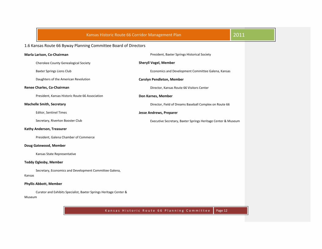
1.6 Kansas Route 66 Byway Planning Committee Board of Directors
Marla Larison, Co-Chairman
Cherokee County Genealogical Society
Baxter Springs Lions Club
Daughters of the American Revolution
Renee Charles, Co-Chairman
President, Kansas Historic Route 66 Association
Machelle Smith, Secretary
Editor, Sentinel Times
Secretary, Riverton Booster Club
Kathy Anderson, Treasurer
President, Galena Chamber of Commerce
Doug Gatewood, Member
Kansas State Representative
Teddy Oglesby, Member
Secretary, Economics and Development Committee Galena,
Kansas
Phyllis Abbott, Member
Curator and Exhibits Specialist, Baxter Springs Heritage Center &
Museum
President, Baxter Springs Historical Society
Sheryll Vogel, Member
Economics and Development Committee Galena, Kansas
Carolyn Pendleton, Member
Director, Kansas Route 66 Visitors Center
Don Karnes, Member
Director, Field of Dreams Baseball Complex on Route 66
Jesse Andrews, Preparer
Executive Secretary, Baxter Springs Heritage Center & Museum

Kansas Historic Route 66 Corridor Management Plan
2011
K a n s a s H i s t o r i c R o u t e 6 6 P l a n n i n g C o m m i t t e e
Page 13
Intrinsic Qualities
Assessment

K a n s a s H i s t o r i c R o u t e 6 6 P l a n n i n g C o m m i t t e e
Page 14
Kansas Historic Route 66 Corridor Management Plan 2011
2.1 Table of Intrinsic Qualities
Page # Site # City Name GPS Coordinates Type
42 1 Galena
Begins Kansas Route 66
Historic District, East of
Galena
State Line Rd & Front St, Galena, KS 66739, USA
street address: State Line Rd & Front St
city: Galena
county/district: Cherokee
state/province: KS
country: USA
latitude, longitude: N37° 5.1549', W094° 37.0787'
HISTORIC, SCENIC
42 2 Galena Small box culvert
Front St, Galena, KS 66739, USA
street address: Front St
city: Galena
county/district: Cherokee
state/province: KS
country: USA
latitude, longitude: N37° 5.1040', W094° 37.1136'
HISTORIC,
ARCHITECTURAL

K a n s a s H i s t o r i c R o u t e 6 6 P l a n n i n g C o m m i t t e e
Page 15
Kansas Historic Route 66 Corridor Management Plan 2011
Page # Site # City Name GPS Coordinates Type
42 3 Galena Route 66 shield painted
on road
Front St, Galena, KS 66739, USA
street address: Front St
city: Galena
county/district: Cherokee
state/province: KS
country: USA
latitude, longitude: N37° 5.1549', W094° 37.0787'
SCENIC
42 4 Galena Welcome to Galena Sign
Front St, Galena, KS 66739, USA
street address: Front St
city: Galena
county/district: Cherokee
state/province: KS
country: USA
latitude, longitude: N37° 5.1046', W094° 37.1010'
SCENIC
K a n s a s H i s t o r i c R o u t e 6 6 P l a n n i n g C o m m i t t e e
Page 16
Kansas Historic Route 66 Corridor Management Plan 2011
Page # Site # City Name GPS Coordinates Type
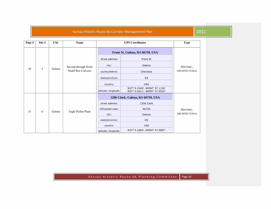
42 5 Galena Second through Sixth
Small Box Culverts
Front St, Galena, KS 66739, USA
street address: Front St
city: Galena
county/district: Cherokee
state/province: KS
country: USA
latitude, longitude: N37° 5.1040', W094° 37.1136'
N37° 5.0411', W094° 37.4525'
HISTORIC,
ARCHITECTURAL
51 6 Galena Eagle Picher Plant
1206 Clark, Galena, KS 66739, USA
street address: 1206 Clark
ZIP/postal code: 66739
city: Galena
state/province: KS
country: USA
latitude, longitude: N37° 5.1883', W094° 37.5897'
HISTORIC,
ARCHITECTURAL
K a n s a s H i s t o r i c R o u t e 6 6 P l a n n i n g C o m m i t t e e
Page 17
Kansas Historic Route 66 Corridor Management Plan 2011
Page # Site # City Name GPS Coordinates Type
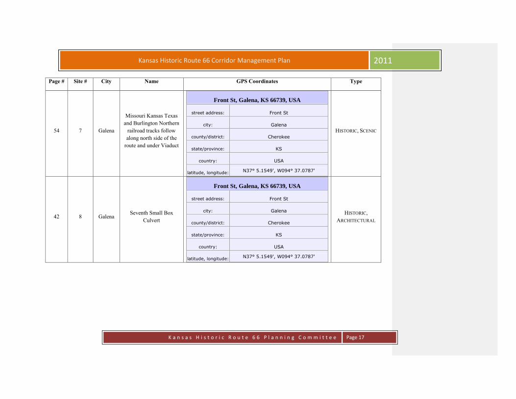
54 7 Galena
Missouri Kansas Texas
and Burlington Northern
railroad tracks follow
along north side of the
route and under Viaduct
Front St, Galena, KS 66739, USA
street address: Front St
city: Galena
county/district: Cherokee
state/province: KS
country: USA
latitude, longitude: N37° 5.1549', W094° 37.0787'
HISTORIC, SCENIC
42 8 Galena Seventh Small Box
Culvert
Front St, Galena, KS 66739, USA
street address: Front St
city: Galena
county/district: Cherokee
state/province: KS
country: USA
latitude, longitude: N37° 5.1549', W094° 37.0787'
HISTORIC,
ARCHITECTURAL

K a n s a s H i s t o r i c R o u t e 6 6 P l a n n i n g C o m m i t t e e
Page 18
Kansas Historic Route 66 Corridor Management Plan 2011
Page # Site # City Name GPS Coordinates Type
42 9 Galena Triple Box Culvert
Front St, Galena, KS 66739, USA
street address: Front St
city: Galena
county/district: Cherokee
state/province: KS
country: USA
latitude, longitude:
N37° 4.5976', W094° 37.5686'
HISTORIC,
ARCHITECTURAL
49 10 Galena Hot Rod Street & Hell’s
Half Acre
Front St, Galena, KS 66739, USA
street address: Front St
city: Galena
county/district: Cherokee
state/province: KS
country: USA
latitude, longitude: N37° 4.5974', W094° 37.5720'
HISTORIC, SCENIC

K a n s a s H i s t o r i c R o u t e 6 6 P l a n n i n g C o m m i t t e e
Page 19
Kansas Historic Route 66 Corridor Management Plan 2011
Page # Site # City Name GPS Coordinates Type
57 11 Galena The Galena Viaduct
Front St, Galena, KS 66739, USA
city: Front St.
county/district: Cherokee
state/province: KS
country: USA
latitude, longitude: N37° 4.5537', W094° 38.3803'
HISTORIC, SCENIC,
ARCHITECTURAL
61 12 Galena Victorian House
203 Main St, Galena, KS 66739, USA
street address: 203 Main St
ZIP/postal code: 66739
city: Galena
state/province: KS
country: USA
latitude, longitude: N37° 4.7317', W094° 38.35'
HISTORIC,
ARCHITECTURAL
63 13 Galena 4 Women on the Route
119 N. Main St, Galena, KS 66739, USA
street address: 119 N Main St
ZIP/postal code: 66739
city: Galena
state/province: KS
country: USA
latitude, longitude: N37° 4.8481', W094° 38.3521'
RECREATIONAL,
HISTORICAL,
ARCHITECTURAL,
CULTURAL

K a n s a s H i s t o r i c R o u t e 6 6 P l a n n i n g C o m m i t t e e
Page 20
Kansas Historic Route 66 Corridor Management Plan 2011
Page # Site # City Name GPS Coordinates Type
65 14 Galena Bradshaw Building
N. Main St. & Front St., Galena, KS 66739, USA
street address: N. Main St. & Front St.
city: Galena
county/district: Cherokee
state/province: KS
country: USA
latitude, longitude: N37° 5.1549', W094° 37.0787'
HISTORIC,
ARCHITECTURAL
66 15 Galena Prehm Building
212 Main St., Galena, KS 66739, USA
street address: 212 Main St
city: Galena
county/district: Cherokee
state/province: KS
country: USA
latitude, longitude: N37° 4.7267', W094° 38.3527'
HISTORIC,
ARCHITECTURAL

K a n s a s H i s t o r i c R o u t e 6 6 P l a n n i n g C o m m i t t e e
Page 21
Kansas Historic Route 66 Corridor Management Plan 2011
Page # Site # City Name GPS Coordinates Type
67 16 Galena Gill Building
214 Main St., Galena, KS 66739, USA
street address: 214 Main St
city: Galena
county/district: Cherokee
state/province: KS
country: USA
latitude, longitude: N37° 4.7257', W094° 38.3527'
HISTORIC,
ARCHITECTURAL
68 17 Galena Old Maywood Theater
320 Main St, Galena, KS 66739, USA
street address: 320 Main St
city: Galena
county/district: Cherokee
state/province: KS
country: USA
latitude, longitude: N37° 4.6721', W094° 38.3525'
HISTORIC,
ARCHITECTURAL
K a n s a s H i s t o r i c R o u t e 6 6 P l a n n i n g C o m m i t t e e
Page 22
Kansas Historic Route 66 Corridor Management Plan 2011
Page # Site # City Name GPS Coordinates Type
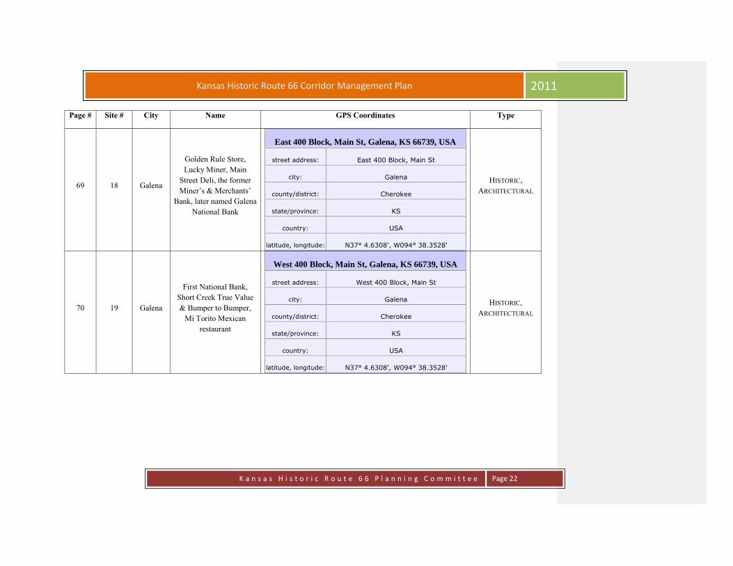
69 18 Galena
Golden Rule Store,
Lucky Miner, Main
Street Deli, the former
Miner’s & Merchants’
Bank, later named Galena
National Bank
East 400 Block, Main St, Galena, KS 66739, USA
street address: East 400 Block, Main St
city: Galena
county/district: Cherokee
state/province: KS
country: USA
latitude, longitude: N37° 4.6308', W094° 38.3528'
HISTORIC,
ARCHITECTURAL
70 19 Galena
First National Bank,
Short Creek True Value
& Bumper to Bumper,
Mi Torito Mexican
restaurant
West 400 Block, Main St, Galena, KS 66739, USA
street address: West 400 Block, Main St
city: Galena
county/district: Cherokee
state/province: KS
country: USA
latitude, longitude: N37° 4.6308', W094° 38.3528'
HISTORIC,
ARCHITECTURAL

K a n s a s H i s t o r i c R o u t e 6 6 P l a n n i n g C o m m i t t e e
Page 23
Kansas Historic Route 66 Corridor Management Plan 2011
Page # Site # City Name GPS Coordinates Type
71 20 Galena City Hall
East 500 Block, Main St, Galena, KS 66739, USA
street address: East 500 Block, Main St
city: Galena
county/district: Cherokee
state/province: KS
country: USA
latitude, longitude: N37° 4.5795', W094° 38.3534'
HISTORIC,
ARCHITECTURAL
72 21 Galena Howard “Pappy” Litch
Park,
West 500 Block, Main St, Galena, KS 66739, USA
street address: West 500 Block, Main St
city: Galena
county/district: Cherokee
state/province: KS
country: USA
latitude, longitude: N37° 4.5795', W094° 38.3534'
HISTORIC,
RECREATIONAL,
SCENIC, NATURAL

K a n s a s H i s t o r i c R o u t e 6 6 P l a n n i n g C o m m i t t e e
Page 24
Kansas Historic Route 66 Corridor Management Plan 2011
Page # Site # City Name GPS Coordinates Type
74 22 Galena
Chamber building south
of park still with the
original design and vault
from early days as a Post
Office.
509 Main St, Galena, KS 66739, USA
street address: 509 Main
city: Galena
county/district: Cherokee
state/province: KS
country: USA
latitude, longitude: N37° 4.5754', W094° 38.3506'
HISTORIC,
ARCHITECTURAL
75 23 Galena Former gas station being
restored as detailed shop.
Galena, KS 66739, USA
street address:
city: Galena
county/district: Cherokee
state/province: KS
country: USA
latitude, longitude: N37° 5.1549', W094° 37.0787'
HISTORIC,
ARCHITECTURAL

K a n s a s H i s t o r i c R o u t e 6 6 P l a n n i n g C o m m i t t e e
Page 25
Kansas Historic Route 66 Corridor Management Plan 2011
Page # Site # City Name GPS Coordinates Type
76 24 Galena Sapp Opera House
Main St & 7th
St, Galena, KS 66739, USA
street address: Main St. & 7th St.
city: Galena
county/district: Cherokee
state/province: KS
country: USA
latitude, longitude: N37° 4.4958', W094° 38.3522'
HISTORIC
80 25 Galena The Grace House
1302 S Main St, Galena, KS 66739, USA street address: S Main St
ZIP/postal code: 66739
city: Galena
state/province: KS
country: USA
latitude, longitude: N37° 4.171', W094° 38.3539'
HISTORIC,
ARCHITECTURAL
81 26 Galena SE Kansas Nature Center
& Schermerhorn Park
3501 Main St, Galena, KS 66739, USA
street address: 3501 S Main St
ZIP/postal code: 66739
city: Galena
state/province: KS
country: USA
latitude, longitude: N37° 2.9094', W094° 38.3847'
RECREATIONAL,
ARCHAEOLOGICAL,
SCENIC, HISTORIC,
NATURAL,
ARCHITECTURAL
K a n s a s H i s t o r i c R o u t e 6 6 P l a n n i n g C o m m i t t e e
Page 26
Kansas Historic Route 66 Corridor Management Plan 2011
Page # Site # City Name GPS Coordinates Type
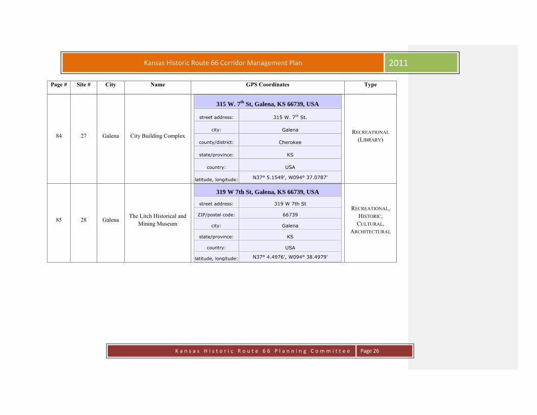
84 27 Galena City Building Complex
315 W. 7th
St, Galena, KS 66739, USA
street address: 315 W. 7th St.
city: Galena
county/district: Cherokee
state/province: KS
country: USA
latitude, longitude: N37° 5.1549', W094° 37.0787'
RECREATIONAL
(LIBRARY)
85 28 Galena The Litch Historical and
Mining Museum
319 W 7th St, Galena, KS 66739, USA
street address: 319 W 7th St
ZIP/postal code: 66739
city: Galena
state/province: KS
country: USA
latitude, longitude: N37° 4.4976', W094° 38.4979'
RECREATIONAL,
HISTORIC,
CULTURAL,
ARCHITECTURAL

K a n s a s H i s t o r i c R o u t e 6 6 P l a n n i n g C o m m i t t e e
Page 27
Kansas Historic Route 66 Corridor Management Plan 2011
Page # Site # City Name GPS Coordinates Type
87 29 Galena Galena Cemetery
Galena Cemetery, Galena, KS 66739, USA
street address: Galena Cemetery
neighborhood: Galena Cemetery
city: Galena
county/district: Cherokee
state/province: KS
country: USA
latitude, longitude: N37° 4.5729', W094° 38.9152'
HISTORIC, SCENIC
88 30 Galena
Hacienda style home –
private residence “No
Public Access”
2415 W 7th St, Galena, KS 66739, USA
street address: 2415 W 7th St
ZIP/postal code: 66739
city: Galena
state/province: KS
country: USA
latitude, longitude: N37° 4.4904', W094° 40.0645'
ARCHITECTURAL

K a n s a s H i s t o r i c R o u t e 6 6 P l a n n i n g C o m m i t t e e
Page 28
Kansas Historic Route 66 Corridor Management Plan 2011
Page # Site # City Name GPS Coordinates Type
89 31 Riverton Stevenson Cemetery
Stevenson Cemetery, Riverton, KS 66739, USA
street address: Stevenson Cemetery
neighborhood: Stevenson Cemetery
city: Riverton
county/district: Cherokee
state/province: KS
country: USA
latitude, longitude: N37° 4.5107', W094° 40.3734'
HISTORIC
90 32 Riverton
Spring River banks are
nesting areas for the
American Eagle
Hwy 66, KS, USA
street address: Kansas 66
latitude, longitude: N37° 4.4958', W094° 40.9609'
SCENIC, NATURAL,
RECREATIONAL
91 33 Riverton
Spring River Inn Neon
Sign – Westbound side of
Route 66
Hwy 66 & SE 73rd Terrace, Riverton, KS 66770,
USA
street address: Kansas 66 & SE 73rd Terrace
ZIP/postal code: 66770
city: Riverton
county/district: Cherokee
state/province: KS
country: USA
latitude, longitude: N37° 4.495', W094° 41.9037'
HISTORIC

K a n s a s H i s t o r i c R o u t e 6 6 P l a n n i n g C o m m i t t e e
Page 29
Kansas Historic Route 66 Corridor Management Plan 2011
Page # Site # City Name GPS Coordinates Type
92 34 Riverton Empire District Electric
7242 Hwy 66, Riverton, KS 66770, USA
street address: 7242 Kansas 66
ZIP/postal code: 66770
city: Riverton
state/province: KS
country: USA
latitude, longitude: N37° 4.4843', W094° 41.9602'
HISTORIC
98 35 Riverton Old Riverton Store
7109 Hwy 66, Riverton, KS 66770, USA
street address: 7109 Kansas 66
ZIP/postal code: 66770
city: Riverton
state/province: KS
country: USA
latitude, longitude: N37° 4.4946', W094° 42.1266'
HISTORIC,
RECREATIONAL
K a n s a s H i s t o r i c R o u t e 6 6 P l a n n i n g C o m m i t t e e
Page 30
Kansas Historic Route 66 Corridor Management Plan 2011
Page # Site # City Name GPS Coordinates Type
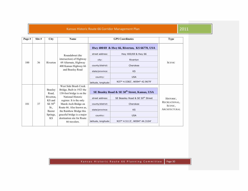
100 36 Riverton
Roundabout (the
intersection) of Highway
69 Alternate, Highway
400 Kansas Highway 66
and Beasley Road
Hwy 400/69 & Hwy 66, Riverton, KS 66770, USA
street address: Hwy 400/69 & Hwy 66
city: Riverton
county/district: Cherokee
state/province: KS
country: USA
latitude, longitude: N37° 4.5382', W094° 42.9679'
SCENIC
101 37
Beasley
Road,
Riverton,
KS and
SE 50th
St.,
Baxter
Springs,
KS
West Side Brush Creek
Bridge, Built in 1923 the
130-foot bridge is on the
National Historic
register. It is the only
Marsh Arch Bridge on
Route 66. Also known as,
the Rainbow Bridge this
graceful bridge is a major
destination site for Route
66 travelers.
SE Beasley Road & SE 50th
Street, Kansas, USA
street address: SE Beasley Road & SE 50th Street
county/district: Cherokee
state/province: KS
country: USA
latitude, longitude: N37° 4.5113', W094° 44.3104'
HISTORIC,
RECREATIONAL,
SCENIC,
ARCHITECTURAL

K a n s a s H i s t o r i c R o u t e 6 6 P l a n n i n g C o m m i t t e e
Page 31
Kansas Historic Route 66 Corridor Management Plan 2011
Page # Site # City Name GPS Coordinates Type
103 38 Baxter
Springs Field of Dreams
8933 SE 50th St, Baxter Springs, KS 66713, USA
street address: 8933 SE 50th St
ZIP/postal code: 66713
city: Baxter Springs
state/province: KS
country: USA
latitude, longitude: N37° 2.771', W094° 44.4387'
SCENIC,
RECREATIONAL
105 39 Baxter
Springs Fort Blair
Military Ave & W 6th St, Baxter Springs, KS 66713,
USA
street address: Military Ave & W 6th St
ZIP/postal code: 66713
city: Baxter Springs
county/district: Cherokee
state/province: KS
country: USA
latitude, longitude: N37° 1.7938', W094° 44.0923'
ARCHEOLOGICAL,
HISTORIC,
RECREATIONAL

K a n s a s H i s t o r i c R o u t e 6 6 P l a n n i n g C o m m i t t e e
Page 32
Kansas Historic Route 66 Corridor Management Plan 2011
Page # Site # City Name GPS Coordinates Type
107 40 Baxter
Springs
Baxter Springs Heritage
Center & Museum
740 East Ave, Baxter Springs, KS 66713, USA
street address: 740 East Ave
ZIP/postal code: 66713
city: Baxter Springs
state/province: KS
country: USA
latitude, longitude: N37° 1.7012', W094° 44.0215'
CULTURAL,
RECREATIONAL,
HISTORIC
109 41 Baxter
Springs
Historic Route 66
Visitors Center
940 Military Ave, Baxter Springs, KS 66713, USA
street address: 940 Military Ave
ZIP/postal code: 66713
city: Baxter Springs
state/province: KS
country: USA
latitude, longitude: N37° 1.5704', W094° 44.1071'
HISTORIC,
CULTURAL,
RECREATIONAL,
ARCHITECTURAL
111 42 Baxter
Springs
Illinois Cash Store -
Baxter National Bank
1046 Military Ave, Baxter Springs, KS 66713, USA
street address: 1046 Military Ave
ZIP/postal code: 66713
city: Baxter Springs
state/province: KS
country: USA
latitude, longitude: N37° 1.5155', W094° 44.1107'
HISTORIC,
ARCHITECTURAL
K a n s a s H i s t o r i c R o u t e 6 6 P l a n n i n g C o m m i t t e e
Page 33
Kansas Historic Route 66 Corridor Management Plan 2011
Page # Site # City Name GPS Coordinates Type
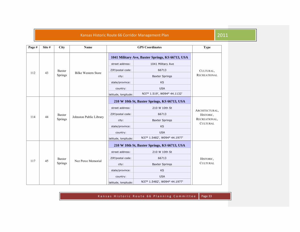
112 43 Baxter
Springs Bilke Western Store
1041 Military Ave, Baxter Springs, KS 66713, USA
street address: 1041 Military Ave
ZIP/postal code: 66713
city: Baxter Springs
state/province: KS
country: USA
latitude, longitude: N37° 1.519', W094° 44.1132'
CULTURAL,
RECREATIONAL
114 44 Baxter
Springs Johnston Public Library
210 W 10th St, Baxter Springs, KS 66713, USA
street address: 210 W 10th St
ZIP/postal code: 66713
city: Baxter Springs
state/province: KS
country: USA
latitude, longitude: N37° 1.5482', W094° 44.1977'
ARCHITECTURAL,
HISTORIC,
RECREATIONAL,
CULTURAL
117 45 Baxter
Springs Nez Perce Memorial
210 W 10th St, Baxter Springs, KS 66713, USA
street address: 210 W 10th St
ZIP/postal code: 66713
city: Baxter Springs
state/province: KS
country: USA
latitude, longitude: N37° 1.5482', W094° 44.1977'
HISTORIC,
CULTURAL
K a n s a s H i s t o r i c R o u t e 6 6 P l a n n i n g C o m m i t t e e
Page 34
Kansas Historic Route 66 Corridor Management Plan 2011
Page # Site # City Name GPS Coordinates Type
122 46 Baxter
Springs
Little Brick Inn Bed and
Breakfast Cafe on the
Route
1101 Military Ave, Baxter Springs, KS 66713, USA
street address: 1101 Military Ave
ZIP/postal code: 66713
city: Baxter Springs
state/province: KS
country: USA
latitude, longitude: N37° 1.4796', W094° 44.1162'
HISTORIC,
RECREATIONAL
124 47 Baxter
Springs
Indiana House
Kingrey-Kellum Agency
1145 Military Ave, Baxter Springs, KS 66713, USA
street address: 1145 Military Ave
ZIP/postal code: 66713
city: Baxter Springs
state/province: KS
country: USA
latitude, longitude: N37° 1.4451', W094° 44.1185'
HISTORIC,
ARCHITECTURAL
125 48 Baxter
Springs Wells-Fargo Station
1112 Military Ave, Baxter Springs, KS 66713, USA
street address: 1112 Military Ave
ZIP/postal code: 66713
city: Baxter Springs
state/province: KS
country: USA
latitude, longitude: N37° 1.4593', W094° 44.1148'
HISTORIC,
ARCHITECTURAL

K a n s a s H i s t o r i c R o u t e 6 6 P l a n n i n g C o m m i t t e e
Page 35
Kansas Historic Route 66 Corridor Management Plan 2011
Page # Site # City Name GPS Coordinates Type
126 49 Baxter
Springs SACS 66
1141 Military Ave, Baxter Springs, KS 66713, USA
street address: Military Ave
ZIP/postal code: 66713
city: Baxter Springs
state/province: KS
country: USA
latitude, longitude: N37° 1.4468', W094° 44.1184'
HISTORIC,
ARCHITECTURAL,
RECREATIONAL
128 50 Baxter
Springs Angels on the Route
1143 Military Ave, Baxter Springs, KS 66713, USA
street address: 1143 Military Ave
ZIP/postal code: 66713
city: Baxter Springs
state/province: KS
country: USA
latitude, longitude: N37° 1.446', W094° 44.1184'
HISTORIC,
RECREATIONAL,
ARCHITECTURAL
130 51 Baxter
Springs
Route 66 Soda Fountain
Shop
1136 Military Ave, Baxter Springs, KS 66713, USA
street address: 1136 Military Ave
ZIP/postal code: 66713
city: Baxter Springs
state/province: KS
country: USA
latitude, longitude: N37° 1.4376', W094° 44.1162'
HISTORIC
RECREATIONAL,
ARCHITECTURAL,
CULTURAL

K a n s a s H i s t o r i c R o u t e 6 6 P l a n n i n g C o m m i t t e e
Page 36
Kansas Historic Route 66 Corridor Management Plan 2011
Page # Site # City Name GPS Coordinates Type
132 52 Baxter
Springs
Frieze on Exterior Wall
of American Bank
1201 Military Ave, Baxter Springs, KS 66713, USA
street address: 1201 Military Ave
ZIP/postal code: 66713
city: Baxter Springs
state/province: KS
country: USA
latitude, longitude: N37° 1.4154', W094° 44.1206'
SCENIC,
RECREATIONAL,
HISTORIC
134 53 Baxter
Springs Kirkendolls/Edens
Grocery
544 W 12th St, Baxter Springs, KS 66713, USA
street address: W 12th St
ZIP/postal code: 66713
city: Baxter Springs
state/province: KS
country: USA
latitude, longitude: N37° 1.4356', W094° 44.4662'
HISTORIC,
ARCHITECTURAL
K a n s a s H i s t o r i c R o u t e 6 6 P l a n n i n g C o m m i t t e e
Page 37
Kansas Historic Route 66 Corridor Management Plan 2011
Page # Site # City Name GPS Coordinates Type
136 54 Baxter
Springs National Cemetery Plot
Hwy 166, Baxter Springs, KS 66713, USA
street address: Baxter Springs Cemetery, Hwy 166
city: Baxter Springs
county/district: Cherokee
state/province: KS
country: USA
latitude, longitude: N37° 1.9355', W094° 46.1883'
HISTORIC, SCENIC,
ARCHITECTURAL
138 55 Baxter
Springs Presbyterian Church
133 E 12th St, Baxter Springs, KS 66713, USA
street address: 133 E 12th St
ZIP/postal code: 66713
city: Baxter Springs
state/province: KS
country: USA
latitude, longitude: N37° 1.4163', W094° 44.0923'
HISTORIC,
ARCHITECTURAL

K a n s a s H i s t o r i c R o u t e 6 6 P l a n n i n g C o m m i t t e e
Page 38
Kansas Historic Route 66 Corridor Management Plan 2011
Page # Site # City Name GPS Coordinates Type
140 56 Baxter
Springs Grantham Home
Derfelt Funeral Home
328 E 12th St, Baxter Springs, KS 66713, USA
street address: 328 E 12th St
ZIP/postal code: 66713
city: Baxter Springs
state/province: KS
country: USA
latitude, longitude: N37° 1.424', W094° 43.9489'
HISTORIC,
ARCHITECTURAL
141 57 Baxter
Springs Cooper Home
Abbott Funeral Home
519 E 12th St, Baxter Springs, KS 66713, USA
street address: 519 E 12th St
ZIP/postal code: 66713
city: Baxter Springs
state/province: KS
country: USA
latitude, longitude: N37° 1.42', W094° 43.8199'
HISTORIC,
ARCHITECTURAL

K a n s a s H i s t o r i c R o u t e 6 6 P l a n n i n g C o m m i t t e e
Page 39
Kansas Historic Route 66 Corridor Management Plan 2011
Page # Site # City Name GPS Coordinates Type
143 58 Baxter
Springs Youse Home
532 E. 12th
St, Baxter Springs, KS 66713, USA
street address: 532 E. 12th St.
city: Baxter Springs
county/district: Cherokee
state/province: KS
country: USA
latitude, longitude: N37° 1.4222', W094° 43.7906'
HISTORIC,
ARCHITECTURAL
145 59 Baxter
Springs Niles Home
605 E. 12th
St, Baxter Springs, KS 66713, USA
street address: 605 E 12th St
ZIP/postal code: 66713
city: Baxter Springs
state/province: KS
country: USA
latitude, longitude: N37° 1.4204', W094° 43.7527'
HISTORIC,
ARCHITECTURAL

K a n s a s H i s t o r i c R o u t e 6 6 P l a n n i n g C o m m i t t e e
Page 40
Kansas Historic Route 66 Corridor Management Plan 2011
Page # Site # City Name GPS Coordinates Type
147 60 Baxter
Springs Lea Manor
709 E 12th St, Baxter Springs, KS 66713, USA
street address: 709 E 12th St
ZIP/postal code: 66713
city: Baxter Springs
state/province: KS
country: USA
latitude, longitude: N37° 1.4199', W094° 43.6663'
HISTORIC,
ARCHITECTURAL,
RECREATIONAL
149 61 Baxter
Springs Little League & Youth
Ball Parks
Lions Ave & W 14th St, Baxter Springs, KS 66713,
USA
street address: Lions Ave & W 14th St
ZIP/postal code: 66713
city: Baxter Springs
county/district: Cherokee
state/province: KS
country: USA
latitude, longitude: N37° 1.3086', W094° 44.4414'
HISTORICAL,
RECREATIONAL

K a n s a s H i s t o r i c R o u t e 6 6 P l a n n i n g C o m m i t t e e
Page 41
Kansas Historic Route 66 Corridor Management Plan 2011
Page # Site # City Name GPS Coordinates Type
152 62 Baxter
Springs Former Shouse Service
Station
1901 Military Ave, Baxter Springs, KS 66713, USA
street address: 1901 Military Ave
ZIP/postal code: 66713
city: Baxter Springs
state/province: KS
country: USA
latitude, longitude: N37° 0.9823', W094° 44.1545'
HISTORICAL,
ARCHITECTURAL
155 63 Baxter
Springs Historic Route 66
Roadbed
W 30th St & Roberts Rd, Baxter Springs, KS 66713,
USA
street address: W 30th St & Roberts Rd
ZIP/postal code: 66713
city: Baxter Springs
county/district: Cherokee
country: USA
latitude, longitude: N37° 0.00601', W094° 73657'
HISTORIC

K a n s a s H i s t o r i c R o u t e 6 6 P l a n n i n g C o m m i t t e e
Page 42
Kansas Historic Route 66 Corridor Management Plan 2011
2.2 Description of Intrinsic Qualities
Sites # 1, 2, 3, 4, 5, 8, 9: Beginning of Kansas Route 66 Historic District east of Galena, Kansas. Includes roadbed, 7 single culverts, and 1
triple culvert. Location: State line Road and Front Street, Galena, Kansas to Front Street and Main Street Galena Kansas
GPS Location: N37° 5.1549', W094° 37.0787'
Description:
Archaeological Natural
Cultural Recreational
Historic Scenic
Architectural
1.) Roadbed is approximately 25 feet wide. It has an asphalt surface with soft, gravel and grassy shoulders. The roadbed has been
resurfaced since its original construction. Several culverts and a viaduct line this segment of road, which extends from the Missouri State
Line to the intersection Front Street in Galena. This section of road appears to have been part of the 1922-23 improvements. Estimated date
of construction: 1923 c. Pictured on page 45
2.) Concrete culvert with railing located at State Line. On the north side of the road the culvert retains a railing composed of three square
posts with inset panels on each side and chamfered tops. Pairs of rectangular rails with chamfered edges connect the posts. The posts are
set into the top of the concrete culvert structure. The railing on the south side of the road is missing. This structure is one of several of a
similar vintage located along an original two-lane section of Highway 66 flanked by chat piles and industrial facilities. This is one of several
road structures that appears to date to the 1922-23 improvements of this road. Estimated date of construction: 1923 c. Pictured on page 45

K a n s a s H i s t o r i c R o u t e 6 6 P l a n n i n g C o m m i t t e e
Page 43
Kansas Historic Route 66 Corridor Management Plan 2011
3.) Route 66 Shield painted on the road depicts the expected tourist attraction. Many can be spotted along the 13.2 miles of Kansas Historic
Route 66. Pictured on page 45.
4.) Welcome to Galena sign directly to the right of the painted shield. Pictured on page 45.
5.) Concrete culvert located 0.1 miles west of State Line. On the south side of the road the culvert retains a railing composed of two square
posts with inset panels on each side and chamfered tops. A pair of rectangular rails with chamfered edges connects the posts. The posts are
set in to the top of the concrete culvert structure. The railing on the north side of the road has been significantly damaged, although pieces
remain. This structure is one of several of a similar vintage located along an original two-lane section of Highway 66 flanked by chat piles
and industrial facilities. The culvert railing appears to have been damaged during a collision, perhaps with an automobile or truck. Both
posts are chipped and one has been knocked askew allowing the railings to become detached. This is one of several road structures that
appears to date to the 1922-23 improvement of this road. Estimated date of construction: 1923 c.
Concrete culvert located 0.3 miles west of the Missouri state line. The poured concrete structure has a visible opening only on the south
side of the road. It no longer retains its original railing. This structure is one of several of a similar vintage located along an original two-lane
section of Highway 66 flanked by chat piles and industrial facilities. This is one of several road structures that appears to date to the 1922-23
improvement of this road. Estimated date of construction: 1923 c.
Concrete culvert located 0.385 miles west of the Missouri state line. The poured concrete structure has opening on the north and south
sides of the road. Neither side retains its original railing. This structure is one of several of a similar vintage located along an original two-
lane section of Highway 66 flanked by chat piles and industrial facilities. This is one of several road structures that appears to date to the
1922-23 improvement of this road. Estimated date of construction: 1923 c.
Concrete culvert located 0.6 miles west of State Line. On the north side of the road the railing is composed of two square posts with inset
panels on each side and chamfered tops. A pair of rectangular rails with chamfered edges connects the posts. The posts are set in to the top
of the concrete culvert structure. The railing is no longer extant on the south culvert opening. Structure is in good condition and unchanged
from its original design. This is one of several road structures that appears to date to the 1922-23 improvement of this road. Estimated date
of construction: 1923 c. Pictured on page 46.
Concrete culvert located at the intersection of Old Highway 66 & Bellevue Street. The poured concrete structure has opening on the
southeast and southwest corners of the intersection. Neither opening retains its original railing. This structure is one of several of a similar

K a n s a s H i s t o r i c R o u t e 6 6 P l a n n i n g C o m m i t t e e
Page 44
Kansas Historic Route 66 Corridor Management Plan 2011
vintage located along an original two-lane section of Highway 66 flanked by chat piles and industrial facilities. This is one of several road
structures that appears to date to the 1922-23 improvement of this road. Estimated date of construction: 1923 c. Pictured on page 47.
8.) Concrete culvert located 0.65 miles west of State Line. On the north side of the road a railing is composed of two square post with inset
panels on each side and chamfered tops. A pair of rectangular rails with chamfered edges connects the posts. The posts are set in to the top
of the concrete culvert structure. There is no railing extant on the south side of the road. This structure is one of several vintage located
along an original two-lane section of Highway 66 flanked by chat piles and industrial facilities. This is one of several road structures that
appears to date to the 1922-23 improvement of this road. Estimated date of construction: 1923 c. Pictured on page 48
9.) A triple-culvert structure is located 0.8 miles west of Missouri State Line. The poured concrete structure includes retaining walls on east
and west and two rectangular slab piers that divide the structure into three equal bays. Lining the north and south sides of the bridge are
concrete railings. Each railing features five square posts with inset panels on each side and chamfered tops. Pairs of rectangular rails with
chamfered edges connect the posts. The posts are set in to the top of the concrete culvert structure. This structure is one of several of a
similar vintage located along an original two-lane section of Highway 66 flanked by chat piles and industrial facilities. Modern metal
guardrails extend east and west from both ends of the bridge. Otherwise the structure appears unchanged from its original design. This is
one of several road structures that appears to date to the 1922-23 improvement of this road. Estimated date of construction: 1923 c.
Pictured on page 48.
Intrinsic qualities 1, 2, 5, 8, and 9 are all on the National Register of Historic Places and pictured on pages 44-47. The registration form can
be found online at http://www.kshs.org/resource/national_register/nominationsNRDB/Cherokee_KansasRoute66HistoricDistrictNR.pdf .
Approved on August 29th, 2003, the application form was prepared by Elizabeth Rosin of Historic Preservation Services, LLC at the request
of Cherokee County, Kansas.

K a n s a s H i s t o r i c R o u t e 6 6 P l a n n i n g C o m m i t t e e
Page 45
Kansas Historic Route 66 Corridor Management Plan 2011
# 4, Welcome to Galena upon entering Kansas from Missouri Route 66
#4, Route 66 shield painted on roadbed east of Galena
K a n s a s H i s t o r i c R o u t e 6 6 P l a n n i n g C o m m i t t e e
Page 46
Kansas Historic Route 66 Corridor Management Plan 2011
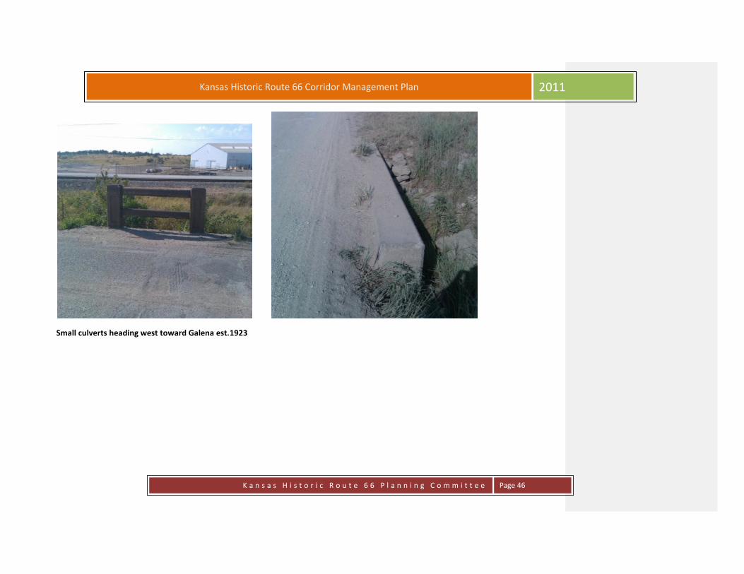
Small culverts heading west toward Galena est.1923

K a n s a s H i s t o r i c R o u t e 6 6 P l a n n i n g C o m m i t t e e
Page 47
Kansas Historic Route 66 Corridor Management Plan 2011
# 5, This structure no longer has its original railing and is one of
several of these structures on the section of the Rt. 66 Historic District east of Galena, est. date of construction 1923.
K a n s a s H i s t o r i c R o u t e 6 6 P l a n n i n g C o m m i t t e e
Page 48
Kansas Historic Route 66 Corridor Management Plan 2011
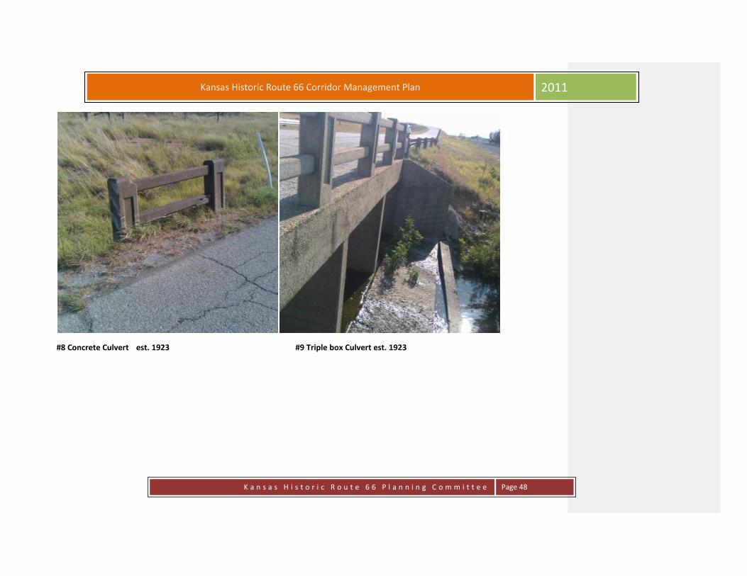
#8 Concrete Culvert est. 1923 #9 Triple box Culvert est. 1923

K a n s a s H i s t o r i c R o u t e 6 6 P l a n n i n g C o m m i t t e e
Page 49
Kansas Historic Route 66 Corridor Management Plan 2011
Site # 10: The Galena Viaduct
Location: Front Street, Galena, Kansas
GPS Location: N37° 4.5537', W094° 38.3803'
Description:
Archaeological Natural
Cultural Recreational
Historic Scenic
Architectural
Concrete structure with asphalt deck is located 1 mile west of Missouri state line. Concrete encapsulated steel girder structure includes a
central span flanked by approach spans on either end. The piers supporting the girders include pairs in an “H”-shaped and individual posts.
Five foot wide concrete sidewalks flank the roadway across the viaduct. Railings composed of short square posts connected by three
horizontal members flank the sidewalks. This structure is one of several of a similar vintage located long an original two-lane section of
Highway 66 flanked by chat piles and industrial facilities. The bridge deck has been resurfaced and the structure suffers from delayed
maintenance. This is one of several road structures that appears to date to the 1922-23 improvement of this road. Estimated date of
construction: 1923 c.
Many blogs, websites, and stories from visitors near and far tell of their travels over this interesting viaduct. Taking visitors over the “Katy”
railroad tracks the viaduct is characteristic of an original icon of Historic Route 66. The view of Hell’s Half Acre facing the east is something
to pause and enjoy.

K a n s a s H i s t o r i c R o u t e 6 6 P l a n n i n g C o m m i t t e e
Page 50
Kansas Historic Route 66 Corridor Management Plan 2011
The Galena Viaduct

K a n s a s H i s t o r i c R o u t e 6 6 P l a n n i n g C o m m i t t e e
Page 51
Kansas Historic Route 66 Corridor Management Plan 2011
Site # 6: Eagle-Picher Plant
Location: 1206 Clark St., Galena KS
GPS Location: N37° 5.1883', W094° 37.5897'
Description:
Archaeological Natural
Cultural Recreational
Historic Scenic
Architectural
Dominating the complex are a series of large industrial buildings with corrugated metal siding, sliding barn-style doors and gable or shed
roofs. One smaller older brick building with a board-and-batten front addition is located at the center of the complex. This industrial
complex is located north of Highway 66 between the Missouri state line and the Galena commercial district. A railroad track runs between
the road and the complex. A chain link fence encircles the complex. The smelting operation at this facility ceased 1980. It now serves as a
warehouse facility for Eagle-Picher. Most of the complex’s historic fabric has been removed.
Located in the valley north of town and sitting next to Historic Route 66 was the Eagle-Picher Smelter. Trains brought millions of tons of ore
from mines all over the Kansas and Oklahoma mine fields to be processed in the furnaces at the large ore-processing center At one time,
the smelter employed thousands of workers. In 1935, violence came to the city when an attempt was made to organize the miners into
unions. Despite efforts by mine owners and operators to prevent it, the area laborers organized, and elected to strike for better wages and
working conditions. The situation grew ugly and dangerous when the mining companies attempted to use replacement workers in the
absence of the newly-unionized miners. Gunfire in the streets eventually led Governor Landon to declare martial law in the town, and
K a n s a s H i s t o r i c R o u t e 6 6 P l a n n i n g C o m m i t t e e
Page 52
Kansas Historic Route 66 Corridor Management Plan 2011
deployed the Kansas National Guard to enter Galena and re-establish the peace.
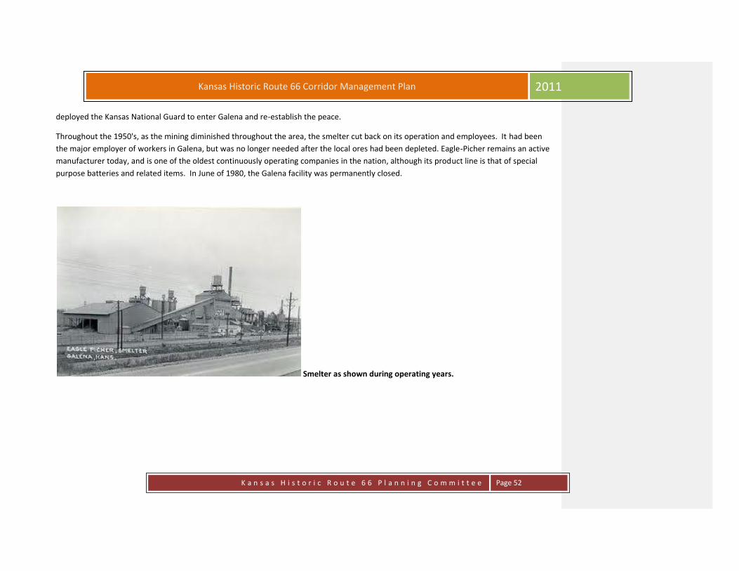
Throughout the 1950's, as the mining diminished throughout the area, the smelter cut back on its operation and employees. It had been
the major employer of workers in Galena, but was no longer needed after the local ores had been depleted. Eagle-Picher remains an active
manufacturer today, and is one of the oldest continuously operating companies in the nation, although its product line is that of special
purpose batteries and related items. In June of 1980, the Galena facility was permanently closed.
Smelter as shown during operating years.
K a n s a s H i s t o r i c R o u t e 6 6 P l a n n i n g C o m m i t t e e
Page 53
Kansas Historic Route 66 Corridor Management Plan 2011
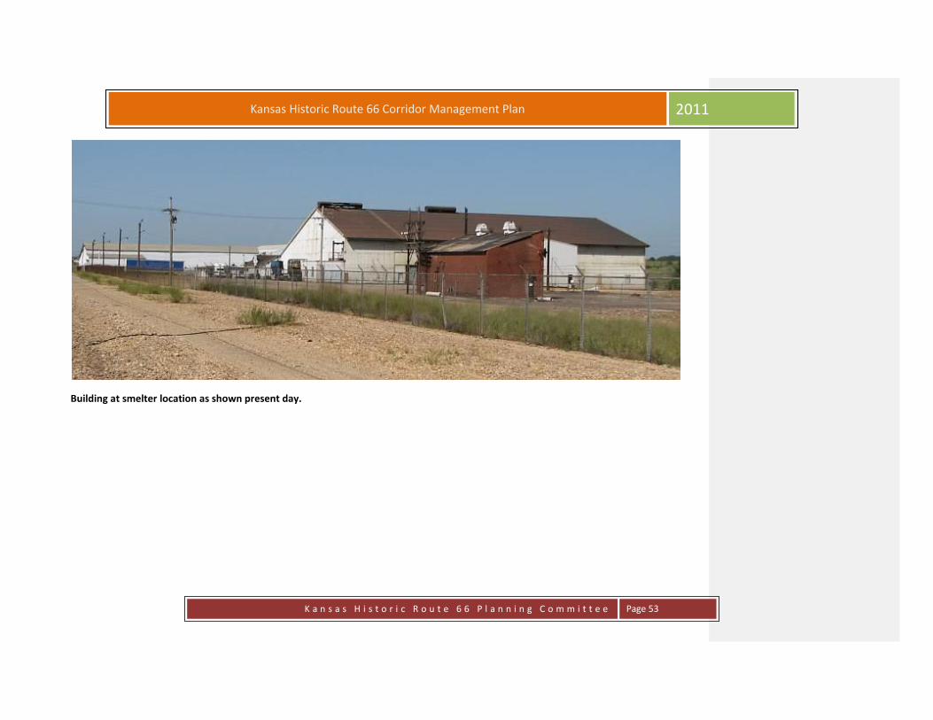
Building at smelter location as shown present day.

Kansas Historic Route 66 Corridor Management Plan
2011
K a n s a s H i s t o r i c R o u t e 6 6 P l a n n i n g C o m m i t t e e
Page 54
Site # 7: Missouri Kansas Texas and Burlington Northern Railroad Tracks
Location: Can be viewed along many places on the first mile section of Kansas Route 66 (Front Street), Galena, KS
GPS Location: N37° 5.1549', W094° 37.0787'
Description:
Archaeological Natural
Cultural Recreational
Historic Scenic
Architectural
Missouri-Kansas-Texas Railroad (1865-1988) – Formerly called the M.K.T. and affectionately referred to as "Katy," the Missouri-Kansas-
Texas Railroad was created in 1865. First called the Union Pacific Railway, Southern Branch (unrelated to the Union Pacific Railroad,) the line
was chartered by the State of Kansas to build from Fort Riley, Kansas, to the state's southern boundary. After receiving a land grant, the
company began construction in 1869. After the federal government announced that a right-of-way would be given through Indian
Territory and a liberal bonus of land given to the first railroad to first reach the Territory's northern border, other companies joined the
race. But, on June 6, 1870, the Union Pacific Railway, Southern Branch won the race and officially changed its name to the Missouri, Kansas
& Texas Railway.
Winning the sole right to build south through Indian Territory, construction began southward and the company also acquired the Tebo &
Neosho Railroad, that connected Sedalia, Missouri to Parsons, Kansas.
The "Katy," touted in advertisements as the Gateway to Texas, breached the Texas frontier near the site of present Denison, where the first

K a n s a s H i s t o r i c R o u t e 6 6 P l a n n i n g C o m m i t t e e
Page 55
Kansas Historic Route 66 Corridor Management Plan 2011
regular train arrived on Christmas Day, 1872. Eventually, the Missouri-Kansas-Texas Railroad grew to link Missouri's main cities,
with Tulsa and Oklahoma City, Oklahoma; as well as Texas' large cities, including Dallas, Fort Worth, Waco, Temple, Austin, San Antonio,
Houston, and Galveston
The Missouri-Kansas-Texas Railroad was purchased by the Missouri Pacific Railroad Company (MoPac), a subsidiary of the Union Pacific
Railroad in 1988. By that time, the century old company served six mid-western states with more than 3,377 miles of track. Today, it
continues to operate as part of the Union Pacific Railroad system.

K a n s a s H i s t o r i c R o u t e 6 6 P l a n n i n g C o m m i t t e e
Page 56
Kansas Historic Route 66 Corridor Management Plan 2011
Above:Railroad Tracks looking down from the Viaduct
Left: MKT train depot now houses a museum

K a n s a s H i s t o r i c R o u t e 6 6 P l a n n i n g C o m m i t t e e
Page 57
Kansas Historic Route 66 Corridor Management Plan 2011
Site # 11: Red Hot Street & Hell’s Half Acre
Location: Can be viewed from along many places on the first mile section of Kansas Route 66 (Front Street), Galena, KS
GPS Location: N37° 4.5974', W094° 37.5720'
Description:
Archaeological Natural
Cultural Recreational
Historic Scenic
Architectural
From a vantage point near the viaduct, one is overlooking Hell's Half Acre, earlier called Hickory Flats. To the west, from this point and to
the south, the land was completely pocked with shafts and piles of mine waste called chat. Now, this area is almost completely reclaimed
by the EPA; however, it remains mostly under-mined, the result of the millions of tons of ore taken from the ground. Envision also the
infamous Red Hot Street, the nickname of the area which ran east and west and featured many saloons, gambling houses, and brothels
during the height of the mining boom. The stories this area could tell are amazing.
It's been more than 30 years since the last lead and zinc mine closed in Cherokee County. Undermining is just one aspect of the damaging
environmental effects left from years of mostly unchecked mining practices that are still evident. In 1983 the federal government placed the
southeast corner of the county on a priority list for environmental cleanup. It became a Superfund site for the Environmental Protection
Agency to deal with.
Mountainous piles of "tailings" or chat rose up around Galena, Baxter Springs and Treece. The tailings are a waste product from digging in

K a n s a s H i s t o r i c R o u t e 6 6 P l a n n i n g C o m m i t t e e
Page 58
Kansas Historic Route 66 Corridor Management Plan 2011
the mines to get to the lead and zinc ore.
"Some people look at them and think it's harmless gravel, but nothing could be further from the truth," said Dave Drake, project manager
for the Superfund Program in the EPA's Region 7. "It is highly enriched in heavy metals."
Dust from the chat, which carries particles of lead, zinc and cadmium, can be carried into residential yards and into bodies of water.
Children, simply playing in yards, can get waste metals on their hands and track them into their homes. As they put their hands in their
mouths, lead can get into their bodies. Children sometimes played on abandoned chat piles and so have adults, riding dirt bikes and
motorcycles.
A 1991 study of more than 50 children in Galena showed that nearly 10 percent had blood lead levels of 10 micrograms per deciliter or
higher, according to the Kansas Department of Health and Environment. A 10 and higher is considered lead poisoning, but levels at 5 and
above also are a concern, according to KDHE. Elevated blood lead levels can cause learning and developmental problems in children. In
adults, it can cause neurological problems.
Adding to the pollution problem in Galena was a smelter, which heated the lead and zinc ore to separate the metals. Smoke from the
smelter went into the atmosphere and spread just like the mine tailings dust.
Rain has carried runoff from the polluted soil into bodies of water. Water filled abandoned mines, picked up more mine waste - then leaked
into streams and contaminated the ground water.
"It takes a lot of time and effort and money to change that landscape," Drake said.
'Hell's Half-Acre'
The Cherokee County Superfund site covers 115 square miles around Galena, Baxter Springs and Treece. Cleaning it up began in the late
1980s.
By 2007 more than 1,200 acres of mining wastes, including tailing piles, had been cleaned up, according to an EPA report. Nearly 800
residential properties had been excavated and backfilled with clean soils, and more than 500 homes had been provided a clean source of
water, the report states.
Municipal water supplies were not affected by pollution because of water treatment plants. Rural water district supplies also were OK. The

K a n s a s H i s t o r i c R o u t e 6 6 P l a n n i n g C o m m i t t e e
Page 59
Kansas Historic Route 66 Corridor Management Plan 2011
concern was for residents using private, shallow wells, Drake said.
Heavy construction equipment was brought in to grade the piles of mine tailings into a more natural, flatter feature, Drake said. It was then
capped with clay and top soil. The ground was re-vegetated with a mixture of hay and prairie grass.
A few blocks northeast of downtown Galena is an area that once was so notorious for mine wastes and pollution that local residents called
it "Hell's Half-Acre." The area was cleaned and today it is mostly clear but it is rough, revegetated ground. It is still a problem area, however,
because it is undermined and sinkholes still occur.
A fenced-off area at Hell's Half-Acre contains the contaminated dirt removed from remediated yards in Galena.
"There is still some follow-up work to be done," Drake said. "It is an area that really should not be developed."
Over the past two years, the Surface Mining Section of the Kansas Department of Health and Environment has filled and covered about 60
sinkholes and open mine shafts in the lead and zinc mining areas. Several white posts set in concrete mark where ground openings were
closed in a field north of Galena's city hall and police station. There are still many more to close throughout the Superfund site.1
1 LJWorld.com Mining’s Legacy: A SCAR ON KANSAS; Stories by Mike Belt, 20 March 2007

K a n s a s H i s t o r i c R o u t e 6 6 P l a n n i n g C o m m i t t e e
Page 60
Kansas Historic Route 66 Corridor Management Plan 2011
Missouri-Kansas-Texas Railroad (MKT) and Burlington Northern Railroad tracks

K a n s a s H i s t o r i c R o u t e 6 6 P l a n n i n g C o m m i t t e e
Page 61
Kansas Historic Route 66 Corridor Management Plan 2011
Site # 12: Victorian House
Location: 203 N. Main St., Galena, KS
GPS Location: N37° 4.7317', W094° 38.35'
Description:
Archaeological Natural
Cultural Recreational
Historic Scenic
Architectural
This Victorian home was originally a bordello in the early 1900’s. Deemed haunted by the After Midnight Paranormal Investigations in 2010.
http://www.aftermidnightparanormalinvestigationteam.com/investigations. The current owners plan to restore this once majestic home.
Picture on page 62

K a n s a s H i s t o r i c R o u t e 6 6 P l a n n i n g C o m m i t t e e
Page 62
Kansas Historic Route 66 Corridor Management Plan 2011
Victorian House
K a n s a s H i s t o r i c R o u t e 6 6 P l a n n i n g C o m m i t t e e
Page 63
Kansas Historic Route 66 Corridor Management Plan 2011
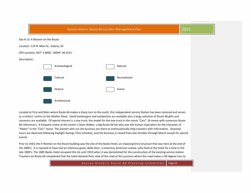
Site # 13: 4 Women on the Route
Location: 119 N. Main St., Galena, KS
GPS Location: N37° 4.8481', W094° 38.3521'
Description:
Archaeological Natural
Cultural Recreational
Historic Scenic
Architectural
Located at First and Main where Route 66 makes a sharp turn to the south, this Independent service Station has been restored and serves
as a visitors' center on the Mother Road. Good hamburgers and sandwiches are available plus a large selection of Route 66 gifts and
souvenirs are available. Of special interest is a tow truck, the model for the tow truck in the movie “Cars”. (A movie with numerous Route
66 references.) A frequent visitor at the center is Dean Walker, a big Route 66 fan who was the human inspiration for the character of
“Mater” in the “Cars” movie. The women who run the business are there to enthusiastically help travelers with information. Seasonal
hours are observed following Daylight Savings Time schedule, and the business is closed from late October through March except for special
events.
Prior to 1934, the 4 Women on the Route building was the site of the Banks Hotel, an imposing brick structure that was here at the end of
the 1800's. It is reputed to have had an infamous guest, Belle Starr, a notorious American outlaw, who lived at the hotel for a time in the
late 1800's. The 1885 Banks Hotel occupied this lot until 1933 when it was demolished for the construction of the existing service station.
Travelers on Route 66 complained that the hotel blocked their view of the road at this juncture where the road makes a 90-degree turn to

K a n s a s H i s t o r i c R o u t e 6 6 P l a n n i n g C o m m i t t e e
Page 64
Kansas Historic Route 66 Corridor Management Plan 2011
the east.
4 Women on the Route
Kansas Historic Route 66 Corridor Management Plan
2011
K a n s a s H i s t o r i c R o u t e 6 6 P l a n n i n g C o m m i t t e e
Page 65
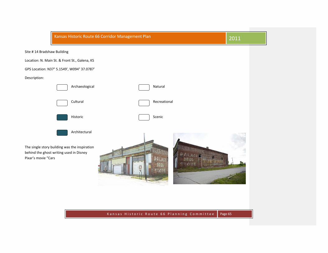
Site # 14 Bradshaw Building
Location: N. Main St. & Front St., Galena, KS
GPS Location: N37° 5.1549', W094° 37.0787'
Description:
Archaeological Natural
Cultural Recreational
Historic Scenic
Architectural
The single story building was the inspiration
behind the ghost writing used in Disney
Pixar’s movie “Cars
K a n s a s H i s t o r i c R o u t e 6 6 P l a n n i n g C o m m i t t e e
Page 66
Kansas Historic Route 66 Corridor Management Plan 2011
Site #15 Prehm Building
Location: 212 Main Street, Galena, KS
GPS Location: N37° 4.7267', W094° 38.3527'
Description:
Archaeological Natural
Cultural Recreational
Historic Scenic
Architectural
Prehm Building originally built in 1895 as a mercantile. Picture on Page 67.

K a n s a s H i s t o r i c R o u t e 6 6 P l a n n i n g C o m m i t t e e
Page 67
Kansas Historic Route 66 Corridor Management Plan 2011
Site #16 Gill Building
Location: 214 Main Street, Galena, KS
GPS Location: N37° 4.7257', W094° 38.3527'
Description:
Archaeological Natural
Cultural Recreational
Historic Scenic
Architectural
Buck’s building built in 1895 as a mercantile for John Gill, listed as the Gill Building in
census records. Opened as a Pool Hall in the 1940’s.
Prehm & Gill Building

K a n s a s H i s t o r i c R o u t e 6 6 P l a n n i n g C o m m i t t e e
Page 68
Kansas Historic Route 66 Corridor Management Plan 2011
Site #17 Old Maywood Theater
Location: 320 Main Street, Galena, KS
GPS Location: N37° 4.6721', W094° 38.3525'
Description:
Archaeological Natural
Cultural Recreational
Historic Scenic
Architectural
This two story building has a parapet front wall with a gently curved shape and concrete coping. The top and sides of the façade wall are
covered with stucco, although the first story and second stories also have areas of clapboard siding. A series of vertical and diamond shaped
elements decorate the stucco wall above the second story windows. A variety of double-hung and fixed windows have been installed at
both levels. A flat metal canopy above the first story is anchored to the building wall by a series of cables. Centered on a block of early 20th
century commercial businesses, this building is part of the continuous street wall lining the west side of the block. A concrete sidewalk with
a very shallow curb runs in front of the buildings. A variety of changes have been made to this building including replacing windows and
siding in the first and second stories. This building appears on the 1918 Sanborn Insurance Map as a Motion Picture and Vaudeville theater.
A stage occupied the west end of the space, while a second story viewing gallery was located at the east end. By 1930 it functioned strictly
as a movie theater, but was listed as Purkett’s Laundry & Master Cleaners in the 1944 directory. Estimated date of construction pre-1918.
K a n s a s H i s t o r i c R o u t e 6 6 P l a n n i n g C o m m i t t e e
Page 69
Kansas Historic Route 66 Corridor Management Plan 2011
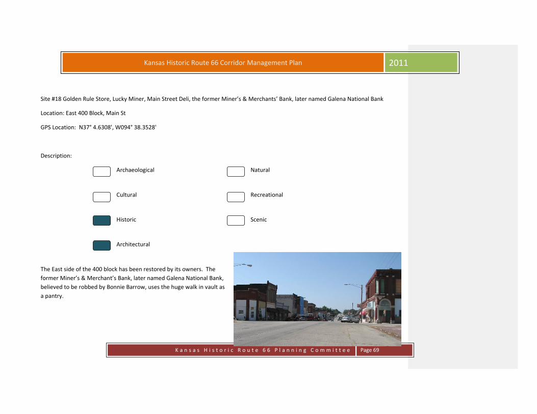
Site #18 Golden Rule Store, Lucky Miner, Main Street Deli, the former Miner’s & Merchants’ Bank, later named Galena National Bank
Location: East 400 Block, Main St
GPS Location: N37° 4.6308', W094° 38.3528'
Description:
Archaeological Natural
Cultural Recreational
Historic Scenic
Architectural
The East side of the 400 block has been restored by its owners. The
former Miner’s & Merchant’s Bank, later named Galena National Bank,
believed to be robbed by Bonnie Barrow, uses the huge walk in vault as
a pantry.

K a n s a s H i s t o r i c R o u t e 6 6 P l a n n i n g C o m m i t t e e
Page 70
Kansas Historic Route 66 Corridor Management Plan 2011
Site # 19 First National Bank, Short Creek True Value & Bumper to Bumper, Mi Torito
Location: West 400 Block, Main Street, Galena, KS
GPS Location: N37° 4.6308', W094° 38.3528'
Description:
Archaeological Natural
Cultural Recreational
Historic Scenic
Architectural
The 4th block west side, begins with what once was the First National Bank, the tile work is still present at the front door, Short Creek True
Value & Bumper to Bumper owners have restored this block upstairs and down. Mi Torito serves Mexican cuisine in this former 1950’s gas
station..

K a n s a s H i s t o r i c R o u t e 6 6 P l a n n i n g C o m m i t t e e
Page 71
Kansas Historic Route 66 Corridor Management Plan 2011
Site # 20 City Hall
Location: East 500 Block, Main Street, Galena, KS
GPS Location: N37° 4.5795', W094° 38.3534'
Description:
Archaeological Natural
Cultural Recreational
Historic Scenic
Architectural
The City Hall building housed the court, jail and fire department at one time the end of the block was known as the Bliss Building. There is outstanding ghost writing on the end of this block. Ghost signs from the earlier days of Route 66 are still found on the vintage buildings at the end of this block.
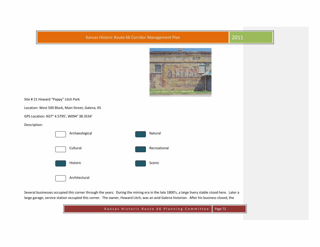
K a n s a s H i s t o r i c R o u t e 6 6 P l a n n i n g C o m m i t t e e
Page 72
Kansas Historic Route 66 Corridor Management Plan 2011
Site # 21 Howard “Pappy” Litch Park
Location: West 500 Block, Main Street, Galena, KS
GPS Location: N37° 4.5795', W094° 38.3534'
Description:
Archaeological Natural
Cultural Recreational
Historic Scenic
Architectural
Several businesses occupied this corner through the years. During the mining era in the late 1800's, a large livery stable stood here. Later a
large garage, service station occupied this corner. The owner, Howard Litch, was an avid Galena historian. After his business closed, the
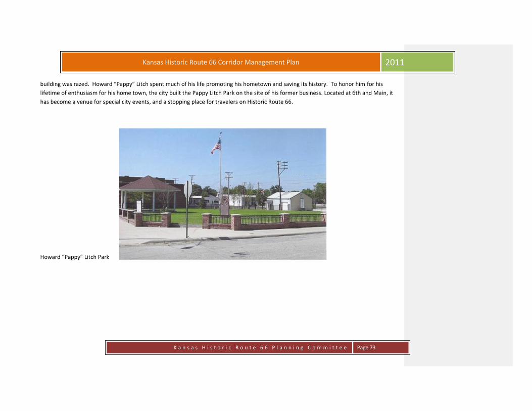
K a n s a s H i s t o r i c R o u t e 6 6 P l a n n i n g C o m m i t t e e
Page 73
Kansas Historic Route 66 Corridor Management Plan 2011
building was razed. Howard “Pappy” Litch spent much of his life promoting his hometown and saving its history. To honor him for his
lifetime of enthusiasm for his home town, the city built the Pappy Litch Park on the site of his former business. Located at 6th and Main, it
has become a venue for special city events, and a stopping place for travelers on Historic Route 66.
Howard “Pappy” Litch Park

K a n s a s H i s t o r i c R o u t e 6 6 P l a n n i n g C o m m i t t e e
Page 74
Kansas Historic Route 66 Corridor Management Plan 2011
Site # 22 Chamber Building, Early Post Office
Location: 509 Main Street, Galena, KS
GPS Location: N37° 4.5754', W094° 38.3506'
Description:
Archaeological Natural
Cultural Recreational
Historic Scenic
Architectural
The Chamber building on the south side of the park still has its original design and vault from the early days.

K a n s a s H i s t o r i c R o u t e 6 6 P l a n n i n g C o m m i t t e e
Page 75
Kansas Historic Route 66 Corridor Management Plan 2011
Site # 23 Former Gas Station
Location: Main Street, Galena, KS
GPS Location: N37° 5.1549', W094° 37.0787'
Description:
Archaeological Natural
Cultural Recreational
Historic Scenic
Architectural
The stone structure of this one-story service station rests on a concrete slab foundation. The building is sited at an angle on the corner lot. A
second wood framed service bay was added to the end of the original block. The building retains two garage bays, an entry door and plate
glass display windows. A metal post at the corner of the lot supported a sign on its triangular frame. The entire lot in front of the building
has a paved asphalt surface. Very few changes have been made to this building. The entry door was either removed or boarded over when
the last business closed. This gas station first appears on the 1946 Sanborn Insurance map. A small wedge-shaped addition connects the
service station to the neighboring post office. Estimated date of construction is 1930-46.
Formatted: Not Highlight

K a n s a s H i s t o r i c R o u t e 6 6 P l a n n i n g C o m m i t t e e
Page 76
Kansas Historic Route 66 Corridor Management Plan 2011
Site # 24 Sapp Opera House
Location: Main Street & 7th Street, Galena, KS
GPS Location: N37° 4.4958', W094° 38.3522'
Description:
Archaeological Natural
Cultural Recreational
Historic Scenic
Architectural
The Sapp Opera House was located on the southeast corner of 7th and Main. The theatre was a three-story brick structure built prior to
1896. There were businesses on the ground floor, and a theatre on the 2nd floor. A constant stream of performers and speakers were
engaged through the years of its existence, many famous performers were booked, including the famous Harry Houdini who performed
there January 8th, 1898. The theatre burned March 8th, 1931, thus ending another important iconic symbol of the early days of Galena's
rich history.
Sapp's Opera House was located at Seventh and Main Streets in Galena. It sat on the southeast corner of the intersection. The following are

K a n s a s H i s t o r i c R o u t e 6 6 P l a n n i n g C o m m i t t e e
Page 77
Kansas Historic Route 66 Corridor Management Plan 2011
excerpts from articles and newspapers on file at the Galena City Library.
The Opera House was built in 1890. Below are some excerpts from the Joplin Sunday Herald, June 1, 1890 Edward Sapp has the plans and
specifications ready for the erection of a fine brick block on the corner of Main and Seventh streets. The building is to be 50X90 in floor
dimensions and three stories high. The ground floor will be divided into two business rooms, and the second and third floors will be fitted
up as an opera house. The preliminary work will be commenced at once and the building pushed to completion as rapidly as possible.
July 26, 1890 Sapp & Aldrich have commenced to lay the foundation for their new brick opera house in the south part of town on Main
street. They will have two business rooms below and the opera house will be the second story.
September 21, 1890 the new opera house is up and the carpenters area at work finishing it up and putting on the roof.
October 26, 1890 the new Sapp opera house is receiving finishing touches, and will be ready for use in a few weeks.
November 2, 1890 the new Sapp opera house will be opened tonight by the Hyers Sisters renowned colored minstrels. Quite a number of
reserved seat tickets have already been sold and it is expected that the house will be crowded.
November 23, 1890 the I.O.O.F. lodge will give a grand masquerade ball at Sapp's opera house on Wednesday night, November 26. The
best music will be furnished and an excellent time is anticipated.
The ladies of Galena are making big preparations for a Trades Carnival at Sapp's opera house on Thanksgiving night, Nov. 27. There will be
57 businesses represented and the drill is to be excellent. The people of Joplin are cordially invited to attend.
December 7, 1890 the Trades Carnival at Sapp's opera house on Thanksgiving was a decided success. L.C. Weldy of the Republican managed
the drill and acquitted himself in Grand style. There were 56 trades represented and the people who visited the carnival were well pleased
with the program.
January 4, 1891 Payton's Comedy Company is playing this week at the Sapp opera house to good houses and those who are attending the
performances say that it is decidedly the best company that has visited this winter.
January 11 1891, Uncle Tom's Cabin Company is billed to play at Sapp's opera house here on Thursday night of this week.
The London Clothing Company, of Joplin, are moving into the north room of the new Sapp opera house building on the corner of Main and
K a n s a s H i s t o r i c R o u t e 6 6 P l a n n i n g C o m m i t t e e
Page 78
Kansas Historic Route 66 Corridor Management Plan 2011
Seventh streets.
January 25, 1891 Miss Georgie Hammond is booked to play at the Sapp opera house next Saturday.
May 10, 1891 a home concert will be given by home talent at Sapp's opera house on Friday evening of this week for the benefit of the
Presbyterian Church. A nice musical program has been prepared after which the entertainment will close with the laughable farce "Ten
Minutes in an Irish Court."
May 24, 1891 the ladies of the M.E. Church gave a cantata at the Sapp opera house on Thursday night for a benefit of the M.E. Church.
July 5, 1891 the John D'Ormand Company has been presenting it repertoire to the theater goers from the stage of Sapp's opera house this
week. The Wollgast Orchestra furnishes the music.
July 12, 1891 a member of the John D'Ormond troupe and a member of Galena sports had a three cornered fist fight last Saturday night.
Many noted stage stars appeared at the opera house.. Harry Houdini appeared at the opera house as a medium on January 9, 1898; AL.
W. Martin's "Uncle Tom's Cabin" touring company performed on November 19, 1901; there were also several boxing matches with boxers
from all across the country, there is a Kansas Supreme Court case relating to a boxing match held in Galena.
HON. EDWARD E. SAPP, an attorney and ex-Probate judge and ex-judge of the Court of Common Pleas, whose portrait is shown on the
opposite page, is one of the large capitalists and leading citizens of Galena. He was born at Jackson, Michigan, July 12, 1858, and is a son of
Rev. Rezin and Margaret (Peyreferry) Sapp.
Judge Sapp was educated in the schools at Grand Rapids, Michigan, where his father was a minister in the Methodist Episcopal Church.
When he came to Kansas, he spent some time herding cattle in the eastern part of the State. Later he located in Cherokee County and
studied law, and was admitted to the bar in 1883. In January of the following year he removed to Galena and entered into partnership with
his brother, W. F. Sapp, under the firm name of Sapp & Sapp, which continued until 1886. He then continued alone until 1891 when he
entered into partnership with George Webb, under the firm style of Webb & Sapp, which continued from 1891 to 1896, when he was
elected Probate judge. After holding the office three years, he resigned in the middle of his second term, and was then honored by election
as judge of the Court of Common Pleas for Cherokee and Crawford counties, and continued in this responsible position until 1900. Since July
5, 1904, Judge Sapp has been the senior member of the law firm of Sapp & Brown, having offices in the Opera House Block, which he
erected in 1900. This firm has the most expensively furnished offices in the county, the suite consisting of public and private offices and a

K a n s a s H i s t o r i c R o u t e 6 6 P l a n n i n g C o m m i t t e e
Page 79
Kansas Historic Route 66 Corridor Management Plan 2011
library of several thousand volumes.
The city of Galena has profited greatly by Judge Sapp’s public spirit. It now has an Opera House of which it may be very proud, the seating
capacity being 900, having a gallery and parquet circle and a stage with dimensions of 47 by 36 feet. All the equipments are modern
throughout and it compares favorably with like structures in much larger cities.
Judge Sapp was married in 1885, at Galena, to Mary E. Andrews, who was born in New York, and they have three children: Dexter, Thomas
and Viva. The family home is an elegant residence on Galena Avenue and the family take part in the social life of the city.
Politically, Judge Sapp is one of the leading Democrats of Cherokee County. He served as city attorney from 1885 to 1892 and again, from
1901 to 1903. His professional standing, either at the bar or on the bench, cannot be assailed. He served his fellow citizens for many years in
high positions, with the justice, fairness and dignity which reflects upon him the greatest credit, both as an upright exponent of the law and
as a man of high personal aims and character.
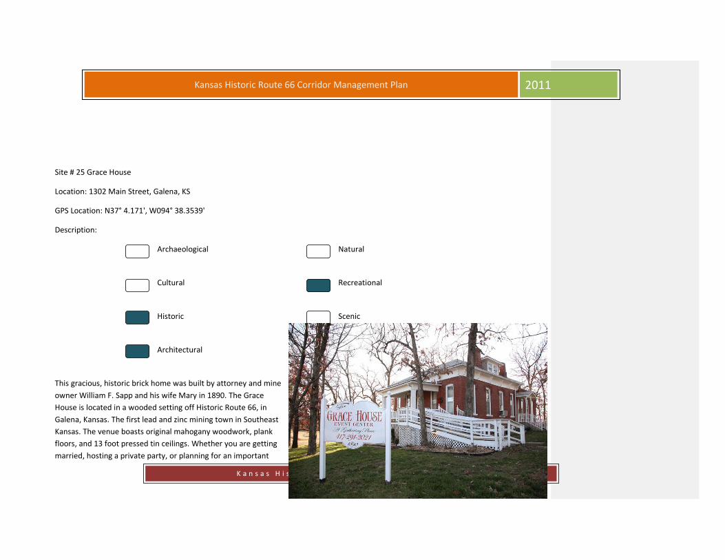
K a n s a s H i s t o r i c R o u t e 6 6 P l a n n i n g C o m m i t t e e
Page 80
Kansas Historic Route 66 Corridor Management Plan 2011
Site # 25 Grace House
Location: 1302 Main Street, Galena, KS
GPS Location: N37° 4.171', W094° 38.3539'
Description:
Archaeological Natural
Cultural Recreational
Historic Scenic
Architectural
This gracious, historic brick home was built by attorney and mine
owner William F. Sapp and his wife Mary in 1890. The Grace
House is located in a wooded setting off Historic Route 66, in
Galena, Kansas. The first lead and zinc mining town in Southeast
Kansas. The venue boasts original mahogany woodwork, plank
floors, and 13 foot pressed tin ceilings. Whether you are getting
married, hosting a private party, or planning for an important

K a n s a s H i s t o r i c R o u t e 6 6 P l a n n i n g C o m m i t t e e
Page 81
Kansas Historic Route 66 Corridor Management Plan 2011
company event, The Grace House Event Center is your perfect choice. Full day and half day rentals available.
Site # 26 SE Kansas Nature Center & Schermerhorn Park
Location: 3501 Main Street, Galena, KS
GPS Location: N37° 2.9094', W094° 38.3847'
Description:
Archaeological Natural
Cultural Recreational
Historic Scenic
Architectural
One of the greatest places to experience the “Kansas Ozarks” is the beautiful Schermerhorn Park, located two miles south of the stop light
in downtown Galena. It is a local treasure and a Kansas treasure. In 1922, E. B Schermerhorn, a local entrepreneur who made a fortune
with his mining interests, presented 22 acres on Shoal Creek to the city of Galena to be used as a park. Development began immediately.
The biggest project was the construction of a rustic cabin on top of a high hill for use by Boy Scouts and Camp Fire Girls. During the Great
Depression of the 1930's, the Works Progress Administration (WPA) did extensive terracing of the big hill and added fencing around the
park, including an impressive gateway, and several outdoor cooking pavilions. For the past 90 years, it has been a popular spot for class
and family reunions, church picnics, club gatherings and children's activities. The many trails up into the woods and along the bluffs are
wonderful places to explore and enjoy the natural beauty of the place. The cool waters of Shoal Creek have always been popular with

K a n s a s H i s t o r i c R o u t e 6 6 P l a n n i n g C o m m i t t e e
Page 82
Kansas Historic Route 66 Corridor Management Plan 2011
swimmers. Caves found in the park are indications that the area is honeycombed with underground caverns. Schermerhorn Cave is a large
cave with a small opening that opens up into a huge cavern. It is home to some of the rarest animals in the world, such as the Dark Sided,
Cave and Graybelly Salamander. Schermerhorn Cave and the park around it are home to almost half of the state's 44 threatened and
endangered species. The woods and the area along the creek are home to flora and fauna that are found exclusively in the region. Every
effort is made to maintain the natural habitat for these unique creatures and plants. The beauty of Schermerhorn Park remains, and is still
lovingly maintained by the city. The park is open year-round and is an ideal location for fishing, canoeing, exploring, and picnics.
The lovely structure at the top of the hill was built by the WPA in the early 1930's to be used as a camp for Scouts has, in recent years
become the Southeast Kansas Nature Center made possible by a group whose dream of converting the building into a nature center, were
successful in acquiring funds in order to bring the project to reality. The center features display cases with animal specimens in natural
poses. Open drawers give visitors an opportunity to feel rock specimens and plants. A bird-watching window allows visitors to view a wide
variety of wild birds as they feed. The center is a popular stopping point for local school classes, and is manned by knowledgeable
volunteers who are happy to provide information about the area. This outstanding Center has been helped and encouraged by Pittsburg
State University and the Gallaghar Audobon Society. Open year round, Tuesday through Saturday, 10:00 a.m.- 4:00 p.m. Sundays, 1:00 - 4:-
00 p.m. Free admission.

K a n s a s H i s t o r i c R o u t e 6 6 P l a n n i n g C o m m i t t e e
Page 83
Kansas Historic Route 66 Corridor Management Plan 2011

Kansas Historic Route 66 Corridor Management Plan
2011
K a n s a s H i s t o r i c R o u t e 6 6 P l a n n i n g C o m m i t t e e
Page 84
Site # 27 City Building Complex
Location: 315 W. 7th Street, Galena, KS
GPS Location: N37° 5.1549', W094° 37.0787'
Description:
Archaeological Natural
Cultural Recreational
Historic Scenic
Architectural
The city had this building constructed at the turn of the last
century to house the city offices, the police department, the
fire department and the city library. The building remains. The
city hall was moved to west 7th Street on Route 66.

K a n s a s H i s t o r i c R o u t e 6 6 P l a n n i n g C o m m i t t e e
Page 85
Kansas Historic Route 66 Corridor Management Plan 2011
Site # 28 Litch Historical and Mining Museum
Location: 319 W. 7th Street, Galena, KS
GPS Location: N37° 4.4976', W094° 38.4979'
Description:
Archaeological Natural
Cultural Recreational
Historic Scenic
Architectural
The Missouri-Kansas Texas Railway Station was moved to its present location in 1984 from its original home north of Front Street on Main.
Moved to the area adjacent to the City Municipal Building on Route 66, it became the Galena Mining Museum. The museum contains
countless photos, mining tools and equipment as well as many historical items relative to the town's rich history. Many people worked to
make the museum a reality, and the museum was dedicated to the city in June of 1984. Visitors are greeted by genial people who are
willing to share information and stories about the exciting years when Galena was a major producer of lead and zinc. The Museum is open
during the summer months on Monday through Saturday from 9:00 -11:30 a.m. and winter months on Monday, Wednesday and Friday
from 1:00 - 3:00 p.m.

K a n s a s H i s t o r i c R o u t e 6 6 P l a n n i n g C o m m i t t e e
Page 86
Kansas Historic Route 66 Corridor Management Plan 2011

Kansas Historic Route 66 Corridor Management Plan
2011
K a n s a s H i s t o r i c R o u t e 6 6 P l a n n i n g C o m m i t t e e
Page 87
Site # 29 Galena Cemetery
Location: Galena Cemetery, Galena, KS
GPS Location: N37° 4.5729', W094° 38.9152'
Description:
Archaeological Natural
Cultural Recreational
Historic Scenic
Architectural

K a n s a s H i s t o r i c R o u t e 6 6 P l a n n i n g C o m m i t t e e
Page 88
Kansas Historic Route 66 Corridor Management Plan 2011
Site # 30 Hacienda Style Home
Location: 2415 W. 7th Street, Galena, KS
GPS Location: N37° 4.4904', W094° 40.0645'
Description:
Archaeological Natural
Cultural Recreational
Historic Scenic
Architectural
No Public Access

K a n s a s H i s t o r i c R o u t e 6 6 P l a n n i n g C o m m i t t e e
Page 89
Kansas Historic Route 66 Corridor Management Plan 2011
Site # 31 Stevenson Cemetery
Location: Stevenson Cemetery, Riverton, KS
GPS Location: N37° 4.5107', W094° 40.3734'
Description:
Archaeological Natural
Cultural Recreational
Historic Scenic
Architectural
The Stevenson Cemetery is located on property once owned by John A. Stevenson, who was a Methodist minister. The first burial was
probably the infant child of T.S. and Annie E. Stevenson who died December 2, 1871, as that is the oldest legible tombstone in the mid
1960’s when the cemetery was canvassed. This small family cemetery is found on Highway 66, about a mile west of Galena and has many
persons who were buried there before 1900. T.C. and Nelli G. Senter donated this one-half acre of land to Lowell Township on September 9,
1936. One would find the following surnames buried in Stevenson Cemetery: Fritts, Baker, Stevenson, Ashley, Zimmerman, Blause, Hill,
Rowland, and Summers.
Most of these little out of the way cemeteries were started when a family lost a loved one and a neighbor donated land for the burial. There
are many small cemeteries in Cherokee County in out-of-the-way places, but they served the neighborhood.

K a n s a s H i s t o r i c R o u t e 6 6 P l a n n i n g C o m m i t t e e
Page 90
Kansas Historic Route 66 Corridor Management Plan 2011
Site # 32 Spring River Banks
Location: Hwy. 66, Riverton, KS
GPS Location: N37° 4.4958', W094° 40.9609'
Description:
Archaeological Natural
Cultural Recreational
Historic Scenic
Architectural
A popular fishing and hunting area. Bald eagles have been spotted nesting in the area on the river.

K a n s a s H i s t o r i c R o u t e 6 6 P l a n n i n g C o m m i t t e e
Page 91
Kansas Historic Route 66 Corridor Management Plan 2011
Site # 33 Spring River Neon
Location: Hwy 66 & 73rd Terrace, Riverton, KS
GPS Location: N37° 4.495', W094° 41.9037'
Description:
Archaeological Natural
Cultural Recreational
Historic Scenic
Architectural
Just after crossing Spring River, The Spring River Inn and a country club were
constructed on the grounds of the electric plant, north of Lake Lowell. Built in 1905, the
Inn and country club first catered to the wealthy patrons from Galena and became the
social center of the area. However, when the depression hit, the club was sold in 1932
and was used as a boating club. Reopening in 1952, the restaurant and inn catered to
the many travelers of the Mother Road. The restaurant was known for its thirty-five
foot buffet table loaded with home-cooked food, cinnamon pull apart rolls and squaw
bread. In the mid 1990’s the Inn and restaurant closed and a couple of years later the
Inn burned to the ground. The restaurant was never rebuilt and all that remains is the
neon sign that once marked its location

K a n s a s H i s t o r i c R o u t e 6 6 P l a n n i n g C o m m i t t e e
Page 92
Kansas Historic Route 66 Corridor Management Plan 2011
Site # 34 Empire District Electric
Location: 7242 Hwy 66, Riverton, KS
GPS Location: N37° 4.4843', W094° 41.9602'
Description:
Archaeological Natural
Cultural Recreational
Historic Scenic
Architectural
This plant can be viewed to the south from Route 66 as it crosses Spring River. Empire District Company employees live and work in the
area and are involved in many community events. The Empire District Company supports the community from the schools to museums.
The history of The Empire District Electric Company is closely interwoven with the story of the development of the four-state region.
Although Empire was organized in 1909, tracing its history takes us back beyond the turn of the century for a look at a growing mining
industry in the area.
The use of electric power in the mining industry had been untested prior to 1890. Individual zinc and lead miners used mules and hard labor
to scratch out a living. The names of the mines, Yellow Dog, Grasshopper, Windy Bill, and Morning Star, were as colorful as the people who
worked them. As mining companies sprung up across the tri-state region, electric motors began to replace the mule and steam powered
engines in several of the mines.

K a n s a s H i s t o r i c R o u t e 6 6 P l a n n i n g C o m m i t t e e
Page 93
Kansas Historic Route 66 Corridor Management Plan 2011
Electricity generating companies were born in several locations across the region. These small companies appeared haphazardly to supply
the new mining district with the power it demanded. On October 16, 1909, papers of incorporation were filed in Topeka, Kansas, bringing
together Consolidated Light, Power and Ice Company, Spring River Power Company, The Galena Light and Power Company, and the Joplin
Light, Power, and Water Company to form The Empire District Electric Company, under its parent company, Cities Services.
The formation of Empire marked the end of indiscriminate electrical development in the area, and was the beginning of a construction
program designed to meet the needs of a growing region. The vision of the New York financiers who invested in this area is still alive today.
Hoping to develop a financially feasible venture, they referred to this region as “Little Empire” to denote their pride in New York, the Empire
State. To this day, the name Empire represents the history of mining development in this area.
At the time of its organization, Empire had 109 miles of transmission line, 8 megawatts of generating capacity, and 2,400 customers. Today,
the Company utilizes over 1,200 miles of transmission line and over 1,000 megawatts of capacity to serve over 165,000 customers.
As industry grew and families moved into the four-state region, the demand for electrical power grew as well. Power for Empire was first
produced from generation at the Lowell and Reddings Mill hydroelectric plants. Soon, however, the demand for more generation became
evident.
In the summer of 1909, work began on the Riverton Generating Station and it was completed nine months later. One of the generators at
the plant was dubbed “Old Kate.” Kate was famous for supplying power to the St. Louis World’s Fair in 1904.
Construction of the Ozark Beach Dam began in 1911 in Taney County, Missouri. Two years later, the 1,300 foot long dam was complete. The
dam forms Lake Taneycomo, a crystal clear lake stretching 22 miles throughout the picturesque Ozarks. Today, Ozark Beach Hydroelectric
Plant supplies Empire with 16 megawatts of power and the Taney County area with a beautiful recreational area. Empire Park, located just
above the dam, is a park maintained by Empire District. In 1999, the park was honored with the annual Advisory Council on Disabilities
Community Award for the refurbishment and addition of handicap accessible facilities.
From 1910 to its independence from Cities Services, Empire had purchased 27 separate power companies to become the dominate provider
of electric service in the region. In 1944, The Empire District Electric Company separated from its parent company. Empire’s common stock
was listed on the New York Stock Exchange under the symbol EDE in 1946.

K a n s a s H i s t o r i c R o u t e 6 6 P l a n n i n g C o m m i t t e e
Page 94
Kansas Historic Route 66 Corridor Management Plan 2011
After the war, customer growth was high throughout the Empire District service territory. Empire began work to increase capacity at the
Riverton Generating Station. The additions over the next several years at Riverton generated additional capacity to meet the future growth
of the region. Construction began in 1947 to install a 30-megawatt steam turbine named Riverton 7. It officially began producing power in
March 1950. Four years later, an additional 44-megawatt steam turbine, Riverton 8, came online. The construction of Riverton 7 & 8 grew
capacity of the power plant to 150-megawatts.
From 1959 to 1966, Empire spent approximately $25 million on construction, mostly on new transmission and distribution facilities, to
handle the increased demand for electric energy. This construction program included new high-voltage transmission lines and new
substations. It also included new transmission lines to tie Empire’s system with neighboring electric companies, making Empire an
important part of a vast power grid embracing the Midwest.
In the early 1960’s, the need for more automation in Empire’s operations was apparent. This realization brought about the construction of
an operations and communications center in Joplin. System Operations was completed in 1964. Equipped with the latest design in
electronic technology, this nerve center monitors and controls the production and power flow throughout the entire Empire system.
By the mid-60’s, the energy needs of this growing and diverse economic region would once gain exceed the capacity of existing generation
facilities. On September 10, 1967, just north of Asbury, Missouri, ground was broken for a 200-megawatt, coal-fired power plant. The $26
million Asbury Generating Station was put into operation in June 1970.
Asbury was designed as a “mine-mouth” plant to burn coal from the Empire Mine located just north of the plant. Total plant capacity is
approximately 210 megawatts. Unit One is rated at 193 megawatts. Unit Two, completed in 1986, generates 17 megawatts of energy from
the excess boiler capacity of Unit One. In 1990, the plant was converted to use a blend of low-sulfur Wyoming coal and native coal to
comply with new clean air standards. Further environmental upgrades were instituted in 2007 with the investment in a $37 million selective
catalytic reduction (SCR) system to the plant to further reduce nitrogen oxide (NOX) emissions.
As the demand for energy has grown, Empire has met the need with additional building projects and purchase power agreements. In 1978,
Empire added the first of two 90-megawatt combustion turbine peaking units at the Empire Energy Center near LaRussell, Missouri,
approximately 20 miles east of Joplin. An opportunity to purchase 12 percent, or 80 megawatts, of the 650-megawatt Iatan Power Plant,

K a n s a s H i s t o r i c R o u t e 6 6 P l a n n i n g C o m m i t t e e
Page 95
Kansas Historic Route 66 Corridor Management Plan 2011
near Kansas City, allowed Empire to delay the addition of a second 90-megawatt unit at the Empire Energy Center until 1981. Originally
these peaking units utilized only fuel oil for combustion, but were converted to natural gas use in 1994.
In 1993, Empire announced the addition of the State Line Power Plant located west of Joplin. A 98-megawatt combustion turbine began
providing energy to Empire’s customers in May 1995. Two years later, a second 150-megawatt turbine was added to State Line. Plans were
announced in 1998 for construction of an additional 350 megawatts of power generation at the plant. A new 150-megawatt combustion
turbine, combined with the existing 150-megawatt unit, generate enough waste heat to produce an additional 200 megawatts of steam-
powered, combined-cycle energy. The combined cycle unit began providing energy to Empire customers in June 2001. Westar Generating,
Inc., a wholly owned subsidiary of Western Resources, is a partner in the State Line combined cycle. Empire owns 60 percent and serves as
the plant operator. Total plant capacity is approximately 596 megawatts, making it Empire’s highest megawatt output plant. All three
combustion turbines at State Line Power Plant use natural gas.
Growth continued in Empire’s service territory, and by 2002 it was necessary to add two additional natural gas-fired peaking units at Empire
Energy Center. Ground was broken on this additional capacity in July 2002, and the units became operational in April 2003. Both units
added 50-megawatts of low cost, efficient power to Empire’s system.
By 2004 Empire was searching for ways to invest in renewable energy for customers. In December 2004, Empire announced a 20-year
contract with PPM Energy (now Iberdrola) to receive all energy generated at the 150-megawatt Elk River Windfarm, located in Butler
County, Kansas. The first energy was received from Elk River on October 17, 2005.
The success of the agreement with PPM Energy led Empire to sign a second purchase power agreement with Horizon Wind Energy. Ground
was broken on the Meridian Way Wind Farm in April 2008. Meridian Way is a 201-megawatt wind farm located eight miles south of
Concordia, Kansas. Empire anticipates 105 megawatts of energy will be put on the grid from the contract. Westar Energy will purchase the
additional 96 megawatts of energy from this project. This project became operational in December 2008.
Although the purchase power agreements with both Elk River Windfarm and Meridian Way Wind Farm provide Empire with additional
energy, it was necessary to build more baseload generation as customer demand rose. In 2006, Empire announced two new construction
projects for coal-fired plants. Empire will own 12 percent, or approximately 100 megawatts, of Iatan II. The plant will be located with Iatan I,
near Kansas City. Plum Point Energy Station will be located near Osceola, Arkansas. Empire has signed a contract to be a part owner of the

K a n s a s H i s t o r i c R o u t e 6 6 P l a n n i n g C o m m i t t e e
Page 96
Kansas Historic Route 66 Corridor Management Plan 2011
plant and also entered into a purchased power agreement for additional energy produced by the plant. Both plants will be highly-efficient
and utilize the latest in environmental technology. They are currently under construction, with an estimated date of completion in 2010.
In addition to construction projects for brand-new plants, Empire also increased capacity at existing facilities. In April 2007, a new natural
gas-fired turbine began producing energy at the Riverton Power Plant. The new turbine added 148 megawatts of capacity to Riverton.
Construction on the new turbine began in 2005 with the majority of construction completed during 2006. Today, the Riverton Plant is still in
operation, generating 286 megawatts of electricity and is one of the oldest operational power plants in the United States.
Empire also provides both water and natural gas service to customers in Missouri. Empire Water Company was created in 1926 when
Empire purchased the Lawrence County Water, Light, and Cold Storage Company. The company served the electric and water needs of
Aurora, Missouri. Currently the water company meets the water needs of approximately 4,500 customers in Aurora, Marionville, and
Verona, Missouri.
In 2006, Empire acquired natural gas distribution rights from Aquila, Inc. This acquisition created The Empire District Gas Company, a wholly
owned subsidiary of The Empire District Electric Company. Empire District Gas serves the natural gas needs of approximately 48,000
customers in 44 communities in northwest, north central, and west central Missouri.
As Empire celebrates 100 years of service, the dedication and professionalism of its employees has allowed Empire to fulfill its mission of
providing safe, reliable, and low-cost energy to homes and industry alike. From its early beginnings, Empire has strived to be a good
corporate citizen while providing a fair return for its owners, the stockholders. The Company has utilized technical improvements to
produce and deliver energy more efficiently while maintaining the quality of the environment for future generations.
From the early mining camps to the diverse array of industry found across the four-state region today, the "Empire District" is alive and
thriving due to the leadership, courage, and spirit of The Empire District Electric Company.
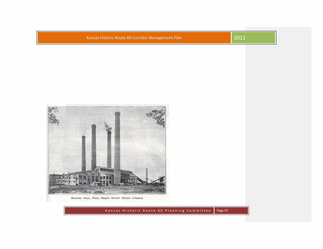
K a n s a s H i s t o r i c R o u t e 6 6 P l a n n i n g C o m m i t t e e
Page 97
Kansas Historic Route 66 Corridor Management Plan 2011
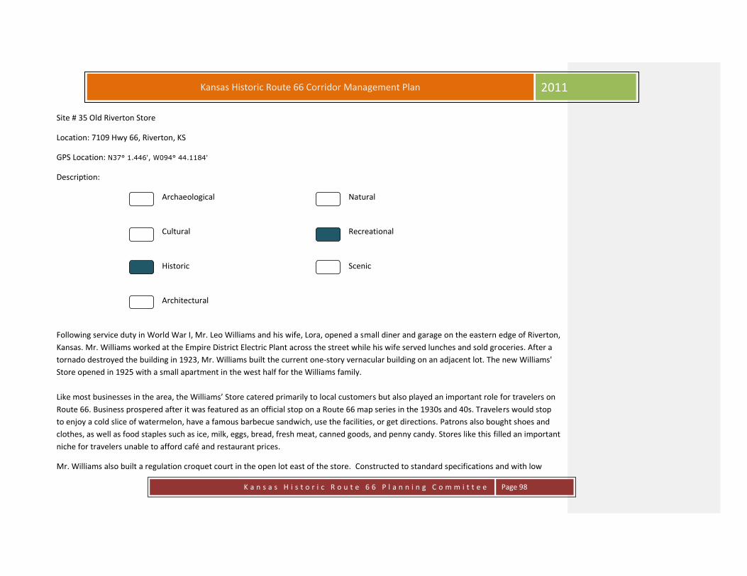
K a n s a s H i s t o r i c R o u t e 6 6 P l a n n i n g C o m m i t t e e
Page 98
Kansas Historic Route 66 Corridor Management Plan 2011
Site # 35 Old Riverton Store
Location: 7109 Hwy 66, Riverton, KS
GPS Location: N37° 1.446', W094° 44.1184'
Description:
Archaeological Natural
Cultural Recreational
Historic Scenic
Architectural
Following service duty in World War I, Mr. Leo Williams and his wife, Lora, opened a small diner and garage on the eastern edge of Riverton,
Kansas. Mr. Williams worked at the Empire District Electric Plant across the street while his wife served lunches and sold groceries. After a
tornado destroyed the building in 1923, Mr. Williams built the current one-story vernacular building on an adjacent lot. The new Williams'
Store opened in 1925 with a small apartment in the west half for the Williams family.
Like most businesses in the area, the Williams’ Store catered primarily to local customers but also played an important role for travelers on
Route 66. Business prospered after it was featured as an official stop on a Route 66 map series in the 1930s and 40s. Travelers would stop
to enjoy a cold slice of watermelon, have a famous barbecue sandwich, use the facilities, or get directions. Patrons also bought shoes and
clothes, as well as food staples such as ice, milk, eggs, bread, fresh meat, canned goods, and penny candy. Stores like this filled an important
niche for travelers unable to afford café and restaurant prices.
Mr. Williams also built a regulation croquet court in the open lot east of the store. Constructed to standard specifications and with low

K a n s a s H i s t o r i c R o u t e 6 6 P l a n n i n g C o m m i t t e e
Page 99
Kansas Historic Route 66 Corridor Management Plan 2011
walls surrounding the playing field, the court was lit for night games. It was a focal point of entertainment in Riverton, drawing crowds for
tournament play. When the store’s parking needs increased, however, the Williams removed the court for additional parking.
The Williams family sold the store in 1973 to Joe and Isabell Eisler, whose nephew, Scott Nelson, now runs the business as a market, deli,
general store, and Route 66 souvenir shop. Scott purchased the store on March 31st, 2011 from the Eisler Estate. Scott is the president of
the Route 66 Association of Kansas. The one-story red brick building has changed little over its 80 years of operation, still retaining the glass-
enclosed porch, the wooden shelves, the rear deli counter, and the interior pressed-tin ceiling. It was listed in the National Register of
Historic Places in 2003 and received a National Park Service Route 66 Corridor Preservation Program Cost-Share Grant award in 2005 for
repairs to the roof and electrical system upgrades.
The Williams' Store, now Nelson’s Old Riverton Store, is located at 7109 SE Highway 66 in Riverton, KS. The store is open for business
Monday-Saturday. For further information, please contact the store at 620-848-3330 or visit the store's website.
http://www.eislerbros.com/
Nelson’s Old Riverton Store 2011

K a n s a s H i s t o r i c R o u t e 6 6 P l a n n i n g C o m m i t t e e
Page 100
Kansas Historic Route 66 Corridor Management Plan 2011
Site # 36 Round-A-Bout
Location: Hwy 400 & Hwy 66, Riverton, KS
GPS Location: N37° 1.4593', W094° 44.1148'
Description:
Archaeological Natural
Cultural Recreational
Historic Scenic
Architectural
This is where Old Route 66 veers off on Beasley Road and leads to the Marsh Arch Bridge.
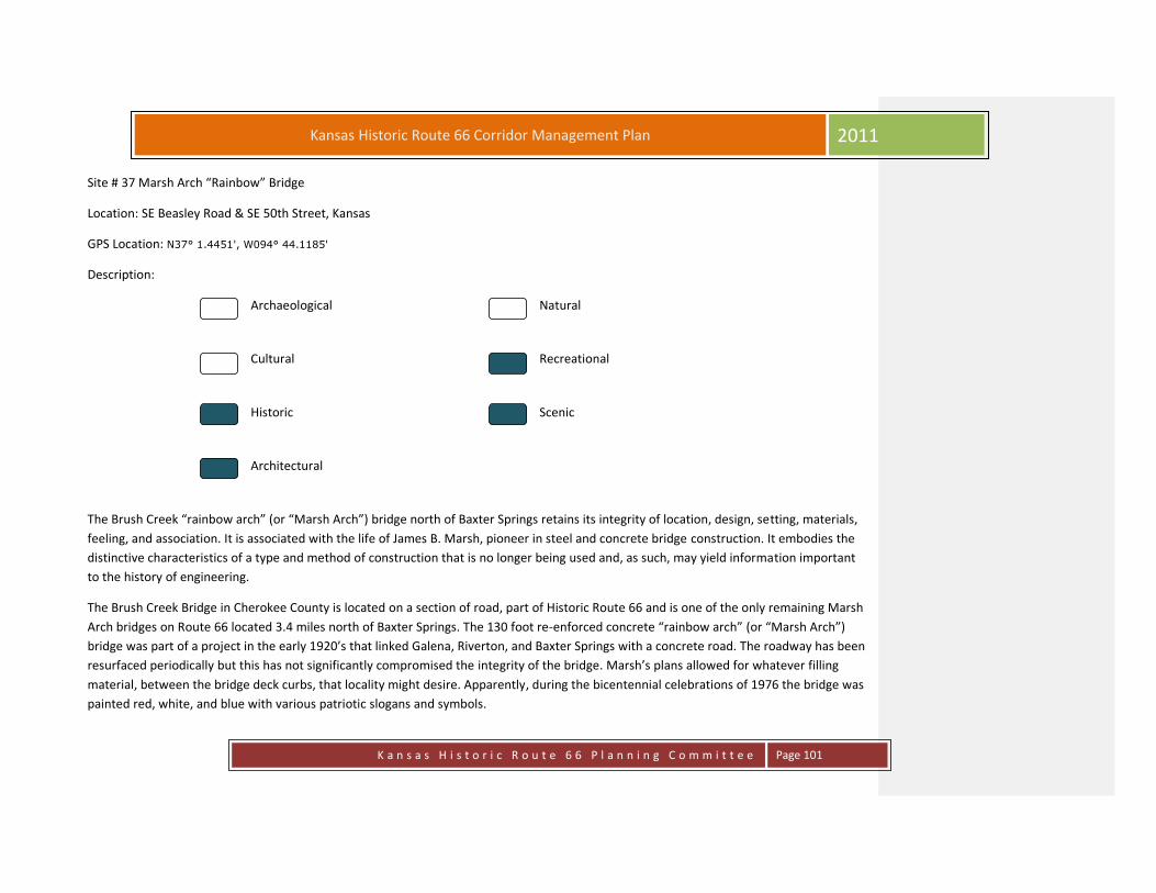
K a n s a s H i s t o r i c R o u t e 6 6 P l a n n i n g C o m m i t t e e
Page 101
Kansas Historic Route 66 Corridor Management Plan 2011
Site # 37 Marsh Arch “Rainbow” Bridge
Location: SE Beasley Road & SE 50th Street, Kansas
GPS Location: N37° 1.4451', W094° 44.1185'
Description:
Archaeological Natural
Cultural Recreational
Historic Scenic
Architectural
The Brush Creek “rainbow arch” (or “Marsh Arch”) bridge north of Baxter Springs retains its integrity of location, design, setting, materials,
feeling, and association. It is associated with the life of James B. Marsh, pioneer in steel and concrete bridge construction. It embodies the
distinctive characteristics of a type and method of construction that is no longer being used and, as such, may yield information important
to the history of engineering.
The Brush Creek Bridge in Cherokee County is located on a section of road, part of Historic Route 66 and is one of the only remaining Marsh
Arch bridges on Route 66 located 3.4 miles north of Baxter Springs. The 130 foot re-enforced concrete “rainbow arch” (or “Marsh Arch”)
bridge was part of a project in the early 1920’s that linked Galena, Riverton, and Baxter Springs with a concrete road. The roadway has been
resurfaced periodically but this has not significantly compromised the integrity of the bridge. Marsh’s plans allowed for whatever filling
material, between the bridge deck curbs, that locality might desire. Apparently, during the bicentennial celebrations of 1976 the bridge was
painted red, white, and blue with various patriotic slogans and symbols.

K a n s a s H i s t o r i c R o u t e 6 6 P l a n n i n g C o m m i t t e e
Page 102
Kansas Historic Route 66 Corridor Management Plan 2011
The best description of a rainbow arch span is contained in James Marsh’s 1911 patent application. The bridge consists of “… two
abutments (which could be Piers), a pair of arches disposed between and springing from the abutments, the floor carried with the parapets
or rails along opposite sides of the floor line. : the original patents called for slideable wear plates to be molded into the concrete where the
bridge floor came into contact with the beams and abutments. This is of importance as one of the main benefits of this design was to allow
for the expansion and contraction of the reinforced concrete bridge under varying conditions of temperature and moisture.
The Brush Creek Bridge is 20 feet wide and its arches rise 27 feet. The bridge deck is approximately 22 feet above the low water elevation
and approximately 34 feet above the bedrock on which the abutments rest. Completed on December 20, 1923 the structure had live load
capacity of 125 pounds per square foot. Travelers may still drive over the bridge, but it is load restricted.

K a n s a s H i s t o r i c R o u t e 6 6 P l a n n i n g C o m m i t t e e
Page 103
Kansas Historic Route 66 Corridor Management Plan 2011
Site # 38 Field of Dreams
Location: 8933 SE 50th Street, Baxter Springs, KS
GPS Location: N37° 1.4796', W094° 44.1162'
Description:
Archaeological Natural
Cultural Recreational
Historic Scenic
Architectural
The Field of Dreams is just that--a dream come true. The complex is the dream of former Baxter Springs High School baseball coach Don
Karnes. Over the past eight years, Coach Karnes' dream has come true through his efforts and the hard work and contributions of many in
the community. The Baxter Springs Field of Dreams is a nonprofit organization established in 1999 by Don and Betty Karnes and Gene and
Linda Leonhard. The goal is to provide fine facilities for area youth to play ball. Constructing this complex has become a community project.
The Field of Dreams is the home of the local American Legion baseball team that has represented Baxter Springs admirably over the years.
In the years 2003 and 2004, the Baxter Springs American Legion teams have the distinction of winning the Division II National
Championships consecutively. Playing a very competitive schedule, the legion teams consistently continue to perpetuate the baseball
tradition of success and good sportsmanship that is synonymous with Baxter Springs baseball.

K a n s a s H i s t o r i c R o u t e 6 6 P l a n n i n g C o m m i t t e e
Page 104
Kansas Historic Route 66 Corridor Management Plan 2011

K a n s a s H i s t o r i c R o u t e 6 6 P l a n n i n g C o m m i t t e e
Page 105
Kansas Historic Route 66 Corridor Management Plan 2011
Site # 39 Fort Blair
Location: Military Avenue & 6th Street, Baxter Springs, KS
GPS Location: N37° 1.5482', W094° 44.1977'
Description:
Archaeological Natural
Cultural Recreational
Historic Scenic
Architectural
Located on Historic Route 66 between 6th and 7th Streets, this replicated fort is open the year round and is free of charge. It is constructed
of logs and follows closely the official descriptions of the fort. Interpretive signage on the site tells the story of the heroic defense of the fort
by the 2nd Kansas Colored Infantry. This engagement between black Union troops and the guerrilla troops under William Quantrill was one
of the first uses of black troops during the Civil War.
The site is also noteworthy because of other historic events. To the south of the fort site once grew the infamous “hanging tree” where
frontier justice was meted out during the Cow Town era. The original big spring was also south of the fort site. The first settler, John Baxter
and his family built a home on this site in 1849. The fort is located on Route 66, and the battle at the fort and the subsequent battle north of
town are believed to be the only battles to take place directly on what would later be Route 66.

K a n s a s H i s t o r i c R o u t e 6 6 P l a n n i n g C o m m i t t e e
Page 106
Kansas Historic Route 66 Corridor Management Plan 2011
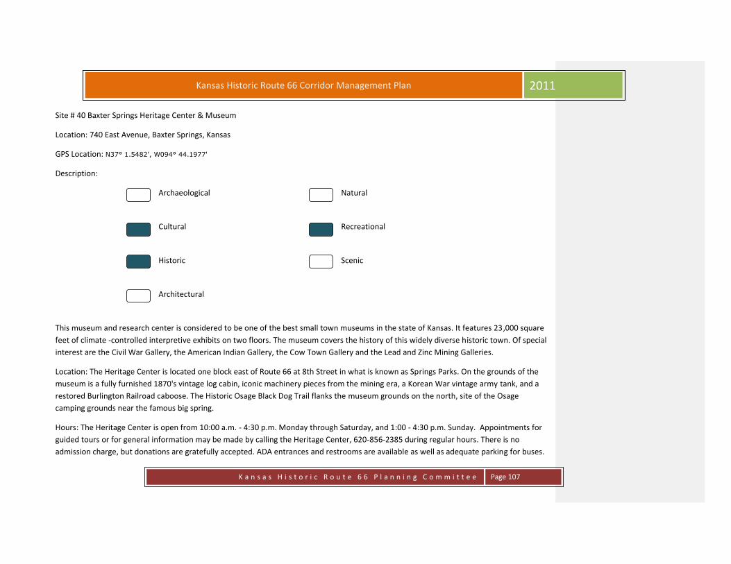
K a n s a s H i s t o r i c R o u t e 6 6 P l a n n i n g C o m m i t t e e
Page 107
Kansas Historic Route 66 Corridor Management Plan 2011
Site # 40 Baxter Springs Heritage Center & Museum
Location: 740 East Avenue, Baxter Springs, Kansas
GPS Location: N37° 1.5482', W094° 44.1977'
Description:
Archaeological Natural
Cultural Recreational
Historic Scenic
Architectural
This museum and research center is considered to be one of the best small town museums in the state of Kansas. It features 23,000 square
feet of climate -controlled interpretive exhibits on two floors. The museum covers the history of this widely diverse historic town. Of special
interest are the Civil War Gallery, the American Indian Gallery, the Cow Town Gallery and the Lead and Zinc Mining Galleries.
Location: The Heritage Center is located one block east of Route 66 at 8th Street in what is known as Springs Parks. On the grounds of the
museum is a fully furnished 1870's vintage log cabin, iconic machinery pieces from the mining era, a Korean War vintage army tank, and a
restored Burlington Railroad caboose. The Historic Osage Black Dog Trail flanks the museum grounds on the north, site of the Osage
camping grounds near the famous big spring.
Hours: The Heritage Center is open from 10:00 a.m. - 4:30 p.m. Monday through Saturday, and 1:00 - 4:30 p.m. Sunday. Appointments for
guided tours or for general information may be made by calling the Heritage Center, 620-856-2385 during regular hours. There is no
admission charge, but donations are gratefully accepted. ADA entrances and restrooms are available as well as adequate parking for buses.

K a n s a s H i s t o r i c R o u t e 6 6 P l a n n i n g C o m m i t t e e
Page 108
Kansas Historic Route 66 Corridor Management Plan 2011

K a n s a s H i s t o r i c R o u t e 6 6 P l a n n i n g C o m m i t t e e
Page 109
Kansas Historic Route 66 Corridor Management Plan 2011
Site # 41 Historic Route 66 Visitors Center
Location: 940 Military Avenue, Baxter Springs, KS
GPS Location: N37° 1.519', W094° 44.1132'
Description:
Archaeological Natural
Cultural Recreational
Historic Scenic
Architectural
The beginning of the downtown Baxter Springs business district was boosted economically by the addition of Route 66. Starting with the
now restored Visitor’s Center, you can take a tour discovering the historic aspects of the downtown buildings. The Independent Gas and Oil
Company built the gas station at 940 Military Avenue in 1929. It was later purchased by Phillips 66 Oil Company, and mostly, since that
time, has functioned as a Phillips 66 station with a variety of owners and proprietors. In 2003, this Tudor-style station was placed on the
National Register of Historic Places. The station is now owned by the Baxter Springs Historical Society and has been adapted for use as a
Visitors Center and Information Bureau for travelers on Historic Route 66. Hours are: Monday – Saturday 10:00 a.m. – 4 p.m. or by
appointment by calling 620-856-2066. Volunteers staff the facility. Gas Pumps were installed in December 2011.
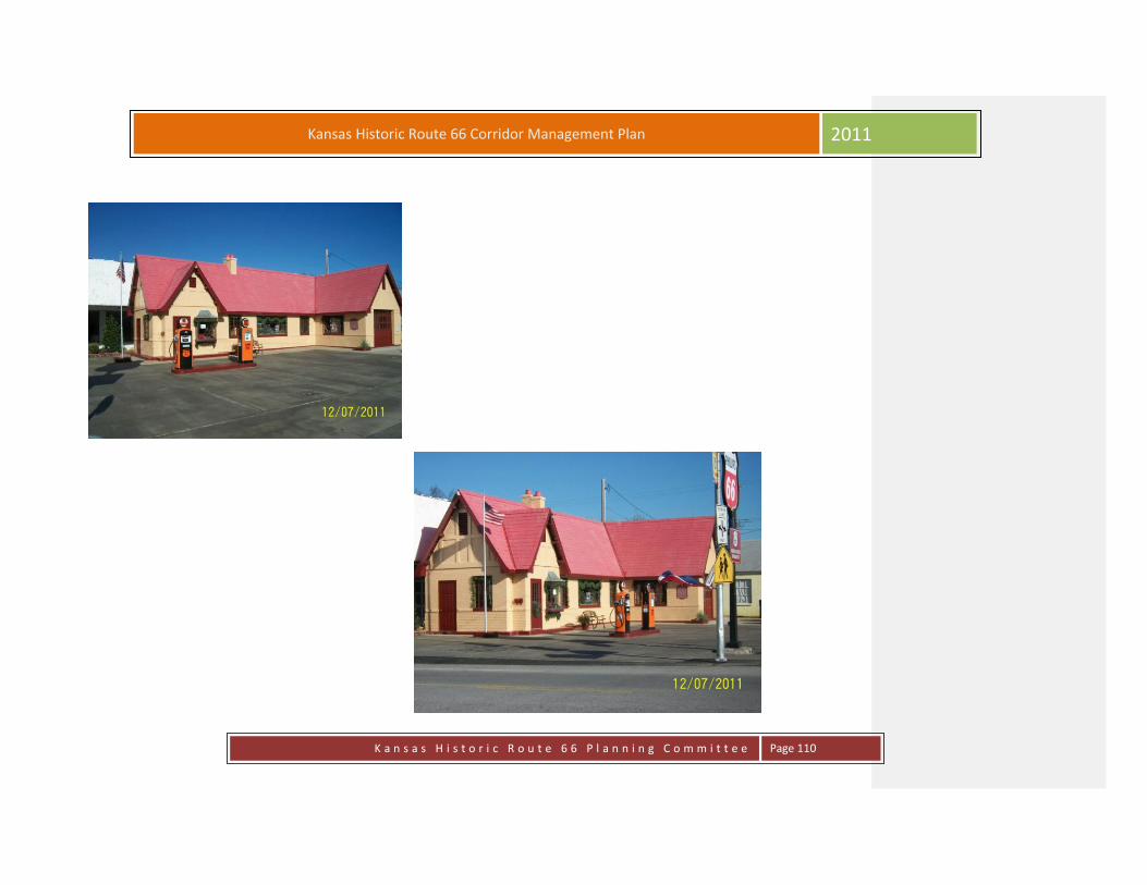
K a n s a s H i s t o r i c R o u t e 6 6 P l a n n i n g C o m m i t t e e
Page 110
Kansas Historic Route 66 Corridor Management Plan 2011

K a n s a s H i s t o r i c R o u t e 6 6 P l a n n i n g C o m m i t t e e
Page 111
Kansas Historic Route 66 Corridor Management Plan 2011
Site # 42 Illinois Cash Store – Baxter National Bank
Location: 1046 Military Avenue, Baxter Springs, KS
GPS Location: N37° 1.5155', W094° 44.1107'
Description:
Archaeological Natural
Cultural Recreational
Historic Scenic
Architectural

K a n s a s H i s t o r i c R o u t e 6 6 P l a n n i n g C o m m i t t e e
Page 112
Kansas Historic Route 66 Corridor Management Plan 2011
Site # 43 Bilke Western Store
Location: 1041 Military Avenue, Baxter Springs, KS
GPS Location: N37° 1.5704', W094° 44.1071'
Description:
Archaeological Natural
Cultural Recreational
Historic Scenic
Architectural
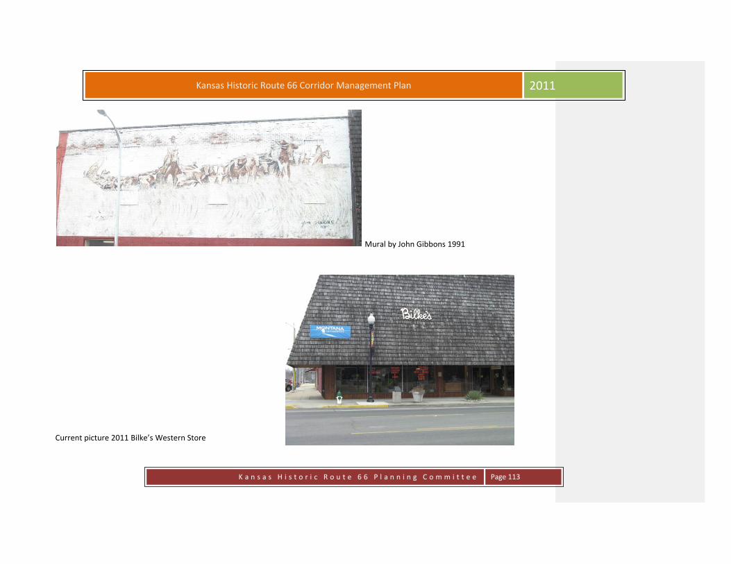
K a n s a s H i s t o r i c R o u t e 6 6 P l a n n i n g C o m m i t t e e
Page 113
Kansas Historic Route 66 Corridor Management Plan 2011
Mural by John Gibbons 1991
Current picture 2011 Bilke’s Western Store

K a n s a s H i s t o r i c R o u t e 6 6 P l a n n i n g C o m m i t t e e
Page 114
Kansas Historic Route 66 Corridor Management Plan 2011
Site # 44 Johnston Public Library
Location: 210 W. 10th Street, Baxter Springs, KS
GPS Location: N37° 1.7012', W094° 44.0215'
Description:
Archaeological Natural
Cultural Recreational
Historic Scenic
Architectural
Unquestionably, one of the most imposing structures in Baxter Springs is one of the oldest. The Johnston Public Library stands today as a
symbol of our town's history, past and present; it is located just two blocks west of Route 66 and covers an entire city block..
The structure was one of the earliest brick buildings to be constructed in Baxter Springs having been constructed through the sale of bonds
in 1872 in the amount of $10,000. The old Lincoln School was constructed in the same year a block northwest.
The building was constructed in a park like setting, the only building to be found on the entire block. No other structure has been built on
that block. The purpose of the building was to provide a home for the anticipated county courthouse. The upper two floors were to be used
for offices and an auditorium or presumably a courtroom. A jail was housed in the basement.
When the city lost its bid to become the county seat, some say through voting irregularities, the building was utilized for numerous
purposes. One denomination used the building temporarily for church services.

K a n s a s H i s t o r i c R o u t e 6 6 P l a n n i n g C o m m i t t e e
Page 115
Kansas Historic Route 66 Corridor Management Plan 2011
In 1894, the Baxter Springs Normal and Business College, was established in the building, offering classical courses as well as some
professional courses, primarily teacher education. The auditorium on the second floor was known as the Baldwin Opera House in 1895. The
first motion picture shown in Baxter Springs was shown here in 1898.
Although a small library had existed on Military, it was not until 1905 that a permanent and more adequate location was to be found. A
local resident named Nils Peter Johnston endowed the city with a bequest of $5,000. Through the generosity of Mr. Johnston, the present
library was established.
The first directors of the library, L. D. Brewster, Charles Jones, and Samuel Smith oversaw an addition to the building, adding a new
imposing entrance to the south frontage. Old pictures depict the entrance with metal gates at the entrance.
For many years, the library remained as it was originally constructed. A new building project was undertaken in 1988. A new external
elevator made the building handicap accessible. The interior was completely renovated as was the exterior. The second floor which was
intended as an auditorium was seldom used. It was renovated to expand the total library space.
The Johnston Public Library is an example of historic preservation. A beautiful structure, built in 1872, still being used functionally for the
use and enjoyment of the people of Baxter Springs.
In its long history, the Johnston Public Library has had five librarians, each with long tenures. The first was Lyon Leroy. Next was Lotta Smith.
Among the most recognizable names are Miss Anna Webb, Miss Beulah Cardwell, and the current librarian, Mrs. Betty Burrows. All have
given dedicated service to this city treasure.

K a n s a s H i s t o r i c R o u t e 6 6 P l a n n i n g C o m m i t t e e
Page 116
Kansas Historic Route 66 Corridor Management Plan 2011

K a n s a s H i s t o r i c R o u t e 6 6 P l a n n i n g C o m m i t t e e
Page 117
Kansas Historic Route 66 Corridor Management Plan 2011
Site # 45 Nez Perce Memorial
Location: 210 W. 10th Street, Baxter Springs, KS
GPS Location: N37° 1.7938', W094° 44.0923'
Description:
Archaeological Natural
Cultural Recreational
Historic Scenic
Architectural
On November 4, 2005, dozens of people gathered at Quapaw, Oklahoma, and Baxter Springs, Kansas, to acknowledge and participate in the
site certification ceremonies for two interpretive panels commemorating the time during which the Nez Perce were held prisoner in these
foreign locations so far from their beloved home. Note: This Project, started by the Nez Perce Foundation, was completed by McCormack
Landscape Design. The following information was taken from the Nez Perce National Historical Trail web page. See that site for the
complete program.
Our representative at the Program was Charlie Moses Jr. “Who told how this place was a turning point for the Nez Perce, how it marked the
beginning of a long series of divisions among the people. When they were finally allowed to head back West, every adult was asked, "Do
you want to move to Lapwai and become a Christian, or do you want to move to Nespelem and be who you are?" About half chose Lapwai
and about half chose Nespelem. "This divided families," he said, “and it divided friends. It divided even brothers, who were split up in that
way. Chief Joseph was the only one who was not asked his choice, and since those years a number of other divisive events and issues have

K a n s a s H i s t o r i c R o u t e 6 6 P l a n n i n g C o m m i t t e e
Page 118
Kansas Historic Route 66 Corridor Management Plan 2011
often splintered the Nez Perce even further. “
Historian Larry O'Neal, Archivist at the Baxter Heritage Center, spoke of the Nez Perce during their time in this place, and what a painful
time it was in the history of the people. He said that many of the wounds have yet to heal, that the Nez Perce people's bones are scattered
across half the country. Larry’s remarks follow below.
THE NEZ PERCE IN BAXTER SPRINGS, KANSAS.
The 21st day of July 1878 was a very typical summer day in Kansas, very hot and terribly humid, and in the west a billowing storm front was
building, promising a forthcoming thunderstorm very soon. Several hundred local citizens had gathered that evening on the platform at the
railroad station, awaiting the arrival of a special train from Ft. Leavenworth. Between 6-7 p.m. that evening the train arrived carrying the
famous Chief Joseph and his people, the Nez Perce, or the Nimipuu, as they called themselves. These people had since the previous
November been prisoners of war at Fort Leavenworth following their capture that autumn at the Bear Paw Battlefield in Montana.
It was the fate of the Nez Perce Indians that they had been released from military authorities at 4 a.m. that morning, boarded the train with
all their possessions and suffered an excruciating trip of about 14 hours to Baxter Springs that day. Earlier in the day, they had been
released from military authority and status as prisoners of war. They were released into the hands of civilian overseers, in this case the
Quaker agent at the Quapaw Agency south of Baxter Springs. This was the end of the journey, and it was the “jumping off place” for all the
tribes who would be relocated to the Quapaw Agency in Indian Territory.
Upon their arrival at the Baxter Station nearly 410 frightened and very tired and sick Nez Perces disembarked from the train witnessed by
the curious stares of the many local onlookers. It was too late in the evening to continue into the Territory. Thus, the exhausted Nez Perces
were forced to spend that evening camping the railroad freight yards.
The journey that day had been a horrific experience. The stifling heat had resulted in over half the people being prostrated by heat
exhaustion to the point they required assistance to depart the train. Sadly three children succumbed to the conditions on the train. The
freight yard became their camp for the night and the burial site for the unfortunate children. These were the first of a succession of deaths
and rapid burials that would begin at once. The sad occasions plagued this tribe for the next few months of their stay in the neighboring
Quapaw Agency. Within a matter of months, nearly one quarter of those who had arrived at the Baxter Station would succumb to any
number of illnesses that even medicine could not cure.
The story of the Nez Perce flight and the period spent in exile is one of the most compelling sagas in American frontier history. It is a story

K a n s a s H i s t o r i c R o u t e 6 6 P l a n n i n g C o m m i t t e e
Page 119
Kansas Historic Route 66 Corridor Management Plan 2011
of a people treated shabbily by the U. S. Government, forcing them to endure a long period of suffering, hardship, homesickness, and death.
It is a story of a people who through a series of broken government promises suffered broken hearts and shattered dreams. It is a story of a
people longing only to be free and to be treated as all mankind. It is a story of a people forced to endure the hardships and “needless
neglect” of a corrupt and intolerably arrogant local Quaker agent, Hirum Jones, whose mission was ostensibly to civilize and Christianize his
newly accepted savages from the Northwest. He called his methodology the “straightening out process.”
As the Chief of the Nez Perce band, Joseph was the spokesman and advocate in restoring his people to their home so far away. From the
moment of their arrival in Baxter Springs, Joseph labored tirelessly, despite so many odds, to educate the outside world of what tragedy
was befalling his people stranded in the Indian Territory. Joseph was a frequent visitor to Baxter Springs during this time of exile. As chief
he often spoke to newspaper reporters and the public in general about the treatment of his people, their suffering, and dying. He perfected
his speeches to ever present audiences and with gifted talents of oratory captivated his audience whomever it might be. He used the
telegraph at the station nearby to fire off innumerable communiqués to various Washington dignitaries begging for compassion and asking
for freedom for his unfortunate band. It was from this station in Baxter Springs that Joseph and his trusty ally Yellow Bull and Interpreter A.
I. Chapman departed in January 1879 for a monumental trip to Washington, D. C. There he lobbied the case for his people and their
freedom; he spoke to dignitaries, Washington socialites, Congressmen, and even the Great Chief President Hayes. His campaign stirred the
imagination of newspapers in the east and inquisitive groups such as religious organizations, and many Congressmen who embraced their
plight.
But freedom was far from coming any time soon. The Nez Perce would remain in this area for a period of 10 months before they again
unceremoniously were moved to another “permanent home” as they were always called. This time the move would take them to near
present day Ponca City, Oklahoma. In April 1879 Joseph hand moved his people to a new location, unilaterally, on the west bank of Spring
River just below the city of Baxter Springs. Realizing that their days at this camp were to be short, the Nez Perce made many treks into this
border town. The trip could easily be made on foot either by following the river trail into town on the east or following the Military Road in
from the south. The women used this opportunity to bring their highly coveted moccasins and gloves to town to trade for merchandise
needed at the new home in the west. It was said by the merchants that the Nez Perce women were some of the shrewdest traders they
had ever met. Bows and arrows were also eagerly sought by the townspeople. The warrior who so bravely crossed the rampaging waters
of the Northwest on their ponies and so proudly had displayed their equestrian prowess, were forced to walk into town. They then were
taught by local citizens how to pair up and drive teams of draft horses and mules pulling wagons. This skill was needed for they then would
become drovers and teamsters to drive the animals on the trek to the west.

K a n s a s H i s t o r i c R o u t e 6 6 P l a n n i n g C o m m i t t e e
Page 120
Kansas Historic Route 66 Corridor Management Plan 2011
Joseph and his interpreter, Chapman, were seen almost daily on the Streets as the massive preparations were being made. Joseph even
frequented the local Planter’s Hotel, signing his name in the guestbook. Joseph remarked that he and his people had been well treated by
the townspeople of Baxter Springs, but “he now had to follow the decisions of the Great Spirit,” and the Nimipuu would be going on west to
a new home. The first week of May, 1889 the caravan of wagons and human cargo left this region never to return, leaving nearly one fourth
of their number behind in such a short time.
The internment of your ancestors in this area is a most significant aspect of our local history as it is to your tribal.
Many questions remain and are yet to be answered. But the designation of this extension of the Nez Perce Trail to include Ft. Leavenworth,
Baxter Springs, the Quapaw Agency, and the Ponca experience should help to make all aware of this tragic episode that occurred nearby.
This memorial will always serve as a reminder of this time to the descendants of this generation of Nez Perce and to the future generations
of Baxter Springs residents who will become familiar with the Nez Perce and what happened to them while they were here. This will be a
permanent bond that will exist between the citizens of Baxter Springs and the Nez Perce people for all time.
Today, sadly, the bones of the Nez Perce lie buried and scattered across half the nation from Idaho in the West to as far east as Kansas and
Oklahoma never to be located or repatriated to their beloved Northwest. With these monuments however, it is a certainty that their time
here will not be forgotten. We too will remember. To you, my friends, who have come so far for this special occasion, I am truly honored to
share this moment in time with you.

K a n s a s H i s t o r i c R o u t e 6 6 P l a n n i n g C o m m i t t e e
Page 121
Kansas Historic Route 66 Corridor Management Plan 2011

K a n s a s H i s t o r i c R o u t e 6 6 P l a n n i n g C o m m i t t e e
Page 122
Kansas Historic Route 66 Corridor Management Plan 2011
Site # 46 Little Brick Inn Bed & Breakfast/Café on the Route
Location: 1101 Military Avenue, Baxter Springs, KS
GPS Location: N37° 2.771', W094° 44.4387'
Description:
Archaeological Natural
Cultural Recreational
Historic Scenic
Architectural
Cafe on the Route is located in the old Crowell Bank and was built in 1870. It was said the building was robbed in 1876 by Jesse James and
Cole Younger.
The Mother Road, Route 66, passes by the cafe's front door. Many guests from around the world have enjoyed the unique dining
experience Cafe on the Route offers.
Café on the Route, the eccentric little dining establishment located in the old Crowell Bank Building on Military Avenue in the historic
Southeast Kansas Cowtown, can add one more item to its growing list of acclaim – an appearance on the Food Network.
Amy and Richard Sanell’s eating establishment was featured during a 2007 episode of Diners, Drive-Ins and Dives. The show is hosted by
Guy Fieri, co-owner of a small restaurant chain and the winner of the Food Networks Contest the Next Food Network Star in 2006.
The segment shot at Café on the Route was part of a Route 66 series in August 2007. Making the cut from a show like Diners, Drive-Ins, and

K a n s a s H i s t o r i c R o u t e 6 6 P l a n n i n g C o m m i t t e e
Page 123
Kansas Historic Route 66 Corridor Management Plan 2011
Dives is very competitive, meaning a restaurant has to stand out to get noticed. Perhaps the producers of Diners, Drive-Ins and Dives were
attracted to the Café on the Route by its eclectic menu items. Or that Baxter Springs is one of those charming little out of the way towns
where a fine food dining establishment stands out like a Guicci suit under a Stetson. Aztec chicken, smoked salmon, fried potato salad and
cheesecake Buenella were featured dishes Chef Guy selected to air on his program. A fun-filled day was shared by all and Café on the Route
and staff feel privileged to have had the opportunity to be on the Food Network.
Mural painted by Lis McCool, October 1999
2011

K a n s a s H i s t o r i c R o u t e 6 6 P l a n n i n g C o m m i t t e e
Page 124
Kansas Historic Route 66 Corridor Management Plan 2011
Site # 47 Indiana House/Kingrey-Kellum Agency
Location: 1145 Military Avenue, Baxter Springs, KS
GPS Location: N37° 4.5113', W094° 44.3104'
Description:
Archaeological Natural
Cultural Recreational
Historic Scenic
Architectural
The Indiana Hotel, later renamed the Indiana House, was constructed on this site in 1870. Christian Null acquired the Indiana House in 1881,
and operated the business until its closing in the late 1890’s. In 1900, the present building was erected, replacing one of the colorful
landmarks of the Baxter Springs “Cowtown” era. During the 20th Century, it was a feed store, a grocery store and later a general
merchandise store. The Kingrey-Kellum Real Estate Agency is now housed there. Picture on page 265.

K a n s a s H i s t o r i c R o u t e 6 6 P l a n n i n g C o m m i t t e e
Page 125
Kansas Historic Route 66 Corridor Management Plan 2011
Site # 48 Wells-Fargo Station
Location: 1112 Military Avenue, Baxter Springs, KS
GPS Location: N37° 4.5382', W094° 42.9679'
Description:
Archaeological Natural
Cultural Recreational
Historic Scenic
Architectural
This building is one of very few that has its original façade. The site has served as a variety of businesses since the 1870’s. It was a grist meal
and feed store in the 1870’s. By the 1890’s it housed the Baxter News Publishing Company and it was, for a short time, the We lls Fargo
Station. During this century, a variety of businesses have operated from this site, including Daniels’ and later Skinner’s news Stand in the
1920’s and McGregor’s Café. From 1940 until 1982, the bus station was located here, and buses traveling Route 66 stopped several times a
day to pick up or dispense passengers. Picture page 265.

K a n s a s H i s t o r i c R o u t e 6 6 P l a n n i n g C o m m i t t e e
Page 126
Kansas Historic Route 66 Corridor Management Plan 2011
Site # 49 SACS 66
Location: 1141 Military Ave, Baxter Springs, KS 66713, USA
GPS Location: N37° 1.4468', W094° 44.1184'
Description:
Archaeological Natural
Cultural Recreational
Historic Scenic
Architectural
The building at 1139-1141 Military was built in 1928 by the Hartley family and remained in the family until the mid 1980's, where the deed
was separated and established as only sharing a party wall. 1141 Military was used as an investment for the Hartley family and became a
space for a variety of small business to lease and operate over the next twenty years. In 1942 Beltram Furniture, Appliance, and Hardware
moved from 1000 Military Ave to 1141 Military and remained there until sometime in the mid 1950's, when once again it went back on the
market to become a place for entrepreneurs. It was during this time period that the Hartley’s decided to open and operate a gift shop next
to Hartley Drug which was in operation at 1139 Military. The Treasure House became a household name and the place many of us
remember finding that special gift for mother and later in life where, as a bride-to-be registered our china and glassware. The Treasure
House operated for over 20 years and as the families retired was once again on the market and a few businesses found their way in and out
of 1141. New owners quickly established it as a great little flea market, one of two in Baxter that lots of weary travelers loved to visit.
Although it has changed ownership, it remains a great little place to find little treasures of the past.

K a n s a s H i s t o r i c R o u t e 6 6 P l a n n i n g C o m m i t t e e
Page 127
Kansas Historic Route 66 Corridor Management Plan 2011

K a n s a s H i s t o r i c R o u t e 6 6 P l a n n i n g C o m m i t t e e
Page 128
Kansas Historic Route 66 Corridor Management Plan 2011
Site # 50 Angels on the Route
Location: 1143 Military Avenue, Baxter Springs, KS
GPS Location: N37° 4.4946', W094° 42.1266'
Description:
Archaeological Natural
Cultural Recreational
Historic Scenic
Architectural
Angel’s On the Route has just as much history as it does character. The original 1865 20’ by 108’ building was constructed for Cooper’s Dry
Goods Store. In 1910 the building was sold to Mike Reedy, a pharmacist, then in 1958 to R. F. Hartley who operated a drug store and
treasure shop. In 1977 the building was then sold to Terry Martin and after that the building was a donut shop up until Sue Gast and Sue
Ramage gave it a new beginning on Route 66 as a shop serving soups and sandwiches; breakfast items and frozen custard. Souvenirs and
gift items are available. The reconstruction started with removing paneling, wallpaper, and plaster on bricks. It moved to removing 150
year old 20’ timbers of southern yellow pine to be cut for the woodwork of the shop including the floors. As the front of the building was
being removed for outside seating; two pillars were discovered. They were left and painted the color of the Golden Gate Bridge to bring a
little touch of California to the shop. The brick work had to be repaired and a second floor was added for local artists to display their works
or used for special events.
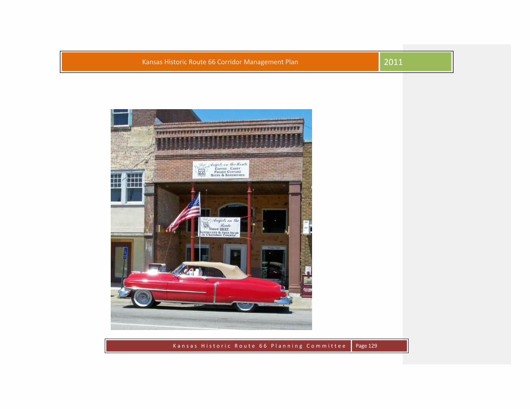
K a n s a s H i s t o r i c R o u t e 6 6 P l a n n i n g C o m m i t t e e
Page 129
Kansas Historic Route 66 Corridor Management Plan 2011
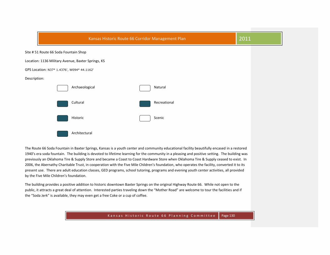
K a n s a s H i s t o r i c R o u t e 6 6 P l a n n i n g C o m m i t t e e
Page 130
Kansas Historic Route 66 Corridor Management Plan 2011
Site # 51 Route 66 Soda Fountain Shop
Location: 1136 Military Avenue, Baxter Springs, KS
GPS Location: N37° 1.4376', W094° 44.1162'
Description:
Archaeological Natural
Cultural Recreational
Historic Scenic
Architectural
The Route 66 Soda Fountain in Baxter Springs, Kansas is a youth center and community educational facility beautifully encased in a restored
1940’s era soda fountain. The building is devoted to lifetime learning for the community in a pleasing and positive setting. The building was
previously an Oklahoma Tire & Supply Store and became a Coast to Coast Hardware Store when Oklahoma Tire & Supply ceased to exist. In
2006, the Abernathy Charitable Trust, in cooperation with the Five Mile Children’s foundation, who operates the facility, converted it to its
present use. There are adult education classes, GED programs, school tutoring, programs and evening youth center activities, all provided
by the Five Mile Children’s foundation.
The building provides a positive addition to historic downtown Baxter Springs on the original Highway Route 66. While not open to the
public, it attracts a great deal of attention. Interested parties traveling down the “Mother Road” are welcome to tour the facilities and if
the “Soda Jerk” is available, they may even get a free Coke or a cup of coffee.
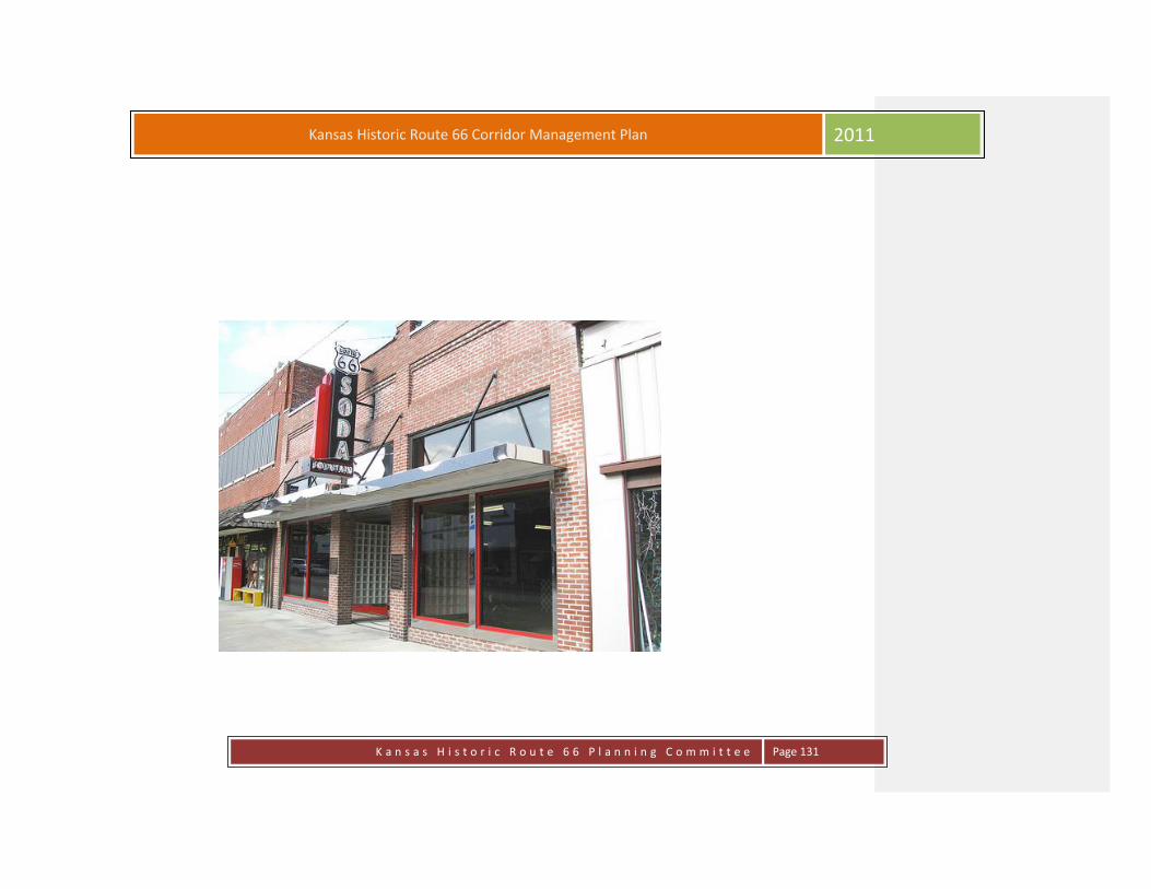
K a n s a s H i s t o r i c R o u t e 6 6 P l a n n i n g C o m m i t t e e
Page 131
Kansas Historic Route 66 Corridor Management Plan 2011

K a n s a s H i s t o r i c R o u t e 6 6 P l a n n i n g C o m m i t t e e
Page 132
Kansas Historic Route 66 Corridor Management Plan 2011
Site # 52 Frieze on Exterior Wall of American Bank
Location: 1201 Military Avenue, Baxter Springs, KS
GPS Location: N37° 1.4154', W094° 44.1206'
Description:
Archaeological Natural
Cultural Recreational
Historic Scenic
Architectural
An outstanding and unique mural may be viewed on the outside southeast corner of the American Bank. The brick sculpture, designed and
created by Paula Collier of Denton, Texas depicts many aspects of the heritage of Baxter Springs. Created in 1995, the large bas relief
sculpture shows a number of events spanning more the 150 years of Baxter Spring’s history. The collage is made up of symbolic scenes
representing Baxter Springs Native American role, the events of the Civil War, the Cowtown era and vigilante justice, the role of the
railroad, the Military road, the various trails that have crossed through Baxter Springs, the significance of our location on historic Route 66,
the mining era in which Baxter Springs was the hub of the largest lead and zinc mining operation in the world, and much more.

K a n s a s H i s t o r i c R o u t e 6 6 P l a n n i n g C o m m i t t e e
Page 133
Kansas Historic Route 66 Corridor Management Plan 2011

K a n s a s H i s t o r i c R o u t e 6 6 P l a n n i n g C o m m i t t e e
Page 134
Kansas Historic Route 66 Corridor Management Plan 2011
Site # 53 Kirkendoll/Edens Grocery
Location: Hwy 166, Baxter Springs, KS
GPS Location: N37° 1.4356', W094° 44.4662'
Description:
Archaeological Natural
Cultural Recreational
Historic Scenic
Architectural
No Public Access
Bonnie and Clyde were a couple, although living a relatively short life of crime, who visited Baxter Springs in March of 1933. Spying a small
grocery store at the corner of 12th and Wyandotte, called Kirkendoll's Grocery, Bonnie and Clyde and an accomplice pulled up to the store,
entered brandishing their guns and demanded all the cash from the proprietor, Mr. Kirkendoll.
The cash had earlier in the evening been stashed away, and very little was taken from the register. Bonnie never got out of the vehicle,
electing to sit and wait, and smoke her cigar.
The disappointed pair departed, but decided to make a second call on the Kirkendoll Grocery the following Saturday night. This time a small
amount of money was taken. Two robberies committed by the same gang, at the same establishment, a week apart was rather bold. But
that was the modus operandi of Bonnie and Clyde-- unpredictability. But cold and cunning they were, lacking any remorse. Fortunately, they

K a n s a s H i s t o r i c R o u t e 6 6 P l a n n i n g C o m m i t t e e
Page 135
Kansas Historic Route 66 Corridor Management Plan 2011
did not injure anyone in Baxter Springs.
The building robbed by Bonnie and Clyde still exists at the corner of 12th and Wyandotte. Instead of Kirkendoll Grocery, the faded sign on
the building says Edens Grocery, a grocery store owned by Jack and Hazel Edens for many years.

K a n s a s H i s t o r i c R o u t e 6 6 P l a n n i n g C o m m i t t e e
Page 136
Kansas Historic Route 66 Corridor Management Plan 2011
Site # 54 National Cemetery Plot
Location: Hwy 166, Baxter Springs, KS
GPS Location: N37° 1.9355', W094° 46.1883'
Description:
Archaeological Natural
Cultural Recreational
Historic Scenic
Architectural
The Plot is located one-half mile west of town on Highway 166. It is situated in the center of the city cemetery. In 1886, the Federal
Government designated a national cemetery plot to commemorate those men killed in the attack on Ft. Blair and the Battle of Baxter
Springs which is also known as the Baxter Springs Massacre. A large imposing statue of a Union soldier sits atop a large stone base bearing
the names of the nearly 100 men interred there.

K a n s a s H i s t o r i c R o u t e 6 6 P l a n n i n g C o m m i t t e e
Page 137
Kansas Historic Route 66 Corridor Management Plan 2011

K a n s a s H i s t o r i c R o u t e 6 6 P l a n n i n g C o m m i t t e e
Page 138
Kansas Historic Route 66 Corridor Management Plan 2011
Site # 55 Presbyterian Church
Location: 133 E. 12th Street, Baxter Springs, KS
GPS Location: N37° 1.4222', W094° 43.7906'
Description:
Archaeological Natural
Cultural Recreational
Historic Scenic
Architectural
In the fall of 1867, a small group of people with Presbyterian preferences had been holding religious service in Baxter Springs. Reverend
John W. Pinkerton, a 34-year-old supply minister who was also serving the new church in Carthage, Missouri preached the first service on
Sunday morning, November 10 and continued this service once a month until March of 1868. Reverend Pinkerton made the rigorous trip of
35 miles without roads or bridges once each month that winter. After March, 1868 Reverend J.L. Hawkins preached until the church
organization was completed. The church is located 1 block east of Route 66 on E. 12th Street.
Consequently, the Baxter Springs church began its service just one month after the organization of Kansas Presbytery or Synod and seven
months later became a member of that Presbytery.
By May of 1868, L. T. Stowell of Baxter Springs sent this application the Kansas Presbytery, “We are as sheep without a shepherd living in
the midst of a growing community destitute of the means of grace and the ordinances of religion as administered in the church of our
choice. Last autumn our town had a population of 400, at present it numbers 1200.” Before long, L.T. Stowell was chosen ruling elder, giving

K a n s a s H i s t o r i c R o u t e 6 6 P l a n n i n g C o m m i t t e e
Page 139
Kansas Historic Route 66 Corridor Management Plan 2011
him the distinction of being the first elder of this church. The charter members included L.T. Stowell, Oliver S. Stowell, Mr. Dana Neil, I.N.
McCampbell and Emma H. McCampbell.
For eight months, the little congregation marked time, but on January 10, 1969, a Rev. Hawkins administered the ordinance of the Lord’s
Supper and 13 members were received; seven more joined that year bring this total to 25. Reverend Hawkins closed his labors in the winter
of 1870. The church had irregular supply until February 1872 when Reverend Warren Mayo preached morning and evening to a small
congregation in the brick church, then partially completed. It is not known where the congregation had met between the time of
organization and the completion of the church building. The first church was a brick building located directly east across the street from the
Lincoln School. It was started in 1871 and completed in 1872. The cost was reputed to be $4000 and remained there until about the turn of
the century when work was started on the present building at 12th and East Avenue. This church was built on land given by L. Murry Perkins
and was dedicated September 28, 1902.
In 1948, the brick building was rearranged and a new sanctuary was built to the east of the original building. It was dedicated on November
21, 1948. A house and lot adjoing the church on the south was given to the church in 1954 and the house was used for Sunday school. In
1962, an educational wing was built in the south of the building and another expansion to the educational wing was made in 1979. The
congregation observed its one hundredth anniversary of the local church in May of 1968.

K a n s a s H i s t o r i c R o u t e 6 6 P l a n n i n g C o m m i t t e e
Page 140
Kansas Historic Route 66 Corridor Management Plan 2011
Site # 56 Grantham Home/Derfelt Funeral Home
Location: 328 E. 12th Street, Baxter Springs, KS
GPS Location: N37° 1.42', W094° 43.8199'
Description:
Archaeological Natural
Cultural Recreational
Historic Scenic
Architectural
This Colonial Revival home was built in the early 1870’s. The most prominent residents were Mr. and Mrs. J. Walter Grantham, who owned
a music store and later owned the New Baxter Theatre. Because of the theatre, they became friends with several prominent show business
personalities, including Gene Autry and Tom Mix, whom they entertained in this home. In 1956 the property was purchased by the
Schurman family who converted it to a funeral home. Present owners are John and Frankie Derfelt, who built a chapel addition on the north
side. Derfelt’s are located 3 blocks east of Historic Route 66 on East 12th Street. Picture page 266.

K a n s a s H i s t o r i c R o u t e 6 6 P l a n n i n g C o m m i t t e e
Page 141
Kansas Historic Route 66 Corridor Management Plan 2011
Site # 57 Cooper Home/Abbott Funeral Home
Location: 519 E. 12th Street, Baxter Springs, KS
GPS Location: N37° 1.424', W094° 43.9489'
Description:
Archaeological Natural
Cultural Recreational
Historic Scenic
Architectural
This Classic Italianate styled home was built in 1868 by John M. Cooper, and was the largest and grandest home in the area, at the time. Mr.
Cooper was a prominent local business man, served as mayor, and started the Baxter State Bank. This home was the first in town to have
indoor plumbing. Indoor running water was gravity fed from a cistern. The first telephone in town connected the home by direct line with
Mr. Cooper’s mercantile business at 12th and Military. After Cooper’s death in 1914, the building was sold and in 1924 became the Wallace
Hospital. In 1950 it became the Blosser-Shewmake Mortuary, later the Wene Funeral, and the Purdy Funeral Home. Abbott Funeral home
was established here in 1969. Present owners are Robert and Phyllis Abbott. This unique structure is located 5 blocks east of Historic Route
66 on East. 12th St.
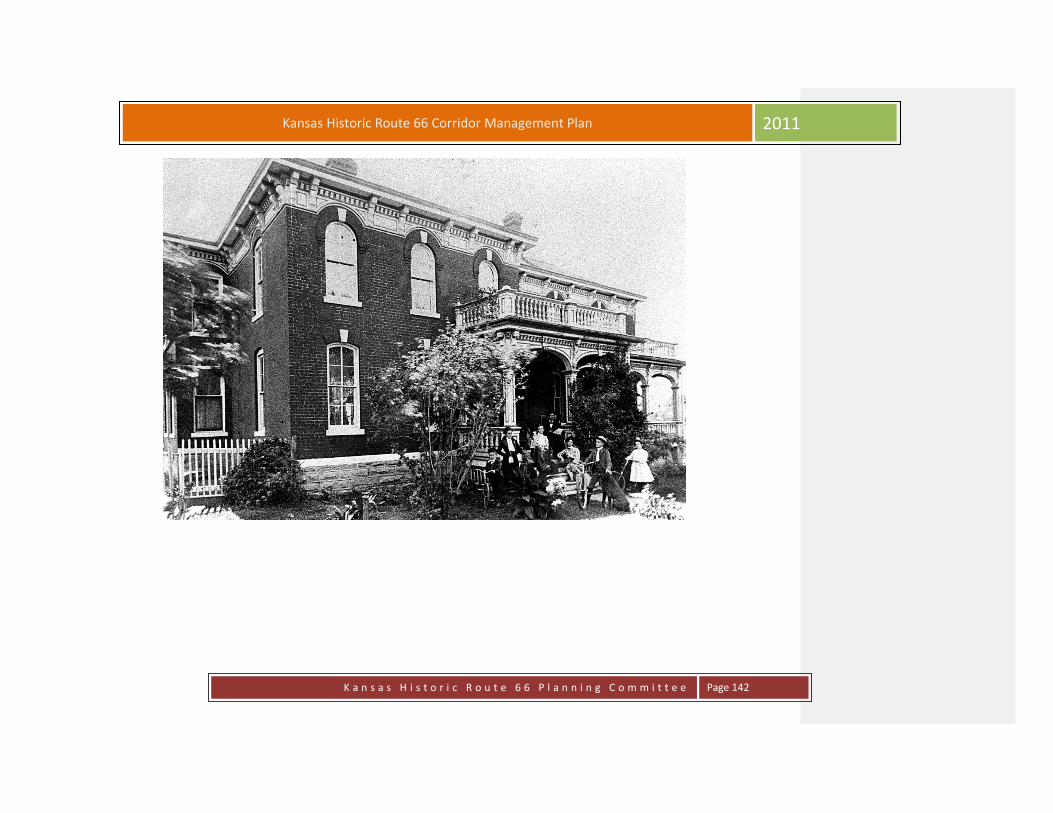
K a n s a s H i s t o r i c R o u t e 6 6 P l a n n i n g C o m m i t t e e
Page 142
Kansas Historic Route 66 Corridor Management Plan 2011

K a n s a s H i s t o r i c R o u t e 6 6 P l a n n i n g C o m m i t t e e
Page 143
Kansas Historic Route 66 Corridor Management Plan 2011
Site # 58 Youse Home
Location: 532 E. 12th Street, Baxter Springs, KS
GPS Location: N37° 1.4163', W094° 44.0923'
Description:
Archaeological Natural
Cultural Recreational
Historic Scenic
Architectural
This house has long been a Baxter Springs landmark with one of the most impressive facades in the city. It was initially constructed in 1916
and was occupied by several subsequent owners before it was purchased by Clare and Glad Youse in 1927. The house has remained in the
family since that date. The Youses employed a Joplin architect, Truman Martinie to design changes including raising the roof line and adding
the columns in the front and the sun porch on the east. The result is a blend of several architectural styles – Classic Greek Revival with some
Queen Ann influences. The sun porch later was enclosed to become a first floor music room. Mrs. Youse was a world renowned composer
of sacred music. Clare Youse served as a Kansas State Representative and later a State Senator, Clare and Glad’s daughter, Madolyn and her
husband Ed Babcock presently own the home. This home is located five blocks east of Historic Route 66 on East 12th Street. There are three
houses located within this block on the north side of the street. The house was listed on the Register of Historic Places in 2011.

K a n s a s H i s t o r i c R o u t e 6 6 P l a n n i n g C o m m i t t e e
Page 144
Kansas Historic Route 66 Corridor Management Plan 2011
Youse Home 2011

K a n s a s H i s t o r i c R o u t e 6 6 P l a n n i n g C o m m i t t e e
Page 145
Kansas Historic Route 66 Corridor Management Plan 2011
Site # 59 Niles Home
Location: 605 E. 12th Street, Baxter Springs, KS
GPS Location: N37° 1.4204', W094° 43.7527'
Description:
Archaeological Natural
Cultural Recreational
Historic Scenic
Architectural
Rial A. Niles and his wife Mary built this Classic Italianate Home in 1870. Niles was a partner in a bank called the Drovers Bank on the
southwest corner of 11th and Military Road. Three years later, as the cattle boom was nearly over, the Niles family returned to their native
Michigan. In 1875 the home was purchased by Colonel William March, local postmaster. The house sold several times until 1923, when it
was rented to the Baxter Women’s Club to use as a club house. In 1956, the Episcopal Church purchased the building, using it as a church
until 1977. The square shape of the home, the cupola on top, and the corbels under the eaves are typical of the Italianate style. The house is
on the National Historic Register. Present owner of the home is Gabe Nichols. The Niles home is located 6 blocks east of Historic Route 66
and is located within a group of homes that were built in the late 1800’s.

K a n s a s H i s t o r i c R o u t e 6 6 P l a n n i n g C o m m i t t e e
Page 146
Kansas Historic Route 66 Corridor Management Plan 2011
Niles Home

K a n s a s H i s t o r i c R o u t e 6 6 P l a n n i n g C o m m i t t e e
Page 147
Kansas Historic Route 66 Corridor Management Plan 2011
Site # 60 Lea Manor
Location: 709 E. 12th Street, Baxter Springs, KS
GPS Location: N37° 1.4199', W094° 43.6663'
Description:
Archaeological Natural
Cultural Recreational
Historic Scenic
Architectural
This lovely historic home was built in 1869 by Archibald Lea and his wife. Lea was a publisher of three area newspapers, The Baxter Springs
Republican, The Columbus News, and The Galena Republican. He later had mining interests in Galena. This Classic Italianate home features
high ceilings and the original window casements and front door. It was constructed with bricks from the Baxter Brick Works located at 7th
Street near Spring River. In 1906, the home was owned by O. C. Rummel, a city councilman. D. C. McKaller and his wife Caledonia Long
McKaller, acquired the house in 1929. Caledonia was a sister of Huey long, infamous long-time governor of Louisiana. The Howard Saunders
family purchased the house in 1949. The house had an enclosed single story porch on the east side with an added second story sun room.
David and Cheryl Holden purchased the house in 1982 and did extensive restoration and redecorating. Recently, the home was purchased
by local artist Doug Scott and is now Lea Manor, a bed and breakfast. Lea Manor is located 7 blocks east of Historic Route 66 on East 12th
Street.

K a n s a s H i s t o r i c R o u t e 6 6 P l a n n i n g C o m m i t t e e
Page 148
Kansas Historic Route 66 Corridor Management Plan 2011

K a n s a s H i s t o r i c R o u t e 6 6 P l a n n i n g C o m m i t t e e
Page 149
Kansas Historic Route 66 Corridor Management Plan 2011
Site # 61 Little League & Youth Ball Parks
Location: 14th St. and Lions Road , Baxter Springs, KS
GPS Location: N37° 1.3086', W094° 44.4414'
Description:
Archaeological Natural
Cultural Recreational
Historic Scenic
Architectural
The ball parks are located 4 blocks west on 14th Street from Historic Route 66. Baseball is America’s pastime and Baxter has a rich baseball
history and has provided a wonderful place for local youth to play over the years. This location of the program started in the 1950’s and
continues with a state of the art facility today. This impressive Little League facility is located at 14th & Lions Rd. There is a baseball
museum on site but is open only during tournaments and special events. There are three ball fields located on the property owned by the
Baxter Springs Lion’s Club. In 1955 the Lion’s Club approved providing a suitable field and facilities for the Little League program. In 1976 the
club acquired the adjacent property where the Babe Ruth Park and Girls Softball Field had been for 10 years. The Baxter Springs Lion’s Club
owns this property today for the use of the community youth.
Baxter Springs and baseball go hand in hand. It seems there has always been some sort of baseball activity going on locally in this century.
Within the archives of the Baxter Springs Heritage Center and Museum are many pictures, most undated, but all very old, of teams in old
baggy uniforms and rudimentary gloves. Viewing them makes one appreciate the love of the game those young men had.
Many towns in the region had teams and competition was keen. Many of the teams were comprised of miners. They worked hard during

K a n s a s H i s t o r i c R o u t e 6 6 P l a n n i n g C o m m i t t e e
Page 150
Kansas Historic Route 66 Corridor Management Plan 2011
the week and played hard on Sunday afternoon. Nearly every mine would have its own team comprised of men who worked that mine.
The games were played on a rudimentary playing field, but that mattered little. The love of the game and the entertainment they provided
for their families was paramount to these men. Large crowds would attend. They were in a sense celebrations- a means of separating
themselves from the agonies and the dangers of the work that they had chosen.
In the 1940's, a Baxter resident and mine operator or foreman named Barney Barnett, Sr. began expanding baseball to another level. He
envisioned baseball for local boys to begin competition with teams the same age from other surrounding towns. He was very selective in
comprising his team members. They did not have to be just "Baxter Boys." He selected outstanding talent from Baxter, Picher, Hockerville,
and Commerce and some farm boys as well.
The name given to his teams was "the Whiz Kids." This team Mr. Barnett coached was successful year in and year out. They played their
home games in the old wooden stadium that sat on the east side of Kiwanis Park, sandwiched between a small rivulet flowing through the
park and Spring River, the outfield.
The crowds packed the stands whenever "the Whiz Kids" played at home. The local newspaper, the CITIZEN, covered all of their games and
statistics on the front page.
The Whiz Kids belonged to the Kansas, Missouri, Oklahoma (KMO) league, winning the league championship in 1948.
Some of the players who comprised the team at various times included Wiley Pitts, Calvin Mishler, Rex Haven, Bill Johnson, Ben Craig, Jim
Kenega, Buddy Ball, Mickey Mantle and many others.
Many local residents, to this day, regale the listener with their memories of the times they enjoyed spending afternoons and evenings at the
old wooden stadium in Kiwanis Park.
The Baxter Springs Little League was established in 1955. The park was created on land adjacent to the old Kansas City Southern railroad
tracks. Over the years, the local teams have distinguished themselves as a formidable power in state and regional little league competition.
That success has carried over to the national level as well. On several occasions, local teams have advanced in tournament competition to
within one or two games of progressing to the Little League World Series.
The community of Baxter Springs is very proud of the visible symbol of Baxter Springs Little League. The local stadium has hosted many post
season tournaments. Visiting teams have marveled at the beauty of the facility, and visitors often question how such a facility could exist in

K a n s a s H i s t o r i c R o u t e 6 6 P l a n n i n g C o m m i t t e e
Page 151
Kansas Historic Route 66 Corridor Management Plan 2011
a small town. It's easy to answer. Historically, this is a baseball crazy town, with a proud tradition to uphold. Several generations of families
have worked together to perpetuate this tradition and image. Mr. Wayne Metcalf and Mr. Calvin Mishler, former "Whiz Kids", and their
families, and countless other families, too many to name, have given many years of their lives to this program. Pride is evident, and it carries
over in providing a fine facility to the public, second to none.
The Little League serves to teach the fundamentals and the spirit of competition. This was carried up to the former Babe Ruth program. In
1974, the Baxter Springs Babe Ruth team advanced in tournament brackets culminating in their appearance in the Babe Ruth World Series
in Abbeyville, Louisiana.
The program was changed to the Senior Little League in later years. Success was continued at this level of competition as well. In 2000, this
group of young men represented Baxter Springs well by traveling to Tyler, Michigan. At the conclusion of the tournament, the boys
returned to Baxter Springs in possession of the Senior Little League World championship.
These same boys all attended Baxter Springs High School. Playing as teammates from Little League through high school, the Baxter Springs
baseball program has distinguished itself as one of the premier baseball towns in the state of Kansas. Since its inception in 1981, the local
high school baseball team has won seven state championships, and four state runner ups, a record that many schools only envy.
Over the many years, the town is exceedingly proud of the recognition that baseball has given to Baxter Springs.
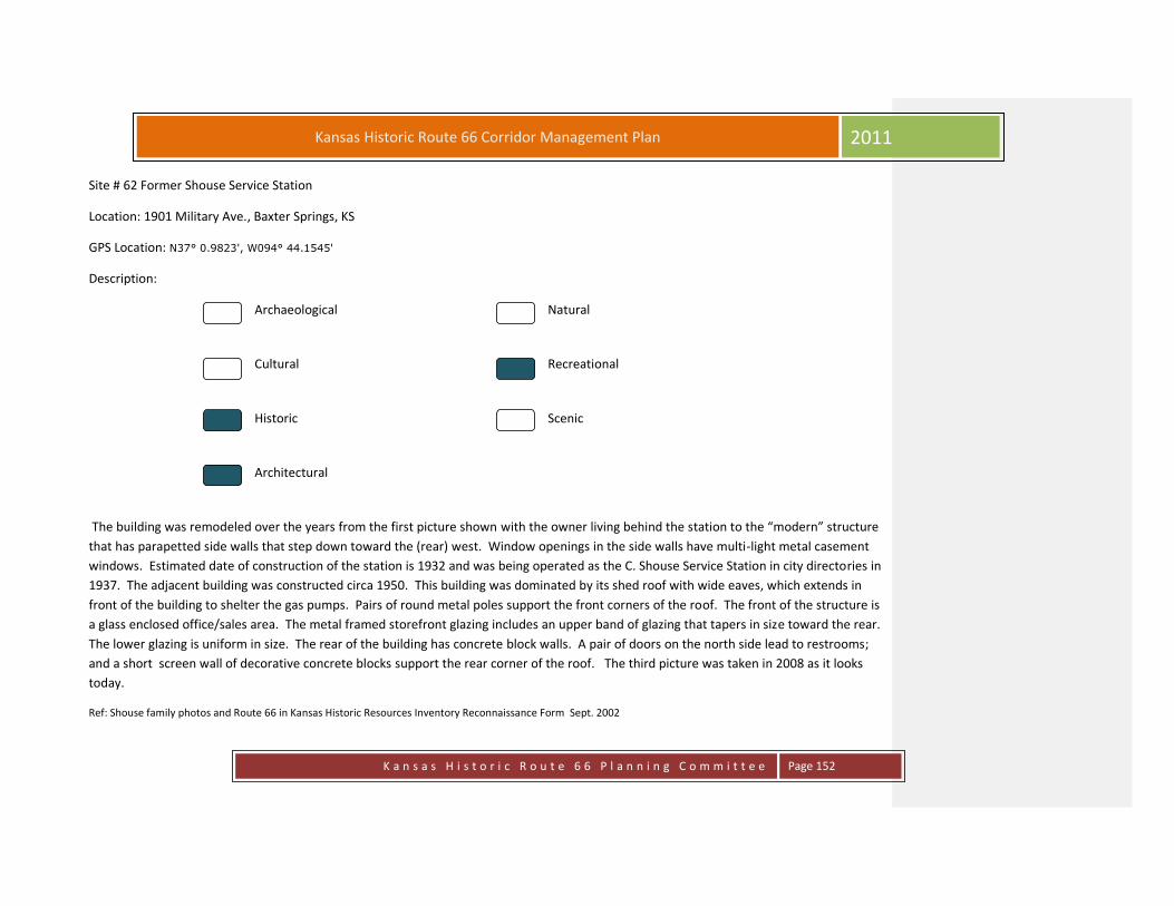
K a n s a s H i s t o r i c R o u t e 6 6 P l a n n i n g C o m m i t t e e
Page 152
Kansas Historic Route 66 Corridor Management Plan 2011
Site # 62 Former Shouse Service Station
Location: 1901 Military Ave., Baxter Springs, KS
GPS Location: N37° 0.9823', W094° 44.1545'
Description:
Archaeological Natural
Cultural Recreational
Historic Scenic
Architectural
The building was remodeled over the years from the first picture shown with the owner living behind the station to the “modern” structure
that has parapetted side walls that step down toward the (rear) west. Window openings in the side walls have multi-light metal casement
windows. Estimated date of construction of the station is 1932 and was being operated as the C. Shouse Service Station in city directories in
1937. The adjacent building was constructed circa 1950. This building was dominated by its shed roof with wide eaves, which extends in
front of the building to shelter the gas pumps. Pairs of round metal poles support the front corners of the roof. The front of the structure is
a glass enclosed office/sales area. The metal framed storefront glazing includes an upper band of glazing that tapers in size toward the rear.
The lower glazing is uniform in size. The rear of the building has concrete block walls. A pair of doors on the north side lead to restrooms;
and a short screen wall of decorative concrete blocks support the rear corner of the roof. The third picture was taken in 2008 as it looks
today.
Ref: Shouse family photos and Route 66 in Kansas Historic Resources Inventory Reconnaissance Form Sept. 2002

K a n s a s H i s t o r i c R o u t e 6 6 P l a n n i n g C o m m i t t e e
Page 153
Kansas Historic Route 66 Corridor Management Plan 2011
Left: Shouse Station about 1937
Below: about 1950
Photographs courtesy of Mark Shouse

K a n s a s H i s t o r i c R o u t e 6 6 P l a n n i n g C o m m i t t e e
Page 154
Kansas Historic Route 66 Corridor Management Plan 2011
Former Shouse Service Station 2008

K a n s a s H i s t o r i c R o u t e 6 6 P l a n n i n g C o m m i t t e e
Page 155
Kansas Historic Route 66 Corridor Management Plan 2011
Site # 63 Historic Route 66 Roadbed
Location: W. 30th Street & Roberts Road, Baxter Springs, KS
GPS Location: N37° 0.00601', W094° 73657'
Description:
Archaeological Natural
Cultural Recreational
Historic Scenic
Architectural
Left on Roberts Road and curves back to Hwy 69A to Oklahoma

K a n s a s H i s t o r i c R o u t e 6 6 P l a n n i n g C o m m i t t e e
Page 156
Kansas Historic Route 66 Corridor Management Plan 2011
Linked by the Mother
Road: History of the
Kansas Route 66
Communities

K a n s a s H i s t o r i c R o u t e 6 6 P l a n n i n g C o m m i t t e e
Page 157
Kansas Historic Route 66 Corridor Management Plan 2011
Galena

K a n s a s H i s t o r i c R o u t e 6 6 P l a n n i n g C o m m i t t e e
Page 158
Kansas Historic Route 66 Corridor Management Plan 2011
Galena Area during the Civil War
This entire area was the scene of much violence during the period leading up to the Civil War. Border ruffians and guerillas clashed with the
settlers, often robbing and even murdering those they suspected of being Free-Staters, supporting the effort to get Kansas admitted to the
Union as a free, anti-slavery state. Stories abound about those dangerous days, and legends have been told for years about settlers burying
their meager treasure in the ground to keep it from intruders, and of guerillas burying their pillaged loot with the idea of picking it up later.
Whether treasures were buried throughout the area, no one knows for sure, but through the years since, many have looked for buried
treasure. During the Civil War, many local settlers left the area for safety, moving to points further west. Some returned after the war, only
to find their cabins burned.
Galena Incorporated as a city June 19, 1877.
The existence of lead ore in the district was known to the Indians, long before the advent of the white men, and to the hunters who visited
the area for the wild and forest game.
When the settler finally arrived he heard of the ore with indifference, thinking that if the ore were there he could get it at leisure. In 1872
ore in paying quantities was discovered in Garden Township and about the same time indication of ore were found in the vicinity of Baxter
Springs.
Previous to this, however, mining had been carried on in a small way at Granby and Joplin and other small towns in Missouri and it was
generally believed that pay ore would be found in or near Short Creek, because of the similarity of the two areas.
There was some prospecting along the creek but nothing of value was discovered. In April, 1876 a mass of pure lead ore was accidently
discovered at the bottom of a well on a farm.
A company was formed, composed of Baxter Springs capitalists. The farm was purchased, buildings were erected and the mining camp of
Bonanza came into existence. Mining was prospected slowly at first because few rich deposits of ore were found but by year nineteen
hundred Bonanza was one of the best paying camps centered at Galena.
In February, 1877, two boys, while digging a hole at the roots of a tree on the Nichols farm near Short Creek, uncovered a large deposit of
pure lead ore. The farm was located one mile southeast of the find of the previous year at Bonanza.
The prospectors who had made the discovery at Bonanza were induced to sink a shaft and at fifteen feet they struck a pocket of rich lead

K a n s a s H i s t o r i c R o u t e 6 6 P l a n n i n g C o m m i t t e e
Page 159
Kansas Historic Route 66 Corridor Management Plan 2011
ore. They named the mine “The Discovery” and proclaimed their find on Sunday, April 12, 1877.
The news spread like “wildfire” and parties from points in Missouri and Kansas flocked to Short Creek. Soon the cornfields were
transformed into a large, bustling mining camp. Almost every shaft sunk gave up large deposits of ore and the excitement ran high.
As the news of the discovery spread, fortune hunters and adventurers rushed to the new camp and within a week, hundreds of tents dotted
the hills near Shoal Creek.
Within a month the Nichols farm and the land adjoining had changed hands. Two rival companies were in the field biding for the land to
lease and sell as mining lots. In the immediate vicinity were tents, wagons and rudely constructed huts sheltering about ten thousand
people. The Nichols farm and the adjoining land had been purchased by the Empire town company and the land on the south of it belonged
to the Galena town company.
The height of Empire City being nearer the field of operations was chosen at first by many of the homeseekers and the majority of the
people attracted to the camp settled at that place.
Empire was formed under the laws governing third class towns, the papers being taken out by petition before Hon. B. W. Perkins, judge of
the eleventh judicial district, state of Kansas, dated June 18, 1877.
Galena had prospered and was also incorporated as a city of the third class on June 19, 1877.
Elections for municipal officers for Empire City and also Galena were held June 30, 1877.
The rivalry was so keen and the inhabitants of the twin cities were so zealous of their own interests that when the election at Galena was
held men were stationed at the polling booth, heavily armed, to protect the voters and to prevent bloodshed.
The first officers of the two cities were inducted into office on the same day and at the same hour. Their positions were not enviable ones.
The prospect of keeping order in a mining camp was not a very promising one. Columbus Street in Empire and “Red Hot” and Main Streets
in Galena were the first to build up with business houses, which were of log, frame and box hastily thrown together for temporary use.
Columbus Street began at the north line of Galena and ran north through the town of Empire. Main Street, Galena, began one block east of
Columbus the south line of Empire and ran east.

K a n s a s H i s t o r i c R o u t e 6 6 P l a n n i n g C o m m i t t e e
Page 160
Kansas Historic Route 66 Corridor Management Plan 2011
“Red Hot” Street was one block long and running east and west formed the connecting link between Main Street of Galena and Columbus
Street of Empire. This road was the main thoroughfare traveled in reaching the mines and then notorious Hickory Flat.
In this section were innumerable haunts of dissipation and vice. The most infamous were the “The Log Cabin in the Lane”
At these places assembled the murderers, outlaws, gamblers, and the evil hearted Lorelis, (a term once used to describe women who
enticed men from the straight and narrow), outcasts of society, and many were the miners who were lured inside, and who lost their hard
earned gold, at the bar, at the roulette wheel, and other questionable pastimes. Many a miner entered the resorts and was never seen
again.
It is claimed that this section was in the path and was, at times, the rendezvous of Quantrill’s band, the Younger brothers, the James boys
and many other outlaw bands.
Some were frequent hangers-on at the resorts while others worked in the mines, always being heavily armed and refusing to reveal their
true identity. Murder and violence was so common on “Red Hot Street” that no citizen who valued his life ventured there at night. The first
days witnessed many murders and during the first fourteen days in office, the police judge of Empire presided at nine inquests.
One important event of the early days, which stirred every citizen of the two cities, was the affair of the stockade. The land of the two
incorporations met in the valley of Short Creek and it was here the first ore was discovered.
To a stranger visiting the camp, Short Creek appeared to be the natural boundary line between the two cities and thus the rich finds of ore
in the bottoms were credited to Galena. It would have made little difference to the community on which side the newcomers settled if
there had been but one city, but with two cities striving to settle within their own limits the thousands rushing to the camp, nothing but war
could exist.
The quarrel assumed a serious aspect when Empire decided to arrest the population from moving over to the Galena side by building a
stockade. On the night of July 25, 1877, the city council of Empire passed a resolution ordering a stockade eight feet high and one-half mile
in length to be built along the south side of the city.
This plan, if carried out, would stop all communication between the two cities and hinder public travel. The stockade was to enclose the
south end of Columbus Street and the bridge over Short Creek. The action caused much confusion and the workmen were given police
protection while building the wall. Galena protested in vain against the act and petitioned her city council which in turn appealed to the

K a n s a s H i s t o r i c R o u t e 6 6 P l a n n i n g C o m m i t t e e
Page 161
Kansas Historic Route 66 Corridor Management Plan 2011
United States government asking them to prevent the closing of a public highway to the United State mail. This action proved too slow,
however, and the gap was being closed, when the mayor acting under the authority of the city council, organized a posse of fifty citizens
and on August 15, 1877 at 4 a.m., attacked, tore down, and burned the great portion of the wall. The attack, being a surprise to the
builders, prevented much bloodshed and resulted in the exchange of only a few shots.
The question entered the courts and after a long period of litigation, a truce was declared and from that time on the two cities began to
work together in building one of the best mining camps in the world.
A spirit of friendship grew between them until July 9, 1907, when Empire became s suburb of Galena. The surrender of her rights as an
incorporated city to Galena was made amid great rejoicing and the pieces of the old stockade were taken away as souvenirs by citizens of
the old Empire and the old Galena.
Galena Today, a City Rediscovering Itself
Today, Galena is proud of an excellent school system that regularly meets and exceeds state standards. The high school, remodeled in 1997
is home to one of the finest Performing Arts Centers in the area. Liberty Grade School is an imposing stone building constructed by the WPA
in 1939. Galena has perhaps the most outstanding city park in southeast Kansas—Schermerhorn Park. Other parks include a city park at
12th and Main, and the Pappy Litch Route 66 Park in the downtown area on Main Street. Galena's mining history is being saved and
exhibited at the Mining Museum located in the old Katy Railroad Station near the city's city hall/library on Route 66.
A committed downtown development committee is working to enhance the appearance on Main Street (Route 66) with new sidewalks,
lighting, and plantings. That committee is also committed to promoting the cultural arts in the city. Some restoration is ongoing on Main
Street, with more planned in the near future, and a new orthopedic surgery center has opened within the city limits. Most new home
building is taking place in the south end of the city, although there has been some notable building in older sections of town. Galena will
never have the population and financial well-being that marked its glory during the mining era, but it aspires to becoming an even better
place to live and raise families. The city stands ready to share its history with the rest of the world.
K a n s a s H i s t o r i c R o u t e 6 6 P l a n n i n g C o m m i t t e e
Page 162
Kansas Historic Route 66 Corridor Management Plan 2011
Riverton

K a n s a s H i s t o r i c R o u t e 6 6 P l a n n i n g C o m m i t t e e
Page 163
Kansas Historic Route 66 Corridor Management Plan 2011
Just three miles down the road from Galena is a tiny town that sprang up during the Kansas Mining hey days. In the beginningit was an early
Quaker settlement. But shortly after the turn of the century, the Empire District Electric Company dammed Shoal Creek just south of the
Spring River to construct a hydroelectric plant at Riverton. The facility generated enough electricity to illuminate 80 communities as well as
mining operations throughout the surrounding tri-state area. The dam also created the recreational Lake Lowell. The power plant, which
still operates today, is the only major business in this small Route 66 town.
There was a time when the Route 66 traveler, after leaving Galena and heading west towards Riverton, would have crossed the Spring River
on a classic old Marsh Rainbow Arch Bridge. This beautiful bridge, with three consecutive spans, was built in 1922 and saw service
throughout the entire period of Route 66. Unfortunately, it was dismantled in 1986.
Also, between Galena and Riverton was once a popular motor court and gas station called Camp Joy. However, by the 1960’s Camp Joy had
all but disappeared.
Just after crossing the Spring River, The Spring River Inn and a country club were constructed on the grounds of the electric plant, north of
Lake Lowell. Built in 1905, the Inn and country club first catered to the wealthy patrons from Galena and became the social center of the
area. However, when the depression hit, the club was sold in 1932 and was used as a boating club.
Reopening in 1952, the restaurant and inn catered to the many travelers of the Mother Road. The restaurant was known for its thirty-five-
foot buffet table loaded with home-cooked food, cinnamon pull-apart rolls and squaw bread. In the mid 1990's the Inn and restaurant
closed and a couple of years later the Inn burned to the ground. The restaurant has never reopened and as of the writing, the property is for
sale.
The biggest attraction is the old Eisler Brother Store, built in 1925. The store was purchased in 2011 by Scott Nelson and is now known as
“Nelson’s Old Riverton Store. A one-of-a-kind landmark, the store was originally a Standard Station. By 1932, a "Y Not Eat Barbecue” had
been added. The Eisler family bought the location in 1973 and opened a market and deli. The old building is well maintained and still
contains the original pressed tin ceiling. Be sure to stop here, where you can not only see a variety of Route 66 souvenirs, but also enjoy an
old-fashioned deli sandwich while watching the Mother Road travelers by the store’s front porch.
Continuing west through Riverton at the 66 Junction with 69 Alternate & U.S. 400 roundabout, take the Beasley road exit and you will soon
come upon the Marsh Arch Bridge that lies between Riverton and Baxter Springs, known as the "Rainbow Bridge."
In 1992, construction of a softer curve bypassed the Rainbow Bridge at Brush Creek. After a hard fight by the Kansas Route 66 Association,

K a n s a s H i s t o r i c R o u t e 6 6 P l a n n i n g C o m m i t t e e
Page 164
Kansas Historic Route 66 Corridor Management Plan 2011
County officials agreed to leave the Brush Creek Bridge standing as a historic landmark. Today, the bridge can be viewed in its historic
setting and can be driven by south-bound traffic only.
Now, that you've enjoyed the quaint tiny town of Riverton, head on down the original Route 66 to Kansas' First Cowtown - Baxter Springs
for more Route 66 icons as well as a wealth of Old West history.

K a n s a s H i s t o r i c R o u t e 6 6 P l a n n i n g C o m m i t t e e
Page 165
Kansas Historic Route 66 Corridor Management Plan 2011
Baxter Springs

K a n s a s H i s t o r i c R o u t e 6 6 P l a n n i n g C o m m i t t e e
Page 166
Kansas Historic Route 66 Corridor Management Plan 2011
The earliest inhabitants known to reside in the Baxter Springs region were Native Americans. This was the land of the mighty Osage Nation.
The migratory Osage people roamed the area that in 1803 was known as Louisiana. From central Kansas as far east as the Mississippi River,
and south into present-day Oklahoma and Arkansas, the Osage claimed these lands as their traditional homelands.
The Osages made frequent journeys each spring and autumn to their hunting grounds, many of which were located in and around Baxter
Springs. At this place the Osages found game plentiful and the springs a natural campsite.
Chief Black Dog was the leader of the western band of Osages. The chief was an imposing figure, a man of great physical stature, standing
nearly seven feet tall. Quite naturally, Chief Black Dog presented a most powerful image, endowed with extraordinary judgment and
leadership ability. Highly esteemed by his people, Black Dog was a formidable leader.
To travel from homes in the west to hunting grounds as far away as Baxter Springs, Chief Black Dog conceived a plan to construct a
permanent trail to connect these two sites. The Osage needed this trail for mourning parties and to provide a route for replenishing their
pony supplies.
The bottom land along Spring Branch was one of the Osage's primary camping sites. From this location Black Dog's trail began. Black Dog
ordered all the warriors in his band to work on the trail. It is believed the work began in 1803. From this campsite, the work progressed
west. The warriors worked by day and returned to their families at night. The work continued for several weeks. The trail basically followed
the same route as present-day highway 166. The trail was completed in the vicinity of Arkansas City, Kansas.
The trail was a monumental achievement for the time. The untrained workers blazed a trail, it is said, that was wide enough for thirty
horses to travel abreast.
The Osages maintained this trail for many years, until their homelands were reduced and they were forced to accept reservation life. Their
migratory hunting trips ended when their lands were reduced to a small portion of land west of Baxter Springs.
This important trail is permanently recognized by a commemorative marker placed beside Spring Branch below the Baxter Springs Heritage
Center and Museum.
THE CHEROKEE REMOVAL AND THE NEW CHEROKEE NATION

K a n s a s H i s t o r i c R o u t e 6 6 P l a n n i n g C o m m i t t e e
Page 167
Kansas Historic Route 66 Corridor Management Plan 2011
The Cherokees were not native to Southeast Kansas or present-day Oklahoma. Rather, their homelands were the Smokey Mountain region
of Tennessee and Northern Georgia. Their lands were rich and fertile, greatly coveted by the ever encroaching white population. Gold was
discovered in the early part of the 19th century on some of the Cherokee lands. It was only a matter of time before the whites would
successfully entice the government to force the Cherokees from their homelands.
The Cherokees and the other tribes of the Southeast known as the Five Civilized Tribes were forced to cede their lands to the government
and relocate elsewhere. The new home for the displaced Indians was to be lands west of the Mississippi, a place unnamed at the time.
Through a series of treaties, the Cherokees were given the choice of selling or being forcibly removed.
The first wave to accept and move west departed in 1819. The destination was to be called Indian Territory. The treaties invariably would
include the clause "As long as the grass grows and the rivers flow," the lands would be theirs solely and forever.
The treaties were met with much opposition and bitterness by most of the Cherokees and the other Five Civilized Tribes who shared much
of the same region. The Indians eventually were forced to leave their homes, and in the winter of 1838-39, with military accompaniment,
thousands of tribal members moved westward to the newly formed Indian Territory. This trek is now known infamously as "The Trail of
Tears." Many hundreds, if not thousands, of Indians perished during this winter of forced removal.
The Cherokees were assigned the northeastern corner of the new territory. This region was below the territory later named Kansas. One
interesting feature of the Cherokee treaty provided that 800,000 acres of land in Kansas would be the property of the Cherokees. They were
forced to use profits from their land sales in the South to purchase this property.
The acreage in what would become Kansas (including the City of Baxter Springs) was called the Cherokee Neutral Lands. The purpose of this
territory was to create a buffer zone between the slave holding State of Missouri from the Osage Indians. The Osage had only recently been
isolated to a small reservation to the west of the Neutral Lands. In short, at first, this area was intended to be a no man's land to separate
both the whites in the east from Indians in the west.
The Neutral Lands were technically off limits to all whites, but occasionally challenged. This land would be a constant source of contention
from the time of its purchase until its eventual final sale to the United States Government following the Civil War in 1866.
By and large, the Neutral Lands remained unoccupied. Very few Cherokees ventured north to settle there initially. In present-day Cherokee
County, in an
K a n s a s H i s t o r i c R o u t e 6 6 P l a n n i n g C o m m i t t e e
Page 168
Kansas Historic Route 66 Corridor Management Plan 2011
1859 report to the Commissioner of Indian Affairs, between 250 and 400 Cherokees were reported to be residing in the Neutral Lands.
Two of the early documented settlers were David Harlan and John Rogers. Both had homesteaded land in the Shoal Creek and Galena areas.
Rogers' claim was in the Lowell area. Harlan homesteaded nearer to Galena. One early visitor to the Harlan home wrote that it was "a real
mansion."
In 1842, surveyors from the United States military were laying out the proposed route for a military road to link Ft. Leavenworth to Ft.
Gibson in Indian Territory. The proposed route was intended to pass east of Spring River near Lowell, rather than through the routing
through Baxter Springs as we now know it. The engineers suggested that a fort be constructed at the convergence of Spring River and Shoal
Creek. The proposed site was on land John Rogers had claimed as his own.
The military officers offered to purchase the land from Rogers. The offer tendered was $1,000, Rogers countered by demanding $4,000. The
offer was rejected and the military moved on north on their expedition. Finding a suitable site on the Marmaton River, a new fort and a
town sprang up at that location. That site is now Ft. Scott, Kansas.
David Harlan had also claimed very choice property in the Neutral Lands. Harlan had left his native Georgia in 1835. Harlan operated a
successful nursery in the area of the Neutral Lands known as Brushville, west of Riverton. His daughter Lucinda was one of the first children
born in Cherokee County.
In 1856, Lucinda married a native of Indiana named John Archer. They lived near Galena until the Civil War began. As most individuals who
lived in the area at the time, they were forced to flee the vicinity. Returning home at war's end, they found nearly everything they owned
destroyed, they assumed, by Confederate forces.
Mr. Archer purchased an interest in a ferry and opened a commercial operation across Spring River at Baxter Springs. This business would
remain in operation until the construction of the bridge spanning Spring River in 1886. The fares charged by Archer were "for home people
crossing on the ferry boat were five cents for a passenger on foot, twenty-five for a wagon and team, but for immigrants passing through
the country, the rates for each were doubled."
Only small numbers of Cherokees were residents of the vast Neutral Lands. In 1849, a large family of white settlers ventured into the
Neutral Lands from nearby Southwest Missouri. Their name was Baxter.
THE JOHN BAXTER FAMILY

K a n s a s H i s t o r i c R o u t e 6 6 P l a n n i n g C o m m i t t e e
Page 169
Kansas Historic Route 66 Corridor Management Plan 2011
Settlement within the Cherokee Neutral Lands was restricted to Cherokee settlement. Homesteading was not an option available to land-
hungry settlers. However, there was little authority present that could prevent white settlers from entering the Neutral Lands. The law,
however, was circumvented. And a few trespassers did venture into the lands intent on setting claim to choice lands.
John Baxter, a resident of neighboring Newton County, Missouri entered the Neutral Lands and lay claim to lands west of Spring River. The
year was assumed to be 1849. The exact date is questionable. Baxter was an intriguing character. He had an extremely large, extended
family. His eight children had a wide span in ages.
Baxter was a self-proclaimed minister, a practitioner of a phenomenon called Spiritualism. Largely unknown to the rural Newton County
farm families, Baxter and his family were a subject of curiosity.
Wiley Britton, who, as a neighbor boy of the Baxter's, recalled the mysterious Baxter and his family: He described the family as being
"enlivened, intelligent, very liberal for this region. Baxter was an adherent of Universalism who conducted religious services from his home.
Baxter was a man of considerable force of character living among us and was distinctly beneficial in bringing about broader religious and
political toleration among the people of Newton County.
The Baxter’s were all extremely talented. They provided newspapers and books which were made available to the community. They
possessed an organ. All could sing and would entertain local guests frequently. Great conversationalists, the Baxter’s were certainly a
culturally advanced family compared to their farm neighbors."
It is uncertain for what reason the Baxter’s elected to depart their Newton County home to move to the Neutral Lands. Perhaps the lure of
free lands encouraged their relocation west of the Missouri line.
John Baxter and his large family found land just west of Spring River that they deemed to be attractive and claimed this for themselves.
Their claim was illegal, but there was little reason for them to fear being removed from the Neutral Lands.
A small creek fed by numerous springs, one being highly mineral in content, dotted the hillside across from site chosen for the homestead.
Abundant timber was found all along Spring River to their east. The homestead lay east of the Military Road, which linked Ft. Leavenworth,
Kansas to Ft. Gibson, Indian Territory or Cherokee Nation.
The Military Road had originally been surveyed to pass to the east near Spring River and Lowell but its course was altered to the west. John
Baxter built his home strategically adjacent to the Road. The springs below his home provided a natural campsite for passers-by. The

K a n s a s H i s t o r i c R o u t e 6 6 P l a n n i n g C o m m i t t e e
Page 170
Kansas Historic Route 66 Corridor Management Plan 2011
military convoys frequently traveled the length of the road.
Since no other business ventures were found nearby, Baxter established a mercantile of sorts to cater to the needs of those traveling by. His
business came to be known as "Baxter's Place." The Baxter business became a popular wayside stop on the Ft. Leavenworth to Ft. Gibson
road.
The Baxter’s were not the only white settlers to take up residence in the Neutral Lands. Another settler by the uncertain name of Rogers or
Commons had claimed land on the east side of Spring River. Both families resided near one another, Spring River being a dividing line of
sorts. A disagreement arose, however, between the above named individual and a daughter of Baxter over a disputed land claim.
Baxter and his son ventured across Spring River to confront the adversary over the "ownership" of the disputed property.
Commons and his family were waiting in their cabin when the Baxter’s approached. Upon reaching the cabin, civil talk increased into rage,
and ultimately shots were fired. The lifeless body of John Baxter lay on the ground. His son continued the volley and killed the son of
Commons. The date was December 20, 1860.
The patriarch of the Baxter family was gone. The Baxter era was also over. The entire family departed their homestead in the Cherokee
Neutral Lands. Their only vestige of the years spent in this location was the cabin and the grave of the head of the Baxter family.
The land, which John Baxter claimed as his own and the springs that faced his cabin have given rise to the name of the town that we know
today as Baxter Springs, Kansas.
THE INDIAN BRIGADES FORM AT BAXTER SPRINGS
In the early months of the Civil War, desperate attempts were made by the Confederate government to enlist the support of the Five
Civilized Tribes in Indian Territory to side with the southern cause. Gen. Albert Pike was the representative of the Confederacy whose job it
was to induce the Indians to join in the war effort against the North. This was a very difficult quandary that the Indians were forcibly placed.
They were tied to the North by treaty, but their homes, from which they had been removed by way of the ''Trail of Tears," lay in the South.
They were torn between two differing sides. Compounding this dilemma was the fact that within the tribes themselves, there were
disagreements over internal leadership.
Pike negotiated with the tribes throughout the summer of 1861, but it was not until August of that year that the tribes who took the lead of
the Cherokees did indeed sign an agreement supporting the Confederacy, thus rejecting their allegiance to the Union. At once, tribal

K a n s a s H i s t o r i c R o u t e 6 6 P l a n n i n g C o m m i t t e e
Page 171
Kansas Historic Route 66 Corridor Management Plan 2011
members were forced to side either with the Southern cause or the Northern cause. Those who remained sympathetic to the North were
forced to flee their homes in Indian Territory. Their destination was the border in Kansas. Indians by the hundreds, sympathetic to the North
fled at once to the Baxter Springs area for protection against their own enemy. Their hope was to seek northern military protection.
The Indians who were living in present-day Ottawa County, which at that time was called the Quapaw Agency, were also forced to flee their
homes. Most of these were not sympathetic to the Confederacy, Many of those people who were of the Quapaw, Ottawa, Miami, Peoria,
Wyandotte and other small tribes who had been relocated to Indian Territory only a few years before were forced to move back to safety in
Northeastern Kansas
The tribes in Ottawa County resisted siding with the Confederacy until the Cherokees had joined the South. It was only after Chief John Ross
addressed these northern neighbors and convinced them to secede that they did indeed follow his lead. Chief Ross sided with the
Confederacy, only out of extreme pressure from those within his own tribe. Chief Ross soon realized the blunder he had made and switched
his support to the North. His loyal followers quickly joined him.
Those members of the Cherokee and other Five Civilized Tribes settled north of the border as far west as Humboldt and over into Newton
County, Missouri. Many of the dependents of the warriors camped in the Baxter Springs area during the early part of the winter that year.
The conditions were extremely harsh on the women and children. Most gravitated on over to Neosho where living conditions were
somewhat better. Many of the soldiers, who were forced to flee because of their loyalty to the Union, remained in and around Baxter
Springs that winter to protect the border and their families nearby.
During the first year of the war, there were skirmishes along the border between both factions of Indians. It was almost a civil war within a
civil war. Indians were fighting Indians for control of their tribal governments and at the same time fighting for the Union and the
Confederacy.
Chief John Ross was the primary leader among all the Indian tribes. His primary opponent within his own tribe was a three-quarter blood
warrior named Stand Watie. They were bitter rivals. Stand Watie was instrumental in securing the Five Civilized Tribes to ally with the
South. Stand Watie ventured north into Neutral Lands and made a number of incursions against property owners and other Indians
inhabiting the Southeast Kansas region. Stand Watie even ventured into the Baxter Springs vicinity.
For their own safety, the few white settlers moved their families out of the Neutral Lands. The only other enemies Stand Watie and his
Confederate soldiers could attack were the military and other Indians.

K a n s a s H i s t o r i c R o u t e 6 6 P l a n n i n g C o m m i t t e e
Page 172
Kansas Historic Route 66 Corridor Management Plan 2011
Brigadier General James G. Blunt was commander of the Frontier of the West and Indian Territory. The Commander of the area, including
Baxter Springs, was Colonel William Weer. Under the leadership of these commands, three regiments of loyal Indians comprised primarily
of Cherokees and a few other members of the Five Civilized Tribes loyal to the Union were organized during this year of encampment in and
around Baxter Springs.
The Indians were a motley looking group, furnished with a colorful array of uniforms and undisciplined militarily as described by local soldier
at the time, Wiley Britton. as follows:
"Fully equipped as a warrior, one might have seen an Indian soldier dressed as described, wearing a high crowned stiff wool hat, with long
black hair falling over his shoulders and riding an Indian pony so small that his feet appeared to almost touch the ground, with a long
squirrel rifle thrown across the pommel of his saddle. When starting out on the march every morning anyone with this command might
have seen this warrior in full war-paint, and he might have also heard the war-whoop commence at the head of the column and run back to
the rear, and re-occurrence at the head of the column several times and run back to the rear."
These Indian regiments patrolled and encamped around Baxter Springs during the summer of 1862 to buffer against any southern
sympathizers from advancing farther north. Additionally, they provided vital protection for their own families who were sheltered in the
area.
The troops, assembled on the border at Baxter Springs under the command of Colonel Weer, whose orders were to invade Indian Territory,
consisted of five regiments. In all, nearly 6,000 soldiers were massed at this place. This was called the Indian Brigade. From the onset, the
loyal Indians were successful in driving the Confederates deeper into Indian Territory. Their families followed the Indians and the Union
soldiers. They were able to reclaim much of the land they had been forced to abandon, albeit, much of their property lay in waste. The
military assisted the Indians in capturing much of the livestock that the Confederate families were harboring. The contraband provided
sustenance for the weary families.
The war within the Cherokees continued throughout the duration of the Civil War. Stand Watie defiantly led his loyal followers throughout
to war's end. By 1865, Stand Watie had achieved the rank of Brigadier General in the Confederate Army. He proudly fought the Confederate
cause throughout, achieving the distinction of being the last Confederate general to surrender in the Civil War.
After the Indian Brigade had successfully recovered much of the land they had left behind, the non-Indian exiles were confident that they
could return to Baxter Springs to camp. The Southern Indians had been successfully driven as far south as the Arkansas River. Those

K a n s a s H i s t o r i c R o u t e 6 6 P l a n n i n g C o m m i t t e e
Page 173
Kansas Historic Route 66 Corridor Management Plan 2011
returning Indians expecting to return from exile into their homes south of Baxter Springs, were saddened to discover nearly everything they
had owned was totally destroyed. Hardly any dwelling was left standing in the Quapaw Agency. The same could be said of the few white
settlers who had resided in the Neutral Lands. Nothing remained of their former homesteads.
Chief John Ross had been put in a very delicate balancing situation at the onset of the war. He wanted his tribe to remain loyal to the union.
Yet he had a strong minority as his opponents within his own tribe. Very reluctantly he capitulated and encouraged other tribes to join. He
very quickly realized the blunder he had made. His own home and property were destroyed, and he was forced to leave the Cherokee
Nation and flee into exile. His entourage, under federal escort, made their way north to Baxter Springs. At this place, Chief Ross addressed
his warriors, poised to invade the Territory, and rallied them in a spirited speech encouraged them to fight gallantly in their upcoming
military engagement.
His speech was well received by his followers and motivated them to valiantly fight to recover their homes. Chief Ross was then escorted
from Baxter Springs out of the Neutral Lands to Ft. Scott and then into exile in Washington, D. C. The elderly chief died shortly after the
conclusion of the war, never to see his home or Indian Territory again.
The Indian Brigade, formed at Baxter Springs in 1862, proceeding from this location, successfully regained Indian Territory. The actions of
this brigade, coupled with successful campaigns of General Blunt, kept the Indian Territory in the Union hands for the duration of the Civil
War.
THE DAY OF CONFLICT
The morning of October 6, 1863 promised to be an uneventful day for Major James B. Blunt and Lieutenant James G. Pond; or this they
thought. General Blunt, in civilian life a medical doctor, had been a highly touted and successful Commander of the District of the Frontier,
headquartered in Fort Scott. His reputation had been bolstered in previous months by successful campaigns in Arkansas and Indian
Territory.
Upon hearing of gathering Confederate strength in the southern region of his command, General Blunt opted to relocate his headquarters
from Ft. Scott, Kansas to Ft. Smith, Arkansas. On the previous afternoon, General Blunt had mustered his staff and personnel to move his
entire command to Ft. Smith.
Three days previously, Lieutenant Pond had departed Ft. Scott with a cadre of 50 soldiers from the 3rd Wisconsin Cavalry. This battalion had
arrived at the outpost near Baxter Springs, Cherokee Nation, only two days previously. The outpost had been under intermittent occupancy

K a n s a s H i s t o r i c R o u t e 6 6 P l a n n i n g C o m m i t t e e
Page 174
Kansas Historic Route 66 Corridor Management Plan 2011
throughout the summer.
In May of 1863, the 1st Kansas Colored Infantry, newly mustered and commanded by Colonel James
Williams, was ordered to move from their headquarters in Ft. Scott to the outpost called Baxter's Springs, or simply Baxter's. The black
infantry, many of whom were runaway slaves from Southwest Missouri, were ordered to Baxter Springs to quell confederate disturbances
in this region.
Foraging for supplies in enemy territory was a common occurrence practiced on both sides. Facetiously, it could be called either searching
for needed supplies for your troops, or stealing, whichever side you were on. Colonel Williams ordered his Negro Regiment to proceed to
Sherwood, Missouri on May 18, 1863. This small hamlet was near the present day town of Carl Junction, Missouri.
The Negro soldiers discovered an encampment of Tom Livingston and his renegade band. An engagement resulted in the 1st Kansas being
routed. Nearly 30 of the 1st Kansas were killed. Retribution was quick and certain. Nearly 300 soldiers were ordered from Baxter Springs to
Sherwood. The town was completed leveled, and many lives were lost. This event proved an inflammatory event, not forgotten by either
side.
But significantly, this greatly proved that a permanent garrison was needed at Baxter Springs. Within months Ft. Blair came into existence,
manned by a predominantly black contingent.
Several military encampments had been deployed around the Baxter Springs area in the summer of 1863. The most recent was constructed
in August of 1863. Lt. Crites had a rudimentary containment made on the hill north of Spring Branch. The fort site at the present location
along Military Avenue is a replication of the "permanent" site as nearly possible of all the descriptions available. The fort was approximately
100 feet wide by 200 feet in length, constructed of logs three to four feet high. Within the breastworks, firing pits were dug and the dirt cast
over the sides to form an embankment outside the walls. Within the compound, a small wooden blockhouse was centrally located, the
purpose of which was to provide quarters for a hospital and possibly an ammunition supply depot.
This outpost was the temporary encampment for the 2nd Kansas Colored Infantry. Nearly 50 black soldiers were under the command of Lt.
Ralph Cook. There were an additional 50 white soldiers under the command of Lt. Crites.
Upon his arrival at Baxter Springs, Lt. Pond, as senior officer, took command and immediately named the encampment Ft. Blair after his
commanding officer at Ft. Scott, Maj. Charles Blair.

K a n s a s H i s t o r i c R o u t e 6 6 P l a n n i n g C o m m i t t e e
Page 175
Kansas Historic Route 66 Corridor Management Plan 2011
Lt. Pond realized the size of Fort Blair was inadequate to house the expanded operations emanating out of the site. He first ordered that the
west breastwork be torn down to expand the dimension of the fort a greater distance to the west. Lt. Pond had brought his wife and an
infant along. Their tent was erected about 200 feet west of the fort.
On the morning of the 6th, Lt. Pond ordered his cavalry contingent to go on a foraging detail over in Missouri. Nearly 50 soldiers mounted to
leave. Twenty five had reported as being sick. They remained in camp that morning. The fifty black soldiers from the 2nd Kansas Colored
Infantry remained to defend the fort. Being infantry, the black soldiers had no horses.
They were forced to defend the fort from the trenches.
Below the fort itself, the dining area was constructed as a brush arbor along the north side of the Spring Branch. The black soldiers and the
"sick" white soldiers were about to eat their noon meal.
Earlier in the morning, General Blunt and his entourage was progressing south from their camp north of Pittsburg. At the same time, the
guerilla band of Col. William Quantrill was also progressing south paralleling the route of General Blunt. Each was oblivious to the other's
movement.
Upon reaching the area near Redding's Mill in Missouri, Quantrill elected to move west to reach the Military Road of which he and his men
were quite familiar. It is not known if Quantrill made the move intentionally to seek an easier route to his winter destination near Sherman,
Texas. It has been suggested that Quantrill was aware of Union buildup of troops further south. Both theories are suggested. At any rate,
Quantrill did, in fact, make a direct westerly move and head into southern Kansas, known then as the Cherokee Nation.
Lt. Pond's foraging patrol was moving east towards the Redding's Mill area at the approximate time. Both companies were near one
another, but passed undetected. Upon nearing Baxter Springs, Quantrill did intercept a sole wagon. The teamster provided Quantrill with
the information that a Union fort was situated only a few miles in his direction. Fortunately for the teamster, his life was spared.
Spring River was not far in the distance, and upon hearing gunshots, the guerrillas approached cautiously. Advancing across the river,
Quantrill's scouts located two individuals, one military and one civilian, practicing at a firing range. One of the two was Lt. Cook, the
commander of the black unit at Ft. Blair. The other man was Johnny Fry. Fry was also known by the nickname "Pony Johnny." Johnny had
the distinction of being the first Pony Express rider to depart St. Joseph when the famous mail route was inaugurated. Fry maintained his
route throughout the short existence of the Pony Express.
K a n s a s H i s t o r i c R o u t e 6 6 P l a n n i n g C o m m i t t e e
Page 176
Kansas Historic Route 66 Corridor Management Plan 2011
Surprising the two unsuspecting marksmen, Quantrill's men immediately recognized Cook as being the leader of a black unit. Both were
summarily executed on the spot, their bodies left lying in the woods. When located the following day, their bodies had been riddled by so
many bullets, as if they were intended for target practice.
Quantrill's scouts were then able to report to the Colonel that there was indeed a small fort within a short distance. Quantrill ordered two
of his most trusted lieutenants, William Gregg and also Dave Poole to take nearly 100 men and approach the fort from the southeast. The
remainder of his command, perhaps 300 in number, advanced to the north along the tree line, intending to circle the fort from the north.
It was about noon. The troops had stacked their rifles within the timbered breastworks of the fort. They were eating their noon meal.
Suddenly the charge was ordered by the rebels who descended the hill to the south and also from the east. The startled soldiers fled up the
hill to the safety of the walls of the fort amidst a hail of wild, raucous, and a totally undisciplined enemy. Quantrill's mounted attackers,
although superior in numbers, were no match for the disciplined and determined sharp shooting black soldiers. The white soldiers, aroused
from their sick bay, joined their black comrades, to take up arms. Black and white soldiers fought a common opponent in the trenches and
throughout the fort site.
This was indeed an event that set the Battle of Baxter Springs apart from battles being waged in the East. Black and white soldiers fought
side by side, oblivious to color.
Lt. Pond was also dining with his wife and infant at the time of the attack. He emerged from his tent and immediately took control of the
situation. Dashing gallantly amid the hails of gunfire, Lt. Pond issued orders to his men to hasten to their rifle pits. He had, himself, brought
with his command two days previously a small 12 pound mountain howitzer cannon. Although Pond was not trained in artillery, he
nonetheless survived the wild bullets flying about him and rushed to the cannon. He fired one round which got the attention of the rebels.
He then fired another which sent the guerrillas rushing away from the fort to join forces with the remainder of Quantrill's band further
north.
The fort was saved with very few casualties. Likewise, the rebels sustained few fatalities. The reports are all inconsistent as to the number
killed. But very likely, the number of Quantrill's men killed exceeded the men defending the fort. His report listed ten enemy killed.
Miraculously, the black soldiers lost only six men, and ten men injured, despite their mad dash among the rebel horses and gunfire in their
pursuit to retrieve their weapons. Pond reported at least ten enemy killed altogether.
Lt. Pond wrote in his official report that the American flag still flew over Ft. Blair at Baxter Springs. Lt. Pond also was very gracious and
K a n s a s H i s t o r i c R o u t e 6 6 P l a n n i n g C o m m i t t e e
Page 177
Kansas Historic Route 66 Corridor Management Plan 2011
sincere when he lauded the heroics of the men from the 2nd Kansas Colored Infantry. In his official report, LT. Pond wrote. "The coloreds
fought like devils. Thirteen of them were wounded the first round, and not one but what fought the thing through." The black soldiers
would have fought to the death rather than run the risk of being taken prisoner.
A marker has been placed by the Baxter Springs Heritage Center and Museum at the fort site commemorating the action which occurred at
this place. It states as follows: The action in Baxter Springs was the first real test for these men of the 2nd Kansas. Following the attack,
Pond praised the 2nd Kansas Colored saying "they fought the best of any men I ever saw. Not one would give up after they were wounded,
but kept shooting as long as they could see a rebel. I think that if our northern pro-slavery friends could serve a few weeks with a colored
regiment and witness the soldierly appearance, all prejudice against them would be removed. I don't want to be without a company of
coloreds if I can help it." The men of the Second Colored Infantry were the true heroes of the Battle of Ft. Blair, October 6, 1863.
Lt. Pond was very magnanimous in his praise for his troop's gallantry. But for his leadership, he was awarded the Congressional Medal of
Honor. His brother, Homer Pond, was also awarded the Congressional Medal of Honor for his bravery at the Battle of Drywood Creek, near
Ft. Scott. This is the only incident of two brothers receiving the honor in the same conflict.
The fort was safely in control of the stars and stripes. Quantrill's men, however, converged north of the fort, perhaps a half mile distant.
Quantrill's units observed a wagon train supported by armed cavalry approaching from the north. As the caravan neared, Quantrill realized
that he had inadvertently happened upon a Union wagon train. Quantrill immediately realized that he had happened upon a very a very
significant one. He immediately suspected that this was the entourage of the despised Union commander, General Blunt. With most of his
men concealed among the timber to the east, a contingent of Quantrill's men dressed in northern uniforms neared Blunt's caravan. General
Blunt was escorting one Mrs. Chester Thomas in her buggy when the approaching riders were brought to his attention.
Seemingly unaware of the potential danger, General Blunt ordered his scout, William Tough, who was himself, a rather unseemly character,
to ride out to meet, or identify, the advancing troops. Tough immediately recognized the approaching riders as being Quantrill's rebels and
rushed to report to Gen. Blunt.
With little time to mount a defense, the attack began on Gen. Blunt's train. The Fourteenth Kansas Cavalry immediately bolted and fled. The
3rd Wisconsin Cavalry, much better disciplined, manned a feeble but brave defense. Quickly, the entire train was overrun by the screaming
and rabid action of Quantrill's command. Hardly an organized military unit, rather, it was a rag tag group of undisciplined ruffians, rabble
and unseemly characters. Many were in the fray for only the spoils of war, as opposed to any loyalty to the confederacy. Others had joined
the famed Quantrill group seeking retribution for acts committed by Union troops in the Kansas City area. Among the notorious followers of

K a n s a s H i s t o r i c R o u t e 6 6 P l a n n i n g C o m m i t t e e
Page 178
Kansas Historic Route 66 Corridor Management Plan 2011
Quantrill who participated at the Baxter Springs Massacre was Frank James. Jesse was too young at the time. He would join the band at a
later date.
The entire enemy was named for Quantrill, but it was actually comprised of different groups each loyal to a particular leader.
The battle was of short duration, actually. It quickly became every man for himself, most fleeing for their lives. The tall grass and small
ravines provided cover for a lucky few. Most of the Union men on horseback were ridden down and shot, in many instances multiple times..
The entire massacre site covered several square miles. It was not a pitched battle as bodies were scattered over a wide area of the prairie
north and west of Baxter Springs.
Gen. Blunt had proudly displayed his new band wagon in Ft. Scott prior to their afternoon departure the day before. His brigade band was
accompanying the rest of the headquarters command from Ft. Scott. The band was also from the 3rd Wisconsin Cavalry. The director was
named Henry Pellage. Most of the band members were of German descent and were mustered out of Baraboo, Wisconsin.
In the mad dash to outrun the enemy, the teamster fled the Military Road and drove to the prairie, hoping to outrun the pursuing riders.
Running into a slight rut, the wagon lost a wheel, throwing the wagon on its side. The pursuing guerillas caught the band members' wagon.
The bandsmen plead for their lives, but were assassinated on the spot. It was reported all were unarmed. Their bodies were removed from
the wagon, placed in a heap and then burned.
One of the saddest tales of this episode emerged. The little black drummer boy, Johnny, although shot and presumed dead, his lifeless body
was later found nearly fifty feet from the pile of bodies. The grass was charred where he crawled away.
Another casualty of note was the murder of famed writer and artist James O'Neill of Fort Leavenworth. O'Neill was a correspondent for
Frank Leslie's Illustrated Newspaper. His death immediately generated much negative publicity nationwide regarding the massacre at Baxter
Springs. O'Neill was a highly esteemed journalist and artist. Despite all of the hostilities that were being waged east of the Mississippi, and
all the battles being covered by the working press, the only correspondent to be killed in the Civil War action was James O'Neill at the
Massacre of Baxter Springs.
When the carnage was complete, the entire episode was actually very short in duration, Quantrill's men celebrated gleefully. Finding the
body of a heavily ornamented officer on the prairie, Quantrill believed that he had done what no other commissioned Confederate officer
had been able to do. He was in the belief that he had killed the hated Gen. Blunt. In actuality, the officer was Major Z. Curtis, General Blunt's
Adjutant. In their revelry, Quantrill's men scavenged every item they could find in the wagons, taking virtually everything of value. They
K a n s a s H i s t o r i c R o u t e 6 6 P l a n n i n g C o m m i t t e e
Page 179
Kansas Historic Route 66 Corridor Management Plan 2011
completed the rout by destroying everything left. Discovering the General's supply of medical alcohol, Quantrill even joined in the drunken
revelry. Surviving band members, in later years, stated that this was the only instance that Quantrill was ever observed being inebriated.
The massacre being complete in their minds, Quantrill and his troops gathered their senses and proceeded south intending to take the fort
which had eluded Gregg and Poole on the first wave of activity. Quantrill and his inebriated men passed the fort to the west of Military
Road. Lt. Pond could see his adversary. Messages were sent to both sides suggesting an exchange of prisoners. Pond declined since he had
no prisoners. Quantrill had in reality had no prisoners to exchange. His band had already murdered any survivors. The rebels, perhaps
because of their lack of sobriety, did not mount another attack. Quantrill and his band pushed on south and made their way to Sherman,
Texas, their intended destination.
Miraculously, General Blunt survived. Some said it was from cowardice. That assessment was largely made by representatives of the media,
none of whom were present at the Massacre. His own secretary, when writing his memoirs in later years, defended the General. He stated
the General preferred wearing civilian clothes rather than a uniform. The rebels were not as interested in him. His last picture, in fact, with
the band in Ft. Scott, shows him donned in a white civilian suit.
Many differing accounts have been written regarding the events that took place on that afternoon, October 6, 1863. And there are many
variations of what exactly did take place. We will never know exactly all the details in every respect. However, one of the survivors Private
Lewis Coon, 3rd Wisconsin Cavalry, probably sums up in his recollections adequately as to what actually occurred that afternoon on the
prairie.
"We were outnumbered, surprised, and practically surrounded and every man knew his only chance was to fight his way through and get
away. Under these circumstances no two men saw it alike--Each had his own work to attend to which kept him mighty busy for a while."
Blunt did manage to gather about 15 survivors and collectively they followed Quantrill's men down into Indian Territory about 10 miles.
After returning at dusk Blunt resumed control of Ft. Blair, and ordered the search of the battle grounds. Speedy couriers were sent to Ft.
Scott to report the Massacre and order replacement troops.
It was not until the next day that the search patrol was able to see the full extent of the preceding day's events. Bodies were strewn over a
wide distance from the onset of the debacle. It was not a pitched battle. As has been mentioned, it was every man for himself. The
massacre occurred over several square miles of prairie.
The few wounded survivors were taken to the fort hospital which was tended by Dr. W. Warner. A huge burial site was dug north of the fort

K a n s a s H i s t o r i c R o u t e 6 6 P l a n n i n g C o m m i t t e e
Page 180
Kansas Historic Route 66 Corridor Management Plan 2011
itself. 'The bodies were all placed in a common grave. James O'Neill was buried in a separate grave and a marker placed over it. The other
bodies were placed together in a common and unidentified grave. The number is not exact. In almost every report there were inconsistent
numbers. But somewhere near 90, it is presumed, were killed either at Ft. Blair or on the prairie north of Baxter Springs. No exact number
of guerilla casualties could ever be ascertained.
Although official reports were submitted to the military, General Blunt in a private letter defended himself and confidently boasted, "I
believe I am not to be killed by a rebel bullet." This was true. But he lost his command shortly thereafter. And this former doctor, turned
soldier, died in 1881 in a mental institution.
The Massacre of Baxter Springs was the zenith of Quantrill's career. His band of guerrillas abandoned his leadership. His command fell apart
in their winter quarters of 1863. He was never able to command a loyal and organized following thereafter. Quantrill did continue to wage
his private "confederate" conflict throughout the duration of the war.
William Quantrill, a former Kansas teacher turned guerilla leader, was shot in the last few weeks of the war in Kentucky. He died a long and
agonizing death from a round shot by a Union soldier which had penetrated his spine.
In 1869, the city of Baxter Springs deeded to the government about an acre of land in the center of the new city cemetery to be known as
the National Plot. The soldiers who died in the Battle and Massacre had been buried north of the fort in a common grave immediately
following the disaster. Their bodies were exhumed and interred in the Baxter Springs National Plot that year.
The Baxter Springs National Plot is sometimes confused with a national cemetery. National Plots which are found locally where battles were
fought were intended to be the resting places of Civil War dead only. National Cemeteries such as at Ft. Scott and Ft. Leavenworth are the
burial sites of veterans from any conflict. In 1885, an imposing marker was placed in the center of the plot by the DAR. The marker is
inscribed with the names of those known to have died on October 6, 1863. The dedication was attended by the few survivors of the
massacre.
Ft. Blair remained an entity for only a short time following the Battle and Massacre of Baxter Springs. Within weeks, the site was
decommissioned, and the fort was demolished. Baxter Springs was then only a wayside stop on the Military Road between Ft. Scott and Ft.
Gibson until after the Civil War.
An entire region had been decimated by the ravages of war. Following the cessation of the Civil War, settlement was then possible, and the

K a n s a s H i s t o r i c R o u t e 6 6 P l a n n i n g C o m m i t t e e
Page 181
Kansas Historic Route 66 Corridor Management Plan 2011
town then emerged from the ashes of Ft. Blair.
BAXTER SPRINGS, A BOOMING FRONTIER TOWN
The town of Baxter Springs was incorporated in 1868 after a charter was issued by the State of Kansas. Baxter Springs was located in the
southeastern corner of what was previously called the Cherokee Neutral Lands. This unique region, situated in Kansas, was known as
McGee County in the Kansas Territory days. It was the property of the Cherokee Indians. Although the Confederacy had claimed the land as
their own, under the treaty provisions between the Cherokees and the Confederates, the sale of this property was never actually
consummated. The Neutral Lands were always the possession of the Cherokees, although they were occupied by Union troops throughout
the Civil War.
In treaty negotiations following the war, the Cherokees ceded the Neutral Lands back to the federal government. The transaction was
enacted in 1866 and from the Neutral Lands, two new counties emerged in the State of Kansas. Crawford County was named after Governor
Samuel Crawford (who would later become a resident of rural Baxter Springs), and Cherokee County was named after the tribe of the same
name.
Baxter Springs then became officially a part of the State of Kansas. This new town on the map was certainly not new to the many cattle men
and drovers from Texas. Upon the war's conclusion, it was found that herds of longhorns numbering in the hundreds of thousands were
roaming at will on the plains of south central Texas. The demands for beef in the East provided an alluring market for all the beef that could
be rounded up in Texas and somehow transported to those markets. The only requirement was driving these vast herds to the nearest
market places where they could be shipped east.
The location of Baxter Springs made it a natural destination for the long drives from Texas. The Southeastern Kansas town was the closest
town to Texas being situated on the edge of Indian Territory. Small herds were reported to have been driven to Baxter Springs as early as
1866, immediately following the cessation of the Civil War. Each year larger numbers of longhorns were driven on a trail that became
known as the Eastern Shawnee Trail. Terminating in Baxter Springs, an eastern branch advanced as-far as Sedalia, Missouri.
COWBOYS WERE PREVALENT
This trail was the shortest route from the south Texas plains to the railroad markets. This trail was popular, but it was not without its
negatives. Very rough terrain, major rivers to ford, many with treacherous quick sands, rustlers who prowled the Indian Territory at will,
free of law enforcement, were all hazards with which to contend. Within the territory, some Indians allowed passage uninterrupted; others

K a n s a s H i s t o r i c R o u t e 6 6 P l a n n i n g C o m m i t t e e
Page 182
Kansas Historic Route 66 Corridor Management Plan 2011
considered cattle drivers as trespassers, thus extracting tolls from the drovers.
Among the legendary drovers were cowboys by the name of Juvenal, Doherty, Duffield, and local boy, Enoch Wright. Some of the drovers
were merely teenagers, Wright among them, made his home in Baxter Springs, later serving a term as mayor.
After the longhorns had traversed the trail and averted the many obstacles along the way, the arrival at Baxter Springs could often be
bittersweet. This town, the southernmost town in Kansas and the shortest trail to travel, has the distinction of being "the First Cow Town in
Kansas."
The drovers were met in Baxter Springs by cattle buyers, some of questionable character, who negotiated the price of the herd. At times,
drovers unhappy with the prices offered to them, continued to drive their herds further north. Others, out of fear of rustlers, bypassed the
town turning westward to avoid the possibility of losing their money or their herd.
The coming of the railroad had a dramatic impact upon both the cattle trade and the development of the town of Baxter Springs. The town
was aware that the railroad was rapidly making its way south from Kansas City. As each town was connected by rail, the promise of rail
service to Baxter Springs was inevitable. With the hope of economic prosperity looming, corrals for holding thousands of cattle to load them
onto railroad cars were constructed. The pens were constructed on land west of the proposed tracks west of the present 12th Street, then
called South Street. The railroad depot was located between 10th and 11th street, then called Sheridan Street.
Corrals were not so much to pen the cattle, because the massive herds grazed openly on the vast expanses of prairie grasslands south of
Baxter Springs, even into the Quapaw reservation. These were ideal locations near the railroad to fatten the cattle after the long and tiring
drive from Texas. Drovers were always on the alert to guard the herds from the potential dangers that they knew might await them at the
end of the trailhead. Baxter Springs was certainly no exception to the potential dangers.
As with most frontier cattle towns Baxter Springs for a while was home to its own class of desperados, a rather lewd and raucous sort.
Legendary tales report that lawlessness, as might be expected, occurred here. It probably was not unlike most other frontier towns of the
time. Exactly to what extent, it would be difficult to ascertain. No doubt, all sorts of vile and shady characters sought to make Baxter Springs
their place of business, at least for a time. City court records reflect any number of fines collected, mostly for civil offenses. For some, a
court appearance was a frequent occurrence, their fines adding greatly to city coffers.
The arrival of the railroad in May of 1870 indeed ushered in a period of prosperity for the fledgling town, albeit it was a short period of time.
Cattle arrivals from Texas no longer had to be driven a longer distance to Sedalia or other markets. Formerly, the additional drive could take

K a n s a s H i s t o r i c R o u t e 6 6 P l a n n i n g C o m m i t t e e
Page 183
Kansas Historic Route 66 Corridor Management Plan 2011
several more tiring days. Shipping the cattle from Baxter Springs to northern terminals took from 10 to 12 hours by rail.
Countless thousands were shipped from Baxter Springs in the first couple years after the arrival of the railroad.
The glee following the arrival for ease of cattle shipment was short lived, however. In 1870 the Kansas legislature enacted a bill which was
intended to prevent Texas cattle from entering Kansas at any point east of the Arkansas River. This restriction was to be effective until
November of each year, months after the arrival of most herds. The legislation was in response to complaints of local ranchers who claimed
that the Texas longhorns were infected with tick fever. Secondly, the competing cattle towns to the west were then also receiving cattle by
way of the Chisholm Trail, a much longer distance. This legislation definitely worked to the advantage of those opposed to the cattle trade
taking place in Baxter Springs. Thus arose the more famous Kansas cow towns of Abilene, Dodge City, Caldwell and Wichita.
Out of necessity, cattle drovers chose those routes to the west from that point on to market their vast herds. By 1872, Baxter Springs, "the
First Cowtown in Kansas" had now become largely a memory in the cattle industry.
INCORPORATING A NEW TOWN
As a fledgling cattle town, Baxter Springs was incorporated in the year 1868. Very rapid growth ensued. Lots were platted as early as 1866.
Two gentlemen named Barnes and Mann constructed the first homes on property that became the original city plats. Eighty acres of land
encompassing the springs, the old Ft. Blair and the Baxter homestead became the original plats for the city. Those first homes were on
property that is now the Baxter Springs Heritage Center and Museum.
In its first year as an incorporated city, Baxter Springs could boast an impressive array of diverse and vital businesses enterprises. These
included as follows: Dry goods, 7; Clothing, 2; Hardware, 1; Drug, 2; Tin, 1; Shoes, 1; Groceries, 3; Shingle makers, 2; Wagon makers, 1;
Contractors, 4; Blacksmiths, 3;
Painters,' 1; Plasters, 2: Barbers, 1; Cabinet makers, 1; Tailors, 1; Attorneys, 4; Jewelers, 2; Meat markets, 3; Hotels, 2; Sawmill,1; Physicians,
6; and two stage lines. But what might be most astonishing for a developing frontier town, only two saloons were in operation that first
year.
The cessation of the Civil War greatly impacted the makeup of the populations of many towns. People who saw little hope for themselves in
the rapidly growing and increasingly expensive East were seeking a new life in the wide open spaces of the West. They greatly anticipated
the prospects of cheap and bountiful land. Many of these migrating folks were actually immigrants from Europe. The census rolls of 1870

K a n s a s H i s t o r i c R o u t e 6 6 P l a n n i n g C o m m i t t e e
Page 184
Kansas Historic Route 66 Corridor Management Plan 2011
illustrate the fact that many of those who first came to the new town of Baxter Springs were, in fact, born in Europe. Many of the skills and
trades which these immigrants brought with them to the frontier were helpful in constructing the town of Baxter Springs.
City government was quickly established. Mayor L. G. Denton presided over the first elected council which quickly enacted a very
progressive and admirable book of city ordinances. These ordinances addressed many pertinent issues of the day pertaining to diverse
subjects such as preventing watering livestock at the city springs, loitering on the streets, regulating the hours of operation of saloons and
gaming houses, outlawing public intoxication, forbidding the carrying of weapons in public, forbidding prostitution, riding horses faster than
eight miles an hour in town, mandatory sidewalks and describing their width, ordering all able bodied men to contribute one weekend of
community service, and forbidding animals from roaming freely within the town. This is only a small list of the original ordinances.
Unquestionably, all of these ordinances would have been exceedingly difficult for a single marshal and his constable to have enforced at all
times. Yet, it is surprising the number of arrests made by the authorities. The court docket also records an extraordinary number of cases,
mostly guilty, which were adjudicated in the municipal court.
The original books of handwritten ordinances and the court proceedings are among the most perfectly preserved documents among the
archival collections of the Baxter Springs Heritage Center and Museum. These documents preserve the most accurate record of the town's
early history.
COUNTY SEAT DISPUTE
Following the Civil War, the Neutral Lands were ceded to the United States by the Cherokee Indians. The two counties that comprised this
territory had been called McGee County. However, by action of the Kansas Legislature, the Neutral Lands were separated into the two
counties we know today--Cherokee County named for the Cherokee Indians who had owned the land and Governor Samuel Crawford. The
date was Feb. 18, 1860, while Kansas was still a territory.
A very confusing and controversial set of events occurred during those first few months of county organization.
Pleasant View, a township located in the extreme northeast corner of the county, was the temporary county seat. Pleasant View was a rural
setting with no public accommodations to house county business. Thus, an election was held to determine a permanent county seat.
The election, the first of numerous, was held on November 5, 1867. Weeks turned into months and the ballots were not certified. Finally, a
writ of mandamus was issued ordering the ballots be certified. A sequence of elections followed with contrasting results. The ballots initially

K a n s a s H i s t o r i c R o u t e 6 6 P l a n n i n g C o m m i t t e e
Page 185
Kansas Historic Route 66 Corridor Management Plan 2011
gave the voter the choice between Baxter Springs or Geographic Center. Later this would be Columbus.
The county records had been removed temporarily from Pleasant View to Baxter Springs. But the city leaders of Baxter Springs were
confident that the election, when held, again would finally be counted in this town's favor. The next election was held on February 20, 1869.
When the ballots were tabulated, the tally showed that Baxter Springs received 1,118 votes to Columbus' 1,151.
It was claimed at the time that one of the township election captains was late getting to the commissioner's office for the tally. It was only
after the count had been made that he realized that he had misplaced some of his ballots and they were in his coat. This of course made the
difference in the final outcome. Columbus was granted the county seat by the slimmest of margins, and under questionable circumstances.
The Baxter people called foul. And each side was accused of "ballot stuffing". It was probably correct both ways.
Since the election results were certified, Columbus was then declared the new county seat officially. The official county records left their
office in Baxter Springs that night and were mysteriously moved to Columbus.
Although most of the population was found in the southern portion of the county, the remainder of the county felt that the county seat
should be more centrally located. It was also believed that many of the rural residents of the county were still seething at the railroad that
had recently been constructed through the county. They especially were irate that Baxter Springs had invested so much money in
supporting the construction of the railroad through their lands. Baxter Springs had voted nearly $150,000 in bonded indebtedness to lure
the railroad to Baxter. Mr. James Joy, the railroad president, was an evil man to many farmers at that time. Their revenge against Mr. Joy
was expressed in their votes against Baxter Springs being selected the county seat.
BAXTER'S SPRINGS
Baxter Springs received its name from the original resident of the area John Baxter. The springs came from the fact that magnificent springs
did flow freely and abundantly from the hillside across from his homestead.
The mineral content of the springs had long been recognized by the Osage Indians and passers-by as early as 1800. A natural camping place,
it was also believed to be a place of healing. Numerous trips were made by the Osage along the Black Dog Trail to the springs in the belief
that drinking the mineral water might have a curative effect upon illnesses. It was deemed that bathing in the waters might rejuvenate the
body physically.
Military surveying parties led by Colonel Joseph Johnson camped around the springs in 1857. A massive military party consisting of

K a n s a s H i s t o r i c R o u t e 6 6 P l a n n i n g C o m m i t t e e
Page 186
Kansas Historic Route 66 Corridor Management Plan 2011
hundreds of soldiers, animals and wagons spent several days around the springs as the survey of the boundary between Kansas and Indian
Territory commenced.
Col. Johnson wrote in his diary on May 18, 1857 the following entry: "A strong calybeate (chalybeate) spring at Baxter's, or rather two near
each other, each rising in the vortex of an obtuse cone of red mud." Chalybeate means tinged with salts of iron. The red mud was
undoubtedly the iron content building up from the copious flow of water.
Originally, the Military Road was to pass further east of Spring River. But when the road plans were finalized, the route was changed to pass
by the springs. The army realized the location to be an ideal camping site along the road linking Ft. Leavenworth and Ft. Gibson in Indian
Territory. Since the Indians were being moved in great numbers to the new territory, it was incumbent upon them to have a good route to
travel as well as to patrol the region. The springs became a primary campsite from that time until the Civil War.
After the hostilities had subsided, a westward migration of settlers began. Eastern Kansas was an area ripe for settlement. Many immigrants
flocked into the area both seeking land and for the purpose of setting up new businesses in the area. The economics for both were realistic.
The campsite called Baxter's Spring’s was well-known during and after the Civil War. The notoriety, of course, came from the infamous
Quantrill raid and subsequent massacre.
A town quickly emerged on the rise overlooking the ruins of the old fort and the springs on the hillside east of the Military Road. By 1868,
the town was teeming with new families building homes around the hillsides and businesses springing up just blocks away to the south. The
springs became the water source for the new town.
On a note of negativity, the springs also became the primary source of water for livestock which roamed freely around the town. One of the
first acts of the newly elected city council was to enact ordinances protecting the springs from pollution by ordering fencing placed around
the precious springs.
In the 1880's, the possibility of developing the springs to capitalize upon their presumed health benefits emerged. A park was laid out one
block square, east of Military Avenue to present-day East Avenue, the springs being situated in the middle of the block.
Local papers touted in bold letters glowingly the curative powers of the mineralized waters. The chalybeate springs were advertised as
follows: "The springs are well protected, over each has been built a pagoda of fancy design. In the northwest corner of the park has been
built an admirably arranged bath house which affords hot and cold baths at all times. During the summer and fall months a silver cornet

K a n s a s H i s t o r i c R o u t e 6 6 P l a n n i n g C o m m i t t e e
Page 187
Kansas Historic Route 66 Corridor Management Plan 2011
band discourses sweet music from a stand located in the center of the park."
An attractive bath house was situated on the northwest corner of the park. This corner would be 7th and Military. Across Spring Branch
from the Main Spring, a sapling grew, which in later years would gain notoriety as being the legendary "hangman's tree."
The springs, it was reported in the local papers, were recognized nationally for their curative effect for any number of maladies. The
advertisements touted the healing powers of the springs. It was reported that many did come. However, they failed to report how many
visitors received "the cure."
Situated two blocks south of the springs, a lavish hotel sat at the edge of the business district. The hotel was constructed to house the many
tourists traveling by train to town. Initially called the Planters, the hotel was later renamed appropriately the Springs Hotel.
This spacious hotel was Baxter's finest and one of the largest in the region at the time. Sadly, this fine and beautiful building was abandoned
after the turn of the century and destroyed by fire in 1913.
The springs were an important asset to the region for much of the early history of Baxter Springs. They continued to flow until the early part
of the past century. It is believed that the development of the mining industry was, in large measure, a contributing factor in the drying up
of the springs.
NATIVE AMERICAN RELOCATION
It has previously been noted that the Cherokees were the first tribe to be removed from their native lands to the newly formed Indian
Territory. By treaty provisions, the Cherokees and the other tribes known as the Five Civilized Tribes were forced to abandon their
homeland and were forcibly removed to the newly formed territory in 1838.
Other tribes were soon to follow, and many small tribal organizations were forced to move to a small area of approximately 200,000 acres
in that is now a portion of Ottawa County, Oklahoma.
The first of those tribes to be relocated to this region south of Baxter Springs was the Quapaw tribe. Originally found in the region of the
Ohio River in Indiana and Ohio, the Quapaws, like so many of the Eastern and Midwestern tribes, were forced, by treaty provisions, to cede
their lands and move further west.
The Quapaws were relocated first to the area where the Arkansas River meets the Mississippi in Southeast Arkansas. Thus, they were to

K a n s a s H i s t o r i c R o u t e 6 6 P l a n n i n g C o m m i t t e e
Page 188
Kansas Historic Route 66 Corridor Management Plan 2011
become called "The Downstream People."
The Quapaw’s were assigned a reservation adjoining the land that would eventually become the Kansas Territory. This was in June 1832.
The reservation actually extended about a mile and a half into the present-day state of Kansas. The boundary line was approximately
present-day 19th street in Baxter Springs. Although in frontier days the city limits would have been much further north than today, the
southern portion of Baxter Springs is now what was the northern portion of the reservation called "the Quapaw Strip."
The above designation would remain until treaty provisions following the Civil War ceded the strip to the Federal Government.
The Quapaw’s were the first of numerous other tribes who were primarily located in East Central Kansas who would likewise be moved to
the reservation carved from the Cherokee cession. Their removal was forced upon them by the same reasons as the above tribes, the
incursion of whites who coveted the land and feared the presence of "the red man."
The Quapaw’s established a similar lifestyle as the Cherokees. They lived in homes, farmed to sustain themselves, and acquiesced to the
orders they were forced to obey. There was little, if any, defiance on the part of the Quapaw’s.
In 1854, Congress enacted the Kansas-Nebraska act. Under terms of this act, the Territory of Kansas was created. The southern boundary of
Kansas was to be the 37th parallel. Since no survey had ever been conducted to determine this line to separate the Indian Territory from
Kansas, Congress directed that a formal survey be undertaken. Col. Joseph Johnson from Ft. Leavenworth led an expedition that originated
east of Baxter Springs to discern the division. It was discovered that the southern boundary of Kansas separated the Quapaw Reservation.
The Quapaw’s had little objection to this land discrepancy since there was to be no settlement within the land to their north, the Cherokee
Neutral Lands.
The Civil War, however, was to change things completely. Their reservation adjoining a Union state, and a potential southern territory,
created a quandary. The Quapaw’s maintained a position of neutrality until August of 1861. Upon the urging of Chief John Ross of the
Cherokees, the Quapaw’s and all the other small tribes in Ottawa County signed a treaty joining the Confederacy. This was a tragic mistake.
The reservation was the scene of intense guerilla as well as organized military activity by both Union and Confederate forced. By the end of
the war, it is said that not a single structure remained standing. All the livestock and small animals had been foraged or stolen, depending
upon which side one might support.
At the conclusion of the Civil War, the Quapaws were forced, by treaty, to cede the Quapaw Strip in Kansas to the Federal Government.

K a n s a s H i s t o r i c R o u t e 6 6 P l a n n i n g C o m m i t t e e
Page 189
Kansas Historic Route 66 Corridor Management Plan 2011
Those lands were then opened to settlement. The Quapaw Strip comprises the southern portion of Baxter Springs, as has been previously
mentioned.
The Dawes Appropriation Act of 1887 effectively eliminated the reservation system in Indian Territory. Each registered member of each
tribe was then issued a certain amount of land within their old reservation. For many Indians it was considered an insult to be forced onto a
stated amount of land. To others, it was a godsend. With the discovery of lead and zinc, primarily, within the former reservation, many
Quapaw’s were in a position to become very wealthy. Many, in fact, did. Unfortunately for others, either their land covered no lead deposits
or they sold their property, poverty became a very common plague, as it would happen with other local tribes. By 1893, the reservation
system had been eliminated completely in Indian Territory.
INDIAN REMOVALS
The story of the removal and relocation of the local Indian tribes to Ottawa County is both poignant and tragic. It is significant to the story
of Baxter Springs since all of these small tribes excepting the Quapaw’s and the Cherokees all passed through this place. But the Quapaw’s
have always been out immediate neighbors to the south, the north portion of their reservation, the Quapaw Strip is now the south part of
our city.
The Miami’s, Peoria’s, Seneca’s, and Shawnees were all tribes whose homelands were in what was called in Continental United States time
as the Northwest. In actuality, this area is now the Ohio River region.
The ever encroaching white population pushing westward, precipitated conflict as would be expected, between both sides. These Indian
tribes, in defense of their lands, lost wars, and signed treaties forcing them further west. Ultimately, these tribes made their way to the
Kansas City, Paola, Louisburg area, mostly in the 1840 period.
Prior to the Civil War most were either forced or voluntarily relocated to the newly created reservation lands in present-day Ottawa County,
at that time called the Neosho Agency. Each of those tribes traveled south on the Military Road and ultimately reached the springs that
would be called Baxter Springs.
The springs' location would be the last stop for these immigrating tribes before they were escorted into Indian Territory. Thus Baxter
Springs would be come the "Jumping off place" for all the Indians who were to follow in later years.
The Ponca Tribe, native to the lands to the north of Kansas, primarily from Nebraska were ordered from their homes to Indian Territory in

K a n s a s H i s t o r i c R o u t e 6 6 P l a n n i n g C o m m i t t e e
Page 190
Kansas Historic Route 66 Corridor Management Plan 2011
1875. They too made their way south, eventually ending their long journey to Baxter Springs. From here, they were transported to the
Quapaw Agency where their camp was established on the Quapaw Reservation lands which is locally known as "Blue Hole" on Spring River.
Here, they as so many other relocated tribes suffered greatly from the many maladies that all other relocated tribes endured. Their
residence south of Baxter
Springs lasted only about two years when they were assigned a reservation at present-day Ponca City, Oklahoma.
Each tribe was assigned a small tract of land that became their reservation. The land was either assigned by the government, or the
individual tribes negotiated purchase agreements with the existing tribes. The boundaries of those tribes would remain as such until tribal
reservations were disbanded in the late 1880's and 1890's.
The Native Americans who have been the southern neighbors of Baxter Springs have throughout their residence in Ottawa County and
Baxter Springs have greatly contributed both economically and culturally to our rich history.
THE WESTERN MIGRANTS
The above tribes had one thing in common. They were all displaced from their traditional homelands east of the Mississippi River. There
were two exceptions, however, to the migrations from the east.
The Modoc’s and the Nez Perce were two later removals to the Indian Territory south of Baxter Springs. Both of these unfortunate tribes
have the distinction of being relocated to this area from the Northwest Pacific region. Both came as a result of war and against their will, of
course.
As was common in the 1800's, nearly every Native American tribe was forced to cede land to the government and move west by white
incursion on their lands. The Modoc’s were no exception. Their home was in the beautiful mountainous region of Southern Oregon and
Northern California.
In the spring and summer of 1873, the small Modoc tribe, who had largely assimilated with their white neighbors, were ordered to move to
a reservation in Oregon. A war between the Government and the few very tough Modoc’s, resulted in a military victory. As a consequence,
the surviving Modoc’s and their families were as a consequence of defending their homes were ordered to be relocated to Indian Territory.
This was not until they were all forced to watch their leader Chief, Captain Jack, be public hanged.
The small tribe, numbering about 150, chained together and herded into railroad freight cars, were transported the lengthy distance from

K a n s a s H i s t o r i c R o u t e 6 6 P l a n n i n g C o m m i t t e e
Page 191
Kansas Historic Route 66 Corridor Management Plan 2011
San Francisco to their ultimate destination by rail, Baxter Springs, Kansas in 1873.
The Modoc’s had no accommodations of any kind waiting for them in Indian Territory upon their arrival. The terrified Indians emerging from
the freight cars found an entirely different terrain in Baxter Springs than what they had remembered in California.
The families were separated. Women and children were taken to a small hotel in the north part of town above the springs called the Hyland
House. Here, in crowded quarters, they awaited the return of their husbands and fathers.
The warriors were removed from their families and taken to the Territory now called the Quapaw Agency. Here the agent forced the men,
unaccustomed to construction, to erect dormitories for the Modoc people to spend the upcoming winter. The reservation for these hapless
souls was about a mile from the agents head quarters on a piece of ground about two and a half by two and a half miles square.
The Modoc’s were then taken by wagon from their temporary Baxter Springs home to the dormitories for the winter home. Within a matter
of months, nearly 60 of their people died from hunger, sickness, and exposure to the elements.
Their Modoc’s endured many hardships during their entire confinement in Indian Territory. The Modoc’s were described by the agent and
government as a model example of the success of relocation of tribes to the new Indian Territory. The Modoc’s would hardly agree,
however.
The second Pacific tribe to be removed to Indian Territory was the Nez Perce tribe led by the indomitable and brilliant Chief Joseph. The Nez
Perce (pierced Nose) were, like the Modoc’s, relocated to the Indian Territory as a result of losing a war lodged against the United States.
Unlike the Modoc’s, who basically fought within the region of their home, the Nez Perce roamed over thousands of square miles in the
Snake River region of the northwest. In 1877, gold, and white encroachment ordered the band of Chief Joseph to be moved to the confines
of a reservation in Idaho. Revulsion toward this edict led to a protracted engagement lasting the entire summer of 1877, covering a distance
of 1,200 miles.
The consequence of this action resulted in a loss to the U. S. Army and resultant confinement of the Nez Perce at Ft. Leavenworth as
prisoners of war. A year later, in November of 1878, the captives were ordered to move to a permanent reservation in Indian Territory
fifteen miles south of Baxter Springs.
The Nez Perce also were transported to the end of the railroad line, however, not in freight cars as chained prisoners. Arriving at the Baxter
depot November 22, 1878, the 411 Nez Perce were immediately carted south to the tiny Modoc Reservation. It took forty wagons to

K a n s a s H i s t o r i c R o u t e 6 6 P l a n n i n g C o m m i t t e e
Page 192
Kansas Historic Route 66 Corridor Management Plan 2011
transport the entire entourage to the Quapaw Agency.
Ironically, one of the teamsters who hustled wagon loads of Indians south was one Abe Boyd. Abe was a black immigrant to Baxter Springs
who only a few years earlier had been freed as a slave and fled the segregated south to find a new life in a state distant from the South. His
family chose Baxter Springs. His descendants remained in the Baxter Springs for many years.
The Nez Perce remained in Indian Territory despite conditions that were unthinkable to persons living in eastern parts of the country. They
were allowed to return to their native lands in 1885. Only 250 of their original 411 made the long journey back to their native homes.
The Modoc’s whose numbers continued to decline in Indian Territory basically remained in Ottawa County until termination of the
Reservation system in the late 1800's. After land allocations were made, many sold their allotments and returned to their native Northwest.
Native Americans have been an integral part of the local population of Baxter Springs since the inception of the town. Both economically
and culturally, their presence is felt and appreciated by the community.
SPRING RIVER
Many of the settlers migrating to Baxter Springs in the 1870's had their roots in the eastern states. Water power and its many uses were
well known to those new residents. Spring River had long been recognized as a potential source of power.
In the year 1886, the first project was undertaken to harness and utilize the power of Spring River. A low water dam was constructed along
with a metal bridge above. Costing approximately $40,000, the use was twofold. The bridge, a metal span designed by August Chanute, the
chief engineer of the railroad that terminated in Baxter Springs in 1870, provided easy and free transportation crossing the river. No longer
was it necessary to pay tolls to cross on a cable ferry. The bridge was an architectural marvel for its day.
Secondly, the dam was fitted with turbines that could now generate electricity. The water was the source to power a flour mill and saw mill
on the site.
The modern span crossing Spring River was 550 feet in length. The dam beneath the bridge was 240 feet in length. The electricity generated
by the 150 horse power turbines was hoped to produce the necessary power for a new generation of industries in Baxter Springs.
Mr. Albert Willard, a civic leader and pioneer businessman in Baxter Springs, constructed a grist mill on the west end of the dam. Willard
had been the first mail carrier to make the mail run from Ft. Scott to Ft. Gibson. His other business enterprise had been a farm implements

K a n s a s H i s t o r i c R o u t e 6 6 P l a n n i n g C o m m i t t e e
Page 193
Kansas Historic Route 66 Corridor Management Plan 2011
dealer. Willard was one of the most prominent businessmen in frontier Baxter Springs.
Located west of Spring River were to be found the clay pits and the brick factory.
About this same time, fires had devastated the town, leaving the town scarred with empty lots, the site of former frame businesses and
houses. City Ordinances mandated water barrels be positioned on all city sidewalks. Despite attempts to prevent fires, there was little hope
of saving a building once engulfed in flames.
The need for bricks to use as the material for replacing the burned out structures, required a constant supply of bricks. The Spring River
brickworks provided a reliable source of building material produced near town. Many of the oldest brick structures both in the business
district and residences were constructed using clay mined along Spring River in the late 1800's.
THE SOLDIERS' REUNION
Twenty years following the Baxter Springs Massacre, a commemorative celebration was inaugurated to pay homage to that tragic event.
In 1883, a reunion of the survivors of the massacre was begun, and was attended by several of the few survivors. The first few reunions
were held on the actual massacre site. This site served as the camp ground for the many who attended. The event was immediately a
popular event.
Among the area residents who were survivors of the massacre were Dr. W. H. Warner, post surgeon, and Pvt. Frank DeWitt Arnold.
Following the war, both remained in the area. They were regular attendees for the duration of the reunions.
As many as 12,000 persons attended the early reunions, prompting the organizers to provide a more accommodating location.
One hundred acres were purchased by the In-ter-State Reunion Association in 1890. The location was above Spring River southeast of the
town. The new campground became a permanent location in anticipation of the larger crowds who were predicted to come.
The week of the Reunion cast Baxter Springs into one of the biggest tourist sites in the area. As many as 50,000 visitors came into town. To
handle the many people arriving by train, the Frisco railroad constructed a spur from their main line to the reunion grounds.
When the passengers unloaded, they were able to enjoy the many features of Red Hot Street and its many side shows and concessions.
There were all manners of entertainment. A shoot-the-chute enabled the passenger to ride on a track from the bluff to Spring River below.

K a n s a s H i s t o r i c R o u t e 6 6 P l a n n i n g C o m m i t t e e
Page 194
Kansas Historic Route 66 Corridor Management Plan 2011
The newly built dam created a lake that enabled boat excursions to cruise up Spring River.
A newspaper, the REUNION DAILY NEWS was printed on site each day.
Many of the local businessmen closed their stores downtown and opened booths for business at Camp Logan that week.
A large, wooden amphitheater was erected as a permanent building to highlight the speeches and entertainers who participated.
The Civil War cannon was moved to the grounds each year and was fired each morning as a wakeup call.
Despite the success and popularity of the reunions, the passage of time took its toll on the numbers of surviving Civil War veterans who
could participate. So very few were still living in 1914, that the last reunion was held in the summer.
LAWLESS ACTIVITIES IN BAXTER SPRINGS, KANSAS
In the month of May in 1876, few buildings of any permanence existed on Military Avenue at the time. An exception, however, was the two-
story brick building located at the corner of 11th and Military, built in 1870. This stately building housed the Crowell Bank.
The proprietor, Mr. Crowell, was alone at the noontime hour when two strangers who had been observed lingering around town in recent
days entered the bank. It was assumed they were drovers just enjoying the town before returning to their homes of origin, wherever that
might have been, presumably Texas.
After some pleasantries, the two pulled out their revolvers and demanded all the cash, in the bank. Their withdrawal amounted to about
$2,900 it was reported.
The bandits had tethered their horses at the livery directly behind the bank. Taking Mr. Crowell hostage, the duo headed south out of town.
The town limits at the time were only a very few blocks south of the bank. So there was little that local authorities could do except round up
a posse and take chase.
Mr. Crowell was released outside of town. The posse pursued the bandits into Indian Territory, safe from any authorities, and then
vanished, evading the posse.
The case was never solved. At the time no one had any idea who the assumed Texans might be. Mr. Crowell, certainly very shaken by the

K a n s a s H i s t o r i c R o u t e 6 6 P l a n n i n g C o m m i t t e e
Page 195
Kansas Historic Route 66 Corridor Management Plan 2011
ordeal, had no idea who the rascals were who robbed him at gun point.
Months later, however, a photo of Cole Younger was shown to Mr. Crowell. He then immediately "positively" identified the bandit as
Younger. Years after the robbery, Mr. Crowell, by then a very old man, was shown the busts of Jesse James and Frank James, and he then
recanted and "positively identified" the James brothers as the guilty parties who had robbed him many years previously.
Thus, from these tales, legends are born. The town of Baxter Springs, not unlike other towns and cities on the frontier, has its share of
legends. This is part of the lore of a town, legends that are known to be only that, harmless no doubt, but add to the richness of a town's
history.
THE ADVENT OF THE MINING INDUSTRY
The demise of the cattle industry signaled the forthcoming economic downturn in Baxter Springs. Coupled with the economic woes of the
town, the future seemed bleak. As an inducement to bring the M.R. Ft. Scott & Gulf RR to the city, bonds had been sold in the amount of
$150,000 in a scheme to lure the railroad to Baxter Springs. The alternative location was Chetopa. Additionally, bonds were floated by the
city in the amount of $25,000 to construct a new school along with the proposed court house.
These factors all contributed to a climate that pushed the city into a critical economic dilemma. A very bleak economic condition arose.
Dwindling population occurred as residents departed the city seeking a better financial climate. Many residents razed their homes and
reconstructed them in Galena and other area towns.
The discovery of lead in large veins in the tri-state area revived the area towns from the economic doldrums, Baxter Springs and Galena in
particular.
Lead had been found in small quantities and of poor quality in the early days of Baxter Springs along Spring Branch. It was suspected that
higher grade ore could be found, but only at deeper depths. Deep shafts would necessarily have to be sunk in order to effectively extract
the high grade lead. Two shafts were dug in Baxter Springs it is believed, both along Spring Branch. One was drilled north of present-day
Lincoln School. The other was bored on property immediately east of the Baxter Springs Heritage Center and Museum.
The Baxter Springs City Council by Ordinance No. 42 enacted provisions which greatly limited any mining within the corporate city limits.
The size of any claim was limited to only 50 feet by 40 feet on property facing a street. On an alley, the size was only 50 feet by 8 feet. Such
a limited area for a mining claim made it virtually impossible for any successful mining activity. A profitable mining operation would have

K a n s a s H i s t o r i c R o u t e 6 6 P l a n n i n g C o m m i t t e e
Page 196
Kansas Historic Route 66 Corridor Management Plan 2011
required mills, settling ponds, and of course the unsightly and land wasting chat piles.
Thus, the city fathers, by their action, prevented mining within the city limits of Baxter Springs. But by their actions, they prevented the
desecration of the land that is so pervasive in bordering towns. Those towns that allowed extensive mining within and around their towns
have suffered irreparable damages. There are no chat piles to be found in Baxter Springs, nor is there the danger of lead contamination and
under ground instability.
Baxter Springs did, however, greatly benefit from mining activity. Many of the mine owners and operators chose Baxter Springs for their
residences. Many mining executives maintained their offices within Baxter Springs. Much of the appearance of the businesses on Military
Avenue can be attributed to the growth of the mining industry. The dates on many building bear dates from the early 1900's.
Many of the oldest and finest residences were also built by affluent families whose wealth was obtained through their connections to the
mining industry.
Although Baxter Springs was not the center of the actual mining district, several of the more productive mines bore names which are readily
recognizable. The Brewster, the Hartley, the Swalley, and the largest of the local mines, the Ballard located west on nineteenth street all
produced substantial quantities of lead and zinc during their years of operation, contributing significantly to the local affluence.
The Estes mine was significant, not that it was among the largest or the most productive. It was owned by the Estes family, one of the
pioneering black families who had taken up a homestead southwest of Baxter Springs. There were reports of good strikes at times. But the
Estes was important in that it provided work for nearly 25 black workers. Very few blacks were employed in any of the other mines at the
time. In a very labor intensive industry, mining required many workers and different job descriptions. The local black workers were able to
exercise their skills. For many years, the miners worked in extremely harsh and difficult conditions. In the latter years of the mining boom
the industry became more mechanized, employing state of the art machinery designed particularly for the industry.
As with any operating mine at the turn of the century, many dangers confronted the miners. The accounts are numerous in the local papers
of frequent mining incidents and fatalities . Silicosis of the lungs was a disease incurred by countless numbers of miners resulting from the
persistent inhalation of rock dust.
The decline in the mining activity resulted as the amounts of lead and zinc being extracted became lower in grade. The price of these valued
minerals began to fall. The costs of operations became oppressive. The war years had provided a ready market for lead and zinc. The post
war years of the late 40's saw a decline in demand. The decline of the mining industry which had so greatly impacted the economy of the

K a n s a s H i s t o r i c R o u t e 6 6 P l a n n i n g C o m m i t t e e
Page 197
Kansas Historic Route 66 Corridor Management Plan 2011
entire tri-state region for so many years was now inevitable.
The mining industry brought so much wealth into the region while it was active. After its decline, innumerable problems followed. The
towns of Hockerville, Lincolnville, Douthit, Zincville and others disappeared. The residue from mine areas created pollution that has
permanently scarred the landscape and polluted the environment. The land over the massive underground drifts is unstable and
unpredictable.
The mountains of chat above the ground were mute evidence of the massive caverns below the surface. Most of the chat piles are now
gone. Restoration efforts around Baxter Springs have reclaimed much of the land that was marred by the mining activity years ago.
For well over fifty years, the mining industry greatly impacted the economy of Baxter Springs and the lifestyles of many of its residents.
EARLY TRANSPORTATION
The method of travel for the early settlers of Baxter Springs was the stagecoach. The stagecoach schedules, as advertised by the different
companies, were very similar to those later used by the railroad companies. The coach leaving Baxter Springs in the morning arrived at Ft.
Scott in the evening, stopping at a tavern at Pittsburg, then known as "Holes in the Prairie" for lunch and a change of horses.
In 1866, there were two stagecoach lines operating from Baxter Springs.
After the railroad was built to Baxter Springs, the stagecoach service to Ft. Scott was discontinued, but stages continued to carry mail to
other points not reached by the railroad.
One stage line continued operating for a time out of Baxter Springs south to Fort Gibson. The regular driver was a sixteen year old youth
who drove the round trip twice weekly. The lad ran the route every other day with one day's rest on each leg of the route. This line was
discontinued after the railroad was allowed to be constructed into Indian Territory.
By 1888 the Missouri River, Fort Scott and Gulf Railroad was known as the Kansas, Fort Scott and Gulf Railroad and the line had been
extended to Joplin, Missouri from Baxter Springs, and from Ft. Scott to Birmingham. It also connected at Parsons, Kansas with the Missouri,
Kansas and Texas Railroad which had extended its line to Galveston. Later the road was taken over by the Frisco which extended a line
south.
In 1919, the Kansas City, Missouri, Oklahoma and Gulf Railroad built a line through Baxter Springs to Joplin, connecting with the Kansas City

K a n s a s H i s t o r i c R o u t e 6 6 P l a n n i n g C o m m i t t e e
Page 198
Kansas Historic Route 66 Corridor Management Plan 2011
Southern.
The transportation in Baxter Springs was improved by the Southwestern Street Car Railway, which began to operate between Joplin and
Picher, Oklahoma, in 1918. This company continued its thirty minute service for twenty years, until trucks and private motor cars made the
operation of the street cars unnecessary. The tracks were removed in 1939. The last segment of the line was the Picher-Baxter Springs track.
A contributing factor in the demise of the local trolley service was due in part to the rise of the bus service which was expanding rapidly.
Route 66 had been established as a major highway system. Its erratic course through the region connected all the mining towns and camps
between Joplin and Miami. Frequent scheduling of bus service into Baxter Springs made it a transportation hub.
THE TRI-STATE TROLLEY
The civic leaders of Baxter Springs had lobbied to have the Electric Railway Company out of Joplin extend their line into Kansas and Baxter
Springs in particular. In 1917, a sum of $4,000,000 had been obtained to finance such an endeavor. The line would be extended west and
built in stages.
The population of Baxter Springs in 1906 was 1836 persons. The expansion of the mining industry and, in particular, the Picher mining field,
spurred the city fathers of Baxter Springs to obtain any and all advantages over neighboring towns. It was reported, in the local paper at the
time, that the mining district south and west of Baxter Springs contained more than seventy-five mining companies. These companies had
drilled over 100 shafts.
Transportation became a very important consideration at the time. Connections linking the burgeoning mining camps necessitated a system
of movement for freight and people.
Construction on the line west commenced in early 1917. Before the line could proceed from Galena to Baxter Springs, a major hurdle had to
be overcome. Spring River had to be crossed. A bridge consisting of 20 steel-reinforced concrete arches was erected over Spring River and
the island and branch to its east. This span had the distinction of being the longest interurban bridge in the state of Kansas, approximately
1400 feet in length. The project was completed in six months.
Progress quickly followed the completion of the bridge. By May of 1918, the trolley or streetcar line had made its way to Baxter Springs. By
May 11, 1918, the trolleys could go as far as Hockerville, Oklahoma. On June 9, 1918, the trolley reached Picher, and service could then run
from Joplin to Picher daily.

K a n s a s H i s t o r i c R o u t e 6 6 P l a n n i n g C o m m i t t e e
Page 199
Kansas Historic Route 66 Corridor Management Plan 2011
The first car left Joplin at 5:25 each morning, and departed every half hour thereafter until the last departure at 10:55 p.m. The one-way
fare for the trip was 55 cents and an additional 4 cents tax as a war surcharge. Tickets were sold primarily at local drug stores. In Baxter
Springs, the vendor was the Scott Drug store.
The trolley was a most vital link to the development and success of the mining industry in the first part of the century. Both freight and
passengers could be carried on this line. The tri-state mining district was the world's greatest producer of lead and zinc at the time. The
railroads were unable to provide the local services of transportation.
The highways were not a factor to be considered at the time. The trolleys became so popular and practical that more miles were included to
link the mining areas to Pittsburg and the coal mining camps.
It was not until the mid 1920's that highways began to emerge, and the automobile became cheaper and more popular. The days of the
trolley became numbered.
Route 66 was constructed linking all of the local mining towns by its circuitous routing. As more and more highways were built throughout
the area, profitability of the trolleys became a problem. Section by section was discontinued and the tracks pulled up. By 1937, the only
section of the electric railroad still in service was the Baxter Springs, Hockerville, and Picher section, a distance of about six miles. Later that
same year, all activity on the line was terminated and the rails were pulled up. The trolley played a very significant role in the success of the
mining era during its brief span when it ran down the center of Military Avenue in Baxter Springs.
THE DEVELOPMENT OF THE ECUMENICAL MOVEMENT
The growth of churches in Baxter Springs was evident as the rise of immigrants occurred in this area. As early as 1868, it was recorded that
140 parishioners met in an ecumenical meeting. From this beginning, denominations sprung forth and organized formally.
The Jesuits were among the first missionaries to minister to the people of the Catholic faith in Cherokee County. Many of the immigrants
moving into this region were from Europe and were Catholic. Two Italian priests, Fathers Paul Ponzigliani and Father Paul Buoncini,
established the first missions in Baxter Springs between 1868 and 1871. In the latter year, a permanent brick structure was erected in 1871
west of 9th and Wyandotte Streets. That structure was replaced when a new building was constructed at the present location of 12th and
Cleveland. The old Catholic Church remained idle for many years until it was converted into an elementary school for the black children of
the community. It was known as the Douglas School. Classes were held in Douglas School until desegregation in 1954 mandated that all
black schools were unconstitutional. Today the old building is hardly recognizable. It is again a church building, housing the Cana Tabernacle

K a n s a s H i s t o r i c R o u t e 6 6 P l a n n i n g C o m m i t t e e
Page 200
Kansas Historic Route 66 Corridor Management Plan 2011
congregation.
The Presbyterian congregation organized a church in Baxter Springs in 1868. Although consisting of only five charter members, a brick
building was erected at great expense east of the Lincoln School. This structure served the congregation until 1902, when a second church
was constructed at its present location at 12th and East Avenue.
The Methodist Church was founded by charter in 1869. Their first building was a small frame structure moved to the site of the present day
police station. In 1888 a brick structure replaced the first frame building. The devastating cyclone of 1895 destroyed the church. Rebuilt the
next year, fire then destroyed this structure in 1917. An impressive building, costing $100,000, replaced the destroyed church building. The
location for the new building was the corner of 13th and East Avenue. This has remained the same location. However, in 1977, the
congregation felt it necessary to replace their aging structure, which was razed and a new building was completed in 1978.
The Baptist denomination had their origins in Baxter Springs in 1872. Their first location was between Park and Lincoln on west 11th. This
was a brick structure. The congregation, however, because of declining membership, was forced to relinquish this facility. It was then
turned over the black community who renamed their new church Mount Olive Baptist Church. That congregation, though small in numbers,
still worships in this location.
The Baptists relocated to a frame structure south of the Johnston Public Library. Here they conducted their worship services until 1922. At
that time, their new home became their present location, the corner of 10th and East Avenue.
The Christian Church (the Disciples of Christ) traces their origin in Baxter Springs to 1883 when services were led by local elders. Services
were held at various locations. For a time, that included the auditorium in the public library. In 1890, a building was constructed on the site
of the present Presbyterian Church. The devastating cyclone of 1895 destroyed this building, forcing rebuilding. A site was purchased at
10th and Park and a new building was dedicated in 1904. This served the congregation until 1949 when it was replaced by a large two story
structure. In 1992, a decision was made to replace the downtown location for their church. Property located west of the Baxter Springs
Country Club known as Hunter's Hill was purchased, and a new facility was dedicated in 1992. Historically, this was the location of one of
the observatory sites when the original land survey was conducted in 1857.
The Bethel Community Church had its origin in 1933. The church was erected at the corner of 21st and Military. In later years the old stone
building at the corner of 20th and Military was converted into a fellowship hall. The year 2007 saw the completion of a new contemporary
facade. The church encompasses the entire frontage of Military between 20th and 21st streets.

K a n s a s H i s t o r i c R o u t e 6 6 P l a n n i n g C o m m i t t e e
Page 201
Kansas Historic Route 66 Corridor Management Plan 2011
The year 1933 also saw the establishment of an Assembly of God Church. The congregation established their first place of worship over the
old Goodeagle Building between East Avenue and Military. Their second location was a structure just east of the Johnston Library. Their
present location dates back to 1951. In recent years, the church has been greatly expanded and attractively renovated.
St. Mark's Episcopal Church was established in 1871. A frame building that still stands at the corner of 12th and Cleveland became their first
permanent sanctuary in 1882. This building still remains as a private residence.
In 1956 a Victorian home at Cherokee and East 12th, formerly the Baxter Springs Women's Club, was purchased and used until the
congregation dissolved in 1977. This building remains as a private residence.
The Church of the Nazarene has its local roots at a rural building north of the city. The first building near Pleasant View Cemetery burned in
the late 1940's, and the congregation then moved to the Pleasant View School. After several years, the congregation moved to their present
location at 8th and Park Avenue. The church celebrated its 60th anniversary in 2007.
The Jehovah's Witnesses worshipped at a rock structure situated between the old Empire Hotel and the Yellow Freight terminal between-
Park and Grant on West 12th Street. This building had formerly been used as a meeting place for the Apostolic Congregation. The Jehovah's
Witnesses built a new facility one mile east of Baxter Springs, adjacent to the old Star School house.
THE ROUTE 66 PHENOMENON
The turning of the century from the nineteen hundreds to the twentieth century ushered in an unbelievable growth in the transportation
opportunities for the citizens of Baxter Springs and the Tri-State region. Prior to this time, commuting from one locale to another could only
be made by using old stage routes and unimproved dirt roads that often took hours if not days to negotiate. With the coming of new and
improved road systems, movement became easier and more frequent.
The first major road to pass through Baxter Springs was the Jefferson Highway, named after the third President. This route was unusual
since it originated in Winnipeg, Canada and traversed a route south to New Orleans, Louisiana. The all-weather, paved road, completed
through Baxter Springs in 1919, followed the route of present day Highway 69.
A garage for auto repair was located at Twelfth and Military. Guy Shields, who would later be famous for his participation in the national
"Great Bunion Foot Race”, was manager.
Those who sought to entice travel on the road advertised quite cleverly that ''There was always summer somewhere on the Pines to Palms
K a n s a s H i s t o r i c R o u t e 6 6 P l a n n i n g C o m m i t t e e
Page 202
Kansas Historic Route 66 Corridor Management Plan 2011
Highway."
But, unquestionably, the road that would revolutionize transportation, not only in Baxter Springs but throughout this area, was the arrival
of highway 66.
The nation, in 1926, was experiencing a frenzied growth of national road development. Railroads which were geared primarily for longer
distances were proving inadequate. Population increases, industrial development and above all, the mass production of cheap automobiles,
all created demands upon the government to provide a vast network of paved roads.
Baxter Springs was certainly no exception to the above rationale for a new road system to connect our area towns.
The mining industry was at the height of its production, workers and mining companies, more often than not, lived and worked away from
the mine itself. The trolley or streetcar had proven adequate for some years.
But in 1926, the new Route 66, which was designed to create a network of connecting roads from Chicago to Santa Monica, California, was
completed. This all new highway connected the main streets of Mid-America throughout its entire course. Baxter Springs was no exception.
The 13.2 mile segment in Kansas linked the two towns of Galena and Baxter Springs. The road zigzagged through the landscape and then on
through the main streets of both towns. In Baxter Springs, Military Avenue was Route 66.
The Tri-State region, at the time, being the lead and zinc capital of the world, relied greatly upon the road system for transporting their
materials. This was especially a reality during the war years when the mineral products from the Picher-Baxter-Galena mining districts were
in such demand.
Farmers and ranchers could now easily and quickly transport their products to local markets.
Perhaps the most significant aspect of the arrival of Route 66 in Baxter Springs was the advent of new business in a town that had struggled
to overcome the economic doldrums that had plagued the town in the late 1800s. Travel became a new industry, new and cheap
automobiles were beginning to become more and more prevalent as people began to hit the roads.
Route 66 in Kansas became the first fully paved road. Since it was only 13.2 miles in length that is understandable, however, automobile
traffic began to enter the town in greater numbers. From the Oklahoma state line, new businesses began to emerge providing gas, auto
repair, restaurants, motels and other service businesses. Throughout the length of Military

K a n s a s H i s t o r i c R o u t e 6 6 P l a n n i n g C o m m i t t e e
Page 203
Kansas Historic Route 66 Corridor Management Plan 2011
Avenue, few buildings were unoccupied. Nearly every commodity a traveler would need could be purchased in Baxter Springs. No fast food
eateries or strip malls existed anywhere on Route 66 but lots of "mom and pop" establishments catered to the traveling public.
Route 66 passed through the business district of Baxter Springs with the trolley tracks running through the center of the street, until 1937.
The route continued north to 3rd street making a sharp left to Willow Street. The curve became another service area for automobiles
coming from the north. Those drivers would have traversed the historic Marsh Arch Bridge, known locally as Rainbow Curve.
At least five service stations, if not more, were in business on the Willow Street curve. Two motels, a diner, a blacksmith shop, a gift shop
and grocery stores were in business to greet the traveling public.
It has been said by some of those who lived and worked in Baxter Springs that they would be busy until late in the night servicing vehicles
and catering to the needs of the travelers passing through. The business district buzzed with activity with, at one time, four theaters on
Military. On Friday and Saturday nights, the town was alive with activity, as stores remained open until late in the night.
This was a different era. Route 66 has been called 'The Mother Road" because it has become more famous than any other federal highway.
No other highway has been heaped with such nostalgia and publicity. Countless numbers of migrants used this thoroughfare to pass from
the crowdedness of the east. The dust bowl disasters of the Midwest in the Depression years lured many to the West. This movement by so
many Americans to the West was characterized in John Steinbeck's, The Grapes of Wrath.
But a modernized and sanitized highway system of interstate thoroughfares have bypassed the quaint towns with their intriguing mom and
pop types establishments, the unpredictable paths of Route 66 passing through them are all too often forgotten.
Route 66 no longer exists as an entity in its entirety, but curiously, its demise has created a new industry, even in Baxter Springs. Few of
those old establishments along Route 66 exist, however, travelers keep that memory of the old route alive by traveling its length, hoping to
absorb a vision of that era long ago. Baxter Springs is one of the premier stops on this route as travelers attempt to discover the nostalgia
that once was so prevalent on the Route.
The Baxter Springs Heritage Center and Museum recently purchased one of the few, old businesses still standing along the route. The
Phillips 66 station located at the corner of Tenth and Military has been completely restored, in large part through a grant from the federal
Government for historic preservation. After extensive architectural study and research, the building replicates the exact color scheme of the
original building. The interior has been renovated to resemble an old Phillips 66 station. This building was completed and dedicated in the
K a n s a s H i s t o r i c R o u t e 6 6 P l a n n i n g C o m m i t t e e
Page 204
Kansas Historic Route 66 Corridor Management Plan 2011
autumn of 2007.
The old station is now open as the Visitor's Center for all to enjoy when they pass through town.
Unquestionably, new life is being infused into Route 66 through the revitalization of buildings and attractions throughout its great length.
The restoration and renovation of numerous businesses in Baxter Springs recently promises a continuation of the Route 66 Phenomenon.

K a n s a s H i s t o r i c R o u t e 6 6 P l a n n i n g C o m m i t t e e
Page 205
Kansas Historic Route 66 Corridor Management Plan 2011
Strategies, Goals,
Objectives, &
Implementation
K a n s a s H i s t o r i c R o u t e 6 6 P l a n n i n g C o m m i t t e e
Page 206
Kansas Historic Route 66 Corridor Management Plan 2011
4.1 Strategy for Preserving Intrinsic Qualities The committee will meet to review preservation ideas, methods and progress along the Kansas Historic Route 66 Corridor. Following these
10 goals we will develop a strategy plan for preserving the intrinsic qualities along the Kansas Historic Route 66 Byway.
Beautification - Maintaining relationships with Cherokee County as well as the communities’ of Galena, Riverton, and Baxter Springs to
ensure the Kansas Historic Route 66 Corridor displays a clean appearance.
Education - Explore the possibility of holding seminars encouraging historic registration informing owners of potential properties. Reach
towards educating our younger generations, so that they appreciate and understand the value of preserving.
History - Maintain current historical characteristic along the Kansas Historic Route 66 Corridor and in the communities.
Signs -A signage plan will be coordinated in conjunction with byway approval by KDOT and with the full support of Cherokee County as well
as the communities of Galena, Riverton, and Baxter Springs.
Tourism - Research visitor experience to match preferences and expectations with actual experience.
Economic Health - Sustain relationships with communities, businesses; help enhance existing businesses and tourism related activities and
work to expand needed services appropriate to each community.
Safety - Strive to provide safety along Kansas Historic Route 66 Corridor for people to live and visit.
Open Space - Maintain natural landscapes.
Environment - Ensure natural environment is healthy and able to flourish.
Quality of Life - Sustain important qualities unique to each segment and communities.
K a n s a s H i s t o r i c R o u t e 6 6 P l a n n i n g C o m m i t t e e
Page 207
Kansas Historic Route 66 Corridor Management Plan 2011
4.2 General Goals for Marketing & Promoting Route 66 To efficiently reach the broad market that Route 66, particularly Historic Route 66, caters to, the committee will address three major
markets. Specifically: 1) the local community, 2) travel and tourism professionals, including travel and tourism writers and editors, and 3)
the traveling public.
Market One: The Local Community
The communities of Galena, Riverton, and Baxter Springs, as well as the Cherokee County Commission have been informed of the planning
of the Route 66 Historic Byway. The Byway Committee will conduct seminars and workshops on the importance of this historic byway, while
emphasizing the economic resources and this regions quality of life and work to develop the relationships needed to sustain the
continuation of Kansas Historic Route 66 as a Byway.
Market Two: Travel & Tourism Professionals
Developing promotional tools to fit our needs will benefit the communities located along the Historic Route 66 Corridor. Sustaining these
relationships with the travel and tourism industry will additionally benefit the needs of the communities.
Market Three: The Traveling Public
After building and effectively sustaining the relationships with the local community and the travel industry, further development of a
relationship with the traveling public will continue to enhance the Kansas Historic Route 66 Byway. By establishing the previous two steps
first, we will be successful in reaching this third and crucial step in our marketing plan.
Has the committee considered as a goal application for Route 66 to apply for national designation if/when applications are opened again?
How about a goal to work with the already exisiting Route 66 Byways in the program in adjoining states with Route 66?
4.3 Signage Plan A sign inventory will be implemented to identify the quantity and placement, to address maintenance needs, to replace and update aging
signs, to remove unnecessary signs, and to survey public and private signs making sure they are in compliance with city, county, state and

K a n s a s H i s t o r i c R o u t e 6 6 P l a n n i n g C o m m i t t e e
Page 208
Kansas Historic Route 66 Corridor Management Plan 2011
federal regulations.
A specific committee may be named to monitor signs for general condition and effectiveness according to the Corridor Management Plan,
with the Kansas Historic Route 66 Byway Committee monitoring the progress.
Interpretive themes at visitor centers, waysides, and communities will be a priority.
Develop a “wayfinding” system in both directions to identify the byway route. An effective system will follow the byway without causing
visitors to stop and ask for directions. Develop a logo that will capture the spirit of Kansas Historic Route 66.
Use signage to promote businesses while attracting visitors and encouraging economically viable services and businesses.
Make signs no larger than necessary to communicate essential information.
Use signage to show community pride. Signs, landscaping and plantings should demonstrate a strong community image and sense of caring.
4.4 Public Participation Public participation is important in building strong community support. In order to build public participation in Kansas Historic Route 66 the
committee will use the following strategies to implement public participation.
Hold public meetings in the corridor communities. Educate the public about the byway, explain the Kansas Byways and National
Scenic Byways Program and recruit local volunteers.
Identify key leaders in the communities. Hold orientation meetings introducing key leaders to the program and its purpose.
Publicize and use special invitations to key contacts and leaders.
Ask each person attending a public meeting to fill out a volunteer sign-up form assigning them to a different committee associated
with the Kansas Historic Route 66 Byway; such as route task force, town task force, corridor management plan, Civil War heritage,
byway beautification, assessing intrinsic qualities, cemeteries, wildflowers, Native American Heritage, hunting and fishing, and
African-American Heritage.
Have key contacts/leaders in each committee compile information and monitor completion of volunteer assignments.

K a n s a s H i s t o r i c R o u t e 6 6 P l a n n i n g C o m m i t t e e
Page 209
Kansas Historic Route 66 Corridor Management Plan 2011
Kansas Historic Route 66 Byway
Task Force Volunteers
County: Date:
Name:
Address:
City: State: Zip:
Home Phone: Business Phone:
Name of Business Organization:
Fax: Email:
____ I will serve on the following: Route Task Force
____ I will serve on the following: Town Task Force
I am particularly interested in the following:
____ Agricultural Projects ____ African-American Heritage ____ Cemeteries
____ Civil War Heritage ____ Cultural Heritage ____ Hiking and Biking Trails
____ Hunting and Fishing ____ Native American Heritage ____ Wildflowers

K a n s a s H i s t o r i c R o u t e 6 6 P l a n n i n g C o m m i t t e e
Page 210
Kansas Historic Route 66 Corridor Management Plan 2011
Roadway
Characteristics
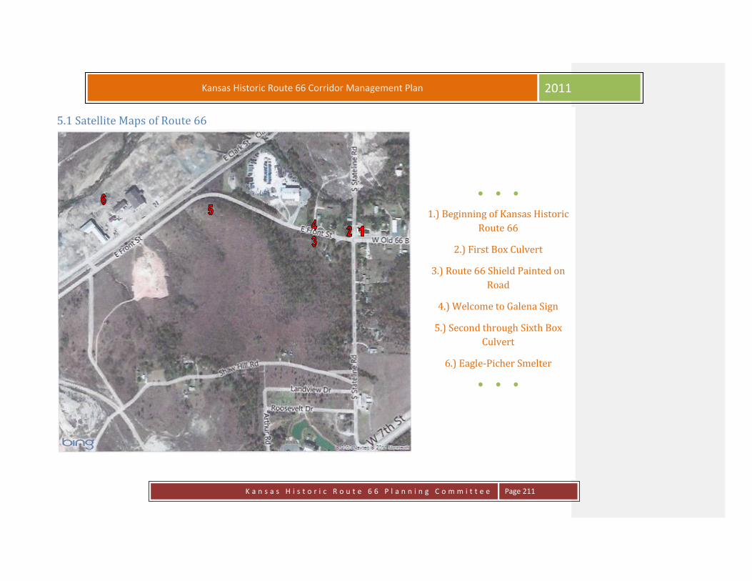
K a n s a s H i s t o r i c R o u t e 6 6 P l a n n i n g C o m m i t t e e
Page 211
Kansas Historic Route 66 Corridor Management Plan 2011
5.1 Satellite Maps of Route 66
● ● ●
1.) Beginning of Kansas Historic
Route 66
2.) First Box Culvert
3.) Route 66 Shield Painted on
Road
4.) Welcome to Galena Sign
5.) Second through Sixth Box
Culvert
6.) Eagle-Picher Smelter
● ● ●

K a n s a s H i s t o r i c R o u t e 6 6 P l a n n i n g C o m m i t t e e
Page 212
Kansas Historic Route 66 Corridor Management Plan 2011
● ● ●
7.) Missouri-Kansas-Texas
Railroad & Burlington Northern
Railroad Lines
8.) Seventh Box Culvert
9.) Triple Box Culvert
10.) Hell’s Half Acre
11.) Viaduct
12.) Victorian House
13.) Four Women on the Route
● ● ●

K a n s a s H i s t o r i c R o u t e 6 6 P l a n n i n g C o m m i t t e e
Page 213
Kansas Historic Route 66 Corridor Management Plan 2011
● ● ●
14.) Bradshaw Building
15.) Prehm Building
16.) Gill Building
17.) Old Maywood Theater
18.) East 400 Block
19.) West 400 Block
20.) City Hall
21.) Howard “Pappy” Litch Park
22.) Chamber Building
23.) Former Gas Station
24.) Sapp Opera House Location
26.) City Building Complex
27.) Litch Historical & Mining
Museum
28.) Galena Cemetery
● ● ●

K a n s a s H i s t o r i c R o u t e 6 6 P l a n n i n g C o m m i t t e e
Page 214
Kansas Historic Route 66 Corridor Management Plan 2011
● ● ●
Route 66 just west of Galena, KS
● ● ●
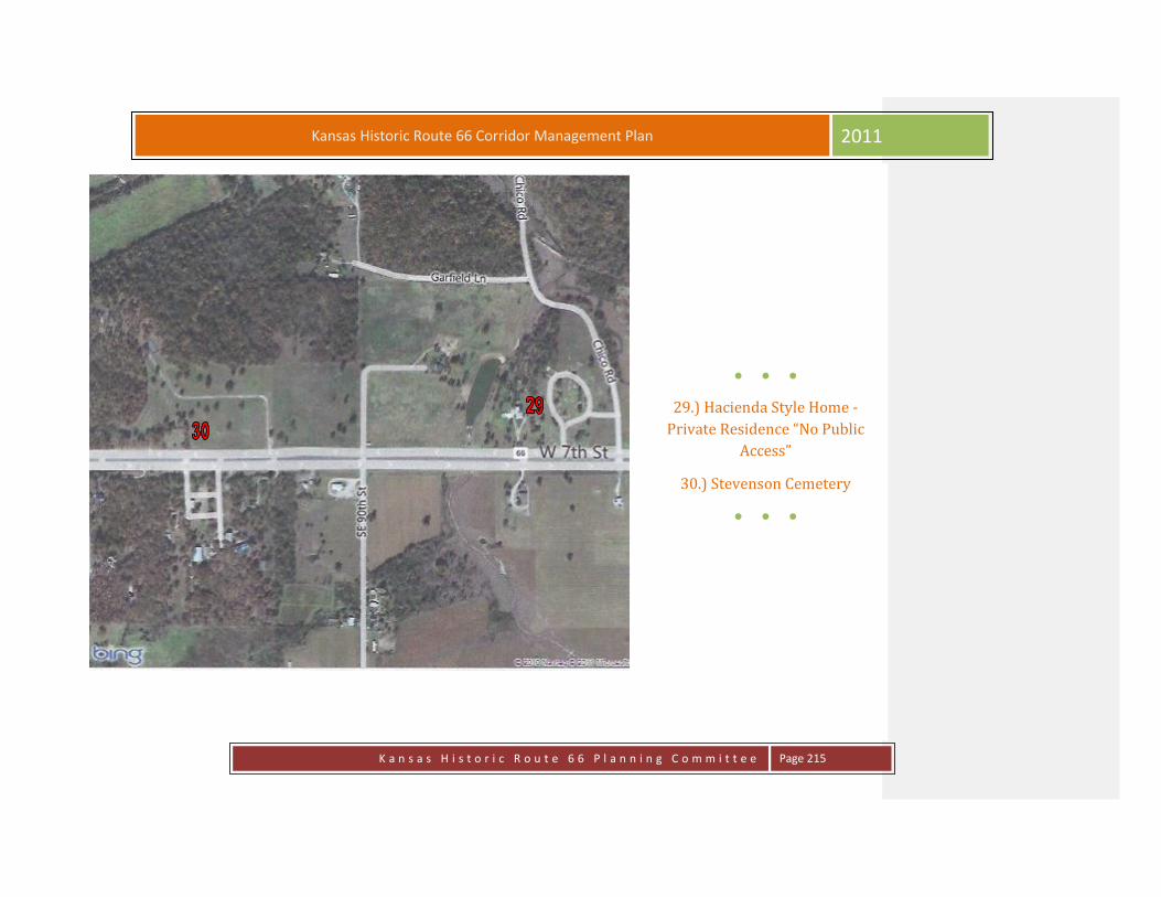
K a n s a s H i s t o r i c R o u t e 6 6 P l a n n i n g C o m m i t t e e
Page 215
Kansas Historic Route 66 Corridor Management Plan 2011
● ● ●
29.) Hacienda Style Home -
Private Residence “No Public
Access”
30.) Stevenson Cemetery
● ● ●
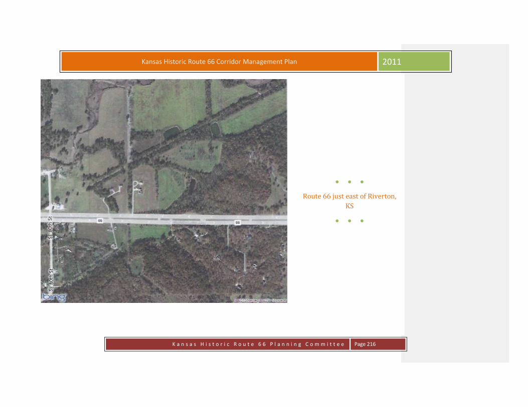
K a n s a s H i s t o r i c R o u t e 6 6 P l a n n i n g C o m m i t t e e
Page 216
Kansas Historic Route 66 Corridor Management Plan 2011
● ● ●
Route 66 just east of Riverton,
KS
● ● ●

K a n s a s H i s t o r i c R o u t e 6 6 P l a n n i n g C o m m i t t e e
Page 217
Kansas Historic Route 66 Corridor Management Plan 2011
● ● ●
31.) Spring River Banks
● ● ●

K a n s a s H i s t o r i c R o u t e 6 6 P l a n n i n g C o m m i t t e e
Page 218
Kansas Historic Route 66 Corridor Management Plan 2011
● ● ●
32.) Spring River Inn Neon Sign
33.) Empire District Electric
34.) Old Riverton Store
● ● ●

K a n s a s H i s t o r i c R o u t e 6 6 P l a n n i n g C o m m i t t e e
Page 219
Kansas Historic Route 66 Corridor Management Plan 2011
● ● ●
35.) Roundabout
● ● ●

K a n s a s H i s t o r i c R o u t e 6 6 P l a n n i n g C o m m i t t e e
Page 220
Kansas Historic Route 66 Corridor Management Plan 2011
● ● ●
Route 66 just west of Riverton,
KS and north of Baxter Springs,
KS (shown as SE Beasley Rd?)
● ● ●

K a n s a s H i s t o r i c R o u t e 6 6 P l a n n i n g C o m m i t t e e
Page 221
Kansas Historic Route 66 Corridor Management Plan 2011
● ● ●
Route 66 just west of Riverton,
KS and north of Baxter Springs,
KS (shown as SE Beasley Rd?)
● ● ●

K a n s a s H i s t o r i c R o u t e 6 6 P l a n n i n g C o m m i t t e e
Page 222
Kansas Historic Route 66 Corridor Management Plan 2011
● ● ●
36.) Marsh Arch “Rainbow”
Bridge
● ● ●

K a n s a s H i s t o r i c R o u t e 6 6 P l a n n i n g C o m m i t t e e
Page 223
Kansas Historic Route 66 Corridor Management Plan 2011
● ● ●
Route 66 just north of Baxter
Springs, KS (shown as County
Road SE 50th St)
● ● ●

K a n s a s H i s t o r i c R o u t e 6 6 P l a n n i n g C o m m i t t e e
Page 224
Kansas Historic Route 66 Corridor Management Plan 2011
● ● ●
Route 66 just north of Baxter
Springs, KS
● ● ●

K a n s a s H i s t o r i c R o u t e 6 6 P l a n n i n g C o m m i t t e e
Page 225
Kansas Historic Route 66 Corridor Management Plan 2011
● ● ●
37.) Field of Dreams
● ● ●

K a n s a s H i s t o r i c R o u t e 6 6 P l a n n i n g C o m m i t t e e
Page 226
Kansas Historic Route 66 Corridor Management Plan 2011
● ● ●
Route 66 just north of Baxter
Springs, KS (shown as SE 50th
St?)
● ● ●

K a n s a s H i s t o r i c R o u t e 6 6 P l a n n i n g C o m m i t t e e
Page 227
Kansas Historic Route 66 Corridor Management Plan 2011
● ● ●
Route 66 just north of Baxter
Springs, KS (shown as SE 50th St
& N Willow Ave?)
● ● ●

K a n s a s H i s t o r i c R o u t e 6 6 P l a n n i n g C o m m i t t e e
Page 228
Kansas Historic Route 66 Corridor Management Plan 2011
● ● ●
38.) Fort Blair
39.) Baxter Springs Heritage
Center
● ● ●

K a n s a s H i s t o r i c R o u t e 6 6 P l a n n i n g C o m m i t t e e
Page 229
Kansas Historic Route 66 Corridor Management Plan 2011
● ● ●
40.) Historic Route 66 Visitors Center
41.) Illinois Cash Store - Baxter State Bank
42.) Bilke Western Store
43.) Johnston Public Library
44.) Nez Perce Memorial
45.) Little Brick Inn/Café on the Route
46.) Indiana House/Kingrey-Kellum Agency
47.) Wells-Fargo Station
48.) Angels on the Route
49.) Route 66 Soda Fountain
50.) Frieze
51.) Kirkendolls/Edens Grocery
52.) National Cemetery Plot
53.) Presbyterian Church
54.) Grantham Home/Derfelt Funeral Home
55.) Cooper Home/ Abbott Funeral Home
56.) Youse Home
57.) Niles Home
58.) Lea Manor
● ● ●

K a n s a s H i s t o r i c R o u t e 6 6 P l a n n i n g C o m m i t t e e
Page 230
Kansas Historic Route 66 Corridor Management Plan 2011
● ● ●
60.) Shouse Service Station
● ● ●

K a n s a s H i s t o r i c R o u t e 6 6 P l a n n i n g C o m m i t t e e
Page 231
Kansas Historic Route 66 Corridor Management Plan 2011
● ● ●
Route 66 south end of Baxter
Springs, KS
● ● ●

K a n s a s H i s t o r i c R o u t e 6 6 P l a n n i n g C o m m i t t e e
Page 232
Kansas Historic Route 66 Corridor Management Plan 2011
● ● ●
61.) Historical Road Bed
Route 66 follows the curve
to W 30th St and back to Alt
69)
● ● ●
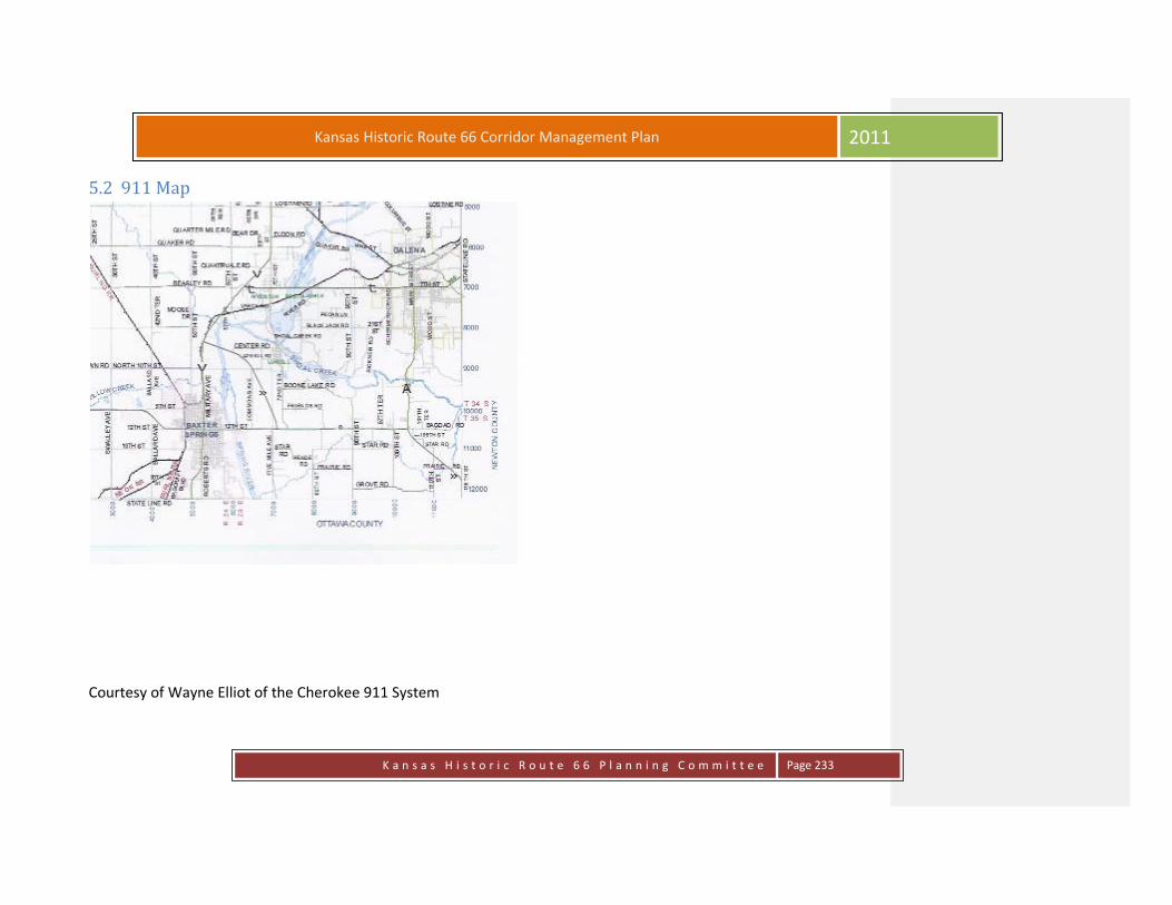
K a n s a s H i s t o r i c R o u t e 6 6 P l a n n i n g C o m m i t t e e
Page 233
Kansas Historic Route 66 Corridor Management Plan 2011
5.2 911 Map
Courtesy of Wayne Elliot of the Cherokee 911 System

K a n s a s H i s t o r i c R o u t e 6 6 P l a n n i n g C o m m i t t e e
Page 234
Kansas Historic Route 66 Corridor Management Plan 2011
5.3 Traffic Flow Maps & Comparisons

K a n s a s H i s t o r i c R o u t e 6 6 P l a n n i n g C o m m i t t e e
Page 235
Kansas Historic Route 66 Corridor Management Plan 2011
5.4 Route 66 Safety and Accident Record Upon entering Kansas on US-69A from Oklahoma or turn on W Old 66 Boulevard from Missouri US-66 you are greeted with portions of
original Route 66 throughout. There are 13.2 miles that will reveal parts of the history of the area; whether you are interested in the Civil
War era, the western Cowtown history; mining history, Native American and baseball history. There is truly something for everyone during
this drive.
There are no major traffic problem areas existing at this time. In Baxter Springs, signage to indicate parking off the main roadway would be
helpful to the visitor.
An area of concern with increased traffic on Route 66 would be the 3rd and Military intersection where Highway 69A enters Baxter Springs.
The intersection at 3rd & Willow in Baxter Springs needs more definition as to right of way where Route 66 curves its way north out of
town. Additional signage would help in that area.
The area around the Marsh Bridge north of Baxter Springs has been separated from the main road and affords the traveler an option to
travel over the bridge and has adequate parking for visitors to stop.
The roundabout on Highway K-66/US-69A/US-400 & Beasley road has improved traffic flow for that intersection and signage has been
posted that helps with locating Old Route 66/Beasley road at this intersection.
Riverton and Galena are connected with a four lane highway and it is state law that the left lane is used only for passing. This signage is not
posted clearly and is a common problem for locals.” Visitors to the area would definitely need this posted to prevent traffic problems and
tickets.
Stevenson Cemetery is located on this stretch of the highway and there isn’t much room to pull over to look at the cemetery. A widening of
the driveway or shoulder would allow travelers to pull away from the traffic and visit the cemetery.
At 7th & Main in Galena traffic is always busy there but seems to be adequately marked and controlled.
There is adequate parking on the side streets for anyone wanting to stop and view the ghost writing on the buildings or visit Pappy Litch
Park.
Following Route 66 down Main Street until the route turns east toward Missouri appears to have no problems. Some additional signage

K a n s a s H i s t o r i c R o u t e 6 6 P l a n n i n g C o m m i t t e e
Page 236
Kansas Historic Route 66 Corridor Management Plan 2011
may be required to make visitors aware of parking areas. At this point the route has various points of interest noted until the Missouri state
line.
PHYSICAL DESCRIPTION
GENERAL ROAD SAFETY NARRATIVE AND HIGHWAY DESIGN MAINTENANCE STANDARDS SAFETY
The Historical Route 66 is located on portions of K-66 and US-69 Alternate. These two routes are part of the Kansas state roadway system,
and as such, are regularly reviewed in the Kansas Department of Transportation’s Safety Program. Accident statistics are maintained and
analyzed for identification and prioritization of locations needing reconstruction/rehabilitation. Attached tables provide motor vehicle
accident summaries for 2006-2010.
Traffic engineers regularly evaluate the accident experiences at intersections and on roadway segments to identify potentially hazardous
locations so that they may reduce the incidence of accidents. It would be a simple matter to count the number of accidents along a segment
of roadway, but a count alone would not tell a complete story. If there were ten accidents along a route in a given time period, and only ten
vehicles traveled the route, it would be a significantly high accident rate. However, if there were ten accidents on a given route within a
given time period, but there were 10,000 vehicles that traveled that route per day; the overall accident experience would be significantly
lower. In order to gain a rate that can be compared with other rates, the number of accidents in a given time rate is multiplied by 1,000,000.
Then that figure is divided by the quantity (average daily traffic x 365 days x length of roadway x number years). The attached sheets from
the Cherokee County Road Safety Audit will give the accident rate for various sections on the routes. The Road Safety Audit (RSA) is a
proactive and thorough process to complete a traffic study of the Kansas state highway system county by county. The purpose of the RSA is
to give the Kansas Department of Transportation (KDOT) an effective and powerful tool to actively recognize and immediately attend to
locations that may need safety improvements.
HIGHWAY DESIGN AND MAINTENANCE STANDARDS
Historical Route 66 on K-66 and US-69 Alternate have several cross section types throughout its length. K-66 west of Galena is a four lane
expressway. A section through Riverton has no center median and has curb and gutters. A short section approaching the roundabout
intersection with US-69 Alternate has two lanes with shoulders. US-69 Alternate is a two-lane highway with paved shoulders. In the City of
Baxter Springs the section is urban curb and gutter. South of Baxter Springs the roadway section diverts back to a two-lane with paved

K a n s a s H i s t o r i c R o u t e 6 6 P l a n n i n g C o m m i t t e e
Page 237
Kansas Historic Route 66 Corridor Management Plan 2011
shoulders.
The KDOT Southeast District at Chanute and the KDOT Area Office at Pittsburg are responsible for maintenance of K-66 and US-69 Alternate
roadway facilities. The KDOT Subarea Shop located at Columbus provides the day to day maintenance of these sections. KDOT maintains the
sections within the city limits of Galena and Baxter Springs by a city connecting link agreement.
*Please note that the Traffic and Safety information accompanying this document is covered by the following: 23 U.S.C § 409. Discovery and
admission as evidence of certain reports and surveys notwithstanding any other provision of law, reports, surveys, schedules, lists, or data
compiled or collected for the purpose of identifying evaluating, or planning the safety enhancement of potential accident sites, hazardous
roadway conditions, or railway-highway crossings, pursuant to sections 130, 144, and 148 of this title or for the purpose of developing any
highway safety construction improvement project which may be implemented utilizing Federal-aid highway funds shall not be subject to
discovery or ad-mitted into evidence in a Federal or State court proceeding or considered for other purposes in any action for damages
arising from any occurrence at a location mentioned or addressed in such reports, surveys, schedules, lists, or data.
Information provided by Kansas Department of Transportation

K a n s a s H i s t o r i c R o u t e 6 6 P l a n n i n g C o m m i t t e e
Page 238
Kansas Historic Route 66 Corridor Management Plan 2011
Kansas Motor Vehicle Accident Summary
K-66 from Galena to the US-400/US69ALT
Intersection in Cherokee County
Accidents People
Year Total Fatal Injuries PDO* Deaths Injuries 2006 15 - 6 9 - 8
2007 16 - 2 14 - 4
2008 10 - - 10 - -
2009 6 - - 6 - -
2010** 6 - 1 5 - 1
Total 53 - 8 44 - 13
*PDO - Property Damage Only Accidents
** Date is incomplete and unofficial at this time
Information provided by Kansas Department of Transportation
Date as of 5/6/2011

K a n s a s H i s t o r i c R o u t e 6 6 P l a n n i n g C o m m i t t e e
Page 239
Kansas Historic Route 66 Corridor Management Plan 2011
Kansas Motor Vehicle Accident Summary
US-69 ALT from the Oklahoma/Kansas State Line to 3rd Street in
Baxter Springs, KS in Cherokee County
Accidents People
Year Total Fatal Injuries PDO* Deaths Injuries 2006 19 - 7 12 - 9
2007 25 - 6 19 - 8
2008 23 - 4 19 - 4
2009 15 - 10 51 - 11
2010** 9 - 2 7 - 5
Total 91 - 29 108 - 37
*PDO - Property Damage Only Accidents
** Date is incomplete and unofficial at this time
Information provided by Kansas Department of Transportation
Date as of 5/6/2011

K a n s a s H i s t o r i c R o u t e 6 6 P l a n n i n g C o m m i t t e e
Page 240
Kansas Historic Route 66 Corridor Management Plan 2011
Tourist Amenities
& Overview

K a n s a s H i s t o r i c R o u t e 6 6 P l a n n i n g C o m m i t t e e
Page 241
Kansas Historic Route 66 Corridor Management Plan 2011
6.1 Lodging Little Brick Inn
1101 Military
Baxter Springs, KS
620-856-5646
Lea Manor
709 E. 12th St.
Baxter Springs, KS
620-856- 2433
Baxter Inn
2451 Military
Baxter Springs, KS
620-856-2106
Grace House
1302 Main St.
Galena, KS
417-291-2021
Maple Uncommon Hotel
120 E. Maple
Columbus, KS(approx. 15 miles from Baxter Springs)
620-429 3130 www.MapleUncommonhotel.com
Smittle House Bed & Breakfast
426 S. Kansas
Columbus, KS
620-429-2420 www.smittlehouse.com
Camping Facilities
Riverside West Park (1/4 m. E on Hwy 166 at Spring River)
Baxter Springs, KS
Baxter Springs City Clerk or Baxter Police Dept.
620-856-2114 or 620-856-620-2112

K a n s a s H i s t o r i c R o u t e 6 6 P l a n n i n g C o m m i t t e e
Page 242
Kansas Historic Route 66 Corridor Management Plan 2011
6.2 Restaurants
GALENA
4 Women on the Route
119 N. Main
Chopstix Express
300 W. 7th
Main St. Deli & Gift Bank
413 Main
Mi Torito
418 Main
Steve’s Candy & Ice Cream Shop
W. 7th
Dairy Queen Brazier
500 E. 7th
Sonic Drive In
505 W. 7th
Pizza Hut
1001 East 7th St.
620-783-4353
Los Cabos
115 W. 7th St
Streetcar Station
515 Main
Opening June 2012.
RIVERTON
Old Riverton Store
7190 SE Hwy 66
Riverton, Kansas
620-848-3330
Fresh Deli Sandwiches, Drinks, Grocery & Souvenir Items
“Listed on National Historic Register”
BAXTER SPRINGS
Café on the Route
1101 Military
Red Ball Café
539 W. 5th St.
Angel’s on the Route
1143 Military
Weston’s Café
1737 Military
Souper Sweets
1648 Military
El Cabrito
1524 Military
Simple Simon’s
2135 Military
Baxter Smoke House
23rd & Military
Van’s Steak House
2447 Military
Rice House
2932 Military
Subway
1301 Military
Sonic
1838 Military
Pizza Hut
1802 Military
Kentucky Fried Chicken/Taco Bell
1920 Military
McDonald’s
2800 Military
Oriental Garden
1910 Military
620-856-3003

K a n s a s H i s t o r i c R o u t e 6 6 P l a n n i n g C o m m i t t e e
Page 243
Kansas Historic Route 66 Corridor Management Plan 2011
6.3 Tours and Local Events
Civil War Theme Day Tour
This tour begins at the Heritage Center and Museum, 8th and East Avenue, Baxter Springs, Kansas for a brief presentation about the Civil
War activity in this area. A qualified guide is available for a guided tour at the museum. Baxter Springs was the site of much conflict in the
years leading up to the Civil War, with both Indian and Black troops encamped here and moving from this place for various incursions
against enemy forces. A frontier fort, called Ft. Blair, was attacked in October of 1863 by the renegade Confederate forces of William
Quantrill. The same day, Quantrill attacked a military wagon train approaching Ft. Blair from the north (Ft. Scott). The resulting attack was
a massacre of nearly all of the men in the wagon train. Those victims are all interred in the National Cemetery Plot west of town.
Beginning at Kiwanis Park east of the city on Spring River, there is a driving tour, with interpretive signage at 12 stops at significant Civil War
sites within the city. This includes a stop at Ft. Blair, two blocks north of the museum and the National Cemetery Plot west of town.
For bus tours, an on-board tour guide is available upon request. For further information or to schedule a tour, call the Baxter Springs
Heritage Center at 620-856-2385
Historic Baxter Springs Tour
This tour begins at the Heritage Center and Museum, 8th and East Avenue for an overview of exhibits related to the various historic periods
in Baxter Springs history—The Civil War attack on Fort Blair and the Baxter Massacre, The Cowtown Period, which earned Baxter Springs the
reputation of being the roughest town on the frontier in the late 1860's. The turn-of-the-century period when Baxter Springs was a
nationally advertised site of the mineral springs for which the town was named and which were reputed to have great curative powers, and
the mining period when Baxter Springs was the hub of the largest lead and zinc mining operation in the world. The museum exhibits are
interpretive in nature. A qualified guide is available upon request. Following a visit to the Heritage Center, the tour involves either a
walking or a driving tour to historic sites within a ¼ mile radius of the city center.
This tour includes historic business buildings, historic homes, and may be expanded to include a driving tour of 12 Civil War sites. For
further information, or to schedule a tour, call the Heritage Center at 620856-2385
K a n s a s H i s t o r i c R o u t e 6 6 P l a n n i n g C o m m i t t e e
Page 244
Kansas Historic Route 66 Corridor Management Plan 2011
Historic Route 66
This tour originates at the Phillips 66 Tourist Information Center located at 10th and Military. The restored service station is on the National
Register of Historic Places. Included is a visit to the Baxter Springs Heritage Center and Museum at 8th and East Avenue where an
interpretive exhibit about Route 66 may be seen. The famous route covers 13 miles in southeast Kansas, passing through Galena, Riverton
and Baxter Springs. The famous route the main street of both Baxter Springs and Galena
From the museum, the tour goes north of town to the famous Marsh Rainbow Bridge, the only bridge of this type still found on the original
road. The Old Riverton Store is located in Riverton.
In Galena, a stop at the Pappy Litch Route 66 park, and the Route 66 Kan-O-Tex restored service station and cafe where the tow truck
which was the inspiration for the character Tow Mater in the Cars” movie may be seen. This tour concludes with a possible lunch or dinner
stop at Cafe on the Route, famous for having been featured on the Cooking Channel. In Galena, the Four Women on the Route, serves
sandwiches and sides. For lighter fare, Angels on the Route in downtown Baxter Springs features sandwiches, soups and custard desserts.
An on-board tour guide is available upon request.
To schedule a tour or get more information, contact the Route 66 Visitor's Center at 620-856-2066 of the Heritage Center and Museum at
620-856-2385
The Baseball Tour
This tour originated at the Baxter Springs Heritage Center and Museum at 8th and East Avenue where an interpretive exhibit featuring the
interesting history of Baxter Springs baseball may be seen. The Whiz Kids team, active throughout the late 1940's and early 1950's is
legendary. Mickey Mantle played for the Whiz Kids and signed his first major contract in Kiwanis Park after a game. Artifacts related to
Mantle's career are on view. The Baxter Springs Little League program and stadium' and field is considered to be one of the best in the
nation and has turned out an incredible number of state championship teams. Following the visit to the museum, this tour includes a visit
to the Little League complex, a brief tour of the Little League museum, and a tour of the Field of Dreams Baseball complex north of the city.
A qualified tour guide is available at each site.
To schedule a guided tour or to get more information, call the Heritage Center at 620-856-2385

K a n s a s H i s t o r i c R o u t e 6 6 P l a n n i n g C o m m i t t e e
Page 245
Kansas Historic Route 66 Corridor Management Plan 2011
The Baxter Springs-Galena Tour
This tour combines any combination of the other tours listed but also includes a visit to the Southeast Kansas Nature Center in Galena.
Located on scenic Shoal Creek, the Center is a must-see site. The area around the Center is home to some rare and endangered species of
aquatic life and fauna and flora.
Guided tours are available upon request. A stop at the Galena Mining Museum is another option.
For further information, call the Heritage Center at 620-856-2385
Bad Guys and Criminals Tour
This tour originates at the Baxter Springs Heritage Center and Museum and offers something a bit different. Baxter Springs has been the
site of many bank robberies and crimes committed by famous and some not-so-famous criminals. These include Bonnie and Clyde, Wilbur
Underhill, The Daltons, William Quantrill Raiders, the Younger Brother, the James Brothers, the Miser Brothers. Even Pretty Boy Floyd made
friendly visits here from time to time before he met his demise. Numerous cattle and horse thieves met their fate at the end of a rope
hanging from the old hanging tree at 7th and East Avenue. A guided tour is available to take a look at these sites and hear the amusing and
not so amusing stories of Crime and Justice in a Frontier Kansas town. For further information call the Heritage Center, 620-856-2385.
October Nights-Ghost Tour
This tour originates at the Baxter Springs Heritage Center and Museum
This tour must be done after dark, and may be taken as a bus tour, with an on-board guide, or it may be a walking tour for the more hale
and hardy people. Baxter Springs is reputed to have many homes and business sites that are believed to be haunted. We make no claims,
but tell the stories like we heard them. Small groups may prefer vans for transportation. We have two convincing story tellers to share
these tales with your group. Following the tour, groups have the option of coming to the Heritage Center for a dessert and cider conclusion.
Price is $8.00 per person. For further information call the Heritage Center at 620-856-2385 or 620-856-4030

K a n s a s H i s t o r i c R o u t e 6 6 P l a n n i n g C o m m i t t e e
Page 246
Kansas Historic Route 66 Corridor Management Plan 2011
Victorian Tea Party
This tour begins at the Heritage Center with a tour of exhibits related to the Victorian era. An option for this tour is a program of 40
minutes in length on Ladies Hats through the Years. From the Heritage Center, the tour moves to one of our local Historic Homes for an
authentic Victorian tea party with a light repast of tea sandwiches, fruit, and tea. The cost for the tea party is $5.00 per person. For further
information, call the Heritage Center, 620-856-2385 or 620-856-4030.
BAXTER SPRINGS
Kiwanis Egg Hunt - Saturday before Easter
4th of July in Kiwanis Park
Cowtown Days & Rodeo - 2nd Weekend August
Historic Homes Christmas Tour - Weekend before Thanksgiving
Christmas Parade & Tree Lighting - 1st Saturday in December
2013 - 3 day Civil War encampment at Fort Blair site October 5-6
Mother Road Marathon - 2nd Sunday in October
Steel Guitar Rendezvous - First Full Weekend in October
GALENA
Galena Days - 1st Thursday, Friday, and Saturday in June
Car Show - 1st Saturday in June
October Fest & Art Walk 1st Saturday in October
Christmas Parade - 1st Saturday in December
K a n s a s H i s t o r i c R o u t e 6 6 P l a n n i n g C o m m i t t e e
Page 247
Kansas Historic Route 66 Corridor Management Plan 2011
Byway Summary
K a n s a s H i s t o r i c R o u t e 6 6 P l a n n i n g C o m m i t t e e
Page 248
Kansas Historic Route 66 Corridor Management Plan 2011
7.1 Overall Summary
The Kansas Historic Route 66 Planning Committee was formed to oversee the implementation of Historic Route 66 as a state byway. The
committee has pulled together information relevant to Kansas Historic Route 66 to shape into this corridor management plan. The
information found here follows the Kansas portion of Historic Route 66 from Missouri state line to Oklahoma state line, all 13.2 miles. This
document describes qualities of historic value to the Kansas portion of Route 66, while keeping in mind various items of interest to travelers
along our road. The Kansas Historic Route 66 Corridor Management Plan is a “living” document that will be edited as needed.

K a n s a s H i s t o r i c R o u t e 6 6 P l a n n i n g C o m m i t t e e
Page 249
Kansas Historic Route 66 Corridor Management Plan 2011
7.2 Overall Goals
The Kansas Historic Route 66 Planning Committee will form the Kansas Route 66 Historic Byway Committee after
Historic Route 66 has been declared a state level byway. After such designation, the committee will decide the best
possible way to implement strategies needed to reach goals ascertained in the corridor management plan. Establishing
relationships with the existing communities and organizations located along and close to the corridor will help identify
the needs to preserve and maintain Kansas Historic Route 66. As the communities grow and change so will the
committee, which will allow room for adapting and evolving the goals and strategies found in the corridor management
plan.

K a n s a s H i s t o r i c R o u t e 6 6 P l a n n i n g C o m m i t t e e
Page 250
Kansas Historic Route 66 Corridor Management Plan 2011
Appendix

K a n s a s H i s t o r i c R o u t e 6 6 P l a n n i n g C o m m i t t e e
Page 251
Kansas Historic Route 66 Corridor Management Plan 2011
8.1 Resolutions
Official Cherokee County, City of Galena, and City of Baxter Springs Resolutions adopting Kansas Historic Route 66 as a Kansas State Designated Byway.

K a n s a s H i s t o r i c R o u t e 6 6 P l a n n i n g C o m m i t t e e
Page 252
Kansas Historic Route 66 Corridor Management Plan 2011

K a n s a s H i s t o r i c R o u t e 6 6 P l a n n i n g C o m m i t t e e
Page 253
Kansas Historic Route 66 Corridor Management Plan 2011
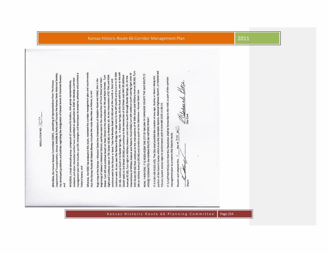
K a n s a s H i s t o r i c R o u t e 6 6 P l a n n i n g C o m m i t t e e
Page 254
Kansas Historic Route 66 Corridor Management Plan 2011

K a n s a s H i s t o r i c R o u t e 6 6 P l a n n i n g C o m m i t t e e
Page 255
Kansas Historic Route 66 Corridor Management Plan 2011

K a n s a s H i s t o r i c R o u t e 6 6 P l a n n i n g C o m m i t t e e
Page 256
Kansas Historic Route 66 Corridor Management Plan 2011
8.2 Letters of Support
Letters of Support from Representative Doug Gatewood and Cherokee County.
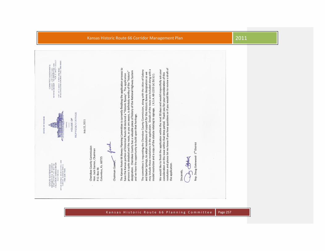
K a n s a s H i s t o r i c R o u t e 6 6 P l a n n i n g C o m m i t t e e
Page 257
Kansas Historic Route 66 Corridor Management Plan 2011

K a n s a s H i s t o r i c R o u t e 6 6 P l a n n i n g C o m m i t t e e
Page 258
Kansas Historic Route 66 Corridor Management Plan 2011
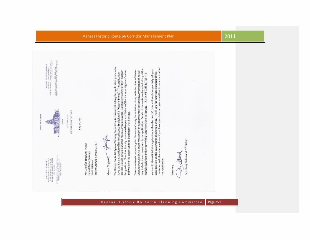
K a n s a s H i s t o r i c R o u t e 6 6 P l a n n i n g C o m m i t t e e
Page 259
Kansas Historic Route 66 Corridor Management Plan 2011

K a n s a s H i s t o r i c R o u t e 6 6 P l a n n i n g C o m m i t t e e
Page 260
Kansas Historic Route 66 Corridor Management Plan 2011

K a n s a s H i s t o r i c R o u t e 6 6 P l a n n i n g C o m m i t t e e
Page 261
Kansas Historic Route 66 Corridor Management Plan 2011

K a n s a s H i s t o r i c R o u t e 6 6 P l a n n i n g C o m m i t t e e
Page 262
Kansas Historic Route 66 Corridor Management Plan 2011

K a n s a s H i s t o r i c R o u t e 6 6 P l a n n i n g C o m m i t t e e
Page 263
Kansas Historic Route 66 Corridor Management Plan 2011
Additional Projects and goals:
Billboards or Kiosks located at the state lines; Rainbow Bridge and entrances to the cities along the route. Additional
locations for placement would be 4 Women on the Route, The Galena Museum, Ft. Blair; and downtown at historic
locations. These would provide informational materials for travelers passing through during seasonal and holiday
closings. Roadside parks or sides that have historic meaning on the route, for example the strike on Route 66 where
martial law was soon declared in Galena; The Riverton Empire Plant, The Old Riverton Store.
Plaques on the historic buildings identifying the years built, businesses it has housed and or who owned them at the
time. The plaques should be uniform along the route tying all communities together. We need uniformity along the
route so we are presented as one and not as three communities all pulling in different directions.
Make repairs to both the viaduct and the Rainbow bridge on the route to make them esthetically pleasing to the eye
and improve their safety in future years.
Sunflower & Wildflower Project; plantings in various areas along the road.
Historic signage at 19th & Military to document the architectural heritage of the Phillips Station during the time Route
66 was the main thoroughfare.
Welcome sign coming into the towns; perhaps tied in with the kiosks.
Move the memorial marker back on Route 66 in the north end of Baxter from the roadside park on Highway
400/US69A.

K a n s a s H i s t o r i c R o u t e 6 6 P l a n n i n g C o m m i t t e e
Page 264
Kansas Historic Route 66 Corridor Management Plan 2011
Late 1800’s Baxter Springs “ First Cowtown in Kansas”
Galena

K a n s a s H i s t o r i c R o u t e 6 6 P l a n n i n g C o m m i t t e e
Page 265
Kansas Historic Route 66 Corridor Management Plan 2011
Indiana House/ Kingrey Kellum Real Estate Agency
Wells Fargo Station currently under restoration 2011

K a n s a s H i s t o r i c R o u t e 6 6 P l a n n i n g C o m m i t t e e
Page 266
Kansas Historic Route 66 Corridor Management Plan 2011
Grantham Home/ Derfelt Funeral Home

K a n s a s H i s t o r i c R o u t e 6 6 P l a n n i n g C o m m i t t e e
Page 267
Kansas Historic Route 66 Corridor Management Plan 2011