kingdom of bahrain ministry of works - gwf 2018 report sater.pdf · 5/13/2011 · kingdom of...
TRANSCRIPT

Kingdom Of Bahrain Ministry of Works
Enterprise Asset Management System A Geocentric Approach
Presented By Hisham Y. Sater
April 2012

Bahrain MOW
• The construction arm of the Kingdom of Bahrain
• Provides infrastructure in to The whole country
• Oversees the following areas:
– Infrastructure Development consisting of the strategic Planning Design
– Plan, design, construct and maintain drainage systems
– 2700 Km of Sanitary Network
– Planning, designing, constructing and maintaining Road Network at the kingdom
– 3000 Km of Road Assets
– Design, Construction, Project Management and Maintenance of Public Buildings.
– Hundreds of Government Buildings
• Significant achievements has been the Treated Sewerage Effluent (TSE) Project
Ministry Of Works

Challenge
• Effective Methods & Tools
To maintain & manage public infrastructure assets.
• Asset Life & Performance
• Optimize Expenditures
Capital & Recurrent
• Proactive, not Reactive
modes of maintenance
• Funding Forecast
Realistic predictions on capital & recurrent funding needs for construction & maintenance.
• Prompt Information Access
Delays in information access, leading to a slow business cycle.

Challenge
• Effort to Verify Information Accuracy
Non-availability of accurate information in a consolidated view, resulting in significant communication and longer project cycles.
• Lacking Reports & Performance Statistics
results in great challenges in management tracking for accountability and determining audit trails which impedes securing funds for Public-Private-Partnership (PPP).
• Duplication and Redundancy
and existence of disparate non-standard systems for capturing, storing and maintaining information.
• Tracking
Manual business processes, leading to challenges in tracking the progress of activities through asset life cycle.

The Vision
• Move away from the manual processes for managing Infrastructure Assets
• Advanced Asset Life Cycle Management • Preventive / Predictive Management • Cost Optimization • Reduce Duplication • Centralized Reports and Statistics • Geography Centric Data • Integration between all the MOW Core
Systems

Integration
The Key to any successful system is Integration
• Asset Register
• Geographic Information System (GIS)
• Document Management System
• Project Management Information System (PMIS)
• Accident Information System
• Pavement Condition System
• eServices Portal
• Contract Information System

Solution Envisioned..
Integrated Asset Data Repository
Enterprise Asset Management System
GIS Data Asset Data

Public Private Partnerships
Integrated Asset Data Repository
Enterprise Asset Management System
GIS Data Asset Data
SLRB
MOH EWA CIO
CPO
National GIS
Survey & Land Registration Bureau
Ministry of Housing
Electricity and Water Authority
Central Information Office
Central Planning Office
National GIS Committee

Integrations with MOW Applications Documents
Projects
Complaints
Contracts and Projects Road Condition Under ground Road
Ducts Accidents
Location
Visualization and Analysis
Asset Lifecycle Management

The Solution Integration Example
Each offers its own “muscle”, but the real strength is in having all four work together.
Within MOW’s EAMS, there are four key data repositories; the Asset Register, the Document Repository,
and GIS. the Project Management Information System,
This combined strength relies on making sure respective IDs are in sync between the systems.
This would traditionally be done manually.

The Solution Integration Example
For example, a CAD file comes in. On that CAD file there is a fitting
(among many other assets).
Asset ID Type
12345678 Valve
12345679 Pump
12345680 Y-Fitting
Doc ID Date
65489 May 3, 2011
65490 May 13, 2011
65491 May 15, 2011
Feature ID Type
79457652 Pump
79457653 Manhole
79457654 Y-Fitting
The CAD file would be entered into the Document Repository, and get assigned a DOC ID.
The individual fitting would be entered into the Asset Register, and get assigned an Asset ID.
It would also be added to the GIS, and get assigned a Feature ID.
Manual entry of cross reference tables becomes a huge task.
Asset ID Feature ID
12345680 79457654
Cross Reference
PMIS ID Start Date
15676 June 29, 2011
15677 July 22, 2011
15678 Sept 03, 2011
If the CAD file is for a pending project, and the assets are not yet capitalized, the document goes into the PMIS.
Asset ID Doc ID
12345680 65491
Asset ID PMIS ID
12345680 15678
Doc ID PMIS ID
65491 15678
Doc ID Feature ID
65491 79457654
PMIS ID Feature ID
15678 79457654

The Solution Integration
This is where our CAD Import capability comes in.
Geographic features are added to the GIS database, and assigned a Feature ID.
Assets are added to the Asset Register, along with an ID, attributes, and “assets within assets”
(e.g. A pump within a pump station).
One or more CAD files are added to the Document Repository, and Doc IDs are assigned.
All of this means that the CAD Import process ensures asset and related table IDs are properly managed
throughout this framework.
CAD IMPORT
A user searches, selects, maps, filters, or reports on assets within this system as though it is
just one integrated system.
Users continue using CAD files with our existing system, without interruption to current workflow.
If this CAD file, or series of multiple CAD files are for a project,
they are added to the PMIS.

The Solution Importing As-built CAD data
Even though as-built drawings are delivered in digital format as CAD files, we still need to...
• extract the assets,
• generate new asset IDs
• append each asset to the correct GIS layer,
• apply all the correct attributes,
• append related tabular data to the correct tables,
• Register the drawing with the document management server,
• Update the status in the Capital Work In Progress (CWIP) system
• etc.
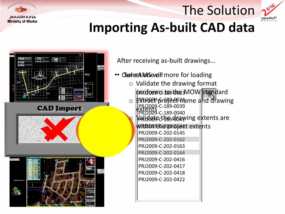
The Solution Importing As-built CAD data
Select Drawings... PRJ2009-C-189-0023 PRJ2009-C-189-0024 PRJ2009-C-189-0039 PRJ2009-C-189-0040 PRJ2009-C-189-0041 PRJ2009-C-202-0144 PRJ2009-C-202-0145 PRJ2009-C-202-0162 PRJ2009-C-202-0163 PRJ2009-C-202-0164 PRJ2009-C-202-0416 PRJ2009-C-202-0417 PRJ2009-C-202-0418 PRJ2009-C-202-0422
• Select one or more for loading
After receiving as-built drawings...
CAD Import
• Our eAMS will o Validate the drawing format
conforms to the MOW standard o Extract project name and drawing
extents o Validate the drawing extents are
within the project extents

Parcels Road Edge Road
Centerline Road Names Related Tables
Project Details
The Solution Importing As-built CAD data
Now, the import will:
• Split the data out into various parts (e.g. geographic features, table records, etc.)
• Append them to the appropriate layers and tables in the database
• Update all your project management records
LOAD REPORT Date: 1 June 2009 at 11:23 am Project: PRJ2009-C-202 Successfully Loaded Sheets:
- 0144 - 0164
Failed Sheets: - 0162
CAD Import

• New As-Built Drawings – Asset Details • Cadastral Updates Data Collection
Geodatabase Maintenance Sewer Roads Building Parcel
Service Requests
Applications and Tools
EAMS
Routing
Zoning/ Landuse
Modeling
Carto Maps.
Thematic Mapping
Dynamic Segmenta
tion
Tracing
Others…
Decision Support
Performance Reports KPIs
Investment Plans
Simple Searches and
drill down
1
2
3
4
• Customer Complaints • Field Updates

Current Asset Data in multiple formats Current
Geospatial Data in multiple formats
EAM Data Template Created by team United
Full Manual Data Migration by team
United
Production Load
Converted by MOW to standard template format
EAMS User
Data Gaps reported by team United
Data Gaps corrected by MOW
Pilot Templates
Pilot Load
Pilot DB
Pilot Data Corrections
Update Pilot DB
Pilot Data Review
Production DB
Data Migration Approach
Ad
dit
ion
al
ph
ase
to r
edu
ce
futu
re r
isk
Pu
sh P
rod
uct
ion
M
igra
tio
n c
lose
r to
Go
Live
Use for UAT

CAD and GIS Interoperability
Publishes OGC Map Services
Network File Server stores DGN CAD Files
Spatial ETL Server automates updating of CAD data into GIS
EAMS Database stores Spatial Data
EAMS Application Server serves GIS and EAM applications
Mobile Users
OnPoint Users
EAMS Users
Microstation CAD Users
DGN File Changes received by Spatial ETL Server
DGN Updates migrated to GIS database

GIS / Asset Geodatabase
Asset Register (Asset Mgmt
Database) We have our Asset Management Data.
Along with our related Asset Geodatabase
Business Data & other Application
Other Geodatabase
Layers
Infor uses this data…
And provides a powerful suite of functions to users
We also have staff in our organization that could benefit from EAMS data, but may not be trained on how to use Infor.
That’s where OnPoint fits in.
OnPoint takes the same Asset data and Geographic data…
… and provides web based access to those other staff.
OnPoint also integrates spatial data and non-spatial data from other business systems
Document Management
RoadFax
RoadFax
Data
Document
Management
Data
Access via OnPoint offers multiple levels of security, and can be configured to utilize your LDAP.
The Solution Technologies Used : Technologies Integrated

MOW EAMS Draft Logical Architecture
Web Application Tier SAN Infrastructure
“WORKS” Intranet
DMZ Tier
HW LB
Shared Enterprise
Reverse Proxy
Database Tier
SQL Server
Cluster Active/
Passive
CIO, SLRB
BSDI
Desktop CAD
Users
(Microstation 8i)
UAT
DB
PROD
DB
Replicate
EAMS Production and UAT Environment
Combined Web Application and Database Tier SAN Infrastructure
DMZ Tier
HW LB
Shared Enterprise
Reverse Proxy
Test Environment
Desktop GIS
Users
(ArcEditor)
Internal DMZ FW
Internal DMZ FW
External GIS
Services
CIO, SLRB
BSDI
Existing
Environment
PMIS Server
EDMS Server
Active Directory
Other Business
Systems
OnPoint Application
Server + ArcGIS
Server
Infor Application
Server
EAMS Users
(IE 8/Firefox 4)
5
C
External GIS
Services
OnPoint Users
(IE 8/Firefox 4)
Infor Report
Server
Spatial ETL
Server
· SQL Database Server
· Infor Report Server
· Infor Application Server
· OnPoint Web and
Application Server + IIS
· Spatial ETL Server
A
B D
E
A Infor EAM Concurrent Use – 34 Licenses
BOnPoint Professional
ArcGIS Server 10
C Infor EAM Report Server
D FME Server 2010
E SQL Server 2008
F
F
Infor EAM
OnPoint Professional
ArcGIS Server 10
FME Server 2010
SQL Server 2008

Never Standing Still Solution Benefits
EAMS
GIS
Reporting On demand reports containing
content from the Enterprise Asset Management System (EAMS)
along with relevant assets/ work orders highlighted/ color-coded
on embedded GIS maps
Geo-referenced Assets Geo-referenced assets
would be seamlessly available from the GIS
system even though information resides
across GIS and EAMS
As-built and maintenance updates The Assets from As-built drawings and maintenance updates will be loaded into GIS, EDMS and EAMS as part of a single load process to minimize errors and ensure true integration.
Asset Condition Data Condition data for all asset types including linear referenced asset condition data for road assets would be accessed by the GIS system. Proposed solution would reference and display this information as dynamic segments
Service Request and Work order Management Service requests and work orders will be tracked spatially as well. This will allow MOW to gain operational efficiencies and better visibility into operational activities and issues
Mapping Enterprise Mapping
would be available over a browser and would allow
sophisticated queries across multiple business
systems

Never Standing Still eAMS Evolution
• The business processes we follow today, will not necessarily be the same processes we follow tomorrow
• Our process flows will evolve
• Critical to the long term success of our solution has been its ability to be reconfigured over and over (i.e. without the need to dig into and make change to the solution’s source code)
• We believe our insistence on having a reconfigurable solution is what will carry our current success into continued future successes
