kombolcha – oromia atvet assessement...
TRANSCRIPT
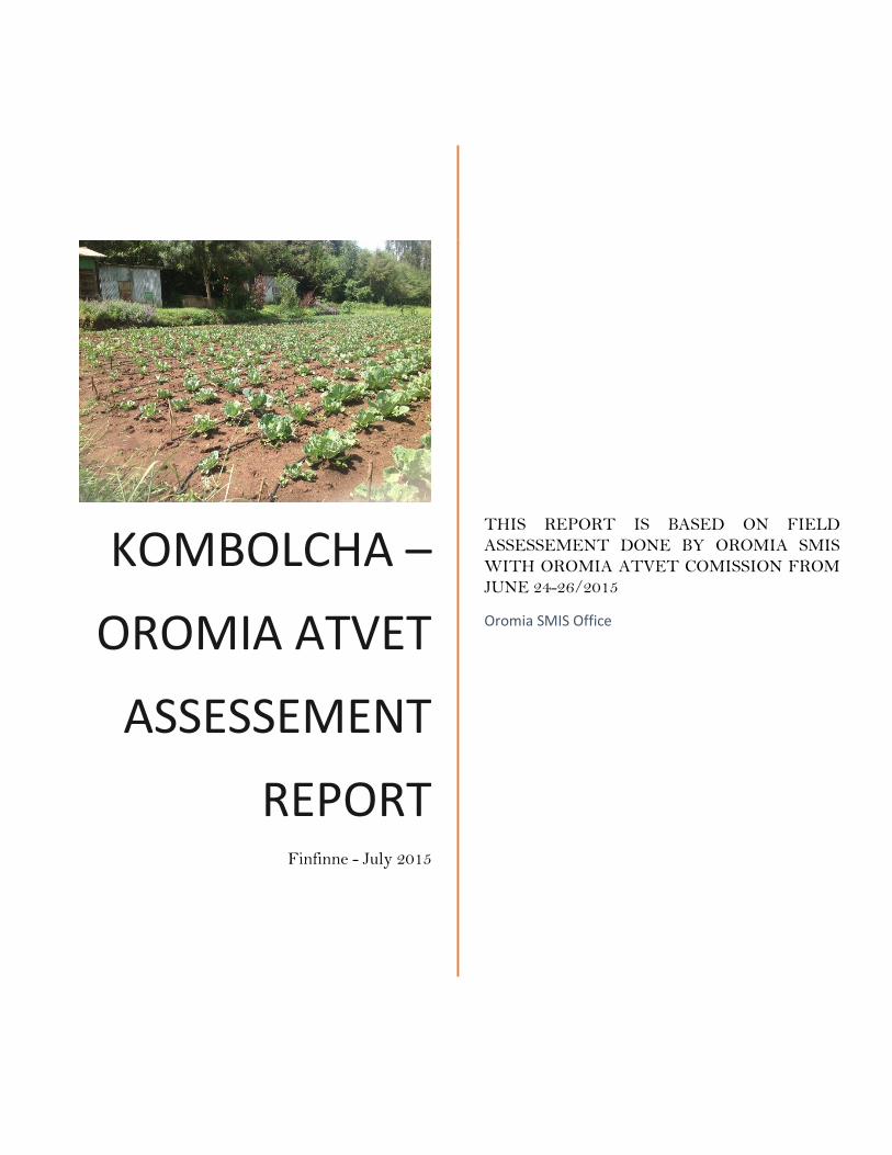
KOMBOLCHA –
OROMIA ATVET
ASSESSEMENT
REPORT Finfinne - July 2015
THIS REPORT IS BASED ON FIELD
ASSESSEMENT DONE BY OROMIA SMIS
WITH OROMIA ATVET COMISSION FROM
JUNE 24-26/2015
Oromia SMIS Office
i
Contents 1 General ....................................................................................................................................................... 1
1.1 Location ............................................................................................................................................. 1
1.2 Climate ............................................................................................................................................... 1
2 Physical resources: ................................................................................................................................... 2
2.1 Physical Facilities at main compound ......................................................................................... 2
2.2 Physical infrastructure at the Farm land ................................................................................... 3
2.3 Teaching Resources ........................................................................................................................ 4
2.4 Irrigation Farm Operation Equipment ...................................................................................... 5
3 Enrollment and Gender .......................................................................................................................... 5
4 Water Resource: ....................................................................................................................................... 5
4.1 Source and Location ........................................................................................................................ 5
4.2 Availability and reliability ............................................................................................................. 6
4.3 Water Quality................................................................................................................................... 6
5 Topography: .............................................................................................................................................. 6
5.1 Data availability ............................................................................................................................... 6
5.2 Land feature ...................................................................................................................................... 7
6 Soils: ............................................................................................................................................................ 7
7 Water harvesting ..................................................................................................................................... 7
8 On-farm Water Management, efficiency, equity and adequacy .................................................... 8
9 Crop selection and Crop water Requirement .................................................................................... 8
10 Water saving techniques .................................................................................................................... 8
11 Support personnel ................................................................................................................................ 9
12 Priority Needs in view of Dean and irrigation instructors ........................................................ 9
13 Senior Personnel interviewed ........................................................................................................... 9

ii
List of Tables
Table 1 Metrological stations around Kombolcha TVET .................................................................... 2
Table 2 list of available pumps at Kombolcha ATVET .......................................................................... 5
Table 3 List of senior personnel interviewed ............................................................................................ 9
List of Figures/Photos
Figure 1: Metrology Station Location Map ............................................................................................... 1
Figure 2 growing and dry season of Kombolcha (retrieved from FAO LocClim) ............................ 2
Figure 3 Kombolcha ATVET building layout (Source Google earth, image 2013) ......................... 3
Figure 4 Farm area of Kombolch ATVET ................................................................................................. 4
Figure 5 Library ............................................................................................................................................... 4
Figure 6 Model of hand dug well in Kombolcha ATVET...................................................................... 5
Figure 7 Delineated Compound and Layout of Kombolcha ATVET .................................................. 6
Figure 8 Sub catchment and unit catchment area of Kombolcha ATVET ......................................... 8
1
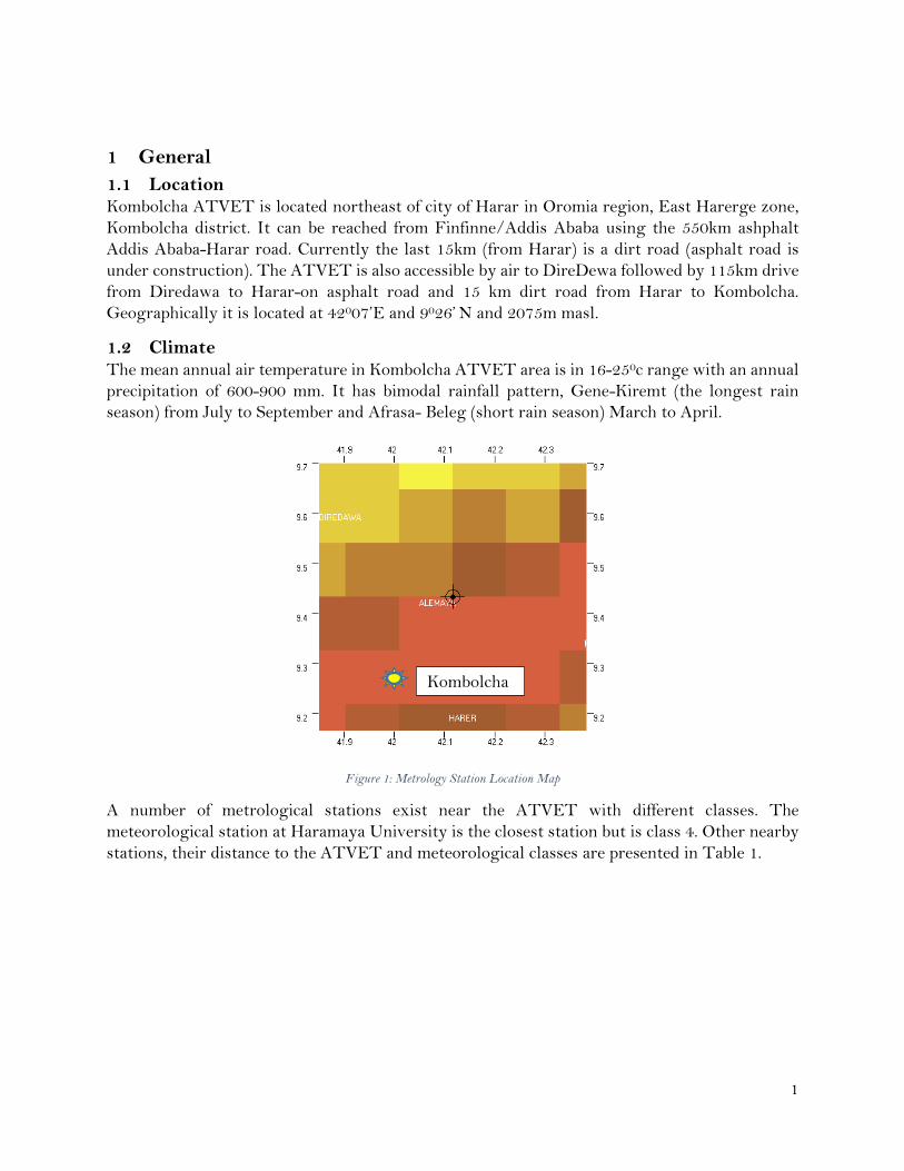
1 General
1.1 Location Kombolcha ATVET is located northeast of city of Harar in Oromia region, East Harerge zone,
Kombolcha district. It can be reached from Finfinne/Addis Ababa using the 550km ashphalt
Addis Ababa-Harar road. Currently the last 15km (from Harar) is a dirt road (asphalt road is
under construction). The ATVET is also accessible by air to DireDewa followed by 115km drive
from Diredawa to Harar-on asphalt road and 15 km dirt road from Harar to Kombolcha.
Geographically it is located at 42007’E and 9026’ N and 2075m masl.
1.2 Climate The mean annual air temperature in Kombolcha ATVET area is in 16-250c range with an annual
precipitation of 600-900 mm. It has bimodal rainfall pattern, Gene-Kiremt (the longest rain
season) from July to September and Afrasa- Beleg (short rain season) March to April.
Figure 1: Metrology Station Location Map
A number of metrological stations exist near the ATVET with different classes. The
meteorological station at Haramaya University is the closest station but is class 4. Other nearby
stations, their distance to the ATVET and meteorological classes are presented in Table 1.
Kombolcha
ATVET
2
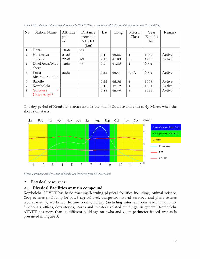
Table 1 Metrological stations around Kombolcha TVET (Source: Ethiopian Metrological station website and FAO locClim)
No Station Name Altitude(m) asl
Distance from the ATVET
(km)
Lat Long Metro. Class
Year Establis
hed
Remark
1 Harar 1856 26 2 Haramaya 2125 7 9.4 42.03 1 1954 Active 3 Girawa 2250 46 9.13 41.83 3 1968 Active 4 DireDewa/Met
chera 1260 35 9.5 41.85 4 N/A
5 Funa Bira/Gursume/
2050 9.35 42.4 N/A N/A Active
6 Babille 9.22 42.32 4 1968 Active 7 Kombolcha 9.43 42.12 4 1981 Active 8 Galedesa /
University?? 9.43 42.06 3 1933 Active
The dry period of Kombolcha area starts in the mid of October and ends early March when the
short rain starts.
Figure 2 growing and dry season of Kombolcha (retrieved from FAO LocClim)
2 Physical resources:
2.1 Physical Facilities at main compound Kombolcha ATVET has basic teaching/learning physical facilities including; Animal science,
Crop science (including irrigated agriculture), computer, natural resource and plant science
laboratories, y, workshop, lecture rooms, library (including internet room: even if not fully
functional), offices, dormitories, stores and livestock related buildings. In general, Kombolcha
ATVET has more than 20 different buildings on 3.5ha and 755m perimeter fenced area as is
presented in Figure 3.
3
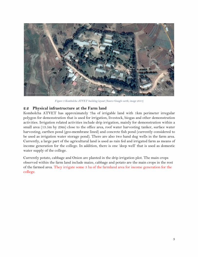
Figure 3 Kombolcha ATVET building layout (Source Google earth, image 2013)
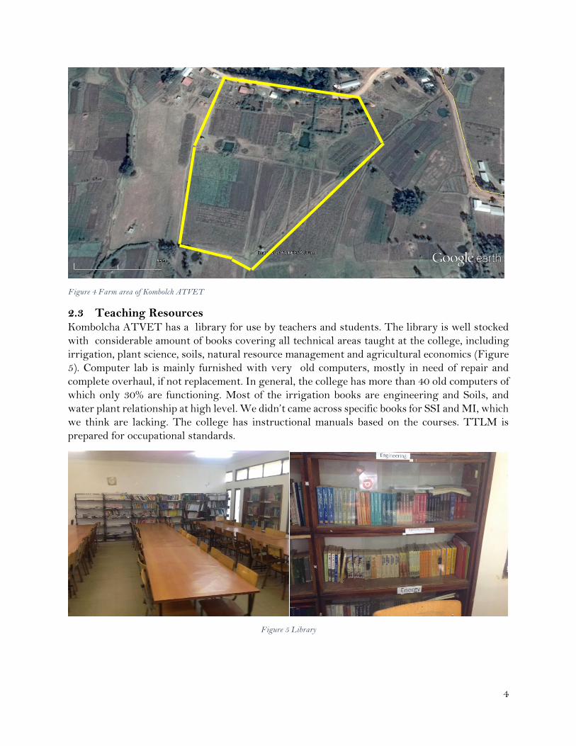
2.2 Physical infrastructure at the Farm land Kombolcha ATVET has approximately 7ha of irrigable land with 1km perimeter irregular
polygon for demonstration that is used for irrigation, livestock, biogas and other demonstration
activities. Irrigation related activities include drip irrigation, mainly for demonstration within a
small area (13.5m by 29m) close to the office area, roof water harvesting tanker, surface water
harvesting, earthen pond (geo-membrane lined) and concrete fish pond (currently considered to
be used as irrigation water storage pond). There are also two hand dug wells in the farm area.
Currently, a large part of the agricultural land is used as rain fed and irrigated farm as means of
income generation for the college. In addition, there is one ‘deep well’ that is used as domestic
water supply of the college.
Currently potato, cabbage and Onion are planted in the drip irrigation plot. The main crops
observed within the farm land include maize, cabbage and potato are the main crops in the rest
of the farmed area. They irrigate some 3 ha of the farmland area for income generation for the
college.
4
Figure 4 Farm area of Kombolch ATVET
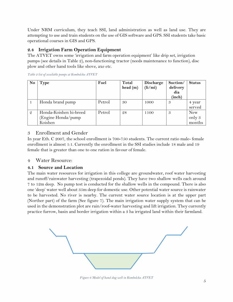
2.3 Teaching Resources Kombolcha ATVET has a library for use by teachers and students. The library is well stocked
with considerable amount of books covering all technical areas taught at the college, including
irrigation, plant science, soils, natural resource management and agricultural economics (Figure
5). Computer lab is mainly furnished with very old computers, mostly in need of repair and
complete overhaul, if not replacement. In general, the college has more than 40 old computers of
which only 30% are functioning. Most of the irrigation books are engineering and Soils, and
water plant relationship at high level. We didn’t came across specific books for SSI and MI, which
we think are lacking. The college has instructional manuals based on the courses. TTLM is
prepared for occupational standards.
Figure 5 Library
5
Under NRM curriculum, they teach SSI, land administration as well as land use. They are
attempting to use and train students on the use of GIS software and GPS. SSI students take basic
operational courses in GIS and GPS.
2.4 Irrigation Farm Operation Equipment The ATVET owns some ‘irrigation and farm operation equipment’ like drip set, irrigation
pumps (see details in Table 2), non-functioning tractor (needs maintenance to function), disc
plow and other hand tools like shove, axe etc.
Table 2 list of available pumps at Kombolcha ATVET
No Type Fuel Total head (m)
Discharge (li/mi)
Suction/delivery
dia (inch)
Status
1 Honda brand pump Petrol 30 1000 3 4 year served
2 Honda-Koishen hi-breed (Engine Honda/pump Koishen
Petrol 28 1100 3 New only 3 months
3 Enrollment and Gender In year Eth. C 2007, the school enrollment is 700-750 students. The current ratio male- female
enrollment is almost 1:1. Currently the enrollment in the SSI studies include 18 male and 19
female that is greater than one to one ration in favour of female.
4 Water Resource:
4.1 Source and Location The main water resources for irrigation in this college are groundwater, roof water harvesting
and runoff/rainwater harvesting (trapezoidal ponds). They have two shallow wells each around
7 to 12m deep. No pump test is conducted for the shallow wells in the compound. There is also
one ‘deep’ water well about 35m deep for domestic use. Other potential water source is rainwater
to be harvested. No river is nearby. The current water source location is at the upper part
(Norther part) of the farm (See figure 7). The main irrigation water supply system that can be
used in the demonstration plot are rain/roof-water harvesting and lift irrigation. They currently
practice furrow, basin and border irrigation within a 3 ha irrigated land within their farmland.
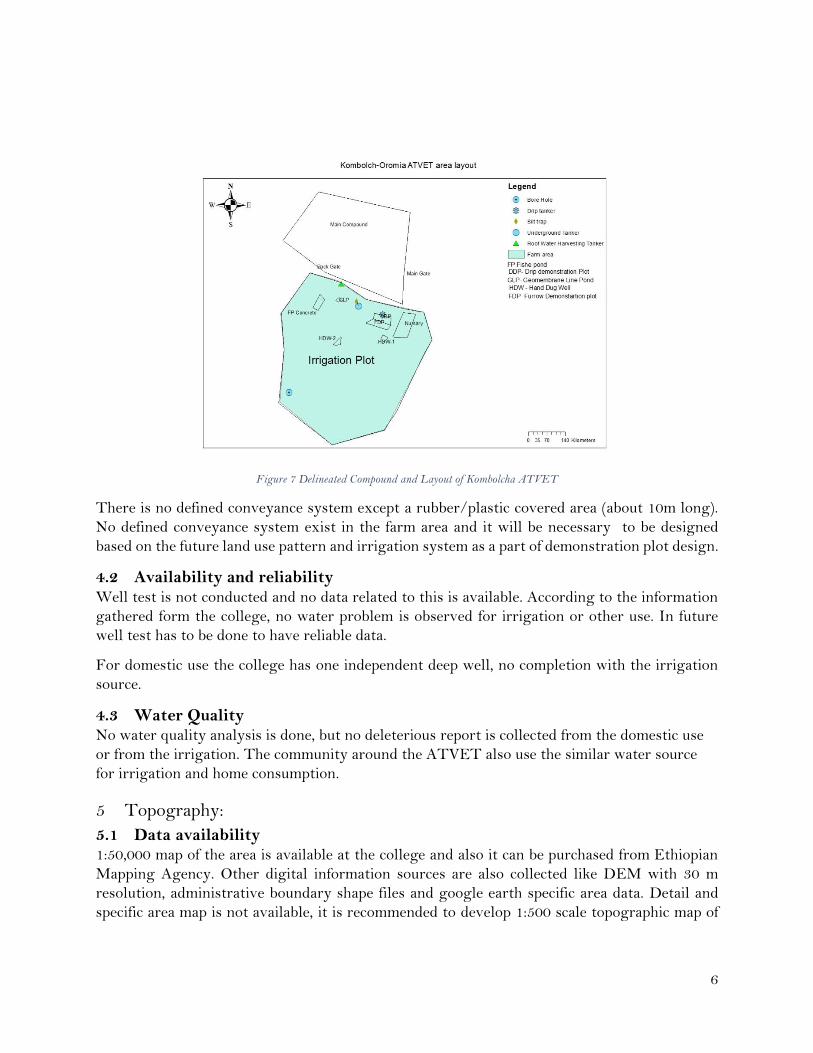
Figure 6 Model of hand dug well in Kombolcha ATVET
6
Figure 7 Delineated Compound and Layout of Kombolcha ATVET
There is no defined conveyance system except a rubber/plastic covered area (about 10m long).
No defined conveyance system exist in the farm area and it will be necessary to be designed
based on the future land use pattern and irrigation system as a part of demonstration plot design.
4.2 Availability and reliability Well test is not conducted and no data related to this is available. According to the information
gathered form the college, no water problem is observed for irrigation or other use. In future
well test has to be done to have reliable data.
For domestic use the college has one independent deep well, no completion with the irrigation
source.
4.3 Water Quality No water quality analysis is done, but no deleterious report is collected from the domestic use
or from the irrigation. The community around the ATVET also use the similar water source
for irrigation and home consumption.
5 Topography:
5.1 Data availability 1:50,000 map of the area is available at the college and also it can be purchased from Ethiopian
Mapping Agency. Other digital information sources are also collected like DEM with 30 m
resolution, administrative boundary shape files and google earth specific area data. Detail and
specific area map is not available, it is recommended to develop 1:500 scale topographic map of
7
the farmland area (demonstration plot). The college do not own any surveying instrument to
conduct the surveying works.
5.2 Land feature The ATVET as explained above has two compounds; main compound for teaching/learning
activity and second compound for practical demonstration with the area of 3.5 and 6.8ha,
respectively.
The farmland area is generally flat to gently sloping with an average slope of 1 to 3% in a North-
south direction. No irrigation canals or drainage system was observed.
6 Soils: The farmland was surveyed through a transect walk, observing mainly the topsoil and the soil
profile along one of the cut off areas. Based on a very quick study, soils are believed to be
mainly Luvisols with fine (clay to silty clay) texture, reddish brown to dark reddish brown
color and well developed soil structure (fine sub-angular blocky structure in the topsoil
followed by medium moderated angular to sub-angular structure in the subsoil to a depth of 90
cm followed by gleyed substrata, indicating perched water table fluctuate and reaches up to 100
cm depth. Soil is deep in the whole farmland area (more than 2m deep). Rooting depth is deep
and can easily reach 90cm depth due to well-developed soil structure (fine to medium sub-
angular blocky structure) and relatively good soil porosity. No hardpan or claypan was
observed. However, if adequate care is not taken during irrigation, clay pan can be developed
due to continuous plowing at the same depth.
No soil profile description or data on soil physical and chemical properties with depth are
available. The past and present land use is intensive cultivation with main crops being maize,
potato, cabbage and hay as animal feed. Other crops used in the past include pulses, and
vegetables but they were not seen planted in the field at time of field observation.
7 Water harvesting The site is an ideal place for rain water harvesting, with three months of long rainy season and
two months of short rainy season. More than 20 building with estimated area of around 2000 m2
of corrugated metal sheet roof is a potential for direct rain water (roof water) harvesting. In
addition to this surface/flood water harvesting can be conducted from the sub catchment of the
college area which is about 80ha or from unit sub catchment of the college; the college falls in
three different unit catchments having 17, 31.5 and 30.7 ha.
Shallow well is the major water source of the area. At 7-10m depth plenty of water is found.

8
Figure 8 Sub catchment and unit catchment area of Kombolcha ATVET
8 On-farm Water Management, efficiency, equity and adequacy Except for demonstration purpose on the drip field no OFWM exercise was observed. Irrigation
practice on irrigated fields is based on individual’s common sense judgement rather than planned
OFWM.
No water conveyance, distribution and application efficiency are designed and implemented at
ATVET plot. The same is true for the surrounding area, but Harar people have a long history of
using irrigation and have a good experience in how to efficiently use irrigation water compared
to other farming communities in Oromia. Regarding equity and adequacy; everyone has his own
shallow well. Apparently, no equity or adequacy issue is raised in the surrounding farming areas.
However, this should be assessed based on well yield, density of well per defined area, the total
ground water potential of the area and other variables.
9 Crop selection and Crop water Requirement According to the discussion made with ATVET staff, crop selection for irrigation is conducted
mainly based on market demand. Crop water requirement is not considered or exercised at the
ATVET or in the surrounding area.
10 Water saving techniques Except for the drip system installed for demonstration, no defined water saving technology was
observed at the site. The discussion was made with the ATVET staff also confirmed this fact.
9
11 Support personnel There is one non-functioning tractor available with one disc plow. However, they do not have
any tractor operators. Other support staff like finance, Administration form 60% of the total staff
(instructors number depends on department and enrollment of students). They also have lab and
field technicians.
12 Priority Needs in view of Dean and irrigation instructors From five hour discussion with the dean and other senior staffs, it was understood that the
college is delighted to be selected as SMIS Oromia ATVET capacity building center. They are
interested to work with SMIS team to enhance their SSI and MI training capacity specially on
demonstration plot development, GIS, improvement of the computer laboratory capacities fro
better GIS, CAD and other SSI/MI related software.
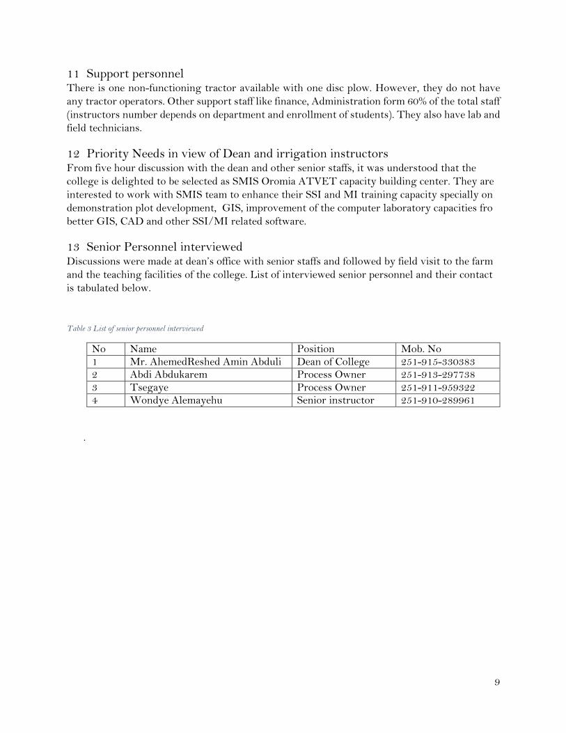
13 Senior Personnel interviewed Discussions were made at dean’s office with senior staffs and followed by field visit to the farm
and the teaching facilities of the college. List of interviewed senior personnel and their contact
is tabulated below.
Table 3 List of senior personnel interviewed
No Name Position Mob. No 1 Mr. AhemedReshed Amin Abduli Dean of College 251-915-330383 2 Abdi Abdukarem Process Owner 251-913-297738 3 Tsegaye Process Owner 251-911-959322 4 Wondye Alemayehu Senior instructor 251-910-289961
.