land acquisition and resettlement framework, ilovica...
TRANSCRIPT

LARF – Ilovica-Shtuka Project – September 2016 1
Land Acquisition and Resettlement Framework, Ilovica-Shtuka Gold-Copper Project Final for Disclosure August 2016

LARF – Ilovica-Shtuka Project – September 2016 2
Contents
Abbreviations & Glossary of Terms
1. LARF INTRODUCTION, SUMMARY AND STRATEGY ................................................................................. 4
1.1. Introduction .................................................................................................................................................. 4
1.2. Summary of Key Considerations for Project LAR Planning .......................................................................... 4
1.3. LAR Strategy ................................................................................................................................................ 6
2. THE PROJECT ............................................................................................................................................... 8
2.1. Project Description ....................................................................................................................................... 8
2.2. Summary of Socio-Economic Setting ......................................................................................................... 10
2.3. Land Use and Ownership Context.............................................................................................................. 12
2.4. Project Land Requirements & Potential Displacement Impacts ................................................................. 14
3. LEGAL AND POLICY FRAMEWORK .......................................................................................................... 27
3.1. Macedonian Legal and Policy Framework .................................................................................................. 27
3.2. EBRD Policy Framework (PR5 Land Acquisition, Involuntary Resettlement and Economic Displacement)31
3.3. Gap Analysis .............................................................................................................................................. 32
3.4. Summary of Implications for the Project ..................................................................................................... 33
4. LARF OBJECTIVES, PRINCIPLES AND APPROACH ................................................................................ 34
4.1. LARF Objectives ........................................................................................................................................ 34
4.2. LARF Principles .......................................................................................................................................... 34
5. ELIGIBILITY AND ENTITLEMENTS ............................................................................................................. 36
5.1. Eligibility Criteria and Categories................................................................................................................ 36
5.2. Entitlements / Compensation Framework ................................................................................................... 37
5.3. Livelihood Assistance and Restoration ....................................................................................................... 47
5.4. Support to Vulnerable Households ............................................................................................................. 47
5.5. Valuation .................................................................................................................................................... 48
6. LAND ACQUISITION AND COMPENSATION PROCESSES ...................................................................... 48
6.1. Overview of Land Access Approaches ....................................................................................................... 48
6.2. Identification of Affected Land Parcels and Gathering of Cadastral Data ................................................... 49
6.3. Census and Land & Asset Inventory Surveys ............................................................................................ 49
6.4. Database .................................................................................................................................................... 51
6.5. Verification of Census and Asset Inventory Results ................................................................................... 51
6.6. Household Socio-Economic Survey ........................................................................................................... 51
6.7. Valuation of Affected Land and Assets ....................................................................................................... 51
6.8. Preparation of Agreements and Contracts ................................................................................................. 51
6.9. Payment of Compensation and Delivery of Assistance .............................................................................. 52
6.10. Absent Owners or Incomplete Title of Affected Land & Assets .................................................................. 52
7. PUBLIC CONSULTATION AND DISCLOSURE ........................................................................................... 52
7.1. Summary of Previous Project Consultation & Engagement ....................................................................... 52
7.2. LARF Disclosure & Consultation ................................................................................................................ 53
Land Acquisition ......................................................................................................................................... 54
7.3. Committee .................................................................................................................................................. 54
7.4. Future Land Acquisition & Resettlement Consultation Activities ................................................................ 54
8. GRIEVANCE PROCEDURE ......................................................................................................................... 54
9. LARF IMPLEMENTATION, TIMETABLE, BUDGET, MONITORING AND REPORTING ............................. 57
9.1. Implementation ........................................................................................................................................... 57
9.2. Timeplan .................................................................................................................................................... 57

LARF – Ilovica-Shtuka Project – September 2016 3
9.3. Resources and Budget ............................................................................................................................... 59
9.4. Monitoring .................................................................................................................................................. 59
9.5. Reporting .................................................................................................................................................... 59
10. LARF CONTACT DETAILS .......................................................................................................................... 60
Figures
Figure 1-1 Summary of Land Acquisition & Resettlement Planning Approach for Ilovica-Shtuka Gold-Copper Project
.................................................................................................................................................................................6 Figure 2-1 Regional Location Map of the Ilovica-Shtuka Gold-Copper Project .........................................................8 Figure 2-2 Local Setting of the Ilovica-Shtuka Gold-Copper Project ...................................................................... 10 Figure 2-3 Ownership of Land in the Mine Concession Area ................................................................................. 13 Figure 2-4 Priority Areas for Forestry Clearance (Green Hatched Areas) in the Mine Concession Area ................ 17 Figure 2-5 Map of Land Acquisition Area (red dotted line – 1,148 ha – Land Acquisition Required) within the
Concession Area (red line - 1,542 ha) .................................................................................................................... 18 Figure 2-6 Proposed Access Road Route Options ................................................................................................. 21 Figure 2-7 Proposed OHL Routes – top map shows northern half of map from Berovo south towards mine site,
bottom map shows southern half of map from Sushica to mine site. ...................................................................... 24 Figure 3-1 Summary of Expropriation Process ....................................................................................................... 28 Figure 8-1 Euromax Grievance Procedure Flow Chart ........................................................................................... 56
Tables
Table 2-1 Summary of Land Requirements & Displacement Impacts for Mine Concession Area .......................... 15 Table 2-2 Summary of Land Requirements & Displacement Impacts for Mine Access Road ................................ 19 Table 2-3 Summary of Land Requirements & Displacement Impacts for Overhead Power Line ............................ 22 Table 2-4 Summary of Land Requirements & Displacement Impacts for Water Pipeline ....................................... 25 Table 2-5 Summary of Key Land Access Characteristics by Project Component................................................... 26 Table 5-1 Planned Entitlements Framework for the Mine Concession Area .......................................................... 38 Table 5-2 Planned Entitlements Framework for the Project Access Road, OHL and Water Pipeline. ................... 43 Table 9-1 Indicative Responsibilities for Land Acquisition for Project Components............................................... 58 Table 9-2 Indicative Timeplan for Project Construction Start ................................................................................. 58 Table 9-3 Monitoring Indicators ............................................................................................................................. 60 Boxes
Box 1-1 Land Acquisition & Resettlement Framework ..............................................................................................4 Box 1-2 Ilovica-Shtuka Gold-Copper Project – Key Project Components ................................................................5 Box 6-1 Common Steps in Expected Land Acquisition Processes for Different Project Components ................... 48 Box 6-2 Indication of information to be gathered in Census and Asset Inventory .................................................. 50
Annexes
Annex 1 Euromax Grievance Form
ABBREVIATIONS
AR Access Road OHL Overhead Line
EBRD European Bank for Reconstruction and
Development
NTFP Non-Timber Forest Products
ESIA Environmental & Social Impact Assessment PAP Projected Affected Person
ESP Environmental & Social Policy PR Performance Requirement
km kilometre, used to identify length RAP Resettlement Action Plan
FG Focus Group SEP Stakeholder Engagement Plan
LAR Land Acquisition & Resettlement TBC To Be Confirmed
LARF Land Acquisition and Resettlement Framework TMF Tailings Management Facility
LRP Livelihood Restoration Plan

LARF – Ilovica-Shtuka Project – September 2016 4
1. LARF INTRODUCTION, SUMMARY AND STRATEGY
1.1. Introduction
Euromax Resources Ltd is a public company incorporated in British Columbia, Canada, listed on the TSX Venture
Exchange and operating in Macedonia through its subsidiary Euromax Resources DOO Skopje (“Euromax”).
Euromax has a major mining development project in Macedonia which focuses on building and operating the Ilovica-
Shtuka Gold-Copper project (the “Project”).
The European Bank for Reconstruction and Development (EBRD) is contributing finance to the Project and is
currently the largest Company shareholder with 19.9% ownership of Euromax. The Project is being developed by
Euromax in line with Macedonian legislative requirements and those of EBRD, including EBRD’s Environmental
and Social Policy (20141) and Performance Requirements (PR), such as PR 5: Land Acquisition, Involuntary
Resettlement and Economic Displacement.
Since the Project may also seek finance from institutions which abide by the Equator Principles, the Project will also
be compliant with the International Finance Corporation’s (IFC) Performance Standards on Environmental and
Social Sustainability, notably PS5: Land Acquisition and Involuntary Resettlement.
The Project requires acquisition of land for the mining Concession and related road, power and water supply
infrastructure, which could involve economic displacement of land owners and users. The land acquisition process
for the Project is in its early stages but it appears based on current knowledge that there will be very limited (if any)
cases where physical displacement of ‘residential’ structures will occur. There are a few non-residential structures
which could be affected; this will be confirmed during the further land acquisition planning.
Box 1-1 Land Acquisition & Resettlement Framework
This Land Acquisition & Resettlement Framework (LARF) outlines the potential displacement impacts
associated with the Project and the compensation and resettlement principles and responsibilities to ensure no
one affected by the Project’s implementation is disadvantaged compared to current conditions. The LARF
outlines how Euromax will consult and engage with affected people and includes a grievance mechanism for
people affected by land acquisition to raise their concerns. This document has been developed in accordance
with the Macedonian legal framework and in compliance with EBRD’s PR5 and IFC PS5.
1.2. Summary of Key Considerations for Project LAR Planning
This Section presents a summary of the key considerations of direct relevance to Project land access and the
Project’s proposed Land Acquisition & Resettlement (LAR) Strategy. The LAR Strategy is summarised in Section
1.3.
Project Location: The Ilovica-Shtuka Project is located in the southeast of Macedonia, approximately 15 km west of the
border with Bulgaria and lies within the municipalities of Bosilovo and Novo Selo, situated on the western slopes of the
Maleševske mountain range and the slopes of the Ograzhden Mountain in particular.
Project Components: The key Project components requiring land access and/or acquisition are identified in Error!
Not a valid bookmark self-reference..
Roles and Responsibilities: The different Project components are characterised by different patterns of land
ownership and use and different institutional roles. Generally, it is expected that Euromax will play lead roles in
land acquisition for the different components, supported by various external bodies, though the exact roles and
responsibilities are still to be confirmed. In the Mine Concession Area, Euromax will be supported by the Forest
Company (Strumica Department of PC Makedonski Shumi) (and the Public Enterprise for Pastures, Regional
Office); for the OHL by MEPSO; for the Access Road by the Municipality of Bosilovo; and for the Water Pipeline by
the Water Management Company (WMC) Vodostopanstvo AD.
1 http://www.ebrd.com/news/publications/policies/environmental-and-social-policy-esp.html

LARF – Ilovica-Shtuka Project – September 2016 5
Box 1-2 Ilovica-Shtuka Gold-Copper Project – Key Project Components
Mine Concession Area: Mining facilities including the open pit, plant, infrastructure and tailings management
facility (TMF) are to be located within the Mine Concession Area – currently a largely forested area under a
combination of State, mixed State/private and private ownership, with licenced and un-licenced users of the
area, such as bee keepers, cattle graziers, timber harvesters and gatherers of non-forest products (such as
mushrooms and plants of cultural significance). The Concession Area itself sits within an extensive area of
forestry. The land acquisition area for the Project will cover approximately 1148 hectares (ha) within the
Concession Area of 1,542 ha. Land acquisition will only be carried out for the area required for the mining
facilities within the Concession Area, therefore some areas of the Concession will remain under their current
ownership and land use. Land access in the mine area within the Concession Area is required by end of Q4
2016.
Access Road: The new access road linking the entrance of the mine site with the existing Macedonian А4
highway will run a distance of approximately 7 km across an area of many privately owned, largely arable
farming plots. Land access is required in Q4 2016 (Phase 1) and Q4 2017 (Phase 2). Phase 1 would involve
works to support the construction phase and include a bypass to the village of Shtuka and potentially a
temporary bypass for Turnovo village.
OHL: 2x 110kV overhead line (OHL) power connections to two existing sub-stations – one in Sushica
(approximately 7 km south of the mine site) and the second in Berovo (30 km north of the site). The timeframe
for the former is flexible within 2017, and for the latter Q1 2018.
Water Pipeline: The technical solution for the mine water supply has not yet been confirmed, both a shared
pipeline solution using improved existing water supply infrastructure and a possible dedicated pipeline are
being evaluated. It is possible that if a dedicated supply solution was adopted a new water pipeline would run
approximately 17 km mainly along the existing Turija canal from the Turija reservoir to the mine site (and to the
water treatment plant for local villages). The shared pipeline water supply option is also being evaluated by
Euromax in discussion with the Water Management Company. The exact timeframe for any land access
required has not yet been defined but is needed by Q1 2018 and earlier if possible.
Land Requirements: The Project land take requirements will affect plots owned by the State and privately owned
land and assets, also there are plots within the Mine Concession which are in mixed State/Private ownership. The
Project requires land access over the estimated 20 years plus life of mine and temporary access during construction
and for periodic maintenance of the access road, the OHL and water pipeline. Land access is planned to be secured
through a combination of land acquisition, access agreements, wayleaves2 and easements3. Whilst negotiated
settlements with land owners and users is Euromax’s preferred approach to land acquisition, some compulsory
acquisition/expropriation, implemented in line with Macedonian legislation and EBRD requirements, may also take
place where negotiation to reach agreement fails. Euromax also plans to examine the option of moving the private
shares of mixed State/private parcels into separate State/private parcels outside the Concession area, thereby
potentially avoiding the need to acquire these plots.
Programme of Land Access: The different Project components are at different stages of design, planning and
land acquisition related data/studies. The programme for construction of the mine facilities and key infrastructure
means that land access is required at different times for the Project components. The Land Acquisition &
Resettlement (LAR) programme and strategy needs to be carefully planned to ensure sufficient time is available to
complete the necessary studies, data collection and consultations for each component.
2 A Wayleave or ‘Servitude’ is a right of way over someone’s land, which, for example, gives a company the right to install and retain pipeline or cabling across land in return for annual payments to the landowner. A way leave is normally a temporary arrangement and does not automatically transfer to a new owner or occupier.
3 An Easement provides a right of access to land for installing and maintaining infrastructure equipment (e.g. pipeline or cabling), for a one-off payment, it provides permanent access rights to another’s land and can pass to subsequent land owners. It can also restrict the proprietor’s use of the land (e.g. prohibit groundwork excavation).

LARF – Ilovica-Shtuka Project – September 2016 6
Displacement Impacts: The Project is being carefully designed to avoid, or where avoidance is not possible, to
minimise displacement impacts4:
Physical Displacement: is expected to be avoided and therefore resettlement of households is not anticipated
at this time. However, there is a very small risk of physical displacement arising, which needs to be confirmed
or otherwise during the planning of the access road, OHL and water pipeline.
Economic Displacement: is expected to arise from the Project due to the loss of forestry, grazing and
agricultural land, loss of access to forestry and natural resources, loss of crops and trees and loss of (or impacts
on) some non-residential structures/assets, such as farm buildings (including abandoned) and bee hives. The
Project will also result in some restrictions on access to land and land use, for example, wayleaves or
easements along the water pipeline, access road and OHL.
The above summary of the potential displacement impacts is based on preliminary investigations. The precise list
of impacts and planned delivery of compensation and assistance for these impacts will be informed by the results
of the further socio-economic surveys, census activities, including land and asset inventories, which will be detailed
in the RAPs or LRPs for the individual Project components.
1.3. LAR Strategy
The strategy for the Land Acquisition & Resettlement (LAR) planning and the key guiding documentation, namely
this LARF and the detailed LAR plans, is summarised below. Figure 1.1 provides an overview of the LAR strategy
and approach.
Figure 1-1 Summary of Land Acquisition & Resettlement Planning Approach for Ilovica-Shtuka Gold-
Copper Project
4 EBRD PR5 defines: ‘Physical Displacement’ as the relocation or loss of shelter/housing resulting from Project related land acquisition and/or restrictions on land use; and ‘Economic Displacement’ as the loss of assets or resources, and/or loss of access to assets or resources that leads to loss of income sources or means of livelihood.

LARF – Ilovica-Shtuka Project – September 2016 7
Overarching Framework for Project Components - LARF: Although there will be some differences in LAR
approaches, roles and responsibilities for the different Project components, all land access and acquisition needs
to be undertaken in line with national legislation and EBRD requirements, as far as possible. It will also be important
to have consistent approaches in terms of, for example, valuation of assets, compensation and assistance across
all Project components, irrespective of whether they are led by Euromax or a Government Agency. The Project
has therefore prepared this Land Acquisition and Resettlement Framework (LARF) to provide an overarching
framework for ‘Project’ land access and acquisition.
LARF Structure & Content: The LARF provides the following:
Section 2: Description of the Project and its land requirements and information on current land ownership, use
and users. Summary of potential impacts and categories of persons affected by project land access in terms
of physical and economic displacement.
Section 3: Legal and policy framework, covering relevant Macedonian legislation for each Project component,
clauses in the Mining Licence, the EBRD E&S Policy, notably PR5 and IFC PS5. Brief gap analysis between
national legislation and EBRD requirements and proposed measures to address any such gaps.
Section 4: Objectives and principles of the LARF.
Section 5: Eligibility criteria for compensation and assistance and identification of the compensation and
assistance entitlements that will be provided, including special measures for vulnerable people/households and
groups.
Section 6: Planned approaches and processes for land access/acquisition including identifying affected
persons and assets, valuation and compensation.
Sections 7 & 8: The Project’s approach to stakeholder engagement, consultation and disclosure relating to land
access and acquisition (Section 7) and the related grievance mechanism (Section 8).
Section 9: The Project’s land acquisition implementation plan, including roles and responsibilities, outline
Project land access timetable, budget, monitoring and reporting arrangements.
Section 10: Contact details for persons seeking further information about the LARF and the Project’s land
access and acquisition activities.
Preparation of Separate RAP/LRP/Plans for each Project Component: Whilst the LARF provides the
overarching framework for the Project’s approach to land access and acquisition, specific Resettlement Action Plans
(RAP) and/or Livelihood Restoration Plans (LRP) will be prepared for the different Project components (depending
on whether physical and/or economic displacement takes place)5. These RAPs/LRPs will provide all the specific
information required to meet national legislative and EBRD PR5 and IFC PS5 requirements, for example, full details
on the actual land ownership and use, the nature of displacement impacts, persons and assets affected and details
of the proposed compensation and assistance provided. Given that currently no physical displacement is
anticipated it is likely that LRPs will be prepared for the Project components, rather than RAPs.
Given the complex nature of staggered land access being required for certain Project components and the need to
undertake and complete the necessary LAR studies and consultations with Project Affected Persons (PAPs), a
detailed programme will be developed for the RAP/LRPs and build on the one outlined within this LARF. The
RAP/LRPs will be informed by additional socio-economic survey, census work and land & asset inventories to be
undertaken during the next phase of Project development, to understand more fully the scale and magnitude of the
impacts of economic displacement on the Project Affected Persons (PAPs). This will build on the work undertaken
to date.
In addition, if a Government Agency is responsible (or has certain responsibilities) for land acquisition for a particular
Project component (e.g. the Water Authority for the water pipeline), Euromax is required by EBRD PR5 (Para. 41)
to prepare a Land Acquisition Plan (LAP), which together with the documents prepared by that Government Agency,
5 EBRD PR5 requires preparation of a Resettlement Action Plan (RAP) where physical displacement occurs; and a Livelihood Restoration Plan (LRP) where only economic displacement occurs.

LARF – Ilovica-Shtuka Project – September 2016 8
meets the requirements of PR5. If the Government Agency’s approach to land acquisition does not meet all
requirements of PR5, Euromax would potentially provide supplementary measures to fill these gaps with PR5, e.g.
by providing supplementary support for livelihood restoration or by providing compensation for assets at full
replacement cost instead of only at market value.
As shown in Figure 1.1, the following separate RAP, LRP or LAP for Project components are envisaged:
Mining Concession – (1 version – covering all the land requirements within the Concession Area in a single
phase; it is likely this document will be a Livelihood Restoration Plan (LRP) as only economic displacement is
likely to occur).
Access Road – (2 versions – Access Road Phase 1 and updated for Phase 2; it is likely this document will be
a Livelihood Restoration Plan (LRP) as only economic displacement is likely to occur).
Overhead Line – (probably an LRP assuming Euromax lead land acquisition assisted by MEPSO).
Water Pipeline – (probably an LRP if Euromax lead land acquisition, or a LAP document covering requirements
of PR5 Para. 41 if led by the Water Authority).
At this LARF stage, not all details of the Project have been identified (e.g. the access road route), and not all details
of the approach to land acquisition have been agreed (e.g. the approach and roles of Euromax, MEPSO and the
Water Authority on the OHL and water pipeline, and whether supplementary roles will be needed to meet EBRD
requirements). Updated information will be contained in the RAP/LRP/LAPs for specific Project components.
Subsequent iterations of the LARF will only be prepared if new information arises or changes occur which materially
alter the proposed approach outlined in this LARF and which cannot be sufficiently dealt with in the RAP/LRP/LAPs.
2. THE PROJECT
2.1. Project Description
The Ilovica-Shtuka Gold-Copper Project is a proposed copper and gold mine with supporting facilities located in
southeast Macedonia, approximately 180 km south east of Skopje, 18 km east of Strumica and 15 km west of the
border with Bulgaria (see Figure 2-1).
Figure 2-1 Regional Location Map of the Ilovica-Shtuka Gold-Copper Project

LARF – Ilovica-Shtuka Project – September 2016 9
The Project lies within the municipalities of Bosilovo and Novo Selo, situated on the western slopes of the
Maleševske mountain range, approximately 3 km northeast of the villages of Ilovica and Shtuka – see Figure 2-2.
Within the Project footprint area in the mine Concession area the Project will include an open pit mine, two areas
of ancillary facilities and warehouses, processing plant, and a tailings management facility (TMF) which incorporates
waste rock disposal. Ore extracted from the open pit will be crushed and transported via conveyor to the processing
plant. Crushed ore will undergo milling and flotation to remove copper and gold bearing minerals. Leaching will be
used to extract gold from the milled ore which has undergone flotation. The copper concentrate will be transported
from the site in trucks to an existing smelter in Bulgaria. The gold leachate will be processed on site to produce
doré bars.
The key infrastructure to be developed in connection with the mine comprises:
An access road will be constructed to connect the mine site to the existing А4 highway 6 km south west of the
mine. It is intended that the road will be for shared Project and public use, though this has not yet been confirmed
with the Municipality of Bosilovo. An agreement will set out responsibilities for the road, with Euromax constructing
the road and potentially maintaining it for life of the Project, and then handing it over to the Municipality for public
use.
Power to the Project will be via 2x 110kV overhead line (OHL) connections to two existing sub-stations
approximately 7 km and 30 km from the mine site at Sushica and Berovo.
It is planned (but not yet finalised) for water to be pumped to the Project from the existing Turija reservoir (17km
north west of the mine site) via a new water pipeline to be installed as far as possible along the wayleave of the
existing Turija canal which currently brings irrigation water to the vicinity of the site.

LARF – Ilovica-Shtuka Project – September 2016 10
Figure 2-2 Local Setting of the Ilovica-Shtuka Gold-Copper Project
The Project construction phase is expected to take 18 months – 2 years with production scheduled to commence
in 2017/18, continuing over the 20+ year estimated life of mine. Initially (9-12 months) significant earthworks will
be carried out on the site using standard heavy duty construction equipment, which will require access to the site.
Mining pre-strip operations will commence at the start of 2017 using large dump trucks and excavators. Process
plant equipment, will start to arrive in 2018 and continue through the year. Operations will commence at the end of
2018 and the main product of the mine, copper concentrate, will be trucked to a smelter in Bulgaria via the А4 road.
Once in operation, the Project is expected to have approximately 500 direct employees, as well as indirect
employment opportunities through local contractors. When the mine is in full production an annual royalty will be
paid to the State of estimated US$3.8 million. According to Macedonian Minerals Law, 22% of the royalty would go
to national government and 78% would go to the municipalities where the concession is located. This would
generate an estimated US$77 million to the Municipalities of Bosilovo and Novo Selo over the life of mine.
2.2. Summary of Socio-Economic Setting
Demographics - The populations of the two closest village settlements to the Concession along the access route,
Ilovica (1,907) and Shtuka (781), are predominantly Macedonian, though small populations of other ethnicities do
exist in these settlements (80-100 Turk-Roma households in Ilovica, but none in Shtuka). Turkish language is used
in certain community facilities, including the school in Ilovica. Demographically, Ilovica and Shtuka villages have
median ages of 35 and 36 years respectively, and male to female ratios of 51:49 for Ilovica and 54:46 for Shtuka.
Over the past decade the area has seen some out-migration of younger people and qualified and trained workers
seeking employment opportunities in Skopje and western Europe (particularly Italy, Switzerland and Slovenia),
which has constrained local business development.
The depopulated village of Barbarevo, lies on the Ograzden Mountain (part of the Maleševske mountains) 5 km
south east of the Concession Area, in the Municipality of Novo Selo. The village was abandoned from the 1970s
due to poor living conditions and limited availability of water, with most of the inhabitants moving to the villages of
Novo Selo and Samuilovo in the valley 9 km and 11 km respectively south of the Concession Area (not to Shtuka
and Ilovica).
LARF – Ilovica-Shtuka Project – September 2016 11
Community facilities - Access to community facilities for education and healthcare in the local area is considered
to be relatively good. They include a Primary School in Ilovica and Secondary Schools in the regional cities of
Strumica and Radovish (14 km south west and 30 km north west of Ilovica respectively); a primary healthcare clinic
in Ilovica and two hospitals in Strumica.
Income sources and employment - In the Municipalities of Bosilovo and Novo Selo, agriculture is still the main
industry and source of income, with 91% of the working population of Bosilovo and 68% of Novo Selo either engaged
in agricultural wage labour or self-employed agricultural activity. Involvement in waged labour is relatively low, and
30% of the approximately 600 people over the age of 18 years in the villages of Ilovica and Shtuka are not employed
in waged labour and are seeking work.
Agriculture dominates economic activity in the local Project area and most households (72%) maintain arable land
and receive some agricultural income annually. Some households also maintain vineyards for personal
consumption, or pastureland (40%) for livestock grazing. Arable farming takes place in the valley through which
the access road would pass, but not in the hills of the Concession Area.
A few households raise livestock for sale, with small numbers of livestock usually being kept for home use - cows
and goats being kept for milk, chickens for eggs and meat, and pigs for meat. Nearly half of all households keep
cattle, with the average household keeping about five cows. A few households have flocks of sheep and there are
several small-scale (i.e. estimated 50 head) cattle ranching operations run out of the villages largely for milk and
beef production. Cattle are grazed in pastures and woodlands near the communities of Ilovica and Shtuka, including
some grazing in the Mine Concession Area.
Some private individuals and small enterprises (mainly from Shtuka village) supplement income by harvesting
mushrooms on forested slopes of Ograzden Mountain (including in the Mine Concession Area) and gathering plants
with cultural significance at certain times of the year, as well as foraging for medicinal plants, forest fruits, fungi,
lichen, moss and snails. It is understood that many of these foraged resources are collected from across the
mountain range on a commercial basis by licenced individuals, but that many households collect fungi in particular
for personal consumption on an opportunistic basis, when conditions are good and fungi plentiful. Based on
currently available information there are approximately 20 people from Shtuka and approximately 5 people from
Ilovica who regularly harvest mushrooms from the Concession Area.
There are a few bee keepers with hives on the southern slopes of Ograzden Mountain involved in small-scale honey
production for household consumption and surpluses sold in local markets. There are at least three bee keepers
with hives near the Ilovica reservoir, they work together in a cooperative and only one of them has hives within the
southern edge of the Concession Area. All of these bee keepers are registered as separate hive owners with the
Ministry of Agriculture and with veterinarians. The land they use is not owned by them.
The southeast Region of Macedonia is heavily forested, with over 60% of the total regional land area being covered
by forest. However, much (two thirds) of the forested land in the region is not suitable for timber production. In the
Municipality of Bosilovo, forestry activity on the Ograzden Mountain is operated by the Strumica Department of PC
Makedonski Shumi (Macedonian Forest Company).
A limited amount of licenced forestry activity occurs in the area immediately around Ilovica and Shtuka. Several
small forestry enterprises in the area sell wood to local processing companies and as fuel for domestic furnaces.
Wood processing businesses produce pellets and crates for use in the packaging and shipping of agricultural
products abroad.
Many households from Ilovica and Shtuka gather wood and timber from forested hills (including in the Concession
Area), both for domestic fuel and small scale construction. Some hold licences to gather wood, whilst others are
unlicensed. Recently, illegal wood harvesting has decreased as a result of policing efforts6 (Municipality of Bosilovo,
n.d.), but it still occurs in the area. The Bosilovo Local Environmental Action Plan (LEAP) has identified a cooperative
initiative with the Ministry of Agriculture, Forestry and Water Economy to further reduce illegal harvesting through
volunteer patrols and public education.
Vulnerable Communities - The significant land-based dependency in the villages close to the mine, very low to
low incomes for paid work and aging population does mean there are signs of vulnerability in the local communities
6 Illegal harvesting is a punishable offence that carries the potential for a prison sentence.

LARF – Ilovica-Shtuka Project – September 2016 12
within the Project area which will be considered in terms of methods of engagement and the resettlement/livelihood
assistance offered.
The socio–economic baseline carried out for the ESIA has identified groups falling into the categories above who
will be a particular focus of attention in considering the impacts of economic displacement. These include groups
who harvest timber without a licence, who are unable to pay for a licence or the fines for harvesting illegally.
Vulnerability will be assessed based on the results of the further socio economic survey works and defined more
precisely in the RAP/LRPs.
Cultural Heritage - Cultural heritage (CH) in the area of Ilovica and Shtuka includes features such as churches,
cemeteries, archaelogical sites from the Late Antiquity period, springs and sites of historic events. Within the
Concession Area Project footprint, the ESIA recorded a spring with an inscribed memorial stone and a waterfall that
is the local focal point for collecting Bigroot Cranesbill, a decorative herb collected at Easter and archaeological
sites from late antiquity period. The villages of Ilovica and Shtuka have cultural heritage resources, including
cemeteries, churches, a mosque, sites of religious/ritual importance, springs and sites of historic events.
2.3. Land Use and Ownership Context
2.3.1. Mine Concession Area
The Mine Concession is located in a large area of forested hills with areas of scrub and open sward used for rough
grazing, largely without fencing. As shown in Figure 2.3, land in the Concession is: largely State owned (blue
dashed), reflecting State ownership of forests; but there are also some limited areas of private ownership (pink);
and areas of mixed State/private ownership (green dashed). The land acquisition area and the locating within it of
Project facilities (as shown by the red line in Figure 2-3) has been designed to avoid the areas of private land. At
this stage, 72 private part owners have been identified in the mine land acquisition area; more accurate data will be
obtained from field work and included in the Concession Area LRP.
Land ownership of the mixed State/private ownership areas is complex - the State frequently owns the largest
proportion of a land parcel; in some cases a parcel is owned by two, three or four private parties with equal shares,
but in others there are up to 38 part owners with very small shares. Furthermore, the areas of the parcels are not
always known, and they do not appear to be related to specific areas on the ground. It is understood that owners
other than the State of Macedonia (devolved to the Forestry Company), have no benefits from the land in terms of
harvesting or hunting rights, nor royalties from the timber harvested by the Forestry Company. It is understood that
there are just 3 title deeds (five cadestral parcels) for the whole area which is in mixed State/Private ownership, of
which just a portion is within the Concession boundary and required for the Project. Most of the owners of the land
parcels are understood to have originated from the depopulated village of Barbarevo (now living largely in the
villages of Novo Selo and Samuilovo around 10 km south of the concession). However, further survey work and
consultation is required to know whether the individuals are named as part owners on the deeds, or where these
are held.
Land users in the Concession Area include licensed and unlicensed bee keepers, cattle graziers, small scale timber
harvesters and collectors of non-timber forest products (NTFP) notably mushrooms. Bigroot Cranesbill is harvested
from points within the Concession for cultural purposes at Easter. Since the Concession Area sits within a large
area of forestry that is also available for community and domestic access to natural resources, it is not expected
that end of access to the Concession Area will significantly affect their activities. Licensed users are licensed by
the Municipalities and the Public Enterprise for Forestry and are able to access extensive areas outside the
Concession Area – a license from the Enterprise for Forestry, for example, enables a licensee to access any area
of State forestry across the whole of Macedonia.

LARF – Ilovica-Shtuka Project – September 2016 13
Figure 2-3 Ownership of Land in the Mine Concession Area
Key: Pink areas = privately owned plots; Blue dashed = State owned plots; Green dashed = mixed State and private ownership (with the State being the dominant owner).

LARF – Ilovica-Shtuka Project – September 2016 14
2.3.2. Strumica Valley Area
The Strumica Valley lies to the south west and south of the Maleševske mountains where the Ilovica mine site is
located; the villages of Ilovica and Shtuka lie on the valley’s northern edge and the А4 highway runs along the
valley. The mine Access Road would run in a broadly southerly direction across the valley to join the А4 highway.
Outside of the hilly, largely forested area of the Mine Concession, the ground in the Strumica Valley is generally flat
and used for arable farming and market gardening. Crops include tobacco, potatoes, tomatoes, cucumbers, melons,
chillies, cabbages, peppers, maize, grapes, grain (wheat and barley) and fruit. Here the land is divided into narrow
strips that are usually at right angles to roads or tracks; fences are infrequent. There are also some orchards,
vineyards, meadows and pastures. Some fields are served by irrigation boreholes or fed with water from the Turija
canal. There are no permanent green-houses in the immediate area around Ilovica and Shtuka but reusable plastic
poly tunnels are used to protect early crops and to extend the growing season.
Most of this agricultural land is privately owned, with some meadows and pastures being state owned (ESIA Focus
Groups (FG), 2015). Where land is State owned, the party farming the land may hold a standard 30-year concession
on the land (ESIA FG, 2015).
According to Euromax Resources baseline surveys (2015), most households (72%) in Ilovica and Shtuka maintain
plough land for growing vegetables (for their own use and for generating income) and commercial crops (i.e.
tobacco). 40% of households hold meadows and vineyards (34%). Relatively few households maintain fallow fields
(8%), pastures (5%) or greenhouses (4%). The average area of agricultural land held by each household is greatest
for plough land (1.08 ha) and fallow fields (0.74 ha), and smallest for vineyards (0.19 ha) and greenhouses (0.13
ha). A small number (2%) of households also maintain orchards, but do not generate incomes from them.
2.4. Project Land Requirements & Potential Displacement Impacts
Further information on the four Project components which require access to land is provided below. The summary
of the potential displacement impacts shown below is based on preliminary investigations, community consultation
and socio-economic assessment work. This work has provided an understanding of how Project related land
acquisition and restrictions on land use would potentially affect people, who would be affected and the needs and
rights of affected people, as well as helping to develop appropriate actions to minimise and mitigate impacts
(described further in Section 5). The precise list of impacts and planned delivery of compensation and assistance
associated with these impacts will be informed by the results of forthcoming socio-economic surveys and asset
inventories which will be detailed in the RAPs or LRPs for individual Project components.

LARF – Ilovica-Shtuka Project – September 2016 15
2.4.1. Mine Concession Area
Table 2-1 Summary of Land Requirements & Displacement Impacts for Mine Concession Area
Project Component: Mine Concession Area
Description of Mine Concession: The Project will occupy an area of approximately 1148 hectares (ha) within
the Concession Area of 1,542 ha – see Figure 2.4. The Concession Area itself sits within a large mountainous
/ hilly area.
A Definitive Feasibility Study has recently been completed for the Project (Dec 2015) and describes an open
pit operation mining copper and gold, with on-site processing to copper concentrate and doré with associated
mine waste management and support infrastructure. Principal Project facilities to be developed in the
Concession include an open pit, tailings management facility and embankment that serves as a waste rock
storage facility, upper processing plant site, lower support services site, haul roads, on site roads, water
reticulation network and 110kV power lines. Much of this infrastructure lies within the Ilovica 11 Concession
Boundary; this Concession was granted to Euromax on 29th December 2015. The Ilovica 6 Concession lies
entirely within the boundary of Ilovica 11 and was granted to Euromax in 2011. Some land within this area will
be permanently occupied by Project infrastructure. Other areas will be acquired for the Project as a buffer zone,
but will remain as forest. Other areas in the Concession outside the land acquisition area (i.e. including the
Project footprint and buffer zone) will not be acquired and continue to be owned and used in line with the exiting
situation. There is the potential for remaining forested areas within the Concession to continue to be managed
by the Forestry Company under a management agreement.
Timetable for land access: In line with requirements of the exploitation permit to resolve property issues
within the whole of the planned footprint prior to construction on any part, land access within the Mine
Concession ideally would be secured by the end of Q4 2016. The forestry clearance areas are indicated in
Figure 2-4.
Design alternatives considered to minimise impacts: In order to minimise impacts of land requirements in the
Concession Area the Project has been designed to avoid private land within the Concession and physical
displacement of households has been avoided.
Land Ownership and Use: Land in the Concession is largely State owned and managed by the Forestry
Company, but with some limited areas of private ownership and areas of mixed State/private ownership. Work
is ongoing by Euromax in 2016 to provide detailed identification of owners – this information will be contained
within the LRP for the Mine Concession Area. The proposed Project Land Acquisition Area within the
Concession avoids privately owned land (see Figure 2-5).
There are no people living within the Concession Area and only licensed and unlicensed users such as bee
keepers, cattle graziers, small scale timber harvesters and collectors of non-timber forest products (NTFP) (e.g.
mushrooms and plants for cultural purposes). There are no houses or other domestic buildings present within
the Concession Area and the only structures present are agricultural related ones (some abandoned and to do
with livestock). There are several bee hives in proximity to the Concession Area as well few agricultural
plots.The users of the Concession Area generally come from the villages of Ilovica and Shtuka. There are 600
licences issued across four municipalities (Bosilovo, Novo Selo, Strumica and Vasilevo, a total of 942km2) for
people to harvest 10m3/year of timber from local forests, and although any of these people could in theory
harvest timber from the Concession Area, in practice currently it is thought that most of the licensed timber
harvesters using the area come from the villages of Ilovica and Shtuka. Unlicensed timber harvesters are also
thought to come mainly from these two villages – this will be confirmed in on-going studies and detailed in the
RAP/LRP. The bee hive keepers, cattle graziers and collectors of non-timber forest products are also
understood to come from Ilovica and Shtuka. The RAP/LRP for the Concession Area will provide more specific
data on land users based on forthcoming meetings with the local community, municipalities and Forestry
Company.
The Concession Area only forms one part of the wider forest area that is available potentially for timber
gathering, bee keeping, cattle graziers, collectors of non-timber forest products (NTFP) and other traditional
uses.
Potential Displacement impacts: No physical displacement is expected to arise from Project land acquisition in
the Concession Area because no residential housing exists in the area. Some economic displacement is
expected to arise, however, it should be noted that because the Concession Area sits within a large area of
forestry, the impact on community and domestic access to natural resources will be lessened by being able to

LARF – Ilovica-Shtuka Project – September 2016 16
access similar areas of natural resources in the vicinity of the Concession Area. Potential losses are listed
below:
Permanent loss of land in the Project Land Acquisition Area (including buffer zone) in the Concession Area
under State or mixed State/private ownership. This could include semi natural forest managed for timber
harvesting and areas of grassland used for cattle grazing.
Potential temporary loss of land in the Concession Area during construction under private (unlikely and
avoidance of such temporary use will be an aim of the Company), mixed State/private ownership land and
State ownership.
Loss of trees, from clearance of forest, or perennial plants in the Project Land Acquisition Area in the
Concession Area.
Loss of access to natural resources for licensed & unlicensed users, affecting timber gathers, beekeepers,
cattle graziers, mushroom and cultural plant collectors. It is expected that similar natural resources could
be accessed in the vicinity of the Concession area.
More difficult or more remote access to natural resources, e.g. for mushroom collectors, cattle graziers and
wood collectors, which may result from alternative sites being less accessible or further from the villages.
Loss of access to livestock watering points (springs with drinking troughs installed) in the Project Land
Acquisition Area (including buffer zone) in the Concession Area.
Loss of non-domestic structures in the Project Land Acquisition Area (including buffer zone) in the
Concession Area, such as beehives and cattle enclosures.
Loss of sources of income and/or livelihoods associated with any of the above losses. This impact would
be reduced if people are able to access similar natural resources outside the Concession area.
Potential impacts on cultural heritage within the Concession, (the ESIA identified two potential cultural
heritage sites: a spring with an inscribed memorial stone and a waterfall that is the local focal point for
seasonal collection of Bigroot Cranesbill).

LARF – Ilovica-Shtuka Project – September 2016 17
Figure 2-4 Priority Areas for Forestry Clearance (Green Hatched Areas) in the Mine Concession Area
Proposed Priority
Deforestation Areas in the
Mine Concession

LARF – Ilovica-Shtuka Project – September 2016 18
Figure 2-5 Map of Land Acquisition Area (red dotted line – 1,148 ha – Land Acquisition Required) within the Concession Area (red line - 1,542 ha)

LARF – Ilovica-Shtuka Project – September 2016 19
2.4.2. Main Access Road
Table 2-2 Summary of Land Requirements & Displacement Impacts for Mine Access Road
Project Component:
Description of Mine Access Road: A new access road connecting the entrance of the mine site to the А4
highway 7 km to the south west of the site is required for Project vehicles (during construction and operation)
to avoid the villages of Turnovo, Ilovica and Shtuka. The route corridor of the access road is expected to be
confirmed in July 2016. Detailed design work is ongoing, including whether the road will be for mixed mine
and public use, whether there are service roads for community use, junction design, laydown areas etc. Land
take for the road and associated infrastructure (road drains, culverts etc.) will be permanent, but additional
land will be required on a temporary basis during the construction phase for lay down areas and access (a
standard 30 m wayleave/shelter belt is planned to enable construction and maintenance). This temporarily
required land will be returned to its former use when construction is complete. Route options are shown in
Figure 2-6.
For the construction phase access, as part of Phase 1, a temporary bypass route to avoid Turnovo village is
also being evaluated.
Timetable for land access: It is envisaged that construction of the Ilovica mining project will commence in Q4
2016. Phase 1 of the Access Road will be one of the first mining project elements to be constructed, with an
intended start by end of Q4 2016. Phase 1 comprises a bypass around the village of Shutka and, possibly, a
temporary bypass for Turnovo. Until the full road is complete, the mine site will continue to be accessed along
existing roads, with a bypass around the village of Shtuka. Phase 2 of the road requires land access by Q4
2017.
Design alternatives considered to minimise impacts: A number of routes for the access road have been
considered during the Feasibility Study and Project planning; and one route (Option 3) has been selected for
detailed design. The route options considered include:
Option 1: a new route joining the А4 between Turnovo and Sekirnik following the Shtuka river. This was
rejected due to Macedonian regulations on the protection of water courses which require a 50m buffer
zone, which would have resulted in disproportionally large disturbance to fields along the route, and a
greater land take. (As this route was rejected early in the process it is not shown on Figure 2-6).
Option 2: an upgrade of the existing road from the А4 at Turnovo to Ilovica and Shtuka, with village
bypasses. This option was not selected because it would use a large area of good quality arable land
under intensive production. Also, there would be more road users and potential traffic safety issues if the
junction with the А4 State road to Bulgaria was sited between the villages of Turnovo and Sekirnik.
Option 3: shown as the red and blue route in Figure 2-6, a route which joins the А4 to the east of
Sekirnik – this route has been selected for detailed design. Phase 1 route (red line) has been confirmed
and construction is due to start by the end of Q4 2016 and planned to finish within 9 months. Phase 2
Construction of new road (blue line), and connection with junction on the State road east of Sekirnik village.
The connection with the State road is safer since the number of local users is lower. This route will be
entirely in the Municipality of Bosilovo, which will enable more practical and efficient administrative
permitting process. The construction for Phase 2 is due to start Q3- Q4 2017, and is expected to last
approximately 9 months.
In selecting the potential route for the road, environmental and social considerations have been taken into
account – including the requirement to avoid settlements in close proximity to the Project, in particular Ilovica
and Shtuka, to avoid and/or minimise impacts of noise, air quality, vibration and community health and safety,
minimise land take, avoid physical displacement and minimise economic displacement such as impacts on
productive agricultural land. The current proposed route (Option 3) includes bypasses or buffers/stand offs from
villages, avoidance of water courses (apart from crossing points) and direct routes to minimise the length of the
road. Further details of the selected route will be included in the LRP prepared for the access road.
Land Ownership and Use: Most of the land along the Access Road corridor (Option 3) is arable land. The land
comprises privately owned agricultural land parcels and some woodland. The majority of title holders have a
single parcel of land. Some land may be State owned and with long-term leases issued to local tenants. Plot
owners are understood to live predominantly in Shtuka and Ilovica, and some in other local communities such
as Turnovo and Sekirnik. Some owners may potentially reside further away in Strumica and even Skopje. Land

LARF – Ilovica-Shtuka Project – September 2016 20
along the road near the villages of Ilovica and Shtuka is farmed by people from those villages; and similarly
land near the villages of Turnovo and Sekirnik is farmed by people from Turnovo and Sekirnik.
Crops include tobacco, potatoes, tomatoes, cucumbers, melons, chillies, cabbages, peppers, maize, grapes,
grain (wheat and barley) and fruit. The land is divided into narrow strips that are usually at right angles to any
roads or tracks; fences are infrequent. There are also some orchards, vineyards, meadows and pastures. Some
fields are served by irrigation boreholes or fed with water from the Turija canal. There are no permanent green-
houses in the immediate area around Ilovica and Shtuka, but reusable plastic poly tunnels are used to protect
early crops and to extend the growing season. The potential for the road route to cross building land is very low
but could be present (e.g. close to the road near Shtuka). Further information on land owners and users will be
provided in the LRP for the access road which will draw on consultations, socio-economic surveys, census and
cadastral data.
Potential Displacement impacts: No physical displacement is expected from Project access road, but economic
displacement is expected. This will largely affect agricultural land and some woodland. Land take for the road
and associated infrastructure (road drains, culverts etc.) will be permanent, but additional land will be required
on a temporary basis during the construction phase for lay down areas and access. This temporary accessed
land will be returned to its former use when construction is complete. Potential losses include the following:
Permanent loss of agricultural land (crop, grazing and fallow land) owned privately or State owned land
leased to tenant farmers.
Temporary loss of agricultural land during road construction (e.g. laydown areas) – privately owned or
State owned and tenanted.
Temporary difficulties in accessing land for farming or other livelihood related land uses and disturbance,
e.g. to livestock.
Restrictions on how land is used due to wayleaves / easements associated with the access road.
Orphaned land - i.e. part of an affected land plot which remains after land acquisition and for which the
owner has no more economic interest in using and/or is an economically unviable plot.
Permanent loss of trees, including vines and trees within orchards (e.g. apple, plum, pear). Loss of annual
or perennial crops (e.g. potatoes, maize, chillies, vegetables, cereals, tobacco).
Loss of non-residential structures along the route, such as sheds, animal shelters, fences, poly-tunnels,
irrigation systems etc.
Damage or temporary disruption to agricultural infrastructure along the route, such as fences or irrigation
systems etc.
Temporary loss of and/or more difficult access to commercial facilities or for businesses.
More difficult access to community infrastructure and facilities – e.g. road network, pathways, irrigation
schemes.
Loss of sources of income and/or livelihoods associated with any of the above losses.
Potential impacts on cultural heritage.
The following losses/impacts are considered very unlikely, but as surveys are ongoing, they are included
in the LARF provisions just in case: Loss of residential buildings – houses, ancillary buildings, outdoor
toilets, etc.; Loss of business structures or assets, e.g. premises; and Loss of community infrastructure
and facilities – e.g. electricity lines, irrigation schemes, roads, pathways, community buildings.

LARF – Ilovica-Shtuka Project – September 2016 21
Figure 2-6 Proposed Access Road Route Options
Note: The route selected for detailed design involves: Phase 1 route (bypass to Shtuka – 1,189 and 2,092 m route lengths) by-passes to the east of Shtuka village, construction is due to start by end Q4
2016 (Temporary bypass options for Turnovo are also being considered for use during construction); and Phase 2 (2,802 m route length) would connect to the State road at a junction east of Sekirnik village,
construction due to start Q3- Q4 2017.

LARF – Ilovica-Shtuka Project – September 2016 22
2.4.3. Overhead Power Line
Table 2-3 Summary of Land Requirements & Displacement Impacts for Overhead Power Line
Project Component: Overhead Power Line
Description of Overhead Power Line: The electrical power supply for the operations phase will be provided via
new 110kV OHL from the existing substation at Sushica (approx. 7 km south of the mine site); and a new 110kV
OHL from the existing substation at Berovo (approx. 30 km north of the mine site) connected to a new substation
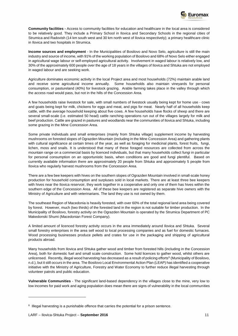
at the mine’s process plant site. The two OHL routes are shown in
Figure 2-7. The routes are mainly along or near existing roads (highways, forest roads etc.) and aim to
maximise distances from settlements.
The OHL component footprint will include land required for the OHL tower bases (an estimated 150 towers,
each requiring approximately 100m2 of land) and temporary access routes to the tower bases for construction
and maintenance, using existing paved or non-paved roads where possible. Right of way corridors of 70m
which will be cleared along sections of the OHL routes to be confirmed in subsequent discussions and detailed
in the RAP/LRP. While the OHL routes are not finalised, a conceptual route corridor has been prepared. A
wide area has been chosen for the corridor to allow for possible changes and avoidance of constraints such as
the terrain, sensitive biodiversity and cultural heritage..
Whilst roles and responsibilities for OHL land access have not yet been finally agreed with MEPSO, it is likely
that Euromax will finance, construct and manage land acquisition for the OHL and extended sub-stations,
possibly with assistance from MEPSO. Once commissioned, the new transmission lines would be handed over
to MEPSO for operation and maintenance. Respective land access roles for Euromax and MEPSO are still to
be agreed and will be presented in the OHL LRP.
Timetable for land access: The timeframe for land access for the OHL from the Sushica substation is flexible
within 2017, and for the OHL from Berovo Q1 2018.

LARF – Ilovica-Shtuka Project – September 2016 23
Design alternatives considered to minimise impacts: During the selection of the OHL routes, attention was paid
to accessibility, especially for the Angle Points / towers. Therefore, the locations of the Angle Points / towers
are mostly in the vicinity of existing roads (forest, access, local, regional roads and highways). Where possible,
towers are located on the edge of property lines to lessen disruption of cropping activities, or straddling property
lines to lessen the impact on each owner. This approach minimises land take impacts associated with access
to the OHL during construction and maintenance. The routes have been designed to maximise the distance
from populated areas, and the route of the OHL Ilovitsa–Berovo does not pass through populated areas, with
the exception of the approach to Berovo on the outskirts of the town (south-west, at a distance of 4 km). Details
on Ilovica-Sushica OHL will be included in LRP.
Land Ownership and Use: In terms of terrain, the Ilovica–Berovo OHL route falls into three categories:
mountainous, hilly and flat. The mountainous part of the route is dominated by high quality beech and pine
forests (mainly State owned), while low sparse forest appears in a small area. The hilly part of the route is
dominated by forest areas (State owned) and pastures and meadows (mainly privately owned) and a small
area is private farmland. The flat part of the route is dominated by privately owned croplands, orchards and
meadows, while non-arable land may be seen in a small part of this route. The Ilovica to Berovo OHL will pass
through different land uses as follows: Farmland 8.7 km; Pasture 4.3 km; Forest 9.7 km; Low forest (sparse
forest) 2.8 km; and Sward 1.6 km. The existing sub-stations at Berovo and Sushica, both on land already owned
by MEPSO, will be expanded.
Details on Ilovica-Sushica OHL ownership and use will be included in LRP. Further information on land owners
and users will be included in the LRP/LAP relating specifically to the OHL and will draw on consultations, socio-
economic surveys, census and cadastral work.
A number of cultural heritage sites are known in the vicinity of the proposed Ilovica sub-station; the OHL route
avoids these. An ongoing request for information has been made to the Museum in Strumica and the National
Conservation Centre and a review of constraints is underway. Additional checks will be made of known sites
along the remainder of the route, and appropriate baseline surveys will be carried out on the footprint of the
route.
Potential Displacement Impacts: No physical displacement is expected from land requirements for the OHL
lines, but some economic displacement is expected. Land acquisition will be permanent in the case of the land
for the tower bases (relatively small areas of approximately 100m2 per tower for an estimated 150 towers) and
some permanent acquisition may be necessary for access to the power line corridor. An easement/right of way
of some type will be established for the powerline route but the land beneath it will not be subject to permanent
acquisition. While the forested sections of the OHL corridor may be cleared of trees during construction, this
will most likely revert to second growth woodland and scrub once the line is in place. Sections of the corridor
which are grassland, pasture or arable land will be occupied on a temporary basis while the OHL is being built,
and will revert to original land use when the line is complete. Existing access roads and forest tracks will be
used where possible to avoid the need for new access tracks. Some land use restrictions and easements may
be required. Potential losses include the following:
Permanent loss of agricultural land at the tower bases and possible new sections of access tracks.
Permanent loss of forestry land at tower bases and possible new access roads (expected to be mainly
State owned, but potentially with some mixed State/private and some private land ownership).
Potential orphaning of land, for example, where a new OHL access track makes a portion of a larger land
plot impractical or economically non-viable plot for the land owner or user.
Temporary loss of access to land, during construction or maintenance.
Temporary difficulties during construction in accessing land for farming or other livelihood related land uses
and disturbance, e.g. to livestock.
Restrictions on land use via easements or wayleaves.
Permanent loss of trees at tower bases, new access roads and potentially along some sections of the OHL
route. Loss of annual or perennial crops (e.g. potatoes, maize, chillies, vegetables, cereals, tobacco).
Loss of sources of income and/or livelihoods associated with the above losses.
Potential impacts on cultural heritage.
LARF – Ilovica-Shtuka Project – September 2016 24
Figure 2-7 Proposed OHL Routes – top map shows northern half of map from Berovo south towards mine
site, bottom map shows southern half of map from Sushica to mine site.

LARF – Ilovica-Shtuka Project – September 2016 25

LARF – Ilovica-Shtuka Project – September 2016 26
2.4.4. Water Pipeline
Table 2-4 Summary of Land Requirements & Displacement Impacts for Water Pipeline
Project Component: Water Pipeline
Description of Water Pipeline: The technical water supply solution has not yet been identified and still subject
to on-going discussion with the Water Management Company (WMC) / Vodostopanstvo AD and technical
studies on various options. Both a shared pipeline solution using improved existing water supply infrastructure
and a possible dedicated pipeline are being evaluated.
The shared pipeline option which the WMC have indicated to Euromax a preference for involves the
reconstruction of the existing canal to a low pressure pipeline with shared use; a reconstruction option would
be unlikely to require any significant land acquisition.
The current indicative dedicated support option would probably involve a new water pipeline running
approximately 17 km mainly along the existing Turija canal (as close as technically feasible) from the Turija
reservoir to the mine site (and to the water treatment plant for local villages). The timeframe for land access
has not yet been defined but is needed by Q1 2018 and earlier if possible.
Full details of the water supply technical solution and land access will be provided in the future LRP relating
specifically to any new pipeline.
Whilst roles and responsibilities for construction and land access for any new water pipeline have not yet been
agreed with the WMC, it is likely that Euromax will finance any new pipeline. For a new pipeline option Euromax
would be responsible for securing land access and construction. If the WMC is responsible for land access then
Euromax will ensure that any approaches to compensation or assistance for displacement impacts are
consistent with those of LARF for the wider project by, for example, providing supplementary measures beyond
those provided by the WMC/Vodostopanstvo AD.
Timetable for land access: By Q1 2018, earlier if possible.
Land Ownership and Use: When the water supply solution and (if selected) pipeline route has been confirmed,
Euromax will undertake data gathering, potentially with the assistance of the WMC, to identify land owners and
users along any sections of land where access for the water pipeline is required. The roles and responsibilities
for land access are still subject to discussion and agreement with the WMC and will be presented in the
LRP/LAP.
Potential Displacement impacts: Since the water pipeline route has not yet been agreed, the displacement
impacts are not yet confirmed. However, it is expected that displacement impacts would be very limited.
Nevertheless, potential impacts include the following:
Permanent loss of agricultural land, including privately owned agricultural land and State owned land
leased to tenant farmers.
Orphaning of land, for example, where a new pipeline access road makes a portion of a larger land plot
impractical or economically non-viable plot for the land owner or user.
Temporary loss of land during pipeline construction or maintenance.
Temporary more difficult access during construction to land for farming or other livelihood related land uses
and disturbance, e.g. to livestock.
Restrictions on land use via easements or wayleaves.
Permanent loss of trees including vines and trees within orchards (e.g. plums, pear). Loss of annual or
perennial crops (e.g. potatoes, maize, chillies, vegetables, cereals, tobacco).
LARF – Ilovica-Shtuka Project – September 2016 27
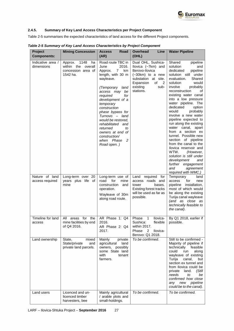
2.4.5. Summary of Key Land Access Characteristics per Project Component
Table 2-5 summarises the expected characteristics of land access for the different Project components.
Table 2-5 Summary of Key Land Access Characteristics by Project Component
Project
Components:
Mining Concession Access Road
(AR)
Overhead Line
(OHL)
Water Pipeline
Indicative area / dimensions
Approx. 1148 ha within the overall concession area of 1542 ha.
Road route TBC in June 2016. Approx. 7 km length, with 30 m wayleave.
(Temporary land access may be required for development of a temporary construction phase bypass for Turnovo – land would be restored, rehabilitated and returned to owners at end of construction/ when Phase 2 Road open. )
Dual OHL, Sushica-Ilovica (~7km) and Berovo-Ilovica (~30km) to a new substation at site. Expansion of 2 existing sub-stations.
Shared pipeline solution and dedicated pipeline solution still under evaluation. Shared solution would involve probably reconstruction of existing water canal into a low pressure water pipeline. The dedicated option would probably involve a new water pipeline expected to run along the existing water canal, apart from a section ex tunnel. Possible new section of pipeline from the canal to the Ilovica reservoir and WTW. (However, solution is still under development and further engagement and agreement required with WMC.)
Nature of land access required
Long-term over 20 years plus life of mine
Long-term use of road for mine construction and operation.
Wayleave of 30m along road route.
Land required for access roads and tower bases. Existing forest tracks will be used as far as possible.
Temporary land access for new pipeline installation, most of which would be along the existing Turija canal wayleave (and as close as technically feasible to the canal).
Timeline for land access
All areas for the mine facilities by end of Q4 2016.
AR Phase 1: Q4 2016.
AR Phase 2: Q4 2017.
Phase 1 Ilovica-Sushica: flexible within 2017.
Phase 2 Ilovica-Berovo: Q1 2018.
By Q1 2018, earlier if possible.
Land ownership State, mixed State/private and private land parcels.
Mainly private agricultural land owners, possibly some State land with tenant farmers.
To be confirmed. Still to be confirmed - Majority of pipeline if technically feasible could run along wayleave of existing Turija canal, but section ex tunnel and from Ilovica could be private land. (Still needs to be confirmed how close any new pipeline could be to the canal).
Land users Licenced and un-licenced timber harvesters, bee
Mainly agricultural / arable plots and small-holdings.
To be confirmed. To be confirmed.

LARF – Ilovica-Shtuka Project – September 2016 28
Project
Components:
Mining Concession Access Road
(AR)
Overhead Line
(OHL)
Water Pipeline
keepers and cattle graziers.
Assets present A few non-residential structures in Forest, e.g. informal livestock shelters, bee hives etc.
Possibility of a few non-residential agricultural structures being affected.
To be confirmed. To be confirmed.
Potential displacement impacts
Expected to be mainly economic displacement and no physical displacement, with a few non-residential structures affected in Forest (e.g. informal livestock shelters) and loss of access to forest resources. Impacts can be lessened by supporting access to similar natural resources nearby.
Expected economic displacement (permanent and temporary). No physical displacement expected.
Displacement impacts still to be confirmed but thought to be mainly temporary restrictions during construction or easements.
Limited long-term economic displacement. Physical displacement unlikely.
Displacement would largely be avoided since the new pipeline would follow as far as possible the existing canal corridor. But some impacts on stretches ex tunnel and near Ilovica which are to be confirmed.
Limited long-term economic displacement. Physical displacement unlikely.
3. LEGAL AND POLICY FRAMEWORK
Land acquisition and resettlement for the Project will follow the national legislative requirements of Macedonia as
well as applicable EBRD requirements. In line with national legislation and EBRD requirements, Euromax’s
preferred approach to land access and acquisition is via negotiated settlement – i.e. agreements between the willing
buyer and willing seller. Should the negotiated approach be unsuccessful, legally defined expropriation processes
established in the Macedonian Expropriation Law for Public Interest activities can be applied.
3.1. Macedonian Legal and Policy Framework
Requirements for land acquisition, compensation and resettlement for affected parties are covered under the key
law: the Expropriation Law7 ; and the Law on Obligations8 .
In addition, the Minerals Law9 and Concession Agreements10 between the State of Macedonia and Euromax contain
clauses relevant to the land acquisition approach.
7 Official Gazette of Republic of Macedonia (OGRM) Nos. 5/12, 131/12, 24/13, 27/14
8 OGRM Nos. 18/01, 78/01, 04/02, 59/02, 05/03, 84/08, 81/09, 161/09
9 OGRM Nos 136/2012, 25/2013, 93/2013, 44/2014, 160/2014, 129/2015, 192/2015, 39/2016, 53/2016
10 Concession Ilovica 6 - Decision for granting concession for exploitation of minerals – copper and gold on Ilovica no. 41-4681/1 from 16.06.2012 (published in the OGRM No.81/12). Concession agreement for exploitation of minerals Ref. No. 24-6749/1 from 24 July 2012 which was replaced with a new concession agreement for exploitation of minerals Ref. No.24-4563/1 from 23 September 2014 harmonized with the new Minerals law from 2012 (as amended with Annex to the Concession Agreement Ref. No. 24-4170/1 from 22 June 2015). Concession Ilovica 11- Decision for granting concession for exploitation of minerals – copper and gold on Ilovica no. 42-12537/1 from 29.12.2015 (published in the OGRM No.231/15). Concession agreement for exploitation of minerals Ref. No. 24-40/2 from 13 January 2016.

LARF – Ilovica-Shtuka Project – September 2016 29
3.1.1. Expropriation Law
Expropriation for Public Interest Activities: The Expropriation Law states that projects in the Public Interest are
able to make use of expropriation procedures as defined in that law. The Ilovica-Shtuka Gold/Copper Mining Project
in the Concession and its three other components (OHL/power line, Access Road and water pipeline) are all
classified as being of Public Interest, as defined by the following:
Expropriation Law article 6, paragraph 1, which states that “exploitation of mineral raw materials of strategic
importance for the Republic of Macedonia” is classified as in the Public Interest.
Expropriation Law article 6, paragraph 1, indent 1, includes construction of long-distance high voltage power
lines as Public Interest activities of importance for the Republic of Macedonia.
Expropriation Law article 7 includes construction of long distance power transmission lines as being of Public
Interest of local importance, as well as construction of local water supply systems and municipal roads.
In addition, the Minerals Law article 4, paragraph 3, states that exploration and exploitation of metallic minerals
(e.g. cooper and gold) are defined as activities in the Public Interest.
Accordingly, land expropriation procedures as set out in the Expropriation Law for realising activities in the Public
Interest, can be implemented for all four components of the Project should negotiated agreements be unsuccessful.
The Law covers permanent acquisition of land, as well as temporary occupation of land (relevant to construction)
and rights of easements (for periodic access for maintenance along the access road, OHL and water pipeline route).
Expropriation Procedure: The Expropriation Law (Part II) sets out the procedure for expropriation, as summarised
in Figure 3.1 below. If negotiated settlements are unsuccessful and expropriation is required for any of the Project
components, the first step would be to submit an Initiative to the Government of Macedonia, and once this is
accepted to then prepare the Proposal for Expropriation which draws on information from various studies. Once
the final Project design is completed Euromax will outsource the development of an Expropriation Study which will
contain a list of all the affected land, plots, registered assets (i.e. structures) and their owners, as recorded in the
Cadastre.
A land and assets inventory is then completed by certified evaluators from the Bureau for Assessment & Valuation
or other licenced agency. The inventory will provide basic information on affected land plots (i.e. total area and area
to be acquired, land use and land category) and all assets located on them (e.g. structures, crops, trees, orchards,
businesses etc.). Both assets that are registered in the Cadastre and those that are not will be recorded.
Figure 3-1 Summary of Expropriation Process
Proposal for Expropriation
The procedure for expropriation starts with a submission of a ‘Proposal for Expropriation’ to the ‘Expropriation
Authority’ (i.e. the relevant office in the affected municipality(s) of the Department for Property & Legal Issues
in the Ministry of Finance). The Proposal for Expropriation is initiated in this case by Euromax and is submitted
on behalf of the State by the State Attorney. The Proposal for Expropriation contains the following information:
The proposer of the expropriation;
The property for which expropriation is proposed;
The owner of the property and the holders of other property rights;
The type of facility of works for which the expropriation is proposed.
A set of accompanying documents have to be provided with the Proposal for Expropriation, including
information from the Expropriation Study, and land and assets inventory and proof of funds for compensation.
Notification of Affected Owners & Invitation to Hearing
Affected owners of properties are individually invited to a hearing and notified about the submission of the
Proposal for Expropriation and the proposed compensation amount. At this stage an amicable compensation
settlement can be reached and expropriation avoided.
Expropriation Decision
If an amicable settlement is not reached and the documentation submitted is in order, a final Expropriation
Decision can be passed by the Expropriation Authority, within 30 days of receiving the Proposal for
Expropriation. If there is no further (judicial) appeal (see below), the Expropriation Decision also becomes
legally binding.
Affected Owner Appeals

LARF – Ilovica-Shtuka Project – September 2016 30
Judicial Appeal(s)
An affected owner can choose to submit a judicial appeal to the relevant
administrative Court (including a second judicial appeal to the Higher
Administrative Court), after whose ruling the decision on expropriation becomes
legally binding. The Expropriation Law lists detailed deadlines for administrative
Courts to rule on submitted appeals and foresees penalties for not meeting
these deadlines.
Hearing on Expropriation Decision
When the Expropriation Decision becomes legally binding, another hearing must to be held by the Expropriation
Authority within 8 days to discuss and determine the level of compensation for each affected owner. In case
an agreement on the level of compensation is not reached, the case is referred to the Courts to decide, within
8 days of the meeting.
Payment of Compensation
The Proposer of Expropriation proceeds with the payment of compensation or provision of replacement
properties, within 30 days of the signing of a compensation agreement or the decision on compensation
becoming legally binding (for delays in payment, interest rates apply).
Compensation: The Expropriation Law article 18, paragraph 1 states that “Just compensation shall be payable for
the expropriated immovable property which cannot be lower than the market value”; and article 18, paragraph 2
states that the market value of the property shall be established by an authorised appraiser in accordance with the
Law of Appraisal.
An important feature of the Macedonian Expropriation Law is that it allows for compensation of structures built
informally (i.e. without a valid permit). Compensation for structures without a valid permit are set at the amount that
corresponds to their construction value, i.e. the market value of the materials and costs of labour, and excluding
depreciation.
3.1.2. Law on Obligations
Compensation: In some instances, issues related to provision of compensation for land and assets can also be
addressed through the implementation of the Law on Obligations. In principle, this law requires provision of compensation
in cash to formal legal owners of acquired land and assets (or those whose rights are recognisable under national laws),
or damages or losses incurred as a result of investors/contractors (or others) accessing land or preventing access to land
and/or assets. Compensation is provided after the damages and/or losses have already occurred. Cases, in which the
one causing the damage/losses and the affected person are not able to agree on the amount of compensation, are
referred to the Courts to decide. Project land acquisition will be implemented in accordance with the Obligations Law.
However, if negotiated settlement is not reached, compulsory expropriation may be implemented in accordance with the
Expropriation Law in cases where public interest is identified according the Law.
3.1.3. Minerals Law
As noted above, Article 4, paragraph 3 of the Minerals Law establishes that exploitation of copper and gold mineral exploitation is in the Public Interest, and therefore expropriation procedures established in the Expropriation Law can be applied.
Article 38 paragraph (3) of the Minerals Law gives Euromax rights over land in the Concession (State, private or
mixed ownership):
(3) The concession for exploitation of energy, metallic and techno-genic minerals shall be awarded for land
in ownership of the Republic of Macedonia and/or land in ownership of legal entities and/or natural persons
for which the entity requesting award of concession for exploitation initiates procedures for expropriation
under the conditions and in the manner determined in the Law on Expropriation.
Under Article 38 paragraph (6), where the concession area includes State land, Euromax would need to
register the right to use the land with the Cadastre.

LARF – Ilovica-Shtuka Project – September 2016 31
(6) Regarding the land in ownership of the Republic of Macedonia for which Concession for exploitation is
awarded, the concessionaire (i.e. Euromax) shall be obliged to submit a request for registering right of use
in the Real Estate Cadastre.
In respect to State land, the right of use of the land of Ilovica 6 Concession has been already registered with the
Cadastre; for the Ilovica 11 Concession, land is planned to be registered in the second half of 2016.
3.1.4. Urbanisation Process
In line with Macedonian legislation, such as the Law on Forests11 and the Law on Agricultural Land12, as well as the Law
on Spatial and Urban Planning and the Environmental Law, forestry and agricultural land (in State or private ownership)
can be converted into land for industrial use via the urbanisation process. This urbanisation process is being applied within
the Concession area (land acquisition area which includes the mine footprint) to convert forestry land into land for industrial
use. For the linear infrastructure (access road, OHL, water pipeline) the urbanisation process involves the conversion of
agricultural land into land for construction of infrastructure.
The urbanisation process for the mine footprint area is as follows:
To undertake construction activities on forestry or agricultural land (arable and pasture) outside of urban plan
areas, respective urban planning documentation needs to be prepared for the site and submitted for approval
to the authorities.
The existence of users/leasees of the agricultural or forestry land parcels is identified by the concessionaire by
requesting information from the Ministry of Agriculture, Forestry and Water Economy and the Public Enterprise
Pastures.
Where there are land users/leasees, their lease or land use contracts are terminated by law, upon formal
resolution by Ministry of Agriculture, Forestry and Water Economy. The concessionaire (eg. Euromax), is
obliged to compensate the lessee for the termination of the lease contract, with the value of compensation
determined by an independent authorised appraiser.
Conditions for Spatial Planning are issued by the Agency for Spatial Planning.
Planning program is approved by the Ministry of Transport and Communications (MoTC).
Forestry land is converted into construction land by a decision of the Ministry of Agriculture, Forestry and Water
Economy (MAFWE). Agricultural land is converted into land for the construction of infrastructure by a decision
of the Government of the Republic of Macedonia.
Public consultation is held on the State Urban Planning Documentation.
Ministry for Transport and Communications’ (MoTC)/Municipality authorities issue the approval and the area is
urbanized and converted into concession (construction) area.
Information on the new land user is updated via State Urbanistic Planning Documentation, which is submitted
to the ‘MoTC’/Municipality Commission for Urbanisation.
3.1.5. Concession Agreements
Article 4 paragraph (1) of the Concession Agreements between the State and Euromax establish that the
concessionaire (i.e. Euromax) has to play a role in securing land access in the Concession Area:
For the exploitation of mineral raw materials – subject of this agreement, the concessionaire is obliged to resolve
the issue of use of the land on which the exploitation of mineral raw materials will be performed, as subject of this
agreement.
11 Law on forests (Official Gazette of Republic of Macedonia no. 64/2009, 24/2011, 53/2011, 25/2013, 79/2013, 147/2013, 43/2014, 160/2014, 33/2015, 44/2015, 147/2015, 7/2016, 39/2016).
12 Law on agricultural land (Official Gazette of Republic of Macedonia no. 135/2007, 17/2008, 18/2011, 42/2011, 148/2011, 95/2012, 79/2013, 87/2013, 106/2013, 164/2013, 39/2014, 130/2014, 166/2014, 72/2015, 98/2015, 154/2015, 215/2015, 7/2016, 39/2016).

LARF – Ilovica-Shtuka Project – September 2016 32
Therefore, Euromax is obliged to play the lead role in acquiring land for Project use within the Concession Area.
The Concession Agreements do not contain any compulsory assistance from the State or Municipalities in terms of
land acquisition. However, in the case of the access road which is expected to be available for Project and public
use, some assistance in land acquisition may be provided by the Municipality of Bosilovo, with agreed roles to be
reflected in an agreement between Euromax and the Municipality.
3.1.6. Key Legal Framework/Social Assistance Options for Resettlement Assistance
The Expropriation Law focuses on the process of providing compensation for affected properties and assets, rather
than on addressing physical and economic displacement. As a result, solutions for addressing these impacts may
have to be sought through the use of various service providers.
Municipal Centres for Social Welfare may provide some assistance, under the Law on Social Welfare13. This law
enables provision of social welfare payments and services to vulnerable residents, as defined by the law. One of the
available social welfare payments under the law is a one-off financial payment for those who find themselves in a
situation of sudden and temporary need, including the need for accommodation. Assistance from social workers
can be used to address the needs of persons with disabilities, single headed households, households with low
incomes, etc. The Republic of Macedonia also has a set of laws under which affected people can be assisted to
improve their living standards (e.g. access to health care, education, personal documentation, social housing etc.)
and these laws can be used as a basis for developing resettlement/livelihood restoration programmes, particularly
for vulnerable groups.
Legal assistance can be provided to vulnerable people under the Law on Free Legal Assistance (OGRM Nos.
161/09, 185/11, 27/14) by lawyers from the Ministry for Justice and selected citizens’ associations.
3.2. EBRD Policy Framework (PR5 Land Acquisition, Involuntary Resettlement and Economic Displacement)
The Project has been screened as a Category A project under EBRD’s Environmental & Social Policy 2014.
The Project needs to meet the requirements of EBRD Environmental and Social Policy (2014) and Performance
Requirements (PRs), including PR5 on Land Acquisition, Involuntary Resettlement and Economic Displacement.
EBRD requirements pertaining to land acquisition and displacement, relevant for this Project can be summarised as
follows:
To avoid or, when unavoidable, minimise, involuntary resettlement by exploring alternative project designs;
measures to mitigate adverse impacts on displaced persons and host communities should be carefully planned
and implemented.
To mitigate adverse social and economic impacts from land acquisition or restrictions on affected persons’ use
of and access to land by: (i) Providing compensation for loss of assets at replacement cost, prior to taking
possession of acquired assets; and (ii) Ensuring that resettlement activities are implemented with appropriate
disclosure of information, consultation, and the informed participation of those affected.
To restore or, where possible, improve the livelihoods and standards of living of displaced persons, including
those who have no legally recognisable rights or claims to the land (present in the project affected area at the
time of the cut-off date), to pre-project levels and support them during the transition period.
To make special provisions for assisting disadvantaged or vulnerable individuals or groups (present in the project
affected area at the time of the cut-off date) that may be more adversely affected by displacement than others
and who may be limited in their ability to claim or take advantage of livelihood assistance and related
development benefits.
To establish a grievance mechanism to receive and address in a timely fashion specific concerns about
compensation and relocation that are raised by displaced persons, including a recourse mechanism designed
to resolve disputes in an impartial manner.
13 OGRM Nos. 79/09, 36/11, 51/11, 166/12, 15/13, 79/13, 164/13, 187/13, 38/14, 44/14, 116/14, 180/14, 33/15

LARF – Ilovica-Shtuka Project – September 2016 33
The above list is only a summary of the main EBRD PR 5: Land Acquisition, Involuntary Resettlement & Economic
Displacement (2014) requirements and the full text of the policy is at
http://www.ebrd.com/news/publications/policies/environmental-and-social-policy-esp.html.
In accordance with requirements of EBRD’s PR5 (para 10), Euromax will attempt to acquire land rights through
negotiated settlements even though the legal means to gain access to the land without the consent of the seller is
available. Negotiated settlements help avoid expropriation and can usually be achieved by providing fair and
appropriate compensation and other incentives or benefits to affected persons or communities.
This Land Acquisition & Resettlement Framework (LARF) has been developed in accordance with PR5, paragraph
22 which states that:
“A Resettlement and/or Livelihood Restoration Framework will be developed where the exact nature or magnitude
of the land acquisition or restrictions on land use related to a project with potential to cause physical and/or economic
displacement is unknown due to the project development stage. This framework will outline general principles,
procedures and entitlement framework consistent with this PR. Once the individual project components are defined
and the required information becomes available, the framework will serve as a basis for the development of a
detailed Resettlement Action Plan or Livelihood Restoration Plan (RAP) in accordance with paragraphs 26 to 29 [of
this PR].”
As noted above, since the Project may also seek finance from banks or other institutions which abide by the Equator
Principles, the Project will also be compliant with the International Finance Corporation’s (IFC) Performance
Standards on Environmental and Social Sustainability, notably PS5: Land Acquisition and Involuntary Resettlement.
PS5 requirements are broadly similar to those of EBRD PR5.
3.3. Gap Analysis
The key gaps between the national legislation of the Macedonia and EBRD’s PR5 relevant for this Project are
summarised below. This LARF (including the entitlements matrix and eligibility criteria) contains measures to
address these gaps through which Euromax will meet all the additional EBRD requirements:
Informal Land Rights: Macedonian law focuses on compensation for formal land rights, whereas EBRD also
covers compensation, livelihood restoration and consultation for people with no formal legal right or claim to land
they occupy. Euromax will recognise and compensate for formal and informal land rights.
Livelihood Restoration: EBRD PR5 includes requirements for livelihood restoration to restore incomes and
standards of living of displaced persons to pre-project levels (both for people with formal and informal land
title). Whilst Macedonian law requires compensation for lost profit / income of affected formal economic
activities resulting from displacement, this only applies to people with formal land rights. Neither does
Macedonian law require assistance for resettlement or alternative livelihood assistance such as training or
provision of favourable loans or employment opportunities. This gap will be address through Euromax support
for social programs in cooperation with the State Agency.
Participation and Consultation: EBRD PR5 sets greater requirements than Macedonian law for giving
affected parties the opportunity to take part in the negotiation of the compensation packages, eligibility
requirements, livelihood restoration and resettlement assistance.
Socio-Economic Surveys: Conducting socio-economic surveys to assess impacts on livelihoods is required
by EBRD, but not required by Macedonian law. Instead, Macedonian law focuses on the development of
expropriation studies which represent inventories of affected properties and involve basic census information
about registered owners of these properties (i.e. names, addresses, and ID numbers etc.) so that they can be
identified and compensated. Such reports do not generally apply to people with informal land rights or
unregistered land/assets. Euromax will ensure that informal land rights are reflected in the surveys.
Vulnerable Individuals & Groups: Macedonian law does not stipulate special measures relating to vulnerable
groups. EBRD, however, requires particular attention to be paid to vulnerable groups, including during
consultation, identification of entitlements and appropriate resettlement assistance.
Resettlement Action & Livelihood Restoration Frameworks & Plans: Macedonian law does not require
the preparation of resettlement action or livelihood restoration frameworks/plans. However, these are required

LARF – Ilovica-Shtuka Project – September 2016 34
for EBRD financed projects involving land acquisition and resettlement resulting in physical and/or economic
displacement.
Valuation of Expropriated Assets: EBRD states that compensation for loss of assets is calculated at full
replacement cost, i.e. market value of the assets plus transaction costs, and that depreciation of structures and
assets should not be taken into account. However, Macedonian law states that compensation is established
according to the market value of the material and the labour necessary for construction of facilities, decreased
by the relevant depreciation amount. Euromax commits to pay the difference between national and EBRD
requirements – this shall be reflected in the direct negotiations with the land owners as well as at the hearing
within the land acquisition procedure in front of the Expropriation Body for reaching settlement.
Grievance Mechanisms: Although Macedonian law establishes rights of affected citizens (those with
formal land rights) to appeal to Courts during the expropriation process, it does not require development of
specific grievance mechanisms. EBRD, however, requires grievance mechanisms to be set up as early as
possible in the process, to receive and address in a timely fashion specific concerns about compensation and
relocation that are raised by displaced persons, including a recourse mechanism designed to resolve disputes
in an impartial manner. A summary of complaints and the measures taken to resolve them should be made
public on a regular basis.
Access to Land/Property Prior to Payment of Compensation: There are several options for the Proposer
of Expropriation to acquire the right of accessing land/property prior to payment of compensation, under the
Expropriation Law and the Construction Law.
Cut-off Date for Affected Persons with No Legal Right or Claim to Land they Occupy/Use: Persons who
have no recognisable legal right or claim to the land they occupy and/or use are not recorded by a census and
survey; consequently, there is no cut-off date for determining eligibility for compensation for this affected group.
Monitoring & Evaluation: There are no requirements in Macedonian law for monitoring and evaluation of the
resettlement and the livelihood restoration process and outcomes.
3.4. Summary of Implications for the Project
In summary, implications of the legal and policy framework for the Project are as follows:
The Project’s approach to land acquisition will meet Macedonian legislative requirements and EBRD PR5
requirements. Where PR5 sets additional or higher requirements than national legislation (as set out in Section
3.3), the Project will ensure that these are met, including in the following areas:
Formal and informal land rights will be reflected in compensation, assistance, livelihood restoration and
consultation.
Affected land and assets will be valued at full replacement cost. Therefore, if any Government Agency
is involved in land acquisition, Euromax will provide resources to fill the gap relative to market value.
Compensation and assistance will be provided to mitigate impacts on livelihoods / economic
displacement.
Particular attention will be paid to vulnerable groups.
The Project’s preferred approach to land acquisition is via negotiated agreements with the land owners
and users. Affected parties will be given the opportunity to participate in the negotiation of the
compensation packages, eligibility requirements, livelihood restoration and assistance.
The Project will also look into the option of moving private shares of mixed State/private parcels into
separate State/private plots outside the Concession area.
Legislation allows the Project to adopt compulsory acquisition / expropriation of land. The Project will only use
these expropriation powers if the negotiated agreement approach is unsuccessful.
The legal basis of the approaches to land acquisition for different Project components are summarised below:

LARF – Ilovica-Shtuka Project – September 2016 35
For the Mine Land Acquisition Area in the Concession Area - Euromax will lead the land acquisition process
(in line with the Concession Agreements), using the negotiated approach with land owners and users, and only using expropriation procedures for Public Interest as set out in the Expropriation Law if negotiations are unsuccessful. As noted above, the Project will also look into the option of moving private shares of mixed State/private parcels into separate State/private plots outside the Concession area. It is expected that the State Forestry Company will provide assistance in the Concession Area including in the valuation of affected timber.
For the Access Road – whilst the design details of Access Road are subject to on-going discussion with the
Municipality of Bosilovo, because the road is essential to the Project’s public interest activity (exploitation of
mineral raw materials), expropriation for Public Interest will be available if negotiated settlement with land
owners and users is unsuccessful. On-going discussions will agree whether land acquisition is undertaken by
Euromax alone or with the assistance of the Municipality of Bosilovo; however, at this stage it is likely Euromax
will lead the land acquisition for the Access Road.
For the OHL – whilst subject to on-going discussion with MEPSO, it is expected that land acquisition
(permanent and rights of easement) required for the OHL will be led by Euromax using negotiated agreements,
and expropriation procedures established in the Expropriation Law if the negotiated approach proves
unsuccessful. Euromax will address any gaps that exist between standard Macedonian practices for
transmission lines and EBRD PR5 requirements for compensation and assistance.
For the water pipeline – land acquisition for the water pipeline is deemed to be in the Public Interest and
therefore expropriation powers will be available if negotiated agreement approach is unsuccessful. Euromax
may be responsible for securing land access with the assistance of the Water Management
Company/Vodostopanstvo AD, though respective roles are currently under discussion. Even if the WMC take
the lead, Euromax would be expected to address any gaps that exist between standard WMC practices and
EBRD PR5 requirements for compensation and assistance.
4. LARF OBJECTIVES, PRINCIPLES AND APPROACH
4.1. LARF Objectives
The objectives of the Land Acquisition & Resettlement Framework (LARF) are to implement a land acquisition
process which aims to:
Avoid or minimise involuntary resettlement, physical and economic displacement.
Consider feasible alternative project designs to avoid or at least minimise displacement impacts, while
balancing environmental, social and financial costs and benefits.
Mitigate adverse social and economic impacts resulting from land acquisition or restrictions on affected persons’
use of and access to land.
Provide compensation for loss of assets at full replacement cost.
Improve or, at a minimum, restore the livelihoods and standards of living of displaced persons to pre-project
levels.
4.2. LARF Principles
Key principles which underpin the LARF are set out below.
LARF Requirements: Resettlement and compensation of affected persons shall be carried out in accordance with
the applicable Macedonian legal framework and EBRD`s Environmental and Social Policy Performance
Requirement 5 (2014). In the case of inconsistency between national legislation and EBRD requirements, the
higher standards will be adopted. Both ‘physical displacement’ (the relocation or loss of shelter/housing resulting
from Project related land acquisition and/or restrictions on land use) and ‘economic displacement’ (the loss of assets
or resources, and/or loss of access to assets or resources that leads to loss of income sources or means of
livelihood) shall be taken into account and mitigated within the LARF.
Resettlement Action Plan (RAP) / Livelihood Restoration Plan (LRP)/Land Acquisition Plans (LAPs) for each
Project Component: Whilst the LARF provides the overarching framework for the Project’s approach to land
access and acquisition, specific RAP/LRP/LAPs will be prepared for the different Project components (depending

LARF – Ilovica-Shtuka Project – September 2016 36
on whether physical and/or economic displacement takes place). These will provide all the specific information
required to meet national legislative and EBRD PR5 requirements.
Consistency: Although it is possible that there will be some differences in land access approaches, roles and
responsibilities for different Project components, it will be important that there are consistent approaches in terms,
for example, valuation of assets, compensation and assistance across all Project components, irrespective of
whether they are led by Euromax or a Government Agency.
Negotiated Settlements: The Project’s preferred approach to acquiring land rights is via negotiated settlements
with land owners and users, even where there are legal means available for compulsory acquisition. Where
possible, negotiated settlements will be achieved by providing fair and appropriate compensation and other
incentives or benefits to affected persons. However, some compulsory acquisition or expropriation may also take
place, (this would be implemented in line with legislation and EBRD requirements), including if Government
Agencies have full or partial responsibility for land acquisition for specific Project components.
Working with Government Institutions: If a Government Agency plays a role in land acquisition for a particular
Project component (e.g. MEPSO, Municipalities or WMC), Euromax will liaise with the Agency to ensure that EBRD
PR5 requirements are met. If the Government Agency’s approach to land acquisition does not meet all
requirements of PR5, Euromax would potentially provide supplementary measures to fill these gaps with PR5.
Project Affected Persons: All owners, occupants/tenants and users of affected structures and land at the time of
the relevant cut-off date, whether with or without fully recognised legal rights or claim, are eligible for compensation
and assistance as specified in the Entitlements Matrix in the LARF. Entitlements of all categories of Project Affected
Persons (PAPs) will be established.
Socio-Economic Survey, Censuses and Inventories: The RAPs/LRPs/LAPs for different Project components will
be informed by additional socio-economic survey/census work and land & asset inventories to, for example, identify
all impacts, impacted persons and appropriate compensation and assistance measures. This will build on the work
undertaken to date. The date of the census/inventory shall be the cut-off date for eligibility for compensation and
assistance.
Valuation of Assets: Methods will be used to value affected assets or resources, or the access thereto, and
livelihood impacts, in line with national legislative and PR5 requirements involving authorised experts who are
independent qualified parties.
Compensation and Assistance Measures: Affected properties will be compensated in cash and relocation
assistance will also be provided where identified in the Entitlements Matrix. Although local land markets in the
vicinity of the Project are currently relatively inactive, it is understood that land would become readily available for
purchase if appropriate offers were made, which indicates that replacement land would be available. Cash
compensation rather than like-for-like compensation is therefore considered appropriate for this Project.
Compensation will be paid to the PAP prior to any relocation or access to land, as far as possible. Compensation
for all affected assets will be provided at full replacement cost. All compensation and livelihood restoration
assistance will be provided equally to men and women.
Livelihood Restoration: Livelihoods and standards of living of affected persons will be improved or at least
restored to the level prior to project related displacement, in as short a period as possible.
Construction Impacts: Short-term impacts related to temporary occupation of land for construction purposes and
loss of and/or disruption to access may also trigger compensation or other assistance to affected persons.
Construction related activities will be organised in a way that avoids and minimises economic displacement, i.e. by
ensuring access is maintained to agricultural land and effects during key planting and harvest periods are carefully
managed.
Vulnerable Groups/Individuals: Specific assistance will be provided to vulnerable groups/individuals identified
through consultations and socio economic surveys. Specific stakeholder engagement activities will be targeted
towards vulnerable and potentially marginalised groups.
Absent/Unknown/Deceased PAPs: A mechanism will be established to provide compensation to persons with
recognisable rights to land and property where owners are unknown and/or deceased, including the potential use
of escrow accounts.

LARF – Ilovica-Shtuka Project – September 2016 37
Consultation, Participation and Disclosure: Affected persons and communities (including vulnerable groups and
individuals) will be consulted to facilitate their early and informed participation in decision-making processes related
to resettlement, eligibility, compensation and assistance and ensure that acquisition and compensation activities
are implemented with appropriate disclosure of information and consultation. This shall be carried out in line with the
provisions contained within the SEP and allow for targeted consultation with vulnerable and potentially marginalised
groups.
Grievance Management: A grievance management mechanism will be established for the Project by Euromax
(and the Contractor(s)). It is assumed that these parties will work together to ensure the appropriate party deals
with land acquisition and resettlement related grievances.
Monitoring & Record Keeping: Euromax will establish appropriate procedures to monitor and evaluate their
responsibilities in the implementation of the LARF and the RAP/LRP/LAPs, and corrective actions will be taken as
necessary. All transactions to acquire land rights, as well as compensation measures, relocation activities and
resettlement assistance will be documented. A Euromax Land Acquisition and Resettlement (LAR) Team will be
established and part of their remit will be to support the preparation of the RAP/LRP/LAPs and monitor
implementation of relevant provisions of the LARF and RAP/LRP/LAPs.
5. ELIGIBILITY AND ENTITLEMENTS
This Section of the LARF sets out the entitlements for each type of displacement impact and eligibility criteria for
affected persons to receive compensation and assistance. It addresses the following questions:
Who will eligible to receive compensation and assistance? (see Section 5.1).
To what kinds of compensation and assistance will they be entitled for each type of loss? (see Sections 5.2
and 5.3).
How will the entitlements and needs of vulnerable groups be ensured during land acquisition? (see Section
5.4).
How will losses be measured and valued? (see Section 5.5).
5.1. Eligibility Criteria and Categories
All individuals / households occupying or using project affected land, who are affected by physical and/or economic
displacement, recorded in the surveys and census (owners and users, both formal and informal) are entitled to
compensation and/or livelihood restoration or other assistance as outlined in the Entitlements Matrices for the
different Project components. Based on community consultations and research done to date, the following potential
categories of Project Affected Persons (PAPs) have been identified:
Owners of land (formal with legal rights or claims over the land), including State and private owners.
Formal users of land (e.g. a tenant with formal legal right over the land they occupy/use or a permit to collect
wood or fungi).
Forestry management companies which manage State owned forestry land on behalf of the State.
Informal / unlicensed users of land such as graziers, bee keepers and mushroom collectors (with no formal legal
rights or claims over the land they use – this may also refer to areas of State land (or other land) which has
been used on a customary or long-term basis but right of use not registered).
Owners of crops and trees (including vines and trees in orchards).
Owners of non-residential structures/assets and infrastructure.
Owners of businesses (formal or informal business/economic activity).
Owners of business structures/assets.

LARF – Ilovica-Shtuka Project – September 2016 38
Local community and individuals/households affected by loss of access and/or disruption of access.
Local community and individuals/households affected by loss of access and/or disruption of access which may
potentially cause significant effects on livelihood, that due to their vulnerability and/or livelihood dependency
on these activities may cause a disproportionate affect.
5.1.1. Affected persons with formal legal rights and claims to land recognisable under national law
Persons with formal legal rights are recorded in the Cadastre and this information will be updated in accordance
with national legislation when the expropriation processes are initiated. Examples of persons with a claim that is
recognised or recognisable under national legislation include heirs of deceased owners, and persons who
purchased properties with a valid sale purchase contract, however did not transfer property rights to their name in
the Cadastre.
5.1.2. Affected persons with no formal legal rights to the land they occupy, at the time of the census
Persons with no legal rights or claims to the land they occupy (informal users) will be recorded at the time of the
socio-economic survey and census. The date of the survey will generally be the cut-off date for eligibility for
compensation and assistance, meaning that any individuals / households that use or occupy Project affected land
(without legal rights or claims) after this date will not be entitled to compensation and/or livelihood restoration
assistance. Examples of persons with no legal rights or claims include persons who have constructed barns or small
summer residences on public land or those that are farming public land or even private land, without the knowledge
and/or approval of the owner. Such persons will not be entitled to compensation for land, as they do not own it,
however they will be entitled to compensation for assets which they own, for example, the replacement value of
structures, crops, trees, etc. Where possible, alternative land will be made available through discussions with other
users of the land and the Forestry Company in the Concession area.
5.2. Entitlements / Compensation Framework
The Entitlements Framework for the four Project components are presented in Tables 5.1 and Table 5.2 below,
which show the planned compensation and assistance that Project affected persons will be entitled to for the
different types of loss associated with physical or economic displacement resulting from the Project.
It should be noted that some of the losses included in these framework matrices may not exist once the Project
design details and routes have been confirmed.
The specific RAPs or LRPs (or LAPs) for the individual Project components will contain more precise entitlement
matrices based on the confirmed routes and forthcoming census surveys and asset inventories to identify affected
persons and assets.
The options for compensation (e.g. in-kind or cash compensation) and proposed entitlements will be discussed and
agreed with representatives of affected communities and stakeholders during consultation in advance of the land
acquisition. However, given the expected availability of land for purchase in the Project vicinity, Euromax propose
generally to offer cash compensation for loss of land. If requested and needed by Project Affected Persons (PAPS)
Euromax will provide support to them in identifying and acquiring replacement land.
Euromax understands from initial investigations that whilst there may be available land in the area (e.g. including
arable land which is currently abandoned), there is not a fully active land market. Therefore, Euromax will carry out
further investigations into the land market and this will help them to assist affected people in identifying and acquiring
replacement land if required.

LARF – Ilovica-Shtuka Project – September 2016 39
Table 5-1 Planned Entitlements Framework for the Mine Concession Area
Type of Loss/Impact: Category of Project Affected Persons: Entitlements / Mitigation – Compensation and Assistance
Permanent loss of land in Mine Concession Area:
Permanent loss of land in private ownership Owners of land (formal with legal rights or
claims over the land14) – private, State or
mixed.
Cash compensation at full replacement cost; or (if requested by PAP)
replacement land of similar value and characteristics where available; and
relocation assistance if required.
Permanent loss of land in State ownership When State owned land is acquired, Euromax will pay annual land leases,
based on values established by registered valuer’s, due from the time of
construction start.
Some parts of the Concession Area not converted to industrial use (i.e. that outside the Mine Land Acquisition Area and mine facilities footprint) will remain as forest and some may potentially be managed by the Forestry Company under a management agreement.
Permanent loss of land in mixed State/Private ownership
Two parallel processes are planned:
1) Acquisition of private portions of mixed State/private parcels via a proposed
one-off payment made to the private owner to purchase the land, at full
replacement cost based on the registered valuer’s valuation of the parcel and
the proportion of the parcel owned by the private owner. The State would be
paid an annual lease based on the registered valuer’s land valuation and the
proportion of the parcel owned by the State.
2) Sub-division of State and Private land into separate parcels, with the aim of
having the ‘private parcels or mixed State/private parcels’ outside the areas to
be urbanised within the Concession thereby potentially avoiding the need to
acquire land from the private owner.
Temporary loss of land in Mine Concession Area during construction:
Temporary loss of land in private ownership Owners of land (formal with legal rights or
claims over the land15) – private, State or
mixed.
Cash compensation at full replacement cost for the right to use land under contract/agreement for an agreed period; and reinstatement of land after use.
OR provision of temporary access to similar land outside the Concession, implemented in liaison with the Forestry Company.
14 Owners with a claim without full legal documentation will be assisted to obtain and prepare necessary documentation to support valid claims (e.g. those where inheritance process needs to be completed).
15 See footnote Error! Bookmark not defined..

LARF – Ilovica-Shtuka Project – September 2016 40
Type of Loss/Impact: Category of Project Affected Persons: Entitlements / Mitigation – Compensation and Assistance
Temporary loss of land in State ownership Cash compensation paid to the State at full replacement cost for the right to use land under contract/agreement for an agreed period; and reinstatement of land
after Project use.
Temporary loss of land in mixed State/Private ownership
For private part owner and State owner: Cash compensation at full replacement
cost for the right to use land under contract/agreement for an agreed period;
and reinstatement of land after use; and reinstatement of land after Project use.
OR provision of temporary access to similar land outside the Concession,
implemented in liaison with the Forestry Company.
Orphaned land - i.e. part of an affected land plot which
remains after land acquisition and for which the owner has
no more economic interest in using and/or is an
economically unviable plot. [Note: This is unlikely to arise
in the Concession Area].
Owners of land (formal with legal rights or
claims over the land16)
If a request of the affected owner of land has been made in accordance with the
Expropriation Law (Article 20) and has been declared as being justified based
on the expert valuation report: Cash compensation at full replacement cost.
Loss of trees, crops or perennial plants:
Permanent loss of trees in Concession Area Owner17 of trees – Forest company,
mixed State/private owners.
Cash compensation for trees based on State compensation rates or the
algorithm developed and agreed with the Forest company during the exploration
phase (e.g. taking into account the size and species of tree).
Permanent loss of crops or perennial plants in Concession Area
OwnerError! Bookmark not defined. of crops or
erennial plants
Cash compensation for standing crops at full replacement cost, including the
cost of forfeited economic benefits, for crops at agreed rates set by registered
valuer.
Loss of non-residential structures:
Permanent loss of livestock enclosures (formal with documentation and informal without documentation).
OwnerError! Bookmark not defined. of enclosure Cash compensation at full replacement value for establishing a similar
enclosure elsewhere; assistance in finding an alternative location; plus
relocation assistance if required.
16 See footnote Error! Bookmark not defined..
17 Affected PAPs with or without legal documentation.

LARF – Ilovica-Shtuka Project – September 2016 41
Type of Loss/Impact: Category of Project Affected Persons: Entitlements / Mitigation – Compensation and Assistance
Permanent loss of bee hives OwnerError! Bookmark not defined. of bee hives
n or proximate to Concession land, plus
other bee hive owners within the same
bee hive network who also need to
relocate.
Assistance in finding an alternative suitable location for bee hives and
associated structures (away from potential noise and vibration disturbance and
with bee foraging habitat).
Assistance in relocating hives and associated structures to alternative suitable
location. (Hive relocation would be done in the appropriate season, e.g.
October).
Cash compensation at full replacement cost for hives and associated structures
which cannot be relocated.
Permanent loss of livestock water points OwnerError! Bookmark not defined. of water
oints
Cash compensation at full replacement value for establishing a similar water
point elsewhere; assistance in finding an alternative location; plus relocation
assistance if required.
Permanent loss of access to land and natural resources:
Loss of access to land and vegetation in forests / hill slopes for bee keepers – including:
bee keepers with a licence to have hives within the concession area;
Bee keepers with hives in or near the
concession area
Cash compensation at full replacement cost of hives and associated structures
which cannot be relocated, or assistance in relocating hives and associated
structures; assistance in finding an alternative suitable location. Hive relocation
would be done in the appropriate season (e.g. October).
bee keepers who do not have licenses for hives within the concession area but who are members of bee keeping ‘networks’ in which other members are licensed to have hives within the concession area.
Bee keepers in same hive networks as the
above bee keepers
Cash compensation at full replacement cost of hives and associated structures
which cannot be relocated, or assistance in relocating hives and associated
structures; assistance in finding an alternative suitable location. Hive relocation
would be done in the appropriate season (e.g. October).
Loss of access to forests for livestock graziers, including:
Unhefted cattle (licensed or unlicensed graziers)
Cattle owner. Assistance in identifying a suitable alternative location with cattle grazing and
water supply, and relocation assistance – subject to approval from the Forestry
Company. Advice will be sought from relevant professionals.
Option of cash compensation equivalent to full replacement value of cattle.
Possible additional assistance to unlicensed graziers in obtaining grazing
licenses (tbc with Forestry Company).
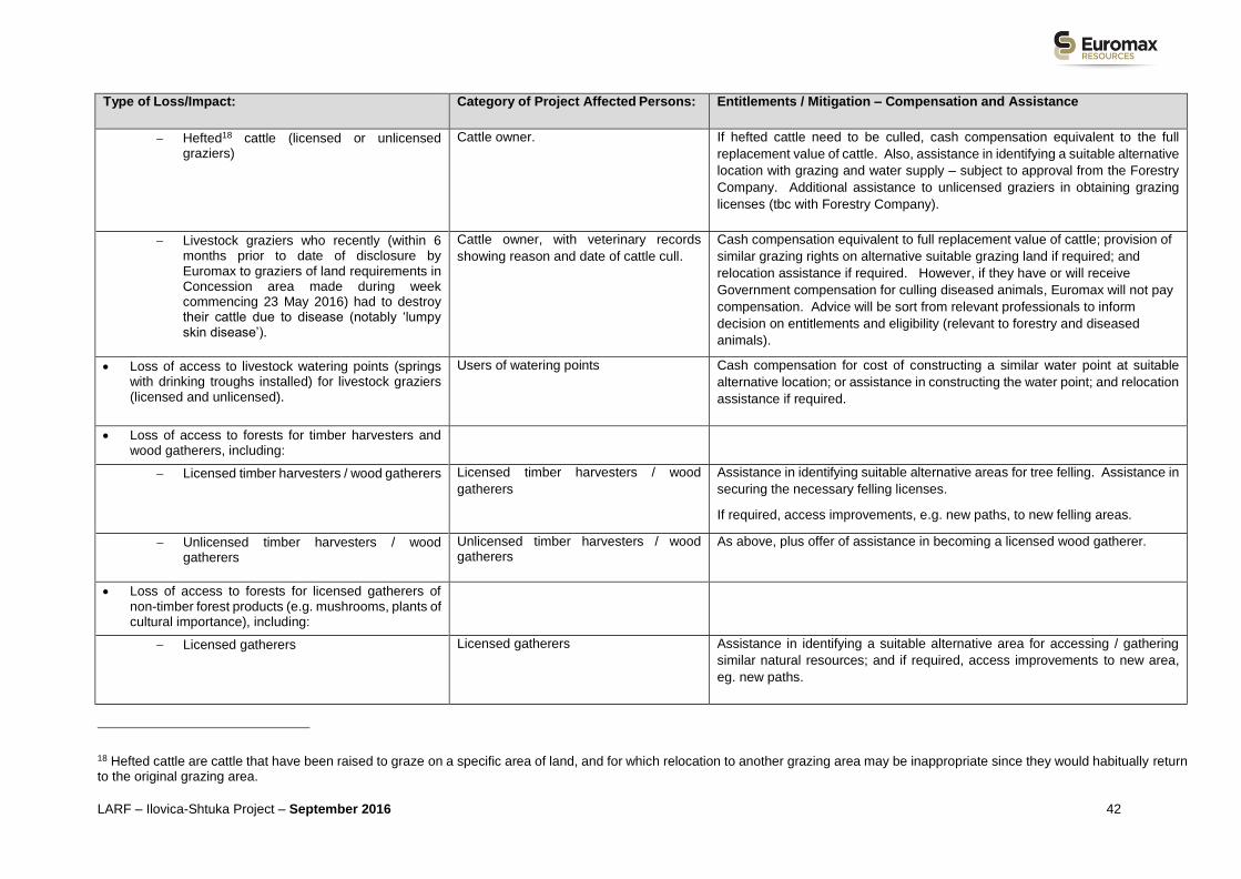
LARF – Ilovica-Shtuka Project – September 2016 42
Type of Loss/Impact: Category of Project Affected Persons: Entitlements / Mitigation – Compensation and Assistance
Hefted18 cattle (licensed or unlicensed graziers)
Cattle owner. If hefted cattle need to be culled, cash compensation equivalent to the full
replacement value of cattle. Also, assistance in identifying a suitable alternative
location with grazing and water supply – subject to approval from the Forestry
Company. Additional assistance to unlicensed graziers in obtaining grazing
licenses (tbc with Forestry Company).
Livestock graziers who recently (within 6 months prior to date of disclosure by Euromax to graziers of land requirements in Concession area made during week commencing 23 May 2016) had to destroy their cattle due to disease (notably ‘lumpy skin disease’).
Cattle owner, with veterinary records
showing reason and date of cattle cull.
Cash compensation equivalent to full replacement value of cattle; provision of
similar grazing rights on alternative suitable grazing land if required; and
relocation assistance if required. However, if they have or will receive
Government compensation for culling diseased animals, Euromax will not pay
compensation. Advice will be sort from relevant professionals to inform
decision on entitlements and eligibility (relevant to forestry and diseased
animals).
Loss of access to livestock watering points (springs with drinking troughs installed) for livestock graziers (licensed and unlicensed).
Users of watering points Cash compensation for cost of constructing a similar water point at suitable
alternative location; or assistance in constructing the water point; and relocation
assistance if required.
Loss of access to forests for timber harvesters and wood gatherers, including:
Licensed timber harvesters / wood gatherers Licensed timber harvesters / wood
gatherers
Assistance in identifying suitable alternative areas for tree felling. Assistance in
securing the necessary felling licenses.
If required, access improvements, e.g. new paths, to new felling areas.
Unlicensed timber harvesters / wood gatherers
Unlicensed timber harvesters / wood gatherers
As above, plus offer of assistance in becoming a licensed wood gatherer.
Loss of access to forests for licensed gatherers of non-timber forest products (e.g. mushrooms, plants of cultural importance), including:
Licensed gatherers Licensed gatherers Assistance in identifying a suitable alternative area for accessing / gathering
similar natural resources; and if required, access improvements to new area,
eg. new paths.
18 Hefted cattle are cattle that have been raised to graze on a specific area of land, and for which relocation to another grazing area may be inappropriate since they would habitually return to the original grazing area.

LARF – Ilovica-Shtuka Project – September 2016 43
Type of Loss/Impact: Category of Project Affected Persons: Entitlements / Mitigation – Compensation and Assistance
Unlicensed gatherers Unlicensed gatherers As above, plus offer of assistance in becoming a licensed gatherer with Forestry
authority/company. EOX involvement in a translocation programme for Bigroot
Cranesbill.
More difficult or more remote access to natural
resources, e.g. for mushroom collectors, cattle graziers
and wood collectors, which may result from alternative
sites being less accessible or further from the villages.
Users of land for accessing natural
resources.
Assistance in identifying alternative area for accessing / gathering similar
natural resources; and if required, access improvements to new area, e.g. new
paths.
Loss of income / sources of livelihood:
Loss of sources of income and/or livelihoods
associated with any of the above losses.
Owners or users of land (licensed and
unlicensed) whose income or livelihood is
affected by Project land access.
Cash compensation for lost net income during the period of transition (until the
re- establishment of income level/livelihood activities19) and livelihood
restoration assistance.
Loss of cultural assets:
Potential impacts on cultural heritage assets
Individual or community owners and users
of cultural heritage
Appropriate measures will be agreed based on the nature of the cultural heritage
asset – e.g. potential relocation, blessing, relocation costs, assistance in
identifying and improving access to suitable alternative locations.
Losses / impacts on vulnerable groups:
Any other specific losses / impacts on vulnerable
groups, associated with land acquisition for the
Project, identified during the development of the LRP.
Identified vulnerable groups in line with
EBRD definitions.
Special measures for effective participation, compensation, assistance and
livelihood restoration, to be defined in the LRP.
19 Annual incomes from certain livelihood activities based on the preceding 3 years will be gathered (as far as possible) during the Socio-Economic surveys and used as one metric for determining lost net income. Effects on harvest periods will be given specific consideration in determining entitlement.

LARF – Ilovica-Shtuka Project – September 2016 44
Table 5-2 Planned Entitlements Framework for the Project Access Road, OHL and Water Pipeline.
Note: Specific Entitlement Frameworks for the Access Road, OHL and Water Pipeline will be included in the LRP or LAP for individual Project Components. Some losses may not apply to
all of these Project components.
Type of Loss/Impact: Category of Project Affected Persons: Entitlements / Mitigation – Compensation and Assistance
Permanent loss of land:
Permanent loss of agricultural land (crop, grazing and fallow land) in private ownership
Owner of land (formal with legal rights or
claims over the landError! Bookmark not defined.).
Cash compensation at full replacement cost; or replacement land of similar
value and characteristics where available; and relocation assistance if required.
When State owned land is acquired, Euromax will pay annual land leases,
based on values established by registered valuers, due from the time of
construction start.
Permanent loss of agricultural land (crop, grazing and fallow land) leased to tenant farmers
Land tenants (formal with legal tenancy
rights or claims over the land)
Information about the acquisition of land at least three months in advance of
using the land for the project to enable tenant to find other land for lease. Plus,
relocation assistance.
If during socio-economic survey specific vulnerabilities of formal tenants are
identified, then support will be sort from the Municipalities to find alternative land
to lease formally and provide access to available support services.
Permanent loss of agricultural land (crop, grazing and fallow land) affecting informal land users.
Informal land users (without formal
ownership or tenancy) of State or privately
owned land.
Information about the acquisition of land at least three months in advance of
using the land for the project to enable informal land user to find other land to
use. Plus, relocation assistance.
Plus, offer of assistance in becoming a formal tenant of similar land.
If during socio-economic survey specific vulnerabilities of formal tenants are
identified, then support will be sort from the Municipalities to find alternative land
to lease formally and provide access to available support services.
Temporary loss of land or restrictions on use of land (e.g.
laydown areas during construction):
Temporary loss of agricultural land in private ownership.
Owner of untenanted land (formal with
legal rights or claims over the landError!
ookmark not defined.).
Cash compensation at full replacement cost for the right to use land under
contract/agreement for an agreed period; and reinstatement of land after use.

LARF – Ilovica-Shtuka Project – September 2016 45
Type of Loss/Impact: Category of Project Affected Persons: Entitlements / Mitigation – Compensation and Assistance
Temporary loss of agricultural land leased to tenant farmers.
Land tenants (formal with legal tenancy
rights or tenancy claims over the land)
Cash compensation at full replacement cost for the right to use land under
contract/agreement for an agreed period; and reinstatement of land after use.
Temporary loss of agricultural land used by informal land users.
Informal land users of State or privately
owned land.
Information about the acquisition of land at least three months in advance of
using the land for the project to enable informal land user to find other land to
use. Plus, relocation assistance.
Plus, offer of assistance in becoming a formal tenant of similar land.
Restrictions on access to or use of land due to wayleaves / easements
Owner of landError! Bookmark not defined.. Cash compensation based on registered valuer’s assessment of wayleave /
easement value.
Orphaned land - Part of an affected land plot which
remains after land acquisition and for which the owner has
no more economic interest in using and/or is an
economically unviable plot.
Owner of land (formal with legal rights or
claims over the landError! Bookmark not defined.)
If a request of the affected owner of land has been made in accordance with the
Expropriation Law (Article 20) and has been declared as being justified based
on the expert valuation report: Cash compensation at full replacement cost.
Loss of trees and crops:
Permanent loss of trees – vines, fruit trees Owner20 trees Cash compensation for lost or damaged trees at full replacement cost, based
on registered valuer’s assessment.
Loss of annual or perennial crops (e.g. potatoes,
maize, chillies, vegetables, cereals, tobacco)
OwnerError! Bookmark not defined. of crops Cash compensation for lost or damaged annual / perennial crops / plants at full
replacement cost, based on registered valuer’s assessment.
Loss of residential buildings / dwellings: Loss of
residential buildings (formal with documentation and
informal without documentation). – houses, ancillary
buildings, outdoor toilets, etc. (This loss is considered to
be unlikely but included for completeness if during the
subsequent land acquisition studies, it is identified.)
OwnerError! Bookmark not defined. of building /
welling
Cash compensation at full replacement cost of building. Assistance in finding
an alternative building and plus relocation assistance if required.
20 Affected PAPs with or without legal documentation.

LARF – Ilovica-Shtuka Project – September 2016 46
Type of Loss/Impact: Category of Project Affected Persons: Entitlements / Mitigation – Compensation and Assistance
Loss of structures (non-residential): Loss of non-
domestic structures, such as sheds, animal shelters,
fences, poly-tunnels, irrigation systems etc. (formal with
documentation and informal without documentation).
OwnerError! Bookmark not defined. of structure Cash compensation at full replacement cost of the structure. Assistance in
finding an alternative building and plus relocation assistance if required.
Loss of business / assets – e.g. Premises
(This loss is considered to be very unlikely but included for
completeness if during the subsequent land acquisition
studies, it is identified.)
OwnerError! Bookmark not defined. of
uilding/assets
Cash compensation at full replacement cost of building/ assets. Assistance in
finding an alternative building and plus relocation assistance if required.
Temporary loss of and/or more difficult access to
commercial facilities or for businesses.
Owner of facility or business. Cash compensation equivalent to the cost of using a similar alternative facility
or building nearby based on registered valuer’s assessment. Assistance in
finding an alternative facility and relocation assistance if required.
Loss of community infrastructure and facilities – e.g.
electricity lines, irrigation schemes, roads, pathways,
community buildings.
(This loss is considered to be very unlikely but included for
completeness if during the subsequent land acquisition
studies, it is identified.)
Affected community/Owner of
infrastructure or facility
Cash compensation at full replacement cost of infrastructure or facility.
Where appropriate, assistance will be provided for relocating infrastructure (e.g.
re-routing of pathways).
More difficult access to community infrastructure and
facilities – e.g. road network, pathways, irrigation
schemes.
Local community and individuals /
households affected by loss of access
and/or disruption on access.
No permanent difficulties with access are anticipated therefore at this stage no
additional entitlements for compensation are proposed assuming the following
mitigation measure is met as part of the Project design:
Mitigation Incorporated into Design: Avoidance of impacts through the creation
of local access points for fields and local roads for movement of people and
animals, as discussed with local community during consultations and other
measures agreed with local communities.

LARF – Ilovica-Shtuka Project – September 2016 47
Type of Loss/Impact: Category of Project Affected Persons: Entitlements / Mitigation – Compensation and Assistance
Loss of income / sources of livelihood: Loss of sources
of income and/or livelihoods associated with any of the
above losses.
Owners or users of land or assets
(licensed and unlicensed) whose income
or livelihood is affected by Project land
access.
Cash compensation for lost net income during the period of transition (until the
re-establishment of income level/livelihood activities21) and livelihood
restoration assistance.
Loss of cultural assets: Impacts on cultural heritage
assets [to be avoided wherever possible]
Individual or community owners and users
of cultural heritage
Appropriate measures will be agreed based on the nature of the cultural heritage
asset – e.g. potential relocation, blessing, relocation costs, assistance in
identifying and improving access to suitable alternative locations.
Losses / impacts on vulnerable groups:
Any other specific losses / impacts on vulnerable
groups, associated with land acquisition for the
Project, identified during the development of the
LRP.
Identified vulnerable groups in line with
EBRD definitions.
Special measures for effective participation, compensation, assistance and
livelihood restoration, to be defined in the LRP.
21 Annual incomes from certain livelihood activities based on the preceding 3 years will be gathered (as far as possible) during the Socio-Economic surveys and used as one metric for determining lost net income. Effects on harvest periods will be given specific consideration in determining entitlement.

LARF – Ilovica-Shtuka Project – September 2016 48
5.3. Livelihood Assistance and Restoration
In case the implementation of the Project and loss of land and other assets or access to assets, leads to loss of
income sources or means of livelihood (economic displacement) of PAPs, alongside compensation for affected land
and assets, Euromax will implement livelihood restoration measures which will be defined in greater detail in the
individual component RAP, LRP or LAPs. Such measures may include:
Access to employment opportunities created by the Project (e.g. during construction).22
Compensation for the cost of re-establishing business activities elsewhere.
Assistance to identify and access other income/livelihood generation activities.
Assistance to access training, skill development, job opportunities, agricultural development support etc.
Compensation for, or assistance to transport equipment or machinery.
Livelihood restoration assistance will be provided to those identified as needing it during the socio-economic survey.
Euromax will cooperate with institutions and organisations that can provide this assistance, such as the
Municipalities for Bosilovo and Novo Selo, agricultural development agencies operating in the area (e.g. Agency for
Promotion of Agricultural Development) and local service providers.
In detailing the assistance measures for agricultural livelihood restoration the findings of the socio-economic surveys
and engagement with institutions and organisations will be considered. Other considerations in identifying measures
will be given to State subsidies for farming land, identifying improvements which could help affected PAPs increase
their yield and income on all land (e.g. irrigation, training for increasing their yield and production, training of other
members of a household who are not engaged in agriculture etc.). The RAP/LRP/LAPs will focus on identifying
livelihood assistance measures that will be sustainable and keep bringing benefits in so they can help improve
livelihoods, rather than a one-off Project compensation payment.
5.4. Support to Vulnerable Households
The EBRD Environmental and Social Policy (2014) defines vulnerable groups as:
“those who, by virtue of gender identity, sexual orientation, religion, ethnicity, indigenous status, age, disability,
economic disadvantage or social status may be more adversely affected by project impacts than others and who
may be limited in their ability to claim or take advantage of project benefits. Vulnerable individuals and/or groups
may also include, but not be limited to, people living below the poverty line, the landless, the elderly, women and
children-headed households, refugees, internally displaced people, ethnic minorities, natural resource dependent
communities or other displaced persons who may not be protected through national legislation and/or international
law”.
Euromax will use community consultations and the socio-economic surveys during land acquisition processes to
identify any vulnerable persons or groups. Euromax will take necessary actions to ensure that vulnerable groups
are not disadvantaged in the land acquisition process, are fully informed and aware of their rights, are able to be
effectively involved and are able to benefit from the assistance opportunities and benefits.
Where State bodies have a lead role to play in land acquisition for specific Project components (e.g. MEPSO for
the OHL), Euromax will work closely with these bodies to integrate measures into land acquisition processes to
ensure that vulnerable groups are not disadvantaged.
Some individuals or groups will be considered more vulnerable than the majority of the affected population and, if
affected by the Project, will require the implementation of special livelihood restoration and/or assistance measures.
Such groups might include:
Informal users of affected land who have no or limited sources of income or assets of their own.
22 However, under the Macedonian legal framework for employment, labour preference cannot be given to the local PAPs/communities.

LARF – Ilovica-Shtuka Project – September 2016 49
People who depend on the affected land for incomes/livelihoods and it is the only land they own or use.
Persons who will be affected by economic displacement, whose socio economic status is low, for example
beneficiaries of social welfare.
Illiterate persons who may have difficulties accessing information about the Project and land acquisition or
understanding contracts and other important documents, etc.
Specific measures to assist any vulnerable groups identified through the socio-economic surveys will be defined in
accordance with their needs. For example, certain groups may need legal or other assistance to restore their
livelihoods, such as assistance to improve their businesses; some vulnerable households may need additional
services from social workers, etc.
5.5. Valuation
Valuation of land and assets will be conducted by certified valuers, including those from the Bureau for Assessment
and Valuation in accordance with the Law of Property Valuation. Both formal (registered) and informal assets will
be valued. In line with EBRD PR5, valuation of assets will be at full replacement cost, plus any transaction costs,
and not including depreciation. Replacement cost of land will correspond to the market value of land of similar
characteristics in the vicinity of the affected land, plus any transaction costs.
Valuation of livelihood impacts will be confirmed by the certified valuer and based on data gathered in the socio-
economic surveys. It will be agreed with the affected household/person, and approved by representatives of the
Municipality, the community (e.g. a member of the proposed Land Acquisition Committees) and Euromax.
6. LAND ACQUISITION AND COMPENSATION PROCESSES
6.1. Overview of Land Access Approaches
As noted above, the Project’s preferred approach for acquiring land rights is via negotiated settlements with land
owners and users, even where there are legal means available for compulsory acquisition. However, some
compulsory acquisition or expropriation may also take place where, for example, Government Agencies have partial
responsibility for land acquisition for specific Project components (e.g. MEPSO for the OHL).
Since the roles and responsibilities for Euromax and various Government Agencies in land acquisition for the
different Project components are still under consideration, the detailed acquisition processes for the different Project
components will be set out in the component specific RAP, LRP or LAPs. However, the processes for different
component are expected to involve broadly similar steps – as shown in Box 6.1, with some of the steps described
below. Where differences do arise, they may relate to detailed aspects, such as the basis for valuation of assets
(e.g. market value of assets instead of ‘full replacement cost’), or whether compensation and assistance is provided
for livelihood impacts or just loss of land and assets. It should be noted, however, that a separate process may be
followed for the OHL as this may well be subject to expropriation.
Box 6-1 Common Steps in Expected Land Acquisition Processes for Different Project Components
Identification of affected land parcels and gathering of cadastral data.
Census, socio-economic and asset inventory surveys - to identify affected persons (owners/users),
affected assets and obtain socio-economic data to assess effectiveness of subsequent livelihood
restoration. Census and survey dates will represent cut-off for eligibility.
Verification census and asset inventory results.
Database entry.
Valuation of affected land and assets.
Preparation of agreements and contracts with owners.
Payment of compensation and/or delivery of assistance.

LARF – Ilovica-Shtuka Project – September 2016 50
Completion monitoring and reporting.
Plus: Consultation and information disclosure about the process to the community and stakeholders, on-going
communication and grievance mechanism.
6.2. Identification of Affected Land Parcels and Gathering of Cadastral Data
Once Project design work and routes are agreed in 2016 for the mine site, the access road, the OHL and the water
pipeline, land elaborates will be prepared from cadastral data from the Municipalities, identifying the affected land
parcels. Land will need to be acquired from three Cadastral Areas, Bosilovo, Novo Selo and Berovo. This work will
build on existing mapping work already done by Euromax on the Concession Area and Access Road corridor.
It should be noted the cadastral information may not be fully up to-date with gaps in information and it will need to
be verified a) in the field (during the socio-economic survey and land & asset inventory); b) through valuation of
properties; and c) through the consultation process with affected land owners & users.
Some of the possible gaps may include:
Users of land and properties are not registered.
Owners are deceased and the legal heirs have not been registered and/or have not completed the inheritance
process.
Sale purchase contracts have not been registered.
Ownership rights resulting from right of use (i.e. of State Land – could be on a customary basis) have not been
registered.
Data on mixed State/private ownership in the forest area of the mine concession may be difficult to obtain.
Residential and non-residential structures which are not registered.
Structures which are registered may be recorded of a different size (e.g. have been extended).
Structures without permits are not recorded etc.
Gaps and issues in the Cadastral data will be considered when determining eligibility and where such instances are
found the RAP/LRP will contain clear mechanisms to ensure these issues do not affect an eligible person’s claim
to entitlements.
Identification of eligible land owners and land users will be done through a combination of:
User group meetings and surveys, for example, groups of Concession land users such as mushroom
harvesters, graziers and timber gatherers.
Community meetings.
Surveys of selected households along, for example, the access road route.
6.3. Census and Land & Asset Inventory Surveys
Census work will be undertaken to produce an inventory of affected people and assets, as well as a socio-economic
survey of affected households and land users. The inventory will provide basic information on affected land plots
(i.e. total area and area to be acquired, land use & land category etc.) and all assets located on it (e.g. structures,
crops, trees, orchards, businesses etc.). Both assets that are registered in the Cadastre and those that are not
registered will be recorded.
The census and survey dates will represent the cut-off date for eligibility, and only assets, people and livelihoods
inventoried during the census will be taken into consideration for the provision of entitlements. Any individuals /

LARF – Ilovica-Shtuka Project – September 2016 51
households that use/occupy Project affected land (without legal rights or claims) after this date will not be entitled
to compensation and/or livelihood restoration assistance. However, as discussed below, special procedures will be
adopted to allow for absent land owners and users, or for incomplete or unverified cadastral data.
It is anticipated that a rapid inventory will be undertaken at the start of census work for each Project component and
mark with paint all structures, noting and taking photos of the status of buildings, so as to avoid new buildings being
initiated during the time the census period. The census will then systematically gather data outlined in Box 6.2
below.
To determine lost net income and inform livelihood compensation and assistance measures, the socio-economic
survey will gather annual income data for certain livelihood activities based on the preceding 3 years (as far as
possible). Information on crop harvest periods and seasonality of land based income activities (e.g. honey
production) will also be collected.
A statement from each affected person will be obtained giving permission to maintain confidential and personal
data. Further protective measures and actions shall be examined with the Personal Data Protection Directorate.
A technical file will be prepared for each affected person or household as part of the census, including information
shown in Box 6.2.
Box 6-2 Indication of information to be gathered in Census and Asset Inventory
Socio-Economic Survey & Census:
Name of owner/occupant of land and/or asset
(including the number of the affected land plot, so
that it can be connected to the appropriate
valuation report).
Identification document.
Full name(s) of any spouse.
Full name(s) of any children.
Names of other members of the households,
including tenants (paying and non-paying).
Ages and marital status.
Occupational and educational status of all
members of the household.
Vulnerability status.
Years working the plot of land.
Data on income and revenue sources derived
from the land, and other sources, and existing
standard of living.
Preferences for compensation and assistance.
Photographs of head of household and other
residents (if available & agreeable to affected
persons).
Contact information.
Land & Asset Inventory:
Property/asset location, boundaries and
coordinates.
Property/asset description.
Land tenure information including, if available, title
deed, bill of sale, customary agreements.
Property characteristics (cultivated land, fallow
land, orchards etc.).
Types of crops grown, trees etc. and current
growth status.
Measurement of land and other productive
assets, including count of perennial crops (like
fruit trees).
Inventory of other assets including construction
materials and infrastructure improvements to the
land.
Photos of the property/assets.
Agreements with owners (if residents are
tenants).
It should be noted that non-perennial crops to be compensated in the event of land acquisition or access restrictions
are not necessarily surveyed at the time of an initial household census, but rather as close to the time of
displacement and resettlement as possible. Compensation for lost crops also takes into account the loss of part or
all of a planting season, depending on the timing of the land acquisition.

LARF – Ilovica-Shtuka Project – September 2016 52
6.4. Database
The information that is collected through the census / inventory process will be entered into the Project database
for purposes of entitlement management. This database will be designed to manage entitlements during the land
acquisition and compensation phase, as well as being used during subsequent monitoring of RAP/LRP/LAP
implementation.
6.5. Verification of Census and Asset Inventory Results
A verification of the census and inventory data will be conducted together with representatives of the Municipality,
community, landowners and/or land-users. In cases where individuals or households are not titleholders of their
properties and have informal or unlicensed ownership or use rights, these rights and the boundaries of plots will be
verified with village representatives and municipal authorities. This verification process will also apply to seasonal
users of land, non-resident property owners, tenants, licensed and unlicensed land users.
Census forms are reviewed with each Project Affected Household/Party and their signature will be sought to confirm
that they agree with the identification, description and counts. Both spouses will sign (where applicable), in the
presence of witnesses, including a Municipality official (where possible), a community representative (eg. a member
of the proposed Land Acquisition Committee) and a Euromax representative.
All recorded land owners and users will be provided with written findings from the census / inventory, and verified
as accurate, corrected if required, and signed as verified.
6.6. Household Socio-Economic Survey
The household socio-economic survey will take place during the same period as the land and asset inventory (as
far as possible) in order to establish a socio-economic baseline of affected households, to understand the
significance of impacts, to confirm which villages use and/or own land, including any abandoned agricultural land
understand, and to develop appropriate mitigation measures to help people restore and improve livelihoods. It will
complement community baseline data that has already been collected by Euromax and as part of the ESIA. The
survey will assist in identification and recording of persons who have no recognisable legal claim to the land they
occupy or use in the affected area. The survey data will enable Euromax to track affected people’s ability to restore
their livelihoods. Questionnaires will focus on income sources and demographics relevant to understanding
household livelihoods. The resulting analyses will provide the background for the component-specific
RAP/LRP/LAP, and also feed into the component-specific entitlement frameworks.
In planning the surveys, discussions will be held with the Municipalities. Initial research will be undertaken and
planned public consultation meetings will be used to identify any villages/households: who have land that are
affected by loss of land and/or assets to which their access may be affected; and who may be subject to significant
access impacts during construction and/or operation.
Participation in the surveys will be voluntary and will only be conducted with the agreement of Project Affected
Persons. All information collected will be treated as confidential. The survey will encompass villages who are close
to the planned site / routes who may be affected by loss of land and/or access to land they own or use. The strategy
for the surveys will ensure that vulnerable groups are included (i.e. cannot just be reliant on people coming to public
meetings) and any customary use of land by certain villages is captured.
6.7. Valuation of Affected Land and Assets
Valuation of land and assets will be conducted by certified valuers from the Bureau for Assessment and Valuation
in accordance with the Law of Property Valuation. Both formal (registered) and informal assets will be valued.
Replacement cost of land will correspond to the market value of land of similar characteristics in the vicinity of the
affected land, plus any transaction costs. In line with EBRD PR5 valuation of assets will be at full replacement cost,
plus any transaction costs.
Valuation of livelihood impacts will be confirmed by the certified valuer and based on data gathered in the socio-
economic surveys. It will be discussed and agreed with the affected household/person, and approved by the
Municipality, community and Euromax representatives.
6.8. Preparation of Agreements and Contracts
After agreement is reached with the affected household or individual on compensation, allowances and livelihood
restoration, an agreement is signed by the individual concerned, or by both the husband and wife if the asset is

LARF – Ilovica-Shtuka Project – September 2016 53
jointly owned by the household, and Euromax (or the expropriation body). The agreement will be witnessed by a
representative of the community (if possible), the municipality (if possible) and Euromax. The agreement will clearly
state the commitments of both parties.
6.9. Payment of Compensation and Delivery of Assistance
In addition to the compensation agreements, receipts and certificates of delivery will be signed by both parties upon
delivery of any of the components of the overall entitlement. Documents will be scanned and stored on the land
acquisition database.
In cases of disputes, affected people can turn to the Courts for their resolution, which has to be processed prior to
the passing of the Expropriation Decision. Further information, along with the grievance mechanism is provided in
Section 8.
6.10. Absent Owners or Incomplete Title of Affected Land & Assets
If an affected owner is not identified or cannot be contacted, or no owner holds legal title to the affected parcel of
land, then Euromax will deposit the assigned compensation amount to a special account/escrow account until the
owner of the affected parcel proves his/her rights or legalises his/her title to a land plot, and claims the
compensation. This may also be used where there is a delay due to inheritance documentation not being in-place.
7. PUBLIC CONSULTATION AND DISCLOSURE
This Section of the LARF summarises the previous project consultation activities, the LARF disclosure and
consultation activities and the future land related consultation activities.
7.1. Summary of Previous Project Consultation & Engagement
Previous consultation and engagement has been undertaken by Euromax during the Project’s development and
specifically connected to the ESIA programme. These activities were to provide stakeholders with information on
the Project and to obtain their views, and some were used to collect data and inputs into the ESIA:
A summary of the key activities is provided below,
Focus Group Discussions (FGDs), including with Municipalities, community representatives, local agricultural
business representatives and representatives of the Emergency Services, Youth, Farming community,
Healthcare and Education sectors.
Key Informant Interviews (KIIs), including with school principals, local religious leaders and the hunting
association.
Stakeholder engagement meetings with national and local stakeholders, including with Government Ministries
(e.g. Ministry of Environment & Physical Planning (MOEPP) and Ministry of Economy), Municipalities of
Bosilovo and Novo Selo, Strumichko Water Management Company, Belasica Forestry Company & Forestry
Inspectorate, and the Strumica Museum.
Open house events for the public to access and review information on the Project, the ESIA studies and findings
and to meet and ask questions of Euromax and Company representatives. Open houses were held to share
ESIA baseline information (Sep 2015) and during the ESIA report disclosure period (May 2015) in Ilovica (to
cover Ilovica, Shtuka and other communities in the Municipality of Bosilovo) and in Novo Selo (to cover the
communities within the Municipality of Novo Selo).
Project messaging activities have disseminated information on the Project and specifically environmental,
social and safety issues using various other communication methods to those noted above, including Project
Update Newsletter, communication through the Project’s Information Centre in Ilovica, Euromax’s national and
local websites and social media (e.g. the Project’s Facebook page).
Information Centre, Ilovica: Euromax has established an Information Centre in Ilovica village which serves as a
key communication channel with the local affected communities of Ilovica and Shtuka.

LARF – Ilovica-Shtuka Project – September 2016 54
Stakeholder Engagement Plan (SEP): There is a Project wide Stakeholder Engagement Plan (SEP) (September
2015) for the ESIA, also disclosed on the Euromax websites. The SEP will be updated in due course to contain the
engagement activities for the Project and will include the engagements planned for land acquisition with affected
owners and users of land and assets (including those with legal and no legal rights or claims to land they occupy
or use).
Liaison Committee: Euromax established in July 2016 a Public Liaison Committee, representing the affected
communities in the vicinity of the proposed Mine, namely the villages of Ilovica and Shtuka. The purpose of this
Committee is to ensure information is provided to residents and businesses in a timely, easily understood and
efficient manner and that concerns of the communities represented by the Committee are effectively communicated
to Euromax. The composition of the Committee is drawn from Euromax and the villages of Ilovica and Shtuka,
including community representatives, NGOs, local businesses, associations, education workers, and those
undertaking livelihood activities (i.e. within the Mine Concession Area). Representatives of the Municipality of
Bosilovo are also invited to attend the Liaison Committee meetings as observers.
7.2. LARF Disclosure & Consultation
Activities During the LARF Preparation
During the preparation of the LARF meetings were undertaken with the Municipality of Bosilovo to discuss the
access road and development of the LARF. Meetings were also undertaken with certain agencies to obtain inputs
to the land acquisition planning and review roles in relation to land acquisition, including with MEPSO, the local
Water Management Company, the Ministry of Agriculture & Forestry and the State Forestry Company.
LARF Disclosure
The LARF will be disclosed on the Euromax (EOX) websites (www.euromaxresources.com in English and
www.euromaxresources.mk in Macedonian and English). In addition, hard copies of the LARF will be available at
the following locations:
Euromax Resources DOO offices in:
o Strumica – Goce Delchev 58, Strumica 2400, Macedonia.
o Skopje - Blvd Partizanski Odredi, Br.14, 1/2-3, Skopje 1000, Macedonia.
Euromax Information Centre, Ilovica
(Ilovica 220a, Municipality of Bosilovo E-mail:[email protected]).
Municipality of Bosilovo
(2431 Bosilovo, Macedonia www.opstinabosilovo.gov.mk; E-mail: [email protected] ).
Municipality of Novo Selo
(Manus Turnovski, 2434 Novo Selo, Macedonia www.novoselo.gov.mk; E-mail: [email protected] ).
Euromax Land Acquisition office in Bosilovo, Magistralna ulica Br. 604, Dabilje, Strumica.
Tel: +389 34 347 001, Mob: +389 75 451 778
As the land acquisition process develops with regard to the overhead power line, relevant documents will be
deposited at the Municipality of Berovo (Dimitar Vlahov 10, 2330 Berovo, Macedonia).
Plan for Consultation on LARF Document
Once Euromax disclose the LARF, a round of consultations on this with the affected communities and other
stakeholders will commence. A simple 1-page summary will be prepared on the LARF, which will be distributed via
the Information Office in Ilovica and the local Municipalities. The LARF will be presented at the next Project Liaison
Committee meeting after its disclosure, and agreement made over subsequent engagement activities with affected
communities. LARF related engagement activities are anticipated to be held with the communities of Ilovica,
Shtuka, Turnovo, Sekirnik and Sushica. These may be integrated with data collection activities and engagement
with affected land owners and users as well.

LARF – Ilovica-Shtuka Project – September 2016 55
Ongoing in parallel to the LARF disclosure and engagement, Euromax will be undertaking necessary data collection
in the field on affected land owners and users; this will obviously involve engagement with various parties.
7.3. Land Acquisition Committee
It is also the intention of Euromax to establish separate Land Acquisition Committees as separate bodies to the
Project Liaison Committee. These Land Acquisition Committees will comprise of the affected owners and users of
land and assets. It is likely Land Acquisition Committees may be required for the Mine Concession, Access Road
and OHL, however this will be reviewed during the development of the Project and in discussion with stakeholders.
The members of the committees would be from the public and private sector with good representation of affected
parties and authorities. These Committees will include representatives drawn from the local communities affected
by the components. Also, a similar type of forum may be established in Strumica if affected owners are found to be
resident in Strumica.
7.4. Future Land Acquisition & Resettlement Consultation Activities
The future LAR activities are likely to include:
Consultation meetings for the development of the Livelihood Restoration Plans/Resettlement Action
Plans/Land Acquisition Plans, to present the detailed project component footprints and affected land and
assets, to announce the socio economic survey/census and valuations of properties, present the LARF, and
present, negotiate and agree the proposed entitlements matrix and type and method of compensation and
assistance.
Socio-economic survey, censuses and valuation of properties (land & assets) will require and be reliant
on direct engagement with affected parties. For the collation of additional socio-economic information on land
users, specifically in the Concession Area, the Public Liaison Committee and existing relationships with Ilovica
and Shtuka (and other affected communities) will be used. Affected user groups (e.g. livestock graziers etc.)
will be invited to Open House style meetings to gather data on their use of the Concession and livelihoods, and
to discuss entitlement options (e.g. provision of alternative access to other areas etc.). Focus Group meetings
of specific land users and owner groups may be established to gather data and engage with affected persons.
Other stakeholders (such as community administrators/representatives and other parties (e.g. local vets)) shall
be engaged with to obtain data relevant to the LAR process.
Individual meetings as required to support the negotiation of land acquisition and under Macedonian
legislation as part of the expropriation process (see Section 3 above).
Consultation will be carried out on certain specific issues including effects on access to land (e.g. in which
season bee hives should be moved as part of mitigation, and how access to agricultural land can be maintained
during construction & operation).
A series of public consultation meetings/Open Houses will continue to be undertaken on the wider Project to which
affected land owners and users will be welcome and encouraged to attend. Any public consultation meetings will
be advertised and details confirmed in discussion with the Municipalities.
Before any of the LRPs/RAPs/LAPs are implemented, Euromax will summarise the information contained in these
documents for public disclosure to ensure that affected people understand the compensation procedures and know
what to expect at the various stages of the project. When implementation of the Plans begins, Euromax will continue
to regularly inform and consult affected people. All meetings and consultations will be documented by Euromax,
providing the date when the meeting/ consultation was held, list of attendees, and a summary of the discussions.
8. GRIEVANCE PROCEDURE
Euromax recognise that consultation is an ongoing process and that concerns may arise as the Project undertakes
land acquisition and construction. The LARF includes a grievance procedure for people affected by land acquisition
to raise their concerns. This follows the same procedure as the current grievance procedure developed as part of
the Company’s stakeholder engagement programme, but will be administered separately. This procedure has been
developed to meet international requirements for grievance management and is in line with EBRD’s Environmental
and Social Policy.
Euromax has established a Grievance Procedure for Project use, and while the same process will be used, a
separate set of records for grievances related to land acquisition, access and resettlement will be kept. The

LARF – Ilovica-Shtuka Project – September 2016 56
procedure is designed to receive and address in a timely fashion specific concerns about compensation and
livelihood restoration measures that are raised by displaced persons and/or members of host communities. It
includes a recourse procedure designed to resolve disputes in an impartial manner.
Submitting a Grievance/Concern – Grievance Form
Euromax will accept all comments and complaints associated with the Project and in connection with the land
acquisition and resettlement process, submitted either verbally or in writing. A Grievance Form is provided in Annex
A. People raising Grievances should complete Part 1 only of the form. Preferably all land acquisition and
resettlement grievances relating to this Project should be channelled to Euromax through the contact details below
of a designated staff member.
The Grievance Form (in Macedonian and English) will be made available on the Euromax web site
(www.euromaxresources.com in English and www.euromaxresources.mk in Macedonian and English), the
Euromax Information Centre in Ilovica and all the concerned municipalities (i.e. Municipalities of Bosilovo and Novo
Selo) will receive pre-printed forms to be readily- available for the public.
Contact Information for Submitting a Grievance/Concern
Any project affected person or member of the host communities may send comments and/or complaints regarding
the land acquisition, access and resettlement process in person, by phone or via post or email using the contact
information provided below.
Borka Kovacevic, Land Acquisition Co-ordinator.
Euromax Resources DOO, Goce Delchev 58, Strumica 2400, Macedonia
Euromax Land Acquisition office in Bosilovo, Magistralna ulica Br. 604, Dabilje, Strumica.
Or
Euromax Resources DOO, Blvd Partizanski Odredi, Br.14, 1/2-3, Skopje 1000, Macedonia
Or by telephone: +389 34 347 001; Mob: +389 75 451 778
Or by email to: [email protected]
If additional support is required to complete the Grievance Form the contact information above can be used and
support is also available at the Euromax Information Office in Ilovica:
Euromax Information Office, Ilovica 220a, Municipality of Bosilovo
Contact: Elizabeta Stoeva - [email protected]
Euromax Grievance Procedure
The full Euromax Grievance Procedure will be available on the Company websites (www.euromaxresources.com
in English and www.euromaxresources.mk in Macedonian and English) and at their offices. The procedure covers:
Grievance Submission; Grievance Registry Recording; Grievance Analysis & Review (2-stage review);
Completion/Corrective Actions and Close Out; and Monitoring. The Euromax Grievance Procedure is summarised
in the flowchart in
Figure 8-1.
Euromax is obliged to respond to all complaints according to procedures prescribed in national legislation. The
response time for grievances will be in accordance with national legislation for the particular issue in question.
Euromax will endeavour to acknowledge receipt of the Grievance within 5 working days, and to respond following

LARF – Ilovica-Shtuka Project – September 2016 57
the first review process within 15 days of receiving the grievance. At all times, complainants are also able to seek
legal remedies in accordance with the laws and regulations of the Republic of Macedonia.
Figure 8-1 Euromax Grievance Procedure Flow Chart
9. LARF IMPLEMENTATION, TIMETABLE, BUDGET, MONITORING AND REPORTING
LARF – Ilovica-Shtuka Project – September 2016 58
9.1. Implementation
Euromax will be ultimately responsible for the implementation of the Land Acquisition & Resettlement Framework
(LARF), and for the specific Resettlement Action Plans (RAP), Livelihood Restoration Plans (LRP) or Land
Acquisition Plans (LAP) for the individual Project components.
As noted above, whilst the roles and responsibilities for land acquisition for the Project components are still subject
to discussion and confirmation, it is expected that:
Mining Concession Area - Euromax will lead land acquisition within the Concession area, including
preparation and implementation of the LRP, working closely with the Forestry Company, municipalities and
affected communities.
Access road – Euromax, potentially with the assistance of the Municipalities, will lead land acquisition and
preparation of the RAP, LRP or LAP. Respective roles will be confirmed in an agreement between Euromax
and the Municipality.
Overhead power line – Euromax is expected to lead land acquisition for the two overhead transmission lines
(one to Berovo and one to Sushica) and expansion of the two existing MEPSO owned sub-stations (at Berovo
and Sushica), working closely with MEPSO. Euromax would prepare the LRP, do the socio-economic surveys
and provide any supplementary assistance measures in line with PR5 (e.g. livelihood restoration).
Water pipeline – roles and responsibilities for land access for the water pipeline have not yet been agreed
between Euromax and the Water Management Company (WMC). Euromax may be responsible for securing
land access with assistance from the WMC. Even if WMC take the lead, Euromax is expected to prepare the
LRP, do the socio-economic surveys and provide any supplementary assistance measures in line with PR5
(e.g. livelihood restoration).
Even where State agencies are involved in land acquisition, Euromax will still hold ultimate responsibility for
ensuring that implementation meets legal and EBRD requirements.
The following separate RAP, LRP or LAP for Project components are envisaged:
Mining Concession – (1 version – covering all the land requirements within the Concession Area in a single
phase; it is likely this document will be a Livelihood Restoration Plan (LRP) as only economic displacement is
likely to occur).
Access Road – (2 versions – Access Road Phase 1 and updated for Phase 2; it is likely this document will be
a Livelihood Restoration Plan (LRP) as only economic displacement is likely to occur).
Overhead Line – (probably a LRP if Euromax lead land acquisition, or a LAP document covering requirements
of PR5 Para. 41 if led by MEPSO).
Water Pipeline – (probably a LRP if Euromax lead land acquisition, or a LAP document covering requirements
of PR5 Para. 41 if led by the Water Authority).
Whilst roles and responsibilities for individual steps in the land acquisition processes (e.g. collation of cadestral
data, socio-economic studies, asset inventories, negotiations with land owners, preparation of Expropriation Study
etc.) are also still to be confirmed, Table 9.1 below provides an indicative break down.
9.2. Timeplan
Table 9.2 below shows the current timeplan for Project construction. Construction is planned to start in the
Concession Area at the end of Q4 2016 and Phase 1 of the Access Road during Q4 2016, which necessitates
agreement on and implementation of the land acquisition process by December 2016. Land access for Phase 1 of
the OHL is needed by Q1 2017.

LARF – Ilovica-Shtuka Project – September 2016 59
Table 9-1 Indicative Responsibilities for Land Acquisition for Project Components
Outline Land Acquisition Tasks: MINING
CONCESSION
ACCESS ROAD
OHL
WATER PIPELINE
(If selected)
Expropriation Study (inc. Cadastre
land elaborates, land parcels,
property list etc.).
Euromax. Euromax supported
by Municipality.
Euromax in
coordination with
MEPSO.
Euromax in
coordination with
WMC.
Socio-economic survey work. Euromax. Euromax supported
by Municipality.
Euromax. Euromax.
Land & Asset Inventory / Valuation
of land & property.
Registered/
Certified Valuers
and Euromax.
Registered/ Certified
Valuers and Euromax
/ Municipality.
Registered/
Certified Valuers
and Euromax.
Registered/
Certified Valuers
and Euromax.
Establishment of Entitlements. Euromax. Euromax supported
by Municipality.
Euromax. Euromax supported
by WMC.
Preparation and disclosure of
RAP/LRP/LAP.
Euromax. Euromax. Euromax. Euromax.
Negotiation with land owners –
willing buyer/willing seller.
Euromax. Euromax supported
by Municipality.
Euromax supported
by MEPSO.
Euromax supported
by WMC.
If negotiations fail, expropriation
process takes over.
State / Ministry Euromax supported
by Municipality.
Euromax or
MEPSO.
Euromax or WMC.
Payment of compensation. Euromax Euromax and/or
Municipalities.
Euromax to provide
funds, payment by
Euromax/MEPSO
[tbc]
Euromax to provide
funds, payment by
Euromax/WMC
[tbc].
Delivery of livelihood restoration
and assistance.
Euromax and other
relevant body
Euromax and other
relevant bodies
Euromax and other
relevant bodies
Euromax and other
relevant bodies
Grievance management Euromax. Euromax supported
by Municipality [tbc].
Euromax Euromax supported
by WMC [tbc].
Consultation & Disclosure. Euromax. Euromax. Euromax. Euromax.
Database, Monitoring & Reporting. Euromax. Euromax. Euromax. Euromax.
Table 9-2 Indicative Timeplan for Project Construction Start
2016 2017 2018
Project Component: Q3 Q4 Q1 Q2 Q3 Q4 Q1
Mining Concession end of Q4
Access Road
- Phase 1
- Phase 2
Overhead Line
- Phase 1 Ilovica-Sushica flexible within 2017
- Phase 2 Ilovica-Berovo
Water Pipeline earlier if poss.

LARF – Ilovica-Shtuka Project – September 2016 60
9.3. Resources and Budget
Euromax have extended their in-country team and will have a dedicated Land Acquisition Co-ordinator with direct
experience of EBRD requirements in Macedonia. They will work with the existing Euromax stakeholder
engagement, legal, E&S, database manager and technical staff. The LAR Coordinator will undertake with the
support of enumerators the household censuses and other LAR data collection activities.
Euromax has legal advisors and land valuers on board for the LAR process. Euromax has secured the services of
an international LAR consultancy (Zyl Consulting) to provide oversight of LAR planning and assist in preparation of
documentation.
The above personnel will comprise the Euromax Land Acquisition and Resettlement (LAR) team, which will meet
weekly to track progress and assign new tasks as required.
The budget for land acquisition and compensation is not yet known, but will be included in the RAP/LRP/LAP for
the individual Project components. Budgets will include the expected costs of, for example, compensation and
assistance measures required to meet national legislative and EBRD PR5 requirements.
9.4. Monitoring
Once the RAP/LRP/LAPs are developed and adopted for the different Project components, Euromax will monitor
implementation until all displacement impacts have been mitigated, as determined by Completion Audits, which
will be carried out as agreed with EBRD, and in compliance with EBRD PR5 and IFC PS5.
An internal monitoring system will be established in Euromax, comprising:
Progress monitoring of inputs and outputs to assess that implementation is in line with the overarching LARF
and the individual RAP/LRPs/LAPs.
Periodic measurement of outcome indicators against baseline conditions, obtained through the socio-economic
survey.
Table 9.3 below provides an indicative list of indicators which will be used for monitoring. A final list of indicators,
which draw on the results of the socio-economic surveys will be included in the RAP/LRP/LAPs.
9.5. Reporting
Euromax will maintain a database (including a sub-database for each Project component) of the Project Affected
Persons (PAPs) (individuals, households, businesses etc.) whose land and assets have been affected by the Project,
and the compensation and livelihood restoration measures that have been implemented. This will include information
on their vulnerabilities and any specific issues regarding effects on access to their land as a result of the Project.
The Euromax Database manager will be responsible for regularly updating the database. All information on PAPs,
their holdings and their compensation payments and assistance measures will be kept confidential.
Using the monitoring framework, Euromax will produce biannual reports on progress achieved in implementing the
LARF and individual RAP/LRP/LAPs. These reports will consolidate the information on compensation, assistance
and livelihood restoration measures, consultations, disclosure, information on negotiations and results, provision of
assistance to vulnerable groups, grievance management etc. Euromax will document all meetings and
consultations with minutes and photographs, and will submit these to EBRD, together with progress reports.
Information from these reports will be summarised and included in the Euromax Annual Environmental & Social
Reports, distributed to relevant stakeholders, including EBRD.

LARF – Ilovica-Shtuka Project – September 2016 61
Table 9-3 Monitoring Indicators
Indicator Source of Information Frequency of
Measurement
Input indicators
Number of consultation meetings, focus group meetings,
results of consultation activities.
Meeting minutes Biannually
Number of affected people/households, by category (formal
or informal, owners or users, vulnerable groups) and types
of impacts (physical displacement, temporary or permanent
economic displacement, other).
EUROMAX LARF database and grievance
management records
Biannually
Number and type of affected assets (land, houses, non-
residential structures, crops, trees, etc.).
EUROMAX LARF database Biannually
Overall spending on compensation, resettlement and
livelihood restoration.
EUROMAX financial records Biannually
Number of staff dedicated to resettlement and
compensation, with distribution in-house / outsourced (if
applicable).
EUROMAX Legal Department (HR officer) Annually
Reinstatement of land – number of plots complete. Construction contractors’ reports and
grievance management records
Annually
Timing of implemented activities in comparison to the RAP
implementation schedule.
Compare status of implementation to
RAP/LRP/LAP schedule
Biannually
Output indicators
Number of compensation contracts signed.
Number and % of compensation payments completed.
EUROMAX LARF database and financial
records
Biannually
Livelihood restoration measures – types of measures
implemented, implementation progress, number of
beneficiaries.
EUROMAX LARF database Annually
Outcome indicators
Number and type of outstanding or unresolved grievances
and trends.
Grievance management records Biannually
Average time for payment of compensation. Measure time between compensation
agreement and payment
Annually
Does compensation represent full replacement cost? Investigate whether recipients of cash
compensation were able to purchase a
similar property
Annually
Use of compensation. EUROMAX LARF database Annually
Income / livelihoods:
Changes in income level (maintained, increased,
decreased).
Reinvestment in livelihood activities (purchase of land,
equipment, skill training, etc.).
Individual meetings with
people/households
EUROMAX LARF database
Annually
10. LARF CONTACT DETAILS
Euromax are responsible for the implementation of the LARF and preparation of the future RAPs/LRPs/LAPs. The
responsible person in Euromax for fulfilment of the Land Acquisition & Resettlement Framework is:
Borka Kovacevic, Land Acquisition Co-ordinator – Ilovica-Shtuka Gold/Copper Mining Project.
Euromax Resources DOO, Goce Delchev 58, Strumica 2400, Macedonia
Euromax Resources DOO, Blvd Partizanski Odredi, Br.14, 1/2-3, Skopje 1000, Macedonia Or
Euromax Land Acquisition office in Bosilovo, Magistralna ulica Br. 604, Dabilje, Strumica.
Telephone: +389 34 347 001 Email to: [email protected]

LARF – Ilovica-Shtuka Project – September 2016 62
GRIEVANCE FORM
Annex A Euromax Grievance Form
EUROMAX RESOURCES LTD. is committed to providing opportunities for resolution of community and
environmental grievances.
For our Company to adequately address your grievance, please provide us with as many specific details
as possible in this form. Attach pictures or other documents if possible.
All formal complaints must be properly filed out on this form. Please contact the Company Representatives if
you require further assistance with this form.
NAME OF COMPLAINANT: TEL NO:
Age: SEX
M F
Contact Information (Address):
Town/Community:
PART 1: DETAILS OF COMPLAINT / INCIDENT
COMPLAINT SHORT TITLE:
DATE: PLACE OF INCIDENT (Address/Project Site/GPS Coordinates)
BRIEF DESCRIPTION/STATEMENT
If insufficient space please write on a separate sheet, sign, date and attach to this form.
Signature (Complainant) …………………………………….
Signature (CR Staff) …………………………………….
Date ……………………………………………………………
Date ……………………………………………………………

LARF – Ilovica-Shtuka Project – September 2016 63
GRIEVANCE FORM
PART 2: RESPONSE FROM COMPANY
No Yes
Does the claim proceed?
If NO, give reasons:
Name of Person Logging the Incident:
Signature (CR Staff) ……………………………………. Date ……………………………………………………………
Signature (CR Staff) ……………………………………. Date ……………………………………………………………
PART 3: VERIFICATION
PARTICIPANTS’ NAMES FROM DEPARTMENT
________________________________ ___________________________ ___________________________
________________________________ ___________________________ ___________________________
________________________________ ___________________________ ___________________________
Person Responsible for Technical Report ............................................................................................................................
Date of Submittal of Technical Report
…........................................................................................................................................................................................Sign
ature....................................................
Signature (CR Staff) ……………………………………. Date ……………………………………………………………

LARF – Ilovica-Shtuka Project – September 2016 64
GRIEVANCE FORM
PART 4: CORRECTIVE ACTIONS
Specify Corrective Action:
ACKNOWLEDGEMENT OF CLOSURE TO GRIEVANCE
Signature (CR Staff) ……………………………………. Date ……………………………………………………………
OTHER RECOURSE TAKEN
If Complainant seeks further action (ADMINISTRATIVE OR LEGAL), please provide details if known.
Signature (CR Staff) ……………………………………. Date ……………………………………………………………
Signature (Company Rep) .………………………………. Date ……………………………………………………………
Date of Corrective Action: ……………………………………..
Signature (CR Staff) ……………………………………. Date ……………………………………………………………