land parcel mapping with unmanned aerial vehicle (uav ... · uavs are a component of an unmanned...
TRANSCRIPT

Land Parcel Mapping With Unmanned Aerial Vehicle (UAV) Technology To
Accelerate Land Certification In Cisumdawu Highway Construction Area
Bambang Edhi LEKSONO, Agoes Soewandito SOEDOMO, Andri HERNANDI, Levana
APRIANI, Atifah RABBANI, and Nanin Trianawati SUGITO, Indonesia
Key words: Cadastre; Land management; Photogrammetry; Land Certification, Land Parcel;
UAV
SUMMARY
Cisumdawu Highway will be 60 km highway from Trans Java Highway in West Java connected
to Cileunyi - Sumedang - Dawuan or Padaleunyi Highway with Palimanan - Kanci Highway
covering an area of 825 ha. The construction of the Cisumdawu Highway is expected to reduce
the traffic jam of Sumedang - Bandung route and the road in Cadas Pangeran which is known
to be prone to landslides. But just that there is also a negative impact of the Cisumdawu
Highway construction. There will be loss of agricultural land area of 750 ha, and can reduce
the income from local community who has restaurant in Cadas Pangeran. Beside those problem,
highway construction is often found land certification problems. From map of Land National
Agency (BPN), there are many land parcels in Cisumdawu Highway area that have not been
legally certified. Land parcel which is not certified will affect land acquisition in there. On the
Cisumdawu Highway construction, land acquisition alone has been completed by 35%. It's just
that construction can not be done yet all released. So the acceleration needed to do land
acquisition, so the construction of Cisumdawu Highway can also be quickly resolved. One of
the solution is using Unmanned Aerial Vehicle (UAV) technology to acquire data of land
parcels. Once it is done, the data can be given to district or village head as temporary notary to
make certification of land. This method will be the solution of conflict that always happened
when it comes to land acquisition for public facility.
Land Parcel Mapping with Unmanned Aerial Vehicle (UAV) Technology to Accelerate Land Certification in
Cisumdawu Highway Construction Area (9354)
Bambang Edhi Leksono, Agoes Soewandito Soedomo, Andri Hernandi, Levana Apriani, Atifah Rabbani and Nanin
Trianawati Sugito (Indonesia)
FIG Congress 2018
Embracing our smart world where the continents connect: enhancing the geospatial maturity of societies
Istanbul, Turkey, May 6–11, 2018

Land Parcel Mapping With Unmanned Aerial Vehicle (UAV) Technology To
Accelerate Land Certification In Cisumdawu Highway Construction Area
Bambang Edhi LEKSONO, Agoes Soewandito SOEDOMO, Andri HERNANDI, Levana
APRIANI, Atifah RABBANI, and Nanin Trianawati SUGITO, Indonesia
1. INTRODUCTION
The Cisumdawu Toll Road is a 60 km highway part of the Trans Java Toll Road in West Java
connecting the Cileunyi - Sumedang - Dawuan or Padaleunyi Toll Road with the entire
Palimanan - Kanci Toll Road using an area of 825 ha. The construction of Cisumdawu Highway
is expected to reduce the congestion level of Sumedang - Bandung route and the road load on
Cadas Pangeran Road which is famous for landslide. It's just that there is also a negative impact
of reduced agricultural land area of 750 ha, and can reduce the incomes of people around Cadas
Pangeran Road.
In addition to the above problems, the construction of toll roads is often found problems of land
acquisition. Generally, land acquisition is hampered due to uncertainty over own land covering
land price, release time, and ownership status. In the construction of Cisumdawu Toll Road,
land acquisition alone has been completed by about 35%. It's just that construction cannot be
done if not all have been released. Thus the necessary acceleration to conduct land acquisition,
thus the construction of Cisumdawu Toll Road can also be quickly resolved. One factor which
can be an obstacle to land acquisition is the absence of land certification. Land that has not been
certified will be difficult to be released because the ownership is not clear and will reduce the
value of the land. This will be a loss for both parties, namely the government as a buyer and the
community as a seller. One solution offered to help accelerate certification is mapping with
UAV. Using UAV can generate large-scale maps with more affordable survey cost, and also
avoid conflicts due to direct measurement.
2. METHODOLOGY
2.1 Unmanned Aerial Vehicle
An over-simplistic view of an unmanned aerial vehicle is that it is an aircraft with its aircrew
removed and replaced by a computer system and a radio-link. In reality it is more complex than
that, and the aircraft must be properly designed, from the beginning, without aircrew and their
accommodation, etc. The aircraft is merely part, albeit an important part, of a total system
(Austin, 2009). UAVs are a component of an unmanned aircraft system (UAS); which include
a UAV, a ground-based controller, and a system of communications between the two.
The ultimate goal of UAVs is to replace human pilots altogether. Another major design criterion
is UAV endurance (range). Since there is no human pilot onboard, there is no concern for pilot
fatigue. UAVs can be designed to maximize flight times to take advantage of this fact. Different
Land Parcel Mapping with Unmanned Aerial Vehicle (UAV) Technology to Accelerate Land Certification in
Cisumdawu Highway Construction Area (9354)
Bambang Edhi Leksono, Agoes Soewandito Soedomo, Andri Hernandi, Levana Apriani, Atifah Rabbani and Nanin
Trianawati Sugito (Indonesia)
FIG Congress 2018
Embracing our smart world where the continents connect: enhancing the geospatial maturity of societies
Istanbul, Turkey, May 6–11, 2018

systems can afford a wide variety of maximum range. Internal combustion engines require
relatively frequent refueling and inflight refueling is a major obstacle for this type of propulsion
system (Dahad, 2015).
This research is using Low Altitude, Short Endurance (LASE) type of UAV or drone, because
the location of toll road is easy field and only need 1-2 hour for capturing it (Watts, et al, 2012).
Although drone is not high end technology, drone can be useful if user needs high spatial
resolution data without the obstacle from cloud cover which is obtained by using satellite image.
Drone is also effective for low cost surveying (Paneque-Gálvez, et al, 2014). In using UAV,
the method can be seen in Figure 1.
Figure 1 UAV Diagram Flow
The first thing to do is determine the area of interest (AOI). AOI selected is the Pamekaran
Village that the land acquisition process has been completed, thus it does not cause a conflict
when doing the measurement. Second is Ground Control Point (GCP) using GPS. Third is data
retrieval is done using a quadcopter drone which follows flight plan, meaning there are four
propellers on the drone. For a better understanding of the tools, Figure 2 shown the illustraions
of survey using UAV.
Land Parcel Mapping with Unmanned Aerial Vehicle (UAV) Technology to Accelerate Land Certification in
Cisumdawu Highway Construction Area (9354)
Bambang Edhi Leksono, Agoes Soewandito Soedomo, Andri Hernandi, Levana Apriani, Atifah Rabbani and Nanin
Trianawati Sugito (Indonesia)
FIG Congress 2018
Embracing our smart world where the continents connect: enhancing the geospatial maturity of societies
Istanbul, Turkey, May 6–11, 2018
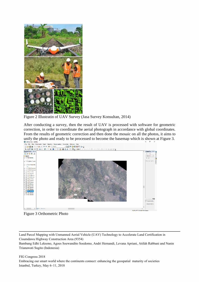
Figure 2 Illustratin of UAV Survey (Jasa Survey Konsultan, 2014)
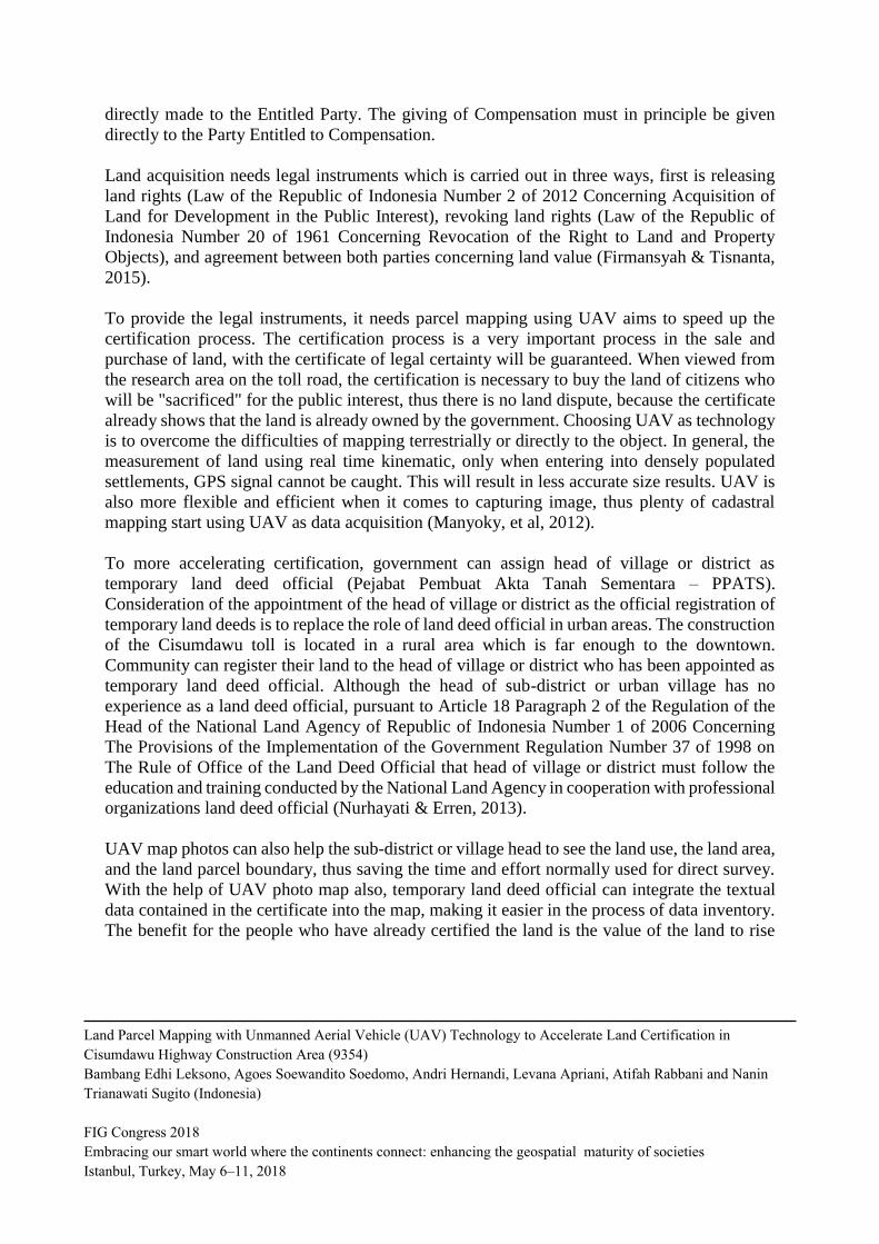
After conducting a survey, then the result of UAV is processed with software for geometric
correction, in order to coordinate the aerial photograph in accordance with global coordinates.
From the results of geometric correction and then done the mosaic on all the photos, it aims to
unify the photo and ready to be processed to become the basemap which is shown at Figure 3.
Figure 3 Orthometric Photo
Land Parcel Mapping with Unmanned Aerial Vehicle (UAV) Technology to Accelerate Land Certification in
Cisumdawu Highway Construction Area (9354)
Bambang Edhi Leksono, Agoes Soewandito Soedomo, Andri Hernandi, Levana Apriani, Atifah Rabbani and Nanin
Trianawati Sugito (Indonesia)
FIG Congress 2018
Embracing our smart world where the continents connect: enhancing the geospatial maturity of societies
Istanbul, Turkey, May 6–11, 2018

2.2 Data Plotting
Land parcels are made referring to the data obtained from the Cisumdawu Toll Road Inventory
and Land Acquisition Work Units. The land parcels taken are land parcels that will be affected
by the construction of the Cisumdawu toll road and special data held by the community, not the
public facilities data. The process is shown in Figure 4.
Figure 4 Land Parcel Digitizing
After the digitizing process, done matching data with data given. Matching data is done by
giving the land parcel number. Land parcel matching is intended for pooling of parcel data with
textual. data related to the plot. Land parcels are also matched with peta.bpn.go.id to find out
their legal status, whether certified or not in Figure 5.
Figure 5 Land National Agency Online Map
Land Parcel Mapping with Unmanned Aerial Vehicle (UAV) Technology to Accelerate Land Certification in
Cisumdawu Highway Construction Area (9354)
Bambang Edhi Leksono, Agoes Soewandito Soedomo, Andri Hernandi, Levana Apriani, Atifah Rabbani and Nanin
Trianawati Sugito (Indonesia)
FIG Congress 2018
Embracing our smart world where the continents connect: enhancing the geospatial maturity of societies
Istanbul, Turkey, May 6–11, 2018

3. RESULT AND DISCUSSION
The result is obtained in the form of a photo map with Pamekaran Village. The information that
can be displayed on the Pamekaran Village is the land area and the legal status. There is
information related to land acquisition, but the information cannot be displayed because it is
confidential. Map displayed on the Figure 6.
Figure 6 Land Parcel Map
Land acquisition is a preliminary task of road development projects. For proper highway
network, especially for expand the existing roads and construct new roads, highways and
expressways, private lands in both sides of the roads should be acquired. Based on Law of the
Republic of Indonesia Number 2 of 2012 Concerning Acquisition of Land for Development in
the Public Interest, The Government and the Regional Governments guarantees the availability
of land in the Public Interest and funding. Furthermore, it is stated that the acquisition of land
shall be performed through planning with involving all the guardians and stakeholders.
Land in the Public Interest shall be used for the development of the national defense and
security; public roads, toll roads, tunnels, rail lines, railway stations, and railway operating
facilities; etc. The Entitled Party must release his/her land during the implementation of the
Acquisition of Land in the Public Interest upon the giving of Compensation or under a final and
binding court decision. The giving of Compensation for Objects of the Acquired Land shall be
Land Parcel Mapping with Unmanned Aerial Vehicle (UAV) Technology to Accelerate Land Certification in
Cisumdawu Highway Construction Area (9354)
Bambang Edhi Leksono, Agoes Soewandito Soedomo, Andri Hernandi, Levana Apriani, Atifah Rabbani and Nanin
Trianawati Sugito (Indonesia)
FIG Congress 2018
Embracing our smart world where the continents connect: enhancing the geospatial maturity of societies
Istanbul, Turkey, May 6–11, 2018
directly made to the Entitled Party. The giving of Compensation must in principle be given
directly to the Party Entitled to Compensation.
Land acquisition needs legal instruments which is carried out in three ways, first is releasing
land rights (Law of the Republic of Indonesia Number 2 of 2012 Concerning Acquisition of
Land for Development in the Public Interest), revoking land rights (Law of the Republic of
Indonesia Number 20 of 1961 Concerning Revocation of the Right to Land and Property
Objects), and agreement between both parties concerning land value (Firmansyah & Tisnanta,
2015).
To provide the legal instruments, it needs parcel mapping using UAV aims to speed up the
certification process. The certification process is a very important process in the sale and
purchase of land, with the certificate of legal certainty will be guaranteed. When viewed from
the research area on the toll road, the certification is necessary to buy the land of citizens who
will be "sacrificed" for the public interest, thus there is no land dispute, because the certificate
already shows that the land is already owned by the government. Choosing UAV as technology
is to overcome the difficulties of mapping terrestrially or directly to the object. In general, the
measurement of land using real time kinematic, only when entering into densely populated
settlements, GPS signal cannot be caught. This will result in less accurate size results. UAV is
also more flexible and efficient when it comes to capturing image, thus plenty of cadastral
mapping start using UAV as data acquisition (Manyoky, et al, 2012).
To more accelerating certification, government can assign head of village or district as
temporary land deed official (Pejabat Pembuat Akta Tanah Sementara – PPATS).
Consideration of the appointment of the head of village or district as the official registration of
temporary land deeds is to replace the role of land deed official in urban areas. The construction
of the Cisumdawu toll is located in a rural area which is far enough to the downtown.
Community can register their land to the head of village or district who has been appointed as
temporary land deed official. Although the head of sub-district or urban village has no
experience as a land deed official, pursuant to Article 18 Paragraph 2 of the Regulation of the
Head of the National Land Agency of Republic of Indonesia Number 1 of 2006 Concerning
The Provisions of the Implementation of the Government Regulation Number 37 of 1998 on
The Rule of Office of the Land Deed Official that head of village or district must follow the
education and training conducted by the National Land Agency in cooperation with professional
organizations land deed official (Nurhayati & Erren, 2013).
UAV map photos can also help the sub-district or village head to see the land use, the land area,
and the land parcel boundary, thus saving the time and effort normally used for direct survey.
With the help of UAV photo map also, temporary land deed official can integrate the textual
data contained in the certificate into the map, making it easier in the process of data inventory.
The benefit for the people who have already certified the land is the value of the land to rise
Land Parcel Mapping with Unmanned Aerial Vehicle (UAV) Technology to Accelerate Land Certification in
Cisumdawu Highway Construction Area (9354)
Bambang Edhi Leksono, Agoes Soewandito Soedomo, Andri Hernandi, Levana Apriani, Atifah Rabbani and Nanin
Trianawati Sugito (Indonesia)
FIG Congress 2018
Embracing our smart world where the continents connect: enhancing the geospatial maturity of societies
Istanbul, Turkey, May 6–11, 2018

and for the government as the buyer of the land is to accelerate the process of developing the
toll road because it does not need to be difficult anymore in conducting land certification.
4. CONCLUSION
Mapping with UAV can be done for cadastre problem one of them is certification. By using
photo map of UAV, land parcels can be mapped and assist in data collection of land that can be
released for further certificate.
REFERENCES
Austin, Reg. (2009). Unmanned Aircraft Systems: UAVS Design, Development and
Deployment.
Dahad, S. O. & Malokar, Mayur S. (2015). Review Paper on Visual Contor of Unmanned Aerial
Vehicle for Handling Disaster Management Issue. International Journal on Recent and
Innovation Trends in Computing and Communication, 5
Firmansyah, A., & Tisnanta, H. (2015). Land Acquisition in Accelerating and Expansion of
Indonesia's Economic Development Program: A Review of Law, Moral and Politic
Relations. South East Asia Journal of Contemporary Business, Economics and Law, 7(4),
18-23.
Law of the Republic of Indonesia Number 2 of 2012 Concerning Acquisition of Land for
Development in the Public Interest
Law of the Republic of Indonesia Number 20 of 1961 Concerning Revocation of the Right to
Land and Property Objects
Manyoky, M., Theiler, P., Stendler, D., & Eisenbeiss, H. (2011). Unmanned Aerial Vehicle in
Cadastral Applications. International Archives of the Photogrammetry, Remote Sensing
and Spatial Information Sciences, XXXVIII-1/C22(38), 57-62.
Nurhayati, & Erren, L. (2013). Kajian Hukum Terhadap Camat Sebagai Pejabat Pembuat Akta
Tanah (PPAT) Sementara Ditinjau Dari Peraturan Pemerintah Nomor 37 Tahun 1998
Tentang Peraturan Pejabat Pembuat Akta Tanah. Yuriska: Jurnal Ilmiah Hukum, 5(1), 29-
37.
Paneque-Gálvez, J., McCall, M., Napoletano, B., Wich, S., & Koh, L. (2014). Small Drones for
Community-Based Forest Monitoring: An Assessment of Their Feasibility and Potential
in Tropical Areas. Forests, 1481-1507.
Land Parcel Mapping with Unmanned Aerial Vehicle (UAV) Technology to Accelerate Land Certification in
Cisumdawu Highway Construction Area (9354)
Bambang Edhi Leksono, Agoes Soewandito Soedomo, Andri Hernandi, Levana Apriani, Atifah Rabbani and Nanin
Trianawati Sugito (Indonesia)
FIG Congress 2018
Embracing our smart world where the continents connect: enhancing the geospatial maturity of societies
Istanbul, Turkey, May 6–11, 2018

Watts, A., Ambrosia, V., & Hinkley, E. (2012). Unmanned Aircraft Systems in Remote Sensing
and Scientific Research: Classification and Considerations of Use. Remote Sensing, 1671-
1692.
BIOGRAPHICAL NOTES
Dr. Ir. Bambang Edhi LEKSONO, M.Sc, born in 1957, Graduated in 1982 as Engineer in
Surveying and Mapping from Bandung Institute of Technology (Indonesia), obtaining Master
degree in Urban Survey & Human Settlement Analysis (ITC-Holland) in 1990 and doctorate
degree in Geography in 1996 from Universite de Nice Sophia Antipolis (France). Now, Dr. Ir.
Bambang Edhi Leksono, M.Sc is member of Survey and Cadastre Research Group in Institut
Teknologi Bandung, Indonesia.
CONTACTS
Dr. Ir. Bambang Edhi LEKSONO, M.Sc
Survey and Cadastre Research Group, ITB
Labtek IX-C 3rd floor, Jl Ganesha 10,
Bandung- 40132
INDONESIA
Tel. +62.22.2530701
Fax. +62.22.2530702
Email: [email protected]
Email: [email protected]
Web site: -
Land Parcel Mapping with Unmanned Aerial Vehicle (UAV) Technology to Accelerate Land Certification in
Cisumdawu Highway Construction Area (9354)
Bambang Edhi Leksono, Agoes Soewandito Soedomo, Andri Hernandi, Levana Apriani, Atifah Rabbani and Nanin
Trianawati Sugito (Indonesia)
FIG Congress 2018
Embracing our smart world where the continents connect: enhancing the geospatial maturity of societies
Istanbul, Turkey, May 6–11, 2018