landcover mapping for bering land bridge national preserve
TRANSCRIPT

National Park Service U.S. Department of the Interior Natural Resource Program Center
Landcover Mapping for Bering Land Bridge National Preserve and Cape Krusenstern National Monument, Northwestern Alaska Natural Resource Technical Report NPS/ARCN/NRTR—2004/001

ON THE COVER Burnt tussocks on Bering Land Bridge National Preserve plot V516. Photograph by: ABR, Inc.
Landcover Mapping for Bering Land Bridge National Preserve and Cape Krusenstern National Monument, Northwestern Alaska Natural Resource Technical Report NPS/ARCN/NRTR—2004/001 M. Torre Jorgenson Joanna E. Roth Michael Emers Wendy A. Davis Sharon F. Schlentner Matthew J. Macander ABR, Inc.—Environmental Research & Services P.O. Box 80410 Fairbanks, AK, 99708 November 2004 U.S. Department of the Interior National Park Service Natural Resource Program Center Fort Collins, Colorado

The Natural Resource Publication series addresses natural resource topics that are of interest and applicability to a broad readership in the National Park Service and to others in the management of natural resources, including the scientific community, the public, and the NPS conservation and environmental constituencies. Manuscripts are peer-reviewed to ensure that the information is scientifically credible, technically accurate, appropriately written for the intended audience, and is designed and published in a professional manner. The Natural Resources Technical Reports series is used to disseminate the peer-reviewed results of scientific studies in the physical, biological, and social sciences for both the advancement of science and the achievement of the National Park Service’s mission. The reports provide contributors with a forum for displaying comprehensive data that are often deleted from journals because of page limitations. Current examples of such reports include the results of research that addresses natural resource management issues; natural resource inventory and monitoring activities; resource assessment reports; scientific literature reviews; and peer reviewed proceedings of technical workshops, conferences, or symposia. Views, statements, findings, conclusions, recommendations and data in this report are solely those of the author(s) and do not necessarily reflect views and policies of the U.S. Department of the Interior, NPS. Mention of trade names or commercial products does not constitute endorsement or recommendation for use by the National Park Service. Printed copies of reports in these series may be produced in a limited quantity and they are only available as long as the supply lasts. This report is also available from the Natural Resource Program Center website (http://www.nature.nps.gov/publications/NRPM) on the internet, or by sending a request to the address on the back cover. Please cite this publication as: Jorgenson, M. T., J. E. Roth, M. Emers, W. A. Davis, , S. F. Schlentner, and M. J. Macander, 2004. Landcover mapping for Bering Land Bridge National Preserve and Cape Krusenstern National Monument, Northwestern Alaska. Natural Resource Technical Report NPS/ARCN/NRTR—2004/001. National Park Service, Fort Collins, Colorado. NPS D-41, November 2004


iii BELA-CAKR Landcover Mapping
TABLE OF CONTENTS
LIST OF FIGURES ......................................................................................................................................iiiLIST OF TABLES........................................................................................................................................ ivLIST OF APPENDICES............................................................................................................................... viINTRODUCTION ......................................................................................................................................... 1METHODS.................................................................................................................................................... 4
FIELD SURVEYS ...................................................................................................................................... 4ECOLOGICAL CLASSIFICATION.......................................................................................................... 7
ECOLOGICAL COMPONENTS ............................................................................................................ 7ECOTYPES ............................................................................................................................................. 7
LANDCOVER MAPPING ......................................................................................................................... 8IMAGERY AND ANCILLARY DATA SETS ....................................................................................... 8SIGNATURE EVALUATION AND SPECTRAL DATABASE DEVELOPMENT ............................ 8IMAGE CLASSIFICATION ................................................................................................................. 10RULE-BASED MODELING................................................................................................................. 11PERIPHERAL IMAGE CLASSIFICATION ........................................................................................ 11ACCURACY ASSESSMENT ............................................................................................................... 11
RESULTS.................................................................................................................................................... 13CLASSIFICATION AND DESCRIPTION OF ECOTYPES AND PLANT ASSOCIATIONS............. 13MAPPING................................................................................................................................................. 46
ABUNDANCE AND DISTRIBUTION ................................................................................................ 46ACCURACY ASSESSMENT ............................................................................................................... 46
RELATIONSHIPS AMONG ECOLOGICAL COMPONENTS ............................................................. 53LANDSCAPE RELATIONSHIPS......................................................................................................... 53ENVIRONMENTAL CHARACTERISTICS........................................................................................ 60VEGETATION COMPOSITION .......................................................................................................... 68SOIL CHARACTERISTICS.................................................................................................................. 71
FACTORS AFFECTING LANDSCAPE EVOLUTION AND ECOSYSTEM DEVELOPMENT ........ 79CLIMATE .............................................................................................................................................. 79OCEANOGRAPHY............................................................................................................................... 85TECTONIC SETTING AND PHYSIOGRAPHY ................................................................................. 86BEDROCK GEOLOGY......................................................................................................................... 87GEOMORPHOLOGY............................................................................................................................ 88FIRE ....................................................................................................................................................... 89
SUMMARY AND CONCLUSIONS.......................................................................................................... 89LITERATURE CITED................................................................................................................................ 91
LIST OF FIGURES
Figure 1. Interaction of interrelated state factors that control the structure and function of ecosystems and the scales at which they operate...................................................................... 2
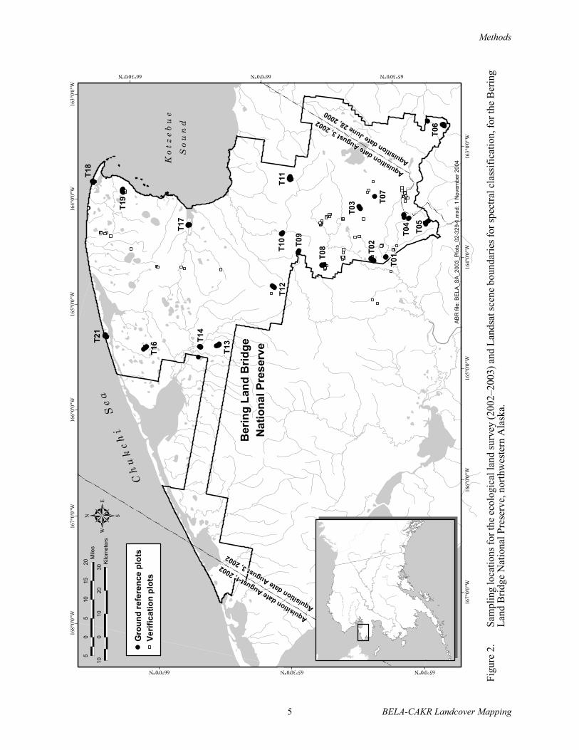
Figure 2. Sampling locations for the ecological land survey and Landsat scene boundaries for spectral classification, for the Bering Land Bridge National Preserve, northwestern Alaska ................................................................................................................. 5
Figure 3. Sampling locations for the ecological land survey in the Cape Krusenstern National Monument, northwestern Alaska, 2003.................................................................................... 6
Figure 4. Landcover map for the Bering Land Bridge National Preserve, northwestern Alaska .......... 47

BELA-CAKR Landcover Mapping iv
Figure 5. Landcover map for the Cape Krusenstern National Monument, northwestern Alaska.......... 49Figure 6. Principal components analysis of the distribution of spectral characteristics of
vegetation types ...................................................................................................................... 52Figure 7. A generalized toposequence for the Goodhope Mountains illustrating geomorphic,
topographic, permafrost, soils, and vegetation relationships in alpine and upland alkaline ecotypes..................................................................................................................... 54
Figure 8. A generalized toposequence for the Bendeleben Eastern Mountains illustrating geomorphic, topographic, permafrost, soils, and vegetation relationships in alpine and upland non alkaline ecotypes ........................................................................................... 55
Figure 9. A generalized toposequence for the Bering Strait Upper Coastal Plain illustrating geomorphic, topographic, permafrost, soils, and vegetation relationships in lowland and lacustrine ecotypes ........................................................................................................... 56
Figure 10. A generalized toposequence for the Bering Strait Lower Floodplains illustrating geomorphic, topographic, permafrost, soils, and vegetation relationships in riverine ecotypes .................................................................................................................................. 57
Figure 11. A generalized toposequence for the Espenberg Coast illustrating geomorphic, topographic, permafrost, soils, and vegetation relationships in coastal ecotypes .................. 58
Figure 12. Mean surface organic layer thickness, depth to rock, and thaw depths of ecotypes in Bering Land Bridge National Preserve and Cape Krusenstern National Monument, northwestern Alaska, 2002–2003 ........................................................................................... 65
Figure 13. Mean pH, electrical conductivity, and water depth of ecotypes in Bering Land Bridge National Preserve and Cape Krusenstern National Monument, northwestern Alaska, 2002–2003 .............................................................................................................................. 66
Figure 14. Mean surface organic layer thickness, depth to rock, and thaw depths for plant and cryptogam species in Bering Land Bridge National Preserve and Cape Krusenstern National Monument, northwestern Alaska, 2002–2003 ......................................................... 67
Figure 15. Mean pH, electrical conductivity, and water depth for abundant species in Bering Land Bridge National Preserve and Cape Krusenstern National Monument, northwestern Alaska, 2002–2003 ........................................................................................... 69
Figure 16. Detrended correspondence analysis of species composition of plots sampled in Bering Land Bridge National Preserve and Cape Krusenstern National Monument, northwestern Alaska, 2002–2003 ................................................................................................................. 70
Figure 17. Map of soil associations in the Bering Land Bridge National Preserve based on analysis of ecotype-soil relationships derived from field surveys........................................................ 81
Figure 18. Map of soil associations in Cape Krusenstern National Monument based on analysis of ecotype-soil relationships derived from field surveys........................................................ 83
LIST OF TABLES
Table 1. Vegetation cover and frequency for Alpine Alkaline Dry Barrens ........................................ 13Table 2. Vegetation cover and frequency for Alpine Alkaline Dry Dryas Shrub ................................ 14Table 3. Vegetation cover and frequency for Alpine Nonalkaline Dry Barrens .................................. 15Table 4. Vegetation cover and frequency for Alpine Nonalkaline Dry Dryas Shrub........................... 16

v BELA-CAKR Landcover Mapping
Table 5. Vegetation cover and frequency for Upland Dry Lichen Barrens .......................................... 17Table 6. Vegetation cover and frequency for Upland Moist Spruce Forest ......................................... 18Table 7. Vegetation cover and frequency for Upland Moist Low Willow Shrub ................................ 19Table 8. Vegetation cover and frequency for Upland Moist Dwarf Birch–Ericaceous Shrub ............. 20Table 9. Vegetation cover and frequency for Upland Moist Dwarf Birch–Tussock Shrub ................. 21Table 10. Vegetation cover and frequency for Upland Dry Crowberry Shrub....................................... 22Table 11. Vegetation cover and frequency for Upland Moist Sedge–Dryas Meadow........................... 23Table 12. Vegetation cover and frequency for Lowland Moist Tall Alder–Willow Shrub.................... 24Table 13. Vegetation cover and frequency for Lowland Moist Low Willow Shrub .............................. 25Table 14. Vegetation cover and frequency for Lowland Moist Dwarf Birch–Willow Shrub ................ 26Table 15. Vegetation cover and frequency for Lowland Wet Dwarf Birch–Ericaceous Shrub ............. 27Table 16. Vegetation cover and frequency for Lowland Moist Sedge–Dryas Meadow......................... 28Table 17. Vegetation cover and frequency for Lowland Sedge–Moss Fen Meadow............................. 29Table 18. Vegetation cover and frequency for Lowland Sedge Fen Meadow ....................................... 30Table 19. Vegetation cover and frequency for Lowland Water ............................................................. 31Table 20. Vegetation cover and frequency for Lacustrine Maresail Marsh ........................................... 31Table 21. Vegetation cover and frequency for Lacustrine Moist Bluejoint Meadow ............................ 32Table 22. Vegetation cover and frequency for Riverine Barrens ........................................................... 33Table 23. Vegetation cover and frequency for Riverine Moist Tall Alder–Willow Shrub .................... 34Table 24. Vegetation cover and frequency for Riverine Moist Tall Willow Shrub ............................... 35Table 25. Vegetation cover and frequency for Riverine Moist Low Willow Shrub .............................. 36Table 26. Vegetation cover and frequency for Riverine Moist Dwarf Birch–Willow Shrub................. 37Table 27. Vegetation cover and frequency for Coastal Barrens ............................................................. 38Table 28. Vegetation cover and frequency for Coastal Dry Dunegrass Meadow .................................. 39Table 29. Vegetation cover and frequency for Coastal Brackish Wet Sedge–Grass Meadow............... 40Table 30. Vegetation cover and frequency for Coastal Saline Wet Sedge–Grass Meadow................... 41Table 31. Key to ecotypes for Bering Land Bridge National Preserve and Cape Krusenstern
National Monument, western Alaska ..................................................................................... 43Table 32. Areal extent of ecotypes and vegetation types within the Bering Land Bridge National
Preserve and Cape Krusenstern National Monument, Alaska................................................ 51Table 33. Relationships among landscape components in the Bering Land Bridge National
Preserve and Cape Kusenstern National Monument, northwestern Alaska ........................... 61Table 34. Mean cover of the most abundant species in alpine and upland ecotypes. ............................ 72Table 35. Mean cover of the most abundant species in lowland and lacustrine ecotypes...................... 73Table 36. Mean cover of the most abundant species in coastal ecotypes............................................... 74Table 37. Classification and description of soil types in the in the Bering Land Bridge National
Preserve and Cape Krusenstern National Monument, Alaska................................................ 75

BELA-CAKR Landcover Mapping vi
Table 38. Mean soil properties of common soil types in the Bering Land Bridge National Preserve and Cape Kusenstern National Monument, Alaska, 2002–2003 ............................. 76
Table 39. Cross-tabulation of soil types by map ecotype ....................................................................... 77Table 40. Crosswalk of soil associations and their equivalent landtype associations, associated
soils, and associated ecotypes for mapping ............................................................................ 78
LIST OF APPENDICES
Appendix 1. Coding system for characterizing ecological characteristics of field plots .................... 98Appendix 2. Data file listing of ecological components of ground reference and verification
plots in the Bering Land Bridge National Preserve and Cape Krusenstern National Monument, northwestern Alaska, 2002–2003.............................................................. 100
Appendix 3. Data file listing of environmental characteristics intensive ground reference plots in the Bering Land Bridge National Preserve and Cape Krusenstern National Monument, northwestern Alaska, 2002–2003.............................................................. 105
Appendix 4. List of vascular plant species found in the Bearing Land Bridge National Preserve and Cape Krusenstern National Monument, northwestern Alaska, 2002–2003........... 109
Appendix 5. List of some nonvascular plant species found in the Bering Land Bridge National Preserve and Cape Krusenstern National Monument, northwestern Alaska, 2002–2003 .................................................................................................................... 112
Appendix 6. List of signature vegetation classes with associated ground vegetation classes and showing the number of spectral signatures for each class ............................................ 114
Appendix 7. Example diagrams of rules used to model ecotypes using the ERDAS knowledge- base routine ................................................................................................................... 116
Appendix 8. Codes used in ERDAS rule-based classification of ecotypes for Bering Land Bridge National Preserve and Cape Krusenstern National Monument, 2004 .............. 120
Appendix 9. Cross-walk of 33 ecotypes and 31 plant associations developed from analysis of ground data, and 29 map ecotypes, 17 map vegetation types, and 12 map aggregated ecotypes ...................................................................................................... 121
Appendix 10. Cross-tabulation of consistency between independently derived spectral classes and signature vegetation class....................................................................................... 123
Appendix 11. Comparison of mapped and ground ecotypes determined at 256 points used to create map signatures.................................................................................................... 124
Appendix 12. Comparison of mapped and ground vegetation determined at 256 points used to create map signatures................................................................................................ 125
Appendix 13. Comparison of mapped and ground ecotypes after aggregation into 12 classes, determined at 256 points used to create map signatures............................................... 126
Appendix 14. Vegetation cover and frequency for ecotypes described by two plant associations ..... 127

Introduction
1 BELA-CAKR Landcover Mapping
INTRODUCTION
Ecological field surveys and landcovermapping are essential to evaluating land resourcesand developing management strategies that areappropriate to the varying conditions of thelandscape. More specifically, land classificationand mapping can be used to more efficientlyallocate inventory and monitoring efforts, topartition ecological information for analysis ofecological relationships, to develop predictiveecological models, and to improve techniques forassessing and mitigating impacts. To satisfy thiswide range of needs for the Bering Land BridgeNational Preserve (BELA) and Cape KrusensternNational Monument (CAKR), the National ParkService (NPS) is pursuing an integrated “bottomup” approach for inventorying and classifyingecological characteristics, and a “top down”approach to landcover mapping using satelliteimage processing and environmental modeling toincorporate numerous environmentalcharacteristics. In this effort we combined the areasfor BELA and CAKR into one mapping effortbecause the the ecological characteristics weresimilar, both areas were covered by a singlesatellite scene, and it was more efficient to do themtogether.
To enhance the landcover mapping, which isbased primarily on spectral characteristics, we useda multi-step process to better partition thevariability in vegetation and other ecologicalcharacteristics. These included: (1) an integratedecological land survey to characterize vegetation,soils, and other ecological characteristics; (2)classification of plant communities (floristicassociations), soils, and local-scale ecosystems(termed “ecotypes”) that integrate covaryingecological properties; (3) analysis of relationshipsamong ecological components; (4) spectralclassification of vegetation structure and dominantplants; and (5) rule-based modeling to betteridentify and separate the plant communitiesassociated with alpine, riverine, and coastalphysiographic regions. Using this integratedecological land survey approach, we produced alandcover map that has accompanying attributesfor vegetation, soils, ecotypes, and a suite ofenvironmental properties. In this report, weemphasize the ecotype component of the landcover
map, because it provides the most discrete basis fororganizing relationships among vegetation, soils,physiography, and other environmental properties.
In an ecological land survey and classification(ELS), landscapes are viewed not as aggregationsof independent biological and physical resources,but as ecological systems with functionally relatedparts (Rowe 1961; Wiken and Ironside 1977;Bailey 1980, 1996; Driscoll et al. 1984). The goalof an ELS is to provide a consistent conceptualframework for modeling, analyzing, interpreting,and applying ecological knowledge. To provide theinformation required for such a wide range ofapplications, an ELS includes three phases: (1) anecological land inventory that surveys and analyzesdata obtained in the field; (2) an ecological landclassification that classifies and maps ecosystemdistribution; and (3) an ecological land evaluationthat assesses the capabilities and sensitivities of theland to various land management practices. Thisthree-phased approach of linking ecologicalcharacteristics within a landcover map and spatialdatabase improves our ability to predict theresponse of ecosystems to human impacts andfacilitates the production of thematic maps forspecialized engineering and environmentalapplications.
The structure and function of naturalecosystems are regulated largely along gradients ofenergy, moisture, nutrients, and disturbance. Thesegradients are affected by climate, physiography,geomorphology, soils, hydrology, vegetation, andfauna, and are referred to as ecological components(in this report) or ‘state factors’ (Barnes et al. 1982,ECOMAP 1993, Bailey 1996). We used thestate-factor approach (Jenny 1941, Van Cleve et al.1990, Vitousek 1994, Bailey 1996, Ellert et al.1997) to evaluate relationships among individualecological components and to develop a reducedset of ecotypes (Figure 1a). Based on the landscaperelationships developed from the “bottom up,” weintegrated satellite remote sensing of vegetationcharacteristics, physiographic maps, and DigitalElevation Model (DEM) topography to model thedistribution of landcover types from the “topdown.” The resulting landcover maps, whichintegrate co-varying biological and physicalcharacteristics, provide a comprehensiveinformation base that can be used for ecosystemmanagement.

Introduction
BELA-CAKR Landcover Mapping 2
An ecological land classification also involvesthe organization of ecological components within ahierarchy of spatial and temporal scales (Wiken1981, Allen and Starr 1982, O’Neil et al. 1986,Delcourt and Delcourt 1988, Klijn and Udo deHaes 1994, Forman 1995, Bailey 1996).Local-scale features (e.g., vegetation) are nestedwithin regional-scale components, (e.g., climateand physiography) (Figure 1b). Climate,
particularly temperature and precipitation,accounts for the largest proportion of globalvariation in ecosystem structure and function(Walter 1979, Vitousek 1994, Bailey 1998). Withina given climatic zone, physiography (characteristicgeologic substrate, surface shape, and relief)controls the rates and spatial arrangements ofgeomorphic processes and energy flow. Theseprocesses result in the formation of geomorphic
Figure 1. Interaction of interrelated state factors that control the structure and function of ecosystems (a) and the scales at which they operate (b).
a)
b)
1
10
100
1000
10000
100000
1 10 100 1000 10000 100000 1000000
Space (m2)
Tim
e (
yr)
Physiography
Regional
Climate
Geomorphology
Soil Texture
Geomorphic Unit
Slope Position
Drainage
Permafrost
HydrologyWater Level
Soil Moisture
Vegetation
Structure
Plant Association
DisturbanceFire
FluvialThermokarst
Human
Disturbance
Time
Climate
Topography
(Physio
graphy)
Paren
t
Materia
lO
rgan
ism
s
Hydrology
ECOREGION
Soil Type
Eco-
type

Introduction
3 BELA-CAKR Landcover Mapping
units with characteristic lithologies, textures, andsurface forms, which in turn affect soil propertiesand the movement of water (Wahrhaftig 1965,Swanson et al. 1988, Bailey 1996). Watermovement through soil is a critical factor indetermining the distribution of vegetation (Fitterand Hay 1987, Oberbauer et al. 1989), due to itsinfluence on both water balance and nutrientavailability for plants. Finally, vegetation providesstructure and energy that affect the distribution ofmany wildlife species. The interrelated processesthat operate across these components at the variousscales can also be sources of disturbance thatgreatly influence the timing and development ofecosystems (Watt 1947, Pickett et al. 1989, Walkerand Walker 1991, Forman 1995). Official systemsfor classifying ecosystems across scales have beendeveloped for both the United States (ECOMAP1993) and Canada (Wiken and Ironside 1977),while the proposed system for Europe incorporateselements of both the U.S. and Canadian systems(Klijn and Udo de Haes 1994).
A hierarchical approach to mappingvegetation and land cover was developed fornorthern Alaska by Everett and Walker (Everett etal. 1978; Walker 1983, 1999). They also applied anintegrated geobotanical approach to mappingecosystem components in the Prudhoe Bay region,but did not group the integrated units hierarchically(Walker et al. 1980). Recently, anintegrated-terrain-unit (ITU) approach wasdeveloped for large-scale mapping of ecosystemson the Arctic Coastal Plain (Jorgenson et al. 1997,Jorgenson et al. 2003), the entire North Slope(Walker 1999, Jorgenson and Heiner 2003),Yukon-Kuskokwim Delta (Jorgenson 2000),interior Alaska (Jorgenson et al. 1999, Jorgenson etal. 2001), and south-central Alaska (Jorgenson etal. 2003). The ITU approach also has been used formapping circumpolar arctic vegetation (Walker etal. 2002).
In implementing the ecological landclassification portion of landcover mapping, weused a simplified ITU approach that incorporatedthree components that are readily mapped ormodeled, including physiographic units derivedfrom the existing landscape-level ecological maps(subsections) for BELA (Jorgenson 2001) andCAKR (Swanson 2001) that are closely related tosurficial geology and geomorphology, surface
forms derived from the DEM (primarilyslope-related features), and vegetation from thelandcover spectral classification. This ITUapproach, along with the landscape relationshipsdeveloped from the analysis of the field surveyinformation, allowed us to develop an enhanced setof landcover types from remote sensing thatessentially differentiate ecosystems at the ecotypelevel of ecological land classification. Thisintegrated approach has several benefits: itrecognizes the important effects of geomorphicprocesses on natural disturbance regimes (e.g.,flooding, thermokarst) and the flow of energy andmaterial, it preserves the diversity ofenvironmental characteristics, and it uses asystematic approach to classifying landscapefeatures for applied analyses. To demonstrate oneapplication of this approach, we analyzed therelationships among soil and landcover types, andused these relationships to develop a map of soilassociations. Thus, the landcover map can serve asthe spatial database with differing ecologicalcomponents to aid resource managers evaluateecological impacts and develop land managementstrategies appropriate for a diversity of landscapeconditions.
Accordingly, the specific objectives of thisecological land survey and landcover mapping forBELA and CAKR were to:
1) conduct a field survey of ecosystemcomponents, including geomorphology(surficial geology), topography, soils,hydrology, and vegetation within thestudy area;
2) evaluate the relationships amongecosystem components;
3) classify landcover types (local-scaleecosystems or ecotypes) based onquantitative analysis of field data;
4) map landcover types through processingof Landsat TM satellite imagery andrule-based modeling; and
5) use the map database and ecologicalrelationships to derive maps of soildistribution.

Methods
BELA-CAKR Landcover Mapping 4
METHODS
FIELD SURVEYSField surveys were conducted in BELA
during 10–15 July 2002 and in CAKR during11–16 July 2003 (Figures 2 and 3) to collectecosystem component data. A gradient-directedsampling scheme (Austin and Heyligers 1989) wasused to sample the range of ecological conditionsand to provide the spatially-related data needed tointerpret ecosystem development. Intensivesampling was done primarily along transects(toposequences) located within majorphysiographic environments, including coastal,riverine, lacustrine, lowland, upland, and alpineareas. Along each transect, 6–14 plots weresampled, each in a distinct vegetation type orspectral signature identifiable on aerialphotographs. Data were collected at 231 plotsalong 32 toposequences. An additional 257verification sites were sampled off transects forcharacterizing vegetation structure and dominantplants for use during mapping. All samplelocations were located on aerial photographs, andcoordinates (including approximate elevations)were obtained with a Global Positioning System(GPS) receiver (accuracy ±15 m). At eachintensive plot (~10-m radius), descriptions ormeasurements of geology, surface form (micro-and macrotopography), hydrology, soilstratigraphy, and vegetation cover were recorded(Appendices 1–3). Photos were taken at all samplelocations. Data and photos are archived at ABRand NPS.
Geologic and surface-form variables recordedincluded physiography, surface geomorphic unit,slope, aspect, surface form, and height ofmicrorelief. Hydrologic variables measured at eachsampling site included depth of water above orbelow ground surface, depth to saturated soil, pH,and electrical conductivity (EC). Water depthswere measured with a ruler and water-qualitymeasurements (pH and EC) were made withOakton or Cole-Palmer portable meters that werecalibrated daily with standard solutions.
Soil stratigraphy was described from ashallow soil core or soil pit at each plot. Most soilprofiles were limited to the seasonally thawed layer(~0.5–1 m) above the permafrost and were
described from soil plugs dug with a shovel. For allintensive plots, the dominant mineral texture, thedepth of surface organic matter, cumulativethickness of all organic horizons, percentage ofcoarse fragments, depth to rock (>15% by volume),and depth of thaw were recorded. When water wasnot present, EC and pH were measured from asaturated soil paste. A single simplified texture(i.e., loamy, sandy, organic) was assigned tocharacterize the dominant texture in the top 40 cmat each plot for ecotype classification. Within asubset of plots, however, a more complete soilstratigraphy was described using standard methods(SSDS 1993).
Vegetation structure and composition wereassessed semiquantitatively. Cover of each specieswas visually estimated to the nearest 1%, if coverwas <10% or >90%, and to the nearest 5% forcover ≥10–90%. Isolated individuals or specieswith very low cover were assigned a cover value of0.1%. A species list was compiled that included allvascular plants and the dominant nonvascularplants observed in the plot. Total cover of eachplant growth form (e.g., tall shrub, dwarf shrub,lichens) was estimated independently of the coverestimates for individual species. Data were thencross checked to ensure that the summed cover ofindividual species within a growth form categorywas comparable to the total cover estimated forthat growth form. Taxonomic nomenclaturefollowed Viereck and Little (1972) for shrubs andHultén (1968) for other vascular plants, with theexception of shrub birch. We did not distinguishbetween Betula glandulosa and Betula nana, butcalled both B. nana. We also used a draft floristicinventory of the Seward Peninsula (Kelso et al.1997) and CAKR (Carolyn Parker, Univ. AlaskaMuseum, unpublished data 2003) for guidance.Nomenclature for bryophytes and lichens followedthe National Plants Database (NRCS 2001).Identification of mosses and lichens during fieldsampling was limited to dominant, readilyidentifiable species. Dominant cryptogams thatcould not be identified in the field were collectedand sent to Mikhail Zhurbenko and Olga Afonina,Komarov Botanical Institute, Russia, foridentification. Plant species identified are listed inAppendices 4 and 5.
Methods
5 BELA-CAKR Landcover Mapping
Figu
re 2
. Sa
mpl
ing
loca
tions
for t
he e
colo
gica
l lan
d su
rvey
(200
2–20
03) a
nd L
ands
at sc
ene
boun
darie
s for
spec
tral c
lass
ifica
tion,
for t
he B
erin
g La
nd B
ridge
Nat
iona
l Pre
serv
e, n
orth
wes
tern
Ala
ska.
T13
T19
T17
T07
T04
T05
Aquisitiondate
August1,2002
Aquisitiondate
August3,2002
Aquisitiondate
August3,2002
Aquisitiondate
June28,2000
T08 T02
T01
T09
T06
T03
T18
T21
T16 T
14
T12
T10
T11
16
8°0
'0"W
16
7°0
'0"W
16
7°0
'0"W
16
6°0
'0"W
16
6°0
'0"W
16
5°0
'0"W
16
5°0
'0"W
16
4°0
'0"W
16
4°0
'0"W
16
3°0
'0"W
16
3°0
'0"W
65°0'0"N65°30'0"N
65°30'0"N
66°0'0"N
66°0'0"N66°30'0"N
AB
R f
ile:
BE
LA
_S
A_2
00
3_P
lots
_0
2-3
29
-1.m
xd;
1 N
ovem
ber
20
04
10
010
20
30
Kilo
me
ters
50
510
15
20
Mile
s
5
Beri
ng
Lan
d B
rid
ge
Nati
on
al P
res
erv
e
Gro
un
d r
efe
ren
ce p
lots
Ve
rifi
ca
tio
n p
lots
Ch
uk
ch
iS
ea
K o
t z
e b
u e
S o
u n
d

Methods
BELA-CAKR Landcover Mapping 6
Figure 3. Sampling locations for the ecological land survey in Cape Krusenstern National Monument, northwestern Alaska, 2003. The entire monument was included within one Landsat scene acquired 3 August 2002.
T04
T01
T07
T06
T05
T02
T08
T13
T11
T15
T14
T12
T10
164°30'0"W
164°0'0"W
164°0'0"W
163°30'0"W
163°30'0"W
163°0'0"W
163°0'0"W
162°30'0"W
162°30'0"W
162°0'0"W
67°0
'0"N
67°0
'0"N
67°1
5'0
"N
67°1
5'0
"N
67°3
0'0
"N
67°3
0'0
"N
67°4
5'0
"N
67°4
5'0
"N
ABR file: CAKR_SA_2003_Plots_02-329-1.mxd; 14 May 2004
5
Ground reference plots
Verification plots
Cape Krusenstern
National Monument
5 0 5 10 15Kilometers
5 0 5 10Miles
Ko
tz
eb
ue
So
un
d

Methods
7 BELA-CAKR Landcover Mapping
ECOLOGICAL CLASSIFICATIONEcosystem classification was undertaken at
two levels. First, individual ecological componentswere classified and coded using standardclassification systems developed for Alaska.Second, these ecological components wereintegrated to classify ecotypes (local-scaleecosystems) that best partitioned the range ofvariation for all the measured components.
ECOLOGICAL COMPONENTSGeomorphic units were classified according to
a system based on landform-soil characteristics forAlaska, originally developed by Kreig and Reger(1982) and the Alaska Division of Geological andGeophysical Survey (1983) and modified for thisstudy. We relied on previous landscape analysis ofBELA (Jorgenson 2001) and CAKR (Swanson2001) as a guide to our identification of geomorphicand geologic units. We made slight modifications tothese maps, however, to extend some of thefloodplain mapping farther upstream, and revisedsome of the coastal and floodplain boundaries tobetter coregister with the image. We emphasizedmaterials near the surface (<2 m) because theyhave the greatest influence on ecologicalprocesses. Within the geomorphic classification, wealso classified waterbodies based on their depth,salinity, and genesis.
Surface forms (macrotopography) wereclassified according to a system modified from thatof Schoeneberger et al. (1998). Microtopographywas classified according to the periglacial systemof Washburn (1973).
Vegetation was classified in the field to Level4 of the Alaska Vegetation Classification (AVC)developed by Viereck et al. (1992), with slightmodifications previously developed for tundra andcoastal classes (Jorgenson et al. 1997). Afterfieldwork was completed and unknown specimenswere identified, plant associations were developedthrough numeric analyses to further identify plantcommunities. First, vegetation data (species coverby plot) were ordered into species groups usingTWINSPAN (PCOrd 4.17, MjM SoftwareDesigns). Second, sorted table analyses(Mueller-Dombois and Ellenberg 1974) were usedto refine the groups and identify potential outlierplots. Finally, detrended correspondence analysiswas used to chart the plots in species space to
assess their dispersion and further identify outliers.After groups were finalized, each plant associationwas identified by a dominant and characteristicspecies.
ECOTYPESClassification of ecotypes (local-scale
ecosystems) was accomplished in three generalsteps: (1) the ecological components wereindividually classified for each detailed grounddescription, (2) relationships along transects wereexamined to illustrate trends across the landscape,and (3) contingency tables were used to identifythe common relationships and central tendenciesamong ecological components. In developing theecotype classes, we emphasized ecologicalcharacteristics (primarily geomorphology andvegetation structure) that could be interpreted fromaerial photographs. We also developed anomenclature for ecotypes that describesecological characteristics (physiography, soilchemistry, moisture, vegetation structure, anddominant species) using a terminology that can beeasily understood.
To reduce the number of ecotype classes, weaggregated the field data for individual ecologicalcomponents (e.g., soil stratigraphy and vegetationcomposition), using a hierarchical approach.Geomorphic units were assigned to physiographicsettings based on their erosional or depositionalprocesses. Surface-forms were aggregated into areduced set of slope elements (crest, upper slope,lower slope, toe, and flat). For vegetation, we usedthe structural levels of the Alaska VegetationClassification (Viereck et al. 1992), because theyare readily identifiable on aerial photographs.Some textural classes were grouped (e.g., sandyand loamy) because the vegetation associated withthem was similar, and some vegetation structures(e.g., open and closed shrub) were groupedbecause their species composition was similar.Ecotype names were then based on the aggregatedecological components.
Common relationships among ecosystemcomponents were identified by use of contingencytables. The contingency tables sorted plots byphysiography, soil texture, geomorphic unit, slopeposition, drainage, soil chemistry (pH and salinity),vegetation structure, and plant association. Fromthese tables, common associations were identified
Methods
BELA-CAKR Landcover Mapping 8
and unusual associations either were lumped withthose having similar characteristics or excluded asunusual (outliers). The resulting final ecotypeswere used for mapping and to summarize theground data.
LANDCOVER MAPPING
IMAGERY AND ANCILLARY DATA SETSThree terrain-corrected Landsat TM scenes
(28.5 m pixel resolution) were used to create themap. The main scene, acquired 3 August 2002(Path 81, Rows 12-14), covered all of CAKR andthe central 91% of BELA. The image wasessentially cloud-free, though some haze obscuredthe Bendeleben Mountains. Scenes for theperipheral eastern and western edges of BELAwere acquired 28 June 2000 (Path 79, Row 14) and1 August 2002 (Path 83, Row 14), respectively.The western image was cloud-free in the area ofinterest, and the eastern image had a few smallclouds along the southern edge of the study area.After a position analysis based on USGS digitalmaps and GPS locations acquired in the field,images were shifted 17 m west and 23 m north.Based on GPS data, the horizontal positionalaccuracy of the image is less than 1 pixel (28.5 m).
In addition to the TM imagery, several layerswere used to differentiate specific landscape andvegetation features during post-classificationmodeling. Existing ecosubsection mapping(Jorgenson 2001, Swanson 2001) was used todefine major physiographic and geologic regions.Some modification was made to region boundariesto extend floodplain delineations and correctpositional errors. Digital elevation models from theNational Elevation Dataset also were used formodeling. Finally, vector layers were created topartition a few specific features, such as areas ofcloud and shadow on flat terrain, forested patchesin BELA, and the road to the Red Dog Mine.
SIGNATURE EVALUATION AND SPECTRAL DATABASE DEVELOPMENT
Satellite image processing was done usingERDAS 8.6 software. Spectral signatures weregenerated by overlaying a point file of ground truthsites on the imagery and using region growingtools (seeding) to group pixels of similar spectralcharacteristics with associated ground-truth sites.
In addition to the 488 sites surveyed in this study,ground data collected from the NPS IntensiveMapping Area Survey, 1991–1993 were used.Region-growing parameters varied with thecharacteristics associated with the ground-truthsites, but a conservative approach was used torestrict pixels to areas that the mapper easilyrecognized as belonging to the same vegetationtype as the ground truth site. The spectral Euclidiandistance and total number of pixels within theregion were used as primary parameters. Euclidiandistances commonly were between 5 and 10,though some particularly homogenous areas werelower, and seeded regions typically were less than20 pixels. Small, distinct features such as beachfringe or gravel bars were allowed larger Euclidiandistances, and large homogenous areas, such aslarge water bodies, were allowed larger regions. Aminimum of seven pixels was required for a validsignature. Seeded regions were added to asignature file if they met these basic parametersand appeared to represent a homogenous photosignature on the satellite image and airphotos forthe ground class. A total of 574 signatures werecreated using ground data and photo interpretation.Of the 60 vegetation classes identified in theground data, spectral signatures were assigned to56. The four classes not included in the signaturefile were Four-leaf Marestail, Dry Forb Meadow,Mixed Herbs, and Open Dwarf White Spruce. Thefew examples of these classes described by theground data were either in areas too small or tooheterogeneous to generate good signatures. Oneclass was added based on the NPS IntensiveMapping Area Survey data, Open TallAlder–Willow, yielding spectral signatures for 57vegetation classes based on ground data.
A spectral database was created by exportingthe spectral data for each signature, including meanand standard deviation for each spectral band, intoan ACCESS database. Ground data associated witheach signature, including plot identifier, vegetationclass, ecotype class, vegetation cover by canopystructure, organic layer depth, slope, and percentcover of the most abundant 70 species in the regionwere added where available. A normalizeddifference vegetation index (NDVI) also wascalculated for each signature and added to thedatabase.

Methods
9 BELA-CAKR Landcover Mapping
Signatures were evaluated by testing theinherent quality of the spectral informationassociated with the signature and by assessing therelationships of the signatures to vegetationclasses. Analyses used in the signature evaluationincluded analysis of: (1) the variability of spectralbands for each signature, (2) the fidelity of thesignature to the ground information, (3) the centraltendencies and overlap of signatures withinpreliminary ground vegetation classes usingprincipal components analysis, and (4) theassociation of ground vegetation classes within andamong spectral clusters. The results wereincorporated into the database.
To assess the spectral variability of eachsignature, a mean coefficient of variation wascalculated for each band for each signature and theresults averaged. Signatures with <10% meanvariation were judged acceptable the remainingsignatures were identified for further evaluation.Exceptions were made for signatures describingWater and Partially Vegetated areas as these classeshave high inherent variability. All signatures withcoefficients >10% were evaluated by case andretained or excluded based on the results of theanalysis described below.
To assess the fidelity of the signature to theground information, a contingency table wasgenerated based on a maximum likelihoodclassification of all signature areas using ERDASsignature evaluation routines. The number ofpixels classified to the same signature as thatdeveloped from the corresponding signature areawas calculated. The resulting matrix of inputsignature by classified signature area provided ameasure of the ability of signatures to mapcorrectly to themselves. We extended this analysisto show signature fidelity to the vegetation classesassigned to them based on the ground data.Signatures where >80% of the pixels classified tothe correct vegetation class within a signature areawere considered acceptable. A few signatures ofinfrequently occurring ground vegetation classesthat had less fidelity to their vegetation class wereretained on a case by case basis because theyclassified accurately to a closely related class. Wepreserved these signatures because we anticipatedthe need of merging unusual classes with thoseclasses more frequently observed. Examples ofthese low fidelity signatures included a signature
for Moist Sedge–Willow Meadow that mappedwell to Moist Sedge–Dryas Meadow, and asignature for Closed Low Willow that mapped wellto Open Low Willow. The two analysis of spectralquality resulted in the elimination of 117signatures.
To assess the central tendencies and overlap ofspectral characteristics of signatures among theinitial 57 ground vegetation classes, principalcomponents analysis (PCA) was used inconjunction with cluster analysis (PCOrd 4.17,MjM Software Designs). Results were then usedto aggregrate ground vegetation classes withsimilar spectral and vegetative characteristics intoa reduced set of signature vegetation classes. APCA of the signatures using band data with NDVIwas conducted on the 457 signatures remainingafter the basic signature evaluation to reduce thevariability in signatures to two dimensions andidentify outliers within ground vegetation classes.The center of each vegetation class was calculatedbased on the first two PCA axes, and a distancefrom the center in axis space was calculated foreach signature within the vegetation class. Thesignatures for each vegetation class were rankedaccording to their proximity to the center of thevegetation class. The 20% of signatures with thelowest rank (farthest from the center of eachvegetation group) were identified as potentialoutliers. The potential outliers were evaluated forspectral (see cluster analysis below) and plantassociation (see Ecological Components) similarityand compared with the main characteristics of thevegetation class. While we recognize that somelegitimate signatures may have been lost throughthis analysis, we believe it more important toreduce the potential for misclassifying pixels in theneighborhood of vegetation class outliers than topreserve the outliers themselves.
As another measure for assessing how uniquethe spectral characteristics were for each groundvegetation class, cluster analysis of band data andNDVI (PCOrd 4.17) was used to group the spectralcharacteristics of all 574 signatures into clusters, ornodes. A dendrogram with hierarchical linkagespartitioned the variability into 66 nodes. The nodesthen were cross-tabulated with the groundvegetation classes to identify the frequency withwhich vegetation types were associated withindividual spectral nodes. Signatures within nodes

Methods
BELA-CAKR Landcover Mapping 10
that were strongly associated with a particularvegetation class (the dominant vegetation type forthe node) were considered valid. Signatures forvegetation classes not consistent with the dominantvegetation type represented by the node wereidentified for further evaluation. Plantassociations, PCA, and cluster analysis nodes wereused to group poorly differentiated groundvegetation classes with the most appropriate classor to reject signatures as invalid. Sixty-fivesignatures were eliminated after the PCA andcluster analysis.
Based on the results of these multivariateanalyses of spectral characteristics, the similarityof species composition, and the relative abundanceof the vegetation types in the study area, weconsolidated the original 57 ground vegetationclasses (AVC Level 4) into 18 signature vegetationclasses. Signatures with ground vegetation classespoorly defined by the multivariate analysis weremerged with other vegetation classes of similarspecies composition, landscape position, andspectral characteristics. Four ground vegetationclasses were eliminated through the signatureverification process because the signaturesassociated with them did not self classify (CassiopeDwarf Shrub Tundra, Vaccinium Dwarf ShrubTundra, Open Low Alder, Open LowAlder–Willow) and one class was eliminatedbecause signatures did not self classify or weredefined as outliers by the PCA (Wet Sedge–BirchTundra). Major vegetation class consolidationsincluded merging 13 low shrub classes into 4, 7dwarf shrub classes into 2, and 5 lowland wetsedge classes into 2 (Appendix 6). Some groundvegetation classes were split among severalsignature vegetation classes as dictated by theirspectral characteristics and results of themultivariate analysis. For example, the groundvegetation class Dryas–Sedge Dwarf Shrub Tundrawas merged with either Dryas Dwarf Shrub Tundraor Moist Sedge–Dryas Tundra, depending uponeach signature plant association and results of themultivariate analysis. The final classification setincluded 389 spectral signatures and 18 signaturevegetation classes. The original 574 signatures,
however, were retained in the complete spectraldatabase.
IMAGE CLASSIFICATIONSupervised classification of the main scene
was done with a fuzzy classification using the389-signature classification set. We chose to use afuzzy classification and convolution because wewanted to minimize the occurance of isolated,single pixels that might result from theclassification of pixels with mixed spectralsignatures. The reduced graininess produced fromthis supervised classification method makes themap more amenable for analysis and landmanagement. An initial maximum likelihoodclassification resulted in a highly pixelated mapthat appeared, in some areas, to impart diversitythat was not observed on the ground. Much of thispixelation is due to overlap in spectralcharacteristics among similar vegetation classesand the spectral diversity within classes. The fuzzyclassification and convolution routines provided amethod by which secondary as well as bestclassifications for each pixel could be consideredand weighed against surrounding pixels to providea more useful classification. The fuzzyclassification was based on a maximum likelihoodroutine and classified the 3 best classes per pixel. Afuzzy convolution was performed on the resultingclassification using 2 fuzzy classification layersand a 3 × 3 pixel window. The window used a 0.34equal weighting factor for all 8 adjoining pixels.We selected the parameters of our fuzzyclassification and convolution conservatively toallow mixed pixels to be classified with similarneighbor pixels while preserving the classificationof individual pixels with strong spectral signaturesdissimilar from their neighbors. After the fuzzyconvolution was completed, we recoded theclassification using the 18 signature vegetationclasses to produce a vegetation classification basedon the relationships between signatures andvegetation classes identified in the spectraldatabase.

Methods
11 BELA-CAKR Landcover Mapping
RULE-BASED MODELINGRule-based modeling (ERDAS Knowledge
Engineer) was used to reclassify the supervisedclassification into 29 ecotypes (Appendices 7 and8). Inputs to the rules included the classes resultingfrom the fuzzy convolution, the signaturevegetation classification created by recoding thefuzzy convolution, ecosubsection regions, DEManalyses, and specifically generated vector layers(see above). Each ecotype was defined as acollection of signature vegetation classes and/orfuzzy convolution classes within a particular groupof physiographic regions. In this way, thevegetation class Open Low Willow Shrub wasdefined as Lowland Moist Low Willow on coastalplains and in small drainages, Riverine Moist Lowand Tall Willow Shrub on floodplain deposits, andUpland Moist Low Willow on upper slopes.Signature vegetation classes such as HalophyticSedge–Grass Wet Meadow were redefined innon-coastal areas, and shadows on alpine slopes,frequently classified as Water, were redefinedusing a slope rule. Results of the multivariateanalysis, particularly the principal componentscluster nodes, were used along with photointerpretation to assign an appropriate ecotype tosignature vegetation classes that occurred outsidetheir normally associated region. Occasionally,ecotype classes were assigned to individual fuzzyclasses when their associated signature vegetationclass was broadly distributed. We classified theroad to the Red Dog mine in CAKR, by digitizingthe road and designating the Partially Vegetatedclass within that region as Human ModifiedBarrens. The completed knowledge-based rule filedefines each mapped ecotype by its associatedsignature vegetation class or fuzzy convolutionclass, the associated physiographic region, and anypertinent DEM or vector layers. After theknowledge-based classification was finished andthe ecotype map was completed, we generated avegetation map derived from the ecotype classes inorder to create a vegetation layer corrected by therule-based modeling. Seventeen classes arepresented in the ecotype-derived vegetation map,compared with 18 signature vegetation classes,because low and tall willow classes were combined
in the Riverine Moist Low and Tall Willow Shrubecotype.
PERIPHERAL IMAGE CLASSIFICATIONThe classification of the peripheral images
was done through correlation of the spectral classesof the peripheral image with those in the mainimage. This method was used because the the twoperipheral areas were relatively small, theirvegetation was similar, and fieldwork to developfull training sets was not practical because offunding and logistical constraints. The peripheraleast and west scenes for BELA were classifiedusing a combination of unsupervised andrule-based classification. Each scene was classifiedinto 100 classes using an unsupervised (ISODATA)classification. In the areas of overlap between themain scene and the peripheral images, acontingency matrix was generated, and eachunsupervised class was assigned the most commonclass from the fuzzy convolution in the mainimage. The unsupervised classifications wererecoded with the fuzzy convolution classes fromthe main scene and also with signature vegetationclasses. The east and west scenes were run throughthe rule-based classification generated for the mainscene and the results examined for consistencywith the main image. New knowledge-base fileswere created for east and west images andfine-tuned to minimize inconsistencies amongimages. Finally, a minimal cluster size wasspecified for each edge scene based on consistencyof appearance with the main classification, 2 pixelsfor the west and 3 for the east, with smaller pixelsize groups eliminated. The peripheral scenes werethen merged with the main image.
ACCURACY ASSESSMENTWe assessed the quality and consistency of the
classification process using four methods. First,after applying region growing tools, signaturequality was determined by how well the signaturesclassified to themselves (e.g., the number of pixelswithin the seeded area for signature 180 classifiedas 180) and to the ground vegetation type (e.g.,signature 180 was correctly classified as DryasDwarf Shrub Tundra) prior to the supervisedclassification (see section above on signatureevaluation). Second, the results of the principal

Methods
BELA-CAKR Landcover Mapping 12
components analysis were reviewed to assess theseparability of the signatures or overlap amongsignature vegetation types. Third, spectral nodesgenerated from cluster analysis (aggregations ofsignatures) were cross-tabulated with signaturevegetation classes to assess the degree to whichsignature vegetation was consistently associatedwith certain spectral signatures. Finally, theecotypes and mapped vegetation types werecross-tabulated with the field survey data toquantify the consistency of the map with theground data. Although we did not haveindependent points to assess the true accuracy ofthe mapping, we believe the combination ofvalidating the relationships between spectralcharacteristics and vegetation and assessing theconsistency of the mapping with a large set ofwidely distributed data points, provide goodmeasures for approximating the overall accuracy ofthe classification and mapping effort. A full,independent accurary assessment was not donebecause of funding constraints.
Results
13 BELA-CAKR Landcover Mapping
RESULTS
CLASSIFICATION AND DESCRIPTION OF ECOTYPES AND PLANT ASSOCIATIONS
Descriptions of the 33 ecotypes and theirrespective plant associations are given below andinclude information on distribution and landscapesetting, soil characteristics, plant associations anddominant plant species. Vegetation cover valuesare provided after the ecotype descriptions inTables 1–30. Usually, each ecotype corresponds toa unique plant association, however, 4 ecotypeshad two plant associations. Tables with thevegetation cover separated by plant associationwithin ecotype are provided in Appendix 14. Therewere a total of 31 plant associations.
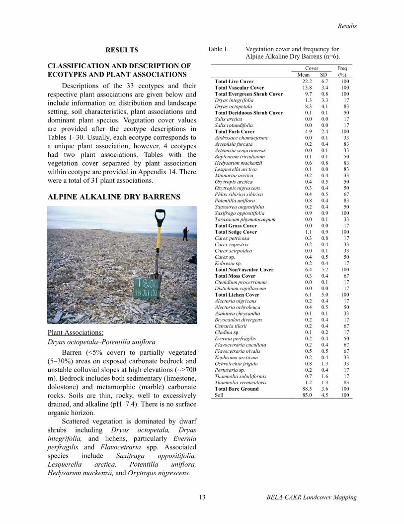
ALPINE ALKALINE DRY BARRENS
Plant Associations:Dryas octopetala–Potentilla uniflora
Barren (<5% cover) to partially vegetated(5–30%) areas on exposed carbonate bedrock andunstable colluvial slopes at high elevations (~>700m). Bedrock includes both sedimentary (limestone,dolostone) and metamorphic (marble) carbonaterocks. Soils are thin, rocky, well to excessivelydrained, and alkaline (pH 7.4). There is no surfaceorganic horizon.
Scattered vegetation is dominated by dwarfshrubs including Dryas octopetala, Dryasintegrifolia, and lichens, particularly Everniaperfragilis and Flavocetraria spp. Associatedspecies include Saxifraga oppositifolia,Lesquerella arctica, Potentilla uniflora,Hedysarum mackenzii, and Oxytropis nigrescens.
Table 1. Vegetation cover and frequency for Alpine Alkaline Dry Barrens (n=6).
Cover Freq Mean SD (%) Total Live Cover 22.2 6.7 100 Total Vascular Cover 15.8 3.4 100 Total Evergreen Shrub Cover 9.7 0.8 100 Dryas integrifolia 1.3 3.3 17 Dryas octopetala 8.3 4.1 83 Total Deciduous Shrub Cover 0.1 0.1 50 Salix arctica 0.0 0.0 17 Salix rotundifolia 0.0 0.0 17 Total Forb Cover 4.9 2.4 100 Androsace chamaejasme 0.0 0.1 33 Artemisia furcata 0.2 0.4 83 Artemisia senjavinensis 0.0 0.1 33 Bupleurum triradiatum 0.1 0.1 50 Hedysarum mackenzii 0.6 0.8 83 Lesquerella arctica 0.1 0.0 83 Minuartia arctica 0.2 0.4 33 Oxytropis arctica 0.4 0.5 50 Oxytropis nigrescens 0.3 0.4 50 Phlox sibirica sibirica 0.4 0.5 67 Potentilla uniflora 0.8 0.4 83 Saussurea angustifolia 0.2 0.4 50 Saxifraga oppositifolia 0.9 0.9 100 Taraxacum phymatocarpum 0.0 0.1 33 Total Grass Cover 0.0 0.0 17 Total Sedge Cover 1.1 0.9 100 Carex petricosa 0.3 0.8 17 Carex rupestris 0.2 0.4 33 Carex scirpoidea 0.0 0.1 33 Carex sp. 0.4 0.5 50 Kobresia sp. 0.2 0.4 17 Total NonVascular Cover 6.4 5.2 100 Total Moss Cover 0.3 0.4 67 Ctenidium procerrimum 0.0 0.1 17 Distichium capillaceum 0.0 0.0 17 Total Lichen Cover 6.1 5.0 100 Alectoria nigricans 0.2 0.4 17 Alectoria ochroleuca 0.4 0.5 50 Asahinea chrysantha 0.1 0.1 33 Bryocaulon divergens 0.2 0.4 17 Cetraria tilesii 0.2 0.4 67 Cladina sp. 0.1 0.2 17 Evernia perfragilis 0.2 0.4 50 Flavocetraria cucullata 0.2 0.4 67 Flavocetraria nivalis 0.5 0.5 67 Nephroma arcticum 0.2 0.4 33 Ochrolechia frigida 0.8 1.3 33 Pertusaria sp. 0.2 0.4 17 Thamnolia subuliformis 0.7 1.6 17 Thamnolia vermicularis 1.2 1.3 83 Total Bare Ground 88.5 3.6 100 Soil 85.0 4.5 100

Results
BELA-CAKR Landcover Mapping 14
ALPINE ALKALINE DRY DRYAS SHRUB
Plant Associations:Dryas integrifolia–Rhododendron lapponicum; Dryas octopetala–Potentilla uniflora
Areas on carbonate bedrock and relativelystable slopes at high elevations (~>700m)dominated by dwarf shrub vegetation. Soils arealkaline (pH 7.4), rocky, and well drained with athin organic horizon.
Vegetation is dominated by dwarf shrubs andlichens including Dryas integrifolia (mostly southslopes), or D. octopetala, Thamnolia vermicularis,Ochrolechia frigida, Nephroma arcticum,Flavocetraria cucullata, and F. nivalis. Otherspecies include Cassiope tetragona, Potentillauniflora, Arctostaphylos rubra, Rhytidiumrugosum, and Tomentypnum nitens.
The first plant association is dominated byDryas integrifolia and differentiated by thecommon occurrence of Rhododendronlapponicum. Other common species include Salixarctica, Salix reticulata, Arctostaphylos rubra,Carex scirpoidea, Tomentypnum nitens andRhytidium rugosum. The second plant associationis dominated by Dryas octopetala anddifferentiated by the presence of Potentillauniflora. Other common species include Saxifragaoppositifolia, Artemisia furcata, Hedysarummackenzii, and Lesquerella arctica.
This ecotype is similar to Alpine NonalkalineDry Dryas Shrub, but lacks the acidiphilic speciesSalix phlebophylla and Hierochloe alpina.
Table 2. Vegetation cover and frequency for Alpine Alkaline Dry Dryas Shrub (n=13).
Cover Freq Mean SD (%) Total Live Cover 96.1 46.8 100Total Vascular Cover 60.8 20.0 100Total Evergreen Shrub Cover 44.1 15.2 100Cassiope tetragona 2.6 4.3 54 Dryas integrifolia 14.6 20.4 38 Dryas octopetala 21.2 23.5 54 Rhododendron lapponicum 0.6 1.4 54 Total Evergreen Tree Cover 0.4 1.4 8 Picea glauca 0.4 1.4 8 Total Deciduous Shrub Cover 5.2 5.8 69 Andromeda polifolia 0.2 0.4 31 Arctostaphylos rubra 1.8 2.1 54 Salix arctica 1.9 2.6 54 Salix reticulata 0.8 1.4 46 Total Forb Cover 7.3 2.5 100 Androsace chamaejasme 0.0 0.1 46 Artemisia furcata 0.1 0.3 54 Equisetum variegatum 0.2 0.6 31 Hedysarum alpinum 0.5 1.0 31 Hedysarum mackenzii 0.4 0.9 46 Lagotis glauca 0.1 0.3 23 Minuartia sp. 0.1 0.3 31 Oxytropis nigrescens 0.1 0.3 23 Pedicularis capitata 0.1 0.3 54 Phlox sibirica sibirica 0.2 0.6 23 Polygonum viviparum 0.1 0.3 62 Potentilla biflora 0.4 1.0 23 Potentilla uniflora 0.1 0.3 23 Saussurea angustifolia 0.2 0.4 38 Saxifraga oppositifolia 1.2 0.9 77 Silene acaulis 0.2 0.4 62 Tofieldia coccinea 0.1 0.3 38 Tofieldia pusilla 0.2 0.4 38 Total Grass Cover 0.3 0.6 62 Arctagrostis latifolia 0.1 0.3 8 Festuca altaica 0.2 0.6 8 Total Sedge Cover 3.5 2.4 100 Carex bigelowii 0.3 0.7 23 Carex membranacea 0.2 0.4 23 Carex nardina 0.3 0.6 38 Carex scirpoidea 1.2 1.9 54 Eriophorum angustifolium 0.2 0.4 23 Total NonVascular Cover 35.3 32.3 100 Total Moss Cover 7.2 9.0 77 Hylocomium splendens 1.2 3.0 15 Rhytidium rugosum 1.9 3.7 46 Tomentypnum nitens 2.6 5.5 38 Total Lichen Cover 28.1 29.0 100 Alectoria ochroleuca 0.9 1.6 38 Bryocaulon divergens 0.3 0.9 23 Cetraria islandica cf 2.6 8.2 46 Cetraria tilesii 0.2 0.4 38 Dactylina arctica 0.4 0.9 46 Flavocetraria cucullata 5.7 9.6 77 Flavocetraria nivalis 1.9 1.8 69 Masonhalea richardsonii 0.2 0.4 23 Nephroma arcticum 3.2 11.1 23 Ochrolechia frigida 2.6 4.7 46 Thamnolia vermicularis 3.7 4.3 92 Vulpicida tilesii 0.3 0.6 31 Total Bare Ground 44.5 26.7 100Soil 25.0 27.0 100 Litter alone 19.5 19.6 100

Results
15 BELA-CAKR Landcover Mapping
ALPINE NONALKALINE DRY BARRENS
Plant Association:Dryas octopetala–Salix phlebophylla– Hierochlöe alpina
Barren to partially vegetated (<30% cover)areas on exposed noncarbonate bedrock and talusslopes at high elevations (~>700 m). Bedrockincludes felsic intrusive, noncarbonatemetamorphic, and noncarbonate sedimentary rocksthat generally have low calcium and magnesiumand high aluminum concentrations that lead toacidic soils. Soils are thin, rocky, well toexcessively drained, lacking in surface organicaccumulations, and acidic to circumneutral(pH <7.4).
The vegetation is dominated by lichens andhas a wide variety of colonizing plants. Commonspecies include Dryas octopetala, Salixphlebophylla, Hierochlöe alpina, Carexpodocarpa, Geum glaciale, Alectoria ochroleuca,Sphaerophorus globosus, Thamnolia vermicularis,and Cladonia spp.
This ecotype is similar to Alpine Alkaline DryBarrens, but lacks the calciphilic species Saxifragaoppositifolia, Potentilla uniflora, Hedysarummackenzii, and Oxytropis nigrescens.
Table 3. Vegetation cover and frequency for Alpine Nonalkaline Dry Barrens (n=7).
Cover Freq Mean SD (%) Total Live Cover 51.1 30.1 100Total Vascular Cover 5.7 5.3 85 Total Evergreen Shrub Cover 1.6 2.1 71 Cassiope tetragona 0.4 0.7 42 Diapensia lapponica 0.4 0.8 42 Dryas octopetala 0.6 1.0 28 Total Deciduous Shrub Cover 1.1 1.2 85 Arctostaphylos alpina 0.1 0.4 14 Salix phlebophylla 0.9 1.2 71 Total Forb Cover 1.6 1.9 71 Artemisia arctica arctica 0.3 0.8 14 Geum glaciale 0.3 0.8 28 Saxifraga sp. 0.2 0.4 42 Selaginella selaginoides 0.1 0.4 14 Silene acaulis 0.3 0.5 28 Total Grass Cover 0.2 0.4 42 Hierochlöe alpina 0.2 0.4 42 Total Sedge Cover 1.2 1.8 71 Carex bigelowii 0.3 0.5 28 Carex podocarpa 0.9 1.9 42 Total NonVascular Cover 45.4 30.1 100 Total Moss Cover 2.6 4.3 85 Eurhynchium pulchellum 0.1 0.4 14 Hylocomium splendens 0.3 0.8 14 Hypnum holmenii 0.1 0.4 14 Plagiomnium curvatulum 0.1 0.4 14 Polytrichum sp. 0.7 1.9 42 Racomitrium lanuginosum 0.7 1.9 14 Total Lichen Cover 42.8 27.8 100 Alectoria nigricans 0.2 0.4 42 Alectoria ochroleuca 0.6 1.1 57 Cetraria islandica cf 0.6 1.1 28 Cetraria nigricans 0.2 0.4 42 Cetraria sp. 0.2 0.4 14 Cladina rangiferina 0.1 0.4 14 Cladina stygia 0.4 1.1 28 Cladonia coccifera 0.0 0.1 14 Cladonia gracilis 0.0 0.1 14 Cladonia sp. 0.3 0.5 71 Dactylina arctica 0.0 0.1 28 Flavocetraria cucullata 0.6 1.1 28 Flavocetraria nivalis 0.2 0.4 28 Ochrolechia frigida 0.5 1.1 28 Parmelia omphalodes 3.0 7.5 28 Rhizocarpon geographicum 1.0 1.2 57 Sphaerophorus fragilis 0.1 0.4 14 Sphaerophorus globosus 0.1 0.1 57 Thamnolia vermicularis 0.3 0.5 71 Umbilicaria sp. 0.2 0.4 28 Umbilicaria torrefacta 1.4 2.4 28 Unknown crustose lichen 13.7 19.1 71 Unknown foliose lichen 14.3 25.1 28 Xanthoria sp. 1.1 1.9 42 Total Bare Ground 67.0 24.8 100 Soil 65.7 23.9 100 Litter alone 1.3 1.8 71

Results
BELA-CAKR Landcover Mapping 16
ALPINE NONALKALINE DRY DRYAS SHRUB
Plant Association:Dryas octopetala–Salix phlebophylla–Hierochlöe alpina
Crests and slopes at high elevations(~>700 m) on noncarbonate bedrock andcolluvium dominated by dwarf shrub vegetation.Soils are rocky, well to excessively drained, havevery thin surface organic accumulations, and arestrongly acidic (pH <6).
Vegetation is dominated by dwarf shrubs,sedges, and lichens including Dryas octopetala,Salix phlebophylla, Loiseleuria procumbens, andCarex podocarpa. Associated species include Salixplanifolia pulchra, Hierochlöe alpina,Sphaerophorus globosus, Nephroma arcticum, andFlavocetraria cucullata.
This ecotype differs from Alpine Alkaline DryDryas Shrub by lacking the calciphilic speciesSaxifraga oppositifolia, Potentilla uniflora,Hedysarum mackenzii, and Oxytropis nigrescens.It differs from Upland Moist DwarfBirch–Ericaceous Shrub by lacking Betula nanaand Ledum decumbens.
Table 4. Vegetation cover and frequency for Alpine Nonalkaline Dry Dryas Shrub (n=8).
Cover FreqMean SD (%)
Total Live Cover 82.7 19.0 100Total Vascular Cover 44.6 16.2 100Total Evergreen Shrub 23.1 12.3 100Cassiope tetragona 2.1 3.6 50Diapensia lapponica 2.1 2.5 50Dryas octopetala 13.8 14.1 87Empetrum nigrum 0.5 0.8 37Ledum decumbens 0.4 0.7 37Loiseleuria procumbens 3.3 5.3 62Vaccinium vitis-idaea 0.9 1.8 37Total Deciduous Shrub 10.4 6.9 100Salix phlebophylla 6.8 4.0 100Salix planifolia pulchra 0.5 0.5 75Vaccinium uliginosum 1.7 3.5 62Total Forb Cover 4.5 3.8 100Anemone narcissiflora 0.4 0.5 62Antennaria friesiana 0.3 0.4 50Arnica lessingii 0.2 0.3 37Artemisia arctica arctica 0.5 0.8 37Castilleja hyperborea 0.2 0.3 37Oxytropis arctica 0.3 0.7 37Polygonum bistorta 0.2 0.3 37Selaginella selaginoides 1.0 1.6 37Total Grass Cover 1.2 1.3 100Hierochlöe alpina 0.8 1.0 100Trisetum spicatum 0.2 0.3 37Total Sedge Cover 5.3 5.2 100Carex bigelowii 0.8 1.2 37Carex microchaeta 0.5 1.1 25Carex podocarpa 3.0 5.6 50Luzula sp. 0.2 0.4 37Total NonVascular Cover 38.2 20.7 100Total Moss Cover 6.6 4.7 100Dicranum sp. 1.1 1.4 50Polytrichum sp. 1.6 1.9 50Polytrichum strictum 1.0 1.8 37Racomitrium lanuginosum 0.4 0.7 25Rhizomnium sp. 1.3 2.3 25Total Lichen Cover 31.6 17.8 100Alectoria ochroleuca 0.3 0.5 37Asahinea chrysantha 0.3 0.7 25Bryocaulon divergens 0.4 0.7 50Cetraria islandica cf 0.9 1.8 25Cladina mitis 1.4 2.4 37Cladina rangiferina 1.3 1.9 37Cladina stygia 0.9 2.5 25Cladonia sp. 0.5 0.8 37Flavocetraria cucullata 2.3 3.5 87Flavocetraria nivalis 0.8 1.0 62Nephroma arcticum 0.4 0.7 50Parmelia omphalodes 5.3 9.9 37Pertusaria dactylina 0.4 0.5 37Pertusaria subobducens 3.1 4.6 37Rhizocarpon geographicum 1.3 3.5 12Sphaerophorus globosus 1.3 1.0 87Stereocaulon sp. 0.6 0.9 37Thamnolia vermicularis 0.8 0.7 87Umbilicaria spp. 0.6 1.8 25Unknown crustose lichen 1.1 2.1 25Unknown lichen 2.3 3.7 37Total Bare Ground 58.8 17.6 100Soil 35.3 25.7 100Litter alone 23.3 19.1 100

Results
17 BELA-CAKR Landcover Mapping
UPLAND DRY LICHEN BARRENS
Plant Association:Betula nana–Ledum decumbens–Loiseleuria procumbens
Crests and slopes of colluvial material orrecent volcanic deposits at moderate elevationswith less than 30% cover of vascular plants. In thestudy area the largest expanse of Upland DryLichen Barrens is found within the Imuruk LavaFlows in BELA. Exposed rocks are alkali olivinebasalt and vent deposits, there is little soildevelopment. Soils on colluvial slopes are rocky,excessively to well drained, circumneutral andhave little to no organic horizons. On lava flows,soils are lacking or limited to small lowermicrosites.
Vegetation is dominated by foliose andfruticose lichens with only low cover of vascularplants. Frequently occurring species includeBetula nana, Ledum decumbens, Loiseleuriaprocumbens, Empetrum nigrum, Vacciniumuliginosum, Racomitrium lanuginosum,Umbilicaria hyperborea, Cladina stellaris,Flavocetraria spp., and Alectoria ochroleuca.
This ecotype differs from Alpine NonalkalineDry Dryas Shrub by lacking the common alpinespecies Salix phlebophylla, Hierochlöe alpina andSelaginella selaginoides. It differs from UplandMoist Dwarf Birch–Ericaceous Shrub by lackingSalix planifolia pulchra and high cover of Cladinastellaris, Ochrolechia spp., and Umbilicaria spp.
Table 5. Vegetation cover and frequency for Upland Dry Lichen Barrens (n=4).
Cover Freq Mean SD (%) Total Live Cover 109.7 10.4 100 Total Vascular Cover 7.3 11.7 100 Total Evergreen Shrub Cover 2.7 3.7 100 Empetrum nigrum 0.8 0.9 100 Ledum decumbens 0.3 0.5 75 Loiseleuria procumbens 1.6 2.3 100 Total Deciduous Shrub Cover 4.0 7.4 100 Alnus crispa 0.5 1.0 50 Betula nana 2.5 5.0 25 Salix planifolia pulchra 0.3 0.5 25 Vaccinium uliginosum 0.6 1.0 100 Total Forb Cover 0.1 0.1 75 Potentilla fruticosa 0.1 0.1 50 Saxifraga bronchialis 0.0 0.1 25 Saxifraga tricuspidata 0.0 0.1 25 Total Grass Cover 0.4 0.6 75 Festuca rubra 0.0 0.1 25 Hierochlöe alpina 0.3 0.5 50 Total Sedge Cover 0.1 0.1 75 Carex sp. 0.1 0.1 50 Total NonVascular Cover 102.5 11.1 100 Total Moss Cover 0.4 0.4 100 Polytrichum hyperboreum 0.0 0.1 25 Racomitrium lanuginosum 0.3 0.5 100 Total Lichen Cover 102.1 11.3 100 Alectoria nigricans 1.3 2.5 50 Alectoria ochroleuca 3.8 4.8 75 Bryocaulon divergens 2.0 2.4 75 Cetraria islandica cf 0.8 1.0 50 Cetraria nigricans 0.1 0.1 50 Cetrariella delisei 0.3 0.5 25 Cladina arbuscula 0.8 1.5 50 Cladina mitis 0.3 0.5 25 Cladina sp. 0.5 1.0 25 Cladina stellaris 14.5 23.8 75 Cladina stygia 1.3 2.5 25 Cladonia coccifera 1.0 1.4 50 Cladonia nipponica 0.5 0.6 50 Flavocetraria cucullata 0.8 0.9 75 Flavocetraria nivalis 1.5 1.7 50 Nephroma arcticum 0.1 0.1 50 Ochrolechia frigida 17.5 35.0 25 Ophioparma lapponica 3.8 7.5 25 Pseudephebe pubescens 1.3 2.5 25 Rhizocarpon geographicum 2.5 2.9 50 Thamnolia vermicularis 1.0 0.8 100 Umbilicaria hyperborea 16.3 26.3 50 Unknown crustose lichen 16.3 29.3 50 Unknown foliose lichen 6.3 9.5 50 Xanthoria sp. 7.5 9.6 50 Total Bare Ground 13.8 9.3 100 Soil 12.5 9.6 100Litter alone 1.3 0.5 100

Results
BELA-CAKR Landcover Mapping 18
UPLAND MOIST SPRUCE FOREST
Plant Association:Picea glauca–Salix planifolia pulchra
Gentle to steep, upper and lower slopes oncolluvial glacial till deposits, but most oftenassociated with carbonate bedrock. The soils arerocky to loamy, moderately well to poorly drained,alkaline to circumneutral and have moderatelythick organic horizons and active-layer thickness.The forests occur only along the eastern boundariesof CAKR and BELA.
The vegetation has an open to woodlandcanopy of Picea glauca and a shrub understorydominated by Salix planifolia pulchra and Salixlanata richardsonii. Other common species includeSalix glauca, Equisetum arvense, Petasitesfrigidus, Carex bigelowii, Hylocomium splendens,Tomentypnum nitens, and Aulacomnium palustre.The plant association is poorly understood andprobably can be subdivided into an upland alkalinetype and a lowland willow-dominated type.
This ecotype differs from all others by thepresence of at least 10% white spruce in thecanopy. There may be some shrub ecotypes wherescattered trees are present but tree cover neverexceeds 10%.
Table 6. Vegetation cover and frequency for Upland Moist Spruce Forest (n=3).
Cover Freq Mean SD (%) Total Live Cover 169.0 43.7 100 Total Vascular Cover 112.3 15.0 100 Evergreen Tree 18.3 2.9 100 Picea glauca 18.3 2.9 100 Total Evergreen Shrub Cover 5.3 5.0 67 Dryas integrifolia 1.7 2.9 33 Empetrum nigrum 1.7 1.5 67 Vaccinium vitis-idaea 0.7 1.2 33 Total Deciduous Shrub Cover 46.3 17.1 100 Arctostaphylos alpina 3.3 5.8 33 Betula nana 3.3 5.8 33 Salix glauca 5.0 8.7 33 Salix lanata richardsonii 10.0 8.7 67 Salix planifolia pulchra 20.0 13.2 100 Salix reticulata 1.3 1.5 67 Vaccinium uliginosum 3.3 2.9 67 Total Forb Cover 34.8 27.2 100 Anemone richardsonii 1.0 1.7 67 Epilobium angustifolium 0.7 0.5 100 Equisetum arvense 10.0 17.3 33 Equisetum scirpoides 0.1 0.1 67 Petasites frigidus 8.3 7.6 67 Polygonum viviparum 0.4 0.6 67 Potentilla fruticosa 3.3 5.8 33 Rubus chamaemorus 5.7 8.1 67 Saussurea angustifolia 0.7 1.2 33 Valeriana capitata 0.4 0.6 67 Zygadenus elegans 1.0 1.7 33 Total Grass Cover 0.8 0.6 100 Calamagrostis canadensis 0.4 0.6 67 Total Sedge Cover 6.7 7.2 100 Carex bigelowii 5.7 8.1 67 Carex krausei 1.0 1.7 33 Total NonVascular Cover 56.7 28.7 100 Total Moss Cover 55.0 30.0 100 Aulacomnium palustre 8.3 10.4 67 Brachythecium erythrorrhizon 0.7 1.2 33 Dicranum angustum 0.7 1.2 33 Dicranum sp. 1.7 2.9 33 Drepanocladus sp. 1.0 1.7 33 Hylocomium splendens 18.3 18.9 100 Paludella squarrosa 1.0 1.7 33 Pleurozium schreberi 2.0 2.6 67 Ptilidium ciliare 2.0 2.6 67 Rhizomnium sp. 1.7 2.9 33 Sanionia uncinata 1.7 2.9 33 Tomentypnum nitens 15.0 15.0 67 Total Lichen Cover 1.7 2.0 100 Cladonia sp. 1.0 1.7 33 Peltigera aphthosa 0.7 0.5 100 Total Bare Ground 22.2 7.4 100 Soil 0.4 0.6 67 Water 0.2 0.3 33 Litter alone 21.7 7.6 100

Results
19 BELA-CAKR Landcover Mapping
UPLAND MOIST LOW WILLOW SHRUB
Plant Association:Salix glauca–Dryas integrifolia
Gentle to moderate slopes on well-drained,weathered bedrock, colluvium, and glacial till withvegetation dominated by low shrubs (0.2–1.5 mtall). Soils are rocky to loamy, moderately welldrained, circumneutral, and have thin tomoderately thick organic horizons and moderatelydeep (40–80 cm) active layers.
Vegetation has an open to closed canopy ofSalix glauca and/or S. planifolia pulchra. Othercommon plants include Dryas integrifolia, Dryasoctepetela, Vaccinium uliginosum, Salix reticulata,and Carex bigelowii. Common mosses and lichensinclude Hylocomium splendens, Cladinaarbuscula, and Cetraria islandica.
This ecotype differs from Lowland Moist LowWillow Shrub by lacking Petasites frigidus,Polemonium acutiflorum, and Carex aquatilis. Itdiffers from Upland Dwarf Birch–EricaceousShrub by lacking Ledum decumbens and Rubuschamaemorus. It differs from Upland MoistSedge–Dryas Meadow by the abundance of Salixplanifolia pulchra.
Table 7. Vegetation cover and frequency for Upland Moist Low Willow Shrub (n=2).
Cover Freq Mean SD (%) Total Live Cover 132.0 61.5 100 Total Vascular Cover 110.8 71.3 100 Total Evergreen Shrub Cover 19.0 1.4 100 Cassiope tetragona 2.0 1.4 100 Dryas integrifolia 7.5 10.6 50 Dryas octopetala 7.5 10.6 50 Empetrum nigrum 1.0 1.4 50 Rhododendron lapponicum 1.0 1.4 50 Total Deciduous Shrub Cover 62.5 46.0 100 Arctostaphylos rubra 1.0 1.4 50 Betula nana 2.5 3.5 50 Salix arctica 2.5 3.5 50 Salix glauca 12.5 17.7 50 Salix lanata richardsonii 10.0 14.1 50 Salix planifolia pulchra 17.5 10.6 100 Salix reticulata 15.0 21.2 50 Vaccinium uliginosum 1.5 2.1 50 Total Forb Cover 25.9 28.4 100 Aconitum delphinifolium 0.6 0.6 100 Anemone richardsonii 0.5 0.7 50 Artemisia arctica arctica 0.6 0.6 100 Aster sibiricus 0.5 0.7 50 Castilleja caudata 0.5 0.7 50 Epilobium angustifolium 1.5 2.1 50 Equisetum arvense 10.0 14.1 50 Equisetum scirpoides 0.1 0.1 50 Galium sp. 0.5 0.7 50 Hedysarum alpinum 0.5 0.7 50 Mertensia paniculata 3.5 4.9 50 Pedicularis capitata 0.6 0.6 100 Potentilla fruticosa 1.5 2.1 50 Valeriana capitata 1.0 0.0 100 Zygadenus elegans 1.5 2.1 50 Total Grass Cover 1.5 1.2 100 Arctagrostis latifolia 0.3 0.4 50 Festuca altaica 0.6 0.6 100 Total Sedge Cover 2.0 2.8 50 Carex bigelowii 1.5 2.1 50 Carex podocarpa 0.5 0.7 50 Total NonVascular Cover 21.2 9.8 100 Total Moss Cover 10.7 3.7 100 Distichium capillaceum 1.5 2.1 50 Hylocomium splendens 5.0 0.0 100 Pleurozium schreberi 1.5 2.1 50 Tomentypnum nitens 2.5 3.5 50 Total Lichen Cover 10.6 13.5 100 Cetraria islandica cf 5.0 7.1 50 Cladina arbuscula 1.5 2.1 50 Cladina rangiferina 0.5 0.7 50 Cladina stygia 2.5 3.5 50 Thamnolia vermicularis 0.5 0.7 50 Total Bare Ground 38.5 16.3 100 Soil 0.5 0.7 50 Water 0.5 0.7 50 Litter alone 37.5 17.7 100
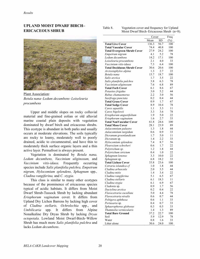
Results
BELA-CAKR Landcover Mapping 20
UPLAND MOIST DWARF BIRCH– ERICACEOUS SHRUB
Plant Association:Betula nana–Ledum decumbens–Loiseleuria procumbens
Upper and middle slopes on rocky colluvialmaterial and fine-grained eolian or old alluvialmarine coastal plain deposits with vegetationdominated by dwarf birch and ericaceous shrubs.This ecotype is abundant in both parks and usuallyoccurs at moderate elevations. The soils typicallyare rocky to loamy, moderately well to poorlydrained, acidic to circumneutral, and have thin tomoderately thick surface organic layers and a thinactive layer. Permafrost is always present.
Vegetation is dominated by Betula nana,Ledum decumbens, Vaccinium uliginosum, andVaccinium vitis-idaea. Frequently occurringspecies include Salix planifolia pulchra, Empetrumnigrum, Hylocomium splendens, Sphagnum spp.,Cladina rangiferina, and C. stygia.
This class is similar to many other ecotypesbecause of the prominence of ericaceous speciestypical of acidic habitats. It differs from MoistDwarf Shrub-Tussock Shrub by lacking abundantEriophorum vaginatum cover. It differs fromUpland Dry Lichen Barrens by lacking high coverof Cladina stellaris, Ochrolechia spp., andUmbilicaria spp. It differs from AlpineNonalkaline Dry Dryas Shrub by lacking Dryasoctopetala. Lowland Moist Dwarf-Birch–WillowShrub has much more Salix planifolia pulchra andlacks Ledum decumbens.
Table 8. Vegetation cover and frequency for Upland Moist Dwarf Birch–Ericaceous Shrub (n=8).
Cover Freq Mean SD (%) Total Live Cover 136.3 56.7 100 Total Vascular Cover 74.4 40.8 100 Total Evergreen Shrub Cover 27.9 24.2 100 Empetrum nigrum 4.1 5.2 78 Ledum decumbens 14.2 17.1 100 Loiseleuria procumbens 2.1 4.0 33 Vaccinium vitis-idaea 7.3 6.4 100 Total Deciduous Shrub Cover 30.6 20.6 100 Arctostaphylos alpina 1.3 2.7 22 Betula nana 15.7 18.7 100 Salix arctica 1.7 3.5 22 Salix planifolia pulchra 3.8 6.3 78 Vaccinium uliginosum 7.6 6.8 89 Total Forb Cover 6.1 8.6 67 Petasites frigidus 3.0 5.2 44 Rubus chamaemorus 2.2 3.0 56 Saxifraga punctata 0.2 0.4 44 Total Grass Cover 0.9 1.7 67 Total Sedge Cover 8.9 10.4 78 Carex aquatilis 1.1 3.3 11 Carex bigelowii 3.3 3.6 78 Eriophorum angustifolium 1.9 5.0 22 Eriophorum vaginatum 1.6 2.7 33 Total NonVascular Cover 61.8 24.6 100 Total Moss Cover 28.1 23.9 89 Aulacomnium palustre 1.3 1.8 44 Aulacomnium turgidum 0.6 0.9 33 Dicranum groenlandicum 1.7 5.0 11 Dicranum sp. 1.4 2.2 33 Hylocomium splendens 7.4 8.7 56 Pleurozium schreberi 0.6 1.7 22 Polytrichum sp. 1.2 1.8 44 Polytrichum strictum 0.4 1.0 22 Sphagnum lenense 3.3 10.0 22 Sphagnum sp. 6.8 18.2 33 Total Lichen Cover 33.8 23.6 100 Cetraria islandica cf 1.0 1.8 44 Cladina arbuscula 2.0 3.5 44 Cladina mitis 1.4 3.4 22 Cladina rangiferina 5.1 6.5 67 Cladina stellaris 6.1 18.3 11 Cladina stygia 6.1 6.9 67 Cladonia sp. 0.9 1.7 56 Dactylina arctica 0.2 0.4 22 Flavocetraria cucullata 5.0 4.4 78 Flavocetraria nivalis 0.6 0.7 44 Peltigera aphthosa 0.6 1.1 33 Pertusaria sp. 0.4 0.7 33 Sphaerophorus globosus 0.3 0.5 33 Thamnolia vermicularis 1.4 1.3 89 Total Bare Ground 37.2 22.7 100 Soil 5.9 12.9 78 Water 0.8 1.6 33 Litter alone 30.6 24.0 100

Results
21 BELA-CAKR Landcover Mapping
UPLAND MOIST DWARF BIRCH–TUSSOCK SHRUB
Plant Association:Betula nana–Eriophorum vaginatum
Moderate to gentle slopes at moderate andlower elevations on loess, colluvium, and raisedareas of drained basins with vegetation dominatedby tussock-forming sedges. Soils are loamymoderately well to poorly drained, acidic, and havemoderately thick surface organics and shallowactive layers (<40 cm). Permafrost is alwayspresent and probably ice-rich. This ecotype is themost abundant ecotype in both parks and is proneto fire.
Vegetation is dominated by Eriophorumvaginatum, Betula nana, Ledum decumbens, andEmpetrum nigrum. Other common species includeRubus chamaemorus, Carex bigelowii, Salixplanifolia pulchra, Vaccinium uliginosum,Flavocetraria cucullata, and Cladina rangiferina.Sphagnum mosses are abundant and diverse.
This ecotype is very similar to Upland MoistDwarf Birch–Ericaceous Shrub, Lowland MoistDwarf Birch–Willow Shrub and Lowland WetDwarf Birch–Ericaceous Shrub but differs by theprevalence (>12% cover) of Eriophorumvaginatum and the lack of Carex aquatilis. Thistussock class, at least the acidic type describedhere, is unusual in that species composition is verysimilar among plots within the type.
Table 9. Vegetation cover and frequency for Upland Moist Dwarf Birch–Tussock Shrub (n=8).
Cover Freq Mean SD (%) Total Live Cover 142.2 23.4 100 Total Vascular Cover 71.4 17.6 100 Total Evergreen Shrub Cover 24.5 13.1 88 Empetrum nigrum 5.8 3.5 88 Ledum decumbens 11.9 7.0 88 Vaccinium vitis-idaea 6.8 4.4 88 Total Deciduous Shrub Cover 18.3 14.2 100 Arctostaphylos rubra 0.5 1.1 25 Betula nana 9.1 6.1 100 Salix glauca 0.3 0.7 13 Salix lanata richardsonii 0.6 1.8 13 Salix planifolia pulchra 2.9 5.0 100 Salix reticulata 0.3 0.7 25 Vaccinium uliginosum 4.6 3.7 100 Total Forb Cover 8.3 9.2 100 Petasites frigidus 1.8 3.5 50 Rubus chamaemorus 5.6 3.9 88 Total Grass Cover 0.5 1.4 13 Arctagrostis latifolia 0.5 1.4 13 Total Sedge Cover 19.8 4.0 100 Carex bigelowii 4.5 3.1 100 Eriophorum angustifolium 1.1 1.7 50 Eriophorum vaginatum 14.0 3.3 100 Total NonVascular Cover 70.8 9.3 100 Total Moss Cover 50.4 20.7 100 Aulacomnium palustre 3.4 3.5 63 Aulacomnium turgidum 4.4 4.2 63 Dicranum elongatum 2.5 5.3 25 Dicranum groenlandicum 1.3 3.5 13 Dicranum sp. 1.1 1.9 38 Hylocomium splendens 8.8 13.8 50 Pleurozium schreberi 1.3 3.5 13 Polytrichum sp. 0.4 0.7 25 Sphagnum balticum 9.4 11.2 50 Sphagnum capillifolium 3.1 8.8 13 Sphagnum fuscum 4.4 8.2 25 Sphagnum girgensohnii 0.6 1.8 13 Sphagnum lenense 1.3 3.5 13 Sphagnum sp. 6.6 13.8 38 Tomentypnum nitens 1.4 3.5 25 Total Lichen Cover 20.4 16.0 88 Cetraria islandica cf 0.4 0.7 38 Cladina arbuscula 3.0 5.2 50 Cladina mitis 2.5 5.2 38 Cladina rangiferina 4.8 4.5 75 Cladina stygia 1.7 3.5 38 Cladonia sp. 0.3 0.5 38 Flavocetraria cucullata 2.8 3.6 63 Nephroma arcticum 0.6 1.2 25 Peltigera aphthosa 1.3 1.7 63 Thamnolia vermicularis 1.4 1.7 63 Total Bare Ground 36.7 18.4 100 Soil 0.4 0.5 50 Water 0.0 0.0 13 Litter alone 36.3 18.7 100

Results
BELA-CAKR Landcover Mapping 22
UPLAND DRY CROWBERRY SHRUB
Plant Association:Empetrum nigrum–Elymus arenarius mollis
Exposed ridges and upper slopes of inactivedunes and gravel beaches along the coast withvegetation dominated by Crowberry. Soils aresandy to gravelly, excessively to well-drained, andcircumneutral, and have very thin organics anddeep thaw depths. This ecotype is limited to coastalareas, and while the soils are nonsaline, somehalophytic species persist. In BELA the beachridges are sandy, whereas, in CAKR the beachridges are gravelly. Bare, wind-scoured patches arecommon in BELA.
Vegetation is dominated by Empetrumnigrum, Arctostaphylos rubra, Betula nana,Flavocetraria cucullata, and Cladina arbuscula.Halophytic species that have persisted from earliersuccessional stages include Elymus arenariusmollis, Lathyrus maritimus, Armeria maritima, andSalix ovalifolia. Other common species includeEpilobium latifolium, Rhytidium rugosum,Flavocetraria nivalis, Thamnolia vermicularis, andStereocaulon sp.
This ecotype differs from Upland MoistDwarf Birch–Ericaceous Shrub and LowlandMoist Dwarf Birch–Willow Shrub by thedominance of Empetrum nigrum, the presence ofElymus arenarius mollis, and its occurrence incoastal areas.
Table 10. Vegetation cover and frequency for Upland Dry Crowberry Shrub (n=5).
Cover Freq Mean SD (%) Total Live Cover 92.4 23.0 100 Total Vascular Cover 54.8 9.9 100 Total Evergreen Shrub Cover 34.8 8.1 100 Cassiope tetragona 0.4 0.9 40 Empetrum nigrum 31.0 11.4 100 Ledum decumbens 0.8 1.3 40 Loiseleuria procumbens 0.2 0.4 20 Vaccinium vitis-idaea 2.4 4.3 60 Total Deciduous Shrub Cover 10.9 9.6 80 Arctostaphylos alpina 1.0 2.2 40 Arctostaphylos rubra 3.0 6.7 20 Betula nana 2.6 4.2 60 Salix alaxensis 0.4 0.9 20 Salix glauca 0.6 1.3 40 Salix lanata richardsonii 0.2 0.4 20 Salix ovalifolia 0.6 1.3 20 Salix planifolia pulchra 0.2 0.4 60 Salix reticulata 0.6 0.9 60 Vaccinium uliginosum 1.6 2.1 60 Total Forb Cover 6.0 4.8 100 Armeria maritima 0.3 0.4 100 Epilobium latifolium 1.6 3.6 20 Lathyrus maritimus 1.2 1.1 60 Oxytropis maydelliana 0.4 0.5 60 Potentilla uniflora 1.0 2.2 20 Saxifraga bronchialis 0.4 0.9 20 Total Grass Cover 2.8 1.1 100 Elymus arenarius mollis 2.0 1.4 100 Trisetum spicatum 0.2 0.4 60 Total Sedge Cover 0.3 0.4 80 Luzula multiflora 0.2 0.4 40 Total NonVascular Cover 37.6 20.5 100 Total Moss Cover 8.5 7.0 100 Bryum sp. 1.8 2.0 60 Dicranum acutifolium 2.0 4.5 20 Dicranum sp. 2.0 4.5 20 Hylocomium splendens 0.4 0.9 20 Pleurozium schreberi 0.2 0.4 40 Ptilidium ciliare 0.4 0.9 40 Rhytidium rugosum 1.4 2.1 60 Sanionia uncinata 0.2 0.4 20 Total Lichen Cover 29.1 15.7 100 Alectoria nigricans 1.6 2.3 40 Bryocaulon divergens 1.2 2.2 40 Bryoria nitidula 1.0 2.2 40 Cetraria islandica cf 0.6 0.9 40 Cetraria laevigata 0.8 1.3 40 Cladina arbuscula 3.0 4.1 60 Cladina rangiferina 2.2 4.4 40 Cladonia sp. 0.6 1.3 20 Flavocetraria cucullata 6.4 6.1 80 Flavocetraria nivalis 2.8 4.1 60 Lobaria linita 0.1 0.1 60 Ochrolechia frigida 0.4 0.9 40 Pertusaria sp. 3.0 6.7 20 Sphaerophorus fragilis 0.4 0.9 20 Sphaerophorus globosus 0.8 1.3 60 Stereocaulon sp. 2.0 4.5 40 Thamnolia vermicularis 1.4 2.1 60 Total Bare Ground 29.4 24.1 100 Soil 4.4 3.4 100 Litter alone 25.0 25.7 100

Results
23 BELA-CAKR Landcover Mapping
UPLAND MOIST SEDGE–DRYAS MEADOW
Plant Association:Dryas integrifolia–Carex bigelowii–Senecio atropurpureus
Moderate to gentle, middle to upper slopes atmoderate elevations on colluvium and glacial tillwith vegetation co-dominated by sedges and dwarfshrubs. Soils are loamy, somewhat poorly drained,circumneutral to alkaline, and have moderatelythick surface organics and moderately deep (40–80 cm) thaw depths. The water table typicallyis 15–30 cm below the soil surface. This ecotype isabundant in both parks and commonly occurs onslopes below carbonate bedrock.
Dominant plants include Dryas integrifolia,Salix arctica, Salix reticulata, Carex bigelowii, andTomentypnum nitens. Other common speciesinclude Salix lanata richardsonii, Arctostaphylosrubra, Equisetum arvense, Hylocomium splendens,and Flavocetraria cucullata.
This ecotype is very similar to Lowland MoistSedge–Dryas Meadow but lacks Betula nana, andhas lower cover of Equisetum arvense. Duringmapping, this ecotype was restricted to upland andmountainous areas, whereas, Lowland MoistSedge–Dryas Meadows was restricted to thecoastal plains and drainages.
Table 11. Vegetation cover and frequency for Upland Moist Sedge–Dryas Meadow (n=10).
Cover FreqMean SD (%)
Total Live Cover 147.5 25.6 100Total Vascular Cover 81.6 15.6 100Total Evergreen Shrub Cover 30.9 19.0 100Cassiope tetragona 1.2 1.7 50Dryas integrifolia 27.0 19.3 80Rhododendron lapponicum 1.8 2.4 50Total Deciduous Shrub Cover 22.1 7.5 100Andromeda polifolia 0.6 1.6 30Arctostaphylos rubra 3.9 2.8 90Salix arctica 5.2 3.5 90Salix lanata richardsonii 2.6 3.3 80Salix planifolia pulchra 0.3 0.9 40Salix reticulata 6.0 6.2 60Vaccinium uliginosum 1.9 3.1 60Total Forb Cover 12.2 4.8 100Astragalus umbellatus 0.3 0.5 50Equisetum arvense 3.8 4.4 60Equisetum scirpoides 0.2 0.6 30Equisetum variegatum 0.3 0.7 30Hedysarum alpinum 0.2 0.4 50Lagotis glauca 0.1 0.3 50Pedicularis langsdorffii arctica 0.2 0.4 20Petasites frigidus 0.8 1.3 30Pinguicula vulgaris 0.2 0.3 60Polygonum viviparum 0.2 0.4 60Potentilla biflora 0.3 0.5 30Potentilla fruticosa 0.4 0.7 30Saussurea angustifolia 0.3 0.5 70Saxifraga hirculus 0.3 0.5 70Saxifraga oppositifolia 1.4 3.2 40Senecio atropurpureus 0.2 0.4 60Silene acaulis 0.1 0.3 40Total Grass Cover 1.5 1.7 80Arctagrostis latifolia 0.6 1.0 40Festuca altaica 0.5 1.1 20Poa arctica SL 0.2 0.4 40Total Sedge Cover 15.0 5.2 100Carex atrofusca 1.1 1.7 40Carex bigelowii 5.1 7.1 60Carex membranacea 1.2 2.0 40Carex misandra 0.6 1.1 40Carex rotundata 0.9 1.7 40Carex scirpoidea 1.8 2.6 60Eriophorum angustifolium 0.7 1.1 40 Eriophorum vaginatum 0.2 0.4 40Total NonVascular Cover 65.9 21.9 100Total Moss Cover 52.9 27.3 100Aulacomnium acuminatum 3.5 6.7 30Aulacomnium palustre 0.9 1.4 30Hylocomium splendens 15.5 21.4 70Hypnum bambergeri 2.0 3.5 30Ptilidium ciliare 2.0 2.3 50Rhytidium rugosum 4.4 5.1 70Tomentypnum nitens 17.3 19.3 80Total Lichen Cover 13.0 7.8 100Asahinea chrysantha 0.8 1.5 40Cetraria islandica cf 0.3 0.5 30Flavocetraria cucullata 3.8 2.5 100Flavocetraria nivalis 0.9 0.9 60Pertusaria sp. 1.5 2.2 50Thamnolia vermicularis 2.0 2.2 70Total Bare Ground 38.5 22.1 100Soil 2.3 2.9 80Water 0.7 1.0 60Litter alone 35.5 20.2 100

Results
BELA-CAKR Landcover Mapping 24
LOWLAND MOIST TALL ALDER–WILLOW SHRUB
Plant Association:Alnus crispa–Salix planifolia pulchra–Rubus arcticus
Lower slopes and drainages on hillsidecolluvium with vegetation dominated by tall(>1.5m) shrubs. Soils typically are loamy,moderately well to somewhat poorly drained, andcircumneutral. Thaw depths are generally >50 cmand soil organic horizons are thin.
Vegetation is dominated by an open or closedcanopy of Salix planifolia pulchra and/or Alnuscrispa. Areas dominated by Alnus crispa haveSalix planifolia pulchra as a co-dominant or in theunderstory. Other understory species include Rubusarcticus, Equisetum arvense, Artemisia tilesii,Mertensia paniculata, Galium boreale,Arctagrostis latifolia, and Calamagrostiscanadensis. Due to heavy litterfall mosses havelow cover.
This ecotype differs from Riverine Moist TallAlder–Willow Shrub by lacking Salix alaxensis,S. barclayi, and S. arbusculoides. It differs fromLowland Moist Low Willow Shrub by lackingSalix lanata richardsonii, S. reticulata,Tomentypnum nitens, and Hylocomium splendens.
Table 12. Vegetation cover and frequency for Low-land Moist Tall Alder–Willow Shrub (n=5).
Cover Freq Mean SD (%) Total Live Cover 116.3 23.0 100 Total Vascular Cover 112.2 24.1 100 Total Evergreen Shrub Cover 0.8 1.3 40 Dryas octopetala 0.4 0.9 20 Juniperus communis 0.2 0.4 20 Linnaea borealis 0.2 0.4 20 Total Deciduous Shrub Cover 72.8 19.9 100 Alnus crispa 57.0 21.7 100 Salix lanata richardsonii 1.0 2.2 20 Salix planifolia pulchra 13.0 14.4 80 Salix reticulata 0.6 1.3 20 Spiraea beauverdiana 0.6 1.3 40 Vaccinium uliginosum 0.2 0.4 40 Total Forb Cover 25.7 19.8 100 Aconitum delphinifolium 0.4 0.5 80 Angelica lucida 1.0 1.2 60 Artemisia arctica arctica 0.4 0.5 40 Artemisia tilesii 2.2 2.6 60 Epilobium angustifolium 1.0 2.2 20 Equisetum arvense 7.0 5.7 100 Galium boreale 2.6 4.3 40 Iris setosa 0.6 1.3 20 Lycopodium annotinum 1.2 1.6 40 Mertensia paniculata 2.4 4.3 40 Petasites frigidus 1.2 1.3 60 Potentilla fruticosa 1.0 2.2 20 Rubus arcticus 1.6 2.1 80 Valeriana capitata 1.0 1.2 80 Total Grass Cover 11.8 14.2 100 Arctagrostis latifolia 6.0 13.4 20 Calamagrostis canadensis 5.2 8.3 80 Total Sedge Cover 1.1 2.2 80 Carex atrofusca 1.0 2.2 20 Total NonVascular Cover 4.1 2.8 80 Total Moss Cover 3.7 2.3 80 Brachythecium reflexum 0.6 0.9 40 Brachythecium sp. 1.2 2.2 40 Climacium dendroides 0.2 0.4 20 Hylocomium splendens 0.2 0.4 20 Plagiomnium ellipticum 0.2 0.3 40 Sanionia uncinata 0.2 0.4 40 Total Lichen Cover 0.4 0.7 60 Total Bare Ground 78.0 19.6 100 Soil 2.0 4.5 20 Water 0.0 0.0 0 Litter alone 76.0 23.8 100

Results
25 BELA-CAKR Landcover Mapping
LOWLAND MOIST LOW WILLOW SHRUB
Plant Association: Salix planifolia pulchra– Calamagrostis canadensis
Low-lying flats and lower slopes withindrained-lake basins, on abandoned floodplains, andon colluvium with vegetation dominated by lowwillows (0.2–1.5 m tall). Soils typically are loamy,saturated, poorly drained, alkaline tocircumneutral, and underlain by permafrost atmoderate depths. Surface organics are thin onslopes and moderately thick on flats.
Vegetation is an open to closed low shrubcanopy dominated by Salix planifolia pulchra.Other common species include Salix lanatarichardsonii, Betula nana, Salix reticulata, Festucaaltaica, Calamagrostis canadensis, Equisetumarvense, Polemonium acutiflorum, Eriophorumangustifolium, Valeriana capitata, Tomentypnumnitens, and Hylocomium splendens.
This ecotype differs from closely relatedUpland Moist Low Willow Shrub by lacking Salixglauca and Cassiope tetragona and havingCalamagrostis canadensis. While speciescomposition is similar, the fine-grained soilassociated with ice-rich permafrost is considerablydifferent from the rocky soil with presumablyice-poor permafrost on upland hillsides.
Table 13. Vegetation cover and frequency for Lowland Moist Low Willow Shrub (n=10).
Cover Freq Mean SD (%) Total Live Cover 213.8 48.2 100Total Vascular Cover 162.7 30.8 100Total Evergreen Shrub Cover 2.9 6.4 50Dryas integrifolia 2.0 6.3 10Empetrum nigrum 0.3 0.5 40Total Deciduous Shrub Cover 81.5 15.0 100Arctostaphylos rubra 2.5 6.3 20Betula nana 0.8 1.0 50Salix hastata 7.5 23.7 10Salix lanata richardsonii 13.5 20.0 50Salix planifolia pulchra 38.0 34.6 70Salix reticulata 16.8 22.1 70Spiraea beauverdiana 0.3 0.5 30Vaccinium uliginosum 1.3 1.8 60Total Forb Cover 63.8 24.7 100Aconitum delphinifolium 0.7 0.8 60Anemone parviflora 1.2 3.1 30Anemone richardsonii 0.8 1.0 50Artemisia arctica arctica 2.3 3.4 50Cardamine pratensis 0.2 0.6 40Dodecatheon frigidum 0.7 0.8 60Equisetum arvense 26.4 31.9 90Myosotis alpestris asiatica 0.7 1.3 30Petasites frigidus 15.4 25.7 70Polemonium acutiflorum 3.7 9.3 100Polygonum bistorta 0.5 1.0 30Potentilla fruticosa 0.9 1.7 30Rubus arcticus 1.3 3.1 50Rubus chamaemorus 1.1 3.1 20Saxifraga punctata 0.2 0.4 40Senecio lugens 0.3 0.7 30Stellaria sp. 0.1 0.1 40Valeriana capitata 3.5 2.8 100Total Grass Cover 9.7 10.6 100Arctagrostis latifolia 0.2 0.6 20Calamagrostis canadensis 3.3 5.1 50Festuca altaica 5.1 10.7 60Poa arctica SL 0.6 1.3 40Trisetum spicatum 0.1 0.3 40Total Sedge Cover 4.8 6.3 90Carex aquatilis 1.9 3.6 40Carex bigelowii 0.6 1.6 30Carex scirpoidea 0.2 0.4 20Eriophorum angustifolium 1.4 2.8 30Total NonVascular Cover 51.1 25.6 100Total Moss Cover 49.3 25.3 100Aulacomnium palustre 5.3 8.0 60Brachythecium coruscum 1.0 3.2 10Brachythecium salebrosum 1.5 4.7 10Brachythecium sp. 0.6 1.3 20Bryum pseudotriquetrum 1.0 3.2 10Calliergon stramineum 4.0 12.6 10Campylium stellatum 1.0 3.2 10Dicranum sp. 1.6 3.1 40Hylocomium splendens 15.7 22.6 70Plagiomnium ellipticum 1.5 4.7 20Pleurozium schreberi 0.6 1.6 20Tomentypnum nitens 6.8 12.3 70Unknown moss 3.6 9.4 30Total Lichen Cover 1.8 3.4 80Peltigera aphthosa 0.4 0.7 60Total Bare Ground 41.8 21.0 100Soil 0.3 0.5 30Water 0.5 0.7 40Litter alone 41.0 21.2 100
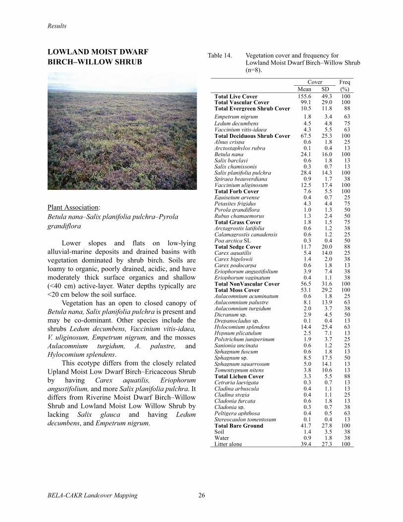
Results
BELA-CAKR Landcover Mapping 26
LOWLAND MOIST DWARF BIRCH–WILLOW SHRUB
Plant Association:Betula nana–Salix planifolia pulchra–Pyrola grandiflora
Lower slopes and flats on low-lyingalluvial-marine deposits and drained basins withvegetation dominated by shrub birch. Soils areloamy to organic, poorly drained, acidic, and havemoderately thick surface organics and shallow(<40 cm) active-layer. Water depths typically are<20 cm below the soil surface.
Vegetation has an open to closed canopy ofBetula nana, Salix planifolia pulchra is present andmay be co-dominant. Other species include theshrubs Ledum decumbens, Vaccinium vitis-idaea,V. uliginosum, Empetrum nigrum, and the mossesAulacomnium turgidum, A. palustre, andHylocomium splendens.
This ecotype differs from the closely relatedUpland Moist Low Dwarf Birch–Ericaceous Shrubby having Carex aquatilis, Eriophorumangustifolium, and more Salix planifolia pulchra. Itdiffers from Riverine Moist Dwarf Birch–WillowShrub and Lowland Moist Low Willow Shrub bylacking Salix glauca and having Ledumdecumbens, and Empetrum nigrum.
Table 14. Vegetation cover and frequency for Lowland Moist Dwarf Birch–Willow Shrub (n=8).
Cover Freq Mean SD (%) Total Live Cover 155.6 49.3 100Total Vascular Cover 99.1 29.0 100Total Evergreen Shrub Cover 10.5 11.8 88Empetrum nigrum 1.8 3.4 63 Ledum decumbens 4.5 4.8 75Vaccinium vitis-idaea 4.3 5.5 63Total Deciduous Shrub Cover 67.5 25.3 100Alnus crispa 0.6 1.8 25Arctostaphylos rubra 0.1 0.4 13Betula nana 24.1 16.0 100Salix barclayi 0.6 1.8 13Salix chamissonis 0.3 0.7 13Salix planifolia pulchra 28.4 14.3 100Spiraea beauverdiana 0.9 1.7 38Vaccinium uliginosum 12.5 17.4 100Total Forb Cover 7.6 5.5 100Equisetum arvense 0.4 0.7 25Petasites frigidus 4.3 4.4 75Pyrola grandiflora 1.0 1.3 50Rubus chamaemorus 1.3 2.4 50Total Grass Cover 1.8 1.5 75Arctagrostis latifolia 0.6 1.2 38Calamagrostis canadensis 0.6 1.2 25Poa arctica SL 0.3 0.4 50Total Sedge Cover 11.7 20.0 88Carex aquatilis 5.4 14.0 25Carex bigelowii 1.4 2.0 38Carex podocarpa 0.6 1.8 13Eriophorum angustifolium 3.9 7.4 38Eriophorum vaginatum 0.4 1.1 38Total NonVascular Cover 56.5 31.6 100Total Moss Cover 53.1 29.2 100Aulacomnium acuminatum 0.6 1.8 25Aulacomnium palustre 8.1 13.9 63Aulacomnium turgidum 2.0 3.7 38Dicranum sp. 2.9 4.5 50Drepanocladus sp. 0.1 0.4 13Hylocomium splendens 14.4 25.4 63Hypnum plicatulum 2.5 7.1 13Polytrichum juniperinum 1.9 3.7 25Sanionia uncinata 0.6 1.2 25Sphagnum fuscum 0.6 1.8 13Sphagnum sp. 8.5 17.5 50Sphagnum squarrosum 5.0 14.1 13Tomentypnum nitens 3.8 10.6 13Total Lichen Cover 3.3 5.5 88Cetraria laevigata 0.3 0.7 13Cladina arbuscula 0.4 1.1 13Cladina stygia 0.4 1.1 25Cladonia furcata 0.6 1.8 13Cladonia sp. 0.3 0.7 38Peltigera aphthosa 0.4 0.5 63Stereocaulon tomentosum 0.1 0.4 13Total Bare Ground 41.7 27.8 100Soil 1.4 3.5 38Water 0.9 1.8 38Litter alone 39.4 27.3 100
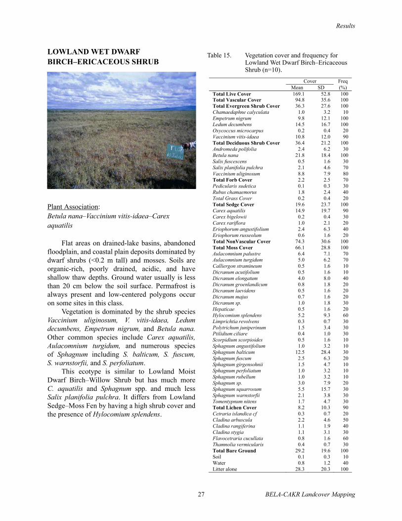
Results
27 BELA-CAKR Landcover Mapping
LOWLAND WET DWARF BIRCH–ERICACEOUS SHRUB
Plant Association:Betula nana–Vaccinium vitis-idaea–Carex aquatilis
Flat areas on drained-lake basins, abandonedfloodplain, and coastal plain deposits dominated bydwarf shrubs (<0.2 m tall) and mosses. Soils areorganic-rich, poorly drained, acidic, and haveshallow thaw depths. Ground water usually is lessthan 20 cm below the soil surface. Permafrost isalways present and low-centered polygons occuron some sites in this class.
Vegetation is dominated by the shrub speciesVaccinium uliginosum, V. vitis-idaea, Ledumdecumbens, Empetrum nigrum, and Betula nana.Other common species include Carex aquatilis,Aulacomnium turgidum, and numerous speciesof Sphagnum including S. balticum, S. fuscum,S. warnstorfii, and S. perfoliatum.
This ecotype is similar to Lowland MoistDwarf Birch–Willow Shrub but has much moreC. aquatilis and Sphagnum spp. and much lessSalix planifolia pulchra. It differs from LowlandSedge–Moss Fen by having a high shrub cover andthe presence of Hylocomium splendens.
Table 15. Vegetation cover and frequency for Lowland Wet Dwarf Birch–Ericaceous Shrub (n=10).
Cover Freq Mean SD (%) Total Live Cover 169.1 52.8 100Total Vascular Cover 94.8 35.6 100 Total Evergreen Shrub Cover 36.3 27.6 100 Chamaedaphne calyculata 1.0 3.2 10 Empetrum nigrum 9.8 12.1 100 Ledum decumbens 14.5 16.7 100 Oxycoccus microcarpus 0.2 0.4 20 Vaccinium vitis-idaea 10.8 12.0 90 Total Deciduous Shrub Cover 36.4 21.2 100 Andromeda polifolia 2.4 6.2 30 Betula nana 21.8 18.4 100 Salix fuscescens 0.5 1.6 30 Salix planifolia pulchra 2.1 4.6 70 Vaccinium uliginosum 8.8 7.9 80 Total Forb Cover 2.2 2.5 70 Pedicularis sudetica 0.1 0.3 30 Rubus chamaemorus 1.8 2.4 40 Total Grass Cover 0.2 0.4 20 Total Sedge Cover 19.6 23.7 100 Carex aquatilis 14.9 19.7 90 Carex bigelowii 0.2 0.4 30 Carex rariflora 1.0 2.1 20 Eriophorum angustifolium 2.4 6.3 40 Eriophorum russeolum 0.6 1.6 20 Total NonVascular Cover 74.3 30.6 100 Total Moss Cover 66.1 28.8 100 Aulacomnium palustre 6.4 7.1 70 Aulacomnium turgidum 5.0 6.2 70 Calliergon stramineum 0.5 1.6 10 Dicranum acutifolium 0.5 1.6 10 Dicranum elongatum 4.0 8.0 40 Dicranum groenlandicum 0.8 1.8 20 Dicranum laevidens 0.5 1.6 20 Dicranum majus 0.7 1.6 20 Dicranum sp. 1.0 1.8 30 Hepaticae 0.5 1.6 20 Hylocomium splendens 5.2 9.3 60 Limprichtia revolvens 0.3 0.7 30 Polytrichum juniperinum 1.5 3.4 30 Ptilidium ciliare 0.4 1.0 30 Scorpidium scorpioides 0.5 1.6 10 Sphagnum angustifolium 1.0 3.2 10 Sphagnum balticum 12.5 28.4 30 Sphagnum fuscum 2.5 6.3 20 Sphagnum girgensohnii 1.5 4.7 10 Sphagnum perfoliatum 1.0 3.2 10 Sphagnum rubellum 1.0 3.2 10 Sphagnum sp. 3.0 7.9 20 Sphagnum squarrosum 5.5 15.7 30 Sphagnum warnstorfii 2.1 3.8 30 Tomentypnum nitens 1.7 4.7 30 Total Lichen Cover 8.2 10.3 90 Cetraria islandica cf 0.3 0.7 20 Cladina arbuscula 2.2 4.6 50 Cladina rangiferina 1.1 1.9 40 Cladina stygia 1.1 3.1 30 Flavocetraria cucullata 0.8 1.6 60 Thamnolia vermicularis 0.4 0.7 30 Total Bare Ground 29.2 19.6 100 Soil 0.1 0.3 10 Water 0.8 1.2 40 Litter alone 28.3 20.3 100

Results
BELA-CAKR Landcover Mapping 28
LOWLAND MOIST SEDGE–DRYAS MEADOW
Plant Association:Dryas integrifolia–Equisetum arvense
Moderate to gentle, lower slopes at lowerelevations on colluvium, glacial till, and coastalplain deposits with vegetation co-dominated bysedges and dwarf shrubs. Soils are loamy,somewhat poorly drained, circumneutral toalkaline, and have moderately thick surfaceorganics and moderately deep (40–80 cm) thawdepths. The water table typically is 15–30 cmbelow the soil surface. This ecotype is abundant inboth parks.
Dominant plants include Dryas integrifolia,Dryas octopetala, Salix reticulata, Salix arctica,Equisetum arvense, and Hylocomium splendens.Other common species include Salix lanatarichardsonii, Arctostaphylos rubra, Carexbigelowii, Tomentypnum nitens, and Flavocetrariacucullata.
This ecotype is very similar to Upland MoistSedge–Dryas Meadow but has more Equisetumarvense. During mapping, this ecotype wasrestricted to the coastal plains and drainages,whereas, Upland Moist Sedge–Dryas Meadow wasrestricted to upland and mountainous areas. Ofparticular interest in differentiating upland andlowland types is the likelihood of ice-richpermafrost in the loamy lowlands and ice-poorpermafrost in the rocky uplands.
Table 16. Vegetation cover and frequency for Lowland Moist Sedge–Dryas Meadow (n=3).
Cover FreqMean SD (%)
Total Live Cover 146.5 8.2 100Total Vascular Cover 83.9 10.2 100Total Evergreen Shrub Cover 28.0 15.1 100Cassiope tetragona 0.7 1.2 33Dryas integrifolia 16.7 20.8 67Dryas octopetala 10.0 17.3 33Total Deciduous Shrub Cover 24.7 8.0 100Arctostaphylos rubra 2.3 2.5 67Betula nana 0.7 1.1 67Salix arctica 3.3 1.5 100Salix lanata richardsonii 2.0 2.6 67Salix planifolia pulchra 0.7 0.6 67Salix reticulata 13.3 7.6 100Vaccinium uliginosum 1.7 2.9 33Total Forb Cover 18.5 2.9 100Artemisia arctica arctica 1.0 1.7 33Dodecatheon frigidum 1.3 1.5 67Equisetum arvense 9.3 8.0 100Petasites frigidus 2.0 2.6 67Polygonum bistorta 0.7 0.5 100Polygonum viviparum 0.7 0.5 100Saxifraga hirculus 0.1 0.1 67Saxifraga punctata 0.1 0.1 67Valeriana capitata 0.4 0.6 67Total Grass Cover 4.3 5.9 67Arctagrostis latifolia 1.3 1.5 67Festuca altaica 1.0 1.7 33Poa arctica SL 1.3 1.5 67Trisetum spicatum 0.7 1.2 33Total Sedge Cover 8.3 4.0 100Carex bigelowii 4.7 2.5 100Carex podocarpa 1.0 1.7 33Carex scirpoidea 0.7 1.2 33Luzula multiflora 0.7 0.6 67Total NonVascular Cover 62.7 2.1 100Total Moss Cover 57.0 2.0 100Aulacomnium acuminatum 5.0 8.7 33Aulacomnium palustre 3.3 5.8 33Aulacomnium turgidum 0.7 1.2 33Dicranum sp. 4.0 1.7 100Drepanocladus sp. 1.7 2.9 33Hylocomium splendens 20.0 10.0 100Hypnum sp. 3.3 5.8 33Rhytidium rugosum 3.3 5.8 33Sanionia uncinata 1.0 1.7 33Tomentypnum nitens 12.7 11.2 100Unknown moss 1.7 2.9 33Total Lichen Cover 5.7 0.6 100Cetraria islandica cf 1.7 0.6 100Cladonia sp. 0.7 0.6 67Flavocetraria cucullata 1.3 1.2 67Peltigera aphthosa 0.7 0.6 67Total Bare Ground 44.1 29.5 100.0Soil 0.4 0.6 66.7Water 0.4 0.6 66.7Litter alone 43.3 28.9 100.0

Results
29 BELA-CAKR Landcover Mapping
LOWLAND SEDGE–MOSS FEN MEADOW
Plant Association:Carex aquatilis–Salix fuscescens–Sphagnum
Flat areas, primarily in drained-lake basins,with vegetation dominated by sedges andSphagnum mosses. Soils are organic-rich(20–40 cm of organics), poorly drained, acidic, andhave shallow active-layer depths. Water usually iswithin 10 cm of the surface. This ecotype iscommon on the coastal plains of both parks.
Vegetation is dominated by Carex aquatilis,Salix fuscescens, and numerous Sphagnum spp.Other common species include Betula nana,Ledum decumbens, Eriophorum angustifolium, andAulacomnium palustre.
This ecotype differs from closely relatedLowland Sedge Fen Meadow by the presence ofSalix fuscescens, Sphagnum, and Betula nana. Itdiffers from Lowland Wet Dwarf Birch–EricacousShrub by the low cover of shrubs and by the lack ofHylocomium splendens.
Table 17. Vegetation cover and frequency for Lowland Sedge–Moss Fen Meadow (n=9).
Cover Freq Mean SD (%) Total Live Cover 113.6 33.0 100 Total Vascular Cover 45.4 18.6 100 Total Evergreen Shrub Cover 5.4 6.5 89 Empetrum nigrum 1.2 1.7 67 Ledum decumbens 2.8 3.4 89 Oxycoccus microcarpus 0.6 1.0 33 Vaccinium vitis-idaea 0.8 1.7 33 Total Deciduous Shrub Cover 8.8 6.3 100 Andromeda polifolia 0.7 1.1 33 Betula nana 2.8 3.1 100 Salix fuscescens 1.6 1.7 67 Salix planifolia pulchra 1.3 3.3 22 Vaccinium uliginosum 2.3 2.6 89 Total Forb Cover 2.2 4.5 78 Pedicularis sudetica 0.2 0.4 22 Petasites frigidus 0.3 1.0 22 Potentilla palustris 1.2 3.3 44 Rubus chamaemorus 0.3 0.7 22 Total Grass Cover 1.1 2.0 44 Calamagrostis canadensis 0.7 1.7 33 Hierochloe pauciflora 0.4 0.7 33 Total Sedge Cover 27.9 17.1 100 Carex aquatilis 16.3 17.6 100 Carex bigelowii 1.1 3.3 11 Carex chordorrhiza 0.6 1.7 11 Carex rariflora 2.1 3.4 56 Carex rotundata 0.1 0.3 22 Eriophorum angustifolium 4.7 5.7 56 Eriophorum russeolum 1.0 1.7 33 Eriophorum scheuchzeri 1.3 2.2 33 Eriophorum vaginatum 0.3 0.7 22 Luzula arcuata 0.1 0.3 11 Total NonVascular Cover 68.1 21.5 100 Total Moss Cover 67.3 21.0 100 Aulacomnium palustre 3.9 7.0 44 Campylium stellatum 0.6 1.7 11 Dicranum sp. 1.3 3.3 33 Polytrichum juniperinum 0.4 0.7 33 Sphagnum balticum 2.2 6.7 11 Sphagnum capillifolium 4.4 13.3 11 Sphagnum compactum 1.7 5.0 11 Sphagnum fuscum 8.9 20.3 22 Sphagnum imbricatum 3.9 7.8 22 Sphagnum lenense 5.6 11.3 22 Sphagnum lindbergii 1.7 5.0 11 Sphagnum obtusum 1.1 3.3 11 Sphagnum sp. 11.1 19.6 33 Sphagnum squarrosum 15.6 16.5 56 Sphagnum subsecundum 2.0 5.0 22 Sphagnum warnstorfii 2.8 6.7 22 Total Lichen Cover 0.8 1.6 44 Cladina arbuscula 0.4 1.3 11 Cladonia sp. 0.1 0.3 11 Total Bare Ground 47.4 22.0 100 Soil 0.1 0.3 22 Water 7.8 11.2 78 Litter alone 39.4 15.9 100
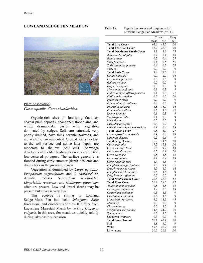
Results
BELA-CAKR Landcover Mapping 30
LOWLAND SEDGE FEN MEADOW
Plant Association:Carex aquatilis–Carex chordorrhiza
Organic-rich sites on low-lying flats, oncoastal plain deposits, abandoned floodplains, andwithin drained-lake basins with vegetationdominated by sedges. Soils are saturated, verypoorly drained, have thick organic horizons, andare acidic to circumneutral. Ground water is closeto the soil surface and active later depths aremoderate to shallow (<40 cm). Ice-wedgedevelopment in older landscapes creates distinctivelow-centered polygons. The surface generally isflooded during early summer (depth <30 cm) anddrains later in the growing season.
Vegetation is dominated by Carex aquatilis,Eriophorum angustifolium, and C. chordorrhiza.Aquatic mosses Scorpidium scorpioides,Limprichtia revolvens, and Calliergon giganteumoften are present. Low and dwarf shrubs may bepresent but cover is very low.
This ecotype is similar to LowlandSedge–Moss Fen but lacks Sphagnum, Salixfuscescens, and ericaceous shrubs. It differs fromLacustrine Marestail Marsh by lacking Hippurusvulgaris. In this area, fen meadows quickly acidifyduring lake-basin succession.
Table 18. Vegetation cover and frequency for Lowland Sedge Fen Meadow (n=11).
Cover Freq Mean SD (%) Total Live Cover 65.6 43.7 100 Total Vascular Cover 45.2 26.3 100 Total Deciduous Shrub Cover 1.1 1.2 73 Andromeda polifolia 0.2 0.4 18 Betula nana 0.2 0.4 27 Salix fuscescens 0.4 0.5 55 Salix planifolia pulchra 0.4 0.7 27 Salix sp. 0.0 0.0 9 Total Forb Cover 7.8 17.5 91 Caltha palustris 0.9 2.0 36 Cardamine pratensis 0.0 0.0 9 Galium trifidum 0.0 0.0 9 Hippuris vulgaris 0.0 0.0 9 Menyanthes trifoliata 0.1 0.3 9 Pedicularis parviflora pennellii 0.1 0.3 27 Pedicularis sudetica 0.3 0.6 36 Petasites frigidus 0.0 0.0 9 Polemonium acutiflorum 0.0 0.0 9 Potentilla palustris 4.8 15.0 36 Ranunculus pallasii 0.6 1.5 27 Rumex arcticus 0.1 0.3 9 Saxifraga hirculus 0.1 0.3 9 Utricularia sp. 0.0 0.0 9 Utricularia vulgaris 0.3 0.9 9 Utricularia vulgaris macrorhiza 0.4 0.8 18 Total Grass Cover 0.5 1.0 27 Calamagrostis canadensis 0.4 0.9 18 Dupontia fischeri 0.2 0.6 9 Total Sedge Cover 35.7 14.6 100 Carex aquatilis 15.2 12.8 100 Carex chordorrhiza 6.8 9.2 64 Carex membranacea 0.5 0.8 36 Carex rariflora 0.5 1.5 18 Carex rotundata 0.4 0.9 18 Carex saxatilis laxa 1.4 4.5 9 Eriophorum angustifolium 8.5 7.4 91 Eriophorum russeolum 1.7 1.7 64 Eriophorum scheuchzeri 0.5 1.5 9 Eriophorum vaginatum 0.0 0.0 9 Total NonVascular Cover 20.4 28.3 82 Total Moss Cover 20.4 28.3 82 Aulacomnium turgidum 0.5 1.5 18 Calliergon giganteum 1.9 6.0 18 Campylium stellatum 0.5 1.5 9 Cinclidium latifolium 0.5 1.5 9 Limprichtia revolvens 4.5 11.9 45 Mnium sp. 0.0 0.0 9 Rhizomnium sp. 0.5 1.5 9 Scorpidium scorpioides 11.4 21.9 36 Sphagnum sp. 0.5 1.5 9 Unknown liverwort 0.3 0.9 9 Total Bare Ground 90.1 42.4 100 Soil 1.8 6.0 9 Water 57.5 28.2 100 Litter alone 30.7 26.1 100

Results
31 BELA-CAKR Landcover Mapping
LOWLAND WATER
Shallow (<1.5 m) and deep (≥1.5 m) lakesprimarily resulting from thawing of ice-richpermafrost on the coastal plain and distal portionsof abandoned floodplains. These lakes lackriverine influences. In shallow ponds, water freezesto the bottom during winter, thaws by early tomid-June, and is warmer than water in deep lakes.In deep lakes, water does not freeze to the bottomduring winter in deeper portions of the lake.Sediments are loamy to sandy. The alpine lakes inthe Bendeleben Mountains are included in thisclass because they are relatively rare.
Table 19. Vegetation cover and frequency for Lowland Water (n=4).
Cover Freq Mean SD (%) Total Live Cover 1.5 3.0 25 Total Vascular Cover 1.3 2.5 25 Total Forb Cover 0.5 1.0 25 Hippuris vulgaris 0.3 0.5 25 Potentilla palustris 0.3 0.5 25 Total Grass Cover 0.3 0.5 25 Arctophila fulva 0.3 0.5 25 Total Sedge Cover 0.5 1.0 25 Carex aquatilis 0.3 0.5 25 Eriophorum angustifolium 0.3 0.5 25 Total Moss Cover 0.3 0.5 25 Calliergon giganteum 0.3 0.5 25 Total Bare Ground 100.0 0.0 100 Water 100.0 0.0 100
Shallow water with emergent vegetation.Although the plant associations are distinct theywere combined because they are uncommon andsampling was inadequate. This class was includedin the Lowland Water class for mapping. Dominantspecies include Hippuris vulgaris and Carexaquatilis, while Caltha natans, Arctophila fulva,and Potentilla palustris often occur in differingcircumstances.
Table 20. Vegetation cover and frequency for Lacustrine Maresail Marsh (n=5).
Cover Freq Mean SD (%) Total Live Cover 34.3 23.5 100 Total Vascular Cover 30.5 19.0 100 Total Deciduous Shrub Cover 0.2 0.4 20 Salix fuscescens 0.2 0.4 20 Total Forb Cover 19.9 16.9 100 Caltha natans 3.0 6.7 20 Caltha palustris 0.8 1.3 40 Hippuris vulgaris 8.6 8.5 80 Menyanthes trifoliata 0.4 0.9 20 Myriophyllum spicatum 0.6 1.3 40 Potamogeton sp. 0.4 0.5 60 Potentilla palustris 5.0 8.7 40 Ranunculus hyperboreus 0.6 1.3 40 Ranunculus pallasii 0.4 0.9 20 Total Grass Cover 4.2 8.8 40 Arctophila fulva 4.2 8.8 40 Total Sedge Cover 6.2 13.3 40 Carex aquatilis 3.2 6.6 40 Eriophorum angustifolium 3.0 6.7 20 Total Moss Cover 3.8 6.9 40 Limprichtia revolvens 2.0 4.5 20 Scorpidium scorpioides 1.0 2.2 20 Sphagnum cf. jensnii 0.2 0.4 20 Sphagnum squarrosum 0.6 1.3 20 Total Bare Ground 105.0 27.1 100 Water 86.8 18.4 100 Litter alone 18.2 40.1 40
LACUSTRINE MARESTAIL MARSH
Plant Associations: Hippurus vulgaris–Potamogeton spp.; Carex aquatilis–Caltha palustris; Arctophila fulva
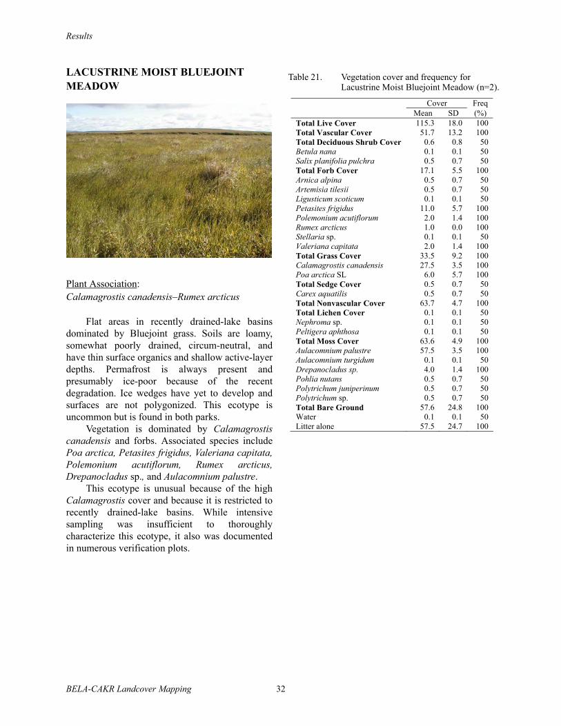
Results
BELA-CAKR Landcover Mapping 32
LACUSTRINE MOIST BLUEJOINT MEADOW
Plant Association:Calamagrostis canadensis–Rumex arcticus
Flat areas in recently drained-lake basinsdominated by Bluejoint grass. Soils are loamy,somewhat poorly drained, circum-neutral, andhave thin surface organics and shallow active-layerdepths. Permafrost is always present andpresumably ice-poor because of the recentdegradation. Ice wedges have yet to develop andsurfaces are not polygonized. This ecotype isuncommon but is found in both parks.
Vegetation is dominated by Calamagrostiscanadensis and forbs. Associated species includePoa arctica, Petasites frigidus, Valeriana capitata,Polemonium acutiflorum, Rumex arcticus,Drepanocladus sp., and Aulacomnium palustre.
This ecotype is unusual because of the highCalamagrostis cover and because it is restricted torecently drained-lake basins. While intensivesampling was insufficient to thoroughlycharacterize this ecotype, it also was documentedin numerous verification plots.
Table 21. Vegetation cover and frequency for Lacustrine Moist Bluejoint Meadow (n=2).
Cover Freq Mean SD (%) Total Live Cover 115.3 18.0 100 Total Vascular Cover 51.7 13.2 100 Total Deciduous Shrub Cover 0.6 0.8 50 Betula nana 0.1 0.1 50 Salix planifolia pulchra 0.5 0.7 50 Total Forb Cover 17.1 5.5 100 Arnica alpina 0.5 0.7 50 Artemisia tilesii 0.5 0.7 50 Ligusticum scoticum 0.1 0.1 50 Petasites frigidus 11.0 5.7 100 Polemonium acutiflorum 2.0 1.4 100 Rumex arcticus 1.0 0.0 100 Stellaria sp. 0.1 0.1 50 Valeriana capitata 2.0 1.4 100 Total Grass Cover 33.5 9.2 100 Calamagrostis canadensis 27.5 3.5 100 Poa arctica SL 6.0 5.7 100 Total Sedge Cover 0.5 0.7 50 Carex aquatilis 0.5 0.7 50 Total Nonvascular Cover 63.7 4.7 100 Total Lichen Cover 0.1 0.1 50 Nephroma sp. 0.1 0.1 50 Peltigera aphthosa 0.1 0.1 50 Total Moss Cover 63.6 4.9 100 Aulacomnium palustre 57.5 3.5 100 Aulacomnium turgidum 0.1 0.1 50 Drepanocladus sp. 4.0 1.4 100 Pohlia nutans 0.5 0.7 50 Polytrichum juniperinum 0.5 0.7 50 Polytrichum sp. 0.5 0.7 50 Total Bare Ground 57.6 24.8 100 Water 0.1 0.1 50 Litter alone 57.5 24.7 100

Results
33 BELA-CAKR Landcover Mapping
RIVERINE BARRENS
Plant Association:Epilobium latifolium–Agropyron macrourum
Barren or partially vegetated (<30% cover)areas on active river channel deposits associatedwith meandering or braided rivers. Frequentsedimentation and scouring restricts establishmentand growth of vegetation. Soils are well toexcessively drained, sandy to gravelly, alkaline tocircumneutral and lack surface organics.Permafrost is always present and active-layerdepths are deep (>80 cm). Water usually is found atthe bottom of the active layer.
Typical pioneering plants include Salixalaxensis, S. planifolia pulchra, Festuca rubra,Elymus arenarius mollis, Artemisia arctica arctica,Epilobium latifolium, and Oxytropis borealis.
This ecotype is relatively uncommon becauseof the riverine setting and lack of vegetation. Whileit has many of the species found in Riverine TallWillow Shrub, its shrub cover is much lower. It hassome species in common with Coastal Barrens,particularly Elymus arenarius mollis, Artemisiatilesii, and Deschampsia caespitosa.
Table 22. Vegetation cover and frequency for Riverine Barrens (n=6).
Cover Freq Mean SD (%) Total Live Cover 16.2 21.6 150Total Vascular Cover 15.9 21.6 150Total Deciduous Shrub Cover 3.5 5.3 133Salix alaxensis 1.5 1.7 117Salix arbusculoides 0.1 0.3 17Salix barclayi 1.0 3.2 33Salix hastata 0.1 0.3 33Salix niphoclada 0.4 1.3 17Salix planifolia pulchra 0.3 0.7 50Vaccinium uliginosum 0.0 0.0 17Total Forb Cover 3.9 4.4 150Artemisia arctica arctica 0.2 0.6 33Artemisia glomerata 0.0 0.0 17Artemisia tilesii 0.2 0.4 50Aster sibiricus 0.4 0.7 83Astragalus alpinus 0.0 0.0 50Epilobium angustifolium 0.1 0.3 17Epilobium ciliatum 0.0 0.0 17Epilobium latifolium 1.6 2.5 117Hedysarum alpinum 0.1 0.3 33Linum perenne 0.1 0.3 17Oxytropis borealis 0.5 1.6 17Potentilla fruticosa 0.1 0.3 33Rumex sp. 0.1 0.3 33Stellaria sp. 0.0 0.1 33Wilhelmsia physodes 0.0 0.1 67Total Grass Cover 8.5 15.8 117Agropyron boreale 0.0 0.0 33Agropyron macrourum 0.1 0.3 17Agropyron sp. 0.1 0.3 50Arctagrostis latifolia 0.1 0.3 50Bromus pumpellianus 0.1 0.3 17Calamagrostis sp. 0.0 0.0 33Deschampsia caespitosa 0.1 0.3 33Elymus arenarius mollis 5.5 15.7 50Festuca rubra 1.0 1.8 83Poa alpigena 0.1 0.3 17Poa alpina 0.1 0.3 33Poa sp. 0.8 2.5 33Trisetum spicatum 0.3 0.7 50Total Sedge Cover 0.0 0.0 33Carex bigelowii 0.0 0.0 17Juncus castaneus 0.0 0.0 17Total NonVascular Cover 0.4 0.8 67Total Moss Cover 0.3 0.7 67Ceratodon purpureus 0.2 0.6 17Hylocomium splendens 0.0 0.0 17Racomitrium lanuginosum 0.0 0.0 17Rhytidium rugosum 0.0 0.0 17Sanionia uncinata 0.0 0.1 17Sphagnum obtusum 0.0 0.1 17Total Bare Ground 86.4 20.0 167Soil 82.1 23.3 167Litter alone 4.3 5.0 133

Results
BELA-CAKR Landcover Mapping 34
RIVERINE MOIST TALL ALDER–WILLOW SHRUB
Plant Association:Alnus crispa–Salix barclayi
Flat areas on active and inactive-floodplaindeposits subject to occasional flooding anddominated by tall (>1.5 m) alder shrubs. Soils arecomposed of interbedded layers of riverine silts,sands, gravels, and organics, are seasonallysaturated, moderately well drained, andcircumneutral. Permafrost is always present andthe active-layer is shallow. This ecotype is rare andmost notably found on the Serpentine River inBELA. It appears to be expanding alongfloodplains through water-born movement ofseeds.
Vegetation is dominated by an open cover ofAlnus crispa, Salix barclayi, and other willows.Common associated species include Salix glauca,Salix alaxensis, Petasites frigidus, Arctagrostislatifolia, and Climacium dendroides.
This ecotype is distinctive because of thepresence of alder on river floodplains. It differsfrom Riverine Tall Willow Shrub by the abundanceof Alnus crispa and Arctagrostis latifolia and thelack of Aster sibiricus. This class was merged withother early successional riverine shrubs andmapped as Riverine Moist Low and Tall WillowShrub.
Table 23. Vegetation cover and frequency for Riverine Moist Tall Alder–Willow Shrub (n=3).
Cover Freq Mean SD (%) Total Live Cover 158.1 25.2 100 Total Vascular Cover 143.4 11.3 100 Total Deciduous Shrub Cover 92.7 14.5 100 Alnus crispa 60.0 40.0 100 Salix alaxensis 7.3 11.0 67 Salix arbusculoides 2.7 2.5 67 Salix barclayi 10.7 16.8 67 Salix glauca 6.7 11.5 33 Salix lanata richardsonii 1.0 1.7 33 Salix niphoclada 1.7 2.9 33 Salix planifolia pulchra 1.7 2.9 33 Spiraea beauverdiana 0.3 0.6 33 Vaccinium uliginosum 0.7 1.2 33 Total Forb Cover 17.3 10.2 100 Aconitum delphinifolium 0.1 0.1 67 Anemone richardsonii 0.3 0.6 33 Artemisia tilesii 2.0 1.7 67 Aster sibiricus 0.0 0.1 33 Equisetum arvense 0.7 0.5 100 Galium sp. 0.0 0.1 33 Petasites frigidus 10.7 12.5 100 Polemonium acutiflorum 0.7 0.5 100 Ranunculus sp. 0.0 0.1 33 Rubus arcticus 1.3 0.6 100 Saxifraga punctata 0.7 0.6 67 Stellaria sp. 0.1 0.1 67 Valeriana capitata 0.7 1.2 33 Total Grass Cover 33.3 15.3 100 Arctagrostis latifolia 33.3 15.3 100 Total Sedge Cover 0.0 0.1 33 Luzula sp. 0.0 0.1 33 Total NonVascular Cover 14.8 14.2 100 Total Moss Cover 13.8 14.2 100 Brachythecium mildeanum 1.7 2.9 67 Brachythecium sp. 0.1 0.1 67 Climacium dendroides 7.7 10.8 67 Plagiomnium ellipticum 2.0 2.6 67 Sanionia uncinata 2.3 2.5 67 Total Lichen Cover 1.0 1.0 67 Parmelia sp. 1.0 1.0 67 Total Bare Ground 81.7 2.9 100 Soil 23.3 40.4 33 Water 0.0 0.0 0 Litter alone 58.3 37.5 100

Results
35 BELA-CAKR Landcover Mapping
RIVERINE MOIST TALL WILLOW SHRUB
Plant Association:Salix alaxensis–Aster sibiricus
Flat areas on active and inactive floodplaindeposits subject to frequent flooding anddominated by tall (>1.5 m) willow shrubs. Activefloodplain sites have sandy, well-drained soils, arecircumneutral and lack organic horizons. Oninactive floodplain deposits, soils are composed ofinterbedded layers of riverine silts and sands,seasonally saturated, well to somewhat poorlydrained, circumneutral, and usually lack surfaceorganic layers. Permafrost is always present andactive-layer depths are the deepest of any ecotype.This type is widespread in narrow zones alongrivers but is uncommon overall.
Vegetation is dominated by a closed to opencanopy of the tall shrub Salix alaxensis. Otherspecies include S. lanata richardsonii, Equisetumarvense, Galium boreale, Artemisia tilesii, Astersibiricus, Petasites frigidus, Potentilla fruticosa,Calamagrostis canadensis, and Arctagrostislatifolia.
This ecotype is most similar to Riverine MoistTall Willow shrub but lacks Alnus crispa. It differsfrom Riverine Moist Low Willow Shrub andLowland Moist Low Willow Shrub by the lack ofSalix planifolia pulchra. This class was mergedwith other early successional riverine shrubs andmapped as Riverine Moist Low and Tall WillowShrub.
Table 24. Vegetation cover and frequency for Riverine Moist Tall Willow Shrub (n = 6).
Cover Freq Mean SD (%) Total Live Cover 160.3 68.0 100 Total Vascular Cover 139.4 59.6 100 Total Evergreen Shrub Cover 0.3 0.5 33 Empetrum nigrum 0.3 0.5 33 Total Deciduous Shrub Cover 81.5 31.2 100 Arctostaphylos rubra 4.8 9.9 50 Salix alaxensis 42.5 16.0 100 Salix arbusculoides 3.5 8.1 33 Salix glauca 2.0 1.9 67 Salix hastata 1.4 2.1 50 Salix lanata richardsonii 14.7 24.3 50 Salix niphoclada 5.8 12.0 33 Salix planifolia pulchra 1.2 1.9 50 Salix reticulata 3.4 8.2 33 Total Forb Cover 45.8 42.1 100 Artemisia arctica arctica 1.0 2.0 33 Artemisia tilesii 2.0 2.4 67 Aster sibiricus 2.2 2.2 100 Astragalus alpinus 0.4 0.5 50 Castilleja caudata 1.2 2.0 33 Epilobium latifolium 1.8 2.1 50 Equisetum arvense 6.7 9.6 100 Equisetum variegatum 1.3 2.8 33 Galium boreale 15.2 30.4 83 Mertensia paniculata 1.7 4.1 17 Parnassia palustris 0.5 0.8 50 Pedicularis verticillata 0.4 0.8 67 Petasites frigidus 2.5 6.1 17 Polemonium acutiflorum 0.2 0.4 67 Polygonum viviparum 0.4 0.5 67 Potentilla fruticosa 3.0 3.0 67 Solidago multiradiata var. multiradiata 1.0 1.5 33 Valeriana capitata 0.2 0.4 67 Total Grass Cover 10.1 6.3 100 Arctagrostis latifolia 1.3 1.4 67 Calamagrostis canadensis 2.5 3.9 50 Festuca altaica 1.2 2.0 33 Festuca rubra 2.5 2.9 83 Poa alpina 0.8 1.0 50 Poa arctica SL 0.2 0.4 33 Trisetum spicatum 0.4 0.5 50 Total Sedge Cover 1.2 2.0 50 Carex aquatilis 0.8 2.0 17 Luzula multiflora 0.2 0.4 17 Luzula parviflora 0.2 0.4 17 Total Deciduous Tree Cover 0.5 0.8 33 Populus balsamifera 0.5 0.8 33 Total NonVascular Cover 20.9 20.5 100 Total Moss Cover 19.0 20.8 100 Brachythecium reflexum 2.5 6.1 17 Brachythecium sp. 7.0 16.2 50 Hylocomium splendens 1.0 2.0 33 Pohlia sp. 1.7 4.1 17 Polytrichum juniperinum 0.7 1.2 33 Racomitrium lanuginosum 1.3 2.2 33 Sanionia uncinata 1.3 3.3 17 Total Lichen Cover 1.9 2.9 33 Peltigera aphthosa 0.2 0.4 17 Stereocaulon alpinum 0.8 2.0 17 Stereocaulon sp. 0.8 2.0 17 Total Bare Ground 41.4 28.5 100 Soil 6.4 7.6 83 Litter alone 35.0 30.8 100

Results
BELA-CAKR Landcover Mapping 36
RIVERINE MOIST LOW WILLOW SHRUB
Plant Association:Salix lanata richardsonii–Festuca altaica
Flat areas on inactive floodplain depositssubject to infrequent flooding with vegetationdominated by low shrubs. Soils are interbeddedalluvial silts, sands, and organics, moderately wellto somewhat poorly drained, and circumneutral.Permafrost is always present and the active layer ismoderately deep (40–80 cm).
Vegetation is dominated by an open or closedcanopy of low willows, most commonly a mixtureof Salix lanata richardsonii, S. glauca,S. planifolia pulchra, S. alaxensis, andS. arbusculoides. Other species present includeBetula nana, Salix reticulata, Arctostaphylosrubra, Valeriana capitata, Festuca altaica,Calamagrostis canadensis, Carex bigelowii,Tomentypnum nitens, and Hylocomium splendens.
This ecotype is similar to Lowland Moist LowWillow Shrub, Riverine Moist DwarfBirch–Willow Shrub, and Upland Moist LowWillow Shrub but differs by having Salixalaxensis, S. arbusculoides, and S. niphoclada.This class was merged with other earlysuccessional riverine shrubs and mapped asRiverine Moist Low and Tall Willow Shrub.
Table 25. Vegetation cover and frequency for Riverine Moist Low Willow Shrub (n=6).
Cover Freq Mean SD (%) Total Live Cover 173.6 57.2 100 Total Vascular Cover 127.4 53.4 100 Total Evergreen Shrub Cover 7.7 18.3 50 Dryas integrifolia 5.9 14.3 33 Empetrum nigrum 1.7 4.1 17 Ledum decumbens 0.2 0.4 17 Total Deciduous Shrub Cover 94.4 39.2 100 Arctostaphylos rubra 15.3 23.0 83 Betula nana 5.2 4.3 83 Salix alaxensis 9.8 13.4 83 Salix arbusculoides 7.8 15.9 50 Salix glauca 13.3 16.0 83 Salix lanata richardsonii 11.7 14.7 67 Salix niphoclada 5.8 5.8 67 Salix planifolia pulchra 10.8 13.2 67 Salix reticulata 9.2 10.6 83 Vaccinium uliginosum 5.0 8.4 33 Total Forb Cover 11.3 6.8 100 Astragalus alpinus 0.4 0.5 50 Cardamine pratensis 0.1 0.1 50 Equisetum arvense 0.7 1.2 33 Galium boreale 0.4 0.8 33 Hedysarum alpinum 0.4 0.5 50 Lupinus arcticus 1.7 2.6 33 Polemonium acutiflorum 0.2 0.4 50 Potentilla fruticosa 2.3 2.2 83 Rubus arcticus 1.3 2.2 33 Stellaria sp. 0.2 0.4 33 Valeriana capitata 0.6 0.8 83 Total Grass Cover 8.4 6.7 100 Arctagrostis latifolia 0.1 0.1 50 Calamagrostis canadensis 2.8 6.0 33 Festuca altaica 4.7 5.8 67 Poa arctica SL 0.2 0.4 33 Total Sedge Cover 5.7 6.4 83 Carex aquatilis 0.2 0.4 33 Carex bigelowii 3.3 5.2 33 Carex capillaris 0.5 1.2 33 Total NonVascular Cover 46.2 30.3 100 Total Moss Cover 46.2 30.3 100 Aulacomnium acuminatum 1.7 4.1 17 Aulacomnium palustre 2.5 4.2 50 Aulacomnium turgidum 0.8 2.0 17 Bryum sp. 0.9 2.0 33 Campylium polygamum 4.2 10.2 33 Ceratodon purpureus 2.5 4.2 33 Climacium dendroides 0.7 0.8 50 Dicranum sp. 2.0 4.0 33 Hylocomium splendens 9.2 12.0 50 Hypnum lindbergii 0.8 2.0 17 Hypnum pratense 3.3 8.2 17 Sanionia uncinata 1.0 2.0 50 Tomentypnum nitens 15.8 18.8 83 Total Bare Ground 53.7 16.6 100 Soil 0.4 0.5 50 Litter alone 53.3 16.6 100

Results
37 BELA-CAKR Landcover Mapping
RIVERINE MOIST DWARF BIRCH–WILLOW SHRUB
Plant Association:Betula nana–Salix planifolia pulchra–Pyrola grandiflora
Flat areas on inactive floodplain depositssubject to infrequent flooding with vegetationdominated by low shrubs. Soils are interbeddedalluvial silts, sands, and organics, moderately wellto somewhat poorly drained, circumneutral, andhave thin surface organic layers due to occasionalsedimentation. Permafrost is always present andthe active layer is moderately deep (40–80 cm).
Vegetation is dominated by an open to closedcanopy of Betula nana and Salix planifoliapulchra. Other common species include Vacciniumuliginosum, Petasites frigidus, Calamagrostiscanadensis, Arctagrostis latifolia, and Hylocomiumsplendens.
This ecotype is very similar to LowlandDwarf Birch–Willow Shrub and they share thesame plant association. It differs by having verylow cover of the shrubs Vaccinium vitis-idaea,Ledum decumbens, and Empetrum nigrum. It is alate-successional community that occurs onsurficial deposits at the last stages of floodplaindevelopment and grades into abandoned overbankfloodplain deposits associated with lowlandecotypes.
Table 26. Vegetation cover and frequency for Riverine Moist Dwarf Birch–Willow Shrub (n=6).
Cover Freq Mean SD (%) Total Live Cover 170.5 35.2 100Total Vascular Cover 116.8 16.6 100Total Evergreen Shrub Cover 1.9 1.8 83Ledum decumbens 0.9 1.0 67Vaccinium vitis-idaea 1.0 2.0 50Total Deciduous Shrub Cover 87.3 13.4 100Arctostaphylos rubra 0.8 2.0 17Betula nana 32.5 27.5 100Salix barclayi 0.5 1.2 17Salix glauca 5.5 8.0 67Salix hastata 0.5 0.8 33Salix lanata richardsonii 1.7 4.1 17Salix planifolia pulchra 35.3 31.8 100Vaccinium uliginosum 10.2 10.2 100Total Forb Cover 14.3 8.4 100Equisetum arvense 1.0 1.5 33Petasites frigidus 6.7 7.3 100Polemonium acutiflorum 0.2 0.4 83Polygonum bistorta 0.5 1.2 17Potentilla fruticosa 1.2 1.5 50Pyrola grandiflora 1.3 1.0 83Rubus chamaemorus 2.2 3.5 33Saussurea angustifolia 0.5 0.8 33Valeriana capitata 0.5 0.5 83Total Grass Cover 8.2 3.7 100Arctagrostis latifolia 2.7 3.8 67Calamagrostis canadensis 2.5 4.2 33Calamagrostis sp. 0.5 1.2 17Festuca altaica 1.0 1.3 50Festuca rubra 0.3 0.5 33Poa arctica SL 1.2 1.9 50Total Sedge Cover 5.2 9.8 67Carex aquatilis 0.2 0.4 17Carex bigelowii 2.2 3.9 67Eriophorum angustifolium 1.2 2.0 33Eriophorum vaginatum 1.7 4.1 17Total NonVascular Cover 53.7 27.9 100Total Moss Cover 51.6 26.5 100Aulacomnium acuminatum 2.5 6.1 17Aulacomnium palustre 4.2 7.8 83Aulacomnium turgidum 1.2 1.5 67Calliergon giganteum 0.3 0.8 17Dicranum sp. 0.7 1.2 33Hylocomium splendens 20.0 24.3 83Pleurozium schreberi 3.3 8.2 17Polytrichum juniperinum 0.7 1.2 33Sanionia uncinata 1.9 4.0 50Sphagnum spp. 4.2 10.2 17Tomentypnum nitens 10.5 19.5 67Total Lichen Cover 2.1 1.9 83Cetraria islandica cf 0.2 0.4 17Cladina rangiferina 0.2 0.4 33Peltigera aphthosa 1.2 2.0 33Total Bare Ground 31.7 21.6 100Soil 0.0 0.0 0Litter alone 31.7 21.6 100

Results
BELA-CAKR Landcover Mapping 38
RIVERINE WATER
Permanently flooded channels of freshwaterrivers and lakes on well-developed floodplains.River water is alkaline and sediments are gravelly.Most mappable areas in the parks are low-gradientmeandering rivers that reach peak flood in latespring. High-gradient headwater streams at upperelevations typically are too narrow to be mappable.Lakes on floodplains are included in this classbecause they are subject to periodic flooding andusually have fish communities similar to those ofadjacent rivers.
COASTAL BARRENS
Plant Associations:Elymus arenarius mollis–Lathyrus maritimus; Carex ramenskii–Puccinellia phryganodes
Barren or partially vegetated (<30% cover),salt-affected areas on tidal flats, deltas, dunes, andbeaches along the coast that may be frequentlyinundated or affected by storm surges. Soils aresandy, lack surface organics, brackish, and havedeep (>80 cm) active layers. Permafrost is alwayspresent and presumably ice-poor.
Common colonizing plants on dry brackishsites include Elymus arenarius mollis, Honkenyapeploides, Artemisia tilesii, and Lathyrusmaritimus. Plants on saline wet sites include Carexsubspathacea, Potentilla egedii, andChrysanthemum arcticum; species that also aretypical of the Carex ramenskii–Puccinelliaphryganodes plant association of more vegetatedsites.
This class also includes tundra that has beenkilled by saltwater intrusions from storm surgesand is being colonized by salt-tolerant plants.Newly deposited sediments typically are found ontop of a thick organic horizon. These areas havelow pH, high salinity, and shallow thaw depths.
Table 27. Vegetation cover and frequency for Coastal Barrens (n=7).
Cover Freq Mean SD (%) Total Live Cover 3.6 6.1 57 Total Vascular Cover 3.4 6.1 42 Total Deciduous Shrub Cover 0.0 0.1 14 Salix ovalifolia 0.0 0.0 14 Total Forb Cover 1.4 2.4 42 Artemisia tilesii 0.0 0.0 14 Chrysanthemum arcticum 0.0 0.0 14 Honckenya peploides 0.9 1.5 28 Lathyrus maritimus 0.2 0.4 28 Mertensia maritima 0.3 0.8 14 Potentilla Egedii 0.0 0.0 14 Senecio sp. 0.0 0.0 14 Stellaria humifusa 0.0 0.0 14 Total Grass Cover 1.9 3.8 42 Elymus arenarius mollis 1.9 3.8 42 Festuca rubra 0.0 0.0 14 Total Sedge Cover 0.1 0.4 14 Carex subspathacea 0.1 0.4 14 Total NonVascular Cover 0.1 0.2 42 Total Moss Cover 0.1 0.2 42 Bryum pseudotriquetrum 0.0 0.1 14 Ceratodon purpureus 0.0 0.1 14 Dicranum spadiceum 0.0 0.1 14 Leptobryum pyriforme 0.0 0.1 14 Total Bare Ground 98.4 3.7 100 Soil 96.0 6.0 100 Water 0.1 0.4 14 Litter alone 2.3 3.9 57

Results
39 BELA-CAKR Landcover Mapping
COASTAL DRY DUNEGRASS MEADOW
Plant Association:Elymus arenarius mollis–Lathyrus maritimus
Coastal dunes and beach fringes withvegetation dominated by grasses. Soils are sandy,excessively drained, unstable and circumneutralwith no organic horizon. Permafrost is alwayspresent and active-layers are deep (>80 cm).
Vegetation is dominated by Elymus arenariusmollis, with scattered individuals of Artemisiatilesii, Chrysanthemum bipinnatum, andDeschampsia caespitosa.
This class is similar to Coastal Barrens butdiffers by having >30% vegetation cover. It differsfrom Upland Dry Crowberry Tundra, which occurson inactive dunes and is a late-successionalecotype that develops from Coastal Dry DunegrassMeadow by lacking Empetrum nigrum.
Table 28. Vegetation cover and frequency for Coastal Dry Dunegrass Meadow (n=4).
Cover Freq Mean SD (%) Total Live Cover 55.5 28.7 100Total Vascular Cover 55.3 28.7 100Total Forb Cover 26.2 18.2 100Artemisia tilesii 1.3 1.4 100Aster sp. 0.3 0.5 25Astragalus eucosmus sealei 0.3 0.5 25Bupleurum triradiatum 0.3 0.5 50Chrysanthemum arcticum 0.0 0.1 25Chrysanthemum bipinnatum 0.0 0.1 25Cnidium cnidiifolium 1.5 1.3 75Conioselinum chinense 0.8 1.5 25Honckenya peploides 1.0 0.8 75Lathyrus maritimus 17.5 15.0 75Mertensia maritima 0.5 1.0 25Papaver lapponicum 0.0 0.1 25Saussurea nuda 0.0 0.1 25Saxifraga bronchialis 0.0 0.1 25Senecio pseudoarnica 2.5 5.0 25Stellaria sp. 0.3 0.5 25Total Grass Cover 29.0 11.8 100Bromus sp. 0.8 1.5 25Deschampsia caespitosa 0.0 0.1 25Elymus arenarius mollis 25.0 7.1 100Festuca rubra 0.8 1.5 25Festuca sp. 1.3 2.5 25Poa arctica SL 1.3 2.5 25Total Sedge Cover 0.0 0.1 25Triglochin maritimum 0.0 0.1 25Total NonVascular Cover 0.3 0.5 50Total Moss Cover 0.3 0.5 50Bryum sp. 0.3 0.5 50Total Bare Ground 72.6 35.7 100Soil 6.3 7.4 100Water 0.0 0.0 0Litter alone 66.3 37.5 100

Results
BELA-CAKR Landcover Mapping 40
COASTAL BRACKISH WET SEDGE–GRASS MEADOW
Plant Associations:Carex ramenskii–Dupontia fisheriSalix ovalifolia–Deschampsia caespitosa
Flat areas on active and inactive tidal flatsalong the coast with vegetation dominated byhalophytic sedges and dwarf shrubs. Soils areloamy, poorly drained, brackish, and have little tono surface organic layers. Permafrost is alwayspresent and presumably ice-poor due to frequentsedimentation. This type is common along thecoast, particularly at deltas, but rare overall.
Vegetation on lower, wetter sites is dominatedby Carex ramenskii, Dupontia fisheri, andCalamagrostis deschampsioides. On moderatelywell drained sites, particularly on low, indistinctlevees along the sloughs, Salix ovalifolia,Deschampsia caespitosa, Elymus arenarius mollis,and Stellaria humifus occur. The plant associationswith these varying dominant species were groupedinto one ecotype because they are highlyinterspersed and could not be mapped separately.
This ecotype is similar to Coastal Saline WetSedge–Grass Meadow but differs by the lack ofPuccinellia phryganodes and the presence ofDupontia fisheri and/or Salix ovalifolia. The twohalophytic wet meadows were merged for mappingas Coastal Wet Sedge–Grass Meadow.
Table 29. Vegetation cover and frequency for Coastal Brackish Wet Sedge–Grass Meadow (n=7).
Cover Freq Mean SD (%) Total Live Cover 52.7 14.7 100 Total Vascular Cover 48.1 11.4 100 Total Evergreen Shrub Cover 0.2 0.4 29 Empetrum nigrum 0.2 0.4 29 Total Deciduous Shrub Cover 5.0 7.5 71 Salix fuscescens 0.1 0.4 14 Salix ovalifolia 4.9 7.6 57 Total Forb Cover 8.4 4.9 100 Androsace chamaejasme 0.0 0.0 14 Castilleja elegans 0.1 0.4 14 Chrysanthemum arcticum 0.3 0.5 29 Chrysanthemum bipinnatum 0.0 0.0 14 Cochlearia officinalis arctica 1.6 2.0 43 Lathyrus maritimus 0.1 0.4 14 Melandrium apetalum 0.0 0.0 14 Pedicularis langsdorffii arctica 0.1 0.4 14 Pedicularis sudetica 0.6 1.0 29 Polygonum sp. 0.0 0.0 14 Potentilla egedii 1.6 3.7 43 Potentilla sp. 0.0 0.1 43 Primula borealis 0.0 0.0 14 Rumex arcticus 0.2 0.3 86 Saxifraga exilis 0.7 1.9 14 Sedum rosea 0.0 0.0 14 Stellaria humifusa 2.9 3.6 71 Total Grass Cover 11.7 6.9 100 Arctagrostis latifolia 0.7 1.9 14 Calamagrostis deschampsioides 4.3 4.5 57 Calamagrostis holmii 1.7 3.7 29 Deschampsia caespitosa 2.4 3.8 43 Dupontia fisheri 2.1 2.1 71 Elymus arenarius mollis 0.2 0.4 29 Poa arctica SL 0.3 0.8 14 Total Sedge Cover 22.9 6.7 100 Carex amblyorhynca 0.7 1.9 14 Carex aquatilis 0.4 0.8 29 Carex canescens 0.3 0.8 14 Carex ramenskii 20.7 9.8 100 Eriophorum angustifolium 0.3 0.8 29 Juncus albescens 0.4 1.1 14 Total NonVascular Cover 4.6 10.1 29 Total Moss Cover 4.6 10.1 29 Aulacomnium palustre 0.3 0.8 14 Bryum pallescens 0.7 1.9 14 Bryum sp. 1.1 2.0 29 Campylium polygamum 0.7 1.9 14 Campylium sp. 1.1 2.0 29 Leptobryum pyriforme 0.7 1.9 14 Total Bare Ground 66.6 21.7 100 Soil 8.4 18.4 86 Water 0.3 0.5 57 Litter alone 57.9 21.0 100

Results
41 BELA-CAKR Landcover Mapping
COASTAL SALINE WET SEDGE–GRASS MEADOW
Plant Association: Carex ramenskii–Puccinellia phryganodes
Low-lying, salt-affected areas on active tidalflats and deltas along the coast that are frequentlyto irregularly flooded and have vegetationdominated by halophytic sedges and grasses. Thevegetated surface is nonpatterned but small tidalponds frequently are interspersed within themeadows. Soils are saline (>16,000 µS/cm), verypoorly drained, and sandy to loamy with variableorganic horizon depths. Permafrost is alwayspresent and the active layer is moderately thick.
Vegetation is dominated by Carex ramenskii,Puccinellia phryganodes, Calamagrostisdeschampsioides, Elymus arenarius mollis,Chrysanthemum arcticum, and Potentilla egedii.Mapped as Coastal Wet Sedge–Grass Meadow.
Table 30. Vegetation cover and frequency for Coastal Saline Wet Sedge–Grass Meadow (n=6).
Cover Freq Mean SD (%) Total Live Cover 55.8 9.5 100 Total Vascular Cover 55.7 9.3 100 Total Forb Cover 16.3 10.3 100 Chrysanthemum arcticum 7.3 6.6 100 Potentilla Egedii 8.5 9.7 83 Saussurea nuda 0.4 0.8 33 Stellaria humifusa 0.1 0.0 100 Total Graminoid Cover 14.2 7.8 83 Calamagrostis deschampsioides 2.5 4.2 33 Elymus arenarius mollis 4.0 4.3 83 Puccinellia phryganodes 7.7 6.1 83 Carex ramenskii 19.3 10.3 100 Carex subspathacea 5.8 10.2 33
Coastal Lake
COASTAL WATER
Nearshore Water
Coastal Water is comprised of nearshoremarine and estuarine waters and coastal lakes.Nearshore water includes open waters of BeringStrait, Chukchi Sea and Kotzebue Sound. CoastalLakes are flooded periodically with saltwaterduring high tides or storm surges. Salinity levelsoften are increased by subsequent evaporation ofimpounded saline water. The substrate is sandy toloamy and occasionally contains peat. Shorelinesusually have halophytic vegetation. Some CoastalLakes have distinct outlets or have been partiallydrained (tapped) through erosion of river banks.Shallow lakes (<1.5m) freeze to the bottom duringwinter. Hippuris tetraphylla occasionally is presentin coastal ponds.

Results
BELA-CAKR Landcover Mapping 42
HUMAN MODIFIED BARRENS
Plant Association: None
Barren or partially (<30% cover) vegetatedareas that have been disturbed by human activity.Roads, airstrips, buildings, mines, and clearings areincluded in this class. Partially vegetated areashave pioneering indigenous species. In the studyarea, this ecotype was mapped only along the roadto the Red Dog mine, although other barren areassuch as airstrips and old mine sites are known tooccur. Areas adjacent to the road are affected bydust, making the mapping of vegetation typesalong the road unreliable.
UNUSUAL ECOTYPESUnusual ecotypes that were insufficiently
sampled to reliably classify include: Alpine Lake,Riverine Moist Broadleaf Forest, Riverine DryDryas Shrub, Riverine Moist Sedge–DryasMeadow, Riverine Dry Grass Meadow, and CoastalForb Marsh. In addition to being rare, these typesalso were too small to map.
Alpine Lakes occur at high elevations, areoligotrophic, lack submergent and emergentvascular plants, and are noted by the clear blue orturquoise color of the water. Alpine Lakes arerestricted to the Bendeleben-Darby Mountains andwere included in the Lowland Water class formapping.
Riverine Moist Broadleaf Forest occurs onsandy or gravelly point bars along meandering
rivers. Vegetation is dominated by Populusbalsamifera, Salix alaxensis, Equisetum arvense,Calamagrostis canadensis, Petasites frigida,Artemisia tilesii, Mertensia paniculata, andGalium boreale. This type was found in thesouthern portions of both BELA and CAKR and atone hillside spring. It was included in the RiverineMoist Low and Tall Willow Shrub class formapping.
Riverine Dry Dryas Shrub occurs on dry riverterraces. Vegetation is dominated by Dryasintegrifolia or Dryas drummondii. This type wasmapped as Riverine Barrens.
Riverine Moist Sedge–Dryas Shrub Meadowoccurs on poorly drained organic-rich floodplains.Vegetation is similar to Lowland MoistSedge–Dryas Meadow. This type was included inthe Riverine Moist Dwarf Birch–Willow Shrubclass for mapping.
Riverine Dry Grass Meadow occurs on sandyor gravelly point bars along meandering rivers.Vegetation is dominated by Elymus arenariusmollis, Festuca rubra, Agropyron macrourum,Artemisia tilesi, Aster sibericus, and Deschampsiacaespitosa. It was classified as Riverine Barrens orRiverine Moist Low and Tall Willow Shrub duringmapping.
Coastal Forb Marsh occurs in shallowbrackish coastal ponds. Vegetation is dominated byHippurus tetraphylla. It was mapped as eitherCoastal Water or Coastal Wet Sedge–GrassMeadow depending on pond size.
KEY TO ECOTYPESA key was developed to differentiate the
ecotypes in the field using vegetation structure(based on Viereck et al. 1992), physiography, andcharacteristic species (Table 31). Characteristics ofunusual ecotypes also are included in the key toassign the most appropriate similar class to thesenonmapped ecotypes directly.
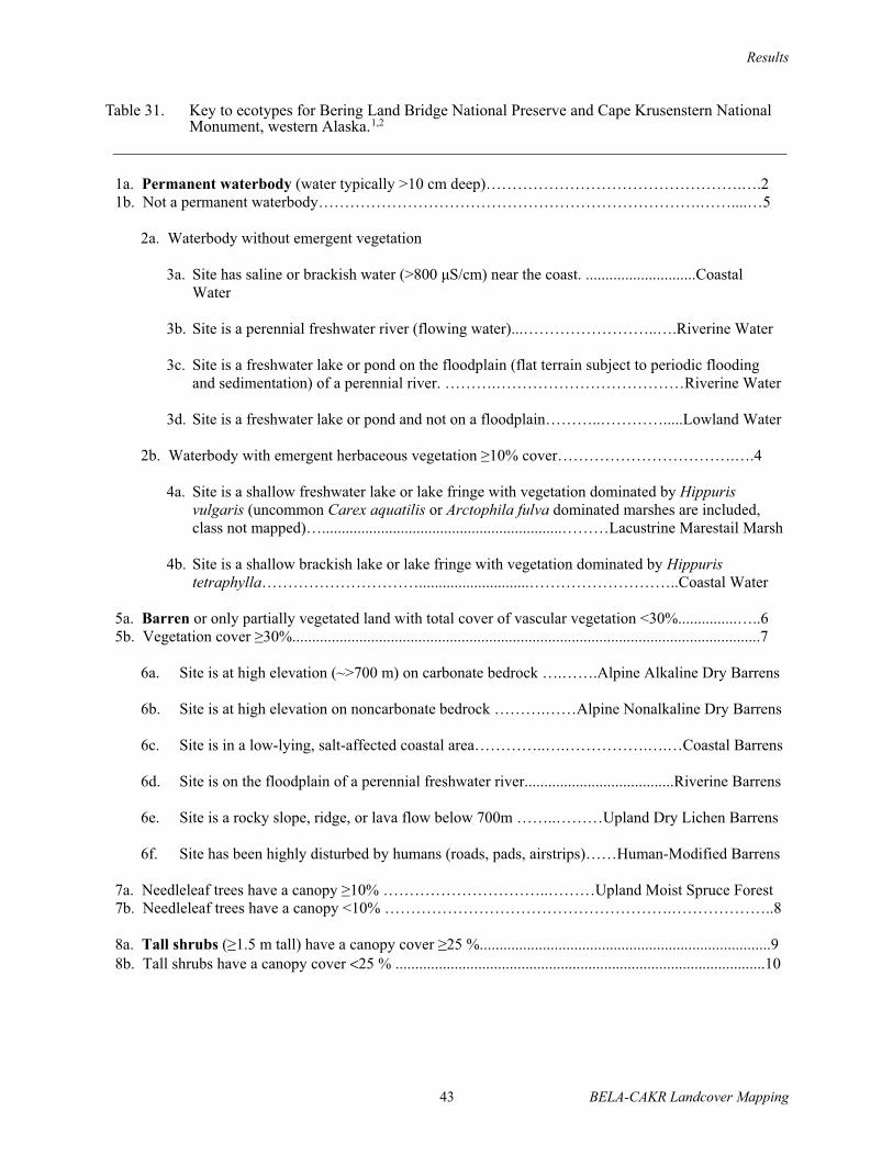
Results
43 BELA-CAKR Landcover Mapping
1a. Permanent waterbody (water typically >10 cm deep)………………………………………….….2
1b. Not a permanent waterbody……………………………………………………………….……....…5
2a. Waterbody without emergent vegetation
3a. Site has saline or brackish water (>800 µS/cm) near the coast. ............................Coastal
Water
3b. Site is a perennial freshwater river (flowing water)...……………………..….Riverine Water
3c. Site is a freshwater lake or pond on the floodplain (flat terrain subject to periodic flooding
and sedimentation) of a perennial river. ……….………………………………Riverine Water
3d. Site is a freshwater lake or pond and not on a floodplain………..………….....Lowland Water
2b. Waterbody with emergent herbaceous vegetation 10% cover…………………………….….4
4a. Site is a shallow freshwater lake or lake fringe with vegetation dominated by Hippuris
vulgaris (uncommon Carex aquatilis or Arctophila fulva dominated marshes are included,
class not mapped)….............................................................………Lacustrine Marestail Marsh
4b. Site is a shallow brackish lake or lake fringe with vegetation dominated by Hippuris
tetraphylla…………………………............................………………………..Coastal Water
5a. Barren or only partially vegetated land with total cover of vascular vegetation <30%...............…..6
5b. Vegetation cover 30%.......................................................................................................................7
6a. Site is at high elevation (~>700 m) on carbonate bedrock ….…….Alpine Alkaline Dry Barrens
6b. Site is at high elevation on noncarbonate bedrock ……….……Alpine Nonalkaline Dry Barrens
6c. Site is in a low-lying, salt-affected coastal area…………..….…………….….…Coastal Barrens
6d. Site is on the floodplain of a perennial freshwater river......................................Riverine Barrens
6e. Site is a rocky slope, ridge, or lava flow below 700m ……..………Upland Dry Lichen Barrens
6f. Site has been highly disturbed by humans (roads, pads, airstrips)……Human-Modified Barrens
7a. Needleleaf trees have a canopy 10% …………………………..………Upland Moist Spruce Forest
7b. Needleleaf trees have a canopy <10% ……………………………………………….………………..8
8a. Tall shrubs ( 1.5 m tall) have a canopy cover 25 %..........................................................................98b. Tall shrubs have a canopy cover <25 % ..............................................................................................10
Table 31. Key to ecotypes for Bering Land Bridge National Preserve and Cape Krusenstern National Monument, western Alaska.1,2

Results
BELA-CAKR Landcover Mapping 44
Table 31. Continued.
9a. Site is on the floodplain of a freshwater river and vegetation is dominated by tall willows (Salix
alaxensis) without alder (Aster sibiricus is common, this class was merged into Riverine Moist
Low and Tall Willow Shrub for mapping)……………….... Riverine Moist Tall Willow Shrub
9b. Site is on the floodplain of a freshwater river and vegetation is dominated by tall willows (Salix
alaxensis) and alder (Arctagrostis latifolia is common, this class was merged into Riverine
Moist Low and Tall Willow Shrub for mapping) ……Riverine Moist Tall Alder–Willow Shrub
9c. Site is a drainage (sometimes lower slope) and is dominated by tall willows (Salix planifolia
pulchra) or occasionally alder ……………...……...Lowland Moist Tall Alder–Willow Shrub
10a. Low shrubs (0.2–1.5 m tall) have a canopy cover 25 % ............................................................11
10b. Low shrubs have a canopy cover <25% ….………………………………...……………….……12
11a. Site is a gentle middle or upper slope (sometimes high-centered polygons on flats) with shrub
birch and willows, and cover of whole tussocks (Eriophorum vaginatum) >15%
………………………………………………………Upland Moist Dwarf Birch–Tussock Shrub
11b. Site is a middle or upper slope with shrubs dominated by dwarf birch (Betula nana), ericaceous
shrubs, and lichens (willow <10% cover)………Upland Moist Dwarf Birch–Ericaceous Shrub
11c. Site is a middle or upper slope with shrubs dominated by low willows (Salix glauca, Salix
planifolia pulchra, Salix lanata richardsonii) and lacks Sphagnum
………………………………………………………..……….Upland Moist Low Willow Shrub
11d. Site is a lower slope, flat, drained basin, or abandoned floodplain (surface organics >20cm deep)
with vegetation dominated by dwarf birch, willows (Salix planifolia pulchra) and Sphagnum
…....………………………………...…..Lowland Moist Dwarf Birch–Willow Shrub
11e. Site is a lower slope, flat, drained basin, or abandoned floodplain (surface organics >20cm deep)
with vegetation dominated by willows (Salix planifolia pulchra) and Sphagnum
……………………………………………………………… Lowland Moist Low Willow Shrub
11f. Site is a wet flat or depression in an organic-rich lowland and vegetation is dominated by Betula
nana, ericaceous shrubs and Sphagnum (dwarf shrubs are present and may be co-dominant)
..……………………………...Lowland Wet Dwarf Birch–Ericaceous Shrub
11g. Site is on a river floodplain with vegetation dominated by dwarf birch and willows (Salix
planifolia pulchra) (Petasites frigidus is common; this class was merged into Riverine Moist
Low and Tall Willow Shrub for mapping) …......… Riverine Moist Dwarf Birch–Willow Shrub
11h. Site is on a river floodplain (soil surface organic horizon is <20 cm) with vegetation dominated
by willows (Salix lanata richardsonii, S. planifolia pulchra, and S. alaxensis) and lacks
Sphagnum (Festuca altaica is common; this class was merged into Riverine Moist Low and
Tall Willow Shrub for mapping) ..…………….………...Riverine Moist Low Willow Shrub
12a. Dwarf shrubs (<0.2 m) have a canopy cover 25%……………...……………………………...13
12b. Dwarf shrubs have a canopy cover <25%………………………………………………………..16
13a. Elevation is high (usually >700 m) creating severely exposed alpine conditions ………….….14

Results
45 BELA-CAKR Landcover Mapping
Table 31. Continued.
14a. Bedrock is limestone, marble or other carbonate deposit (soil pH ≥ 7.4) and vegetation is
dominated by Dryas and lichens……….…………………Alpine Alkaline Dry Dryas Shrub
14b. Bedrock is not a carbonate deposit, vegetation is dominated by Dryas
……………………………...………….………..…….Alpine Nonalkaline Dry Dryas Shrub
13b. Elevation is low (usually <700 m) without alpine conditions .……………..……………….15
15a. Site is a gentle mid- or upper slope (sometimes high-centered polygons on flats) with dwarf
and low shrubs, and cover of whole tussocks (Eriophorum vaginatum) >15%
………………………………………………… Upland Moist Dwarf Birch–Tussock Shrub
15b. Site is an inactive sand dune in a coastal area and vegetation is dominated by crowberry
(Empetrum nigrum)…………………………………………...Upland Dry Crowberry Shrub
15c. Site is a wet flat or depression in an organic-rich lowland and vegetation is dominated by
dwarf shrubs (Ledum decumbens, Empetrum nigrum, Oxycoccus microcarpus) and
Sphagnum (Betula nana is common and may be co-dominant)
…………………………………….Lowland Wet Dwarf Birch–Ericaceous Shrub
16a. Herbaceous vegetation co-dominated by sedges and low and dwarf shrubs (usually 15–25%
cover) and soils are moist ....................................................................................………………….17
16b. Herbaceous vegetation without substantial low and dwarf shrub cover………………………….…18
17a. Whole tussocks of Eriophorum vaginatum >15%...... Upland Moist Dwarf Birch–Tussock Shrub
17b. Site is moderate hillside slope with vegetation dominated by Carex bigelowii and Dryas
integrifolia, lichens may be abundant ……...……………..Upland Moist Sedge–Dryas Meadow
17c. Site is a gentle to moderate slope in low-lying areas with vegetation dominated by Carex
bigelowii, Equisetum arvense, and Dryas integrifolia, and lichen are sparse
..………………………………..Lowland Moist Sedge–Dryas Meadow
18a. Herbaceous vegetation is dominated by sedges and soils are wet…………...……….………….19
18b. Herbaceous vegetation is not dominated by sedges…………………………………...…....…….20
19a. Site is a flat, drained basin (surface organics usually >40cm deep) dominated by sedges (Carex
aquatilis, C. chordorrhiza), and aquatic mosses ……………..Lowland Sedge Fen Meadow
19b. Site is a flat, drained basin, or abandoned floodplain with vegetation dominated by sedges
(Carex aquatilis) and Sphagnum spp, often with scattered ericaceous shrubs
……...………………………………...………………..Lowland Sedge–Moss Fen Meadow
19c. Site is a flat or depression in a saline coastal area with vegetation dominated by sedges (Carex
ramenskii, C. subspathacea), and grasses (Puccinellia phryganodes)
…………………………………………………... ......Coastal Saline Wet Sedge–Grass Meadow
19d. Site is a flat or depression in a brackish coastal area with vegetation dominated by Carex
ramenskii and/or Dupontia fischeri, Salix ovalifolia, Deschampsia caespitosa
………………………………………………………..Coastal Brackish Sedge–Grass Meadow

BELA-CAKR Landcover Mapping 46
MAPPING
ABUNDANCE AND DISTRIBUTIONThe mapping differentiated 18 vegetation
types and 29 ecotypes, based on a supervisedclassification of spectral characteristics of the threeLandsat TM scenes and modeling of thephysiography and bedrock associated withecosubsection maps and digital elevation models(Figures 4 and 5). The initial supervisedclassification of 18 signature vegetation types wassubdivided into 29 ecotypes through the rule-basedmodeling. In the final map, four ecotypes identifiedby the ground data were combined with otherclasses because they could not be mappedseparately (Appendix 9). The most abundantecotypes within the park boundaries includeUpland Moist Dwarf Birch–Ericaceous Shrub,Upland Moist Dwarf Birch–Tussock Shrub,Upland Moist Sedge–Dryas Meadow, LowlandMoist Sedge–Dryas Meadow, and LowlandSedge–Moss Fen Meadow (Table 32). To simplifythe map and improve map accuracy, the 29ecotypes also were aggregated into 12 classesbased on ecological and spectral similarity.
ACCURACY ASSESSMENTSignature evaluation prior to supervised
classification showed the fidelity of signatures tothemselves (percentage of pixels within signatureareas correctly classified to themselves) was veryhigh (90%) for 49%, high (80–89%) for 27%,moderately high (60–79%) for 17%, and low(<60%) for 7% of signatures. Overall, 76% of thesignatures self-classify (≥80% of pixels withinsignatures) and are therefore distinct and separable.The ability of the signatures to classify to thecorrect signature vegetation type (percentage ofpixels within a signature area classifying to thecorrect vegetation type) was very high (90%) for80%, high (80–89%) for 18%, and moderately high(70–79%) for 2% of the training areas. Thisindicates that the 389 signatures used in thesupervised classification were highly reliable; thesignature vegetation was classified correctly (80%of pixels within signature) in 98% of the trainingsignatures.
To assess the variability of signatures for anygiven signature vegetation type, the values of thefirst and second axes of the principal componentsanalysis were plotted to identify any overlaps ofsignatures among the various vegetation types(Figure 6). These axes explained 95% of the
Table 31. Continued.
20. Herbaceous vegetation is dominated by grasses ……………………………...…………………….21
21a. Site is a well-drained active sand dune in a salt-affected coastal area and vegetation is
dominated by Elymus arenarius mollis………………….……Coastal Dry Dunegrass Meadow
21b. Site is on somewhat well-drained soils in young drained-lake basins with vegetation dominated
by Calamagrostis canadensis…………………………..…Lacustrine Moist Bluejoint Meadow
Note: 1. Shrub cover cutpoints represent general guidelines and classification decisions should also rely on dominant indicator species
and landscape position. For example, Upland Moist Sedge–Dryas Meadow can sometime have 30–35% cover of shrubs, but
should still be classified as a sedge–dryas meadow based on dominance of Carex bigelowii and Dryas integrifolia.
2. Rare ecotypes were not included in mapping and analysis. These include Alpine Lake (mapped as Lowland Lake), Riverine
Moist Broadleaf Forest (Riverine Moist Low and Tall Willow Shrub), Riverine Dry Dryas Shrub (Riverine Barrens), Riverine
Moist Sedge–Dryas Meadow (Riverine Moist Dwarf Birch–Willow Shrub), Riverine Dry Grass Meadow (Riverine Barrens),
Riverine Wet Sedge Tundra (Lowland Sedge Moss Fen) and Coastal Forb Marsh (Coastal Water).

168°0'0"W
167°0'0"W
167°0'0"W
166°0'0"W
166°0'0"W
165°0'0"W
165°0'0"W
164°0'0"W
164°0'0"W
163°0'0"W
163°0'0"W
162°0'0"W
65°0
'0"N
65°3
0'0"
N
65°3
0'0"
N
66°0
'0"N
66°0
'0"N
66°3
0'0"
N
Ecosystem Classification Approach:The classification of ecotypes (local-scale ecosystems) combines physiography(i.e., coastal, riverine, alpine), bedrock geology, topography (DEM modeling), andspectral characteristics of vegetation derived from image processing to model ecotypesthat best partition geomorphic, hydrologic, pedologic, and vegetative characteristics.
Map Sources:Landsat TM Images from 28 June 2000, 1 Aug 2002, 3 Aug 2002;Ecological Subsections map from NPS for physiography and bedrock geology;USGS National Elevation Dataset for elevation, slope, moisture index.
Map Projection:Albers Conical Equal Area; NAD 27 datumMap prepared by ABR, Inc.File: BELA_Ecotype_02-329-7.mxd,6 October 2004
5
Figure 4.
EcotypesLand Cover Mapping
Bering Land BridgeNational Preserve
Approximate scale = 1:690,000
5 0 5 10 15 20 Kilometers
5 0 5 10 15 Miles
Ecotypes
Alpine Alkaline Dry Barrens
Alpine Alkaline Dry Dryas Shrub
Alpine Nonalkaline Dry Barrens
Alpine Nonalkaline Dry Dryas Shrub
Upland Moist Spruce Forest
Upland Moist Dwarf Birch–Ericaceous Shrub
Upland Moist Dwarf Birch–Tussock Shrub
Upland Dry Crowberry Shrub
Upland Moist Low Willow Shrub
Upland Dry Lichen Barrens
Upland Moist Sedge–Dryas Meadow
Lowland Moist Tall Alder–Willow Shrub
Lowland Moist Low Willow Shrub
Lowland Moist Dwarf Birch–Willow Shrub
Lowland Wet Dwarf Birch–Ericaceous Shrub
Lowland Moist Sedge–Dryas Meadow
Lowland Sedge Fen Meadow
Lowland Sedge–Moss Fen Meadow
Lacustrine Moist Bluejoint Meadow
Lowland Water
Riverine Barrens
Riverine Moist Low and Tall Willow Shrub
Riverine Moist Dwarf Birch–Willow Shrub
Riverine Water
Coastal Barrens
Coastal Water
Human-modified Barrens
Coastal Dry Dunegrass Meadow
Coastal Wet Sedge–Grass Meadow


Ecosystem Classification Approach:The classification of ecotypes (local-scale ecosystems)combines physiography (i.e., coastal, riverine, alpine),bedrock geology, topography (DEM modeling), andspectral characteristics of vegetation derived from imageprocessing to model ecotypes that best partition geomorphic,hydrologic, pedologic, and vegetative characteristics.
Map Sources:Landsat TM Image from 3 Aug 2002;Ecological Subsections map from NPSfor physiography and bedrock geology;USGS National Elevation Dataset forelevation, slope, and moisture index.
Map Projection:Albers Conical Equal Area; NAD 27 datumMap prepared by ABR, Inc.File: CAKR_Ecotype_02-329-7.mxd, 6 October 2004
5Approximate scale = 1:350,000
EcotypesLand Cover Mapping
Cape KrusensternNational Monument
2 0 2 4 6 8 10 Kilometers
2 0 2 4 6 8 Miles
Ecotypes
Figure 5.
Lowland Moist Sedge–Dryas Meadow
Lowland Sedge Fen Meadow
Lowland Sedge–Moss Fen Meadow
Lacustrine Moist Bluejoint Meadow
Riverine Barrens
Riverine Moist Low and Tall Willow Shrub
Lowland Moist Low Willow Shrub
Lowland Moist Dwarf Birch–Willow Shrub
Lowland Wet Dwarf Birch–Ericaceous Shrub
Lowland Water
Riverine Moist Dwarf Birch–Willow Shrub
Riverine Water
Coastal Barrens
Coastal Dry Dunegrass Meadow
Coastal Water
Human-modified Barrens
Coastal Wet Sedge–Grass Meadow
Upland Moist Sedge–Dryas Meadow
Lowland Moist Tall Alder–Willow Shrub
Upland Dry Crowberry Shrub
Upland Moist Dwarf Birch–Tussock Shrub
Upland Moist Dwarf Birch–Ericaceous Shrub
Upland Moist Low Willow Shrub
Upland Moist Spruce Forest
Alpine Nonalkaline Dry Dryas Shrub
Alpine Alkaline Dry Dryas Shrub
Alpine Alkaline Dry Barrens
Upland Dry Lichen Barrens
Alpine Nonalkaline Dry Barrens
164°30'0"W
164°0'0"W
164°0'0"W
163°30'0"W
163°30'0"W
163°0'0"W
163°0'0"W
162°30'0"W
66°45'0"N67°0'0"N
67°0'0"N
67°15'0"N
67°15'0"N
67°30'0"N
67°30'0"N
67°45'0"N
67°45'0"N68°0'0"N


51 BELA-CAKR Landcover Mapping
Table 32. Areal extent of ecotypes and vegetation types within the Bering Land Bridge National Preserve and Cape Krusenstern National Monument, Alaska.
Bering Land Bridge Cape Krusenstern ha % ha %
Map Ecotype Alpine Alkaline Dry Barrens 6779 0.6 9038 3.4 Alpine Alkaline Dry Dryas Shrub 18769 1.7 7209 2.7 Alpine Nonalkaline Dry Barrens 6055 0.6 729 0.3 Alpine Nonalkaline Dry Dryas Shrub 15152 1.4 1647 0.6 Upland Dry Lichen Barrens 24275 2.2 1 0.0 Upland Moist Spruce Forest 0 0.0 1018 0.4 Upland Dry Crowberry Shrub 3018 0.3 1502 0.6 Upland Moist Low Willow Shrub 43322 3.9 10900 4.1 Upland Moist Dwarf Birch–Ericaceous Shrub 63932 5.8 56127 21.1 Upland Moist Dwarf Birch–Tussock Shrub 394856 35.9 79007 29.7 Upland Moist Sedge–Dryas Meadow 149507 13.6 28553 10.7 Lowland Moist Tall Alder–Willow Shrub 2263 0.2 2264 0.9 Lowland Moist Low Willow Shrub 39520 3.6 9807 3.7 Lowland Moist Dwarf Birch–Willow Shrub 11355 1.0 4692 1.8 Lowland Wet Dwarf Birch–Ericaceous Shrub 46239 4.2 11699 4.4 Lowland Moist Sedge–Dryas Meadow 83163 7.6 7390 2.8 Lowland Sedge–Moss Fen Meadow 51790 4.7 3712 1.4 Lowland Sedge Fen Meadow 34269 3.1 3741 1.4 Lacustrine Moist Bluejoint Meadow 3104 0.3 233 0.1 Lowland Water 58631 5.3 2127 0.8 Riverine Barrens 5213 0.5 1418 0.5 Riverine Moist Low and Tall Willow Shrub 7464 0.7 2137 0.8 Riverine Moist Dwarf Birch–Willow Shrub 5918 0.5 3284 1.2 Riverine Water 3666 0.3 202 0.1 Coastal Barrens 4949 0.4 918 0.3 Coastal Dry Dunegrass Meadow 713 0.1 507 0.2 Coastal Wet Sedge–Grass Meadow 3664 0.3 768 0.3 Coastal Water 12360 1.1 15064 5.7 Human-modifed Barrens 0 0.0 174 0.1
Map Vegetation Type Dryas Dwarf ShrubTundra 33922 3.1 8856 3.3 Lichen 24275 2.2 1 0.0 Partially Vegetated 22996 2.1 12103 4.6 Open White Spruce Forest 0 0.0 1018 0.4 Tall and Low Willow Shrub 92569 8.4 25108 9.4 Crowberry Dwarf Shrub Tundra 3018 0.3 1502 0.6 Low Shrub Birch–Ericaceous Shrub 110171 10.0 67826 25.5 Low Shrub Birch–Willow Shrub 17274 1.6 7976 3.0 Low Mixed Shrub–Tussock Tundra 394856 35.9 79007 29.7 Sedge–Dryas Tundra 232671 21.2 35944 13.5 Bluejoint Meadow 3104 0.3 233 0.1 Lowland Sedge–Moss Bog Meadow 51790 4.7 3712 1.4 Lowland Sedge Bog Meadow 34269 3.1 3741 1.4 Halophytic Sedge–Grass Wet Meadow 3664 0.3 768 0.3 Elymus Meadow 713 0.1 507 0.2 Water 74656 6.8 17394 6.5 Grand Total 1,099,948 100 265869 100

Results
52 BELA-CAKR Landcover Mapping
Figu
re 6
.Pr
inci
pal c
ompo
nent
s ana
lysi
s of t
he d
istri
butio
n of
spec
tral c
hara
cter
istic
s of v
eget
atio
n ty
pes.
The
cen
tral t
ende
ncie
s (>9
0% o
f po
ints
with
in c
lass
) are
del
inea
ted
with
han
d-fit
elli
pses
.
-3-2-10123
-5-4
-3-2
-10
12
3
Blu
ejo
int M
eadow
Dry
as D
warf
Shru
b
Tundra
Ely
mus
Halo
phytic
Sedge–G
rass
Wet M
eadow
, bra
cki
sh
Lic
hen
Low
land S
edge B
og
Meadow
Low
land S
edge–M
oss
Bog M
eadow
Mix
ed L
ow
Shru
b–S
edge
Tussock
Tundra
Mois
t S
edge–D
ryas
Tundra
Open L
ow
Mesic
Shru
b
Birch–Ericaceous S
hru
b
Open L
ow
Shru
b
Birch–W
illow
Open L
ow
Willow
Open T
all
Willow
Open W
hite
Spru
ce
Part
ially
Vegeta
ted
Clo
sed T
all
Ald
er–
Willow
Cro
wberr
y D
warf
Shru
b
Tundra
Lic
he
n
Dry
as
Tu
nd
ra
Halo
ph
yti
c
Se
dg
e-G
ras
sLo
wla
nd
Se
dg
e
Bo
g M
ead
ow
Wh
ite
Sp
ruce
Lo
w a
nd
Tall W
illo
w
Sh
rub
Tall A
lde
r-W
illo
w
Mo
ist
Se
dg
e-D
ryas
Tu
nd
ra
Mix
ed
Sh
rub
-Se
dg
e T
us
so
ck
Sh
rub
Bir
ch
-Eri
cace
ou
s S
hru
b
Wate
r
(not
show
n)
Blu
ejo
int
Me
ad
ow
Lo
wla
nd
Se
dg
e-M
os
s
Bo
g M
ead
ow
Cro
wb
err
y
Sh
rub
Bir
ch
-Willo
w
Part
ially
Ve
ge
tate
d
PC
A A
xis
1
PCA Axis 2

Results
53 BELA-CAKR Landcover Mapping
variation in the 6 spectral bands. When the centraltendencies of the signature vegetation types arehighlighted with ellipses (>90% of the plots of avegetation type within an ellipse), the plot revealssubstantial overlap in signature characteristicsamong closely related signature vegetation types.This indicates that after outliers and poorsignatures were removed, slightly differentvegetation types can still have similar spectralcharacteristics; thus, spectral characteristics alonelimit the extent to which vegetation types can bedistinguished. In addition, independentclassification of spectral characteristics by clusteranalysis cross-tabulated with the ground datarevealed that for only 65% of the plots, thesignature vegetation was consistently associatedwith specific spectral nodes (Appendix 10).Together, these analyses demonstrate that eventhough a specific signature may be unique andclassify correctly with its ground data (highsignature fidelity), signatures that are highlysimilar within a cluster can actually be within therange of the spectral variability of several differentvegetation types. This indicates that if the map wasbased solely on spectral characteristics, 35% of themap potentially could be misclassified.
The cross-tabulation of 29 ecotypes afterrule-based modeling revealed that 71% of the mappixels were consistent with ground data from 256plots (Appendix 11). These plots represented theground points used to create map signatures forwhich a complete data set was available. Theremaining signatures were created from NPS datawithout specific point locations, were watersignatures generated without ground referencedata, or were signatures created near groundreference plots. The cross-tabulation of the 17mapped vegetation types reveals that 85% of themap pixels were consistent with the ground data(Appendix 12). Most of the vegetation errors wereassociated with confusion between Dryas Tundraand Moist Sedge–Dryas Tundra at high elevationsand among the open, low shrub classes at lowelevations. Inconsistencies for ecotypes were dueto similar errors, plus prevalent problems withdifferentiating upland and lowland classes basedon model rules. An unknown portion of this erroralso was due to spatial registration where theground plot did not correspond to the respectivemap pixel because of both GPS and satellite
positional error. When the 29 ecotypes wereaggregated into 12 to improve the accuracy of themap, the consistency between ground and mapdeterminations was 88% (Appendix 13).
The cross-tabulations of agreement betweenthe map and ground classification provide anapproximate upper limit of the accuracy of themap, while the evaluation of the spectraluniqueness of the mapped vegetation typesprovides an approximate lower limit of mapaccuracy. Thus, the accuracy of the 17 mappedvegetation classes, which were derived from bothspectral characteristics and post-classificationmodeling to reduce error, is probably between 65%and 77%. Given this range, we expect the accuracyto be 70–75%, because substantial effort was madein modeling out many of the errors associated withthe signature vegetation (e.g., Lowland Sedge BogMeadows and Water occurring on north-facingslopes, Halophytic Sedge–Grass Wet Meadowsoccurring inland). The accuracy of the map of 29ecotypes, which was derived from the signaturevegetation, ecosubsection map, and DEMmodeling is probably in the 60 to 70% range. Weestimate that aggregation of the ecotypes into 12classes increased the accuracy to around 80%.Accordingly, the user can select the vegetation,ecotype, or aggregated ecotype fields linked to thelandcover map depending on their priorities ofpartitioning ecological variation (more classes)versus map accuracy (fewer classes).
RELATIONSHIPS AMONG ECOLOGICAL COMPONENTS
LANDSCAPE RELATIONSHIPS
ToposequencesThe classification of ecotypes (local-scale
ecosystems) was based on the survey of ecologicalcomponents (topography, geomorphology, soil,hydrology, permafrost, and vegetation) alongtoposequences. The toposequences displaytwo-dimensional views of the lithofacies that wereused as the basis for classifying and mappinggeomorphic units (Figures 7–11). Vegetationclasses follow the AVC. Five ecosubsectionswithin the study area are described below topresent some of the main ecological relationshipswithin alkaline alpine-upland, nonalkaline

Results
54 BELA-CAKR Landcover Mapping
Figu
re 7
.A
gen
eral
ized
topo
sequ
ence
for t
he G
oodh
ope
Mou
ntai
ns il
lust
ratin
g ge
omor
phic
, top
ogra
phic
, per
maf
rost
, soi
ls, a
nd v
eget
atio
nre
latio
nshi
ps in
alp
ine
and
upla
nd a
lkal
ine
ecot
ypes
.
Co
lluv
ium
Res
idu
um
/ c
arb
on
ate
met
amo
rph
ic r
ock
Hea
dw
ater
floodpla
in
So
rted
circ
leS
no
wb
ed
Sto
ne
stri
pes
Sto
ne
circ
les
Gel
iflu
ctio
n
lob
es
Fro
st
bo
ils
Chan
nel
and
ban
ks
Mois
t
Sed
ge-
Dry
as
tun
dra
Cas
sioppe
dw
arf
scru
b
Dry
as
tun
dra
Dry
as-
lich
en
tun
dra
Co
lluv
ium
Co
lluv
ium
Sto
ne
stri
pes
Fro
st
bo
ils
Wet
sed
ge
mea
do
w
tun
dra
Op
en t
all
ald
er
scru
b
Dry
as
tun
dra
Mois
t
sed
ge-
Dry
as
tun
dra
Op
en t
all
alder
-
wil
low
scru
b
Mois
t
sed
ge-
Dry
as
tun
dra
10
0 m
PE
RM
AF
RO
ST
Fro
zen
0 m
1 m
?
C1
kver
y
gra
vel
ly
A C2
kver
y
cob
bly
C3
ver
y
sto
ny
Typ
ic
Eu
tro
gel
epts
0 m
1 m
?
Bw
silt
lo
am
Oa
C gra
vel
ly
loam
C2
co
bb
ly
Typ
ic
Eu
tro
gel
epts
A
0 m
1 m
?
BA
loam
Oi
2C
1ex
trem
ely
g
rav
elly
Typ
ic
Hap
lort
hel
s
AO
a
2C
1ex
trem
ely
g
rav
elly
0 m
1 mCg
silt
lo
am
Oi
Cf
gra
vel
ly
loam
A
Ru
pti
c-H
isti
c
Aq
uit
urb
els
0 m
1 m
Typ
ic
Fib
rist
els
Oi
Oe
Cf
silt
/
san
d
wa
ter
tab
le
per
ma
fro
st t
ab
le
1 k
m
0 m
1 mC s
ilt/
sa
nd
2C
gra
vel
ly
Typ
ic
Gel
ort
hen
ts
?
A

Results
BELA-CAKR Landcover Mapping 55
Figu
re 8
.A
gen
eral
ized
topo
sequ
ence
for t
he B
ende
lebe
n Ea
ster
n M
ount
ains
illu
stra
ting
geom
orph
ic, t
opog
raph
ic, p
erm
afro
st, s
oils
, and
ve
geta
tion
rela
tions
hips
in a
lpin
e an
d up
land
non
alk
alin
e ec
otyp
es.
PE
RM
AF
RO
ST
Fro
zen
Res
idu
um
/
Gra
nit
icR
ock
Hea
dw
ater
Flo
odpla
in
Sto
ne
Str
ipes
Rubb
le-
Fel
lfie
ld
Sto
ne
Str
ipes
Sto
ne
Str
ipes
Gel
iflu
ctio
n
Lo
bes
Chan
nel
and
Ban
ks
Dry
as-
Lic
hen
Tu
nd
ra
Bar
ren
Dry
as
Tu
nd
ra
Wat
er
Co
lluv
ium
Co
llu
-
viu
m
Fro
st
Bo
ils
Op
en T
all
Ald
er
Scr
ub
an
d
Bar
ren
s
Dry
as
Tu
nd
ra
Mois
t
Sed
ge-
Dry
as
Tu
nd
ra
Dry
as-
Lic
hen
Tu
nd
ra
Mes
ic
shru
b
bir
ch-
eric
aceo
us
shru
b
Dee
p G
laci
al
Lak
e
Res
iduum
/
Gra
nit
icR
ock
Wat
erR
ubb
le-
Fel
lfie
ld
Un
fro
zen
0 m
1 m
?
C1
kver
y
gra
vel
ly
A C2
kver
y
cob
bly
C3
ver
y
sto
ny
Lit
hic
Dy
stro
gel
epts
0 m
1 m
?
Bw
silt
lo
am
Oa
C gra
vel
ly
loam
C2
co
bb
ly
Typ
ic
Hap
lort
hel
s
A
0 m
1 mA silt
/ sa
nd
2C
gra
vel
ly
Typ
ic
Gel
ort
hen
ts
0 m
1 m
?
Bw
v. g
rav
elly
A1
C1
v. co
bb
ly
Typ
ic
Dy
stro
gel
eptsA
2
C2
extr
emel
y
cob
bly
extr
emel
y
aci
dic
30
0 m
1 k
m
Mois
t
Sed
ge-
Dry
as
Tu
nd
ra

Results
56 BELA-CAKR Landcover Mapping
Figu
re 9
.A
gen
eral
ized
topo
sequ
ence
for t
he B
erin
g St
rait
Upp
er C
oast
al P
lain
illu
stra
ting
geom
orph
ic, t
opog
raph
ic, p
erm
afro
st, s
oils
, and
ve
geta
tion
rela
tions
hips
in lo
wla
nd a
nd la
cust
rine
ecot
ypes
.
Lo
ess/
all
uv
ial
and
mar
ine
dep
osi
ts
Dee
p t
haw
lak
e/
Th
aw l
ake
dep
osi
t
Shal
low
lak
e
Lo
ess/
all
uv
ial
and
mar
ine
dep
osi
ts
Th
aw l
ake
dep
osi
ts
Wet
sed
ge
mea
do
w t
un
dra
Fre
sh
gra
ss
mar
sh
Op
en
wat
er
Clo
sed
low
wil
low
scru
b
Tu
sso
ck
tun
dra
Clo
sed
tall
wil
low
scru
b
Mois
t se
dge-
wil
low
tu
nd
ra
Tu
sso
ck
tun
dra
Lo
w-c
ente
red
po
lyg
ons
No
np
atte
rned
Fro
st b
oil
sW
ater
Dra
in-
age
Fro
st
bo
ils
Ero
din
g
ban
k
10
m
PE
RM
AF
RO
ST
Fro
zen
Un
fro
zen?
0 m
1 mOi
Cg
bf
silt
Typ
ic
Fib
rist
els
Wa
ter
tab
le
Per
ma
fro
st t
ab
le
0 m
1 mBw
silt
lo
am
Oa
Cf
silt
lo
am
Oi
Oe
Typ
ic
Aq
uo
rthel
s
1 k
m
0 m
1 m
Oi
Oef
Cg
f
silt
loam
Typ
ic
Aq
uit
urb
els
0 m
1 m
Typ
ic
Aq
uit
urb
els
Oi
Cg
f
Oeb
f
Cg
bf
Bw

Results
BELA-CAKR Landcover Mapping 57
Figu
re 1
0.A
gen
eral
ized
topo
sequ
ence
for t
he B
erin
g St
rait
Low
er F
lood
plai
ns il
lust
ratin
g ge
omor
phic
, top
ogra
phic
, per
maf
rost
, soi
ls, a
nd
vege
tatio
n re
latio
nshi
ps in
rive
rine
ecot
ypes
.
10
m
Wet
sed
ge-
mea
do
w
tun
dra
Riv
erin
e
lak
e
Wat
er
Loes
s/ a
lluvia
l-m
arin
e
terr
ace
(El/
Mt) M
esic
shru
b-
tuss
ock
tun
dra
Clo
sed
shru
b
bir
ch-
wil
low
scru
b
Par
tial
ly
veg
e-
tate
d
Clo
sed t
all
ald
er-
wil
low
scru
b
Ab
ando
ned
chan
nel
Mea
n-
der
ing
chan
nel
Lo
wla
nd
sed
ge-
mo
ss b
og
mea
do
w
Clo
sed
tall
ald
er-
wil
low
scru
b
Wat
erM
esic
shru
b-
tuss
ock
tun
dra
Inac
tive
flo
od
pla
in
cover
dep
osi
t
Act
ive
flo
od
pla
in
cov
er d
epo
sit
(Fd
ca)
0 m
1 m
Ox
yaq
uic
Gel
ort
hen
ts
C rip
ple
d
san
d
2C
gra
vel
0 m
1 m
Oi
Oe
Cg
f
silt
loam
Typ
ic
His
tort
hel
s
El/
Mt
PE
RM
AF
RO
ST
Fro
zen
Un
fro
zen?
Un
fro
zen?
0 m
1 mC silt
/ sa
nd
2C
g
silt
A
Flu
ven
tic
Hap
lort
hel
0 m
1 m
Typ
ic
Hem
iste
ls
Oi
Oe
Cf
san
d
Wa
ter
tab
le
Per
ma
fro
st t
ab
le
Lo
w-c
ente
red
po
lyg
ons
No
np
atte
rned
No
np
atte
rned
Wat
er
Fro
st
bo
ils
Wat
erW
ater
Fro
st
bo
ils
1 k
m
0 m
1 mC s
ilt/
sa
nd
2C
san
d
Flu
ven
tic
Hap
lort
hel
Oi
No
n-
pat
tern
ed
Fd
ca

Results
58 BELA-CAKR Landcover Mapping
Figu
re 1
1.A
gen
eral
ized
topo
sequ
ence
for t
he E
spen
berg
Coa
st il
lust
ratin
g ge
omor
phic
, top
ogra
phic
, per
maf
rost
, soi
ls, a
nd v
eget
atio
nre
latio
nshi
ps in
coa
stal
eco
type
s.
10
m
Wat
erP
arti
ally
veg
etat
ed
Cro
wb
erry
Tu
nd
ra
Ely
mus
Mea
do
w
Lo
wla
nd
sed
ge
bog
mea
do
w
Hal
op
hy
tic
wet
sed
ge
mea
do
w
Wat
er
Nea
rsh
ore
Wat
er
Gra
vel
Bea
ch
Wat
er
Pea
t/
San
d
Wat
er
Lag
oo
n
Tid
al
Fla
t
San
dy
Bea
ch
Th
aw
Lak
e
Eo
lian
San
d
Eo
lian
San
d
Pea
t/
San
d
Fo
resh
ore
Act
ive
Du
ne
Blo
wou
tS
wal
e
No
n-
pat
tern
edW
ater
Bac
ksh
ore
Inac
tiv
e
Du
ne
Sh
allo
w
Wat
er
No
n-
pat
tern
ed
Bar
ren
sW
et
sed
ge
mea
do
w
tun
dra
Pea
t/
San
d
Sw
ale
Par
tial
ly
veg
etat
ed
0 m
1 m
C
Typ
ic
Psa
mm
ort
hel
s
0 m
1 m
Typ
ic
Fib
rist
els
Oi
Oe C
f
PE
RM
AF
RO
ST
Fro
zen
Un
fro
zen
Un
fro
zen
0 m
1 m
Oi
Oe
Cf
Wa
ter
tab
le
Per
ma
fro
st t
ab
le
0 m
1 m
Cg
layer
ed
silt
an
d
fine
san
d
Flu
vaq
uen
tic
Aq
uo
rth
els,
bra
ckis
h
sali
ne
0 m
1 m
C
Ox
yaq
uic
Cry
op
sam
men
ts,
bra
ckis
h
sali
ne
0 m
1 m
C
Typ
ic
Cry
op
sam
men
tsfine
san
d
slig
htl
y
sali
ne
1 k
m
Lo
wla
nd
sed
ge-
bog
mea
do
w
Typ
ic
Fib
rist
els

Results
59 BELA-CAKR Landcover Mapping
alpine-upland, lowland (coastal plain), riverine,and coastal physiographic environments.
On a alkaline alpine and upland toposequencerepresentative of the Goodhope Mountains, whichwere formed from carbonate sedimentary rock, thegeomorphology was dominated by WeatheredBedrock, Hillslope Colluvium, and narrowHeadwater Floodplains (Figure 7). Soils on therounded mountains range from extremely rocky,excessive drained, strongly alkaline soils near thepeaks, to moderately well-drained soils withmoderately thick organic horizons mid-slope, tosaturated organic soils on the toe slope. Vegetationranges from partially vegetated areas at the crests,to Dryas Dwarf Shrub Tundra on the upper slopes,to Sedge–Dryas Tundra on mid- to lower slopes.The Headwater Floodplains support Open TallAlder–Willow Shrub. Snowbeds, which areuncommon, support Cassiope Dwarf ShrubTundra.
On an alpine and upland toposequencerepresentative of the Bendeleben EasternMountains, which were formed from granitic rock,the geomorphology was dominated by WeatheredBedrock, Residual Soils, Hillslope Colluvium, andnarrow Headwater Floodplains (Figure 8). Soils onthe rounded mountains vary from extremely rocky,excessive drained, strongly acidic soils near thepeaks, to moderately well-drained soils withmoderately thick organic horizons mid-slope, tosaturated organic soils on the toe slope. Vegetationtrends from partially vegetated areas at the crests,to Dryas Dwarf Shrub Tundra on the upper slopes,to moist Open Low Shrub Birch–Ericaceous Shrubon mid- to lower slopes. The HeadwaterFloodplains support Open Tall Alder Shrub.
On a lowland and upland toposequencerepresentative of the Bering Strait Upper CoastalPlain, the topography is gently undulating withprominent thermokarst lake basins (Figure 9).Geomorphic units include Loess over Alluvial andMarine Deposits, Ice-poor and Ice-rich ThawBasins, and Deep and Shallow Lakes. Soils rangefrom poorly drained silt loam soils in drainedbasins, very poorly drained organic soils in drainedbasins, to moderately well-drained deposits ongentle upland slopes. In lake basins, vegetationtrends from Marestail and Fresh Grass Marshes inshallow water, to Bluejoint Meadows and OpenLow Willow Shrub in recently drained basins, to
Lowland Sedge Fen Meadows, LowlandSedge–Moss Fen Meadows and Open Low ShrubBirch–Willow Shrub in wet, older portions of thebasins. The gently sloping upland areas aredominated by Open Low Mixed ShrubBirch–Tussock Tundra.
On a riverine toposequence representative ofthe Bering Strait Lower Floodplains, thegeomorphology ranges from active, high-energyfluvial regimes associated with the Meander ActiveChannel Deposits to lower energy regimesassociated with Meander Inactive OverbankDeposits and Abandoned Channels (Figure 10). Inthis transition, the rate of sedimentation decreaseswhile accumulation rates for organic matter and iceincrease. On the newly-formed surfaces associatedwith the active floodplain, soils along the channelsare well drained and sandy, whereas the soils onthe older portions of the floodplain are poorlydrained and have thick organic accumulations. Soilnutrients become less available, due to decreasingcation concentrations (indicated by lower electricalconductivity) and pH. Over the successionalsequences, ice aggrades both as segregated ice andas wedge ice, transforming the surface patternsfrom nonpatterned to low-centered polygons. Theoldest ice-rich portions of the floodplainaccumulate sufficient ground ice that they becomeunstable and susceptible to thermokarst andformation of thaw lakes. Vegetation responds tothese changing environmental conditions withchanges in both structure and species composition.Open Tall Willow Shrub, dominated by Salixalaxensis, occurs on the well-drained, sandy soils.Behind this zone, Open Low Willow Shrub,dominated by Salix lanata richardsonii, S.planifolia pulchra, and S. niphoclada is found onmoderately well-drained soils with thin,interbedded organic layers. Farther back from thechannel, moist Open Low Shrub Birch–WillowShrub, dominated by Betula nana and S. planifoliapulchra, occurs on somewhat poorly drained soils,while Lowland Sedge–Moss Fen Meadows,dominated by Carex aquatilis and Sphagnum, isfound on very poorly drained organic soils.
On a coastal toposequence representative ofthe Cape Espenberg Coast, which is dominated bymarine and estuarine processes, thegeomorphology is dominated by Sandy beaches,Eolian Coastal Sand, Active and Inactive Tidal

Results
BELA-CAKR Landcover Mapping 60
Flats, and Nearshore Water (Figure 11). Thetopography is generally flat except for prominentridges of dunes, beach ridges and swales that formparallel features along the coast. The soils on theActive Tidal Flats are loamy, poorly drained, andlack organic matter accumulation, while soils onInactive Tidal Flats have moderately thick organicaccumulations. Coastal dunes have well drainedsandy soils, while beach ridges formed duringstorm surges have excessively drained soils.Vegetation on these deposits ranged from salineHalophytic Sedge–Grass Wet Meadow (dominatedby Puccinellia phryganodes), brackish HalophyticSedge–Grass Wet Meadow (dominated by Carexramenskii), Marestail Marsh (mostly Hippuristetraphylla), and Elymus Meadow. On inactivedunes away from the coast, Crowberry Tundrapredominates.
Hierarchical Organization of Ecological Components
We developed hierarchical relationshipsamong ecological components by successivelygrouping data from the 231 intensive plots byphysiography, soil texture, geomorphology, slopeposition, surface form, drainage, soil chemistry,vegetation structure, and floristic class. Frequently,geomorphic units with similar textures or genesiswere grouped (e.g., loamy and organic weregrouped for some lowlands) to reduce the numberof classes. Ecotypes then were derived from thesetabular associations to differentiate sets ofassociated characteristics.
Examination of the toposequences andcross-tabulation of the plot data revealed consistentassociations among soil texture, geomorphic unitsthat denote depositional environments, slopeposition, surface forms related to ice aggradationand active-layer processes, hydrology, andvegetation structure (Table 33). The hierarchicalorganization of the ecological components revealshow tightly or loosely the components are linked.For example, some physiographic settings includedseveral geomorphic units with similar soil textures.Similarly, a given vegetation type could occur onseveral geomorphic units, depending on surfaceform characteristics and hydrology. In contrast,some geomorphic units (e.g. tidal flats) wereassociated only with a few distinct vegetationtypes.
Results from this analysis were used inseveral ways. First, they were used to evaluate howecosystems respond to the evolving landscapecomprising a wide variety of geomorphic processesassociated with alpine, upland, lowland, riverine,and coastal areas (see section on Factors AffectingLandscape Evolution). Identification of thechanging patterns in geomorphic units andvegetation, along with analysis of changes in soilproperties, helps identify processes (e.g.,acidification, sedimentation) that affect thechanging patterns. Second, the hierarchicalrelationships developed “from the ground up” wereused to determine the rules for modeling andrestricting the distribution of map classesdifferentiated by spectral characteristics “from thetop down” (see Methods for Rule-BasedModeling). Third, knowledge of ecologicalrelationships can be used to recode the ecotypemap into a derived map of other ecologicalcharacteristics, such as a soils map or a lichen map(see Section on Soils).
The contingency table analysis also can beused to evaluate how well these generalrelationships conform to the data set, and howreliably they can be used to extrapolate trendsacross the landscape. During development of therelationships, 13% of the observations wereexcluded from the table because of inconsistenciesamong physiography, texture, geomorphology,drainage, soil chemistry, and vegetation. Weexcluded these points because our primary goalwas to identify the most distinct and consistenttrends, not necessarily to include every plot. Webelieve that there is an upper limit to our ability todescribe landscape patterns; there will always be aproportion (in this case 13%) of sites that do notconform to the overall relationships among factors.These sites may be transitional (ecotones) or siteswhere vegetation and soils have been affected byhistorical factors (e.g., changes in water levels,disturbances) in ways that are not readilyexplainable based on current environmentalconditions.
ENVIRONMENTAL CHARACTERISTICS
Single-factor Comparisons by EcotypeSix environmental parameters (surface
organic-horizon thickness, cumulative

Results
BELA-CAKR Landcover Mapping 61
Tabl
e 33
.R
elat
ions
hips
am
ong
land
scap
e co
mpo
nent
s in
the
Ber
ing
Land
Brid
ge N
atio
nal P
rese
rve
and
Cap
e K
usen
ster
n N
atio
nal M
onum
ent,
north
wes
ern
Ala
ska.
Phys
io-
grap
hy
Soil
Text
ure
Geo
mor
phic
Uni
ts
Slop
e Po
sitio
n D
rain
age
Soil-
wat
er
Che
mis
try
Plan
t Ass
ocia
tion
Veg
etat
ion
Type
s (L
evel
IV)
Ecot
ype
(a
ggre
gate
d)
Alp
ine
Roc
ky
Cre
st,
Shou
lder
Ex
cess
ive,
W
ell
Parti
ally
Veg
etat
ed (5
–30
% C
over
) A
lpin
e N
onal
kalin
e D
ry B
arre
ns
Intru
sive
Fel
sic
Bed
rock
, Met
amor
phic
an
d Se
dim
enta
ry
Non
carb
onat
e B
edro
ck,
Hill
side
Col
luvi
um,
Talu
s
Upp
er
Slop
e (S
u)
Aci
dic
( pH
≤ 5
.6),
Circ
um-
neut
ral
( pH
5.6
–7.
3 )
Dry
as o
ctop
etal
a–Sa
lix
phle
boph
ylla
–Hie
roch
loe
alpi
na
Dry
as–L
iche
n Tu
ndra
, D
ryas
–Sed
ge T
undr
a A
lpin
e N
onal
kalin
e D
ry D
ryas
Shr
ub
Alk
alin
e (p
H >
7.3
) Pa
rtial
ly V
eget
ated
(5–
30%
Cov
er)
Alp
ine
Alk
alin
e D
ry
Bar
rens
Se
dim
enta
ry a
nd
Met
amor
phic
Car
bona
te
Bed
rock
, H
illsi
de C
ollu
vium
, Ta
lus
Cre
st,
Shou
lder
, Su
Exce
ssiv
e W
ell
Dry
as in
tegr
ifolia
–Rh
odod
endr
on la
ppon
icum
; D
ryas
oct
opet
ala–
Pote
ntill
a un
iflor
aD
ryas
Tun
dra,
Dry
as–
Lich
en T
undr
a A
lpin
e A
lkal
ine
Dry
D
ryas
Shr
ub
Upl
and
Roc
ky
Hill
side
Col
luvi
um,
You
ng M
afic
Vol
cani
cs
Old
Maf
ic V
olca
nics
Cre
st,
Slop
es
Exce
ssiv
e,
Wel
l C
ircum
-ne
utra
l Be
tula
nan
a–Le
dum
de
cum
bens
–Loi
sele
uria
pr
ocum
bens
Parti
ally
Veg
etat
ed,
Cru
stos
e an
d Fr
utic
ose
Lich
en
Upl
and
Dry
Lic
hen
Bar
rens
Sa
ndy
Coa
stal
Inac
tive
Sand
D
unes
C
rest
, Su
Exce
ssiv
e,
Wel
l C
ircum
-ne
utra
l Em
petr
um n
igru
m–E
lym
us
aren
ariu
s mol
lis
Cro
wbe
rry
Tund
ra
Upl
and
Dry
C
row
berr
y Sh
rub
R
ocky
, Lo
amy
Upp
er
Slop
e,
Mod
er-
atel
y
Alk
alin
e,
CN
Pice
a gl
auca
–Sal
ix
plan
ifolia
pul
chra
O
pen
Whi
te S
pruc
e Fo
rest
U
plan
d M
oist
Spru
ce
Fore
st
Hill
side
Col
luvi
um,
Solif
luct
ion
Dep
osits
, Lo
ess
Salix
gla
uca–
Dry
as
inte
grifo
liaO
pen
Low
Will
ow,
Shru
b B
irch–
Will
ow
Upl
and
Moi
st Lo
w
Will
ow S
hrub
Low
er
Slop
e (S
l)
Dry
as in
tegr
ifolia
–Car
ex
bige
low
ii–Se
neci
o at
ropu
rpur
eus
Sedg
e–D
ryas
Tun
dra,
D
ryas
–For
b Tu
ndra
U
plan
d M
oist
Sedg
e–D
ryas
Mea
dow
Wel
l (W
m),
Poor
Aci
dic,
C
ircum
-ne
utra
l
Betu
la n
ana–
Ledu
m
decu
mbe
ns–L
oise
leur
ia
proc
umbe
ns
Ope
n M
esic
Shr
ub
Birc
h–Er
icac
eous
Sh
rub
Upl
and
Moi
st D
war
f B
irch–
Eric
aceo
us
Shru
b
Lo
amy,
O
rgan
ic
Hill
side
Col
luvi
um,
Loes
s, Ic
e-R
ich
Thaw
B
asin
, Bog
Cre
st,
Slop
es
Wm
, Poo
r A
cidi
c Be
tula
nan
a–Er
ioph
orum
va
gina
tum
M
ixed
Shr
ub S
edge
–Tu
ssoc
k Tu
ndra
U
plan
d M
oist
Dw
arf
Birc
h–Tu
ssoc
k Sh
rub
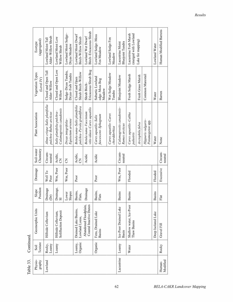
Results
62 BELA-CAKR Landcover Mapping
Tabl
e 33
.C
ontin
ued.
Phys
io-
grap
hy
Soil
Text
ure
Geo
mor
phic
Uni
ts
Slop
e Po
sitio
n D
rain
age
Soil-
wat
er
Che
mis
try
Plan
t Ass
ocia
tion
Veg
etat
ion
Type
s (L
evel
IV)
Ecot
ype
(a
ggre
gate
d)
Low
land
R
ocky
, Lo
amy
Hill
side
Col
luvi
um
Dra
inag
e (D
r)
Wel
l To
Poor
Circ
um-
neut
ral
Alnu
s cri
spa–
Salix
pla
nifo
lia
pulc
hra–
Rubu
s arc
ticus
Clo
sed
and
Ope
n Ta
ll A
lder
–Will
ow
Low
land
Moi
st T
all
Ald
er–W
illow
Shr
ub
Lo
amy
Hill
side
Col
luvi
um,
Solif
luct
ion
Dep
osit
D
rain
age.
Sl
Wm
, Poo
r A
cidi
c,
CN
Salix
pla
nifo
lia p
ulch
ra–
Cal
amag
rost
is c
anad
ensi
s C
lose
d an
d O
pen
Low
W
illow
Lo
wla
nd M
oist
Low
W
illow
Shr
ub
Lo
wer
Sl
opes
W
m, P
oor
CN
D
ryas
inte
grifo
lia–
Equi
setu
m a
rven
se
Sedg
e–D
ryas
Tun
dra,
D
ryas
–For
b Tu
ndra
Lo
wla
nd M
oist
Sed
ge–
Dry
as M
eado
w
Lo
amy,
O
rgan
ic
Bas
ins,
Flat
s,Po
or
Aci
dic,
C
NBe
tula
nan
a–Sa
lix p
lani
folia
pu
lchr
a–Py
rola
gra
ndifl
ora
Clo
sed
and
Ope
n Sh
rub
Birc
h–W
illow
Lo
wla
nd M
oist
Dw
arf
Birc
h-W
illow
Shr
ub
Dra
ined
Lak
e B
asin
s, Lo
wla
nd L
oess
, A
band
oned
Flo
odpl
ain,
C
oast
al In
activ
e D
unes
D
rain
age
A
cidi
c Be
tula
nan
a–Va
ccin
ium
vi
tis-id
aea–
Car
ex a
quat
ilis
Shru
b B
irch–
Eric
aceo
us S
hrub
Bog
Lo
wla
nd W
et D
war
f B
irch–
Eric
aceo
us S
hrub
O
rgan
ic
Fens
, Dra
ined
Lak
e B
asin
s B
asin
s, Fl
ats
Poor
A
cidi
c C
arex
aqu
atili
s–Sa
lix
fusc
esce
ns–S
phag
num
Su
barti
c Lo
wla
nd
edge
–Mos
s Bog
M
eado
w
Low
land
Sed
ge–M
oss
Fen
Mea
dow
Car
ex a
quat
ilis–
Car
ex
chor
ddor
hiza
W
et S
edge
Mea
dow
Tu
ndra
Lo
wla
nd S
edge
Fen
M
eado
w
Lacu
strin
e Lo
amy
Ice-
Poor
Dra
ined
Lak
e B
asin
B
asin
s W
m, P
oor
Cal
amag
rost
is c
anad
ensi
s–Ru
mex
arc
ticus
B
luej
oint
Mea
dow
La
cust
rine
Moi
st
Blu
ejoi
nt T
undr
a
W
ater
Sh
allo
w w
ater
, Ice
-Poo
r Th
aw B
asin
s B
asin
s Fl
oode
d C
arex
aqu
atili
s–C
alth
a pa
lust
ris
Fres
h Se
dge
Mar
sh
Ar
ctop
hila
fulv
a Fr
esh
Gra
ss M
arsh
Lacu
strin
e Fo
rb M
arsh
(m
erge
d w
ith L
owla
nd
Lake
for m
appi
ng)
H
ippu
ris v
ulga
ris–
Pota
mog
eton
spp.
Com
mon
Mar
esta
il
Dee
p Is
olat
ed L
ake
Bas
ins
Floo
ded
Circ
um-
neut
ral
Wat
er
Wat
er
Low
land
Wat
er
Hum
an-
Mod
ified
R
ocky
G
rave
l Fill
Fl
at
Exce
ssiv
e C
ircum
-ne
utra
l N
one
Bar
ren
Hum
an M
odifi
ed B
arre
ns

Results
BELA-CAKR Landcover Mapping 63
Tabl
e 33
.C
ontin
ued.
Phys
io-
Gra
phy
Text
ure
Geo
mor
phic
Uni
ts
Slop
e Po
sitio
n D
rain
age
Soil-
wat
er
Che
mis
try
Flor
istic
Cla
ss
Veg
etat
ion
Type
s (L
evel
IV)
Ecot
ype
Riv
erin
e R
ocky
, Sa
ndy
Mea
nder
Act
ive
Cha
nnel
Dep
osit
Riv
erba
r Ex
cess
ive,
W
ell
Alk
alin
e Ep
ilobi
um la
tifol
ium
–Ag
ropy
ron
mac
rour
um
Bar
ren
(<5%
cov
er),
Parti
ally
Veg
etat
ed
Riv
erin
e B
arre
ns
Mea
nder
Act
ive
Ove
rban
k, M
eand
er
Inac
tive
Cha
nnel
Flat
, In
terf
luv
Wel
l C
ircum
-ne
utra
l Al
nus c
risp
a–Sa
lix b
arcl
ayi
Clo
sed
and
Ope
n, T
all
Ald
er–W
illow
R
iver
ine
Moi
st T
all
Ald
er–W
illow
Sh
rub¹
Sa
ndy,
Lo
amy
Mea
nder
Act
ive
Ove
rban
k D
epos
it In
terf
luv,
Fl
at B
ank
Wel
l, Po
or
Circ
um-
neut
ral
Salix
ala
xens
is–As
ter
sibi
ricu
s C
lose
d an
d O
pen
Tall
Will
ow
Riv
erin
e M
oist
Tal
l W
illow
Shr
ub¹
Mea
nder
Inac
tive
Ove
rban
k D
epos
it In
terf
luv,
Fl
at B
ank
Wel
l, Po
or
Circ
um-
neut
ral
Salix
lana
ta ri
char
dson
ii–Fe
stuc
a al
taic
a C
lose
d an
d O
pen
Low
W
illow
R
iver
ine
Moi
st L
ow
Will
ow S
hrub
¹
Betu
la n
ana–
Salix
pla
nifo
lia
pulc
hra–
Pyro
la g
rand
iflor
a C
lose
d an
d O
pen
Shru
b B
irch–
Will
ow
Riv
erin
e M
oist
D
war
f Birc
h–W
illow
Shr
ub
W
ater
N
ongl
acia
l Low
er a
nd
Upp
er P
eren
nial
Riv
ers,
Lake
Cha
nnel
Fl
oode
d A
lkal
ine
Wat
er
Wat
er
Riv
erin
e W
ater
Coa
stal
R
ocky
,Sa
ndy
Mar
ine
Act
ive
Bea
ch,
Bea
ch,
Poor
to
Wel
l B
rack
ish,
N
A
Bar
ren,
C
oast
al B
arre
ns
Sa
ndy
All
Slop
es
Exce
ssiv
e To
Sl
ight
ly
Bra
ckis
h El
ymus
are
nariu
s mol
lis–
Lath
yrus
mar
itim
usPa
rtial
ly V
eget
ated
Coa
stal
Act
ive
Sand
D
unes
, Mar
ine
Inac
tive
B
each
Elym
us
Coa
stal
Dry
D
uneg
rass
Mea
dow
Sa
ndy,
O
rgan
ic
Act
ive
And
Inac
tive
Tida
l Fla
ts
Leve
e M
oder
-at
ely
Wel
l Sl
ight
ly
Bra
ckis
h Sa
lix o
valif
olia
–D
esch
amps
ia c
aesp
itosa
H
alop
hytic
Dw
arf
Will
ow
Fl
ats,
Po
or
Bra
ckis
h,
Car
ex ra
men
skii–
Dup
ontia
fis
cher
i H
alop
hytic
Sed
ge W
et
Mea
dow
Coa
stal
Bra
ckis
h W
et S
edge
–Gra
ss
Mea
dow
²
Sa
line
Car
ex ra
men
skii–
Pucc
inel
lia
phry
gano
des
Hal
ophy
tic G
rass
Wet
M
eado
w
Coa
stal
Sal
ine
Wet
Se
dge–
Gra
ss M
ead.
²
Bar
ren
Coa
stal
Bar
rens
W
ater
N
ears
hore
Wat
er, T
idal
R
iver
W
ater
Fl
oode
d Sa
line,
B
rack
ish
Wat
er
Wat
er
Coa
stal
Wat
er
Unu
sual
eco
type
s tha
t wer
e no
t ade
quat
ely
sam
pled
to q
uant
ify in
clud
e: A
lpin
e La
ke (m
appe
d w
ith L
owla
nd L
ake)
, Riv
erin
e D
ry G
rass
Mea
dow
(Ely
mus
are
nariu
s mol
lis),
Riv
erin
e M
oist
Bro
adle
af F
ores
t (Po
pulu
s tre
mul
oide
s), a
nd C
oast
al F
orb
Mar
sh (H
ippu
ris t
etra
phyl
la).
¹, ² Cla
sses
mer
ged
for m
appi
ng.

Results
BELA-CAKR Landcover Mapping 64
organic-horizon thickness, thaw depth, depth togroundwater, pH, and electrical conductivity) werecharted for comparison among ecotypes. Not allecotypes, however, were included in the chartsbecause data were insufficient in some cases.
The thickness of the surface organic-horizon(an indicator of frequency of sedimentation)showed large differences among sites (Figure 12).Ecotypes where surface organic accumulationswere absent ranged from areas with severe climateand soil conditions, such as Alpine Alkaline DryBarrens, to areas with frequent sedimentdeposition, such as Riverine Moist Barrens andRiverine Moist Tall Willow Shrub. The thickestsurface organic accumulations were found inLowland Sedge Fen Meadow, indicating thatsedimentation events were rare or absent in theseecotypes.
Depth to rocks (soils with >15% rocks) wasshallowest on alpine ridges and crests (e.g., AlpineNonalkaline Dry Dryas Shrub) and in rockydrainages (Lowland Moist Tall Alder–WillowShrub) and deepest in lowland and coastal areaswith fine-grained deposits (e.g. Coastal Barrens,Lowland Sedge–Moss Fen Meadow) (Figure 12).Ecotypes with rock depths ≥ 200 cm represent anestimated minimum depth.
Thaw depths varied four-fold among ecotypes(Figure 12). While permafrost was found at allsites with fine-grained soils, the permafrost statusof rocky sites, particularly on south-facing slopes,is unknown. Values generally were shallowest forlowland and lacustrine ecotypes and for gentlysloping upland areas with Upland Moist DwarfBirch–Tussock Shrub. Deepest thaw depths werefound in coastal and riverine areas withwell-drained sandy soils and early successionalvegetation (e.g. Coastal Dry Dunegrass Meadow,Riverine Moist Tall Willow Shrub).
Depth to water above (+) or below (–) thesurface also varied widely among ecotypes, butrelatively little within ecotypes (Figure 13). Meanwater depths were above the soil surface for fourecotypes, and were greatest for Coastal Water andLowland Water. Ecotypes with the deepest watertables were found in alpine areas with rocky soils(e.g., Alpine Alkaline Dry Dryas Shrub) andriverine areas with sandy soils (e.g., RiverineMoist Tall Alder–Willow Shrub). Values ≥100 cmrepresent minimum, estimated depths.
Site pH values varied from 5.0 to 8.3 amongecotypes (Figure 13). Ecotypes with the lowest(most acidic) pH values occurred in nonalkalinealpine and upland areas (e.g., Alpine NonalkalineDry Dryas Shrub, Upland Moist DwarfBirch–Tussock Meadow) and in lowland areas(e.g., Lowland Sedge–Moss Fen Meadow,Lowland Wet Dwarf Birch–Ericaceous Shrub)These ecotypes are late successional, wherecarbonates have been leached from soils over longperiods. Ecotypes with the highest pH valuestended to occur in alkaline alpine and upland areas(Alpine Alkaline Dry Dryas Shrub, Upland MoistSedge–Dryas Dwarf Shrub) and in riverine andcoastal early successional environments withfrequent mineral sedimentation (e.g., RiverineBarrens, Coastal Barrens).
Electrical conductivity (EC) measurementsindicated that most ecotypes were nonsaline(Figure 13). High mean EC values (>800 µS/cm),indicating brackish or slightly brackish to salineconditions, were limited to coastal areas (e.g.,Coastal Saline Wet SedgeGrass Meadow, CoastalBarrens). EC values were low (<300 µS/cm) in allother ecotypes. Variability was low withinnonsaline ecotypes and high within salineecotypes.
Single-factor Comparisons by Plant SpeciesTo determine how the environmental
parameters measured influenced the distribution ofindividual plant and cryptogam species, wecalculated the mean value of each parameter forlocations where 66 common species occurred.Only sites where a species had >1% cover wereincluded, to exclude locations with atypicalconditions for that species.
Thickness of the surface organic horizon (anindication of frequency of sedimentation) washighly variable both among and within species atground sites (Figure 14). Species typically foundon sites with thin organic horizons at the surface(indicating frequent sedimentation), includedLathyrus maritimus, Epilobium latifolium,Deschampsia caespitosa, and Salix alaxensis.These species typically occur mainly in earlysuccessional ecotypes subject to frequent fluvial oreolian deposition. Species characteristic of siteswith thick surface organic accumulations includedCarex chordorrhiza, Calla palustris, Salix

Results
65 BELA-CAKR Landcover Mapping
Figure 12. Mean (± SD) surface organic layer thickness, depth to rock (>15 % coarse fragments), and thaw depths of ecotypes in Bering Land Bridge National Preserve and Cape Krusenstern National Monument, northwestern Alaska, 2002–2003.
Surface Organic Depth
0 10 20 30 40
Coastal Barrens
Coastal Water
Coastal Saline Wet Sedge–Grass Meadow
Coastal Brackish Wet Sedge–Grass Meadow
Coastal Dry Dunegrass Meadow
Riverine Barrens
Riverine Water
Riverine Moist Dryas Shrub
Riverine Moist Dwarf Birch–Willow Shrub
Riverine Moist Low Willow Shrub
Riverine Moist Tall Willow Shrub
Riverine Moist Tall Alder–Willow Shrub
Lacustrine Marestail Marsh
Lacustrine Moist Bluejoint Meadow
Lowland Water
Lowland Sedge Fen Meadow
Lowland Sedge–Moss Fen Meadow
Lowland Moist Dryas–Forb Shrub
Lowland Wet Dwarf Birch–Ericaceous Shrub
Lowland Moist Dwarf Birch–Willow Shrub
Lowland Moist Low Willow Shrub
Lowland Moist Low and Tall Willow Shrub
Lowland Moist Tall Alder–Willow Shrub
Upland Dry Lichen Barrens
Upland Dry Crowberry Shrub
Upland Moist Sedge–Dryas Meadow
Upland Moist Dryas–Sedge Shrub
Upland Moist Dwarf Birch–Tussock Shrub
Upland Moist Dwarf Birch–Ericaceous Shrub
Upland Moist Low Willow Shrub
Upland Moist Tall Alder Shrub
Upland Moist Spruce Forest
Alpine Alkaline Dry Barrens
Alpine Nonalkaline Dry Barrens
Alpine Alkaline Dry Dryas Shrub
Alpine Nonalkaline Dry Dryas Shrub
Depth (cm)
No Data
No Data
No Data
No Data
Rock Depth
0 50 100 150 200 250 300
Depth (cm)
Thaw Depth
0 25 50 75 100 125 150
Depth (cm)

Results
BELA-CAKR Landcover Mapping 66
Figure 13. Mean (± SD) pH, electrical conductivity (EC), and water depth (positive when above ground) of ecotypes in Bering Land Bridge National Preserve and Cape Krusenstern National Monument, northwestern Alaska, 2002–2003.
��
� � � � � �
���� �����
���� ����
���� ����� ��� �������� �����
��� ������ ��� �������� �����
���� ��� �!���� �����
"�#����� �����
"�#����� ����
"�#����� ���� ��� ���!$
"�#����� ���� ���% ������������ ���!$
"�#����� ���� &�� ������ ���!$
"�#����� ���� '�� ������ ���!$
"�#����� ���� '�� *����������� ���!$
&�!����� ������ ���
&�!����� ���� ��!�+���� �����
&����� ����
&����� ����� /�� �����
&����� �������� /�� �����
&����� ���� ����/��$ ���!$
����� ��� ���% ������6������! ���!$
&����� ���� ���% ������������ ���!$
&����� ���� &�� ������ ���!$
&����� ���� &�� �� '�� ������ ���!$
&����� ���� '�� *����������� ���!$
8<��� ��� &����� �����
8<��� ��� ����$���� ���!$
8<��� ���� ��������� �����
8<��� ���� ��������� ���!$
8<��� ���� ���% ������'!��� ���!$
<��� ���� ���% ������6������! ���!$
8<��� ���� &�� ������ ���!$
8<��� ���� '�� *���� ���!$
8<��� ���� �<�!�� /����
*�<��� *������ ��� �����
*�<��� =�������� ��� �����
*�<��� *������ ��� ��� ���!$
*�<��� =�������� ��� ��� ���!$
<>
=� ��
=� ��
=� ��
=� ��
��
? @??? �??? �???6� !�I�J
���������
Q@?? QX?? ? X?? @??��<�� Y�JZ

Results
67 BELA-CAKR Landcover Mapping
Figure 14. Mean (± SD) surface organic layer thickness, depth to rock (>15 % coarse fragments), and thaw depths for plant and cryptogam species in Bering Land Bridge National Preserve and Cape Krusenstern National Monument, northwestern Alaska, 2002–2003.
����������������
? X? @? [? �? �?
���\ ����������]
���� <�!���
���\ %!�����
���\ ^!����
�<���!J %!�!J
>�<<!�� #!����
6���<���!J ��!��%���!J
"!$! ��J�J��!
6���<���!J #����!J
&��!J ���!J$��
`�������� ������
*!���J��!J <�!���
�!<���� %������
`!�������� <��������
���!� ��
���\ �J�����
����� ����%����
q�����!J #���Q���
����� �$!�!�
"!J�\ �����!
����� ����
`��� ��!�
��J����� ������
6J<���!J ����!J
q�����!J !������!J
`����� %�����!
���\ $��������
���\ <���%��� <!����
��������J!J �����!J
>�����J�!J <������
`���� �����%���
'�J����<�!J �����
/�#������� �!�!���
`���J���!J �!��%���!J
���\ �#��%���
���\ ��� ����������
6^!���!J �#���
���\ �����!��
"!$! �����!
���\ �����
/�#������� ��#��
*�����<���� �!$�
���\ !$<����
��� �������%���
*��! ���<
"����������� �<<����!J
���\ ��!�
*������� �������!�
/��!� ����
���\ <���$�<����
6��J! �����! J����
`�������� %�!����
���\ $�����
����J<� ��<���
�\�%�� �<<����%���
����� ������
>��������� �<��
���\ ��<�����
���!��� �����
��� ����<��� ����<���
���\ �\���
*��� �$����!
&�����!�� <���!J$��
6<���$�!J ���%���!J
`�������� !��%���
&����! J����J!
��<�� Y�JZ
���������
? �? X?? X�? @?? @�? [??��<�� Y�JZ
���������
? @� �? �� X?? X@� X�?��<�� Y�JZ

Results
BELA-CAKR Landcover Mapping 68
fuscescens, Carex aquatilis, and Sphagnumfuscum. These species typically occurred on wetsoils subjected to little or no disturbance.
Depth to rocks also was highly variableamong species and within many species (Figure14). Species commonly associated with rocks nearthe surface include Minuartia arctica, Potentillauniflora, Salix phlebophylla, Cladina stellaris, andAlectoria ochroleuca. Species commonly found onthick silt or organic deposits include Hippurisvulgaris, Potentilla egedii, Rumex arcticus, Rubuschamaemorus, and Sphagnum fuscum.
Thaw depths varied up to four-fold amongspecies (Figure 14). Species associated with thegreatest thaw depths included Lathyrus maritimus,Epilobium latifolium, Aster sibiricus, Elymusarenarius mollis, and Carex subspathacea. Thesespecies typically occur on sandy to loamy soils inearly successional ecotypes. Species generallyfound on sites with shallow thaw depths includedSphagnum fuscum, Rubus chamaemorus,Eriophorum vaginatum, Ledum decumbens, Pyrolagrandiflora, and Cladina stygia. These species arecharacteristic of late successional sites where soilsare acidic, ice-rich, and highly organic.
Depth to water above (+) or below (–) thesurface varied widely both among and withinspecies (Figure 15). Species associated with thegreatest water depths above the surface wereHippuris vulgaris, Caltha palustris, and Carexchordorrhiza, which was not surprising, given thatthese species typically grow in standing water.Species that occurred mostly on sites where waterwas near the surface included Carex aquatilis,Carex saxatilis, Pedicularis sudetica, Eriophorumangustifolium, Dupontia fischeri, Salix fuscescens,and Aulacomnium palustre. Species associatedwith the greatest depths to groundwater includedSalix alaxensis, Salix barclayi, Minuartia arctica,Dryas octopetala, and Epilobium latifolium. Manyspecies occurred on sites with a wide range ofwater depths, indicating that most tundra plants cantolerate a wide range of moisture conditions. Depthto groundwater was highly variable both spatiallyand temporally, contributing to high standarddeviations both within and among species.
The pH of groundwater or soil (whengroundwater was not present) was circumneutral(5.6–7.3) for most species and highly variablewithin species (Figure 15). Species associated with
strongly acidic sites included Ledum decumbens,Vaccinium vitis-idaea, Eriophorum vaginatum,Rubus chamaemorus, and Sphagnum fuscum.Species associated with alkaline (>7.3) soilsincluded Saxifraga oppositifolia, Minuartiaarctica, Rhododendron lapponicum, and Dryasintegrifolia. The latter group typically wasassociated with soils on carbonate bedrock.However, most species occurred on sites with awide range of pH values, indicating broadecological tolerances to pH conditions.
EC values were low for most species,indicating nonsaline conditions (Figure 15).Species associated with saline conditions (meanEC >16,000 µS/cm) included Carex subspathacea,Puccinellia phryganodes, Chrysanthemumarcticum, and Potentilla egedii. Species associatedwith brackish conditions (EC 800–16000 µS/cm)included Carex ramenskii, Deschampsiacaespitosa, Salix ovalifolia, Dupontia fischeri,Elymus arenarius mollis, Rumex arcticus, andHippuris tetraphylla. Their high standarddeviations indicate they tolerated a broad range ofsalinity conditions.
VEGETATION COMPOSITION
Ordination of VegetationIn addition to the single-factor comparisons,
detrended correspondence analysis (DCA) wasused to demonstrate the separation of plots byspecies composition. The combined effects ofphysiography and various environmental variableswere assessed by superimposing the ecotype classfor each plot on the ordination (Figure 16).
The DCA robustly separated the ecotypesassociated with the various physiographic settings.Coastal ecosystems showed no similarity (overlap)with other ecotypes because of the effects ofsalinity. Riverine ecotypes are some of theyoungest and most frequently disturbed classes,and most are early or mid-successional. The wetlowland ecotypes that are dominated by sedges aredistinctly separate from the ecotypes associatedwith the other physiographic settings. Alpineecotypes show a transition to upland ecotypes, butalso reveal large differences between alkaline andnonalkaline substrata.
In contrast to these distinct ecotypes locatedaround the margins of the DCA plot, there are

Results
69 BELA-CAKR Landcover Mapping
Figure 15. Mean (± SD) pH, electrical conductivity (EC), and water depth (positive when above ground) for abundant species in Bering Land Bridge National Preserve and Cape Krusenstern National Monument, northwestern Alaska, 2002–2003.
��
� � � � � �
���\ ����������]
���� <�!���
���\ %!�����
���\ ^!����
�<���!J %!�!J
>�<<!�� #!����
6���<���!J ��!��%���!J
"!$! ��J�J��!
6���<���!J #����!J
&��!J ���!J$��
`�������� ������
*!���J��!J <�!���
�!<���� %������
`!�������� <��������
���!� ��
���\ �J�����
����� ����%����
q�����!J #���Q���
����� �$!�!�
"!J�\ �����!
����� ����
`��� ��!�
��J����� ������
6J<���!J ����!J
q�����!J !������!J
`����� %�����!
���\ $��������
���\ <���%��� <!����
��������J!J �����!J
>�����J�!J <������
`���� �����%���
'�J����<�!J �����
/�#������� �!�!���
`���J���!J �!��%���!J
���\ �#��%���
���\ ��� ����������
6^!���!J �#���
���\ �����!��
"!$! �����!
���\ �����
/�#������� ��#��
*�����<���� �!$�
���\ !$<����
��� �������%���
*��! ���<
"����������� �<<����!J
���\ ��!�
*������� �������!�
/��!� ����
���\ <���$�<����
6��J! �����! J����
`�������� %�!����
���\ $�����
����J<� ��<���
�\�%�� �<<����%���
����� ������
>��������� �<��
���\ ��<�����
���!��� �����
��� ����<��� ����<���
���\ �\���
*��� �$����!
&�����!�� <���!J$��
6<���$�!J ���%���!J
`�������� !��%���
&����! J����J!
<>
��
? @??? �??? �???6� Y!�I�JZ
���������
QX�? QX?? Q�? ? �? X??��<�� Y�JZ

Results
70 BELA-CAKR Landcover Mapping
Figu
re 1
6.
Det
rend
ed c
orre
spon
denc
e an
alys
is o
f spe
cies
com
posi
tion
of p
lots
sam
pled
in B
erin
g La
nd B
ridge
Nat
iona
l Pre
serv
e an
d C
ape
Kru
sens
tern
Nat
iona
l Mon
umen
t, no
rthw
este
rn A
lask
a, 2
002–
2003
. Elli
pses
dep
ict c
entra
l gro
upin
gs o
f eco
type
s.
0
10
0
20
0
30
0
40
0
50
0
60
0
70
0
80
0
01
00
20
03
00
40
05
00
60
07
00
80
09
00
DC
A A
xis
1
DCA Axis 2
Alp
ine
Alk
alin
e D
ry B
arr
en
s
Alp
ine
Alk
alin
e D
ry D
rya
s S
hru
b
Alp
ine
No
na
lka
line
Dry
Ba
rre
ns
Alp
ine
No
na
lka
line
Dry
Dry
as S
hru
b
Co
asta
l B
arr
en
s
Co
asta
l B
rackis
h W
et
Se
dg
e–
Gra
ss M
ea
do
w
Co
asta
l D
ry D
un
eg
rass M
ea
do
w
Co
asta
l S
alin
e W
et
Se
dg
e–
Gra
ss M
ea
do
w
La
cu
str
ine
Ma
resta
il M
ars
h
La
cu
str
ine
Mo
ist
Blu
ejo
int
Me
ad
ow
Lo
wla
nd
Mo
ist
Dw
arf
Birch
–W
illo
w S
hru
b
Lo
wla
nd
Mo
ist
Lo
w W
illo
w S
hru
b
Lo
wla
nd
Mo
ist
Se
dg
e–
Dry
as M
ea
do
w
Lo
wla
nd
Mo
ist
Ta
ll A
lde
r–W
illo
w S
hru
b
Lo
wla
nd
Se
dg
e F
en
Me
ad
ow
Lo
wla
nd
Se
dg
e–
Mo
ss F
en
Me
ad
ow
Lo
wla
nd
We
t D
wa
rf B
irch
–E
rica
ce
ou
s S
hru
b
Riv
erin
e B
arr
en
s
Riv
erin
e M
ois
t D
wa
rf B
irch
–W
illo
w S
hru
b
Riv
erin
e M
ois
t L
ow
Will
ow
Sh
rub
Riv
erin
e M
ois
t T
all
Ald
er–
Will
ow
Sh
rub
Riv
erin
e M
ois
t T
all
Will
ow
Sh
rub
Up
lan
d D
ry C
row
be
rry S
hru
b
Up
lan
d D
ry L
ich
en
Up
lan
d M
ois
t D
wa
rf B
irch
–E
rica
ce
ou
s S
hru
b
Up
lan
d M
ois
t D
wa
rf B
irch
–T
usso
ck S
hru
b
Up
lan
d M
ois
t L
ow
Will
ow
Sh
rub
Up
lan
d M
ois
t S
ed
ge
–D
rya
s M
ea
do
w
Up
lan
d M
ois
t S
pru
ce
Fo
rest
La
cu
str
ine
Ma
resta
il
Ma
rsh
Lo
wla
nd
Se
dg
e F
en
Me
ad
ow
Lo
wla
nd
Se
dg
e-M
oss F
en
Me
ad
ow
Lo
wla
nd
We
t D
wa
rf-B
irch
Erica
ce
ou
s S
hru
b
Up
lan
d M
ois
t D
wa
rf B
irch
-
Tu
sso
ck S
hru
b
Up
lan
d M
ois
t D
wa
rf
Birch
-Erica
ce
ou
s S
hru
b
Up
lan
d D
ry L
ich
en
Ba
rre
ns
Lo
wla
nd
Mo
ist
Ta
ll A
lde
r-W
illo
w S
hru
b
Riv
erin
e M
ois
t T
all
Will
ow
Sh
rub
Riv
erin
e
Ba
rre
ns
Co
asta
l D
ry D
un
eg
rass
Me
ad
ow
Co
asta
l B
arr
en
s
Up
lan
d D
ry C
row
be
rry S
hru
b
(in
active
co
asta
l d
un
es)
Alp
ine
No
na
lka
line
Dry
Ba
rre
ns
Alp
ine
No
na
lka
line
Dry
Dry
as S
hru
b
Lo
wla
nd
Mo
ist
Dw
arf
Birch
-Will
ow
Sh
rub
Riv
erin
e M
ois
t D
wa
rf B
irch
-Will
ow
Sh
rub
La
cu
str
ine
Mo
ist
Blu
ejo
int
Me
ad
ow
Up
lan
d M
ois
t S
ed
ge
-Dry
as M
ea
d.
Up
lan
d M
ois
t S
pru
ce
Fo
rest
Riv
erin
e M
ois
t L
ow
Will
ow
Sh
rub
Lo
wla
nd
Mo
ist
Lo
w
Will
ow
Sh
rub
Co
asta
l B
rackis
h W
et
Se
dg
e-G
rass M
ea
do
w
Co
asta
l S
alin
e W
et
Se
dg
e-G
rass M
ea
do
w
Alp
ine
Alk
alin
e D
ry D
rya
s S
hru
b
Alp
ine
Alk
alin
e D
ry B
arr
en
s
Riv
erin
e M
ois
t T
all
Ald
er-
Will
ow
Lo
wla
nd
Mo
ist
Se
dg
e-D
rya
s
Me
ad
ow
Up
lan
d M
ois
t
Lo
w W
illo
w
Sh
rub

Results
71 BELA-CAKR Landcover Mapping
groups of ecotypes in the center that showsubstantial overlap. The barrens and dryas shrubecotypes in the alpine are highly similar incomposition, when separated for alkaline andnonalkaline soil chemistry, and vary principally inthe amount vegetation present. Upland MoistSedge–Dryas Meadow, Lowland Moist LowWillow Shrub, and Riverine Moist Low WillowShrub are similar due to the prevalence ofcalciphilic species. Upland Moist DwarfBirch–Ericaceous Shrub, Upland Moist DwarfBirch–Tussock Shrub, Lowland Wet DwarfBirch–Ericaceous Shrub, Lowland Moist DwarfBirch–Willow Shrub, and Riverine Moist DwarfBirch–Willow Shrub (late successional) are similarbecause they are dominated by Betula nana andacidophilic species.
The axes of the DCA as a whole areinconsistently related to specific environmentalvariables, indicating that non-linear relationshipsare affecting species distribution. For example,Axis 1 suggests a salinity gradient, thoughecotypes in the center have very low EC values,and Axis 2 suggests a pH gradient though thenonalkaline and alkaline alpine classes are not farapart. When considered within physiographicconditions, gradients among physiographicallyrelated ecotypes are much more distinct. Coastalecotypes show a gradient from wet to dry ecotypesalong Axis 1. For alpine and upland ecotypes thereis a strong moisture and pH gradient along Axis 1and Axis 2, respectively. For riverine ecotypes,there are similar trends revealing later successionalecotypes getting wetter, more organic, and moreacidic. While the moisture gradient along Axis 1 issimilar for lowland ecotypes, later successionalstages become less wet due to accumulation oforganics and ground ice which increases thesurface relief.
Sorted TablesSorted vegetation tables (Tables 34–36) were
constructed to provide a more direct means ofcomparing similarities and differences in thefloristic composition of closely associated ecotypes(horizontal order) and for evaluating theassociation of species along environmentalgradients (vertical order). The tables, however,only include species that are abundant or ofrelatively high frequency within each ecotype.
SOIL CHARACTERISTICSTwenty-eight soil types were identified during
field sampling, although four soil types had onlysingle observations and were therefore excludedfrom the analysis and mapping (Table 37). Themost common types observed were Typic Fibristels(10% of 198 observations), Typic Aquorthel (9%),Typic Historthel (8%), Typic Hemistel (7%), andTypic Eutrogelepts (7%). Four of the soils wereEntisols, which includes poorly developed soilswith deep thaw depths. These were associated withactive geomorphic environments. Three soils wereIncepticols, which includes weakly developed soilswith deep thaw depths. These were associated withrocky alpine and upland environments. Theremaining 17 soils were Gelisols, which hadpermafrost near the surface (<1 m). These covereda broad range of environments.
The soil classification was fairly effective atpartitioning the variability of numerous soilproperties because the classification is based inlarge part on thaw depths, depth to water, organicthickness, and base saturation status as inferredfrom pH (Table 38). In a few instances, the use ofthe newly revised Gelisol order did notdifferentiate some important characteristics,however. For example, Typic Haploturbels did notdifferentiate between alkaline (euic) and acidic(dysic) soils even though A-horizon developmentand species composition on the soils were verydifferent. In contrast, there was very littledifference in soil properties and vegetationrelationships between Typic Haplorthels and TypicHaploturbels. There also was little difference inthe properties among Typic Historthels, TypicAquiturbels, and Typic Aquorthels.
The cross-tabulation of soils with ecotypesindicates that most soil types were associated with2–3 ecotypes (Table 39). Seven soil types werepredominantly restricted to only one ecotype thatwas associated with a distinctive geomorphicenvironment. In contrast, six soil types werebroadly distributed across five or more ecotypes.The primary and secondary soil types associatedwith each ecotype are highlighted by dark and lightgray boxes, respectively, on Table 38.
These relationships allowed the developmentof 15 soil associations and two waterbody types bycombining the soil types that occured in closelyrelated ecotypes (Table 40). Most soil associations

Results
BELA-CAKR Landcover Mapping 72
Table 34. Mean cover (%) of the most abundant species in alpine and upland ecotypes. Bolded numbers represent frequencies >60% within ecotype; blanks indicate species is absent; and 0 indicates cover <0.5%. Italicized fonts denote dominant and differential species used to name plant association.
Alpine A
lkaline Dry
Barrens
Alpine A
lkaline Dry
Dryas Shrub
Upland M
oist Sedge–D
ryas Meadow
Upland M
oist Low
Willow
Shrub
Upland M
oist Spruce Forest
Upland M
oist Dw
arf B
irch–Tussock Shrub
Upland M
oist Dw
arf B
irch–Ericaceous Shrub
Upland D
ry Lichen B
arrens
Alpine N
onalkaline Dry
Barrens
Alpine N
onalkaline Dry
Dryas Shrub
Taxon Saxifraga oppositifolia 1 1 1 Dryas octopetala 8 21 8 1 14Potentilla uniflora 1 0 0 Silene acaulis 0 0 0 0 0 Carex scirpoidea 0 1 2 Rhododendron lapponicum 1 2 1 0 Polygonum viviparum 0 0 0 0 0 0 0 Cassiope tetragona 3 1 2 0 0 2 Senecio atropurpureus 0 0 0 0 Anemone richardsonii 0 1 1 Rhytidium rugosum 0 2 4 0 1 0 Dryas integrifolia 1 15 27 8 2 Arctostaphylos rubra 0 2 4 1 1 0 1 Salix arctica 0 2 5 3 2 Salix reticulata 1 6 15 1 0 0 0 Tomentypnum nitens 0 3 17 3 15 1 Salix lanata richardsonii 3 10 10 1 Salix glauca 0 1 13 5 0 0 0 0 Saussurea angustifolia 0 0 0 1 0 0 Polygonum bistorta 0 0 1 0 0 0 Pedicularis capitata 0 0 0 1 0 0 Equisetum arvense 0 4 10 10 0 Potentilla fruticosa 0 0 2 3 0 0 Festuca altaica 0 1 1 0 0 Picea glauca 0 18 Aconitum delphinifolium 0 1 0 Calamagrostis canadensis 0 Epilobium angustifolium 2 1 Artemisia arctica arctica 0 1 0 1 Valeriana capitata 0 1 0 0 0 Petasites frigidus 1 0 8 2 3 Poa arctica SL 0 0 0 0 0 0 0 0 Flavocetraria nivalis 1 2 1 0 1 2 0 1Thamnolia vermicularis 1 4 2 1 1 1 1 0 1 Flavocetraria cucullata 0 6 4 3 5 1 1 2Salix planifolia pulchra 0 18 20 3 4 0 0 1Hylocomium splendens 1 16 5 18 9 7 0 0 Carex bigelowii 0 5 2 6 5 3 0 1 Vaccinium uliginosum 0 2 2 3 5 8 1 0 2Betula nana 0 3 3 9 16 3 0 Ledum decumbens 0 0 0 12 14 0 0 0 Empetrum nigrum 0 1 1 2 6 4 1 0 1 Cladonia sp. 0 0 1 1 0 1 0 1Aulacomnium palustre 1 8 3 1 Rubus chamaemorus 0 6 6 2 Eriophorum vaginatum 0 0 14 2 Cladina rangiferina 0 1 5 5 0 1 Vaccinium vitis-idaea 0 1 7 7 0 1 Cladina stygia 0 3 2 6 1 0 1 Cladina stellaris 6 15Bryocaulon divergens 0 0 0 2 0 0 Alectoria ochroleuca 0 1 0 4 1 0 Sphaerophorus globosus 0 0 0 0 0 1Salix phlebophylla 0 0 0 0 1 7Hierochloe alpina 0 0 0 1 0Loiseleuria procumbens 2 2 0 3Sample size 6 13 10 2 3 8 9 4 7 8

Results
73 BELA-CAKR Landcover Mapping
Table 35. Mean cover (%) of the most abundant species in lowland and lacustrine ecotypes. Bolded numbers represent frequencies >60% within ecotype; blanks indicate species is absent; and 0 indicates cover <0.5%. Italicized fonts denote dominant and differential species used to name plant association.
Lacu
strine M
arestail Marsh
Lo
wlan
d S
edg
e Fen
Mead
ow
Lo
wlan
d S
edg
e–M
oss F
en
Mead
ow
Lo
wlan
d W
et Dw
arf Birch
–
Ericaceo
us S
hru
b
Lo
wlan
d M
oist D
warf
Birch
–W
illow
Sh
rub
Lo
wlan
d M
oist S
edg
e-Dry
as
Mead
ow
Lacu
strine M
oist B
luejo
int
Mead
ow
Lo
wlan
d M
oist L
ow
Willo
w
Sh
rub
Lo
wlan
d M
oist T
all Ald
er–
Willo
w S
hru
b
Riv
erine M
oist D
warf B
irch–
Willo
w S
hru
b
Riv
erine M
oist T
all Ald
er–
Willo
w S
hru
b
Riv
erine M
oist L
ow
Willo
w
Sh
rub
Riv
erine M
oist T
all Willo
w
Sh
rub
Riv
erine B
arrens
Taxon
Potamogeton sp. 0
Hippuris vulgaris 9 0
Rumex arcticus 0 0 1
Carex chordorrhiza 7 1
Salix fuscescens 0 0 2 1 1
Eriophorum angustifolium 3 9 5 2 4 0 1 1
Carex aquatilis 3 15 16 15 5 1 2 0 0 1
Vaccinium vitis-idaea 1 11 4 0 1
Ledum decumbens 3 15 5 1 0
Empetrum nigrum 1 10 2 0 0 2 0
Flavocetraria cucullata 0 1 0 1 0 0 0
Aulacomnium turgidum 0 0 5 2 1 0 1 1
Carex bigelowii 1 0 1 5 1 2 3 0
Peltigera aphthosa 0 0 0 1 0 0 0 1 0
Sanionia uncinata 0 0 1 1 1 0 2 2 1 1 0
Polemonium acutiflorum 0 0 0 0 2 4 0 0 1 0 0 0
Poa arctica SL 0 0 1 6 1 1 0 0
Valeriana capitata 0 0 2 4 1 1 1 1 0
Aulacomnium palustre 4 6 8 3 58 5 4 3
Calamagrostis canadensis 0 1 1 28 3 5 3 3 3
Betula nana 0 3 22 24 1 0 1 33 5 0 0
Salix planifolia pulchra 0 1 2 28 1 1 38 13 35 2 11 1 0
Vaccinium uliginosum 2 9 13 2 1 0 10 1 5 1 0
Hylocomium splendens 5 14 20 16 0 20 9 1 0
Equisetum arvense 0 9 26 7 1 1 1 7 0
Petasites frigidus 0 0 0 4 2 11 15 1 7 11 0 3 0
Alnus crispa 1 0 57 0 60 0
Arctagrostis latifolia 0 1 1 0 6 3 33 0 1 0
Tomentypnum nitens 2 4 13 7 11 16 0
Pyrola grandiflora 0 1 0 1 0
Salix reticulata 13 17 1 0 9 3
Salix lanata richardsonii 2 14 1 2 1 12 15
Festuca altaica 1 5 0 1 5 1
Aconitum delphinifolium 0 1 0 0 0 0
Rubus arcticus 0 1 2 1 1 1 0
Salix barclayi 1 1 11 1 1
Saxifraga punctata 0 0 0 0 1 0
Plagiomnium ellipticum 2 0 2 0
Climacium dendroides 0 2 8 1 1
Salix glauca 0 6 7 13 2
Arctostaphylos rubra 0 0 2 3 1 15 5 0
Artemisia tilesii 1 0 2 2 0 2 0
Salix arbusculoides 3 8 4 0
Salix niphoclada 2 6 6 0
Salix alaxensis 7 10 43 2
Festuca rubra 0 0 0 3 1
Potentilla fruticosa 0 1 1 1 2 3 0
Galium boreale 0 3 0 0 15
Aster sibiricus 0 0 0 0 2 0
Caltha palustris 1 1
Dryas integrifolia 2 2 6
Pedicularis verticillata 0 0
Epilobium latifolium 0 2 2
Agropyron macrourum 0
Sphagnum sp. 1 0 61 36 14 5
Sample size 5 11 9 10 8 3 2 10 5 6 3 6 6 10

Results
BELA-CAKR Landcover Mapping 74
Table 36. Mean cover (%) of the most abundant species in coastal ecotypes. Bolded numbers represent frequencies >60% within ecotype; blanks indicate species is absent; and 0 indicates cover <0.5%. Italicized fonts denote dominant and differential species used to name plant association.
Coastal Saline W
et Sedge–G
rass Meadow
Coastal B
rackish Wet
Sedge–Grass M
eadow
Coastal B
arrens
Coastal D
ry Dunegrass
Meadow
Upland D
ry Crow
berry Shrub
Taxon Puccinellia phryganodes 8 Carex subspathacea 6 0 Carex ramenskii 19 21 Potentilla egedii 9 2 0 Chrysanthemum arcticum 7 0 0 0 Calamagrostis deschampsioides 3 4 Stellaria humifusa 0 3 0 Dupontia fischeri 2 Cochlearia officinalis 1 Rumex arcticus 0 Salix ovalifolia 5 0 1 Deschampsia caespitosa 2 0 Saussurea nuda 0 0 Honckenya peploides 1 1Elymus arenarius mollis 4 0 2 25 2 Lathyrus maritimus 0 0 18 1Chrysanthemum bipinnatum 0 0 0 Artemisia tilesii 0 1Cnidium cnidiifolium 2Senecio pseudoarnica 3 Mertensia maritima 0 1 Festuca rubra 0 1 0 Bryum sp. 1 0 2Castilleja elegans 0 0 Salix planifolia pulchra 0 0Astragalus eucosmus sealei 0 0 Bupleurum triradiatum 0 0 Flavocetraria cucullata 6Empetrum nigrum 0 31Cladina arbuscula 3Flavocetraria nivalis 3Arctostaphylos rubra 3 Betula nana 3Vaccinium vitis-idaea 2Vaccinium uliginosum 2Thamnolia vermicularis 1Rhytidium rugosum 1Sphaerophorus globosus 1Salix reticulata 1Armeria maritima 0Oxytropis maydelliana 0Trisetum spicatum 0Lobaria linita 0
Sample size 6 7 7 4 5

Results
75 BELA-CAKR Landcover Mapping
Table 37. Classification and description of soil types in the in the Bering Land Bridge National Preserve and Cape Krusenstern National Monument, Alaska.
Soil Class (Subgroup) Description
ENTISOLS Poorly developed soils lacking mineral horizon development,
Oxyaquic Gelorthents (Eogo)
Gravelly, excessively or well-drained soils, with deep (>1 m) thaw depths and a fluctuating water table within 100 cm of the surface. They have no surface or buried organic layers. They resemble the more widespread Typic Cryopsamment soils, but are composed of gravel mixed with some sand, rather than pure sand as in Typic Cryopsamments. They are usually barren due to frequent flood scouring.
Typic Gelorthents (Eogt) Gravelly to sandy, excessively or well-drained soils, with deep (>1 m) thaw depths. Water is absent within 100 cm of the surface. Organic layer is absent or very thin. They occur on marine beaches, active coastal dunes, fluvial channel deposits, and active overbank deposits.
Typic Cryopsamments (Ecpt)
Sandy, excessively or well-drained soils with deep (>1 m) thaw depths. They have little or no organic surface layer, and consist of homogenous sand with few or no dark layers. The soils occur on sand dunes or, less frequently, on sandy river floodplains.
Oxyaquic Cryopsamments (Epco)
Sandy, excessively or well-drained soils, with deep (>1 m) thaw depths and a fluctuating water table within 100 cm of the surface. They occur on sandy channel deposits and on sandy overbank deposits where the water table fluctuates with river discharge.
Oxyaquic Cryopsamments, brackish (Epco, brackish)
Sandy, brackish, excessively or well-drained soils, with deep (>1 m) thaw depths and a fluctuating water table within 100 cm of the surface. They occur on sandy active beach deposits and low-lying active coastal dunes. Soil salinity varies from fresh to brackish (>800 uS/cm) due to varying exposure to tidal fluctuations and storm surge activity.
INCEPTISOLS ORDER Weakly developed soils with incipient mineral horizon development.
Typic Eutrogelepts (Iget) Rocky, excessively to well-drained, alkaline soils with deep (>1 m) thaw depths. The surface organic horizon is thin or lacking, but an organic-rich mineral horizon is often present near the surface. Thaw and water depths are unknown because of the rocky soils. They occur on upper slopes and crests of rounded mountains comprised of carbonate bedrock, including limestone, dolomite, and marble.
Typic Dystrogelepts (Igdt) Rocky, excessively or well-drained, acidic soils with deep (>1 m) thaw depths. The surface organic horizon is thin or lacking, but an organic-rich mineral horizon is often present near the surface. Thaw and water depths are unknown because of the rocky soils. They occur on upper slopes and crests of mountains comprised of noncarbonate igneous, metamorphic, volcanic, and sedimentary bedrock.
Lithic Dystrogelepts (Igdl) Rocky, excessively or well-drained, acidic to circumneutral soils, with deep (>1 m) thaw depths. Bedrock is within 50 cm of the mineral surface. This soil was commonly associated with the Quaternary lava flows.
GELISOLS ORDER Cold soils over permafrost that are affected by cryoturbation or ice segregation.
Typic Fibristels (Ghft) Very poorly drained soils dominated by a thick layer (80% of the top 50 cm) of poorly decomposed organic matter. The water table is almost always near the ground surface, and the depth of thaw in late summer is 25 to 40 cm. These soils occur in areas of low-center polygons or disjunct polygon rims in drained-lake basins, and on abandoned portions of floodplains.
Typic Hemistels, (Ghht) Very poorly drained soils dominated by a thick layer (80% of the top 50 cm) of moderately decomposed organic matter. The water table is almost always within 20 cm of the ground surface, and the depth of thaw in late summer is 25–40 cm. These broadly distributed soils occur on gently sloping upland areas with colluvium and loess deposits, and on flat low-lying areas in drained-lake
Fluvaquentic Aquorthels, (Goaf)
Poorly drained, wet, stratified, loamy, circumneutral soils with shallow thaw depths (<1 m) above permafrost. Soil layers are not deformed by frost action, which differentiates the Orthel suborder. The water table with usually 20–40 cm below the ground surface and thaw depths are moderately deep (30–50 cm). The soils occur on inactive floodplain overbank deposits subject to infrequent flooding.

Results
BELA-CAKR Landcover Mapping 76
Table 38. Mean soil properties of common soil types in the Bering Land Bridge National Preserve and Cape Kusenstern National Monument, Alaska, 2002–2003.
Soil Type (Subgroup Level)
Surface Organic Layer Depth (cm)1
Cumul-ative
Organic Layer
Depth in Top 40 cm
(cm)1
Depth to
Rocks (cm)2
Thaw Depth (cm)3
Depth to
Water (cm)
SitepH
Site EC (µS/cm)
Sample Size (n)
Typic Eutrogelepts 1 1 4 -100 8.0 128 14 Bedrock-Rubble 0 0 0 -150 5 Lithic Dystrogelepts 6 6 25 6.5 32 3 Typic Dystrogelepts 2 2 27 -98 5.8 30 10 Typic Haplorthels 3 3 59 50 -64 6.9 102 13 Typic Haploturbels 3 3 50 41 -43 5.9 90 10 Typic Histoturbels 18 18 147 51 -23 6.4 187 3 Typic Historthels 22 23 160 38 -14 5.6 149 15 Typic Aquiturbels 7 9 146 35 -21 5.9 165 12 Ruptic-histic Aquiturbels 8 8 104 83 -11 7.7 360 2 Typic Aquorthels 9 9 153 37 -14 6.1 148 17 Typic Hemistels 29 29 180 26 -8 5.5 89 14 Typic Fibristels 34 34 171 32 2 5.7 89 19 Typic Historthels, brackish 22 23 200 70 -11 5.9 8740 2 Fluvaquentic Aquorthels, brackish
4 12 200 67 -12 6.6 13704 8
Oxyaquic Cryopsamments, brackish
0 0 200 100 -40 7.6 4741 2
Typic Cryopsamments 1 1 158 120 -115 7.0 102 10 Typic Psammorthels 1 1 144 78 -71 6.3 109 7 Oxyaquic Gelorthents 0 0 0 -71 7.2 130 3 Oxyaquic Cryopsamments 0 0 150 124 -69 7.9 43 5 Typic Gelorthents 1 1 12 150 -100 6.7 40 4 Fluventic Haplorthels 3 5 159 46 -74 6.4 191 9 Fluvaquentic Aquorthels 8 10 200 42 -22 6.4 414 5 Fluvaquentic Haplorthels 5 11 23 6.4 140 2
1 Surface and cumulative depths measured only down to permafrost table. 2 Measurement of values greater than 100 limited by permafrost so true value, which is usually much deeper, is unknown. 3 Thaw depths for rocky soil are unknown and assumed to be >100 cm.

Results
BELA-CAKR Landcover Mapping 77
Tabl
e 39
. C
ross
-tabu
latio
n of
soil
type
s (su
bgro
up le
vel)
by m
ap e
coty
pe. D
ark
gray
cel
ls h
ighl
ight
the
prim
ary
soil
type
and
ligh
t gra
y ce
lls
high
light
the
seco
ndar
y so
il ty
pe a
ssoc
iate
d w
ith e
ach
ecot
ype.
Bla
ck b
orde
rs (m
ay in
volv
e se
para
te ro
ws w
ithin
gro
uped
col
umns
)su
rrou
nd so
ils th
at a
re g
roup
ed in
to so
il as
soci
atio
ns.
Soil
Type
(Subgro
up L
evel
)
Alpine Alkaline Dry Barrens
Alpine Alkaline Dry Dryas Shrub
Upland Dry Lichen Barrens
Alpine Nonalkaline Dry Barrens
Alpine Nonalkaline Dry Dryas Shrub
Lowland Moist Tall Alder–Willow
Shrub
Upland Moist Spruce Forest
Upland Moist Low Willow Shrub
Upland Moist Dwarf Birch–Ericaceous
Shrub
Upland Moist Dwarf Birch–Tussock
Shrub
Upland Moist Sedge–Dryas Meadow
Lowland Moist Sedge–Dryas Meadow
Lacustrine Moist Bluejoint Meadow
Lowland Moist Low Willow Shrub
Lowland Moist Dwarf Birch–Willow
Shrub
Lowland Wet Dwarf Birch–Ericaceous
Shrub
Lowland Sedge–Moss Fen Meadow
Lowland Sedge Fen Meadow
Coastal Wet Sedge–Grass Meadow
Coastal Barrens
Coastal Dry Dunegrass Meadow
Upland Dry Crowberry Shrub
Riverine Barrens
Riverine Moist Low and Tall Willow
Shrub
Riverine Moist Dwarf Birch–Willow
Shrub
Total
Ty
pic
Eutr
ogel
epts
5
6
1
1
13
Bed
rock
-Rubble
3
3
6
Lit
hic
Dy
stro
gel
epts
1
1
1
3
Ty
pic
Dy
stro
gel
epts
2
32
1
1
9
Ty
pic
Hap
lort
hel
s 1
4
21
12
11
13
Ty
pic
Hap
lotu
rbel
s
2
1
3
1
2
1
10
Ty
pic
His
totu
rbel
s
1
11
3
Ty
pic
His
tort
hel
s
1
1
2
3
1
21
2
1
14
Ty
pic
Aquit
urb
els
13
4
2
2
12
Ru
pti
c-H
isti
c A
qu
itu
rbel
s
2
2
Ty
pic
Aquort
hel
s
2
22
34
1
15
Ty
pic
Hem
iste
ls
2
1
2
52
12
Ty
pic
Fib
rist
els
6
11
17
Ty
pic
His
tort
hel
s, b
rack
ish
2
2
Flu
vaq
uen
tic
Aqu
ort
hel
s, b
rack
ish
7
1
8
Oxy
aquic
Cry
opsa
mm
ents
,
2
2
Ty
pic
Cry
opsa
mm
ents
33
2
2
10
Ty
pic
Psa
mm
ort
hel
s
1
5
6
Oxy
aquic
Gel
ort
hen
ts
3
3
Oxy
aquic
Cry
opsa
mm
ents
1
2
1
4
Ty
pic
Gel
ort
hen
ts
3
3
Flu
ven
tic
Hap
lort
hel
s
1
53
9
Flu
vaq
uen
tic
Aquort
hel
s
1
1
2
Flu
vaq
uen
tic
Hap
lort
hel
s
1
1
2
To
tal
6
14
6
8
5
3
2
9
8
13
2
18
10
9
1
1
17
4
5
8
15
6
1
8U
nco
mm
on
typ
es w
ith
sin
gle
occ
urr
ence
s in
clu
de:
Ty
pic
Hap
log
elo
lls,
Aq
uic
Hap
lort
hel
s, F
luv
aqu
enti
c H
isto
rth
els-
bra
ckis
h, A
qu
ic G
elif
luv
ents
-bra
ckis
h

Results
BELA-CAKR Landcover Mapping 78
Table 40. Crosswalk of soil associations and their equivalent landtype associations, associated soils, and associated ecotypes for mapping.
Soil Association Landtype Association
Associated Soils Related Ecotypes
Typic Eutrogelepts-Typic Haplorthels, coarse
Rocky Dry Alkaline Alpine
Typic Eutrogelepts, Typic Haplorthels, Typic Haploturbels
Alpine Alkaline Dry Barrens; Alpine Alkaline Dry Dryas Shrub
Typic Dystrogelepts- Bedrock, coarse
Rocky Dry Acidic Upland and Alpine
Typic Dystrogelepts, Bedrock-Rubble, Lithic Dystrogelepts, Typic Haplorthels, Typic Haploturbels
Alpine Nonalkaline Dry Barrens; Alpine Nonalkaline Dry Dryas Shrub; Upland Dry Lichen Barrens
Typic Dystrogelepts-Typic Eutrogelepts, coarse-loamy
Rocky-Loamy Moist Circum-neutral Lowland
Typic Dystrogelepts, Typic Eutrogelepts
Lowland Moist Tall Alder–Willow Shrub
Typic Haplorthels-Typic Haploturbels, coarse-loamy
Rocky-Loamy Moist Circum-neutral Upland
Typic Haplorthels, Typic Haploturbels
Upland Moist Spruce Forest; Upland Moist Low Willow Shrub
Typic Historthels-Typic Aquiturbels, loamy
Loamy Moist Acidic Upland
Typic Haplorthels, Typic Aquiturbels, Typic Haploturbels, Typic Historthels
Upland Moist Dwarf Birch–Ericaceous Shrub; Upland Moist Dwarf Birch–Tussock Shrub
Typic Aquiturbels-Ruptic-Histic Aquiturbels, coarse-loamy
Rocky-Loamy Moist Alkaline Upland
Typic Aquiturbels, Ruptic-histic Aquiturbels, Typic Aquorthels
Upland Moist Sedge–Dryas Meadow
Typic Aquorthels, loamy Loamy Moist Circum. Lowland
Typic Aquorthels Lowland Moist Sedge–Dryas Meadow; Lacustrine Moist Bluejoint Meadow
Typic Aquorthels, Typic Historthels, loamy
Organic-rich Moist Circum-neutral Lowland
Typic Aquorthels, Typic Historthels, Typic Hemistels, Typic Aquiturbels,
Lowland Moist Dwarf Birch–Willow Shrub; Lowland Moist Low Willow Shrub;
Typic Hemistels-Typic Fibristels, dysic
Organic Wet Acidic Lowland
Typic Hemistels, Typic Fibristels, Typic Historthels
Lowland Wet Dwarf Birch–Ericaceous Shrub; Lowland Sedge–Moss Fen Meadow
Typic Fibristels, dysic Organic Wet Circum. Lowland
Typic Fibristels Lowland Sedge Fen Meadow
Fluvaquentic Aquorthels-Typic Historthels, brackish
Loamy Wet Brackish Coast
Fluvaquentic Aquorthels, brackish; Typic Historthels, brackish
Coastal Wet Sedge–Grass Meadow
Typic Psammorthels, sandy
Sandy Dry Circum. Upland
Typic Psammorthels Upland Dry Crowberry Shrub
Typic Cryopsamments-Oxyaquic Cryopsam-ments, sandy-brackish
Sandy Dry Brackish Coast
Typic Cryopsamments, Oxyaquic Cryopsamments, brackish
Coastal Barrens; Coastal Dry Dunegrass Meadow
Oxyaquic Gelorthents-Oxyaquic Cryopsam-ments, coarse-sandy
Gravelly-Sandy Moist Alkaline Floodplain
Oxyaquic Gelorthents, Oxyaquic Cryopsamments
Riverine Barrens
Fluventic Haplorthels-Typic Gelorthents, loamy
Sandy-Loamy Moist Circum. Floodplain
Fluvaquentic Haplorthels, Typic Gelorthents, Fluvaquentic Aquorthels, Fluventic Haplorthels
Riverine Moist Low and Tall Willow Shrub; Riverine Moist Dwarf Birch–Willow Shrub
Human-Modified Barrens, coarse
Human-Modified Barrens
Typic Gelorthents Human-Modified Barrens
Freshwater Freshwater Lowland Water; Riverine Water
Coastal Water Coastal Water Coastal Water

Results
79 BELA-CAKR Landcover Mapping
were comprised of two or less soil types associatedwith two or less ecotypes. For example, thewell-drained, alkaline soils Typic Eutrogelepts andTypic Haplorthels were predominantly associatedwith Alpine Alkaline Dry Barrens and AlpineAlkaline Dry Dryas Shrub and were thereforecombined into the Typic Eutrogelepts–TypicHaplorthels, coarse soil association. The creationof distinctive soil associations in moist upland andlowland areas was problematic, however, due tothe wide distribution of similar soil typesassociated with ecotypes with similar plant speciescompostion (Table 38). For example, the highlysimilar Typic Haplorthels and Typic Haploturbels,which were differentiated only by the presence ofcryoturbation features, were broadly distributedacross well-drained, rocky alpine and uplandenvironments. The highly similar TypicHistorthels, Typic Histoturbels, and TypicAquiturbles, which were differentiated by smalldifferences in organic layer thicknes and presenceof turbation, were broadly distributed across 5–9ecotypes. These later three soils, however, servedas the primary soils for three differing soilassociations, depending of the frequency ofoccurrence of other soil types.
Landtype associations, which arelandscape-level units of the national ecologicalland classification (ELC) hierarchy (ECOMAP1993) also were identified (Table 40). They areidentical in concept to soil associations, except thenomenclature for the ELC uses terminology thatcan be understood by a broader group of users.
Based on the ecotype-soil relationships, soilassociation maps were developed by recoding theindividual ecotypes to their respective soilassociations (Figures 17 and 18). This recoding tosoil associations appears to provide a goodapproximation of the distribution of soil types.Note, however, that the ~30-m pixel scale of themap is not the appropriate scale for soil-associationor landtype-association maps and that a standardsoil-association map would integrate the variabilityof soils over broader areas.
FACTORS AFFECTING LANDSCAPE EVOLUTION AND ECOSYSTEM DEVELOPMENT
The structure and function of ecosystems areregulated largely along gradients of energy,moisture, nutrients, and disturbance. Thesegradients are affected by climate, tectonic effectson physiography, and parent material as controlledby bedrock geology and geomorphology (Swansonet al. 1988, ECOMAP 1993, Bailey 1996). Thus,these large-scale ecosystem components can beviewed as state factors that affect ecologicalorganization (Jenny 1941, Van Cleve et al. 1990,Vitousek 1994, Bailey 1996). Information on howthese landscape components have affectedecosystem patterns and processes in BELA andCAKR were synthesized from our results andrelavent literature.
CLIMATEClimate is a dominant factor affecting
ecosystem distribution (Walters 1979). Long-termweather stations surrounding BELA and CAKRreveal strong gradients in temperature andprecipitation. Mean annual air temperature rangedfrom –3.2°C at Nome (1949–1999) in the south, to–6.0°C at Wales (1949–1999), –5.8°C at Kotzebue,–5.8°C at Kobuk, –8.1°C at Cape Lisburne, and–11.8°C at Umiat in the north (WRCC 2001).Mean annual precipitation ranged from 408 mm atNome in the south, to 240 mm at Kotzebue, 241mm at Kobuk, and 139 mm at Umiat (north). Inaddition, there was a west to east precipitationgradient, with 288 mm occurring at Cape Lisburneand 291 mm at Wales in the west to 424 mm atKobuk in the east. Note, however, that problemswith measuring blowing snow can lead tounderestimation of precipitation in the Arctic. Allstations follow similar seasonal patterns: summersare short (June through August), winters are long,and most of the precipitation falls during July,August, and September. Additionally, there is anelevational gradient in temperature, with coolersummers and generally warmer and windierwinters at higher elevations, the latter due to thepooling of cold air in valleys. Hammond and Yarie(1996) estimate that growing season temperaturesat high elevations in the western Brooks Rangeaverage 2 to 3°C cooler than in adjacent valleybottoms. Limited data from Racine (1979) also


168°0'0"W
167°0'0"W
167°0'0"W
166°0'0"W
166°0'0"W
165°0'0"W
165°0'0"W
164°0'0"W
164°0'0"W
163°0'0"W
163°0'0"W
162°0'0"W
65°0
'0"N
65°3
0'0"
N
65°3
0'0"
N
66°0
'0"N
66°0
'0"N
66°3
0'0"
N
Classification Approach:Soil associations were developed by grouping similar soil types that wereassociated with closely related ecotypes. The map was created by recoding the ecotype map with the soil association that corresponded with each ecotype.
Map Sources:Landsat TM Images from 28 June 2000, 1 Aug 2002, 3 Aug 2002;Ecological Subsections map from NPS for physiography and bedrock geology;USGS National Elevation Dataset for elevation, slope, moisture index.
Map Projection:Albers Conical Equal Area; NAD 27 datumMap prepared by ABR, Inc.File: BELA_Ecotype_02-329-7.mxd,6 October 2004
5
Figure 17.
Approximate scale = 1:690,000
5 0 5 10 15 20 Kilometers
5 0 5 10 15 Miles
Soil Associations
Soil AssociationsLand Cover Mapping
Bering Land BridgeNational Preserve
Coastal Water
Fluvaquentic Aquorthels-Typic Historthels, brackish
Fluventic Haplorthels-Typic Gelorthents, loamy
Freshwater
Human-Modified Barrens, coarse
Oxyaquic Gelorthents-Oxyaquic Cryopsamments, coarse-sandy
Typic Cryopsamments-Oxyaquic Cryopsamments, sandy, brackish
Typic Fibristels, dysic
Typic Psammorthels, sandy
Typic Aquiturbels-Ruptic-Histic Aquiturbels, coarse-loamy
Typic Aquorthels, loamy
Typic Aquorthels-Typic Historthels, loamy
Typic Dystrogelepts- Bedrock, coarse
Typic Dystrogelepts-Typic Eutrogelepts, coarse-loamy
Typic Eutrogelepts-Typic Haplorthels, coarse
Typic Haplorthels-Typic Haploturbels, coarse-loamy
Typic Hemistels-Typic Fibristels, dysic
Typic Historthels-Typic Aquiturbels, loamy


Classification Approach:Soil associations were developed bygrouping similar soil types that wereassociated with closely related ecotypes.The map was created by recodingthe ecotype map with the soil associationthat corresponded with each ecotype.
Map Sources:Landsat TM Image from 3 Aug 2002;Ecological Subsections map from NPSfor physiography and bedrock geology;USGS National Elevation Dataset forelevation, slope, and moisture index.
Map Projection:Albers Conical Equal Area; NAD 27 datumMap prepared by ABR, Inc.File: CAKR_SoilAssociation_02-329-7.mxd, 6 October 2004
5Approximate scale = 1:350,000
2 0 2 4 6 8 10 Kilometers
2 0 2 4 6 8 Miles
Soil Associations
Figure 18.
Soil AssociationsLand Cover Mapping
Cape KrusensternNational Monument
Fluvaquentic Aquorthels-Typic Historthels, brackish
Human-Modified Barrens, coarse
Oxyaquic Gelorthents-Oxyaquic Cryopsamments, coarse-sandy
Typic Cryopsamments-Oxyaquic Cryopsamments, sandy, brackish
Coastal Water
Fluventic Haplorthels-Typic Gelorthents, loamy
Freshwater
Typic Psammorthels, sandy
Typic Aquiturbels-Ruptic-Histic Aquiturbels, coarse-loamy
Typic Aquorthels-Typic Historthels, loamy
Typic Dystrogelepts- Bedrock, coarse
Typic Dystrogelepts-Typic Eutrogelepts, coarse-loamy
Typic Eutrogelepts-Typic Haplorthels, coarse
Typic Fibristels, dysic
Typic Haplorthels-Typic Haploturbels, coarse-loamy
Typic Hemistels-Typic Fibristels, dysic
Typic Historthels-Typic Aquiturbels, loamy
Typic Aquorthels, loamy
164°30'0"W
164°0'0"W
164°0'0"W
163°30'0"W
163°30'0"W
163°0'0"W
163°0'0"W
162°30'0"W
66°45'0"N67°0'0"N
67°0'0"N
67°15'0"N
67°15'0"N
67°30'0"N
67°30'0"N
67°45'0"N
67°45'0"N68°0'0"N


Results
85 BELA-CAKR Landcover Mapping
indicate that air temperatures during the summerare colder in coastal areas compared to inlandareas.
These strong climatic gradients have resultedin a wide range of ecological responses evident onthe ecotype maps. Most of the area is in the polardomain, while some portions are included in theboreal domain (Nowacki et al. 2002). Because oflow summer temperatures, vegetation over most ofthe area (polar domain), is dominated bygraminoids, low and dwarf shrubs, mosses, andlichens. At intermediate elevations in easternmargins of BELA and CAKR, relatively highsummer temperatures (12–13°C July mean) allowfor the growth of the northwestern-most needleleaftrees in North America. Consequently, spruceforests occur only in the eastern portions of theparks. At higher elevations, summer temperaturesare lower and winds are stronger; as a result alpineareas frequently are barren or support only a sparsecover of lichens, mosses, and a few vascularspecies.
The mountains contribute to these gradientsby impeding movement of large-scale air masses.The Bendeleben and York Mountains appear toprovide a barrier to movement of moist maritimeair masses from the Bering Sea, causingprecipitation to be two times higher on the southernside of the mountains (Nome) than on the northernside (Kotzebue).
Climatic conditions also have variedconsiderably over time. Stable isotope analysis ofice cores from Greenland and Antarctica revealnumerous large, rapid shifts in climate during thePleistocene (Bradley 1999). These changes haveresulted in multiple episodes of glaciation,associated loess deposition, and sea-levelfluctuations (Hopkins 1982), and have beendocumented in numerous geomorphic andpaleoecological studies in the Bering Land Bridgearea (Smith 1933, Matthews 1974, McColloch andHopkins 1966, Hopkins 1967, Hopkins 1982,Hamilton and Brigham-Grette 1991, Mann andHamilton 1995). During the late Pleistocene,buried calcareous paleosols in northern BELAindicate that the climate was cold and dry around16,000–19,000 years ago and loess deposition washeavy (Höfle and Ping 1996). During the earlyHolocene, white spruce macrofossils, ice-wedgecasts, and buried soils indicate that the climate was
much warmer 8,300–10,000 years before present(ybp) (McColloch and Hopkins 1966).
Fossil insect and pollen records (Elias et al.1999) indicate that during the last interglacialperiod (about 130,000 years ybp), the climate inthe Noatak Valley to the east of CAKR was similarto or slightly warmer than it is today. Thisinterglacial was followed by a prolonged period oflower temperatures, when the vegetation wasdominated by herbaceous plants. About13,000–14,000 years ybp the climate warmed,probably to conditions similar to those at present,allowing colonization of the Noatak Valley byshrubs (and locally trees) over the next fewthousand years (Anderson 1988, Eisner andColinvaux 1992, Anderson and Brubaker 1994).On the basis of beetle fossils assemblages, Elias etal. (1999) estimated that mean summertemperatures were ~2° C below and above currenttemperatures during glacial and interglacialperiods, respectively. White spruce fossil remains,ice-wedge casts, and buried soils indicate that theclimate in northwestern Alaska 8,300–10,000 ybpwas warmer than at present (McColloch andHopkins 1966).
More recently, historical records and analysesof proxy indicators indicate that mean annualtemperatures were substantially (~1° C) lowerduring the Little Ice Age (ending around 1850)than at present, and that temperatures during thelast decade (1990–2000) were the warmest in thelast 400 years (Overpeck et al. 1997). This recentwarming has enhanced tree growth in the NoatakValley and allowed some expansion of spruceforest onto the tundra (Suarez et al. 1999). Futuretemperature increases expected as a result of globalwarming likely will lead to further expansion of theforest, but the change is likely to be very slowbecause of the topographic barrier presented by theBrooks Range (Rupp et al. 2001).
OCEANOGRAPHYThe western coast of the BELA abuts the
Bering Strait and the western portion of CAKRabuts the southern margin of the Chukchi Sea, arectangular embayment of the Arctic Ocean. AtShishmaref, mean high tides reach 0.8 m, and thehighest tidal drift line is only 1.0 m above mean sealevel (amsl) (Naidu and Gardner 1988). At CapeEspenberg, storm debris extends to 2.3 m amsl

Results
BELA-CAKR Landcover Mapping 86
(Mason et al. 1997). Current direction and thus,sediment transport, is northward along the coast.Drifting pack and shorefast ice covers the entireChukchi Sea for 7–8 months. Sea depths extend toonly ~80 m in the Bering Strait.
Large fluctuations in sea level, however, haveaccompanied the climatic changes describedabove. During maximum glaciation in the latePleistocene (∼18,000 years ybp), sea level fell to∼100 m below current sea level. This drop exposeda broad land bridge across the Bering continentalshelf (Hopkins 1967). By ~11,000 ybp the landbridge was again inundated and the migrationcorridor for plants and animals, including humans,closed (Elias et al. 1992). Sea level reached nearlyits present level (within 2–3 m) around 5,000 ybp(Mason et al. 1995), and sediment transport andstorm events have contributed to the developmentof extensive barrier islands, spits, and beach ridgecomplexes along the Bering Strait (McCullough1967, Jordan 1988, Mason and Jordan 1991,Mason et al. 1997).
Sea level also has been much higher in thepast, and marine transgressions during thePleistocene have created the broad coastal plainacross the northern portion of the SewardPeninsula. The Pelukian transgression during thelast interglacial (isotope stage 5e) occurred∼125,000 ybp and left beach ridge deposits thatoutcrop at elevations of 8–10 m above mean sealevel (Sainsbury 1967, Hamilton andBringham-Grette 1991, Brigham-Grette andHopkins 1995). The Pelukian transgression isrecorded by a well-defined wave-cut scarp andmarine terrace that can be traced along much of thecoast of the northern Bering Sea and southernChukchi Sea (Sainsbury 1967, Hopkins 1973).During the middle Pleistocene, two marinetransgressions, the Kotzebuan (∼175,000 ybp) andEinahnuhtan (∼225,000 ybp) have been described,although their sea-level history has been difficult toreconstruct (Hopkins 1967, Hopkins 1973). Sealevel during the later transgression reached amaximum elevation of ∼35 m amsl. Marinetransgressions during the Pliocene may have beenas high as 70 m (Brigham-Grette and Carter 1992).These transgressions left marine beach and coastaldeposits of silt, sand, and gravel across the coastalplain. Ancient barrier bars are occasionally
evident, comprised of well-sorted sand forminglinear ridges (Till et al. 1986).
TECTONIC SETTING AND PHYSIOGRAPHYBELA is within a moderately active seismic
zone connected to the Brooks Range and ischaracterized as having a relatively thin crust,scattered Quaternary volcanism, and relativelyhigh heat flow (Thenhaus et al. 1982). The coastalplain on the northern portion of the SewardPeninsula is a subsiding basin comprised ofCenozoic sediments several thousand meters thickthat are crosscut by several east/west faults justsouth of Cape Espenberg (Tolson 1987). Thegeologic structure and physiography of the regionis dominated by thrust faulting of two differentages. Probably beginning in the mid-Cretaceous,Precambrian and Paleozoic rocks were thrusteastward creating north-trending folds (Sainsbury1972). Later in the Cretaceous, unmetamorphosedrocks in the York Mountains moved northward intotheir present position. At the end of the Cretaceous,isolated blocks of granite intruded the thrust sheetsand several normal faults developed. Tertiarytectonism is responsible for prominent, high-anglefaulting and the volcanic activity in the ImarukBasin. Little uplift or subsidence has occurredduring the Holocene, however, and isostaticrebound is unlikely because the northern coastalplain was not glaciated during the Pleistocene.
CAKR has been affected by the tectonicuplifting that produced the Brooks Range.Uplifting probably began in the mid-Jurassic andwas active into the Cretaceous within the area(Moore et al. 1994). This uplifting occurred when athick piece of the earth’s crust that now composesmost of the Brooks Range, known as the ArcticAlaska Terrane, collided with and then fused withother terranes to the south (Mull 1982, Box 1985,Mayfield et al. 1983, Karl and Long 1990, Moore1992). The quiet-water, marine sedimentary rocksof the Arctic Alaska Terrane were initially forcedsouthward (subducted) beneath a section ofoceanic crust known as the Angayucham Terrane,then uplifted and eroded. As a result, bedrock inCAKR consists mostly of sedimentary rock,including a substantial amount of carbonate rock.
These tectonic forces and the resultingphysiography in the parks have exerted stronginfluences on ecosystem distribution and

Results
87 BELA-CAKR Landcover Mapping
successional development through their effects onregional climate (Hammon and Yarie 1996, VanCleve et al. 1990), microclimate and drainage(Bailey 1996), and plant migration and life-historypatterns (Suarez et al. 1999, Rupp et al. 2001). Inaddition, lower temperatures at higher elevationscreate conditions for glacier expansion intolow-lying areas (Péwé 1975), resulting insubstantial alteration of surficial materials thatform the substrate for supporting plant growth.
BEDROCK GEOLOGYThe bedrock geology within BELA and
CAKR is highly complex and includes a widevariety of sedimentary, metamorphic, volcanic, andintrusive rocks (Sainsbury 1972, Hudson 1977,Beikman 1980, Nelson and Nelson 1982, Curtis etal. 1984, Ellersieck et al. 1984, Mayfield et al.1984, Till et al. 1986, Karl et al. 1989, Till andDumoulin 1994, Moore et al. 1994). Thiscomplexity and interspersion of rock types greatlyinfluenced the diverse range of high-elevationecotypes identified in this study. In addition,vegetation composition varies greatly among areaswith different bedrock types, due to differences insoil pH and potential phytotoxic effects of solublemetals (described below). Acidic soils, typicallyassociated with noncarbonate sedimentary andmetamorphic rocks, usually are dominated by acidtolerant plants such as Betula nana, Dryasoctopetala, Empetrum nigrum, Eriophorumvaginatum, Ledum decumbens, Rubuschamaemorus, Salix planifolia pulchra, Sphagnumspp., and Vaccinium uliginosum (Hanson 1953,Young 1974, Walker et al. 1994). In contrast,common plants on alkaline soils typically includeDryas integrifolia, Equisetum scirpoides, Lupinusarcticus, Parrya nudicaulis, Salix arctica, S. lanatarichardsonii, and S. reticulata (Young 1974,Walker et al. 1994). Some of the principaldifferences among carbonate, noncarbonate,felsic-intrusive, and mafic extrusive (volcanic)rocks, and their influence on soil and vegetation,are described below.
Carbonate or calcareous rocks, such aslimestone, dolostone, marble, and calcareousschists are common in the Baird and DelongMountains (Dumoulin and Harris 1987, Moore etal. 1994). The relatively high pH and abundance ofcalcium in the alkaline soils formed by these rocks
result in reduced availability of phosphorus andpoor absorption and utilization of phosphorus byplants (Bohn et al. 1985). These nutrientavailability problems may explain the lower plantcover apparent on satellite imagery for carbonaterock regions in CAKR and BELA. Alkaline soilsalso tend to be rich in humus, are often associatedwith more active cryoturbation, and tend to havedeeper active layers (Ping et al. 1998).
Noncarbonate sedimentary (mostly shale,chert, sandstone, and conglomerate) andmetamorphic (mostly schist) rocks are the mostcommon rock types throughout the Brooks Rangeand the study area (Moore et al. 1994, Brosgé et al.1983). Topography generally is gentler on shalesthan other rock types in BELA and CAKR.Because of reduced carbonate and calciumconcentrations in the soil, the soils tend to bestrongly acidic. Vegetation cover is distinctlygreater on these rocks than either carbonatesedimentary rocks or ultramafic igneous rocks.
Felsic intrusive igneous rocks occur in theBendeleben and Darby Mountains and in otherisolated locations, such as the upper SerpentineRiver and Inmachuk River areas. These graniticrocks are dominated by light-colored minerals,such as quartz, alkali feldspars (orthoclase), andmuscovite mica, and are rich in aluminum silicates,with little to no calcium, magnesium, and iron. Thehigh aluminum and low calcium–magnesiumcontent contributes to development of stronglyacidic soils and high soluble aluminumconcentrations. The elevated aluminum, in turn,can lead to plant growth problems because rootgrowth can be stopped by Al concentrations as lowas 1 mg/l (Bohn et al. 1985). Phosphoruspredominantly is fixed as aluminum and ironphosphates in the acid soils but is still moreavailable than in alkaline soils. To reducealuminum toxicity, many plants generate organicacids, such as tannins, that act as chelating agentsin the rhizosphere for protection (Rendig andTaylor 1989). Thus, ericaceous plants, which arebetter adapted to these conditions, tend todominate.
Mafic volcanic rocks are prevalent in theImuruk Plateau and around the Devil MountainLakes. The Imuruk Plateau basically was formedfrom basaltic lava flows of Tertiary and Quaternaryage (Till et al. 1986). While the Tertiary flows are

Results
BELA-CAKR Landcover Mapping 88
mostly covered by eolian silt and colluvium, theLost Jim and Gosling lava flows of Quaternary ageare mostly barren. Farther north, the shieldvolcanoes that form Devil Mountain occur at thenorthern limit of late Cenozoic volcanism inAlaska (Hopkins 1988). Explosive eruptionsduring the last 200,000 years have created a largeregion of basaltic ash, massive pyroclastic flows,and explosion breccia (Begét et al. 1996). Thesebarren areas tend to be dominated by fruticose andcrustose lichens.
GEOMORPHOLOGYDespite its strong influence on
geomorphology elsewhere in Alaska and NorthAmerica, the Pleistocene glaciations had only aslight affect on the geomorphology of BELA andCAKR. Glaciers extended into northern CAKRfrom source areas in the surrounding mountainsduring the early and middle Pleistocene, but didnot cover the valley entirely during the latest(Wisconsin) glacial period (Smith 1912, Péwé1975, Hamilton 1994, Hamilton, 2001). Glacialmoraines deposited in pre-Wisconsin glaciationshave been modified greatly by subsequentthermokarst and gelifluction, so that the morainemorphology is now indistinct. Glaciations duringthe middle to late Pleistocene also covered theBendeleben, Darby, western York, and Kiwalikmountains, but effects within BELA are limited(Matthews 1974, Hopkins et al. 1983, Kaufmanand Hopkins 1986, Kaufman et al. 1991). TheNome River glaciation (∼280,000–580,000 ybp)extended into the Bendeleben Northern Foothills,but little can be found in the fossil record regardingecosystem development on the glacial deposits.The many cirque lakes present in the BendelebenMountains originated from this glacial activity.
Eolian activity during dry, full glacial periodshas deposited thick beds of eolian silt (loess) overmuch of the northern Seward Peninsula (Mathews1974, Hopkins 1982). Near Imuruk Lake, eoliandeposits up to 6-m thick have been observed(Holowaychuk and Smeck 1979). In contrast, latePleistocene eolian deposits that occur on top ofvolcanic ash deposited ~17,500 ybp are only ~0.5m thick (Holowaychuk and Smeck 1979). Much ofthe silt probably blew off glaciofluvial outwashplains associated with the Illinoian glaciation,which extended as far west as the terminal moraine
now forming the Baldwin Peninsula (Matthews1974). Loess accumulation during the Wisconsinglaciation (maximum at ~18,000 ybp) probablywas much less because outwash streams wereblocked by the Baldwin Peninsula. Chemicalanalysis of loess in northern BELA buried duringthe late Pleistocene (around 16,000–19,000 ybp)indicates it remained calcareous throughout theprofile because the climate was cold and dry (Höfleand Ping 1996). While the frozen loess beneath theactive layer of modern soils tends to remainalkaline, surface organic horizons usually arestrongly acidic on the Imuruk Plateau and northernBELA (Holowaychuk and Smeck 1979, Höfle andPing 1996), presumably due to leaching andpaludification under a wetter climatic regime.
The long, gentle slopes of the hills and lowmountains in the parks probably were formed, andcontinue to be modified, by gelifluction. This is themovement of saturated soil material downslopeover permafrost (Washburn 1973). Gelifluctionlobes are even visible on many rather steep,vegetated mountain slopes in both BELA andCAKR.
Alluvial processes in narrow mountain andbroad lowland valleys in the parks have created adynamic landscape characterized by active erosionand deposition. Channel migration erodes andrecycles surficial deposits, while depositionfollows a predictable sequence from gravellydeposits in active channels, to sandy activefloodplains adjacent to the active channel, topeat-covered loamy soils on inactive floodplains(Ugolini and Walters 1974, Binkley et al. 1997,Jorgenson et al. 1998). In the latter stages of thissequence, ice-rich permafrost aggrades in the siltycover alluvium and greatly modifies the surfacewith ice-wedge polygons. In higher gradientstreams in the mountains, bedrock control andheavy bedload result in confined headwaters andgravelly braided floodplains. On lower gradientstreams in the lowlands, sandy deposits withmeandering morphology are common. Thefloodplains provide connectivity between regions,because water is a conduit for the movement ofsediments and nutrients, as well as fish,invertebrates, and plant materials.
Permafrost distribution is nearly continuousthroughout the region because of low airtemperatures (Brown et al. 1997) and is >100m

SUMMARY AND CONCLUSIONS
89 BELA-CAKR Landcover Mapping
thick (Hopkins 1988). Permafrost in the lowlandsgenerally is extremely ice-rich due to the thickloess deposits and long period of development,whereas upland areas underlain by bedrock havelittle ground ice as indicated by the lack ofthermokarst features. Most of the massive ice thathas accumulated in the lowlands appears to havedeveloped during the mid-late Pleistocene and is inthe form of massive ice sheets similar to the“paloma” described in Russia (Yuri Shur, pers.comm.). Ice-wedge development, which occurs inareas where mean annual air temperatures havebeen <-6°C (Péwé 1975) during the Holocene, alsohas contributed to the ice-rich permafrost. With theonset of a warmer and moister climate during theearly Holocene, thermokarst of the ice-rich terrainhas resulted in an abundance of thaw lakes (Heiserand Hopkins 1995). On the coastal plain, thawbasins are up to 25-m deep, indicating the groundice volume is extremely high (Hopkins and Kidd1988, Kidd 1990). Collapse of permafrost intothaw lakes, and subsequent aggradation of groundice in exposed lacustrine sediments has lead to a“thaw-lake cycle” and occasional development ofice-cored mounds or “pingos” (Hopkins 1949).
Permafrost also greatly affects ecosystemdevelopment by altering soil processes. First,permafrost forms an impermeable layer beneaththe active layer, causing the surface soils tobecome saturated in low-lying areas and on gentleslopes (Ford and Bedford 1987). Soil saturation, inturn, reduces soil oxygen and microbialdecomposition and thereby increases organicmatter accumulation (Höfle et al. 1998). Second,the impermeable layer eliminates subsurfaceleaching, so that solute removal is slowed downand occurs laterally. This lateral movement throughthe active layer creates distinct branching patternof “water-tracks” on slopes and enhances plantgrowth in the drainages (Walker et al. 1989, Kaneet al. 1992). Finally, freezing and thawingprocesses associated with permafrost contribute tocryoturbation (mixing of soil horizons) anddevelopment of patterned ground features, such asfrost boils and ice-wedge polygons, which providea range of wet and moist microsites. Theseprocesses all alter the composition of vegetationthat can grow on the cold, saturated soils.
FIREAlthough fire is not considered to be an
important disturbance factor in tundra ecosystemsdue to the lack of fuel (Patterson and Dennis 1981),periodic summer droughts and thunderstorms haveproduced several major fires in BELA during thelast several decades (Melchior 1979, Wein 1976,Racine 1981, and Racine et al. 1983). Most fireshave occurred in the eastern portion of the SewardPeninsula, but several incidences also haveoccurred near the Kuzitrin River, and to a lesserextent near Imuruk Lake. Fires are notably absentfrom the coastal plain region. While the effects offire are variable in this landscape, they can belocally important since they increase the depth ofthe active layer and initiate permafrost degradation(Racine 1981, Racine et al. 1983).
SUMMARY AND CONCLUSIONS
This report presents the results of a landcovermapping and ecological land survey (ELS) effortthat inventoried, classified, and mappedecosystems in the Bering Land Bridge NationalPreserve and the Cape Krusenstern NationalMonument. By analyzing the dynamic physicalprocesses associated with coastal, riverine, coastalplain, and hillside environments, and theabundance and distribution of their diverseecological resources, this study contributes toecosystem management in national parklands innorthwestern Alaska.
Field surveys at 231 intensive plots duringJuly 2002 and 2003 collected information on thegeomorphic, topographic, hydrologic, pedologic,and vegetative characteristics of ecosystems acrossthe entire range of environmental gradients acrossthe two parks. An additional 257 verification plotswere surveyed to obtain data on vegetationstructure and dominant species for use as groundreference plots for mapping. Individual ecologicalcomponents (e.g., geomorphic unit, vegetationtype) were determined using standard classificationschemes for Alaska, but modified when necessaryto differentiate unique characteristics in the studyarea. Thirty-one plant associations were developedthrough multivariate classification techniques. Thehierarchical relationships among ecologicalcomponents were used to derive 33 ecotypes(local-scale ecosystems) that best partition the

SUMMARY AND CONCLUSIONS
BELA-CAKR Landcover Mapping 90
variation in ecological characteristics across theentire range of aquatic and terrestrialenvironments.
Mapping was based on the classification ofspectral characteristics of three Landsat scenes thatcovered the area and modeling the physiographyassociated with ecosubsection (majorphysiographic and geologic regions) maps anddigital elevation models. A spectral database wasdeveloped that integrated the spectral,environmental, and vegetative characteristics for389 ground plots and was used as part of asupervised classification to classify the area into 18signature vegetation types. Rule-based modelingusing the supervised classifcation, ecosubsectionmaps ,and digital elevations models was used toreclassify signature vegetation into 29 ecotypes.Four ecotypes were aggregated into other classesbecause they could not be mapped separately. Themost abundant ecotypes within the park boundariesinclude Upland Moist Dwarf Birch–EricaceousShrub, Upland Moist Dwarf Birch–Tussock Shrub,Upland Moist Sedge–Dryas Meadow, LowandMoist Sedge–Dryas Meadow, and LowlandSedge–Moss Fen Meadow.
Multiple environmental site factorscontributed to the distribution of ecotypes and theirassociated plant species, and there were largedifferences among ecotypes. Mean surfaceorganic-horizon thickness, an indicator of landsurface age and anaerobic soil conditions anddisturbance, ranged from 0 cm in Coastal andRiverine Barrens to 40 cm in Lowland Sedge FenMeadow. Mean depth to rock, an indicator ofsurficial deposit depth and drainage, ranged from 0cm in Alpine Alkaline Dry Barrens to >200 cm innumerous ecotypes that occurred on thick eolian ormarine surficial deposits. Permafrost was presentin all terrestrial ecotypes and mean thaw depthsranged from 26 cm in Moist Dwarf Birch–TussockShrub to 130 cm in Riverine Moist TallAlder–Willow Shrub. Mean depth of water(negative when below ground), ranged from >-2 min Riverine Moist Tall Alder-Willow Shrub to >1 min Coastal Water. Mean pH, which affects nutrientavailability and ion exchange, ranged from 5.0 inMoist Dwarf Birch–Tussock Shrub to 8.2 in AlpineAlkaline Dry Barrens. Mean electrical conductivity(EC), important for osmotic regulation of plantsand animals, ranged from 20 µS/cm in Alpine
Nonalkaline Dry Barrens to 22,430 µS/cm inCoastal Saline Wet Sedge–Grass Meadow.
Soils described at 198 plots were classifiedinto 24 soil types for mapping and analysis. Themost common types observed were Typic Fibristels(10% of 198 observations), Typic Aquorthel (9%),Typic Historthel (8%), Typic Hemistel (7%), andTypic Eutrogelepts (7%). The classification wasfairly effective at partitioning the variability ofnumerous soil properties, including organic-layerthickness, depth to rocks, thaw depths, depth towater, pH, and EC. Cross-tabulation of soils withthe ecotypes assigned for each plot indicates thatmost soil types were associated with 2–3 ecotypes.These relationships allowed the development of 15soil associations and two waterbody types bycombining the soil types that occured in closelyrelated ecotypes. Based on the ecotype-soilrelationships, soil association maps weredeveloped by recoding the individual ecotypes totheir respective soil associations.
Ecotype distribution also was greatly affectedby landscape-level factors. Strong north-south andeast-west climatic gradients have affected theforest-tundra ecotone and modes of permafrostdevelopment and degradation. Oceanographicconditions and Quaternary sea-level changes haveresulted in the occurrence of salt-affected ecotypesalong the coast and the prevalence of lowlandecotypes on the coastal plain. Tectonics andregional mountain building have created barriers toatmospheric movement and topographic climategradients. Carbonate sedimentary and felsicintrusive bedrock greatly affects soil pH andnutrient status. Geomorphic environmentsassociated with sediment erosion and depositioncreate a wide range of soil conditions anddisturbance regimes. Permafrost acts as a barrier tosubsurface drainage and the varying volumes ofground ice result in varying degrees of permafrostdegradation. Finally, fires occasionally occur inecotypes that have developed sufficient evergreenvegetation, litter and woody fuel.
Three main benefits are derived from anecological land survey approach to understandinglandscape processes and their influence onecosystem functions. First, it analyzes landscapesas ecological systems with functionally relatedparts and recognizes the importance thatgeomorphic and hydrologic processes have on

Literature Cited
91 BELA-CAKR Landcover Mapping
disturbance regimes, the flow of energy andmaterial, and ecosystem development. Thishierarchical approach, which incorporatesnumerous ecological components into ecotypeswith co-varying properties, allows users topartition the variability of a wide range ofecological characteristics. Second, developing aspectral database that integrates the spectral,physical, and floristic information for use insatellite image processing facilitates the analysis ofnumerous environmental characteristics across thelandscape. Finally, this linkage of ecologicalcharacteristics within a spatial database improvesour ability to predict the response of ecosystems tohuman impacts and facilitates the production ofthematic maps for resource managementapplications and analyses.
LITERATURE CITED
Allen, T. E. H. and T. B. Starr. 1982. Hierarchy:Perspectives for Ecological Complexity.University of Chicago;. Chicago, IL.
Anderson, P. M. 1988. Late Quaternary pollenrecords from the Kobuk and Noatak riverdrainages, northwestern Alaska. QuaternaryResearch 29(3): 263-276.
Anderson, P. M., and L. B. Brubaker. 1994.Vegetation history of north-central Alaska: Amapped summary of Late-Quaternary pollendata. Quaternary Science Reviews 13:71-92.
Bailey, R. G. 1980. Descriptions of ecoregions ofthe United States. U.S. Dept. of Agriculture,Washington, DC. Misc. Publ. No. 1391. 77pp.
Bailey, R. G. 1996. Ecosystem Geography.Springer-Verlag, New York. 199 pp.
Bailey. 1998. Ecoregions: the ecosystemgeography of the oceans and continents.Springer, New York.
Barnes, B.V., K.S.; Pregitzer, T.A. Spies, and V.H.Spooner. 1982. Ecological forest siteclassification. Journal of Forestry 80:493-498.
Begét, J. E., D. M. Hopkins, and S. D. Charron.1996. The largest known maars on Earth,Seward Peninsula, Northwest Alaska . Arctic49:62-69.
Beikman, H. M. 1980. Geologic Map of Alaska.U.S. Geological Survey, Reston, VA.
Binkley, D., F. Suarez, R. Stottlemyer, and B.Caldwell. 1997. Ecosystem development onterraces along the Kugururok river, northwestAlaska. Ecoscience 4: 311–318.
Bohn, H. l., B. L. McNeal, and G. A. O'Connor.1985. Soil Chemistry. Wiley & Sons, NewYork, NY. 341 pp.
Box, S. E. 1985. Early Cretaceous orogenic belt innortheastern Alaska: internal organization,lateral extent, and tectonic interpretation.Pages 137–145 in D. G. Howell, ed.,Tectonostratigraphic terranes of thecircum-Pacific region. Circum-PacificCouncil for Energy and Mineral Resources,Earth Science Series no. 11.
Bradley, R. S. 1999. Paleoclimatology(International Geophysics Series vol 64).Academic Press, Ltd., New York. 612 pp.
Brigham-Grette, J., and L. D. Carter. 1992.Pliocene marine transgressions of northernAlaska: circumarctic correlations andpaleoclimatic interpretations. Arctic 45:78-89.
Bringham-Grette, J., and D. M. Hopkins. 1995.Emergent marine record and paleoclimate ofthe last Interglaciation along the northwestAlaskan coast. Quaternary Research43:159-173.
Brosgé, W. P., T. H. Nilsen, T. E. Moore, and T. J.Dutro, Jr. 1983. Geology of the upperDevonian and lower Mississippian (?)Kanayut conglomerate in the central andeastern Brooks Range. Pages 299–316 inGeology and Exploration of the NationalPetroleum Reserve in Alaska. U.S. GeologicalSurvey, Washington, DC. Prof. Pap. 1399.
Brown, J., O. J. Ferrians Jr., J. A. Heginbottom,and E. S. Melnikov. 1997. Circum-arctic mapof permafrost and ground-ice conditions. U.S.Geological Survey, Washington, DC. MapCP-45.
Literature Cited
BELA-CAKR Landcover Mapping 92
Curtis, S. M., I. Ellersieck, C. F. Mayfield, and I. L.Tailleur. 1984. Reconnaissance geologic mapof southwestern Micheguk Mountainquadrangle, Alaska. U.S. Geological Survey,Reston, VA. Miscellaneous InvestigationsSeries Map I-1502.
Delcourt, H. R., and P. A. Delcourt. 1988.Quaternary landscape ecology:relevant scalesin space and time. Landscape Ecology2:23-44.
Driscoll, R. S., D. L. Merkel, D. L. Radloff, D. E.Snyder, and J. S. Hagihara. 1984. Anecological land classification framework forthe United States. U.S. Dept. of Agriculture,Washington, DC. Misc. Publ. 1439. 56 pp.
Dumoulin, J. A., and A. G. Harris. 1987. LowerPaleozoic crbonate rocks of the BairdMountains quadrangel, western BrooksRange, Alaska. Pages 311–329 in I. Tailleur,and P. Weimer, eds., Alaskan North SlopeGeology. Alaska Geological Society,Anchorage, Ak.
Dunton, K. H., E. Reimnitz, and S. Schonberg.1982. An arctic kelp community in theAlaskan Beaufort Sea. Arctic 35:465-484.
ECOMAP. 1993. National hierarchical frameworkof ecological units. U.S. Forest Service,Washington, DC. 20 pp.
Eisner, W. R., and P. A. Colinvaux. 1992. LateQuaternary Pollen Records from Oil Lake andFeniak Lake, Alaska, USA. Arctic and AlpineResearch 24: 56–63.
Ellert, B. H., M. J. Clapperton, and D. W.Anderson. 1997. An ecosystem perspective ofsoil quality. Pages 115-141 in E. G.Gregorich, and M. R. Carter, Soil Quality forCrop Production and Ecosystem Health.Developments in Soil Science, ElsevierScience Publ B V, Sara Burgerhartstraat25/PO Box 211/1000 AEAmsterdam/Netherlands.
Elias, S. A., T. D. Hamilton, M. E. Edwards. 1999.Late Pleistocene environments of the westernNoatak Basin, northwestern Alaska.Geological Society of America Bulletin 111:769–789.
Elias, S. E., S. R. Short, and R. L. Phillips. 1992.Paleoecology of late glacial peats from theBering Land Bridge, Chukchi Shelf region,northwest Alaska. Quaternary Research38:371-378.
Ellersieck, I., S. M. Curtis, C. F. Mayfield, and I. L.Tailleur. 1984. Reconnaissance geologic mapof south-central Misheguk Mountainquadrangle, Alaska. U.S. Geological Survey,Reston, VA. Miscellaneous InvestigationsSeries Map I-1504.
Everett, K. R. 1978. Some effects of oil on thephysical and chemical characteristics of wettundra soils. Arctic 31:260-276.
Fitter, A. H., and R. K. M. Hay. 1987.Environmental physiology of plants.Academic Press, San Diego, CA. 423 pp.
Ford, J., and B. L. Bedford. 1987. The hydrologyof Alaskan wetlands, U.S.A.: a review. Arcticand Alpine Research 19:209-229.
Forman, R. T. 1995. Land Mosaics: the ecology oflandscapes and regions. CambridgeUniversity Press, Cambridge, UK.
Hamilton, T. D. 1994. Late Cenozoic glaciation inAlaska. Pages 813–844 in G. Plafker, and H.C. Berg, eds., The Geology of Alaska. TheGeological Society of America, Denver, CO.The Geology of North America, Vol. G-1.
Hamilton, T. D. 2001. Quaternary glacial,lacustrine, and fluvial interactions in thewestern Noatak Basin, Northwest Alaska.Quaternary Science Reviews 20: 371–391.
Hamilton, T. D., and J. Brigham-Grette. 1991. Thelast interglaciation in Alaska: stratigraphy andpaleoecology of potential sites. QuaternaryInternational 10-12:49-71.
Hammond, T., and J. Yarie. 1996. Spatialprediction of climatic state factor regions inAlaska. Ecoscience 3: 490–501.
Hanson, H. C. 1953. Vegetation types innorthwestern Alaska and comparisons withcommunities in other arctic regions. Ecology34:111-140.

Literature Cited
93 BELA-CAKR Landcover Mapping
Heiser, P. A., and D. M. Hopkins. 1995. Landscapedevelopment on the coastal plain of theBering Land Bridge National Park, northwestAlaska. Pages 23 in Program and Abstracts,46th Arctic Division Science Conference,19-22 Sept. 1995. University of Alaska,Fairbanks, AK.
Höfle, C., M. E. Edwards, D. M. Hopkins, D. H.Mann, and C. L. Ping. 1998. The full-glacialenvironment of the Bering Land Bridgereconstructed from a 18,000 yr old soil onSeward Peninsula, northwest Alaska.Quaternary Research.
Höfle. C., and C. L. Ping. 1996. Properties and soildevelopment of late-Pleistocene paleosolsfrom Seward Peninsula, northwest Alaska.Geoderma 71:219-243.
Holowaychuk, N., and N. E. Smeck. 1979b. Soilsof the Chucki-Imuruk area. Pages 114-192 inH. R. Melchior, ed., Biological Survey of theBering Land Bridge National Monument.Alaska Cooperative Park Studies Unit, Univ.of Alaska, Fairbanks, AK. 283 pp.
Hopkins, D. M. 1949. Thaw lakes and thaw sinksin the Imuruk Lake area, Seward Peninsula,Alaska. Journal of Geology 57:119-131.
Hopkins, D. M. 1967. The Bering Land Bridge.Stanford University Press, Stanford, CA.
Hopkins. 1973. Sea level history in Beringia duringthe last 250,000 years. Quaternary Research3:520- 540.
Hopkins. 1982. Aspects of the paleogeography ofBeringia during the late Pleistocene. Pages3-28 in D. M. Hopkins, J. V. Matthews Jr., C.E. Schweger, and S. B. Yount, eds.,Paleoecology of Beringia. Academic Press,New York.
Hopkins. 1988. The Espenberg Maars: a record ofexplosive volcanic activity in the DevilMtn.-Cape Espenberg, Seward Peninsula,Alaska. Pages 262-321 in J. Schaff, ed., TheBering Land National Preserve: anArcheological Survey. National Park Service,Anchorage, AK.
Hopkins, D. M., and J. G. Kidd. 1988. Thaw lakesediments and sedimentary environments.Pages 790- 795 in Proc. Fifth Intern. Conf. onPermafrost. TAPIR Publishers, Trondheim,Norway.
Hopkins, D. M., R. Pratt, R. E. Nelson, and C. L.Powell II. 1983. Glacial sequence,southwestern Seward Peninsula. Pages 45-50in R. M. Thorson, and T. D. Hamilton, eds.,Glaciation in Alaska, Extended Abstracts.Univ. of Alaska Museum, Fairbanks, AK.
Hudson, T. 1977. Geology map of SewardPeninsula, Alaska. U.S. Geological Survey,Washington, DC. Open File Rep. 77-796A.
Jenny, H. 1941. Factors of Soil Formation.McGraw-Hill Book Co., New York, 281 pp.
Jordan, J. W. 1988. Erosion characteristics andretreat rates along the north coast of SewardPeninsula. Pages 322-362 in J. Schaff, ed.,The Bering Land National Preserve: anArcheological Survey. National Park Service,Anchorage, AK.
Jorgenson, M. T. 2000. Hierarchical organizationof ecosystems at multiple spatial scales on theYukon-Kuskokwim Delta, Alaska. Arctic,Antarctic, and Alpine Research 32: 221–239.
Jorgenson, M. T., J. E. Roth, M. Emers, S.Schlentner, D. K. Swanson, E. Pullman, J.Mitchell, and A. A. Stickney. 2003. Anecological land survey for the NortheastPlanning Area of the National PetroleumReserve – Alaska, 2002. Final Reportprepared for ConocoPhillips, Anchorage, AK,by ABR, Inc., Fairbanks, AK. 128 pp.
Jorgenson, M. T. and Heiner, M. 2003. Ecosystemsof northern Alaska. Unpublished map by TheNature Conservancy, Anchorage, AK.
Jorgenson, M. T., J. E. Roth, M. D. Smith, S.Schlentner, W. Lentz, E. R. Pullman, and C.HRacine. 2001. An ecological land survey forFort Greely, Alaska. U.S. Army Cold RegionsResearch and Engineering Laboratory. Tech.Rep. 01-4. 85 pp.
Literature Cited
BELA-CAKR Landcover Mapping 94
Jorgenson, M. T. 2001. Landscape-level mappingof ecological units for the Bering Land BridgeNational Preserve. Final Rep. Produced forNational Park Service, Anchorage, AK byABR, Inc., Fairbanks, AK. 45 pp.
Jorgenson, M. T., J. E. Roth, M. D. Smith, S.Schlentner, W. Lentz, and E. R. Pullman.2001. An ecological land survey for FortGreely, Alaska. U.S. Army Cold RegionsResearch and Engineering Laboratory,Hanover, NH. ERDC/CRREL TR-01-04. 85pp.
Jorgenson, M. T., J. Roth, M. Raynolds, M. D.Smith, W. Lentz, A. Zusi-Cobb, and C. H.Racine. 1999. An ecological land survey forFort Wainwright, Alaska. U.S. Army ColdRegions Research and EngineeringLaboratory, Hanover, NH. CRREL Report99-9. 83 pp.
Jorgenson, M. T., Y. Shur, and H. J. Walker. 1998.Factors affecting evolution of a permafrostdominated landscape on the Colville RiverDelta, northern Alaska. Pages 523-530 in A.G. Lewkowicz, and M. Allard, eds.,Proceedings of Seventh InternationalPermafrost Conference. Universite Laval,Sainte- Foy, Quebec.
Jorgenson, M. T., J. E. Roth, E. R. Pullman, R. M.Burgess, M. Raynolds, A. A. Stickney, M. D.Smith, and T. Zimmer. 1997. An ecologicalland survey for the Colville River Delta,Alaska, 1996. Unpubl. Rep. prepared forARCO Alaska, Inc., Anchorage, AK, byABR, Inc., Fairbanks, AK. 160 pp.
Kane, D. L., L. D. Hinzman, M. Woo, and K. R.Everett. 1992. Arctic hydrology and climatechange. Pages 35-58 in Arctic Ecosystems ina Changing Climate. Academic Press, SanDiego, CA. 469 pp.
Karl, S. M., and C. L. Long. 1990. FoldedBrookian thrust faults: implications of threegeologic/geophysical transects in the westernBrooks Range, Alaska. Journal ofGeophysical Research 95: 8581–8592.
Karl, S. M., J. A. Dumoulin, I. Ellersieck, A. G.Harris, and J. M. Schmidt. 1989. Preliminarygeologic map of the Baird Mountainsquadrangle, Alaska. Open-File Report 89-551,U.S. Geological Survey, Menlo Park, CA.
Kaufman, D. S., R. C. Walter, J. Brigham-Grette,and D. M. Kopkins. 1991. Middle Pleistoceneage of the Nome River glaciation,northwestern Alaska. Quaternary Research36:277-293.
Kaufman, D. S., and D. M. Hopkins. 1986. Glacialhistory of the Seward Peninsula. Pages 51-77in T. D. Hamilton, K. M. Reed and R. M.Thorson, eds., Glaciation in Alaska: theGeologic Record. Alaska Geological Society,Anchorage, AK.
Kidd, J.G. 1990. The effect of thaw-lakedevelopment on the deposition andpreservation of plant macrofossils - acomparison with the local vegetation. Univ. ofAlaska, Fairbanks. M.S. Thesis. 48 pp.
Klijn, F., and H. A. Udo de Haes. 1994. Ahierarchical approach to ecosystem and itsimplication for ecological land classification.Landscape Ecology 9:89-104.
Mann, D. H., and T. D. Hamilton. 1995.Late-Pleistocene and Holocenepaleoenvironments of the North Pacific coast.Quaternary Science Review 14:449-471.
Mason, O. K., D. M. Hopkins, and L. Plug. 1997.Chronology and paleoclimate ofstorm-induced erosion and episodic dunegrowth across Cape Espenberg Spit, Alaska,U.S.A. Journal of Coastal Research13:770-797.
Mason, O. K., J. W. Jordan, and L. Plug. 1995.Late Holocene storm and sea-level history inthe Chukchi Sea. Journal of Coastal ResearchSpecial Issue No. 17:173-180.
Mason, O. K., and J. W. Jordan. 1991. A proxy lateHolocene climate record deduced from NWAlaska beach ridges. Pages 649-657 in Weller.G. et al., eds., Proceedings, InternationalConference on the Role of the Polar Regionsin Global Change. Geophysical Institute,University of Alaska, Fairbanks, AK.

Literature Cited
95 BELA-CAKR Landcover Mapping
Matthews Jr., J. V. 1974. Quaternary environmentsat Cape Deceit (Seward Peninsula, Alaska):Evolution of a tundra ecosystem. Geol. Soc.Amer. Bull. 85:1353-1384.
Mayfield, C. F., S. M. Curtis, I. Ellersieck, and I. L.Tailleur. 1984. Reconnaissance geologic mapof southeastern Misheguk Mountainquadrangle, Alaska. U.S. Geological Survey,Denver, CO. Miscellaneous InvestigationsSeries Map I-1503.
Mayfield, C. F., I. L. Tailleur, and Ellersieck.1983. Stratigraphy, structure, and palispasticsynthesis of the western Brooks Range,northwestern Alaska. Pages 143–186 inGeology and Exploration of the NationalPetroleum Reserve in Alaska. U.S. GeologicalSurvey, Washington, DC. Prof. Pap. 1399.
McCulloch, D. S., and D. M. Hopkins. 1966.Evidence for a warm interval 10,000 to 8,300years ago in northwestern Alaska. Geol. Soc.Amer. Bull. 77:1089-1108.
McCullough, D. S. 1967. Quaternary geology ofthe Alaskan shore of Chuckchi Sea. Pages91-120 in D. M. Hopkins, ed., The BeringLand Bridge. Stanford University Press,Stanford, CA.
Melchior, H. R.. 1979. Mining, reindeer, climate,and fire: major historical factors affecting theChucki-Imuruk environment. Pages 10-23 inH. R. Melchior, ed., Biological Survey of theBering Land Bridge National Monument.Alaska Cooperative Park Studies Unit,University of Alaska Fairbanks, Fairbanks,AK. 283 pp.
Moore, T. E., W. K. Wallace, K. J. Bird, S. M. Karl,C. G. Mull, and J. T. Dillon. 1994. Geology ofnorthern Alaska. Pages 49–140 in G. Plafker,and H. C. Berg, eds., The Geology of Alaska.The Geological Society of America, Denver,CO. The Geology of North America, Vol. G-1.
Moore, T.E. 1992. The Arctic Alaska superterrane.U.S. Geological Survey Bulletin 2041:238–244.
Mull, C. G. 1982. The tectonic evolution andstructural style of the Brooks Range, Alaska:an illustrated summary. Pages 1–45 in R. B.Powers, ed., Geological studies of theCordilleran thrust belt. Rocky MountainAssociation of Geologists, Denver, CO. Vol.1.
Naidu, A. S., and G. Gardner. 1988. Marinegeology. Pages 11-28 in M. J. Hameedi, andA. S. Naidu, eds., The Environment andResources of the southeastern Chukchi Sea.Mineral Management Service Service,Anchorage, AK. OCSEAP Study 87-0113.
Natural Resource Conservation Service (NRCS).2001. The PLANTS database. National PlantData Center, USDA. Baton Rouge, LA.(http://plants.usda.gov).
Soil Survey Staff (SSS). 1998. Keys to SoilTaxonomy, Eighth Edition. U.S. Departmentof Agriculture, Washington, D.C.
Nelson, S. W., and W. H. Nelson. 1982. Geology ofthe Siniktanneyak Mountain ophiolite,Howard Pass quadrangle, Alaska. Reston, VA:U.S. Geological Survey. Misc. Field StudiesMap MF-1441.
Nowacki, G., P. Spencer, T. Brock, M. Fleming,and T. Jorgenson. 2002. Ecoregions of Alaskaand Neighborin Territories. U.S. GeologicalSurvey, Washington, D.C. Open File Rep.02-297 (map)
O'Neil, R. V., D. L. DeAngelis, J. B. Waide, and T.F. H. Allen. 1986. A hierarchical concept ofecosystems. Princeton Univ. Press, Princeton,NJ.
Overpeck, J., K. Hughen, D. Hardy, R. Bradley, R.Case, M. Douglas, B. Finney, K. Gajewski, G.Jacoby, and and others. 1997. Arcticenvironmental change of the last fourcenturies. Science 278:1251-1256.
Patterson III, W. A., and J. G. Dennis. 1981.Tussock replacement as a means of stabilizingfire breaks in tundra vegetation. Arctic34:188-189.
Péwé, T. L. 1975. Quaternary geology of Alaska.U.S. Geological Survey, Geol. Surv. Prof.Pap. 835. 145 pp.

Literature Cited
BELA-CAKR Landcover Mapping 96
Ping, C. L., J. G. Bockheim, J. M. Kimble, and G. J.Walker D. A. Michaelson. 1998.Characteristics of cryogenic soils along alatitudinal transect in Arctic Alaska. Journalof Geophysical Research. 103(D22):28,917-28,928.
Racine. 1981. Tundra fire effects on soils and threeplant communities along a hill-slope gradientin the Seward Peninsula, Alaska. Arctic34:71-84.
Racine. 1979. Climate of the Chucki-Imuruk area.Pages 32-37 in H. R. Melchior, ed., BiologicalSurvey of the Bering Land Bridge NationalMonument. Alaska Cooperative Park StudiesUnit, University of Alaska Fairbanks,Fairbanks, AK.
Racine, C. H. 1977. Tundra Disturbance ResultingFrom A 1974 Drilling Operation inthe CapeEspenberg Area, Seward Peninsula, Alaska.U.S. Department of the Interior. 47 pp.
Racine, C. H., W. A. Patterson III, and J. G. Dennis.1983. Permafrost thaw associated with tundrafires in northwest Alaska. Pages 1024-1029 inProceedings, Permafrost, Fourth InternationalConference. National Academy Press,Washington, D.C.
Rendig, V. V., and H. M. Taylor. 1989. Principlesof Soil-Plant Interrelationships. McGraw-Hill,New York. 275 pp.
Rowe, J. S. 1961. The level-of-integration conceptand ecology. Ecology 42:420-427.
Rupp, T. S., F. S. Chapin III, and A. M. Starfield.2001. Modeling the influence of topographicbarriers on treeline advance at theforest-tundra ecotone in northwestern Alaska.Climatic Change 48: 399–416.
Sainsbury, C. L. 1972. Geologic map of the TellerQuadrangle, Western Seward Peninsula,Alaska. U.S. Geological Survey, Washington,D.C. Map I-685. 4 pp. plus map.
Sainsbury, C. L.. 1967. Quaternary geology ofWestern Seward Peninsula. Pages 121-143 inD. M. Hopkins, ed., The Bering Land Bridge.Stanford University Press, Stanford, CA.
Smith, P. S. 1933. Geographic and geologicevidence relating to the connection of Siberiaand northwestern Alaska. Pages 753–758 in5th Pacific Science Congress, Canada 1933,Proceedings. Vol. 1.
Smith, P. S. 1912. Glaciation in northwesternAlaska. Geol. Soc. of Amer. Bulletin 23:563–570.
Suarez, F., D. Binkley, M. W. Kaye, and R.Stottlemyer. 1999. Expansion of forest standsinto tundra in the Noatak National Preserve,northwest Alaska. Écoscience 6: 465–470.
Swanson, D. K. 2001. Ecological units of CapeKrusenstern National Monument, Alaska.Fairbanks, AK: National Park Service;.
Swanson, F. J., T. K. Kratz, N. Caine, and R. G.Woodmansee. 1988. Landform effects onecosystem patterns and processes. Bioscience38:92-98.
Thenhaus, P. C., J. I. Zion, W. H. Diment, M. G.Hopper, D. M. Perkins, S. L. Hanson, and S.T. Aigermissen. 1982. Probalistic estimates ofmaximum seismic horizontal ground motionon rock in Alaska and the adjacent outercontinental shelf. Pages 5-8 in U.S.Geological Survey in Alaska:Accomplishments during 1980. U.S.Geological Survey, Washington, D.C. USGSCircular 844.
Till, A. B. and J. A. Dumoulin. 1994. Geology ofSeward Peninsula and Saint Lawrence Island.Pages 141-152 in Plafker, G. and Berg, H. C.,eds., The Geology of Alaska. The Geology ofNorth America, Vol. G-1. The GeologicalSociety of America, Denver, CO.
Till, A. B., J. A. Dumoulin, B. M. Gamble, D. S.Kaufman, and P. I Carroll. 1986. U.S.Geological Survey, Washington, D.C.Open-File Rep. 86-276. 8 pp., plus maps.
Tolson, R. B. 1987. Structure and stratigraphy ofthe Hope Basin, southern Chukchi Sea,Alaska. Pages 59-71 in D. W. Scholl et al.,eds. Geology and Resource Potential of theContinental Margin of western North America

97 BELA-CAKR Landcover Mapping
and Adjacent Ocean Basins-Beaufort Sea toBaja California. Circum-Pacific Council forEnergy and Minerals, Houston, TX. EarthScience Series, Vol. 6.
Ugolini, F. C., and J. Walters. 1974. Pedologicalsurvey of the Noatak River Valley, Alaska.Pages 86–157 in S. B. Young, ed., TheEnvironment of the Noatak River Basin,Alaska: results of the Center for NorthernStudies biological survey of the Noatak RiverValley, 1973. Center for Northern Studies,Wolcott, VT.
Van Cleve, K., F. S. Chapin III, C. T. Cyrness, andL. A. Viereck. 1990. Element cycling in taigaforests: state-factor control. Bioscience41:78-88.
Vitousek, P. M. 1994. Factors controllingecosystem structure and function. Pages 87-97in R. Amundsen, J. Harden, and M. Singer,eds., Factors of Soil formation: a FiftiethAnniversary Retrospective. Soil ScienceSociety of America, Madison, WI.
Wahrhaftig, C. 1965. Physiographic Divisions ofAlaska. U.S. Geological Survey,Waqshington, D.C. Professional Paper 482. 52p., 6 pl.
Walker, D. A. 1999. An integrated vegetationmapping approach for northern Alaska (1:4 Mscale). Int. Journ. Remote Sensing20:2895-2920.
Walker, D. A. 1983. A hierarchical tundravegetation classification especially designedfor mapping in northern Alaska. Pages1332-1337 in Permafrost Fourth InternationalConference Proceedings. National AcademyPress Washington, D.C.
Walker, D. A. 1981. The vegetation andenvironmental gradients of the Prudhoe Bayregion, Alaska. University of Colorado,Boulder, Colorado.
Walker, D.A., W.A Gould, H.A. Meier, and M.K.Raynolds. 2002. The circumpolar arcticvegetation map. International Journal ofRemote Sensing.; 23:2552-2570.
Walker, D. A., K. R. Everett, P. J. Webber, and J.Brown. 1980. Geobotanical atlas of thePrudhoe Bay region, Alaska. U.S. ArmyCorps of Engineers Cold Regions Researchand Engineering, Hanover, NH. LaboratoryReport 80-14. 69 p.
Walker, M. D., D. A. Walker, and N. A. Auerbach.1994. Plant communities of a tussock tundralandscape in the Brooks Range Foothills,Alaska. Journal of Veg. Sci. 5:843-866.
Walker, D. A., and M. D. Walker. 1991. Historyand pattern of disturbance in Alaskan arcticterrestrial ecosystems: a hierarchicalapproach to analyzing landscape change. J.Appl. Ecol. 28:244-276.
Walker, M. D., D. A. Walker, and K. A. Everett.1989. Wetland soils and vegetation, Arcticfoothills, Alaska. U.S. Fish and WildlifeService, Wash., D.C. Biol. Rep. 89 (7). 89 pp.
Walter, H. 1979. Vegetation of the Earth, andEcological Systems of the Geobiosphere.Springer-Verlag, New York. 274 pp.
Washburn, A. L. 1973. Periglacial Processes andEnvironments. Edward Arnold, London. 320pp.
Watt, A. S. 1947. Pattern and process in the plantcommunity. Journal of Ecology 35:1-22.
Wein, R. W. 1976. Frequency and characteristics ofarctic tundra fires. Arctic 29:213-222.
Wiken, E. B., and G. Ironside. 1977. Thedevelopment of ecological (biophysical) landclassification in Canada. Landscape Planning4:273-275.
Western Regional Climate Center (WRCC). 2001.Alaska climate summaries. Western RegionalClimate Center, Desert Research Institute,Reno, NV. (Website(http://www.wrcc.dri.edu/summary/climsmak.html).
Young, S. B. (ed.) 1974. The Environment of theNoatak River Basin, Alaska. Center forNorthern Studies, Wolcott, VT. 584 pp.

BELA-CAKR Landcover Mapping 98
App
endi
x 1.
Cod
ing
syst
em fo
r cha
ract
eriz
ing
ecol
ogic
al c
hara
cter
istic
s of f
ield
plo
ts.
TE
RR
AIN
UN
ITS
BE
DR
OC
K
Bx
w
Bed
rock
, w
eath
ered
(u
ndif
fer.
)
Sc
Sed
imen
tary
, ca
rbon
ate
(lim
esto
ne,
do
lost
on
e)
Sn
Sed
imen
tary
, n
on
carb
on
ate
(shal
e,
silt
stone,
co
nglo
mer
ate)
Sm
S
edim
enta
ry,
mix
ed n
on
carb
on
ate
and
car
bon
ate
Vfy
V
olc
anic
-fel
sic-
yo
ung
Vfo
V
olc
anic
-fel
sic-
old
Vm
y
Vo
lcan
ic-m
afic
-yo
ung
(Q
uat
ern
.)
Vm
o
Vo
lcan
ic-m
afic
(d
ark)-
old
Vp
V
olc
anic
-pyro
clas
tics
If
Intr
usi
ve-
fels
ic
Im
Intr
usi
ve-
maf
ic
Nc
Met
amorp
hic
-car
bonat
e
Nn
M
etam
orp
hic
-non
carb
on
ate
Mcn
M
etam
orp
hic
-mix
ed c
arb
/no
nca
r b
CO
LL
UV
IAL
DE
PO
SIT
SC
C
oll
uvia
l D
eposi
ts
Ch
Hil
lslo
pe
Coll
uviu
m
Cl
Lan
dsl
ide
Dep
osi
t
Cs
So
lifl
uct
ion
Dep
osi
ts
EO
LIA
N D
EP
OS
ITS
E
sa
Eo
lian
Act
ive
San
d
Esi
E
oli
an I
nac
tive
San
d
Ess
i E
oli
an I
nac
tive
San
d S
hee
t
FL
UV
IAL
DE
PO
SIT
S
Fu
F
luvia
l, u
nd
iffe
ren
tiate
d
Fd
D
elta
Flo
od
pla
in
Fd
ra
Del
ta A
ctiv
e C
han
nel
Dep
osi
t
Fd
ri
Del
ta I
nac
tive
Ch
annel
Dep
osi
t
(Hig
h-w
ater
Ch
ann
el)
Fd
oa
Del
ta A
ctiv
e O
ver
ban
k D
eposi
t
Fd
oi
Del
ta I
nac
tive
Ov
erban
k D
epo
sit
Fd
ob
Del
ta A
ban
don
ed O
ver
ban
k D
ep
Fp
m
Mea
nd
er F
lood
pla
in
Fm
r M
ean
der
Ch
ann
el D
ep (
riv
erb
ed)
Fm
rac
Mea
nd C
ours
e A
ctiv
e C
han
. D
ep.
Fm
rif
Mea
nder
Fin
e In
acti
ve
Chan
Dep
.
Fm
o
Mea
nd
er O
ver
ban
k D
epo
sit
(co
mp
lex)
Fm
oa
Mea
nd
er A
ctiv
e O
ver
ban
k D
ep
Fm
oi
Mea
nd
er I
nac
tive
Over
ban
k D
ep
Fm
ob
Mea
n. A
ban
do
ned
Ov
erb
ank
Dep
Fb
B
raid
ed F
loo
dp
lain
Fb
r B
raid
ed C
han
nel
Dep
(riv
erb
ed)
Fb
rac
Bra
ided
Cou
rse
Act
ive
Ch
anD
ep.
Fb
rif
Bra
ided
Fin
e In
acti
ve
Ch
an D
ep.
Fb
o
Bra
ided
Ov
erb
ank
Dep
(co
mp
lex
)
Fb
oa
Bra
ided
Act
ive
Ov
erb
ank
Dep
osi
t
Fb
oi
Bra
ided
Inac
tiv
e O
ver
ban
k D
ep
Fb
ob
Bra
ided
Ab
and
on
ed O
vrb
ank
Dep
Fh
l H
ead
wate
r L
ow
lan
d F
lood
pla
in
Fto
O
ld T
erra
ce (
low
er t
erra
ces)
Ff
A
llu
via
l F
an
GL
AC
IAL
AN
D N
ON
-G.
DE
PO
SIT
SF
Gp
All
uvia
l P
lain
Dep
osi
ts
GL
AC
IAL
DE
PO
SIT
S
Gm
o
Old
er M
ora
ine
Gm
y
Yo
un
ger
Mo
rain
e
Gto
O
lder
Til
l S
hee
t
Gty
Y
oun
ger
Til
l S
hee
t
GL
AC
IOF
LU
VIA
L D
EP
OS
ITS
G
Fo
Gla
cio
fluvia
l O
utw
ash
GF
k
Kam
e D
epo
sits
GL
AC
IOL
AC
US
TR
INE
DE
PO
SIT
SG
L
Gla
ciola
cust
rine
Dep
osi
ts
L
LA
CU
ST
RIN
E D
EP
OS
ITS
L
tn
Ice-
poo
r T
haw
Bas
in (
yo
un
g)
Lti
Ic
e-ri
ch T
haw
Bas
in (
old
)
Lti
c Ic
e ri
ch c
ente
rs
Lti
m
Ice
rich
mar
gin
s
Lti
p
Ice-
rich
-pin
gos
MA
N-M
AD
E D
EP
OS
ITS
Hfg
F
ill,
gra
vel
Hfo
F
ill,
ov
erbu
rden
Hfp
F
ill,
pea
t
He
Ex
cav
atio
ns
MA
RIN
E D
EP
OS
ITS
Mb
Bea
ch D
epo
sits
Mta
A
ctiv
e T
idal
Fla
t
Mti
In
acti
ve
Tid
al F
lat
Mp
Coas
tal
Pla
in D
eposi
t
Mps
San
dy c
oas
tal
pla
in d
epo
sit
Mp
f F
ine
coas
tal
pla
in d
epo
sit
GL
AC
IOM
AR
INE
DE
PO
SIT
S
MG
G
laci
om
arin
e D
epo
sits
OR
GA
NIC
DE
PO
SIT
S (
0rg
>4
0cm
)O
f O
rgan
ic F
ens
Ob
B
og
s
WA
TE
RW
r R
iver
s a
nd
Str
eam
s
Wrl
n
Lo
wer
Per
ennia
l, n
on-g
laci
al
Wrl
g
Lo
wer
Per
ennia
l, g
laci
al
Wru
n
Up
per
Per
ennia
l, N
on-g
laci
al
Wru
g
Up
per
Per
ennia
l, G
laci
al
Wld
cr
Dee
p C
onn
ecte
d L
ake,
Riv
erin
e
Wld
ct
Dee
p C
onnec
ted L
ake,
Thaw
Wld
cm
Dee
p C
on
nec
ted
Lak
e, M
ora
inal
Wld
ir
Dee
p I
sola
ted
Lak
e, R
iver
ine
Wld
it
Dee
p I
sola
ted
Lak
e, T
haw
Wld
im
Dee
p I
sola
ted
Lak
e, M
ora
inal
Wls
cr S
hal
low
Conn
ecte
d P
ond
., R
iver
.
Wls
ct S
hal
low
Conn
ecte
d P
ond
., T
haw
Wls
cm
Sh
al. C
on
nec
ted
Pond
., M
ora
inal
Wls
ir
Sh
allo
w I
sola
ted
Po
nd
., R
iver
ine
Wls
it
Sh
allo
w I
sola
ted
Po
nd
., T
haw
Wls
im
Sh
allo
w I
sola
ted
Po
nd
., M
ora
inal
Wm
Mari
ne
Wm
n
Nea
rsh
ore
Wat
er
We
E
stu
ari
ne
Wel
t
Tid
al P
ond
s (a
ffec
ted b
y t
ides
)
Wer
t
Tid
al R
iver
(b
rack
ish
)
Wel
d
Bra
ckis
h D
eep
Lak
e
Wel
s
Bra
ckis
h S
hal
low
Lak
e
Wh
Ma
n-m
ad
e W
ate
rbo
die
s
Wh
id
Dra
inag
e Im
pou
nd
men
t
Wh
ir
Res
erv
e P
it
MA
CR
OT
OP
OG
RA
PH
Y
CL
AS
SE
S:
C
Top
, C
rest
, S
um
mit
Or
Rid
ge
Fh
P
late
au
(H
igh
Fla
ts)
Sh
Sh
ou
lder
Slo
pe
XP
P
ingo
Ste
ep S
lop
es
Sb
B
luff
or
Ban
k (
unco
nso
lid
ated
)
Sb
s
Ste
ep b
luff
sou
th f
acin
g
Sc
C
liff
(ro
cky)
Sb
r
Riv
erban
ks
Su
U
PP
ER
SL
OP
E (
convex
, cr
eep)
Su
c C
on
cav
e (w
ater
gat
her
ing
)
Su
v
Con
vex
(w
ater
sh
eddin
g)
Su
p
Pla
ne
Sl
LO
WE
R S
LO
PE
(co
nca
ve)
Slc
C
on
cav
e (w
ater
gat
her
ing
)
Slc
h
N
ivat
ion
ho
llo
ws,
S
no
wb
ank
s,
Slv
C
on
vex
(w
ater
sh
eddin
g)
Slp
P
lan
e
T
TO
E S
lop
e
D
Dra
inag
e or
Wat
er T
rack
B
BA
SIN
S O
R D
EP
RE
SS
ION
S
Bd
Dra
ined
Bas
in
Bk
Ket
tle
F
FL
AT
OR
FL
UV
IAL
RE
LA
TE
D
Fn
No
np
atte
rned
Fm
F
lats
mar
gin
s (t
ran
siti
on
)
Fc
C
han
nel
, sw
ale
or
gut,
Fi
In
terf
luv
or
flat
ban
k
Fl
L
evee
Fb
B
ar (
po
int,
lat
eral
, m
id-c
han
nel
)
Fs
C
revas
se s
pla
y
Ft
T
erra
ce
Ff
F
lood
Bas
in (
beh
ind
lev
ee)
L
LA
KE
S A
ND
OC
EA
N
Wi
Isla
nd
s P
rese
nt
Ls
S
mo
oth
Fla
tLak
e M
arg
in
Fw
b
W
ave
cut
ben
ch (
sho
re)
Fw
t
Wav
e cu
t te
rrac
e (s
ho
re)
R
RIV
ER
OR
ST
RE
AM
Rp
D
eep
Pools
(>
1.5
m)
Rs
S
hal
low
Runs
(<1
.5 m
)
Ri
R
iffl
es,
Rr
R
apid
s
XC
CH
AN
NE
L C
OM
PL
EX
Xcb
Bra
ided
chan
nel
s an
d i
nte
rflu
vs
Xcm
Mea
nder
scr
oll
s
CR
Rid
ge
An
d S
wal
e C
om
ple
x
E
E
oli
an P
atte
rns
El
E
oli
an l
inea
r d
un
es
Ep
Eo
lian
par
abo
lic
dunes
Hm
H
um
an
mo
dif
ied
MIC
RO
TO
PO
GR
AP
HY
CL
AS
SE
SN
N
ON
PA
TT
ER
NE
D
FR
OS
T F
EA
TU
RE
S
Fh
Hu
mm
ock
s (m
iner
al c
ore
d)
Fr
Ret
icula
te
Ff
Fro
st S
cars
and
Bo
ils
Fc
Cir
cles
(n
on
-so
rted
, so
rted
)
Fs
Str
ipes
(n
on
-so
rted
, so
rted
)
Fn
Net
s (n
on
-so
rted
, so
rted
)
Ft
Ste
ps
(no
n-s
ort
ed, so
rted
)
Po
lygo
ns
Pd
Dis
jun
ct p
oly
gon
rim
s
Pll
l L
ow
-cen
t., lo
w-r
elie
f, l
ow
-den
sity
Pll
h
Lo
w-c
ent.
, lo
w-r
elie
f, h
igh
-den
sity
Plh
h
Lo
w-c
ent.
, hig
h-r
elie
f, h
igh-d
ensi
ty
Pm
M
ixed
hig
h a
nd
lo
w p
oly
gon
s
Ph
l H
igh
-cen
t., lo
w-r
elie
f (f
lat-
cen
t.)
Ph
h
Hig
h-c
ente
red
, hig
h-r
elie
f
Th
erm
ok
ars
t
Tm
M
ixed
th
erm
ok
arst
pit
s an
d
poly
gon
s
Tb
B
ead
ed s
trea
m
MO
UN
DS
(ic
e a
nd
pea
t re
late
d)
Mi
Ice-
core
d m
ou
nds
Mp
m
Pea
t m
ou
nd
s
Ms
Str
ing
(st
rang
)
Mg
Gel
iflu
ctio
n l
ob
es(s
atu
rate
d f
low
)
Mir
Ic
e-sh
oved
rid
ge
Mid
Ic
e-ra
fted
deb
ris
Mrb
R
ock
s, B
lock
fiel
ds
Mrm
R
ock
y M
ou
nd
s (s
oil
cov
ered
rock
s)
Mw
M
ou
nds
cause
d b
y w
ildli
fe
Mh
Mou
nds
cause
d b
y h
um
ans
Mu
Un
dif
fere
nti
ated
mo
un
ds
(dis
tin
ct)
DR
AIN
AG
E o
r E
RO
SIO
N
RE
LA
TE
DD
t W
ater
tra
cks
(no
n-i
nci
sed
dra
inag
es)
Df
Fea
ther
pat
tern
(in
fen
s)
Dr
Rip
ple
s
Dd
F
low
dun
es
Ds
Sco
ur
chan
nel
s-ri
dg
es
EO
LIA
N R
EL
AT
ED
E
s S
mal
l dun
e
Eb
S
cou
r dep
ress
ion
W
WA
TE
R
Wi
Isla
nd
s p
rese
nt
Lp
P
oly
goniz
ed m
arg
in (
>10
%)
X
CO
MP
LE
XE
S
VE
GE
TA
TIO
N C
LA
SS
ES
(IV
):B
bg
Bar
ren
s (<
5%
veg
)
Bpv
Par
tial
ly V
eget
ated
(5
–30
)
Haf
A
qu
atic
Fre
sh H
erb
Hab
A
qu
atic
Bra
chis
h H
erb
Ham
e E
elg
rass
Hfm
M
ois
t F
orb
Mea
do
w
Hfw
hh
Hal
oph
yti
c H
erb
Wet
Mea
do
w
Hg
dl
Ely
mu
s (L
eym
us)
Hg
mb
B
luej
oin
t M
eado
w
Hg
msw
S
edg
e -w
illo
w t
un
dra
Hg
msd
S
edg
e-d
ryas
tund
ra
Hg
mt
T
uss
ock
tund
ra
Hg
wfg
F
resh
gra
ss m
arsh
Hg
wfs
F
resh
sed
ge
mar
sh
Hg
wst
W
et s
edg
e m
ead
ow
tu
nd
ra
Hg
wsw
W
et s
edg
e-w
illo
w t
un
dra
Hg
whg
Hal
oph
yti
c g
rass
wet
m
ead
ow
Hg
wh
s H
aloph
yti
c se
dg
e w
et
mea
do
w
tund
ra
Hg
wk
Sal
t-kil
led
wet
mea
do
w
Haf
m
Co
mm
on
mar
esta
il
Stc
a C
lose
d T
all
Ald
er
Sto
a O
pen
Tal
l A
lder
Stc
w
Tal
l cl
ose
d w
illo
w
Sto
w
Tal
l o
pen
wil
low
Slc
b
Lo
w c
lose
d S
hru
b B
irch
Slc
bw
L
ow
clo
sed
sb
rub
bir
ch-w
illo
w
Slc
be
Clo
sed
Sh
rub
Bir
ch-E
rica
ceo
us
Slc
w
Lo
w c
lose
d W
illo
w
Slo
w
Lo
w o
pen
Wil
low
Slo
b
Lo
w o
pen
Sh
rub
Bir
ch
Slo
bw
O
pen
Sh
rub
Bir
ch-W
illo
w
Slo
be
Op
en S
hru
b B
irch
-Eri
cace
ou
s
Slo
tt
Mix
ed s
hru
b-s
edge
tuss
ock
tun
dra
Sd
ee
Cro
wber
ry T
un
dra
Sd
dt
Dry
as t
und
ra (
litt
le s
edge
or
lich
en)
Sd
ds
Dry
as-s
edg
e tu
nd
ra
Sd
dl
Dry
as-l
ich
en t
und
ra
Sd
ec
Cas
sio
pe
tun
dra
Sd
ww
D
war
f W
illo
w t
un
dra
Sd
wg
Hal
oph
yti
c w
illo
w-g
ram
inoid
W
Wat
er

99 BELA-CAKR Landcover Mapping
App
endi
x 1.
Con
tinue
d.E
NV
IRO
NM
EN
TA
L P
LO
T
DA
TA
Sit
eID
: U
niq
ue
Iden
tifi
er
Date
:
Tim
e:
Na
me:
In
itia
ls o
f O
bse
rver
Grn
dP
ho
toN
o.:
So
ilP
hoto
No
.:
Geo
gL
an
dM
ark
:
La
t(d
d83
):
Lo
ng
(dd
83
):
Ele
vG
PS
(m):
Air
ph
oto
No
: Y
Y-R
oll
-Fra
me
Pin
Pri
ck:
ente
r “y
” af
ter
mar
ked
Plo
tRa
diu
s(m
): U
sual
ly 1
0
Ph
ysi
og
rap
hy
:
A
Alp
ine
U
Up
land
L
Lo
wla
nd
P
Lac
ust
rine
(pon
ded
)
R
Riv
erin
e
C
Co
asta
l
Su
rfT
errU
nit
: se
e T
erra
in U
nit
cod
es
Su
bT
errU
nit
: se
e T
erra
in U
nit
codes
Slo
pe(
deg
):
Asp
ect(
deg
):
Ma
cro
top
og
rap
hy
: se
e co
des
Mic
roto
pog
: se
e co
des
Mic
rore
lief
(cm
):
NW
I W
ate
r R
egim
e:
U
Up
land
Ts
S
ubti
dal
Te
Irre
gu
larl
y e
xp
ose
d
Tr
Reg
ula
rly f
lood
ed
Ti
Irre
gu
larl
y f
loo
ded
Np
P
erm
anen
tly f
loo
ded
Nei
In
term
itte
ntl
y e
xpo
sed
Nsp
S
emip
erm
anen
tly f
loo
ded
Nse
S
easo
nal
ly f
lood
ed
Nsa
S
atu
rate
d (
S)
Nt
Tem
po
rari
ly f
loo
ded
Ni
Inte
rmit
ten
tly f
lood
ed
Na
Art
ific
iall
y f
loo
ded
Wate
rDep
: (+
/-, o
r >
pit
dep
th)
Sa
tura
t<3
0:
yes
or
no
Wate
rPH
: t
o 0
.1 p
H u
nit
s
Wate
rEC
: (u
S/c
m)
Dra
inag
e:
E
Ex
cess
ivel
y d
rain
ed
Es
So
mew
hat
ex
cess
. d
rain
ed
W
Wel
l d
rain
ed
Wm
M
od
erat
ely w
ell
dra
ined
Ps
S
om
ewh
at p
oo
rly d
rain
ed
P
Po
orl
y d
rain
ed
Pv
V
ery p
oo
rly d
rain
ed
F
Flo
od
ed
So
ilM
ois
t:D
ry, M
ois
t, W
et (
fiel
d c
ap. to
sat.
), A
quat
ic (
>10cm
)
Low
Mott
Dep
: d
epth
, A
bse
nt,
Pea
t, o
r N
D,
chr=
2 o
r le
ss
Low
Matr
Dep
th:
dep
th, A
bse
nt,
Pea
t, o
r
ND
, ch
r=1
, no
mo
ttli
ng
, fu
ll g
ley
Hy
dri
cSo
il:
Pre
sen
t o
r A
bse
nt
Th
aw
Dep
th (
cm):
Cry
oT
urb
:P
rese
nt
or
Ab
sen
t
Su
rfO
rg:
dep
th o
f to
p l
ayer
(cm
)
Cu
mO
rg4
0:
tota
l o
rg i
n t
op
40
Do
mM
iner
al4
0:
dom
inan
t m
iner
al t
ext.
in
top
40
cm
RE
Ex
trem
ely R
ock
y (
>6
0%
co
arse
; >
2
mm
)
R
Rock
y (
SaG
r +
15-6
0%
rock
s)
S
S
and
y (
grS
a to
l S
a; <
15
% g
rav
el)
L
L
oam
y (
CL
to
SL
)
C C
layey
(S
C t
o C
)
O
Org
anic
(use
d i
f no
min
eral
)
Do
mT
ext4
0:
do
min
ant
tex
t. (
O o
r M
) <
40cm
Su
rface
Fra
g:
0
n
on
e
S
Sto
ny (
<0.1
%)
Sv
V
ery S
ton
ey (
0.1
-3)
Se
Ex
trem
ely S
ton
y, (3
– 1
5%
)
R
Rub
bly
, (1
5 –
50
%)
Re
Ver
y R
ub
bly
(>
50
%)
Ro
ckD
epth
(>1
5%
): c
m
Soil
PH
: t
o 0
.1 u
nit
s fr
om
pas
te
Soil
EC
: u
S/c
m f
rom
pas
te
Sam
pD
epth
10:
Sa
mp
Met
h (
Sa
mp
lin
g M
eth
od
):
P
pit
L
plu
g
A
aug
er
C
core
r
E
ban
k e
xp
osu
re
S
surf
ace
M
met
al p
rob
e
LM
p
lug
+ p
rob
e
LA
p
lug
+ a
ug
er
Fro
stB
oil
(% c
ov
): %
co
v. b
arre
n a
ctiv
e
frost
boil
s
So
ilC
lass
: N
RC
S t
axo
no
my 1
99
8
Veg
Cla
ss(L
IV
): V
iere
ck L
evel
IV
Eco
Ty
pe:
seq
uen
cial
co
din
g f
or
Ph
ysi
og
raph
, D
om
Min
40
, S
oil
Mois
t, V
eg
Str
uct
ure
SO
IL P
RO
FIL
E F
OR
ML
ith
ofa
cies
:
B
Blo
cky (
ang
ula
r>38
0 m
m, >
60
%)
R
Rub
ble
(an
gula
r, 2
-38
0 m
m,
>6
0%
)
S
Sto
ny (
round
ed, >
25
0 m
m, >
60
%)
Gm
G
rav
el (
roun
ded
, m
assi
ve,
>6
0%
)
Gfm
G
rav
el, w
ith
fin
e, m
assi
ve,
15
-60
%
Gl
G
rav
el (
2-2
50
mm
), l
ayer
ed
Sm
S
and
s, m
assi
ve
Si
S
and
s, i
ncl
ined
Sl
S
and
s, l
ayer
d
So
i
San
ds
wit
h o
rg, in
clin
ed
Sr
S
and
s, r
ipple
d
So
r –
san
ds
wit
h o
rg, in
clin
ed
Sg
m
San
ds
w/t
r g
rav
el,
mas
siv
e
Sg
mt
S
and
s w
/tr
gra
vel
, tu
rbat
ed
Om
O
rgan
ic, m
assi
ve
Ol
O
rgan
ic, la
yer
ed (
> 1
0%
org
anic
)
Olt
O
rgan
ic, la
yer
ed, tu
rbat
ed
Oa
O
rgan
ic, li
mn
ic
Fm
F
ines
mas
siv
e
Fo
m
Fin
es w
ith
org
anic
s, m
assi
ve
Fo
mt
F
ines
wit
h o
rgan
ics,
mas
siv
e,
turb
ated
Fg
m
Fin
es w
/tr
gra
vel
(tr
-15
% g
rav
el)
Fl
F
ines
, la
yer
ed
Fr
F
ines
, ri
pple
d
Fo
r
Fin
es w
ith
org
anic
s, r
ipple
d
Fcm
F
ines
wit
h c
lay,
mas
siv
e
Fcl
F
ines
wit
h c
lay, la
yer
ed
Fa
F
ines
wit
h a
lgae
, li
mn
ic
Ho
rizo
n:
use
d N
RC
S c
od
es
Mas
ter
ho
rizo
n
O, A
, A
B,
A/B
, A
C,
E, E
A, B
A B
, B
C
Ho
rizo
n s
uff
ixes
a, b
, c,
d, e,
f, ff
, g
, h
, i,
j j
j, k
, m
, j,
o, p
, q
,
r, s
, ss
, t,
v, w
, y, z,
Dis
tin
ctn
ess:
A
Ab
rup
t (<
2 c
m)
C
Cle
ar 2
–5
cm
G
Gra
dual
(5–
15
cm
)
D
Dif
fuse
(>
15 c
m)
To
po
gra
ph
y:
S
Sm
oo
th
W
Wav
y
I Ir
reg
ula
r (d
eep
er t
han
wid
e)
B
Bro
ken
Tex
tura
l A
bb
rev
iati
on
s
Fin
e fr
act
ion
s s
and
vco
s v
ery c
oar
se s
and
cos
coar
se s
and
fs
fin
e sa
nd
vfs
v
ery f
ine
sand
ls
loam
y s
and
l
loam
si
silt
c
clay
Co
ars
e fr
ag
men
ts (
>2
mm
)
boul
b
ould
er (
> 6
0 c
m)
st
ston
e (2
5 –
60
cm
)
cob
co
bble
(7
.5 –
25
cm
)
gr
g
rav
el (
0.2
–
7.5
cm
)
Co
ars
e fr
ag
men
t m
od
ifie
rs
sg
0 t
o 1
5 %
g
15
to
35
%
vg
35
to
60
%
eg
60
-90
% (
exg
SiL
)
G
>90
%
Org
an
ic S
oil
s
Oi
sl
ightl
y d
eco
mp
ose
d
Oe
in
term
edia
te d
eco
mp
osi
tio
n.
Oa
h
igh
ly d
eco
mp
ose
d
Crs
Fra
gS
izeM
ax
:
Co
ars
e F
rag
men
t S
ha
pe:
Av
v
ery a
ngu
lar,
A
ang
ula
r,
As
su
ban
gula
r
Rs
su
bro
und
ed,
R
round
ed,
Rw
w
ell
round
ed
Co
lorM
atr
ix:
Mun
sell
ch
art
Colo
rMott
le:
Munse
ll c
har
t
Mo
ttle
s (c
om
bin
e.g
., f
fd)
Ab
un
dan
ce:
f
few
(<
2%
are
a)
c
com
mo
n (
2 –
20
%)
m
man
y (
> 2
0 %
are
a)
Siz
e:
f
fin
e (<
2 m
m)
m
med
ium
(2
to
5 m
m)
l
coar
se (
5 -
20
mm
)
v
ver
y c
oar
se (
20
– 7
6 m
m)
e ex
trem
ely
co
arse
(>
76
mm
)
Con
tras
t: (
chan
ge
in v
alu
e, c
hro
ma)
f
fain
t (h
ue,
ch
rom
a si
mil
ar)
d
dis
tin
ct (
val
ue
2-4
, >
1 c
hro
ma)
p
pro
min
ent
(val
ue
> 4
)
Str
uct
ure
: (
Not
Use
d)
Gra
de
m
mas
siv
e
sg
sing
le g
rain
ed
w
wea
k (
bar
ely v
isib
le)
m
mo
der
ate
(eas
ily o
bse
rvab
le)
s
stro
ngly
(d
isti
nct
ly v
isib
le
Siz
e
vf
v
ery f
ine
(<1
mm
)
f
fine
(1 –
2 m
m)
m
med
ium
(2
–5
mm
)
c
coar
se (
5 –
10
mm
)
vc
ver
y c
oar
se (
>10 m
m)
Typ
e
gr
g
ran
ula
r
pl
p
laty
pr
p
rism
atic
clr
co
lum
nar
abk
an
gula
r b
lock
y
sbk
su
ban
gula
r b
lock
y
w
wed
ge
Pea
t T
yp
es (
Pea
t):
G
Gra
min
oid
or
sed
ge
Gf
G
ram
in., f
ine
(<2
mm
wid
e)
Gc
G
ram
, co
arse
(>
2 m
m w
ide)
Gh
G
ram
in.-
Her
b
A
All
och
tonou
s (d
rift
ed)
F
feat
her
mo
ss
S
SphaG
D =
dic
ranu
m/P
oly
tric
hu
m
M =
Liv
e m
oss
es
W =
wo
od
y
L =
Lim
nic
(al
gal
)
Ice
Str
uct
ure
s (I
ceS
tr):
Pri
mar
y C
on
tinuit
y a
nd
Bed
din
g
Pn
P
ore
nonv
isib
le (
v,f
,m,c
,l)
Pv
Po
re, vis
ible
On
O
rgan
ic m
atri
x, no
nvis
ible
Ov
O
rgan
ic m
atri
x, v
isib
le
Ce
Cru
stal
, en
tire
Cp
Cru
stal
, par
tial
Vv
V
ein
, v
erti
cal
Vi
Vei
n, ir
regula
r
Lh
L
enti
cula
r, h
ori
zonta
l
Li
Len
ticu
lar,
in
clin
ed
Lc
Len
ticu
lar,
cro
ssb
edded
Lg
L
enti
cula
r, g
roup
ed
Bs
Bed
ded
(la
yer
ed),
spar
se (
<5%
)
Bm
B
edd
ed, m
ediu
m (
5-2
5%
ice
)
Bd
Bed
ded
, d
ense
(25
-50%
)
Rt
Ret
icula
te, tr
apez
oid
al (
pri
smat
ic)
Rl
Ret
icula
te, la
ttic
e (b
lock
y)
Rf
Ret
icula
te, fo
liat
ed (
pla
ty)
As
Ata
xit
ic, sp
arse
(50
-75
% i
ce)
Am
A
taxit
ic, m
ediu
m (
75-9
5%
)
Ad
A
taxit
ic, d
ense
(95
-99
%)
Sr
Soli
d, co
lum
nar
Sh
Soli
d, sh
eet
Sw
S
oli
d, w
edg
e
Sec
ondar
y I
ce S
hap
e:
Len
ticu
lar
and
Bed
ded
p
Pla
nar
w
Wav
y
c C
urv
ed
Ata
xit
ic
r R
ou
nd
a A
ngu
lar
b
Blo
cky
So
lid
c C
lear
(c)
q
Op
aqu
e (o
)
d
Dir
ty (
<1%
soil
)
s P
oro
us
Ter
tiar
y I
ce S
ize
v
Ver
y f
ine
(<0
.5 m
m)
f F
ine
(0.5
- <
1 m
m)
m
Med
ium
(1
-3 m
m)
c C
oar
se (
3-5
mm
)
l L
arge
(5-1
0 m
m)
y
Ver
y L
arge
(>10 m
m)
Ice
cod
ing
ex
amp
les:
Lh
wf,
Am
b

BELA-CAKR Landcover Mapping 100
App
endi
x 2.
D
ata
file
listin
g of
eco
logi
cal c
ompo
nent
s of g
roun
d re
fere
nce
and
verif
icat
ion
plot
s in
the
Ber
ing
Land
Brid
ge N
atio
nal P
rese
rve
and
Cap
e K
ruse
nste
rn N
atio
nal M
onum
ent,
north
wes
tern
Ala
ska,
200
2–20
03.
Sit
e ID
Dat
e
LatDD83
LongDD83
Physiog
Slope
Aspect
Geom Unit
MicroRel
VegClass
Eco
type
Flo
rist
ic C
lass
Dom
inan
t P
lants
Microtopo
BE
LA
_T
01
_0
1/1
0/2
002
65.4
287
-164.1
07
R0
0W
rln
0W
Riv
erin
e W
ater
wat
erW
BE
LA
_T
01
_0
2/1
0/2
002
65.4
294
-164.1
04
R1
355
Fm
raf
2B
bg
Riv
erin
e B
arre
ns
epil
at-a
grm
acso
il-r
um
ex-w
ilphy
Dr
BE
LA
_T
01
_0
3/1
0/2
002
65.4
292
-164.1
04
R2
354
Fm
oa
3H
gd
lR
iver
ine
Bar
rens
epil
at-a
grm
acso
il-p
oa-
elym
ol-
fesr
ub-a
grm
ac-a
rtti
l-as
tsib
-des
cae
Dr
BE
LA
_T
01
_0
4/1
0/2
002
65.4
291
-164.1
04
R1
0F
mo
a2
0S
tow
Riv
erin
e M
ois
t T
all
Wil
low
Sh
rub
sala
la-a
stsi
bsa
lala
-sal
arb-c
alca
n-a
rtti
l-as
tsib
-fes
rub-e
lym
ol
Mu
BE
LA
_T
01
_0
5/1
0/2
002
65.4
287
-164.1
04
R0
0F
mo
i4
0S
lcw
Riv
erin
e M
ois
t L
ow
Wil
low
Sh
rub
salp
ul-
calc
ansa
larb
-cal
can-b
etnan
-sal
nip
-sal
pul-
vac
uli
-sal
ala
Fh
BE
LA
_T
01
_0
6/1
0/2
002
65.4
282
-164.1
03
R0
0F
mo
i3
0S
lcbe
Riv
erin
e M
ois
t D
war
f B
irch
–W
illo
w S
hru
bbet
nan
-sal
pul-
pyrg
rabet
nan
-vac
uli
-Moss
-sal
pul-
calc
an-p
oaa
rc-p
etfr
iF
h
BE
LA
_T
01
_0
7/1
0/2
002
65.4
274
-164.1
00
L0
0F
mo
b2
5H
gw
smb
Low
land S
edge–
Moss
Fen
Mea
dow
bet
nan
-vac
vit
-car
aqu
Moss
-car
rar-
leddec
-car
aqu-e
mpnig
-vac
vit
-bet
nan
Pll
l
BE
LA
_T
02
_0
1/1
4/2
002
65.4
723
-164.1
52
L0
0O
b1
0H
gw
smb
Low
land S
edge–
Moss
Fen
Mea
dow
cara
qu-s
alfu
s-sp
hag
Moss
-eri
ang-p
otp
al-c
alca
n-e
risc
h-p
etfr
i-sa
lfu
sN
BE
LA
_T
02
_0
2/1
4/2
002
65.4
713
-164.1
55
P0
0L
tnc
15
Hgm
bh
Lac
ust
rine
Mois
t B
luej
oin
t M
eadow
calc
an-r
um
arc
Moss
-cal
can-p
etfr
i-poaa
rc-p
ola
cu-a
rtti
l-ru
mar
cN
BE
LA
_T
02
_0
3/1
4/2
002
65.4
711
-164.1
55
P0
0W
lsi
0H
gw
fgL
acust
rine
Gra
ss M
arsh
cara
qu-c
alpal
arcf
ul-
caln
at-c
alpal
-hip
vul-
myrs
pi-
ranhyp-p
ota
mW
BE
LA
_T
02
_0
4/1
4/2
002
65.4
728
-164.1
57
L0
0O
b1
0H
gw
smb
Low
land S
edge–
Moss
Fen
Mea
dow
cara
qu-s
alfu
s-sp
hag
Moss
-car
aqu-c
arch
o-s
alfu
s-er
iang-e
risc
h-c
alca
nN
BE
LA
_T
02
_0
5/1
4/2
002
65.4
736
-164.1
50
L0
0L
tic
25
Slc
bw
Lo
wla
nd M
ois
t D
war
f B
irch
–W
illo
w S
hru
bbet
nan
-sal
pul-
pyrg
raM
oss
-bet
nan
-sal
pul-
pet
fri-
pyrg
ra-c
alca
n-e
mpnig
Mi
BE
LA
_T
02
_0
6/1
4/2
002
65.4
779
-164.1
51
L0
0L
tic
30
Slc
be
Lo
wla
nd W
et D
war
f B
irch
–E
rica
ceous
Shru
bbet
nan
-vac
vit
-car
aqu
Moss
-bet
nan
-led
dec
-vac
uli
-vac
vit
-Lic
hen
-em
pnig
Fh
BE
LA
_T
02
_0
7/1
4/2
002
65.4
848
-164.1
43
L0
0O
b2
5H
gw
smb
Low
land S
edge–
Moss
Fen
Mea
dow
cara
qu-s
alfu
s-sp
hag
Moss
-car
aqu-c
arra
r-er
isch
-vac
uli
-led
dec
-oxym
icP
lll
BE
LA
_T
02
_0
8/1
4/2
002
U0
0E
ll25
Slo
ttU
pla
nd M
ois
t D
war
f B
irch
–T
uss
ock
Shru
ber
ivag
-bet
nan
Lic
hen
-Moss
-eri
vag
-led
dec
-bet
nan
-em
pnig
-vac
vit
BE
LA
_T
02
_0
9/1
4/2
002
65.4
836
-164.1
34
L0
0O
b5
Hgw
sbL
ow
land S
edge
Fen
Mea
dow
cara
qu-c
arch
ow
ater
-Moss
-car
aqu-e
risc
h-c
arro
t-utr
vul-
carc
ho-s
alf
BE
LA
_T
03
_0
1/1
0/2
002
65.5
524
-163.6
98
U0
0V
mo
30
Hbl
Upla
nd D
ry L
ichen
bet
nan
-led
dec
-lo
ipro
Lic
hen
-car
gla
-cas
tet-
empnig
-led
dec
-loip
ro-M
oss
Mrb
BE
LA
_T
03
_0
2/1
0/2
002
65.5
531
-163.6
96
U0
0V
mo
100
Slo
be
Upla
nd M
ois
t D
war
f B
irch
–E
rica
ceous
Shru
bbet
nan
-led
dec
-loip
roL
ichen
-led
dec
-loip
ro-b
etnan
-Moss
-vac
uli
-vac
vit
Mrm
BE
LA
_T
03
_0
3/1
0/2
002
65.5
568
-163.6
89
U0
0V
mo
75
Hbl
Upla
nd D
ry L
ichen
bet
nan
-led
dec
-loip
roL
ichen
-Moss
-em
pnig
-fes
rub-h
ieal
p-l
oip
ro-p
otf
ruM
rb
BE
LA
_T
03
_0
4/1
0/2
002
65.5
597
-163.6
80
L0
0E
ll50
Slo
bw
Lo
wla
nd M
ois
t D
war
f B
irch
–W
illo
w S
hru
bbet
nan
-sal
pul-
pyrg
rabet
nan
-vac
uli
-Moss
-sal
pul-
Lic
hen
-car
big
-led
dec
Mrm
BE
LA
_T
03
_0
5/1
0/2
002
65.5
595
-163.6
78
U0
0O
b20
Hgm
tU
pla
nd M
ois
t D
war
f B
irch
–T
uss
ock
Shru
ber
ivag
-bet
nan
Moss
-eri
vag
-bet
nan
-car
big
-em
pnig
-led
dec
-rub
cha
BE
LA
_T
04
_0
1/1
3/2
002
65.3
838
-163.6
92
L13
40
Ch
15
Stc
aL
ow
land M
ois
t T
all
Ald
er–W
illo
w S
hru
bal
ncr
i-sa
lpul-
rubar
cal
ncr
i-M
oss
-equar
v-s
alpul-
calc
an-l
yca
nn-v
alca
pM
u
BE
LA
_T
04
_0
2/1
3/2
002
65.3
845
-163.6
95
L6
40
Ch
15
Stc
aL
ow
land M
ois
t T
all
Ald
er–W
illo
w S
hru
bal
ncr
i-sa
lpul-
rubar
cal
ncr
i-eq
uar
v-s
alpul-
Moss
-cal
can-p
etfr
i-ru
bar
cM
u
BE
LA
_T
04
_0
3/1
3/2
002
65.3
839
-163.6
96
U1
25
0C
h1
5H
gm
swU
pla
nd M
ois
t S
edge–
Dry
as M
eadow
bet
nan
-sal
pul-
pyrg
raM
oss
-car
big
-sal
ric-
vac
uli
-Lic
hen
-arc
alp-b
etnan
Mu
BE
LA
_T
04
_0
4/1
3/2
002
65.3
830
-163.7
L8
35
Ch
10
Stc
wL
ow
land M
ois
t L
ow
and T
all
Wil
low
Shru
bsa
lpul-
calc
ansa
lpul-
Moss
-art
arc-
vac
uli
-bet
nan
-fes
alt-
lyca
nn
Mu
BE
LA
_T
04
_0
5/1
3/2
002
65.3
815
-163.7
15
L10
50
Ch
20
Sto
wL
ow
land M
ois
t L
ow
and T
all
Wil
low
Shru
bsa
lpul-
calc
ansa
lpul-
Moss
-equar
v-a
rtar
c-ca
lcan
-val
cap-d
od
fri
Mu
BE
LA
_T
04
_0
6/1
3/2
002
65.3
814
-163.7
21
U8
10
Ch
25
Hgm
ssU
pla
nd M
ois
t S
edge–
Dry
as M
eadow
dry
int-
carb
ig-s
enat
rM
oss
-car
big
-dry
int-
salr
et-e
quar
v-s
alri
c-L
ichen
Mu
BE
LA
_T
04
_0
7/1
3/2
002
65.3
648
-163.7
23
U1
7280
Ch
10
Sto
aU
pla
nd M
ois
t T
all
Ald
er S
hru
bal
ncr
i-sa
lpul-
rubar
cal
ncr
i-ca
lcan
-sal
pul-
equar
v-a
rtti
l-M
oss
-gal
bo
rM
u
BE
LA
_T
04
_0
8/1
3/2
002
65.3
619
-163.7
17
A3
2220
Sc
10
Sddt
Alp
ine
Alk
alin
e D
ry D
ryas
Shru
bdry
oct
-potu
ni
dry
oct
-Lic
hen
-art
em-s
axopp-c
arnar
-Moss
-ox
yn
igM
u
BE
LA
_T
05
_0
1/1
0/2
002
65.2
855
-163.7
16
A9
253
Ch
20
Bp
vA
lpin
e N
onal
kal
ine
Dry
Bar
ren
sd
ryoct
-sal
phl-
hie
alp
soil
-Lic
hen
-car
pod-c
aste
t-em
pnig
-loip
ro-s
alp
hl-
luz
Fs
BE
LA
_T
05
_0
2/1
0/2
002
65.2
911
-163.7
27
A1
0284
Ch
20
Sdds
Alp
ine
Nonal
kal
ine
Dry
Dry
as S
hru
bd
ryoct
-sal
phl-
hie
alp
soil
-Lic
hen
-car
pod-s
alphl-
cast
et-M
oss
-luzu
l-em
pn
igD
t
BE
LA
_T
05
_0
3/1
0/2
002
65.2
971
-163.7
41
A1
2240
Ch
50
Hbl
Alp
ine
Nonal
kal
ine
Dry
Bar
ren
sdry
oct
-sal
phl-
hie
alp
Lic
hen
-car
pod-c
aste
t-em
pnig
-loip
ro-m
inm
ac-M
oss
N
BE
LA
_T
05
_0
4/1
0/2
002
65.2
949
-163.7
52
A2
0220
Cs
10
Sdds
Alp
ine
Nonal
kal
ine
Dry
Dry
as S
hru
bd
ryoct
-sal
phl-
hie
alp
dry
oct
-sal
phl-
carp
od-L
ich
en-a
nem
o-a
nte
n-f
esru
bN
BE
LA
_T
06
_0
1/1
5/2
002
65.3
429
-162.8
12
U5
90
Ch
10
Slo
be
Upla
nd M
ois
t D
war
f B
irch
–E
rica
ceous
Shru
bbet
nan
-led
dec
-loip
roL
ichen
-bet
nan
-vac
uli
-Moss
-arc
alp-c
arbig
-vac
vit
N
BE
LA
_T
06
_0
2/1
5/2
002
65.3
432
-162.8
11
L5
90
Ch
30
Sto
aL
ow
land M
ois
t T
all
Ald
er–W
illo
w S
hru
bal
ncr
i-sa
lpul-
rubar
cal
ncr
i-sa
lpul-
artt
il-M
oss
-cal
can-a
nglu
c-ru
bst
eD
s
BE
LA
_T
06
_0
3/1
5/2
002
65.2
767
-162.8
35
A30
122
Ch
40
Hbl
Alp
ine
Nonal
kal
ine
Dry
Bar
rens
dry
oct
-sal
phl-
hie
alp
Lic
hen
-arc
alp-M
oss
Mrb
BE
LA
_T
06
_0
4/1
5/2
002
65.2
769
-162.8
35
A0
0W
ldim
0W
Alp
ine
Lak
ew
ater
W
BE
LA
_T
06
_0
5/1
5/2
002
65.2
774
-162.8
34
A1
188
Ch
30
Sdec
Alp
ine
Nonal
kal
ine
Dry
Dry
as S
hru
bd
ryoct
-sal
phl-
hie
alp
Lic
hen
-lo
ipro
-sal
phl-
cast
et-c
arbig
-Moss
-anem
ul
Mrb
BE
LA
_T
06
_0
6/1
5/2
002
65.2
795
-162.8
31
L0
0O
b2
5H
gm
ssoutl
ier
dry
int-
carb
ig-s
enat
rM
oss
-Lic
hen
-bet
nan
-car
aqu-v
aculi
-vac
vit
-car
big
Mu
BE
LA
_T
06
_0
7/1
5/2
002
65.2
778
-162.8
25
A0
0C
h2
5S
dds
Upla
nd M
ois
t D
ryas
–S
edge
Sh
rub
dry
oct
-sal
phl-
hie
alp
Lic
hen
-dry
oct
-sal
phl-
vac
uli
-loip
ro-M
oss
-car
pet
Mrm
BE
LA
_T
06
_0
8/1
5/2
002
65.2
812
-162.8
19
U1
0340
Ch
20
Slo
wU
pla
nd M
ois
t L
ow
Wil
low
Shru
bsa
lgla
-dry
int
salp
ul-
Lic
hen
-dry
oct
-Moss
-sal
arc-
carb
ig-c
aste
tD
s
BE
LA
_T
06
_0
9/1
5/2
002
65.2
833
-162.8
23
A6
5C
h100
Hbl
Alp
ine
Nonal
kal
ine
Dry
Bar
rens
dry
oct
-sal
phl-
hie
alp
Lic
hen
-soil
Mrb
BE
LA
_T
06
_1
0/1
5/2
002
65.2
86
-162.8
25
U6
90
Ch
20
Sdet
Upla
nd M
ois
t D
war
f B
irch
–E
rica
ceous
Shru
bbet
nan
-led
dec
-loip
roL
ichen
-loip
ro-a
rcal
p-v
aculi
-em
pnig
-car
big
-car
pod
Mrm
BE
LA
_T
07a_
01
/13/2
002
65.5
051
-163.5
66
U0
0V
my
30
Hbl
Upla
nd D
ry L
ich
enbet
nan
-led
dec
-lo
ipro
Lic
hen
-em
pnig
-loip
ro-a
lncr
i-ca
rex
-led
dec
-Moss
Mrb
BE
LA
_T
07a_
02
/13/2
002
65.5
051
-163.5
66
U0
0V
my
50
Hbl
Upla
nd D
ry L
ichen
bet
nan
-led
dec
-lo
ipro
Lic
hen
-bet
nan
-loip
ro-a
lncr
i-em
pnig
-vac
uli
-hie
alp
N

101 BELA-CAKR Landcover Mapping
App
endi
x 2.
Con
tinue
d.
Sit
e ID
Dat
e
LatDD83
LongDD83
Physiog
Slope
Aspect
Geom Unit
MicroRel
VegClass
Eco
type
Flo
rist
ic C
lass
Dom
inan
t P
lants
Microtopo
BE
LA
_T
08_01
/13/2
002
65.6
670
-164.2
69
A0
0S
c5
Bpv
Alp
ine
Alk
alin
e D
ry B
arre
ns
dry
oct
-potu
ni
soil
-Lic
hen
-dry
oct
-sax
opp-c
arex
-ox
yar
c-oxynig
-phls
N
BE
LA
_T
08_02
/13/2
002
65.6
674
-164.2
72
A8
295
Ch
20
Sddl
Alp
ine
Alk
alin
e D
ry D
ryas
Shru
bdry
int-
rhola
pL
ichen
-dry
int-
Moss
-cas
tet-
sala
rc-a
rcru
b-p
otb
ifF
f
BE
LA
_T
08_03
/13/2
002
65.6
667
-164.2
65
A4
120
Ch
30
Sddl
Alp
ine
Alk
alin
e D
ry D
ryas
Shru
bdry
int-
rhola
pL
ichen
-dry
int-
erit
r-M
oss
-sal
arc-
arcr
ub-c
arbig
Ff
BE
LA
_T
08_04
/13/2
002
65.6
606
-164.2
66
A8
170
Ch
Bpv
Alp
ine
Alk
alin
e D
ry B
arre
ns
dry
oct
-potu
ni
soil
-dry
oct
-Lic
hen
-Moss
-car
ex-c
arru
p-p
otu
ni-
anem
oF
f
BE
LA
_T
08_05
/13/2
002
65.6
572
-164.2
63
U12
110
Ch
35
Slo
wU
pla
nd M
ois
t L
ow
Wil
low
Shru
bsa
lgla
-dry
int
salr
et-s
algla
-equar
v-s
alri
c-dry
int-
Moss
-sal
pul
Mw
BE
LA
_T
09_01
/11/2
002
65.7
655
-164.1
92
A15
120
Ch
5B
pv
Alp
ine
Alk
alin
e D
ry B
arre
ns
dry
oct
-potu
ni
soil
-dry
oct
-Lic
hen
-kobre
-potu
ni-
sax
opp-M
oss
-ox
ynig
N
BE
LA
_T
09_02
/11/2
002
65.7
645
-164.1
88
A25
120
Ch
5S
ddl
Alp
ine
Alk
alin
e D
ry D
ryas
Shru
bdry
oct
-potu
ni
dry
oct
-Lic
hen
-phls
ib-a
rcru
b-a
rtfu
r-ca
rex
-cas
tet
N
BE
LA
_T
09_03
/11/2
002
65.7
658
-164.1
87
A10
20
Ch
5S
ddt
Alp
ine
Alk
alin
e D
ry D
ryas
Shru
bdry
int-
rhola
pdry
int-
Moss
-Lic
hen
-arc
rub-s
alar
c-eq
uar
v-p
otb
ifN
BE
LA
_T
09_04
/11/2
002
65.7
639
-164.1
79
U20
120
Cs
15
Sdds
Upla
nd M
ois
t D
ryas
–S
edge
Shru
bdry
int-
rhola
pdry
int-
Lic
hen
-Moss
-sal
arc-
arcr
ub-c
aste
t-rh
ola
pF
t
BE
LA
_T
09_05
/11/2
002
65.7
629
-164.1
67
L10
80
Ch
10
Slc
wL
ow
land M
ois
t L
ow
and T
all
Wil
low
Shru
bsa
lric
-fes
alt
equar
v-s
alhas
-Moss
-sal
ret-
fesa
lt-p
otf
ru-a
ner
icN
BE
LA
_T
10_01
/11/2
002
65.8
393
-164.0
38
R0
0W
run
WR
iver
ine
Wat
erw
ater
W
BE
LA
_T
10_02
/11/2
002
65.8
393
-164.0
37
R3
350
Fm
rac
5B
bg
Riv
erin
e B
arre
ns
epil
at-a
grm
acso
il-c
arbig
-epil
at-s
alhas
-ste
hum
Dc
BE
LA
_T
10_03
/11/2
002
65.8
386
-164.0
38
R1
355
Fm
rac
10
Bpv
Riv
erin
e B
arre
ns
epil
at-a
grm
acso
il-f
esru
b-o
xybor-
Moss
-art
arc-
sala
la-t
risp
i-ag
rop
Dc
BE
LA
_T
10_04
/11/2
002
65.8
382
-164.0
37
R0
0F
moi
0S
lcw
Riv
erin
e M
ois
t L
ow
Wil
low
Shru
bsa
lala
-ast
sib
Moss
-sal
ala-
salr
ic-s
alnip
-rubar
c-sa
larb
-sal
gla
N
BE
LA
_T
10_05
/11/2
002
65.8
378
-164.0
36
R0
0F
moi
20
Slo
wR
iver
ine
Mois
t L
ow
Wil
low
Shru
bsa
lala
-ast
sib
Moss
-sal
ala-
carb
ig-s
algla
-bet
nan
-sal
pul-
salr
etF
h
BE
LA
_T
10_06
/11/2
002
65.8
374
-164.0
34
L0
0F
mob
30
Hgw
sboutl
ier
bet
nan
-sal
pul-
pyrg
raM
oss
-eri
ang-c
arbig
-car
sax
-eri
op-b
etnan
-sal
ret
Fh
BE
LA
_T
10_07
/11/2
002
65.8
349
-164.0
24
U3
350
Ch
30
Hgm
tU
pla
nd M
ois
t D
war
f B
irch
–T
uss
ock
Shru
ber
ivag
-bet
nan
Moss
-Lic
hen
-eri
vag
-em
pnig
-led
dec
-bet
nan
-car
big
N
BE
LA
_T
10_08
/11/2
002
65.8
36
-164.0
36
R0
0F
moi
15
Hgm
ssoutl
ier
dry
int-
carb
ig-s
enat
rM
oss
-car
big
-eri
ang-d
ryin
t-sa
lret
-sal
has
-arc
rub
Fh
BE
LA
_T
11_01
/15/2
002
65.8
391
-163.4
98
A4
300
Sc
5S
ddt
Alp
ine
Alk
alin
e D
ry D
ryas
Shru
bdry
oct
-potu
ni
soil
-dry
oct
-Lic
hen
-car
ex (
2%
)-ox
yar
c-sa
xopp-a
rtse
nN
BE
LA
_T
11_02
/15/2
002
65.8
376
-163.4
95
A12
50
Sc
5B
pv
Alp
ine
Alk
alin
e D
ry B
arre
ns
dry
oct
-potu
ni
soil
-dry
oct
-Lic
hen
-hed
mac
-ox
yar
c-potu
ni-
anem
ul-
arc
N
BE
LA
_T
11_03
/15/2
002
65.8
407
-163.5
10
U8
310
Ch
30
Hgm
ssU
pla
nd M
ois
t S
edge–
Dry
as M
eadow
dry
int-
carb
ig-s
enat
rM
oss
-Lic
hen
-sal
arc-
cars
ci-a
rcru
b-c
arm
em-r
hola
pM
u
BE
LA
_T
11_04
/15/2
002
65.8
396
-163.5
18
L12
310
Ch
30
Slo
wL
ow
land M
ois
t L
ow
and T
all
Wil
low
Shru
bsa
lric
-fes
alt
salr
et-M
oss
-sal
ric-
arcr
ub-d
ryin
t-eq
uar
v-f
esal
tM
g
BE
LA
_T
11_05
/15/2
002
65.8
400
-163.5
2R
2190
Fhm
o10
Slo
wR
iver
ine
Mois
t L
ow
Wil
low
Shru
bsa
lric
-fes
alt
Moss
-sal
gla
-arc
rub-f
esal
t-bet
nan
-potf
ru-s
alre
tN
BE
LA
_T
11_06
/15/2
002
65.8
399
-163.5
20
R2
180
Wru
n0
WR
iver
ine
Wat
erw
ater
W
BE
LA
_T
11_07
/15/2
002
65.8
367
-163.5
27
U10
120
Ch
40
Hgm
sdU
pla
nd M
ois
t S
edge–
Dry
as M
eadow
dry
int-
carb
ig-s
enat
rM
oss
-dry
int-
sax
opp-s
alar
c-ar
crub-c
arat
r-ca
rrot
Mg
BE
LA
_T
11_08
/15/2
002
65.8
328
-163.5
19
L4
290
Ch
20
Sto
wL
ow
land M
ois
t L
ow
and T
all
Wil
low
Shru
bsa
lric
-fes
alt
Moss
-sal
ric-
fesa
lt-p
ola
cu-s
alre
t-eq
uar
v-a
nep
arF
h
BE
LA
_T
11_09
/15/2
002
65.8
337
-163.5
18
U5
270
Ch
10
Hgm
sdU
pla
nd M
ois
t S
edge–
Dry
as M
eadow
dry
int-
carb
ig-s
enat
rdry
int-
Moss
-Lic
hen
-sal
arc-
andpol-
arcr
ub-c
arm
emF
s
BE
LA
_T
12_01
/15/2
002
65.8
338
-164.5
46
A0
0C
h15
Bpv
Alp
ine
Nonal
kal
ine
Dry
Bar
rens
dry
oct
-sal
phl-
hie
alp
soil
-Lic
hen
-dry
oct
-car
big
-sal
phl-
sax
if-s
ilac
a-an
emN
BE
LA
_T
12_02
/15/2
002
65.8
347
-164.5
42
A25
40
Ch
30
Bpv
Alp
ine
Nonal
kal
ine
Dry
Bar
rens
dry
oct
-sal
phl-
hie
alp
soil
-Lic
hen
-Moss
-sal
phl-
cast
et-d
iala
p-d
ryoct
-geu
gl
Mrb
BE
LA
_T
12_03
/15/2
002
65.8
368
-164.5
39
A6
45
Ch
20
Sddl
Alp
ine
Nonal
kal
ine
Dry
Dry
as S
hru
bdry
oct
-sal
phl-
hie
alp
Lic
hen
-dry
oct
-cas
tet-
Moss
-dia
lap-c
arbig
-geu
gla
Mrm
BE
LA
_T
12_04
/15/2
002
65.8
381
-164.5
38
L6
54
Ch
25
Hgw
swt
outl
ier
cara
qu-s
alfu
s-sp
hag
Moss
-eri
ang-s
alre
t-sa
larc
-car
aqu-s
alpul-
pet
fri
Mrm
BE
LA
_T
12_05
/15/2
002
65.8
388
-164.5
41
U2
50
Cs
35
Slo
be
Upla
nd M
ois
t D
war
f B
irch
–E
rica
ceous
Shru
bbet
nan
-vac
vit
-car
aqu
Moss
-Lic
hen
-eri
ang-b
etnan
-car
aqu-s
alar
c-er
irus
Mi
BE
LA
_T
12_06
/15/2
002
65.8
408
-164.5
36
U6
80
Cs
40
Slo
be
Upla
nd M
ois
t D
war
f B
irch
–E
rica
ceous
Shru
bbet
nan
-led
dec
-loip
roL
ichen
-Moss
-bet
nan
-vac
uli
-car
big
-led
dec
-sal
arc
Mi
BE
LA
_T
12_07
/15/2
002
65.8
443
-164.5
31
L10
40
Cs
40
Sdev
outl
ier
bet
nan
-sal
pul-
pyrg
raM
oss
-Lic
hen
-vac
uli
-cas
tet-
salp
ul-
vac
vit
-car
pod
Mi
BE
LA
_T
13_01
/12/2
002
66.0
191
-165.1
75
L0
0L
tim
20
Slo
be
Low
land W
et D
war
f B
irch
–E
rica
ceous
Shru
bbet
nan
-vac
vit
-car
aqu
Moss
-led
dec
-vac
vit
-bet
nan
-Lic
hen
-rubch
a-er
ivag
Mt
BE
LA
_T
13_02
/12/2
002
66.0
161
-165.1
70
L0
020
Hgw
sbt
Low
land W
et D
war
f B
irch
–E
rica
ceous
Shru
bbet
nan
-vac
vit
-car
aqu
Moss
-car
aqu-L
ichen
-led
dec
-em
pnig
-bet
nan
-rubch
aF
h
BE
LA
_T
13_03
/12/2
002
66.0
147
-165.1
69
L15
320
Cs
30
Slo
bw
Low
land M
ois
t D
war
f B
irch
–W
illo
w S
hru
bbet
nan
-sal
pul-
pyrg
raM
oss
-bet
nan
-Lic
hen
-em
pnig
-led
dec
-sal
pul-
vac
vit
Mt
BE
LA
_T
13_04
/12/2
002
66.0
123
-165.1
68
U0
0E
ll30
Slo
be
Upla
nd M
ois
t D
war
f B
irch
–E
rica
ceous
Shru
bbet
nan
-vac
vit
-car
aqu
Lic
hen
(50)-
Moss
-led
dec
-em
pnig
-vac
vit
-rubch
a-er
ivag
Tm
BE
LA
_T
13_05
/12/2
002
66.0
11
-165.1
65
U12
160
Ell
20
Slc
be
Upla
nd M
ois
t D
war
f B
irch
–E
rica
ceous
Shru
bbet
nan
-vac
vit
-car
aqu
Moss
-bet
nan
-led
dec
-vac
vit
-Lic
hen
-car
big
-eri
vag
N
BE
LA
_T
13_06
/12/2
002
66.0
081
-165.1
60
L0
0O
b5
Hgw
smb
Low
land S
edge–
Moss
Fen
Mea
dow
cara
qu-s
alfu
s-sp
hag
Moss
-car
aqu-e
rian
g-l
eddec
-Lic
hen
-bet
nan
-vac
uli
W
BE
LA
_T
13_07
/12/2
002
66.0
085
-165.1
52
L7
1C
s0
Slc
wL
ow
land M
ois
t L
ow
and T
all
Wil
low
Shru
bsa
lpul-
calc
anM
oss
-equar
v-s
alpul-
eria
ng-v
aculi
-arc
lat-
bet
nan
N
BE
LA
_T
13_08
/12/2
002
66.0
088
-165.1
52
P0
0W
lsit
WL
ow
land L
ake
cara
qu-c
alpal
wat
er-a
rcfu
l-ca
raqu-e
rian
g-h
ipvul-
Moss
-potp
alW
BE
LA
_T
14_01
/14/2
002
66.0
771
-165.2
09
R0
0W
rln
WR
iver
ine
Wat
erw
ater
N
BE
LA
_T
14_02
/14/2
002
66.0
772
-165.2
09
R2
160
Fm
oa
4B
bg
Riv
erin
e B
arre
ns
epil
at-a
grm
acso
il-s
alpul-
Moss
-agrb
or-
cala
m-e
lym
ol-
epil
at-s
alal
aD
r
BE
LA
_T
14_03
/14/2
002
66.0
774
-165.2
10
R0
0F
moa
3H
gdl
Riv
erin
e B
arre
ns
epil
at-a
grm
acel
ym
ol-
salb
ar-s
alal
a-sa
lpul-
artt
il-e
pia
ng-a
grb
or
Dr
BE
LA
_T
14_04
/14/2
002
66.0
776
-165.2
1R
00
Fm
oa
2S
tcaw
Riv
erin
e M
ois
t T
all
Ald
er–W
illo
w S
hru
bal
ncr
i-sa
lbar
salb
ar-a
lncr
i-ar
clat
-sal
ala-
Moss
-sal
arb-s
alpul
N
BE
LA
_T
14_05
/14/2
003
66.0
776
-165.2
1R
00
Fm
oi
5S
tca
Riv
erin
e M
ois
t T
all
Ald
er–W
illo
w S
hru
bal
ncr
i-sa
lbar
alncr
i-ar
clat
-Moss
-pet
fri-
artt
il-L
ichen
-sal
ala
N

BELA-CAKR Landcover Mapping 102
App
endi
x 2.
Con
tinue
d.
Sit
e ID
Dat
e
LatDD83
LongDD83
Physiog
Slope
Aspect
Geom Unit
MicroRel
VegClass
Eco
type
Flo
rist
ic C
lass
Dom
inan
t P
lants
Microtopo
BE
LA
_T
14_06
/14/2
002
66.0
778
-165.2
1R
00
Fm
oi
10
Sto
aR
iver
ine
Mois
t T
all
Ald
er–W
illo
w S
hru
bal
ncr
i-sa
lbar
alncr
i-ar
clat
-Moss
-pet
fri-
saln
ip-s
alar
b-s
alri
cM
u
BE
LA
_T
14_07
/14/2
002
66.0
781
-165.2
09
R0
0F
moi
25
Slo
bw
Riv
erin
e M
ois
t D
war
f B
irch
–W
illo
w S
hru
bbet
nan
-sal
pul-
pyrg
raM
oss
-sal
pul-
carb
ig-e
rivag
-sal
gla
-rubch
a-ar
crub
Fh
BE
LA
_T
14_08
/14/2
002
66.0
788
-165.2
09
L0
0F
mob
30
Slo
bw
Low
land M
ois
t D
war
f B
irch
–W
illo
w S
hru
bbet
nan
-sal
pul-
pyrg
raM
oss
-sal
pul-
cara
qu-e
rian
g-b
etnan
-vac
uli
-aln
cri
Mu
BE
LA
_T
14_09
/14/2
002
66.0
799
-165.3
07
L0
0F
mob
10
Slo
bb
Low
land W
et D
war
f B
irch
–E
rica
ceous
Shru
bca
raqu-s
alfu
s-sp
hag
Moss
-car
aqu-a
ndpol-
eria
ng-s
alpul-
bet
nan
-chac
alM
u
BE
LA
_T
14_10
/14/2
002
66.0
802
-165.2
07
R0
0F
moi
15
Slc
bw
Riv
erin
e M
ois
t D
war
f B
irch
–W
illo
w S
hru
bbet
nan
-sal
pul-
pyrg
rasa
lpul-
Moss
-pet
fri-
arcl
at-b
etnan
-vac
uli
-rubch
aM
u
BE
LA
_T
14_11
/14/2
002
66.0
81
-165.2
06
L0
0F
mob
3H
gw
sbL
ow
land S
edge
Fen
Mea
dow
cara
qu-c
arch
oM
oss
-car
aqu-c
arch
o-e
rian
g-c
arex
-car
mem
-andpol
Pll
l
BE
LA
_T
14_12
/12/2
002
66.0
819
-165.2
06
L0
0F
mob
0H
gw
sbL
ow
land S
edge
Fen
Mea
dow
cara
qu-c
arch
oM
oss
-car
aqu-c
arch
o-e
riru
s-potp
al-d
upfi
s-er
iang
W
BE
LA
_T
14_13
/14/2
002
66.0
823
-165.2
08
R0
0W
ldir
0W
Riv
erin
e W
ater
wat
erW
BE
LA
_T
16_01
/12/2
002
66.2
83
-165.2
93
P0
0O
f5
Hgw
sbL
ow
land S
edge
Fen
Mea
dow
cara
qu-c
alpal
eria
ng-M
oss
-cal
pal
-car
aqu-c
alca
n-r
anpal
-rum
arc
N
BE
LA
_T
16_02
/12/2
002
66.2
846
-165.2
96
L0
0O
b30
Hgw
smb
Low
land S
edge–
Moss
Fen
Mea
dow
cara
qu-s
alfu
s-sp
hag
Moss
-car
aqu-a
ndpol-
erir
us-
bet
nan
-car
rot-
empnig
Pll
l
BE
LA
_T
16_03
/12/2
002
66.2
862
-165.3
03
L0
0O
f5
Hgw
fsL
ow
land S
edge
Fen
Mea
dow
cara
qu-c
arch
oca
raqu-e
rian
g-e
riru
s-m
entr
i-sa
lfus-
ped
pen
N
BE
LA
_T
16_04
/12/2
002
66.2
883
-165.3
09
U0
0L
tic
20
Hgm
tU
pla
nd M
ois
t D
war
f B
irch
–T
uss
ock
Shru
ber
ivag
-bet
nan
Lic
hen
-led
dec
-Moss
-eri
vag
-vac
vit
-em
pnig
-rubch
a
BE
LA
_T
16_05
/12/2
002
66.2
919
-165.3
16
L0
0L
tim
25
Slc
be
Low
land W
et D
war
f B
irch
–E
rica
ceous
Shru
bbet
nan
-vac
vit
-car
aqu
bet
nan
-led
dec
-em
pnig
-Moss
-vac
vit
-vac
uli
-Lic
hen
M
BE
LA
_T
16_06
/12/2
002
66.2
932
-165.3
23
L0
0L
tic
15
Hgw
sbt
Low
land W
et D
war
f B
irch
–E
rica
ceous
Shru
bbet
nan
-vac
vit
-car
aqu
Lic
hen
-Moss
-car
aqu-b
etnan
-em
pnig
-rubch
a-le
ddec
Pll
l
BE
LA
_T
17_01
/14/2
002
66.1
951
-164.0
86
C0
0W
ertg
0W
Coas
tal
Wat
ersa
lt w
ater
W
BE
LA
_T
17_02
/14/2
002
66.1
951
-164.0
87
C0
0M
ta10
Bb
gC
oas
tal
Bar
rens
carr
am-p
ucp
hr
soil
-car
sub-M
oss
-chra
rc-e
lym
ol-
pote
ge-
steh
um
N
BE
LA
_T
17_03
/14/2
002
66.1
953
-164.0
87
C0
0M
ti15
Hgw
hss
Coas
tal
Sal
ine
Wet
Sed
ge–
Gra
ss M
eadow
carr
am-p
ucp
hr
carr
am-c
arsu
b-c
hra
rc-p
ote
ge-
algae
-ste
hum
-chra
rcM
u
BE
LA
_T
17_04
/14/2
002
66.1
956
-164.0
84
C0
0M
ta10
Hgw
hsg
bC
oas
tal
Sal
ine
Wet
Sed
ge–
Gra
ss M
eadow
carr
am-p
ucp
hr
chra
rc-c
aldes
-car
sub-e
lym
ol-
pucp
hr-
carr
am-s
tehum
N
BE
LA
_T
17_05
/14/2
002
66.1
964
-164.0
85
C0
0M
ti15
Hgw
hsg
sC
oas
tal
Sal
ine
Wet
Sed
ge–
Gra
ss M
eadow
carr
am-p
ucp
hr
carr
am-p
ucp
hr-
chra
rc-p
ote
ge-
elym
ol-
steh
um
N
BE
LA
_T
17_06
/14/2
002
66.1
984
-164.0
84
C0
0W
elt
WC
oas
tal
Wat
erw
ater
W
BE
LA
_T
17_07
/14/2
002
66.2
003
-164.0
85
C0
0M
ti45
Hgw
hsg
bC
oas
tal
Sal
ine
Wet
Sed
ge–
Gra
ss M
eadow
carr
am-p
ucp
hr
carr
am-p
ucp
hr-
chra
rc-p
ote
ge-
elym
ol-
steh
um
Mu
BE
LA
_T
17_08
/14/2
002
66.2
002
-164.0
91
C0
0M
ti45
Hgw
hsg
sC
oas
tal
Sal
ine
Wet
Sed
ge–
Gra
ss M
eadow
carr
am-p
ucp
hr
carr
am-p
ote
ge-
elym
ol-
chra
rc-p
ucp
hr-
steh
um
N
BE
LA
_T
17_09
/14/2
002
66.2
001
-164.0
93
C0
0M
ti45
Hgw
hsg
sC
oas
tal
Sal
ine
Wet
Sed
ge–
Gra
ss M
eadow
carr
am-p
ucp
hr
pote
ge-
carr
am-c
aldes
-chra
rc-e
lym
ol-
pucp
hr-
saunud
N
BE
LA
_T
18_01
/11/2
002
66.5
911
-163.8
14
C0
0W
mn
0W
Coas
tal
Wat
erw
ater
W
BE
LA
_T
18_02
/11/2
002
66.5
908
-163.8
14
C2
340
Mba
0B
bg
Coas
tal
Bar
rens
soil
-Moss
N
BE
LA
_T
18_03
/12/2
002
66.5
9-1
63.8
14
C10
10
Esa
c50
Bpv
Coas
tal
Bar
rens
elym
ol-
latm
arso
il-e
lym
ol-
honpep
-Moss
-art
til-
fesr
ub-l
atm
ar-s
alov
Es
BE
LA
_T
18_04
/12/2
002
66.5
903
-163.8
14
C0
0E
sac
40
Bpv
outl
ier
elym
ol-
latm
arso
il-M
oss
-junar
c-ar
ttil
-ast
sib-c
asti
-coco
ff-e
lym
ol
Eb
BE
LA
_T
18_05
/12/2
002
66.5
89
-163.8
16
U5
180
Esi
c100
Sdee
Upla
nd D
ry C
row
ber
ry S
hru
bem
pnig
-ely
mol
Lic
hen
-em
pnig
-Moss
-potu
ni-
vac
uli
-ely
mol-
bet
nan
Es
BE
LA
_T
18_06
/12/2
002
66.5
866
-163.8
18
U0
0E
sic
100
Sdee
Upla
nd D
ry C
row
ber
ry S
hru
bem
pnig
-ely
mol
Lic
hen
-em
pnig
-Moss
-bet
nan
-vac
vit
-arc
alp-l
eddec
Es
BE
LA
_T
18_07
/12/2
002
66.5
864
-163.8
2L
3180
Ob
30
Hgm
ss/S
loe
outl
ier
bet
nan
-vac
vit
-car
aqu
Lic
hen
-Moss
-car
aqu-s
alpul-
vac
vit
-vac
uli
-bet
nan
Fh
BE
LA
_T
18_08
/12/2
002
66.5
852
-163.8
14
L0
0O
f30
Hgw
sbL
ow
land S
edge
Fen
Mea
dow
cara
qu-c
arch
oca
raqu-e
rian
g-c
arch
o-e
riru
s-M
oss
-car
mem
-sal
fus
N
BE
LA
_T
18_09
/12/2
002
66.5
843
-163.8
14
P0
0W
lsi
0W
Low
land L
ake
wat
erW
BE
LA
_T
19_01
/11/2
002
66.4
695
-163.8
42
L0
0L
tnc
20
Slo
bw
Low
land M
ois
t D
war
f B
irch
–W
illo
w S
hru
bbet
nan
-sal
pul-
pyrg
rasa
lpul-
bet
nan
-eri
ang-M
oss
-car
aqu-c
asel
e-em
pnig
N
BE
LA
_T
19_02
/11/2
002
66.4
704
-163.8
45
L0
0L
tnm
20
Slo
ebL
ow
land W
et D
war
f B
irch
–E
rica
ceous
Shru
bbet
nan
-vac
vit
-car
aqu
Moss
-car
aqu-v
aculi
-em
pnig
-bet
nan
-vac
vit
-andpol
N
BE
LA
_T
19_03
/11/2
002
66.4
723
-163.8
51
L0
0O
b60
Slo
be
outl
ier
bet
nan
-led
dec
-loip
roL
ichen
-Moss
-bet
nan
-led
dec
-vac
vit
-eri
vag
-rubch
aP
hh
BE
LA
_T
19_04
/11/2
002
66.4
716
-163.8
6P
00
Ltn
c20
Hgm
bh
Lac
ust
rine
Mois
t B
luej
oin
t M
eadow
calc
an-r
um
arc
Moss
-cal
can-p
etfr
i-val
cap-p
oaa
rc-a
rnal
p-c
araq
uN
BE
LA
_T
19_05
/11/2
002
66.4
71
-163.8
69
L0
0O
f30
Hgw
sbL
ow
land S
edge
Fen
Mea
dow
cara
qu-c
arch
ow
ater
-eri
ang-M
oss
-car
aqu-e
riru
s-an
dpol-
bet
nan
-car
mP
lll
BE
LA
_T
19_06
/11/2
002
66.4
669
-163.8
76
P0
0L
tnm
10
Hgw
fsL
acust
rine
Sed
ge
Mar
shca
raqu-c
alpal
cara
qu-e
rian
g-p
otp
al-M
oss
-sal
fus-
pola
cuF
BE
LA
_T
21_01
/12/2
002
66.4
484
-165.2
46
C0
0M
ta5
Hgw
hsg
bC
oas
tal
Bra
ckis
h W
et S
edge–
Gra
ss M
eadow
salo
va-
des
cae
Moss
-car
ram
-des
cae-
cald
es-c
aram
b-s
axex
i-ped
sud
N
BE
LA
_T
21_02
/12/2
002
66.4
480
-165.2
48
C0
0W
elsc
0W
Coas
tal
Wat
erw
ater
W
BE
LA
_T
21_03
/13/2
002
66.4
491
-165.2
57
C2
340
Mba
5B
bg
Coas
tal
Bar
rens
soil
N
BE
LA
_T
21_04
/13/2
002
66.4
485
-165.2
56
C0
0M
ti15
Hgw
hgb
Coas
tal
Bra
ckis
h W
et S
edge–
Gra
ss M
eadow
salo
va-
des
cae
salo
va-
cald
es-a
rcla
t-ca
rram
-dupfi
s-M
oss
-junal
bM
u
BE
LA
_T
21_05
/13/2
002
66.4
48
-165.2
62
C0
0E
sac
50
Hgdl
Coas
tal
Dry
Duneg
rass
Mea
dow
elym
ol-
latm
arli
tter
alone-
elym
ol-
artt
il-c
hrb
ip-d
esca
e-M
oss
-car
bi
Es
BE
LA
_T
21_06
/13/2
002
66.4
448
-165.2
6C
00
Mti
5H
gw
swt
outl
ier
salo
va-
des
cae
carb
ig-M
oss
-sal
ova-
des
cae-
dupfi
s-er
iang-c
arca
n
BE
LA
_T
21_07
/13/2
002
66.4
425
-165.2
63
C0
0M
ti2
Hgw
hsg
bC
oas
tal
Bra
ckis
h W
et S
edge–
Gra
ss M
eadow
carr
am-p
ucp
hr
carr
am-c
aldes
-des
cae-
steh
um
-pote
nN
BE
LA
_T
21_08
/13/2
002
66.4
413
-165.2
64
U1
130
Esi
c20
Sdee
Upla
nd D
ry C
row
ber
ry S
hru
bem
pnig
-ely
mol
empnig
-sal
ova-
Lic
hen
-lat
mar
-Moss
-cas
ele-
elym
ol
Es
BE
LA
_T
21_09
/13/2
002
66.4
417
-165.2
66
U1
120
Esi
c60
Sdee
Upla
nd D
ry C
row
ber
ry S
hru
bem
pnig
-ely
mol
empnig
-Lic
hen
-ely
mol-
latm
ar-M
oss
-arm
mar
-chrb
ipE
s

103 BELA-CAKR Landcover Mapping
App
endi
x 2.
Con
tinue
d.
Sit
e ID
Dat
e
LatDD83
LongDD83
Physiog
Slope
Aspect
Geom Unit
MicroRel
VegClass
Eco
type
Flo
rist
ic C
lass
Dom
inan
t P
lants
Microtopo
BE
LA
_T
21
_1
0/1
3/2
002
66.4
415
-165.2
67
P0
0W
lsid
Haf
mL
acust
rine
Mar
esta
il M
arsh
hip
vul-
pota
mw
ater
-hip
vul-
calp
al-r
um
arc-
pota
mW
CA
KR
_T
01
_0
1/1
1/2
003
67.1
327
-162.9
05
L6
140
Ch
80
Fnw
ws
Upla
nd M
ois
t S
pru
ce F
ore
stpic
gla
-sal
pul
Moss
-sal
pul-
carb
ig-p
icgla
-sal
ric-
bet
nan
-pet
fri
Mu
CA
KR
_T
01
_0
2/1
1/2
003
67.1
351
-162.9
08
U23
150
Ch
40
Fnow
sU
pla
nd M
ois
t S
pru
ce F
ore
stpic
gla
-sal
pul
Moss
-pic
gla
-sal
gla
-arc
alp-p
otf
ru-s
alpul-
dry
int
Mg
CA
KR
_T
01
_0
3/1
1/2
003
67.1
366
-162.9
07
A2
4150
Ch
60
Sddt
Alp
ine
Alk
alin
e D
ry D
ryas
Shru
bdry
oct
-potu
ni
dry
oct
-Moss
-Lic
hen
-pic
gla
-potf
ru-a
ner
ic-j
unco
mM
g
CA
KR
_T
01
_0
4/1
1/2
003
67.1
381
-162.9
10
A15
125
Sc
5B
pv
Alp
ine
Alk
alin
e D
ry B
arre
ns
dry
int-
rhola
pso
il-d
ryin
t-sa
xopp-L
ichen
-min
arc-
ox
ynig
-anep
ar-a
rtN
CA
KR
_T
01
_0
5/1
1/2
003
67.1
429
-162.9
12
L5
10
Ch
70
Fnow
sU
pla
nd M
ois
t S
pru
ce F
ore
stpic
gla
-sal
pul
Moss
-equar
v-p
icgla
-pet
fri-
rubch
a-sa
lpul-
salr
icM
u -
th
CA
KR
_T
02
_0
1/1
1/2
003
67.1
455
-163.0
33
U6
200
Ch
25
Hgm
ssU
pla
nd M
ois
t S
edge–
Dry
as M
eadow
dry
int-
equar
vM
oss
-dry
int-
salr
et-c
arlu
g-L
ichen
-equar
v-s
algla
Mt
CA
KR
_T
02
_0
2/1
1/2
003
67.1
466
-163.0
32
U16
220
Ch
40
Sto
aU
pla
nd M
ois
t T
all
Ald
er S
hru
bal
ncr
i-sa
lpul-
rubar
cal
ncr
i-ar
clat
-gal
bor-
mer
pan
-car
atr-
epia
ng-e
qu
arv
Mg
CA
KR
_T
02
_0
3/1
1/2
003
67.1
471
-163.0
31
U2
6200
Ch
50
Sddt
outl
ier
dry
int-
rhola
pdry
int-
rhola
p-s
alre
t-ar
crub-p
otf
ru-s
algla
-vac
uli
Mg
CA
KR
_T
02
_0
4/1
1/2
003
67.1
474
-163.0
26
A26
200
Ct
25
Bpv
Alp
ine
Alk
alin
e D
ry B
arre
ns
dry
oct
-potu
ni
soil
-dry
oct
-car
pet
-hed
mac
-art
fur-
min
arc-
phls
ib-p
ot
N
CA
KR
_T
02
_0
5/1
1/2
003
67.1
498
-163.0
20
A8
100
Bx
w15
Sddt
Alp
ine
Alk
alin
e D
ry D
ryas
Shru
bdry
oct
-potu
ni
dry
oct
-Lic
hen
-hed
mac
-ox
yb
ry-c
arpet
-sax
opp-a
ndch
aN
CA
KR
_T
02
_0
6/1
1/2
003
67.1
548
-163.0
18
U23
10
Ch
40
Sddl
Alp
ine
Alk
alin
e D
ry D
ryas
Shru
bdry
int-
rhola
pdry
ala-
Lic
hen
-car
sci-
cast
et-h
edal
p-a
rcru
b-s
alar
cR
m
CA
KR
_T
02
_0
7/1
1/2
003
67.1
560
-163.0
17
U3
5C
h40
Sddf
Low
land M
ois
t D
ryas
–F
orb
Shru
bd
ryin
t-eq
uar
vM
oss
-dry
int-
equar
v-c
arbig
-arc
rub-s
alar
c-sa
lret
Fh
CA
KR
_T
04
_0
1/1
6/2
003
67.0
849
-163.4
84
C3
350
Mba
5H
gdl
Coas
tal
Dry
Duneg
rass
Mea
dow
elym
ol-
latm
arel
ym
ol-
latm
ar-f
estu
-poaa
rc-b
rom
u-a
rtti
l-cn
icni
N
CA
KR
_T
04
_0
2/1
6/2
003
67.0
856
-163.4
75
L0
0F
dob
50
Sdee
Low
land W
et D
war
f B
irch
–E
rica
ceous
Shru
bbet
nan
-vac
vit
-car
aqu
Moss
-em
pnig
-bet
nan
-vac
vit
-car
rar-
rubch
a-sa
lova
Fh
CA
KR
_T
04
_0
3/1
6/2
003
67.0
894
-163.4
72
C0
0M
ti10
Hgw
hsb
Coas
tal
Bra
ckis
h W
et S
edge–
Gra
ss M
eadow
carr
am-d
upfi
sca
rram
-coco
ff-d
upfi
s-poaa
rc-s
tehum
-car
aqu-s
alfu
sN
CA
KR
_T
04
_0
4/1
6/2
003
67.0
903
-163.4
73
C0
0M
ti5
Hgw
hsb
Coas
tal
Bra
ckis
h W
et S
edge–
Gra
ss M
eadow
carr
am-d
upfi
sca
rram
-ste
hum
-coco
ff-c
alhol-
chen
o-d
upfi
s-ch
rbip
N
CA
KR
_T
04
_0
5/1
6/2
003
67.0
905
-163.4
73
C0
0W
ert
0W
Coas
tal
Wat
erw
ater
W
CA
KR
_T
04
_0
6/1
6/2
003
67.0
903
-163.4
77
C0
0W
els
0W
Coas
tal
Wat
erw
ater
W
CA
KR
_T
04
_0
7/1
6/2
003
67.0
937
-163.4
85
C0
0M
ti5
Hgw
hsg
bC
oas
tal
Bra
ckis
h W
et S
edge–
Gra
ss M
eadow
carr
am-d
upfi
sca
rram
-cal
hol-
dupfi
s-sa
lova-
steh
um
-coco
ff-p
ote
ge
N
CA
KR
_T
05
_0
0/1
6/2
003
67.0
906
-163.5
68
C0
0M
ba
Bbg
Coas
tal
Bar
rens
soil
n
CA
KR
_T
05
_0
1/1
6/2
003
67.0
907
-163.5
67
C0
0M
ba
5H
gdl
Coas
tal
Dry
Duneg
rass
Mea
dow
elym
ol-
latm
arel
ym
ol-
latm
ar-a
rtti
l-cn
icni-
fesr
ub-h
onpep
-mer
mar
n
CA
KR
_T
05
_0
2/1
6/2
003
67.0
909
-163.5
67
U0
0M
bi
Hfd
Outl
ier
elym
ol-
latm
arM
oss
-fes
rub-l
atm
ar-b
uptr
i-ca
scau
-conch
i-ep
ilat
n
CA
KR
_T
05
_0
3/1
6/2
003
67.0
938
-163.5
65
U0
0M
bi
10
Sdee
Upla
nd D
ry C
row
ber
ry S
hru
bem
pnig
-ely
mol
Lic
hen
-em
pnig
-arc
rub-M
oss
-epil
at-e
lym
ol-
salr
etn
CA
KR
_T
05
_0
4/1
5/2
003
67.0
887
-163.5
32
U0
0M
bi
10
Sdee
outl
ier
bet
nan
-led
dec
-lo
ipro
empnig
-Lic
hen
-Moss
-sax
tri-
vac
uli
-bet
nan
-epil
atP
hl
CA
KR
_T
06
_0
1/1
4/2
003
67.2
697
-163.6
7L
00
Of
0H
gw
sbL
ow
land S
edge
Fen
Mea
dow
cara
qu-c
arch
oca
raqu-c
arch
o-M
oss
-eri
ang-c
arm
em-e
riru
s-utr
mac
N
CA
KR
_T
06
_0
2/1
4/2
003
67.1
834
-163.5
97
L0
0O
b10
Hgw
smb
Low
land S
edge–
Moss
Fen
Mea
dow
cara
qu-s
alfu
s-sp
hag
Moss
-car
aqu-b
etnan
-sal
pul-
eria
ng-c
arra
r-er
iru
sN
CA
KR
_T
06
_0
3/1
4/2
003
67.1
847
-163.5
96
P0
0O
f0
Hgw
sbL
ow
land S
edge
Fen
Mea
dow
cara
qu-c
alpal
potp
al-c
araq
u-c
alpal
-eri
ang-r
anpal
-cal
can-s
alpul
N
CA
KR
_T
06
_0
4/1
4/2
003
67.1
856
-163.5
95
P0
0W
ldit
WL
ow
land L
ake
wat
erW
CA
KR
_T
06
_0
5/1
4/2
003
67.1
832
-163.6
14
L0
0L
tic
0S
lobe
Low
land M
ois
t D
war
f B
irch
–W
illo
w S
hru
bbet
nan
-sal
pul-
pyrg
raM
oss
-bet
nan
-vac
vit
-led
dec
-pet
fri-
salp
ul-
vac
uli
N
CA
KR
_T
06
_0
6/1
4/2
003
67.1
840
-163.6
13
P0
0W
ldit
0H
afm
Lac
ust
rine
Mar
esta
il M
arsh
wat
er-h
ipvul
w
CA
KR
_T
06
_0
7/1
4/2
003
67.1
865
-163.6
10
L0
0O
f0
Hgw
sbL
ow
land S
edge
Fen
Mea
dow
cara
qu-c
arch
oer
iang-c
araq
u-c
arch
o-e
riru
s-utr
mac
-ped
icN
CA
KR
_T
06
_0
8/1
4/2
003
67.1
877
-163.6
11
L0
0O
b0
Slo
be
Lo
wla
nd W
et D
war
f B
irch
–E
rica
ceous
Shru
bbet
nan
-vac
vit
-car
aqu
Moss
-bet
nan
-vac
vit
-led
dec
-vac
uli
-em
pnig
-Lic
hen
Mpm
CA
KR
_T
06
_0
9/1
4/2
003
67.1
897
-163.6
20
L0
0O
b2
0S
lobb
Lo
wla
nd W
et D
war
f B
irch
–E
rica
ceous
Shru
bbet
nan
-vac
vit
-car
aqu
Moss
-car
aqu-v
aculi
-bet
nan
-car
rar-
empnig
-eri
rus
Fh
CA
KR
_T
07
_0
1/1
4/2
003
67.2
721
-163.6
14
U1
330
Ch
25
Hgm
tU
pla
nd M
ois
t D
war
f B
irch
–T
uss
ock
Shru
ber
ivag
-bet
nan
Moss
-Lic
hen
-led
dec
-vac
vit
-car
big
-em
pnig
-eri
vag
N
CA
KR
_T
07
_0
2/1
4/2
003
67.2
721
-163.6
23
U2
300
Ch
50
Hgm
bh
outl
ier
calc
an-r
um
arc
Moss
-cal
can-c
araq
u-p
etfr
i-dodfr
i-eq
uar
v-e
rian
gN
CA
KR
_T
07
_0
3/1
4/2
003
67.2
73
-163.6
28
L1
300
Ch
5S
lcw
Low
land M
ois
t L
ow
and T
all
Wil
low
Shru
bsa
lpul-
calc
anpet
fri-
salp
ul-
Moss
-cal
can-e
quar
v-v
alca
p-a
cod
elD
CA
KR
_T
07
_0
4/1
4/2
003
67.2
749
-163.6
27
R0
0F
mri
c10
Stc
wR
iver
ine
Mois
t T
all
Wil
low
Shru
bsa
lala
-ast
sib
sala
la-M
oss
-equar
v-s
alri
c-pet
fri-
mer
pan
-art
til
N
CA
KR
_T
07
_0
5/1
4/2
003
67.2
728
-163.6
51
U5
170
Ch
25
Sdds
Upla
nd M
ois
t D
ryas
–S
edge
Sh
rub
dry
int-
rhola
pdry
int-
Lic
hen
-Moss
-rhola
p-c
arsc
i-ar
crub-c
aste
tF
f
CA
KR
_T
07
_0
6/1
4/2
003
67.2
73
-163.6
58
U3
130
Ch
40
Hgm
sdU
pla
nd M
ois
t S
edge–
Dry
as M
eadow
dry
int-
carb
ig-s
enat
rM
oss
-dry
int-
Lic
hen
-arc
rub-s
alar
c-sa
lret
-car
aqu
Fh
CA
KR
_T
07
_0
7/1
4/2
003
67.2
705
-163.6
65
A3
60
Ch
10
Sddt
Alp
ine
Alk
alin
e D
ry D
ryas
Shru
bdry
oct
-potu
ni
dry
oct
-Lic
hen
-aned
ru-c
arfr
a-fe
salt
-sax
opp-c
argla
cN
,Ff
CA
KR
_T
08
_0
1/1
3/2
003
67.3
507
-163.7
21
R0
0W
rln
0W
Riv
erin
e W
ater
wat
erW
CA
KR
_T
08
_0
2/1
3/2
003
67.3
512
-163.7
23
R0
.520
Fm
rac
3B
bg
Riv
erin
e B
arre
ns
epil
at-a
grm
acso
il-e
pil
at-s
alal
a-al
lsch
-arc
lat-
fesr
ub-w
ilphy
N
CA
KR
_T
08
_0
3/1
3/2
003
67.3
510
-163.7
24
R0.5
10
Fm
rac
20
Bpv
Riv
erin
e B
arre
ns
epil
at-a
grm
acso
il-e
pil
at-s
alnip
-sal
ala-
asts
ib-f
esru
b-a
rcla
t-poa
N
CA
KR
_T
08
_0
4/1
3/2
003
67.3
507
-163.7
23
R0
0F
moa
5S
tcw
Riv
erin
e M
ois
t T
all
Wil
low
Shru
bsa
lala
-ast
sib
salr
ic-s
alal
a-M
oss
-sal
gla
-car
aqu-p
otf
ru-s
alnip
N
CA
KR
_T
08
_0
5/1
3/2
003
67.3
507
-163.7
24
R0
0F
moi
20
Slo
wR
iver
ine
Mois
t L
ow
Wil
low
Shru
bsa
lric
-fes
alt
arcr
ub-s
alri
c-M
oss
-sal
ret-
salp
ul-
salg
la-f
esal
tN
CA
KR
_T
08
_0
6/1
3/2
003
67.3
499
-163.7
23
R0
0F
moi
20
Slo
wR
iver
ine
Mois
t L
ow
Wil
low
Shru
bsa
lric
-fes
alt
Moss
-dry
int-
salp
ul-
salr
et-v
aculi
-arc
rub-c
arbig
N

BELA-CAKR Landcover Mapping 104
App
endi
x 2.
Con
tinue
d.
Sit
e ID
Dat
e
LatDD83
LongDD83
Physiog
Slope
Aspect
Geom Unit
MicroRel
VegClass
Eco
type
Flo
rist
ic C
lass
Dom
inan
t P
lants
Microtopo
CA
KR
_T
08_07
/13/2
003
67.3
491
-163.7
24
L0
0F
mob
25
Slo
ttU
pla
nd M
ois
t D
war
f B
irch
–T
uss
ock
Shru
bbet
nan
-sal
pul-
pyrg
raM
oss
-bet
nan
-sal
pul-
eriv
ag-r
ubch
a-pet
fri-
carb
igN
CA
KR
_T
08_08
/13/2
003
67.3
480
-163.7
24
L0
0F
mob
40
Hgw
sbL
ow
land S
edge
Fen
Mea
dow
cara
qu-c
arch
oca
rsax
-Moss
-car
cho-c
araq
u-c
arra
r-er
iang-p
edsu
dM
s
CA
KR
_T
08_09
/13/2
003
67.3
493
-163.7
21
R0
0F
moa
35
Sto
wR
iver
ine
Mois
t T
all
Wil
low
Shru
bsa
lala
-ast
sib
gal
bor-
saln
ip-a
rcru
b-s
alal
a-sa
lret
-Moss
-equar
vE
s?
CA
KR
_T
08_10
/13/2
003
67.3
507
-163.7
21
R0
0F
mri
f5
Slo
woutl
ier
dry
int-
rhola
pM
oss
-sal
nip
-dry
int-
lupar
c-ep
ilat
-ox
ybor-
potf
ruN
CA
KR
_T
10_01
/13/2
003
67.4
899
-163.3
78
A0
0B
xw
15
Sddt
Alp
ine
Alk
alin
e D
ry D
ryas
Shru
bdry
oct
-potu
ni
dry
oct
-Lic
hen
-car
nar
-sax
opp-h
edm
ac-a
ndch
a-ar
tarc
N
CA
KR
_T
10_02
/13/2
003
67.4
899
-163.3
82
U3
200
Ch
30
Hgm
ssU
pla
nd M
ois
t S
edge–
Dry
as M
eadow
dry
int-
equar
vM
oss
-dry
int-
Lic
hen
-equar
v-s
alre
t-ca
stet
-sal
arc
M
CA
KR
_T
10_03
/13/2
003
67.4
846
-163.4
18
L10
320
Of
20
Sto
wL
ow
land M
ois
t L
ow
and T
all
Wil
low
Shru
bsa
lpul-
calc
anM
oss
-sal
ret-
pet
fri-
salr
ic-r
ubar
c-sa
lpul-
equar
vD
t
CA
KR
_T
10_04
/13/2
003
67.4
841
-163.4
19
U6
220
Ch
40
Hgm
ssU
pla
nd M
ois
t S
edge–
Dry
as M
eadow
dry
int-
equar
vM
oss
-dry
int-
Lic
hen
-sal
ret-
equar
v-c
arbig
-arc
rub
Mg
CA
KR
_T
10_05
/13/2
003
67.4
837
-163.4
21
U10
Ch
35
Sddt
Alp
ine
Alk
alin
e D
ry D
ryas
Shru
bdry
int-
rhola
pL
ichen
-Moss
-dry
int-
cast
et-a
rcru
b-s
alre
t-vac
uli
Mg
CA
KR
_T
11_01
/11/2
003
67.4
79
-163.7
33
R0
0W
rln
0W
Riv
erin
e W
ater
wat
erw
CA
KR
_T
11_02
/11/2
003
67.4
789
-163.7
33
R2
20
Fm
rac
5B
bg
Riv
erin
e B
arre
ns
soil
N
CA
KR
_T
11_03
/11/2
003
67.4
785
-163.7
33
R0
0F
mra
c20
Bpv
Riv
erin
e B
arre
ns
epil
at-a
grm
acso
il-e
pil
at-s
alal
a-as
tsib
-sal
has
-Moss
-agro
p-a
rcla
tN
CA
KR
_T
11_04
/11/2
003
67.4
776
-163.7
33
R0
0F
mri
c5
Sto
wR
iver
ine
Mois
t T
all
Wil
low
Shru
bsa
lala
-ast
sib
sala
la-M
oss
-Lic
hen
-art
arc-
casc
au-f
esal
t-ep
ilat
N
CA
KR
_T
11_05
/11/2
003
67.4
771
-163.7
31
R0
0F
moi
15
Slc
bw
Riv
erin
e M
ois
t D
war
f B
irch
–W
illo
w S
hru
bbet
nan
-sal
pul-
pyrg
raM
oss
-bet
nan
-sal
gla
-sal
pul-
pet
fri-
vac
uli
-arc
lat
N
CA
KR
_T
11_06
/11/2
003
67.4
757
-163.7
35
R0
0F
mri
c20
Sto
wR
iver
ine
Mois
t T
all
Wil
low
Shru
bsa
lala
-ast
sib
sala
la-M
oss
-gal
bor-
Lic
hen
-potf
ru-s
alhas
-arc
rub
N
CA
KR
_T
11_07
/11/2
003
67.4
751
-163.7
30
R0
0F
moi
20
Slc
bw
Riv
erin
e M
ois
t D
war
f B
irch
–W
illo
w S
hru
bsa
lpul-
calc
ansa
lpul-
Moss
-bet
nan
-cal
can-s
alri
c-eq
uar
v-p
otf
ruN
CA
KR
_T
11_08
/11/2
003
67.4
728
-163.7
29
R0
0F
mo
i1
0S
lcb
Riv
erin
e M
ois
t D
war
f B
irch
–W
illo
w S
hru
bbet
nan
-sal
pul-
pyrg
rabet
nan
-Moss
-vac
vit
-cal
am-L
ichen
-polb
is-p
yrg
raY
CA
KR
_T
12_01
/12/2
003
67.5
951
-163.7
28
A0
0B
xw
50
Sddl
Alp
ine
Nonal
kal
ine
Dry
Dry
as S
hru
bdry
oct
-sal
phl-
hie
alp
Lic
hen
-dry
oct
-Moss
-dia
lap-s
alphl-
hie
alp
-sel
sel
N
CA
KR
_T
12_02
/12/2
003
67.5
956
-163.7
25
A16
60
Ct
2H
bl
Alp
ine
Nonal
kal
ine
Dry
Bar
rens
dry
oct
-sal
phl-
hie
alp
Lic
hen
-Moss
-art
arc-
salp
hl-
anen
ar-c
arpod-d
iala
pN
CA
KR
_T
12_03
/12/2
003
67.5
937
-163.7
25
A14
120
Ch
60
Sddl
Alp
ine
Nonal
kal
ine
Dry
Dry
as S
hru
bdry
oct
-sal
phl-
hie
alp
Lic
hen
-dry
oct
-Moss
-dia
lap-s
alphl-
leddec
-anen
arN
CA
KR
_T
12_04
/12/2
003
67.5
923
-163.7
25
A6
140
Ch
50
Sddt
Alp
ine
Nonal
kal
ine
Dry
Dry
as S
hru
bdry
oct
-sal
phl-
hie
alp
Lic
hen
-dry
oct
-Moss
-arc
rub-s
alphl-
vac
vit
-sel
sel
Mu
CA
KR
_T
12_05
/12/2
003
67.5
894
-163.7
24
A11
140
Ch
20
Sdee
outl
ier
dry
oct
-sal
phl-
hie
alp
Lic
hen
-em
pnig
-art
arc-
loip
ro-M
oss
-fes
alt-
carp
od
N
CA
KR
_T
12_06
/12/2
003
67.5
887
-163.7
23
L4
120
Ch
25
Slc
eL
ow
land M
ois
t D
war
f B
irch
–W
illo
w S
hru
bbet
nan
-sal
pul-
pyrg
raM
oss
-vac
uli
-sal
pul-
leddec
-pet
fri-
rubch
a-ca
rpod
N
CA
KR
_T
13_01
/13/2
003
67.7
167
-163.3
68
U3
350
Ob
20
Slo
ttU
pla
nd M
ois
t D
war
f B
irch
–T
uss
ock
Shru
ber
ivag
-bet
nan
Moss
-eri
vag
-Lic
hen
-bet
nan
-led
dec
-rubch
a-vac
vit
FH
CA
KR
_T
13_02
/13/2
003
67.7
170
-163.3
75
U3
310
Ch
25
Slo
bw
Upla
nd M
ois
t D
war
f B
irch
–E
rica
ceous
Shru
bbet
nan
-sal
pul-
pyrg
raM
oss
-Lic
hen
-sal
pul-
vac
uli
-pet
fri-
carb
ig-e
mpnig
FF
+F
H
CA
KR
_T
13_03
/13/2
003
67.7
166
-163.3
91
L1
250
Ch
10
Slo
wL
ow
land M
ois
t L
ow
and T
all
Wil
low
Shru
bsa
lpul-
calc
anM
oss
-sal
pul-
pet
fri-
calc
an-a
rtar
c-ru
bch
a-val
cap
N
CA
KR
_T
13_04
/13/2
003
67.7
155
-163.3
97
L5
270
Ch
20
Slo
wL
ow
land M
ois
t L
ow
and T
all
Wil
low
Shru
bsa
lric
-fes
alt
Moss
-equar
v-s
alpul-
salr
et-s
alri
c-L
ichen
-pet
fri
FS
CA
KR
_T
13_05
/13/2
003
67.7
146
-163.4
02
L3
290
Ch
7S
ddf
Low
land M
ois
t D
ryas
–F
orb
Shru
bdry
int-
carb
ig-s
enat
rM
oss
-dry
oct
-sal
ret-
carb
ig-L
ichen
-arc
lat-
arta
rcN
CA
KR
_T
13_06
/13/2
003
67.7
147
-163.4
03
R5
360
Wrh
mW
Riv
erin
e W
ater
wat
erW
CA
KR
_T
14_01
/12/2
003
67.7
512
-163.7
67
P0
0W
lsit
0H
afm
Lac
ust
rine
Mar
esta
il M
arsh
hip
vul-
pota
mhip
vul-
potp
al-M
oss
-men
tri-
ranpal
-arc
ful-
cara
qu
W
CA
KR
_T
14_02
/12/2
003
67.7
511
-163.7
69
U0
0L
tim
35
Slo
ttU
pla
nd M
ois
t D
war
f B
irch
–T
uss
ock
Shru
ber
ivag
-bet
nan
Moss
-led
dec
-bet
nan
-eri
vag
-vac
uli
-vac
vit
-Lic
hen
Ph
l
CA
KR
_T
14_03
/12/2
003
67.7
497
-163.7
68
L0
0L
tim
15
Slc
bw
Low
land M
ois
t D
war
f B
irch
–W
illo
w S
hru
bbet
nan
-sal
pul-
pyrg
raM
oss
-sal
pul-
bet
nan
-pet
fri-
calc
an-p
yrg
ra-v
aculi
N
CA
KR
_T
14_04
/12/2
003
67.7
473
-163.7
67
L0
0O
b15
Hgw
smb
Low
land S
edge–
Moss
Fen
Mea
dow
cara
qu-s
alfu
s-sp
hag
Moss
-eri
ang-c
araq
u-e
riru
s-bet
nan
-luza
rc2-s
alfu
sn
CA
KR
_T
14_05
/12/2
003
67.7
450
-163.7
77
L0
0L
tic
15
Hgw
smb
Low
land S
edge–
Moss
Fen
Mea
dow
bet
nan
-vac
vit
-car
aqu
Moss
-car
big
-vac
uli
-bet
nan
-car
aqu-l
eddec
-vac
vit
Pd
CA
KR
_T
14_06
/12/2
003
67.7
434
-163.7
74
UL
tip
30
Slo
be
Upla
nd M
ois
t D
war
f B
irch
–E
rica
ceous
Shru
bbet
nan
-sal
pul-
pyrg
raM
oss
-led
dec
-bet
nan
-vac
uli
-vac
vit
-pet
fri-
arcl
atM
CA
KR
_T
15_01
/14/2
003
67.2
634
-163.7
58
U4
160
CH
15
Sddf
Low
land M
ois
t D
ryas
–F
orb
Shru
bd
ryin
t-eq
uar
vM
oss
-sal
ret-
dry
int-
equar
v-L
ichen
-pet
fri-
salr
icF
H
CA
KR
_T
15_02
/14/2
003
67.2
649
-163.7
66
C0
0W
mn
0W
Coas
tal
Wat
erw
ater
W
CA
KR
_T
15_03
/14/2
003
67.2
649
-163.7
66
C3
270
Mba
0B
bg
Coas
tal
Bar
rens
soil
N
CA
KR
_T
15_04
/14/2
003
67.2
649
-163.7
66
C5
260
Mba
Bpv
Coas
tal
Bar
rens
elym
ol-
latm
arso
il-e
lym
ol-
honpep
-mer
mar
-lat
mar
-sen
ecN
D
CA
KR
_T
15_05
/14/2
003
67.2
65
-163.7
65
C3
100
Mba
Hgdl
Coas
tal
Dry
Duneg
rass
Mea
dow
elym
ol-
latm
arel
ym
ol-
latm
ar-s
enpse
-conch
i-cn
icni-
asts
ea-h
onpep
ND
CA
KR
_T
15_06
/14/2
003
67.2
655
-163.7
63
C0
0M
tiH
gw
hsb
Coas
tal
Bra
ckis
h W
et S
edge–
Gra
ss M
eadow
carr
am-d
upfi
sca
rram
-pote
ge-
salo
va-
cald
es-d
upfi
s-st
ehum
-rum
arc
ND
CA
KR
_T
15_07
/14/2
003
67.2
656
-163.7
63
C0
0W
els
0W
Coas
tal
Wat
erw
ater
ND
CA
KR
_T
15_08
/14/2
003
67.2
639
-163.7
63
C0
0W
els
Hab
mC
oas
tal
Mar
esta
il M
arsh
wat
er-h
ipte
tN
D
CA
KR
_T
15_09
/14/2
003
67.2
628
-163.7
6R
00
Fm
oi
15
Hgw
stoutl
ier
calc
an-r
um
arc
eria
ng-c
araq
u-M
oss
-pet
fri-
poaa
lp2-s
alova-
val
cap
FH
CA
KR
_T
15_10
/14/2
003
67.2
634
-163.7
58
R0
0W
rln
WR
iver
ine
Wat
erw
ater
W

105 BELA-CAKR Landcover Mapping
Appendix 3. Data file listing of environmental characteristics intensive ground reference plots in the Bering Land Bridge National Preserve and Cape Krusenstern National Monument, northwestern Alaska, 2002–2003.
Site ID
NW
IWaterR
eg
Wa
terDep
th
Satu
rated
<30cm
Dra
inage
SoilM
oistu
re
Mo
ttleDep
th
Ma
trix
Dep
th
Hy
dric
So
il
Cry
otu
rb
Su
rfOrg
Cu
mO
rg4
0(cm
)
Do
mM
inera
l40
Do
mT
ext4
0
Lo
essTh
ick(cm
)
Th
aw
Dep
th
Fro
stBo
il
Sitep
H
SiteE
C SiteChemistry
BELA_T01_01 Np 100 y F A nd nd u nd nd nd nd nd 8 130 Alkaline
BELA_T01_02 Nse -47 n W M nd 50 n a 0 0 S S nd 97 0 7 50 Circumneutral
BELA_T01_03 Nse -150 n W M nd nd n a 0 0 S S nd 112 0 6 50 Circumneutral
BELA_T01_04 Nse -114 n W M a a n a 0 0 S S nd 114 0 6 50 Circumneutral
BELA_T01_05 Nse -50 n W M 12 52 n a 6 6 L L 0 52 0 6 60 Circumneutral
BELA_T01_06 Nsa -26 n Ps M 25 a n p 6 6 L L 0 25 0 6 80 Circumneutral
BELA_T01_07 Nsa -8 y P W 25 a y a 25 25 O O 0 25 0 5 50 Acidic
BELA_T02_01 Nsa 0 y Pv W a a y a 25 25 O O 0 25 0 5 40 Acidic
BELA_T02_02 Nsa y W M a a y a 5 5 L L 0 25 0 6 50 Circumneutral
BELA_T02_03 Np 40 y F A nd nd u nd nd nd nd nd 6 80 Circumneutral
BELA_T02_04 Np 4 y Pv W a a y a 32 32 O O 0 32 0 6 40 Circumneutral
BELA_T02_05 Nsa -17 y Pv W a a y a 6 6 L L 0 26 0 5 60 Acidic
BELA_T02_06 Nsa -14 y Ps W a a y a 10 10 L L 0 16 0 5 380 Acidic
BELA_T02_07 Nse 5 y Pv W a a y a 31 31 O O 0 31 0 5 70 Acidic
BELA_T02_08 Nsa 0 y Pv W a a y a 18 18 L 0 23 0 5 220 Acidic
BELA_T02_09 Nsp 5 y Pv W a a y a 41 41 O O 0 41 0 6 100 Circumneutral
BELA_T03_02 U n W M a a n a 3 3 R R 0 0 7 30 Circumneutral
BELA_T03_04 U n Ps M 12 a y a 12 12 L L 0 0 6 47 Circumneutral
BELA_T04_01 U n W M nd nd n a 2 2 L L 0 60 0 6 130 Circumneutral
BELA_T04_02 U n W M nd nd n p 3 4 L L 0 95 0 7 120 Circumneutral
BELA_T04_03 U -16 y Ps M nd nd n a 13 13 L L 0 36 0 7 40 Circumneutral
BELA_T04_04 U n W M 35 nd n p 3 3 L L 0 50 0 6 50 Circumneutral
BELA_T04_05 Nsa -15 y Ps M 29 29 y p 2 2 L L 0 29 0 6 20 Circumneutral
BELA_T04_06 U n Ps M nd nd n p 7 7 L L 0 30 0 7 190 Circumneutral
BELA_T04_07 U n W M nd nd n a 3 3 R R 0 0 5 70 Acidic
BELA_T04_08 U n E D nd nd n a 2 2 RE RE 0 0 8 180 Alkaline
BELA_T05_01 U -52 n W M a a n p 0 0 S S nd 52 15 5 20 Acidic
BELA_T05_02 Nsa -12 y Ps W a a n p 0 0 R R nd 60 2 6 10 Circumneutral
BELA_T05_04 U -25 n W M a a n a 1 1 R R nd 25 0 5 40 Acidic
BELA_T06_01 U nd W M 10 nd n a 4 4 L L 0 60 0 5 10 Acidic
BELA_T06_02 U nd Es M nd nd n a 3 3 Re RE 0 0 6 30 Circumneutral
BELA_T06_04 Tr 30 y F A nd nd n a nd nd 0 0 7 10 Circumneutral
BELA_T06_05 U nd Es M nd nd n p 2 2 R R 0 25 5 20 Acidic
BELA_T06_06 Nsa -16 y Ps W nd nd y p 27 27 O O 0 27 0 5 20 Acidic
BELA_T06_07 U nd W M nd nd n p 3 3 L L 0 30 15 5 10 Acidic
BELA_T06_08 U nd W M nd nd n p 4 4 L L 0 0 5 40 Acidic
BELA_T06_10 U nd Es D nd nd n p 1 1 R R 0 0 5 10 Acidic
BELA_T07a_0 U -20 n W M 7 7 n a 4 3.5 R R 17 0 7 20 Circumneutral
BELA_T08_01 U -50 n E D a a n a 0 0 RE RE 0 0 8 50 Alkaline
BELA_T08_02 U -35 n W M a a n a 3 3 R R 30 35 2 7 280 Alkaline
BELA_T08_03 U -40 n W M a a n a 6 6 R R nd 40 10 7 280 Alkaline
BELA_T08_04 U -30 n W M a a n a 0 0 R R nd 30 0 8 100 Alkaline
BELA_T08_05 U -40 n W M a a n a 4 4 L L nd 40 0 7 140 Circumneutral
BELA_T09_02 U n W M a a n a 0 0 R R 0 nd 8 120 Alkaline
BELA_T09_03 U n W M 16 a n a 16 16 L L 0 nd 8 110 Alkaline
BELA_T09_04 W n W M nd nd n a 3 3 R R nd nd 8 150 Alkaline
BELA_T09_05 Nsa -40 y W M 23 nd y a 23 23 L O nd nd 7 640 Circumneutral
BELA_T10_01 Np 30 y F A a a n a 0 0 nd nd nd nd 8 210 Alkaline
BELA_T10_02 Ni n Es M nd nd n a RE RE nd 0 8 50 Alkaline
BELA_T10_03 Ni n Es M nd nd n a 0 0 RE RE 0 0 8 90 Alkaline
BELA_T10_04 Nse -48 y W M 28 nd n a 2 4 L L 0 55 0 7 930 Circumneutral
BELA_T10_05 Nsa nd Ps M nd nd n p 5 17 L L 0 22 0 7 170 Circumneutral
BELA_T10_06 Nsa -1 y Pv W nd nd n p 10 28 L O 0 28 0 7 140 Circumneutral
BELA_T10_07 U -20 y Ps M nd nd n p 16 16 L L 0 22 0 5 40 Acidic
BELA_T10_08 Nse n Ps M 25 nd n p 4 4 L L 0 40 0 7 240 Circumneutral
BELA_T11_01 U -50 n E D 20 20 n a 0 0 RE RE 0 20 0 8 110 Alkaline
BELA_T11_02 U -50 n E D 30 30 n a 0 0 RE RE 0 30 0 8 80 Alkaline
BELA_T11_03 Nsa -18 y Ps M 15 40 y p 2 2 L L 0 76 3 7 410 Alkaline
BELA_T11_04 Nsa -28 y W M 10 30 y a 5 5 L L 0 74 0 8 200 Alkaline
BELA_T11_05 U -45 n W M 19 54 n a 7 9 S S 0 54 0 7 220 Circumneutral
BELA_T11_06 Np 15 y F A nd nd u nd nd nd nd nd 8 340 Alkaline

BELA-CAKR Landcover Mapping 106
Appendix 3. Continued.
Site ID
NW
IWaterR
eg
Wa
terDep
th
Satu
rated
<30cm
Dra
inage
SoilM
oistu
re
Mo
ttleDep
th
Ma
trixD
epth
Hyd
ricSoil
Cry
otu
rb
Su
rfOrg
Cu
mO
rg4
0(cm
)
Do
mM
inera
l40
Do
mT
ext4
0
Lo
essTh
ick(cm
)
Th
aw
Dep
th
Fro
stBo
il
Sitep
H
SiteE
C SiteChemistry
BELA_T11_07 Nsa -8 y Ps M 6 45 y p 1 1 R R 10 84 2 8 400 Alkaline
BELA_T11_08 Nsa -10 y Ps M 17 48 y a 3 7 L L 0 48 0 8 460 Alkaline
BELA_T11_09 Nsa -14 y W M 17 82 y p 14 14 L L 0 82 3 7 320 Circumneutral
BELA_T12_01 U n W M a a y a 0 0 RE RE 0 30 0 7 20 Circumneutral
BELA_T12_02 U n W M a a n a 0 0 RE RE 0 51 0 7 20 Circumneutral
BELA_T12_03 Nsa -30 y Ps M a a y a 2 2 R R 0 50 0 6 50 Circumneutral
BELA_T12_04 Nsa -1 y Pv W a a y a 5 5 RE RE 0 16 0 6 40 Circumneutral
BELA_T12_05 Nsa -8 y Pv W a a y p 22 22 L O 0 28 0 5 30 Acidic
BELA_T12_06 Nsa 0 y Pv W a a n a 21 21 O O 0 21 0 5 190 Acidic
BELA_T12_07 Nsa -8 y Pv W a a y a 18 18 RE RE 0 20 0 6 40 Circumneutral
BELA_T13_01 Nsa nd P W nd nd n p 6 10 O L 0 20 0 4 140 Acidic
BELA_T13_03 Nsa nd Ps M nd nd n p 13 13 O O 0 13 0 6 40 Circumneutral
BELA_T13_04 Nsa nd W M nd nd n p 6 16 L L 0 25 0 4 30 Acidic
BELA_T13_05 Nsa nd W M nd nd n p 4 4 L L 0 26 0 5 30 Acidic
BELA_T13_06 Nsa -2 y Pv W nd nd y a 25 25 O O 0 25 0 6 30 Acidic
BELA_T13_07 Nsa -1 y P W nd nd y a 3 3 L L 0 25 0 7 60 Circumneutral
BELA_T13_08 Np 40 y F A nd nd u nd nd nd nd 0 7 90 Circumneutral
BELA_T14_01 Tr 50 y F A nd nd u nd nd nd nd nd 8 140 Alkaline
BELA_T14_02 Ni -150 n W M nd nd n a 0 0 S S 0 0 8 20 Alkaline
BELA_T14_03 Nse 2 n W M nd nd n a 0 0 S S 0 93 0 7 90 Circumneutral
BELA_T14_04 Nse -200 n W M nd nd n a 1 1 S S 0 47 0 6 60 Circumneutral
BELA_T14_05 Nse nd Ps M nd nd n a 5 5 L L 0 26 0 6 80 Circumneutral
BELA_T14_06 Nsa nd Ps M nd nd n p 4 8 L L nd 25 0 7 200 Circumneutral
BELA_T14_07 Nsa nd Ps M nd nd n p 5 5 L L 0 24 0 6 110 Circumneutral
BELA_T14_08 Nsa -3 y Pv W nd nd y p 27 27 O O 0 27 0 7 160 Circumneutral
BELA_T14_09 Nsa -1 y Pv W nd nd y a 25 25 O O 0 25 0 6 50 Circumneutral
BELA_T14_10 Ni nd W M nd nd n p 4 8 L L 0 25 0 6 60 Circumneutral
BELA_T14_11 Nsa 0 y Pv W nd nd y a 28 28 O O 0 28 0 6 60 Circumneutral
BELA_T14_12 Nsa 0 y Pv W nd nd y a 25 25 O O 0 25 0 6 50 Circumneutral
BELA_T14_13 Tr 50 y F A nd nd n a nd nd nd 26 nd 7 40 Circumneutral
BELA_T16_01 Nsa -5 y Pv W a a y a 30 30 O O 0 30 0 6 60 Circumneutral
BELA_T16_02 Nsp -3 y Pv W a a y a 23 23 O O 0 23 0 5 70 Acidic
BELA_T16_03 Np 15 y F A a a y a 35 35 O O 0 35 0 6 60 Circumneutral
BELA_T16_04 Nsa -16 y W M a a y a 27 27 L O 0 27 0 5 60 Acidic
BELA_T16_05 U -14 n Ps M a a n a 14 14 O O 0 14 0 5 10 Acidic
BELA_T17_01 Ts 200 y F A nd nd u nd nd nd nd nd 8 11500 Brackish
BELA_T17_02 Ts -10 y Pv W 2 nd y p 0 0 S S nd 62 0 7 18790 Saline
BELA_T17_03 Ts -8 y Pv W a 18 y a 18 28 S O 0 90 0 6 29800 Saline
BELA_T17_04 Ti -42 n W M 4 29 y a 0 4 S S 0 87 0 6 13480 Brackish
BELA_T17_05 Ti -16 y P W 0 38 y a 3 37 L O 0 82 0 6 30700 Saline
BELA_T17_06 Ti 30 y F A nd nd u nd 0 0 nd nd 0 0 8 12300 Brackish
BELA_T17_07 Ti -50 y Ps M a 16 y a 16 26 L O 0 53 0 7 13600 Brackish
BELA_T17_08 Ti -40 y Ps M a 37 y a 31 31 L O 0 0 7 24200 Saline
BELA_T17_09 Ti -40 y Ps M a 40 y a 36 36 L O 0 45 0 7 22800 Saline
BELA_T18_01 Ts 50 y F A nd nd u nd nd nd nd nd 7 45300 Saline
BELA_T18_02 Ti -44 n W M nd nd n a 0 0 S S 0 110 0 8 4412 Brackish
BELA_T18_03 U -90 n E D 90 90 n a 0 0 S S 0 90 0 6 110 Brackish
BELA_T18_04 Nse -5 y P W nd nd y a 0 0 S S 0 108 0 7 220 Brackish
BELA_T18_05 U -78 n Es D 78 78 n a 1 3 S S 0 78 0 6 80 Circumneutral
BELA_T18_06 U -81 y Es D 81 81 n a 1 1 S S 0 81 0 7 20 Circumneutral
BELA_T18_07 Nsa -15 y Ps M p p y a 20 40 O O 0 20 0 7 200 Circumneutral
BELA_T18_08 Nsp 12 y Pv W p p y a 60 40 O O 0 40 0 7 130 Circumneutral
BELA_T18_09 Np 80 y F A nd nd u nd nd nd nd nd 7 130 Alkaline
BELA_T19_01 Nsa -7 y Pv W p p y a 27 27 L O 0 32 0 6 90 Circumneutral
BELA_T19_02 Nsa -7 y Pv W p p y a 20 31 L O 0 32 0 6 80 Acidic
BELA_T19_03 Nsa -15 y Ps M p p y a 40 O O 0 28 0 4 110 Acidic
BELA_T19_04 Nsa -3 y Pv W p p y a 9 9 L L 0 28 0 6 90 Circumneutral
BELA_T19_05 Nsp 8 y Pv W p p y a 28 28 O O 0 28 0 6 100 Circumneutral
BELA_T19_06 Nsp 12 y F A p p y a 13 15 L L 0 40 0 6 60 Circumneutral
BELA_T21_01 Nsa -10 y Pv W a a y a 1 S S 0 35 0 7 1560 Brackish
BELA_T21_02 Np 50 y F A a a n a nd S nd 100 nd 9 4500 Brackish

107 BELA-CAKR Landcover Mapping
Appendix 3. Continued.
Site ID
NW
IWaterR
eg
Wa
terDep
th
Satu
rated
<30cm
Dra
inage
SoilM
oistu
re
Mo
ttleDep
th
Ma
trixD
epth
Hyd
ricSoil
Cry
otu
rb
Su
rfOrg
Cu
mO
rg4
0(cm
)
Do
mM
inera
l40
Do
mT
ext4
0
Lo
essTh
ick(cm
)
Th
aw
Dep
th
Fro
stBo
il
Sitep
H
SiteE
C SiteChemistry
BELA_T21_03 U -35 n Es M a a n a 0 0 S S 0 90 0 7 5070 Brackish
BELA_T21_04 Nsa -1 y Pv W a a y a 1 7 S S 0 60 0 6 6100 Brackish
BELA_T21_05 U -50 n Es D a a n a 0 0 S S 0 50 0 8 20 Brackish
BELA_T21_06 Nsa 0 y Pv W a a y a 18 18 S S 0 62 0 6 590 Brackish
BELA_T21_07 Nsa 0 y Pv W a a y a 3 6 S S 0 78 0 7 2000 Brackish
BELA_T21_08 U -40 n W M a a y a 0 2 S S 0 83 0 7 150 Circumneutral
BELA_T21_09 U -50 n E D a a n a 1 1 S S 0 85 0 6 40 Circumneutral
BELA_T21_10 40 y F A nd nd u nd nd nd nd 40 0 7 160 Circumneutral
CAKR_T01_01 Nsa -28 y Ps M 27 >38 y p 27 27 L O nd 30 0 7 410 Circumneutral
CAKR_T01_02 U -75 n W M >50 >50 n a 4 4 L L 13 0 7 130 Circumneutral
CAKR_T01_03 U -100 n Es D >50 >50 n a 2 2 R R 0 1 8 149 Alkaline
CAKR_T01_04 U -150 n E D >25 >25 n a 0 0 RE RE 0 0 9 120 Alkaline
CAKR_T01_05 Nsa -8 y Ps M 17 >48 y a 17 18 L L 7 76 0 7 250 Circumneutral
CAKR_T02_01 Nsa -30 y Ps M a a n a 16 16 R R 0 60 0 8 370 Alkaline
CAKR_T02_02 U -100 n W M a a n a 5 5 R R 0 0 8 170 Alkaline
CAKR_T02_03 U -100 n W M 20 a n a 2 2 R R 0 0.1 8 170 Alkaline
CAKR_T02_04 U -150 n Es D a a n a 0 0 RE RE 0 0 8 160 Alkaline
CAKR_T02_05 U -150 n Es D a a n a 0 0 RE RE 0 0 8 80 Alkaline
CAKR_T02_06 U -150 n W M a a n a 1 1 RE RE 0 0 8 150 Alkaline
CAKR_T02_07 Nsa -20 y Ps M 20 nd s a 9 9 R R 0 80 0 7 370 Alkaline
CAKR_T04_01 U -100 n E D a a n a 0 0 S S 0 125 0 7 160 Brackish
CAKR_T04_02 Nsa -16 y P W a a y a 24 24 S O 0 24 0 5 150 Acidic
CAKR_T04_03 Ti -5 y Pv W a 21 y a 18 19 L L 0 75 0 6 8480 Brackish
CAKR_T04_04 Ni -1 y Pv W 25 25 y a 25 25 L O 0 125 0 6 17070 Saline
CAKR_T04_05 Np 200 y F A a a u nd nd nd nd nd 9 10800 Brackish
CAKR_T04_06 Np 200 nd F A nd nd u nd nd nd nd nd 7 240 Brackish
CAKR_T04_07 Nsa -16 y P W a 26 y a 26 26 L O 0 65 0 6 9000 Brackish
CAKR_T05_00 T -75 n E m >10 >10 n a 0 0 S S 0 150 0 Saline
CAKR_T05_01 Ti -150 n E d >50 >50 n a 0 0 S S 0 125 0 7 60 Brackish
CAKR_T05_02 U -150 n E d >10 >10 n a 1 1 R R 0 150 0 7 40 Circumneutral
CAKR_T05_03 U -95 n E d >92 >92 n a 1 1 R R 3 92 0 5 270 Acidic
CAKR_T05_04 U -100 n Es M a a n a 1 1 R R 0 0 6 180 Circumneutral
CAKR_T06_01 Nsp 8 y Pv W p p n a 40 40 O O a 49 0 6 100 Circumneutral
CAKR_T06_02 Nsp 4 y Pv W p p n a 40 40 O O a 30 0 6 250 Circumneutral
CAKR_T06_03 Nsp 11 y Pv W p p u a 60 60 O O a 43 0 6 300 Circumneutral
CAKR_T06_04 P 200 y F A nd nd n nd nd a 0 7 310 Circumneutral
CAKR_T06_05 Nsa -13 W M 13 24 n a 13 13 L L 1m 24 0 5 40 Acidic
CAKR_T06_06 Np 71 y F A nd nd u nd 0 0 L L 0 0 6 170 Circumneutral
CAKR_T06_07 Nsp 9 y Pv W nd nd u a 60 60 O O a 50 0 6 70 Circumneutral
CAKR_T06_08 Nsa -31 y W M p p n a 23 23 O O a 31 0 5 110 Acidic
CAKR_T06_09 Nsa -8 y P W p p y a 40 40 O O 0 36 0 5 30 Acidic
CAKR_T07_01 Nsa -12 30 P W a a y a 30 30 O O 0 30 0.1 4 40 Acidic
CAKR_T07_02 Nsa -19 y P M 15 15 y a 12 12 L L 0 30 0 6 240 Circumneutral
CAKR_T07_03 Nsa -1 y Pv W a a y a 35 35 O O 0 69 0 6 30 Circumneutral
CAKR_T07_04 Ni -100 n W M a a n a 3 3 S S 0 150 0 8 50 Alkaline
CAKR_T07_05 U -100 n W M a a n a 3 3 R R 0 15 8 150 Alkaline
CAKR_T07_06 Nsa -19 y Pv W 0 2 y a 2 2 R R 0 73 5 8 420 Alkaline
CAKR_T07_07 U -100 n W M a a n a 0 0 R R 0 10 8 120 Alkaline
CAKR_T08_01 Np 75 y F nd nd nd u nd nd nd nd na 8 280 Alkaline
CAKR_T08_02 Nse -75 n W M a a n a 0 0 R R 0 0 8 210 Alkaline
CAKR_T08_03 Ni -75 n W M a a n a 0 0 S S 0 0 8 100 Alkaline
CAKR_T08_04 Ni -75 n W M a a n a 2 1.5 S S 0 0 7 90 Circumneutral
CAKR_T08_05 Ni -75 n Ps M a a n a 5 5 R R 0 0 8 90 Alkaline
CAKR_T08_06 U -75 n Ps M a a n a 4 3.5 R R 0 0 7 90 Circumneutral
CAKR_T08_07 Nsa -24 y P W 12 a y a 5 4.5 L L 0 28 0 6 90 Circumneutral
CAKR_T08_08 Nsp 10 y Pv W a a y a 29 29 O O 0 29 0 7 170 Circumneutral
CAKR_T08_09 Ni -75 n W M a a n a 0 0 S S 0 125 0 8 10 Alkaline
CAKR_T08_10 U -75 b W M a a n a 0 0 R R 0 0 8 10 Alkaline
CAKR_T10_01 U -150 n Es D a a n a 0 0 Re RE 0 a 8 150 Alkaline
CAKR_T10_02 U -50 n Ps M 15 3 y a 3 3 R R 1 8 240 Alkaline
CAKR_T10_03 Nsa -13 y Ps W 0 0 y a 50 40 O O n 50 0 6 70 Circumneutral

BELA-CAKR Landcover Mapping 108
Appendix 3. Continued.
Site ID
NW
IWaterR
eg
Wa
terDep
th
Satu
rated
<30cm
Dra
inage
SoilM
oistu
re
Mo
ttleDep
th
Ma
trixD
epth
Hy
dricS
oil
Cry
otu
rb
Su
rfOrg
Cu
mO
rg4
0(cm
)
Do
mM
inera
l40
Do
mT
ext4
0
Lo
essTh
ick(cm
)
Th
aw
Dep
th
Fro
stBo
il
Sitep
H
SiteE
C SiteChemistry
CAKR_T10_04 Nsa -12 y P W 10 a y a 10 10 R R a 40 0 8 310 Alkaline
CAKR_T10_05 U -100 n W M a a n a 3 3 R R a 0 7 240 Circumneutral
CAKR_T11_01 Np 100 y F A nd nd u a 0 0 RE RE 0 0 6 160 Circumneutral
CAKR_T11_02 Nt -37 n Es M >37 >37 n a 0 0 RE RE 0 0 7 150 Circumneutral
CAKR_T11_03 Nt -100 n E D >30 >30 n a 0 0 RE RE 0 0 7 30 Circumneutral
CAKR_T11_04 Nt -100 n Es D >22 >22 n a 2 2 RE RE 0 0 6 20 Circumneutral
CAKR_T11_05 Nt -75 n W M >20 >55 y a 3 4 L L 0 N 6 40 Circumneutral
CAKR_T11_06 Ni -75 n ES D >28 >28 n a 0 0 R R 0 N 6 10 Circumneutral
CAKR_T11_07 Ni -115 n W M >20 >48 y a 4 5 L L 0 125 N 6 30 Circumneutral
CAKR_T11_08 Ni -75 n W M >35 >35 n a 3 4 L L 0 N 6 40 Circumneutral
CAKR_T12_01 U -100 n W M a a n a 2 2 R R 0 n 6 10 Circumneutral
CAKR_T12_03 U -100 n W M a a n a 0.5 0.5 R R 0 0 6 10 Acidic
CAKR_T12_04 U -100 n W M a a n a 2 2 R R 0 a 5 10 Acidic
CAKR_T12_05 U -100 n W M a a n a 0.5 0.5 R R 0 0 4 10 Acidic
CAKR_T12_06 Nsa -40 y Ps M a a y a 1 1 R R 0 0 6 10 Acidic
CAKR_T13_01 Nsa -15 y Ps M p p y a 40 40 O O 0 30 1 6 20 Acidic
CAKR_T13_02 Nsa -18 y Ps M p p y p 24 24 L O 0 28 5 6 30 Circumneutral
CAKR_T13_03 Nsa -31 y Ps M 16 >40 y a 13 13 L L 0 55 0 5 30 Acidic
CAKR_T13_04 U -75 n W M >46 >46 n p 5 6 L L 0 1 7 200 Circumneutral
CAKR_T13_05 U -97 n W M >12 >40 y a 10 10 L L 0 97 N 6 40 Circumneutral
CAKR_T13_06 Np 20 y F A nd nd u nd nd nd nd ND 7 240 Circumneutral
CAKR_T14_01 Np 15 y F A nd nd u a 35 35 O O 0 35 a 6 20 Circumneutral
CAKR_T14_02 Nsa -12 y P W nd nd y a 24 24 L O a 24 0 5 30 Acidic
CAKR_T14_03 Nsa -17 y Ps M 17 a y a 15 15 L L 0 32 0 6 40 Acidic
CAKR_T14_04 Nsa -14 y Pv W a a y a 30 30 O O 0 26 0 5 70 Acidic
CAKR_T14_05 Nsa -13 y Pv W a a u a 32 32 L O 0 32 n 5 40 Acidic
CAKR_T15_01 Nsa -10 y P W 19 >30 y a 13 13 L L 0 30 0 6 130 Circumneutral
CAKR_T15_02 Ts na W nd nd nd u nd nd nd nd na 7 46400 Saline
CAKR_T15_03 Tr -100 n E D a a y a 0 0 S S 0 0 7 Saline
CAKR_T15_04 Ti -100 n E D >43 >43 n a 0 0 S S 0 0 8 280 Brackish
CAKR_T15_05 Ti -100 n E D >40 >40 n a 3 3 R R 0 125 0 8 140 Brackish
CAKR_T15_06 Nsa -10 y PV W 7 >40 y a 4 6 L L 0 40 N 7 7200 Brackish
CAKR_T15_07 Np y F A nd nd y a nd nd nd ND 8 3000 Brackish
CAKR_T15_08 Np 10 y F A nd nd y a 5 5 L L 0 80 0 7 4800 Brackish
CAKR_T15_09 Nsa -13 y Ps W 5 >30 y nd 4 14 L L 0 30 0 7 1100 Brackish
CAKR_T15_10 Np 50 y F A nd nd u nd nd nd nd ND 8 320 Alkaline

109 BELA-CAKR Landcover Mapping
Appendix 4. List of vascular plant species found in the Bearing Land Bridge National Preserve and Cape Krusenstern National Monument, northwestern Alaska, 2002–2003.
Aspidiaceae (Shield fern) Saussurea nuda Ledeb. Dryopteris fragrans (L.) Schott Senecio atropurpureus (Ledeb.) Fedtsch.
Aspleniaceae Senecio conterminus Greenm. Gymnocarpium dryopteris (L.) Newm. Senecio lugens Richardson
Athyriaceae Senecio pseudoarnica Less. Cystopteris montana (Lam.) Bernh. Senecio resedifolius Less.
Betulaceae Senecio sp. Alnus crispa (Ait.) Pursh Solidago multiradiata Ait. var. multiradiataBetula nana L. Taraxacum phymatocarpum J. Vahl
Boraginaceae Taraxacum sp. Eritrichium aretioides (Cham.) DC. CrassulaceaeMertensia maritima SL Sedum rosea (L.) Scop. Mertensia paniculata (Ait.) G. Don Cruciferae (Brassicaceae) Myosotis alpestris F. W. Schmidt Braya humilis (C. A. Mey.) Robins
Campanulaceae Cardamine hyperborea O.E. Schulz Campanula lasiocarpa Cham. Cardamine pratensis Campanula sp. Cardamine sp. Campanula uniflora L Cochlearia officinalis L. Lomatogonium rotatum (l.) E. Fries Cochlearia officinalis L. ssp. arctica
Caprifoliaceae Draba cinerea Adams. Linnaea borealis L. Draba fladzinensis Wulf
Caryophyllaceae Draba glabella Pursh Arenaria longipedunculata Hult. Draba nivalis Liljebl. Cerastium beeringianum Cham. & Schlecht. var. Draba sp. Honckenya peploides (L.) Ehrh. Lesquerella arctica (Wormsk.) S. Wats. Melandrium apetalum (L.) Fenzl. Parrya nudicaulis (L.) Regel Melandrium sp. CupressaceaeMinuartia arctica (Stev.) Aschers. & Graebn. Juniperus communis L. Minuartia macrocarpa (Pursh) Ostenf. CyperaceaeMinuartia rossii (T. Br.) Graebn. Carex amblyorhynca Krecz. Minuartia sp. Carex aquatilis Wahlenb. ssp. aquatilis Moehringia lateriflora (L.) Fenzl Carex atrofusca SchkuhrSilene acaulis L. Carex bigelowii Torr.Silene sp. Carex canescens L.Stellaria crassifolia Ehrh. Carex capillaris L.Stellaria edwardsii R. Br. Carex capitata Soland. In L.Stellaria humifusa Rottb. Carex chordorrhiza Ehrh.Stellaria longipes Goldie Carex franklinii BoottStellaria sp. Carex glacialis Mack.Wilhelmsia physodes (Fisch.) McNeill Carex glareosa Wahlenb. ssp. amphigena (Fern.) Hulten
Compositae (Asteraceae) Carex krausei Boeck. Antennaria friesiana (Trautv.) Ekman Carex lachenalii Schkuhr. Antennaria sp. Carex lugens Holm Arnica alpina L. Carex membranacea Hook. Arnica frigida C. A. Mey. Carex microchaeta Holm. Arnica lessingii Greene Carex misandra R. Br. Arnica sp. Carex nardina E. Fries Artemisia arctica Less. ssp. arctica Carex obtusata Lilj. Artemisia furcata Bieb. Carex petricosa Dewey Artemisia glomerata Ledeb. Carex podocarpa C. B. Clarke Artemisia senjavinensis Bess. Carex ramenskii Kom. Artemisia sp. Carex rariflora (Wahlenb.) Smith Artemisia tilesii Ledeb. Carex rotundata Wahlenb. Aster sibiricus L. Carex rupestris All. Aster sp. Carex saxatilis L.ssp. laxa (Trautv.) Kalela Chrysanthemum arcticum L. Carex scirpoidea Michx. Chrysanthemum bipinnatum L. Carex sp. Chrysanthemum integrifolium Richards. Carex subspathacea Wormsk. Crepis nana Richards. Carex Williamsii Britt. Erigeron humilis Graham Eriophorum angustifolium Honck. ssp. subarcticum (V.Erigeron hyperboreus Greene. Eriophorum angustifolium Honck. ssp. triste (T. Fries) Löve Erigeron purpuratus Greene Eriophorum brachyanterum Trautv. & Mey. Erigeron sp. Eriophorum russeolum Fries Petasites frigidus (L.) Franchet Eriophorum scheuchzeri Hoppe Saussurea angustifolia (Willd.) DC. Eriophorum sp.

BELA-CAKR Landcover Mapping 110
Appendix 4. Continued.Eriophorum vaginatum L. Puccinellia sp.Kobresia myosuroides (Vill.) Fiori & Paol. Trisetum spicatum (L.) Richter Kobresia sibirica HaloragaceaeKobresia sp. Hippuris tetraphylla L.F.
Diapensiaceae Hippuris vulgaris L. Diapensia lapponica L. Myriophyllum spicatum L.
Elaegnaceae IridaceaeShepherdia canadensis (L.) Nutt. Iris setosa Pall. ssp. setosa
Empetraceae Juncaceae Empetrum nigrum L. Juncus albescens SL
Equisetaceae Juncus arcticus Willd. Equisetum arvense L. Juncus biglumis L. Equisetum scirpoides Michx. Juncus castaneus Smith Equisetum variegatum Schleich. Juncus sp.
Ericaceae Juncus triglumis L. Andromeda polifolia L. Luzula arctica Blytt. Arctostaphylos alpina (L.) Spreng. Luzula arcuata (Wahlenb.) Sw. Arctostaphylos rubra (Rehd. & Wilson) Fern. Luzula confusa Lindeb. Arctostaphylos uva ursi (L.) Sprengel Luzula multiflora (Retz.) Lej. Cassiope tetragona (L.) D. Don Luzula parviflora (Ehrh.) Desv. Chamaedaphne calyculata (L.) Moench Luzula sp. Ledum decumbens (Ait.) Lodd. Luzula tundricola Gorodk. Loiseleuria procumbens (L.) Desv. JuncaginaceaeOxycoccus microcarpus Turcz. ex Rupr. Triglochin maritimum L.Rhododendron camtschaticum Pallas Triglochin palustris L.Rhododendron lapponicum (L.) Wahlenb. LeguminosaeVaccinium uliginosum L. Astragalus alpinus L.Vaccinium vitis idaea L. Astragalus eucosmus Hornem. Subs. Sealie (LePage) Hult.
Gentianaceae Astragalus umbellatus Bunge Gentiana glauca Pallas Hedysarum alpinum L.Gentiana propinqua Richards. ssp. propinqua Hedysarum mackenzii Richards. Gentiana sp. Lathyrus maritimus SL
Graminae (Poaceae) Lupinus arcticus S. Wats. Agropyron boreale (Turcz.) Drobov ssp. alaskanum Oxytropis arctica R. Br. Agropyron macrourum (Turcz.) Drobov Oxytropis borealis DC Agropyron sp. Oxytropis bryophila (E. Greene) Yurtsev Agropyron violaceum (Hornem.) Lange Oxytropis campestris (L.) DC. Agrostis scabra Willd. Oxytropis maydelliana Trautv. Agrostis sp. Oxytropis Mertensiana Turcz. Arctagrostis latifolia (R. Br.) Griseb. Oxytropis nigrescens (Pall.) Fisch. Arctophila fulva (Trin.) Anderss. Oxytropis sp. Bromopsis pumpellianus Scribn. Lentibulariaceae Bromus sp. Pinguicula villosa L. Calamagrostis canadensis (Michx.) Beauv. Pinguicula vulgaris L. Calamagrostis deschampsioides Trin. Utricularia sp. Calamagrostis holmii Lange Utricularia vulgaris L. ssp. macrorhiza (LeConte) Clauson Calamagrostis inexpansa Gray LiliaceaeCalamagrostis purpurascens R. Br. subs. purpurascens Allium schoenoprasum L. Calamagrostis sp. Tofieldia coccinea Richards. Deschampsia caespitosa (L.) P. Beauv. ssp. caespitosa Tofieldia pusilla (Michx.) Pers. Dupontia fischeri R.Br. Tofieldia sp. Elymus arenarius L. ssp. mollis (Trin.) Hult. Veratrum album L. ssp. oxysepalum (Turcz.) Hult. Festuca altaica Trin. Zygadenus elegans Pursh Festuca baffinensis Polunin LinaceaeFestuca brachyphylla Schult Linum perenne L. Festuca rubra L. Lycopodiaceae Festuca sp. Lycopodium alpinum L. [=Diphasiastrum alpinum (L.) Hierchloe alpina (Sw.) Roem. & Schult. Lycopodium annotinum L. Hierochloe pauciflora R. Br. Lycopodium selago SL Poa alpigena (E. Fries) Lindm. MenyanthaceaePoa alpina L. Menyanthes trifoliata L. Poa arctica R. Br. Onagraceae Poa eminens Presl Epilobium angustifolium L. Poa glauca M. Vahl. Epilobium ciliatum Raf. ssp. glandulosum (Lehm.) Hoch & Poa lanata Scribn. & Merr. Epilobium latifolium L. Poa sp. Ophioglossaceae Puccinellia borealis Swallen Botrychium lunaria (L.) Sw. Puccinellia phryganodes (Trin.) Scribner & Marr.

111 BELA-CAKR Landcover Mapping
Appendix 4. Continued.Orchidaceae Sanguisorba officinalis L.
Coeloglossum viride (L.) Hartm. ssp. bracteatum (Muhl.) Spiraea beauverdiana Schneid. Lloydia serotina (L.) Rchb. Rubiaceae
Papaveraceae Galium boreale L. Papaver lapponicum (Tolm.) Nordh. Galium sp. Papaver macounii Greene Galium trifidum L. Papaver sp. Salicaceae
Pinaceae Populus balsamifera L.Picea glauca (Moench) Voss Salix alaxensis (Anderss.) Cov.
Plumbaginaceae Salix arbusculoides Anderss. Armeria maritima (Mill.) Willd. ssp. arctica (Cham.) Hult. Salix arctica Pall.
Polemoniaceae Salix barclayi Anderss. Phlox sibirica L. ssp sibirica Salix chamissonis Anderss. Polemonium acutiflorum Willd. Salix fuscescens Anderss.
Polygonaceae Salix glauca L.Polygonum bistorta L. subsp. plumosum (Small) Hult. Salix hastata L.Polygonum sp. Salix lanata richardsonii (Salix richardsonii)Polygonum viviparum L. Salix niphoclada SLRumex arcticus Trautv. Salix ovalifolia Trautv. Rumex sp. Salix phlebophylla Anderss.
Portulacaceae Salix planifolia Pursch. ssp.pulchra (Cham.) Argus Claytonia acutifolia ssp. graminifolia Salix reticulata L.Claytonia sarmentosa C. Meyer Salix rotundifolia Trautv.
Potamogetonaceae Salix sp. Potamogeton sp. Saxifragaceae
Primulaceae Chrysosplenium tetrandrum (Lund) T. Fries Androsace chamaejasme Host ssp Lehmannia (Spreng.) Parnassia palustris L. Androsace septentrionalis L. Saxifraga bronchialis L. Dodecatheon frigidum Cham. & Schlecht. Saxifraga cernua L. Primula anvilensis S. Kelso Saxifraga exilis Steph Primula borealis Duby Saxifraga flagellaris Willd.
Pyrolaceae Saxifraga hieracifolia Waldst. & Kit. Pyrola asarifolia Michx. Saxifraga hirculis L. Pyrola grandiflora Radius Saxifraga oppositifolia L. Pyrola minor L. Saxifraga punctata L.
Ranunculaceae Saxifraga sp. Aconitum delphinifolium DC. Saxifraga tricuspidata Rottb.Anemone Drummondii S. Watts. Scrophulariaceae Anemone Drummondii S. Watts. (Anemone multiceps) Castilleja caudata (Pennell) Rebr. Anemone multifida Poir. Castilleja elegans Malte Anemone narcissiflora L. Castilleja hyperborea Pennell Anemone parviflora Michx. Castilleja sp. Anemone richardsonii Hook. Lagotis glauca Gaertn. Anemone sp. Pedicularis capitata Adams. Caltha natans Pall. Pedicularis kanei Durand subsp. KaneiCaltha palustris L. ssp. asarifolia (DC.) Hult. Pedicularis labradorica Wirsing Ranunculus hyperboreus Rottb. Pedicularis langsdorffii Fisch. subsp.arctica (R. Br.) Pennell Ranunculus pallasii Schlect. Pedicularis lapponica L. Ranunculus sp. Pedicularis parviflora J.E. Sm. Ssp. Pennellii (Hult.) Hult. Thalictrum alpinum L. Pedicularis sp.
Rosaceae Pedicularis sudetica Willd. Dryas octopetala L. ssp. alaskensis (Pors.) Hult. Pedicularis verticillata L.Dryas integrifolia Vahl. Selaginellaceae Dryas octopetala L. ssp octopetala Selaginella selaginoides (L.) Link Geum glaciale Adams Selaginella sibirica (Milde) Hieron. Geum rossii (R. Br.) Ser. Umbelliferae (FR=Apiaceae)Potentilla biflora Willd. Angelica lucida L. (Angelica lucida E. Nels.) Potentilla Egedii Wormsk. ssp. grandis (Torr. & Gray) Bupleurum triradiatum Adams Potentilla fruticosa L. Cnidium cnidifolium (Turcz.) Schishchk Potentilla Hookeriana SL Conioselinum chinense L. BSP. Potentilla palustris (L.) Scop. Heracleum lanatum Michx. Potentilla sp. Ligusticum scoticum L. ssp. hultenii (Fern.) Cald. & Tayl. Potentilla uniflora Ledeb. ValerianaceaePotentilla villosa Pall. Valeriana capitata Pall. Rubus arcticus L. Violaceae Rubus arcticus L. ssp. stellatus (Sm.) Boiv. Emend. Hulten Viola epipsila Ledeb. ssp. repens (Turcz.) Becker Rubus chamaemorus L. Viola sp.

BELA-CAKR Landcover Mapping 112
Appendix 5. List of some nonvascular plant species found in the Bering Land Bridge National Preserve and Cape Krusenstern National Monument, northwestern Alaska, 2002–2003.
Mosses and Liverworts Mosses and Liverworts continuedWarnstorfia sarmentosa (Wahlenb.) Hedenaes Hypnum plicatulum (Lindb.) Jaeg. Warnstorfia fluitans (Hedw.) Loeske Hypnum lindbergii Mitt.Tortula norvegica (Web.f.) Wahlenb. Ex Lindb. Hypnum holmenii Ando Tortella fragilis (Hook. Et Wils. In Drumm.) Limpr. Hypnum bambergeri Schimp. Tomentypnum nitens (Hedw.) Loeske Hylocomium splendens (Hedw.) B.S.G. Timmia austriaca Hedw. Eurhynchium pulchellum (Hedw.) Jenn. Thuidium recognitum (Hedw.) Lindb. Drepanocladus sp. Syntrichia norvegica Web. Drepanocladus aduncus (Hedw.) Warnst. s.l. Splachnum cf. sphaericum Hedw. (with immature capsules) Ditrichum flexicaule (Schwaegr.) Hampe Sphenolobus minutus (Schreb.) Berggr. Distichium capillaceum (Hedw.) B.S.G. Sphagnum warnstorfii Russ. Didymodon asperifolius (Mitt.) Crum et al. Sphagnum subsecundum Nees ex Sturm Dicranum spadiceum Zett. Sphagnum squarrosum Crome Dicranum sp. Sphagnum sp. Dicranum majus Sm. Sphagnum rubellum Wils. Dicranum laevidens Williams Sphagnum perfoliatum L.Savicz Dicranum groenlandicum Brid. Sphagnum obtusum Warnst. Dicranum fuscescens Turner. Sphagnum lindbergii Schimp. Ex Lindb. Dicranum elongatum Schleich. ex Schwaegr. Sphagnum lenense H.Lindb. ex Pohle Dicranum bonjeanii De Not Sphagnum imbricatum Hornsch. Ex Russ. Dicranum angustum Sphagnum girgensohnii Russ. Dicranum alaevdens Williams Sphagnum fuscum (Schimp.) Klinggr. Dicranum acutifolium (Lindb. et H.Arnell) C.Jens. Sphagnum fimbriatum Wils. Ctenidium procerrimum (Mol.) Lindb. Sphagnum compactum DC. In Lam. Et DC. Climacium dendroides (Hedw.) Web. et Mohr. Sphagnum cf. jensnii H. Lindb. Cirriphyllum cirrosum (Schwaegr.) Grout Sphagnum capillifolium (Ehrh.) Hedw. Cinclidium subrotundum Lindb. Sphagnum balticum (Russ.) Russ. Ex C.Jens. Cinclidium latifolium Lindb. Sphagnum angustifolium (Russ. Ex Russ.) C.Jens Cinclidium arcticum B.S.G. Scorpidium scorpioides (Hedw.) Limpr. Ceratodon purpureus (Hedw.) Brid. Schistidium sp. (complex apocarpum) Catoscopium nigritum (Hedw.) Brid. Sanionia uncinata (Hedw.) Loeske Campylium stellatum (Hedw.) C.Jens. Rhytidium rugosum (Hedw.) Kindb. Campylium sp. Rhytidiadelphus squarrosus (Hedw.) Warnst. Campylium polygamum (B.S.G.) C.Jens. Rhytidiadelphus sp. Campylium longicuspis (Lindb. etH.Arnell) Hedenaes Rhizomnium sp. Calliergon stramineum (Brid.) Kindb. Racomitrium sp. Calliergon giganteum (Schimp.) Kindb. Racomitrium lanuginosum (Hedw.) Brid. Bryum sp. Ptilidium pulcherrimum (G. Web.) Vain. Bryum pseudotriquetrum (Hedw.) Gaertn. et al. Ptilidium ciliare (L.) Hampe Bryum pallescens Schleich. exSchwaegr. (with capsules) Pseudocalliergon turgescens (T.Jens.) Loeske Bryoerythrophyllum recurvirostrum (Hedw.) Chen Polytrichum strictum Brid. Brachythecium sp. Polytrichum sp. Brachythecium salebrosum (Web. et Mohr) B.S.G. Polytrichum juniperinum Hedw. Brachythecium rivulare Schimp. in B.S.G. Polytrichum jensenii Hag. Brachythecium reflexum (Starke in Web.et Mohr) Schimp. Polytrichum hyperboreum R.Br. Brachythecium mildeanum (Schimp.) Schimp. ex Milde Pohlia sp. Brachythecium erythrorrhizon Schimp. in B.S.G. Pohlia nutans (Hedw.) Lindb. Brachythecium coruscum Hag. Pohlia cruda (Hedw.) Lindb. Aulacomnium turgidum (Wahlenb.) Schwaegr. Pleurozium schreberi (Brid.) Mitt. Aulacomnium sp. Plagiothecium denticulatum (Hedw.) B.S.G. Aulacomnium palustre (Hedw.) Schwaegr. Plagiothecium cavifolium (Brid.) Iwats. Aulacomnium acuminatum Plagiothecium berggrenianum Frisvoll Aongstroemia longipes (Somm.) B.S.G. Plagiomnium sp. LichenPlagiomnium ellipticum (Brid.) T.Kop. Xanthoria sp. Plagiomnium curvatulum (Lind.) Schljakov Vulpicida tilesii (Ach.) J.-E. Mattsson & M. J. Lai Philonotis tomentella Molendo Vulpicida pinastri (Scop.) J.-E. Mattsson & M. J. Lai (on bark) Paludella squarrosa (Hedw.) Brid. Umbilicaria torrefacta (Lightf.) Schrader Mnium thomsonii Schimp. Umbilicaria sp. Mnium sp. Umbilicaria proboscidea (L.) Schrader Mnium blyttii B. S.G. Umbilicaria hyperborea (Ach.) Hoffm. Meesia uliginosa Hedw. Umbilicaria caroliniana Tuck. Limprichtia revolvens (Sw.) Loeske Thamnolia vermicularis (Sw.) Ach. ex Schaerer Leptobryum pyriforme (Hedw.) Wils. Thamnolia subuliformis (Ehrh.) Culb. Isopterygiopsis pulchella (Hedw.) Iwats. Stereocaulon tomentosum Fr.Hypnum sp. Stereocaulon sp. Hypnum pratense Koch ex Spruce

113 BELA-CAKR Landcover Mapping
Appendix 5. Continued.Lichen continued Lichen continued
Stereocaulon paschale (L.) Hoffm. Flavocetraria cucullata (Bellardi) Kärnefelt & Thell Stereocaulon apocalypticum Nyl. (saxicolous) Evernia perfragilis Llano Stereocaulon alpinum Laurer ex Funck Dactylina arctica (Richardson) Nyl. Sphaerophorus globosus (Hudson) Vainio Cladonia uncialis (L.) F. H. Wigg. Sphaerophorus fragilis (l.) Pers. Cladonia sulphurina (Michaux) Fr. Rinodina turfacea (Wahlenb.) Körber Cladonia subfurcata (Nyl.) Arnold Rhizocarpon umbilicatum (Ramond) Flagey Cladonia squamosa Hoffm. Rhizocarpon sp. Cladonia sp. Rhizocarpon geographicum (L.) DC. Cladonia pyxidata (L.) Hoffm. Ramalina almquistii Vainio Cladonia pleurota (Flörke) Schaerer Psoroma hypnorum (Vahl) Gray Cladonia nipponica Asah. Pseudephebe pubescens (L.) M. Choisy Cladonia macilenta Hoffm. Pertusaria subobducens Nyl. Cladonia gracilis (L.) Willd. Pertusaria sp. Cladonia furcata (Hudson) Schrader Pertusaria panyrga (Ach.) A. Massal. Cladonia ecmocyna Leighton Pertusaria dactylina (Ach.) Nyl. Cladonia cornuta (L.) Hoffm. Peltigera sp. Cladonia coccifera (L.) Willd. s. lat. Peltigera rufescens (Weiss) Humb. Cladonia chlorophaea (Flörke ex Sommerf.) Sprengel Peltigera neckeri Hepp ex Müll. Arg. Cladonia bellidiflora (Ach.) Schaerer Peltigera malacea (Ach.) Funck Cladonia amaurocraea (Flörke) Schaerer Peltigera leucophlebia (Nyl.) Gyelnik Cladonia alaskana A. Evans Peltigera didactyla var. extenuata (Nyl. ex Vainio) Goffinet & Cladina stygia (Fr.) Ahti Peltigera canina (L.) Willd. Cladina stellaris (Opiz) BrodoPeltigera aphthosa (L.) Willd. Cladina sp.Parmeliopsis hyperopta (Ach.) Arnold (on bark) Cladina rangiferina (L.) Nyl. Parmeliopsis ambigua (Wulfen) Nyl. (on bark) Cladina mitis (Sandst.) Hustich Parmelia sp. Cladina arbuscula (Wallr.) Hale & Culb. Parmelia omphalodes (L.) Ach. Cetrariella fastigiata (Delise ex Nyl.) Kärnefelt & Thell Ophioparma lapponica (Räsänen) Hafellner & R. W. Rogers Cetrariella delisei (Bory ex Schaerer) Kärnefelt & Thell Ochrolechia upsaliensis (L.) A. Massal. Cetraria tilesii Ach. Ochrolechia sp. Cetraria sp. Ochrolechia inaequatula (Nyl.) Zahlbr. Cetraria nigricans Nyl. Ochrolechia frigida (Sw.) Lynge Cetraria laevigata Rass. Nephroma sp. Cetraria kamczatica Savicz Nephroma arcticum (L.) Torss Cetraria islandica subsp. crispiformis (Räsänen) Kärnefelt Melanelia commixta (Nyl.) Thell Cetraria islandica (L.) Ach. subsp. islandicaMegaspora verrucosa (Ach.) Hafellner & V. Wirth Cetraria islandica (L.) Ach. Masonhalea richardsonii (Hook.) Karnefelt Cetraria aculeata (Schreber) Fr. Lobaria linita (Ach.) Rabenh. Caloplaca tiroliensis Zahlbr. Leptogium gelatinosum (With.) J. R. Laundon Buellia insignis(Naeg. ex Hepp) Th. Fr. Lecanora sp. Bryoria nitidula (Th. Fr.) Brodo & D. Hawksw. Lecanora epibryon (Ach.) Ach. Bryocaulon divergens (Ach.) Kärnefelt Lecanora beringii Nyl. Asahinea chrysantha (Tuck.) Culb. & C. Culb. Icmadophila ericetorum (L.) Zahlbr. Arctoparmelia separata (Th. Fr.) Hale Hypogymnia subobscura (Vainio) Poelt Alectoria sp. Hypogymnia physodes (L.) Nyl. Alectoria ochroleuca (Hoffm.) A. Massal. Flavocetraria nivalis (L.) Kärnefelt & Thell Alectoria nigricans (Ach.) Nyl.

BELA-CAKR Landcover Mapping 114
Appendix 6. List of signature vegetation classes with associated ground vegetation classes and showing the number of spectral signatures for each class.
Consolidated Signature Vegetation Class Gound Vegetation Class
Number of Signatures Used
Partially Vegetated Barren 20 Partially Vegetated 37 Water 1
Open White Spruce Open White Spruce 5 White Spruce Woodland 3
Lichen Lichen 8
Elymus Elymus 4
Bluejoint Meadow Bluejoint Meadow 5 Bluejoint–Herb 1 Bluejoint–Shrub 2 Wet Sedge Meadow Tundra 1
Moist Sedge–Dryas Tundra Moist Sedge–Dryas Tundra 5 Moist Sedge–Shrub Tundra 12 Moist Sedge–Willow Tundra 1 Tussock Tundra 1 Dryas–Forb Dwarf ShrubTundra 13 Dryas–Sedge Dwarf ShrubTundra 9 Bearberry Dwarf Shrub Tundra 1
Halophytic Sedge–Grass Wet Meadow, brackish
Halophytic Grass Wet Meadow, brackish 1Halophytic Sedge Wet Meadow, brackish 2Halophytic Sedge–Grass Wet Meadow, brackish 3Halophytic Sedge–Grass Wet Meadow, saline 2Halophytic Sedge Wet Meadow, saline 1
Subartic Lowland Sedge Bog Meadow Fresh Sedge Marsh 2
Subartic Lowland Sedge Bog Meadow 8
Wet Sedge Meadow Tundra 5 Wet Sedge–Willow Tundra 2
Subartic Lowland Sedge–Moss Bog Meadow
Subartic Lowland Sedge–Moss Bog Meadow 10
Wet Sedge Meadow Tundra 6
Dryas Dwarf Shrub Tundra Dryas–Forb Dwarf ShrubTundra 1 Dryas–Lichen Dwarf Shrub Tundra 10 Dryas–Sedge Dwarf ShrubTundra 5 Dryas Dwarf Shrub Tundra 17 Ericaceous Dwarf Shrub Tundra 6
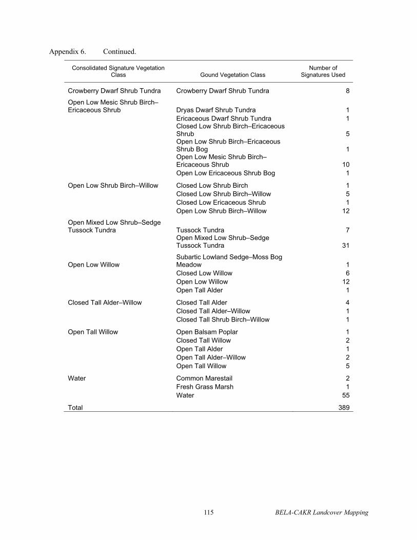
115 BELA-CAKR Landcover Mapping
Appendix 6. Continued.
Consolidated Signature VegetationClass Gound Vegetation Class
Number of Signatures Used
Crowberry Dwarf Shrub Tundra Crowberry Dwarf Shrub Tundra 8
Open Low Mesic Shrub Birch–Ericaceous Shrub Dryas Dwarf Shrub Tundra 1 Ericaceous Dwarf Shrub Tundra 1
Closed Low Shrub Birch–Ericaceous Shrub 5Open Low Shrub Birch–Ericaceous Shrub Bog 1Open Low Mesic Shrub Birch–Ericaceous Shrub 10
Open Low Ericaceous Shrub Bog 1
Open Low Shrub Birch–Willow Closed Low Shrub Birch 1 Closed Low Shrub Birch–Willow 5 Closed Low Ericaceous Shrub 1 Open Low Shrub Birch–Willow 12
Open Mixed Low Shrub–Sedge Tussock Tundra Tussock Tundra 7
Open Mixed Low Shrub–Sedge Tussock Tundra 31
Open Low Willow Subartic Lowland Sedge–Moss Bog Meadow 1
Closed Low Willow 6 Open Low Willow 12 Open Tall Alder 1
Closed Tall Alder–Willow Closed Tall Alder 4 Closed Tall Alder–Willow 1 Closed Tall Shrub Birch–Willow 1
Open Tall Willow Open Balsam Poplar 1 Closed Tall Willow 2 Open Tall Alder 1 Open Tall Alder–Willow 2 Open Tall Willow 5
Water Common Marestail 2 Fresh Grass Marsh 1 Water 55
Total 389

BELA-CAKR Landcover Mapping 116
Appendix 7. Example diagrams of rules used to model ecotypes using the ERDAS knowledgebase routine. See Appendix 8 for codes.

117 BELA-CAKR Landcover Mapping
Appendix 7. Continued.

BELA-CAKR Landcover Mapping 118
Appendix 7. Continued.

119 BELA-CAKR Landcover Mapping
Appendix 7. Continued.
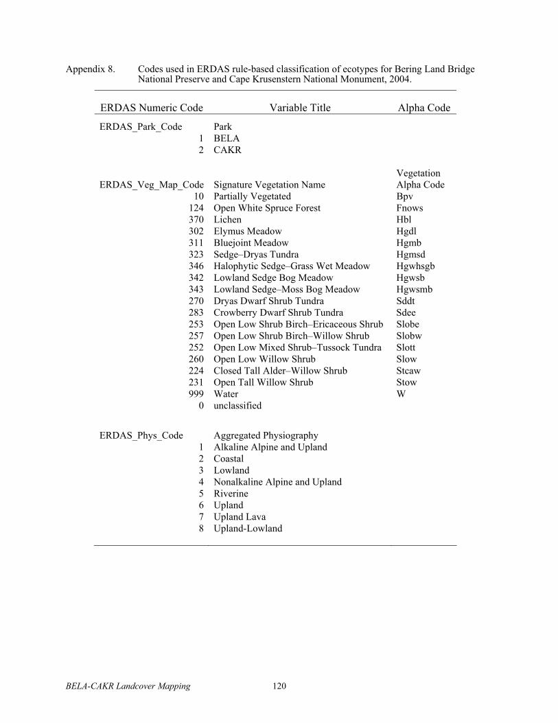
BELA-CAKR Landcover Mapping 120
Appendix 8. Codes used in ERDAS rule-based classification of ecotypes for Bering Land Bridge National Preserve and Cape Krusenstern National Monument, 2004.
ERDAS Numeric Code Variable Title Alpha Code
ERDAS_Park_Code Park 1 BELA 2 CAKR
ERDAS_Veg_Map_Code Signature Vegetation Name VegetationAlpha Code
10 Partially Vegetated Bpv 124 Open White Spruce Forest Fnows 370 Lichen Hbl 302 Elymus Meadow Hgdl 311 Bluejoint Meadow Hgmb 323 Sedge–Dryas Tundra Hgmsd 346 Halophytic Sedge–Grass Wet Meadow Hgwhsgb 342 Lowland Sedge Bog Meadow Hgwsb 343 Lowland Sedge–Moss Bog Meadow Hgwsmb 270 Dryas Dwarf Shrub Tundra Sddt 283 Crowberry Dwarf Shrub Tundra Sdee 253 Open Low Shrub Birch–Ericaceous Shrub Slobe 257 Open Low Shrub Birch–Willow Shrub Slobw 252 Open Low Mixed Shrub–Tussock Tundra Slott 260 Open Low Willow Shrub Slow 224 Closed Tall Alder–Willow Shrub Stcaw 231 Open Tall Willow Shrub Stow 999 Water W
0 unclassified
ERDAS_Phys_Code Aggregated Physiography 1 Alkaline Alpine and Upland 2 Coastal 3 Lowland 4 Nonalkaline Alpine and Upland 5 Riverine 6 Upland 7 Upland Lava 8 Upland-Lowland

121 BELA-CAKR Landcover Mapping
App
endi
x 9.
Cro
ss-w
alk
of 3
3 ec
otyp
es a
nd 3
1 pl
ant a
ssoc
iatio
ns d
evel
oped
from
ana
lysi
s of g
roun
d da
ta, a
nd 2
9 m
ap e
coty
pes,
17 m
ap
vege
tatio
n ty
pes,
12 m
ap a
ggre
gate
d ec
otyp
es. M
ap c
lass
es w
ere
aggr
egat
ed fr
om g
roun
d cl
asse
s to
mat
ch sp
ectra
l ch
arac
teris
tics.
Gro
un
d E
coty
pes
P
lan
t A
sso
ciat
ion
s M
ap E
coty
pes
M
ap V
eget
atio
n T
ypes
M
ap A
gg
reg
ated
Eco
typ
es
Alp
ine
Alk
alin
e D
ry
Bar
ren
s
Dry
as
inte
gri
foli
a–
Rh
od
od
end
ron
la
pp
on
icu
m
Alp
ine
Alk
alin
e D
ry B
arre
ns
Par
tial
ly V
eget
ated
A
lpin
e an
d U
pla
nd D
war
f S
hru
b
and
Bar
ren
s
Dry
as
oct
op
etala
–P
ote
nti
lla u
nif
lora
A
lpin
e A
lkal
ine
Dry
Bar
rens
Par
tial
ly V
eget
ated
A
lpin
e an
d U
pla
nd D
war
f S
hru
b
and
Bar
ren
s
Alp
ine
No
nal
kal
ine
Dry
Bar
ren
s
Dry
as
oct
op
etala
–S
ali
x p
hle
bo
ph
ylla
–
Hie
roch
loe
alp
ina
Alp
ine
No
nal
kal
ine
Dry
Bar
ren
s
Par
tial
ly V
eget
ated
A
lpin
e an
d U
pla
nd D
war
f S
hru
b
and
Bar
ren
s
Alp
ine
Alk
alin
e D
ry D
ryas
Shru
b
Dry
as
inte
gri
foli
a–
Rh
od
od
end
ron
la
pp
on
icu
m
Alp
ine
Alk
alin
e D
ry D
ryas
Shru
b
Dry
as D
war
f S
hru
bT
un
dra
A
lpin
e an
d U
pla
nd
Dw
arf
Sh
rub
and
Bar
ren
s
Dry
as
oct
op
etala
–P
ote
nti
lla u
nif
lora
A
lpin
e A
lkal
ine
Dry
Dry
as
Shru
b
Dry
as D
war
f S
hru
bT
un
dra
A
lpin
e an
d U
pla
nd
Dw
arf
Sh
rub
and
Bar
ren
s
Alp
ine
No
nal
kal
ine
Dry
Dry
as S
hru
b
Dry
as
oct
op
etala
–S
ali
x p
hle
bo
ph
ylla
–
Hie
roch
loe
alp
ina
Alp
ine
No
nal
kal
ine
Dry
Dry
as S
hru
b
Dry
as D
war
f S
hru
bT
un
dra
A
lpin
e an
d U
pla
nd
Dw
arf
Sh
rub
and
Bar
ren
s
Upla
nd D
ry L
ichen
B
etu
la n
an
a–
Led
um
dec
um
ben
s–L
ois
eleu
ria
pro
cum
ben
s
Up
lan
d D
ry L
ich
en B
arre
ns
Lic
hen
A
lpin
e an
d U
pla
nd
Dw
arf
Sh
rub
and
Bar
ren
s
Up
lan
d M
ois
t S
pru
ce
Fo
rest
Pic
ea g
lauca
–S
ali
x p
lan
ifo
lia p
ulc
hra
U
pla
nd
Mo
ist
Sp
ruce
Fo
rest
O
pen
Wh
ite
Sp
ruce
Fo
rest
U
pla
nd
Sp
ruce
Fo
rest
Upla
nd M
ois
t L
ow
Wil
low
Shru
b
Sa
lix
gla
uca
–D
rya
s in
teg
rifo
lia
U
pla
nd M
ois
t L
ow
Wil
low
Shru
b
Tal
l an
d L
ow
Wil
low
Sh
rub
U
pla
nd
an
d L
ow
lan
d L
ow
Wil
low
Shru
b
Up
lan
d D
ry C
row
ber
ry
Shru
b
Em
pet
rum
nig
rum
–E
lym
us
are
nari
us
mo
llis
U
pla
nd
Dry
Cro
wb
erry
Shru
b
Cro
wb
erry
Dw
arf
Sh
rub
Tu
nd
ra
Up
lan
d a
nd L
ow
lan
d D
war
f
Bir
ch–
Wil
low
Sh
rub
Up
lan
d M
ois
t D
war
f
Bir
ch–
Eri
cace
ous
Sh
rub
Bet
ula
na
na
–L
edu
m d
ecu
mb
ens–
Lo
isel
euri
a
pro
cum
ben
s
Up
lan
d M
ois
t D
war
f B
irch
–
Eri
cace
ou
s S
hru
b
Lo
w S
hru
b B
irch
–E
rica
ceo
us
Shru
b
Up
lan
d a
nd L
ow
lan
d D
war
f
Bir
ch–
Wil
low
Sh
rub
Up
lan
d M
ois
t D
war
f
Bir
ch–
Tu
sso
ck S
hru
b
Bet
ula
na
na
–E
rio
ph
oru
m v
ag
inatu
m
Up
lan
d M
ois
t D
war
f B
irch
–
Tu
sso
ck S
hru
b
Lo
w M
ixed
Sh
rub
–T
uss
ock
Tu
nd
ra
Up
lan
d D
war
f B
irch
–T
uss
ock
Shru
b
Up
lan
d M
ois
t S
edg
e–
Dry
as M
eadow
Dry
as
inte
gri
foli
a–
Ca
rex
big
elow
ii–
Sen
ecio
atr
opurp
ure
us
Up
lan
d M
ois
t S
edg
e–D
ryas
Mea
do
w
Sed
ge–
Dry
as T
un
dra
U
pla
nd
an
d L
ow
lan
d S
edge–
Dry
as M
eadow
Lo
wla
nd
Mo
ist
Tal
l
Ald
er–
Wil
low
Sh
rub
Aln
us
cris
pa
–S
ali
x pla
nif
oli
a p
ulc
hra
–R
ub
us
arc
ticu
s
Lo
wla
nd
Mo
ist
Tal
l A
lder
–
Wil
low
Shru
b
Tal
l an
d L
ow
Wil
low
Sh
rub
U
pla
nd
an
d L
ow
lan
d L
ow
Wil
low
Shru
b
Low
land M
ois
t L
ow
Wil
low
Shru
b
Sali
x pla
nif
oli
a p
ulc
hra
–C
ala
magro
stis
can
ad
ensi
s
Low
land M
ois
t L
ow
Wil
low
Shru
b
Tal
l an
d L
ow
Wil
low
Sh
rub
U
pla
nd
an
d L
ow
lan
d L
ow
Wil
low
Shru
b
Low
land M
ois
t D
war
f
Bir
ch–
Wil
low
Sh
rub
Bet
ula
na
na
–S
ali
x pla
nif
oli
a p
ulc
hra
–P
yro
la
gra
nd
iflo
ra
Low
land M
ois
t D
war
f
Bir
ch–
Wil
low
Sh
rub
Low
Shru
b B
irch
–W
illo
w
Shru
b
Up
lan
d a
nd L
ow
lan
d D
war
f
Bir
ch–
Wil
low
Sh
rub
Lo
wla
nd
Wet
Dw
arf
Bir
ch–
Eri
cace
ous
Sh
rub
Bet
ula
na
na
–V
acc
iniu
m v
itis
-id
aea
–C
are
x
aq
ua
tili
s
Lo
wla
nd
Wet
Dw
arf
Bir
ch–
Eri
cace
ou
s S
hru
b
Lo
w S
hru
b B
irch
–E
rica
ceo
us
Shru
b
Up
lan
d a
nd L
ow
lan
d D
war
f
Bir
ch–
Wil
low
Sh
rub
Lo
wla
nd
Mo
ist
Sed
ge–
Dry
as M
eadow
Dry
as
inte
gri
foli
a–
Eq
uis
etu
m a
rven
se
Lo
wla
nd
Mo
ist
Sed
ge–
Dry
as
Mea
do
w
Sed
ge–
Dry
as T
un
dra
U
pla
nd
an
d L
ow
lan
d S
edge–
Dry
as M
eadow
Lo
wla
nd
Sed
ge–
Mo
ss F
en
Mea
do
w
Ca
rex
aq
ua
tili
s–S
ali
x fu
sces
cen
s–S
ph
ag
nu
m
Lo
wla
nd
Sed
ge–
Mo
ss F
en
Mea
do
w
Lo
wla
nd
Sed
ge–
Mo
ss B
og
Mea
do
w
Lo
wla
nd
Sed
ge
Fen
Mea
do
w

BELA-CAKR Landcover Mapping 122
App
endi
x 9.
Con
tinue
d.L
ow
lan
d S
edge
Fen
Mea
do
w
Ca
rex
aq
ua
tili
s–C
are
x ch
ord
do
rhiz
a
Lo
wla
nd
Sed
ge
Fen
Mea
do
w
Lo
wla
nd
Sed
ge
Bo
g M
ead
ow
L
ow
lan
d S
edge
Fen
Mea
do
w
Lac
ust
rin
e M
ois
t B
luej
oin
t
Mea
do
w
Ca
lam
ag
rost
is c
an
ad
ensi
s–R
um
ex a
rcti
cus
Lac
ust
rin
e M
ois
t B
luej
oin
t
Mea
do
w
Blu
ejo
int
Mea
dow
L
ow
lan
d S
edge
Fen
Mea
do
w
Lac
ust
rin
e M
ares
tail
Mar
sh
Arc
top
hil
a f
ulv
a
Lo
wla
nd
Wat
er
Wat
er
Fre
shw
ater
Hip
pu
rus
vulg
ari
s–P
ota
mo
get
on s
pp
.L
ow
lan
d W
ater
W
ater
F
resh
wat
er
Ca
rex
aq
ua
tili
s–C
alt
ha
pa
lust
ris
Lo
wla
nd
Wat
er
Wat
er
Fre
shw
ater
Lo
wla
nd
Wat
er
Wat
er
Lo
wla
nd
Wat
er
Wat
er
Fre
shw
ater
Riv
erin
e W
ater
W
ater
R
iver
ine
Wat
er
Wat
er
Fre
shw
ater
Riv
erin
e M
ois
t T
all
Ald
er–
Wil
low
Shru
b
Aln
us
cris
pa
–S
ali
x b
arc
layi
R
iver
ine
Mo
ist
Lo
w a
nd
Tal
l
Wil
low
Shru
b
Tal
l an
d L
ow
Wil
low
Sh
rub
R
iver
ine
Lo
w a
nd
Tal
l W
illo
w
Shru
b
Riv
erin
e M
ois
t T
all
Wil
low
Shru
b
Sa
lix
ala
xen
sis–
Ast
er s
ibir
icu
s R
iver
ine
Mo
ist
Lo
w a
nd
Tal
l
Wil
low
Shru
b
Tal
l an
d L
ow
Wil
low
Sh
rub
R
iver
ine
Lo
w a
nd
Tal
l W
illo
w
Shru
b
Riv
erin
e M
ois
t L
ow
Wil
low
Shru
b
Sa
lix
lan
ata
ric
ha
rdso
nii
–F
estu
ca a
lta
ica
R
iver
ine
Mo
ist
Lo
w a
nd
Tal
l
Wil
low
Shru
b
Tal
l an
d L
ow
Wil
low
Sh
rub
R
iver
ine
Lo
w a
nd
Tal
l W
illo
w
Shru
b
Riv
erin
e M
ois
t D
war
f
Bir
ch–
Wil
low
Sh
rub
Bet
ula
na
na
–S
ali
x pla
nif
oli
a p
ulc
hra
–P
yro
la
gra
nd
iflo
ra
Riv
erin
e M
ois
t D
war
f
Bir
ch–
Wil
low
Sh
rub
Low
Shru
b B
irch
–W
illo
w
Shru
b
Riv
erin
e L
ow
and
Tal
l W
illo
w
Shru
b
Riv
erin
e B
arre
ns
Ep
ilo
biu
m l
ati
foli
um
–A
gro
pyr
on
ma
cro
uru
m
Riv
erin
e B
arre
ns
Par
tial
ly V
eget
ated
R
iver
ine
and C
oas
tal
Bar
ren
s
Coas
tal
Bar
rens
Ely
mu
s a
ren
ari
us
mo
llis
–L
ath
yru
s m
ari
tim
us
Coas
tal
Bar
rens
Par
tial
ly V
eget
ated
R
iver
ine
and C
oas
tal
Bar
rens
Ca
rex
ram
ensk
ii–
Pu
ccin
elli
a p
hry
ga
no
des
C
oas
tal
Bar
rens
Par
tial
ly V
eget
ated
R
iver
ine
and C
oas
tal
Bar
rens
Coas
tal
Dry
Duneg
rass
Mea
do
w
Ely
mu
s a
ren
ari
us
mo
llis
–L
ath
yru
s m
ari
tim
us
Coas
tal
Dry
Duneg
rass
Mea
do
w
Ely
mu
s M
ead
ow
R
iver
ine
and C
oas
tal
Bar
ren
s
Co
asta
l B
rack
ish
Wet
Sed
ge–
Gra
ss M
ead
ow
Sa
lix
ova
lifo
lia
–D
esch
am
psi
a c
aes
pit
osa
C
oas
tal
Wet
Sed
ge–
Gra
ss
Mea
do
w
Hal
op
hy
tic
Sed
ge–
Gra
ss W
et
Mea
do
w
Co
asta
l S
edg
e–G
rass
Mea
do
w
Ca
rex
ram
ensk
ii–
Du
po
nti
a f
ish
eri
Co
asta
l W
et S
edg
e–G
rass
Mea
do
w
Hal
op
hy
tic
Sed
ge–
Gra
ss W
et
Mea
do
w
Co
asta
l S
edg
e–G
rass
Mea
do
w
Co
asta
l S
alin
e W
et S
edg
e–
Gra
ss M
eadow
Ca
rex
ram
ensk
ii–
Pu
ccin
elli
a p
hry
ga
no
des
C
oas
tal
Wet
Sed
ge–
Gra
ss
Mea
do
w
Hal
op
hy
tic
Sed
ge–
Gra
ss W
et
Mea
do
w
Co
asta
l S
edg
e–G
rass
Mea
do
w
Co
asta
l W
ater
W
ater
C
oas
tal
Wat
er
Wat
er
Co
asta
l W
ater
Hu
man
Mo
dif
ed B
arre
ns
No
ne
Hu
man
Mo
dif
ed B
arre
ns
Par
tial
ly V
eget
ated
H
um
an M
od
ifed
Bar
ren
s

123 BELA-CAKR Landcover Mapping
Appendix 10. Cross-tabulation of consistency between independently derived spectral classes (nodes of hierarchical clustering) and signature vegetation class. Boxes denote central tendencies of nodes associated with vegetation types.
Node
Hb
l
Bp
v
Hg
dl
Sd
dt
Hg
msd
Slo
tt
Slo
be
Slo
bw
Slo
w
Sto
w
Stc
aw
Hg
mb
Fn
ow
s
Sd
ee
Hg
wsm
b
Hg
wsb
Hg
wh
sg
b
W
To
tal8111 2 1 3
7111 2 2
8112 4 2 1 7
7122 3 3
1121 3 3
8121 2 2
7112 2 2
1221 19 1 20
1111 6 1 7
1122 8 1 1 10
8122 3 1 4
6111 4 4 8
6221 1 1 2 1 5
1211 1 4 5
1112 1 6 7
5111 5 5
5112 1 5 2 8
5121 3 3
2212 5 1 1 7
2121 7 5 12
2211 2 1 3
5211 2 6 8 16
2111 1 3 4
2122 1 1 2
2412 8 2 1 1 12
2311 3 3
2322 1 1 2
3113 1 1 1 1 4
3312 2 1 2 1 1 1 8
2321 2 1 3
2411 1 1 2
3322 2 1 2 1 1 1 8
2312 1 1 2
3111 1 2 3
2621 1 2 3
2421 1 1 4 2 8
3122 1 2 3
2612 1 3 2 6
2622 3 3
3211 3 3
2500 1 1 2
4122 2 1 3
4111 1 2 4 2 1 10
4121 2 3 4 1 10
4211 3 1 2 6
7321 2 4 6
7311 1 3 4
5221 1 1 2
6211 2 2 2 6
5212 2 1 5 8
6212 1 5 2 1 1 2 1 13
6121 2 1 1 2 2 8
3321 1 1 1 1 1 1 2 1 9
8211 4 1 5
8221 1 1 2 4
7212 3 3 6
8222 1 1 2
7211 1 1 2
7220 1 2 3
9110 12 12
9120 36 36
9220 7 7
Total 8 58 4 39 42 38 19 19 20 11 6 9 8 8 16 17 9 58 389
% in 100 88 25 62 33 66 42 84 30 36 67 22 88 38 56 35 78 100 65

BELA-CAKR Landcover Mapping 124
App
endi
x 11
. C
ompa
rison
of m
appe
d an
d gr
ound
eco
type
s det
erm
ined
at 2
56 p
oint
s use
d to
cre
ate
map
sign
atur
es. S
hade
d va
lues
indi
cate
the
num
ber o
f cor
rect
ly m
appe
d po
ints
and
bol
ded
valu
es in
dica
te th
e do
min
ant t
ypes
of m
iscl
assi
ficat
ion.
Gro
un
d E
coty
pes
Alpine Alkaline Dry Barrens
Alpine Alkaline Dry Dryas Shrub
Alpine Nonalkaline Dry Barrens
Alpine Nonalkaline Dry Dryas Shrub
Coastal Barrens
Coastal Dry Dunegrass Meadow
Coastal Water
Coastal Wet Sedge-Grass Meadow
Lacustrine Moist Bluejoint Meadow
Lowland Moist Dwarf Birch-Willow Shrub
Lowland Moist Low Willow Shrub
Lowland Moist Sedge-Dryas Meadow
Lowland Moist Tall Alder-Willow Shrub
Lowland Sedge Fen Meadow
Lowland Sedge-Moss Fen Meadow
Lowland Water
Lowland Wet Dwarf Birch-Ericaceous Shrub
Riverine Barrens
Riverine Moist Dwarf Birch-Willow Shrub
Riverine Moist Low and Tall Willow Shrub
Riverine Water
Upland Dry Crowberry Shrub
Upland Dry Lichen Barrens
Upland Moist Dwarf Birch-Ericaceous Shrub
Upland Moist Dwarf Birch-Tussock Shrub
Upland Moist Low Willow Shrub
Upland Moist Sedge-Dryas Meadow
Upland Moist Spruce Forest
Point Total
Fraction Correct
Alp
ine
Alk
alin
e D
ry B
arre
ns
16
2
18
0.8
9
Alp
ine
Alk
alin
e D
ry D
ryas
Sh
rub
1
2
1
1
32
60
.81
A
l pin
e N
on
alk
alin
e D
ry B
arre
ns
52
7
0.2
9
Alp
ine
No
nal
kal
ine
Dry
Dry
as S
hru
b
1
52
19
0.2
2
Co
asta
l B
arre
ns
21
1
4
0.5
0
Co
asta
l D
ry D
un
eg
rass
Mea
do
w
2
1
1
40
.50
C
oas
tal
Wat
e r
3
2
5
0.6
0
Coas
tal
Wet
Sed
ge-
Gra
ss M
ead
ow
9
9
1.0
0
Lac
ust
rin
e M
ois
t B
luej
oin
t M
ead
ow
61
1
8
0.7
5
Lo
wla
nd
Mo
ist
Dw
arf
Bir
ch-W
illo
w
3
25
0.6
0
Lo
wla
nd
Mo
ist
Lo
w W
illo
w S
hru
b
1
33
11
61
50
.20
L
ow
lan
d M
ois
t S
edg
e-D
ryas
Mea
do
w
1
45
0.0
0
Lo
wla
nd
Mo
ist
Tal
l A
lder
-Wil
low
3
1
40
.75
L
ow
lan
d S
edg
e F
en M
ead
ow
1
1
0
1
10
.91
L
ow
lan
d S
edg
e-M
oss
Fen
Mea
do
w
8
19
0.8
9
Lo
wla
nd
Wat
er
1
33
70
.43
L
ow
land W
et D
war
f B
irch
-Eri
cace
ou
s
1
4
11
18
0.5
0
Riv
erin
e B
arre
ns
2
21
.00
R
iver
ine
Mo
ist
Dw
arf
Bir
ch-W
illo
w
1
11
.00
R
iver
ine
Mo
ist
Lo
w a
nd
Tal
l W
illo
w
1
1
1
58
0.6
3
Riv
erin
e W
ate r
11
1.0
0
Up
lan
d D
ry C
row
ber
ry S
hru
b
1
45
0.8
0
Up
lan
d D
ry L
ich
en B
arre
ns
1
78
0.8
8
Up
lan
d M
ois
t D
war
f B
irch
-Eri
cace
ou
s
2
91
12
0.7
5
Up
lan
d M
ois
t D
war
f B
irch
-Tu
sso
ck
2
52
51
.00
U
pla
nd
Mo
ist
Lo
w W
illo
w S
hru
b
3
25
0.4
0
Up
lan
d M
ois
t S
edg
e-D
ryas
Mea
do
w
1
3
1
22
27
0.8
1
Up
lan
d M
ois
t S
pru
ce F
ore
st
8
81
.00
Po
int
To
tal
23
30
3
3
2
3
5
9
6
5
5
6
7
14
9
3
7
3
1
6
1
6
7
17
28
10
29
8
256
Fra
ctio
n c
orr
ect
0.70
0.70
0.67
0.67
1.00
0.67
0.60
1.00
1.00
0.60
0.60
0.00
0.43
0.71
0.89
1.00
0.57
0.67
1.00
0.83
1.00
0.67
1.00
0.53
0.89
0.20
0.76
1.00
0.7
1

125 BELA-CAKR Landcover Mapping
App
endi
x 12
. C
ompa
rison
of m
appe
d an
d gr
ound
veg
etat
ion
dete
rmin
ed a
t 256
poi
nts u
sed
to c
reat
e m
ap si
gnat
ures
. G
roun
d cl
asse
s wer
e cr
oss
wal
ked
to c
orre
spon
d to
redu
ced
set o
f map
ped
clas
ses.
Shad
ed v
alue
s ind
icat
e th
e nu
mbe
r of c
orre
ctly
map
ped
poin
ts a
nd b
olde
d va
lues
indi
cate
the
dom
inan
t typ
es o
f mis
clas
sific
atio
n.
Gro
un
d V
eget
atio
n C
lass
Bluejoint Meadow
Crowberry Dwarf Shrub Tundra
Dryas Dwarf ShrubTundra
Elymus Meadow
Halophytic Sedge-Grass Wet Meadow
Lichen
Low Mixed Shrub-Tussock Tundra
Low Shrub Birch-Ericaceous Shrub
Low Shrub Birch-Willow Shrub
Lowland Sedge Bog Meadow
Lowland Sedge-Moss Bog Meadow
Open White Spruce Forest
Partially Vegetated
Sedge-Dryas Tundra
Tall and Low Willow Shrub
Water
Po
int
To
tal
Fra
ctio
n
Co
rrec
t
Blu
ejo
int
Mea
dow
6
1
1
8
0.7
5
Cro
wb
erry
Dw
arf
Sh
rub
Tu
nd
ra
4
1
5
0.8
0
Dry
as D
war
f S
hru
bT
un
dra
2
9
1
2
3
3
5
0.8
3
Ely
mus
Mea
dow
1
2
1
4
0.5
0
Hal
op
hy
tic
Sed
ge-
Gra
ss W
et M
ead
ow
9
9
1.0
0
Lic
hen
7
1
8
0
.88
Lo
w M
ixed
Sh
rub
-Tu
sso
ck T
und
ra
25
25
1
.00
Lo
w S
hru
b B
irch
-Eri
cace
ou
s S
hru
b
1
2
16
1
20
0
.80
Lo
w S
hru
b B
irch
-Wil
low
Sh
rub
24
6
0.6
7
Lo
wla
nd
Sed
ge
Bo
g M
ead
ow
1
1
0
11
0
.91
Lo
wla
nd
Sed
ge-
Mo
ss B
og
Mea
do
w
8
1
9
0.8
9
Op
en W
hit
e S
pru
ce F
ore
st
8
8
1
.00
Par
tial
ly V
eget
ated
2
1
27
1
3
1
0.8
7
Sed
ge-
Dry
as T
un
dra
1
1
1
2
9
32
0
.91
Tal
l an
d L
ow
Wil
low
Sh
rub
41
1
2
6
3
2
0.8
1
Wat
er
1
3
2
7
1
3
0.5
4
Po
int
To
tal
6
6
33
3
9
7
2
8
24
6
1
4
9
8
31
3
5
28
9
2
56
Fra
ctio
n C
orr
ect
1.0
0
0.6
7
0.8
8
0.6
7
1.0
0
1.0
0
0.8
9
0.6
7
0.6
7
0.7
1
0.8
9
1.0
0
0.8
7
0.8
3
0.9
3
0.7
8
0
.85

BELA-CAKR Landcover Mapping 126
App
endi
x 13
. C
ompa
rison
of m
appe
d an
d gr
ound
eco
type
s afte
r agg
rega
tion
into
12
clas
ses,
dete
rmin
ed a
t 256
poi
nts u
sed
to c
reat
em
ap si
gnat
ures
. Sh
aded
val
ues i
ndic
ate
the
num
ber o
f cor
rect
ly m
appe
d po
ints
and
bol
ded
valu
es in
dica
te th
e do
min
ant t
ypes
of m
iscl
assi
ficat
ion.
.
Ag
gre
gat
ed G
rou
nd
Eco
typ
e
Coastal Water
Alpine and Upland Dwarf Shrub and Barrens
Coastal Sedge-Grass Meadow
Freshwater
Lowland Sedge Fen Meadow
Riverine and Coastal Barrens
Riverine Low and Tall Willow Shrub
Upland and Lowland Dwarf Birch-Willow Shrub
Upland and Lowland Low Willow Shrub
Upland and Lowland Sedge-Dryas Meadow
Upland Dwarf Birch-Tussock Shrub
Upland Spruce Forest
Point Total
Fraction Correct
Co
asta
l W
ater
3
2
5
0.6
0
Alp
ine
and
Up
lan
d D
war
f S
hru
b a
nd
Bar
ren
s
64
1
3
68
0
.94
Co
asta
l S
edg
e-G
rass
Mea
do
w
9
9
1
.00
Fre
shw
ater
43
1
8
0.5
0
Lo
wla
nd
Sed
ge
Fen
Mea
do
w
1
2
5
2
28
0
.89
Riv
erin
e an
d C
oas
tal
Bar
ren
s 1
7
1
1
1
0
0.7
0
Riv
erin
e L
ow
and
Tal
l W
illo
w S
hru
b
1
6
2
9
0.6
7
Up
lan
d a
nd L
ow
lan
d D
war
f B
irch
-Wil
low
Sh
rub
1
1
26
2
30
0
.87
Up
lan
d a
nd L
ow
lan
d L
ow
Wil
low
Sh
rub
1
5
18
24
0
.75
Up
lan
d a
nd L
ow
lan
d S
edge-
Dry
as M
ead
ow
1
1
29
1
32
0
.91
Up
lan
d D
war
f B
irch
-Tu
sso
ck S
hru
b
25
25
1
.00
Up
lan
d S
pru
ce F
ore
st
8
8
1
.00
Po
int
To
tal
5
66
9
4
2
9
8
7
35
2
2
35
2
8
8
25
6
Fra
ctio
n C
orr
ect
0.6
0
0.9
7
1.0
0
1.0
0
0.8
6
0.8
8
0.8
6
0.7
4
0.8
2
0.8
3
0.8
9
1.0
0
0
.88
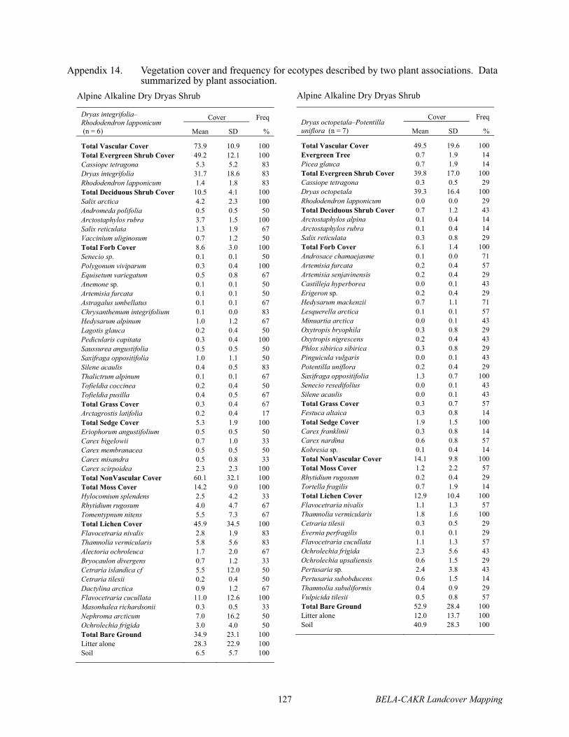
127 BELA-CAKR Landcover Mapping
Appendix 14. Vegetation cover and frequency for ecotypes described by two plant associations. Data summarized by plant association.
Alpine Alkaline Dry Dryas Shrub
Cover Freq Dryas integrifolia–Rhododendron lapponicum (n = 6) Mean SD %
Total Vascular Cover 73.9 10.9 100 Total Evergreen Shrub Cover 49.2 12.1 100 Cassiope tetragona 5.3 5.2 83 Dryas integrifolia 31.7 18.6 83 Rhododendron lapponicum 1.4 1.8 83 Total Deciduous Shrub Cover 10.5 4.1 100 Salix arctica 4.2 2.3 100 Andromeda polifolia 0.5 0.5 50 Arctostaphylos rubra 3.7 1.5 100 Salix reticulata 1.3 1.9 67 Vaccinium uliginosum 0.7 1.2 50 Total Forb Cover 8.6 3.0 100 Senecio sp. 0.1 0.1 50 Polygonum viviparum 0.3 0.4 100 Equisetum variegatum 0.5 0.8 67 Anemone sp. 0.1 0.1 50 Artemisia furcata 0.1 0.1 50 Astragalus umbellatus 0.1 0.1 67 Chrysanthemum integrifolium 0.1 0.0 83 Hedysarum alpinum 1.0 1.2 67 Lagotis glauca 0.2 0.4 50 Pedicularis capitata 0.3 0.4 100 Saussurea angustifolia 0.5 0.5 50 Saxifraga oppositifolia 1.0 1.1 50 Silene acaulis 0.4 0.5 83 Thalictrum alpinum 0.1 0.1 67 Tofieldia coccinea 0.2 0.4 50 Tofieldia pusilla 0.4 0.5 67 Total Grass Cover 0.3 0.4 67 Arctagrostis latifolia 0.2 0.4 17 Total Sedge Cover 5.3 1.9 100 Eriophorum angustifolium 0.5 0.5 50 Carex bigelowii 0.7 1.0 33 Carex membranacea 0.5 0.5 50 Carex misandra 0.5 0.8 33 Carex scirpoidea 2.3 2.3 100 Total NonVascular Cover 60.1 32.1 100 Total Moss Cover 14.2 9.0 100 Hylocomium splendens 2.5 4.2 33 Rhytidium rugosum 4.0 4.7 67 Tomentypnum nitens 5.5 7.3 67 Total Lichen Cover 45.9 34.5 100 Flavocetraria nivalis 2.8 1.9 83 Thamnolia vermicularis 5.8 5.6 83 Alectoria ochroleuca 1.7 2.0 67 Bryocaulon divergens 0.7 1.2 33 Cetraria islandica cf 5.5 12.0 50 Cetraria tilesii 0.2 0.4 50 Dactylina arctica 0.9 1.2 67 Flavocetraria cucullata 11.0 12.6 100 Masonhalea richardsonii 0.3 0.5 33 Nephroma arcticum 7.0 16.2 50 Ochrolechia frigida 3.0 4.0 50 Total Bare Ground 34.9 23.1 100 Litter alone 28.3 22.9 100 Soil 6.5 5.7 100
Alpine Alkaline Dry Dryas Shrub
Cover Freq Dryas octopetala–Potentilla uniflora (n = 7) Mean SD %
Total Vascular Cover 49.5 19.6 100 Evergreen Tree 0.7 1.9 14 Picea glauca 0.7 1.9 14 Total Evergreen Shrub Cover 39.8 17.0 100 Cassiope tetragona 0.3 0.5 29 Dryas octopetala 39.3 16.4 100 Rhododendron lapponicum 0.0 0.0 29 Total Deciduous Shrub Cover 0.7 1.2 43 Arctostaphylos alpina 0.1 0.4 14 Arctostaphylos rubra 0.1 0.4 14 Salix reticulata 0.3 0.8 29 Total Forb Cover 6.1 1.4 100 Androsace chamaejasme 0.1 0.0 71 Artemisia furcata 0.2 0.4 57 Artemisia senjavinensis 0.2 0.4 29 Castilleja hyperborea 0.0 0.1 43 Erigeron sp. 0.2 0.4 29 Hedysarum mackenzii 0.7 1.1 71 Lesquerella arctica 0.1 0.1 57 Minuartia arctica 0.0 0.1 43 Oxytropis bryophila 0.3 0.8 29 Oxytropis nigrescens 0.2 0.4 43 Phlox sibirica sibirica 0.3 0.8 29 Pinguicula vulgaris 0.0 0.1 43 Potentilla uniflora 0.2 0.4 29 Saxifraga oppositifolia 1.3 0.7 100 Senecio resedifolius 0.0 0.1 43 Silene acaulis 0.0 0.1 43 Total Grass Cover 0.3 0.7 57 Festuca altaica 0.3 0.8 14 Total Sedge Cover 1.9 1.5 100 Carex franklinii 0.3 0.8 14 Carex nardina 0.6 0.8 57 Kobresia sp. 0.1 0.4 14 Total NonVascular Cover 14.1 9.8 100 Total Moss Cover 1.2 2.2 57 Rhytidium rugosum 0.2 0.4 29 Tortella fragilis 0.7 1.9 14 Total Lichen Cover 12.9 10.4 100 Flavocetraria nivalis 1.1 1.3 57 Thamnolia vermicularis 1.8 1.6 100 Cetraria tilesii 0.3 0.5 29 Evernia perfragilis 0.1 0.1 29 Flavocetraria cucullata 1.1 1.3 57 Ochrolechia frigida 2.3 5.6 43 Ochrolechia upsaliensis 0.6 1.5 29 Pertusaria sp. 2.4 3.8 43 Pertusaria subobducens 0.6 1.5 14 Thamnolia subuliformis 0.4 0.9 29 Vulpicida tilesii 0.5 0.8 57 Total Bare Ground 52.9 28.4 100 Litter alone 12.0 13.7 100 Soil 40.9 28.3 100

BELA-CAKR Landcover Mapping 128
Appendix 14. Continued.
Lacustrine Marestail Marsh
Cover Freq Hippuris vulgaris– Potamogeton sp (n = 3) Mean SD %
Total Vascular Cover 22.8 21.6 100 Total Forb Cover 22.1 20.5 100 Ranunculus pallasii 0.7 1.2 33 Hippuris vulgaris 13.3 7.6 100 Caltha palustris 0.3 0.6 33 Menyanthes trifoliata 0.7 1.2 33 Potamogeton sp. 0.4 0.6 67 Potentilla palustris 6.7 11.5 33 Total Grass Cover 0.3 0.6 33 Arctophila fulva 0.3 0.6 33 Total Sedge Cover 0.3 0.6 33 Carex aquatilis 0.3 0.6 33 Total NonVascular Cover 5.3 9.2 33 Total Moss Cover 5.3 9.2 33 Limprichtia revolvens 3.3 5.8 33 Scorpidium scorpioides 1.7 2.9 33 Sphagnum cf. jensnii 0.3 0.6 33 Total Bare Ground 91.7 13.5 100 Water 91.3 14.2 100 Litter alone 0.3 0.6 33
Lacustrine Marestail Marsh
Cover Freq Carex aquatilis–Caltha palustris(n = 2) Mean SD %
Total Vascular Cover 42.1 8.4 100 Total Deciduous Shrub Cover 0.5 0.7 50 Salix fuscescens 0.5 0.7 50 Total Forb Cover 16.6 16.2 100 Ranunculus hyperboreus 1.5 2.1 50 Hippuris vulgaris 1.5 2.1 50 Caltha natans 7.5 10.6 50 Caltha palustris 1.5 2.1 50 Myriophyllum spicatum 1.5 2.1 50 Polemonium acutiflorum 0.1 0.1 50 Potamogeton sp. 0.5 0.7 50 Potentilla palustris 2.5 3.5 50 Total Grass Cover 10.0 14.1 50 Arctophila fulva* 10.0 14.1 50 Total Sedge Cover 15.0 21.2 50 Eriophorum angustifolium 7.5 10.6 50 Carex aquatilis 7.5 10.6 50 Total NonVascular Cover 1.5 2.1 50 Total Moss Cover 1.5 2.1 50 Sphagnum squarrosum 1.5 2.1 50 Total Bare Ground 125.0 35.4 100 Water 80.0 28.3 100 Litter alone 45.0 63.6 50
*Arctophila fulva typically occurs as a unique plant association, but was included here because of insufficient data to describe it separately.
Coastal Barrens
Cover Freq Elymus arenarius mollis–Lathyrus maritimus (n = 6) Mean SD %
Total Vascular Cover 3.8 6.6 33 Total Deciduous Shrub Cover 0.0 0.1 17 Salix ovalifolia 0.0 0.0 17 Salix planifolia pulchra 0.0 0.0 17 Total Forb Cover 1.6 2.6 33 Stellaria sp. 0.0 0.0 17 Artemisia tilesii 0.0 0.0 17 Honckenya peploides 1.0 1.5 33 Lathyrus maritimus 0.2 0.4 33 Mertensia maritima 0.3 0.8 17 Senecio pseudoarnica 0.0 0.0 17 Total Grass Cover 2.2 4.0 33 Festuca rubra 0.0 0.0 17 Elymus arenarius mollis 2.2 4.0 33 Total NonVascular Cover 0.1 0.2 33 Total Moss Cover 0.1 0.2 33 Ceratodon purpureus 0.0 0.1 17 Bryum pseudotriquetrum 0.0 0.1 17 Dicranum spadiceum 0.0 0.1 17 Leptobryum pyriforme 0.0 0.1 17 Total Bare Ground 98.3 4.1 100 Litter alone 2.7 4.1 50 Soil 95.7 6.5 100
Coastal Barrens
Carex ramenskii–Puccinellia phryganodes (n = 1) % Cover
Total Vascular Cover 1.4 Total Forb Cover 0.3 Stellaria humifusa 0.1 Chrysanthemum arcticum 0.1 Potentilla egedii 0.1 Total Grass Cover 0.1 Elymus arenarius mollis 0.1 Total Sedge Cover 1.0 Carex subspathacea 1.0 Total NonVascular Cover 0.2 Total Moss Cover 0.2 Sphagnum obtusum 0.2 Total Bare Ground 99.1 Water 1.0 Litter alone 0.1 Soil 98.0

129 BELA-CAKR Landcover Mapping
Appendix 14. Continued.
Coastal Brackish Wet Sedge–Grass Meadow
Cover Freq Salix ovalifolia–Deschampsia caespitosa (n = 2) Mean SD %
Total Vascular Cover 53.6 14.3 100 Total Deciduous Shrub Cover 11.0 12.7 100 Salix ovalifolia 11.0 12.7 100 Total Evergreen Shrub Cover 0.6 0.6 100 Empetrum nigrum 0.6 0.6 100 Total Forb Cover 8.5 2.6 100 Sedum rosea 0.1 0.1 50 Androsace chamaejasme 0.1 0.1 50 Pedicularis sudetica 2.0 0.0 100 Rumex arcticus 0.1 0.0 100 Stellaria sp. 0.1 0.1 50 Castilleja elegans 0.5 0.7 50 Chrysanthemum arcticum 1.0 0.0 100 Cochlearia officinalis arctica 1.0 0.0 100 Lathyrus maritimus 0.5 0.7 50 Melandrium apetalum 0.1 0.1 50 Pedicularis langsdorffii arctica 0.5 0.7 50 Potentilla sp. 0.1 0.0 100 Primula borealis 0.1 0.1 50 Saxifraga exilis 2.5 3.5 50 Total Grass Cover 19.1 5.6 100 Dupontia fisheri 2.5 3.5 50 Calamagrostis deschampsioides 7.5 3.5 100 Arctagrostis latifolia 2.5 3.5 50 Deschampsia caespitosa 6.0 5.7 100 Elymus arenarius mollis 0.6 0.6 100 Total Sedge Cover 14.6 0.8 100 Eriophorum angustifolium 1.1 1.3 100 Carex aquatilis 1.0 1.4 50 Carex amblyorhynca 2.5 3.5 50 Carex canescens 1.0 1.4 50 Carex ramenskii 7.5 3.5 100 Juncus albescens 1.5 2.1 50 Total NonVascular Cover 16.0 15.6 100 Total Moss Cover 16.0 15.6 100 Bryum sp. 3.8 1.8 100 Aulacomnium palustre 1.0 1.4 50 Bryum pallescens 2.5 3.5 50 Campylium polygamum 2.5 3.5 50 Campylium sp. 3.8 1.8 100 Leptobryum pyriforme 2.5 3.5 50 Total Bare Ground 49.5 14.8 100 Water 0.5 0.7 50 Litter alone 47.5 17.7 100 Soil 1.5 2.1 50
Coastal Brackish Wet Sedge–Grass Meadow
Cover Freq Carex ramenskii–Dupontia fisheri (n = 5) Mean SD %
Total Vascular Cover 45.9 11.1 100 Total Deciduous Shrub Cover 2.6 4.2 60 Salix ovalifolia 2.4 4.3 40 Salix fuscescens 0.2 0.4 20 Total Forb Cover 8.3 5.8 100 Stellaria humifusa 4.0 3.7 100 Cochlearia officinalis 1.8 2.2 60 Rumex arcticus 0.3 0.4 80 Chrysanthemum bipinnatum 0.0 0.0 20 Polygonum sp. 0.0 0.0 20 Potentilla egedii 2.2 4.4 60 Potentilla sp. 0.0 0.0 20 Total Grass Cover 8.8 5.2 100 Calamagrostis holmii 2.4 4.3 40 Dupontia fisheri 2.0 1.9 80 Calamagrostis deschampsioides 3.0 4.5 40 Poa arctica SL 0.4 0.9 20 Deschampsia caespitosa 1.0 2.2 20 Total Sedge Cover 26.2 4.4 100 Carex aquatilis 0.2 0.4 20 Carex ramenskii 26.0 4.2 100 Total Bare Ground 73.4 21.2 100 Water 0.2 0.4 60 Litter alone 62.0 22.5 100 Soil 11.2 21.7 100

The Department of the Interior protects and manages the nation’s natural resources and cultural heritage; provides scientific and other information about those resources; and honors its special responsibilities to American Indians, Alaska Natives, and affiliated Island Communities. NPS D-41, November 2004
National Park Service U.S. Department of the Interior Natural Resource Program Center 1201 Oakridge Drive, Suite 150 Fort Collins, CO 80525
www.nature.nps.gov EXPERIENCE YOUR AMERICA TM