landscape area m bulgheria mountain
TRANSCRIPT

Legend Landscape area National Park
M=Main F= Focal C= Complementary S= Secondary
LANDSCAPE AREA M _ BULGHERIA MOUNTAIN
Included Geosites
Id_denomination Imp. Id_denomination Imp. Id_denomination Imp. 90_Mingardo canyon M 98_ Thyrrenian deposits
of Palinuro S 106_Lambro and Min-
gardo Rivers S
91_Capo Palinuro -the Fe-nestrella natural arc
M 99_Marine deposits of Camerota
S 107_Conglomerate of Centola
S
92_Capo Palinuro - grotta di Cala fetente
M 100_The Piano- marine abrasion terrace
S 108_Quarry of Chian-cone Mountain
S
93_Cliff of Capo Palinuro F 101_Road to San Gio-vanni a Piro
S 109_Residual cliff of rabbit -Capo Palinuro
S
94_Coastal caves of Ca-merota
F 102_Canyon of Marcel-lino river
S 110_Licusati S
95_Medieval village San Severino
C 103_ Dolomite of Luna Mountain
S 111_Side North of Bulgheria Mountain
S
96_Coast - White Cave to Porto Infreschi
S 104_ Coastal caves of Cala Cefalo
S 112_Side Est of Bul-gheria Mountain
S
97_Fossil dunes of Palinu-ro
S 105_Dolomite of Torre Fenosa
S


INTEREST (1= primary - 2 = secondary) GEOLOGICAL SCIENTIFIC OTHER
Structural Mineralogical Rare (conservation experimentation) 1
Didactical 2
Stratigrafical Hydrogeological 1 Popularization Hikers/trecking Geomorphological 1 Paleontological 2 Rappresentative Archeological 2 Sedimentological Karsic 1 Mondial/European 2 Naturalistic 2
Paleoenviromental 2 Paleobiological National/Local Historical/religious
MAIN GEOSITE 90_Mingardo's canyon 91_Capo Palinuro -the Fenestrella natural arc
92_Capo Palinuro - grotta di Cala fetente Ubication Altitude Accessibility
Nation - ITALY 5 m. s.l. Region - CAMPANIA feet X trackway X
Province - SALERNO Distance car X recreation X
NATIONAL PARK 30 Km. from National Park
office
boat X restaurant X
Municipality - CENTOLA CAMEROTA
other exposition
Fruition
Cartography of Main Geosite

DESCRIPTION
In this landscape area outcrop all the formations of Bulgheria Mountain Unit and Roccagloriosa Unit.
The morphostructure of Bulgheria Mountain is a large fold-fault with vergence towards the north, with
overlapping tectonic of Miocenic sequence.
In general, the 23 individuals geosites surveyed are of stratigraphic, geomorphologic and karstic interest;
for most are the result of epigean and hypogean karst processes. Within this landscape area we identified
three main gesites: the Mingardo canyon, an example of superimposed canyon, short-term geomor-
phological evolution of a coastal alluvial plain and an area of the mouth (Holocene and historical
changes of the mouth and shoreline); the beautiful and spectacular natural suspended arch “ la fine-
strella” and the cave of “Cala fetente” with sulfur springs of Capo Palinuro. These springs are the most
important in Italy, because in the water we find an colloidal organic sulfur continuously produced by
myriads of colonies of living organisms and therefore presumably more biocompatible with human tis-
sue, skin in particular. The acrid foul-smelling fumes could turn it into a wellness center and point of
reference for the therapeutic thermal Cilento.
We can mention coastal geosites that are epigean and hypogean karst processes such as: the coast of
Palinuro, with its cliffs and the famous Blue Cave; the coastal wreck cave of Camerota including Cala of
Cefalo, tied to an ancient shoreline, then filled with continental deposits containing various fossils
(“mammalofaune, malacofauna”). These fossils are indicators of coldest paleoclimatic contexts and
lithic industries Levallois - mousteriane (around 40.000 years ago). The coastal caves of Camerota are
also of great archaeological importance. The Natural Arch of Palinuro and the cliff of the Rabbit exam-
ples of morphological evolution of a coastal carbonate cliff; the “Marcellino” valley, an example of
coastal gorge river; the mouths of Lambro and Mingardo typical embedded meanders and relict fluvial
forms related to an ancient base level, with relative evolution of shoreline following the action of coastal
processes.
The other geosites are stratigraphic and geomorphological, indeed to be found: medieval village of San
Severino, an example of condensed carbonate series connected to a center left; fossil dunes of Palinuro,
last interglacial marine deposits and fossil dunes around 100.000 years ago; tyrrhenian deposits of Palin-
uro; Camerota deposits, Calabrian marine deposits (early Pleistocene, 1.5 millions years ago) with abun-
dant macrofauna (molluscs, echinoderms, bryozoans) and microfauna of climate cold (Hyalinea Baltic
Schr., Cassidulina smooth carinata SILV., Globigerina pachyderm HER). These lands are the only ma-
rine deposits of Pleistocene outcrops in Campania. They are based with stratigraphic contact on the
lacustrine deposits of the Late Pliocene (> 1.5 millions years ago, the only example in southern Italy)
with diagnostic pollen microfauna.
The Luna Mountain and “Torre Fenosa”, outcrops of crystal gray and black dolomite (upper Trias) with
Gervilleia exilis (STOPP), Megalodon sp. Worthen and solitary (BEN). Oldest rocks in the Park territory
of about 300 millions year ago.
Conglomerates of Centola, a powerful alluvial succession of upper Pliocene (about 3 millions years ago);
Quarry Chiancone Mount, an example of stratigraphic passing limestone/chips/flysch; Licusati, fossil

calcilutiti levels rich of Jurassic Ammonites of about 150 millions years ago, (Lytoceras, Hyldoceras, Aalen-
Toarcian), example of limestone basin series in transition facies; level of green marl to Ammonites of the eastern slope
of Bulgheria Mountain; coastal stretch from Cala Bianca to Porto Infreschi, typical coastal morphology of structural
control, with marine terraces; the road to S. Giovanni a Piro, view of marine terraces of Bulgheria Mountain, example
of interaction between tectonics and eustasy; the “Piano”, an ancient terrace by marine abrasion raised of Quaternary
tectonics in the last 2 millions years ago; the northern slope of Bulgheria Mountain, an example of reverse fault side
affected by intense deformation phenomena of gravitational deep.

Geosite 90_Mingardo canyon
Geosite 90_Mingardo canyon—outcrops
Geosite 91_Capo palinuro– the “Fenestrella” natural arc
Geosite 93_ Cliff of Capo Palinuro

Geosite 96_Coast Porto Infeschi Geosite 96_White cave of Porto Infeschi
Geosite 97_Fossil dunes of Palinuro
Geosite 95_Medieval village– San Severino
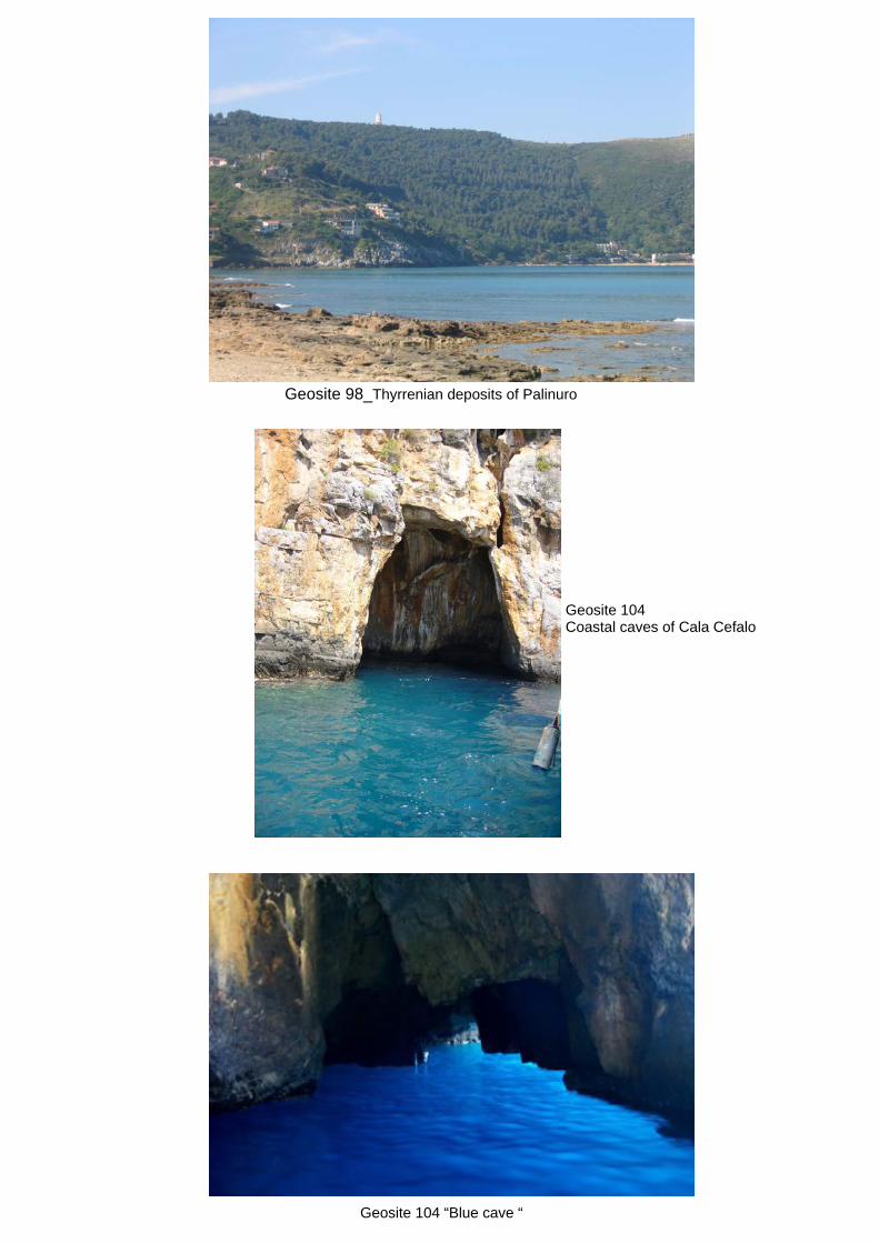
Geosite 98_Thyrrenian deposits of Palinuro
Geosite 104 Coastal caves of Cala Cefalo
Geosite 104 “Blue cave “

Geosite 106_Molpa of palinuro and natural Arc Geosite 106_Mouth of Mingardo river- evolution of shoreline
Geosite 109_Residual cliff of “Rabbit” Geosite 106_The action of coastal processes.
Geosite 111_Side North of Bulgheria Mountain