landslide inventory for the washington side of the ...washington side of the columbia river gorge,...
TRANSCRIPT
JACOBACCI, Kara E. and MICKELSON, Katherine A., Washington Department of Natural Resources, Washington Geological Survey, 1111 Washington Street SE, P.O. Box 47007, Olympia, WA 98504-7007, [email protected]
Landslide Movement Types
Geological Society of America Annual Meeting 2017 - Seattle, Session T244: Landslide Inventories, Databases, Hazard Maps, Risk Analysis and Beyond (Posters) Booth # 7
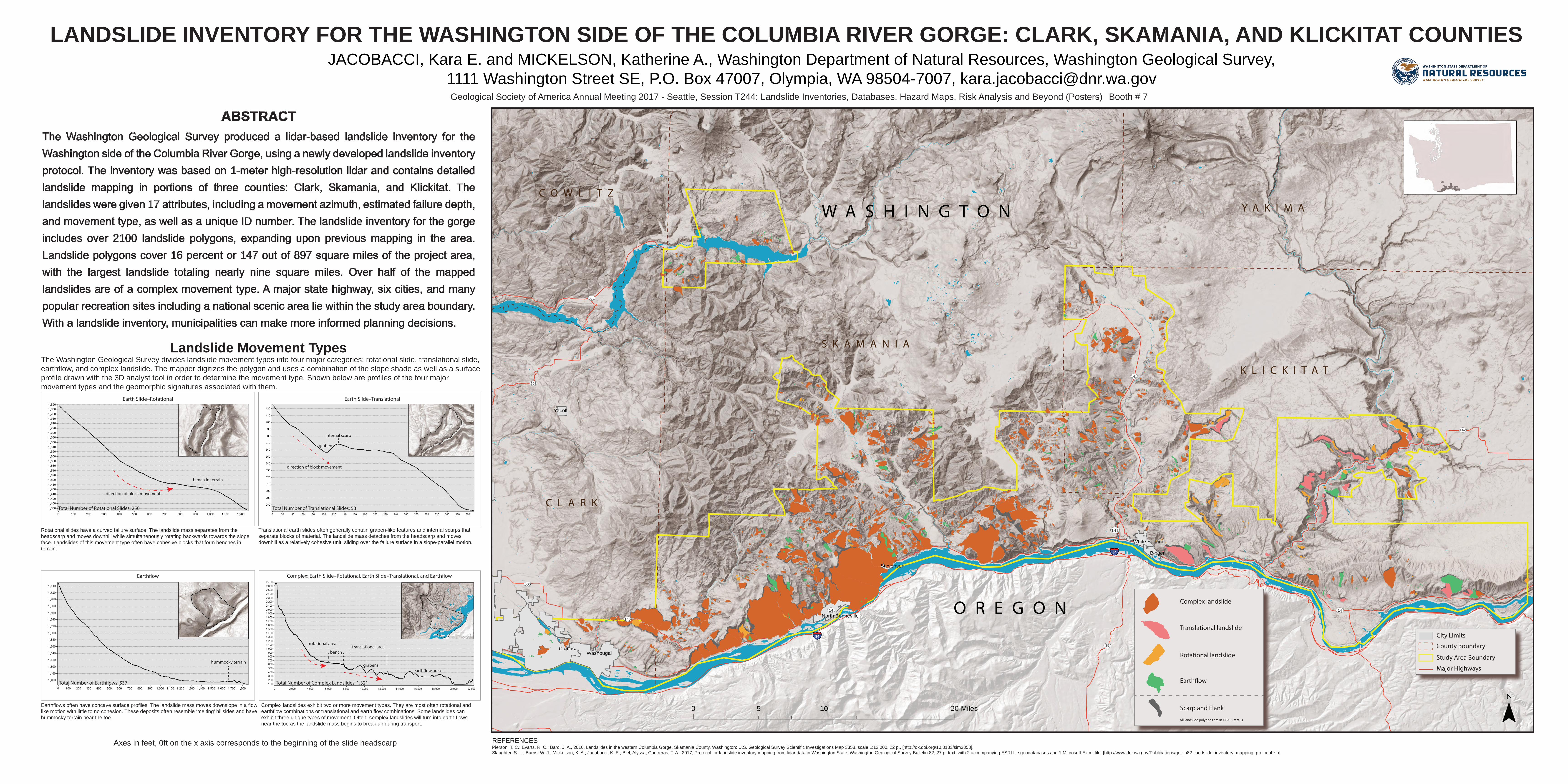
The Washington Geological Survey divides landslide movement types into four major categories: rotational slide, translational slide, earthflow, and complex landslide. The mapper digitizes the polygon and uses a combination of the slope shade as well as a surface profile drawn with the 3D analyst tool in order to determine the movement type. Shown below are profiles of the four major movement types and the geomorphic signatures associated with them.
ABSTRACTThe Washington Geological Survey produced a lidar-based landslide inventory for the Washington side of the Columbia River Gorge, using a newly developed landslide inventory protocol. The inventory was based on 1-meter high-resolution lidar and contains detailed landslide mapping in portions of three counties: Clark, Skamania, and Klickitat. The landslides were given 17 attributes, including a movement azimuth, estimated failure depth, and movement type, as well as a unique ID number. The landslide inventory for the gorge includes over 2100 landslide polygons, expanding upon previous mapping in the area. Landslide polygons cover 16 percent or 147 out of 897 square miles of the project area, with the largest landslide totaling nearly nine square miles. Over half of the mapped landslides are of a complex movement type. A major state highway, six cities, and many popular recreation sites including a national scenic area lie within the study area boundary. With a landslide inventory, municipalities can make more informed planning decisions.
LANDSLIDE INVENTORY FOR THE WASHINGTON SIDE OF THE COLUMBIA RIVER GORGE: CLARK, SKAMANIA, AND KLICKITAT COUNTIES
REFERENCES
Rotational slides have a curved failure surface. The landslide mass separates from the headscarp and moves downhill while simultanenously rotating backwards towards the slope face. Landslides of this movement type often have cohesive blocks that form benches in terrain.
translational area
earth�ow area
Translational earth slides often generally contain graben-like features and internal scarps that separate blocks of material. The landslide mass detaches from the headscarp and moves downhill as a relatively cohesive unit, sliding over the failure surface in a slope-parallel motion.
Complex landslides exhibit two or more movement types. They are most often rotational and earthflow combinations or translational and earth flow combinations. Some landslides can exhibit three unique types of movement. Often, complex landslides will turn into earth flows near the toe as the landslide mass begins to break up during transport.
Earthflows often have concave surface profiles. The landslide mass moves downslope in a flow like motion with little to no cohesion. These deposits often resemble ‘melting’ hillsides and have hummocky terrain near the toe.
hummocky terrain
bench
Total Number of Rotational Slides: 250 Total Number of Translational Slides: 53
Total Number of Complex Landslides: 1,321 Total Number of Earth�ows: 537
Earth Slide–Rotational Earth Slide–Translational
Complex: Earth Slide–Rotational, Earth Slide–Translational, and Earth�ow
direction of block movement
rotational area
internal scarp
Pierson, T. C.; Evarts, R. C.; Bard, J. A., 2016, Landslides in the western Columbia Gorge, Skamania County, Washington: U.S. Geological Survey Scientific Investigations Map 3358, scale 1:12,000, 22 p., [http://dx.doi.org/10.3133/sim3358]. Slaughter, S. L.; Burns, W. J.; Mickelson, K. A.; Jacobacci, K. E.; Biel, Alyssa; Contreras, T. A., 2017, Protocol for landslide inventory mapping from lidar data in Washington State: Washington Geological Survey Bulletin 82, 27 p. text, with 2 accompanying ESRI file geodatabases and 1 Microsoft Excel file. [http://www.dnr.wa.gov/Publications/ger_b82_landslide_inventory_mapping_protocol.zip]
bench in terrain
Axes in feet, 0ft on the x axis corresponds to the beginning of the slide headscarp
direction of block movement
graben
grabens
0 10 205 Miles
Earth�ow
CamasWashougal
Yacolt
Bingen
Stevenson
White Salmon
North Bonneville
§̈¦84
§̈¦84
UV14
UV141
UV142
UV503
UV35
UV140UV206
UV500
UV503
UV141
UV14
Translational landslide
Rotational landslide
Earth�ow
Scarp and Flank ¯All landslide polygons are in DRAFT status
O R E G O N
W A S H I N G T O NC O W L I T Z
C L A R K
Y A K I M A
S K A M A N I A
K L I C K I T A T
Complex landslide
City Limits
County Boundary
Study Area Boundary
Major Highways