ma y % 1ocdimage.emnrd.state.nm.us/imaging/filestore/hobbs/wf/256208/... · 15ty fnl & 1980...
TRANSCRIPT

•t'orm 3160-4" (March 2012)
OCD Hobbs
!
UNITED STATES DEPARTMENT OF THE INTERIOR
BUREAU OF LAND MANAGEMENT
WELL COMPLETION OR RECOMPLETION REPORT AND LOG
FORM APPROVED OMBNO. 1004-0137
Expires: October 31,2014
S. Lease Serial No. NM 92199 VB2228
la. Type of Well fcflOilWell b. Type of Completion: E3 New Well
Gas Well Work Over
_ Q-Qther Deepen • Plug Back • Diff. Resvr.,
6. If Indian, Allottee or Tribe Name
;Other. 7. Unit or CA Agreement Name and No.
NM 131909 2. Name of Operator
Caza Operating, LLC 8. Lease Name and Well No. West Copparline 29 Fed State Com # 3H
3. Address 200 N. Loralne, Suite 1550, Midland, Texas 79701
3a. Phone No. (include area code) 432 682 7 4 2 4 H O R B g Q C D
9. API WeH No. 30-025-41536
4. Location of Well (Report location clearly and in accordance with Federal requirement//)*
At surface 1 5 t y FNL & 1980 FWL, Sec 29, T23S, R34E
At top prod, interval reported J * " ^ 7 ^ 2 F N L * 1 9 8 4 ™ - Sec 29, T23S, R34E
Attotaldepth ffi F S L & 2 0 2 7 ' F W L > S e c 2 9 - T 2 3 S ' R 3 4 E
10. Field and Pool or Exploratory Antelope Ridge Bone Spring West 2209
MAY % 1
R E C B V I
11. Sec, T., R., M„ on Block and Survey or Area
Sec 2S, T23S, R34E
12. County or Parish
Lea
13. State
NM
14. Date Spudded 01/01/2014
15. Date T.D. Reached 02/08/2014
16. Date Completed 03/01/2014 • D & A g ] Ready to Prod.
17. Elevations (DF, RKB, RT, GL)* GL 3539
18. Total Depth: MD 15,804 TVD 11.365
19. Plug Back T.D.: MD 15733 TVD 11-3B8
20. Depth Bridge Plug Set: MD TVD
Was well cored? E l No • Yes (Submit analysis) WasDSTrun? E l No • Yes (Submit report) Directional Survey? I~l No PI Yes (Submit copy)
21. Type Electric & Other Mechanical Logs Run (Submit copy of each) Compensated Neutron/Gamma Ray 11,698 ft - Surface
22.
Hole Size Size/Grade wt. (#«.) Top (MD) Bottom (MD) Stage Cementer Depth
No. of Sks. & Type of Cement
Slurry Vol. (BBL) Cement Top* Amount Pulled
17-1/2 13-3/8 J-55 54.5 Surface 1172 1158 319 Surface 12-1/4 9-5/8 J HCK 40.0 Surface 5085 1290 436 Surface 8-3/4 5-1/2 HCP 20.0 Surface 15,781 2035 767 3594 CBL
Size Depth Set (MD) Packer Depth (MD) Size Depth Set (MD) Packer Depth (MD) Size Depth Set (MD) Packer Depth (MD) 2.875 10,904 10,906 25. Producing Intervals 26. Perforation Record
Formation Top Bottom Perforated Interval Size No. Holes Perf. Status A) Bone Spring (3rd) 11235 TVD 11479 TVD 11600-15719 .4 576 Open B)
C)
D)
27. Acid, Fracture, Treatment, Cement Squeeze, etc. Depth Interval Amount and Type of Material
11600-15719 738bbls15%HCLNEFE 11600-15719 82,200 lbs 40/70 white + 2,983,080 lbs 20/40 Carbo prop + 56,277 bbls water + additives.
28. Production - Interval A Date First Produced
3-1-14
Test Date
3-10-14
Hours Tested
24
rest Production
Ml BBL
969
Gas MCF
1242
Water BBL
756
Dil Gravity Corr. API
43.7
Eras
Gravity
.7164
Production Method
RECLAMATION Flowing
Choke Size
22
Tbg. Press Flwg. SI 1400
Csg. Press.
24 Hr. Rate
Oil BBL
969
Gas MCF
1242
Water BBL
756
Gas/Oil Ratio
1282
Well Status
Producing
prodnctidAMetliodl I L.U J \Jl\ ULUUi'tU 28a. Production - Interval B Date First [Test Date hours Produced Tested
Gas MCF
Test Production
Oil BBL
Water BBL
Oil Gravity Corr. API
Gas Gravity
Choke Size
rbg. Press. Flwg. 51
Csg. Press.
24 Hr. Rate
Oil BBL
Gas MCF
Water BBL
Gas/Oil Ratio
Well Status MAY 1 3 2014
*(See instructions and spaces for additional data on page 2)
#11 OF l \ m HW* r «NT

28b. Production - Interval C Date First Produced
rest Date Hours Tested
rest Production
Oil BBL
Gas MCF
Water BBL
Oil Gravity Corr. API
Gas Gravity
Production Method
Choke Size
rbg. Press. Flwg. SI
Csg. Press.
24 Hr. Hate
Oil BBL
Gas MCF
Water BBL
Gas/Oil Ratio
Well Status
28c. Production - Interval D Date First Produced
rest Date Hours rested
rest Production
Dil BBL
Gas MCF
Water BBL
Oil Gravity Corr. API
Gas Gravity
Production Method
Choke Size
Tbg. Press. Flwg. SI
Csg/ Press.
24 Hr. Rate
Oil BBL
Gas MCF
Water BBL
Gas/Oil Ratio
Well Status
29. Disposition of Gas (Solid, used for fast, vented, etc.)
Sold
30. Summary of Porous Zones (Include Aquifers):
Show all important zones of porosity and contents thereof: Cored intervals and all drill-stem tests, including depth interval tested, cushion used, time tool open, flowing and shut-in pressures and recoveries.
Formation Top Bottom Descriptions, Contents, etc. Name Top
Formation Top Bottom Descriptions, Contents, etc. Name Meas. Depth
Rustler Top of Salt
985 1456
Castas Base of Salt
2775 4780
Bell Canyon Cherry Canyon
5145 5986
Brushy Canyon Bona Spring
7260 8650
1st Bone Spring 2nd Bone Spring
9635 10330
3rd Bone Spring 11235
31. Formation (Log) Markers
32. Additional remarks (include plugging procedure):
33. Indicate which items have been attached by placing a check in the appropriate boxes:
P I Electrical/Mechanical Logs (1 full set req'd.) D Geologic Report
n Sundry Notice for plugging and cement verification Q Core Analysis
• DST Report 21 Directional Survey
E l other: schematic, C-102, C-104
34. I hereby certify that the foregoing and attached information is complete and correct as determined from all available records (see attached instructions)*
Name (please vrin&WdnarA L Wright x Title Operations Manager
Signature & £ d & > & / ^ / ^ J u U A ~ Date 03/12/2014
Title 18 U.S.C. Section 1001 and Title 43 U.S.C. Section 1212, make it acrime for any person knowingly and willfully to make to any department or agency of the United States any false, fictitious or fraudulent statements or representations as to any matter within its jurisdiction.
(Continued on page 3) (Form 3160-4, page 2)

West Copperline 29 State Com #3H Location: Section 29_T23S_R34E_Lea County, New Mexico
API #30-025-41536 Depth
(TVD-ft)
WT
1000
Caza Oil&GasJnc.
Wellbore Sketch
2000
3000
4000
5000
6000
7000
8000
9000
10000
11000
12000
m 20" Cond @ ± 139'
13.375" 54.5# J-55 ST&C @ 1172 ft_ 17-1/2" hole
Cmt w/ 600 sks lead 13.5 ppg + 300 sks tail 14.8 ppg "C". TOC 350' FS. Top job w/ 258 sks "C" 14.8 ppg. 2% CaCI2 Cmt circ.
S u
V
9.625" 40 & 40# J-55 & HCK LT&C @ 5087 ft 12-1/4" hole.
Cmt w/ 990 sks lead 12.4 ppg + 300 sks tail 14.8 ppg "C". Circulated 87 sks to surface.
KOP 10,943 ft. TVD of lateral 11,448-11,384 ft. MD Lateral 15,804'.
Perf clusters 15716-19;15605-08;15485-88; 15360-63;15250-53;15115-18; 14995-98; 14870-73; 14760-63; 14620-23; 14500-03; 14366-69; 14255-58;14140-43; 14038-41; 13900-03;13780-83;13690-93; 13580-83; 13485-88; 13376-79; 13252-255; 13130-33; 13010-13; 12925-28; 12790-93;12696-99; 12560-63; 12420-23;12305-08; 12183-86; 12065-68; 11940-43; 11819-22;11712-15;11600-03.
Acid Soluble cement
L. KOP ±10,900. Curve & Lateral Drilled with 8.75" PDC bit.
Csg: 5-1/2" 20lb Lead 1400 sks "H" lite 12.6 ppg. Tail w/ 633 sks HCP-110 CDC HTQ SoluChem "H" 15.0 ppg. TOC 3594'FS CBL shoe @ 15,781'. FC @ 15,733'.
Stimulation
3rd BS stimulated w/12 stage plug & perf. 57,489 bbls. 56,277 bbls water + 738 bbls acid + 474 bbls chemical + 82,200 lbs 40/70 white sand + 2,983,080 lbs 20/40 Carbo Prop . Total holes 576.

OPERATOR: WELL/LEASE: COUNTY:
Caza Operating, LLC West Copperline 29 State Com # 3 r Lea Co., New Mexico Sec.29. T23S, R34E
STATE OF NEW MEXICO DEVIATION REPORT
spth Deviation Depth Deviation
452 3/4 2,731 1/2 806 3/4 2,920 1/2
1,060 1 3,323 1 1,252 1/2 3,681 3/4 1,336 1/2 3,967 3/4 1,527 3/4 4,157 1 3/4 1,684 1 4,918 1 2,064 1/4 5,238 1 1/4 2,445 3/4 5,332 1 1/2
Patriot Drilling, LLC
M. Leroy Peterson, Executive Vice-President
The foregoing instrument was acknowledged before me on this 12th day of February, 2014 by M. Leroy Peterson, Executive Vice-President of Patriot Drilling,
303 W. Wall St. Ste. 2201 » P.O. Box 16 i0 ° Midland, Texas 79702 ° 432-686-2780 0 Fax 432-686-8800

Company: Caza Operating
Lease/Well: West Copperiine 29 Fed State Com/No. 003H
Rig Name: Patriot 1
State/County: New Mexico/Lea
Latitude: 32.28, Longitude: -103.49
GRID North is 0.45 Degrees East of True North
VS-Azi: 0.00 Degrees
Measured Depth
FT
Inci Angle Deg
Drift Direction
Deg
Depth Reference : RKB = 18.5ft
DRILLOG HA GYRO SURVEY CALCULATIONS Filename: final.ut
Minimum Curvature Method Report Date/Time'. 1/30/7014 /10:02
Vaughn Energy Services Fort Worth, Texas
817-741-3610 Surveyor: Jay Carroll
West Copperiine 29 Fed State Com No. 003H / API 30-025-41536
TVD FT
+N/-S FT
+E/-W FT
Vertical Section
FT
Closure Distance
FT
Closure Direction
Deg
Dogleg Severity Deg/100
0.00 100.00 200.00 300.00 400.00
0.00
0.32
0.15
0.47
0.43
0.00
110.29
114.83
165.07
169.35
0.00
100.00
200.00
300.00
399.99
0.00
-0.10
-0.25
•O.70
-1.46
0.00
0.26
0.64
0.87
1.04
0.00
-0.10
-0.25
-0.70
-1.46
0.00
0.28
0.69
1.11
1.80
0.00
110.29
111.15
128.90
144.57
0.32
0.17
0.39
0.05
500.00
600.00
700.00
800.00
900.00
0.11
0.48
0.69
0.39
0.79
173.21
114.61
207.92
234.27
250.70
499.99
599.99
699.99
799.98
899.98
-1.93
-2.19
-2.82
-3.48
-3.91
1.12
1.61
1.66
1.13
0.21
-1.93
-2.19
-2.82
-3.48
-3.91
2.23
2.66
3.27
3.66
3.91
149.76
145.35
149.64
161.94
176.90
0.33
0.44
0.78
0.30
0.43
1000.00
1100.00
1200.00
1300.00
1400.00
0.19 0.57 0.52 0.60 0.09
249.66 255.84 290.34 277.86 200.10
999.98 1099.97 1199.97 1299.96 1399.96
-4.19 •4.37 -4.33 •4.10 -4.11
-0.59 -1.22 -2.12 -3.06 -3.61
-4.19 -4.37 -4.33 -4.10 •4.11
4.23 4.53 4.82 5.12 5.47
188.01 195.62 206.10 216.73 221.30
0.60 0.38 0.32 0.15 0.59
1500.00
1600.00
1700.00
1800.00
0.14
0.33
0.57
0.72
96.92
73.50
57.60
340.40
1499.96
1599.98
1699.96
1799.95
•4.20 -4.13 -3.78 .2.92
-3.51 -3.11 -2.41 -2.20
Page 1 of 2 VES Survey Data: 01/15/2014
•4.20 -4.13 -3.78 -2.92
6.47 6.17 4.48 3.66
219.90 216.97 212.52 216.96
0.19 0.21 0.27 0.81

S Jred Depth
FT
Incl Angle Deg
Drift Direction
Deg TVD FT
+N/-S FT
+E/-W FT
Vertical Section
FT
Closure Distance
FT
Closure Direction
Deg
Dogleg Severity Deo/100
1900.00 0.95 273.45 1899.94 •2.28 •3.24 -2.2B 3.96 234.83 0.94
2000.00 2100.00 2200.00 2300.00 2400.00
0.92 0.39 0.34 0.42 0.75
254.02 261.69 248.99 313.27 323.16
1999.93 2099.92 2199.92 2299.92 2399.92
-2.45 -2.78 -2.99 -2.85 -2.08
-4.84 -5.94 -6.54 •7.08 -7.73
-2.45 -2.78 -2.99 -2.85 -2.08
5.42 6.56 7.19 7.63 8.01
243.12 244.90 245.39 248.06 254.96
0.32 0.53 0.06 0.41 0.35
2500.00 2600.00 2700.00 2800.00 2900.00
0.33 0.09 0.56 0.45 0.68
306.52 60.58 14.63 357.38 0.08
2499.91 2699.91 2699.91 2799.90 2899.90
-1.38 -1.17 -0.66 0.21 1.20
-8.36 -8.52 -8.32 -8.22 -8.23
-1.38 -1.17 -0.66 0.21 1.20
8.47 8.60 8.36 8.22 8.32
260.60 262.15 265.48 271.48 278.27
0.45 0.37 0.50 0.19 0.23
3000.00 3100.00 3200.00 3300.00 3400.00
0.61 0.85 0.87 1.07 1.46
4.79 9.77 17.56 30.29 37.46
2999.89 3099.89 3199.87 3299.86 3399.84
2.32 3.58 5.04 6.57 8.38
-8.19 -8.02 -7.66 -6.96 -5.72
2.32 3.58 5.04 6.57 8.38
8.51 8.78 9.17 9.57
10.15
285.82 294.08 303.32 313.31 325.70
0.09 0.25 0.12 0.30 0.42
3500.00 3600.00 3700.00 3800.00 3900.00
1.56 1.36 0.46 0.08 0.19
28.89 28.35 28.81 47.12 54.41
3499.80 3599.77 3699.76 3799.75 3899.75
10.58 12.81 14.20 14.60 14.75
-4.29 -3.07 -2.32 -2.07 -1.88
10.58 12.81 14.20 14.60 14.75
11.42 13.17 14.39 14.76 14.87
337.94 346.52 350.73 351.93 352.73
0.24 0.20 0.90 0.38 0.11
4000.00 4100.00 4200.00 4300.00 4400.00
1.01 1.75 1.93 3.28 4.09
58.75 42.37 68.96 64.60 68.31
3999.75 4099.72 4199.67 4299.56 4399.36
15.30 16.89 18.62 20.45 23.55
-0.99 0.79 3.39 7.54
13.16
15.30 16.89 18.62 20.45 23.55
15.34 16.90 18.92 21.79 26.97
356.29 2.67
10.31 20.24 29.20
0.82 0.83 0.86 1.36 0.90
4500.00 4600.00 4700.00 4800.00 4900.00
4.21 3.39 3.20 2.65 1.39
52.44 47.79. 36.37 21.39
358.64
4499.09 4598.87 4698.71 4798.58 4898.52
27.66 31.88 36.11 40.51 43.87
19.10 24.20 28.04 30.64 31.35
27.66 31.88 36.11 40.51 43.87
33.61 40.02 45.72 50.74 53.92
34.63 37.20 37.83 37.01 35.55
0.44 0.88 0.68 0.94 .1.47
5000.00 5100.00 5200.00 6227.00
0.52 0.64 1.15 1.32
327.77 281.22 271.54 270.94
4998.50 5098.50 5198.49 5226.48
45.46 45.96 46.09 46.10
31.08 30.30 28.75 28.17
45.46 45.96 46.09 46.10
55.07 55.04 54.32 54.03
34.36 33.39 31.95 31.42
0.98 0.47 0.53 0.83
Page 2 of 2 VES Survey Date: 01/15/2014

Vaughn Energy Services Fort Worth, Texas
817-741-3610 Surveyor: Jay Carroll
West Copperiine 29 Fed State Com No. 003H / API 30-025-41536 VAXtCHH EM5*0V S E * ? " ^
46 r — -44 42l - • : 40 ; 38- - - -36 ;
34 32 , 30 I -28 \ 26 24; - J- •
co 22 + 20
18 | -16 1 — 14— 12 - • 10 -8 ••• 6- -----4 2 ; -!-O - I - !
-2 i -4
:Depth=5227.0, lnc=1.3, AzG=270.9>
Depth=4600.0, lnc=3.4, AzG=47.8-
.- i
,f:Depth=3900.0, lnc=0.2, AzG=54.4
- -4-
a
•Depth=0.0, lnc=0.0, AzG=0.0|
ro ro ro ro ro Depth=1400.0, lne=0.1, AzG=200 1
ao OT -p. ro o M > 0 ) o o o r o * o > a i
-W/+E VES Survey Date: 01/15/2014
co o

jCaza ;Oil&Gas,loc.
Project: Lea Co. NM Site: West Copperiine 29 State Com Well: West Copperiine 29 State Com #3H
Wellbore: Wellbore Design: Plan #3 .
Rig: Patriot #1 CATHEDRAL
SECTION DETAILS
Sec 1 2 3 4 5 6 7
MD 5227.0 5262.0 5527.4 7116.1 7516.1
10900.0 11785.0
Inc Azi 1.32 270.94 1.32 270.94 7.82 179.47 7.82 179.47 0.00 0.00 0.00 0.00
90.00 179.78 8 15804.1 90.00 179.78
TVD 5225.5 5260.5 5525.1 7098.9 7497.7
10881.6 11445.0 11445.0
+N/-S 46.1 46.1 28.1
-188.0 -215.3 -215.3 -778.7
-4797.8
+E/-W 28.1 27.3 24.4 26.4 26.7 26.7 28.8 44.2
Dleg 0.00 0.00 3.00 0.00 1.95 0.00
10.17 0.00
TFace 0.00 0.00
-100.95 0.00
180.00 0.00
179.78 0.00
VSect -45.9 -45.9 -27.9 188.3 215.5 215.5 778.9
4798.0
Target
PBHL W.CL 29 St. Com #3H
Annotation Tie In @ 5227' MD Build 37100' EOB @ 5527.4' MD Drop 1.957100' EOD @ 7516.1' MD Build 10.177100' EOB @ 11785' MD PBHL @ 15804.1' MD
Wl Azimuths to Grid North True North: -0.45'
Magnetic North: 6.79'
Magnetic Field Strength: 48402.6snT
Dip Angle: 60.19' Date: 1/6/2014
Model: IGRF2010
12000 I I I I I | I I I I I I
6000
Vertical Section at 179.47° (1000 usft/in)
Cathedral Energy Services Survey Report
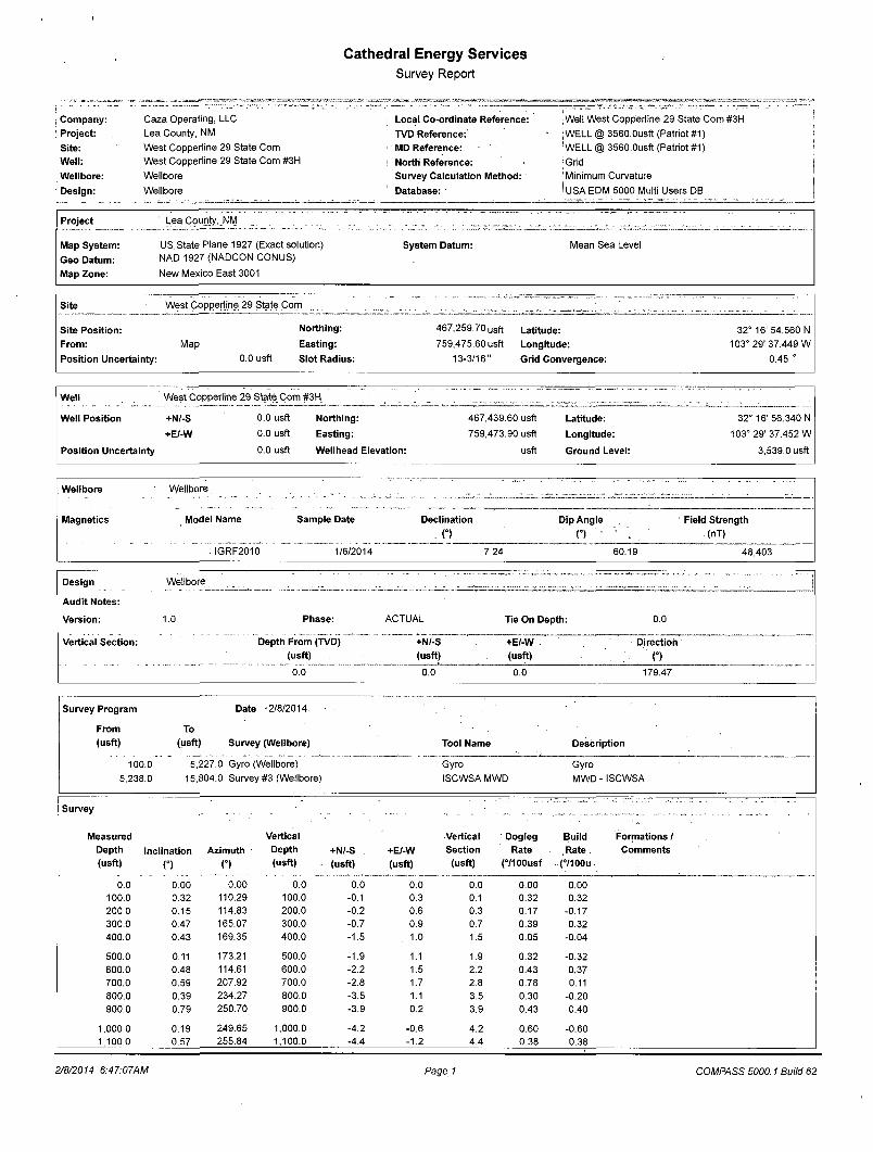
Company: Caza Operating, LLC • Local Co-ordinate Reference: :Well West Copperiine 29 State Com #3H Project: Lea County, NM TVD Reference: • |[email protected] (Patriot #1) Site: West Copperiine 29 State Com < MD Reference: 'WELL @ 3560.0usft (Patriot #1) Well: West Copperiine 29 State Com #3H ! North Reference: {Grid Wellbore: Wellbore Survey Calculation Method: 'Minimum Curvature
Design: Wellbore Database: I USA EDM 5000 Multi Users DB
Project Lea County. NW
Map System: US State Plane 1927 (Exact solution) System Datum: Mean Sea Level
Geo Datum: NAD 1927 (NADCON CONUS)
Map Zone: New Mexico East 3001
Site West Copperiine 29 State Com ZZZ. Z ZZZZI . . ." ZZZZZ.Z "
Site Position: From:
Position Uncertainty:
Northing:
Map Easting:
0.0 usft Slot Radius:
467,259.70 usft
759,475.60 usft
13-3/16"
Latitude: Longitude: Grid Convergence:
32° 16' 54.560 N 103° 29' 37.449 W
0.45 °
Well West Copperiine 29 State Com #3H
Well Position +N/-S 0.0 usft Northing: 467,439.60 usft Latitude: 32° 16' 56.340 N
+E/-W 0.0 usft Easting: 759,473.90 usft Longitude: 103° 29' 37.452 W
Position Uncertainty 0.0 usft Wellhead Elevation: usft Ground Level: 3,539.0 usft
Wellbore Wellbore ZZ'ZZZ" ZZZ1 Magnetics Model Name Sample Date Declination
. (°) Dip Angle
n Field Strength
(nT)
. IGRF2010 1/6/2014 7.24 60.19 48,403
Design Wellbore " I I I . ZIZZZZZ ZZZZZZZZZZZT Z Audit Notes:
Version: 1.0 Phase: ACTUAL Tie On Depth: 0.0
Vertical Section: Depth From (TVD) +N/-S +E/-W . Direction (usft) (usft) (usft) O 0.0 ~* 0.0 0.0 179.47
Survey Program Date -2/8/2014.
From To (usft) (usft) Survey (Wellbore) Tool Name Description
100.0 5,227.0 Gyro (Wellbore) Gyro Gyro 5,238.0 15,804.0 Survey #3 (Wellbore) ISCWSA MWD MWD- ISCWSA
Survey
— • -~- "" "* * - • ~ • Measured Vertical Vertical Dogleg Build Formations / Depth Inclination Azimuth . Depth +N/-S +E/-W Section Rate Rate . Comments (usft) n n (usft) (usft) (usft) (usft) (7100usf (7100u
0.0 0.00 0.00 0.0 0.0 0.0 0.0 0.00 0.00 100.0 0.32 110.29 100.0 -0.1 0.3 0.1 0.32 0.32 200.0 0.15 114.83 200.0 -0.2 0.6 0.3 0.17 -0.17 300.0 0.47 165.07 300.0 -0.7 0.9 0.7 0.39 0.32 400.0 0.43 169.35 400.0 -1.5 1.0 1.5 0.05 -0.04
500.0 0.11 173.21 500.0 -1.9 1.1 1.9 0.32 -0.32 600.0 0.48 114.61 600.0 -2.2 1.5 2.2 0.43 0.37 700.0 0.59 207.92 700.0 -2.8 1.7 2.8 0.78 0.11 800.0 0.39 234.27 800.0 -3.5 1.1 3.5 0.30 -0.20 900.0 0.79 250.70 900.0 -3.9 0.2 3.9 0.43 0.40
1,000.0 0.19 249.65 1,000.0 -4.2 -0.6 4.2 0.60 -0.60 1,100.0 0.57 255.84 1,100.0 -4.4 -1.2 4.4 0.38 0.38
2/8/2014 6:47:07AM Page 1 COMPASS 5000.1 Build 62
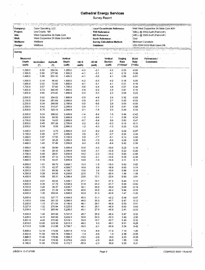
Cathedral Energy Services Survey Report
i Company: Project:
, Site: > Well: , Wellbore: i I Design:
Caza Operating, LLC Lea County, NM West Copperiine 29 State Com West Copperiine 29 State Com #3H Wellbore
Wellbore
Local Co-ordinate Reference:
TVD.Refererice: MD Reference: North Reference: Survey Calculation Method: Database: . ,
i Well West Copperiine 29 State Com #31-1 'WELL @ 3560.0usft (Patriot #1) jWELL @ 3560.0usft (Patriot #1) (Grid [Minimum Curvature
iUSA EDM 5000 Multi Users DB
Survey
Measured Vertical Vertical Dogleg Build Depth Inclination Azimuth Depth +N/-S +E/-W Section Rate Rate (usft) O n (usft) (usft) (usft) (usft) (7100usf (7106u
1,200.0 0.52 290.34 1,200.0 -4.3 -2.1 4.3 0.33 -0.05 1,300.0 0.60 277.86 1,300.0 -4.1 -3.1 4.1 0.15 0.08 1,400.0 0.09 200.10 1,400.0 -4.1 -3.6 4.1 0.59 -0.51
1,500.0 0.14 96.92 1,500.0 -4.2 -3.5 4.2 0.18 0.05 1,600.0 0.33 73.50 1,600.0 -4.1 -3.1 4.1 0.21 0.19 1,700.0 0.57 57.60 1,700.0 -3.8 -2.4 3.8 0.27 0.24 1,800.0 0.72 340.40 1,800.0 -2.9 -2.2 2.9 0.81 0.15 1,900.0 0.95 273.45 1,899.9 -2.3 -3.3 2.3 0.94 0.23
2,000.0 0.92 254.02 1,999.9 -2.5 -4.9 2.4 0.32 -0.03 2,100.0 0.39 251.69 2,099.9 -2.8 -6.0 2.7 0.53 -0.53 2,200.0 0.34 248.99 2,199.9 -3.0 -6.6 2.9 0.05 -0.05 2,300.0 0.42 313.27 2,299.9 -2.9 -7.1 2.8 0.41 0.08 2,400.0 0.75 323.16 2,399.9 -2.1 -7.8 2.0 0.34 0.33
2,500.0 0.33 306.52 2,499.9 -1.4 -8.4 1.3 0.44 -0.42 2,600.0 0.09 60.58 2,599.9 -1.2 -8.6 1.1 0.38 -0.24 2,700.0 0.56 14.63 2,699.9 -0.7 -8.4 0.6 0.50 0.47 2,800.0 0.45 357.38 2,799.9 0.2 -8.3 -0.3 0.19 -0.11 2,900.0 0.68 0.08 2,899.9 1.2 -8.3 -1.3 0.23 0.23
3,000.0 0.61 4.79 2,999.9 2.3 -8.2 -2.4 0.09 -0.07 3,100.0 0.85 9.77 3,099.9 3.6 -8.1 -3.7 0.25 0.24 3,200.0 0.87 17.55 3,199.9 5.0 -7.7 -5.1 0.12 0.02 3,300.0 1.07 30.29 3,299.9 6.6 -7.0 -6.6 0.29 0.20 3,400.0 1.46 37.46 3,399.8 8.4 -5.8 -8.4 0.42 0.39
3,500.0 1.56 28.89 3,499.8 10.6 -4.3 -10.6 0.25 0.10 3,600.0 1.36 28.35 3,599.8 12.8 -3.1 -12.8 0.20 -0.20 3,700.0 0.46 28.81 3,699.8 14.2 -2.3 -14.2 0.90 -0.90 3,800.0 0.08 47.12 3,799.8 14.6 -2.1 -14.6 0.38 -0.38 3,900.0 0.19 54.41 3,899.8 14.8 -1.9 -14.8 0.11 0.11
4,000.0 1.01 58.75 3,999.7 15.3 -1.0 -15.3 0.82 0.82 4,100.0 1.75 42.37 4,099.7 16.9 0.8 -16.9 0.83 0.74 4,200.0 1.93 68.96 4,199.7 18.6 3.4 -18.6 0.86 0.18 4,300.0 3.28 64.60 4,299.6 20.5 7.5 -20.4 1.36 1.35 4,400.0 4.09 58.31 4,399.4 23.6 13.1 -23.4 0.90 0.81
4,500.0 4.21 52.44 4,499.1 27.7 19.1 -27.5 0.44 0.12 4,600.0 3.39 47.79 4,598.9 31.9 24.2 -31.7 0.88 -0.82 4,700.0 3.20 36.37 4,698.7 36.1 28.0 -35.9 0.68 -0.19 4,800.0 2.65 21.39 4,798.6 40.5 30.5 -40.2 '0.94 -0.55 4,900.0 1.39 358.64 4,898.5 43.9 31.3 -43.6 1.47 -1.26
5,000.0 0.52 327.77 4,998.5 45.5 31.1 -45.2 0.98 -0.87 5,100.0 0.64 281.22 5,098.5 46.0 30.3 -45.7 0.47 0.12 5,200.0 1.15 271.54 5,198.5 46.1 28.7 -45.9 0.53 0.51 5,227.0 1.32 270.94 5,225.5 46.1 28.1 -45.9 0.63 0.63 5,238.0 1.10 263.90 5,236.5 46.1 27.9 -45.9 2.41 -2.00
5,333.0 1.40 305.00 5,331.5 46.7 26.0 -46.4 0.97 0.32 5,426.0 4.10 345.00 5,424.3 50.6 24.3 -50.3 3.40 2.90 5,521.0 4.40 270.80 5,519.1 53.9 19.7 -53.7 5.40 0.32 5,618.0 10.50 229.30 5,615.3 48.2 9.3 -48.1 8.01 6.29 5,713.0 10.90 212.80 5,708.7 35.0 -2.1 -35.0 3.24 0.42
5,808.0 12.10 179.00 5,801.9 17.4 -6.8 -17.5 7.10 1.26 5,902.0 11.30 168.70 5,894.0 -1.4 -4.9 1.4 2.38 -0.85 5,996.0 10.40 178.90 5,986.3 -19.0 -2.9 18.9 2.25 -0.96 6,091.0 11.40 178.90 6,079.6 -36.9 -2.5 36.9 1.05 1.05 6,186.0 11.60 179.50 6,172.7 -55.9 -2.3 55.8 0.25 0.21
Formations / Comments
2/8/2014 6:47:07AM Page 2 COMPASS 5000.1 Build 62
Cathedral Energy Services Survey Report
i Company: Caza Operating, LLC i Project: Lea County, NM j Site: West Copperiine 29 State Com : Well: West Copperiine 29 State Com #3H Wellbore: Wellbore
; Design: Wellbore
Local Co-ordinate Reference: TVD Reference: MD Reference: North Reference:
1 Survey Calculation Method: Database:
|Well West Copperiine 29 State Com #3H iWELL @ 3560.0usft (Patriot #1) iWELL @ 3560.0usft (Patriot #1) •Grid ! Minimum Curvature ;USA EDM 5000 Multi Users DB
Survey
Measured Vertical Vertical Dogleg Build Depth Inclination Azimuth Depth +N/-S +E/-W Section Rate Rate (usft) O n (usft) (usft) (usft) (usft) (7100usf (7100u
6,281.0 13.00 178.40 6,265.5 -76.1 -1.9 76.1 1.49 1.47 6,376.0 12.70 179.30 6,358.1 -97.2 -1.5 97.2 0.38 -0.32 6,470.0 12.30 179.40 6,449.9 -117.6 -1.2 117.5 0.43 -0.43 6,565.0 11.40 178.40 6,542.9 -137.1 -0.9 137.0 0.97 -0.95 6,659.0 11.00 181.30 6,635.1 -155.3 -0.8 155.3 0.73 -0.43
6,753.0 9.30 180.00 6,727.6 -171.9 -1.0 171.9 1.82 -1.81 6,848.0 7.20 180.50 6,821.6 -185.5 -1.1 185.5 2.21 -2.21 6,943.0 7.00 183.50 6,915.9 -197.2 -1.5 197.2 0.44 -0.21 7,039.0 5.70 181.00 7,011.3 -207.8 -1.9 207.8 1.38 -1.35 7,133.0 3.60 175.30 7,105.0 -215.4 -1.8 215.4 2.28 -2.23
7,227.0 2.50 182.70 7,198.8 -220.4 -1.6 220.4 1.24 -1.17 7,322.0 1.10 203.10 7,293.8 -223.3 -2.1 223.3 1.60 -1.47 7,418.0 0.80 256.50 7,389.8 -224.3 -3.1 224.3 0.93 -0.31 7,513.0 0.40 267.30 7,484.8 -224.5 -4.1 224.5 0.44 -0.42 7,608.0 0.20 198.20 7,579.8 -224.7 -4.4 224.6 0.40 -0.21
7,704.0 0.40 213.30 7,675.8 -225.1 -4.7 225.1 0.22 0.21 7,799.0 0.60 225.70 7,770.8 -225.8 -5.2 225.7 0.24 0.21 7,894.0 0.50 214.30 7,865.8 -226.4 -5.8 226.4 0.16 -0.11 7,989.0 0.50 217.80 7,960.8 -227.1 -6.3 227.0 0.03 0.00 8,085.0 0.40 178.70 8,056.7 -227.8 -6.5 227.7 0.33 -0.10
8,180.0 0.50 189.00 8,151.7 -228.5 -6.6 228.5 0.13 0.11 8,275.0 0.60 214.90 8,246.7 -229.3 -7.0 229.3 0.28 0.11 8,370.0 0.70 207.70 8,341.7 -230.3 -7.5 230.2 0.14 0.11 8,464.0 0.50 236.00 8,435.7 -231.0 -8.1 230.9 0.37 -0.21 8,559.0 0.60 243.30 8,530.7 -231.5 -8.9 231.4 0.13 0.11
8,653.0 0.60 228.30 8,624.7 -232.0 -9.7 ' 231.9 0.17 0.00 8,748.0 0.90 240.80 8,719.7 -232.7 -10.7 232.6 0.36 0.32 8,860.0 1.10 224.10 8,831.7 -233.9 -12.2 233.8 0.31 0.18 8,955.0 1.50 237.00 8,926.7 -235.2 -13.9 235.1 0.52 0.42 9,049.0 0.50 272.60 9,020.7 -235.9 -15.4 235.7 1.20 -1.06
9,144.0 0.90 237.50 9,115.6 -236.3 -16.4 236.1 0.60 0.42 9,239.0 0.90 201.60 9,210.6 -237.4 -17.3 237.2 0.58 0.00 9,333.0 1.80 216.90 9,304.6 -239.2 -18.5 239.0 1.02 0.96 9,428.0 0.80 345.80 9,399.6 -239.8 -19.5 239.6 2.51 -1.05 9,523.0 1.50 352.60 9,494.6 -237.9 -19.9 237.7 0.75 0.74
9,618.0 0.70 347.20 9,589.6 -236.1 -20.1 235.9 0.85 -0.84 9,713.0 0.90 354.00 9,684.6 -234.8 -20.3 234.6 0.23 0.21 9,808.0 1.30 345.30 9,779.5 -233.0 -20.7 232.8 0.46 0.42 9,902.0 1.10 344.20 9,873.5 -231.1 -21.2 230.9 0.21 -0.21 9,997.0 1.00 321.10 9,968.5 -229.6 -22.0 229.4 0.45 -0.11
10,091.0 0.70 324.10 10,062.5 -228.5 -22.8 228.3 0.32 -0.32 10,186.0 0.60 343.70 10,157.5 -227.5 -23.3 227.3 0.25 -0.11 10,281.0 0.40 359.10 10,252.5 -226.7 -23.5 226.5 0.25 -0.21 10,390.0 0.10 237.80 10,361.5 -226.4 -23.5 226.2 0.42 -0.28 10,484.0 0.30 200.90 10,455.5 -226.7 -23.7 226.4 0.24 0.21
10,579.0 0.20 144.80 10,550.5 -227.0 -23.7 226.8 0.26 -0.11 10,673.0 0.70 211.80 10,644.5 -227.7 -23.9 227.4 0.69 0.53 10,768.0 0.70 209.60 10,739.5 -228.7 -24.5 228.4 0.03 0.00 10,853.0 0.90 233.80 10,824.5 -229.5 -25.3 229.3 0.46 0.24 10,943.0 4.70 172.30 10,914.3 -233.6 -25.4 233.3 4.83 4.22
10,974.0 8.40 167.90 10,945.1 -237.1 -24.7 236.8 12.04 11.94 11,006.0 11.90 166.10 10,976.6 -242.5 -23.4 242.3 10.98 10.94 11,037.0 15.20 165.30 11,006.8 -249.6 -21.6 249.4 10.66 10.65
Formations / Comments
2/8/2014 6:47:07AM Page 3 COMPASS 5000.1 Build 62
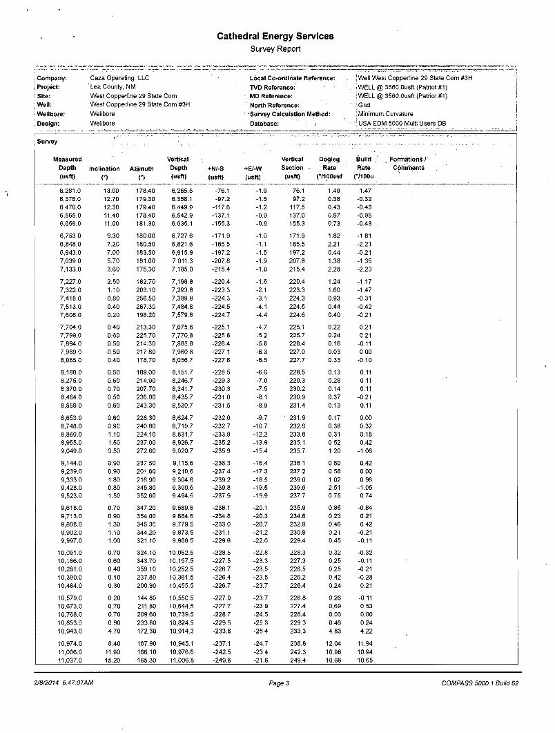
Cathedral Energy Services Survey Report
t j a u j w . j J U V A L j — i . - ^ i . . 11. i.. II II . '-v.. J • w a r n , •, « v , ny • . . . - r - r - . , . .
Company: Caza Operating, LLC Local Co-ordinate Reference: \ Well West Copperiine 29 State Com #3H , {
Project: Lea County, NM ; TVD Reference: iWELL @ 3560.0usft (Patriot #1)
Site: West Copperiine 29 State Com i MD Reference: I WELL @ 3560.0usft (Patriot #1)
Wel l : West Copperiine 29 State Com #3H North Reference: (Grid
Wel lbore: Wellbore Survey Calculat ion Method: - : Minimum Curvature
• Design: Wellbore Database: [USA EDM 5000 Multi Users DB
Survey ... . .. . „ . . . » — „ — ; . — . . . . . . . . . . . •
Measured Vertical Vertical Dogleg Bui ld Format ions /
Depth Incl inat ion Az imuth Depth +N/-S +E/-W Sect ion Rate Rate - Comments
(usft) n . f) (usft) (usft) (usft) (usft) (7100usf (7100(1
11,069.0 19.90 167.80 11,037.3 -259.0 -19.4 258.8 14.87 14.69
11,100.0 22.90 169.10 11,066.1 -270.0 -17.2 269.9 9.80 9.68
11,132.0 24.90 170.40 11,095.4 -282.8 -14.9 282.7 6.46 6.25
11,164.0 27.80 172.60 11,124.1 -296.8 -12.8 296.7 9.56 9.06
11,195.0 30.90 171.90 11,151.1 -311.9 -10.7 311.8 10.06 10.00
11,227.0 34.30 173.00 11,178.0 -329.0 -8.5 328.9 10.78 10.62
11,259.0 37.50 174.90 11,203.9 -347.6 -6.5 347.6 10.59 10.00
11,290.0 40.00 176.60 11,228.1 -367.0 -5.1 366.9 8.76 8.06
11,322.0 42.60 177.70 11,252.2 -388.1 -4.0 388.0 8.44 8.12
11,385.0 48.00 177.40 11,296.5 -432.8 -2.1 432.8 8.58 8.57
11,417.0 50.90 177.50 11,317.3 -457.1 -1.0 457.1 9.07 9.06
11,449.0 54.40 177.70 11,336.7 -482.5 0.0 482.5 10.95 10.94
11,480.0 57.80 177.70 11,354.0 -508.2 1.1 508.2 10.97 10.97
11,512.0 61.30 178.70 11,370.2 -535.8 1.9 535.8 11.26 10.94
11,543.0 64.60 179.40 11,384.3 -563.4 2.4 563.4 10.83 10.65
11,575.0 67.90 178.40 11,397.2 -592.7 2.9 592.7 10.70 10.31
11,606.0 70.90 178.10 11,408.1 -621.7 3.8 621.7 9.72 9.68
11,638.0 74.50 177.90 11,417.6 -652.2 4.9 652.2 11.27 11.25
11,647.0 75.10 177.90 11,419.9 -660.9 5.2 660.9 6.68 6.68
11,678.0 78.80 178.40 11,426.9 -691.0 6.2 691.1 12.04 11.94
11,710.0 80.50 179.00 11,432.7 -722.5 6.9 722.5 5.62 5.31
11,741.0 81.50 178.80 11,437.5 -753.1 7.5 753.1 3.29 3.23
11,772.0 82.50 178.80 11,441.8 -783.8 8.1 783.8 3.23 3.23
11,803.0 83.80 178.80 11,445.5 -814.6 8.8 814.6 4.19 4.19
11,835.0 86.20 178.10 11,448.3 -846.5 9.6 846.5 7.80 7.49
11,898.0 90.40 177.10 11,450.2' -909.4 12.3 909.4 6.85 6.67
11,993.0 91.20 177.10 11,448.9 -1,004.2 17.1 1,004.3 0.84 0.84
12,086.0 90.20 178.10 11,447.7 , -1,097.1 21.0 1,097.3 1.52 -1.08
12,182.0 89.50 177.60 11,448.0 -1,193.1 24.6 1,193.2 0.90 -0.73
12,276.0 89.30 178.10 11,449.0 -1,287.0 28.1 1,287.2 0.57 -0.21
12,371.0 91.10 179.30 11,448.6 -1,382.0 30.3 1,382.2 2.28 1.89
12,466.0 91.70 179.20 11,446.3 -1,476.9 31.5 1,477.2 0.64 0.63
12,560.0 91.40 179.40 11,443.8 -1,570.9 32.7 1,571.1 0.38 -0.32
12,654.0 89.40 179.00 11,443.1 -1,664.9 34.0 1,665.1 2.17 -2.13
12,748.0 90.20 179.10 11,443.4 -1,758.9 35.5 1,759.1 0.86 0.85
12,843.0 91.60 179.10 11,442.0 -1,853.8 37.0 1,854.1 1.47 1.47
12,931.0 89.70 179.80 11,441.0 -1,941.8 37.9 1,942.1 2.30 -2.16
13,026.0 90.10 179.70 11,441.1 -2,036.8 38.3 2,037.1 0.43 0.42
13,121.0 89.40 178.90 11,441.5 -2,131.8 39.4 2,132.1 1.12 -0.74
13,215.0 89.50 177.90 11,442.4 -2,225.8 42.1 2,226.1 1.07 0.11
13,311.0 90.30 179.10 11,442.6 -2,321.7 44.6 2,322.0 1.50 0.83
13,406.0 91.00 178.90 11,441.5 -2,416.7 46.2 2,417.0 0.77 0.74
13,501.0 91.40 179.10 11,439.5 -2,511.7 47.9 2,512.0 0.47 0.42
13,596.0 91.30 179.70 11,437.3 -2,606.6 48.9 2,607.0 0.64 -0.11
13,691.0 91.30 181.20 11,435.1 -2,701.6 48.1 2,701.9 1.58 0.00
13,787.0 91.90 181.50 11,432.5 -2,797.5 45.9 2,797.9 0.70 0.62
13,882.0 90.50 182.00 11,430.5 -2,892.5 43.0 2,892.8 1.56 -1.47
13,977.0 90.90 182.00 11,429.3 -2,987.4 39.7 2,987.7 0.42 0.42
14,072.0 91.30 181.80 11,427.5 -3,082.3 36.5 3,082.6 0.47 0.42
14,167.0 91.60. 182.00 11,425.1 -3,177.3 33.4 3,177.4 0.38 0.32
14,262.0 91.70 181.80 11,422.3 -3,272.2 30.2 3,272.3 0.24 0.11
14,357.0 91.80 181.40 11,419.4 -3,367.1 27.6 3,367.2 0.43 0.11
14,452.0 90.20 181.40 11,417.8 -3,462.0 25.2 3,462.1 1.68 -1.68
2/8/2014 6:47:07AM Page 4 COMPASS 5000.1 Build 62
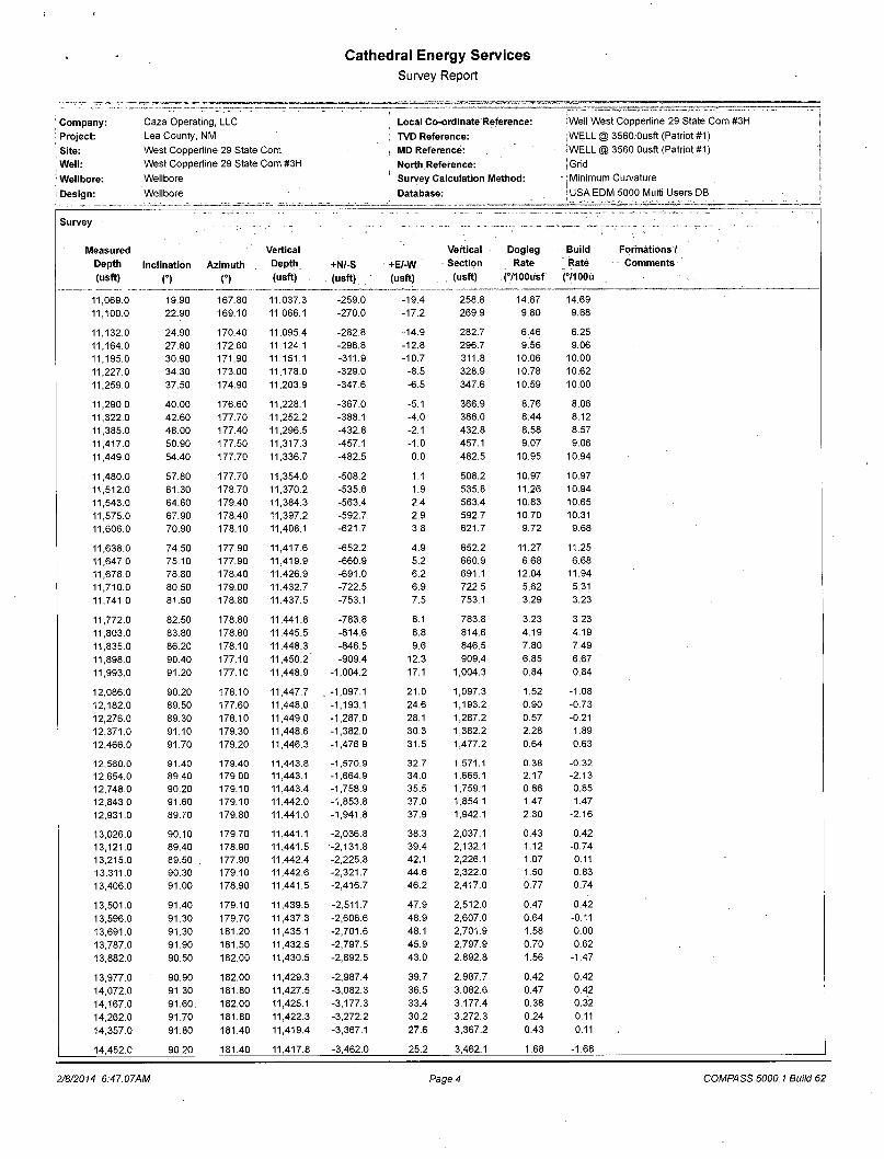
Cathedral Energy Services
Survey Report
1 Company: i Project: Site:
! Well:
Wellbore: t ; Design:
Caza Operating, LLC Lea County, NM West Copperiine 29 State Com West Copperiine 29 State Com #3H Wellbore
Wellbore
Local Co-ordinate Reference:
TVD Reference: MD Reference: North Reference: Survey Calculation Method:
Database:
•Well West Copperiine 29 State Com #3H [WELL @ 3560.0usft (Patriot #1) SWELL @ 3560.0usft (Patriot #1) jGrid 'Minimum Curvature (USA EDM 5000 Multi Users DB
Survey
Measured Vertical Vertical Dogleg Build Formations/ Depth Inclination Azimuth Depth +N/-S +E/-W Section Rate Rate Comments (usft) o . O (usft) (usft) (usft) (usft) (7100usf (7100U
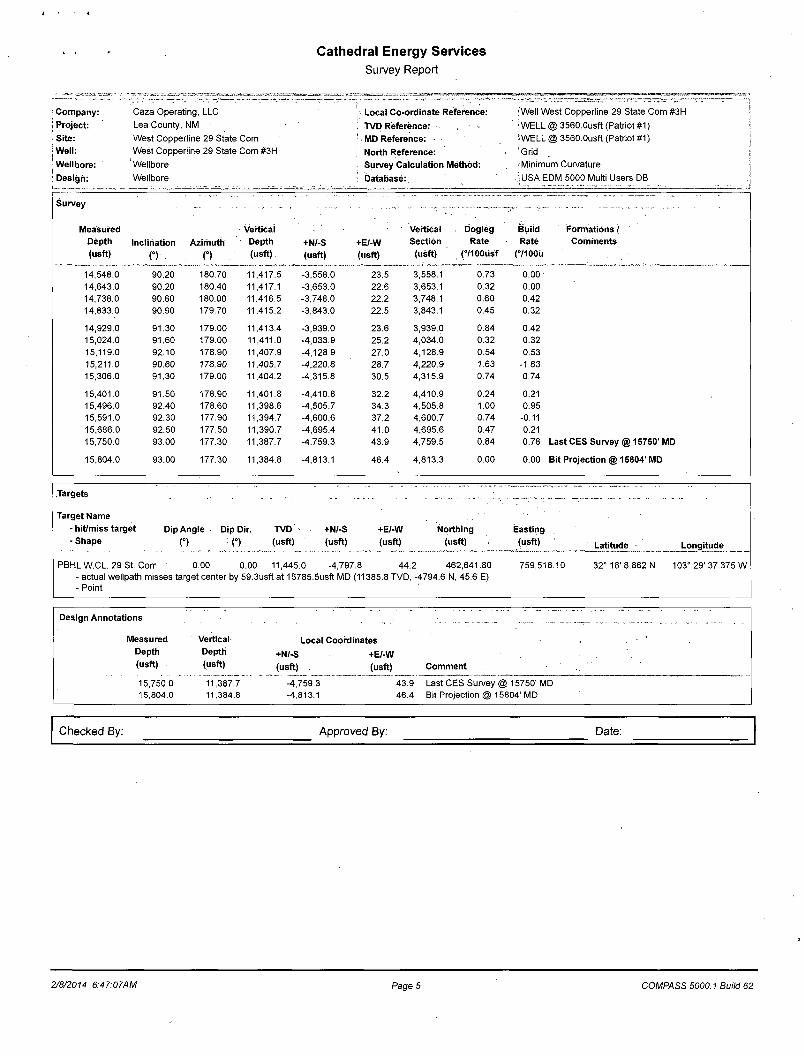
14,548.0 90.20 180.70 11,417.5 -3,558.0 23.5 3,558.1 0.73 0.00 14,643.0 90.20 180.40 11;417.1 -3,653.0 22.6 3,653.1 0.32 0.00 14,738.0 90.60 180.00 11,416.5 -3,748.0 22.2 3,748.1 0.60 0.42 14,833.0 90.90 179.70 11,415.2 -3,843.0 22.5 3,843.1 0.45 0.32
14,929.0 91.30 179.00 11,413.4 -3,939.0 23.6 3,939.0 0.84 0.42 15,024.0 91.60 179.00 11,411.0 -4,033.9 25.2 4,034.0 0.32 0.32 15,119.0 92.10 178.90 11,407.9 -4,128.9 27.0 4,128.9 0.54 0.53 15,211.0 90.60 178.90 11,405.7 -4,220.8 28.7 4,220.9 1.63 -1.63 15,306.0 91.30 179.00 11,404.2 -4,315.8 30.5 4,315.9 0.74 0.74
15,401.0 91.50 178.90 11,401.8 -4,410.8 32.2 4,410.9 0.24 0.21 15,496.0 92.40 178.60 11,398.6 -4,505.7 34.3 4,505.8 1.00 0.95 15,591.0 92.30 177.90 11,394.7 -4,600.6 37.2 4,600.7 0.74 -0.11 15,686.0 92.50 177.50 11,390.7 -4,695.4 41.0 4,695.6 0.47 0.21 15,750.0 93.00 177.30 11,387.7 -4,759.3 43.9 4,759.5 0.84 0.78 Last CES Survey @ 15750' MD
15,804.0 93.00 177.30 11,384.8 -4,813.1 46.4 4,813.3 0.00 0.00 Bit Projection @ 15804' MD
Targets - - ..... .. — —— .— ._
Target Name - hit/miss target Dip Angle Dip Dir. TVD -Shape f ) O (usft)
+N/-S +E/-W (usft) (usft)
Northing (usft)
Easting (usft) Latitude Longitude
PBHL W.CL 29 St. Corr 0.00 0.00 11,445.0 -4,797.8 44.2 - actual wellpath misses target center by 59.3usft at 15785.5usft MD (11385.8 TVD, -- Point
462,641.80 4794.6 N, 45.6 E)
759,518.10 32° 16' 8.862 N 103° 29' 37.375 W
Design Annotations : ... . . ' .... ., . _... _ . ...
Measured Depth (usft)
Vertical Depth (usft)
Local Coordinates +N/-S +E/-W (usft) (usft) Comment
15,750.0 15,804.0
11,387.7 11,384.8
-4,759.3 43.9 -4,813.1 46.4
Last CES Survey @ 15750' MD Bit Projection @ 15804' MD
Checked By: Approved By: Date:
2/8/2014 6:47:07AM Page 5 COMPASS 5000.1 Build 62