maiden mineral resource for the hog ranch gold property in ... · 9/2/2019 · classification...
TRANSCRIPT
ASX and Media Release: 2 September 2019 ASX code: RXM
Maiden Mineral Resource for the Hog Ranch Gold Property in Nevada, USA
HIGHLIGHTS
Rex completes maiden Inferred Mineral Resource estimate for its Hog Ranch Gold Property (Hog Ranch or the Project) in Nevada, USA.
Classification Tonnes Gold Grade Gold Ounces
Inferred 44Mt 0.6g/t 0.83Moz
The Mineral Resource is reported within an open pit shell optimised for heap leach processing, based on a gold price of US$1,300/oz and a cut‐off grade of 0.3g/t gold.
The Mineral Resource is based on the large shallow disseminated gold mineralisation that exists from surface at Hog Ranch and extends to 175m below surface.
Large broad alteration system defined for over a 20km2 area highlights the potential scale and opportunity at Hog Ranch.
Deeper high‐grade vein hosted gold targets at Hog Ranch remain untested. Rex Minerals Ltd (Rex or the Company) has completed a maiden Inferred Mineral Resource estimate for Hog Ranch located in Nevada, USA. The Inferred Mineral Resource is based on a large historical drilling database containing a total of 2,678 drill holes. A large percentage of this historical drilling at Hog Ranch was completed by Western Mining Corporation (WMC) who operated an open pit and heap leach operation there from 1988 through to 1991.
Rex Managing Director Mr Richard Laufmann said, “the acquisition of Hog Ranch and the rapid delivery of a maiden Mineral Resource of over 800,000 ounces of gold (the documentation and reporting of which has been independently peer reviewed by Peter Stoker of AMC Consultants Pty Ltd), demonstrates how positively we view Hog Ranch and its potential.”
“Hog Ranch offers Rex investors immediate exposure to the gold sector in one of the world’s most well‐endowed gold regions. Nevada is a proven destination for successful gold exploration, discovery and production.”
“The current database of 2,678 drill holes, which is included within the Mineral Resource estimate, has a total combined length of over 200,000 metres. At replacement, this drill data base alone would cost over A$30M,” Mr Laufmann said.
For
per
sona
l use
onl
y
RXM Maiden Mineral Resource Hog Ranch 2 | P a g e
Inferred Mineral Resource Estimate
The Inferred Mineral Resource estimate at Hog Ranch is based on a large drill hole database which captures all of the drilling completed since gold was first discovered in 1980. A number of steps were undertaken as part of the validation process for this database, the most significant of which included verification against the original paper logs where available.
In addition, Rex has been able to compare the new block model against the historical production records to further test the validity of the data which was used to create the new block model and define the Inferred Mineral Resource.
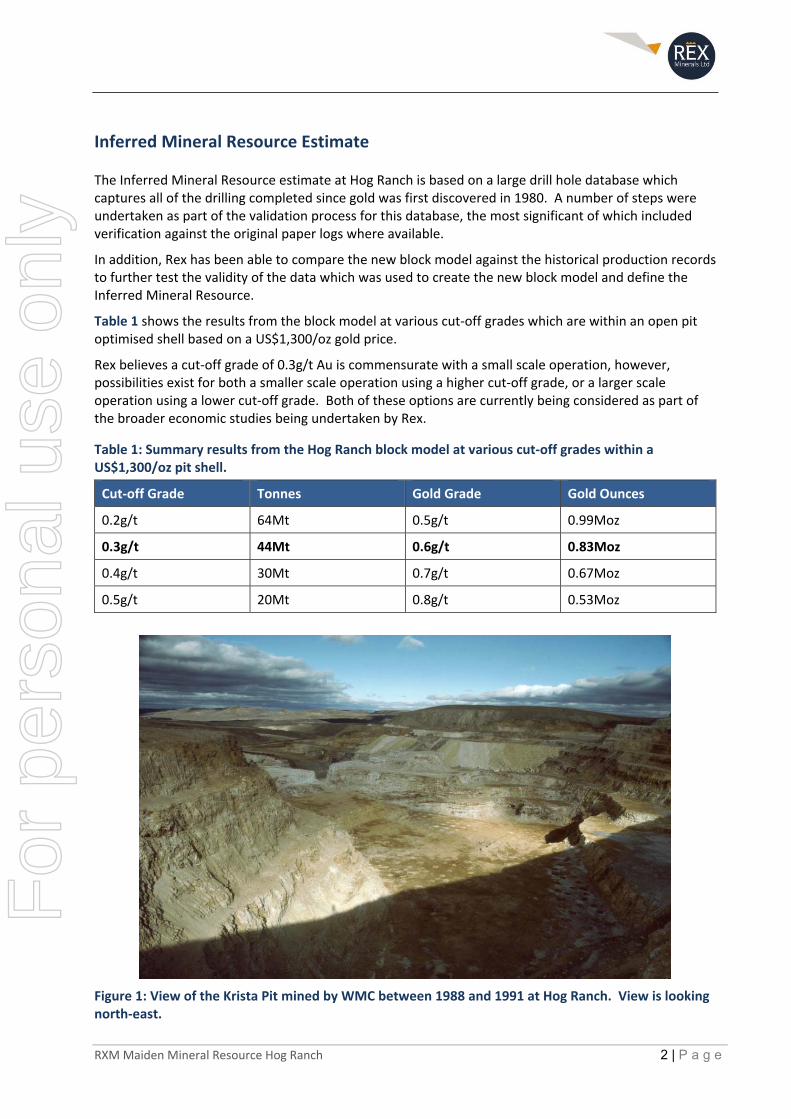
Table 1 shows the results from the block model at various cut‐off grades which are within an open pit optimised shell based on a US$1,300/oz gold price.
Rex believes a cut‐off grade of 0.3g/t Au is commensurate with a small scale operation, however, possibilities exist for both a smaller scale operation using a higher cut‐off grade, or a larger scale operation using a lower cut‐off grade. Both of these options are currently being considered as part of the broader economic studies being undertaken by Rex.
Table 1: Summary results from the Hog Ranch block model at various cut‐off grades within a US$1,300/oz pit shell.
Cut‐off Grade Tonnes Gold Grade Gold Ounces
0.2g/t 64Mt 0.5g/t 0.99Moz
0.3g/t 44Mt 0.6g/t 0.83Moz
0.4g/t 30Mt 0.7g/t 0.67Moz
0.5g/t 20Mt 0.8g/t 0.53Moz
Figure 1: View of the Krista Pit mined by WMC between 1988 and 1991 at Hog Ranch. View is looking north‐east.
For
per
sona
l use
onl
y
RXM Maiden Mineral Resource Hog Ranch 3 | P a g e
Geology and Geological Interpretation
The dominant host rocks at Hog Ranch are a series of relatively flat lying (or gently dipping to the west) volcanic rocks which can be broadly separated into two main rock types:
Welded (often flow banded) rhyolite flow, which is the more competent and less permeable rock type;
Unwelded volcanic tuffs, which are very soft and more permeable making them more amenable for fluid flow in comparison with the surrounding and more dominantly welded rhyolitic rocks.
Based on the current level of understanding, the geological model for the gold mineralisation types at Hog Ranch details two major deposit types:
1. Extensive shallow and low‐grade gold mineralisation within 100m of the paleo water‐table, which has favourably extended along the more porous unwelded tuff units; and
2. Higher grade quartz‐adularia vein hosted gold mineralisation within feeder structures underneath this large system, which would have most likely developed at over 200m beneath the current day surface over a position known as the boiling zone and which is analogous to the high grade vein hosted gold mineralisation as defined in the Sleeper and Midas epithermal gold deposits in Nevada.
Drilling Techniques
The drill hole database at Hog Ranch is dominated by vertical RC drill holes with an average depth of 80m. Out of the total of 2,678 drill holes in the database, 24 drill holes are identified as diamond drill holes with an average depth of 172m.
Sampling and Sub‐sampling Techniques
Samples taken for almost all of the historical drilling at Hog Ranch are from RC drill chips which have been sampled over 5ft intervals. Discussions with geologists from WMC indicated that in general the samples were dry and minimal water was encountered in the shallow RC drill holes. Normal industry standards for RC drilling and sampling are believed to have been followed for the drilling activities.
It is considered that the above procedure was largely followed for the bulk of the drilling at Hog Ranch, with 5ft samples from RC drilling making up over 99% of the drill hole database.
Diamond drilling was used only occasionally at Hog Ranch, typically to test for vein hosted gold at depth and for detailed studies of the geology and alteration. Diamond drilling was more common with explorers after the year 2000 due to the focus on deeper, vein hosted high‐grade gold mineralisation.
Sample Analysis Method
Internal reports by Ferret Exploration identified that the samples from the RC drilling were completed using atomic absorption (AA) analysis by an external Laboratory (Barringer Resources) in Sparks, Nevada. After the drilling by Ferret Exploration and prior to the commencement of mining in 1986, the procedure changed, with all samples assayed by fire assay. Information from WMC geologists noted that the exploration RC drilling samples were sent to an external laboratory (Geochemical Service Inc.) based in Sparks, Nevada for fire assay analysis.
Drilling completed by Cameco (from 1994 to 1997) in addition to subsequent drilling by Seabridge (2001) was sent to the American Assay laboratory in Sparks, Nevada. Original assay sheets from the majority of these drill holes have been reviewed by the author and match the information in the drill hole database.
For
per
sona
l use
onl
y
RXM Maiden Mineral Resource Hog Ranch 4 | P a g e
Drilling completed by both Romarco (2004) and ICN (2009) are reported in NI43‐101 reports respectively (Walker, 2005; Baker, 2010), who both state that their samples were analysed using fire assay at the ALS laboratory in Reno. The ALS laboratory in Reno is a Quality Systems (ISO 17025) accredited laboratory, which is still in operation today.
Estimation Methodology
The block model was created using Vulcan software with a parent cell block size of 10m(X) x 10m(Y) x 10m(Z). For reference, the historical bench heights were typically at 20ft in height (6m). The inverse distance squared (ID2) method was used to estimate gold only and estimates were constrained within the interpreted geological domains.
Up to three estimation passes with increasing search neighbourhood size were run for all domains. 5ft assay composites were used and estimation applied composite length weighting. Geostatistical analysis was performed using Snowden Supervisor.
Top‐cuts were applied for the block estimation for each of the defined geological domains individually. The top‐cut defined was based on the disintegration approach of log probability plots and in each case the defined limit to the main population of data was above the 99th percentile.
In addition to the application of a top‐cut, there was a “high‐yield” restriction applied to the assay results that were top‐cut. The high yield restriction limited the influence of these high‐grade assay results to a 5m(X) x 5m(Y) x 5m(Z) area.
Classification
The Mineral Resource has been classified into the Inferred category on the basis of geological and grade continuity confidence and reflects the Competent Person’s view on the deposit.
The Inferred Mineral Resource has a maximum drill hole spacing of 100m, with an average drill spacing of less than 50m x 50m. A further constraint was applied to the block model for the purpose of defining the Inferred Mineral Resource based on the parameters defined below.
Cut‐off Grade
The Inferred Mineral Resource is reported at a cut‐off grade of 0.3g/t gold within a US$1,300/oz open pit shell.
Mining and Metallurgical Methods and Parameters
An optimised open pit was developed on the Hog Ranch block model. Within this open pit optimisation, a cut‐off of 0.3g/t gold was applied and the Inferred Mineral Resource was then reported inside the pit above this cut‐off. The optimised pit shell was based on a US$1,300/oz gold price, $2.20/oz refining charge, 80% processing recovery, 45 degree wall angles, mining dilution of 5%, mining cost of US$2.60 per mined tonne and a processing/G&A cost of US$4.80 per ore tonne based on historical mining records and internal Rex estimates.
For
per
sona
l use
onl
y
RXM Maiden Mineral Resource Hog Ranch 5 | P a g e
Exploration Target
The extensive drilling database and the recent validation work on this database have provided significant information with regard to a number of potential opportunities at Hog Ranch. This includes the identification of a broad Exploration Target which extends beyond the currently constrained Inferred Mineral Resource estimate.
The Exploration Target is based on estimated mineralisation that lies outside of the US$1,300 open pit shell which includes a distance up to 100m from the drill data (lower range estimate), and a distance up to 400m from the drill data (upper range estimate). Based on this range and using the block model that Rex has created from the drilling data, Rex has defined an Exploration Target of approximately 0.6Moz to 1.6Moz which takes into consideration the natural variation of the gold grade. Table 2 below is a summary of the Exploration Target ranges using a cut‐off grade of 0.3g/t gold. The potential quantity and grade of the Exploration Target is conceptual in nature, there has been insufficient exploration to estimate a Mineral Resource in this area and it is uncertain if further exploration will result in the estimation of a Mineral Resource.
The Exploration Target is defined by a combination of:
An inverse distance squared (ID2) block model estimate within geologically defined wireframes where the data density and sample support, or data validation, does not meet the criteria for a Mineral Resource.
Extrapolation of the Hog Ranch block model supported by the current understanding of the shallow dispersed low‐grade gold mineralisation, which implies a range of possible distance outcomes or level of continuity, ranging from 100m up to 400m.
Similar additional parameters as defined for the Inferred Mineral Resource, and as documented in the attached JORC tables, were also applied to the extrapolated block model which is the basis for the Exploration Target at Hog Ranch. A classification is not applicable for an Exploration Target.
Table 2: Exploration Target expressed as a range of possible outcomes from further exploration activities.
Range Cut‐off Grade Tonnes Gold Grade Gold Ounces
Exploration Target ‐ Lower 0.3g/t 46Mt 0.4g/t ~0.6Moz
Exploration Target ‐ Upper 0.3g/t 85Mt 0.6g/t ~1.6Moz
For
per
sona
l use
onl
y
RXM Maiden Mineral Resource Hog Ranch 6 | P a g e
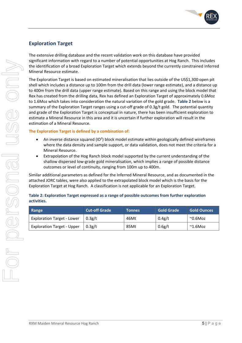
Deeper High‐Grade Vein Hosted Targets There is an extensive body of research which has shown that underneath shallow gold deposits, similar to the dispersed gold mineralisation identified at Hog Ranch, there often exists vein hosted gold deposits which can contain very high‐grade gold mineralisation. This mineralised zone is often at a specific depth range known as the “boiling zone”. This boiling zone typically exists a few hundred meters beneath the ancient surface from when the gold mineralisation was deposited, and at Hog Ranch, is interpreted to exist at least at 150m or further beneath almost all the historical drilling information (Figure 2).
Figure 2: Schematic diagram representing the current day setting of the gold target types at Hog Ranch.
The high‐grade vein hosted gold mineralisation at the Sleeper and Midas deposits are examples of this style of target, which are interpreted to have formed as part of the same geological event as Hog Ranch (Saunders el. al., 2008) (Figure 6).
Supporting information for this deposit type includes:
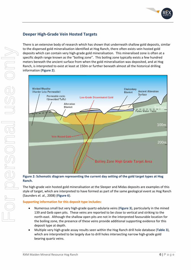
Numerous small but very high‐grade quartz‐adularia veins (Figure 3), particularly in the mined 139 and Geib open pits. These veins are reported to be close to vertical and striking to the north‐east. Although the shallow open pits are not in the interpreted favourable location for the boiling zone, the presence of these veins provide additional supporting evidence for this deposit type at depth.
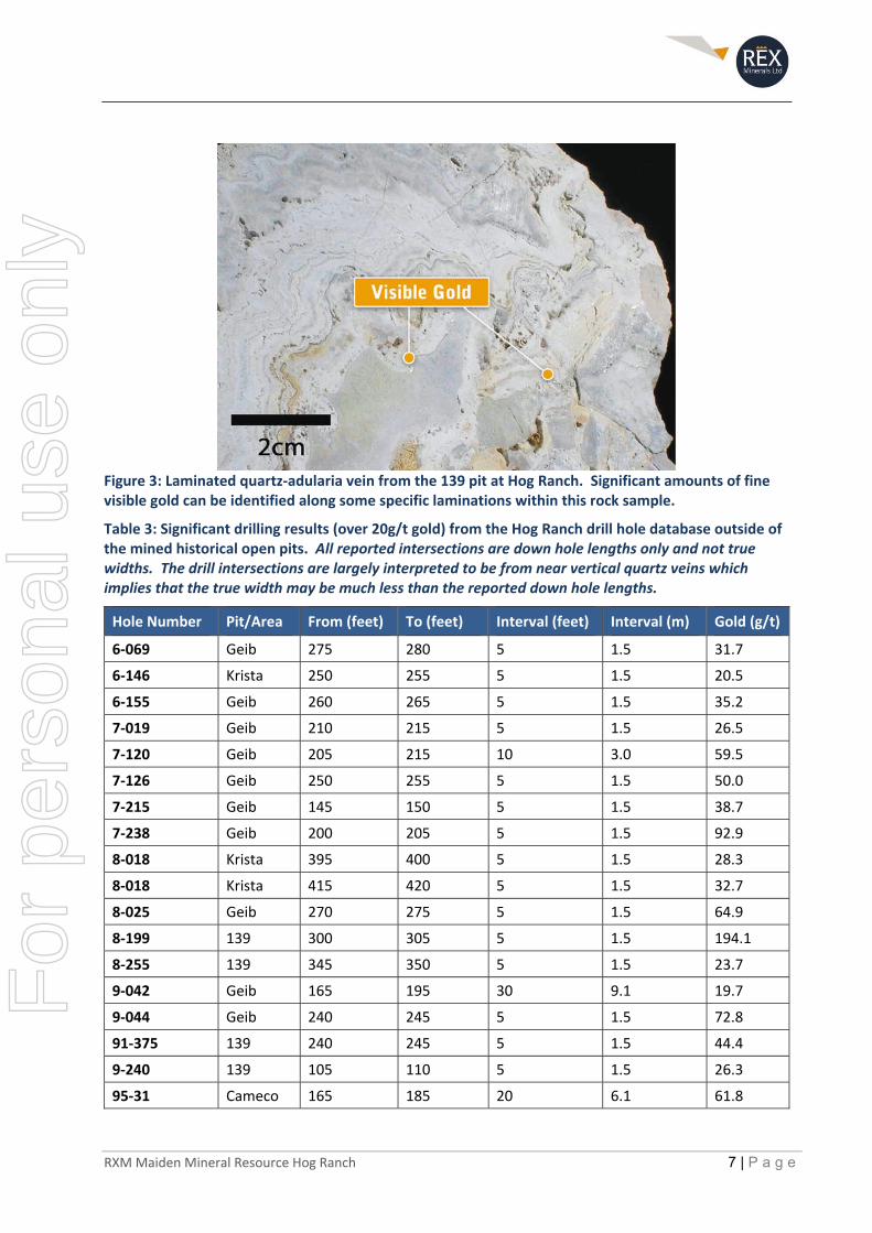
Multiple very high‐grade assay results seen within the Hog Ranch drill hole database (Table 3), which are interpreted to be largely due to drill holes intersecting narrow high‐grade gold bearing quartz veins.
For
per
sona
l use
onl
y
RXM Maiden Mineral Resource Hog Ranch 7 | P a g e
Figure 3: Laminated quartz‐adularia vein from the 139 pit at Hog Ranch. Significant amounts of fine visible gold can be identified along some specific laminations within this rock sample.
Table 3: Significant drilling results (over 20g/t gold) from the Hog Ranch drill hole database outside of the mined historical open pits. All reported intersections are down hole lengths only and not true widths. The drill intersections are largely interpreted to be from near vertical quartz veins which implies that the true width may be much less than the reported down hole lengths.
Hole Number Pit/Area From (feet) To (feet) Interval (feet) Interval (m) Gold (g/t)
6‐069 Geib 275 280 5 1.5 31.7
6‐146 Krista 250 255 5 1.5 20.5
6‐155 Geib 260 265 5 1.5 35.2
7‐019 Geib 210 215 5 1.5 26.5
7‐120 Geib 205 215 10 3.0 59.5
7‐126 Geib 250 255 5 1.5 50.0
7‐215 Geib 145 150 5 1.5 38.7
7‐238 Geib 200 205 5 1.5 92.9
8‐018 Krista 395 400 5 1.5 28.3
8‐018 Krista 415 420 5 1.5 32.7
8‐025 Geib 270 275 5 1.5 64.9
8‐199 139 300 305 5 1.5 194.1
8‐255 139 345 350 5 1.5 23.7
9‐042 Geib 165 195 30 9.1 19.7
9‐044 Geib 240 245 5 1.5 72.8
91‐375 139 240 245 5 1.5 44.4
9‐240 139 105 110 5 1.5 26.3
95‐31 Cameco 165 185 20 6.1 61.8
For
per
sona
l use
onl
y

RXM Maiden Mineral Resource Hog Ranch 8 | P a g e
Overview Introduction
Hog Ranch is situated in north‐west Nevada with year‐round access via a series of highways and well‐maintained gravel roads from the nearest main city of Reno (Figure 4). The Property comprises 247 unpatented mining claims for a total area of approximately 2,000Ha.
Rex has reviewed the nature, and the possible extent, of the shallow gold mineralisation based on the records from the historical mining and a large historical drill hole database. This has identified a very large low‐grade gold system, predominately at grades below the historical mining cut‐off grade of approximately 0.7g/t. At the time the mining operations ceased at Hog Ranch, the gold price was averaging close to US$350/oz.
The new Inferred Mineral Resource is based on the current understanding of Hog Ranch and other similar gold deposits across South West USA, both within and surrounding the state of Nevada. In addition to the new Inferred Mineral Resource estimate, the large historical drill hole database at Hog Ranch implies the potential for additional shallow and low‐grade gold mineralisation. This additional potential has been reported as an Exploration Target, with a broad range of possible outcomes reported.
Figure 4: Regional location diagram of the Hog Ranch Property, Nevada USA.
For
per
sona
l use
onl
y
RXM Maiden Mineral Resource Hog Ranch 9 | P a g e
History
Gold mineralisation at Hog Ranch was first discovered in 1980 as part of a Joint Venture between Noranda Exploration and Ferret Exploration. After a few years of exploration and economic analysis by Ferret Exploration, a consortium made up of Western Goldfields, Geomax (Parent Company of Ferret Exploration) and Royal Resources ultimately provided the funding to commence gold production in 1986 via open pit mining and heap leach methods under the name of Western Hog Ranch Inc.
After approximately 18 months of production, the Project was subsequently sold to WMC, who purchased 100% of Hog Ranch in early 1988. WMC commenced a significant exploration effort, drilling over 1,600 RC holes, a series of additional deep diamond drill holes and further detailed studies during the life of the operation which continued until 1991. Residual gold production and subsequent rehabilitation commenced soon after the mining operations ceased, all of which was completed by 1994.
Post‐mining explorers at Hog Ranch have had small exploration campaigns relative to the exploration effort that occurred prior to and during the mining period. Cameco U.S. Inc was the first company to look in more detail under the cover rocks to the west towards an earlier discovery called the Airport Zone.
The next series of exploration efforts changed focus towards the potential for vein hosted gold mineralisation at greater depths underneath the shallow lower grade gold mineralisation. This exploration target type was investigated to a limited extent by Seabridge Gold Inc., followed by Romarco Minerals Inc. and then ICN Resources Ltd (ICN), who all completed some further mapping, data compilations and subsequent diamond and RC drill testing.
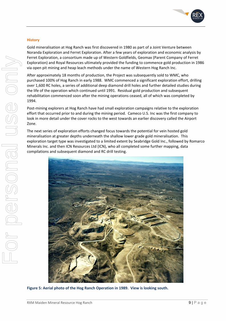
Figure 5: Aerial photo of the Hog Ranch Operation in 1989. View is looking south.
For
per
sona
l use
onl
y
RXM Maiden Mineral Resource Hog Ranch 10 | P a g e
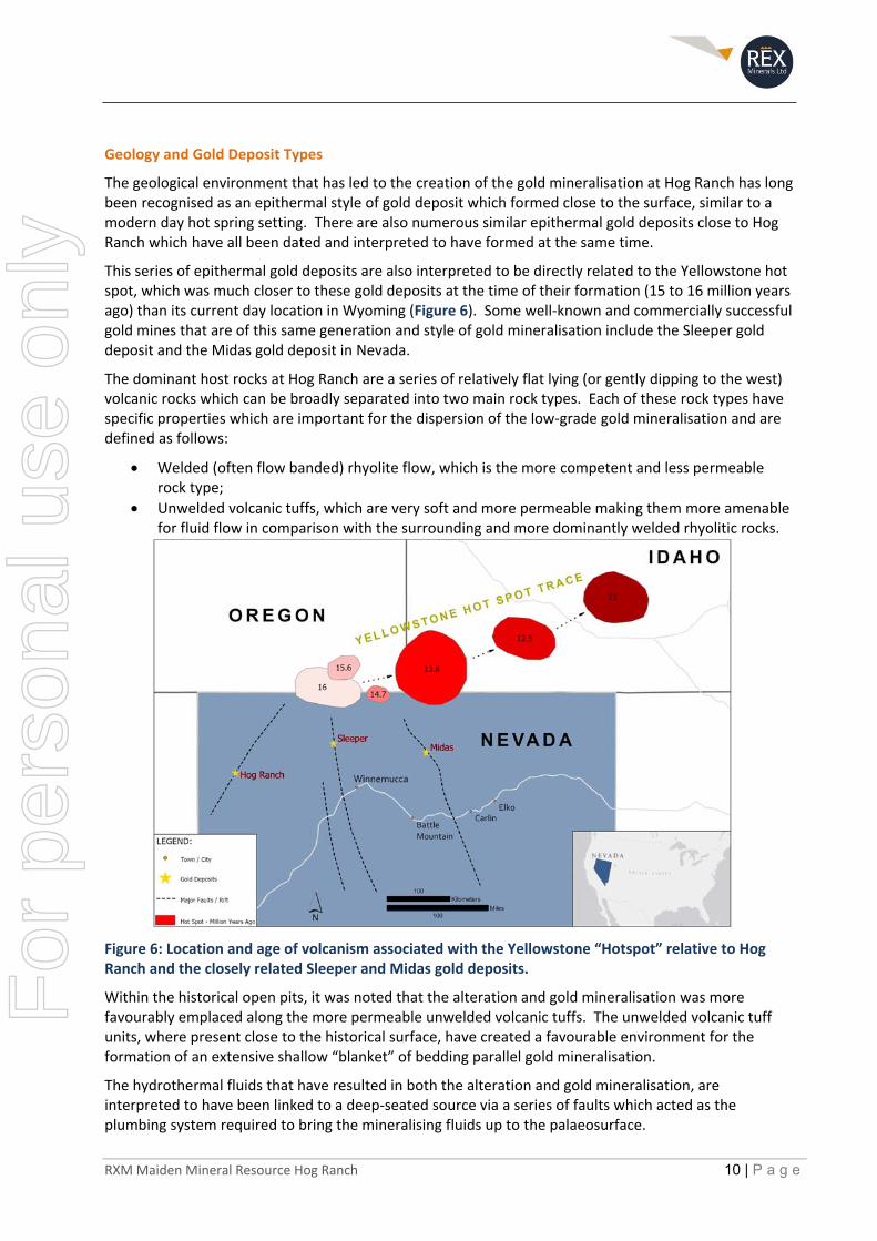
Geology and Gold Deposit Types
The geological environment that has led to the creation of the gold mineralisation at Hog Ranch has long been recognised as an epithermal style of gold deposit which formed close to the surface, similar to a modern day hot spring setting. There are also numerous similar epithermal gold deposits close to Hog Ranch which have all been dated and interpreted to have formed at the same time.
This series of epithermal gold deposits are also interpreted to be directly related to the Yellowstone hot spot, which was much closer to these gold deposits at the time of their formation (15 to 16 million years ago) than its current day location in Wyoming (Figure 6). Some well‐known and commercially successful gold mines that are of this same generation and style of gold mineralisation include the Sleeper gold deposit and the Midas gold deposit in Nevada.
The dominant host rocks at Hog Ranch are a series of relatively flat lying (or gently dipping to the west) volcanic rocks which can be broadly separated into two main rock types. Each of these rock types have specific properties which are important for the dispersion of the low‐grade gold mineralisation and are defined as follows:
Welded (often flow banded) rhyolite flow, which is the more competent and less permeable rock type;
Unwelded volcanic tuffs, which are very soft and more permeable making them more amenable for fluid flow in comparison with the surrounding and more dominantly welded rhyolitic rocks.
Figure 6: Location and age of volcanism associated with the Yellowstone “Hotspot” relative to Hog Ranch and the closely related Sleeper and Midas gold deposits.
Within the historical open pits, it was noted that the alteration and gold mineralisation was more favourably emplaced along the more permeable unwelded volcanic tuffs. The unwelded volcanic tuff units, where present close to the historical surface, have created a favourable environment for the formation of an extensive shallow “blanket” of bedding parallel gold mineralisation.
The hydrothermal fluids that have resulted in both the alteration and gold mineralisation, are interpreted to have been linked to a deep‐seated source via a series of faults which acted as the plumbing system required to bring the mineralising fluids up to the palaeosurface.
For
per
sona
l use
onl
y
RXM Maiden Mineral Resource Hog Ranch 11 | P a g e
The combination of the structures which carried the gold bearing fluids to the surface, and the disseminated gold that has formed from these fluids near the surface, identifies two distinctly separate styles of gold mineralisation (Figure 2) based on the current level of understanding:
1. Extensive shallow and low‐grade gold mineralisation within 100m of the paleo water‐table, which has favourably extended along the more porous unwelded volcanic tuff units; and
2. Higher grade quartz‐adularia vein hosted gold mineralisation within feeder structures underneath the large blanket of disseminated gold mineralisation. This target type would have most likely developed at over 200m beneath the current day surface at a position known as the boiling zone and which is analogous to the high‐grade vein hosted gold mineralisation seen at the Sleeper and Midas epithermal gold deposits located in Nevada.
For more information about the Company and its projects, please visit our website ‘www.rexminerals.com.au’ or contact: Richard Laufmann, Chief Executive Officer Media and Investor Relations: or Kay Donehue, Company Secretary Gavan Collery T +61 8 8299 7100 T +61 419 372 210 E ‘[email protected]’ E ‘[email protected]’
COMPETENT PERSONS STATEMENT
Mineral Resources, Exploration Target and Exploration Results
The information in this announcement for the Hog Ranch Property that relates to Exploration Results, Exploration Target or Mineral Resources is based on, and fairly reflects, information compiled by Mr Steven Olsen who is a Member of the Australasian Institute of Mining and Metallurgy and an employee of Rex Minerals Ltd. Mr Olsen is also a shareholder of Rex Minerals Ltd. Mr Olsen has sufficient experience which is relevant to the style of mineralisation and type of deposit under consideration and to the activity which he is undertaking to qualify as a Competent Person as defined in the 2012 Edition of the ‘Australasian Code for Reporting of Exploration Results, Mineral Resources and Ore Reserves’. Mr Olsen consents to the inclusion in the report of the matters based on his information in the form and context in which it appears.
Forward‐Looking Statements
This announcement contains “forward‐looking statements”. All statements other than those of historical facts included in this announcement are forward‐looking statements. Where the Company expresses or implies an expectation or belief as to future events or results, such expectation or belief is expressed in good faith and believed to have a reasonable basis. However, forward‐looking statements are subject to risks, uncertainties and other factors, which could cause actual results to differ materially from future results expressed, projected or implied by such forward‐looking statements. Such risks include, but are not limited to, copper, gold and other metals price volatility, currency fluctuations, increased production costs and variances in ore grade or recovery rates from those assumed in mining plans, as well as political and operational risks and governmental regulation and judicial outcomes. The Company does not undertake any obligation to release publicly any revisions to any “forward‐looking statement”.
For
per
sona
l use
onl
y
RXM Maiden Mineral Resource Hog Ranch 12 | P a g e
JORC Code, 2012 Edition – Table 1 Report Section 1 Sampling Techniques and Data
Criteria Commentary
Sampling techniques Samples taken for almost all of the historical drilling at Hog Ranch are from RC drill chips which have been sampled over 5ft intervals. There are indications (but not common) from the paper logs of certain samples which were wet due to problems with clay, where water injection was required. Discussions with geologists from WMC indicated that in general the samples were dry and minimal water was encountered in the shallow RC drill holes.
Drilling techniques The drill hole database at Hog Ranch is dominated by vertical RC drill holes with an average depth of 80m. Out of the total of 2,678 drill holes in the database, 24 drill holes are identified as diamond drill holes with an average depth of 172m. Normal industry standards for RC drilling and sampling are believed to have been followed for the drilling activities. In 1982, an internal report from Ferret Exploration (Holso, 1982) documented the drilling and sampling procedure which states as follows:
“Reverse‐circulation drilling was selected as the samples provided would most nearly duplicate core. Lost circulation problems are also more easily overcome with this type of equipment. It was intended that all drilling be done with air injection only, but some water was required to penetrate thick clay units which caused drilling difficulties. Sloughing hole and accumulation of sample around the drill string annulus caused severe problems, especially early in the program in the deeper holes.”
Discussions with geologists who were working with WMC during the operation did not indicate that there were any particular problems as documented at this early stage of exploration at Hog Ranch. Significant water was not believed to be a problem with the bulk of the shallow RC drilling in the Hog Ranch drilling database.
Diamond drilling was used only occasionally at Hog Ranch, typically to test for vein hosted gold at depth and for detailed studies of the geology and alteration. Diamond drilling was more common with explorers after the year 2000 due to the focus on deeper, vein hosted high‐grade gold mineralisation.
Drill sample recovery The paper logs available from the historical drilling at Hog Ranch all identify the locations where there was poor or no sample recovery for each drill hole. It has been observed from reviewing the recovery comments in the paper logs that there is a distinct change after 1985. The early drill logs completed by Ferret indicate poor recoveries and at least one sample interval, or more, where no samples were taken in almost every drill hole. In many cases these are logged as voids. However, there does not appear to be any other evidence for the presence of large voids at Hog Ranch, and these sections are more likely to be poor sample return at locations where the rock is strongly altered and clay rich.
There is a risk with many of these early holes, that the sections which are more favourable for hosting gold mineralisation have been lost due to poor sample recovery. The unwelded tuff units are more permeable which allows for greater fluid movement
For
per
sona
l use
onl
y

RXM Maiden Mineral Resource Hog Ranch 13 | P a g e
Criteria Commentary
during a hydrothermal event. This has resulted in significant clay alteration and also more favourable gold mineralisation within these zones.
It is possible with the RC drilling that some of the soft and more mineralised zones have been lost and this could result in an underestimation of the Mineral Resource. However, after 1985, the remaining drill logs do not record significant core loss. A review of the drill logs that are available from 1986 up to 1991 indicate minimal locations where there was insufficient sample to get an assay result.
Given that 80% of the drill holes in the database were drilled between 1986 and 1991, it is not considered that there is a particular issue with core loss. The records for the drill holes during this period only identified minimal signs of lost sample or no sample recovery.
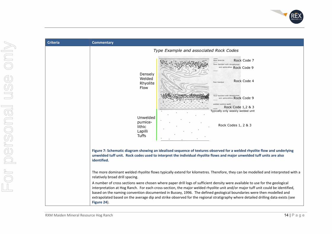
Logging The major rock units and alteration characteristics at Hog Ranch were identified early in the drilling history. Based on what has been observed from the original paper drilling logs, in 1986 just prior to the commencement of mining, a standard rock code and alteration code system was established for rock chip and core logging.
All drill logs completed by Ferret Exploration were completed with general descriptions made for each 5ft interval. After 1986, and for the bulk of the drilling at Hog Ranch, the following rock codes and alteration codes (Table 4) were established which simplified the ability to classify the major rock types, alteration zones and the weathering profile.
Table 4: Sample legend for drill hole logging information recorded from 1986 up to 1991 by Western Hog Ranch and WMC, which makes up 80% of the drill hole database.
Where logging information is available, this has been placed into the Rex database and used to define the broad boundaries between the major flow banded units. This is also in line with the interpreted stratigraphy documented by Bussey, 1996 (see Figure 20).
The typical textures of a welded rhyolite flow and unwelded tuff units from within the Cañon Rhyolite can be characterised as shown in Figure 7. The associated Rock Codes that apply to each portion of the idealised sequence are also identified in Figure 7.
For
per
sona
l use
onl
y
RXM Maiden Mineral Resource Hog Ranch 14 | P a g e
Criteria Commentary
Figure 7: Schematic diagram showing an idealised sequence of textures observed for a welded rhyolite flow and underlying unwelded tuff unit. Rock codes used to interpret the individual rhyolite flows and major unwelded tuff units are also identified.
The more dominant welded rhyolite flows typically extend for kilometres. Therefore, they can be modelled and interpreted with a relatively broad drill spacing.
A number of cross sections were chosen where paper drill logs of sufficient density were available to use for the geological interpretation at Hog Ranch. For each cross‐section, the major welded rhyolite unit and/or major tuff unit could be identified, based on the naming convention documented in Bussey, 1996. The defined geological boundaries were then modelled and extrapolated based on the average dip and strike observed for the regional stratigraphy where detailed drilling data exists (see Figure 24).
For
per
sona
l use
onl
y
RXM Maiden Mineral Resource Hog Ranch 15 | P a g e
Criteria Commentary
Sub‐sampling techniques and sample preparation
The sampling approach used for the RC drilling during the initial exploration period by Ferret Exploration was documented in an internal report by Holso, 1982, which reported the following:
“Sample return from the drill hole was recovered through a cyclone type sampler. This sample was then split through a coarse splitter to approximately half of its volume. Further hand splitting through a riffle splitter was repeated until two four to five‐pound samples were obtained. These were bagged in plastic with one sample intended for analysis while the other was retained for storage. Samples were taken over five‐foot drilling intervals. In cases of insufficient sample, a full‐size sample was slighted or omitted. When drilling with water injection through clays generally only one sample was collected. This sample was essentially a grab sample with uniformity attempted visually as it was found to be impractical to split such material.”
It is considered that the above procedure was largely followed for the bulk of the drilling at Hog Ranch, with 5‐foot samples from RC drilling making up over 99% of the drill hole database.
Quality of assay data and laboratory tests
Internal reports by Ferret Exploration identified that the samples from the RC drilling were completed using atomic absorption (AA) analysis by an external Laboratory (Barringer Resources) in Sparks, Nevada. A report by Holso in 1982 states the following:
“Sample preparation and analysis were performed by Barringer Resources in Sparks….Atomic absorption (AA) analysis was used as it was cheaper than fire assay and appeared to give reliable results. Barringer routinely fire assayed samples greater than 0.03 ounces per ton gold as checks on the AA analysis. These values were not reported but copies of some worksheets that were obtained indicate reasonable compliance with AA values. At the completion of the program nearly all second splits of samples with gold values greater than 0.01 ounces per ton” (0.34g/t) “were fire assayed by Hunter Mining Laboratory in Sparks.”
After the drilling by Ferret Exploration and prior to the commencement of mining in 1986, the procedure changed, with all samples assayed by fire assay. Information from WMC geologists noted that the exploration RC drilling samples were sent to an external laboratory (Geochemical Service Inc.) based in Sparks, Nevada for fire assay analysis. Geochemical Service Inc. no longer exists.
Blast hole sampling information which was used to identify the tonnes and grade placed on the Heap Leach pad at Hog Ranch was completed on site using a hot acid leach method. This information was used for production purposes during the life of the operation but is not included in the Hog Ranch drill hole database. The original blast hole information has not been sourced and not considered for any part of the current Mineral Resource estimate or Exploration Target.
Drilling completed by Cameco (from 1994 to 1997) in addition to subsequent drilling by Seabridge (2001) was sent to the American Assay laboratory in Sparks, Nevada. Original assay sheets from the majority of these drill holes have been reviewed by the author and match the information in the drill hole database. F
or p
erso
nal u
se o
nly
RXM Maiden Mineral Resource Hog Ranch 16 | P a g e
Criteria Commentary
Drilling completed by both Romarco (2004) and ICN (2009) are reported in NI43‐101 reports respectively (Walker, 2005; Baker, 2010), who both state that their samples were analysed using fire assay at the ALS laboratory in Reno. The ALS laboratory in Reno is a Quality Systems (ISO 17025) accredited laboratory, which is still in operation today.
Romarco also undertook some re‐assaying of the Seabridge drill core, which, in essence confirmed the presence of some high‐grade structures from this drill core, with some apparent influence from coarse gold interpreted as the main cause for variations in the assay results (Walker, 2005).
Verification of sampling and assaying
Original paper logs where available were compared and reviewed against the information within the Hog Ranch drill hole database. The paper logs typically recorded any sampling or core recovery issues when encountered, and also reported the assay results returned for each interval sampled. For the dominant drilling campaigns completed by Ferret Exploration, Western Hog Ranch Company Inc (Western) and WMC, there are available paper logs for 30% or more of the recorded drill holes (Table 6). These drilling campaigns make up 96% of the total number of drill holes in the Hog Ranch database.
Location of data points Drill hole collar co‐ordinates are recorded in UTM NAD83 (Zone 11N) within the Hog Ranch database. Historical collar coordinates have been converted into this datum over various stages and have been validated based on the following:
Discussions with personal from the time period that WMC was operating have confirmed that qualified mine surveyors picked up the drill hole locations after the completion of the various drilling campaigns.
The drill holes were originally surveyed in a local mine grid, (which is related to and referenced to the NAD27 state plane), until at least the completion of the drilling by Cameco in 1996. The location of the Romarco and ICN holes can still be identified on the ground and from recent satellite imagery, which have confirmed their reported location in the drill hole database.
The bulk of the pre‐2000 drill hole collars were originally surveyed into a mine grid which is which is related to and referenced to the NAD27 state plane – Nevada West. The mine grid is the same as the state grid less 2,000,000ft in the northing direction and a slight rotation of 0.55 degrees clockwise around the Leadville benchmark on Hog Ranch Mountain, which was apparently the origin point of the mine grid.
The requirement to rotate the mine grid for the accurate placement of the drill hole collars was estimated by work completed by Romarco who completed the collar transformations in the database (Bob Hatch pers comm). The investigations completed by Romarco included locating the old drill holes and using a handheld GPS to confirm the accurate transformation of the drill hole collar information.
The author has reviewed this transformation process with Bob Hatch and compared the locations of the drill hole collar positions against satellite imagery which can identify the disturbance associated with the bulk of the drill hole data in the Hog Ranch database.
For
per
sona
l use
onl
y
RXM Maiden Mineral Resource Hog Ranch 17 | P a g e
Criteria Commentary
The author has also replicated the conversion process and compared the drill hole data from the database with information from the paper drill logs for each of the drilling campaigns where paper drill logs are available.
A review of the current and historical topography in addition to remnant sites of disturbance relative to the drill hole collar locations also indicate that the drill hole collars have been translated correctly.
The validation process identified 82 drill holes in the Hog Ranch database for which there were no records in the original collar information acquired by Romarco. The reported collar position of these drill holes do not correspond with any signs of disturbance and appear to be incorrectly located in the drill hole database. These drill holes and all other drill holes with dubious collar co‐ordinates were removed from the drill hole database (rejected drill holes) for the Mineral Resource estimate due to the apparent errors in their drill collar positions.
Data spacing and distribution
Data spacing is overwhelmingly at 5ft (1.5m) down hole. Accordingly, a composite length of 1.5m (5ft) was chosen.
The gold mineralisation that has been classified as an Inferred Resource, is restricted at this stage to where the general geology and continuity of the gold mineralisation can be reasonably interpreted away from the historical open pit mines. Within this defined area, the drill spacing around each historical open pit mine is as follows:
Bells Area
The drilling data and associated Inferred Mineral Resource in the Bells area are located on the side of a hill, with most of the drilling information and the defined gold mineralisation extending at predominantly lower levels from the crest of the historical mining (Bells pit) towards the south, west and to the north of the historical mining.
The drilling density is very high for the central portion of the Inferred Mineral Resource at 25m spacing or less. Fifty metre (50m) spaced drilling extends further away from the historical mining for up to 300m distance away from the centre of the defined Mineral Resource.
The Inferred Mineral Resource at Bells does not exceed 400m away from the historical mining in the south, west and northerly directions. At some of the outer margins, the drill spacing is up to 100m, with the majority of the Inferred Mineral Resource based on 50m or lower drill spacing. Figure 8 identifies the spread of drilling information available for Bells with the 25m spaced drilling and 50m spaced drilling locations identified in addition to the defined limits of the Inferred Mineral Resource. The Inferred Mineral Resource at Bells extends past the drilling but is not extrapolated beyond the nominal sampling spacing.
For
per
sona
l use
onl
y

RXM Maiden Mineral Resource Hog Ranch 18 | P a g e
Criteria Commentary
Hog Ranch Main Area (northern historical open pits ‐ West, 139, Geib, Krista and East)
Drill spacing between the series of open pit mines in the northern area is typically at less than 50m spacing. The larger Krista open pit, in particular, has detailed drilling at less than 25m drill spacing for approximately 150m in all directions away from the historical mining.
The entire area, outside of the more detailed drilling as described above at Krista, has drilling at 100m spacing or less for up to 500m away from the historical open pit mines, which captures the bulk of the Inferred Mineral Resources at this location. Figure 9 identifies the areas surrounding the historical open pit mines in the main northern section of Hog Ranch which contain very close 25m drill hole spacing and further 50m drill hole spacing in addition to the limits of the defined Inferred Mineral Resource for this area.
Figure 8: Plan view of the drill hole collar locations at Bells with outlines defining the area dominated by 25m drill spacing (or less), 50m drill hole spacing, and the limits of the defined Inferred Mineral Resource.
For
per
sona
l use
onl
y

RXM Maiden Mineral Resource Hog Ranch 19 | P a g e
Criteria Commentary
Figure 9: Plan view of the drill hole collar locations at northern Hog Ranch area with outlines defining the area dominated by 25m drill spacing (or less), 50m drill hole spacing, and the limits of the defined Inferred Mineral Resource.
Orientation of data in relation to geological structure
The stratigraphy and dispersed gold mineralisation near the surface (which is the primary focus of this Mineral Resource estimate) is close to horizontal in orientation. For this style of gold mineralisation, the dominant type of drilling, which is vertical RC drilling, is appropriate and at a good orientation to define the gold mineralisation in terms of its true thickness.
There are in some cases where narrow veins can carry very high gold grades that are vertical in orientation. They are reported by Bussey (1996) to have a north‐westerly strike, and generally a limited strike extent. The orientation of the drilling is at a very poor angle and orientation to define these narrow high‐grade veins. In order to prevent the mis‐representation of the gold related to
Krista Pit
Figure 24 Section
For
per
sona
l use
onl
y
RXM Maiden Mineral Resource Hog Ranch 20 | P a g e
Criteria Commentary
these vertical high grade veins, Rex has placed limits on the extent of the high‐grade gold results that could relate to vertical structures, rather than the dominant low‐grade gold mineralisation which is dispersed in a horizontal orientation.
Sample security No assessment has been made with regard to the transport and security of the samples taken during the various stages of exploration at Hog Ranch. Given the mostly broad low‐grade assays that exist in the database, the results from the historical mining and the ability to reconcile the RC drilling database against the gold produced from the historical mining, the author does not consider that there was any issue associated with the transportation and security of the samples that exist in the Hog Ranch database.
Audits or reviews An important and unique aspect of the Hog Ranch property is the information that is available from the historic mine activities, which reportedly produced approximately 200,000ozs of gold. The reconstruction of the historical open pits were compared against the reported mining information for each location as a method of reviewing and validating the data in the Hog Ranch database.
A review and discussion with regard to the block model created using the Hog Ranch drill hole database compared with the reported mining figures for each open pit is provided in the Section 3 Table under the Criteria ‐ Discussion of Relative Accuracy/Confidence.
No other specific audit or review was conducted other than the validation checks by the author documented earlier (with regard to the sample preparation, analysis and security) for the information in the Hog Ranch drill hole database.
For
per
sona
l use
onl
y

RXM Maiden Mineral Resource Hog Ranch 21 | P a g e
Section 2 Reporting of Exploration Results
Criteria Commentary
Mineral tenement and land tenure status
The Project is made up of 247 unpatented mining claims located in Washoe County, Nevada. The underlying title is held in Platoro West Incorporated (Platoro) and Nevada Select Royalty Inc. The claims are subject to an underlying agreement between Platoro, Nevada Select Royalty Inc and Hog Ranch Minerals Incorporated. The agreement provides full operational control of the Project to Hog Ranch Minerals Inc., with a series of minimum expenditure and activity commitments required to keep the agreement and the option to acquire 100% of Hog Ranch in good standing.
In August 2019, Rex purchased a 100% interest in Hog Ranch via its purchase of the private company Hog Ranch Group, which in turn has 100% ownership of the company Hog Ranch Minerals Inc.
The mining claims at Hog Ranch are located on open public land managed by the Bureau of Land Management (BLM).
Exploration done by other parties
Gold mineralisation at Hog Ranch was first discovered in 1980 after the Project had been initially explored for Uranium. Ferret Exploration was the first company to actively pursue the gold potential at Hog Ranch, leading to some initial Mineral Resource estimates and some mining Proposals. A consortium made up of Western Goldfields, Geomax (parent Company of Ferret Exploration) and Royal Resources ultimately provided the funding to commence gold production at Hog Ranch in 1986 via open pit mining and heap leach methods under the name of Western Hog Ranch Inc.
After approximately 18 months of production, the Project was subsequently sold to WMC, who purchased 100% of Hog Ranch in early 1988. WMC commenced a significant exploration effort, drilling over 1,600 RC holes, a series of additional deep diamond drill holes and further detailed studies during the life of the operation which continued until 1991. Residual gold production and subsequent rehabilitation commenced soon after the mining operations ceased, all of which was completed by 1994. A summary of the gold production and geological information that was obtained during the mining operations was later summarised in a paper by Bussey (1996) – see Table 5.
Table 5: (after Bussey, 1996) Summary of the historical production (mined) from each open pit based on production blast hole information prior to placement onto the leach pads.
Deposit/Resources Tons (Mt) Tonnes (Mt) Gold (oz/ton) Gold (g/t) Comments
Bells 1.18 1.07 0.041 1.4 Found first, mined last
East Deposit 1.00 0.91 0.038 1.3
Krista Deposit 4.64 4.21 0.036 1.23 Largest deposit
Geib Deposit 1.28 1.16 0.033 1.13
139 Deposit 0.23 0.21 0.028 0.96 Local visible gold
West Deposit 0.17 0.15 0.045 1.54
TOTAL 8.5 7.7 0.036 1.23
For
per
sona
l use
onl
y
RXM Maiden Mineral Resource Hog Ranch 22 | P a g e
Criteria Commentary
Post‐mining explorers at Hog Ranch have had small exploration campaigns relative to the exploration effort that preceded and was ongoing during the mining period. Cameco was the first company to look in more detail under the cover rocks to the west towards an earlier discovery called the Airport Zone. Cameco’s drilling effort did intersect significant gold mineralisation and proved the evidence for further potential of shallow gold mineralisation at Hog Ranch under the cover rocks on the western side of the property.
The next series of exploration efforts changed focus towards the potential for vein hosted gold mineralisation at greater depths underneath the shallow lower grade gold that was the focus of earlier exploration and mining. This led to a number of companies starting with Seabridge and followed by Romarco and then ICN, all of which completed some further mapping, data compilations and subsequent diamond and RC drill testing.
The latest exploration effort at Hog Ranch has included two (2) lines of 2D seismic, completed by Hog Ranch Minerals Inc., which were completed as a precursor to a planned 3D seismic survey, again in an attempt to uncover the location of potential high grade vein hosted gold mineralisation at depth.
Geology The geological setting, alteration and characteristics of the gold mineralisation defined at Hog Ranch all provide strong evidence that Hog Ranch is a low sulphidation epithermal style of deposit which formed close to the surface (Figure 10).
For
per
sona
l use
onl
y

RXM Maiden Mineral Resource Hog Ranch 23 | P a g e
Criteria Commentary
Figure 10: (modified from Hedenquist, et al., 2000) Schematic representation of the geological environment for the formation of low sulphidation epithermal deposits.
Large zones of advanced argillic alteration, and horizontal layers of quartz (“Chalcedony Blanket”) as defined in Bussey, 1996 and which can still be observed in the field today, indicate that the gold deposits were formed very close to a paleo water table (Figure 11).
In addition, evidence from fluid inclusion work indicate that the shallow gold mineralisation at Hog Ranch formed very close to the paleosurface at the time that the gold mineralisation was deposited. The fluid inclusion work also implies a depth of formation to be less than 200m from the paleosurface, with approximately 100m of erosion of the paleosurface to the current topography also implied from modelling of the data obtained from the fluid inclusion work (Bussey, 1996).
For
per
sona
l use
onl
y
RXM Maiden Mineral Resource Hog Ranch 24 | P a g e
Criteria Commentary
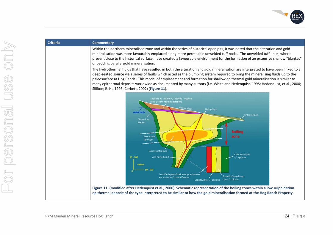
Within the northern mineralised zone and within the series of historical open pits, it was noted that the alteration and goldmineralisation was more favourably emplaced along more permeable unwelded tuff rocks. The unwelded tuff units, where present close to the historical surface, have created a favourable environment for the formation of an extensive shallow “blanket” of bedding parallel gold mineralisation.
The hydrothermal fluids that have resulted in both the alteration and gold mineralisation are interpreted to have been linked to a deep‐seated source via a series of faults which acted as the plumbing system required to bring the mineralising fluids up to the paleosurface at Hog Ranch. This model of emplacement and formation for shallow epithermal gold mineralisation is similar to many epithermal deposits worldwide as documented by many authors (i.e. White and Hedenquist, 1995; Hedenquist, et al., 2000; Sillitoe; R. H., 1993, Corbett, 2002) (Figure 11).
Figure 11: (modified after Hedenquist et al., 2000) Schematic representation of the boiling zones within a low sulphidation epithermal deposit of the type interpreted to be similar to how the gold mineralisation formed at the Hog Ranch Property.
For
per
sona
l use
onl
y
RXM Maiden Mineral Resource Hog Ranch 25 | P a g e
Criteria Commentary
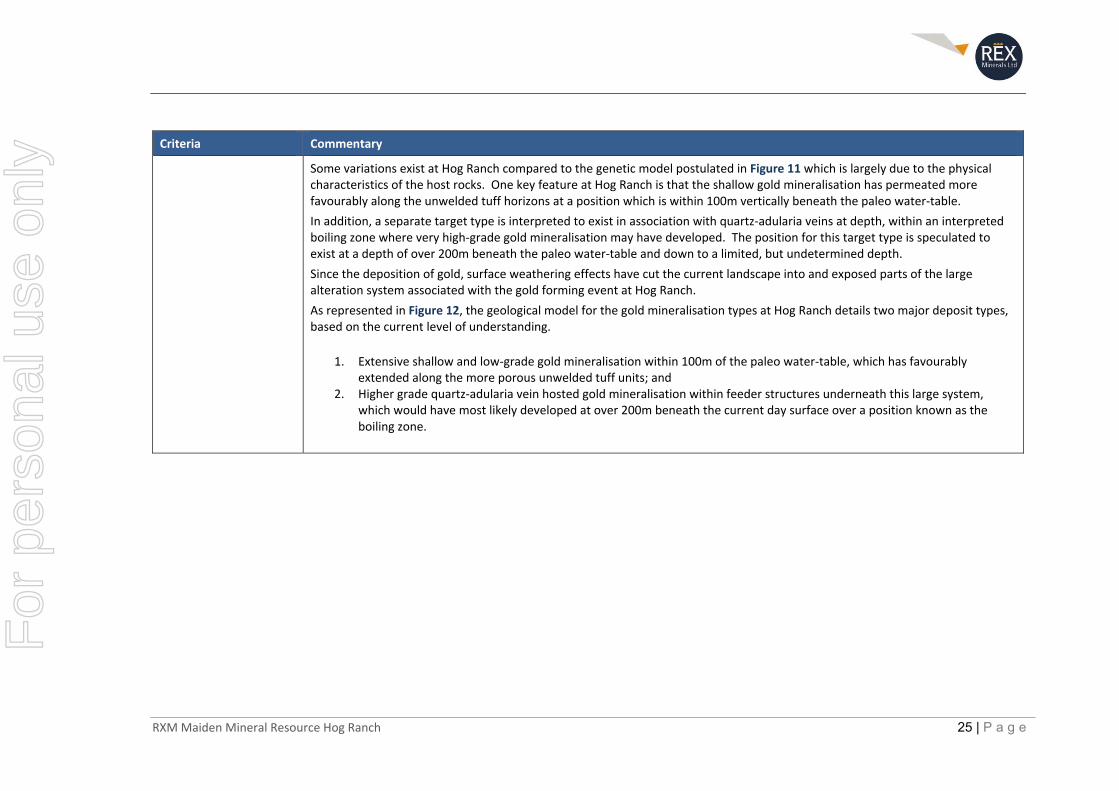
Some variations exist at Hog Ranch compared to the genetic model postulated in Figure 11 which is largely due to the physical characteristics of the host rocks. One key feature at Hog Ranch is that the shallow gold mineralisation has permeated more favourably along the unwelded tuff horizons at a position which is within 100m vertically beneath the paleo water‐table.
In addition, a separate target type is interpreted to exist in association with quartz‐adularia veins at depth, within an interpreted boiling zone where very high‐grade gold mineralisation may have developed. The position for this target type is speculated to exist at a depth of over 200m beneath the paleo water‐table and down to a limited, but undetermined depth.
Since the deposition of gold, surface weathering effects have cut the current landscape into and exposed parts of the large alteration system associated with the gold forming event at Hog Ranch.
As represented in Figure 12, the geological model for the gold mineralisation types at Hog Ranch details two major deposit types, based on the current level of understanding.
1. Extensive shallow and low‐grade gold mineralisation within 100m of the paleo water‐table, which has favourably extended along the more porous unwelded tuff units; and
2. Higher grade quartz‐adularia vein hosted gold mineralisation within feeder structures underneath this large system, which would have most likely developed at over 200m beneath the current day surface over a position known as the boiling zone.
For
per
sona
l use
onl
y
RXM Maiden Mineral Resource Hog Ranch 26 | P a g e
Criteria Commentary
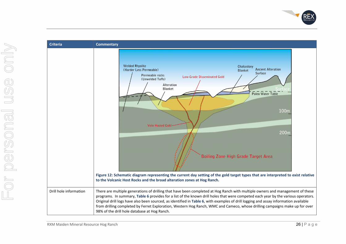
Figure 12: Schematic diagram representing the current day setting of the gold target types that are interpreted to exist relative to the Volcanic Host Rocks and the broad alteration zones at Hog Ranch.
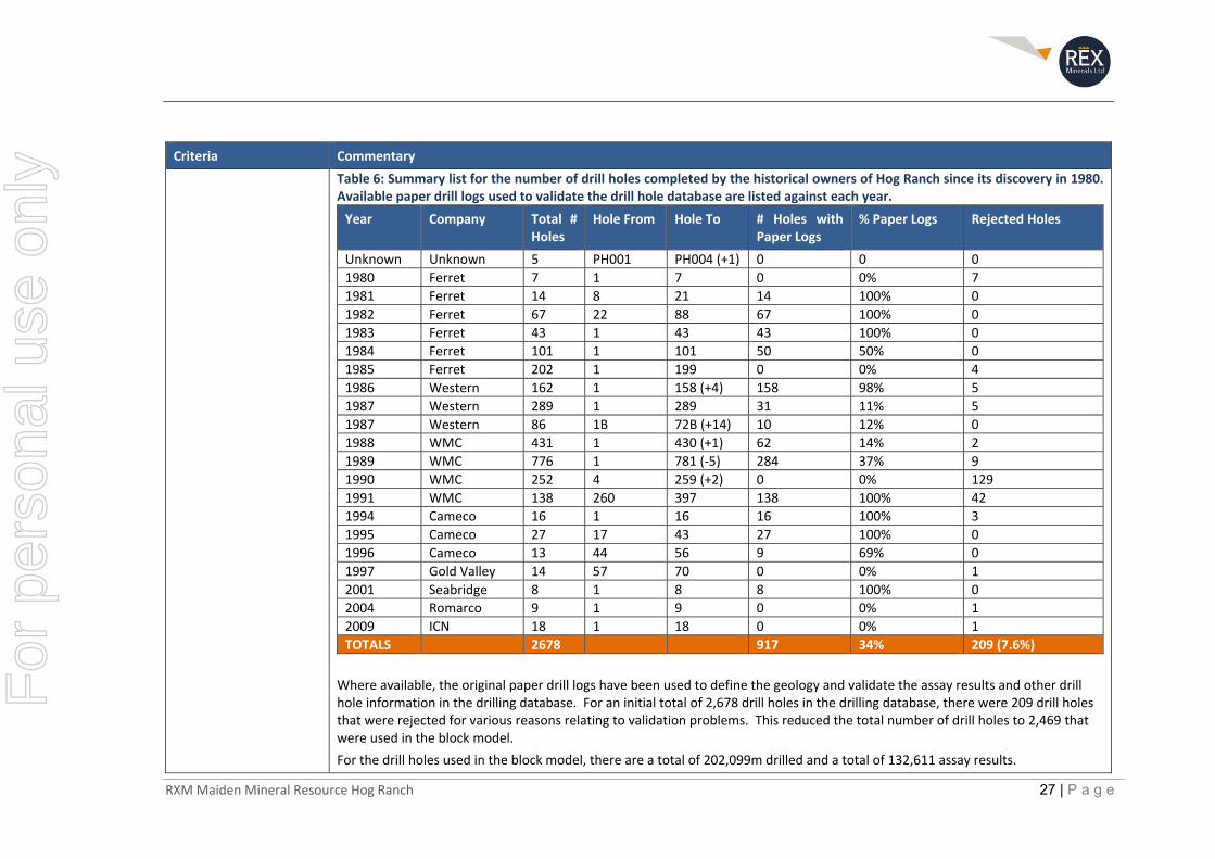
Drill hole information There are multiple generations of drilling that have been completed at Hog Ranch with multiple owners and management of these programs. In summary, Table 6 provides for a list of the known drill holes that were competed each year by the various operators. Original drill logs have also been sourced, as identified in Table 6, with examples of drill logging and assay information available from drilling completed by Ferret Exploration, Western Hog Ranch, WMC and Cameco, whose drilling campaigns make up for over 98% of the drill hole database at Hog Ranch.
For
per
sona
l use
onl
y
RXM Maiden Mineral Resource Hog Ranch 27 | P a g e
Criteria Commentary
Table 6: Summary list for the number of drill holes completed by the historical owners of Hog Ranch since its discovery in 1980. Available paper drill logs used to validate the drill hole database are listed against each year.
Year Company Total # Holes
Hole From Hole To # Holes with Paper Logs
% Paper Logs Rejected Holes
Unknown Unknown 5 PH001 PH004 (+1) 0 0 0
1980 Ferret 7 1 7 0 0% 7
1981 Ferret 14 8 21 14 100% 0
1982 Ferret 67 22 88 67 100% 0
1983 Ferret 43 1 43 43 100% 0
1984 Ferret 101 1 101 50 50% 0
1985 Ferret 202 1 199 0 0% 4
1986 Western 162 1 158 (+4) 158 98% 5
1987 Western 289 1 289 31 11% 5
1987 Western 86 1B 72B (+14) 10 12% 0
1988 WMC 431 1 430 (+1) 62 14% 2
1989 WMC 776 1 781 (‐5) 284 37% 9
1990 WMC 252 4 259 (+2) 0 0% 129
1991 WMC 138 260 397 138 100% 42
1994 Cameco 16 1 16 16 100% 3
1995 Cameco 27 17 43 27 100% 0
1996 Cameco 13 44 56 9 69% 0
1997 Gold Valley 14 57 70 0 0% 1
2001 Seabridge 8 1 8 8 100% 0
2004 Romarco 9 1 9 0 0% 1
2009 ICN 18 1 18 0 0% 1
TOTALS 2678 917 34% 209 (7.6%)
Where available, the original paper drill logs have been used to define the geology and validate the assay results and other drill hole information in the drilling database. For an initial total of 2,678 drill holes in the drilling database, there were 209 drill holes that were rejected for various reasons relating to validation problems. This reduced the total number of drill holes to 2,469 that were used in the block model.
For the drill holes used in the block model, there are a total of 202,099m drilled and a total of 132,611 assay results.
For
per
sona
l use
onl
y
RXM Maiden Mineral Resource Hog Ranch 28 | P a g e
Criteria Commentary
Data aggregation methods
No weighting average techniques or grade truncations have been reported in this release, and thus, this section is not material to this report on Mineral Resources.
In reporting the Mineral Resource, a cut‐off grade of 0.3g/t gold was used.
Relationship between mineralisation widths and intercept lengths
The bulk of the drilling information is from vertical RC drill holes (~90%) which is close to perpendicular to the dominantly flat lying stratigraphy and bedding parallel alteration and dispersed low‐grade gold mineralisation. Therefore, most of the drill intercepts are close to the true width of the mineralisation defined in the Mineral Resource estimate.
There are some narrow, vertical high‐grade veins that do occur throughout the project which are at a very poor angle to the dominant drilling direction. Restrictions have been placed on the high‐grade drill intercepts (reflecting this interpretation) to ensure that their influence is limited, particularly given this Mineral Resource estimate is focused on defining the shallow lower grade and horizontally dispersed gold mineralisation.
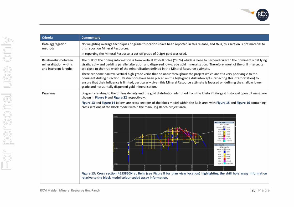
Diagrams Diagrams relating to the drilling density and the gold distribution identified from the Krista Pit (largest historical open pit mine) are shown in Figure 9 and Figure 22 respectively.
Figure 13 and Figure 14 below, are cross sections of the block model within the Bells area with Figure 15 and Figure 16 containing cross sections of the block model within the main Hog Ranch project area.
Figure 13: Cross section 4553850N at Bells (see Figure 8 for plan view location) highlighting the drill hole assay information relative to the block model colour coded assay information.
For
per
sona
l use
onl
y
RXM Maiden Mineral Resource Hog Ranch 29 | P a g e
Criteria Commentary
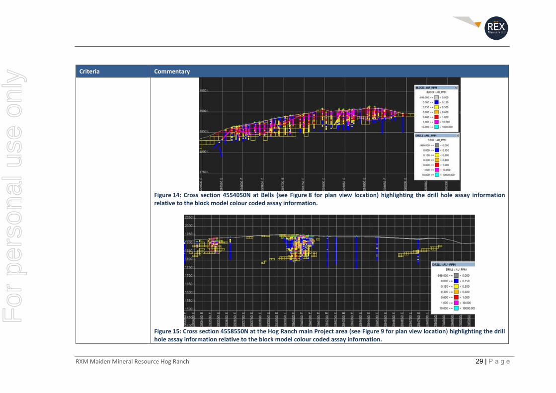
Figure 14: Cross section 4554050N at Bells (see Figure 8 for plan view location) highlighting the drill hole assay information relative to the block model colour coded assay information.
Figure 15: Cross section 4558550N at the Hog Ranch main Project area (see Figure 9 for plan view location) highlighting the drill hole assay information relative to the block model colour coded assay information.
For
per
sona
l use
onl
y
RXM Maiden Mineral Resource Hog Ranch 30 | P a g e
Criteria Commentary
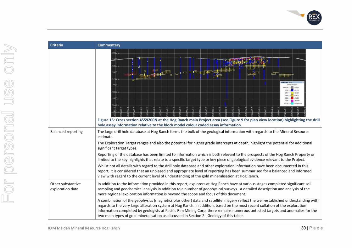
Figure 16: Cross section 4559200N at the Hog Ranch main Project area (see Figure 9 for plan view location) highlighting the drill hole assay information relative to the block model colour coded assay information.
Balanced reporting The large drill hole database at Hog Ranch forms the bulk of the geological information with regards to the Mineral Resource estimate.
The Exploration Target ranges and also the potential for higher grade intercepts at depth, highlight the potential for additional significant target types.
Reporting of the database has been limited to information which is both relevant to the prospects of the Hog Ranch Property or limited to the key highlights that relate to a specific target type or key piece of geological evidence relevant to the Project.
Whilst not all details with regard to the drill hole database and other exploration information have been documented in this report, it is considered that an unbiased and appropriate level of reporting has been summarised for a balanced and informed view with regard to the current level of understanding of the gold mineralisation at Hog Ranch.
Other substantive exploration data
In addition to the information provided in this report, explorers at Hog Ranch have at various stages completed significant soil sampling and geochemical analysis in addition to a number of geophysical surveys. A detailed description and analysis of the more regional exploration information is beyond the scope and focus of this document.
A combination of the geophysics (magnetics plus other) data and satellite imagery reflect the well‐established understanding with regards to the very large alteration system at Hog Ranch. In addition, based on the most recent collation of the exploration information completed by geologists at Pacific Rim Mining Corp, there remains numerous untested targets and anomalies for the two main types of gold mineralisation as discussed in Section 2 ‐ Geology of this table.
For
per
sona
l use
onl
y
RXM Maiden Mineral Resource Hog Ranch 31 | P a g e
Criteria Commentary
Further work There are two distinct target types at Hog Ranch which could lead to a commercially viable option for the development of a new gold project.
Shallow low‐grade gold mineralisation
Similar to the earlier mining operation, the shallow dispersed gold mineralisation remains as a potential target, with a higher gold price and a relatively low‐cost structure now potentially allowing for the economic extraction of the much larger and lower grade gold mineralisation.
A basic assessment of the current economics for a new large‐scale heap leach operation at Hog Ranch implies that a cut‐off grade of 0.2g/t or lower could be used for gold prices in excess of US$1,300/oz. The existing database has identified that the bulk of the gold mineralisation exists in the 0.2g/t to 1.0g/t range and it can also be observed that larger and more consistent bodies of gold mineralisation exist at this cut‐off grade in comparison to a 0.7g/t or higher cut‐off grade which is close to the cut‐off grade applied historically.
The opportunity now exists to consolidate and further validate the existing drilling database in addition to broadly drill testing the extensions to the large alteration system for evidence of further low‐grade gold mineralisation. The Inferred Mineral Resource estimate and further Exploration Target range defined in this report provide an indication of the scale of gold mineralisation that could be uncovered for consideration as part of a new gold operation at Hog Ranch.
Deeper high‐grade vein hosted gold mineralisation
In addition to the shallow gold mineralisation, there remains a significant high value target type at depth which is common within similar styles of epithermal gold deposits throughout Nevada. The Sleeper and Midas gold deposit are examples of the target type which could occur in the right environment at deeper levels, underneath the shallower flat lying and lower grade gold mineralisation at Hog Ranch.
This target type has interested many of the earlier explorers, due to its very high value in the event of a discovery similar to the Sleeper or Midas deposits. However, a combination of limited drill testing and the inability to easily predict the location of the favourable structures at depth has resulted in only limited success to date for this style of deposit.
It is therefore considered that a more effective and efficient approach to testing the deeper vein hosted gold is to apply geophysical methods (such as 3D seismic), to refine the likely location of the more favourable structures for this target type prior to further drill testing of this significant and high value target type.
F
or p
erso
nal u
se o
nly
RXM Maiden Mineral Resource Hog Ranch 32 | P a g e
Section 3 Estimation and Reporting of Mineral Resources
Criteria Commentary
Database integrity The information obtained for the drill hole data at Hog Ranch was contained within an Access Database. This database was originally compiled by earlier explorers who acquired the Hog Ranch Project post the period of active mining. Most of the data was compiled by exploration geologists working for Romarco, ICN and subsequently Pacific Rim.
Rex has completed a number of validation steps to test the integrity and accuracy associated with the data that exists within the database, largely based on comparisons against the original paper drilling logs and other data that are available.
In summary, the assay data, rock codes, alteration and other information in the drill hole database were reviewed and validated as follows:
Approximately 16% of the drill holes in the database are from the drilling completed by Ferret Exploration from 1980 up until 1986. Most of this drilling was located originally around the Bells area followed by the discovery and drilling of the northern deposits (around the West, 139, Geib and Krista pit locations). The author has been able to sight 40% of the original paper drill logs for the drilling that was completed by Ferret Exploration to assist with validating the drilling over this period. The standard rock codes (which appear to have been adopted after 1985) were not used by Ferret Exploration in their drill logs sighted by the author. Some logs did have a rock code assigned, in addition to a description made for each interval to describe the rock type and any other observable features. Assay results were handwritten onto the paper logs in ounces per tonne, which have been checked against the assay information in the database. All assay results appear to have been entered and converted correctly based on the information available from the paper logs completed by Ferret Exploration.
By the time Western took control in 1986, a standardised approach to the core logging was established for the major rock types and alteration. The drilling completed by Western during 1986 and 1987 represents around 20% of the drill hole information in the database. Approximately 33% of the paper drill logs for drilling completed by Western were available to validate the drilling information over this period. Similar to Ferret Exploration, the assay information was handwritten onto the paper drill logs in ounces per ton for all drill logs that have been reviewed by the author.
The bulk of the drilling in the database was completed by WMC from 1988 up to 1992 representing 60% of the drill holes in the Hog Ranch database. The drilling by WMC covered prospects all over the Hog Ranch Property as part of their regional exploration effort. Paper logs for 31% of the drilling completed by WMC have been sighted by the author. The rock, alteration and weathering codes along with the practice of inserting the assay results onto the paper logs continued as per the codes identified in the Western paper logs.
Note: Over 96% of the drill hole information in the database is from drilling completed between 1980 and 1992. Subsequent explorers were focused on either gold mineralisation out to the west underneath shallow cover rocks (Cameco/Gold Valley) or
For
per
sona
l use
onl
y

RXM Maiden Mineral Resource Hog Ranch 33 | P a g e
Criteria Commentary
looking for deeper high‐grade feeder vein hosted gold mineralisation underneath the shallow dispersed gold mineralisation that was exploited during the mining operations at Hog Ranch.
Cameco completed 56 drill holes from 1994 up until 1996, with an additional 16 holes completed by Gold Valley who was in a Joint Venture with Cameco in 1997. Combined, these drill holes were focussed on the discovery of new gold mineralisation underneath shallow cover rocks on the western portion of the Hog Ranch Property, close to, but not as far west as, the Airport zone. The author has been able to sight over 60% of the drill logs from this period of drilling, including some of the original laboratory assay sheets from American Assay Laboratory in Sparks, Nevada.
Seabridge completed eight (8) diamond drill holes in 2001 searching for deeper vein hosted gold. Significant sections of this diamond core are still preserved in a storage shed close to Winnemucca in addition to the original drill logs and laboratory assay sheets being available. Seabridge was very selective with the sampling of the drill core and large sections remain unsampled. In addition, some re‐sampling of the core, where there was reported significant mineralisation, was re‐sampled and reported in an NI43‐101 report by Walker (2004). All the information available from the Seabridge core in the drill hole database appears to be correct based on validation checks by the author.
Further drilling was completed in 2004 and 2009 by Romarco and ICN Resources respectively which represent approximately 1% of the drill holes in the Hog Ranch database combined. The original drill logs for these holes have not been sighted. However, both drilling campaigns were reported separately within an NI43‐101 reports (Walker, 2004; Baker, 2010). The assay results were reported to have been completed at the ALS laboratory in Reno by fire assay.
Site visits The author has visited the Hog Ranch Project on June 9 and June 11, 2019, which included inspections of the rehabilitated open pits from the previous mining activities. In addition, inspections and interviews were completed at Kappes Cassidy and Associates (KCA) site office and testing facilities who completed the original column leach tests for Hog Ranch prior to mining and also discussions with technical staff and management who were working for WMC at Hog Ranch during the time it was actively operating as an open pit and heap leach operation.
Geological interpretation Regional Geology
The geology of north‐eastern Nevada is dominated by extensive volcanic rocks related to extensional tectonism of mid Miocene age. The Volcanic rocks in the region include the Summit Lake Tuff, Soldier Meadow Tuff and the Canon Rhyolite, all of which have been dated at between 16Ma and 15Ma.
Closely associated with this volcanism is a series of gold deposits over a broad area known as the northern Nevada epithermal district, which includes bonanza grade gold deposits such as the Sleeper and Midas gold deposits. These epithermal deposits are interpreted to be genetically related to the Yellowstone Hot Spot (Saunders et. al., 2008) which can be traced from Northern Nevada in an east‐north‐easterly direction up to its present‐day location in Wyoming (Figure 17).
For
per
sona
l use
onl
y
RXM Maiden Mineral Resource Hog Ranch 34 | P a g e
Criteria Commentary
Figure 17: (after Saunders et.al., 2008) LEFT ‐ Ages of the calderas of the Yellowstone Hot Spot track (“HS”) and RIGHT – Locations for many of the low‐sulphidation epithermal deposits in the northern Great Basin and through going structures such as the Northern Nevada Rift (NNRE, NNRC and NNRW). Hog Ranch occurs along the Black Rock Structural Boundary (BRSB), a western strand of the northern Nevada rift system (Figure 18). At Hog Ranch, the Miocene aged rhyolites outcrop, and are part of the Cottonwood Creek Volcanic Centre (“CCVC” Bussey 1996 – Figure 18).
For
per
sona
l use
onl
y
RXM Maiden Mineral Resource Hog Ranch 35 | P a g e
Criteria Commentary
Figure 18: (modified after Bussey, 1996) Regional map of northwest Nevada and southern Oregon and Idaho showing regional volcanic centers and mineralised areas (after Rytuba, 1989; Rytuba and Vander Meulen, 1991). Mines and Prospects: GM‐Grassy Mountain, D‐Delamar, M‐McDermitt, Cordero, N‐National, Buckskin, H‐Hog Ranch and S‐Sleeper. Calderas and volcanic centers: T‐Three Fingers, MM‐Mahogany Mountain, W‐Whitehorse, P‐Pueblo, McD‐McDermitt complex, GL‐Goosey Lake Depression and CCVC‐Cottonwood Creek Volcanic Center. Structural zones: DDVFZ‐ Delamar‐Duck Valley Fault Zone, OR‐Orevada Rift, and BRSB‐Black Rock Structural Boundary.
For
per
sona
l use
onl
y

RXM Maiden Mineral Resource Hog Ranch 36 | P a g e
Criteria Commentary
Local Geology
Hog Ranch is located within a broad basin known as the Cottonwood Creek basin, with the associated host rocks related with the Cottonwood Creek Volcanic Centre (CCVC), which is made up of volcanic and volcaniclastic rocks. The volcanic rocks regionally are referred to as the Cañon Rhyolite which are overlain by volcaniclastic rocks referred to as the High Rock Sequence. The Cottonwood Creek basin is approximately 30km long in a north‐south direction and 20km wide in an east‐west direction. The bulk of the historical mining and defined gold mineralisation at Hog Ranch exists on the eastern margin of the Cottonwood Creek basin.
Stratigraphy
The Hog Ranch Property is hosted predominantly in a thick sequence of volcanic rocks of the Cañon Rhyolite and a thin sequence of overlying volcaniclastic rocks of the High Rock sequence.
The High Rock sequence is composed of volcanic sandstones, tuffaceous fluviolacustrine tuffs and diatomite (Bussey, 1996). Most of the High Rock sequence was deposited on an erosion surface which cuts into the Cañon Rhyolite, and locally interfingers with the uppermost flows of the Cañon Rhyolite.
The Cañon Rhyolite is composed of a series of unwelded bedded tuffs and welded flow‐banded rhyolite tuffs. Diamond drilling completed during the mining operations by WMC reported the Cañon Rhyolite to be over 1,000m in thickness (Bussey, 1996).
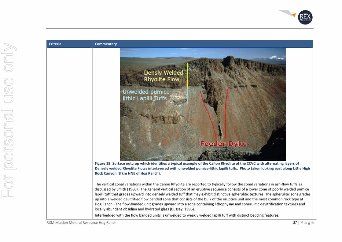
The type model for the Cañon Rhyolite, which is the dominant host rock to the gold mineralisation at Hog Ranch, can be found at local mountain outcrops where parts of the Cañon Rhyolite are exposed. In the example shown in Figure 19, there is a feeder dyke leading up to the welded Rhyolite flow, from which a welded Rhyolite layer extends for over 2km in all directions. At Hog Ranch, the drilling has not identified the location of any feeder dykes and the broad stratigraphy is based solely on relatively flat lying alternate layers of Welded Rhyolite Flows and Unwelded Tuffs. It is typical for the large welded Rhyolite flows to extend for many kilometres at Hog Ranch and the surrounding area.
For
per
sona
l use
onl
y
RXM Maiden Mineral Resource Hog Ranch 37 | P a g e
Criteria Commentary
Figure 19: Surface outcrop which identifies a typical example of the Cañon Rhyolite of the CCVC with alternating layers of Densely welded Rhyolite Flows interlayered with unwelded pumice‐lithic lapilli tuffs. Photo taken looking east along Little High Rock Canyon (8 km NNE of Hog Ranch).
The vertical zonal variations within the Cañon Rhyolite are reported to typically follow the zonal variations in ash‐flow tuffs as discussed by Smith (1960). The general vertical section of an eruptive sequence consists of a lower zone of poorly welded pumice lapilli tuff that grades upward into densely welded tuff that may exhibit distinctive spherulitic textures. The spherulitic zone grades up into a welded devitrified flow banded zone that consists of the bulk of the eruptive unit and the most common rock type at Hog Ranch. The flow‐banded unit grades upward into a zone containing lithophysae and spherulitic devitrification textures and locally abundant obsidian and hydrated glass (Bussey, 1996).
Interbedded with the flow banded units is unwelded to weakly welded lapilli tuff with distinct bedding features.
For
per
sona
l use
onl
y
RXM Maiden Mineral Resource Hog Ranch 38 | P a g e
Criteria Commentary
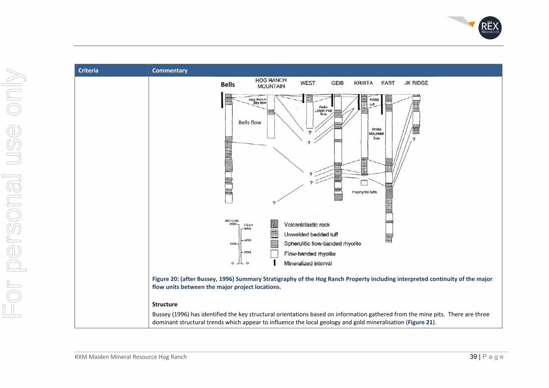
The major flow banded units can be identified over a large area, extending in some cases for kilometres. Locally at the mine site, Bussey (1996) identified a number of flow banded units that could be traced in drill holes around the historical open pits (Figure 20). Locally, the oldest defined flow is the White Mountain Flow which extends underneath the historically mined open pits.
A significant zone of unwelded tuff exists between the White Mountain Flow and the next well‐defined flow called the Geib/Leach Pad Flow. Further to the south, the Bells deposit is hosted in almost solely a large spherulitic to flow banded welded Rhyolite rock. There is a not enough information at this stage to link the Bells flow to the other defined flows around the northern open pits.
Discussions and geological review of the original drill logs where available have enabled a broad geological interpretation to be developed of the major welded flow banded units as described by Bussey (1996), over a large section of the Hog Ranch Project where drilling information with rock codes were available.
For
per
sona
l use
onl
y
RXM Maiden Mineral Resource Hog Ranch 39 | P a g e
Criteria Commentary
Figure 20: (after Bussey, 1996) Summary Stratigraphy of the Hog Ranch Property including interpreted continuity of the major flow units between the major project locations.
Structure
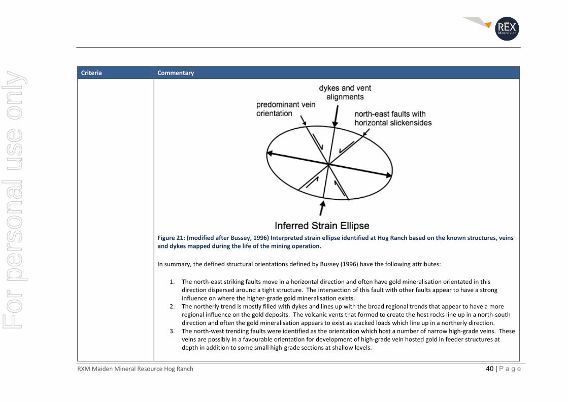
Bussey (1996) has identified the key structural orientations based on information gathered from the mine pits. There are three dominant structural trends which appear to influence the local geology and gold mineralisation (Figure 21).
Bells
Bells flow
For
per
sona
l use
onl
y
RXM Maiden Mineral Resource Hog Ranch 40 | P a g e
Criteria Commentary
Figure 21: (modified after Bussey, 1996) Interpreted strain ellipse identified at Hog Ranch based on the known structures, veins and dykes mapped during the life of the mining operation. In summary, the defined structural orientations defined by Bussey (1996) have the following attributes:
1. The north‐east striking faults move in a horizontal direction and often have gold mineralisation orientated in this direction dispersed around a tight structure. The intersection of this fault with other faults appear to have a strong influence on where the higher‐grade gold mineralisation exists.
2. The northerly trend is mostly filled with dykes and lines up with the broad regional trends that appear to have a more regional influence on the gold deposits. The volcanic vents that formed to create the host rocks line up in a north‐south direction and often the gold mineralisation appears to exist as stacked loads which line up in a northerly direction.
3. The north‐west trending faults were identified as the orientation which host a number of narrow high‐grade veins. These veins are possibly in a favourable orientation for development of high‐grade vein hosted gold in feeder structures at depth in addition to some small high‐grade sections at shallow levels.
For
per
sona
l use
onl
y
RXM Maiden Mineral Resource Hog Ranch 41 | P a g e
Criteria Commentary
Later explorers have also identified a set of faults that strike at around 700 to 900 or close to due east (Baker, 2010). These faults are reported from mapping completed by Baker in 2009 at Hog Ranch.
Alteration
The alteration characteristics of the host rock and associated gold mineralisation have been well defined in Bussey (1996), based on X‐Ray Powder Diffraction (XRD) analysis of over 291 samples from various drill holes throughout the property. In general, the broad alteration pattern defined at Hog Ranch appears to be reflective of the alteration mineralogy and zonation away for the main source of hydrothermal fluids for a low‐sulphidation deposit as defined by many authors, including (White and Hedenquist, 1995; Sillitoe, 1993).
In total, nine alteration assemblages were defined in Bussey (1996), which are summarised in Table 7. The alteration mineralogy is dominated by quartz, adularia, various clay minerals, alunite and opaline silica. Alteration in the northern Hog Ranch region which includes the bulk of the historical open pits covers an area of approximately 20km2, and to the south at the Bells deposit covers an area of 4km2 (Bussey, 1996).
Table 7: (after Bussey, 1996) Description of alteration assemblages in the Hog Ranch district. *Minerals in bold type are definitive for the given assemblage.
Abbreviation XRD Mineralogy Comments
None Alkalie feldspar, cristobalite Devitrified, aphyric rhyolite, unaltered
Hop Opal, alunite, kaolinite Mostly distal alteration assemblage; samples may show incomplete alteration
Hkf/ab K‐feldspar, albite, quartz, illite, pyrite Recrystalized fresh rhyolite; rock appears “bleached”
HA Smectite, mixed layer illite‐smectite, tosudite, kaolinite, opal, pyrite
“shallow” argillic assemblage
Hq Quartz Massive dense silicification
HAAL Kaolinite, quartz, tosudite, alunite, cristobalite Low temperature, advanced argillic assemblage
HS Illite, quartz, K‐feldspar, pyrite “deep” argillic assemblage
HK K‐feldspar, illite, quartz, pyrite Potassic assemblage; K‐feldspar is adularia in thin section
Hkf/k K‐feldspar, kaolinite Probable disequilibrium assemblage, HAAL on HK; only found at White Mn
HP Chlorite, quartz, K‐feldspar, albite, illite, calcite, pyrite
Deepest assemblage; propylitic equivalent
For
per
sona
l use
onl
y
RXM Maiden Mineral Resource Hog Ranch 42 | P a g e
Criteria Commentary
Gold Mineralisation
The following information with regard to the gold mineralisation at Hog Ranch is based on a summary of the observations made from the historical open pit mines in Bussey (1996).
The gold mineralisation can occur in the flow banded (welded) rhyolite units as well as the unwelded bedded tuffs and the overlying volcaniclastic rocks. High grade mineralisation is found in narrow quartz‐adularia veins that were usually surrounded by large halos of lower grade material with only minor veining. The disseminated zones of mineralised rock had a flat tabular distribution (bedding parallel) which were best developed in unwelded bedded tuff units. The only exception to this is at Bells, which is dominated by a thick welded rhyolite unit. This is due to a lack of unwelded bedded tuffs for the fluids to more easily permeate, which differs from the northern area, where there are more extensive unwelded bedded tuff units.
The mineralisation observed within the overlying volcaniclastic rock was best developed in the northern Hog Ranch area and confined to cross‐cutting breccia pipes and porous conglomeratic beds.
Bench mapping and cross sections of the gold mineralisation from four (4) of the historic open pits identified in Bussey (1996) show a general bias of the higher grade gold mineralisation and surrounding lower grade gold mineralisation along a north‐east direction, with limited dispersion along some narrow structures which are in a north‐westerly direction. This is particularly noticeable in the level plan of the Krista pit, from which more than 50% of the ore mine tonnes historically was taken (Figure 22).
For
per
sona
l use
onl
y

RXM Maiden Mineral Resource Hog Ranch 43 | P a g e
Criteria Commentary
Figure 22: (modified after Bussey, 1996) Krista Pit 6180ft level bench map from the Krista open pit showing the gold distribution based on blast hole drilling information.
For
per
sona
l use
onl
y
RXM Maiden Mineral Resource Hog Ranch 44 | P a g e
Criteria Commentary
Dimensions The overall dimensions of the gold mineralisation created in the Hog Ranch block model were reviewed against the broad dimensions and distribution of gold identified throughout the drill hole database and also the gold distribution that is reflected in the historical open pits as reported by Bussey (1996). Higher grade mineralisation (over 1.7g/t Au) as defined in the report by Bussey is typically restricted between 50 and 100m where some level of continuity is observed. The higher grades are also typically more restricted vertically to less than 10m as the mineralisation follows the relatively flat lying stratigraphy.
Similarly, at reducing cut‐off grades, the continuity of the gold mineralisation improves along with the dimensions of the mineralisation. Figure 23 shows a plan view of the block model underlain by a grade contour map (plan) and cross section, from the Bussey (1996) paper to compare the distribution of gold defined in the block model against the blast hole drilling information that was reported in the Bussey (1996) paper. Figure 23 is from the Krista pit, which was the largest of the open pits and contained approximately half of the reported production from the gold operations at Hog Ranch.
At lower grades, the gold mineralisation is identified in both the drill holes and from the historical mining to extend for hundreds of metres horizontally, up to a maximum of 400m, but is restricted to narrower intervals vertically, ranging typically from 20m up to a maximum depth extent of approximately 60 to 80m. This is also reflected in the block model as observations of the grade distribution in cross section (Figure 13 to Figure 16) and various horizontal slices appear to mimic the expected distribution of the gold mineralisation as documented within this report.
For
per
sona
l use
onl
y
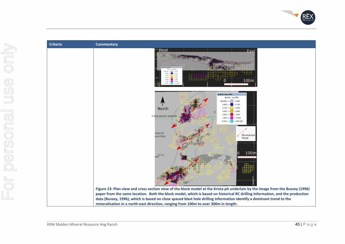
RXM Maiden Mineral Resource Hog Ranch 45 | P a g e
Criteria Commentary
Figure 23: Plan view and cross section view of the block model at the Krista pit underlain by the image from the Bussey (1996) paper from the same location. Both the block model, which is based on historical RC drilling information, and the production data (Bussey, 1996), which is based on close spaced blast hole drilling information identify a dominant trend to the mineralisation in a north‐east direction, ranging from 100m to over 300m in length.
For
per
sona
l use
onl
y

RXM Maiden Mineral Resource Hog Ranch 46 | P a g e
Criteria Commentary
Estimation and modelling techniques
The parameters and modelling technique for the Hog Ranch block model are based on the current understanding of the geology and shallow gold mineralisation largely from documentation in Bussey (1996). In addition to further discussions held directly with Steven Bussey of Western Mining Services who worked as a geologist for WMC at the Hog Ranch mine during its operating life.
Block Size
A parent cell block size of 10m x 10m x 10m was used for the Hog Ranch bock model. The dimensions of the block size were chosen taking into consideration the nature of the gold mineralisation, the relative drill spacing available over the bulk of the Inferred Mineral Resource estimate (typically at 50m x 50m or less) with 1.5m (5 feet) samples down hole, and consideration of the likely mining method of open pit mining with bench heights of 10m or less. For reference, the historical bench heights were typically at 20ft in height (6m).
Interpolation Method
It was considered that with the current drill spacing at Hog Ranch and the rapid changes that can often exist naturally for a gold deposit of this nature, that there is a preference to bias the allocation of grade to the nearest neighbour and thus reduce the influence of assay information that is a greater distance away from the individual blocks. Therefore, the ID2 method of interpolation was chosen, utilising the following criteria for the search ellipse and also the restrictions as defined in the cut‐off parameters for the higher‐grade assay results.
Inverse distance squared (ID2) to the parent block size was used to estimate gold (Au) only.
Search Ellipse Parameters
The search ellipse selected was based on the overall geometry and distribution of gold mineralisation that was documented in Bussey, 1996. There is a distinct preferential trend to the higher grade and lower grade gold mineralisation which is interpreted to be parallel to controlling structural features throughout Hog Ranch.
This dominant trend is in a north‐easterly direction, where mineralisation appears to extend for between 100m to over 300m in some sections (see Figure 22 and Figure 23). Perpendicular to this trend, there is reduced but still significant dispersion of gold mineralisation which is typically restricted to 50m but can extend in some cases to over 100m.
In the vertical direction, there is a strong control on the gold mineralisation which is broadly parallel to the stratigraphy, and the gold mineralisation has a much greater limitation to its distribution in a vertical direction (see Figure 22 and Figure 23).
The following search ellipse parameters were chosen for the sections of block model which could be defined as an Inferred Mineral Resource. The search used radius proportional weighting.
For
per
sona
l use
onl
y
RXM Maiden Mineral Resource Hog Ranch 47 | P a g e
Criteria Commentary
Pass One:
Vertical direction 10m,
North‐east direction 40m (orientated at 40 degrees),
North‐west direction 30m (orientated at 310 degrees).
Pass Two:
Vertical direction 15m,
North‐east direction 60m (orientated at 40 degrees),
North‐west direction 45m (orientated at 310 degrees)
Pass Three:
Vertical direction 20m,
North‐east direction 100m (orientated at 40 degrees),
North‐west direction 75m (orientated at 310 degrees).
The same search ellipse parameters were also used for the parts of the block model which were outside of the defined Inferred Resource boundaries. In this case the potential for further mineralisation extending to a greater extent was also considered with an additional pass used to extend the mineralisation up to 400m in length in the perceived favourable direction for the shallow gold mineralisation.
Pass Four:
Vertical direction 40m,
North‐east direction 400m (orientated at 40 degrees),
North‐west direction 300m (orientated at 310 degrees).
Variogram analysis and comparisons with Ordinary Kriging
Variogram analysis was undertaken using Snowden SUPERVISOR software for each defined geological domain. The results from this analysis indicate that there is a significant nugget effect associated with the distribution of data for every domain reviewed, and that there is limited ability to confirm an association between drill holes samples at even a small (15m) drill spacing.
Given the results of the variogram analysis, and natural variability shown in the drill hole data it was considered that ID2 remain as the preferred interpolation method. However, for comparison, the parameters identified from the Variogram analysis were used to produce an Ordinary Kriged block model for comparison purposes only.
The results from the Ordinary Kriged block model were found to be within 2%, when compared with the ID2 model for both the Mined area and the Inferred Mineral Resource area. Given the natural variability and level of confidence relative to an Inferred
For
per
sona
l use
onl
y
RXM Maiden Mineral Resource Hog Ranch 48 | P a g e
Criteria Commentary
Mineral Resource estimate, this is considered to show no meaningful difference between the Ordinary Kriged estimate and the ID2 estimate.
Grade cutting or capping
Of particular concern with regard to the grade interpolation within the block model was to limit the influence of high‐grade assay results which are more likely to be related to vein hosted vertical structures that are known to have a very small area of continuity. This higher‐grade population of data is not considered to be part of the more continuous lower grade and horizontally dispersed gold mineralisation which is the focus of the Mineral Resources estimate.
To effectively review the data populations based on the current level of geological understanding at Hog Ranch, the assay data for each modelled rock unit was reviewed individually. The summary statistical analysis was completed using Snowden SUPERVISOR software. The data for each population was taken from the composites created in Vulcan on 1.524m (5ft) intervals and coded relative to the appropriate geological domain.
Log histograms and cumulative log‐probability plots
Statistical information was separated into the broad geological domains that could be modelled and identified from the historical technical information and matched with the information in the drilling database. The major rock units, which have distinctly separate physical properties and relationships to the gold mineralisation were modelled in line with the stratigraphy identified by Bussey (1996, see Figure 20). Figure 24 provides an example in cross section of the modelled geological units within the Hog Ranch block model.
Cumulative log‐probability plots for the samples used within the 2019 Inferred Mineral Resource estimate are shown in Figure 25 to Figure 28 for each of the defined geological units respectively.
Data is displayed by domain for values above 0.05ppm Au which predominantly relates to a large volume of data which is above detection.
For
per
sona
l use
onl
y
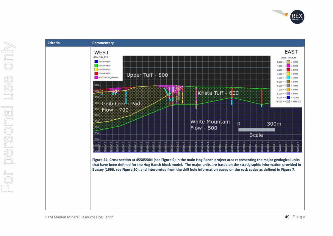
RXM Maiden Mineral Resource Hog Ranch 49 | P a g e
Criteria Commentary
Figure 24: Cross section at 4558550N (see Figure 9) in the main Hog Ranch project area representing the major geological units that have been defined for the Hog Ranch block model. The major units are based on the stratigraphic information provided in Bussey (1996, see Figure 20), and interpreted from the drill hole information based on the rock codes as defined in Figure 7.
For
per
sona
l use
onl
y
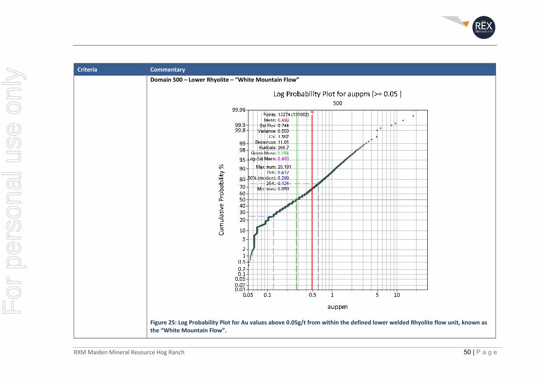
RXM Maiden Mineral Resource Hog Ranch 50 | P a g e
Criteria Commentary
Domain 500 – Lower Rhyolite – “White Mountain Flow”
Figure 25: Log Probability Plot for Au values above 0.05g/t from within the defined lower welded Rhyolite flow unit, known as the “White Mountain Flow”.
For
per
sona
l use
onl
y
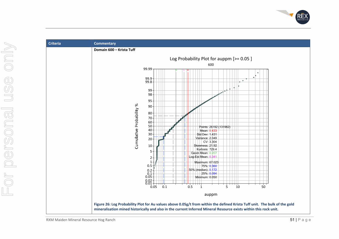
RXM Maiden Mineral Resource Hog Ranch 51 | P a g e
Criteria Commentary
Domain 600 – Krista Tuff
Figure 26: Log Probability Plot for Au values above 0.05g/t from within the defined Krista Tuff unit. The bulk of the gold mineralisation mined historically and also in the current Inferred Mineral Resource exists within this rock unit.
0.05 0.1 0.5 1 5 10 50
auppm
0.010.020.050.10.20.512
5
10
20
3040506070
80
90
95
9899
99.899.9
99.99600
Log Probability Plot for auppm [>= 0.05 ]
Points: 26192 (131962)Mean: 0.433
Std Dev: 1.431Variance: 2.049
CV: 3.304Skewness: 21.92
Kurtosis: 729.4Geom Mean: 0.207
Log-Est Mean: 0.341
Maximum: 67.02375%: 0.360
50% (median): 0.17225%: 0.094
Minimum: 0.050
MG L
For
per
sona
l use
onl
y

RXM Maiden Mineral Resource Hog Ranch 52 | P a g e
Criteria Commentary
Domain 700 – Geib Leach Pad Flow
Figure 27: Log Probability Plot for Au values above 0.05g/t from within the defined Geib Leach Pad Flow. The Geib Leach Pad
Flow is a defined welded Rhyolite rock unit that exists above the Krista Tuff.
For
per
sona
l use
onl
y
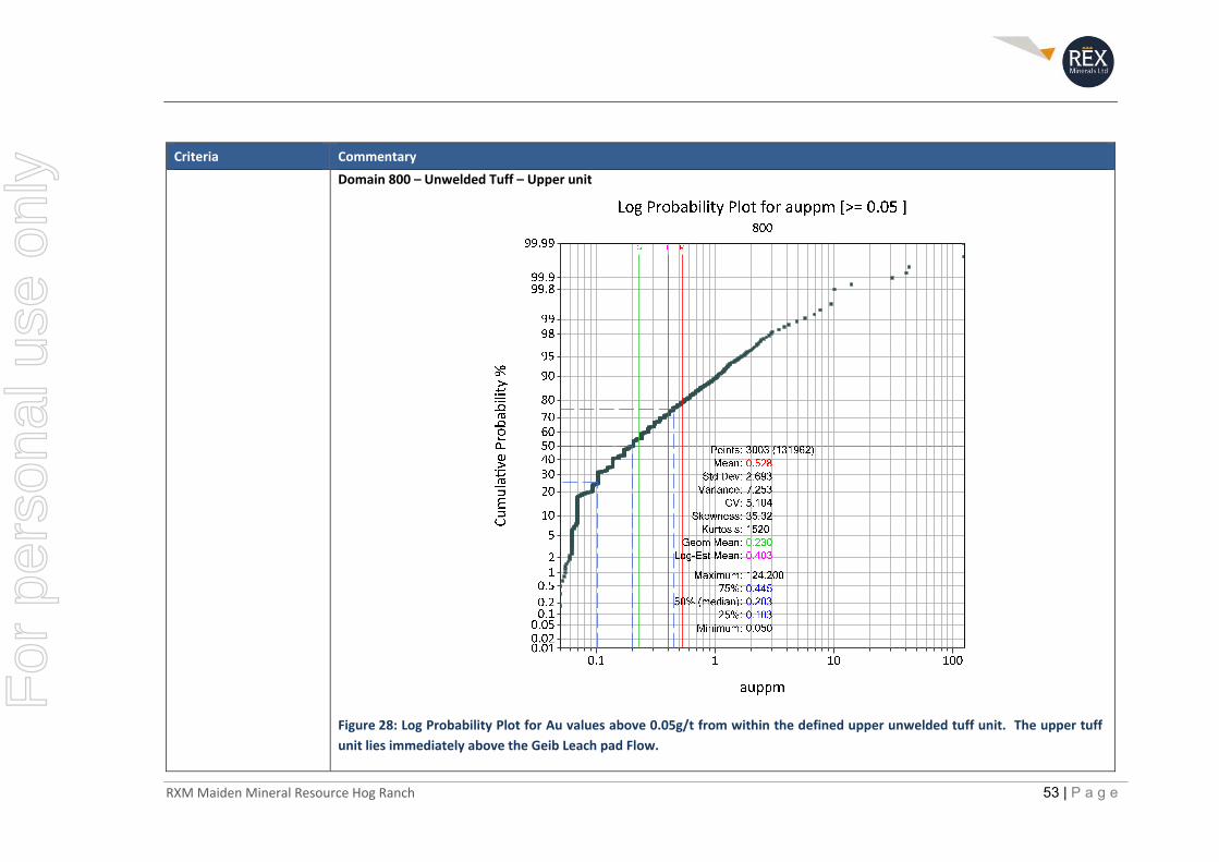
RXM Maiden Mineral Resource Hog Ranch 53 | P a g e
Criteria Commentary
Domain 800 – Unwelded Tuff – Upper unit
Figure 28: Log Probability Plot for Au values above 0.05g/t from within the defined upper unwelded tuff unit. The upper tuff
unit lies immediately above the Geib Leach pad Flow.
For
per
sona
l use
onl
y

RXM Maiden Mineral Resource Hog Ranch 54 | P a g e
Criteria Commentary
Top‐cut values applied to each geological domain
Top‐cuts were applied for the block estimation for each of the defined geological domains individually. The top‐cut defined was based on the disintegration approach of log probability plots whereby the high‐grade tail starts to break away from the main population of data. In each case the defined limit to the main population of data was above the 99th percentile.
A summary of the top cut values applied to the June 2019 Mineral Resource Estimate are shown in the table below.
Table 8: Summary table of top cuts applied to each domain as determined from their respective Log Probability plots
Domain Code Top Cut value (Gold g/t)
500 5
600 10
700 7
800 10
In addition to the application of a top‐cut, there was a “high‐yield” restriction applied to assay results that were top‐cut. The high yield restriction has limited the influence of these high‐grade assay results to a 5m x 5m x 5m area. The discretisation steps in the X, Y and Z direction were set to 5 within the 10m x 10m x 10m parent block. The basis to apply a high yield restriction is due to the interpretation that the bulk of these higher‐grade assay results are associated with narrow vertically oriented structures and veins which have a very small area of continuity.
It was noted from the historical mining information that there is at least one example of high‐grade drill hole assay(s), which carried significant weight within an historical Resource prior to mining. Eventual mining to this region identified that the high‐grade assay results were related to only a very small region and did not have a significant lateral extent, resulting in significantly less ounces mined than originally predicted. This example, plus the understanding of the high‐grade assay results that typically relate to vertical vein hosted gold mineralisation, is the basis for applying the top cut and high‐yield restriction on all assay results that exist above the determined top‐cut value for each respective domain.
Moisture Tonnes have been estimated on a dry basis.
Cut‐off parameters The Inferred Mineral Resource is reported at a cut‐off grade of 0.3g/t gold within a US$1,300/oz open pit shell. Within the Inferred Mineral Resource there is a sufficient volume of material above a 0.3 g/t gold cut‐off to support an open pit mine.
Mining factors or assumptions
The area defined around the historical open pit mines was reviewed to check for continuity of the gold mineralisation within a particular geological horizon. Where continuity away from the historical open pits could be reasonably interpreted, the gold mineralisation defined over this area was then assessed for its potential to exist within an open pit design at some point in time in the future.
For
per
sona
l use
onl
y

RXM Maiden Mineral Resource Hog Ranch 55 | P a g e
Criteria Commentary
An optimised open pit was developed on the Hog Ranch block model. Within this open pit optimisation, a cut‐off of 0.3g/t Au was applied and the Inferred Mineral Resource was then reported inside the pit above the cut‐off. The optimised pit shell was based on a US$1,300/oz gold price, $2.20/oz refining charge, 80% processing recovery, 45 degree wall angles, mining dilution of 5%, mining cost of US$2.6 per mined tonne and a processing/G&A cost of US$4.8 per ore tonne based on historical mining records and internal Rex estimates. In addition, overall Pad design parameters were considered based on documentation from KCA (1986) on the Heap Leach test work at Hog Ranch.
Metallurgical factors or assumptions
There is substantial information from the results of the Historical mining and earlier large‐scale test work which all indicate that gold recoveries from the major rock units should exceed 80%.
KCA, who are a specialised metallurgical testing and design engineering firm based out of Reno, Nevada, completed a number of studies leading up to the commencement of mining at Hog Ranch in 1986. The most significant test results that were completed and reported were from large 10t samples of the two major ore types sourced from two trial open pits in 1986.
The samples taken were reported from two separate pits. The sample in Pit No.1 was classified as mostly welded ash, considered by the author to represent the dominant rock type in the region which is the flow‐banded welded rhyolite. The sample from Pit No.2 was reported to be partially welded and laminated rock with sections of very soft clay material. This is taken by the author to represent the often clay rich and more altered unwelded rhyolite material, or partially mixed material.
The material for the test work was crushed and agglomerated as per the design parameters that were established from earlier test work prior to being placed into 20ft high columns with leaching and testing completed over time to understand the leaching characteristics for both ore types.
The results from this test work identified the following based on head grades that are higher than what is currently contemplated in the Inferred Mineral Resource:
Gold recovery from Pit No.1 was 80% in 80 days
Gold recovery from Pit No.2 was 90% in 63 days of leaching (KCA, 1986)
Historical Production Recoveries
A review of the results from the historical mining indicate that the recoveries for the life of the project were less than 70% (i.e. 200,000ozs recovered for just over 300,000ozs reportedly placed on the leach pads). However, discussions with some of the operators at the mine and indications from some internal reports have highlighted that this was largely a result of (potentially below cut‐off) run‐of‐mine ore being placed on the leach pads, which was noted in earlier reports to have much lower recoveries, in the order of 50% or less. WMC stopped the practice of placing run‐of‐mine ore on the leach pad soon after they acquired the Hog Ranch operation in early 1988. Table 9 below shows the reported material mined and gold recovered when WMC operated and reported production from Hog Ranch, after removing the run‐of‐mine material.
For
per
sona
l use
onl
y
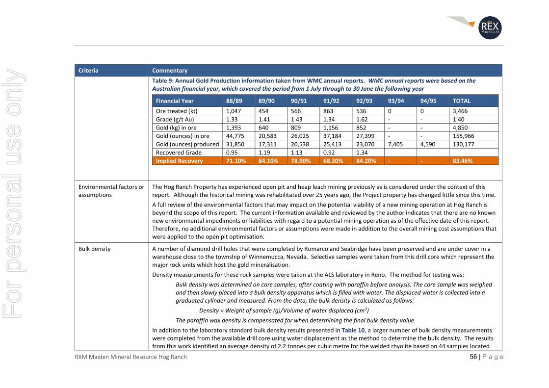
RXM Maiden Mineral Resource Hog Ranch 56 | P a g e
Criteria Commentary
Table 9: Annual Gold Production information taken from WMC annual reports. WMC annual reports were based on the Australian financial year, which covered the period from 1 July through to 30 June the following year
Financial Year 88/89 89/90 90/91 91/92 92/93 93/94 94/95 TOTAL
Ore treated (kt) 1,047 454 566 863 536 0 0 3,466
Grade (g/t Au) 1.33 1.41 1.43 1.34 1.62 ‐ ‐ 1.40
Gold (kg) in ore 1,393 640 809 1,156 852 ‐ ‐ 4,850
Gold (ounces) in ore 44,775 20,583 26,025 37,184 27,399 ‐ ‐ 155,966
Gold (ounces) produced 31,850 17,311 20,538 25,413 23,070 7,405 4,590 130,177
Recovered Grade 0.95 1.19 1.13 0.92 1.34
Implied Recovery 71.10% 84.10% 78.90% 68.30% 84.20% ‐ ‐ 83.46%
Environmental factors or assumptions
The Hog Ranch Property has experienced open pit and heap leach mining previously as is considered under the context of this report. Although the historical mining was rehabilitated over 25 years ago, the Project property has changed little since this time.
A full review of the environmental factors that may impact on the potential viability of a new mining operation at Hog Ranch is beyond the scope of this report. The current information available and reviewed by the author indicates that there are no known new environmental impediments or liabilities with regard to a potential mining operation as of the effective date of this report. Therefore, no additional environmental factors or assumptions were made in addition to the overall mining cost assumptions that were applied to the open pit optimisation.
Bulk density A number of diamond drill holes that were completed by Romarco and Seabridge have been preserved and are under cover in a warehouse close to the township of Winnemucca, Nevada. Selective samples were taken from this drill core which represent the major rock units which host the gold mineralisation.
Density measurements for these rock samples were taken at the ALS laboratory in Reno. The method for testing was:
Bulk density was determined on core samples, after coating with paraffin before analysis. The core sample was weighed and then slowly placed into a bulk density apparatus which is filled with water. The displaced water is collected into a graduated cylinder and measured. From the data, the bulk density is calculated as follows:
Density = Weight of sample (g)/Volume of water displaced (cm3)
The paraffin wax density is compensated for when determining the final bulk density value.
In addition to the laboratory standard bulk density results presented in Table 10, a larger number of bulk density measurements were completed from the available drill core using water displacement as the method to determine the bulk density. The results from this work identified an average density of 2.2 tonnes per cubic metre for the welded rhyolite based on 44 samples located
For
per
sona
l use
onl
y
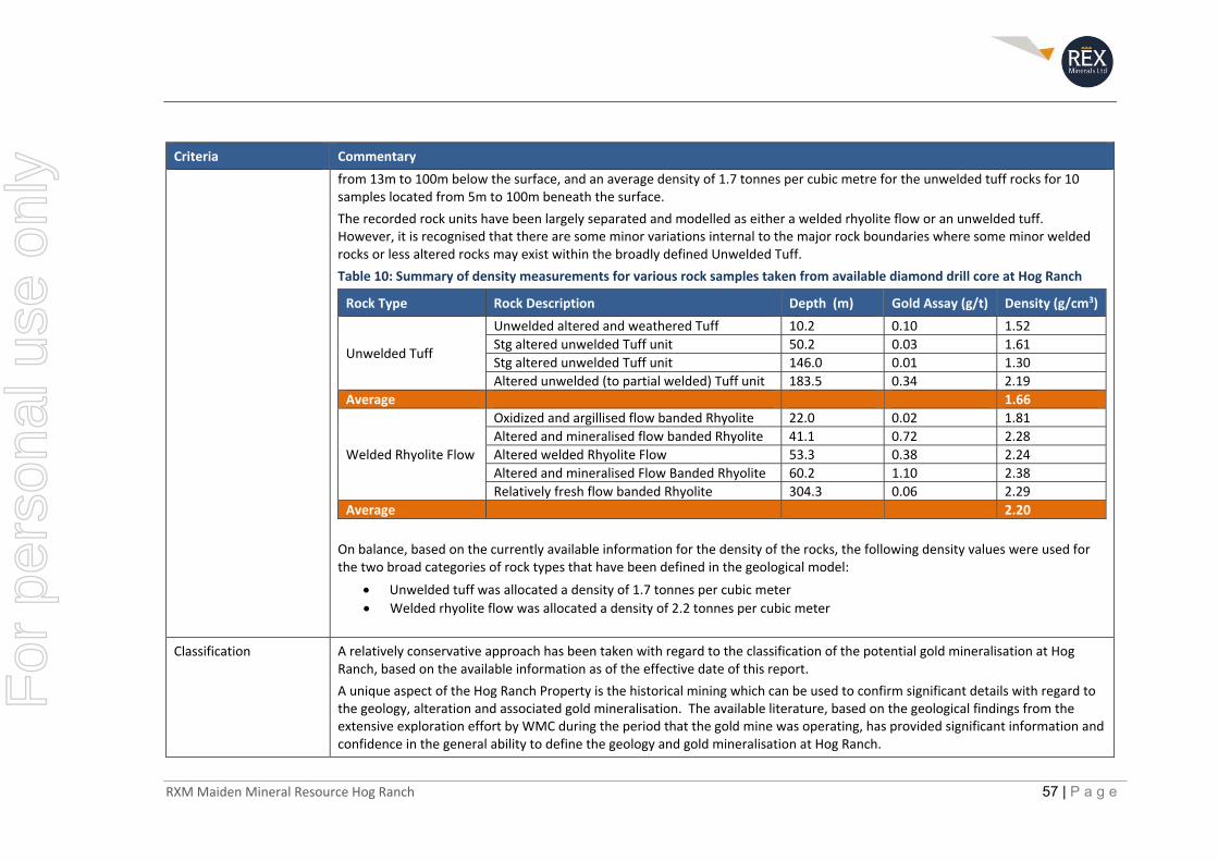
RXM Maiden Mineral Resource Hog Ranch 57 | P a g e
Criteria Commentary
from 13m to 100m below the surface, and an average density of 1.7 tonnes per cubic metre for the unwelded tuff rocks for 10 samples located from 5m to 100m beneath the surface.
The recorded rock units have been largely separated and modelled as either a welded rhyolite flow or an unwelded tuff. However, it is recognised that there are some minor variations internal to the major rock boundaries where some minor welded rocks or less altered rocks may exist within the broadly defined Unwelded Tuff.
Table 10: Summary of density measurements for various rock samples taken from available diamond drill core at Hog Ranch
Rock Type Rock Description Depth (m) Gold Assay (g/t) Density (g/cm3)
Unwelded Tuff
Unwelded altered and weathered Tuff 10.2 0.10 1.52
Stg altered unwelded Tuff unit 50.2 0.03 1.61
Stg altered unwelded Tuff unit 146.0 0.01 1.30
Altered unwelded (to partial welded) Tuff unit 183.5 0.34 2.19
Average 1.66
Welded Rhyolite Flow
Oxidized and argillised flow banded Rhyolite 22.0 0.02 1.81
Altered and mineralised flow banded Rhyolite 41.1 0.72 2.28
Altered welded Rhyolite Flow 53.3 0.38 2.24
Altered and mineralised Flow Banded Rhyolite 60.2 1.10 2.38
Relatively fresh flow banded Rhyolite 304.3 0.06 2.29
Average 2.20
On balance, based on the currently available information for the density of the rocks, the following density values were used for the two broad categories of rock types that have been defined in the geological model:
Unwelded tuff was allocated a density of 1.7 tonnes per cubic meter
Welded rhyolite flow was allocated a density of 2.2 tonnes per cubic meter
Classification A relatively conservative approach has been taken with regard to the classification of the potential gold mineralisation at Hog Ranch, based on the available information as of the effective date of this report.
A unique aspect of the Hog Ranch Property is the historical mining which can be used to confirm significant details with regard to the geology, alteration and associated gold mineralisation. The available literature, based on the geological findings from the extensive exploration effort by WMC during the period that the gold mine was operating, has provided significant information and confidence in the general ability to define the geology and gold mineralisation at Hog Ranch.
For
per
sona
l use
onl
y
RXM Maiden Mineral Resource Hog Ranch 58 | P a g e
Criteria Commentary
One aspect of the Project which is currently limiting the ability to convert larger sections of the block model created from the drill hole database at Hog Ranch, is the limited rock code information and confirmation of some sections of the drilling database.
Inferred Mineral Resource Classification
The approach taken to classify the Mineral Resource estimate at Hog Ranch was to extend the geological interpretation and associated mineralisation away from the known positions defined in the historical open pits.
The Inferred classification was adopted where the geology could be reasonably interpreted, and drill hole information identified a reasonable level of continuity within the shallow low‐grade gold mineralisation.
Given the general confidence in the geology and gold mineralisation in the locations classified as an Inferred Mineral Resource, it is considered that only minimal validation drilling would be required to further upgrade the currently defined Inferred Mineral Resource into an Indicated Mineral Resource.
A further constraint was applied to the block model for the purpose of defining the Inferred Mineral Resource based on the following:
An optimised open pit was developed on the Hog Ranch block model. Within this open pit optimisation, a cut‐off of 0.3g/t Au was applied and the Inferred Mineral Resource was then reported inside the pit above the cut‐off. The optimised pit shell was based on a US$1,300/oz gold price, $2.20/oz refining charge, 80% processing recovery, 45 degree wall angles, mining dilution of 5%, mining cost of US$2.6 per mined tonne and a processing/G&A cost of US$4.8 per ore tonne based on historical mining records and internal Rex estimates. In addition, overall Pad design parameters were considered based on documentation from KCA (1986) on the Heap Leach test work at Hog Ranch.
Exploration Target
Outside of the locations that were defined as an Inferred Mineral Resource, the remaining drill hole database and other historical information all provide strong evidence that there is further extensive shallow gold mineralisation at Hog Ranch. The validation completed to date, with regard to the drill hole database, indicates that this data can be used to reasonably represent the broader potential at Hog Ranch, or a larger Exploration Target range, which is supported by both the drilling and the scale of the known alteration system.
The existing drill hole database was used to further explore the potential scale of the gold mineralisation, depending on the possible continuity (yet to be confirmed) of the gold mineralisation that is reported in the drill hole database. The target range identified is restricted to possible continuity of between 100m and up to 400m away from the existing drill holes in the drill hole database, which are in addition to the defined Inferred Mineral Resource.
For
per
sona
l use
onl
y
RXM Maiden Mineral Resource Hog Ranch 59 | P a g e
Criteria Commentary
There is considered a significant likelihood that further exploration targets away from the known drill hole database could also identify further gold mineralisation that is outside of both the defined Exploration Target range defined in this report and away from existing drill hole information, but within the defined Hog Ranch alteration system.
Audits or reviews The basis of the estimation as outlined in the Table 1 ‘if not, why not” documentation and the reporting of the Inferred Mineral Resource has been independently peer reviewed by Peter Stoker of AMC Consultants Pty Ltd. The review was conducted via several skype screen sharing sessions reviewing the estimation inputs, processes, and block model, as well as reviewing the information in this public report. In AMC’s opinion, the resource models are a suitable basis for the public reporting of an Inferred Mineral Resource for Hog Ranch. AMC has also reviewed the basis for the development of the quoted range for the Exploration Target and considers that to be an acceptable basis for the reporting of the Exploration Target. AMC also considers the reporting of the Inferred Mineral Resource to be in accordance with the JORC Code.
Discussion of relative accuracy/confidence
The reported Inferred Mineral Resource has a relatively high level of confidence for this level of classification. This is due to the ability to interpret both the geology and gold mineralisation away from known historical gold mining and confirmed gold production.
The block model created from the drill hole database (which is based almost solely on RC rock chip samples and sampled via fire assay method) was reconciled against the reported production from the combined open pits and also individually against the production reported from the Bells mine. The reason for a specific review of the Bells mine is due to the understanding that the material mined at Bells was completed late in the mining sequence after WMC had stopped the practice of treating run‐of‐mine ore.
The data available for the run‐of‐mine ore is very poor, with as much as 2 million tonnes of this material mixed in with the global estimate. The run‐of‐mine ore is understood to have been at a much lower, but unknown, cut‐off grade in comparison to the crushed and agglomerated ore.
Table 11 provides a comparison for the reported total production from the Bells deposit, and Table 12 identifies the comparison between all the open pits excluding Bells. The cut‐off grade for the comparison is slightly higher at Bells as this is understood to have been required due to the additional haulage distance between Bells and the location of the leach pads in the Northern Hog Ranch area.
For
per
sona
l use
onl
y
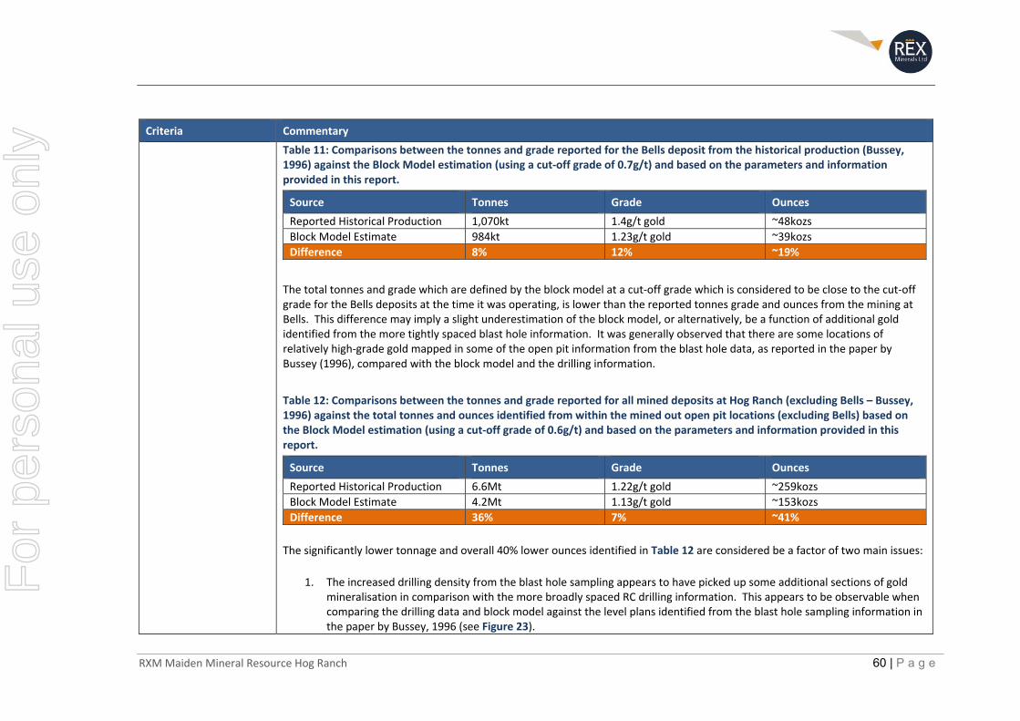
RXM Maiden Mineral Resource Hog Ranch 60 | P a g e
Criteria Commentary
Table 11: Comparisons between the tonnes and grade reported for the Bells deposit from the historical production (Bussey, 1996) against the Block Model estimation (using a cut‐off grade of 0.7g/t) and based on the parameters and information provided in this report.
Source Tonnes Grade Ounces
Reported Historical Production 1,070kt 1.4g/t gold ~48kozs
Block Model Estimate 984kt 1.23g/t gold ~39kozs
Difference 8% 12% ~19%
The total tonnes and grade which are defined by the block model at a cut‐off grade which is considered to be close to the cut‐off grade for the Bells deposits at the time it was operating, is lower than the reported tonnes grade and ounces from the mining at Bells. This difference may imply a slight underestimation of the block model, or alternatively, be a function of additional gold identified from the more tightly spaced blast hole information. It was generally observed that there are some locations of relatively high‐grade gold mapped in some of the open pit information from the blast hole data, as reported in the paper by Bussey (1996), compared with the block model and the drilling information.
Table 12: Comparisons between the tonnes and grade reported for all mined deposits at Hog Ranch (excluding Bells – Bussey, 1996) against the total tonnes and ounces identified from within the mined out open pit locations (excluding Bells) based on the Block Model estimation (using a cut‐off grade of 0.6g/t) and based on the parameters and information provided in this report.
Source Tonnes Grade Ounces
Reported Historical Production 6.6Mt 1.22g/t gold ~259kozs
Block Model Estimate 4.2Mt 1.13g/t gold ~153kozs
Difference 36% 7% ~41%
The significantly lower tonnage and overall 40% lower ounces identified in Table 12 are considered be a factor of two main issues:
1. The increased drilling density from the blast hole sampling appears to have picked up some additional sections of gold mineralisation in comparison with the more broadly spaced RC drilling information. This appears to be observable when comparing the drilling data and block model against the level plans identified from the blast hole sampling information in the paper by Bussey, 1996 (see Figure 23).
For
per
sona
l use
onl
y
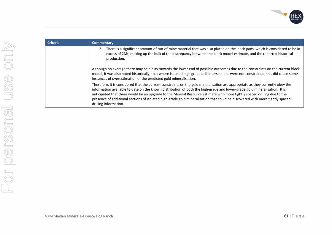
RXM Maiden Mineral Resource Hog Ranch 61 | P a g e
Criteria Commentary
2. There is a significant amount of run‐of‐mine material that was also placed on the leach pads, which is considered to be in excess of 2Mt, making up the bulk of the discrepancy between the block model estimate, and the reported historical production.
Although on average there may be a bias towards the lower end of possible outcomes due to the constraints on the current block model, it was also noted historically, that where isolated high grade drill intersections were not constrained, this did cause some instances of overestimation of the predicted gold mineralisation.
Therefore, it is considered that the current constraints on the gold mineralisation are appropriate as they currently obey the information available to date on the known distribution of both the high‐grade and lower‐grade gold mineralisation. It is anticipated that there would be an upgrade to the Mineral Resource estimate with more tightly spaced drilling due to the presence of additional sections of isolated high‐grade gold mineralisation that could be discovered with more tightly spaced drilling information.
For
per
sona
l use
onl
y
RXM Maiden Mineral Resource Hog Ranch 62 | P a g e
References Allard, G., Mian, N., Drossulis, K., Smith, K., 1987, Development of the Hog Ranch Mine Washoe County, Nevada: Internal company report prepared for Western Hog Ranch Company Inc.
Baker, D., 2010. NI43‐101 Technical Report, 2010 Technical Report on the Hog Ranch Property: Report prepared for ICN Resources Ltd.
Bussey, S.D., Taufen, P. M., Suchomel, B. J. and Ward, M. 1993. Soil and stream sediment geochemical dispersion over the Bells deposit, Hog Ranch Mine, Washoe County, Nevada: F.W. Dickson and L.C. Hsu (eds) Geochimical Exploration 1991, J. Geochem Explor., v 47, pp 217‐234.
Bussey, S. D., 1996. Gold mineralisation and associated rhyolitic volcanism at the Hog Ranch District, northwest Nevada: Geology and Ore Deposits of the American Cordillera: Geological Society of Nevada Symposium Proceedings, 1996, pp 181‐207.
Corbett, G. 2002, Epithermal Gold for Explorationists: AIG Journal, Applied Geoscientific practice and research in Australia. Paper 2002‐1, April.
Hedenquist, J. W., Arribas R., A., and Gonzalez‐Urien, E., 2000, Exploration for Epithermal Gold Deposits: Reviews in Economic Geology, v. 13, pp 245‐277.
Holso, S. 1982, Progress Report, Hog Ranch Project, Washoe County, Nevada: Internal company report prepared for Ferret Exploration Company Inc.
John, D. A., 2001, Miocene and Early Pliocene Epithermal Gold‐Silver Deposits in the Northern Great Basin, Western United States: Characteristics, Distribution, and Relationship to Magmatism: Economic Geology, v. 96, pp 1827‐1853.
Kappes, Cassiday and Associates, 1986, Hog Ranch Nevada, June 1985 Bulk Pit Samples 20ft Column Leach Tests_Final Report January 1986: Internal company report prepared for Ferret Exploration.
Marsden, H., and Baker, D., 2009. Geological and Geochemical Report on the Hog Ranch Project: Internal company report prepared for ICON Industries Ltd.
Ponce, D. A., and Glen, J. M. G., 2002, Relationship of epithermal gold deposits to large‐scale fractures in Northern Nevada: Economic Geology, v. 97, pp. 3‐9.
Saunders, J. A., Unger, D. L., Kamenov, G. D., Fayek, M., Hames, W. E., Utterback, W. C., 2008, Genesis of Middle Miocene Yellowstone hotspot‐related bonanza epithermal Au‐Ag deposits, Northern Great Basin, USA: Minerallium Deposita, DOI 10.1007/s00126‐008‐0201‐7
Sillitoe, R. H. 1993, Epithermal Models: Genetic types, Geometric controls and Shallow Features: GAC Special Paper 40, Mineral Deposit Modeling. pp 403‐417.
Smith, R. L., 1960. Zones and Zonal Variations in Welded Ash Flows: Geological Survey Professional Paper 354 – F. United States Department of the Interior, Geological Survey. pp. 149‐159.
Walker, W. W., 2003, Summary Report on the Hog Ranch Gold Project, Washoe County, Nevada: Internal company report prepared for Romarco Minerals Inc.
Walker, W. W., 2004, Summary Report on the Hog Ranch Gold Project, Washoe County, Nevada: Internal Technical report prepared for Romarco Minerals Inc.
White, N. C. and Hedenquist, J. W., 1995, Epithermal Gold Deposits, Styles, Characteristics and Exploration: Published in SEG Newsletter, 1995, No. 23, pp. 1, 9‐13
For
per
sona
l use
onl
y
RXM Maiden Mineral Resource Hog Ranch 63 | P a g e
Competent Persons Consent Form Pursuant to the requirements of ASX Listing Rules 5.6, 5.22 and 5.24 and Clause 9 of the JORC Code 2012
Edition (Written Consent Statement)
Report Name Mineral Resource Estimate –Report for the Hog Ranch Property, Nevada, USA
Company Name Rex Minerals Ltd (REX)
Name of the Deposit/Property Hog Ranch Gold Property, Nevada, USA
Date of the Report 31 August 2019
Steven Richard Olsen
For
per
sona
l use
onl
y
RXM Maiden Mineral Resource Hog Ranch 64 | P a g e
Statement
I, Steven Richard Olsen, confirm that I am the Competent Person for the Report and:
I have read and understood the requirements of the 2012 Edition of the Australian Code for Reporting of Exploration Results, Mineral Resources and Ore Reserves (JORC Code, 2012 Edition).
I am a Competent Person as defined by the JORC Code 2012 Edition, having over five years’ experience that is relevant to the style of mineralisation and type of deposit described in the Report, and to the activity for which I am accepting responsibility.
I am a member of the Australasian Institute of Mining and Metallurgy (membership number 207675) and the Australian Institute of Geoscientists (membership number 7014).
I have reviewed the Report to which this Consent Statement applies.
I am an employee of Rex Minerals Ltd and have prepared the documentation for the Hog Ranch Gold Property in Nevada, USA on which the report is based for the period ending 31 August 2019.
I declare an interest in the Property as a shareholder of Rex Minerals and vendor of Hog Ranch Group which was acquired by Rex Minerals on 20 August 2019.
I verify that the Report is based on and fairly and accurately reflects in the form and context in which it appears, the information in my supporting documentation relating to Exploration Targets and Mineral Resources.
Consent
I consent to the release of the Report and this Consent Statement by the Directors of Rex Minerals Ltd.
Steven Richard Olsen
Date: 2 September 2019
Member ‐ AusIMM (membership number 207675) and,
Member ‐ AIG (membership number 7014)
______________________________ Kay Donehue
Signature of Witness Level 6, 1Collins Street, Melbourne VIC 3000
Name and address of Witness
For
per
sona
l use
onl
y
AMC Consultants Pty Ltd ABN 58 008 129 164
Level 21, 179 Turbot Street
Brisbane Qld 4000
Australia
T +61 7 3230 9000
W amcconsultants.com
2 September 2019
Mr Steven Olsen
Geology Director
Rex Minerals Limited
PO Box 3435 Rundle Mall
South Australia 5000
By email: [email protected]
External Peer Review – Maiden Mineral Resource Estimate Hog Ranch Gold Property August 2019
AMC Reference Number: 319038
Dear Steven,
Rex Minerals Limited (Rex) engaged AMC Consultants Pty Ltd (AMC) to undertake an external peer
review of the August 2019 Mineral Resource estimation and reporting of the Inferred Mineral Resource
for Rex’s Hog Ranch gold property in Nevada USA.
The review was essentially a desk top review, conducted via several skype screen sharing sessions
reviewing the estimation inputs, processes, and block model, as well as reviewing the information in
the public report, which includes a comprehensive JORC Code Table 1. The basis of the estimation
is outlined in the Table 1 ‘if not, why not” commentary.
As a result of the independent peer review AMC is of the opinion that the Hog Ranch resource model
has been prepared in accordance with acceptable industry standards and provides a suitable basis
for the public reporting by Rex of an Inferred Mineral Resource for Hog Ranch. AMC also considers
the classification and reporting of the Inferred Mineral Resource as reported in Rex Minerals Ltd ASX
and Media Release: 2 September 2019, to be in accordance with the JORC Code.
AMC has also reviewed the basis for the development of the quoted range for the reported
Exploration Target and considers that to be an acceptable basis for the reporting of the Exploration
Target.
The estimation and documentation of the resource estimate has been undertaken and supervised
by Mr Steven Olsen who in AMC’s opinion meets the requirements of the JORC Code to act as a
Competent Person for the public reporting of the Inferred Resource.
Yours sincerely
Peter Stoker
Principal Geologist
For
per
sona
l use
onl
y

319038 2
Reviewer’s Qualification – Peter Stoker
Peter is a Principal Geologist with AMC Consultants Pty Ltd, with over 40 years’ experience in mine
geology, Mineral Resource and Ore Reserve estimation, feasibility studies, project evaluation, mineral
exploration and public reporting of information under the JORC Code. Commodity experience
includes base metals (copper, lead-zinc-silver, nickel), gold, copper-gold (porphyry and iron oxide),
bauxite and sedimentary uranium.
Peter is an Honorary Fellow of The Australasian Institute of Mining and Metallurgy (AusIMM) and a
Chartered Professional (Geology). He was a member of the Steering Committee and a contributor
for Monograph 23 “Mineral Resource and Ore Reserve Estimation – The AusIMM Guide to Good
Practice”, and an author and peer reviewer for “Mineral Resource and Ore Reserve Estimation – The
AusIMM Guide to Good Practice”, second edition, Monograph 30, and has authored or co-authored
a number of papers on Mineral Resource and Ore Reserve estimation, classification, exploration
research and practice.
Distribution list:
1 electronic copy to Mr Steven Olsen, Rex Minerals Limited
1 electronic copy to AMC Brisbane Office
For
per
sona
l use
onl
y