map id map findings direction - granicus
TRANSCRIPT

MAP FINDINGSMap IDDirection
EDR ID NumberDistanceEPA ID NumberDatabase(s)SiteElevation
Closed CaseFacility Status: Soils OnlyFacility Type: LOP - Federal FundFunding: DEH Site Assessment & MitigationAgency: H12937-001Case Number:
SAN DIEGO CO. SAM:
Leak BeganAction: 01/01/1950Date: OtherAction Type: T06019707776Global Id:
Leak ReportedAction: 01/01/1950Date: OtherAction Type: T06019707776Global Id:
Leak DiscoveryAction: 01/01/1950Date: OtherAction Type: T06019707776Global Id:
Leak StoppedAction: 01/01/1950Date: OtherAction Type: T06019707776Global Id:
Notice of ResponsibilityAction: 04/12/2004Date: ENFORCEMENTAction Type: T06019707776Global Id:
Regulatory Activities:
Not reportedPhone Number: [email protected]: San DiegoCity: P.O. Box 129261Address: SAN DIEGO COUNTY LOPOrganization Name: JON SENAHAContact Name: Local Agency CaseworkerContact Type: T06019707776Global Id:
Contact:
Click here to access the California GeoTracker records for this facility:
Not reportedSite History: GasolinePotential Contaminants of Concern: SoilPotential Media Affect: Local AgencyFile Location: H12937-001LOC Case Number: Not reportedRB Case Number: SAN DIEGO COUNTY LOPLocal Agency: JSCase Worker: SAN DIEGO COUNTY LOPLead Agency: 04/14/2005Status Date: Completed - Case ClosedStatus:
SHELL (Continued) S106875058
TC3662583.2s Page 18
MARCH 17, 2016 ITEM 8A 1001 of 1654

MAP FINDINGSMap IDDirection
EDR ID NumberDistanceEPA ID NumberDatabase(s)SiteElevation
11/25/2003Date Began: 4/14/2005Date:
SHELL (Continued) S106875058
-117.29372Longitude:33.06452Latitude:H12937Facility ID:
UST:
710 ft. Site 3 of 13 in cluster B0.134 mi.
Relative:Higher
Actual:163 ft.
1/8-1/4 ENCINITAS, CA 92024ENE 865 ORPHEUS AVE N/AB8 USTLEUCADIA SHELL U003789399
865 ORPHEUS AVEAddress: 2005Year: LEUCADIA SHELL SERVICE STATIONName:
865 ORPHEUS AVEAddress: 2002Year: LEUCADIA SHELL SERVICE STATIONName:
865 ORPHEUS AVEAddress: 2001Year: LEUCADIA SHELL SERVICE STATIONName:
865 ORPHEUS AVEAddress: 2000Year: LEUCADIA SHELL SERVICE STATIONName:
865 ORPHEUS AVEAddress: 1999Year: LEUCADIA SHELL SERVICE STATIONName:
EDR Historical Auto Stations:
710 ft. Site 4 of 13 in cluster B0.134 mi.
Relative:Higher
Actual:163 ft.
1/8-1/4 ENCINITAS, CA 92024ENE 865 ORPHEUS AVE N/AB9 EDR US Hist Auto Stat 1015659099
6197530077Telephone: SAMEContact Name: 0004Total Tanks: Not reportedOther Type: Gas StationFacility Type: 00000010472Facility ID: STATERegion:
HIST UST:
710 ft. Site 5 of 13 in cluster B0.134 mi.
Relative:Higher
Actual:163 ft.
1/8-1/4 ENCINITAS, CA 92024ENE SWEEPS UST865 ORPHEUS AVE N/AB10 HIST USTLEE ANN DONNELLY U001571349
TC3662583.2s Page 19
MARCH 17, 2016 ITEM 8A 1002 of 1654

MAP FINDINGSMap IDDirection
EDR ID NumberDistanceEPA ID NumberDatabase(s)SiteElevation
4Number Of Tanks: REG UNLEADEDContent: PStg: M.V. FUELTank Use: 10000Capacity: Not reportedActv Date: 37-000-012937-000002Swrcb Tank Id: Not reportedOwner Tank Id: ATank Status: 02-29-88Created Date: 06-26-92Action Date: Not reportedReferral Date: 44-000074Board Of Equalization: 9Number: 12937Comp Number: ActiveStatus:
SWEEPS UST:
Stock Inventor, Groundwater Monitoring Well, 10Leak Detection: 1/4 inchesTank Construction: PREMIUMType of Fuel: PRODUCTTank Used for: 00010000Tank Capacity: 1982Year Installed: 4Container Num: 004Tank Num:
Stock Inventor, Groundwater Monitoring Well, 10Leak Detection: 1/4 inchesTank Construction: REGULARType of Fuel: PRODUCTTank Used for: 00010000Tank Capacity: 1982Year Installed: 3Container Num: 003Tank Num:
Stock Inventor, Groundwater Monitoring Well, 10Leak Detection: 1/4 inchesTank Construction: UNLEADEDType of Fuel: PRODUCTTank Used for: 00010000Tank Capacity: 1982Year Installed: 2Container Num: 002Tank Num:
Stock Inventor, 10Leak Detection: 12 gaugeTank Construction: WASTE OILType of Fuel: WASTETank Used for: 00000550Tank Capacity: 1969Year Installed: 1Container Num: 001Tank Num:
ANAHEIM, CA 92803Owner City,St,Zip: P.O. BOX 4848Owner Address: SHELL OIL COMPANYOwner Name:
LEE ANN DONNELLY (Continued) U001571349
TC3662583.2s Page 20
MARCH 17, 2016 ITEM 8A 1003 of 1654

MAP FINDINGSMap IDDirection
EDR ID NumberDistanceEPA ID NumberDatabase(s)SiteElevation
Not reportedAction Date: Not reportedReferral Date: 44-000074Board Of Equalization: Not reportedNumber: 12937Comp Number: Not reportedStatus:
Not reportedNumber Of Tanks: Not reportedContent: WStg: UNKNOWNTank Use: 550Capacity: Not reportedActv Date: 37-000-012937-000005Swrcb Tank Id: Not reportedOwner Tank Id: ATank Status: 02-29-88Created Date: 06-26-92Action Date: Not reportedReferral Date: 44-000074Board Of Equalization: 9Number: 12937Comp Number: ActiveStatus:
Not reportedNumber Of Tanks: LEADEDContent: PStg: M.V. FUELTank Use: 10000Capacity: Not reportedActv Date: 37-000-012937-000004Swrcb Tank Id: Not reportedOwner Tank Id: ATank Status: 02-29-88Created Date: 06-26-92Action Date: Not reportedReferral Date: 44-000074Board Of Equalization: 9Number: 12937Comp Number: ActiveStatus:
Not reportedNumber Of Tanks: LEADEDContent: PStg: M.V. FUELTank Use: 10000Capacity: Not reportedActv Date: 37-000-012937-000003Swrcb Tank Id: Not reportedOwner Tank Id: ATank Status: 02-29-88Created Date: 06-26-92Action Date: Not reportedReferral Date: 44-000074Board Of Equalization: 9Number: 12937Comp Number: ActiveStatus:
LEE ANN DONNELLY (Continued) U001571349
TC3662583.2s Page 21
MARCH 17, 2016 ITEM 8A 1004 of 1654

MAP FINDINGSMap IDDirection
EDR ID NumberDistanceEPA ID NumberDatabase(s)SiteElevation
1Number Of Tanks: Not reportedContent: WASTEStg: PETROLEUMTank Use: 550Capacity: Not reportedActv Date: 37-000-012937-000001Swrcb Tank Id: Not reportedOwner Tank Id: Not reportedTank Status: Not reportedCreated Date:
LEE ANN DONNELLY (Continued) U001571349
NoTreater, storer or disposer of HW: NoTransporter of hazardous waste: NoRecycler of hazardous waste: NoMixed waste (haz. and radioactive): NoU.S. importer of hazardous waste:
Handler Activities Summary:
Not reportedOwner/Op end date: Not reportedOwner/Op start date: OwnerOwner/Operator Type: PrivateLegal status: (713) 241-5036Owner/operator telephone: Not reportedOwner/operator country: HOUSTON, TX 77252 P O BOX 2099Owner/operator address: EQUILON ENTERPRISES L L COwner/operator name:
Owner/Operator Summary:
hazardous waste at any time waste during any calendar month, and accumulates more than 1000 kg of hazardous waste at any time; or generates 100 kg or less of hazardous waste during any calendar month and accumulates less than 6000 kg of Handler: generates more than 100 and less than 1000 kg of hazardousDescription: Small Small Quantity GeneratorClassification: 09EPA Region: Not reportedContact email: (713) 241-5036Contact telephone: USContact country: HOUSTON, TX 772522099 P O BOX 2099Contact address: SONDRA BIENVENUContact: HOUSTON, TX 772522099 P O BOX 2099Mailing address: CAR000080465EPA ID: LEUCADIA, CA 92024 S A P 121651 902 ORPHEUSFacility address: TEXACO SERVICE STATIONFacility name: 08/14/2000Date form received by agency:
RCRA-SQG:
795 ft. Site 6 of 13 in cluster B0.151 mi.
Relative:Higher
Actual:163 ft.
1/8-1/4 LEUCADIA, CA 92024ENE HAZNET902 ORPHEUS CAR000080465B11 RCRA-SQGTEXACO SERVICE STATION 1004676066
TC3662583.2s Page 22
MARCH 17, 2016 ITEM 8A 1005 of 1654

MAP FINDINGSMap IDDirection
EDR ID NumberDistanceEPA ID NumberDatabase(s)SiteElevation
RecyclerDisposal Method: Waste oil and mixed oilWaste Category: Not reportedTSD County: CAT080013352TSD EPA ID: Not reportedGen County: HOUSTON, TX 770670000Mailing City,St,Zip: 12700 NORTHBOROUGH DR 300G03Mailing Address: Not reportedMailing Name: 2818742224Telephone: R HULL/ENV. REPORTING ANALYSTContact: CAR000080465Gepaid: 2006Year:
00Facility County: 1.25Tons: RecyclerDisposal Method: Aqueous solution with total organic residues less than 10 percentWaste Category: Not reportedTSD County: CAT080013352TSD EPA ID: Not reportedGen County: HOUSTON, TX 770670000Mailing City,St,Zip: 12700 NORTHBOROUGH DR 300G03Mailing Address: Not reportedMailing Name: 2818742224Telephone: R HULL/ENV. REPORTING ANALYSTContact: CAR000080465Gepaid: 2006Year:
HAZNET:
No violations foundViolation Status:
BENZENEWaste name: D018Waste code:
WHICH WOULD BE CONSIDERED AS IGNITABLE HAZARDOUS WASTE. MATERIAL. LACQUER THINNER IS AN EXAMPLE OF A COMMONLY USED SOLVENT WHICH CAN BE OBTAINED FROM THE MANUFACTURER OR DISTRIBUTOR OF THE FLASH POINT OF A WASTE IS TO REVIEW THE MATERIAL SAFETY DATA SHEET, CLOSED CUP FLASH POINT TESTER. ANOTHER METHOD OF DETERMINING THE LESS THAN 140 DEGREES FAHRENHEIT AS DETERMINED BY A PENSKY-MARTENS IGNITABLE HAZARDOUS WASTES ARE THOSE WASTES WHICH HAVE A FLASHPOINT OFWaste name: D001Waste code:
Not DefinedWaste name: D000Waste code:
Hazardous Waste Summary:
NoUsed oil transporter: NoUsed oil transfer facility: NoUsed oil Specification marketer: NoUsed oil fuel marketer to burner: NoUser oil refiner: NoUsed oil processor: NoUsed oil fuel burner: NoFurnace exemption: NoOn-site burner exemption: NoUnderground injection activity:
TEXACO SERVICE STATION (Continued) 1004676066
TC3662583.2s Page 23
MARCH 17, 2016 ITEM 8A 1006 of 1654

MAP FINDINGSMap IDDirection
EDR ID NumberDistanceEPA ID NumberDatabase(s)SiteElevation
7 additional CA_HAZNET: record(s) in the EDR Site Report.Click this hyperlink while viewing on your computer to access
00Facility County: 0.01Tons: Transfer StationDisposal Method: Other organic solidsWaste Category: Not reportedTSD County: CAD028409019TSD EPA ID: Not reportedGen County: HOUSTON, TX 770672508Mailing City,St,Zip: 12700 NORTHBOROUGH DR MFT 240-GMailing Address: Not reportedMailing Name: 2818742224Telephone: N CORTEZ/ENVT’L DATA ANALYSTContact: CAR000080465Gepaid: 2004Year:
00Facility County: 0.01Tons: Transfer StationDisposal Method: Other organic solidsWaste Category: Not reportedTSD County: CAD008364432TSD EPA ID: Not reportedGen County: HOUSTON, TX 770672508Mailing City,St,Zip: 12700 NORTHBOROUGH DR MFT 240-GMailing Address: Not reportedMailing Name: 2818742224Telephone: N CORTEZ/ENVT’L DATA ANALYSTContact: CAR000080465Gepaid: 2004Year:
00Facility County: 5.45Tons: RecyclerDisposal Method: Tank bottom wasteWaste Category: Not reportedTSD County: CAT080013352TSD EPA ID: Not reportedGen County: HOUSTON, TX 770670000Mailing City,St,Zip: 12700 NORTHBOROUGH DR 300G03Mailing Address: Not reportedMailing Name: 2818742224Telephone: R HULL/ENV. REPORTING ANALYSTContact: CAR000080465Gepaid: 2006Year:
00Facility County: 1.04Tons:
TEXACO SERVICE STATION (Continued) 1004676066
TC3662583.2s Page 24
MARCH 17, 2016 ITEM 8A 1007 of 1654
MAP FINDINGSMap IDDirection
EDR ID NumberDistanceEPA ID NumberDatabase(s)SiteElevation
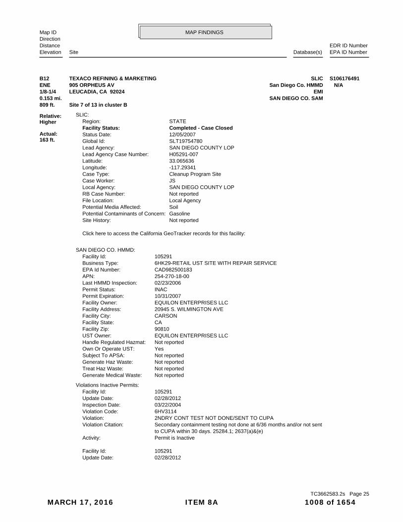
02/28/2012Update Date: 105291Facility Id:
Permit is InactiveActivity: to CUPA within 30 days. 25284.1; 2637(a)&(e) Secondary containment testing not done at 6/36 months and/or not sentViolation Citation: 2NDRY CONT TEST NOT DONE/SENT TO CUPAViolation: 6HV3114Violation Code: 03/22/2004Inspection Date: 02/28/2012Update Date: 105291Facility Id:
Violations Inactive Permits:
Not reportedGenerate Medical Waste: Not reportedTreat Haz Waste: Not reportedGenerate Haz Waste: Not reportedSubject To APSA: YesOwn Or Operate UST: Not reportedHandle Regulated Hazmat: EQUILON ENTERPRISES LLCUST Owner: 90810Facility Zip: CAFacility State: CARSONFacility City: 20945 S. WILMINGTON AVEFacility Address: EQUILON ENTERPRISES LLCFacility Owner: 10/31/2007Permit Expiration: INACPermit Status: 02/23/2006Last HMMD Inspection: 254-270-18-00APN: CAD982500183EPA Id Number: 6HK29-RETAIL UST SITE WITH REPAIR SERVICEBusiness Type: 105291Facility Id:
SAN DIEGO CO. HMMD:
Click here to access the California GeoTracker records for this facility:
Not reportedSite History: GasolinePotential Contaminants of Concern: SoilPotential Media Affected: Local AgencyFile Location: Not reportedRB Case Number: SAN DIEGO COUNTY LOPLocal Agency: JSCase Worker: Cleanup Program SiteCase Type: -117.29341Longitude: 33.065636Latitude: H05291-007Lead Agency Case Number: SAN DIEGO COUNTY LOPLead Agency: SLT19754780Global Id: 12/05/2007Status Date: Completed - Case ClosedFacility Status: STATERegion:
SLIC:
809 ft. Site 7 of 13 in cluster B0.153 mi. SAN DIEGO CO. SAM
Relative:Higher
Actual:163 ft.
1/8-1/4 EMILEUCADIA, CA 92024ENE San Diego Co. HMMD905 ORPHEUS AV N/AB12 SLICTEXACO REFINING & MARKETING S106176491
TC3662583.2s Page 25
MARCH 17, 2016 ITEM 8A 1008 of 1654

MAP FINDINGSMap IDDirection
EDR ID NumberDistanceEPA ID NumberDatabase(s)SiteElevation
02/28/2012Update Date: 105291Facility Id:
Permit is InactiveActivity: 66265.16(d)&(e) with requirements for current and former employees. CCR Personnel training records are not maintained to document complianceViolation Citation: TRAINING RECORDS UNAVAILABLEViolation: 6HV0401Violation Code: 11/12/2002Inspection Date: 02/28/2012Update Date: 105291Facility Id:
Permit is InactiveActivity: 25291(a)(7)(C) Sensors not placed adequately and/or at low point in sumps. 2641(a),Violation Citation: SENSORS NOT AT LOW POINT OR ADEQUATELYViolation: 6HV3258Violation Code: 11/12/2002Inspection Date: 02/28/2012Update Date: 105291Facility Id:
Permit is InactiveActivity: 66262.40(a) waste manifest from the TSD facility on site for review. CCR Generator has not maintained the required signed copy of the hazardousViolation Citation: NO TSDF SIGNED MANIFEST ONSITEViolation: 6HV0138Violation Code: 03/22/2004Inspection Date: 02/28/2012Update Date: 105291Facility Id:
Permit is InactiveActivity: detector not certified annually 25284.1(a)(4)(C); 2630(d), 2641(j) DOUBLE WALLED PRESSURIZED PIPING: OPTION 3-Automatic line leakViolation Citation: AUTOMATIC LLD NOT CERTIFIED ANNUALLYViolation: 6HV3406Violation Code: 03/16/2005Inspection Date: 02/28/2012Update Date: 105291Facility Id:
Permit is InactiveActivity: 2635(b)(1), 2636(a)(1) Spill container is not in good condition and/or liquid free.Violation Citation: SPILL CONTAIN. NOT DRY/IN GOOD CONDITIONViolation: 6HV3255Violation Code: 03/22/2004Inspection Date: 02/28/2012Update Date: 105291Facility Id:
Permit is InactiveActivity: & 25160.2(b)(3) onsite to document proper disposal of hazardous waste. CCR 66262.40(a) Hazardous waste manifests/receipts for 3 years are not maintainedViolation Citation: MANIFESTS/RECEIPTS FOR 3 YEARS NOT ONSITViolation: 6HV0135Violation Code: 11/12/2002Inspection Date:
TEXACO REFINING & MARKETING (Continued) S106176491
TC3662583.2s Page 26
MARCH 17, 2016 ITEM 8A 1009 of 1654

MAP FINDINGSMap IDDirection
EDR ID NumberDistanceEPA ID NumberDatabase(s)SiteElevation
3984Facility ID: SDAir Basin: 37County Code: 2002Year:
0Part. Matter 10 Micrometers & Smllr Tons/Yr: 0Particulate Matter Tons/Yr: 0SOX - Oxides of Sulphur Tons/Yr: 0NOX - Oxides of Nitrogen Tons/Yr: 0Carbon Monoxide Emissions Tons/Yr: 3Reactive Organic Gases Tons/Yr: 3Total Organic Hydrocarbon Gases Tons/Yr: Not reportedConsolidated Emission Reporting Rule: Not reportedCommunity Health Air Pollution Info System: SAN DIEGO COUNTY APCDAir District Name: 5541SIC Code: SDAir District Name: 3984Facility ID: SDAir Basin: 37County Code: 2001Year:
0Part. Matter 10 Micrometers & Smllr Tons/Yr: 0Particulate Matter Tons/Yr: 0SOX - Oxides of Sulphur Tons/Yr: 0NOX - Oxides of Nitrogen Tons/Yr: 0Carbon Monoxide Emissions Tons/Yr: 2Reactive Organic Gases Tons/Yr: 2Total Organic Hydrocarbon Gases Tons/Yr: Not reportedConsolidated Emission Reporting Rule: Not reportedCommunity Health Air Pollution Info System: SAN DIEGO COUNTY APCDAir District Name: 5541SIC Code: SDAir District Name: 3984Facility ID: SDAir Basin: 37County Code: 2000Year:
EMI:
Permit is InactiveActivity: & 25160.2(b)(3) onsite to document proper disposal of hazardous waste. CCR 66262.40(a) Hazardous waste manifests/receipts for 3 years are not maintainedViolation Citation: MANIFESTS/RECEIPTS FOR 3 YEARS NOT ONSITViolation: 6HV0135Violation Code: 03/16/2005Inspection Date: 02/28/2012Update Date: 105291Facility Id:
Permit is InactiveActivity: 25292.2(a), 25299.33; 2809 Current evidence of financial responsibility not available.Violation Citation: NO CURRENT FINANCIAL RESPONSIBILITYViolation: 6HV3105Violation Code: 11/12/2002Inspection Date:
TEXACO REFINING & MARKETING (Continued) S106176491
TC3662583.2s Page 27
MARCH 17, 2016 ITEM 8A 1010 of 1654

MAP FINDINGSMap IDDirection
EDR ID NumberDistanceEPA ID NumberDatabase(s)SiteElevation
2.4963736Total Organic Hydrocarbon Gases Tons/Yr: Not reportedConsolidated Emission Reporting Rule: Not reportedCommunity Health Air Pollution Info System: SAN DIEGO COUNTY APCDAir District Name: 5541SIC Code: SDAir District Name: 3984Facility ID: SDAir Basin: 37County Code: 2005Year:
0Part. Matter 10 Micrometers & Smllr Tons/Yr: 0Particulate Matter Tons/Yr: 0SOX - Oxides of Sulphur Tons/Yr: 0NOX - Oxides of Nitrogen Tons/Yr: 0Carbon Monoxide Emissions Tons/Yr: 2.4963736Reactive Organic Gases Tons/Yr: 2.4963736Total Organic Hydrocarbon Gases Tons/Yr: Not reportedConsolidated Emission Reporting Rule: Not reportedCommunity Health Air Pollution Info System: SAN DIEGO COUNTY APCDAir District Name: 5541SIC Code: SDAir District Name: 3984Facility ID: SDAir Basin: 37County Code: 2004Year:
0Part. Matter 10 Micrometers & Smllr Tons/Yr: 0Particulate Matter Tons/Yr: 0SOX - Oxides of Sulphur Tons/Yr: 0NOX - Oxides of Nitrogen Tons/Yr: 0Carbon Monoxide Emissions Tons/Yr: 2Reactive Organic Gases Tons/Yr: 2Total Organic Hydrocarbon Gases Tons/Yr: Not reportedConsolidated Emission Reporting Rule: Not reportedCommunity Health Air Pollution Info System: SAN DIEGO COUNTY APCDAir District Name: 5541SIC Code: SDAir District Name: 3984Facility ID: SDAir Basin: 37County Code: 2003Year:
0Part. Matter 10 Micrometers & Smllr Tons/Yr: 0Particulate Matter Tons/Yr: 0SOX - Oxides of Sulphur Tons/Yr: 0NOX - Oxides of Nitrogen Tons/Yr: 0Carbon Monoxide Emissions Tons/Yr: 2Reactive Organic Gases Tons/Yr: 2Total Organic Hydrocarbon Gases Tons/Yr: Not reportedConsolidated Emission Reporting Rule: Not reportedCommunity Health Air Pollution Info System: SAN DIEGO COUNTY APCDAir District Name: 5541SIC Code: SDAir District Name:
TEXACO REFINING & MARKETING (Continued) S106176491
TC3662583.2s Page 28
MARCH 17, 2016 ITEM 8A 1011 of 1654

MAP FINDINGSMap IDDirection
EDR ID NumberDistanceEPA ID NumberDatabase(s)SiteElevation
0Part. Matter 10 Micrometers & Smllr Tons/Yr: 0Particulate Matter Tons/Yr: 0SOX - Oxides of Sulphur Tons/Yr: 0NOX - Oxides of Nitrogen Tons/Yr: 0Carbon Monoxide Emissions Tons/Yr: 1.78Reactive Organic Gases Tons/Yr: 1.78Total Organic Hydrocarbon Gases Tons/Yr: Not reportedConsolidated Emission Reporting Rule: Not reportedCommunity Health Air Pollution Info System: SAN DIEGO COUNTY APCDAir District Name: 5541SIC Code: SDAir District Name: 3984Facility ID: SDAir Basin: 37County Code: 2007Year:
0Part. Matter 10 Micrometers & Smllr Tons/Yr: 0Particulate Matter Tons/Yr: 0SOX - Oxides of Sulphur Tons/Yr: 0NOX - Oxides of Nitrogen Tons/Yr: 0Carbon Monoxide Emissions Tons/Yr: 1.78Reactive Organic Gases Tons/Yr: 1.78Total Organic Hydrocarbon Gases Tons/Yr: Not reportedConsolidated Emission Reporting Rule: Not reportedCommunity Health Air Pollution Info System: SAN DIEGO COUNTY APCDAir District Name: 5541SIC Code: SDAir District Name: 3984Facility ID: SDAir Basin: 37County Code: 2007Year:
0Part. Matter 10 Micrometers & Smllr Tons/Yr: 0Particulate Matter Tons/Yr: 0SOX - Oxides of Sulphur Tons/Yr: 0NOX - Oxides of Nitrogen Tons/Yr: 0Carbon Monoxide Emissions Tons/Yr: 1.78Reactive Organic Gases Tons/Yr: 1.78Total Organic Hydrocarbon Gases Tons/Yr: Not reportedConsolidated Emission Reporting Rule: Not reportedCommunity Health Air Pollution Info System: SAN DIEGO COUNTY APCDAir District Name: 5541SIC Code: SDAir District Name: 3984Facility ID: SDAir Basin: 37County Code: 2006Year:
0Part. Matter 10 Micrometers & Smllr Tons/Yr: 0Particulate Matter Tons/Yr: 0SOX - Oxides of Sulphur Tons/Yr: 0NOX - Oxides of Nitrogen Tons/Yr: 0Carbon Monoxide Emissions Tons/Yr: 2.4963736Reactive Organic Gases Tons/Yr:
TEXACO REFINING & MARKETING (Continued) S106176491
TC3662583.2s Page 29
MARCH 17, 2016 ITEM 8A 1012 of 1654

MAP FINDINGSMap IDDirection
EDR ID NumberDistanceEPA ID NumberDatabase(s)SiteElevation
7/21/2006Date Began: 12/5/2007Date: Closed CaseFacility Status: Soils OnlyFacility Type: Private - VAPFunding: DEH Site Assessment & MitigationAgency: H05291-007Case Number:
SAN DIEGO CO. SAM:
TEXACO REFINING & MARKETING (Continued) S106176491
905 ORPHEUS AVEAddress: 2006Year: TEXACOName:
905 ORPHEUS AVEAddress: 2003Year: LEUCADIA TEXACOName:
905 ORPHEUS AVEAddress: 2002Year: LEUCADIA TEXACOName:
905 ORPHEUS AVEAddress: 2001Year: LEUCADIA TEXACOName:
905 ORPHEUS AVEAddress: 2000Year: LEUCADIA TEXACOName:
905 ORPHEUS AVEAddress: 1999Year: LEUCADIA TEXACOName:
EDR Historical Auto Stations:
809 ft. Site 8 of 13 in cluster B0.153 mi.
Relative:Higher
Actual:163 ft.
1/8-1/4 ENCINITAS, CA 92024ENE 905 ORPHEUS AVE N/AB13 EDR US Hist Auto Stat 1015669638
-117.29368Longitude:33.0653Latitude:H05291Facility ID:
UST:
809 ft. Site 9 of 13 in cluster B0.153 mi.
Relative:Higher
Actual:163 ft.
1/8-1/4 ENCINITAS, CA 92024ENE 905 ORPHEUS AVE N/AB14 USTTEXACO REFINING & MARKETING U003941917
TC3662583.2s Page 30
MARCH 17, 2016 ITEM 8A 1013 of 1654

MAP FINDINGSMap IDDirection
EDR ID NumberDistanceEPA ID NumberDatabase(s)SiteElevation
809 ft. Site 10 of 13 in cluster B0.153 mi.
Relative:Higher
Actual:163 ft.
1/8-1/4 ENCINITAS, CA 92024ENE 905 ORPHEUS N/AB15 LUSTEXXON SERVICE STATION S105034167
Soils OnlyFacility Type: LOP - Federal FundFunding: DEH Site Assessment & MitigationAgency: H05291-006Case Number:
8/4/1994Date Began: 9/22/1994Date: Closed CaseFacility Status: Failed Integrity TestFacility Type: Non BillableFunding: DEH Site Assessment & MitigationAgency: H05291-005Case Number:
8/16/1990Date Began: 7/30/1990Date: Closed CaseFacility Status: Failed Integrity TestFacility Type: Non BillableFunding: DEH Site Assessment & MitigationAgency: H05291-004Case Number:
10/28/1987Date Began: 11/6/1987Date: Closed CaseFacility Status: Failed Integrity TestFacility Type: Non BillableFunding: DEH Site Assessment & MitigationAgency: H05291-003Case Number:
4/14/1987Date Began: 9/25/1987Date: Closed CaseFacility Status: Soils OnlyFacility Type: Private - VAPFunding: DEH Site Assessment & MitigationAgency: H05291-002Case Number:
8/14/1986Date Began: 9/30/1986Date: Closed CaseFacility Status: Failed Integrity TestFacility Type: Non BillableFunding: DEH Site Assessment & MitigationAgency: H05291-001Case Number:
SAN DIEGO CO. SAM:
809 ft. Site 11 of 13 in cluster B0.153 mi.
Relative:Higher
Actual:163 ft.
1/8-1/4 ENCINITAS, CA 92024ENE 905 ORPHEUS AV N/AB16 SAN DIEGO CO. SAMTEXACO REFINING & MARKETING S106875411
TC3662583.2s Page 31
MARCH 17, 2016 ITEM 8A 1014 of 1654

MAP FINDINGSMap IDDirection
EDR ID NumberDistanceEPA ID NumberDatabase(s)SiteElevation
2/18/2003Date Began: 1/28/2005Date: Closed CaseFacility Status:
TEXACO REFINING & MARKETING (Continued) S106875411
T0607391100Global Id:Regulatory Activities:
Not reportedPhone Number: [email protected]: San DiegoCity: P.O. Box 129261Address: SAN DIEGO COUNTY LOPOrganization Name: JON SENAHAContact Name: Local Agency CaseworkerContact Type: T0607391100Global Id:
Not reportedPhone Number: Not reportedEmail: SAN DIEGOCity: 9174 SKY PARK COURT, SUITE 100Address: SAN DIEGO RWQCB (REGION 9)Organization Name: UnassignedContact Name: Regional Board CaseworkerContact Type: T0607391100Global Id:
Contact:
Click here to access the California GeoTracker records for this facility:
Not reportedSite History: DieselPotential Contaminants of Concern: SoilPotential Media Affect: Local AgencyFile Location: H05291-006LOC Case Number: Not reportedRB Case Number: SAN DIEGO COUNTY LOPLocal Agency: JSCase Worker: SAN DIEGO COUNTY LOPLead Agency: 01/28/2005Status Date: Completed - Case ClosedStatus: LUST Cleanup SiteCase Type: -117.29341Longitude: 33.065636Latitude: T0607391100Global Id: STATERegion:
LUST:
9UT164Reg Id: LTNKAReg By: 37Facility County Code: CORTESERegion:
CORTESE:
809 ft. Site 12 of 13 in cluster B0.153 mi. HIST UST
Relative:Higher
Actual:163 ft.
1/8-1/4 SLICENCINITAS, CA 92024ENE LUST905 ORPHEUS AVE N/AB17 HIST CORTESEEXXON SERVICE STATION U001571338
TC3662583.2s Page 32
MARCH 17, 2016 ITEM 8A 1015 of 1654

MAP FINDINGSMap IDDirection
EDR ID NumberDistanceEPA ID NumberDatabase(s)SiteElevation
Not reportedCleanup and Abatement order Number: YesInterim Remedial Actions: File discarded, case closedFile Dispn: Low priority. Priority ranking can change over time.Priority: Not reportedNPDES Number: Not reportedBeneficial Use: Not reportedGW Depth: 904.51Basin Number: LOPPilot Program: Not reportedEnforce Type: 9/25/87Closed Date: Not reportedEnforce Date: 04/22/1987Release Date: Not reportedBegan Monitor: Not reportedRemed Action: / /Remed Plan: Not reportedDesc Pollution: 08/14/1986Prelim Assess: Not reportedSubmit Workplan: 04/14/1987Confirm Date: 04/10/1987Date Stopped: 04/10/1987Date Found: Soil onlyCase Type: Local AgencyLead Agency: Structure FailureCause: PipingSource: Repair PipingHow Stopped: Other MeansHow Found: San DiegoLocal Agency: Not reportedAbate Method: 0Qty Leaked: GasolineSubstance: H05291-002Local Case: 9UT164Case Number: Case ClosedStatus: 9Region:
LUST REG 9:
Leak StoppedAction: 01/01/1950Date: OtherAction Type: T0607391100Global Id:
Leak DiscoveryAction: 01/01/1950Date: OtherAction Type: T0607391100Global Id:
Leak BeganAction: 01/01/1950Date: OtherAction Type: T0607391100Global Id:
Leak ReportedAction: 01/01/1950Date: OtherAction Type:
EXXON SERVICE STATION (Continued) U001571338
TC3662583.2s Page 33
MARCH 17, 2016 ITEM 8A 1016 of 1654

MAP FINDINGSMap IDDirection
EDR ID NumberDistanceEPA ID NumberDatabase(s)SiteElevation
Not reportedSite History: DieselPotential Contaminants of Concern: Under InvestigationPotential Media Affected: Local AgencyFile Location: Not reportedRB Case Number: Not reportedLocal Agency: MPCase Worker: Cleanup Program SiteCase Type: -117.29341Longitude: 33.065636Latitude: H05291-004Lead Agency Case Number: SAN DIEGO COUNTY LOPLead Agency: T0608166428Global Id: 07/30/1990Status Date: Completed - Case ClosedFacility Status: STATERegion:
Click here to access the California GeoTracker records for this facility:
Not reportedSite History: Not reportedPotential Contaminants of Concern: Not reportedPotential Media Affected: Local AgencyFile Location: Not reportedRB Case Number: Not reportedLocal Agency: MVCase Worker: Cleanup Program SiteCase Type: -117.29341Longitude: 33.065636Latitude: H05291-003Lead Agency Case Number: SAN DIEGO COUNTY LOPLead Agency: T0608113019Global Id: 11/06/1987Status Date: Completed - Case ClosedFacility Status: STATERegion:
Click here to access the California GeoTracker records for this facility:
Not reportedSite History: Not reportedPotential Contaminants of Concern: Not reportedPotential Media Affected: Local AgencyFile Location: Not reportedRB Case Number: Not reportedLocal Agency: FACase Worker: Cleanup Program SiteCase Type: -117.29341Longitude: 33.065636Latitude: H05291-001Lead Agency Case Number: SAN DIEGO COUNTY LOPLead Agency: T0608122584Global Id: 09/30/1986Status Date: Completed - Case ClosedFacility Status: STATERegion:
SLIC:
Not reportedWaste Discharge Requirement Number:
EXXON SERVICE STATION (Continued) U001571338
TC3662583.2s Page 34
MARCH 17, 2016 ITEM 8A 1017 of 1654

MAP FINDINGSMap IDDirection
EDR ID NumberDistanceEPA ID NumberDatabase(s)SiteElevation
00008000Tank Capacity: 1981Year Installed: 1Container Num: 001Tank Num:
HOUSTON, TX 77210Owner City,St,Zip: 16945 NORTH CHASE BLVD.Owner Address: EXXON COMPANY U.S.A.Owner Name: 6194360956Telephone: STEPHEN RADICKContact Name: 0004Total Tanks: Not reportedOther Type: Gas StationFacility Type: 00000024033Facility ID: STATERegion:
HIST UST:
Click here to access the California GeoTracker records for this facility:
Not reportedSite History: GasolinePotential Contaminants of Concern: SoilPotential Media Affected: Local AgencyFile Location: 9UT164RB Case Number: Not reportedLocal Agency: FACase Worker: Cleanup Program SiteCase Type: -117.293411Longitude: 33.065591Latitude: H05291-002Lead Agency Case Number: SAN DIEGO COUNTY LOPLead Agency: T0607300455Global Id: 09/25/1987Status Date: Completed - Case ClosedFacility Status: STATERegion:
Click here to access the California GeoTracker records for this facility:
Not reportedSite History: Waste Oil / Motor / Hydraulic / LubricatingPotential Contaminants of Concern: Under InvestigationPotential Media Affected: Local AgencyFile Location: Not reportedRB Case Number: Not reportedLocal Agency: MMCase Worker: Cleanup Program SiteCase Type: -117.29341Longitude: 33.065636Latitude: H05291-005Lead Agency Case Number: SAN DIEGO COUNTY LOPLead Agency: T0608143204Global Id: 09/22/1994Status Date: Completed - Case ClosedFacility Status: STATERegion:
Click here to access the California GeoTracker records for this facility:
EXXON SERVICE STATION (Continued) U001571338
TC3662583.2s Page 35
MARCH 17, 2016 ITEM 8A 1018 of 1654

MAP FINDINGSMap IDDirection
EDR ID NumberDistanceEPA ID NumberDatabase(s)SiteElevation
Stock InventorLeak Detection: Not reportedTank Construction: WASTE OILType of Fuel: PRODUCTTank Used for: 00001000Tank Capacity: 1970Year Installed: 4Container Num: 004Tank Num:
Stock InventorLeak Detection: Not reportedTank Construction: REGULARType of Fuel: PRODUCTTank Used for: 00008000Tank Capacity: 1981Year Installed: 3Container Num: 003Tank Num:
Stock InventorLeak Detection: Not reportedTank Construction: PREMIUMType of Fuel: PRODUCTTank Used for: 00008000Tank Capacity: 1981Year Installed: 2Container Num: 002Tank Num:
Stock InventorLeak Detection: Not reportedTank Construction: UNLEADEDType of Fuel: PRODUCTTank Used for:
EXXON SERVICE STATION (Continued) U001571338
hazardous waste at any time waste during any calendar month, and accumulates more than 1000 kg of hazardous waste at any time; or generates 100 kg or less of hazardous waste during any calendar month and accumulates less than 6000 kg of Handler: generates more than 100 and less than 1000 kg of hazardousDescription: Small Small Quantity GeneratorClassification: 09EPA Region: Not reportedContact email: (619) 436-0956Contact telephone: USContact country: LEUCADIA, CA 92024 905 ORPHEUS AVEContact address: ENVIRONMENTAL MANAGERContact: CAD982500183EPA ID: LEUCADIA, CA 92024 905 ORPHEUS AVEFacility address: LEUCADIA TEXACOFacility name: 03/07/1990Date form received by agency:
RCRA-SQG:
809 ft. Site 13 of 13 in cluster B0.153 mi. HAZNET
Relative:Higher
Actual:163 ft.
1/8-1/4 SWEEPS USTLEUCADIA, CA ENE FINDS905 ORPHEUS AVE CAD982500183B18 RCRA-SQGLEUCADIA TEXACO 1000166151
TC3662583.2s Page 36
MARCH 17, 2016 ITEM 8A 1019 of 1654

MAP FINDINGSMap IDDirection
EDR ID NumberDistanceEPA ID NumberDatabase(s)SiteElevation
events and activities related to facilities that generate, transport,Conservation and Recovery Act (RCRA) program through the tracking ofRCRAInfo is a national information system that supports the Resource
facilities.generators, transporters, and treatment, storage, and disposalprovides California with information on hazardous waste shipments forCalifornia Hazardous Waste Tracking System - Datamart (HWTS-DATAMART)
their precursors, as well as hazardous air pollutants (HAPs).on stationary and mobile sources that emit criteria air pollutants andThe NEI (National Emissions Inventory) database contains information Environmental Interest/Information System
110002833462Registry ID:
FINDS:
No violations foundViolation Status:
NoUsed oil transporter: NoUsed oil transfer facility: NoUsed oil Specification marketer: NoUsed oil fuel marketer to burner: NoUser oil refiner: NoUsed oil processor: NoUsed oil fuel burner: NoFurnace exemption: NoOn-site burner exemption: NoUnderground injection activity: NoTreater, storer or disposer of HW: NoTransporter of hazardous waste: NoRecycler of hazardous waste: NoMixed waste (haz. and radioactive): NoU.S. importer of hazardous waste:
Handler Activities Summary:
Not reportedOwner/Op end date: Not reportedOwner/Op start date: OperatorOwner/Operator Type: PrivateLegal status: (415) 555-1212Owner/operator telephone: Not reportedOwner/operator country: NOT REQUIRED, ME 99999 NOT REQUIREDOwner/operator address: NOT REQUIREDOwner/operator name:
Not reportedOwner/Op end date: Not reportedOwner/Op start date: OwnerOwner/Operator Type: PrivateLegal status: (415) 555-1212Owner/operator telephone: Not reportedOwner/operator country: NOT REQUIRED, ME 99999 NOT REQUIREDOwner/operator address: JUDITH A RADICKOwner/operator name:
Owner/Operator Summary:
LEUCADIA TEXACO (Continued) 1000166151
TC3662583.2s Page 37
MARCH 17, 2016 ITEM 8A 1020 of 1654

MAP FINDINGSMap IDDirection
EDR ID NumberDistanceEPA ID NumberDatabase(s)SiteElevation
REG UNLEADEDContent: PStg: M.V. FUELTank Use: 8000Capacity: Not reportedActv Date: 37-000-005291-000003Swrcb Tank Id: Not reportedOwner Tank Id: ATank Status: 02-29-88Created Date: 06-26-92Action Date: Not reportedReferral Date: 44-000217Board Of Equalization: 9Number: 5291Comp Number: ActiveStatus:
Not reportedNumber Of Tanks: REG UNLEADEDContent: PStg: M.V. FUELTank Use: 8000Capacity: Not reportedActv Date: 37-000-005291-000002Swrcb Tank Id: Not reportedOwner Tank Id: ATank Status: 02-29-88Created Date: 06-26-92Action Date: Not reportedReferral Date: 44-000217Board Of Equalization: 9Number: 5291Comp Number: ActiveStatus:
5Number Of Tanks: OTHERContent: PStg: M.V. FUELTank Use: 8000Capacity: Not reportedActv Date: 37-000-005291-000001Swrcb Tank Id: Not reportedOwner Tank Id: ATank Status: 02-29-88Created Date: 06-26-92Action Date: Not reportedReferral Date: 44-000217Board Of Equalization: 9Number: 5291Comp Number: ActiveStatus:
SWEEPS UST:
CRITERIA AND HAZARDOUS AIR POLLUTANT INVENTORY
corrective action activities required under RCRA.program staff to track the notification, permit, compliance, andand treat, store, or dispose of hazardous waste. RCRAInfo allows RCRA
LEUCADIA TEXACO (Continued) 1000166151
TC3662583.2s Page 38
MARCH 17, 2016 ITEM 8A 1021 of 1654

MAP FINDINGSMap IDDirection
EDR ID NumberDistanceEPA ID NumberDatabase(s)SiteElevation
Not reportedMailing Name: 6194360956Telephone: JUDITH RADICKContact: CAD982500183Gepaid: 1998Year:
San DiegoFacility County: 0.03Tons: Transfer StationDisposal Method: Other organic solidsWaste Category: Not reportedTSD County: CAD008252405TSD EPA ID: Not reportedGen County: ENCINITAS, CA 920242160Mailing City,St,Zip: 905 ORPHEUS AVEMailing Address: Not reportedMailing Name: 7604360956Telephone: JUDITH RADICKContact: CAD982500183Gepaid: 2004Year:
HAZNET:
Not reportedNumber Of Tanks: Not reportedContent: PStg: OILTank Use: 10000Capacity: Not reportedActv Date: 37-000-005291-000005Swrcb Tank Id: Not reportedOwner Tank Id: ATank Status: 02-29-88Created Date: 06-26-92Action Date: Not reportedReferral Date: 44-000217Board Of Equalization: 9Number: 5291Comp Number: ActiveStatus:
Not reportedNumber Of Tanks: Not reportedContent: PStg: PETROLEUMTank Use: 1000Capacity: Not reportedActv Date: 37-000-005291-000004Swrcb Tank Id: Not reportedOwner Tank Id: ATank Status: 02-29-88Created Date: 06-26-92Action Date: Not reportedReferral Date: 44-000217Board Of Equalization: 9Number: 5291Comp Number: ActiveStatus:
Not reportedNumber Of Tanks:
LEUCADIA TEXACO (Continued) 1000166151
TC3662583.2s Page 39
MARCH 17, 2016 ITEM 8A 1022 of 1654

MAP FINDINGSMap IDDirection
EDR ID NumberDistanceEPA ID NumberDatabase(s)SiteElevation
San DiegoFacility County: .0458Tons: Treatment, TankDisposal Method: Aqueous solution with total organic residues less than 10 percentWaste Category: Not reportedTSD County: CAD028409019TSD EPA ID: Not reportedGen County: ENCINITAS, CA 920242160Mailing City,St,Zip: 905 ORPHEUS AVEMailing Address: Not reportedMailing Name: 6194360956Telephone: JUDITH RADICKContact: CAD982500183Gepaid: 1997Year:
San DiegoFacility County: .0834Tons: Treatment, TankDisposal Method: Aqueous solution with total organic residues less than 10 percentWaste Category: Not reportedTSD County: CAD028409019TSD EPA ID: Not reportedGen County: ENCINITAS, CA 920242160Mailing City,St,Zip: 905 ORPHEUS AVEMailing Address:
LEUCADIA TEXACO (Continued) 1000166151
OPENPermit Status: 04/15/2010Last HMMD Inspection: 254-324-29-00APN: CAD980674071EPA Id Number: 6HK53-DRY CLEANING SHOPSBusiness Type: 111042Facility Id:
SAN DIEGO CO. HMMD:
7609428343Contact Telephone: Not reportedContact Address 2: 106 LEUCADIA BLVDContact Address: HOWARD LEVENEContact Name: 7609428343Owner Telephone: Not reportedOwner Address 2: 106 LEUCADIA BLVDOwner Address: LEUCADIA VALETOwner Name: Not reportedFacility Addr2: Not reportedInactive Date: YesFacility Active: 01/06/1983Create Date: Power Laundries, Family and CommercialSIC Description: 7211SIC Code: Drycleaning and Laundry Services (except Coin-Operated)NAICS Description: 81232NAICS Code: CAD980674071EPA Id:
DRYCLEANERS:
1309 ft. Site 1 of 3 in cluster C0.248 mi.
Relative:Lower
Actual:64 ft.
1/8-1/4 ENCINITAS, CA 92024West San Diego Co. HMMD106 LEUCADIA BLVD N/AC19 DRYCLEANERSLEUCADIA VALET S106060842
TC3662583.2s Page 40
MARCH 17, 2016 ITEM 8A 1023 of 1654

MAP FINDINGSMap IDDirection
EDR ID NumberDistanceEPA ID NumberDatabase(s)SiteElevation
Personnel training is not adequate to ensure compliance with hazardousViolation Citation: TRAINING PROGRAM NOT ADEQUATEViolation: 6HV0402Violation Code: 04/30/2002Inspection Date: 02/28/2012Update Date: 111042Facility Id:
Permit is ActiveActivity: Waste accumulated in a container in poor condition. CFR 265.171Violation Citation: HW CONTAINER IN POOR CONDITIONViolation: 6HV0232Violation Code: 01/12/2007Inspection Date: 02/28/2012Update Date: 111042Facility Id:
Violations Active Permits:
Not reportedHazardous Categories 2: ACUTEHazardous Categories 1: MaterialMaterial Waste: DRYCLEANING FLUIDOther Information: SYNTHETIC ALIPHATIC HYDROCARBONName: 664742-48-9Case Number: 02/28/2012Update Date: 111042Facility Id:
Not reportedHazardous Categories 2: Not reportedHazardous Categories 1: WasteMaterial Waste: DF 2000 STILLBOTTOM WASTEOther Information: WASTE 252 STILL BOTTOM WASTE (OTHER)Name: Not reportedCase Number: 02/28/2012Update Date: 111042Facility Id:
Not reportedHazardous Categories 2: Not reportedHazardous Categories 1: WasteMaterial Waste: FILTERS/CHARCOALOther Information: WASTE 213 HYDROCARBON SOLVENTSName: Not reportedCase Number: 02/28/2012Update Date: 111042Facility Id:
Active Permits:
Not reportedGenerate Medical Waste: Not reportedTreat Haz Waste: YGenerate Haz Waste: Not reportedSubject To APSA: Not reportedOwn Or Operate UST: YHandle Regulated Hazmat: Not reportedUST Owner: 92024-1714Facility Zip: CAFacility State: ENCINITASFacility City: 106 LEUCADIA BLFacility Address: HOWARD LEVENE CORPFacility Owner: 01/31/2013Permit Expiration:
LEUCADIA VALET (Continued) S106060842
TC3662583.2s Page 41
MARCH 17, 2016 ITEM 8A 1024 of 1654

MAP FINDINGSMap IDDirection
EDR ID NumberDistanceEPA ID NumberDatabase(s)SiteElevation
Failed to properly label/date hazardous waste container &/or tank.Violation Citation: HAZWASTE TANK/CONTAINER W/O LABEL/DATEViolation: 6HV0227Violation Code: 01/12/2007Inspection Date: 02/28/2012Update Date: 111042Facility Id:
Permit is ActiveActivity: 66262.40(a) waste manifest from the TSD facility on site for review. CCR Generator has not maintained the required signed copy of the hazardousViolation Citation: NO TSDF SIGNED MANIFEST ONSITEViolation: 6HV0138Violation Code: 01/12/2007Inspection Date: 02/28/2012Update Date: 111042Facility Id:
Permit is ActiveActivity: Failed to keep container closed. CFR 265.173Violation Citation: CONTAINER NOT KEPT CLOSEDViolation: 6HV0228Violation Code: 01/12/2007Inspection Date: 02/28/2012Update Date: 111042Facility Id:
Permit is ActiveActivity: 66262.40(a) waste manifest from the TSD facility on site for review. CCR Generator has not maintained the required signed copy of the hazardousViolation Citation: NO TSDF SIGNED MANIFEST ONSITEViolation: 6HV0138Violation Code: 07/03/2003Inspection Date: 02/28/2012Update Date: 111042Facility Id:
Permit is ActiveActivity: & 25505(a)(2) complete information for emergency response agencies. HSC 25509(a)(5) Business Plan does not have a site map which provides sufficient orViolation Citation: HMBP: INADEQUATE SITE MAPViolation: 6HV1009Violation Code: 01/07/2005Inspection Date: 02/28/2012Update Date: 111042Facility Id:
Permit is ActiveActivity: 66262.40(a) waste manifest from the TSD facility on site for review. CCR Generator has not maintained the required signed copy of the hazardousViolation Citation: NO TSDF SIGNED MANIFEST ONSITEViolation: 6HV0138Violation Code: 01/07/2005Inspection Date: 02/28/2012Update Date: 111042Facility Id:
Permit is ActiveActivity: waste regulations. CCR 66265.16(a)&(b)
LEUCADIA VALET (Continued) S106060842
TC3662583.2s Page 42
MARCH 17, 2016 ITEM 8A 1025 of 1654

MAP FINDINGSMap IDDirection
EDR ID NumberDistanceEPA ID NumberDatabase(s)SiteElevation
Permit is ActiveActivity: manifest to DTSC/Cal-EPA. CCR 66262.23(a)(4) Generator of hazardous waste has not sent the appropriate copy of theViolation Citation: MANIFEST COPY NOT SENT TO DTSCViolation: 6HV0133Violation Code: 04/30/2002Inspection Date: 02/28/2012Update Date: 111042Facility Id:
Permit is ActiveActivity: 66262.34(f) Failed to properly label/date hazardous waste container &/or tank.Violation Citation: HAZWASTE TANK/CONTAINER W/O LABEL/DATEViolation: 6HV0227Violation Code: 08/07/2008Inspection Date: 02/28/2012Update Date: 111042Facility Id:
Permit is ActiveActivity: 66262.34(f)
LEUCADIA VALET (Continued) S106060842
LOPPilot Program: Not reportedEnforce Type: 7/29/94Closed Date: Not reportedEnforce Date: 12/06/1993Release Date: Not reportedBegan Monitor: 2/7/94Remed Action: / /Remed Plan: Not reportedDesc Pollution: / /Prelim Assess: 12/6/93Submit Workplan: 12/06/1993Confirm Date: 12/06/1993Date Stopped: 12/06/1993Date Found: Soil onlyCase Type: Local AgencyLead Agency: UnknownCause: UnknownSource: Repair PipingHow Stopped: Other MeansHow Found: San DiegoLocal Agency: approved site Excavate and Dispose - remove contaminated soil and dispose inAbate Method: 0Qty Leaked: Unleaded GasolineSubstance: H20581-001Local Case: 9UT2587Case Number: Case ClosedStatus: 9Region:
LUST REG 9:
1329 ft. Site 2 of 3 in cluster C0.252 mi.
Relative:Lower
Actual:63 ft.
1/4-1/2 ENCINITAS, CA 92024West 102 LEUCADIA BLVD N/AC20 LUSTSEVEN-ELEVEN STORE #13627 S102436712
TC3662583.2s Page 43
MARCH 17, 2016 ITEM 8A 1026 of 1654

MAP FINDINGSMap IDDirection
EDR ID NumberDistanceEPA ID NumberDatabase(s)SiteElevation
Not reportedWaste Discharge Requirement Number: Not reportedCleanup and Abatement order Number: YesInterim Remedial Actions: File discarded, case closedFile Dispn: 2BPriority: Not reportedNPDES Number: No Beneficial groundwater useBeneficial Use: Not reportedGW Depth: 904.51Basin Number:
SEVEN-ELEVEN STORE #13627 (Continued) S102436712
Leak ReportedAction: 01/01/1950Date: OtherAction Type: T0607301336Global Id:
Regulatory Activities:
Not reportedPhone Number: Not reportedEmail: SAN DIEGOCity: 9174 SKY PARK COURT, SUITE 100Address: SAN DIEGO RWQCB (REGION 9)Organization Name: UnassignedContact Name: Regional Board CaseworkerContact Type: T0607301336Global Id:
Contact:
Click here to access the California GeoTracker records for this facility:
Not reportedSite History: GasolinePotential Contaminants of Concern: SoilPotential Media Affect: Local AgencyFile Location: H20581-001LOC Case Number: 9UT2587RB Case Number: Not reportedLocal Agency: FACase Worker: SAN DIEGO COUNTY LOPLead Agency: 07/29/1994Status Date: Completed - Case ClosedStatus: LUST Cleanup SiteCase Type: -117.3014922Longitude: 33.064506Latitude: T0607301336Global Id: STATERegion:
LUST:
9UT2587Reg Id: LTNKAReg By: 37Facility County Code: CORTESERegion:
CORTESE:
1329 ft. Site 3 of 3 in cluster C0.252 mi. SAN DIEGO CO. SAM
Relative:Lower
Actual:63 ft.
1/4-1/2 San Diego Co. HMMDENCINITAS, CA 92024West LUST102 LEUCADIA BL N/AC21 HIST CORTESE7-ELEVEN FOOD STORE #13627 S104749496
TC3662583.2s Page 44
MARCH 17, 2016 ITEM 8A 1027 of 1654

MAP FINDINGSMap IDDirection
EDR ID NumberDistanceEPA ID NumberDatabase(s)SiteElevation
WATER & FUELOther Information: WASTE 134 AQUEOUS SOL’N W/LESS 10% ORGName: Not reportedCase Number: 02/28/2012Update Date: 120581Facility Id:
ACUTEHazardous Categories 2: PRESSURE RELEASEHazardous Categories 1: MaterialMaterial Waste: Not reportedOther Information: CARBON DIOXIDE, CO2,99%, COMPRESSED GASName: 124-38-9Case Number: 02/28/2012Update Date: 120581Facility Id:
Active Permits:
Not reportedGenerate Medical Waste: Not reportedTreat Haz Waste: YGenerate Haz Waste: Not reportedSubject To APSA: Not reportedOwn Or Operate UST: YHandle Regulated Hazmat: 7-ELEVEN, INC.UST Owner: 75221-Facility Zip: TXFacility State: DALLASFacility City: P O BOX 711Facility Address: 7-ELEVEN, INC.Facility Owner: 06/30/2012Permit Expiration: OPENPermit Status: 01/21/2011Last HMMD Inspection: 254-324-30-00APN: CAD981407299EPA Id Number: 6HK28-RETAIL UST SITE - NO REPAIR SERVICEBusiness Type: 120581Facility Id:
SAN DIEGO CO. HMMD:
Leak BeganAction: 01/01/1950Date: OtherAction Type: T0607301336Global Id:
Leak StoppedAction: 01/01/1950Date: OtherAction Type: T0607301336Global Id:
Leak DiscoveryAction: 01/01/1950Date: OtherAction Type: T0607301336Global Id:
Notice of ResponsibilityAction: 12/08/1993Date: ENFORCEMENTAction Type: T0607301336Global Id:
7-ELEVEN FOOD STORE #13627 (Continued) S104749496
TC3662583.2s Page 45
MARCH 17, 2016 ITEM 8A 1028 of 1654

MAP FINDINGSMap IDDirection
EDR ID NumberDistanceEPA ID NumberDatabase(s)SiteElevation
Permit is ActiveActivity: 25284(a)(3); 2620(b) Owner/operator agreement not available/complete/submitted to HMD.Violation Citation: NO OWNER/OPERATOR AGREEMENTViolation: 6HV3106Violation Code: 07/17/2002Inspection Date: 02/28/2012Update Date: 120581Facility Id:
Permit is ActiveActivity: Secondary containment system components not liquid free. 2631(d)(4)Violation Citation: 2NDRY CONTAINMENT NOT LIQUID FREEViolation: 6HV3257Violation Code: 01/10/2007Inspection Date: 02/28/2012Update Date: 120581Facility Id:
Permit is ActiveActivity: 2637(a)(4) Secondary Containment testing not submitted to CUPA within 30 days.Violation Citation: 2NDRY CONT TEST NOT SENT TO CUPAViolation: 6HV3113Violation Code: 11/24/2003Inspection Date: 02/28/2012Update Date: 120581Facility Id:
Violations Active Permits:
Not reportedHazardous Categories 2: Not reportedHazardous Categories 1: WasteMaterial Waste: USED GASOLINE FILTERSOther Information: WASTE 352 ORGANIC SOLIDS (OTHER)Name: Not reportedCase Number: 02/28/2012Update Date: 120581Facility Id:
Not reportedHazardous Categories 2: FIREHazardous Categories 1: MaterialMaterial Waste: UNDERGROUND TANK 120581 T005Other Information: PREMIUM UNLEADEDName: 8006-61-9Case Number: 02/28/2012Update Date: 120581Facility Id:
Not reportedHazardous Categories 2: FIREHazardous Categories 1: MaterialMaterial Waste: UNDERGROUND TANK 120581 T004Other Information: REGULAR UNLEADEDName: Not reportedCase Number: 02/28/2012Update Date: 120581Facility Id:
Not reportedHazardous Categories 2: Not reportedHazardous Categories 1: WasteMaterial Waste:
7-ELEVEN FOOD STORE #13627 (Continued) S104749496
TC3662583.2s Page 46
MARCH 17, 2016 ITEM 8A 1029 of 1654

MAP FINDINGSMap IDDirection
EDR ID NumberDistanceEPA ID NumberDatabase(s)SiteElevation
DEH Site Assessment & MitigationAgency: H20581-001Case Number:
SAN DIEGO CO. SAM:
Permit is ActiveActivity: 25292.2(a), 25299.33; 2809 Current evidence of financial responsibility not available.Violation Citation: NO CURRENT FINANCIAL RESPONSIBILITYViolation: 6HV3105Violation Code: 01/14/2004Inspection Date: 02/28/2012Update Date: 120581Facility Id:
Permit is ActiveActivity: 25292.2(a), 25299.33; 2809 Current evidence of financial responsibility not available.Violation Citation: NO CURRENT FINANCIAL RESPONSIBILITYViolation: 6HV3105Violation Code: 01/10/2005Inspection Date: 02/28/2012Update Date: 120581Facility Id:
Permit is ActiveActivity: 2635(a)(2)(A) System not checked as required by tester (at 6 months/3yrs.)Violation Citation: CATH PROT:SYSTEM NOT CHECKED AS REQViolation: 6HV3301Violation Code: 07/17/2002Inspection Date: 02/28/2012Update Date: 120581Facility Id:
Permit is ActiveActivity: days. 2635 (a)(2)(A) CATHODIC PROTECTION: Impressed current system check not done every 60Violation Citation: IMPRESSED CURRENT TEST NOT DONE ON TIMEViolation: 6HV3302Violation Code: 07/17/2002Inspection Date: 02/28/2012Update Date: 120581Facility Id:
Permit is ActiveActivity: All permit operating conditions not met. 25284; 2712Violation Citation: ALL OPERATING CONDITIONS NOT METViolation: 6HV3158Violation Code: 01/10/2005Inspection Date: 02/28/2012Update Date: 120581Facility Id:
Permit is ActiveActivity: 25284(a)(3); 2620(b) Owner/operator agreement not available/complete/submitted to HMD.Violation Citation: NO OWNER/OPERATOR AGREEMENTViolation: 6HV3106Violation Code: 01/14/2004Inspection Date: 02/28/2012Update Date: 120581Facility Id:
7-ELEVEN FOOD STORE #13627 (Continued) S104749496
TC3662583.2s Page 47
MARCH 17, 2016 ITEM 8A 1030 of 1654

MAP FINDINGSMap IDDirection
EDR ID NumberDistanceEPA ID NumberDatabase(s)SiteElevation
10/13/1993Date Began: 7/29/1994Date: Closed CaseFacility Status: Soils OnlyFacility Type: LOP - Federal FundFunding:
7-ELEVEN FOOD STORE #13627 (Continued) S104749496
Click here to access the California GeoTracker records for this facility:
received This is a new VAP case. This section will be updated as data isSite History: Not reportedPotential Contaminants of Concern: Not reportedPotential Media Affected: Not reportedFile Location: Not reportedRB Case Number: SAN DIEGO COUNTY LOPLocal Agency: CFCase Worker: Cleanup Program SiteCase Type: -117.295843362808Longitude: 33.0688423751402Latitude: H39781-001Lead Agency Case Number: SAN DIEGO COUNTY LOPLead Agency: T10000003478Global Id: 01/11/2012Status Date: Open - Site AssessmentFacility Status: STATERegion:
SLIC:
1590 ft.0.301 mi.
Relative:Higher
Actual:163 ft.
1/4-1/2 ENCINITAS, CA 92024North 1050 EOLUS AVENUE N/A22 SLICFORMER FLOWER FARM S111417970
This is a new LOP Case. This section will be updated as data isSite History: DieselPotential Contaminants of Concern: Not reportedPotential Media Affect: Local AgencyFile Location: H06004-001LOC Case Number: Not reportedRB Case Number: SAN DIEGO COUNTY LOPLocal Agency: EPCase Worker: SAN DIEGO COUNTY LOPLead Agency: 02/10/2012Status Date: Open - Site AssessmentStatus: LUST Cleanup SiteCase Type: -117.299147Longitude: 33.0596279Latitude: T10000003561Global Id: STATERegion:
LUST:
1685 ft.0.319 mi.
Relative:Lower
Actual:70 ft.
1/4-1/2 ENCINITAS, CA 92024SSW 577 NORTH VULCAN AVENUE N/A23 LUSTRCP BLOCK & BRICK S111711429
TC3662583.2s Page 48
MARCH 17, 2016 ITEM 8A 1031 of 1654

MAP FINDINGSMap IDDirection
EDR ID NumberDistanceEPA ID NumberDatabase(s)SiteElevation
OtherAction Type: T10000003561Global Id:
Preliminary Site Assessment Workplan - Regulator RespondedAction: 04/22/2012Date: RESPONSEAction Type: T10000003561Global Id:
Technical Correspondence / Assistance / OtherAction: 02/22/2012Date: ENFORCEMENTAction Type: T10000003561Global Id:
Unauthorized Release FormAction: 02/22/2012Date: ENFORCEMENTAction Type: T10000003561Global Id:
Technical Correspondence / Assistance / OtherAction: 01/29/2013Date: ENFORCEMENTAction Type: T10000003561Global Id:
Leak StoppedAction: 01/01/1950Date: OtherAction Type: T10000003561Global Id:
Notice of ResponsibilityAction: 02/14/2012Date: ENFORCEMENTAction Type: T10000003561Global Id:
Leak BeganAction: 01/01/1950Date: OtherAction Type: T10000003561Global Id:
Leak ReportedAction: 01/01/1950Date: OtherAction Type: T10000003561Global Id:
Regulatory Activities:
8585056806Phone Number: [email protected]: SAN DIEGOCity: P.O. Box 129261Address: SAN DIEGO COUNTY LOPOrganization Name: ED PAREDESContact Name: Local Agency CaseworkerContact Type: T10000003561Global Id:
Contact:
Click here to access the California GeoTracker records for this facility:
received
RCP BLOCK & BRICK (Continued) S111711429
TC3662583.2s Page 49
MARCH 17, 2016 ITEM 8A 1032 of 1654

MAP FINDINGSMap IDDirection
EDR ID NumberDistanceEPA ID NumberDatabase(s)SiteElevation
Leak DiscoveryAction: 01/01/1950Date:
RCP BLOCK & BRICK (Continued) S111711429
Click here to access the California GeoTracker records for this facility:
received. This is a new VAP case. This section will be updated as data isSite History: Not reportedPotential Contaminants of Concern: SoilPotential Media Affected: Local AgencyFile Location: Not reportedRB Case Number: SAN DIEGO COUNTY LOPLocal Agency: CFCase Worker: Cleanup Program SiteCase Type: -117.292207Longitude: 33.0692949Latitude: DEH2012-LSAM-000152Lead Agency Case Number: SAN DIEGO COUNTY LOPLead Agency: T10000004487Global Id: 12/12/2012Status Date: Open - Site AssessmentFacility Status: STATERegion:
SLIC:
2180 ft.0.413 mi.
Relative:Higher
Actual:160 ft.
1/4-1/2 ENCINITAS, CA 92024NE 680 NORMANDY ROAD N/A24 SLICFORMER NURSERY (SEA COAST GREENHOUSES) S112274219
Inactive - WithdrawnStatus: Not reportedSpecial Program Status: 36Senate: 76Assembly: 404439Site Code: Southern California Schools & Brownfields OutreachDivision Branch: * Rafat AbbasiSupervisor: Not reportedProject Manager: DTSC - Site Cleanup ProgramLead Agency Description: SMBRPLead Agency: SMBRPCleanup Oversight Agencies: NONational Priorities List: 10Acres: NONE SPECIFIEDSite Mgmt. Req.: SchoolSite Type Detail: School InvestigationSite Type: 37010037Facility ID:
SCH:
5273 ft.0.999 mi.
Relative:Higher
Actual:217 ft.
1/2-1 ENCINITAS, CA 92024ESE ENVIROSTOR499 QUAIL GARDENS DRIVE N/A25 SCHECKE RANCH JUNIOR HIGH SCHOOL S105954564
TC3662583.2s Page 50
MARCH 17, 2016 ITEM 8A 1033 of 1654

MAP FINDINGSMap IDDirection
EDR ID NumberDistanceEPA ID NumberDatabase(s)SiteElevation
SMBRPLead Agency: SMBRPRegulatory Agencies: NONPL: 10Acres: SchoolSite Type Detailed: School InvestigationSite Type:
ENVIROSTOR:
Not reportedSchedule Revised Date: Not reportedSchedule Due Date: Not reportedSchedule Document Type: Not reportedSchedule Sub Area Name: Not reportedSchedule Area Name: Not reportedFuture Due Date: Not reportedFuture Document Type: Not reportedFuture Sub Area Name: Not reportedFuture Area Name:
Not reportedComments: 08/14/2003Completed Date: Technical ReportCompleted Document Type: Not reportedCompleted Sub Area Name: PROJECT WIDECompleted Area Name:
Not reportedComments: 05/20/2003Completed Date: Voluntary Cleanup AgreementCompleted Document Type: Not reportedCompleted Sub Area Name: PROJECT WIDECompleted Area Name:
Not reportedComments: 01/27/2004Completed Date: Cost Recovery Closeout MemoCompleted Document Type: Not reportedCompleted Sub Area Name: PROJECT WIDECompleted Area Name:
Completed Info:
Envirostor ID NumberAlias Type: 37010037Alias Name: Project Code (Site Code)Alias Type: 404439Alias Name: Alternate NameAlias Type: ENCINITAS RANCH, LLCAlias Name: Alternate NameAlias Type: ENCINITAS RANCH LLC-ECKE RANCH JUNIOR HSAlias Name: Alternate NameAlias Type: ECKE RANCH JUNIOR HIGH SCHOOLAlias Name: NONE SPECIFIEDPotential Description: 30015Confirmed COC: 30015Potential COC: AGRICULTURAL - ROW CROPSPast Use: NONE SPECIFIEDAPN: -117.279Longitude: 33.056Latitude: School DistrictFunding: NORestricted Use: 03/13/2013Status Date:
ECKE RANCH JUNIOR HIGH SCHOOL (Continued) S105954564
TC3662583.2s Page 51
MARCH 17, 2016 ITEM 8A 1034 of 1654

MAP FINDINGSMap IDDirection
EDR ID NumberDistanceEPA ID NumberDatabase(s)SiteElevation
Not reportedSchedule Due Date: Not reportedSchedule Document Type: Not reportedSchedule Sub Area Name: Not reportedSchedule Area Name: Not reportedFuture Due Date: Not reportedFuture Document Type: Not reportedFuture Sub Area Name: Not reportedFuture Area Name:
Not reportedComments: 08/14/2003Completed Date: Technical ReportCompleted Document Type: Not reportedCompleted Sub Area Name: PROJECT WIDECompleted Area Name:
Not reportedComments: 05/20/2003Completed Date: Voluntary Cleanup AgreementCompleted Document Type: Not reportedCompleted Sub Area Name: PROJECT WIDECompleted Area Name:
Not reportedComments: 01/27/2004Completed Date: Cost Recovery Closeout MemoCompleted Document Type: Not reportedCompleted Sub Area Name: PROJECT WIDECompleted Area Name:
Completed Info:
Envirostor ID NumberAlias Type: 37010037Alias Name: Project Code (Site Code)Alias Type: 404439Alias Name: Alternate NameAlias Type: ENCINITAS RANCH, LLCAlias Name: Alternate NameAlias Type: ENCINITAS RANCH LLC-ECKE RANCH JUNIOR HSAlias Name: Alternate NameAlias Type: ECKE RANCH JUNIOR HIGH SCHOOLAlias Name: NONE SPECIFIEDPotential Description: 30015Confirmed COC: 30015Potential COC: AGRICULTURAL - ROW CROPSPast Use: NONE SPECIFIEDAPN: -117.279Longitude: 33.056Latitude: School DistrictFunding: NONE SPECIFIEDSite Mgmt. Req.: NORestricted Use: 03/13/2013Status Date: Inactive - WithdrawnStatus: Not reportedSpecial Program: 36Senate: 76Assembly: 404439Site Code: 37010037Facility ID: Southern California Schools & Brownfields OutreachDivision Branch: * Rafat AbbasiSupervisor: Not reportedProgram Manager:
ECKE RANCH JUNIOR HIGH SCHOOL (Continued) S105954564
TC3662583.2s Page 52
MARCH 17, 2016 ITEM 8A 1035 of 1654

MAP FINDINGSMap IDDirection
EDR ID NumberDistanceEPA ID NumberDatabase(s)SiteElevation
Not reportedSchedule Revised Date:
ECKE RANCH JUNIOR HIGH SCHOOL (Continued) S105954564
TC3662583.2s Page 53
MARCH 17, 2016 ITEM 8A 1036 of 1654

ORPHAN SUMMARY
City EDR ID Site Name Site Address Zip Database(s)
Count: 8 records.
ENCINITAS S106927913 JOHN MINICK 434 HIGHWAY 101 92024 SWEEPS USTENCINITAS S109433913 1058 1076 HYMETTUS AVE 1058TH & 1076 HYMETTUS AVE 92024 NPDESENCINITAS 1004678447 FINELINE SCREENPRINTING 740 N HWY 101 92024 RCRA-SQG, FINDSENCINITAS S106916079 TRANS MASTERS 184 N HWY 101 92024 SAN DIEGO CO. SAMENCINITAS S106916039 LEUCADIA AUTO BODY 1508 N HWY 101 92024 SAN DIEGO CO. SAMENCINITAS S106916363 ART WOLDENGA AND/OR JOE STIX 1508 N HWY 101 92024 SAN DIEGO CO. SAMENCINITAS S106922878 ART WOLDENGA AND/OR JOE STIX 1508 N HWY 101 92024 LUST, SWEEPS USTLEUCADIA S106932710 SURFSIDE AUTO BODY 1508 N HIGHWAY 101 92024 SWEEPS UST
TC3662583.2s Page 54MARCH 17, 2016 ITEM 8A 1037 of 1654

To maintain currency of the following federal and state databases, EDR contacts the appropriate governmental agencyon a monthly or quarterly basis, as required.
Number of Days to Update: Provides confirmation that EDR is reporting records that have been updated within 90 daysfrom the date the government agency made the information available to the public.
STANDARD ENVIRONMENTAL RECORDS
Federal NPL site list
NPL: National Priority ListNational Priorities List (Superfund). The NPL is a subset of CERCLIS and identifies over 1,200 sites for prioritycleanup under the Superfund Program. NPL sites may encompass relatively large areas. As such, EDR provides polygoncoverage for over 1,000 NPL site boundaries produced by EPA’s Environmental Photographic Interpretation Center(EPIC) and regional EPA offices.
Date of Government Version: 04/26/2013Date Data Arrived at EDR: 05/09/2013Date Made Active in Reports: 07/10/2013Number of Days to Update: 62
Source: EPATelephone: N/ALast EDR Contact: 05/09/2013Next Scheduled EDR Contact: 07/22/2013Data Release Frequency: Quarterly
NPL Site Boundaries
Sources:
EPA’s Environmental Photographic Interpretation Center (EPIC)Telephone: 202-564-7333
EPA Region 1 EPA Region 6Telephone 617-918-1143 Telephone: 214-655-6659
EPA Region 3 EPA Region 7Telephone 215-814-5418 Telephone: 913-551-7247
EPA Region 4 EPA Region 8Telephone 404-562-8033 Telephone: 303-312-6774
EPA Region 5 EPA Region 9Telephone 312-886-6686 Telephone: 415-947-4246
EPA Region 10Telephone 206-553-8665
Proposed NPL: Proposed National Priority List SitesA site that has been proposed for listing on the National Priorities List through the issuance of a proposed rulein the Federal Register. EPA then accepts public comments on the site, responds to the comments, and places onthe NPL those sites that continue to meet the requirements for listing.
Date of Government Version: 04/26/2013Date Data Arrived at EDR: 05/09/2013Date Made Active in Reports: 07/10/2013Number of Days to Update: 62
Source: EPATelephone: N/ALast EDR Contact: 05/09/2013Next Scheduled EDR Contact: 07/22/2013Data Release Frequency: Quarterly
NPL LIENS: Federal Superfund LiensFederal Superfund Liens. Under the authority granted the USEPA by CERCLA of 1980, the USEPA has the authorityto file liens against real property in order to recover remedial action expenditures or when the property ownerreceived notification of potential liability. USEPA compiles a listing of filed notices of Superfund Liens.
Date of Government Version: 10/15/1991Date Data Arrived at EDR: 02/02/1994Date Made Active in Reports: 03/30/1994Number of Days to Update: 56
Source: EPATelephone: 202-564-4267Last EDR Contact: 08/15/2011Next Scheduled EDR Contact: 11/28/2011Data Release Frequency: No Update Planned
TC3662583.2s Page GR-1
GOVERNMENT RECORDS SEARCHED / DATA CURRENCY TRACKING
MARCH 17, 2016 ITEM 8A 1038 of 1654
Federal Delisted NPL site list
DELISTED NPL: National Priority List DeletionsThe National Oil and Hazardous Substances Pollution Contingency Plan (NCP) establishes the criteria that theEPA uses to delete sites from the NPL. In accordance with 40 CFR 300.425.(e), sites may be deleted from theNPL where no further response is appropriate.
Date of Government Version: 04/26/2013Date Data Arrived at EDR: 05/09/2013Date Made Active in Reports: 07/10/2013Number of Days to Update: 62
Source: EPATelephone: N/ALast EDR Contact: 05/09/2013Next Scheduled EDR Contact: 07/22/2013Data Release Frequency: Quarterly
Federal CERCLIS list
CERCLIS: Comprehensive Environmental Response, Compensation, and Liability Information SystemCERCLIS contains data on potentially hazardous waste sites that have been reported to the USEPA by states, municipalities,private companies and private persons, pursuant to Section 103 of the Comprehensive Environmental Response, Compensation,and Liability Act (CERCLA). CERCLIS contains sites which are either proposed to or on the National PrioritiesList (NPL) and sites which are in the screening and assessment phase for possible inclusion on the NPL.
Date of Government Version: 02/04/2013Date Data Arrived at EDR: 03/01/2013Date Made Active in Reports: 03/13/2013Number of Days to Update: 12
Source: EPATelephone: 703-412-9810Last EDR Contact: 05/29/2013Next Scheduled EDR Contact: 09/09/2013Data Release Frequency: Quarterly
FEDERAL FACILITY: Federal Facility Site Information listingA listing of National Priority List (NPL) and Base Realignment and Closure (BRAC) sites found in the ComprehensiveEnvironmental Response, Compensation and Liability Information System (CERCLIS) Database where EPA Federal FacilitiesRestoration and Reuse Office is involved in cleanup activities.
Date of Government Version: 07/31/2012Date Data Arrived at EDR: 10/09/2012Date Made Active in Reports: 12/20/2012Number of Days to Update: 72
Source: Environmental Protection AgencyTelephone: 703-603-8704Last EDR Contact: 07/08/2013Next Scheduled EDR Contact: 10/21/2013Data Release Frequency: Varies
Federal CERCLIS NFRAP site List
CERCLIS-NFRAP: CERCLIS No Further Remedial Action PlannedArchived sites are sites that have been removed and archived from the inventory of CERCLIS sites. Archived statusindicates that, to the best of EPA’s knowledge, assessment at a site has been completed and that EPA has determinedno further steps will be taken to list this site on the National Priorities List (NPL), unless information indicatesthis decision was not appropriate or other considerations require a recommendation for listing at a later time.This decision does not necessarily mean that there is no hazard associated with a given site; it only means that,based upon available information, the location is not judged to be a potential NPL site.
Date of Government Version: 02/05/2013Date Data Arrived at EDR: 03/01/2013Date Made Active in Reports: 03/13/2013Number of Days to Update: 12
Source: EPATelephone: 703-412-9810Last EDR Contact: 05/29/2013Next Scheduled EDR Contact: 05/09/2013Data Release Frequency: Quarterly
Federal RCRA CORRACTS facilities list
CORRACTS: Corrective Action ReportCORRACTS identifies hazardous waste handlers with RCRA corrective action activity.
TC3662583.2s Page GR-2
GOVERNMENT RECORDS SEARCHED / DATA CURRENCY TRACKING
MARCH 17, 2016 ITEM 8A 1039 of 1654

Date of Government Version: 02/12/2013Date Data Arrived at EDR: 02/21/2013Date Made Active in Reports: 02/27/2013Number of Days to Update: 6
Source: EPATelephone: 800-424-9346Last EDR Contact: 07/01/2013Next Scheduled EDR Contact: 10/14/2013Data Release Frequency: Quarterly
Federal RCRA non-CORRACTS TSD facilities list
RCRA-TSDF: RCRA - Treatment, Storage and DisposalRCRAInfo is EPA’s comprehensive information system, providing access to data supporting the Resource Conservationand Recovery Act (RCRA) of 1976 and the Hazardous and Solid Waste Amendments (HSWA) of 1984. The databaseincludes selective information on sites which generate, transport, store, treat and/or dispose of hazardous wasteas defined by the Resource Conservation and Recovery Act (RCRA). Transporters are individuals or entities thatmove hazardous waste from the generator offsite to a facility that can recycle, treat, store, or dispose of thewaste. TSDFs treat, store, or dispose of the waste.
Date of Government Version: 02/12/2013Date Data Arrived at EDR: 02/15/2013Date Made Active in Reports: 02/27/2013Number of Days to Update: 12
Source: Environmental Protection AgencyTelephone: (415) 495-8895Last EDR Contact: 07/01/2013Next Scheduled EDR Contact: 10/14/2013Data Release Frequency: Quarterly
Federal RCRA generators list
RCRA-LQG: RCRA - Large Quantity GeneratorsRCRAInfo is EPA’s comprehensive information system, providing access to data supporting the Resource Conservationand Recovery Act (RCRA) of 1976 and the Hazardous and Solid Waste Amendments (HSWA) of 1984. The databaseincludes selective information on sites which generate, transport, store, treat and/or dispose of hazardous wasteas defined by the Resource Conservation and Recovery Act (RCRA). Large quantity generators (LQGs) generateover 1,000 kilograms (kg) of hazardous waste, or over 1 kg of acutely hazardous waste per month.
Date of Government Version: 02/12/2013Date Data Arrived at EDR: 02/15/2013Date Made Active in Reports: 02/27/2013Number of Days to Update: 12
Source: Environmental Protection AgencyTelephone: (415) 495-8895Last EDR Contact: 07/01/2013Next Scheduled EDR Contact: 10/14/2013Data Release Frequency: Quarterly
RCRA-SQG: RCRA - Small Quantity GeneratorsRCRAInfo is EPA’s comprehensive information system, providing access to data supporting the Resource Conservationand Recovery Act (RCRA) of 1976 and the Hazardous and Solid Waste Amendments (HSWA) of 1984. The databaseincludes selective information on sites which generate, transport, store, treat and/or dispose of hazardous wasteas defined by the Resource Conservation and Recovery Act (RCRA). Small quantity generators (SQGs) generatebetween 100 kg and 1,000 kg of hazardous waste per month.
Date of Government Version: 02/12/2013Date Data Arrived at EDR: 02/15/2013Date Made Active in Reports: 02/27/2013Number of Days to Update: 12
Source: Environmental Protection AgencyTelephone: (415) 495-8895Last EDR Contact: 07/01/2013Next Scheduled EDR Contact: 10/14/2013Data Release Frequency: Quarterly
RCRA-CESQG: RCRA - Conditionally Exempt Small Quantity GeneratorsRCRAInfo is EPA’s comprehensive information system, providing access to data supporting the Resource Conservationand Recovery Act (RCRA) of 1976 and the Hazardous and Solid Waste Amendments (HSWA) of 1984. The databaseincludes selective information on sites which generate, transport, store, treat and/or dispose of hazardous wasteas defined by the Resource Conservation and Recovery Act (RCRA). Conditionally exempt small quantity generators(CESQGs) generate less than 100 kg of hazardous waste, or less than 1 kg of acutely hazardous waste per month.
Date of Government Version: 02/12/2013Date Data Arrived at EDR: 02/15/2013Date Made Active in Reports: 02/27/2013Number of Days to Update: 12
Source: Environmental Protection AgencyTelephone: (415) 495-8895Last EDR Contact: 07/01/2013Next Scheduled EDR Contact: 10/14/2013Data Release Frequency: Varies
TC3662583.2s Page GR-3
GOVERNMENT RECORDS SEARCHED / DATA CURRENCY TRACKING
MARCH 17, 2016 ITEM 8A 1040 of 1654

Federal institutional controls / engineering controls registries
US ENG CONTROLS: Engineering Controls Sites ListA listing of sites with engineering controls in place. Engineering controls include various forms of caps, buildingfoundations, liners, and treatment methods to create pathway elimination for regulated substances to enter environmentalmedia or effect human health.
Date of Government Version: 03/14/2013Date Data Arrived at EDR: 03/29/2013Date Made Active in Reports: 05/10/2013Number of Days to Update: 42
Source: Environmental Protection AgencyTelephone: 703-603-0695Last EDR Contact: 06/10/2013Next Scheduled EDR Contact: 09/23/2013Data Release Frequency: Varies
US INST CONTROL: Sites with Institutional ControlsA listing of sites with institutional controls in place. Institutional controls include administrative measures,such as groundwater use restrictions, construction restrictions, property use restrictions, and post remediationcare requirements intended to prevent exposure to contaminants remaining on site. Deed restrictions are generallyrequired as part of the institutional controls.
Date of Government Version: 03/14/2013Date Data Arrived at EDR: 03/29/2013Date Made Active in Reports: 05/10/2013Number of Days to Update: 42
Source: Environmental Protection AgencyTelephone: 703-603-0695Last EDR Contact: 06/10/2013Next Scheduled EDR Contact: 09/23/2013Data Release Frequency: Varies
LUCIS: Land Use Control Information SystemLUCIS contains records of land use control information pertaining to the former Navy Base Realignment and Closureproperties.
Date of Government Version: 12/09/2005Date Data Arrived at EDR: 12/11/2006Date Made Active in Reports: 01/11/2007Number of Days to Update: 31
Source: Department of the NavyTelephone: 843-820-7326Last EDR Contact: 05/20/2013Next Scheduled EDR Contact: 09/02/2013Data Release Frequency: Varies
Federal ERNS list
ERNS: Emergency Response Notification SystemEmergency Response Notification System. ERNS records and stores information on reported releases of oil and hazardoussubstances.
Date of Government Version: 12/31/2012Date Data Arrived at EDR: 01/17/2013Date Made Active in Reports: 02/15/2013Number of Days to Update: 29
Source: National Response Center, United States Coast GuardTelephone: 202-267-2180Last EDR Contact: 07/01/2013Next Scheduled EDR Contact: 10/14/2013Data Release Frequency: Annually
State- and tribal - equivalent NPL
RESPONSE: State Response SitesIdentifies confirmed release sites where DTSC is involved in remediation, either in a lead or oversight capacity.These confirmed release sites are generally high-priority and high potential risk.
Date of Government Version: 05/06/2013Date Data Arrived at EDR: 05/07/2013Date Made Active in Reports: 06/25/2013Number of Days to Update: 49
Source: Department of Toxic Substances ControlTelephone: 916-323-3400Last EDR Contact: 05/07/2013Next Scheduled EDR Contact: 08/19/2013Data Release Frequency: Quarterly
State- and tribal - equivalent CERCLIS
TC3662583.2s Page GR-4
GOVERNMENT RECORDS SEARCHED / DATA CURRENCY TRACKING
MARCH 17, 2016 ITEM 8A 1041 of 1654

ENVIROSTOR: EnviroStor DatabaseThe Department of Toxic Substances Control’s (DTSC’s) Site Mitigation and Brownfields Reuse Program’s (SMBRP’s)EnviroStor database identifes sites that have known contamination or sites for which there may be reasons to investigatefurther. The database includes the following site types: Federal Superfund sites (National Priorities List (NPL));State Response, including Military Facilities and State Superfund; Voluntary Cleanup; and School sites. EnviroStorprovides similar information to the information that was available in CalSites, and provides additional site information,including, but not limited to, identification of formerly-contaminated properties that have been released forreuse, properties where environmental deed restrictions have been recorded to prevent inappropriate land uses,and risk characterization information that is used to assess potential impacts to public health and the environmentat contaminated sites.
Date of Government Version: 05/06/2013Date Data Arrived at EDR: 05/07/2013Date Made Active in Reports: 06/25/2013Number of Days to Update: 49
Source: Department of Toxic Substances ControlTelephone: 916-323-3400Last EDR Contact: 05/07/2013Next Scheduled EDR Contact: 08/19/2013Data Release Frequency: Quarterly
State and tribal landfill and/or solid waste disposal site lists
SWF/LF (SWIS): Solid Waste Information SystemActive, Closed and Inactive Landfills. SWF/LF records typically contain an inve ntory of solid waste disposalfacilities or landfills. These may be active or i nactive facilities or open dumps that failed to meet RCRA Section4004 criteria for solid waste landfills or disposal sites.
Date of Government Version: 05/20/2013Date Data Arrived at EDR: 05/21/2013Date Made Active in Reports: 06/25/2013Number of Days to Update: 35
Source: Department of Resources Recycling and RecoveryTelephone: 916-341-6320Last EDR Contact: 05/21/2013Next Scheduled EDR Contact: 09/02/2013Data Release Frequency: Quarterly
State and tribal leaking storage tank lists
LUST REG 8: Leaking Underground Storage TanksCalifornia Regional Water Quality Control Board Santa Ana Region (8). For more current information, please referto the State Water Resources Control Board’s LUST database.
Date of Government Version: 02/14/2005Date Data Arrived at EDR: 02/15/2005Date Made Active in Reports: 03/28/2005Number of Days to Update: 41
Source: California Regional Water Quality Control Board Santa Ana Region (8)Telephone: 909-782-4496Last EDR Contact: 08/15/2011Next Scheduled EDR Contact: 11/28/2011Data Release Frequency: Varies
LUST REG 7: Leaking Underground Storage Tank Case ListingLeaking Underground Storage Tank locations. Imperial, Riverside, San Diego, Santa Barbara counties.
Date of Government Version: 02/26/2004Date Data Arrived at EDR: 02/26/2004Date Made Active in Reports: 03/24/2004Number of Days to Update: 27
Source: California Regional Water Quality Control Board Colorado River Basin Region (7)Telephone: 760-776-8943Last EDR Contact: 08/01/2011Next Scheduled EDR Contact: 11/14/2011Data Release Frequency: No Update Planned
LUST REG 6V: Leaking Underground Storage Tank Case ListingLeaking Underground Storage Tank locations. Inyo, Kern, Los Angeles, Mono, San Bernardino counties.
Date of Government Version: 06/07/2005Date Data Arrived at EDR: 06/07/2005Date Made Active in Reports: 06/29/2005Number of Days to Update: 22
Source: California Regional Water Quality Control Board Victorville Branch Office (6)Telephone: 760-241-7365Last EDR Contact: 09/12/2011Next Scheduled EDR Contact: 12/26/2011Data Release Frequency: No Update Planned
TC3662583.2s Page GR-5
GOVERNMENT RECORDS SEARCHED / DATA CURRENCY TRACKING
MARCH 17, 2016 ITEM 8A 1042 of 1654

LUST REG 6L: Leaking Underground Storage Tank Case ListingFor more current information, please refer to the State Water Resources Control Board’s LUST database.
Date of Government Version: 09/09/2003Date Data Arrived at EDR: 09/10/2003Date Made Active in Reports: 10/07/2003Number of Days to Update: 27
Source: California Regional Water Quality Control Board Lahontan Region (6)Telephone: 530-542-5572Last EDR Contact: 09/12/2011Next Scheduled EDR Contact: 12/26/2011Data Release Frequency: No Update Planned
LUST REG 5: Leaking Underground Storage Tank DatabaseLeaking Underground Storage Tank locations. Alameda, Alpine, Amador, Butte, Colusa, Contra Costa, Calveras, ElDorado, Fresno, Glenn, Kern, Kings, Lake, Lassen, Madera, Mariposa, Merced, Modoc, Napa, Nevada, Placer, Plumas,Sacramento, San Joaquin, Shasta, Solano, Stanislaus, Sutter, Tehama, Tulare, Tuolumne, Yolo, Yuba counties.
Date of Government Version: 07/01/2008Date Data Arrived at EDR: 07/22/2008Date Made Active in Reports: 07/31/2008Number of Days to Update: 9
Source: California Regional Water Quality Control Board Central Valley Region (5)Telephone: 916-464-4834Last EDR Contact: 07/01/2011Next Scheduled EDR Contact: 10/17/2011Data Release Frequency: No Update Planned
LUST REG 4: Underground Storage Tank Leak ListLos Angeles, Ventura counties. For more current information, please refer to the State Water Resources ControlBoard’s LUST database.
Date of Government Version: 09/07/2004Date Data Arrived at EDR: 09/07/2004Date Made Active in Reports: 10/12/2004Number of Days to Update: 35
Source: California Regional Water Quality Control Board Los Angeles Region (4)Telephone: 213-576-6710Last EDR Contact: 09/06/2011Next Scheduled EDR Contact: 12/19/2011Data Release Frequency: No Update Planned
LUST REG 3: Leaking Underground Storage Tank DatabaseLeaking Underground Storage Tank locations. Monterey, San Benito, San Luis Obispo, Santa Barbara, Santa Cruz counties.
Date of Government Version: 05/19/2003Date Data Arrived at EDR: 05/19/2003Date Made Active in Reports: 06/02/2003Number of Days to Update: 14
Source: California Regional Water Quality Control Board Central Coast Region (3)Telephone: 805-542-4786Last EDR Contact: 07/18/2011Next Scheduled EDR Contact: 10/31/2011Data Release Frequency: No Update Planned
LUST REG 2: Fuel Leak ListLeaking Underground Storage Tank locations. Alameda, Contra Costa, Marin, Napa, San Francisco, San Mateo, SantaClara, Solano, Sonoma counties.
Date of Government Version: 09/30/2004Date Data Arrived at EDR: 10/20/2004Date Made Active in Reports: 11/19/2004Number of Days to Update: 30
Source: California Regional Water Quality Control Board San Francisco Bay Region (2)Telephone: 510-622-2433Last EDR Contact: 09/19/2011Next Scheduled EDR Contact: 01/02/2012Data Release Frequency: Quarterly
LUST REG 1: Active Toxic Site InvestigationDel Norte, Humboldt, Lake, Mendocino, Modoc, Siskiyou, Sonoma, Trinity counties. For more current information,please refer to the State Water Resources Control Board’s LUST database.
Date of Government Version: 02/01/2001Date Data Arrived at EDR: 02/28/2001Date Made Active in Reports: 03/29/2001Number of Days to Update: 29
Source: California Regional Water Quality Control Board North Coast (1)Telephone: 707-570-3769Last EDR Contact: 08/01/2011Next Scheduled EDR Contact: 11/14/2011Data Release Frequency: No Update Planned
TC3662583.2s Page GR-6
GOVERNMENT RECORDS SEARCHED / DATA CURRENCY TRACKING
MARCH 17, 2016 ITEM 8A 1043 of 1654

LUST: Geotracker’s Leaking Underground Fuel Tank ReportLeaking Underground Storage Tank Incident Reports. LUST records contain an inventory of reported leaking undergroundstorage tank incidents. Not all states maintain these records, and the information stored varies by state. Formore information on a particular leaking underground storage tank sites, please contact the appropriate regulatoryagency.
Date of Government Version: 06/17/2013Date Data Arrived at EDR: 06/17/2013Date Made Active in Reports: 06/27/2013Number of Days to Update: 10
Source: State Water Resources Control BoardTelephone: see region listLast EDR Contact: 06/17/2013Next Scheduled EDR Contact: 09/30/2013Data Release Frequency: Quarterly
LUST REG 9: Leaking Underground Storage Tank ReportOrange, Riverside, San Diego counties. For more current information, please refer to the State Water ResourcesControl Board’s LUST database.
Date of Government Version: 03/01/2001Date Data Arrived at EDR: 04/23/2001Date Made Active in Reports: 05/21/2001Number of Days to Update: 28
Source: California Regional Water Quality Control Board San Diego Region (9)Telephone: 858-637-5595Last EDR Contact: 09/26/2011Next Scheduled EDR Contact: 01/09/2012Data Release Frequency: No Update Planned
SLIC: Statewide SLIC CasesThe SLIC (Spills, Leaks, Investigations and Cleanup) program is designed to protect and restore water qualityfrom spills, leaks, and similar discharges.
Date of Government Version: 06/17/2013Date Data Arrived at EDR: 06/17/2013Date Made Active in Reports: 06/27/2013Number of Days to Update: 10
Source: State Water Resources Control BoardTelephone: 866-480-1028Last EDR Contact: 06/17/2013Next Scheduled EDR Contact: 09/30/2013Data Release Frequency: Varies
SLIC REG 1: Active Toxic Site InvestigationsThe SLIC (Spills, Leaks, Investigations and Cleanup) program is designed to protect and restore water qualityfrom spills, leaks, and similar discharges.
Date of Government Version: 04/03/2003Date Data Arrived at EDR: 04/07/2003Date Made Active in Reports: 04/25/2003Number of Days to Update: 18
Source: California Regional Water Quality Control Board, North Coast Region (1)Telephone: 707-576-2220Last EDR Contact: 08/01/2011Next Scheduled EDR Contact: 11/14/2011Data Release Frequency: No Update Planned
SLIC REG 2: Spills, Leaks, Investigation & Cleanup Cost Recovery ListingThe SLIC (Spills, Leaks, Investigations and Cleanup) program is designed to protect and restore water qualityfrom spills, leaks, and similar discharges.
Date of Government Version: 09/30/2004Date Data Arrived at EDR: 10/20/2004Date Made Active in Reports: 11/19/2004Number of Days to Update: 30
Source: Regional Water Quality Control Board San Francisco Bay Region (2)Telephone: 510-286-0457Last EDR Contact: 09/19/2011Next Scheduled EDR Contact: 01/02/2012Data Release Frequency: Quarterly
SLIC REG 3: Spills, Leaks, Investigation & Cleanup Cost Recovery ListingThe SLIC (Spills, Leaks, Investigations and Cleanup) program is designed to protect and restore water qualityfrom spills, leaks, and similar discharges.
Date of Government Version: 05/18/2006Date Data Arrived at EDR: 05/18/2006Date Made Active in Reports: 06/15/2006Number of Days to Update: 28
Source: California Regional Water Quality Control Board Central Coast Region (3)Telephone: 805-549-3147Last EDR Contact: 07/18/2011Next Scheduled EDR Contact: 10/31/2011Data Release Frequency: Semi-Annually
TC3662583.2s Page GR-7
GOVERNMENT RECORDS SEARCHED / DATA CURRENCY TRACKING
MARCH 17, 2016 ITEM 8A 1044 of 1654

SLIC REG 4: Spills, Leaks, Investigation & Cleanup Cost Recovery ListingThe SLIC (Spills, Leaks, Investigations and Cleanup) program is designed to protect and restore water qualityfrom spills, leaks, and similar discharges.
Date of Government Version: 11/17/2004Date Data Arrived at EDR: 11/18/2004Date Made Active in Reports: 01/04/2005Number of Days to Update: 47
Source: Region Water Quality Control Board Los Angeles Region (4)Telephone: 213-576-6600Last EDR Contact: 07/01/2011Next Scheduled EDR Contact: 10/17/2011Data Release Frequency: Varies
SLIC REG 5: Spills, Leaks, Investigation & Cleanup Cost Recovery ListingThe SLIC (Spills, Leaks, Investigations and Cleanup) program is designed to protect and restore water qualityfrom spills, leaks, and similar discharges.
Date of Government Version: 04/01/2005Date Data Arrived at EDR: 04/05/2005Date Made Active in Reports: 04/21/2005Number of Days to Update: 16
Source: Regional Water Quality Control Board Central Valley Region (5)Telephone: 916-464-3291Last EDR Contact: 09/12/2011Next Scheduled EDR Contact: 12/26/2011Data Release Frequency: Semi-Annually
SLIC REG 6V: Spills, Leaks, Investigation & Cleanup Cost Recovery ListingThe SLIC (Spills, Leaks, Investigations and Cleanup) program is designed to protect and restore water qualityfrom spills, leaks, and similar discharges.
Date of Government Version: 05/24/2005Date Data Arrived at EDR: 05/25/2005Date Made Active in Reports: 06/16/2005Number of Days to Update: 22
Source: Regional Water Quality Control Board, Victorville BranchTelephone: 619-241-6583Last EDR Contact: 08/15/2011Next Scheduled EDR Contact: 11/28/2011Data Release Frequency: Semi-Annually
SLIC REG 6L: SLIC SitesThe SLIC (Spills, Leaks, Investigations and Cleanup) program is designed to protect and restore water qualityfrom spills, leaks, and similar discharges.
Date of Government Version: 09/07/2004Date Data Arrived at EDR: 09/07/2004Date Made Active in Reports: 10/12/2004Number of Days to Update: 35
Source: California Regional Water Quality Control Board, Lahontan RegionTelephone: 530-542-5574Last EDR Contact: 08/15/2011Next Scheduled EDR Contact: 11/28/2011Data Release Frequency: No Update Planned
SLIC REG 7: SLIC ListThe SLIC (Spills, Leaks, Investigations and Cleanup) program is designed to protect and restore water qualityfrom spills, leaks, and similar discharges.
Date of Government Version: 11/24/2004Date Data Arrived at EDR: 11/29/2004Date Made Active in Reports: 01/04/2005Number of Days to Update: 36
Source: California Regional Quality Control Board, Colorado River Basin RegionTelephone: 760-346-7491Last EDR Contact: 08/01/2011Next Scheduled EDR Contact: 11/14/2011Data Release Frequency: No Update Planned
SLIC REG 8: Spills, Leaks, Investigation & Cleanup Cost Recovery ListingThe SLIC (Spills, Leaks, Investigations and Cleanup) program is designed to protect and restore water qualityfrom spills, leaks, and similar discharges.
Date of Government Version: 04/03/2008Date Data Arrived at EDR: 04/03/2008Date Made Active in Reports: 04/14/2008Number of Days to Update: 11
Source: California Region Water Quality Control Board Santa Ana Region (8)Telephone: 951-782-3298Last EDR Contact: 09/12/2011Next Scheduled EDR Contact: 12/26/2011Data Release Frequency: Semi-Annually
TC3662583.2s Page GR-8
GOVERNMENT RECORDS SEARCHED / DATA CURRENCY TRACKING
MARCH 17, 2016 ITEM 8A 1045 of 1654

SLIC REG 9: Spills, Leaks, Investigation & Cleanup Cost Recovery ListingThe SLIC (Spills, Leaks, Investigations and Cleanup) program is designed to protect and restore water qualityfrom spills, leaks, and similar discharges.
Date of Government Version: 09/10/2007Date Data Arrived at EDR: 09/11/2007Date Made Active in Reports: 09/28/2007Number of Days to Update: 17
Source: California Regional Water Quality Control Board San Diego Region (9)Telephone: 858-467-2980Last EDR Contact: 08/08/2011Next Scheduled EDR Contact: 11/21/2011Data Release Frequency: Annually
INDIAN LUST R10: Leaking Underground Storage Tanks on Indian LandLUSTs on Indian land in Alaska, Idaho, Oregon and Washington.
Date of Government Version: 02/05/2013Date Data Arrived at EDR: 02/06/2013Date Made Active in Reports: 04/12/2013Number of Days to Update: 65
Source: EPA Region 10Telephone: 206-553-2857Last EDR Contact: 04/29/2013Next Scheduled EDR Contact: 08/12/2013Data Release Frequency: Quarterly
INDIAN LUST R1: Leaking Underground Storage Tanks on Indian LandA listing of leaking underground storage tank locations on Indian Land.
Date of Government Version: 09/28/2012Date Data Arrived at EDR: 11/01/2012Date Made Active in Reports: 04/12/2013Number of Days to Update: 162
Source: EPA Region 1Telephone: 617-918-1313Last EDR Contact: 05/01/2013Next Scheduled EDR Contact: 08/12/2013Data Release Frequency: Varies
INDIAN LUST R8: Leaking Underground Storage Tanks on Indian LandLUSTs on Indian land in Colorado, Montana, North Dakota, South Dakota, Utah and Wyoming.
Date of Government Version: 08/27/2012Date Data Arrived at EDR: 08/28/2012Date Made Active in Reports: 10/16/2012Number of Days to Update: 49
Source: EPA Region 8Telephone: 303-312-6271Last EDR Contact: 04/29/2013Next Scheduled EDR Contact: 08/12/2013Data Release Frequency: Quarterly
INDIAN LUST R6: Leaking Underground Storage Tanks on Indian LandLUSTs on Indian land in New Mexico and Oklahoma.
Date of Government Version: 09/12/2011Date Data Arrived at EDR: 09/13/2011Date Made Active in Reports: 11/11/2011Number of Days to Update: 59
Source: EPA Region 6Telephone: 214-665-6597Last EDR Contact: 04/29/2013Next Scheduled EDR Contact: 08/12/2013Data Release Frequency: Varies
INDIAN LUST R4: Leaking Underground Storage Tanks on Indian LandLUSTs on Indian land in Florida, Mississippi and North Carolina.
Date of Government Version: 02/06/2013Date Data Arrived at EDR: 02/08/2013Date Made Active in Reports: 04/12/2013Number of Days to Update: 63
Source: EPA Region 4Telephone: 404-562-8677Last EDR Contact: 04/29/2013Next Scheduled EDR Contact: 08/12/2013Data Release Frequency: Semi-Annually
INDIAN LUST R7: Leaking Underground Storage Tanks on Indian LandLUSTs on Indian land in Iowa, Kansas, and Nebraska
Date of Government Version: 12/31/2012Date Data Arrived at EDR: 02/28/2013Date Made Active in Reports: 04/12/2013Number of Days to Update: 43
Source: EPA Region 7Telephone: 913-551-7003Last EDR Contact: 04/29/2013Next Scheduled EDR Contact: 08/12/2013Data Release Frequency: Varies
TC3662583.2s Page GR-9
GOVERNMENT RECORDS SEARCHED / DATA CURRENCY TRACKING
MARCH 17, 2016 ITEM 8A 1046 of 1654

INDIAN LUST R9: Leaking Underground Storage Tanks on Indian LandLUSTs on Indian land in Arizona, California, New Mexico and Nevada
Date of Government Version: 03/01/2013Date Data Arrived at EDR: 03/01/2013Date Made Active in Reports: 04/12/2013Number of Days to Update: 42
Source: Environmental Protection AgencyTelephone: 415-972-3372Last EDR Contact: 04/29/2013Next Scheduled EDR Contact: 08/12/2013Data Release Frequency: Quarterly
State and tribal registered storage tank lists
UST: Active UST FacilitiesActive UST facilities gathered from the local regulatory agencies
Date of Government Version: 06/17/2013Date Data Arrived at EDR: 06/17/2013Date Made Active in Reports: 06/27/2013Number of Days to Update: 10
Source: SWRCBTelephone: 916-341-5851Last EDR Contact: 06/17/2013Next Scheduled EDR Contact: 09/30/2013Data Release Frequency: Semi-Annually
AST: Aboveground Petroleum Storage Tank FacilitiesRegistered Aboveground Storage Tanks.
Date of Government Version: 08/01/2009Date Data Arrived at EDR: 09/10/2009Date Made Active in Reports: 10/01/2009Number of Days to Update: 21
Source: State Water Resources Control BoardTelephone: 916-327-5092Last EDR Contact: 07/03/2013Next Scheduled EDR Contact: 10/21/2013Data Release Frequency: Quarterly
INDIAN UST R10: Underground Storage Tanks on Indian LandThe Indian Underground Storage Tank (UST) database provides information about underground storage tanks on Indianland in EPA Region 10 (Alaska, Idaho, Oregon, Washington, and Tribal Nations).
Date of Government Version: 02/05/2013Date Data Arrived at EDR: 02/06/2013Date Made Active in Reports: 04/12/2013Number of Days to Update: 65
Source: EPA Region 10Telephone: 206-553-2857Last EDR Contact: 04/29/2013Next Scheduled EDR Contact: 08/12/2013Data Release Frequency: Quarterly
INDIAN UST R9: Underground Storage Tanks on Indian LandThe Indian Underground Storage Tank (UST) database provides information about underground storage tanks on Indianland in EPA Region 9 (Arizona, California, Hawaii, Nevada, the Pacific Islands, and Tribal Nations).
Date of Government Version: 02/21/2013Date Data Arrived at EDR: 02/26/2013Date Made Active in Reports: 04/12/2013Number of Days to Update: 45
Source: EPA Region 9Telephone: 415-972-3368Last EDR Contact: 04/29/2013Next Scheduled EDR Contact: 08/12/2013Data Release Frequency: Quarterly
INDIAN UST R8: Underground Storage Tanks on Indian LandThe Indian Underground Storage Tank (UST) database provides information about underground storage tanks on Indianland in EPA Region 8 (Colorado, Montana, North Dakota, South Dakota, Utah, Wyoming and 27 Tribal Nations).
Date of Government Version: 08/27/2012Date Data Arrived at EDR: 08/28/2012Date Made Active in Reports: 10/16/2012Number of Days to Update: 49
Source: EPA Region 8Telephone: 303-312-6137Last EDR Contact: 04/29/2013Next Scheduled EDR Contact: 08/12/2013Data Release Frequency: Quarterly
TC3662583.2s Page GR-10
GOVERNMENT RECORDS SEARCHED / DATA CURRENCY TRACKING
MARCH 17, 2016 ITEM 8A 1047 of 1654

INDIAN UST R7: Underground Storage Tanks on Indian LandThe Indian Underground Storage Tank (UST) database provides information about underground storage tanks on Indianland in EPA Region 7 (Iowa, Kansas, Missouri, Nebraska, and 9 Tribal Nations).
Date of Government Version: 12/31/2012Date Data Arrived at EDR: 02/28/2013Date Made Active in Reports: 04/12/2013Number of Days to Update: 43
Source: EPA Region 7Telephone: 913-551-7003Last EDR Contact: 04/29/2013Next Scheduled EDR Contact: 08/12/2013Data Release Frequency: Varies
INDIAN UST R6: Underground Storage Tanks on Indian LandThe Indian Underground Storage Tank (UST) database provides information about underground storage tanks on Indianland in EPA Region 6 (Louisiana, Arkansas, Oklahoma, New Mexico, Texas and 65 Tribes).
Date of Government Version: 05/10/2011Date Data Arrived at EDR: 05/11/2011Date Made Active in Reports: 06/14/2011Number of Days to Update: 34
Source: EPA Region 6Telephone: 214-665-7591Last EDR Contact: 04/29/2013Next Scheduled EDR Contact: 08/12/2013Data Release Frequency: Semi-Annually
INDIAN UST R5: Underground Storage Tanks on Indian LandThe Indian Underground Storage Tank (UST) database provides information about underground storage tanks on Indianland in EPA Region 5 (Michigan, Minnesota and Wisconsin and Tribal Nations).
Date of Government Version: 08/02/2012Date Data Arrived at EDR: 08/03/2012Date Made Active in Reports: 11/05/2012Number of Days to Update: 94
Source: EPA Region 5Telephone: 312-886-6136Last EDR Contact: 04/29/2013Next Scheduled EDR Contact: 08/12/2013Data Release Frequency: Varies
INDIAN UST R4: Underground Storage Tanks on Indian LandThe Indian Underground Storage Tank (UST) database provides information about underground storage tanks on Indianland in EPA Region 4 (Alabama, Florida, Georgia, Kentucky, Mississippi, North Carolina, South Carolina, Tennesseeand Tribal Nations)
Date of Government Version: 02/06/2013Date Data Arrived at EDR: 02/08/2013Date Made Active in Reports: 04/12/2013Number of Days to Update: 63
Source: EPA Region 4Telephone: 404-562-9424Last EDR Contact: 04/29/2013Next Scheduled EDR Contact: 08/12/2013Data Release Frequency: Semi-Annually
INDIAN UST R1: Underground Storage Tanks on Indian LandThe Indian Underground Storage Tank (UST) database provides information about underground storage tanks on Indianland in EPA Region 1 (Connecticut, Maine, Massachusetts, New Hampshire, Rhode Island, Vermont and ten TribalNations).
Date of Government Version: 09/28/2012Date Data Arrived at EDR: 11/07/2012Date Made Active in Reports: 04/12/2013Number of Days to Update: 156
Source: EPA, Region 1Telephone: 617-918-1313Last EDR Contact: 04/29/2013Next Scheduled EDR Contact: 08/12/2013Data Release Frequency: Varies
FEMA UST: Underground Storage Tank ListingA listing of all FEMA owned underground storage tanks.
Date of Government Version: 01/01/2010Date Data Arrived at EDR: 02/16/2010Date Made Active in Reports: 04/12/2010Number of Days to Update: 55
Source: FEMATelephone: 202-646-5797Last EDR Contact: 04/18/2013Next Scheduled EDR Contact: 07/29/2013Data Release Frequency: Varies
TC3662583.2s Page GR-11
GOVERNMENT RECORDS SEARCHED / DATA CURRENCY TRACKING
MARCH 17, 2016 ITEM 8A 1048 of 1654

State and tribal voluntary cleanup sites
INDIAN VCP R7: Voluntary Cleanup Priority LisitngA listing of voluntary cleanup priority sites located on Indian Land located in Region 7.
Date of Government Version: 03/20/2008Date Data Arrived at EDR: 04/22/2008Date Made Active in Reports: 05/19/2008Number of Days to Update: 27
Source: EPA, Region 7Telephone: 913-551-7365Last EDR Contact: 04/20/2009Next Scheduled EDR Contact: 07/20/2009Data Release Frequency: Varies
VCP: Voluntary Cleanup Program PropertiesContains low threat level properties with either confirmed or unconfirmed releases and the project proponentshave request that DTSC oversee investigation and/or cleanup activities and have agreed to provide coverage forDTSC’s costs.
Date of Government Version: 05/06/2013Date Data Arrived at EDR: 05/07/2013Date Made Active in Reports: 06/25/2013Number of Days to Update: 49
Source: Department of Toxic Substances ControlTelephone: 916-323-3400Last EDR Contact: 05/07/2013Next Scheduled EDR Contact: 08/19/2013Data Release Frequency: Quarterly
INDIAN VCP R1: Voluntary Cleanup Priority ListingA listing of voluntary cleanup priority sites located on Indian Land located in Region 1.
Date of Government Version: 09/28/2012Date Data Arrived at EDR: 10/02/2012Date Made Active in Reports: 10/16/2012Number of Days to Update: 14
Source: EPA, Region 1Telephone: 617-918-1102Last EDR Contact: 07/02/2013Next Scheduled EDR Contact: 10/14/2013Data Release Frequency: Varies
ADDITIONAL ENVIRONMENTAL RECORDS
Local Brownfield lists
US BROWNFIELDS: A Listing of Brownfields SitesBrownfields are real property, the expansion, redevelopment, or reuse of which may be complicated by the presenceor potential presence of a hazardous substance, pollutant, or contaminant. Cleaning up and reinvesting in theseproperties takes development pressures off of undeveloped, open land, and both improves and protects the environment.Assessment, Cleanup and Redevelopment Exchange System (ACRES) stores information reported by EPA Brownfieldsgrant recipients on brownfields properties assessed or cleaned up with grant funding as well as information onTargeted Brownfields Assessments performed by EPA Regions. A listing of ACRES Brownfield sites is obtained fromCleanups in My Community. Cleanups in My Community provides information on Brownfields properties for which informationis reported back to EPA, as well as areas served by Brownfields grant programs.
Date of Government Version: 12/10/2012Date Data Arrived at EDR: 12/11/2012Date Made Active in Reports: 12/20/2012Number of Days to Update: 9
Source: Environmental Protection AgencyTelephone: 202-566-2777Last EDR Contact: 06/25/2013Next Scheduled EDR Contact: 10/07/2013Data Release Frequency: Semi-Annually
Local Lists of Landfill / Solid Waste Disposal Sites
ODI: Open Dump InventoryAn open dump is defined as a disposal facility that does not comply with one or more of the Part 257 or Part 258Subtitle D Criteria.
Date of Government Version: 06/30/1985Date Data Arrived at EDR: 08/09/2004Date Made Active in Reports: 09/17/2004Number of Days to Update: 39
Source: Environmental Protection AgencyTelephone: 800-424-9346Last EDR Contact: 06/09/2004Next Scheduled EDR Contact: N/AData Release Frequency: No Update Planned
TC3662583.2s Page GR-12
GOVERNMENT RECORDS SEARCHED / DATA CURRENCY TRACKING
MARCH 17, 2016 ITEM 8A 1049 of 1654

DEBRIS REGION 9: Torres Martinez Reservation Illegal Dump Site LocationsA listing of illegal dump sites location on the Torres Martinez Indian Reservation located in eastern RiversideCounty and northern Imperial County, California.
Date of Government Version: 01/12/2009Date Data Arrived at EDR: 05/07/2009Date Made Active in Reports: 09/21/2009Number of Days to Update: 137
Source: EPA, Region 9Telephone: 415-947-4219Last EDR Contact: 04/29/2013Next Scheduled EDR Contact: 08/12/2013Data Release Frequency: No Update Planned
WMUDS/SWAT: Waste Management Unit DatabaseWaste Management Unit Database System. WMUDS is used by the State Water Resources Control Board staff and theRegional Water Quality Control Boards for program tracking and inventory of waste management units. WMUDS is composedof the following databases: Facility Information, Scheduled Inspections Information, Waste Management Unit Information,SWAT Program Information, SWAT Report Summary Information, SWAT Report Summary Data, Chapter 15 (formerly Subchapter15) Information, Chapter 15 Monitoring Parameters, TPCA Program Information, RCRA Program Information, ClosureInformation, and Interested Parties Information.
Date of Government Version: 04/01/2000Date Data Arrived at EDR: 04/10/2000Date Made Active in Reports: 05/10/2000Number of Days to Update: 30
Source: State Water Resources Control BoardTelephone: 916-227-4448Last EDR Contact: 05/10/2013Next Scheduled EDR Contact: 08/26/2013Data Release Frequency: No Update Planned
SWRCY: Recycler DatabaseA listing of recycling facilities in California.
Date of Government Version: 03/18/2013Date Data Arrived at EDR: 03/19/2013Date Made Active in Reports: 03/27/2013Number of Days to Update: 8
Source: Department of ConservationTelephone: 916-323-3836Last EDR Contact: 06/17/2013Next Scheduled EDR Contact: 09/30/2013Data Release Frequency: Quarterly
HAULERS: Registered Waste Tire Haulers ListingA listing of registered waste tire haulers.
Date of Government Version: 04/26/2013Date Data Arrived at EDR: 04/26/2013Date Made Active in Reports: 05/16/2013Number of Days to Update: 20
Source: Integrated Waste Management BoardTelephone: 916-341-6422Last EDR Contact: 06/25/2013Next Scheduled EDR Contact: 09/02/2013Data Release Frequency: Varies
INDIAN ODI: Report on the Status of Open Dumps on Indian LandsLocation of open dumps on Indian land.
Date of Government Version: 12/31/1998Date Data Arrived at EDR: 12/03/2007Date Made Active in Reports: 01/24/2008Number of Days to Update: 52
Source: Environmental Protection AgencyTelephone: 703-308-8245Last EDR Contact: 05/03/2013Next Scheduled EDR Contact: 08/19/2013Data Release Frequency: Varies
Local Lists of Hazardous waste / Contaminated Sites
US CDL: Clandestine Drug LabsA listing of clandestine drug lab locations. The U.S. Department of Justice ("the Department") provides thisweb site as a public service. It contains addresses of some locations where law enforcement agencies reportedthey found chemicals or other items that indicated the presence of either clandestine drug laboratories or dumpsites.In most cases, the source of the entries is not the Department, and the Department has not verified the entryand does not guarantee its accuracy. Members of the public must verify the accuracy of all entries by, for example,contacting local law enforcement and local health departments.
TC3662583.2s Page GR-13
GOVERNMENT RECORDS SEARCHED / DATA CURRENCY TRACKING
MARCH 17, 2016 ITEM 8A 1050 of 1654

Date of Government Version: 03/04/2013Date Data Arrived at EDR: 03/12/2013Date Made Active in Reports: 05/10/2013Number of Days to Update: 59
Source: Drug Enforcement AdministrationTelephone: 202-307-1000Last EDR Contact: 06/03/2013Next Scheduled EDR Contact: 09/16/2013Data Release Frequency: Quarterly
HIST CAL-SITES: Calsites DatabaseThe Calsites database contains potential or confirmed hazardous substance release properties. In 1996, CaliforniaEPA reevaluated and significantly reduced the number of sites in the Calsites database. No longer updated by thestate agency. It has been replaced by ENVIROSTOR.
Date of Government Version: 08/08/2005Date Data Arrived at EDR: 08/03/2006Date Made Active in Reports: 08/24/2006Number of Days to Update: 21
Source: Department of Toxic Substance ControlTelephone: 916-323-3400Last EDR Contact: 02/23/2009Next Scheduled EDR Contact: 05/25/2009Data Release Frequency: No Update Planned
SCH: School Property Evaluation ProgramThis category contains proposed and existing school sites that are being evaluated by DTSC for possible hazardousmaterials contamination. In some cases, these properties may be listed in the CalSites category depending on thelevel of threat to public health and safety or the environment they pose.
Date of Government Version: 05/06/2013Date Data Arrived at EDR: 05/07/2013Date Made Active in Reports: 06/25/2013Number of Days to Update: 49
Source: Department of Toxic Substances ControlTelephone: 916-323-3400Last EDR Contact: 05/07/2013Next Scheduled EDR Contact: 08/19/2013Data Release Frequency: Quarterly
TOXIC PITS: Toxic Pits Cleanup Act SitesToxic PITS Cleanup Act Sites. TOXIC PITS identifies sites suspected of containing hazardous substances where cleanuphas not yet been completed.
Date of Government Version: 07/01/1995Date Data Arrived at EDR: 08/30/1995Date Made Active in Reports: 09/26/1995Number of Days to Update: 27
Source: State Water Resources Control BoardTelephone: 916-227-4364Last EDR Contact: 01/26/2009Next Scheduled EDR Contact: 04/27/2009Data Release Frequency: No Update Planned
CDL: Clandestine Drug LabsA listing of drug lab locations. Listing of a location in this database does not indicate that any illegal druglab materials were or were not present there, and does not constitute a determination that the location eitherrequires or does not require additional cleanup work.
Date of Government Version: 12/31/2012Date Data Arrived at EDR: 04/03/2013Date Made Active in Reports: 05/14/2013Number of Days to Update: 41
Source: Department of Toxic Substances ControlTelephone: 916-255-6504Last EDR Contact: 06/25/2013Next Scheduled EDR Contact: 10/14/2013Data Release Frequency: Varies
US HIST CDL: National Clandestine Laboratory RegisterA listing of clandestine drug lab locations. The U.S. Department of Justice ("the Department") provides thisweb site as a public service. It contains addresses of some locations where law enforcement agencies reportedthey found chemicals or other items that indicated the presence of either clandestine drug laboratories or dumpsites.In most cases, the source of the entries is not the Department, and the Department has not verified the entryand does not guarantee its accuracy. Members of the public must verify the accuracy of all entries by, for example,contacting local law enforcement and local health departments.
Date of Government Version: 09/01/2007Date Data Arrived at EDR: 11/19/2008Date Made Active in Reports: 03/30/2009Number of Days to Update: 131
Source: Drug Enforcement AdministrationTelephone: 202-307-1000Last EDR Contact: 03/23/2009Next Scheduled EDR Contact: 06/22/2009Data Release Frequency: No Update Planned
TC3662583.2s Page GR-14
GOVERNMENT RECORDS SEARCHED / DATA CURRENCY TRACKING
MARCH 17, 2016 ITEM 8A 1051 of 1654

Local Lists of Registered Storage Tanks
CA FID UST: Facility Inventory DatabaseThe Facility Inventory Database (FID) contains a historical listing of active and inactive underground storagetank locations from the State Water Resource Control Board. Refer to local/county source for current data.
Date of Government Version: 10/31/1994Date Data Arrived at EDR: 09/05/1995Date Made Active in Reports: 09/29/1995Number of Days to Update: 24
Source: California Environmental Protection AgencyTelephone: 916-341-5851Last EDR Contact: 12/28/1998Next Scheduled EDR Contact: N/AData Release Frequency: No Update Planned
UST MENDOCINO: Mendocino County UST DatabaseA listing of underground storage tank locations in Mendocino County.
Date of Government Version: 09/23/2009Date Data Arrived at EDR: 09/23/2009Date Made Active in Reports: 10/01/2009Number of Days to Update: 8
Source: Department of Public HealthTelephone: 707-463-4466Last EDR Contact: 06/03/2013Next Scheduled EDR Contact: 09/16/2013Data Release Frequency: Annually
HIST UST: Hazardous Substance Storage Container DatabaseThe Hazardous Substance Storage Container Database is a historical listing of UST sites. Refer to local/countysource for current data.
Date of Government Version: 10/15/1990Date Data Arrived at EDR: 01/25/1991Date Made Active in Reports: 02/12/1991Number of Days to Update: 18
Source: State Water Resources Control BoardTelephone: 916-341-5851Last EDR Contact: 07/26/2001Next Scheduled EDR Contact: N/AData Release Frequency: No Update Planned
SWEEPS UST: SWEEPS UST ListingStatewide Environmental Evaluation and Planning System. This underground storage tank listing was updated andmaintained by a company contacted by the SWRCB in the early 1990’s. The listing is no longer updated or maintained.The local agency is the contact for more information on a site on the SWEEPS list.
Date of Government Version: 06/01/1994Date Data Arrived at EDR: 07/07/2005Date Made Active in Reports: 08/11/2005Number of Days to Update: 35
Source: State Water Resources Control BoardTelephone: N/ALast EDR Contact: 06/03/2005Next Scheduled EDR Contact: N/AData Release Frequency: No Update Planned
Local Land Records
LIENS 2: CERCLA Lien InformationA Federal CERCLA (’Superfund’) lien can exist by operation of law at any site or property at which EPA has spentSuperfund monies. These monies are spent to investigate and address releases and threatened releases of contamination.CERCLIS provides information as to the identity of these sites and properties.
Date of Government Version: 02/06/2013Date Data Arrived at EDR: 04/25/2013Date Made Active in Reports: 05/10/2013Number of Days to Update: 15
Source: Environmental Protection AgencyTelephone: 202-564-6023Last EDR Contact: 04/29/2013Next Scheduled EDR Contact: 08/12/2013Data Release Frequency: Varies
LIENS: Environmental Liens ListingA listing of property locations with environmental liens for California where DTSC is a lien holder.
Date of Government Version: 03/15/2013Date Data Arrived at EDR: 03/15/2013Date Made Active in Reports: 03/27/2013Number of Days to Update: 12
Source: Department of Toxic Substances ControlTelephone: 916-323-3400Last EDR Contact: 06/10/2013Next Scheduled EDR Contact: 09/23/2013Data Release Frequency: Varies
TC3662583.2s Page GR-15
GOVERNMENT RECORDS SEARCHED / DATA CURRENCY TRACKING
MARCH 17, 2016 ITEM 8A 1052 of 1654

DEED: Deed Restriction ListingSite Mitigation and Brownfields Reuse Program Facility Sites with Deed Restrictions & Hazardous Waste ManagementProgram Facility Sites with Deed / Land Use Restriction. The DTSC Site Mitigation and Brownfields Reuse Program(SMBRP) list includes sites cleaned up under the program’s oversight and generally does not include currentor former hazardous waste facilities that required a hazardous waste facility permit. The list represents deedrestrictions that are active. Some sites have multiple deed restrictions. The DTSC Hazardous Waste ManagementProgram (HWMP) has developed a list of current or former hazardous waste facilities that have a recorded landuse restriction at the local county recorder’s office. The land use restrictions on this list were required bythe DTSC HWMP as a result of the presence of hazardous substances that remain on site after the facility (orpart of the facility) has been closed or cleaned up. The types of land use restriction include deed notice, deedrestriction, or a land use restriction that binds current and future owners.
Date of Government Version: 03/11/2013Date Data Arrived at EDR: 03/12/2013Date Made Active in Reports: 03/25/2013Number of Days to Update: 13
Source: Department of Toxic Substances ControlTelephone: 916-323-3400Last EDR Contact: 06/11/2013Next Scheduled EDR Contact: 09/23/2013Data Release Frequency: Semi-Annually
Records of Emergency Release Reports
HMIRS: Hazardous Materials Information Reporting SystemHazardous Materials Incident Report System. HMIRS contains hazardous material spill incidents reported to DOT.
Date of Government Version: 12/31/2012Date Data Arrived at EDR: 01/03/2013Date Made Active in Reports: 02/27/2013Number of Days to Update: 55
Source: U.S. Department of TransportationTelephone: 202-366-4555Last EDR Contact: 07/01/2013Next Scheduled EDR Contact: 10/14/2013Data Release Frequency: Annually
CHMIRS: California Hazardous Material Incident Report SystemCalifornia Hazardous Material Incident Reporting System. CHMIRS contains information on reported hazardous materialincidents (accidental releases or spills).
Date of Government Version: 03/12/2013Date Data Arrived at EDR: 05/01/2013Date Made Active in Reports: 06/25/2013Number of Days to Update: 55
Source: Office of Emergency ServicesTelephone: 916-845-8400Last EDR Contact: 05/01/2013Next Scheduled EDR Contact: 08/12/2013Data Release Frequency: Varies
LDS: Land Disposal Sites ListingThe Land Disposal program regulates of waste discharge to land for treatment, storage and disposal in waste managementunits.
Date of Government Version: 06/17/2013Date Data Arrived at EDR: 06/17/2013Date Made Active in Reports: 06/27/2013Number of Days to Update: 10
Source: State Water Qualilty Control BoardTelephone: 866-480-1028Last EDR Contact: 06/17/2013Next Scheduled EDR Contact: 09/30/2013Data Release Frequency: Quarterly
MCS: Military Cleanup Sites ListingThe State Water Resources Control Board and nine Regional Water Quality Control Boards partner with the Departmentof Defense (DoD) through the Defense and State Memorandum of Agreement (DSMOA) to oversee the investigationand remediation of water quality issues at military facilities.
Date of Government Version: 06/17/2013Date Data Arrived at EDR: 06/17/2013Date Made Active in Reports: 06/27/2013Number of Days to Update: 10
Source: State Water Resources Control BoardTelephone: 866-480-1028Last EDR Contact: 06/17/2013Next Scheduled EDR Contact: 09/30/2013Data Release Frequency: Quarterly
TC3662583.2s Page GR-16
GOVERNMENT RECORDS SEARCHED / DATA CURRENCY TRACKING
MARCH 17, 2016 ITEM 8A 1053 of 1654

SPILLS 90: SPILLS90 data from FirstSearchSpills 90 includes those spill and release records available exclusively from FirstSearch databases. Typically,they may include chemical, oil and/or hazardous substance spills recorded after 1990. Duplicate records that arealready included in EDR incident and release records are not included in Spills 90.
Date of Government Version: 06/06/2012Date Data Arrived at EDR: 01/03/2013Date Made Active in Reports: 02/22/2013Number of Days to Update: 50
Source: FirstSearchTelephone: N/ALast EDR Contact: 01/03/2013Next Scheduled EDR Contact: N/AData Release Frequency: No Update Planned
Other Ascertainable Records
RCRA NonGen / NLR: RCRA - Non GeneratorsRCRAInfo is EPA’s comprehensive information system, providing access to data supporting the Resource Conservationand Recovery Act (RCRA) of 1976 and the Hazardous and Solid Waste Amendments (HSWA) of 1984. The databaseincludes selective information on sites which generate, transport, store, treat and/or dispose of hazardous wasteas defined by the Resource Conservation and Recovery Act (RCRA). Non-Generators do not presently generate hazardouswaste.
Date of Government Version: 02/12/2013Date Data Arrived at EDR: 02/15/2013Date Made Active in Reports: 02/27/2013Number of Days to Update: 12
Source: Environmental Protection AgencyTelephone: (415) 495-8895Last EDR Contact: 07/01/2013Next Scheduled EDR Contact: 10/14/2013Data Release Frequency: Varies
DOT OPS: Incident and Accident DataDepartment of Transporation, Office of Pipeline Safety Incident and Accident data.
Date of Government Version: 07/31/2012Date Data Arrived at EDR: 08/07/2012Date Made Active in Reports: 09/18/2012Number of Days to Update: 42
Source: Department of Transporation, Office of Pipeline SafetyTelephone: 202-366-4595Last EDR Contact: 05/07/2013Next Scheduled EDR Contact: 08/19/2013Data Release Frequency: Varies
DOD: Department of Defense SitesThis data set consists of federally owned or administered lands, administered by the Department of Defense, thathave any area equal to or greater than 640 acres of the United States, Puerto Rico, and the U.S. Virgin Islands.
Date of Government Version: 12/31/2005Date Data Arrived at EDR: 11/10/2006Date Made Active in Reports: 01/11/2007Number of Days to Update: 62
Source: USGSTelephone: 888-275-8747Last EDR Contact: 04/19/2013Next Scheduled EDR Contact: 07/29/2013Data Release Frequency: Semi-Annually
FUDS: Formerly Used Defense SitesThe listing includes locations of Formerly Used Defense Sites properties where the US Army Corps of Engineersis actively working or will take necessary cleanup actions.
Date of Government Version: 12/31/2011Date Data Arrived at EDR: 02/26/2013Date Made Active in Reports: 03/13/2013Number of Days to Update: 15
Source: U.S. Army Corps of EngineersTelephone: 202-528-4285Last EDR Contact: 06/10/2013Next Scheduled EDR Contact: 09/23/2013Data Release Frequency: Varies
CONSENT: Superfund (CERCLA) Consent DecreesMajor legal settlements that establish responsibility and standards for cleanup at NPL (Superfund) sites. Releasedperiodically by United States District Courts after settlement by parties to litigation matters.
TC3662583.2s Page GR-17
GOVERNMENT RECORDS SEARCHED / DATA CURRENCY TRACKING
MARCH 17, 2016 ITEM 8A 1054 of 1654

Date of Government Version: 12/31/2011Date Data Arrived at EDR: 01/15/2013Date Made Active in Reports: 03/13/2013Number of Days to Update: 57
Source: Department of Justice, Consent Decree LibraryTelephone: VariesLast EDR Contact: 06/25/2013Next Scheduled EDR Contact: 10/14/2013Data Release Frequency: Varies
ROD: Records Of DecisionRecord of Decision. ROD documents mandate a permanent remedy at an NPL (Superfund) site containing technicaland health information to aid in the cleanup.
Date of Government Version: 12/18/2012Date Data Arrived at EDR: 03/13/2013Date Made Active in Reports: 04/12/2013Number of Days to Update: 30
Source: EPATelephone: 703-416-0223Last EDR Contact: 06/11/2013Next Scheduled EDR Contact: 09/23/2013Data Release Frequency: Annually
UMTRA: Uranium Mill Tailings SitesUranium ore was mined by private companies for federal government use in national defense programs. When the millsshut down, large piles of the sand-like material (mill tailings) remain after uranium has been extracted fromthe ore. Levels of human exposure to radioactive materials from the piles are low; however, in some cases tailingswere used as construction materials before the potential health hazards of the tailings were recognized.
Date of Government Version: 09/14/2010Date Data Arrived at EDR: 10/07/2011Date Made Active in Reports: 03/01/2012Number of Days to Update: 146
Source: Department of EnergyTelephone: 505-845-0011Last EDR Contact: 05/28/2013Next Scheduled EDR Contact: 09/09/2013Data Release Frequency: Varies
US MINES: Mines Master Index FileContains all mine identification numbers issued for mines active or opened since 1971. The data also includesviolation information.
Date of Government Version: 02/05/2013Date Data Arrived at EDR: 04/18/2013Date Made Active in Reports: 05/10/2013Number of Days to Update: 22
Source: Department of Labor, Mine Safety and Health AdministrationTelephone: 303-231-5959Last EDR Contact: 06/04/2013Next Scheduled EDR Contact: 09/16/2013Data Release Frequency: Semi-Annually
TRIS: Toxic Chemical Release Inventory SystemToxic Release Inventory System. TRIS identifies facilities which release toxic chemicals to the air, water andland in reportable quantities under SARA Title III Section 313.
Date of Government Version: 12/31/2009Date Data Arrived at EDR: 09/01/2011Date Made Active in Reports: 01/10/2012Number of Days to Update: 131
Source: EPATelephone: 202-566-0250Last EDR Contact: 05/29/2013Next Scheduled EDR Contact: 09/09/2013Data Release Frequency: Annually
TSCA: Toxic Substances Control ActToxic Substances Control Act. TSCA identifies manufacturers and importers of chemical substances included on theTSCA Chemical Substance Inventory list. It includes data on the production volume of these substances by plantsite.
Date of Government Version: 12/31/2006Date Data Arrived at EDR: 09/29/2010Date Made Active in Reports: 12/02/2010Number of Days to Update: 64
Source: EPATelephone: 202-260-5521Last EDR Contact: 06/25/2013Next Scheduled EDR Contact: 10/07/2013Data Release Frequency: Every 4 Years
TC3662583.2s Page GR-18
GOVERNMENT RECORDS SEARCHED / DATA CURRENCY TRACKING
MARCH 17, 2016 ITEM 8A 1055 of 1654

FTTS: FIFRA/ TSCA Tracking System - FIFRA (Federal Insecticide, Fungicide, & Rodenticide Act)/TSCA (Toxic Substances Control Act)FTTS tracks administrative cases and pesticide enforcement actions and compliance activities related to FIFRA,TSCA and EPCRA (Emergency Planning and Community Right-to-Know Act). To maintain currency, EDR contacts theAgency on a quarterly basis.
Date of Government Version: 04/09/2009Date Data Arrived at EDR: 04/16/2009Date Made Active in Reports: 05/11/2009Number of Days to Update: 25
Source: EPA/Office of Prevention, Pesticides and Toxic SubstancesTelephone: 202-566-1667Last EDR Contact: 05/28/2013Next Scheduled EDR Contact: 09/09/2013Data Release Frequency: Quarterly
FTTS INSP: FIFRA/ TSCA Tracking System - FIFRA (Federal Insecticide, Fungicide, & Rodenticide Act)/TSCA (Toxic Substances Control Act)A listing of FIFRA/TSCA Tracking System (FTTS) inspections and enforcements.
Date of Government Version: 04/09/2009Date Data Arrived at EDR: 04/16/2009Date Made Active in Reports: 05/11/2009Number of Days to Update: 25
Source: EPATelephone: 202-566-1667Last EDR Contact: 05/28/2013Next Scheduled EDR Contact: 09/09/2013Data Release Frequency: Quarterly
HIST FTTS: FIFRA/TSCA Tracking System Administrative Case ListingA complete administrative case listing from the FIFRA/TSCA Tracking System (FTTS) for all ten EPA regions. Theinformation was obtained from the National Compliance Database (NCDB). NCDB supports the implementation of FIFRA(Federal Insecticide, Fungicide, and Rodenticide Act) and TSCA (Toxic Substances Control Act). Some EPA regionsare now closing out records. Because of that, and the fact that some EPA regions are not providing EPA Headquarterswith updated records, it was decided to create a HIST FTTS database. It included records that may not be includedin the newer FTTS database updates. This database is no longer updated.
Date of Government Version: 10/19/2006Date Data Arrived at EDR: 03/01/2007Date Made Active in Reports: 04/10/2007Number of Days to Update: 40
Source: Environmental Protection AgencyTelephone: 202-564-2501Last EDR Contact: 12/17/2007Next Scheduled EDR Contact: 03/17/2008Data Release Frequency: No Update Planned
HIST FTTS INSP: FIFRA/TSCA Tracking System Inspection & Enforcement Case ListingA complete inspection and enforcement case listing from the FIFRA/TSCA Tracking System (FTTS) for all ten EPAregions. The information was obtained from the National Compliance Database (NCDB). NCDB supports the implementationof FIFRA (Federal Insecticide, Fungicide, and Rodenticide Act) and TSCA (Toxic Substances Control Act). SomeEPA regions are now closing out records. Because of that, and the fact that some EPA regions are not providingEPA Headquarters with updated records, it was decided to create a HIST FTTS database. It included records thatmay not be included in the newer FTTS database updates. This database is no longer updated.
Date of Government Version: 10/19/2006Date Data Arrived at EDR: 03/01/2007Date Made Active in Reports: 04/10/2007Number of Days to Update: 40
Source: Environmental Protection AgencyTelephone: 202-564-2501Last EDR Contact: 12/17/2008Next Scheduled EDR Contact: 03/17/2008Data Release Frequency: No Update Planned
SSTS: Section 7 Tracking SystemsSection 7 of the Federal Insecticide, Fungicide and Rodenticide Act, as amended (92 Stat. 829) requires allregistered pesticide-producing establishments to submit a report to the Environmental Protection Agency by March1st each year. Each establishment must report the types and amounts of pesticides, active ingredients and devicesbeing produced, and those having been produced and sold or distributed in the past year.
Date of Government Version: 12/31/2009Date Data Arrived at EDR: 12/10/2010Date Made Active in Reports: 02/25/2011Number of Days to Update: 77
Source: EPATelephone: 202-564-4203Last EDR Contact: 04/29/2013Next Scheduled EDR Contact: 08/12/2013Data Release Frequency: Annually
TC3662583.2s Page GR-19
GOVERNMENT RECORDS SEARCHED / DATA CURRENCY TRACKING
MARCH 17, 2016 ITEM 8A 1056 of 1654

ICIS: Integrated Compliance Information SystemThe Integrated Compliance Information System (ICIS) supports the information needs of the national enforcementand compliance program as well as the unique needs of the National Pollutant Discharge Elimination System (NPDES)program.
Date of Government Version: 07/20/2011Date Data Arrived at EDR: 11/10/2011Date Made Active in Reports: 01/10/2012Number of Days to Update: 61
Source: Environmental Protection AgencyTelephone: 202-564-5088Last EDR Contact: 04/15/2013Next Scheduled EDR Contact: 07/29/2013Data Release Frequency: Quarterly
PADS: PCB Activity Database SystemPCB Activity Database. PADS Identifies generators, transporters, commercial storers and/or brokers and disposersof PCB’s who are required to notify the EPA of such activities.
Date of Government Version: 11/01/2012Date Data Arrived at EDR: 01/16/2013Date Made Active in Reports: 05/10/2013Number of Days to Update: 114
Source: EPATelephone: 202-566-0500Last EDR Contact: 04/19/2013Next Scheduled EDR Contact: 07/29/2013Data Release Frequency: Annually
MLTS: Material Licensing Tracking SystemMLTS is maintained by the Nuclear Regulatory Commission and contains a list of approximately 8,100 sites whichpossess or use radioactive materials and which are subject to NRC licensing requirements. To maintain currency,EDR contacts the Agency on a quarterly basis.
Date of Government Version: 03/14/2013Date Data Arrived at EDR: 03/20/2013Date Made Active in Reports: 07/10/2013Number of Days to Update: 112
Source: Nuclear Regulatory CommissionTelephone: 301-415-7169Last EDR Contact: 07/10/2013Next Scheduled EDR Contact: 09/23/2013Data Release Frequency: Quarterly
RADINFO: Radiation Information DatabaseThe Radiation Information Database (RADINFO) contains information about facilities that are regulated by U.S.Environmental Protection Agency (EPA) regulations for radiation and radioactivity.
Date of Government Version: 04/09/2013Date Data Arrived at EDR: 04/11/2013Date Made Active in Reports: 05/10/2013Number of Days to Update: 29
Source: Environmental Protection AgencyTelephone: 202-343-9775Last EDR Contact: 04/11/2013Next Scheduled EDR Contact: 07/22/2013Data Release Frequency: Quarterly
FINDS: Facility Index System/Facility Registry SystemFacility Index System. FINDS contains both facility information and ’pointers’ to other sources that contain moredetail. EDR includes the following FINDS databases in this report: PCS (Permit Compliance System), AIRS (AerometricInformation Retrieval System), DOCKET (Enforcement Docket used to manage and track information on civil judicialenforcement cases for all environmental statutes), FURS (Federal Underground Injection Control), C-DOCKET (CriminalDocket System used to track criminal enforcement actions for all environmental statutes), FFIS (Federal FacilitiesInformation System), STATE (State Environmental Laws and Statutes), and PADS (PCB Activity Data System).
Date of Government Version: 03/08/2013Date Data Arrived at EDR: 03/21/2013Date Made Active in Reports: 07/10/2013Number of Days to Update: 111
Source: EPATelephone: (415) 947-8000Last EDR Contact: 06/13/2013Next Scheduled EDR Contact: 09/23/2013Data Release Frequency: Quarterly
RAATS: RCRA Administrative Action Tracking SystemRCRA Administration Action Tracking System. RAATS contains records based on enforcement actions issued under RCRApertaining to major violators and includes administrative and civil actions brought by the EPA. For administrationactions after September 30, 1995, data entry in the RAATS database was discontinued. EPA will retain a copy ofthe database for historical records. It was necessary to terminate RAATS because a decrease in agency resourcesmade it impossible to continue to update the information contained in the database.
TC3662583.2s Page GR-20
GOVERNMENT RECORDS SEARCHED / DATA CURRENCY TRACKING
MARCH 17, 2016 ITEM 8A 1057 of 1654

Date of Government Version: 04/17/1995Date Data Arrived at EDR: 07/03/1995Date Made Active in Reports: 08/07/1995Number of Days to Update: 35
Source: EPATelephone: 202-564-4104Last EDR Contact: 06/02/2008Next Scheduled EDR Contact: 09/01/2008Data Release Frequency: No Update Planned
RMP: Risk Management PlansWhen Congress passed the Clean Air Act Amendments of 1990, it required EPA to publish regulations and guidancefor chemical accident prevention at facilities using extremely hazardous substances. The Risk Management ProgramRule (RMP Rule) was written to implement Section 112(r) of these amendments. The rule, which built upon existingindustry codes and standards, requires companies of all sizes that use certain flammable and toxic substancesto develop a Risk Management Program, which includes a(n): Hazard assessment that details the potential effectsof an accidental release, an accident history of the last five years, and an evaluation of worst-case and alternativeaccidental releases; Prevention program that includes safety precautions and maintenance, monitoring, and employeetraining measures; and Emergency response program that spells out emergency health care, employee training measuresand procedures for informing the public and response agencies (e.g the fire department) should an accident occur.
Date of Government Version: 05/08/2012Date Data Arrived at EDR: 05/25/2012Date Made Active in Reports: 07/10/2012Number of Days to Update: 46
Source: Environmental Protection AgencyTelephone: 202-564-8600Last EDR Contact: 04/29/2013Next Scheduled EDR Contact: 08/12/2013Data Release Frequency: Varies
BRS: Biennial Reporting SystemThe Biennial Reporting System is a national system administered by the EPA that collects data on the generationand management of hazardous waste. BRS captures detailed data from two groups: Large Quantity Generators (LQG)and Treatment, Storage, and Disposal Facilities.
Date of Government Version: 12/31/2011Date Data Arrived at EDR: 02/26/2013Date Made Active in Reports: 04/19/2013Number of Days to Update: 52
Source: EPA/NTISTelephone: 800-424-9346Last EDR Contact: 05/30/2013Next Scheduled EDR Contact: 09/09/2013Data Release Frequency: Biennially
CA BOND EXP. PLAN: Bond Expenditure PlanDepartment of Health Services developed a site-specific expenditure plan as the basis for an appropriation ofHazardous Substance Cleanup Bond Act funds. It is not updated.
Date of Government Version: 01/01/1989Date Data Arrived at EDR: 07/27/1994Date Made Active in Reports: 08/02/1994Number of Days to Update: 6
Source: Department of Health ServicesTelephone: 916-255-2118Last EDR Contact: 05/31/1994Next Scheduled EDR Contact: N/AData Release Frequency: No Update Planned
NPDES: NPDES Permits ListingA listing of NPDES permits, including stormwater.
Date of Government Version: 05/20/2013Date Data Arrived at EDR: 05/21/2013Date Made Active in Reports: 06/12/2013Number of Days to Update: 22
Source: State Water Resources Control BoardTelephone: 916-445-9379Last EDR Contact: 05/21/2013Next Scheduled EDR Contact: 09/02/2013Data Release Frequency: Quarterly
UIC: UIC ListingA listing of underground control injection wells.
Date of Government Version: 03/05/2013Date Data Arrived at EDR: 03/19/2013Date Made Active in Reports: 03/27/2013Number of Days to Update: 8
Source: Deaprtment of ConservationTelephone: 916-445-2408Last EDR Contact: 06/21/2013Next Scheduled EDR Contact: 12/31/2012Data Release Frequency: Varies
TC3662583.2s Page GR-21
GOVERNMENT RECORDS SEARCHED / DATA CURRENCY TRACKING
MARCH 17, 2016 ITEM 8A 1058 of 1654

CORTESE: "Cortese" Hazardous Waste & Substances Sites ListThe sites for the list are designated by the State Water Resource Control Board (LUST), the Integrated WasteBoard (SWF/LS), and the Department of Toxic Substances Control (Cal-Sites).
Date of Government Version: 04/01/2013Date Data Arrived at EDR: 04/02/2013Date Made Active in Reports: 05/14/2013Number of Days to Update: 42
Source: CAL EPA/Office of Emergency InformationTelephone: 916-323-3400Last EDR Contact: 07/05/2013Next Scheduled EDR Contact: 10/14/2013Data Release Frequency: Quarterly
HIST CORTESE: Hazardous Waste & Substance Site ListThe sites for the list are designated by the State Water Resource Control Board [LUST], the Integrated Waste Board[SWF/LS], and the Department of Toxic Substances Control [CALSITES]. This listing is no longer updated by thestate agency.
Date of Government Version: 04/01/2001Date Data Arrived at EDR: 01/22/2009Date Made Active in Reports: 04/08/2009Number of Days to Update: 76
Source: Department of Toxic Substances ControlTelephone: 916-323-3400Last EDR Contact: 01/22/2009Next Scheduled EDR Contact: N/AData Release Frequency: No Update Planned
NOTIFY 65: Proposition 65 RecordsListings of all Proposition 65 incidents reported to counties by the State Water Resources Control Board and theRegional Water Quality Control Board. This database is no longer updated by the reporting agency.
Date of Government Version: 10/21/1993Date Data Arrived at EDR: 11/01/1993Date Made Active in Reports: 11/19/1993Number of Days to Update: 18
Source: State Water Resources Control BoardTelephone: 916-445-3846Last EDR Contact: 06/18/2013Next Scheduled EDR Contact: 10/07/2013Data Release Frequency: No Update Planned
DRYCLEANERS: Cleaner FacilitiesA list of drycleaner related facilities that have EPA ID numbers. These are facilities with certain SIC codes:power laundries, family and commercial; garment pressing and cleaner’s agents; linen supply; coin-operated laundriesand cleaning; drycleaning plants, except rugs; carpet and upholster cleaning; industrial launderers; laundry andgarment services.
Date of Government Version: 12/11/2012Date Data Arrived at EDR: 12/12/2012Date Made Active in Reports: 01/04/2013Number of Days to Update: 23
Source: Department of Toxic Substance ControlTelephone: 916-327-4498Last EDR Contact: 06/18/2013Next Scheduled EDR Contact: 12/24/2012Data Release Frequency: Annually
WIP: Well Investigation Program Case ListWell Investigation Program case in the San Gabriel and San Fernando Valley area.
Date of Government Version: 07/03/2009Date Data Arrived at EDR: 07/21/2009Date Made Active in Reports: 08/03/2009Number of Days to Update: 13
Source: Los Angeles Water Quality Control BoardTelephone: 213-576-6726Last EDR Contact: 06/25/2013Next Scheduled EDR Contact: 10/14/2013Data Release Frequency: Varies
ENF: Enforcement Action ListingA listing of Water Board Enforcement Actions. Formal is everything except Oral/Verbal Communication, Notice ofViolation, Expedited Payment Letter, and Staff Enforcement Letter.
Date of Government Version: 04/26/2013Date Data Arrived at EDR: 04/29/2013Date Made Active in Reports: 05/16/2013Number of Days to Update: 17
Source: State Water Resoruces Control BoardTelephone: 916-445-9379Last EDR Contact: 04/26/2013Next Scheduled EDR Contact: 08/12/2013Data Release Frequency: Varies
TC3662583.2s Page GR-22
GOVERNMENT RECORDS SEARCHED / DATA CURRENCY TRACKING
MARCH 17, 2016 ITEM 8A 1059 of 1654

HAZNET: Facility and Manifest DataFacility and Manifest Data. The data is extracted from the copies of hazardous waste manifests received each yearby the DTSC. The annual volume of manifests is typically 700,000 - 1,000,000 annually, representing approximately350,000 - 500,000 shipments. Data are from the manifests submitted without correction, and therefore many containsome invalid values for data elements such as generator ID, TSD ID, waste category, and disposal method.
Date of Government Version: 12/31/2011Date Data Arrived at EDR: 06/22/2012Date Made Active in Reports: 07/06/2012Number of Days to Update: 14
Source: California Environmental Protection AgencyTelephone: 916-255-1136Last EDR Contact: 04/19/2013Next Scheduled EDR Contact: 07/29/2013Data Release Frequency: Annually
EMI: Emissions Inventory DataToxics and criteria pollutant emissions data collected by the ARB and local air pollution agencies.
Date of Government Version: 12/31/2008Date Data Arrived at EDR: 09/29/2010Date Made Active in Reports: 10/18/2010Number of Days to Update: 19
Source: California Air Resources BoardTelephone: 916-322-2990Last EDR Contact: 06/25/2013Next Scheduled EDR Contact: 10/07/2013Data Release Frequency: Varies
INDIAN RESERV: Indian ReservationsThis map layer portrays Indian administered lands of the United States that have any area equal to or greaterthan 640 acres.
Date of Government Version: 12/31/2005Date Data Arrived at EDR: 12/08/2006Date Made Active in Reports: 01/11/2007Number of Days to Update: 34
Source: USGSTelephone: 202-208-3710Last EDR Contact: 04/19/2013Next Scheduled EDR Contact: 07/29/2013Data Release Frequency: Semi-Annually
SCRD DRYCLEANERS: State Coalition for Remediation of Drycleaners ListingThe State Coalition for Remediation of Drycleaners was established in 1998, with support from the U.S. EPA Officeof Superfund Remediation and Technology Innovation. It is comprised of representatives of states with establisheddrycleaner remediation programs. Currently the member states are Alabama, Connecticut, Florida, Illinois, Kansas,Minnesota, Missouri, North Carolina, Oregon, South Carolina, Tennessee, Texas, and Wisconsin.
Date of Government Version: 03/07/2011Date Data Arrived at EDR: 03/09/2011Date Made Active in Reports: 05/02/2011Number of Days to Update: 54
Source: Environmental Protection AgencyTelephone: 615-532-8599Last EDR Contact: 05/06/2013Next Scheduled EDR Contact: 08/05/2013Data Release Frequency: Varies
US FIN ASSUR: Financial Assurance InformationAll owners and operators of facilities that treat, store, or dispose of hazardous waste are required to provideproof that they will have sufficient funds to pay for the clean up, closure, and post-closure care of their facilities.
Date of Government Version: 03/04/2013Date Data Arrived at EDR: 03/15/2013Date Made Active in Reports: 05/10/2013Number of Days to Update: 56
Source: Environmental Protection AgencyTelephone: 202-566-1917Last EDR Contact: 05/20/2013Next Scheduled EDR Contact: 09/02/2013Data Release Frequency: Quarterly
PCB TRANSFORMER: PCB Transformer Registration DatabaseThe database of PCB transformer registrations that includes all PCB registration submittals.
Date of Government Version: 02/01/2011Date Data Arrived at EDR: 10/19/2011Date Made Active in Reports: 01/10/2012Number of Days to Update: 83
Source: Environmental Protection AgencyTelephone: 202-566-0517Last EDR Contact: 05/03/2013Next Scheduled EDR Contact: 08/12/2013Data Release Frequency: Varies
TC3662583.2s Page GR-23
GOVERNMENT RECORDS SEARCHED / DATA CURRENCY TRACKING
MARCH 17, 2016 ITEM 8A 1060 of 1654

PROC: Certified Processors DatabaseA listing of certified processors.
Date of Government Version: 03/18/2013Date Data Arrived at EDR: 03/19/2013Date Made Active in Reports: 03/27/2013Number of Days to Update: 8
Source: Department of ConservationTelephone: 916-323-3836Last EDR Contact: 06/17/2013Next Scheduled EDR Contact: 09/30/2013Data Release Frequency: Quarterly
MWMP: Medical Waste Management Program ListingThe Medical Waste Management Program (MWMP) ensures the proper handling and disposal of medical waste by permittingand inspecting medical waste Offsite Treatment Facilities (PDF) and Transfer Stations (PDF) throughout thestate. MWMP also oversees all Medical Waste Transporters.
Date of Government Version: 03/06/2013Date Data Arrived at EDR: 03/12/2013Date Made Active in Reports: 03/25/2013Number of Days to Update: 13
Source: Department of Public HealthTelephone: 916-558-1784Last EDR Contact: 06/10/2013Next Scheduled EDR Contact: 09/23/2013Data Release Frequency: Varies
COAL ASH DOE: Sleam-Electric Plan Operation DataA listing of power plants that store ash in surface ponds.
Date of Government Version: 12/31/2005Date Data Arrived at EDR: 08/07/2009Date Made Active in Reports: 10/22/2009Number of Days to Update: 76
Source: Department of EnergyTelephone: 202-586-8719Last EDR Contact: 04/18/2013Next Scheduled EDR Contact: 07/29/2013Data Release Frequency: Varies
COAL ASH EPA: Coal Combustion Residues Surface Impoundments ListA listing of coal combustion residues surface impoundments with high hazard potential ratings.
Date of Government Version: 08/17/2010Date Data Arrived at EDR: 01/03/2011Date Made Active in Reports: 03/21/2011Number of Days to Update: 77
Source: Environmental Protection AgencyTelephone: N/ALast EDR Contact: 06/14/2013Next Scheduled EDR Contact: 09/23/2013Data Release Frequency: Varies
HWT: Registered Hazardous Waste Transporter DatabaseA listing of hazardous waste transporters. In California, unless specifically exempted, it is unlawful for anyperson to transport hazardous wastes unless the person holds a valid registration issued by DTSC. A hazardouswaste transporter registration is valid for one year and is assigned a unique registration number.
Date of Government Version: 04/15/2013Date Data Arrived at EDR: 04/16/2013Date Made Active in Reports: 05/17/2013Number of Days to Update: 31
Source: Department of Toxic Substances ControlTelephone: 916-440-7145Last EDR Contact: 04/16/2013Next Scheduled EDR Contact: 07/29/2013Data Release Frequency: Quarterly
HWP: EnviroStor Permitted Facilities ListingDetailed information on permitted hazardous waste facilities and corrective action ("cleanups") tracked in EnviroStor.
Date of Government Version: 05/28/2013Date Data Arrived at EDR: 05/29/2013Date Made Active in Reports: 06/27/2013Number of Days to Update: 29
Source: Department of Toxic Substances ControlTelephone: 916-323-3400Last EDR Contact: 05/29/2013Next Scheduled EDR Contact: 09/09/2013Data Release Frequency: Quarterly
Financial Assurance 2: Financial Assurance Information ListingA listing of financial assurance information for solid waste facilities. Financial assurance is intended to ensurethat resources are available to pay for the cost of closure, post-closure care, and corrective measures if theowner or operator of a regulated facility is unable or unwilling to pay.
TC3662583.2s Page GR-24
GOVERNMENT RECORDS SEARCHED / DATA CURRENCY TRACKING
MARCH 17, 2016 ITEM 8A 1061 of 1654

Date of Government Version: 05/21/2013Date Data Arrived at EDR: 05/22/2013Date Made Active in Reports: 06/27/2013Number of Days to Update: 36
Source: California Integrated Waste Management BoardTelephone: 916-341-6066Last EDR Contact: 05/20/2013Next Scheduled EDR Contact: 09/02/2013Data Release Frequency: Varies
Financial Assurance 1: Financial Assurance Information ListingFinancial Assurance information
Date of Government Version: 03/01/2007Date Data Arrived at EDR: 06/01/2007Date Made Active in Reports: 06/29/2007Number of Days to Update: 28
Source: Department of Toxic Substances ControlTelephone: 916-255-3628Last EDR Contact: 05/03/2013Next Scheduled EDR Contact: 08/12/2013Data Release Frequency: Varies
LEAD SMELTER 1: Lead Smelter SitesA listing of former lead smelter site locations.
Date of Government Version: 01/29/2013Date Data Arrived at EDR: 02/14/2013Date Made Active in Reports: 02/27/2013Number of Days to Update: 13
Source: Environmental Protection AgencyTelephone: 703-603-8787Last EDR Contact: 07/03/2013Next Scheduled EDR Contact: 10/21/2013Data Release Frequency: Varies
LEAD SMELTER 2: Lead Smelter SitesA list of several hundred sites in the U.S. where secondary lead smelting was done from 1931and 1964. These sitesmay pose a threat to public health through ingestion or inhalation of contaminated soil or dust
Date of Government Version: 04/05/2001Date Data Arrived at EDR: 10/27/2010Date Made Active in Reports: 12/02/2010Number of Days to Update: 36
Source: American Journal of Public HealthTelephone: 703-305-6451Last EDR Contact: 12/02/2009Next Scheduled EDR Contact: N/AData Release Frequency: No Update Planned
2020 COR ACTION: 2020 Corrective Action Program ListThe EPA has set ambitious goals for the RCRA Corrective Action program by creating the 2020 Corrective ActionUniverse. This RCRA cleanup baseline includes facilities expected to need corrective action. The 2020 universecontains a wide variety of sites. Some properties are heavily contaminated while others were contaminated buthave since been cleaned up. Still others have not been fully investigated yet, and may require little or no remediation.Inclusion in the 2020 Universe does not necessarily imply failure on the part of a facility to meet its RCRA obligations.
Date of Government Version: 11/11/2011Date Data Arrived at EDR: 05/18/2012Date Made Active in Reports: 05/25/2012Number of Days to Update: 7
Source: Environmental Protection AgencyTelephone: 703-308-4044Last EDR Contact: 05/17/2013Next Scheduled EDR Contact: 08/26/2013Data Release Frequency: Varies
FEDLAND: Federal and Indian LandsFederally and Indian administrated lands of the United States. Lands included are administrated by: Army Corpsof Engineers, Bureau of Reclamation, National Wild and Scenic River, National Wildlife Refuge, Public Domain Land,Wilderness, Wilderness Study Area, Wildlife Management Area, Bureau of Indian Affairs, Bureau of Land Management,Department of Justice, Forest Service, Fish and Wildlife Service, National Park Service.
Date of Government Version: 12/31/2005Date Data Arrived at EDR: 02/06/2006Date Made Active in Reports: 01/11/2007Number of Days to Update: 339
Source: U.S. Geological SurveyTelephone: 888-275-8747Last EDR Contact: 04/19/2013Next Scheduled EDR Contact: 07/29/2013Data Release Frequency: N/A
TC3662583.2s Page GR-25
GOVERNMENT RECORDS SEARCHED / DATA CURRENCY TRACKING
MARCH 17, 2016 ITEM 8A 1062 of 1654

PRP: Potentially Responsible PartiesA listing of verified Potentially Responsible Parties
Date of Government Version: 12/18/2012Date Data Arrived at EDR: 04/04/2013Date Made Active in Reports: 07/10/2013Number of Days to Update: 97
Source: EPATelephone: 202-564-6023Last EDR Contact: 07/03/2013Next Scheduled EDR Contact: 10/14/2013Data Release Frequency: Quarterly
WDS: Waste Discharge SystemSites which have been issued waste discharge requirements.
Date of Government Version: 06/19/2007Date Data Arrived at EDR: 06/20/2007Date Made Active in Reports: 06/29/2007Number of Days to Update: 9
Source: State Water Resources Control BoardTelephone: 916-341-5227Last EDR Contact: 05/28/2013Next Scheduled EDR Contact: 09/09/2013Data Release Frequency: Quarterly
US AIRS (AFS): Aerometric Information Retrieval System Facility Subsystem (AFS)The database is a sub-system of Aerometric Information Retrieval System (AIRS). AFS contains compliance dataon air pollution point sources regulated by the U.S. EPA and/or state and local air regulatory agencies. Thisinformation comes from source reports by various stationary sources of air pollution, such as electric power plants,steel mills, factories, and universities, and provides information about the air pollutants they produce. Action,air program, air program pollutant, and general level plant data. It is used to track emissions and compliancedata from industrial plants.
Date of Government Version: 01/23/2013Date Data Arrived at EDR: 01/30/2013Date Made Active in Reports: 05/10/2013Number of Days to Update: 100
Source: EPATelephone: 202-564-5962Last EDR Contact: 06/25/2013Next Scheduled EDR Contact: 10/14/2013Data Release Frequency: Annually
US AIRS MINOR: Air Facility System DataA listing of minor source facilities.
Date of Government Version: 01/23/2013Date Data Arrived at EDR: 01/30/2013Date Made Active in Reports: 05/10/2013Number of Days to Update: 100
Source: EPATelephone: 202-564-5962Last EDR Contact: 06/25/2013Next Scheduled EDR Contact: 10/14/2013Data Release Frequency: Annually
EPA WATCH LIST: EPA WATCH LISTEPA maintains a "Watch List" to facilitate dialogue between EPA, state and local environmental agencies on enforcementmatters relating to facilities with alleged violations identified as either significant or high priority. Beingon the Watch List does not mean that the facility has actually violated the law only that an investigation byEPA or a state or local environmental agency has led those organizations to allege that an unproven violationhas in fact occurred. Being on the Watch List does not represent a higher level of concern regarding the allegedviolations that were detected, but instead indicates cases requiring additional dialogue between EPA, state andlocal agencies - primarily because of the length of time the alleged violation has gone unaddressed or unresolved.
Date of Government Version: 12/31/2012Date Data Arrived at EDR: 02/18/2013Date Made Active in Reports: 05/10/2013Number of Days to Update: 81
Source: Environmental Protection AgencyTelephone: 617-520-3000Last EDR Contact: 05/10/2013Next Scheduled EDR Contact: 08/26/2013Data Release Frequency: Quarterly
EDR HIGH RISK HISTORICAL RECORDS
EDR Exclusive Records
TC3662583.2s Page GR-26
GOVERNMENT RECORDS SEARCHED / DATA CURRENCY TRACKING
MARCH 17, 2016 ITEM 8A 1063 of 1654

EDR MGP: EDR Proprietary Manufactured Gas PlantsThe EDR Proprietary Manufactured Gas Plant Database includes records of coal gas plants (manufactured gas plants)compiled by EDR’s researchers. Manufactured gas sites were used in the United States from the 1800’s to 1950’sto produce a gas that could be distributed and used as fuel. These plants used whale oil, rosin, coal, or a mixtureof coal, oil, and water that also produced a significant amount of waste. Many of the byproducts of the gas production,such as coal tar (oily waste containing volatile and non-volatile chemicals), sludges, oils and other compoundsare potentially hazardous to human health and the environment. The byproduct from this process was frequentlydisposed of directly at the plant site and can remain or spread slowly, serving as a continuous source of soiland groundwater contamination.
Date of Government Version: N/ADate Data Arrived at EDR: N/ADate Made Active in Reports: N/ANumber of Days to Update: N/A
Source: EDR, Inc.Telephone: N/ALast EDR Contact: N/ANext Scheduled EDR Contact: N/AData Release Frequency: No Update Planned
EDR US Hist Auto Stat: EDR Exclusive Historic Gas StationsEDR has searched selected national collections of business directories and has collected listings of potentialgas station/filling station/service station sites that were available to EDR researchers. EDR’s review was limitedto those categories of sources that might, in EDR’s opinion, include gas station/filling station/service stationestablishments. The categories reviewed included, but were not limited to gas, gas station, gasoline station,filling station, auto, automobile repair, auto service station, service station, etc. This database falls withina category of information EDR classifies as "High Risk Historical Records", or HRHR. EDR’s HRHR effort presentsunique and sometimes proprietary data about past sites and operations that typically create environmental concerns,but may not show up in current government records searches.
Date of Government Version: N/ADate Data Arrived at EDR: N/ADate Made Active in Reports: N/ANumber of Days to Update: N/A
Source: EDR, Inc.Telephone: N/ALast EDR Contact: N/ANext Scheduled EDR Contact: N/AData Release Frequency: Varies
EDR US Hist Cleaners: EDR Exclusive Historic Dry CleanersEDR has searched selected national collections of business directories and has collected listings of potentialdry cleaner sites that were available to EDR researchers. EDR’s review was limited to those categories of sourcesthat might, in EDR’s opinion, include dry cleaning establishments. The categories reviewed included, but werenot limited to dry cleaners, cleaners, laundry, laundromat, cleaning/laundry, wash & dry etc. This database fallswithin a category of information EDR classifies as "High Risk Historical Records", or HRHR. EDR’s HRHR effortpresents unique and sometimes proprietary data about past sites and operations that typically create environmentalconcerns, but may not show up in current government records searches.
Date of Government Version: N/ADate Data Arrived at EDR: N/ADate Made Active in Reports: N/ANumber of Days to Update: N/A
Source: EDR, Inc.Telephone: N/ALast EDR Contact: N/ANext Scheduled EDR Contact: N/AData Release Frequency: Varies
EDR US Hist Cleaners: EDR Proprietary Historic Dry Cleaners - Cole
Date of Government Version: N/ADate Data Arrived at EDR: N/ADate Made Active in Reports: N/ANumber of Days to Update: N/A
Source: N/ATelephone: N/ALast EDR Contact: N/ANext Scheduled EDR Contact: N/AData Release Frequency: Varies
EDR US Hist Auto Stat: EDR Proprietary Historic Gas Stations - Cole
Date of Government Version: N/ADate Data Arrived at EDR: N/ADate Made Active in Reports: N/ANumber of Days to Update: N/A
Source: N/ATelephone: N/ALast EDR Contact: N/ANext Scheduled EDR Contact: N/AData Release Frequency: Varies
TC3662583.2s Page GR-27
GOVERNMENT RECORDS SEARCHED / DATA CURRENCY TRACKING
MARCH 17, 2016 ITEM 8A 1064 of 1654

COUNTY RECORDS
ALAMEDA COUNTY:
Contaminated SitesA listing of contaminated sites overseen by the Toxic Release Program (oil and groundwater contamination fromchemical releases and spills) and the Leaking Underground Storage Tank Program (soil and ground water contaminationfrom leaking petroleum USTs).
Date of Government Version: 04/15/2013Date Data Arrived at EDR: 04/16/2013Date Made Active in Reports: 05/16/2013Number of Days to Update: 30
Source: Alameda County Environmental Health ServicesTelephone: 510-567-6700Last EDR Contact: 06/28/2013Next Scheduled EDR Contact: 10/14/2013Data Release Frequency: Semi-Annually
Underground TanksUnderground storage tank sites located in Alameda county.
Date of Government Version: 04/15/2013Date Data Arrived at EDR: 04/16/2013Date Made Active in Reports: 05/16/2013Number of Days to Update: 30
Source: Alameda County Environmental Health ServicesTelephone: 510-567-6700Last EDR Contact: 06/28/2013Next Scheduled EDR Contact: 10/14/2013Data Release Frequency: Semi-Annually
AMADOR COUNTY:
CUPA Facility ListCupa Facility List
Date of Government Version: 03/13/2013Date Data Arrived at EDR: 03/14/2013Date Made Active in Reports: 04/04/2013Number of Days to Update: 21
Source: Amador County Environmental HealthTelephone: 209-223-6439Last EDR Contact: 06/18/2013Next Scheduled EDR Contact: 09/23/2013Data Release Frequency: Varies
BUTTE COUNTY:
CUPA Facility ListingCupa facility list.
Date of Government Version: 10/16/2012Date Data Arrived at EDR: 10/17/2012Date Made Active in Reports: 11/13/2012Number of Days to Update: 27
Source: Public Health DepartmentTelephone: 530-538-7149Last EDR Contact: 04/26/2013Next Scheduled EDR Contact: 04/29/2013Data Release Frequency: Varies
CALVERAS COUNTY:
CUPA Facility ListingCupa Facility Listing
Date of Government Version: 04/16/2013Date Data Arrived at EDR: 04/17/2013Date Made Active in Reports: 05/16/2013Number of Days to Update: 29
Source: Calveras County Environmental HealthTelephone: 209-754-6399Last EDR Contact: 06/25/2013Next Scheduled EDR Contact: 10/14/2013Data Release Frequency: Quarterly
COLUSA COUNTY:
TC3662583.2s Page GR-28
GOVERNMENT RECORDS SEARCHED / DATA CURRENCY TRACKING
MARCH 17, 2016 ITEM 8A 1065 of 1654

CUPA Facility ListCupa facility list.
Date of Government Version: 01/04/2013Date Data Arrived at EDR: 01/14/2013Date Made Active in Reports: 03/01/2013Number of Days to Update: 46
Source: Health & Human ServicesTelephone: 530-458-0396Last EDR Contact: 06/13/2013Next Scheduled EDR Contact: 08/26/2013Data Release Frequency: Varies
CONTRA COSTA COUNTY:
Site ListList includes sites from the underground tank, hazardous waste generator and business plan/2185 programs.
Date of Government Version: 04/09/2013Date Data Arrived at EDR: 04/10/2013Date Made Active in Reports: 05/14/2013Number of Days to Update: 34
Source: Contra Costa Health Services DepartmentTelephone: 925-646-2286Last EDR Contact: 05/06/2013Next Scheduled EDR Contact: 08/19/2013Data Release Frequency: Semi-Annually
DEL NORTE COUNTY:
CUPA Facility ListCupa Facility list
Date of Government Version: 01/09/2013Date Data Arrived at EDR: 01/10/2013Date Made Active in Reports: 02/25/2013Number of Days to Update: 46
Source: Del Norte County Environmental Health DivisionTelephone: 707-465-0426Last EDR Contact: 05/06/2013Next Scheduled EDR Contact: 08/19/2013Data Release Frequency: Varies
EL DORADO COUNTY:
CUPA Facility ListCUPA facility list.
Date of Government Version: 05/20/2013Date Data Arrived at EDR: 05/21/2013Date Made Active in Reports: 06/25/2013Number of Days to Update: 35
Source: El Dorado County Environmental Management DepartmentTelephone: 530-621-6623Last EDR Contact: 05/06/2013Next Scheduled EDR Contact: 08/19/2013Data Release Frequency: Varies
FRESNO COUNTY:
CUPA Resources ListCertified Unified Program Agency. CUPA’s are responsible for implementing a unified hazardous materials and hazardouswaste management regulatory program. The agency provides oversight of businesses that deal with hazardous materials,operate underground storage tanks or aboveground storage tanks.
Date of Government Version: 03/31/2013Date Data Arrived at EDR: 04/16/2013Date Made Active in Reports: 05/16/2013Number of Days to Update: 30
Source: Dept. of Community HealthTelephone: 559-445-3271Last EDR Contact: 04/15/2013Next Scheduled EDR Contact: 07/29/2013Data Release Frequency: Semi-Annually
HUMBOLDT COUNTY:
TC3662583.2s Page GR-29
GOVERNMENT RECORDS SEARCHED / DATA CURRENCY TRACKING
MARCH 17, 2016 ITEM 8A 1066 of 1654
CUPA Facility ListCUPA facility list.
Date of Government Version: 03/15/2013Date Data Arrived at EDR: 03/19/2013Date Made Active in Reports: 03/27/2013Number of Days to Update: 8
Source: Humboldt County Environmental HealthTelephone: N/ALast EDR Contact: 05/28/2013Next Scheduled EDR Contact: 09/09/2013Data Release Frequency: Varies
IMPERIAL COUNTY:
CUPA Facility ListCupa facility list.
Date of Government Version: 05/01/2012Date Data Arrived at EDR: 05/02/2012Date Made Active in Reports: 06/11/2012Number of Days to Update: 40
Source: San Diego Border Field OfficeTelephone: 760-339-2777Last EDR Contact: 04/29/2013Next Scheduled EDR Contact: 08/12/2013Data Release Frequency: Varies
INYO COUNTY:
CUPA Facility ListCupa facility list.
Date of Government Version: 06/26/2012Date Data Arrived at EDR: 06/27/2012Date Made Active in Reports: 08/17/2012Number of Days to Update: 51
Source: Inyo County Environmental Health ServicesTelephone: 760-878-0238Last EDR Contact: 05/28/2013Next Scheduled EDR Contact: 09/09/2013Data Release Frequency: Varies
KERN COUNTY:
Underground Storage Tank Sites & Tank ListingKern County Sites and Tanks Listing.
Date of Government Version: 08/31/2010Date Data Arrived at EDR: 09/01/2010Date Made Active in Reports: 09/30/2010Number of Days to Update: 29
Source: Kern County Environment Health Services DepartmentTelephone: 661-862-8700Last EDR Contact: 05/10/2013Next Scheduled EDR Contact: 08/26/2013Data Release Frequency: Quarterly
KINGS COUNTY:
CUPA Facility ListA listing of sites included in the county?s Certified Unified Program Agency database. California?s Secretaryfor Environmental Protection established the unified hazardous materials and hazardous waste regulatory programas required by chapter 6.11 of the California Health and Safety Code. The Unified Program consolidates the administration,permits, inspections, and enforcement activities.
Date of Government Version: 02/12/2013Date Data Arrived at EDR: 02/13/2013Date Made Active in Reports: 03/21/2013Number of Days to Update: 36
Source: Kings County Department of Public HealthTelephone: 559-584-1411Last EDR Contact: 06/10/2013Next Scheduled EDR Contact: 09/09/2013Data Release Frequency: Varies
LAKE COUNTY:
TC3662583.2s Page GR-30
GOVERNMENT RECORDS SEARCHED / DATA CURRENCY TRACKING
MARCH 17, 2016 ITEM 8A 1067 of 1654

CUPA Facility ListCupa facility list
Date of Government Version: 01/23/2013Date Data Arrived at EDR: 01/25/2013Date Made Active in Reports: 02/27/2013Number of Days to Update: 33
Source: Lake County Environmental HealthTelephone: 707-263-1164Last EDR Contact: 04/19/2013Next Scheduled EDR Contact: 08/05/2013Data Release Frequency: Varies
LOS ANGELES COUNTY:
San Gabriel Valley Areas of ConcernSan Gabriel Valley areas where VOC contamination is at or above the MCL as designated by region 9 EPA office.
Date of Government Version: 03/30/2009Date Data Arrived at EDR: 03/31/2009Date Made Active in Reports: 10/23/2009Number of Days to Update: 206
Source: EPA Region 9Telephone: 415-972-3178Last EDR Contact: 07/08/2013Next Scheduled EDR Contact: 10/07/2013Data Release Frequency: No Update Planned
HMS: Street Number ListIndustrial Waste and Underground Storage Tank Sites.
Date of Government Version: 10/31/2012Date Data Arrived at EDR: 12/28/2012Date Made Active in Reports: 01/25/2013Number of Days to Update: 28
Source: Department of Public WorksTelephone: 626-458-3517Last EDR Contact: 04/15/2013Next Scheduled EDR Contact: 07/29/2013Data Release Frequency: Semi-Annually
List of Solid Waste FacilitiesSolid Waste Facilities in Los Angeles County.
Date of Government Version: 04/24/2013Date Data Arrived at EDR: 04/24/2013Date Made Active in Reports: 05/17/2013Number of Days to Update: 23
Source: La County Department of Public WorksTelephone: 818-458-5185Last EDR Contact: 04/24/2013Next Scheduled EDR Contact: 08/05/2013Data Release Frequency: Varies
City of Los Angeles LandfillsLandfills owned and maintained by the City of Los Angeles.
Date of Government Version: 03/05/2009Date Data Arrived at EDR: 03/10/2009Date Made Active in Reports: 04/08/2009Number of Days to Update: 29
Source: Engineering & Construction DivisionTelephone: 213-473-7869Last EDR Contact: 05/20/2013Next Scheduled EDR Contact: 09/02/2013Data Release Frequency: Varies
Site Mitigation ListIndustrial sites that have had some sort of spill or complaint.
Date of Government Version: 01/30/2013Date Data Arrived at EDR: 02/21/2013Date Made Active in Reports: 03/25/2013Number of Days to Update: 32
Source: Community Health ServicesTelephone: 323-890-7806Last EDR Contact: 04/19/2013Next Scheduled EDR Contact: 08/05/2013Data Release Frequency: Annually
City of El Segundo Underground Storage TankUnderground storage tank sites located in El Segundo city.
TC3662583.2s Page GR-31
GOVERNMENT RECORDS SEARCHED / DATA CURRENCY TRACKING
MARCH 17, 2016 ITEM 8A 1068 of 1654

Date of Government Version: 04/22/2013Date Data Arrived at EDR: 04/29/2013Date Made Active in Reports: 05/17/2013Number of Days to Update: 18
Source: City of El Segundo Fire DepartmentTelephone: 310-524-2236Last EDR Contact: 04/19/2013Next Scheduled EDR Contact: 08/05/2013Data Release Frequency: Semi-Annually
City of Long Beach Underground Storage TankUnderground storage tank sites located in the city of Long Beach.
Date of Government Version: 03/28/2003Date Data Arrived at EDR: 10/23/2003Date Made Active in Reports: 11/26/2003Number of Days to Update: 34
Source: City of Long Beach Fire DepartmentTelephone: 562-570-2563Last EDR Contact: 04/26/2013Next Scheduled EDR Contact: 08/12/2013Data Release Frequency: Annually
City of Torrance Underground Storage TankUnderground storage tank sites located in the city of Torrance.
Date of Government Version: 04/15/2013Date Data Arrived at EDR: 04/16/2013Date Made Active in Reports: 05/17/2013Number of Days to Update: 31
Source: City of Torrance Fire DepartmentTelephone: 310-618-2973Last EDR Contact: 04/15/2013Next Scheduled EDR Contact: 07/29/2013Data Release Frequency: Semi-Annually
MADERA COUNTY:
CUPA Facility ListA listing of sites included in the county?s Certified Unified Program Agency database. California?s Secretaryfor Environmental Protection established the unified hazardous materials and hazardous waste regulatory programas required by chapter 6.11 of the California Health and Safety Code. The Unified Program consolidates the administration,permits, inspections, and enforcement activities.
Date of Government Version: 04/15/2013Date Data Arrived at EDR: 04/16/2013Date Made Active in Reports: 05/17/2013Number of Days to Update: 31
Source: Madera County Environmental HealthTelephone: 559-675-7823Last EDR Contact: 05/28/2013Next Scheduled EDR Contact: 09/09/2013Data Release Frequency: Varies
MARIN COUNTY:
Underground Storage Tank SitesCurrently permitted USTs in Marin County.
Date of Government Version: 11/26/2012Date Data Arrived at EDR: 11/28/2012Date Made Active in Reports: 01/21/2013Number of Days to Update: 54
Source: Public Works Department Waste ManagementTelephone: 415-499-6647Last EDR Contact: 07/03/2013Next Scheduled EDR Contact: 10/21/2013Data Release Frequency: Semi-Annually
MERCED COUNTY:
CUPA Facility ListCUPA facility list.
Date of Government Version: 05/28/2013Date Data Arrived at EDR: 05/29/2013Date Made Active in Reports: 06/25/2013Number of Days to Update: 27
Source: Merced County Environmental HealthTelephone: 209-381-1094Last EDR Contact: 02/25/2013Next Scheduled EDR Contact: 09/09/2013Data Release Frequency: Varies
MONO COUNTY:
TC3662583.2s Page GR-32
GOVERNMENT RECORDS SEARCHED / DATA CURRENCY TRACKING
MARCH 17, 2016 ITEM 8A 1069 of 1654

CUPA Facility ListCUPA Facility List
Date of Government Version: 03/04/2013Date Data Arrived at EDR: 03/08/2013Date Made Active in Reports: 03/25/2013Number of Days to Update: 17
Source: Mono County Health DepartmentTelephone: 760-932-5580Last EDR Contact: 06/03/2013Next Scheduled EDR Contact: 09/16/2013Data Release Frequency: Varies
MONTEREY COUNTY:
CUPA Facility ListingCUPA Program listing from the Environmental Health Division.
Date of Government Version: 03/14/2013Date Data Arrived at EDR: 03/15/2013Date Made Active in Reports: 03/27/2013Number of Days to Update: 12
Source: Monterey County Health DepartmentTelephone: 831-796-1297Last EDR Contact: 05/28/2013Next Scheduled EDR Contact: 09/09/2013Data Release Frequency: Varies
NAPA COUNTY:
Sites With Reported ContaminationA listing of leaking underground storage tank sites located in Napa county.
Date of Government Version: 12/05/2011Date Data Arrived at EDR: 12/06/2011Date Made Active in Reports: 02/07/2012Number of Days to Update: 63
Source: Napa County Department of Environmental ManagementTelephone: 707-253-4269Last EDR Contact: 06/03/2013Next Scheduled EDR Contact: 09/16/2013Data Release Frequency: No Update Planned
Closed and Operating Underground Storage Tank SitesUnderground storage tank sites located in Napa county.
Date of Government Version: 01/15/2008Date Data Arrived at EDR: 01/16/2008Date Made Active in Reports: 02/08/2008Number of Days to Update: 23
Source: Napa County Department of Environmental ManagementTelephone: 707-253-4269Last EDR Contact: 06/03/2013Next Scheduled EDR Contact: 09/16/2013Data Release Frequency: No Update Planned
NEVADA COUNTY:
CUPA Facility ListCUPA facility list.
Date of Government Version: 03/08/2013Date Data Arrived at EDR: 03/08/2013Date Made Active in Reports: 03/25/2013Number of Days to Update: 17
Source: Community Development AgencyTelephone: 530-265-1467Last EDR Contact: 05/17/2013Next Scheduled EDR Contact: 08/19/2013Data Release Frequency: Varies
ORANGE COUNTY:
List of Industrial Site CleanupsPetroleum and non-petroleum spills.
TC3662583.2s Page GR-33
GOVERNMENT RECORDS SEARCHED / DATA CURRENCY TRACKING
MARCH 17, 2016 ITEM 8A 1070 of 1654
Date of Government Version: 05/01/2013Date Data Arrived at EDR: 05/15/2013Date Made Active in Reports: 06/12/2013Number of Days to Update: 28
Source: Health Care AgencyTelephone: 714-834-3446Last EDR Contact: 05/10/2013Next Scheduled EDR Contact: 08/26/2013Data Release Frequency: Annually
List of Underground Storage Tank CleanupsOrange County Underground Storage Tank Cleanups (LUST).
Date of Government Version: 05/01/2013Date Data Arrived at EDR: 05/15/2013Date Made Active in Reports: 06/25/2013Number of Days to Update: 41
Source: Health Care AgencyTelephone: 714-834-3446Last EDR Contact: 05/10/2013Next Scheduled EDR Contact: 08/26/2013Data Release Frequency: Quarterly
List of Underground Storage Tank FacilitiesOrange County Underground Storage Tank Facilities (UST).
Date of Government Version: 05/01/2013Date Data Arrived at EDR: 05/15/2013Date Made Active in Reports: 06/25/2013Number of Days to Update: 41
Source: Health Care AgencyTelephone: 714-834-3446Last EDR Contact: 05/10/2013Next Scheduled EDR Contact: 08/26/2013Data Release Frequency: Quarterly
PLACER COUNTY:
Master List of FacilitiesList includes aboveground tanks, underground tanks and cleanup sites.
Date of Government Version: 03/12/2013Date Data Arrived at EDR: 03/13/2013Date Made Active in Reports: 03/27/2013Number of Days to Update: 14
Source: Placer County Health and Human ServicesTelephone: 530-745-2363Last EDR Contact: 06/10/2013Next Scheduled EDR Contact: 09/23/2013Data Release Frequency: Semi-Annually
RIVERSIDE COUNTY:
Listing of Underground Tank Cleanup SitesRiverside County Underground Storage Tank Cleanup Sites (LUST).
Date of Government Version: 04/23/2013Date Data Arrived at EDR: 04/24/2013Date Made Active in Reports: 05/17/2013Number of Days to Update: 23
Source: Department of Environmental HealthTelephone: 951-358-5055Last EDR Contact: 06/18/2013Next Scheduled EDR Contact: 10/07/2013Data Release Frequency: Quarterly
Underground Storage Tank Tank ListUnderground storage tank sites located in Riverside county.
Date of Government Version: 04/23/2013Date Data Arrived at EDR: 04/24/2013Date Made Active in Reports: 05/16/2013Number of Days to Update: 22
Source: Department of Environmental HealthTelephone: 951-358-5055Last EDR Contact: 06/18/2013Next Scheduled EDR Contact: 10/07/2013Data Release Frequency: Quarterly
SACRAMENTO COUNTY:
TC3662583.2s Page GR-34
GOVERNMENT RECORDS SEARCHED / DATA CURRENCY TRACKING
MARCH 17, 2016 ITEM 8A 1071 of 1654

Toxic Site Clean-Up ListList of sites where unauthorized releases of potentially hazardous materials have occurred.
Date of Government Version: 02/04/2013Date Data Arrived at EDR: 04/11/2013Date Made Active in Reports: 05/14/2013Number of Days to Update: 33
Source: Sacramento County Environmental ManagementTelephone: 916-875-8406Last EDR Contact: 07/05/2013Next Scheduled EDR Contact: 10/21/2013Data Release Frequency: Quarterly
Master Hazardous Materials Facility ListAny business that has hazardous materials on site - hazardous material storage sites, underground storage tanks,waste generators.
Date of Government Version: 02/04/2013Date Data Arrived at EDR: 04/12/2013Date Made Active in Reports: 05/16/2013Number of Days to Update: 34
Source: Sacramento County Environmental ManagementTelephone: 916-875-8406Last EDR Contact: 07/05/2013Next Scheduled EDR Contact: 10/21/2013Data Release Frequency: Quarterly
SAN BERNARDINO COUNTY:
Hazardous Material PermitsThis listing includes underground storage tanks, medical waste handlers/generators, hazardous materials handlers,hazardous waste generators, and waste oil generators/handlers.
Date of Government Version: 03/04/2013Date Data Arrived at EDR: 03/05/2013Date Made Active in Reports: 03/25/2013Number of Days to Update: 20
Source: San Bernardino County Fire Department Hazardous Materials DivisionTelephone: 909-387-3041Last EDR Contact: 05/13/2013Next Scheduled EDR Contact: 08/26/2013Data Release Frequency: Quarterly
SAN DIEGO COUNTY:
Hazardous Materials Management Division DatabaseThe database includes: HE58 - This report contains the business name, site address, business phone number, establishment’H’ permit number, type of permit, and the business status. HE17 - In addition to providing the same informationprovided in the HE58 listing, HE17 provides inspection dates, violations received by the establishment, hazardouswaste generated, the quantity, method of storage, treatment/disposal of waste and the hauler, and informationon underground storage tanks. Unauthorized Release List - Includes a summary of environmental contamination casesin San Diego County (underground tank cases, non-tank cases, groundwater contamination, and soil contaminationare included.)
Date of Government Version: 08/17/2012Date Data Arrived at EDR: 08/20/2012Date Made Active in Reports: 10/03/2012Number of Days to Update: 44
Source: Hazardous Materials Management DivisionTelephone: 619-338-2268Last EDR Contact: 06/10/2013Next Scheduled EDR Contact: 09/23/2013Data Release Frequency: Quarterly
Solid Waste FacilitiesSan Diego County Solid Waste Facilities.
Date of Government Version: 10/31/2012Date Data Arrived at EDR: 11/06/2012Date Made Active in Reports: 11/30/2012Number of Days to Update: 24
Source: Department of Health ServicesTelephone: 619-338-2209Last EDR Contact: 04/26/2013Next Scheduled EDR Contact: 08/12/2013Data Release Frequency: Varies
TC3662583.2s Page GR-35
GOVERNMENT RECORDS SEARCHED / DATA CURRENCY TRACKING
MARCH 17, 2016 ITEM 8A 1072 of 1654

Environmental Case ListingThe listing contains all underground tank release cases and projects pertaining to properties contaminated withhazardous substances that are actively under review by the Site Assessment and Mitigation Program.
Date of Government Version: 03/23/2010Date Data Arrived at EDR: 06/15/2010Date Made Active in Reports: 07/09/2010Number of Days to Update: 24
Source: San Diego County Department of Environmental HealthTelephone: 619-338-2371Last EDR Contact: 06/10/2013Next Scheduled EDR Contact: 09/23/2013Data Release Frequency: No Update Planned
SAN FRANCISCO COUNTY:
Local Oversite FacilitiesA listing of leaking underground storage tank sites located in San Francisco county.
Date of Government Version: 09/19/2008Date Data Arrived at EDR: 09/19/2008Date Made Active in Reports: 09/29/2008Number of Days to Update: 10
Source: Department Of Public Health San Francisco CountyTelephone: 415-252-3920Last EDR Contact: 05/10/2013Next Scheduled EDR Contact: 08/26/2013Data Release Frequency: Quarterly
Underground Storage Tank InformationUnderground storage tank sites located in San Francisco county.
Date of Government Version: 11/29/2010Date Data Arrived at EDR: 03/10/2011Date Made Active in Reports: 03/15/2011Number of Days to Update: 5
Source: Department of Public HealthTelephone: 415-252-3920Last EDR Contact: 05/10/2013Next Scheduled EDR Contact: 08/26/2013Data Release Frequency: Quarterly
SAN JOAQUIN COUNTY:
San Joaquin Co. USTA listing of underground storage tank locations in San Joaquin county.
Date of Government Version: 03/25/2013Date Data Arrived at EDR: 03/25/2013Date Made Active in Reports: 04/18/2013Number of Days to Update: 24
Source: Environmental Health DepartmentTelephone: N/ALast EDR Contact: 06/18/2013Next Scheduled EDR Contact: 10/07/2013Data Release Frequency: Semi-Annually
SAN LUIS OBISPO COUNTY:
CUPA Facility ListCupa Facility List.
Date of Government Version: 02/26/2013Date Data Arrived at EDR: 02/26/2013Date Made Active in Reports: 03/25/2013Number of Days to Update: 27
Source: San Luis Obispo County Public Health DepartmentTelephone: 805-781-5596Last EDR Contact: 05/28/2013Next Scheduled EDR Contact: 09/09/2013Data Release Frequency: Varies
SAN MATEO COUNTY:
Business InventoryList includes Hazardous Materials Business Plan, hazardous waste generators, and underground storage tanks.
TC3662583.2s Page GR-36
GOVERNMENT RECORDS SEARCHED / DATA CURRENCY TRACKING
MARCH 17, 2016 ITEM 8A 1073 of 1654

Date of Government Version: 04/09/2013Date Data Arrived at EDR: 04/10/2013Date Made Active in Reports: 05/14/2013Number of Days to Update: 34
Source: San Mateo County Environmental Health Services DivisionTelephone: 650-363-1921Last EDR Contact: 06/13/2013Next Scheduled EDR Contact: 09/30/2013Data Release Frequency: Annually
Fuel Leak ListA listing of leaking underground storage tank sites located in San Mateo county.
Date of Government Version: 03/18/2013Date Data Arrived at EDR: 03/19/2013Date Made Active in Reports: 03/27/2013Number of Days to Update: 8
Source: San Mateo County Environmental Health Services DivisionTelephone: 650-363-1921Last EDR Contact: 06/17/2013Next Scheduled EDR Contact: 09/30/2013Data Release Frequency: Semi-Annually
SANTA BARBARA COUNTY:
CUPA Facility ListingCUPA Program Listing from the Environmental Health Services division.
Date of Government Version: 09/08/2011Date Data Arrived at EDR: 09/09/2011Date Made Active in Reports: 10/07/2011Number of Days to Update: 28
Source: Santa Barbara County Public Health DepartmentTelephone: 805-686-8167Last EDR Contact: 05/20/2013Next Scheduled EDR Contact: 06/10/2013Data Release Frequency: Varies
SANTA CLARA COUNTY:
Cupa Facility ListCupa facility list
Date of Government Version: 03/04/2013Date Data Arrived at EDR: 03/05/2013Date Made Active in Reports: 03/25/2013Number of Days to Update: 20
Source: Department of Environmental HealthTelephone: 408-918-1973Last EDR Contact: 06/03/2013Next Scheduled EDR Contact: 09/16/2013Data Release Frequency: Varies
HIST LUST - Fuel Leak Site Activity ReportA listing of open and closed leaking underground storage tanks. This listing is no longer updated by the county.Leaking underground storage tanks are now handled by the Department of Environmental Health.
Date of Government Version: 03/29/2005Date Data Arrived at EDR: 03/30/2005Date Made Active in Reports: 04/21/2005Number of Days to Update: 22
Source: Santa Clara Valley Water DistrictTelephone: 408-265-2600Last EDR Contact: 03/23/2009Next Scheduled EDR Contact: 06/22/2009Data Release Frequency: No Update Planned
LOP ListingA listing of leaking underground storage tanks located in Santa Clara county.
Date of Government Version: 03/04/2013Date Data Arrived at EDR: 03/06/2013Date Made Active in Reports: 03/25/2013Number of Days to Update: 19
Source: Department of Environmental HealthTelephone: 408-918-3417Last EDR Contact: 06/03/2013Next Scheduled EDR Contact: 09/16/2013Data Release Frequency: Annually
Hazardous Material FacilitiesHazardous material facilities, including underground storage tank sites.
TC3662583.2s Page GR-37
GOVERNMENT RECORDS SEARCHED / DATA CURRENCY TRACKING
MARCH 17, 2016 ITEM 8A 1074 of 1654

Date of Government Version: 05/16/2013Date Data Arrived at EDR: 05/17/2013Date Made Active in Reports: 06/25/2013Number of Days to Update: 39
Source: City of San Jose Fire DepartmentTelephone: 408-535-7694Last EDR Contact: 05/13/2013Next Scheduled EDR Contact: 08/26/2013Data Release Frequency: Annually
SANTA CRUZ COUNTY:
CUPA Facility ListCUPA facility listing.
Date of Government Version: 05/28/2013Date Data Arrived at EDR: 05/29/2013Date Made Active in Reports: 06/27/2013Number of Days to Update: 29
Source: Santa Cruz County Environmental HealthTelephone: 831-464-2761Last EDR Contact: 05/28/2013Next Scheduled EDR Contact: 09/09/2013Data Release Frequency: Varies
SHASTA COUNTY:
CUPA Facility ListCupa Facility List.
Date of Government Version: 03/15/2013Date Data Arrived at EDR: 03/15/2013Date Made Active in Reports: 03/27/2013Number of Days to Update: 12
Source: Shasta County Department of Resource ManagementTelephone: 530-225-5789Last EDR Contact: 05/28/2013Next Scheduled EDR Contact: 09/09/2013Data Release Frequency: Varies
SOLANO COUNTY:
Leaking Underground Storage TanksA listing of leaking underground storage tank sites located in Solano county.
Date of Government Version: 03/20/2013Date Data Arrived at EDR: 03/28/2013Date Made Active in Reports: 05/14/2013Number of Days to Update: 47
Source: Solano County Department of Environmental ManagementTelephone: 707-784-6770Last EDR Contact: 06/12/2013Next Scheduled EDR Contact: 09/30/2013Data Release Frequency: Quarterly
Underground Storage TanksUnderground storage tank sites located in Solano county.
Date of Government Version: 03/20/2013Date Data Arrived at EDR: 03/28/2013Date Made Active in Reports: 05/13/2013Number of Days to Update: 46
Source: Solano County Department of Environmental ManagementTelephone: 707-784-6770Last EDR Contact: 06/12/2013Next Scheduled EDR Contact: 09/30/2013Data Release Frequency: Quarterly
SONOMA COUNTY:
Cupa Facility ListCupa Facility list
Date of Government Version: 04/01/2013Date Data Arrived at EDR: 04/03/2013Date Made Active in Reports: 05/14/2013Number of Days to Update: 41
Source: County of Sonoma Fire & Emergency Services DepartmentTelephone: 707-565-1174Last EDR Contact: 06/25/2013Next Scheduled EDR Contact: 10/14/2013Data Release Frequency: Varies
TC3662583.2s Page GR-38
GOVERNMENT RECORDS SEARCHED / DATA CURRENCY TRACKING
MARCH 17, 2016 ITEM 8A 1075 of 1654

Leaking Underground Storage Tank SitesA listing of leaking underground storage tank sites located in Sonoma county.
Date of Government Version: 04/02/2013Date Data Arrived at EDR: 04/03/2013Date Made Active in Reports: 05/14/2013Number of Days to Update: 41
Source: Department of Health ServicesTelephone: 707-565-6565Last EDR Contact: 06/25/2013Next Scheduled EDR Contact: 10/14/2013Data Release Frequency: Quarterly
SUTTER COUNTY:
Underground Storage TanksUnderground storage tank sites located in Sutter county.
Date of Government Version: 03/13/2013Date Data Arrived at EDR: 03/14/2013Date Made Active in Reports: 03/27/2013Number of Days to Update: 13
Source: Sutter County Department of AgricultureTelephone: 530-822-7500Last EDR Contact: 06/10/2013Next Scheduled EDR Contact: 09/23/2013Data Release Frequency: Semi-Annually
TUOLUMNE COUNTY:
CUPA Facility ListCupa facility list
Date of Government Version: 01/14/2013Date Data Arrived at EDR: 01/16/2013Date Made Active in Reports: 02/27/2013Number of Days to Update: 42
Source: Divison of Environmental HealthTelephone: 209-533-5633Last EDR Contact: 05/15/2013Next Scheduled EDR Contact: 07/29/2013Data Release Frequency: Varies
VENTURA COUNTY:
Business Plan, Hazardous Waste Producers, and Operating Underground TanksThe BWT list indicates by site address whether the Environmental Health Division has Business Plan (B), WasteProducer (W), and/or Underground Tank (T) information.
Date of Government Version: 04/26/2013Date Data Arrived at EDR: 05/22/2013Date Made Active in Reports: 06/25/2013Number of Days to Update: 34
Source: Ventura County Environmental Health DivisionTelephone: 805-654-2813Last EDR Contact: 05/20/2013Next Scheduled EDR Contact: 09/02/2013Data Release Frequency: Quarterly
Inventory of Illegal Abandoned and Inactive SitesVentura County Inventory of Closed, Illegal Abandoned, and Inactive Sites.
Date of Government Version: 12/01/2011Date Data Arrived at EDR: 12/01/2011Date Made Active in Reports: 01/19/2012Number of Days to Update: 49
Source: Environmental Health DivisionTelephone: 805-654-2813Last EDR Contact: 07/03/2013Next Scheduled EDR Contact: 10/21/2013Data Release Frequency: Annually
Listing of Underground Tank Cleanup SitesVentura County Underground Storage Tank Cleanup Sites (LUST).
Date of Government Version: 05/29/2008Date Data Arrived at EDR: 06/24/2008Date Made Active in Reports: 07/31/2008Number of Days to Update: 37
Source: Environmental Health DivisionTelephone: 805-654-2813Last EDR Contact: 02/18/2013Next Scheduled EDR Contact: 06/03/2013Data Release Frequency: Quarterly
TC3662583.2s Page GR-39
GOVERNMENT RECORDS SEARCHED / DATA CURRENCY TRACKING
MARCH 17, 2016 ITEM 8A 1076 of 1654

Medical Waste Program ListTo protect public health and safety and the environment from potential exposure to disease causing agents, theEnvironmental Health Division Medical Waste Program regulates the generation, handling, storage, treatment anddisposal of medical waste throughout the County.
Date of Government Version: 01/28/2013Date Data Arrived at EDR: 02/01/2013Date Made Active in Reports: 03/20/2013Number of Days to Update: 47
Source: Ventura County Resource Management AgencyTelephone: 805-654-2813Last EDR Contact: 06/11/2013Next Scheduled EDR Contact: 08/12/2013Data Release Frequency: Quarterly
Underground Tank Closed Sites ListVentura County Operating Underground Storage Tank Sites (UST)/Underground Tank Closed Sites List.
Date of Government Version: 03/01/2013Date Data Arrived at EDR: 03/28/2013Date Made Active in Reports: 05/13/2013Number of Days to Update: 46
Source: Environmental Health DivisionTelephone: 805-654-2813Last EDR Contact: 06/12/2013Next Scheduled EDR Contact: 09/30/2013Data Release Frequency: Quarterly
YOLO COUNTY:
Underground Storage Tank Comprehensive Facility ReportUnderground storage tank sites located in Yolo county.
Date of Government Version: 03/25/2013Date Data Arrived at EDR: 03/29/2013Date Made Active in Reports: 05/13/2013Number of Days to Update: 45
Source: Yolo County Department of HealthTelephone: 530-666-8646Last EDR Contact: 06/07/2013Next Scheduled EDR Contact: 10/07/2013Data Release Frequency: Annually
YUBA COUNTY:
CUPA Facility ListCUPA facility listing for Yuba County.
Date of Government Version: 05/24/2013Date Data Arrived at EDR: 05/24/2013Date Made Active in Reports: 06/27/2013Number of Days to Update: 34
Source: Yuba County Environmental Health DepartmentTelephone: 530-749-7523Last EDR Contact: 05/20/2013Next Scheduled EDR Contact: 08/19/2013Data Release Frequency: Varies
OTHER DATABASE(S)
Depending on the geographic area covered by this report, the data provided in these specialty databases may or may not becomplete. For example, the existence of wetlands information data in a specific report does not mean that all wetlands in thearea covered by the report are included. Moreover, the absence of any reported wetlands information does not necessarilymean that wetlands do not exist in the area covered by the report.
CT MANIFEST: Hazardous Waste Manifest DataFacility and manifest data. Manifest is a document that lists and tracks hazardous waste from the generator throughtransporters to a tsd facility.
Date of Government Version: 05/20/2013Date Data Arrived at EDR: 05/21/2013Date Made Active in Reports: 06/27/2013Number of Days to Update: 37
Source: Department of Energy & Environmental ProtectionTelephone: 860-424-3375Last EDR Contact: 05/21/2013Next Scheduled EDR Contact: 09/02/2013Data Release Frequency: Annually
TC3662583.2s Page GR-40
GOVERNMENT RECORDS SEARCHED / DATA CURRENCY TRACKING
MARCH 17, 2016 ITEM 8A 1077 of 1654

NJ MANIFEST: Manifest InformationHazardous waste manifest information.
Date of Government Version: 12/31/2011Date Data Arrived at EDR: 07/19/2012Date Made Active in Reports: 08/28/2012Number of Days to Update: 40
Source: Department of Environmental ProtectionTelephone: N/ALast EDR Contact: 04/19/2013Next Scheduled EDR Contact: 07/29/2013Data Release Frequency: Annually
NY MANIFEST: Facility and Manifest DataManifest is a document that lists and tracks hazardous waste from the generator through transporters to a TSDfacility.
Date of Government Version: 05/01/2013Date Data Arrived at EDR: 05/09/2013Date Made Active in Reports: 07/10/2013Number of Days to Update: 62
Source: Department of Environmental ConservationTelephone: 518-402-8651Last EDR Contact: 05/09/2013Next Scheduled EDR Contact: 08/19/2013Data Release Frequency: Annually
PA MANIFEST: Manifest InformationHazardous waste manifest information.
Date of Government Version: 12/31/2011Date Data Arrived at EDR: 07/23/2012Date Made Active in Reports: 09/18/2012Number of Days to Update: 57
Source: Department of Environmental ProtectionTelephone: 717-783-8990Last EDR Contact: 04/23/2013Next Scheduled EDR Contact: 08/05/2013Data Release Frequency: Annually
RI MANIFEST: Manifest informationHazardous waste manifest information
Date of Government Version: 12/31/2011Date Data Arrived at EDR: 06/22/2012Date Made Active in Reports: 07/31/2012Number of Days to Update: 39
Source: Department of Environmental ManagementTelephone: 401-222-2797Last EDR Contact: 05/28/2013Next Scheduled EDR Contact: 09/09/2013Data Release Frequency: Annually
WI MANIFEST: Manifest InformationHazardous waste manifest information.
Date of Government Version: 12/31/2011Date Data Arrived at EDR: 07/19/2012Date Made Active in Reports: 09/27/2012Number of Days to Update: 70
Source: Department of Natural ResourcesTelephone: N/ALast EDR Contact: 06/28/2013Next Scheduled EDR Contact: 09/30/2013Data Release Frequency: Annually
Oil/Gas Pipelines: This data was obtained by EDR from the USGS in 1994. It is referred to by USGS as GeoData Digital Line Graphsfrom 1:100,000-Scale Maps. It was extracted from the transportation category including some oil, but primarilygas pipelines.
Electric Power Transmission Line DataSource: Rextag Strategies Corp.Telephone: (281) 769-2247U.S. Electric Transmission and Power Plants Systems Digital GIS Data
Sensitive Receptors: There are individuals deemed sensitive receptors due to their fragile immune systems and special sensitivityto environmental discharges. These sensitive receptors typically include the elderly, the sick, and children. While the location of allsensitive receptors cannot be determined, EDR indicates those buildings and facilities - schools, daycares, hospitals, medical centers,and nursing homes - where individuals who are sensitive receptors are likely to be located.
AHA Hospitals:Source: American Hospital Association, Inc.Telephone: 312-280-5991The database includes a listing of hospitals based on the American Hospital Association’s annual survey of hospitals.
TC3662583.2s Page GR-41
GOVERNMENT RECORDS SEARCHED / DATA CURRENCY TRACKING
MARCH 17, 2016 ITEM 8A 1078 of 1654

Medical Centers: Provider of Services ListingSource: Centers for Medicare & Medicaid ServicesTelephone: 410-786-3000A listing of hospitals with Medicare provider number, produced by Centers of Medicare & Medicaid Services,a federal agency within the U.S. Department of Health and Human Services.
Nursing HomesSource: National Institutes of HealthTelephone: 301-594-6248Information on Medicare and Medicaid certified nursing homes in the United States.
Public SchoolsSource: National Center for Education StatisticsTelephone: 202-502-7300The National Center for Education Statistics’ primary database on elementaryand secondary public education in the United States. It is a comprehensive, annual, national statisticaldatabase of all public elementary and secondary schools and school districts, which contains data that arecomparable across all states.
Private SchoolsSource: National Center for Education StatisticsTelephone: 202-502-7300The National Center for Education Statistics’ primary database on private school locations in the United States.
Daycare Centers: Licensed FacilitiesSource: Department of Social ServicesTelephone: 916-657-4041
Flood Zone Data: This data, available in select counties across the country, was obtained by EDR in 2003 & 2011 from the FederalEmergency Management Agency (FEMA). Data depicts 100-year and 500-year flood zones as defined by FEMA.
NWI: National Wetlands Inventory. This data, available in select counties across the country, was obtained by EDRin 2002 and 2005 from the U.S. Fish and Wildlife Service.
Scanned Digital USGS 7.5’ Topographic Map (DRG)Source: United States Geologic SurveyA digital raster graphic (DRG) is a scanned image of a U.S. Geological Survey topographic map. The map imagesare made by scanning published paper maps on high-resolution scanners. The raster imageis georeferenced and fit to the Universal Transverse Mercator (UTM) projection.
STREET AND ADDRESS INFORMATION
© 2010 Tele Atlas North America, Inc. All rights reserved. This material is proprietary and the subject of copyright protectionand other intellectual property rights owned by or licensed to Tele Atlas North America, Inc. The use of this material is subjectto the terms of a license agreement. You will be held liable for any unauthorized copying or disclosure of this material.
TC3662583.2s Page GR-42
GOVERNMENT RECORDS SEARCHED / DATA CURRENCY TRACKING
MARCH 17, 2016 ITEM 8A 1079 of 1654

TC3662583.2s Page A-1
geologic strata.of the soil, and nearby wells. Groundwater flow velocity is generally impacted by the nature of theGroundwater flow direction may be impacted by surface topography, hydrology, hydrogeology, characteristics
2. Groundwater flow velocity. 1. Groundwater flow direction, and
Assessment of the impact of contaminant migration generally has two principal investigative components:
forming an opinion about the impact of potential contaminant migration.EDR’s GeoCheck Physical Setting Source Addendum is provided to assist the environmental professional in
1975Most Recent Revision:33117-A3 ENCINITAS, CATarget Property Map:
USGS TOPOGRAPHIC MAP
144 ft. above sea levelElevation:3658207.5UTM Y (Meters): 472330.8UTM X (Meters): Zone 11Universal Tranverse Mercator: 117.2964 - 117˚ 17’ 47.04’’Longitude (West): 33.0638 - 33˚ 3’ 49.68’’Latitude (North):
TARGET PROPERTY COORDINATES
ENCINITAS, CA 92024378 FULVIA STREETHYMETTUS AND FULVIA DEVELOPMENT
TARGET PROPERTY ADDRESS
®GEOCHECK - PHYSICAL SETTING SOURCE ADDENDUM®
MARCH 17, 2016 ITEM 8A 1080 of 1654

TC3662583.2s Page A-2
should be field verified.on a relative (not an absolute) basis. Relative elevation information between sites of close proximitySource: Topography has been determined from the USGS 7.5’ Digital Elevation Model and should be evaluated
SURROUNDING TOPOGRAPHY: ELEVATION PROFILES
Ele
vatio
n (f
t)E
leva
tion
(ft)
TP
TP0 1/2 1 Miles
✩Target Property Elevation: 144 ft.
North South
West East
12
57
66
74
77
88
105
118
141
144
147
153
156
160
163
16211577730 0 0 0 0
72 59
70
91
144
160
162
177
187
179
222
269
272
272
General WSWGeneral Topographic Gradient:TARGET PROPERTY TOPOGRAPHY
should contamination exist on the target property, what downgradient sites might be impacted.assist the environmental professional in forming an opinion about the impact of nearby contaminated properties or,Surface topography may be indicative of the direction of surficial groundwater flow. This information can be used toTOPOGRAPHIC INFORMATION
collected on nearby properties, and regional groundwater flow information (from deep aquifers).sources of information, such as surface topographic information, hydrologic information, hydrogeologic datausing site-specific well data. If such data is not reasonably ascertainable, it may be necessary to rely on otherGroundwater flow direction for a particular site is best determined by a qualified environmental professionalGROUNDWATER FLOW DIRECTION INFORMATION
®GEOCHECK - PHYSICAL SETTING SOURCE SUMMARY®
MARCH 17, 2016 ITEM 8A 1081 of 1654

TC3662583.2s Page A-3
Not Reported
GENERAL DIRECTIONLOCATIONGROUNDWATER FLOWFROM TPMAP ID
hydrogeologically, and the depth to water table.authorities at select sites and has extracted the date of the report, groundwater flow direction as determinedflow at specific points. EDR has reviewed reports submitted by environmental professionals to regulatoryEDR has developed the AQUIFLOW Information System to provide data on the general direction of groundwater
AQUIFLOW®
Search Radius: 1.000 Mile.
Not found Status:1.25 miles Search Radius:
Site-Specific Hydrogeological Data*:
* ©1996 Site−specific hydrogeological data gathered by CERCLIS Alerts, Inc., Bainbridge Island, WA. All rights reserved. All of the information and opinions presented are those of the cited EPA report(s), which were completed undera Comprehensive Environmental Response Compensation and Liability Information System (CERCLIS) investigation.
contamination exist on the target property, what downgradient sites might be impacted.environmental professional in forming an opinion about the impact of nearby contaminated properties or, shouldof groundwater flow direction in the immediate area. Such hydrogeologic information can be used to assist theHydrogeologic information obtained by installation of wells on a specific site can often be an indicatorHYDROGEOLOGIC INFORMATION
YES - refer to the Overview Map and Detail MapENCINITAS
NATIONAL WETLAND INVENTORYNWI ElectronicData CoverageNWI Quad at Target Property
Not ReportedAdditional Panels in search area:
06073C - FEMA DFIRM Flood dataFlood Plain Panel at Target Property:
YES - refer to the Overview Map and Detail MapSAN DIEGO, CA
FEMA FLOOD ZONEFEMA FloodElectronic DataTarget Property County
and bodies of water).Refer to the Physical Setting Source Map following this summary for hydrologic information (major waterways
contamination exist on the target property, what downgradient sites might be impacted.the environmental professional in forming an opinion about the impact of nearby contaminated properties or, shouldSurface water can act as a hydrologic barrier to groundwater flow. Such hydrologic information can be used to assistHYDROLOGIC INFORMATION
®GEOCHECK - PHYSICAL SETTING SOURCE SUMMARY®
MARCH 17, 2016 ITEM 8A 1082 of 1654

TC3662583.2s Page A-4
Map, USGS Digital Data Series DDS - 11 (1994).of the Conterminous U.S. at 1:2,500,000 Scale - a digital representation of the 1974 P.B. King and H.M. BeikmanGeologic Age and Rock Stratigraphic Unit Source: P.G. Schruben, R.E. Arndt and W.J. Bawiec, Geology
ROCK STRATIGRAPHIC UNIT GEOLOGIC AGE IDENTIFICATION
Stratifed SequenceCategory:CenozoicEra:TertiarySystem:EoceneSeries:TeCode: (decoded above as Era, System & Series)
at which contaminant migration may be occurring.Geologic information can be used by the environmental professional in forming an opinion about the relative speedGEOLOGIC INFORMATION IN GENERAL AREA OF TARGET PROPERTY
move more quickly through sandy-gravelly types of soils than silty-clayey types of soils.characteristics data collected on nearby properties and regional soil information. In general, contaminant plumesto rely on other sources of information, including geologic age identification, rock stratigraphic unit and soilusing site specific geologic and soil strata data. If such data are not reasonably ascertainable, it may be necessaryGroundwater flow velocity information for a particular site is best determined by a qualified environmental professionalGROUNDWATER FLOW VELOCITY INFORMATION
®GEOCHECK - PHYSICAL SETTING SOURCE SUMMARY®
MARCH 17, 2016 ITEM 8A 1083 of 1654

EDR Inc.EDR Inc.EDR Inc.EDR Inc.EDR Inc.EDR Inc.EDR Inc.EDR Inc.EDR Inc.EDR Inc.EDR Inc.EDR Inc.EDR Inc.EDR Inc.EDR Inc.EDR Inc.EDR Inc.EDR Inc.EDR Inc.EDR Inc.EDR Inc.EDR Inc.EDR Inc.EDR Inc.EDR Inc.EDR Inc.EDR Inc.EDR Inc.EDR Inc.EDR Inc.EDR Inc.EDR Inc.EDR Inc.EDR Inc.EDR Inc.EDR Inc.EDR Inc.EDR Inc.EDR Inc.EDR Inc.
1
2
21
0 1/16 1/8 1/4 Miles
MARCH 17, 2016 ITEM 8A 1084 of 1654

TC3662583.2s Page A-6
Min: 7.4Max: 8.4
Min: 42Max: 141
Silty Sand.Sands with fines,SOILS, Sands,COARSE-GRAINED
and Sand.Clayey Gravel200), Silty, orpassing No.pct. or lessmaterials (35Granularsand59 inches57 inches 3
Min: 7.4Max: 8.4
Min: 42Max: 141
Silty Sand.Sands with fines,SOILS, Sands,COARSE-GRAINED
and Sand.Clayey Gravel200), Silty, orpassing No.pct. or lessmaterials (35Granularloamy sand57 inches 9 inches 2
Min: 7.4Max: 8.4
Min: 42Max: 141
Silty Sand.Sands with fines,SOILS, Sands,COARSE-GRAINED
and Sand.Clayey Gravel200), Silty, orpassing No.pct. or lessmaterials (35Granular
sandloamy coarse 9 inches 0 inches 1
Soil Layer Information
Boundary Classification Saturatedhydraulicconductivitymicro m/sec
Layer Upper Lower Soil Texture Class AASHTO Group Unified Soil Soil Reaction(pH)
> 0 inchesDepth to Watertable Min:
> 0 inchesDepth to Bedrock Min:
ModerateCorrosion Potential - Uncoated Steel:
Hydric Status: Not hydric
Somewhat excessively drainedSoil Drainage Class:
textures.moderately well and well drained soils with moderately coarseClass B - Moderate infiltration rates. Deep and moderately deep,Hydrologic Group:
loamy coarse sandSoil Surface Texture:
MARINASoil Component Name:
Soil Map ID: 1
in a landscape. The following information is based on Soil Conservation Service SSURGO data.for privately owned lands in the United States. A soil map in a soil survey is a representation of soil patternsSurvey (NCSS) and is responsible for collecting, storing, maintaining and distributing soil survey informationThe U.S. Department of Agriculture’s (USDA) Soil Conservation Service (SCS) leads the National Cooperative Soil
DOMINANT SOIL COMPOSITION IN GENERAL AREA OF TARGET PROPERTY
®GEOCHECK - PHYSICAL SETTING SOURCE SUMMARY®
MARCH 17, 2016 ITEM 8A 1085 of 1654

TC3662583.2s Page A-7
Min: 7.4Max: 8.4
Min: 42Max: 141
Silty Sand.Sands with fines,SOILS, Sands,COARSE-GRAINEDsand.Poorly gradedClean Sands,SOILS, Sands,COARSE-GRAINED
and Sand.Clayey Gravel200), Silty, orpassing No.pct. or lessmaterials (35Granularsand59 inches57 inches 3
Min: 7.4Max: 8.4
Min: 42Max: 141
Silty Sand.Sands with fines,SOILS, Sands,COARSE-GRAINEDsand.Poorly gradedClean Sands,SOILS, Sands,COARSE-GRAINED
and Sand.Clayey Gravel200), Silty, orpassing No.pct. or lessmaterials (35Granularloamy sand57 inches 9 inches 2
Min: 7.4Max: 8.4
Min: 42Max: 141
Silty Sand.Sands with fines,SOILS, Sands,COARSE-GRAINEDsand.Poorly gradedClean Sands,SOILS, Sands,COARSE-GRAINED
and Sand.Clayey Gravel200), Silty, orpassing No.pct. or lessmaterials (35Granular
sandloamy coarse 9 inches 0 inches 1
Soil Layer Information
Boundary Classification Saturatedhydraulicconductivitymicro m/sec
Layer Upper Lower Soil Texture Class AASHTO Group Unified Soil Soil Reaction(pH)
> 0 inchesDepth to Watertable Min:
> 0 inchesDepth to Bedrock Min:
ModerateCorrosion Potential - Uncoated Steel:
Hydric Status: Not hydric
Somewhat excessively drainedSoil Drainage Class:
textures.moderately well and well drained soils with moderately coarseClass B - Moderate infiltration rates. Deep and moderately deep,Hydrologic Group:
loamy coarse sandSoil Surface Texture:
MARINASoil Component Name:
Soil Map ID: 2
®GEOCHECK - PHYSICAL SETTING SOURCE SUMMARY®
MARCH 17, 2016 ITEM 8A 1086 of 1654

TC3662583.2s Page A-8
No Wells Found
STATE DATABASE WELL INFORMATION
LOCATIONFROM TPWELL IDMAP ID
Note: PWS System location is not always the same as well location.
No PWS System Found
FEDERAL FRDS PUBLIC WATER SUPPLY SYSTEM INFORMATION
LOCATIONFROM TPWELL IDMAP ID
No Wells Found
FEDERAL USGS WELL INFORMATION
LOCATIONFROM TPWELL IDMAP ID
1.000State DatabaseNearest PWS within 1 mileFederal FRDS PWS1.000Federal USGS
WELL SEARCH DISTANCE INFORMATION
SEARCH DISTANCE (miles)DATABASE
opinion about the impact of contaminant migration on nearby drinking water wells.professional in assessing sources that may impact ground water flow direction, and in forming anEDR Local/Regional Water Agency records provide water well information to assist the environmental
LOCAL / REGIONAL WATER AGENCY RECORDS
®GEOCHECK - PHYSICAL SETTING SOURCE SUMMARY®
MARCH 17, 2016 ITEM 8A 1087 of 1654

EDR Inc.EDR Inc.EDR Inc.EDR Inc.EDR Inc.EDR Inc.EDR Inc.EDR Inc.EDR Inc.EDR Inc.EDR Inc.EDR Inc.EDR Inc.EDR Inc.EDR Inc.EDR Inc.EDR Inc.EDR Inc.EDR Inc.EDR Inc.EDR Inc.EDR Inc.EDR Inc.EDR Inc.EDR Inc.EDR Inc.EDR Inc.EDR Inc.EDR Inc.EDR Inc.EDR Inc.EDR Inc.EDR Inc.EDR Inc.EDR Inc.EDR Inc.EDR Inc.EDR Inc.EDR Inc.EDR Inc.
2804
0 2 00
2 00
20
0
20 0
20
0
2 002
00
20
02 00
28
0
20
0
36
0
36
0
20
02 0 0
24
0
24
0
160
40
0
20
0
80
80
80
320
40
0
808
0
28
0
120
3
6 0
360
160
60
20
0
2 0 0
20
0
20
0
2 0 0
20
0
20
0
2 0 0
32
0
32 0
3
2 0
320
2 8 0
2 8
28
0
2 80
2 8 0
2 8 0
28
0
28 0
28
0
28
0
24 0
24
02 4 0
24
0
24
0
24
0
24
0
24
0
24
0
24
0
01
60
16
0
16
0
6 0
1 6 0
1 6 0
16
0
16
01
60
16
0
16
0
16
0
16
0
1 6 0
16
0
2 0
12
0
12
0
1 2 0
12
0
12
0
12
0
120
12
0
1 2 012
0
8 0
808
0
80
8 0
80
80
8 0
80
40
40
40
40
CA
MARCH 17, 2016 ITEM 8A 1088 of 1654

TC3662583.2s Page A-10
Not ReportedNot ReportedNot ReportedNot ReportedBasementNot ReportedNot ReportedNot ReportedNot ReportedLiving Area - 2nd Floor0%0%100%0.700 pCi/LLiving Area - 1st Floor
% >20 pCi/L% 4-20 pCi/L% <4 pCi/LAverage ActivityArea
Number of sites tested: 1
Federal Area Radon Information for Zip Code: 92024
: Zone 3 indoor average level < 2 pCi/L. : Zone 2 indoor average level >= 2 pCi/L and <= 4 pCi/L. Note: Zone 1 indoor average level > 4 pCi/L.
Federal EPA Radon Zone for SAN DIEGO County: 3
54292024
______________________> 4 pCi/LNum TestsZipcode
Radon Test Results
State Database: CA Radon
AREA RADON INFORMATION
®GEOCHECK - PHYSICAL SETTING SOURCE MAP FINDINGSRADON
®
MARCH 17, 2016 ITEM 8A 1089 of 1654

TOPOGRAPHIC INFORMATION
USGS 7.5’ Digital Elevation Model (DEM)Source: United States Geologic SurveyEDR acquired the USGS 7.5’ Digital Elevation Model in 2002 and updated it in 2006. The 7.5 minute DEM correspondsto the USGS 1:24,000- and 1:25,000-scale topographic quadrangle maps. The DEM provides elevation datawith consistent elevation units and projection.
Scanned Digital USGS 7.5’ Topographic Map (DRG)Source: United States Geologic SurveyA digital raster graphic (DRG) is a scanned image of a U.S. Geological Survey topographic map. The map imagesare made by scanning published paper maps on high-resolution scanners. The raster imageis georeferenced and fit to the Universal Transverse Mercator (UTM) projection.
HYDROLOGIC INFORMATION
Flood Zone Data: This data, available in select counties across the country, was obtained by EDR in 2003 & 2011 from the FederalEmergency Management Agency (FEMA). Data depicts 100-year and 500-year flood zones as defined by FEMA.
NWI: National Wetlands Inventory. This data, available in select counties across the country, was obtained by EDRin 2002 and 2005 from the U.S. Fish and Wildlife Service.
HYDROGEOLOGIC INFORMATION
AQUIFLOW Information SystemR
Source: EDR proprietary database of groundwater flow informationEDR has developed the AQUIFLOW Information System (AIS) to provide data on the general direction of groundwater
flow at specific points. EDR has reviewed reports submitted to regulatory authorities at select sites and hasextracted the date of the report, hydrogeologically determined groundwater flow direction and depth to water tableinformation.
GEOLOGIC INFORMATION
Geologic Age and Rock Stratigraphic UnitSource: P.G. Schruben, R.E. Arndt and W.J. Bawiec, Geology of the Conterminous U.S. at 1:2,500,000 Scale - A digitalrepresentation of the 1974 P.B. King and H.M. Beikman Map, USGS Digital Data Series DDS - 11 (1994).
STATSGO: State Soil Geographic DatabaseSource: Department of Agriculture, Natural Resources Conservation ServicesThe U.S. Department of Agriculture’s (USDA) Natural Resources Conservation Service (NRCS) leads the nationalConservation Soil Survey (NCSS) and is responsible for collecting, storing, maintaining and distributing soilsurvey information for privately owned lands in the United States. A soil map in a soil survey is a representationof soil patterns in a landscape. Soil maps for STATSGO are compiled by generalizing more detailed (SSURGO)soil survey maps.
SSURGO: Soil Survey Geographic DatabaseSource: Department of Agriculture, Natural Resources Conservation Services (NRCS)Telephone: 800-672-5559SSURGO is the most detailed level of mapping done by the Natural Resources Conservation Services, mappingscales generally range from 1:12,000 to 1:63,360. Field mapping methods using national standards are used toconstruct the soil maps in the Soil Survey Geographic (SSURGO) database. SSURGO digitizing duplicates theoriginal soil survey maps. This level of mapping is designed for use by landowners, townships and countynatural resource planning and management.
TC3662583.2s Page A-11
PHYSICAL SETTING SOURCE RECORDS SEARCHED
MARCH 17, 2016 ITEM 8A 1090 of 1654

LOCAL / REGIONAL WATER AGENCY RECORDS
FEDERAL WATER WELLS
PWS: Public Water SystemsSource: EPA/Office of Drinking WaterTelephone: 202-564-3750Public Water System data from the Federal Reporting Data System. A PWS is any water system which provides water to at
least 25 people for at least 60 days annually. PWSs provide water from wells, rivers and other sources.
PWS ENF: Public Water Systems Violation and Enforcement DataSource: EPA/Office of Drinking WaterTelephone: 202-564-3750Violation and Enforcement data for Public Water Systems from the Safe Drinking Water Information System (SDWIS) after
August 1995. Prior to August 1995, the data came from the Federal Reporting Data System (FRDS).
USGS Water Wells: USGS National Water Inventory System (NWIS)This database contains descriptive information on sites where the USGS collects or has collected data on surfacewater and/or groundwater. The groundwater data includes information on wells, springs, and other sources of groundwater.
STATE RECORDS
Water Well DatabaseSource: Department of Water ResourcesTelephone: 916-651-9648
California Drinking Water Quality DatabaseSource: Department of Health ServicesTelephone: 916-324-2319The database includes all drinking water compliance and special studies monitoring for the state of California
since 1984. It consists of over 3,200,000 individual analyses along with well and water system information.
OTHER STATE DATABASE INFORMATION
California Oil and Gas Well LocationsSource: Department of ConservationTelephone: 916-323-1779Oil and Gas well locations in the state.
RADON
State Database: CA RadonSource: Department of Health ServicesTelephone: 916-324-2208Radon Database for California
Area Radon InformationSource: USGSTelephone: 703-356-4020The National Radon Database has been developed by the U.S. Environmental Protection Agency(USEPA) and is a compilation of the EPA/State Residential Radon Survey and the National Residential Radon Survey.The study covers the years 1986 - 1992. Where necessary data has been supplemented by information collected atprivate sources such as universities and research institutions.
EPA Radon ZonesSource: EPATelephone: 703-356-4020Sections 307 & 309 of IRAA directed EPA to list and identify areas of U.S. with the potential for elevated indoorradon levels.
TC3662583.2s Page A-12
PHYSICAL SETTING SOURCE RECORDS SEARCHED
MARCH 17, 2016 ITEM 8A 1091 of 1654

OTHER
Airport Landing Facilities: Private and public use landing facilitiesSource: Federal Aviation Administration, 800-457-6656
Epicenters: World earthquake epicenters, Richter 5 or greaterSource: Department of Commerce, National Oceanic and Atmospheric Administration
California Earthquake Fault Lines: The fault lines displayed on EDR’s Topographic map are digitized quaternary fault lines,prepared in 1975 by the United State Geological Survey. Additional information (also from 1975) regarding activity at specific faultlines comes from California’s Preliminary Fault Activity Map prepared by the California Division of Mines and Geology.
STREET AND ADDRESS INFORMATION
© 2010 Tele Atlas North America, Inc. All rights reserved. This material is proprietary and the subject of copyright protectionand other intellectual property rights owned by or licensed to Tele Atlas North America, Inc. The use of this material is subjectto the terms of a license agreement. You will be held liable for any unauthorized copying or disclosure of this material.
TC3662583.2s Page A-13
PHYSICAL SETTING SOURCE RECORDS SEARCHED
MARCH 17, 2016 ITEM 8A 1092 of 1654

APPENDIX E
MARCH 17, 2016 ITEM 8A 1093 of 1654

The EDR Aerial Photo Decade Package
Hymettus and Fulvia Development
378 Fulvia Street
Encinitas, CA 92024
Inquiry Number: 3662583.5
July 16, 2013
MARCH 17, 2016 ITEM 8A 1094 of 1654

EDR Aerial Photo Decade Package
Environmental Data Resources, Inc. (EDR) Aerial Photo Decade Package is a screening tool designed to assistenvironmental professionals in evaluating potential liability on a target property resulting from past activities. EDR’sprofessional researchers provide digitally reproduced historical aerial photographs, and when available, provide one photoper decade.
When delivered electronically by EDR, the aerial photo images included with this report are for ONE TIME USEONLY. Further reproduction of these aerial photo images is prohibited without permission from EDR. For moreinformation contact your EDR Account Executive.
Thank you for your business.Please contact EDR at 1-800-352-0050
with any questions or comments.
Disclaimer - Copyright and Trademark Notice
This Report contains certain information obtained from a variety of public and other sources reasonably available to Environmental Data Resources, Inc.It cannot be concluded from this Report that coverage information for the target and surrounding properties does not exist from other sources. NOWARRANTY EXPRESSED OR IMPLIED, IS MADE WHATSOEVER IN CONNECTION WITH THIS REPORT. ENVIRONMENTAL DATARESOURCES, INC. SPECIFICALLY DISCLAIMS THE MAKING OF ANY SUCH WARRANTIES, INCLUDING WITHOUT LIMITATION,MERCHANTABILITY OR FITNESS FOR A PARTICULAR USE OR PURPOSE. ALL RISK IS ASSUMED BY THE USER. IN NO EVENT SHALLENVIRONMENTAL DATA RESOURCES, INC. BE LIABLE TO ANYONE, WHETHER ARISING OUT OF ERRORS OR OMISSIONS, NEGLIGENCE,ACCIDENT OR ANY OTHER CAUSE, FOR ANY LOSS OF DAMAGE, INCLUDING, WITHOUT LIMITATION, SPECIAL, INCIDENTAL,CONSEQUENTIAL, OR EXEMPLARY DAMAGES. ANY LIABILITY ON THE PART OF ENVIRONMENTAL DATA RESOURCES, INC. IS STRICTLYLIMITED TO A REFUND OF THE AMOUNT PAID FOR THIS REPORT. Purchaser accepts this Report AS IS. Any analyses, estimates, ratings,environmental risk levels or risk codes provided in this Report are provided for illustrative purposes only, and are not intended to provide, nor should theybe interpreted as providing any facts regarding, or prediction or forecast of, any environmental risk for any property. Only a Phase I Environmental SiteAssessment performed by an environmental professional can provide information regarding the environmental risk for any property. Additionally, theinformation provided in this Report is not to be construed as legal advice.
Copyright 2013 by Environmental Data Resources, Inc. All rights reserved. Reproduction in any media or format, in whole or in part, of any report or mapof Environmental Data Resources, Inc., or its affiliates, is prohibited without prior written permission.
EDR and its logos (including Sanborn and Sanborn Map) are trademarks of Environmental Data Resources, Inc. or its affiliates. All other trademarksused herein are the property of their respective owners.
MARCH 17, 2016 ITEM 8A 1095 of 1654

Date EDR Searched Historical Sources:Aerial PhotographyJuly 16, 2013
Target Property:378 Fulvia Street
Encinitas, CA 92024
Year Scale Details Source
1939 Aerial Photograph. Scale: 1"=500' Flight Year: 1939 Fairchild
1947 Aerial Photograph. Scale: 1"=500' Flight Year: 1947 Jack Ammann
1953 Aerial Photograph. Scale: 1"=500' Flight Year: 1953 Park
1963 Aerial Photograph. Scale: 1"=500' Flight Year: 1963 Cartwright
1974 Aerial Photograph. Scale: 1"=500' Flight Year: 1974 AMI
1980 Aerial Photograph. Scale: 1"=500' Flight Year: 1980 AMI
1990 Aerial Photograph. Scale: 1"=500' Flight Year: 1990 AMI
1994 Aerial Photograph. Scale: 1"=500' /DOQQ - acquisition dates: 1994 EDR
2005 Aerial Photograph. Scale: 1"=500' Flight Year: 2005 EDR
2009 Aerial Photograph. Scale: 1"=500' Flight Year: 2009 EDR
2010 Aerial Photograph. Scale: 1"=500' Flight Year: 2010 EDR
2012 Aerial Photograph. Scale: 1"=500' Flight Year: 2012 EDR
3662583.52
MARCH 17, 2016 ITEM 8A 1096 of 1654

INQUIRY #:
YEAR:
3662583.5
1939
= 500'MARCH 17, 2016 ITEM 8A 1097 of 1654

INQUIRY #:
YEAR:
3662583.5
1947
= 500'MARCH 17, 2016 ITEM 8A 1098 of 1654

INQUIRY #:
YEAR:
3662583.5
1953
= 500'MARCH 17, 2016 ITEM 8A 1099 of 1654

INQUIRY #:
YEAR:
3662583.5
1963
= 500'MARCH 17, 2016 ITEM 8A 1100 of 1654

INQUIRY #:
YEAR:
3662583.5
1974
= 500'MARCH 17, 2016 ITEM 8A 1101 of 1654

INQUIRY #:
YEAR:
3662583.5
1980
= 500'MARCH 17, 2016 ITEM 8A 1102 of 1654

INQUIRY #:
YEAR:
3662583.5
1990
= 500'MARCH 17, 2016 ITEM 8A 1103 of 1654

INQUIRY #:
YEAR:
3662583.5
1994
= 500'MARCH 17, 2016 ITEM 8A 1104 of 1654

INQUIRY #:
YEAR:
3662583.5
2005
= 500'MARCH 17, 2016 ITEM 8A 1105 of 1654

INQUIRY #:
YEAR:
3662583.5
2009
= 500'MARCH 17, 2016 ITEM 8A 1106 of 1654

INQUIRY #:
YEAR:
3662583.5
2010
= 500'MARCH 17, 2016 ITEM 8A 1107 of 1654

INQUIRY #:
YEAR:
3662583.5
2012
= 500'MARCH 17, 2016 ITEM 8A 1108 of 1654

APPENDIX F
MARCH 17, 2016 ITEM 8A 1109 of 1654

EDR Historical Topographic Map Report
Hymettus and Fulvia Development
378 Fulvia Street
Encinitas, CA 92024
Inquiry Number: 3662583.4
July 11, 2013
MARCH 17, 2016 ITEM 8A 1110 of 1654

EDR Historical Topographic Map Report
Environmental Data Resources, Inc.s (EDR) Historical Topographic Map Report is designed to assist professionals inevaluating potential liability on a target property resulting from past activities. EDRs Historical Topographic Map Reportincludes a search of a collection of public and private color historical topographic maps, dating back to the early 1900s.
Thank you for your business.Please contact EDR at 1-800-352-0050
with any questions or comments.
Disclaimer - Copyright and Trademark Notice
This Report contains certain information obtained from a variety of public and other sources reasonably available to Environmental Data Resources, Inc.It cannot be concluded from this Report that coverage information for the target and surrounding properties does not exist from other sources. NOWARRANTY EXPRESSED OR IMPLIED, IS MADE WHATSOEVER IN CONNECTION WITH THIS REPORT. ENVIRONMENTAL DATARESOURCES, INC. SPECIFICALLY DISCLAIMS THE MAKING OF ANY SUCH WARRANTIES, INCLUDING WITHOUT LIMITATION,MERCHANTABILITY OR FITNESS FOR A PARTICULAR USE OR PURPOSE. ALL RISK IS ASSUMED BY THE USER. IN NO EVENT SHALLENVIRONMENTAL DATA RESOURCES, INC. BE LIABLE TO ANYONE, WHETHER ARISING OUT OF ERRORS OR OMISSIONS, NEGLIGENCE,ACCIDENT OR ANY OTHER CAUSE, FOR ANY LOSS OF DAMAGE, INCLUDING, WITHOUT LIMITATION, SPECIAL, INCIDENTAL,CONSEQUENTIAL, OR EXEMPLARY DAMAGES. ANY LIABILITY ON THE PART OF ENVIRONMENTAL DATA RESOURCES, INC. IS STRICTLYLIMITED TO A REFUND OF THE AMOUNT PAID FOR THIS REPORT. Purchaser accepts this Report AS IS. Any analyses, estimates, ratings,environmental risk levels or risk codes provided in this Report are provided for illustrative purposes only, and are not intended to provide, nor should theybe interpreted as providing any facts regarding, or prediction or forecast of, any environmental risk for any property. Only a Phase I Environmental SiteAssessment performed by an environmental professional can provide information regarding the environmental risk for any property. Additionally, theinformation provided in this Report is not to be construed as legal advice.
Copyright 2013 by Environmental Data Resources, Inc. All rights reserved. Reproduction in any media or format, in whole or in part, of any report or mapof Environmental Data Resources, Inc., or its affiliates, is prohibited without prior written permission.
EDR and its logos (including Sanborn and Sanborn Map) are trademarks of Environmental Data Resources, Inc. or its affiliates. All other trademarksused herein are the property of their respective owners.
MARCH 17, 2016 ITEM 8A 1111 of 1654

Historical Topographic Map
→
NTARGET QUADTARGET QUADNAME: OCEANSIDEMAP YEAR: 1893
SERIES: 15SCALE: 1:62500
SITE NAME: Hymettus and FulviaDevelopment
ADDRESS: 378 Fulvia StreetEncinitas, CA 92024
LAT/LONG: 33.0638 / -117.2964
CLIENT: Geocon Env. Consultants, Inc.CONTACT: Sean KefferINQUIRY#: 3662583.4RESEARCH DATE: 07/11/2013
MARCH 17, 2016 ITEM 8A 1112 of 1654

Historical Topographic Map
→
NTARGET QUADTARGET QUADNAME: SAN LUIS REYMAP YEAR: 1901
SERIES: 30SCALE: 1:125000
SITE NAME: Hymettus and FulviaDevelopment
ADDRESS: 378 Fulvia StreetEncinitas, CA 92024
LAT/LONG: 33.0638 / -117.2964
CLIENT: Geocon Env. Consultants, Inc.CONTACT: Sean KefferINQUIRY#: 3662583.4RESEARCH DATE: 07/11/2013
MARCH 17, 2016 ITEM 8A 1113 of 1654

Historical Topographic Map
→
NTARGET QUADTARGET QUADNAME: OCEANSIDEMAP YEAR: 1901
SERIES: 15SCALE: 1:62500
SITE NAME: Hymettus and FulviaDevelopment
ADDRESS: 378 Fulvia StreetEncinitas, CA 92024
LAT/LONG: 33.0638 / -117.2964
CLIENT: Geocon Env. Consultants, Inc.CONTACT: Sean KefferINQUIRY#: 3662583.4RESEARCH DATE: 07/11/2013
MARCH 17, 2016 ITEM 8A 1114 of 1654

Historical Topographic Map
Unsurveyed Area on the Topographic Map
→
NTARGET QUADTARGET QUADNAME: SOUTHERN CA SHEET 2MAP YEAR: 1904
SERIES: 60SCALE: 1:250000
SITE NAME: Hymettus and FulviaDevelopment
ADDRESS: 378 Fulvia StreetEncinitas, CA 92024
LAT/LONG: 33.0638 / -117.2964
CLIENT: Geocon Env. Consultants, Inc.CONTACT: Sean KefferINQUIRY#: 3662583.4RESEARCH DATE: 07/11/2013
MARCH 17, 2016 ITEM 8A 1115 of 1654

Historical Topographic Map
→
NTARGET QUADTARGET QUADNAME: OCEANSIDEMAP YEAR: 1947
SERIES: 15SCALE: 1:50000
SITE NAME: Hymettus and FulviaDevelopment
ADDRESS: 378 Fulvia StreetEncinitas, CA 92024
LAT/LONG: 33.0638 / -117.2964
CLIENT: Geocon Env. Consultants, Inc.CONTACT: Sean KefferINQUIRY#: 3662583.4RESEARCH DATE: 07/11/2013
MARCH 17, 2016 ITEM 8A 1116 of 1654

Historical Topographic Map
→
NTARGET QUADTARGET QUADNAME: ENCINITASMAP YEAR: 1949
SERIES: 7.5SCALE: 1:24000
SITE NAME: Hymettus and FulviaDevelopment
ADDRESS: 378 Fulvia StreetEncinitas, CA 92024
LAT/LONG: 33.0638 / -117.2964
CLIENT: Geocon Env. Consultants, Inc.CONTACT: Sean KefferINQUIRY#: 3662583.4RESEARCH DATE: 07/11/2013
MARCH 17, 2016 ITEM 8A 1117 of 1654

Historical Topographic Map
→
NTARGET QUADTARGET QUADNAME: ENCINITASMAP YEAR: 1968
SERIES: 7.5SCALE: 1:24000
SITE NAME: Hymettus and FulviaDevelopment
ADDRESS: 378 Fulvia StreetEncinitas, CA 92024
LAT/LONG: 33.0638 / -117.2964
CLIENT: Geocon Env. Consultants, Inc.CONTACT: Sean KefferINQUIRY#: 3662583.4RESEARCH DATE: 07/11/2013
MARCH 17, 2016 ITEM 8A 1118 of 1654

Historical Topographic Map
→
NTARGET QUADTARGET QUADNAME: ENCINITASMAP YEAR: 1975PHOTOREVISED FROM :1968SERIES: 7.5SCALE: 1:24000
SITE NAME: Hymettus and FulviaDevelopment
ADDRESS: 378 Fulvia StreetEncinitas, CA 92024
LAT/LONG: 33.0638 / -117.2964
CLIENT: Geocon Env. Consultants, Inc.CONTACT: Sean KefferINQUIRY#: 3662583.4RESEARCH DATE: 07/11/2013
MARCH 17, 2016 ITEM 8A 1119 of 1654

Historical Topographic Map
→
NTARGET QUADTARGET QUADNAME: ENCINITASMAP YEAR: 1997
SERIES: 7.5SCALE: 1:24000
SITE NAME: Hymettus and FulviaDevelopment
ADDRESS: 378 Fulvia StreetEncinitas, CA 92024
LAT/LONG: 33.0638 / -117.2964
CLIENT: Geocon Env. Consultants, Inc.CONTACT: Sean KefferINQUIRY#: 3662583.4RESEARCH DATE: 07/11/2013
MARCH 17, 2016 ITEM 8A 1120 of 1654

APPENDIX G
MARCH 17, 2016 ITEM 8A 1121 of 1654

Hymettus and Fulvia Development378 Fulvia StreetEncinitas, CA 92024
Inquiry Number: 3662583.6July 17, 2013
The EDR-City Directory Image Report
440 Wheelers Farms RoadMilford, CT 06461800.352.0050www.edrnet.comEnvironmental Data Resources IncEnvironmental Data Resources IncEnvironmental Data Resources IncEnvironmental Data Resources Inc
MARCH 17, 2016 ITEM 8A 1122 of 1654

TABLE OF CONTENTS
SECTION
Executive Summary
Findings
City Directory Images
Thank you for your business. Please contact EDR at 1-800-352-0050
with any questions or comments.
Disclaimer - Copyright and Trademark NoticeThis Report contains certain information obtained from a variety of public and other sources reasonably available to Environmental Data Resources, Inc. It cannot be concluded from this Report that coverage information for the target and surrounding properties does not exist from other sources. NO WARRANTY EXPRESSED OR IMPLIED, IS MADE WHATSOEVER IN CONNECTION WITH THIS REPORT. ENVIRONMENTAL DATA RESOURCES, INC. SPECIFICALLY DISCLAIMS THE MAKING OF ANY SUCH WARRANTIES, INCLUDING WITHOUT LIMITATION, MERCHANTABILITY OR FITNESS FOR A PARTICULAR USE OR PURPOSE. ALL RISK IS ASSUMED BY THE USER. IN NO EVENT SHALL ENVIRONMENTAL DATA RESOURCES, INC. BE LIABLE TO ANYONE, WHETHER ARISING OUT OF ERRORS OR OMISSIONS, NEGLIGENCE, ACCIDENT OR ANY OTHER CAUSE, FOR ANY LOSS OR DAMAGE, INCLUDING, WITHOUT LIMITATION, SPECIAL, INCIDENTAL, CONSEQUENTIAL, OR EXEMPLARY DAMAGES. ANY LIABILITY ON THE PART OF ENVIRONMENTAL DATA RESOURCES, INC. IS STRICTLY LIMITED TO A REFUND OF THE AMOUNT PAID FOR THIS REPORT. Purchaser accepts this Report "AS IS". Any analyses, estimates, ratings, environmental risk levels or risk codes provided in this Report are provided for illustrative purposes only, and are not intended to provide, nor should they be interpreted as providing any facts regarding, or prediction orforecast of, any environmental risk for any property. Only a Phase I Environmental Site Assessment performed by an environmental professional can provide information regarding the environmental risk for any property. Additionally, the information provided in this Report is not to be construed as legal advice.
Copyright 2013 by Environmental Data Resources, Inc. All rights reserved. Reproduction in any media or format, in whole or in part, of any report or map of Environmental Data Resources, Inc. or its affiliates is prohibited without prior written permission.
EDR and its logos (including Sanborn and Sanborn Map) are trademarks of Environmental Data Resources, Inc. or its affiliates. All other trademarks used herein are the property of their respective owners.
MARCH 17, 2016 ITEM 8A 1123 of 1654

EXECUTIVE SUMMARY
DESCRIPTION
Environmental Data Resources, Inc.’s (EDR) City Directory Report is a screening tool designed to assist environmental professionals in evaluating potential liability on a target property resulting from past activities. EDR’s City Directory Report includes a search of available city directory data at 5 year intervals.
RESEARCH SUMMARY
The following research sources were consulted in the preparation of this report. A check mark indicates where information was identified in the source and provided in this report.
Year Target Street Cross Street Source
2009 Haines Criss-Cross Directory
2005 Haines Criss-Cross Directory
2000 Haines Criss-Cross Directory
1995 Haines Criss-Cross Directory
1990 Haines Criss-Cross Directory
1985 Haines Criss-Cross Directory
1980 Haines Criss-Cross Directory
1976 Haines Criss-Cross Directory
1970 Haines Criss-Cross Directory
RECORD SOURCES
EDR is licensed to reproduce certain City Directory works by the copyright holders of those works. The purchaser of this EDR City Directory Report may include it in report(s) delivered to a customer. Reproduction of City Directories without permission of the publisher or licensed vendor may be a violation of copyright.
3662583- 6 Page 1
MARCH 17, 2016 ITEM 8A 1124 of 1654

FINDINGS
TARGET PROPERTY STREET
378 Fulvia StreetEncinitas, CA 92024
Year CD Image Source
Fulvia Street
2009 pg A1 Haines Criss-Cross Directory
2005 pg A2 Haines Criss-Cross Directory
2000 pg A3 Haines Criss-Cross Directory
1995 pg A4 Haines Criss-Cross Directory
1990 pg A5 Haines Criss-Cross Directory
1985 pg A6 Haines Criss-Cross Directory
1980 pg A7 Haines Criss-Cross Directory
1976 pg A8 Haines Criss-Cross Directory
1970 pg A9 Haines Criss-Cross Directory
Hymettus Ave
2009 pg A10 Haines Criss-Cross Directory
2005 pg A11 Haines Criss-Cross Directory
2000 pg A12 Haines Criss-Cross Directory
1995 pg A13 Haines Criss-Cross Directory
1990 pg A14 Haines Criss-Cross Directory
1985 pg A15 Haines Criss-Cross Directory
1980 pg A16 Haines Criss-Cross Directory
1976 pg A17 Haines Criss-Cross Directory
1970 pg A18 Haines Criss-Cross Directory
3662583- 6 Page 2
MARCH 17, 2016 ITEM 8A 1125 of 1654

FINDINGS
CROSS STREETS
No Cross Streets Identified
3662583- 6 Page 3
MARCH 17, 2016 ITEM 8A 1126 of 1654

City Directory Images
MARCH 17, 2016 ITEM 8A 1127 of 1654

-
Fulvia Street
Haines Criss-Cross Directory
3662583.6 Page: A1
SourceTarget Street Cross Street
2009
MARCH 17, 2016 ITEM 8A 1128 of 1654

-
Fulvia Street
Haines Criss-Cross Directory
3662583.6 Page: A2
SourceTarget Street Cross Street
2005
MARCH 17, 2016 ITEM 8A 1129 of 1654

-
Fulvia Street
Haines Criss-Cross Directory
3662583.6 Page: A3
SourceTarget Street Cross Street
2000
MARCH 17, 2016 ITEM 8A 1130 of 1654

-
Fulvia Street
Haines Criss-Cross Directory
3662583.6 Page: A4
SourceTarget Street Cross Street
1995
MARCH 17, 2016 ITEM 8A 1131 of 1654

-
Fulvia Street
Haines Criss-Cross Directory
3662583.6 Page: A5
SourceTarget Street Cross Street
1990
MARCH 17, 2016 ITEM 8A 1132 of 1654

-
Fulvia Street
Haines Criss-Cross Directory
3662583.6 Page: A6
SourceTarget Street Cross Street
1985
MARCH 17, 2016 ITEM 8A 1133 of 1654

-
Fulvia Street
Haines Criss-Cross Directory
3662583.6 Page: A7
SourceTarget Street Cross Street
1980
MARCH 17, 2016 ITEM 8A 1134 of 1654

-
Fulvia Street
Haines Criss-Cross Directory
3662583.6 Page: A8
SourceTarget Street Cross Street
1976
MARCH 17, 2016 ITEM 8A 1135 of 1654

-
Fulvia Street
Haines Criss-Cross Directory
3662583.6 Page: A9
SourceTarget Street Cross Street
1970
MARCH 17, 2016 ITEM 8A 1136 of 1654

-
Hymettus Ave
Haines Criss-Cross Directory
3662583.6 Page: A10
SourceTarget Street Cross Street
2009
MARCH 17, 2016 ITEM 8A 1137 of 1654

-
Hymettus Ave
Haines Criss-Cross Directory
3662583.6 Page: A11
SourceTarget Street Cross Street
2005
MARCH 17, 2016 ITEM 8A 1138 of 1654

-
Hymettus Ave
Haines Criss-Cross Directory
3662583.6 Page: A12
SourceTarget Street Cross Street
2000
MARCH 17, 2016 ITEM 8A 1139 of 1654

-
Hymettus Ave
Haines Criss-Cross Directory
3662583.6 Page: A13
SourceTarget Street Cross Street
1995
MARCH 17, 2016 ITEM 8A 1140 of 1654

-
Hymettus Ave
Haines Criss-Cross Directory
3662583.6 Page: A14
SourceTarget Street Cross Street
1990
MARCH 17, 2016 ITEM 8A 1141 of 1654

-
Hymettus Ave
Haines Criss-Cross Directory
3662583.6 Page: A15
SourceTarget Street Cross Street
1985
MARCH 17, 2016 ITEM 8A 1142 of 1654

-
Hymettus Ave
Haines Criss-Cross Directory
3662583.6 Page: A16
SourceTarget Street Cross Street
1980
MARCH 17, 2016 ITEM 8A 1143 of 1654
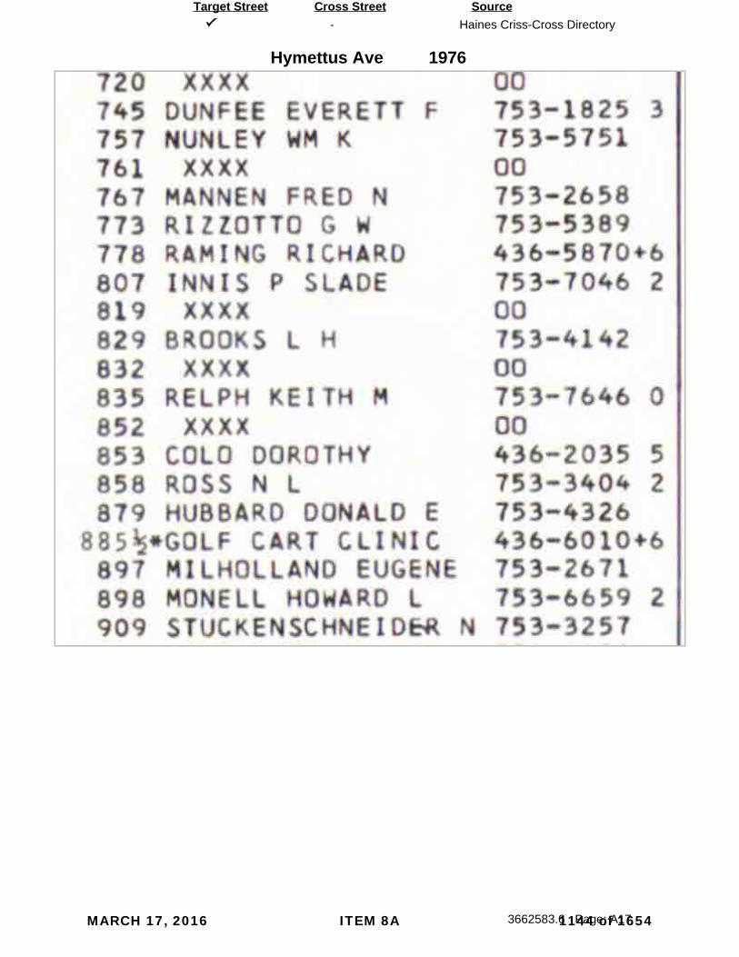
-
Hymettus Ave
Haines Criss-Cross Directory
3662583.6 Page: A17
SourceTarget Street Cross Street
1976
MARCH 17, 2016 ITEM 8A 1144 of 1654

-
Hymettus Ave
Haines Criss-Cross Directory
3662583.6 Page: A18
SourceTarget Street Cross Street
1970
MARCH 17, 2016 ITEM 8A 1145 of 1654

MARCH 17, 2016 ITEM 8A 1146 of 1654

Appendix E‐2 Limited Phase II Environmental Site Assessment
MARCH 17, 2016 ITEM 8A 1147 of 1654

MARCH 17, 2016 ITEM 8A 1148 of 1654

Project No. 09931-06-02 October 12, 2015 Mr. Russ Haley CityMark Communities 3818 Park Boulevard San Diego, California 92013 Subject: LIMITED PHASE II ENVIRONMENTAL SITE ASSESSMENT
HYMETTUS AND FULVIA DEVELOPMENT 378 FULVIA STREET ENCINITAS, CALIFORNIA
Dear Mr. Haley: In accordance with your request, Geocon Incorporated performed a Limited Phase II Environmental Site Assessment (ESA) of an approximate a 2.25-acre property located at 378 Fulvia Street (the Site) in Encinitas, California (Figure 1). The Site is further identified by San Diego County Assessor’s Parcel Numbers (APNs) 254-331-23 and 254-331-24. Our scope of services included soil sampling and analysis and preparation of this report in accordance with our Change Order No. 1 for Limited Phase II
ESA, revised September 17, 2015. The purpose of the Limited Phase II ESA was to evaluate onsite shallow soils for the potential presence of pesticides based on the historical agricultural use of the Site identified during a Phase I ESA we conducted in 2013.
SITE DESCRIPTION AND BACKGROUND
The Site is located in an area of residential development and is currently occupied by three single-family residences and a garage. The Site is bounded to the north by a residential property, to the west and south by Fulvia Street with residential properties beyond and to the east by Hymettus Avenue with residential properties beyond. We completed a Phase I ESA for the Site in July 2013. The Phase I ESA was conducted for CityMark Communities as part of their due diligence process prior to purchasing the Site. The findings of our Phase I ESA are documented in our Phase I Environmental Site Assessment report dated July 31, 2013. The Phase I ESA identified that portions of the Site were an avocado grove from sometime in the 1950s until the 1970s. We concluded, therefore, that there was the potential that soil at the Site had been impacted by pesticides due to this former agricultural use. Although not considered a “recognized environmental condition,” the former agricultural use of the Site and the potential presence of pesticides in site soil was considered a potential environmental concern. We recommended that, as a conservative measure, additional investigation (e.g., sampling and analytical testing) should be considered to characterize the Site with respect to the potential for hazardous concentrations of pesticides in onsite soil due to the former agricultural use.
MARCH 17, 2016 ITEM 8A 1149 of 1654

Project No. 09931-06-02 - 2 - October 12, 2015
Based on results of the Phase I ESA and our recommendation, CityMark Communities authorized us to perform a Limited Phase II ESA for the Site. We conducted the Limited Phase II ESA based on our Change Order No. 1 for Limited Phase II ESA, revised September 17, 2015.
SCOPE OF SERVICES
The scope of services of the Phase II ESA included collecting soil samples from the Site and having them analyzed for contaminants of concern (COCs) related to historical agricultural land use. Soil sampling was conducted on September 23, 2015 and included the following activities.
Soil Sampling
Soil sampling consisted of the following activities:
Advanced ten borings, B1 through B10, using a hand auger at approximate 100-foot intervals throughout the Site (Figure 2).
Collected soil samples from each boring at depths of 0.5 to 1.0-foot and 2.0 to 2.5-feet.
Laboratory Analysis
We submitted the soil samples to Advanced Technology Laboratories (ATL), a state-certified laboratory in Signal Hill, California, for analysis as follows:
Shallow samples (0.5 to 1.0-foot depth) were analyzed for organochlorine pesticides (OCPs) by United States Environmental Protection Agency (USEPA) Test Method 8081A and arsenic by USEPA Test Method 6010B.
Deep samples (2.0 to 2.5-feet depth) were held for analysis pending results of analysis of the shallow samples.
FINDINGS AND CONCLUSIONS
Analysis of the shallow soil samples collected from the Site did not detect OCPs or arsenic at concentrations equal to or exceeding laboratory reporting limits. A copy of the laboratory analytical report is attached.
Based on the analytical results, it appears that the historical agricultural use of the Site has not resulted in the presence of the COCs in shallow soil. The findings of this Limited Phase II ESA suggest that additional assessment of the Site is not warranted at this time.
LIMITATIONS
The conclusions presented in this report are based upon reasonable visual observations made at the Site and research of available materials within the scope and budget of the contract. The information presented is relevant to the dates of our site visit and should not be relied upon to represent conditions at later dates. The opinions expressed herein are based on our experience with similar studies and information obtained during our effort. If additional information becomes available, we request the
MARCH 17, 2016 ITEM 8A 1150 of 1654

Project No. 09931-06-02 - 3 - October 12, 2015
opportunity to review the information and modify our opinions, if necessary. Any reliance upon the information, conclusions, or recommendations contained in this report for purposes other than the transfer of the site shall be at the sole risk of the party undertaking such use.
Our services have been conducted using the degree of care and skill ordinarily exercised, under similar circumstances, by environmental sciences consultants practicing in this or similar localities. No other warranty, express or implied, is made as to the professional opinions presented in this report. Geocon is not responsible for the conclusions, opinions, or recommendations made by others based on this information.
This report was compiled based partially on information supplied to Geocon from outside sources, other information that is in the public domain and visual observations made at the property. The preliminary conclusions and recommendations herein are based solely on the information Geocon obtained in compiling the report. Geocon makes no warranty as to the accuracy of statements made by others which may be contained in the report, nor are any other warranties or guarantees, express or implied, included or intended by the report except that it has been prepared in accordance with the current generally accepted practices and standards consistent with the level of care and skill exercised under similar circumstances by other professional consultants or firms performing the same or similar services. None of the work performed hereunder shall constitute or be represented as a legal opinion of any kind or nature, but shall be a representation of findings of fact from records examined.
We appreciate the opportunity to be of service. Please contact the undersigned with any comments or questions.
Sincerely, GEOCON INCORPORATED Sean K. Keffer Senior Staff Geologist
Jim Brake, PG Senior Geologist/Vice President
(e-mail) Addressee Attachments: Figure 1, Vicinity Map Figure 2, Site Plan Laboratory Reports and Chain-Of-Custody Documentation
MARCH 17, 2016 ITEM 8A 1151 of 1654

MARCH 17, 2016 ITEM 8A 1152 of 1654

MARCH 17, 2016 ITEM 8A 1153 of 1654

NEVADA 3151 W. Post Rd., Las Vegas, NV 89118
P: 702.307.2659 F: 702.307.2691
“Serving Clients with Passion and Professionalism”
CALIFORNIA 11060 Artesia Blvd., Ste C, Cerritos, CA 90703
P: 562.219.7435 F: 562.219.7436
October 01, 2015
Geocon Consultants, Inc.Sean Keffer
Attention: Sean Keffer
RE: 378 FULVIA STREET, 09931-06-02
Workorder No.: N017022FAX: (858) 558 6159TEL: (858) 558 6900
6960 Flanders DriveSan Diego, CA 92121
CA-ELAP No.: 2676NV Cert. No.: NV-00922
Thank you for the opportunity to service the needs of your company.
Please feel free to call me at (702) 307-2659 or Molky Brar at (562)-881-3622 if we can be of further assistance to your company.
Sincerely,
Molky BrarProject Manager
Glen Gesmundo
QA Manager
Enclosed are the results for sample(s) received on September 25, 2015 by ASSET Laboratories . The sample(s) are tested for the parameters as indicated in the enclosed chain of custody in accordance with the applicable laboratory certifications.
01 of 22
MARCH 17, 2016 ITEM 8A 1154 of 1654

NEVADA 3151 W. Post Rd., Las Vegas, NV 89118
P: 702.307.2659 F: 702.307.2691
“Serving Clients with Passion and Professionalism”
CALIFORNIA 11060 Artesia Blvd., Ste C, Cerritos, CA 90703
P: 562.219.7435 F: 562.219.7436
01-Oct-15Date:ASSET Laboratories
Project: 378 FULVIA STREET, 09931-06-02CLIENT: Geocon Consultants, Inc.
Lab Order: N017022CASE NARRATIVE
SAMPLE RECEIVING/GENERAL COMMENTS:
Samples were received intact with proper chain of custody documentation.
Cooler temperature and sample preservation were verified upon receipt of samples if applicable.
Information on sample receipt conditions including discrepancies can be found in attached Sample Receipt Checklist Form.
Samples were analyzed within method holding time.
Analytical Comments for EPA 8081A:
Tetrachloro-m-xylene surrogate recovery biased high for sample N017022-003A possibly due to matrix interferences. Sample results were non-detect (ND) for analytes of interest therefore reanalysis of the sample was not necessary.
Matrix Spike (MS) and Matrix Spike Duplicate (MSD) are outside recovery criteria for Methoxychlor on QC samples N017022-019A-MS, N017022-001A-MS and N017022-001A-MSD possibly due to matrix interference. The associated Laboratory Control Sample (LCS) recovery was acceptable.
Page 2 of 22
02 of 22
MARCH 17, 2016 ITEM 8A 1155 of 1654

NEVADA 3151 W. Post Rd., Las Vegas, NV 89118
P: 702.307.2659 F: 702.307.2691
“Serving Clients with Passion and Professionalism”
CALIFORNIA 11060 Artesia Blvd., Ste C, Cerritos, CA 90703
P: 562.219.7435 F: 562.219.7436
01-Oct-15Date:ASSET Laboratories
Project: 378 FULVIA STREET, 09931-06-02CLIENT: Geocon Consultants, Inc.
Lab Order: N017022Work Order Sample Summary
Lab Sample ID Client Sample ID Collection DateMatrix Date Received
Contract No:
Date Reported
N017022-001A B1-0.5' 9/23/2015 9:15:00 AM 9/25/2015 10/1/2015Soil
N017022-002A B1-2.0' 9/23/2015 9:20:00 AM 9/25/2015 10/1/2015Soil
N017022-003A B2-0.5' 9/23/2015 9:35:00 AM 9/25/2015 10/1/2015Soil
N017022-004A B2-2.0' 9/23/2015 9:40:00 AM 9/25/2015 10/1/2015Soil
N017022-005A B3-0.5' 9/23/2015 9:50:00 AM 9/25/2015 10/1/2015Soil
N017022-006A B3-2.0' 9/23/2015 10:00:00 AM 9/25/2015 10/1/2015Soil
N017022-007A B4-0.5' 9/23/2015 10:10:00 AM 9/25/2015 10/1/2015Soil
N017022-008A B4-2.0' 9/23/2015 10:15:00 AM 9/25/2015 10/1/2015Soil
N017022-009A B5-0.5' 9/23/2015 10:25:00 AM 9/25/2015 10/1/2015Soil
N017022-010A B5-2.0' 9/23/2015 10:30:00 AM 9/25/2015 10/1/2015Soil
N017022-011A B6-0.5' 9/23/2015 10:45:00 AM 9/25/2015 10/1/2015Soil
N017022-012A B6-2.0' 9/23/2015 10:50:00 AM 9/25/2015 10/1/2015Soil
N017022-013A B7-0.5' 9/23/2015 11:10:00 AM 9/25/2015 10/1/2015Soil
N017022-014A B7-2.0' 9/23/2015 11:24:00 AM 9/25/2015 10/1/2015Soil
N017022-015A B8-0.5' 9/23/2015 11:35:00 AM 9/25/2015 10/1/2015Soil
N017022-016A B8-2.0' 9/23/2015 11:40:00 AM 9/25/2015 10/1/2015Soil
N017022-017A B9-0.5' 9/23/2015 11:48:00 AM 9/25/2015 10/1/2015Soil
N017022-018A B9-2.0' 9/23/2015 11:50:00 AM 9/25/2015 10/1/2015Soil
N017022-019A B10-0.5' 9/23/2015 12:05:00 AM 9/25/2015 10/1/2015Soil
N017022-020A B10-2.0' 9/23/2015 12:10:00 AM 9/25/2015 10/1/2015Soil
Page 1 of 1
03 of 22
MARCH 17, 2016 ITEM 8A 1156 of 1654

NEVADA 3151 W. Post Rd., Las Vegas, NV 89118
P: 702.307.2659 F: 702.307.2691
“Serving Clients with Passion and Professionalism”
CALIFORNIA 11060 Artesia Blvd., Ste C, Cerritos, CA 90703
P: 562.219.7435 F: 562.219.7436
Project: 378 FULVIA STREET, 09931-06-02
Client Sample ID: B1-0.5'Collection Date: 9/23/2015 9:15:00 AM
Matrix: SOIL
Analyses Result Qual Units Date Analyzed
CLIENT: Geocon Consultants, Inc.Lab Order: N017022
DF
Lab ID: N017022-001
ASSET Laboratories Print Date: 01-Oct-15
PQL
ANALYTICAL RESULTS
ORGANOCHLORINE PESTICIDES BY GC/ECDEPA 8081A
Analyst: MDM
EPA 3550B
RunID: GC7_150928A 52545QC Batch: PrepDate: 9/28/2015
4,4´-DDD 9/28/2015 05:33 PM2.0 µg/Kg 1ND4,4´-DDE 9/28/2015 05:33 PM2.0 µg/Kg 1ND4,4´-DDT 9/28/2015 05:33 PM2.0 µg/Kg 1NDAldrin 9/28/2015 05:33 PM1.0 µg/Kg 1NDalpha-BHC 9/28/2015 05:33 PM1.0 µg/Kg 1NDalpha-Chlordane 9/28/2015 05:33 PM1.0 µg/Kg 1NDbeta-BHC 9/28/2015 05:33 PM1.0 µg/Kg 1NDChlordane 9/28/2015 05:33 PM8.5 µg/Kg 1NDdelta-BHC 9/28/2015 05:33 PM1.0 µg/Kg 1NDDieldrin 9/28/2015 05:33 PM2.0 µg/Kg 1NDEndosulfan I 9/28/2015 05:33 PM1.0 µg/Kg 1NDEndosulfan II 9/28/2015 05:33 PM2.0 µg/Kg 1NDEndosulfan sulfate 9/28/2015 05:33 PM2.0 µg/Kg 1NDEndrin 9/28/2015 05:33 PM2.0 µg/Kg 1NDEndrin aldehyde 9/28/2015 05:33 PM2.0 µg/Kg 1NDEndrin ketone 9/28/2015 05:33 PM2.0 µg/Kg 1NDgamma-BHC 9/28/2015 05:33 PM1.0 µg/Kg 1NDgamma-Chlordane 9/28/2015 05:33 PM1.0 µg/Kg 1NDHeptachlor 9/28/2015 05:33 PM1.0 µg/Kg 1NDHeptachlor epoxide 9/28/2015 05:33 PM1.0 µg/Kg 1NDMethoxychlor 9/28/2015 05:33 PM8.5 µg/Kg 1NDToxaphene 9/28/2015 05:33 PM85 µg/Kg 1ND Surr: Tetrachloro-m-xylene 9/28/2015 05:33 PM26-120 %REC 164.1 Surr: Decachlorobiphenyl 9/28/2015 05:33 PM31-131 %REC 178.2
TOTAL METALS BY ICPEPA 6010B
Analyst: CEI
EPA 3050B
RunID: ICP2_151001A 52553QC Batch: PrepDate: 9/29/2015
Arsenic 10/1/2015 01:22 PM1.0 mg/Kg 11.9
Qualifiers: B Analyte detected in the associated Method Blank E Value above quantitation rangeH Holding times for preparation or analysis exceeded ND Not Detected at the Reporting LimitS Spike/Surrogate outside of limits due to matrix interference Results are wet unless otherwise specified
DO Surrogate Diluted Out
04 of 22
MARCH 17, 2016 ITEM 8A 1157 of 1654

NEVADA 3151 W. Post Rd., Las Vegas, NV 89118
P: 702.307.2659 F: 702.307.2691
“Serving Clients with Passion and Professionalism”
CALIFORNIA 11060 Artesia Blvd., Ste C, Cerritos, CA 90703
P: 562.219.7435 F: 562.219.7436
Project: 378 FULVIA STREET, 09931-06-02
Client Sample ID: B2-0.5'Collection Date: 9/23/2015 9:35:00 AM
Matrix: SOIL
Analyses Result Qual Units Date Analyzed
CLIENT: Geocon Consultants, Inc.Lab Order: N017022
DF
Lab ID: N017022-003
ASSET Laboratories Print Date: 01-Oct-15
PQL
ANALYTICAL RESULTS
ORGANOCHLORINE PESTICIDES BY GC/ECDEPA 8081A
Analyst: MDM
EPA 3550B
RunID: GC7_150928A 52545QC Batch: PrepDate: 9/28/2015
4,4´-DDD 9/29/2015 01:32 AM2.0 µg/Kg 1ND4,4´-DDE 9/29/2015 01:32 AM2.0 µg/Kg 1ND4,4´-DDT 9/29/2015 01:32 AM2.0 µg/Kg 1NDAldrin 9/29/2015 01:32 AM1.0 µg/Kg 1NDalpha-BHC 9/29/2015 01:32 AM1.0 µg/Kg 1NDalpha-Chlordane 9/29/2015 01:32 AM1.0 µg/Kg 1NDbeta-BHC 9/29/2015 01:32 AM1.0 µg/Kg 1NDChlordane 9/29/2015 01:32 AM8.5 µg/Kg 1NDdelta-BHC 9/29/2015 01:32 AM1.0 µg/Kg 1NDDieldrin 9/29/2015 01:32 AM2.0 µg/Kg 1NDEndosulfan I 9/29/2015 01:32 AM1.0 µg/Kg 1NDEndosulfan II 9/29/2015 01:32 AM2.0 µg/Kg 1NDEndosulfan sulfate 9/29/2015 01:32 AM2.0 µg/Kg 1NDEndrin 9/29/2015 01:32 AM2.0 µg/Kg 1NDEndrin aldehyde 9/29/2015 01:32 AM2.0 µg/Kg 1NDEndrin ketone 9/29/2015 01:32 AM2.0 µg/Kg 1NDgamma-BHC 9/29/2015 01:32 AM1.0 µg/Kg 1NDgamma-Chlordane 9/29/2015 01:32 AM1.0 µg/Kg 1NDHeptachlor 9/29/2015 01:32 AM1.0 µg/Kg 1NDHeptachlor epoxide 9/29/2015 01:32 AM1.0 µg/Kg 1NDMethoxychlor 9/29/2015 01:32 AM8.5 µg/Kg 1NDToxaphene 9/29/2015 01:32 AM85 µg/Kg 1ND Surr: Tetrachloro-m-xylene S 9/29/2015 01:32 AM26-120 %REC 1202 Surr: Decachlorobiphenyl 9/29/2015 01:32 AM31-131 %REC 147.2
TOTAL METALS BY ICPEPA 6010B
Analyst: CEI
EPA 3050B
RunID: ICP2_151001A 52553QC Batch: PrepDate: 9/29/2015
Arsenic 10/1/2015 01:29 PM1.0 mg/Kg 11.7
Qualifiers: B Analyte detected in the associated Method Blank E Value above quantitation rangeH Holding times for preparation or analysis exceeded ND Not Detected at the Reporting LimitS Spike/Surrogate outside of limits due to matrix interference Results are wet unless otherwise specified
DO Surrogate Diluted Out
05 of 22
MARCH 17, 2016 ITEM 8A 1158 of 1654

NEVADA 3151 W. Post Rd., Las Vegas, NV 89118
P: 702.307.2659 F: 702.307.2691
“Serving Clients with Passion and Professionalism”
CALIFORNIA 11060 Artesia Blvd., Ste C, Cerritos, CA 90703
P: 562.219.7435 F: 562.219.7436
Project: 378 FULVIA STREET, 09931-06-02
Client Sample ID: B3-0.5'Collection Date: 9/23/2015 9:50:00 AM
Matrix: SOIL
Analyses Result Qual Units Date Analyzed
CLIENT: Geocon Consultants, Inc.Lab Order: N017022
DF
Lab ID: N017022-005
ASSET Laboratories Print Date: 01-Oct-15
PQL
ANALYTICAL RESULTS
ORGANOCHLORINE PESTICIDES BY GC/ECDEPA 8081A
Analyst: MDM
EPA 3550B
RunID: GC7_150928A 52545QC Batch: PrepDate: 9/28/2015
4,4´-DDD 9/28/2015 06:42 PM2.0 µg/Kg 1ND4,4´-DDE 9/28/2015 06:42 PM2.0 µg/Kg 1ND4,4´-DDT 9/28/2015 06:42 PM2.0 µg/Kg 1NDAldrin 9/28/2015 06:42 PM1.0 µg/Kg 1NDalpha-BHC 9/28/2015 06:42 PM1.0 µg/Kg 1NDalpha-Chlordane 9/28/2015 06:42 PM1.0 µg/Kg 1NDbeta-BHC 9/28/2015 06:42 PM1.0 µg/Kg 1NDChlordane 9/28/2015 06:42 PM8.5 µg/Kg 1NDdelta-BHC 9/28/2015 06:42 PM1.0 µg/Kg 1NDDieldrin 9/28/2015 06:42 PM2.0 µg/Kg 1NDEndosulfan I 9/28/2015 06:42 PM1.0 µg/Kg 1NDEndosulfan II 9/28/2015 06:42 PM2.0 µg/Kg 1NDEndosulfan sulfate 9/28/2015 06:42 PM2.0 µg/Kg 1NDEndrin 9/28/2015 06:42 PM2.0 µg/Kg 1NDEndrin aldehyde 9/28/2015 06:42 PM2.0 µg/Kg 1NDEndrin ketone 9/28/2015 06:42 PM2.0 µg/Kg 1NDgamma-BHC 9/28/2015 06:42 PM1.0 µg/Kg 1NDgamma-Chlordane 9/28/2015 06:42 PM1.0 µg/Kg 1NDHeptachlor 9/28/2015 06:42 PM1.0 µg/Kg 1NDHeptachlor epoxide 9/28/2015 06:42 PM1.0 µg/Kg 1NDMethoxychlor 9/28/2015 06:42 PM8.5 µg/Kg 1NDToxaphene 9/28/2015 06:42 PM85 µg/Kg 1ND Surr: Tetrachloro-m-xylene 9/28/2015 06:42 PM26-120 %REC 157.5 Surr: Decachlorobiphenyl 9/28/2015 06:42 PM31-131 %REC 166.5
TOTAL METALS BY ICPEPA 6010B
Analyst: CEI
EPA 3050B
RunID: ICP2_151001A 52553QC Batch: PrepDate: 9/29/2015
Arsenic 10/1/2015 01:35 PM1.0 mg/Kg 1ND
Qualifiers: B Analyte detected in the associated Method Blank E Value above quantitation rangeH Holding times for preparation or analysis exceeded ND Not Detected at the Reporting LimitS Spike/Surrogate outside of limits due to matrix interference Results are wet unless otherwise specified
DO Surrogate Diluted Out
06 of 22
MARCH 17, 2016 ITEM 8A 1159 of 1654

NEVADA 3151 W. Post Rd., Las Vegas, NV 89118
P: 702.307.2659 F: 702.307.2691
“Serving Clients with Passion and Professionalism”
CALIFORNIA 11060 Artesia Blvd., Ste C, Cerritos, CA 90703
P: 562.219.7435 F: 562.219.7436
Project: 378 FULVIA STREET, 09931-06-02
Client Sample ID: B4-0.5'Collection Date: 9/23/2015 10:10:00 AM
Matrix: SOIL
Analyses Result Qual Units Date Analyzed
CLIENT: Geocon Consultants, Inc.Lab Order: N017022
DF
Lab ID: N017022-007
ASSET Laboratories Print Date: 01-Oct-15
PQL
ANALYTICAL RESULTS
ORGANOCHLORINE PESTICIDES BY GC/ECDEPA 8081A
Analyst: MDM
EPA 3550B
RunID: GC7_150928A 52545QC Batch: PrepDate: 9/28/2015
4,4´-DDD 9/28/2015 07:05 PM2.0 µg/Kg 1ND4,4´-DDE 9/28/2015 07:05 PM2.0 µg/Kg 16.84,4´-DDT 9/28/2015 07:05 PM2.0 µg/Kg 1NDAldrin 9/28/2015 07:05 PM1.0 µg/Kg 1NDalpha-BHC 9/28/2015 07:05 PM1.0 µg/Kg 1NDalpha-Chlordane 9/28/2015 07:05 PM1.0 µg/Kg 1NDbeta-BHC 9/28/2015 07:05 PM1.0 µg/Kg 1NDChlordane 9/28/2015 07:05 PM8.5 µg/Kg 1NDdelta-BHC 9/28/2015 07:05 PM1.0 µg/Kg 1NDDieldrin 9/28/2015 07:05 PM2.0 µg/Kg 1NDEndosulfan I 9/28/2015 07:05 PM1.0 µg/Kg 1NDEndosulfan II 9/28/2015 07:05 PM2.0 µg/Kg 1NDEndosulfan sulfate 9/28/2015 07:05 PM2.0 µg/Kg 1NDEndrin 9/28/2015 07:05 PM2.0 µg/Kg 1NDEndrin aldehyde 9/28/2015 07:05 PM2.0 µg/Kg 1NDEndrin ketone 9/28/2015 07:05 PM2.0 µg/Kg 1NDgamma-BHC 9/28/2015 07:05 PM1.0 µg/Kg 1NDgamma-Chlordane 9/28/2015 07:05 PM1.0 µg/Kg 1NDHeptachlor 9/28/2015 07:05 PM1.0 µg/Kg 1NDHeptachlor epoxide 9/28/2015 07:05 PM1.0 µg/Kg 1NDMethoxychlor 9/28/2015 07:05 PM8.5 µg/Kg 1NDToxaphene 9/28/2015 07:05 PM85 µg/Kg 1ND Surr: Tetrachloro-m-xylene 9/28/2015 07:05 PM26-120 %REC 173.5 Surr: Decachlorobiphenyl 9/28/2015 07:05 PM31-131 %REC 177.8
TOTAL METALS BY ICPEPA 6010B
Analyst: CEI
EPA 3050B
RunID: ICP2_151001A 52553QC Batch: PrepDate: 9/29/2015
Arsenic 10/1/2015 01:41 PM1.0 mg/Kg 11.5
Qualifiers: B Analyte detected in the associated Method Blank E Value above quantitation rangeH Holding times for preparation or analysis exceeded ND Not Detected at the Reporting LimitS Spike/Surrogate outside of limits due to matrix interference Results are wet unless otherwise specified
DO Surrogate Diluted Out
07 of 22
MARCH 17, 2016 ITEM 8A 1160 of 1654

NEVADA 3151 W. Post Rd., Las Vegas, NV 89118
P: 702.307.2659 F: 702.307.2691
“Serving Clients with Passion and Professionalism”
CALIFORNIA 11060 Artesia Blvd., Ste C, Cerritos, CA 90703
P: 562.219.7435 F: 562.219.7436
Project: 378 FULVIA STREET, 09931-06-02
Client Sample ID: B5-0.5'Collection Date: 9/23/2015 10:25:00 AM
Matrix: SOIL
Analyses Result Qual Units Date Analyzed
CLIENT: Geocon Consultants, Inc.Lab Order: N017022
DF
Lab ID: N017022-009
ASSET Laboratories Print Date: 01-Oct-15
PQL
ANALYTICAL RESULTS
ORGANOCHLORINE PESTICIDES BY GC/ECDEPA 8081A
Analyst: MDM
EPA 3550B
RunID: GC7_150928A 52545QC Batch: PrepDate: 9/28/2015
4,4´-DDD 9/28/2015 07:27 PM2.0 µg/Kg 1ND4,4´-DDE 9/28/2015 07:27 PM2.0 µg/Kg 1ND4,4´-DDT 9/28/2015 07:27 PM2.0 µg/Kg 1NDAldrin 9/28/2015 07:27 PM1.0 µg/Kg 1NDalpha-BHC 9/28/2015 07:27 PM1.0 µg/Kg 1NDalpha-Chlordane 9/28/2015 07:27 PM1.0 µg/Kg 1NDbeta-BHC 9/28/2015 07:27 PM1.0 µg/Kg 1NDChlordane 9/28/2015 07:27 PM8.5 µg/Kg 1NDdelta-BHC 9/28/2015 07:27 PM1.0 µg/Kg 1NDDieldrin 9/28/2015 07:27 PM2.0 µg/Kg 1NDEndosulfan I 9/28/2015 07:27 PM1.0 µg/Kg 1NDEndosulfan II 9/28/2015 07:27 PM2.0 µg/Kg 1NDEndosulfan sulfate 9/28/2015 07:27 PM2.0 µg/Kg 1NDEndrin 9/28/2015 07:27 PM2.0 µg/Kg 1NDEndrin aldehyde 9/28/2015 07:27 PM2.0 µg/Kg 1NDEndrin ketone 9/28/2015 07:27 PM2.0 µg/Kg 1NDgamma-BHC 9/28/2015 07:27 PM1.0 µg/Kg 1NDgamma-Chlordane 9/28/2015 07:27 PM1.0 µg/Kg 1NDHeptachlor 9/28/2015 07:27 PM1.0 µg/Kg 1NDHeptachlor epoxide 9/28/2015 07:27 PM1.0 µg/Kg 1NDMethoxychlor 9/28/2015 07:27 PM8.5 µg/Kg 1NDToxaphene 9/28/2015 07:27 PM85 µg/Kg 1ND Surr: Tetrachloro-m-xylene 9/28/2015 07:27 PM26-120 %REC 1119 Surr: Decachlorobiphenyl 9/28/2015 07:27 PM31-131 %REC 183.4
TOTAL METALS BY ICPEPA 6010B
Analyst: CEI
EPA 3050B
RunID: ICP2_151001A 52553QC Batch: PrepDate: 9/29/2015
Arsenic 10/1/2015 01:47 PM1.0 mg/Kg 11.1
Qualifiers: B Analyte detected in the associated Method Blank E Value above quantitation rangeH Holding times for preparation or analysis exceeded ND Not Detected at the Reporting LimitS Spike/Surrogate outside of limits due to matrix interference Results are wet unless otherwise specified
DO Surrogate Diluted Out
08 of 22
MARCH 17, 2016 ITEM 8A 1161 of 1654

NEVADA 3151 W. Post Rd., Las Vegas, NV 89118
P: 702.307.2659 F: 702.307.2691
“Serving Clients with Passion and Professionalism”
CALIFORNIA 11060 Artesia Blvd., Ste C, Cerritos, CA 90703
P: 562.219.7435 F: 562.219.7436
Project: 378 FULVIA STREET, 09931-06-02
Client Sample ID: B6-0.5'Collection Date: 9/23/2015 10:45:00 AM
Matrix: SOIL
Analyses Result Qual Units Date Analyzed
CLIENT: Geocon Consultants, Inc.Lab Order: N017022
DF
Lab ID: N017022-011
ASSET Laboratories Print Date: 01-Oct-15
PQL
ANALYTICAL RESULTS
ORGANOCHLORINE PESTICIDES BY GC/ECDEPA 8081A
Analyst: MDM
EPA 3550B
RunID: GC7_150928A 52545QC Batch: PrepDate: 9/28/2015
4,4´-DDD 9/28/2015 07:50 PM2.0 µg/Kg 1ND4,4´-DDE 9/28/2015 07:50 PM2.0 µg/Kg 14.04,4´-DDT 9/28/2015 07:50 PM2.0 µg/Kg 1NDAldrin 9/28/2015 07:50 PM1.0 µg/Kg 1NDalpha-BHC 9/28/2015 07:50 PM1.0 µg/Kg 1NDalpha-Chlordane 9/28/2015 07:50 PM1.0 µg/Kg 1NDbeta-BHC 9/28/2015 07:50 PM1.0 µg/Kg 1NDChlordane 9/28/2015 07:50 PM8.5 µg/Kg 1NDdelta-BHC 9/28/2015 07:50 PM1.0 µg/Kg 1NDDieldrin 9/28/2015 07:50 PM2.0 µg/Kg 1NDEndosulfan I 9/28/2015 07:50 PM1.0 µg/Kg 1NDEndosulfan II 9/28/2015 07:50 PM2.0 µg/Kg 1NDEndosulfan sulfate 9/28/2015 07:50 PM2.0 µg/Kg 1NDEndrin 9/28/2015 07:50 PM2.0 µg/Kg 1NDEndrin aldehyde 9/28/2015 07:50 PM2.0 µg/Kg 1NDEndrin ketone 9/28/2015 07:50 PM2.0 µg/Kg 1NDgamma-BHC 9/28/2015 07:50 PM1.0 µg/Kg 1NDgamma-Chlordane 9/28/2015 07:50 PM1.0 µg/Kg 1NDHeptachlor 9/28/2015 07:50 PM1.0 µg/Kg 1NDHeptachlor epoxide 9/28/2015 07:50 PM1.0 µg/Kg 1NDMethoxychlor 9/28/2015 07:50 PM8.5 µg/Kg 1NDToxaphene 9/28/2015 07:50 PM85 µg/Kg 1ND Surr: Tetrachloro-m-xylene 9/28/2015 07:50 PM26-120 %REC 156.3 Surr: Decachlorobiphenyl 9/28/2015 07:50 PM31-131 %REC 175.1
TOTAL METALS BY ICPEPA 6010B
Analyst: CEI
EPA 3050B
RunID: ICP2_151001A 52553QC Batch: PrepDate: 9/29/2015
Arsenic 10/1/2015 01:53 PM1.0 mg/Kg 11.0
Qualifiers: B Analyte detected in the associated Method Blank E Value above quantitation rangeH Holding times for preparation or analysis exceeded ND Not Detected at the Reporting LimitS Spike/Surrogate outside of limits due to matrix interference Results are wet unless otherwise specified
DO Surrogate Diluted Out
09 of 22
MARCH 17, 2016 ITEM 8A 1162 of 1654
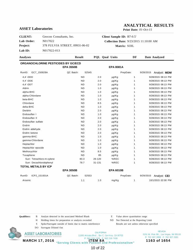
NEVADA 3151 W. Post Rd., Las Vegas, NV 89118
P: 702.307.2659 F: 702.307.2691
“Serving Clients with Passion and Professionalism”
CALIFORNIA 11060 Artesia Blvd., Ste C, Cerritos, CA 90703
P: 562.219.7435 F: 562.219.7436
Project: 378 FULVIA STREET, 09931-06-02
Client Sample ID: B7-0.5'Collection Date: 9/23/2015 11:10:00 AM
Matrix: SOIL
Analyses Result Qual Units Date Analyzed
CLIENT: Geocon Consultants, Inc.Lab Order: N017022
DF
Lab ID: N017022-013
ASSET Laboratories Print Date: 01-Oct-15
PQL
ANALYTICAL RESULTS
ORGANOCHLORINE PESTICIDES BY GC/ECDEPA 8081A
Analyst: MDM
EPA 3550B
RunID: GC7_150928A 52545QC Batch: PrepDate: 9/28/2015
4,4´-DDD 9/28/2015 08:13 PM2.0 µg/Kg 1ND4,4´-DDE 9/28/2015 08:13 PM2.0 µg/Kg 1ND4,4´-DDT 9/28/2015 08:13 PM2.0 µg/Kg 1NDAldrin 9/28/2015 08:13 PM1.0 µg/Kg 1NDalpha-BHC 9/28/2015 08:13 PM1.0 µg/Kg 1NDalpha-Chlordane 9/28/2015 08:13 PM1.0 µg/Kg 1NDbeta-BHC 9/28/2015 08:13 PM1.0 µg/Kg 1NDChlordane 9/28/2015 08:13 PM8.5 µg/Kg 1NDdelta-BHC 9/28/2015 08:13 PM1.0 µg/Kg 1NDDieldrin 9/28/2015 08:13 PM2.0 µg/Kg 1NDEndosulfan I 9/28/2015 08:13 PM1.0 µg/Kg 1NDEndosulfan II 9/28/2015 08:13 PM2.0 µg/Kg 1NDEndosulfan sulfate 9/28/2015 08:13 PM2.0 µg/Kg 1NDEndrin 9/28/2015 08:13 PM2.0 µg/Kg 1NDEndrin aldehyde 9/28/2015 08:13 PM2.0 µg/Kg 1NDEndrin ketone 9/28/2015 08:13 PM2.0 µg/Kg 1NDgamma-BHC 9/28/2015 08:13 PM1.0 µg/Kg 1NDgamma-Chlordane 9/28/2015 08:13 PM1.0 µg/Kg 1NDHeptachlor 9/28/2015 08:13 PM1.0 µg/Kg 1NDHeptachlor epoxide 9/28/2015 08:13 PM1.0 µg/Kg 1NDMethoxychlor 9/28/2015 08:13 PM8.5 µg/Kg 1NDToxaphene 9/28/2015 08:13 PM85 µg/Kg 1ND Surr: Tetrachloro-m-xylene 9/28/2015 08:13 PM26-120 %REC 180.3 Surr: Decachlorobiphenyl 9/28/2015 08:13 PM31-131 %REC 178.7
TOTAL METALS BY ICPEPA 6010B
Analyst: CEI
EPA 3050B
RunID: ICP2_151001A 52553QC Batch: PrepDate: 9/29/2015
Arsenic 10/1/2015 02:00 PM1.0 mg/Kg 11.1
Qualifiers: B Analyte detected in the associated Method Blank E Value above quantitation rangeH Holding times for preparation or analysis exceeded ND Not Detected at the Reporting LimitS Spike/Surrogate outside of limits due to matrix interference Results are wet unless otherwise specified
DO Surrogate Diluted Out
10 of 22
MARCH 17, 2016 ITEM 8A 1163 of 1654

NEVADA 3151 W. Post Rd., Las Vegas, NV 89118
P: 702.307.2659 F: 702.307.2691
“Serving Clients with Passion and Professionalism”
CALIFORNIA 11060 Artesia Blvd., Ste C, Cerritos, CA 90703
P: 562.219.7435 F: 562.219.7436
Project: 378 FULVIA STREET, 09931-06-02
Client Sample ID: B8-0.5'Collection Date: 9/23/2015 11:35:00 AM
Matrix: SOIL
Analyses Result Qual Units Date Analyzed
CLIENT: Geocon Consultants, Inc.Lab Order: N017022
DF
Lab ID: N017022-015
ASSET Laboratories Print Date: 01-Oct-15
PQL
ANALYTICAL RESULTS
ORGANOCHLORINE PESTICIDES BY GC/ECDEPA 8081A
Analyst: MDM
EPA 3550B
RunID: GC7_150928A 52545QC Batch: PrepDate: 9/28/2015
4,4´-DDD 9/28/2015 08:36 PM2.0 µg/Kg 12.54,4´-DDE 9/28/2015 08:36 PM2.0 µg/Kg 12.44,4´-DDT 9/28/2015 08:36 PM2.0 µg/Kg 1NDAldrin 9/28/2015 08:36 PM1.0 µg/Kg 1NDalpha-BHC 9/28/2015 08:36 PM1.0 µg/Kg 1NDalpha-Chlordane 9/28/2015 08:36 PM1.0 µg/Kg 1NDbeta-BHC 9/28/2015 08:36 PM1.0 µg/Kg 1NDChlordane 9/28/2015 08:36 PM8.5 µg/Kg 1NDdelta-BHC 9/28/2015 08:36 PM1.0 µg/Kg 1NDDieldrin 9/28/2015 08:36 PM2.0 µg/Kg 1NDEndosulfan I 9/28/2015 08:36 PM1.0 µg/Kg 1NDEndosulfan II 9/28/2015 08:36 PM2.0 µg/Kg 1NDEndosulfan sulfate 9/28/2015 08:36 PM2.0 µg/Kg 1NDEndrin 9/28/2015 08:36 PM2.0 µg/Kg 1NDEndrin aldehyde 9/28/2015 08:36 PM2.0 µg/Kg 1NDEndrin ketone 9/28/2015 08:36 PM2.0 µg/Kg 1NDgamma-BHC 9/28/2015 08:36 PM1.0 µg/Kg 1NDgamma-Chlordane 9/28/2015 08:36 PM1.0 µg/Kg 1NDHeptachlor 9/28/2015 08:36 PM1.0 µg/Kg 1NDHeptachlor epoxide 9/28/2015 08:36 PM1.0 µg/Kg 1NDMethoxychlor 9/28/2015 08:36 PM8.5 µg/Kg 1NDToxaphene 9/28/2015 08:36 PM85 µg/Kg 1ND Surr: Tetrachloro-m-xylene 9/28/2015 08:36 PM26-120 %REC 152.3 Surr: Decachlorobiphenyl 9/28/2015 08:36 PM31-131 %REC 168.8
TOTAL METALS BY ICPEPA 6010B
Analyst: CEI
EPA 3050B
RunID: ICP2_151001A 52553QC Batch: PrepDate: 9/29/2015
Arsenic 10/1/2015 02:06 PM1.0 mg/Kg 1ND
Qualifiers: B Analyte detected in the associated Method Blank E Value above quantitation rangeH Holding times for preparation or analysis exceeded ND Not Detected at the Reporting LimitS Spike/Surrogate outside of limits due to matrix interference Results are wet unless otherwise specified
DO Surrogate Diluted Out
11 of 22
MARCH 17, 2016 ITEM 8A 1164 of 1654

NEVADA 3151 W. Post Rd., Las Vegas, NV 89118
P: 702.307.2659 F: 702.307.2691
“Serving Clients with Passion and Professionalism”
CALIFORNIA 11060 Artesia Blvd., Ste C, Cerritos, CA 90703
P: 562.219.7435 F: 562.219.7436
Project: 378 FULVIA STREET, 09931-06-02
Client Sample ID: B9-0.5'Collection Date: 9/23/2015 11:48:00 AM
Matrix: SOIL
Analyses Result Qual Units Date Analyzed
CLIENT: Geocon Consultants, Inc.Lab Order: N017022
DF
Lab ID: N017022-017
ASSET Laboratories Print Date: 01-Oct-15
PQL
ANALYTICAL RESULTS
ORGANOCHLORINE PESTICIDES BY GC/ECDEPA 8081A
Analyst: MDM
EPA 3550B
RunID: GC7_150928A 52545QC Batch: PrepDate: 9/28/2015
4,4´-DDD 9/28/2015 08:58 PM2.0 µg/Kg 1ND4,4´-DDE 9/28/2015 08:58 PM2.0 µg/Kg 1ND4,4´-DDT 9/28/2015 08:58 PM2.0 µg/Kg 1NDAldrin 9/28/2015 08:58 PM1.0 µg/Kg 1NDalpha-BHC 9/28/2015 08:58 PM1.0 µg/Kg 1NDalpha-Chlordane 9/28/2015 08:58 PM1.0 µg/Kg 1NDbeta-BHC 9/28/2015 08:58 PM1.0 µg/Kg 1NDChlordane 9/28/2015 08:58 PM8.5 µg/Kg 1NDdelta-BHC 9/28/2015 08:58 PM1.0 µg/Kg 1NDDieldrin 9/28/2015 08:58 PM2.0 µg/Kg 1NDEndosulfan I 9/28/2015 08:58 PM1.0 µg/Kg 1NDEndosulfan II 9/28/2015 08:58 PM2.0 µg/Kg 1NDEndosulfan sulfate 9/28/2015 08:58 PM2.0 µg/Kg 1NDEndrin 9/28/2015 08:58 PM2.0 µg/Kg 1NDEndrin aldehyde 9/28/2015 08:58 PM2.0 µg/Kg 1NDEndrin ketone 9/28/2015 08:58 PM2.0 µg/Kg 1NDgamma-BHC 9/28/2015 08:58 PM1.0 µg/Kg 1NDgamma-Chlordane 9/28/2015 08:58 PM1.0 µg/Kg 1NDHeptachlor 9/28/2015 08:58 PM1.0 µg/Kg 1NDHeptachlor epoxide 9/28/2015 08:58 PM1.0 µg/Kg 1NDMethoxychlor 9/28/2015 08:58 PM8.5 µg/Kg 1NDToxaphene 9/28/2015 08:58 PM85 µg/Kg 1ND Surr: Tetrachloro-m-xylene 9/28/2015 08:58 PM26-120 %REC 157.2 Surr: Decachlorobiphenyl 9/28/2015 08:58 PM31-131 %REC 174.9
TOTAL METALS BY ICPEPA 6010B
Analyst: CEI
EPA 3050B
RunID: ICP2_151001A 52553QC Batch: PrepDate: 9/29/2015
Arsenic 10/1/2015 12:12 PM1.0 mg/Kg 11.3
Qualifiers: B Analyte detected in the associated Method Blank E Value above quantitation rangeH Holding times for preparation or analysis exceeded ND Not Detected at the Reporting LimitS Spike/Surrogate outside of limits due to matrix interference Results are wet unless otherwise specified
DO Surrogate Diluted Out
12 of 22
MARCH 17, 2016 ITEM 8A 1165 of 1654

NEVADA 3151 W. Post Rd., Las Vegas, NV 89118
P: 702.307.2659 F: 702.307.2691
“Serving Clients with Passion and Professionalism”
CALIFORNIA 11060 Artesia Blvd., Ste C, Cerritos, CA 90703
P: 562.219.7435 F: 562.219.7436
Project: 378 FULVIA STREET, 09931-06-02
Client Sample ID: B10-0.5'Collection Date: 9/23/2015 12:05:00 AM
Matrix: SOIL
Analyses Result Qual Units Date Analyzed
CLIENT: Geocon Consultants, Inc.Lab Order: N017022
DF
Lab ID: N017022-019
ASSET Laboratories Print Date: 01-Oct-15
PQL
ANALYTICAL RESULTS
ORGANOCHLORINE PESTICIDES BY GC/ECDEPA 8081A
Analyst: MDM
EPA 3550B
RunID: GC7_150928A 52545QC Batch: PrepDate: 9/28/2015
4,4´-DDD 9/28/2015 09:21 PM2.0 µg/Kg 14.84,4´-DDE 9/28/2015 09:21 PM2.0 µg/Kg 14.34,4´-DDT 9/28/2015 09:21 PM2.0 µg/Kg 1NDAldrin 9/28/2015 09:21 PM1.0 µg/Kg 1NDalpha-BHC 9/28/2015 09:21 PM1.0 µg/Kg 1NDalpha-Chlordane 9/28/2015 09:21 PM1.0 µg/Kg 1NDbeta-BHC 9/28/2015 09:21 PM1.0 µg/Kg 1NDChlordane 9/28/2015 09:21 PM8.5 µg/Kg 1NDdelta-BHC 9/28/2015 09:21 PM1.0 µg/Kg 1NDDieldrin 9/28/2015 09:21 PM2.0 µg/Kg 1NDEndosulfan I 9/28/2015 09:21 PM1.0 µg/Kg 1NDEndosulfan II 9/28/2015 09:21 PM2.0 µg/Kg 1NDEndosulfan sulfate 9/28/2015 09:21 PM2.0 µg/Kg 1NDEndrin 9/28/2015 09:21 PM2.0 µg/Kg 1NDEndrin aldehyde 9/28/2015 09:21 PM2.0 µg/Kg 1NDEndrin ketone 9/28/2015 09:21 PM2.0 µg/Kg 1NDgamma-BHC 9/28/2015 09:21 PM1.0 µg/Kg 1NDgamma-Chlordane 9/28/2015 09:21 PM1.0 µg/Kg 1NDHeptachlor 9/28/2015 09:21 PM1.0 µg/Kg 1NDHeptachlor epoxide 9/28/2015 09:21 PM1.0 µg/Kg 1NDMethoxychlor 9/28/2015 09:21 PM8.5 µg/Kg 1NDToxaphene 9/28/2015 09:21 PM85 µg/Kg 1ND Surr: Tetrachloro-m-xylene 9/28/2015 09:21 PM26-120 %REC 166.6 Surr: Decachlorobiphenyl 9/28/2015 09:21 PM31-131 %REC 178.1
TOTAL METALS BY ICPEPA 6010B
Analyst: CEI
EPA 3050B
RunID: ICP2_151001A 52553QC Batch: PrepDate: 9/29/2015
Arsenic 10/1/2015 02:33 PM1.0 mg/Kg 1ND
Qualifiers: B Analyte detected in the associated Method Blank E Value above quantitation rangeH Holding times for preparation or analysis exceeded ND Not Detected at the Reporting LimitS Spike/Surrogate outside of limits due to matrix interference Results are wet unless otherwise specified
DO Surrogate Diluted Out
13 of 22
MARCH 17, 2016 ITEM 8A 1166 of 1654

NEVADA 3151 W. Post Rd., Las Vegas, NV 89118
P: 702.307.2659 F: 702.307.2691
“Serving Clients with Passion and Professionalism”
CALIFORNIA 11060 Artesia Blvd., Ste C, Cerritos, CA 90703
P: 562.219.7435 F: 562.219.7436
01-Oct-15Date:ASSET Laboratories
Project: 378 FULVIA STREET, 09931-06-02
CLIENT: Geocon Consultants, Inc.Work Order: N017022
ANALYTICAL QC SUMMARY REPORT
TestCode: 6010_S
Sample ID: MB1-52553
Batch ID: 52553 TestNo: EPA 6010B Analysis Date: 10/1/2015
Prep Date: 9/29/2015
Analyte Result SPK value SPK Ref Val %REC RPD Ref Val %RPDLowLimit HighLimit RPDLimit Qual
Units: mg/Kg
PQL
Client ID: PBS
RunNo: 103374
SeqNo: 2095607
MBLKSampType: TestCode: 6010_S
EPA 3050B
Arsenic 1.0ND
Sample ID: MB2-52553
Batch ID: 52553 TestNo: EPA 6010B Analysis Date: 10/1/2015
Prep Date: 9/29/2015
Analyte Result SPK value SPK Ref Val %REC RPD Ref Val %RPDLowLimit HighLimit RPDLimit Qual
Units: mg/Kg
PQL
Client ID: PBS
RunNo: 103374
SeqNo: 2095608
MBLKSampType: TestCode: 6010_S
EPA 3050B
Arsenic 1.0ND
Sample ID: N017019-001A-MS
Batch ID: 52553 TestNo: EPA 6010B Analysis Date: 10/1/2015
Prep Date: 9/29/2015
Analyte Result SPK value SPK Ref Val %REC RPD Ref Val %RPDLowLimit HighLimit RPDLimit Qual
Units: mg/Kg
PQL
Client ID: ZZZZZZ
RunNo: 103374
SeqNo: 2095631
MSSampType: TestCode: 6010_S
EPA 3050B
Arsenic 25.01 99.9 75 1251.0 2.20727.182
Sample ID: N017019-001A-MSD
Batch ID: 52553 TestNo: EPA 6010B Analysis Date: 10/1/2015
Prep Date: 9/29/2015
Analyte Result SPK value SPK Ref Val %REC RPD Ref Val %RPDLowLimit HighLimit RPDLimit Qual
Units: mg/Kg
PQL
Client ID: ZZZZZZ
RunNo: 103374
SeqNo: 2095632
MSDSampType: TestCode: 6010_S
EPA 3050B
Arsenic 24.94 96.3 75 125 201.0 2.207 27.18 3.6126.217
Sample ID: N017022-017A-DUP
Batch ID: 52553 TestNo: EPA 6010B Analysis Date: 10/1/2015
Prep Date: 9/29/2015
Analyte Result SPK value SPK Ref Val %REC RPD Ref Val %RPDLowLimit HighLimit RPDLimit Qual
Units: mg/Kg
PQL
Client ID: ZZZZZZ
RunNo: 103374
SeqNo: 2095634
DUPSampType: TestCode: 6010_S
EPA 3050B
Arsenic 201.0 1.291 0.4001.286
Qualifiers:
B Analyte detected in the associated Method Blank E Value above quantitation range H Holding times for preparation or analysis exceededND Not Detected at the Reporting Limit R RPD outside accepted recovery limits S Spike/Surrogate outside of limits due to matrix interferenceDO Surrogate Diluted Out Calculations are based on raw values
14 of 22
MARCH 17, 2016 ITEM 8A 1167 of 1654

NEVADA 3151 W. Post Rd., Las Vegas, NV 89118
P: 702.307.2659 F: 702.307.2691
“Serving Clients with Passion and Professionalism”
CALIFORNIA 11060 Artesia Blvd., Ste C, Cerritos, CA 90703
P: 562.219.7435 F: 562.219.7436
Project: 378 FULVIA STREET, 09931-06-02
CLIENT: Geocon Consultants, Inc.Work Order: N017022
ANALYTICAL QC SUMMARY REPORT
TestCode: 6010_S
Sample ID: N017022-017A-MS
Batch ID: 52553 TestNo: EPA 6010B Analysis Date: 10/1/2015
Prep Date: 9/29/2015
Analyte Result SPK value SPK Ref Val %REC RPD Ref Val %RPDLowLimit HighLimit RPDLimit Qual
Units: mg/Kg
PQL
Client ID: ZZZZZZ
RunNo: 103374
SeqNo: 2095635
MSSampType: TestCode: 6010_S
EPA 3050B
Arsenic 25.05 78.1 75 1251.0 1.29120.844
Qualifiers:
B Analyte detected in the associated Method Blank E Value above quantitation range H Holding times for preparation or analysis exceededND Not Detected at the Reporting Limit R RPD outside accepted recovery limits S Spike/Surrogate outside of limits due to matrix interferenceDO Surrogate Diluted Out Calculations are based on raw values
15 of 22
MARCH 17, 2016 ITEM 8A 1168 of 1654

NEVADA 3151 W. Post Rd., Las Vegas, NV 89118
P: 702.307.2659 F: 702.307.2691
“Serving Clients with Passion and Professionalism”
CALIFORNIA 11060 Artesia Blvd., Ste C, Cerritos, CA 90703
P: 562.219.7435 F: 562.219.7436
Project: 378 FULVIA STREET, 09931-06-02
CLIENT: Geocon Consultants, Inc.Work Order: N017022
ANALYTICAL QC SUMMARY REPORT
TestCode: 8081SOIL
Sample ID: LCS-52545_OCP
Batch ID: 52545 TestNo: EPA 8081A Analysis Date: 9/28/2015
Prep Date: 9/28/2015
Analyte Result SPK value SPK Ref Val %REC RPD Ref Val %RPDLowLimit HighLimit RPDLimit Qual
Units: µg/Kg
PQL
Client ID: LCSS
RunNo: 103331
SeqNo: 2092761
LCSSampType: TestCode: 8081SOIL
EPA 3550B
4,4´-DDD 16.67 97.2 52 1392.0 016.2044,4´-DDE 16.67 89.5 51 1322.0 014.9214,4´-DDT 16.67 83.5 57 1542.0 013.913Aldrin 16.67 80.0 35 1251.0 013.331alpha-BHC 16.67 82.2 34 1321.0 013.704alpha-Chlordane 16.67 91.1 51 1291.0 015.192beta-BHC 16.67 84.0 48 1201.0 014.002delta-BHC 16.67 91.9 43 1361.0 015.312Dieldrin 16.67 94.0 52 1352.0 015.674Endosulfan I 16.67 93.9 50 1201.0 015.650Endosulfan II 16.67 98.5 58 1352.0 016.428Endosulfan sulfate 16.67 96.2 58 1362.0 016.031Endrin 16.67 89.3 29 1572.0 014.892Endrin aldehyde 16.67 89.2 56 1232.0 014.863Endrin ketone 16.67 100 47 1502.0 016.697gamma-BHC 16.67 79.6 40 1251.0 013.271gamma-Chlordane 16.67 93.1 53 1261.0 015.526Heptachlor 16.67 77.9 37 1291.0 012.986Heptachlor epoxide 16.67 86.0 50 1231.0 014.340Methoxychlor 16.67 81.2 55 1658.5 013.533 Surr: Tetrachloro-m-xylene 16.67 67.0 26 12011.177 Surr: Decachlorobiphenyl 16.67 81.6 31 13113.603
Sample ID: MB-52545
Batch ID: 52545 TestNo: EPA 8081A Analysis Date: 9/28/2015
Prep Date: 9/28/2015
Analyte Result SPK value SPK Ref Val %REC RPD Ref Val %RPDLowLimit HighLimit RPDLimit Qual
Units: µg/Kg
PQL
Client ID: PBS
RunNo: 103331
SeqNo: 2092762
MBLKSampType: TestCode: 8081SOIL
EPA 3550B
4,4´-DDD 2.0ND4,4´-DDE 2.0ND4,4´-DDT 2.0ND
Qualifiers:
B Analyte detected in the associated Method Blank E Value above quantitation range H Holding times for preparation or analysis exceededND Not Detected at the Reporting Limit R RPD outside accepted recovery limits S Spike/Surrogate outside of limits due to matrix interferenceDO Surrogate Diluted Out Calculations are based on raw values
16 of 22
MARCH 17, 2016 ITEM 8A 1169 of 1654

NEVADA 3151 W. Post Rd., Las Vegas, NV 89118
P: 702.307.2659 F: 702.307.2691
“Serving Clients with Passion and Professionalism”
CALIFORNIA 11060 Artesia Blvd., Ste C, Cerritos, CA 90703
P: 562.219.7435 F: 562.219.7436
Project: 378 FULVIA STREET, 09931-06-02
CLIENT: Geocon Consultants, Inc.Work Order: N017022
ANALYTICAL QC SUMMARY REPORT
TestCode: 8081SOIL
Sample ID: MB-52545
Batch ID: 52545 TestNo: EPA 8081A Analysis Date: 9/28/2015
Prep Date: 9/28/2015
Analyte Result SPK value SPK Ref Val %REC RPD Ref Val %RPDLowLimit HighLimit RPDLimit Qual
Units: µg/Kg
PQL
Client ID: PBS
RunNo: 103331
SeqNo: 2092762
MBLKSampType: TestCode: 8081SOIL
EPA 3550B
Aldrin 1.0NDalpha-BHC 1.0NDalpha-Chlordane 1.0NDbeta-BHC 1.0NDChlordane 8.5NDdelta-BHC 1.0NDDieldrin 2.0NDEndosulfan I 1.0NDEndosulfan II 2.0NDEndosulfan sulfate 2.0NDEndrin 2.0NDEndrin aldehyde 2.0NDEndrin ketone 2.0NDgamma-BHC 1.0NDgamma-Chlordane 1.0NDHeptachlor 1.0NDHeptachlor epoxide 1.0NDMethoxychlor 8.5NDToxaphene 85ND Surr: Tetrachloro-m-xylene 16.67 69.1 26 12011.513 Surr: Decachlorobiphenyl 16.67 79.2 31 13113.204
Sample ID: N017022-001A-DUP
Batch ID: 52545 TestNo: EPA 8081A Analysis Date: 9/28/2015
Prep Date: 9/28/2015
Analyte Result SPK value SPK Ref Val %REC RPD Ref Val %RPDLowLimit HighLimit RPDLimit Qual
Units: µg/Kg
PQL
Client ID: ZZZZZZ
RunNo: 103331
SeqNo: 2092764
DUPSampType: TestCode: 8081SOIL
EPA 3550B
4,4´-DDD 302.0 0 0ND4,4´-DDE 302.0 0.4465 0ND4,4´-DDT 302.0 0 0NDAldrin 301.0 0 0ND
Qualifiers:
B Analyte detected in the associated Method Blank E Value above quantitation range H Holding times for preparation or analysis exceededND Not Detected at the Reporting Limit R RPD outside accepted recovery limits S Spike/Surrogate outside of limits due to matrix interferenceDO Surrogate Diluted Out Calculations are based on raw values
17 of 22
MARCH 17, 2016 ITEM 8A 1170 of 1654

NEVADA 3151 W. Post Rd., Las Vegas, NV 89118
P: 702.307.2659 F: 702.307.2691
“Serving Clients with Passion and Professionalism”
CALIFORNIA 11060 Artesia Blvd., Ste C, Cerritos, CA 90703
P: 562.219.7435 F: 562.219.7436
Project: 378 FULVIA STREET, 09931-06-02
CLIENT: Geocon Consultants, Inc.Work Order: N017022
ANALYTICAL QC SUMMARY REPORT
TestCode: 8081SOIL
Sample ID: N017022-001A-DUP
Batch ID: 52545 TestNo: EPA 8081A Analysis Date: 9/28/2015
Prep Date: 9/28/2015
Analyte Result SPK value SPK Ref Val %REC RPD Ref Val %RPDLowLimit HighLimit RPDLimit Qual
Units: µg/Kg
PQL
Client ID: ZZZZZZ
RunNo: 103331
SeqNo: 2092764
DUPSampType: TestCode: 8081SOIL
EPA 3550B
alpha-BHC 301.0 0 0NDalpha-Chlordane 301.0 0 0NDbeta-BHC 301.0 0 0NDChlordane 308.5 0 0NDdelta-BHC 301.0 0 0NDDieldrin 302.0 0 0NDEndosulfan I 301.0 0 0NDEndosulfan II 302.0 0 0NDEndosulfan sulfate 302.0 0 0NDEndrin 302.0 0 0NDEndrin aldehyde 302.0 0 0NDEndrin ketone 302.0 0 0NDgamma-BHC 301.0 0 0NDgamma-Chlordane 301.0 0 0NDHeptachlor 301.0 0 0NDHeptachlor epoxide 301.0 0 0NDMethoxychlor 308.5 0 0NDToxaphene 3085 0 0ND Surr: Tetrachloro-m-xylene 16.64 61.3 26 120 0010.195 Surr: Decachlorobiphenyl 16.64 71.6 31 131 0011.910
Sample ID: N017022-019A-DUP
Batch ID: 52545 TestNo: EPA 8081A Analysis Date: 9/28/2015
Prep Date: 9/28/2015
Analyte Result SPK value SPK Ref Val %REC RPD Ref Val %RPDLowLimit HighLimit RPDLimit Qual
Units: µg/Kg
PQL
Client ID: ZZZZZZ
RunNo: 103331
SeqNo: 2092899
DUPSampType: TestCode: 8081SOIL
EPA 3550B
4,4´-DDD 302.0 4.819 01.2004,4´-DDE 302.0 4.294 14.33.7224,4´-DDT 302.0 0.4117 00.313Aldrin 301.0 0 0NDalpha-BHC 301.0 0 0ND
Qualifiers:
B Analyte detected in the associated Method Blank E Value above quantitation range H Holding times for preparation or analysis exceededND Not Detected at the Reporting Limit R RPD outside accepted recovery limits S Spike/Surrogate outside of limits due to matrix interferenceDO Surrogate Diluted Out Calculations are based on raw values
18 of 22
MARCH 17, 2016 ITEM 8A 1171 of 1654

NEVADA 3151 W. Post Rd., Las Vegas, NV 89118
P: 702.307.2659 F: 702.307.2691
“Serving Clients with Passion and Professionalism”
CALIFORNIA 11060 Artesia Blvd., Ste C, Cerritos, CA 90703
P: 562.219.7435 F: 562.219.7436
Project: 378 FULVIA STREET, 09931-06-02
CLIENT: Geocon Consultants, Inc.Work Order: N017022
ANALYTICAL QC SUMMARY REPORT
TestCode: 8081SOIL
Sample ID: N017022-019A-DUP
Batch ID: 52545 TestNo: EPA 8081A Analysis Date: 9/28/2015
Prep Date: 9/28/2015
Analyte Result SPK value SPK Ref Val %REC RPD Ref Val %RPDLowLimit HighLimit RPDLimit Qual
Units: µg/Kg
PQL
Client ID: ZZZZZZ
RunNo: 103331
SeqNo: 2092899
DUPSampType: TestCode: 8081SOIL
EPA 3550B
alpha-Chlordane 301.0 0 0NDbeta-BHC 301.0 0 0NDChlordane 308.5 0 0NDdelta-BHC 301.0 0 0NDDieldrin 302.0 0 0NDEndosulfan I 301.0 0 0NDEndosulfan II 302.0 0 0NDEndosulfan sulfate 302.0 0 0NDEndrin 302.0 0 0NDEndrin aldehyde 302.0 0 0NDEndrin ketone 302.0 0 0NDgamma-BHC 301.0 0 0NDgamma-Chlordane 301.0 0 0NDHeptachlor 301.0 0 0NDHeptachlor epoxide 301.0 0 0NDMethoxychlor 308.5 0 0NDToxaphene 3085 0 0ND Surr: Tetrachloro-m-xylene 16.65 50.4 26 120 008.401 Surr: Decachlorobiphenyl 16.65 78.0 31 131 0012.987
Sample ID: N017022-001A-MS
Batch ID: 52545 TestNo: EPA 8081A Analysis Date: 9/29/2015
Prep Date: 9/28/2015
Analyte Result SPK value SPK Ref Val %REC RPD Ref Val %RPDLowLimit HighLimit RPDLimit Qual
Units: µg/Kg
PQL
Client ID: ZZZZZZ
RunNo: 103331
SeqNo: 2092994
MSSampType: TestCode: 8081SOIL
EPA 3550B
4,4´-DDD 16.68 112 19 1322.0 018.6034,4´-DDE 16.68 84.5 28 1072.0 0.446514.5304,4´-DDT 16.68 36.9 12 1292.0 06.160Aldrin 16.68 70.1 28 1051.0 011.690alpha-BHC 16.68 68.2 35 1021.0 011.374alpha-Chlordane 16.68 82.3 23 1251.0 013.721
Qualifiers:
B Analyte detected in the associated Method Blank E Value above quantitation range H Holding times for preparation or analysis exceededND Not Detected at the Reporting Limit R RPD outside accepted recovery limits S Spike/Surrogate outside of limits due to matrix interferenceDO Surrogate Diluted Out Calculations are based on raw values
19 of 22
MARCH 17, 2016 ITEM 8A 1172 of 1654

NEVADA 3151 W. Post Rd., Las Vegas, NV 89118
P: 702.307.2659 F: 702.307.2691
“Serving Clients with Passion and Professionalism”
CALIFORNIA 11060 Artesia Blvd., Ste C, Cerritos, CA 90703
P: 562.219.7435 F: 562.219.7436
Project: 378 FULVIA STREET, 09931-06-02
CLIENT: Geocon Consultants, Inc.Work Order: N017022
ANALYTICAL QC SUMMARY REPORT
TestCode: 8081SOIL
Sample ID: N017022-001A-MS
Batch ID: 52545 TestNo: EPA 8081A Analysis Date: 9/29/2015
Prep Date: 9/28/2015
Analyte Result SPK value SPK Ref Val %REC RPD Ref Val %RPDLowLimit HighLimit RPDLimit Qual
Units: µg/Kg
PQL
Client ID: ZZZZZZ
RunNo: 103331
SeqNo: 2092994
MSSampType: TestCode: 8081SOIL
EPA 3550B
beta-BHC 16.68 77.9 16 1241.0 012.983delta-BHC 16.68 88.1 20 1271.0 014.688Dieldrin 16.68 90.5 24 1062.0 015.090Endosulfan I 16.68 85.8 20 1261.0 014.310Endosulfan II 16.68 88.0 20 1212.0 014.668Endosulfan sulfate 16.68 86.3 24 1332.0 014.397Endrin 16.68 84.3 21 1172.0 014.051Endrin aldehyde 16.68 79.2 25 1182.0 013.200Endrin ketone 16.68 80.4 32 1052.0 013.412gamma-BHC 16.68 68.9 24 1151.0 011.491gamma-Chlordane 16.68 85.6 28 1091.0 014.280Heptachlor 16.68 60.7 27 1181.0 010.117Heptachlor epoxide 16.68 82.0 13 1371.0 013.666Methoxychlor 16.68 46.1 55 152 S8.5 07.690 Surr: Tetrachloro-m-xylene 16.68 49.2 26 1208.212 Surr: Decachlorobiphenyl 16.68 70.9 31 13111.821
Sample ID: N017022-001A-MSD
Batch ID: 52545 TestNo: EPA 8081A Analysis Date: 9/29/2015
Prep Date: 9/28/2015
Analyte Result SPK value SPK Ref Val %REC RPD Ref Val %RPDLowLimit HighLimit RPDLimit Qual
Units: µg/Kg
PQL
Client ID: ZZZZZZ
RunNo: 103331
SeqNo: 2093076
MSDSampType: TestCode: 8081SOIL
EPA 3550B
4,4´-DDD 16.65 113 19 132 202.0 0 18.60 1.4518.8754,4´-DDE 16.65 87.9 28 107 202.0 0.4465 14.53 3.7215.0814,4´-DDT 16.65 39.9 12 129 202.0 0 6.160 7.436.635Aldrin 16.65 76.5 28 105 201.0 0 11.69 8.5812.738alpha-BHC 16.65 76.7 35 102 201.0 0 11.37 11.612.774alpha-Chlordane 16.65 85.3 23 125 201.0 0 13.72 3.4614.204beta-BHC 16.65 82.4 16 124 201.0 0 12.98 5.4713.714delta-BHC 16.65 92.0 20 127 201.0 0 14.69 4.1515.312Dieldrin 16.65 93.6 24 106 202.0 0 15.09 3.1715.575
Qualifiers:
B Analyte detected in the associated Method Blank E Value above quantitation range H Holding times for preparation or analysis exceededND Not Detected at the Reporting Limit R RPD outside accepted recovery limits S Spike/Surrogate outside of limits due to matrix interferenceDO Surrogate Diluted Out Calculations are based on raw values
20 of 22
MARCH 17, 2016 ITEM 8A 1173 of 1654

NEVADA 3151 W. Post Rd., Las Vegas, NV 89118
P: 702.307.2659 F: 702.307.2691
“Serving Clients with Passion and Professionalism”
CALIFORNIA 11060 Artesia Blvd., Ste C, Cerritos, CA 90703
P: 562.219.7435 F: 562.219.7436
Project: 378 FULVIA STREET, 09931-06-02
CLIENT: Geocon Consultants, Inc.Work Order: N017022
ANALYTICAL QC SUMMARY REPORT
TestCode: 8081SOIL
Sample ID: N017022-001A-MSD
Batch ID: 52545 TestNo: EPA 8081A Analysis Date: 9/29/2015
Prep Date: 9/28/2015
Analyte Result SPK value SPK Ref Val %REC RPD Ref Val %RPDLowLimit HighLimit RPDLimit Qual
Units: µg/Kg
PQL
Client ID: ZZZZZZ
RunNo: 103331
SeqNo: 2093076
MSDSampType: TestCode: 8081SOIL
EPA 3550B
Endosulfan I 16.65 89.5 20 126 201.0 0 14.31 4.0414.900Endosulfan II 16.65 89.8 20 121 202.0 0 14.67 1.9414.955Endosulfan sulfate 16.65 88.5 24 133 202.0 0 14.40 2.2914.730Endrin 16.65 86.7 21 117 202.0 0 14.05 2.6514.427Endrin aldehyde 16.65 85.0 25 118 202.0 0 13.20 6.9514.150Endrin ketone 16.65 83.2 32 105 202.0 0 13.41 3.1713.845gamma-BHC 16.65 75.1 24 115 201.0 0 11.49 8.4112.500gamma-Chlordane 16.65 88.6 28 109 201.0 0 14.28 3.1914.743Heptachlor 16.65 67.5 27 118 201.0 0 10.12 10.511.241Heptachlor epoxide 16.65 85.7 13 137 201.0 0 13.67 4.3514.274Methoxychlor 16.65 48.0 55 152 20 S8.5 0 7.690 07.998 Surr: Tetrachloro-m-xylene 16.65 58.3 26 120 09.702 Surr: Decachlorobiphenyl 16.65 77.5 31 131 012.902
Sample ID: N017022-019A-MS
Batch ID: 52545 TestNo: EPA 8081A Analysis Date: 9/29/2015
Prep Date: 9/28/2015
Analyte Result SPK value SPK Ref Val %REC RPD Ref Val %RPDLowLimit HighLimit RPDLimit Qual
Units: µg/Kg
PQL
Client ID: ZZZZZZ
RunNo: 103331
SeqNo: 2093077
MSSampType: TestCode: 8081SOIL
EPA 3550B
4,4´-DDD 16.65 104 19 1322.0 4.81922.1904,4´-DDE 16.65 88.2 28 1072.0 4.29418.9764,4´-DDT 16.65 29.2 12 1292.0 0.41175.280Aldrin 16.65 80.4 28 1051.0 013.382alpha-BHC 16.65 80.5 35 1021.0 013.402alpha-Chlordane 16.65 87.4 23 1251.0 014.549beta-BHC 16.65 83.7 16 1241.0 013.947delta-BHC 16.65 89.6 20 1271.0 014.918Dieldrin 16.65 91.1 24 1062.0 015.171Endosulfan I 16.65 88.9 20 1261.0 014.810Endosulfan II 16.65 86.6 20 1212.0 014.428Endosulfan sulfate 16.65 85.2 24 1332.0 014.196
Qualifiers:
B Analyte detected in the associated Method Blank E Value above quantitation range H Holding times for preparation or analysis exceededND Not Detected at the Reporting Limit R RPD outside accepted recovery limits S Spike/Surrogate outside of limits due to matrix interferenceDO Surrogate Diluted Out Calculations are based on raw values
21 of 22
MARCH 17, 2016 ITEM 8A 1174 of 1654

NEVADA 3151 W. Post Rd., Las Vegas, NV 89118
P: 702.307.2659 F: 702.307.2691
“Serving Clients with Passion and Professionalism”
CALIFORNIA 11060 Artesia Blvd., Ste C, Cerritos, CA 90703
P: 562.219.7435 F: 562.219.7436
Project: 378 FULVIA STREET, 09931-06-02
CLIENT: Geocon Consultants, Inc.Work Order: N017022
ANALYTICAL QC SUMMARY REPORT
TestCode: 8081SOIL
Sample ID: N017022-019A-MS
Batch ID: 52545 TestNo: EPA 8081A Analysis Date: 9/29/2015
Prep Date: 9/28/2015
Analyte Result SPK value SPK Ref Val %REC RPD Ref Val %RPDLowLimit HighLimit RPDLimit Qual
Units: µg/Kg
PQL
Client ID: ZZZZZZ
RunNo: 103331
SeqNo: 2093077
MSSampType: TestCode: 8081SOIL
EPA 3550B
Endrin 16.65 85.6 21 1172.0 014.254Endrin aldehyde 16.65 72.7 25 1182.0 012.105Endrin ketone 16.65 77.6 32 1052.0 012.921gamma-BHC 16.65 78.2 24 1151.0 013.025gamma-Chlordane 16.65 89.1 28 1091.0 014.841Heptachlor 16.65 69.7 27 1181.0 011.607Heptachlor epoxide 16.65 87.9 13 1371.0 014.642Methoxychlor 16.65 39.6 55 152 S8.5 06.593 Surr: Tetrachloro-m-xylene 16.65 56.2 26 1209.362 Surr: Decachlorobiphenyl 16.65 78.2 31 13113.021
Qualifiers:
B Analyte detected in the associated Method Blank E Value above quantitation range H Holding times for preparation or analysis exceededND Not Detected at the Reporting Limit R RPD outside accepted recovery limits S Spike/Surrogate outside of limits due to matrix interferenceDO Surrogate Diluted Out Calculations are based on raw values
22 of 22
MARCH 17, 2016 ITEM 8A 1175 of 1654
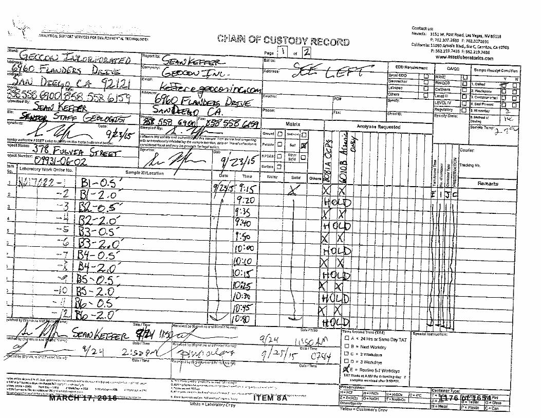
MARCH 17, 2016 ITEM 8A 1176 of 1654

MARCH 17, 2016 ITEM 8A 1177 of 1654

ASSET LaboratoriesPlease review the checklist below. Any NO signifies non-compliance. Any non-compliance will be noted and must be understood as having an impact on the quality of the data. All tests will be performed as requested regardless of any compliance issues.
If you have any questions or further instruction, please contact our Project Coordinator at (702) 307-2659.
Carrier name: Golden State Overnight
Cooler Received/Opened On: 9/25/2015
Rep sample Temp (Deg C): 2.9 IR Gun ID: 2
Temp Blank: Yes No
Last 4 digits of Tracking No.: 0445
Cooling process: Ice Ice Pack Dry Ice Other None
Packing Material Used: Bubble Wrap
Workorder: N017022
Sample Receipt Checklist
4. Chain of custody present? Yes No
6. Chain of custody signed when relinquished and received? Yes No
7. Chain of custody agrees with sample labels? Yes No
8. Samples in proper container/bottle? Yes No
9. Sample containers intact? Yes No
10. Sufficient sample volume for indicated test? Yes No
11. All samples received within holding time? Yes No
Yes No NA13. Water - VOA vials have zero headspace?
14. Water - pH acceptable upon receipt? Yes No NAExample: pH > 12 for (CN,S); pH<2 for Metals
1. Shipping container/cooler in good condition? Yes No Not Present
2. Custody seals intact, signed, dated on shippping container/cooler? Yes No Not Present
3. Custody seals intact on sample bottles? Yes No Not Present
5. Sampler's name present in COC? Yes No
12. Temperature of rep sample or Temp Blank within acceptable limit? Yes No NA
Yes No NA15. Did the bottle labels indicate correct preservatives used?
16. Were there Non-Conformance issues at login? Yes No NAWas Client notified? Yes No NA
Comments:
Checklist Completed By: MBC Reviewed By:
MARCH 17, 2016 ITEM 8A 1178 of 1654

MARCH 17, 2016 ITEM 8A 1179 of 1654

MARCH 17, 2016 ITEM 8A 1180 of 1654

Appendix F‐1 Preliminary Hydrology Study
MARCH 17, 2016 ITEM 8A 1181 of 1654

MARCH 17, 2016 ITEM 8A 1182 of 1654
MARCH 17, 2016 ITEM 8A 1183 of 1654

MARCH 17, 2016 ITEM 8A 1184 of 1654

MARCH 17, 2016 ITEM 8A 1185 of 1654

MARCH 17, 2016 ITEM 8A 1186 of 1654

MARCH 17, 2016 ITEM 8A 1187 of 1654

MARCH 17, 2016 ITEM 8A 1188 of 1654

MARCH 17, 2016 ITEM 8A 1189 of 1654

MARCH 17, 2016 ITEM 8A 1190 of 1654

MARCH 17, 2016 ITEM 8A 1191 of 1654

MARCH 17, 2016 ITEM 8A 1192 of 1654

MARCH 17, 2016 ITEM 8A 1193 of 1654

MARCH 17, 2016 ITEM 8A 1194 of 1654

MARCH 17, 2016 ITEM 8A 1195 of 1654

MARCH 17, 2016 ITEM 8A 1196 of 1654

MARCH 17, 2016 ITEM 8A 1197 of 1654

MARCH 17, 2016 ITEM 8A 1198 of 1654

MARCH 17, 2016 ITEM 8A 1199 of 1654

MARCH 17, 2016 ITEM 8A 1200 of 1654