matching formal and informal geospatial ontologies
TRANSCRIPT
Matching Formal and InformalGeospatial Ontologies
Heshan Du, Natasha Alechina, Mike Jackson and Glen Hart
Abstract The rapid development of crowd-sourcing or volunteered geographicinformation both challenges and provides opportunities to authoritative geospatialinformation. Matching geospatial ontologies is an essential element to realizing thesynergistic use of disparate geospatial information. We propose a new semi-automatic method to match formal and informal real life geospatial ontologies, atboth terminology level and instance level, ensuring that overall information islogically coherent and consistent. Disparate geospatial ontologies are matched byfinding a consistent and coherent set of mapping axioms with respect to them.Disjointness axioms are generated in order to facilitate detection of errors. Incontrast to other existing methods, disjointness axioms are seen as assumptions,which can be retracted during the overall process. We produce candidates forretraction automatically, but the ultimate decision is taken by domain experts.Geometry matching, lexical matching and cardinality checking are combinedwhen matching geospatial individuals (spatial features).
1 Introduction
In recent years, the emergence and development of crowd-sourcing or volunteeredgeographic information has challenged and also provided opportunities to thetraditional model of geospatial data collection, storage and updates. Allowingamateurs to collect geospatial data helps lower the cost, capture richer user-basedinformation and reflect real world changes more quickly. At the same time it may
H. Du (&) � N. Alechina � M. JacksonThe University of Nottingham, Nottingham, UKe-mail: [email protected]
G. HartOrdnance Survey of Great Britain, Southampton, UK
D. Vandenbroucke et al. (eds.), Geographic Information Science at the Heartof Europe, Lecture Notes in Geoinformation and Cartography,DOI: 10.1007/978-3-319-00615-4_9, � Springer International Publishing Switzerland 2013
155
also dilute information quality, such as completeness, consistency and accuracy(Jackson et al. 2010). It is desirable to use volunteered and authoritative geospatialinformation as complements to each other, taking the best of both.
Ontology refers to an explicit specification of a shared conceptualization(Gruber 1993) and plays an important role in establishing shared formal vocab-ularies. A spatial individual has a certain and verifiable location and a meaningfullabel, which together distinguish itself from others. Geospatial ontologies describeconceptual hierarchies and interrelations of terminologies in the domain of geo-spatial science, which are used to describe facts (classifications, relations, attri-butions and locations) about spatial individuals. Compared to other ontologies,geospatial ontologies have some special properties. Firstly, many geospatial ter-minologies are commonly used in daily life and their meanings vary in differentcontexts. For example, ‘‘College’’ may refer to an institution within a university inone ontology, whilst meaning a secondary school in another. In addition, geo-spatial ontologies often do not have a huge number of classes as ontologies inseveral other subject areas (for example, biomedicine) do, but may represent manyreal world spatial individuals, whose locations, at least in theory, can be verified.For example, Space, a large-scale geospatial ontology constructed using WordNet,GeoNames and Thesaurus of Geographical Names, contains 845 classes and 6,907, 417 individuals (Giunchiglia et al. 2012). Since geospatial ontologies forauthoritative and volunteered data sets are developed independently, matchinggeospatial ontologies is an essential step to use them synergistically.
We propose a new semi-automatic method for matching geospatial ontologies,at both terminology level and instance level. Geographic information qualityincludes several aspects, viz., completeness, logical consistency, positional accu-racy, thematic accuracy, temporal quality and usability (International Organizationfor Standardization 2011). We focus on logical consistency, ensuring that, afteradding a mapping, overall information is logically coherent and consistent, withoutany contradictions. We assume that the TBoxes1 of geospatial ontologies are notvery large, but contain concepts which are more ambiguous, compared to, forexample, biomedical ontologies. The matching process is reduced to the problemof finding a coherent and consistent set of assumptions (including disjointnessaxioms, equivalence and inclusion relations between concepts from differentontologies, and ‘‘sameAs’’ and ‘‘partOf’’ relations between spatial instances) withrespect to input ontologies. Unlike a premise, an assumption is believed by default,but can be retracted later if found to be not reasonable later. Disjointness axiomsare generated in order to facilitate detection of errors or contradictions. Geospatialindividuals are matched using location, lexical and classification information.
The rest of the chapter is organized as follows. Section 2 reviews related workon ontology matching and geospatial data integration. We describe our newmethod in Sect. 3, and evaluate it in Sect. 4. Finally, Sect. 5 provides conclusions.
1 Definitions of concepts and roles.
156 H. Du et al.
2 Related Research
Ontology matching is the task of finding a mapping, i.e. a set of correspondences,between entities from different ontologies (Euzenat and Shvaiko 2007). It includestwo main levels, the terminology level and instance level. Many ontologymatching methods and systems have been developed in recent years (Euzenat andShvaiko 2007; Shvaiko and Euzenat 2012). Most of them are based on lexical andstructural analysis and similarity measurements. However, mappings generated bythese methods often contain logical contradictions. Logical reasoning is employedfor either mapping generation or verification in some systems, including the earlylogic-based attempts, such as CtxMatch (Bouquet et al. 2003) and its extensionS-Match (Giunchiglia et al. 2004), and more recently, ASMOV (Jean-Mary et al.2010) which verifies mappings against five specified inconsistent patterns,KOSIMap (Reul and Pan 2010) based on description logic coherence checkingassuming the disjointness of siblings, ContentMap (Jimenez-Ruiz et al. 2009)which computes new entailments from initial mappings generated by other sys-tems, LogMap (Jimenez-Ruiz and Grau 2011) and CODI (Niepert et al. 2010).
LogMap is a logic-based ontology matching tool, designed for large-scale bio-medical ontologies. It employs lexical and structural methods to compute an initialmapping. LogMap iterates two main steps. In Step 1, unsatisfiable classes will bedetected using propositional Horn representation and satisfiability checking, andbe repaired using a greedy diagnosis algorithm. However, the propositional Hornsatisfiability checking is sound but incomplete, and the underlying semantics isrestricted to propositional logic, and thus cannot guarantee the coherence of themapping between more expressive ontologies. In Step 2, new mapping relationswill be generated based on the similarity of classes related to established corre-spondences. Only newly discovered correspondences can be eliminated in therepair step, whilst correspondences found in earlier iterations are seen as estab-lished or valid. In other words, each mapping relation will be checked once,against the available information at that time, which, however, cannot guarantee itscorrectness when new information is discovered later.
CODI is a probabilistic logical alignment system based on Markov logic(Domingos et al. 2008). It transforms the matching problem to a maximum-aposterior optimization problem subject to cardinality constraints, coherence con-straints and stability constraints. The GUROBI optimizer (Gurobi Optimization Inc2012) is employed to solve the optimization problems. CODI reduces incoherenceduring the alignment process for the first time, compared to all other existingmethods repairing alignments afterwards. CODI is based on the rationale of findingthe most likely mapping by maximizing the sum of similarity-weighted probabil-ities for potential correspondences. However, during the optimization process,some valid correspondences can be thrown away.
It is a central problem within the context of Linked Data to identify corre-spondences between instances from different sources. Wolger et al. (2011) providea summary of the existing data interlinking methods. Most of them are based on
Matching Formal and Informal Geospatial Ontologies 157
lexical methods, such as string matching and word relation matching, machinelearning and natural language processing techniques. Only within some systems,such as L2R (Sais et al. 2007), KnoFuss (Nikolov et al. 2007) and RDF-AI(Scharffe et al. 2009), consistency is checked.
In addition, there is some recent work on debugging and repairing ontologymappings (Meilicke and Stuckenschmidt 2009; Qi et al. 2009; Wang and Xu2008), which is still at an early stage. However, to the best of our knowledge, all ofthem, as well as the ontology matching or data interlinking systems describedabove, treat disjointness axioms as premises, rather than retractable assumptions,and none of them have addressed the special properties of geospatial information.
In geospatial information science, several data conflation methods have beendeveloped for matching or integrating geospatial vector data, mainly based on thesimilarities of geometries or topological relations, as well as attributes, if available.Most of them focus on conflating road vector data. However, few of these tech-niques check and ensure the logical coherence and consistency of integratedinformation (Du et al. 2012). In addition, several ontology-driven methods havebeen developed for integrating geospatial terminologies. Most of them are basedon similarity measures or a predefined top-level ontology. Logical reasoning isonly employed when formal ontologies commit to a same top-level ontology(Buccella et al. 2009). However, when ontologies are developed independently,the common top-level ontology is not usually available. Additionally, there existsome other methods (Volz and Walter 2004; Jain et al. 2010), following thebottom-up approach to linking geospatial schemas or ontologies, inferring termi-nology correspondences from instances correspondences. Though this works wellwhen instance data is representative and overlapping, it uses a very strong form ofinduction from particular to the universal, which leads to lack of correctness andcompleteness (Bouquet 2007). Therefore, more research is required to fill in thegap, exploring logic-based approaches to matching geospatial ontologies.
3 Method
We propose a new semi-automated method for matching geospatial ontologies.Initial mappings between concepts and between individuals are generated usinglexical matching and geometry matching. Logical coherence and consistency isensured by automatically generating sets of assumptions responsible for incoher-ence or inconsistency using description logic reasoner Pellet (Sirin et al. 2007),and asking domain experts to decide which assumptions from these sets should beremoved to restore coherence and consistency. Due to limited space, we recom-mend Baader et al. (2007) for the basic notions of description logic.
Definition 1 (Ontology) An ontology O has a TBox which contains knowledge atthe conceptual level, and an ABox which describes facts about individuals usingterminologies described in the TBox.
158 H. Du et al.
Definition 2 (Coherence) An ontology O is coherent if there is no class whichonly admits an empty interpretation. Otherwise, it is incoherent.
Definition 3 (Consistency) An ontology O is consistent if
• there exists no individual name a can be shown to belong to a concept C and toits negation, C;
• there exists no individual names a, b can be shown to belong to a role R and itsnegation, R;
Otherwise, O is inconsistent.
This method matches ontologies from the terminology level to the instance level.It includes four main steps. Since the original ontologies are often lightweight,disjointness axioms are generated in Step 1, to facilitate detection of incoherenciesand inconsistencies. Ontology TBoxes are matched in Step 2. In Step 3, we matchABoxes of geospatial ontologies using location and lexical information. The wholeontologies are matched in Step 4. Mapping relations are represented as axioms instandard description logics, making use of existing and highly optimized reasoningtechniques, for example Pellet (Sirin et al. 2007). Differing from other existingmethods, this method treats generated disjointness axioms and the mappingsbetween different ontologies, as assumptions, rather than premises. Users areallowed to retract or enable existing assumptions, and add new assumptions, duringthe matching process.
Definition 4 (Premise and Assumption) A premise is believed all the time, whilstan assumption is believed by default, but may be retracted later.
To represent and reason with two ontologies Oi and Oj, where i, j are theirnames, as well as the mapping M between them, as if they all belong to one superontology (Oi [ Oj [ M), we label all atomic concepts, roles and individualnames in each ontology by the name of the ontology. An atomic concept C and anindividual name a from ontology i are represented as i: C and i: a respectively.
Definition 5 (Union of Ontologies) The union of ontologies Oi and Oj, repre-sented as (Oi [ Oj), is an ontology containing all axioms in Oi and Oj.
3.1 Matching Terminologies
A terminology mapping is a set of correspondences between concepts from dif-ferent ontologies. A terminology correspondence is represented in one of the twobasic forms:
BiYC j ð1Þ
Bi w C j ð2Þ
Matching Formal and Informal Geospatial Ontologies 159
where B, C denote concepts.2 The relation (1) states that the concept B from theontology i is more specific than or equivalent to the concept C from the ontologyj. The relation (2) states that the concept B from the ontology i is more general thanor equivalent to the concept C from the ontology j. The equivalence relation (3)holds if and only if (1) and (2) both hold.
Bi � C j ð3Þ
It states that the concept B from the ontology i and the concept C from theontology j are equivalent.
A disjointness axiom states that two or more concepts are pairwise disjoint,having no common element. For example, Person and Place are disjoint, whichcan be represented as Person Y: Place, where : denotes negation. Disjointnessaxioms in ontologies play an important role in debugging ontology mappings.However, within original geospatial ontologies, disjointness axioms are not alwaysavailable or sufficient. Adding disjointness axioms manually, especially for largeontologies, is time-consuming and error-prone. Many existing systems employmore automatic approaches, either assuming the disjointness of siblings (e.g. Reuland Pan 2010), or employing machine learning techniques to detect disjointness(e.g. Meilicke et al. 2008a). After disjointness axioms are generated by whatevermeans, all existing ontology matching or debugging methods, to the best of ourknowledge, use them as premises, though the input disjointness axioms can beinsufficient or too restrictive. Differing from these methods, we use generateddisjointness axioms as assumptions, and ensure the assumption set is coherent.
Definition 6 (Coherence of an Assumption Set) An assumption set As is inco-herent with respect to an ontology O, if O [ As is incoherent, but O is coherent.Otherwise, it is coherent with respect to an ontology O.
When some incoherence is introduced by assumptions, minimal incoherentassumption sets (MIA) will be computed. The notion of MIA is defined byextending the minimal conflict set defined for mappings (Meilicke et al. 2008b) tothis context.
Definition 7 (Minimal Incoherent Assumption Set) Given a set of assumptions As,a set C ( As is a minimal incoherent assumption set (MIA) iff C is incoherent andeach C0 , C is coherent.
A minimal incoherent assumption set can be fixed by removing any axiom fromit. When a MIA contains more than one element, one needs to decide which axiomto remove. Most of the existing methods remove the one either with the lowestconfidence value or which is the least relevant. However, there is no consensuswith respect to the measure of the degree of confidence or relevance. In severalcases, confidence values or relevance degrees might be unavailable or difficult to
2 When B, C denote atomic concepts, Bi = i: B, Cj = j: C.
160 H. Du et al.
compute or compare. Rather than relying on them, we allow domain experts tomake ultimate decisions.
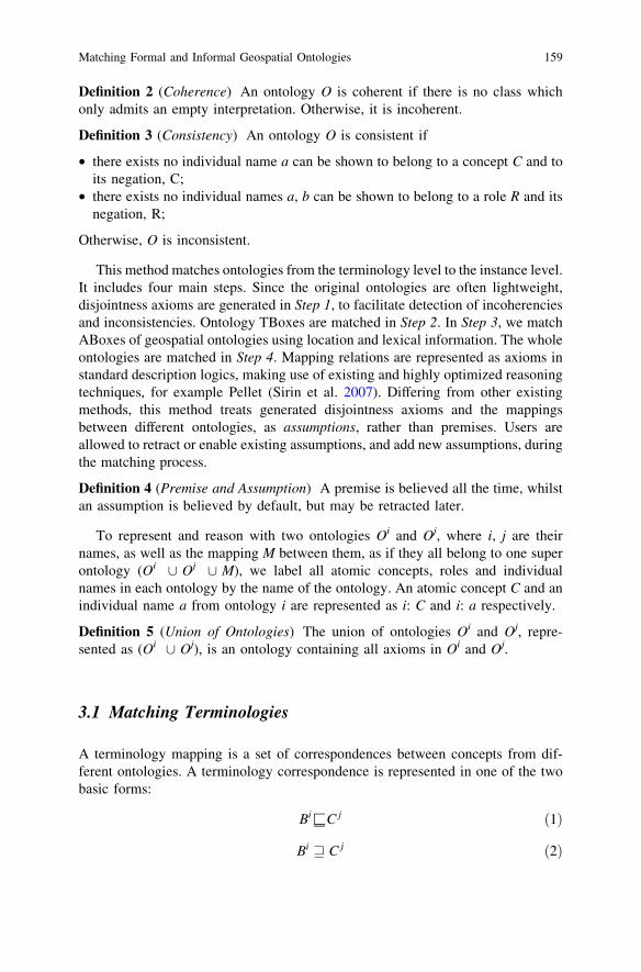
Algorithm 1 is designed to generate a coherent assumption set (CAS) withrespect to an ontology.3 The set of minimal incoherent assumption sets will bevisualized clearly (Line 5). Domain experts are employed to take repair actions(Line 6). Currently, a repair action can be retracting an assumption axiom. Usersare allowed to take several repair actions at one time.
Step 1: Generating coherent disjointness assumption sets (CDAS). For eachcoherent ontology TBox,4 as shown in Algorithm 2, we generate disjointnessaxioms as assumptions for sibling classes and refine them by applying Algorithm 1.
Step 2: Matching terminologies (Algorithm 3). Currently, an initial terminologymapping is generated by using a very simple lexical matching method, i.e. statingequivalence of atomic concepts with identical names (Line 1). Definition 6 can beextended from one ontology O to two ontologies T1 and T2, given that the union oftwo ontologies, T1[T2, is an ontology. A coherent disjointness assumption set forTBoxes (union of CDAS for each TBox) and an initial terminology mapping forman initial assumption set, from which, a coherent assumption set with respect to T1
3 In an algorithm, lines marked with * may require manual intervention.4 An ontology only with a TBox.
Matching Formal and Informal Geospatial Ontologies 161
and T2 is calculated by applying Algorithm 1. An assumption in a minimal inco-herent assumption set can be a disjointness axiom or a terminology correspon-dence axiom. Domain experts are consulted to decide which assumption(s) toretract when incoherence arises.
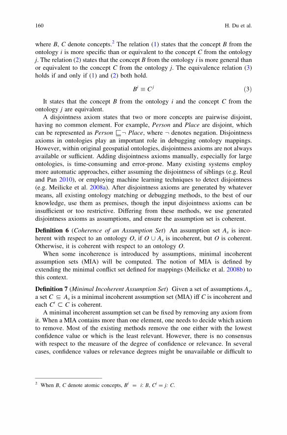
ALGORITHM 3: Matching TerminologiesInput T1, T2: coherent ontology TBoxes
Dcs: a coherent disjointness assumption set with respect to T1, T2
Output Tcs: a coherent terminology assumption set with respect to T1, T2
1. Mst :¼ lexicalMatching(T1, T2);2. Tcs :¼ CAS(T1[T2, Dcs[Mst);3. return Tcs
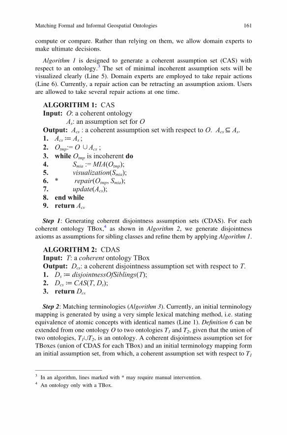
3.2 Matching Geospatial Individuals
An instance level mapping is a set of individual correspondences. An individualcorrespondence is represented in one of the following forms:
i : a; j : bð Þ 2 sameAs ð4Þ
i : a; j : bð Þ 2 partOf ð5Þ
where a, b denote individual names. The relation (4) states that the individualname a from the ontology i and the individual name b from the ontology j refer tothe same object. The relation (5) states that the individual name a from theontology i refers to an object which is a part of the object the individual nameb from the ontology j refers to.
ALGORITHM 4: Matching Geospatial IndividualsInput A1, A2: ontology ABoxesOutput Msa : an initial geospatial instance mapping between A1, A2
1. Msa:¼{};2. for each spatial individual a1 in A1 do3. for each spatial individual a2 in A2 do4. if geo_poss_match(a1.geometry, a2.geometry)5. and lex_poss_match(a1.lexicons, a2.lexicons) then6. add (a1, a2) [ sameAs to Msa;7. end if8. end for9. end for
10. cardinalityChecking (Msa)11. return Msa
162 H. Du et al.
Step 3: Matching Geospatial Individuals. Algorithm 4 is designed to matchgeospatial individuals whose geometries are represented using the same coordinatereference system (CRS). The geometry of a spatial object can be represented indifferent accuracy levels, granularities or world views in different ontologies. Inother words, for the same spatial object, the recorded geometry in ontology i maynot be exactly the same as the recorded geometry in ontology j.
The geo_poss_match (Line 4) between two geometries returns true if thegeometries are similar enough given a margin of error in representation. Currently,it requires input geometries as polygons. Two polygons are possibly matched if oneof them is the smallest polygon containing the characteristic point from the other.5
The lex_poss_match (Line 5) between two lexical descriptions returns true ifthe lexicons (meaningful labels indicating identity) are similar enough, toleratingpartial differences, for example, a full name and its abbreviation, and recognizingdifferent names for the same location. Currently, it employs a series of basic stringmatching strategies, such as equivalence, inclusion and abbreviation.
For each pair of spatial individuals a1 and a2 from different ontologies, if theirgeometries are possibly matched (Line 4) and their lexicons are possibly matched(Line 5), then they can be assumed to be the same. We generate a ‘‘sameAs’’relation linking them and add it to an instance mapping Msa (Line 6).
It is currently assumed that, within a local ontology, a spatial individual has atmost one representation. In other words, there are no ‘‘sameAs’’ relations within alocal ontology. The cardinality checking (Line 10) revises Msa, a set of ‘‘sameAs’’relations, ensuring that ‘‘sameAs’’ is one-to-one. If not, we remove them from Msa,and add corresponding ‘‘partOf’’ relations. For example, if Msa contains (i: a, j:b) [ sameAs and (i: c, j: b) [ sameAs, we replace them with (i: a, j: b) [ partOf and(i: c, j: b) [ partOf. 6
The geometry matching, lexical matching and cardinality checking complementeach other to cope with the following possibilities. Different geospatial individualsmay share the same label or the same location in an ontology. In addition, a samegeospatial individual may be represented as a whole in one ontology, whilst asseveral parts of it in another.
5 Individuals from the Ordnance Survey of Great Britain (OSGB) Buildings and Places ontologyand the OpenStreetMap ontology (See Sect. 4.2) are spatially linked by finding the smallest OSMpolygon containing a point from OSGB address Layer 2. See Fig. 1 for examples. Polygonscontaining the same red point are linked.
A more sophisticated geometry matching method for generating spatial ‘‘sameAs’’ and‘‘partOf’’ relations is under development and evaluation.6 We are aware that, an individual a in one ontology Oi can be part of an individual b in anotherontology Oj, even if there are no other individuals in Oi who can be part of b. This has beconsidered when designing our new geometry matching method.
Matching Formal and Informal Geospatial Ontologies 163
Definition 8 (Consistency of an Assumption Set) An assumption set As is incon-sistent with respect to an ontology O, if O[As is inconsistent, but O is consistent.Otherwise, it is consistent with respect to an ontology O.
Definition 9 (Minimal Inconsistent Assumption Set) Given a set of assumption As,a set C ( As is a minimal inconsistent assumption set (MIA),7 iff C is inconsistentand each C’ , C is consistent.
Similarly, a minimal inconsistent assumption set can be fixed by removing oneelement from it. The algorithm for calculating consistent assumption set (CAS)can be generated from Algorithm 1, changing coherence checking to consistencychecking. Definition 8 can be easily extended to deal with two ontologies.
ALGORITHM 5: Matching Geospatial OntologiesInput O1 = (T1, A1), O2 = (T2, A2): coherent and consistent geospatial
ontologiesTcs: a coherent assumption set with respect to T1, T2
Msa: an initial geospatial instance mapping between A1 and A2.
Output Ocs: a consistent assumption set with respect to O1 and O2
1. Ocs : = CAS(O1 [O2, Tcs [Msa)8;2. return Ocs
Step 4: Matching Geospatial Ontologies (Algorithm 5). A coherent assumptionset with respect to TBoxes is obtained in Step 2. An initial geospatial instancemapping between ABoxes is generated in Step 3. The union of them is anassumption set with respect to input ontologies. Applying CAS, if overall infor-mation is inconsistent, a set of minimal inconsistent assumption sets will be cal-culated, and visualized appropriately to help domain experts to repair them. Thesesteps iterate until a consistent assumption set is found.
4 Evaluation
The method described above is implemented as a system called GeoMap. Pellet(Sirin et al. 2007) is employed for coherence and consistency checking. Minimalincoherent assumption sets are calculated from explanations for unsatisfiableclasses, and minimal inconsistent assumption sets from explanations forinconsistencies.
We evaluate GeoMap using the Ordnance Survey of Great Britain (OSGB)Buildings and Places ontology (Hart et al. 2008) and the OpenStreetMap (OSM)controlled vocabularies (OpenStreetMap 2012). OSGB and OSM are
7 MIA refers to minimal incoherent assumption set when matching terminologies, and refers tominimal inconsistent assumption set when matching instances.8 CAS here refers to the calculation of consistent assumption set.
164 H. Du et al.
representatives of authoritative and crowd-sourced geospatial information sourcesrespectively. OSGB is the national topographic mapping agency of Great Britain.OSM is a collaborative project to create a free editable map of the world, relyingon volunteers for data collection. Currently, OSM has not established a standardontology, but maintains a collection of commonly used tags for main map features.An OSM feature ontology is generated automatically from the existing classifi-cation of main features. For example, given ‘‘Restaurant’’ is a value under the key‘‘Amenity’’ in the OSM classification, we formulate this as OSM: Restau-rant Y OSM: Amenity. Both ontologies are written in the OWL 2 Web OntologyLanguage (W3C 2009). The OSGB Buildings and Places ontology has 692 classesand 1,230 logical axioms. There are 663 classes and 677 logical axioms in theOSM ontology. Both ontologies, containing no disjointness axioms, are coherent.
4.1 Evaluating Terminology Mapping
Evaluating Step 1. Applying Algorithm 2, a coherent disjointness assumption setcontaining 32,299 pairwise disjointness axioms is generated with respect to theOSGB Building and Places ontology. With respect to the OSM ontology, thecoherent disjointness assumption set contains 9,348 pairwise disjointness axioms.A sample of 323 and a sample of 93 are taken randomly from these coherentdisjointness assumption sets respectively. Based on manual evaluation, the rates ofcorrectness are 0.951 and 0.892 respectively.
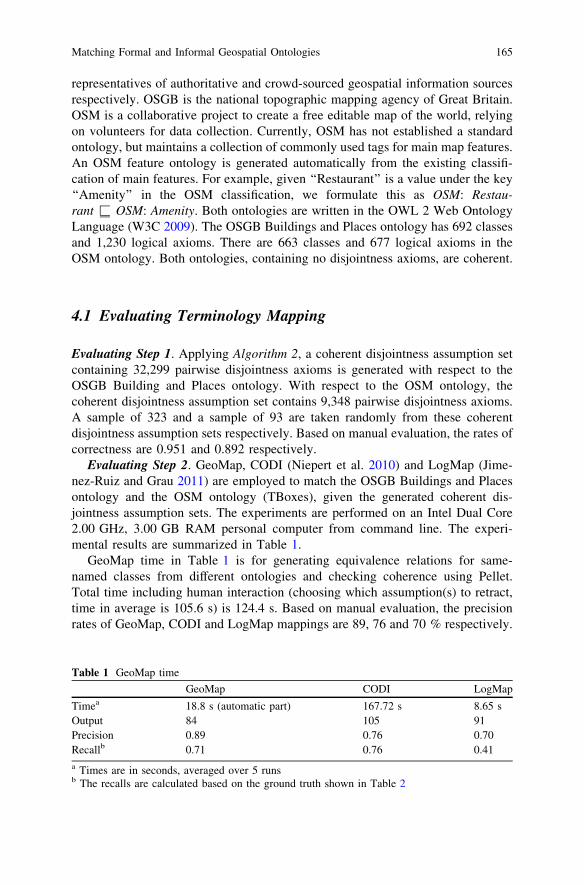
Evaluating Step 2. GeoMap, CODI (Niepert et al. 2010) and LogMap (Jime-nez-Ruiz and Grau 2011) are employed to match the OSGB Buildings and Placesontology and the OSM ontology (TBoxes), given the generated coherent dis-jointness assumption sets. The experiments are performed on an Intel Dual Core2.00 GHz, 3.00 GB RAM personal computer from command line. The experi-mental results are summarized in Table 1.
GeoMap time in Table 1 is for generating equivalence relations for same-named classes from different ontologies and checking coherence using Pellet.Total time including human interaction (choosing which assumption(s) to retract,time in average is 105.6 s) is 124.4 s. Based on manual evaluation, the precisionrates of GeoMap, CODI and LogMap mappings are 89, 76 and 70 % respectively.
Table 1 GeoMap time
GeoMap CODI LogMap
Timea 18.8 s (automatic part) 167.72 s 8.65 sOutput 84 105 91Precision 0.89 0.76 0.70Recallb 0.71 0.76 0.41a Times are in seconds, averaged over 5 runsb The recalls are calculated based on the ground truth shown in Table 2
Matching Formal and Informal Geospatial Ontologies 165
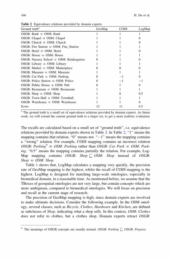
The recalls are calculated based on a small set of ‘‘ground truth’’, i.e. equivalencerelations provided by domain experts shown in Table 2. In Table 2, ‘‘1’’ means themapping contains that relation, ‘‘0’’ means not. ‘‘-1’’ means the mapping containsa ‘‘wrong’’ relation. For example, CODI mapping contains an incorrect relationOSGB: Parking9 : OSM: Parking rather than OSGB: Car Park : OSM: Park-ing. ‘‘0.5’’ means the mapping contains partially the relation. For example, Log-Map mapping contains OSGB: Shop Y OSM: Shop instead of OSGB:Shop : OSM: Shop.
Table 1 shows that, LogMap calculates a mapping very quickly, the precisionrate of GeoMap mapping is the highest, whilst the recall of CODI mapping is thehighest. LogMap is designed for matching large-scale ontologies, especially inbiomedical domain, in a reasonable time. As mentioned before, we assume that theTBoxes of geospatial ontologies are not very large, but contain concepts which aremore ambiguous, compared to biomedical ontologies. We will focus on precisionand recall at the current stage of research.
The precision of GeoMap mapping is high, since domain experts are involvedto make ultimate decisions. Consider the following example. In the OSM ontol-ogy, several classes, such as Bicycle, Clothes, Hardware and Kitchen, are definedas subclasses of Shop, indicating what a shop sells. In this context, OSM: Clothesdoes not refer to clothes, but a clothes shop. Domain experts retract OSGB:
Table 2 Equivalence relations provided by domain experts
Ground trutha GeoMap CODI LogMap
OSGB: Bank : OSM: Bank 1 1 1OSGB: Chapel : OSM: Chapel 1 1 0OSGB: Church : OSM: Church 1 1 0OSGB: Fire Station : OSM: Fire_Station 1 1 1OSGB: Hotel : OSM: Hotel 1 1 0OSGB: House : OSM: House 1 1 1OSGB: Nursery School : OSM: Kindergarten 0 1 0OSGB: Library : OSM: Library 1 1 1OSGB: Market : OSM: Marketplace 0 0 0OSGB: Museum : OSM: Museum 1 1 1OSGB: Car Park : OSM: Parking 0 -1 0OSGB: Police Station : OSM: Police 0 -1 -1OSGB: Public House : OSM: Pub 0 1 0OSGB: Restaurant : OSM: Restaurant 1 1 1OSGB: Shop : OSM: Shop 1 0 0.5OSGB: Town Hall : OSM: Townhall 1 1 1OSGB: Warehouse : OSM: Warehouse 1 1 0Score 12 11 6.5
a The ground truth is a small set of equivalence relations provided by domain experts. As futurework, we will extend the current ground truth to a larger set, to get a more realistic evaluation
9 The meanings of OSGB concepts are usually normal. OSGB: Parking Y OSGB: Purpose.
166 H. Du et al.

Clothes10 : OSM: Clothes, whilst, CODI removes OSGB: Shop : OSM: Shopand keeps the existing correspondences of subclasses of Shop, optimizing the sumof similarity-weighted probability. LogMap weakens the equivalence relation toOSGB: Shop Y OSM: Shop. Though mappings calculated by GeoMap and CODIare always coherent11 with respect to input ontologies, the results based on opti-mization may not be reasonable in several cases, especially when informalinformation exists. Domain experts do not necessarily make the same choices, andan individual domain expert may make different decisions on different occasions.
CODI produces more correct correspondences, such as OSGB: NurserySchool : OSM: Kindergarten and OSGB: Public House : OSM: Pub, owing toits usage of more intelligent lexical matching techniques. However, CODI tradesoff its precision rate, since it also produces incorrect relations, like OSGB: RaceHorse12 : OSM: Horse_Racing. The recall of CODI is better than that of Geo-Map or LogMap, however, it is still far from covering all ground truth relations.All three fail to calculate the relation OSGB: Market : OSM: Marketplace andmiss relations of other types, such as inclusions13 and overlaps. To improve therecall, more sophisticated lexical matching methods are required, and domainexperts are needed, at least at the current stage of development.
The experimental results show that domain experts are indispensable whenmatching terminologies in order to obtain 100 % precision and recall. Mappingsproduced by fully automatic methods, such as CODI and LogMap, require finalvalidation by experts, which is difficult and time-consuming. Our method reduceshuman effort by directing experts to make ultimate decisions during the matchingprocess. As future work, more methods need to be developed to support themanual intervention stage, minimizing human efforts.
4.2 Evaluating Geospatial Instance Mapping
We currently require that, geospatial individuals from different ontologies havepolygonal geometries, represented as two dimension vector data. The instance datafor OSGB Buildings and Places ontology is extracted from the OSGB AddressLayer 2 and the OSGB Topology Layer (Ordnance Survey 2012). The AddressLayer 2 is a point layer, containing lexical and classification information for spatialindividuals. The Topology Layer is a polygon layer, containing geometries ofspatial individuals. These two layers are linked together by finding the smallestTopology Layer polygon containing a point from the Address Layer 2. The OSMinstances are from the building layer (containing polygonal geometries, names and
10 OSGB: Clothes refers to ‘‘garments worn over the body’’. It is a secondary concept.11 A LogMap mapping may not.12 OSGB: Race Horse Y OSGB: Animal. It is used to define OSGB: Racing Stables. .13 LogMap weakens some equivalence relations to inclusions, but also does not produce enough.
Matching Formal and Informal Geospatial Ontologies 167
types) of OSM data, downloaded through Geofabrik (Geofabrik GmbH Karlsruhe2012) in April, 2012. From the studied area of Nottingham city centre, 713 geo-spatial individuals are added to OSGB Buildings and Places ontology, 253 geo-spatial individuals are added to OSM ontology automatically, resulting in twoconsistent ontologies. Each geospatial individual is classified to a class based on itstype information, and has geometry information and lexicon information as its dataproperties.
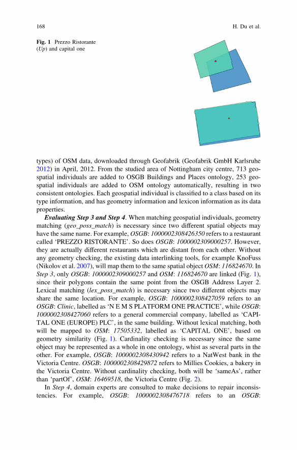
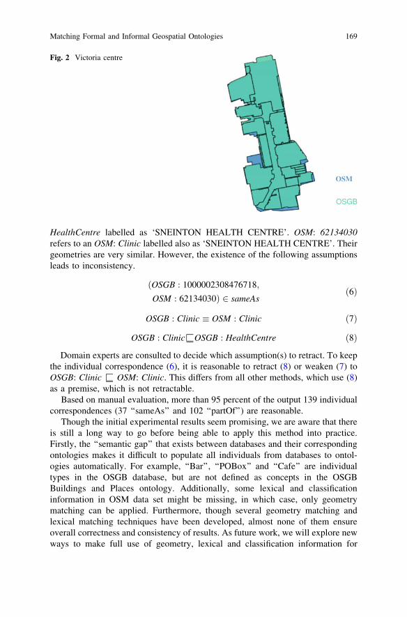
Evaluating Step 3 and Step 4. When matching geospatial individuals, geometrymatching (geo_poss_match) is necessary since two different spatial objects mayhave the same name. For example, OSGB: 1000002308426350 refers to a restaurantcalled ‘PREZZO RISTORANTE’. So does OSGB: 1000002309000257. However,they are actually different restaurants which are distant from each other. Withoutany geometry checking, the existing data interlinking tools, for example KnoFuss(Nikolov et al. 2007), will map them to the same spatial object OSM: 116824670. InStep 3, only OSGB: 1000002309000257 and OSM: 116824670 are linked (Fig. 1),since their polygons contain the same point from the OSGB Address Layer 2.Lexical matching (lex_poss_match) is necessary since two different objects mayshare the same location. For example, OSGB: 1000002308427059 refers to anOSGB: Clinic, labelled as ‘N E M S PLATFORM ONE PRACTICE’, while OSGB:1000002308427060 refers to a general commercial company, labelled as ‘CAPI-TAL ONE (EUROPE) PLC’, in the same building. Without lexical matching, bothwill be mapped to OSM: 17505332, labelled as ‘CAPITAL ONE’, based ongeometry similarity (Fig. 1). Cardinality checking is necessary since the sameobject may be represented as a whole in one ontology, whist as several parts in theother. For example, OSGB: 1000002308430942 refers to a NatWest bank in theVictoria Centre. OSGB: 1000002308429872 refers to Millies Cookies, a bakery inthe Victoria Centre. Without cardinality checking, both will be ‘sameAs’, ratherthan ‘partOf’, OSM: 16469518, the Victoria Centre (Fig. 2).
In Step 4, domain experts are consulted to make decisions to repair inconsis-tencies. For example, OSGB: 1000002308476718 refers to an OSGB:
Fig. 1 Prezzo Ristorante(Up) and capital one
168 H. Du et al.
HealthCentre labelled as ‘SNEINTON HEALTH CENTRE’. OSM: 62134030refers to an OSM: Clinic labelled also as ‘SNEINTON HEALTH CENTRE’. Theirgeometries are very similar. However, the existence of the following assumptionsleads to inconsistency.
OSGB : 1000002308476718;ðOSM : 62134030Þ 2 sameAs
ð6Þ
OSGB : Clinic � OSM : Clinic ð7Þ
OSGB : ClinicYOSGB : HealthCentre ð8Þ
Domain experts are consulted to decide which assumption(s) to retract. To keepthe individual correspondence (6), it is reasonable to retract (8) or weaken (7) toOSGB: Clinic Y OSM: Clinic. This differs from all other methods, which use (8)as a premise, which is not retractable.
Based on manual evaluation, more than 95 percent of the output 139 individualcorrespondences (37 ‘‘sameAs’’ and 102 ‘‘partOf’’) are reasonable.
Though the initial experimental results seem promising, we are aware that thereis still a long way to go before being able to apply this method into practice.Firstly, the ‘‘semantic gap’’ that exists between databases and their correspondingontologies makes it difficult to populate all individuals from databases to ontol-ogies automatically. For example, ‘‘Bar’’, ‘‘POBox’’ and ‘‘Cafe’’ are individualtypes in the OSGB database, but are not defined as concepts in the OSGBBuildings and Places ontology. Additionally, some lexical and classificationinformation in OSM data set might be missing, in which case, only geometrymatching can be applied. Furthermore, though several geometry matching andlexical matching techniques have been developed, almost none of them ensureoverall correctness and consistency of results. As future work, we will explore newways to make full use of geometry, lexical and classification information for
OSM
OSGB
Fig. 2 Victoria centre
Matching Formal and Informal Geospatial Ontologies 169
matching geospatial individuals, aimed for overall correctness and consistency,and minimized human effort.
5 Conclusion
In conclusion, we propose a new semi-automatic method to match disparategeospatial ontologies, guaranteeing the coherence and consistency of overallinformation. Differing from other existing methods, disjointness axioms andmappings are seen as assumptions, which can be retracted later if found to be toorestrictive or inappropriate. A series of algorithms are designed to match disparateontologies from terminology level to instance level by calculating a coherent andconsistent assumption set with respect to them. Geometry matching, lexicalmatching and logical consistency checking are combined for matching geospatialindividuals. The initial experiments show promising results, which indicate that,when matching geospatial ontologies, using geometry or location informationhelps and domain experts are indispensable. As future work, we plan to developmore sophisticated matching methods, aimed at obtaining 100 % precision andrecall, and minimizing human effort.
References
Baader F, Calvanese D, McGuinness DL, Nardi D, Patel-Schneider PF (eds) (2007) Thedescription logic handbook. Cambridge University Press, Cambridge
Bouquet P (2007) Contexts and ontologies in schema matching. Context and ontologyrepresentation and reasoning. Roskilde University, Denmark
Bouquet P, Serafini L, Zanobini S (2003) Semantic coordination: a new approach and anapplication. International semantic web conference, pp 130–145
Buccella A, Cechich A, Fillottrani P (2009) Ontology-driven geographic information integration:a survey of current approaches. Comput Geosci 35:710–723
Domingos P, Lowd D, Kok S, Poon H, Richardson M, Singla P (2008) Just add weights: markovlogic for the semantic web. Uncertainty reasoning for the semantic web I, ISWC InternationalWorkshops, URSW 2005–2007, Revised Selected and Invited Papers, 2008, pp 1–25
Du H, Anand S, Alechina N, Morley J, Hart G, Leibovici D, Jackson M, Ware M (2012)Geospatial information integration for authoritative and crowd sourced road vector data.Transactions in GIS, Blackwell Publishing Ltd, 2012, 16, 455–476
Euzenat J, Shvaiko P (2007) Ontology matching. Springer, BerlinGeofabrik GmbH Karlsruhe: Geofabrik (2012) http://www.geofabrik.deGiunchiglia F, Dutta B, Maltese V, Farazi F (2012) A facet-based methodology for the
construction of a large-scale geospatial ontology. J Data Semant 1:57–73 SpringerGiunchiglia F, Shvaiko P, Yatskevich M (2004) S-Match: an algorithm and an implementation of
semantic matching. European semantic web conference (ESWC), pp 61–75Gruber TR (1993) A translation approach to portable ontology specifications. Knowl Acquisition
5:199–220Gurobi Optimization Inc (2012) Gurobi optimizer reference manual. http://www.gurobi.com
170 H. Du et al.
Hart G, Dolbear C, Kovacs K, Guy A (2008) Ordnance survey ontologies. http://www.ordnancesurvey.co.uk/oswebsite/ontology
International Organization for Standardization (2011) ISO/DIS 19157: Geographic information—Data quality
Jackson MJ, Rahemtulla H, Morley J (2010) The synergistic use of authenticated and crowd-sourced data for emergency response. The 2nd international workshop on validation of geo-information products for crisis management (VALgEO). Ispra, Italy, pp 91–99, 11–13 Oct2010. Available online: http://globesec.jrc.ec.europa.eu/workshops/valgeo-2010/proceedings
Jain P, Hitzler P, Sheth AP, Verma K, Yeh PZ (2010) Ontology alignment for linked open data.Int Semant Web Conf 1:402–417
Jean-Mary YR, Shironoshita EP, Kabuka MR (2010) ASMOV: results for OAEI 2010. The 5thinternational workshop on ontology matching (OM-2010)
Jiménez-Ruiz E, Grau BC (2011) LogMap: logic-based and scalable ontology matching. IntSemant Web Conf 1:273–288
Jiménez-Ruiz E, Grau BC, Horrocks I, Llavori RB (2009) Ontology integration using mappings:towards getting the right logical consequences. The 6th european semantic web conference(ESWC), pp 173–187
Meilicke C, Stuckenschmidt H (2009) An efficient method for computing alignment diagnoses.In: Third international conference on web reasoning and rule systems, pp 182–196
Meilicke C, Stuckenschmidt H, Tamilin A (2008a) Reasoning support for mapping revision.J Logic Comput 19:807–829
Meilicke C, Völker J, Stuckenschmidt H (2008b) Learning disjointness for debugging mappingsbetween lightweight ontologies. Proceedings of the 16th international conference onknowledge engineering: practice and patterns, Springer, Berlin, pp 93–108
Niepert M, Meilicke C, Stuckenschmidt H (2010) A probabilistic-logical framework for ontologymatching. American association for artificial intelligence for ontology matching. In: Proceedingsof the 24th AAAI Conference on Artificial Intelligence, Atlanta, Georgia, AAAI Press
Nikolov A, Uren V, Motta E (2007) KnoFuss: a comprehensive architecture for knowledgefusion. The 4th international conference on knowledge capture, ACM, NY, pp 185–186
OpenStreetMap (2012) The Free Wiki World Map. http://www.openstreetmap.orgOrdnance Survey (2012) Ordnance Survey. http://www.ordnancesurvey.co.uk/oswebsiteQi G, Ji Q, Haase P (2009) A conflict-based operator for mapping revision: theory and
implementation. In: Proceedings of the 8th international semantic web conference. ISWC ‘09,Springer, Berlin, Heidelberg, pp 521–536
Reul Q, Pan JZ (2010) KOSIMap: use of description logic reasoning to align heterogeneousontologies. The 23rd international workshop on description logics (DL 2010)
Sais F, Pernelle N, Rousset MC (2007) L2R: A logical method for reference reconciliation.In: AAAI conference on artificial intelligence. pp 329–334
Scharffe F, Liu Y, Zhou C (2009) RDF-AI: an architecture for RDF datasets matching, fusion andinterlink. IJCAI 2009 workshop on Identity, Reference and Knowledge Representation (IR-KR)
Shvaiko P, Euzenat J (2012) Ontology matching: state of the art and future challenges. IEEETransactions on Knowledge and Data Engineering
Sirin E, Parsia B, Grau BC, Kalyanpur A, Katz Y (2007) Pellet: a practical OWL-DL reasoner.Web semantics: science, services and agents on the World Wide Web, Elsevier SciencePublishers B. V., vol 5, pp 51–53
Volz S, Walter V (2004) Linking different geospatial databases by explicit relations. Internationalsociety for photogrammetry and remote sensing (ISPRS) congress, communication vol IV,pp 152–157
W3C (2009) OWL 2 Web Ontology Language. http://www.w3.org/TR/owl2-overviewWang P, Xu B (2008) Debugging ontology mappings: a static approach. Comput Artif Intell
27(1):21–36Wolger S, Siorpaes K, Bürger T, Simperl E, Thaler S, Hofer C (2011) A survey on data interlinking
methods. Semantic Technology Institute (STI) Innsbruck, University of Innsbruck. Availableonline: http://www.insemtives.eu/publications/A_Survey_on_Data_Interlinking_Methods.pdf
Matching Formal and Informal Geospatial Ontologies 171