mayor’s bicycle advisory council - chicago complete...
TRANSCRIPT

Mayor’s Pedestrian Advisory Council
May 10th, 2017

Year-to-Date Pedestrian Fatalities, 2017 (CPD): 14 Year-to-Date Pedestrian Fatalities, 2016 (CPD): 16
Year-to-Date Pedestrian Fatalities, 2011-2015 (IDOT): 11.4
CITY OF CHICAGO Pedestrian Fatalities by Month
Source IDOT IDOT IDOT IDOT IDOT CPD CPD IDOT
2011 2012 2013 2014 2015 2016 2017 2011-2015
Average January 1 2 1 4 7 5 6 2.6
February 3 5 2 0 1 4 3 2.4 March 3 2 2 3 6 4 4 3.2 April 3 1 2 6 3 3 1 3.2 May 3 3 2 3 6 4 3.4 June 2 0 3 4 6 3 3 July 3 3 3 4 5 3 3
August 2 11 4 3 2 8 4.6 September 5 5 2 3 2 1 3.4
October 5 4 0 2 2 3 3 November 2 7 1 1 1 5 2.4 December 4 4 5 2 5 1 4
TOTAL (Jan 1- Apr 30) 10 10 7 13 17 16 14 11.4
TOTAL 36 47 27 35 46 44 6 38.2

VISION ZERO UPDATE: SUMMER ACTIVITIES

VISION ZERO CHICAGO ACTION PLAN - PROCESS
Departments & Sister
Agencies
Citywide Stakeholders
Action Plan
Release
City & Stake- holders
Community Groups & Residents
High Crash Area Plans

VISION ZERO CHICAGO ACTION PLAN - PROCESS
Departments & Sister
Agencies
Citywide Stakeholders
Action Plan Release
City & Stake- holders
Community Groups & Residents
High Crash Area Plans

GRANT AWARD
The Road to Zero (RTZ) Coalition’s goal is safe mobility for all people, and it will work to develop priorities; take action individually and collaboratively; and encourage partners and stakeholders to take action to meet the goal of eliminating traffic fatalities by 2047. It is a collaboration focused on ending traffic fatalities on our roadways within 30 years. The National Safety Council leads the initiative in partnership with the U.S. Department of Transportation, including the National Highway Traffic Safety Administration, the Federal Highway Administration and the Federal Motor Carrier Safety Administration.

VISION ZERO WEST SIDE

VISION ZERO WEST SIDE
• Research & Data Collection, to create a profile for each Community Area
• Listening & Planning, to gather community input into how traffic safety can be improved
• Learning & Piloting, to create innovative programming and implement new ideas
• Reporting and Accountability, to communicate initiatives and opportunities to neighborhood stakeholders
Phases
• Multiple City agencies and non-profit partners • Hiring four community organizers • Focus on going out into the community to reach populations
we haven’t traditionally heard from on traffic safety issues • Create strategies, invest resources to see enacted
Summary

Chicago Public Schools Safe Routes Update Presentation
to MPAC
5/10/17

Introduction to Chicago Public Schools
• Third largest school district in the country – 381,349 students – 652 schools
• Demographics – African-American 37.7% – Asian 3.9% – Hispanic 46.5% – White 9.9% – Remaining 2.0%
2

Did you know……? CPS has achieved record high rates in SY16 on the following metrics: • “Graduation Rate” of 73.5% (+16.6 pts vs. 2011) • “Freshman on Track Rate” of 87.4% (+18.4 pts vs. 2011) • A district-wide avg. attendance rate of 93.4 percent • $1.16 billion in scholarship offers for the Class of 2016
PLUS: • Chicago Public Schools has 7 of the top 10 high schools in
the State of Illinois
3

Top 10 High Schools in Illinois Seven CPS Schools are among the state’s Top 10 – of which the top 5 are CPS schools:
1. Northside College Preparatory High School, Chicago 2. Payton College Preparatory High School, Chicago 3. Jones College Prep High School, Chicago 4. Whitney Young Magnet High School, Chicago 5. Lane Technical High School, Chicago 6. Adlai E Stevenson High School, Lincolnshire 7. Hinsdale Central High School, Hinsdale 8. Lincoln Park High School, Chicago 9. Prospect High School, Mount Prospect 10. Brooks College Prep Academy High School, Chicago
4
Source: US World News Report 2017

It makes a difference…..
5
…when our children can travel safely to and from school.
Less stress means they can focus on their education.

Spotlight on CPS Safe Passage Program
SY 2010/11 35 schools
6
Quadrupled # of schools!
SY 2016/17 142 schools
72,000 students

21 Community-based Organizations
7
• Hire Safe Passage Workers from the communities where they live
• Workers already have relationships with the community
• Workers are invested in supporting their community
ALL Committed to the Safety of our Children

1300 Safe Passage Workers
8
ALL Committed to the Safety of our Children

Goals of the program
9
• Provide stable, consistent adult presence for children traveling to and from school
• Build relationships with students
• Serve as “eyes and ears” • Prevent incidents from
becoming serious through de- escalation and conflict resolution

Schools have custom designed routes
10

Results
11
• Since 2011, there have been no major incidents involving students on Safe Passage routes during the program’s operational hours
• The program has seen a 33% reduction in crime vs. the previous year along routes during operational hours.
• Students attending schools with safe passage increased their perception of safety traveling to school at double the rate of improvement

Next Steps
• Expansion for Summer Safe Passage – Support Chicago Park District Basketball Programs:
Summer Teen Leagues and Windy City Programs – 250 workers – 6 weeks
• Double the number of days from 2 days/week to 4 days/week for Summer Teen League programs
• Increase # of parks by 50% from 21 to 31 park sites
12

Thank you!!! Questions? Jadine Chou
Chicago Public Schools Chief of Safety and Security
13

CDOT Safe Routes to School Projects
Eric Hanss, Principal Pedestrian Planner May 10, 2017

Barriers to Walking to School – Built Environment
• Gaps in the sidewalk network, lack of accessible crossings
• Uninviting pedestrian experience (lighting, state of repair, lack of visibility)
• Complex, challenging intersections • High vehicle speeds • Uncontrolled crossings and failure to stop for
pedestrians
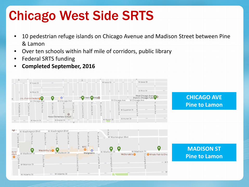
Chicago West Side SRTS • 10 pedestrian refuge islands on Chicago Avenue and Madison Street between Pine
& Lamon • Over ten schools within half mile of corridors, public library • Federal SRTS funding • Completed September, 2016
CHICAGO AVE Pine to Lamon
MADISON ST Pine to Lamon

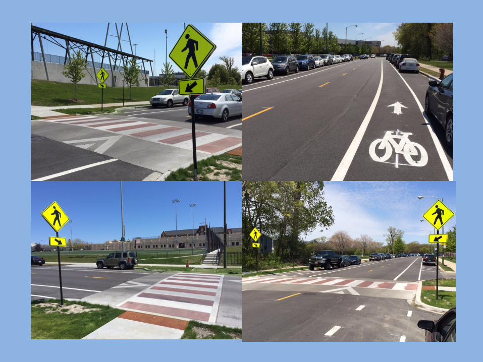
Chicago West Side SRTS
MADISON ST At Lamon

Chicago West Side SRTS
CHICAGO AVE At Latrobe

Safe Routes to School/High School • Improvements at ten schools citywide • Scope: pedestrian refuge islands,
sidewalk restoration, pedestrian countdown timers, speed feedback signs, bicycle racks, speed humps, high visibility crosswalks, and signage
• CMAQ funding • Construction summer/fall 2017

Other Programs
SIMEON CAREER ACADEMY
8100 S Vincennes

Other Programs
HORIZON SCIENCE ACADEMY
2245 W Pershing Rd

Case Study: Lane Tech High School
5-10-17 MPAC Meeting

47th Ward- North Side Lincoln Square, North Center, Ravenswood Parts of Roscoe Village, Lake View, Uptown

Rockwell Speed Display
Western and Cornelia: Ped Refuge Island
Speed Cameras: Addison and Western
Western Ave Improvement Project
Rockwell Raised Crosswalks
Ped Countdown Clocks

Western and Cornelia: Pedestrian Refuge Island
2012
2014
2017


Addison and Rockwell
2013
2016
2017
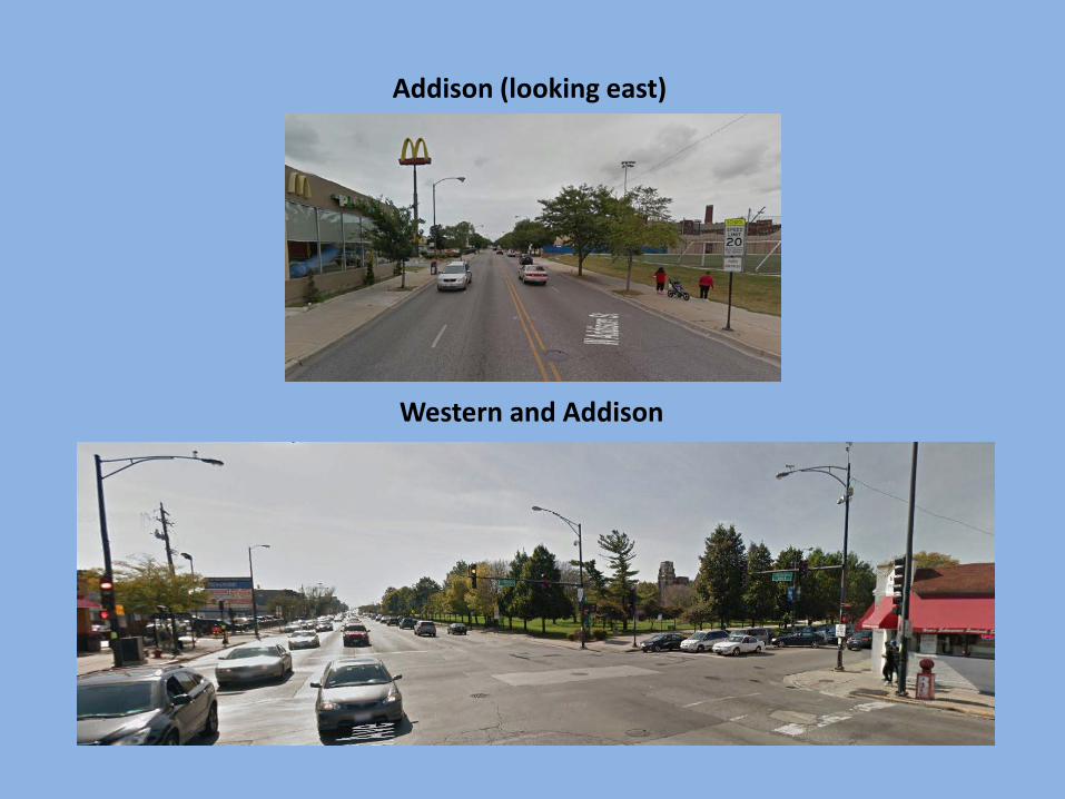
Western and Addison
Addison (looking east)

Western Ave Improvement Project (Fall 2017)

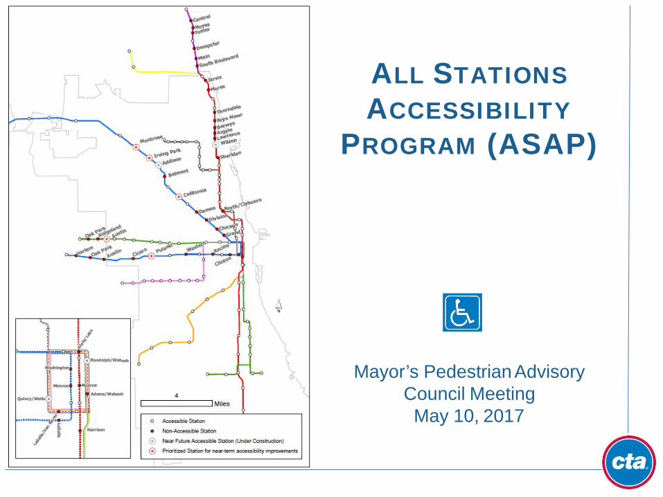
ALL STATIONS ACCESSIBILITY
PROGRAM (ASAP)
Mayor’s Pedestrian Advisory Council Meeting May 10, 2017

ASAP INTRODUCTION
Goal: To create an accessible rail system within 20 years • 45 of 145 CTA stations are currently non-
accessible
• 3 of these stations are currently under design and/or construction
• 42 of these stations will be made
accessible as part of the 20 year program
o 8 of these stations are part of the Blue Line Forest Park Vision Study
o 14 of these stations are part of the Red-
Purple Modernization (RPM) Program
o 20 stations are not part of any existing program
41
• Replacement of 155 existing elevators at CTA rail stations is also part of ASAP
Conceptual, artist's rendering of Quincy station improvements

STATION DESIGN PRINCIPLES
42
ASAP proposed station modifications include - • New elevators meeting ADA standards
• Power assisted doors
• ADA fare array
• New ADA braille and signage
• Accessible customer agent kiosks and staff toilet rooms
• Increasing platform clearances for wheel chair maneuverability
• Evaluation of additional code requirements (i.e. exiting and NFPA 130)
• Adjacent sidewalks and street crosswalks made ADA accessible
• Consideration of wayfinding elements
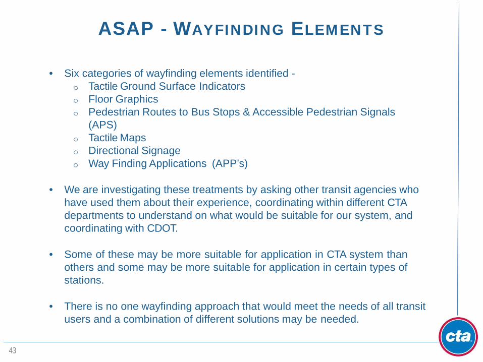
ASAP - WAYFINDING ELEMENTS
43
• Six categories of wayfinding elements identified - o Tactile Ground Surface Indicators o Floor Graphics o Pedestrian Routes to Bus Stops & Accessible Pedestrian Signals
(APS) o Tactile Maps o Directional Signage o Way Finding Applications (APP’s)
• We are investigating these treatments by asking other transit agencies who
have used them about their experience, coordinating within different CTA departments to understand on what would be suitable for our system, and coordinating with CDOT.
• Some of these may be more suitable for application in CTA system than
others and some may be more suitable for application in certain types of stations.
• There is no one wayfinding approach that would meet the needs of all transit
users and a combination of different solutions may be needed.

Warning Surfaces (truncated domes) •used in the United States on transit platform edges and the bottom of curb ramps.
Directional Surfaces •indicate the direction of travel.
•more commonly used in Asia, Europe, and Canada.
•a common concern with these is that they may also create obstructions for wheelchair users when placed in a common pathway.
TACTILE GROUND SURFACE INDICATORS
44
Tactile Ground Surface Indicators assist pedestrians who are Blind or have a Visual Impairment in navigating the environment.

CONTRASTING FLOOR GRAPHICS
Contrasting Floor Graphics is helpful for people who have some sight and normally rely on that sight, as well as other aids, to navigate through the environment. 85% of people considered blind retain some vision.
• Floor graphics with color, high contrast, patterns and light can enhance identification of routes through a complex station and help identify important elements such as fare arrays or vertical transportation, or help navigate details like stair nosings.
• The CTA has used contrasting colors on stair tread
nosings and landings in some recent station projects.
45

PEDESTRIAN ROUTE FROM RAIL STATION TO BUS STOP
• crosswalks with cane detectable surfaces;
• Color contrasting cross walk borders;
• Accessible Pedestrian Signals (APS)
Color contrast crosswalk with tactile surface
46
Color contrast crosswalk with curb ramps
An accessible pathway from rail station to a bus stop is an essential element of overall accessible service.
An accessible route from a CTA station to a CTA bus stop could include -
• Sidewalks that do not present significant
cross or running slopes;
• Compliant curb ramps;

ACCESSIBLE PEDESTRIAN SIGNALS (APS)
APS provides information for Blind and DeafBlind pedestrians at street crossings through audible signals and vibrotactile surfaces. The CDOT is currently analyzing different technologies for APS and is working on a pilot program.
47

TACTILE MAPS
Tactile maps are modeled using raised surfaces to enable people who are Blind or Visually Impaired to plan routes through a rail system, a transit line, or a building. The visually impaired community has a wide range of capabilities and spatial recognition when it comes to using and benefitting from tactile maps.
48

DIRECTIONAL SIGNAGE
Since 85% of the people considered Blind or Visually Impaired retain some vision and rely on that limited vision, it is important to provide information and directional signage that allows people with low vision to move independently.
The CTA currently provides required directional and informational signage.
Directional signage for wayfinding should incorporate - • Frequent signage • Enhanced signage lighting • Contrast – dark character on light
background • Large characters w/ San Serif text • Non-glare
Millennium Park Chicago, Illinois
49

WAYFINDING APPLICATIONS (APPS)
APPs are being developed for smart phones that use WiFi and beacons for interior mapping and navigation. This is an emerging technology. DC Metro recently implemented a pilot project in one of their stations. One limitation of this system is that it may be only useful to people with smartphones.
50

WAYFINDING RECOMMENDATIONS FOR ASAP
51
CTA’s proposed wayfinding recommendations for ASAP include – • find pilot station locations for tactile ground surface indicators and additional
floor graphics – we will need to analyze both how this works functionally and the materials that could be used;
• coordinate with CDOT on pedestrian routes outside rail stations to bus stops
and potential installation of APS;
• explore tactile signage at bus stops to assist with exact location. CTA is currently preparing rail station guides to assist with navigation inside rail stations, which will be available online soon and will serve a similar purpose as tactile maps;
• further enhance directional signage and lighting in stations;
• seek feedback on wayfinding apps from users in other systems on adaptability and usability of these apps and remain engaged on the topic with the goal of potentially adopting something like this when the technology is better proven.

Please join us for the next
Mayor’s Pedestrian Advisory Council Meeting
August 9th, 2017