meeting preliminary program - asprs
TRANSCRIPT

ASPRS ANNUAL CONFERENCEMarch 19–23, 2012
Sacramento Convention CenterSacramento, California
Preliminary Program www.asprs.org/Annual-Conferences/Sacramento-2012

2 ASPRS 2012 Annual Conference w March 19 – 23, 20122 ASPRS 2012 Annual Conference w March 19 – 23, 2012
Oft en called “a snapshot of Wild West history in a modern, world-class city”, Sacramento, California is a perfect desti nati on for the ASPRS 2012 Annual Conference and a great desti nati on to extend your stay and discover California!
Today’s Sacramento is a convergence of cosmopolitan life and gold rush history. As the Capitol of California, it is the oldest city in the state, founded in 1839. That history and charm truly come alive when you visit Old Sacramento. “Old Sac” as
it is referred to, is a historic area of Sacramento located along the Sacramento riverfront, a short distance from the conference headquarters’ hotel, the Hyatt Regency Sacramento. The city has a unique historic landmark district which looks much as it did in the 19th century, with wooden store fronts, shops and the occasional horse-drawn wagon. Here you will fi nd restaurants, shopping, Gold Rush history and even the Transconti nental Railroad. All conference events will be taking place at the Sacramento Conventi on Center, adjacent to the conference host hotel. See you at the 2012 Annual Conference, March 19-23!
More details can be found on the conference website at www.asprs.org/Annual-Conferences/Sacramento-2012.
Oft en called “a snapshot of Wild West history in a modern, world-class city”, Sacramento, California is a perfect desti nati on for the ASPRS 2012 Annual Conference
DISCOVER SACRAMENTO!
THINGS TO DO AND SEE IN SACRAMENTO!A First Stop for Planning and Informati onThe Sacramento Conventi on & Visitors Bureau: Ready to help plan your visit, the Visitors Center is located in the heart of the Old Sacramento historic district. Staff can personally assist you with trip planning, dining reservati ons, provide visitor guides, and brochures and informati on from all the att racti ons in the area. Make this your fi rst stop while exploring Old Sacramento. Visitors Center Open daily, 10 am to 5 pm, 1002 2nd St. Old Sacramento, 916-442-7644.
Most items listed below are within walking distance of the conference hotel. The Aerospace Museum is approximately 12 miles north-east of downtown and will require transportati on.
Things to Do and See Old Sacramento — A Nati onal Historic Landmark District located along the Sacramento River, established in 1849. Shopping, dining, entertainment and world-renowned museums set within the California Gold Rush and the Transconti nental Railroad. To get to Old Sacramento from the conference hotel, walk about a mile westward down the K Street Mall towards the Sacramento River.
Laughs Unlimited — It’s been a long day and you want to unwind and laugh unti l your jaw cramps. This is the place to disappear to along with friends having the same sense of humor. Drinks and food served table side while the act goes on. 1207 Front St. (916) 446-8128
The California State Railroad Museum — The world’s most extensive collecti on of locomoti ves and rolling stock that opened up the West. Walk amongst giants; tour the inside of a 1950’s passenger car complete with sleepers. Climb up into the cab of a steam engine imagine what it took to pull a mile long line of cars up and over the Sierra Nevada. 111 I St. (916) 323-9280
California Aerospace Museum — Get up close to a Russian MIG-17 with red stars-and-bars of the aggressor force of Top-Gun (how, when and where the USAF obtained it remains classifi ed). See an A-10 Warthog with kill markings from Desert Storm. If you appreciate aircraft , this museum should be in your bucket list. 3200 Freedom Park Drive, McClellan, (916) 643-3192. You will need your own transportati on.

3www.asprs.org/Annual-Conferences/Sacramento-2012 3www.asprs.org/Annual-Conferences/Sacramento-2012

4 ASPRS 2012 Annual Conference March 19 – 23, 2012
Silver Sponsor
Media SponsorsAmerican Surveyor
Asian Surveying & Mapping – Vector 1 MediaLiDAR magazineLiDARnews.com
GISuser.comCoordinates
Earth Imaging JournalEARTH magazineGEO:Connexion GeoInformati cs
GeoWorldPoint of Beginning
Professional Surveyor – Flatdog Media, Inc.
TABLE OF CONTENTS SPONSORS
Discover Sacramento! 2
Welcome from the Mayor of Sacramento 3
Sponsors 4
Welcome from the Chairs 5
Student and Young Professionals Events 6
Conference-at-a-Glance 7
ASPRS Committ ee Meeti ngs 8
User Groups 9-10
Workshops 12-18
Classifi ed Session 19
Technical Program
Wednesday, March 21st
Opening Session 21 Technical Sessions 21-23, 25-27 Hot Topics 24
Thursday, March 22nd
President’s Address/General Session 29 Technical Sessions 30-32, 34-36 Commercial Sessions 32
Friday, March 23rd
Technical Sessions 38-40
Poster Sessions 41
Exhibitors 28
2012 Memorial Address 33
Social Events Region Social 18 23rd Annual Awards Luncheon & 23 78th Installati on of ASPRS Offi cers Exhibitors’ Welcome Recepti on 27 California Automobile Museum 37 Breakfast with Exhibitors 34
Hotel/Travel Informati on 42
Frequently Asked Questi ons 43-44
Registrati on Form 45-46
Plati num Medallion
Future ASPRS Conferences 2012 ASPRS/MAPPS Fall Specialty Conference
Marriott Tampa Waterside Hotel Tampa, Florida
October 29 - November 1, 2012
ASPRS 2013 Annual Conference Baltimore Marriott Waterfront Hotel
Baltimore, Maryland March 24-28, 2013
ASPRS 2013 Falll Conference Crowne Plaza San Antonio Riverwalk
San Antonio, TexasOctober 29-31, 2013
ASPRS 2014 Annual Conference Galt House Hotel
Louisville, Kentucky March 23-27, 2014
ASPRS 2015 Annual Conference Tampa Bay Marriott Waterside Hotel
Tampa, Florida May 4-8, 2015
5www.asprs.org/Annual-Conferences/Sacramento-2012
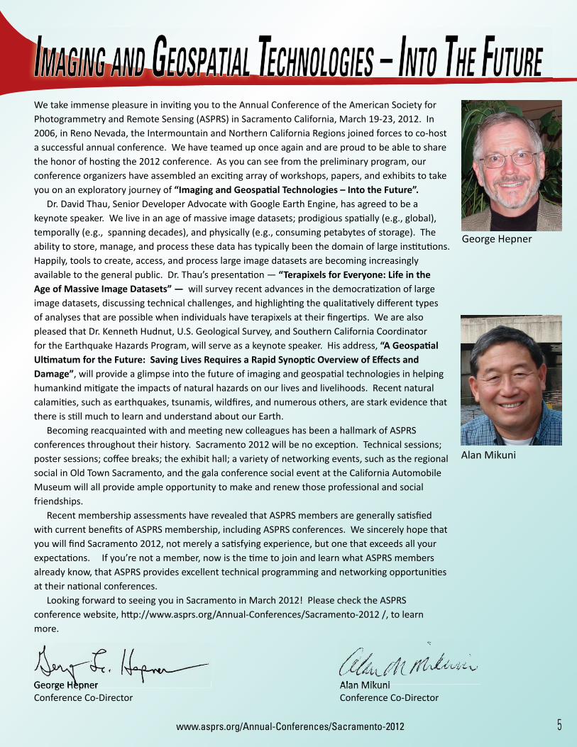
We take immense pleasure in inviti ng you to the Annual Conference of the American Society for Photogrammetry and Remote Sensing (ASPRS) in Sacramento California, March 19-23, 2012. In 2006, in Reno Nevada, the Intermountain and Northern California Regions joined forces to co-host a successful annual conference. We have teamed up once again and are proud to be able to share the honor of hosti ng the 2012 conference. As you can see from the preliminary program, our conference organizers have assembled an exciti ng array of workshops, papers, and exhibits to take you on an exploratory journey of “Imaging and Geospati al Technologies – Into the Future”.
Dr. David Thau, Senior Developer Advocate with Google Earth Engine, has agreed to be a keynote speaker. We live in an age of massive image datasets; prodigious spati ally (e.g., global), temporally (e.g., spanning decades), and physically (e.g., consuming petabytes of storage). The ability to store, manage, and process these data has typically been the domain of large insti tuti ons. Happily, tools to create, access, and process large image datasets are becoming increasingly available to the general public. Dr. Thau’s presentati on — “Terapixels for Everyone: Life in the Age of Massive Image Datasets” — will survey recent advances in the democrati zati on of large image datasets, discussing technical challenges, and highlighti ng the qualitati vely diff erent types of analyses that are possible when individuals have terapixels at their fi ngerti ps. We are also pleased that Dr. Kenneth Hudnut, U.S. Geological Survey, and Southern California Coordinator for the Earthquake Hazards Program, will serve as a keynote speaker. His address, “A Geospati al Ulti matum for the Future: Saving Lives Requires a Rapid Synopti c Overview of Eff ects and Damage”, will provide a glimpse into the future of imaging and geospati al technologies in helping humankind miti gate the impacts of natural hazards on our lives and livelihoods. Recent natural calamiti es, such as earthquakes, tsunamis, wildfi res, and numerous others, are stark evidence that there is sti ll much to learn and understand about our Earth.
Becoming reacquainted with and meeti ng new colleagues has been a hallmark of ASPRS conferences throughout their history. Sacramento 2012 will be no excepti on. Technical sessions; poster sessions; coff ee breaks; the exhibit hall; a variety of networking events, such as the regional social in Old Town Sacramento, and the gala conference social event at the California Automobile Museum will all provide ample opportunity to make and renew those professional and social friendships.
Recent membership assessments have revealed that ASPRS members are generally sati sfi ed with current benefi ts of ASPRS membership, including ASPRS conferences. We sincerely hope that you will fi nd Sacramento 2012, not merely a sati sfying experience, but one that exceeds all your expectati ons. If you’re not a member, now is the ti me to join and learn what ASPRS members already know, that ASPRS provides excellent technical programming and networking opportuniti es at their nati onal conferences.
Looking forward to seeing you in Sacramento in March 2012! Please check the ASPRS conference website, htt p://www.asprs.org/Annual-Conferences/Sacramento-2012 /, to learn more.
George Hepner Alan MikuniConference Co-Director Conference Co-Director
George Hepner
Alan Mikuni
George Hepner Alan MikuniGeorge Hepner Alan Mikuni

6 ASPRS 2012 Annual Conference w March 19 – 23, 20126 ASPRS 2012 Annual Conference w March 19 – 23, 2012
Student & Employer “Meet and Greet”Thursday, March 22nd, 11 am to 12 Noon
This great event is designed to connect students looking to apply for jobs in the digital mapping industry and employers looking to hire! Bring your resume, a business card, or just a smile and a handshake, and expand your job network at the conference.
ASPRS has been kind enough to set up an official interview room for this conference, so use this meet and greet to determine if you should sign up for an interview slot.
Student Icebreaker Tuesday, March 20th, 5:15 pm to 5:45 pm
Whether this is your first ASPRS Conference or you have attended previous conferences, you are invited to join other students and young professionals from all over the world at this special event designed just for you! You will get to meet at least seven new people who may become your friends for the conference or the rest of your life. Make time for this FUN event!
Please join the Student Advisory Council (SAC) for some activities designed just for YOU!
Students &Young Professionals
Student Advisory Council Meeting (SAC)Tuesday, March 20th, 5:45 pm to 6:15 pm
Get together with the other Students and Associate members of ASPRS and learn what the SAC has been working on and what is planned for the coming week. They would love to meet you and hear any ideas you may have to make your conference experience enjoyable. All are welcome to attend.
Exhibit Hall Guided Tour for StudentsWednesday, March 21st, 11:00 am to 12 Noon
The ASPRS Sustaining Members Council is hosting a guided tour of the exhibit hall for students. This is your opportunity to meet the exhibitors, up close and personal. Exhibit halls can be intimidating, but not after this personal tour. Meet at the main exhibit hall entrance doors to participate in this fun tour. See you there!
Other Social Activities:Your SAC Networking Coordinator will arrange relaxed social gatherings after each of the day’s conference activities. These events will allow you to get to know more of the students and young professional members of ASPRS. Attendees are welcome to join in on the fun. To find out about all the activities, visit the conference web page at www.asprs.org/Annual-Conferences/Sacramento-2012 and click on the Presenters & Students tab.
We guarantee that your participation in these activities will make your conference experience more enjoyable!
7www.asprs.org/Annual-Conferences/Sacramento-2012
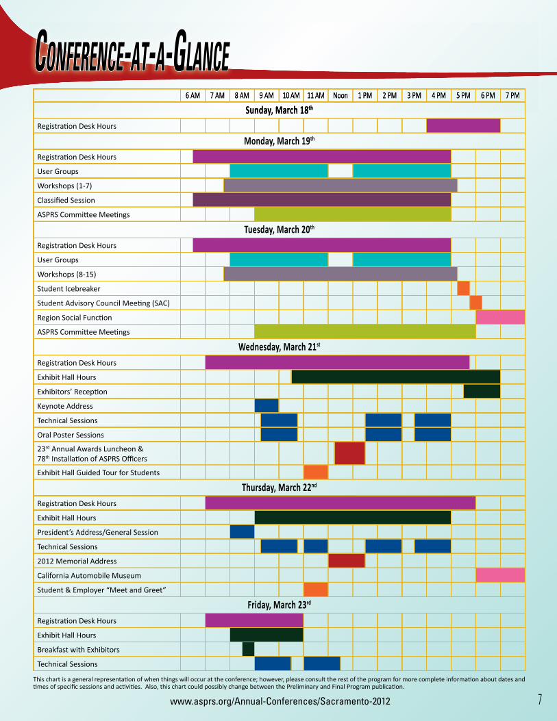
6 AM 7 AM 8 AM 9 AM 10 AM 11 AM Noon 1 PM 2 PM 3 PM 4 PM 5 PM 6 PM 7 PM
Sunday, March 18th
Registrati on Desk Hours
Monday, March 19th
Registrati on Desk Hours
User Groups
Workshops (1-7)
Classifi ed Session
ASPRS Committ ee Meeti ngs
Tuesday, March 20th
Registrati on Desk Hours
User Groups
Workshops (8-15)
Student Icebreaker
Student Advisory Council Meeti ng (SAC)
Region Social Functi on
ASPRS Committ ee Meeti ngs
Wednesday, March 21st
Registrati on Desk Hours
Exhibit Hall Hours
Exhibitors’ Recepti on
Keynote Address
Technical Sessions
Oral Poster Sessions
23rd Annual Awards Luncheon & 78th Installati on of ASPRS Offi cers
Exhibit Hall Guided Tour for Students
Thursday, March 22nd
Registrati on Desk Hours
Exhibit Hall Hours
President’s Address/General Session
Technical Sessions
2012 Memorial Address
California Automobile Museum
Student & Employer “Meet and Greet”
Friday, March 23rd
Registrati on Desk Hours
Exhibit Hall Hours
Breakfast with Exhibitors
Technical Sessions
6 AM 7 AM 8 AM 9 AM 10 AM 11 AM Noon 1 PM 2 PM 3 PM 4 PM 5 PM 6 PM 7 PM
Sunday, March 18th
CONFERENCE-AT-A-GLANCE
This chart is a general representati on of when things will occur at the conference; however, please consult the rest of the program for more complete informati on about dates and ti mes of specifi c sessions and acti viti es. Also, this chart could possibly change between the Preliminary and Final Program publicati on.

8 ASPRS 2012 Annual Conference March 19 – 23, 2012
ASPRS COMMITTEE MEETINGS
Division DirectorsMonday, March 19, 9:00 am to 10:00 am
Committ ee ChairsMonday, March 19, 9:00 am to 10:00 am
Journal Policy & Publicati ons Committ ee (Joint Meeti ng)Monday, March 19, 10:00 am to 12 noon
Awards Committ eeMonday, March 19, 10:00 am to 12 noon
Electronic Communicati ons Committ eeMonday, March 19, 1:00 pm to 2:00 pm
Educati on & Professional Development Committ eeMonday, March 19, 1:00 pm to 3:00 pm
Remote Sensing Applicati ons Division (RSAD) Analysis & Applicati ons Subcommitt eeMonday, March 19, 2:00 pm to 3:00 pm
Remote Sensing Applicati ons Division (RSAD)Monday, March 19, 3:00 pm to 4:00 pm
Region Offi cersMonday, March 19, 3:00 pm to 4:00 pm
New Board Orientati onMonday, March 19, 4:00 pm to 5:00 pm
Bylaws Committ eeMonday, March 19, 4:00 pm to 5:00 pm
Division Directors
MONDAY, MARCH 19, 2012 TUESDAY, MARCH 20, 2012
All ASPRS committees, scheduled to meet during the ASPRS 2012 Annual Conference, are listed below with their specifi c meeting time. Room loca-tions will be determined at a later date and will be listed in the Final Program. Committee meetings will be held in the Sacramento Convention Center, Sacramento, California. The ASPRS Board will meet on Friday, March 23rdand the Conference will offi cially begin on Wednesday, March 21, 2012. Please plan your schedules accordingly.
Data Preservati on & Archive Committ eeTuesday, March 20, 9:00 am to 10:00 am
Photogrammetric Applicati ons Division (PAD)Tuesday, March 20, 9:00 am to 10:00 am
Geographic Informati on Systems Division (GISD)Tuesday, March 20, 10:00 am to 12 noon
Evaluati on for Certi fi cati on Committ eeTuesday, March 20, 10:00 am to 11:00 am
Sustaining Members Committ eeTuesday, March 20, 11:00 am to 1:00 pm
Membership Committ eeTuesday, March 20, 1:00 pm to 2:00 pm
Lidar Division (LD)Tuesday, March 20, 1:00 pm to 2:00 pm
Conventi on Policy & Planning Committ eeTuesday, March 20, 2:00 pm to 4:00 pm
Photogrammetric Applicati ons Division (PAD) Soft copy Subcommitt eeTuesday, March 20, 2:00 pm to 3:00 pm
Professional Practi ce Division (PPD)Tuesday, March 20, 3:00 pm to 4:00 pm
Primary Data Acquisiti on Division (PDAD)Tuesday, March 20, 4:00 pm to 5:00 pm
Division DirectorsTuesday, March 20, 5:00 pm to 6:00 pm
Films Committ eeTuesday, March 20, 5:00 pm to 6:00 pm
ASPRS Board Meeti ngFriday, March 23, 8:00 am to 5:00 pmASPRS Board Meeti ng
FRIDAY, MARCH 23, 2012
Anyone interested in the work of an ASPRS Division or Committ ee is welcome to att end these Committ ee and Division meeti ngs. Your parti cipati on is encouraged.

9www.asprs.org/Annual-Conferences/Sacramento-2012
USER GROUPSKLT Associates, Inc. Monday, March 19th, 8:00 am to 12 Noon
GeoDigital Monday, March 19th, 8:00 am to 12 Noon
Exelis Visual Informati on Soluti onsMonday, March 19th, 1:00 pm to 5:00 pm
Please join the ENVI team for the ENVI User Group Meeting at ASPRS. This session will feature presentations by image analysis and GIS professionals who will demonstrate how they use ENVI to solve real world problems. In addition, you will learn latest advances from the ENVI development team, including new features and updates on the ENVI product roadmap.
NOAAMonday, March 19th, 1:00 pm to 5:00 pm
The mission of NOAA’s National Geodetic Survey is to defi ne, maintain and provide access to the National Spatial Reference System to meet our nation’s economic, social, and environmental needs. NGS provides the framework for all positioning activities in the Nation. The foundational elements - latitude, longitude, elevation and shoreline information - contribute to informed decision making and impact a wide range of important activities including mapping and charting, fl ood risk determination, transportation, land use and ecosystem management.
New Tech Services, Inc. Monday, March 19th, 1:00 pm to 5:00 pm
New Tech Services, Inc. specializes in the Sales of pre-owned Aerial Survey/Mapping equipment. NTS also markets a Photo Mission Planning Tool to calculate the amount of images needed anywhere, accurately and cost effi cient. All data can be exported to most FMS. New in version 8.1: download Maps directly from Google into TopoFlight with selectable resolution. TopoFlight Navigator is the Flight Management System. Visit: www.nts-info.com and www.TopoFlight.com for more info.
Please contact: Tony at [email protected] 1-281-573-8029.
BAE SystemsTuesday, March 20th, 8:00 am to 12 Noon
The future of SOCET SET is here! Learn how to build and complete photogrammetric workfl ows in SOCET GXP v4.0 to increase productivity. The intuitive Microsoft Offi ce Fluent user interface organizes the workspace to simplify tasks. New functionality offers rigorous photogrammetry, including 3-D site and city modeling, automatic feature extraction, and advanced terrain editing (TIN and Grid, including LIDAR point clouds). In addition, see the new tool that everyone is talking about — GXP Xplorer — for effi cient data management.
EsriTuesday, March 20th, 8:00 am to 12 Noon
The Esri User Group meeting, at the ASPRS 2012 Annual Conference, is a gathering of remotely sensed data and imagery users and those who are interested in best practices for remotely sensed data, imagery and GIS. Highlights will include presentations on the future direction of the ArcGIS system for remote sensing professionals, Esri technology demonstrations, and time for user questions and answers.
Geographic Resource Soluti onsTuesday, March 20th, 8:00 am to 12 Noon
Please stop by the GRS Land Cover Mapping User’s Group to discuss the GRS Densitometer and techniques for using point-transect sampling for estimating vegetation cover, fuels, and ground conditions. Discussions will include applying these fi eld techniques to collect ground truth and accuracy assessment data for land cover mapping. We will also share techniques for site selection and fi eld logistics for collecting ground truth and accuracy assessment data over very large areas.
Intergraph, Leica Geosystems and ERDASTuesday, March 20th, 8:00 am to 12 Noon
Together, Intergraph, Leica Geosystems and ERDAS and provide leading hardware and software tools to support the complete geospatial information lifecycle - accurately capturing high-quality imagery, providing photogrammetry and remote sensing data analysis, and managing and delivering data to transform vector, raster and terrain information into fully integrated geospatial solutions.
Intergraph, Leica Geosystems and ERDAS and are wholly owned subsidiaries of Hexagon AB, a leading global provider of precision measurement technology.
KLT Associates, Inc. MONDAY, MARCH 19, 2012
BAE Systems
TUESDAY, MARCH 20, 2012

10 ASPRS 2012 Annual Conference w March 19 – 23, 201210 ASPRS 2012 Annual Conference w March 19 – 23, 2012
ASDTuesday, March 20th, 1:00 pm to 5:00 pm
Solve your most challenging hyperspectral and environmental measurement problems at the ASD User Group. This meeting will include an instructional presentation at 1:30 and 3:30. Each presentation is followed by an open workshop to discuss your specific applications.
Experience the industry-standard FieldSpec line of rugged, portable spectroradiometers and talk with our product experts to learn why these powerful instruments are unparalleled in providing high-quality field results…and why ASD is the top choice for remote sensing and environmental sciences researchers.
ASD Inc. • 303-444-6522 • HYPERLINK “mailto:[email protected]” [email protected] • www.asdi.com.
GeoCue Corporation/QCoherent SoftwareTuesday, March 20th, 1:00 pm to 5:00 pm
Please join us for our combined GeoCue, QCoherent Spring User Group Meeting. During this session, we will not only update you on the latest GeoCue workflow integration solutions but also provide an overview of LIDAR Production tools from initial data processing through data dissemination and on to exploitation in an ArcGIS environment. In addition to updates on GeoCue and LP360, we will have a special focus on the complete integration of LIDAR data management from processing through distribution to end users via web tools.
MicrosoftTuesday, March 20th, 1:00 pm to 5:00 pm
Join the technical experts and business leaders from Microsoft’s UltraCam product group along with business partners in this half day presentation for an opportunity to learn firsthand about the company’s latest aerial mapping sensor and software product advancements as well as the latest business developments. Prizes will be raffled, refreshments will be served, and seating will be limited so be sure to arrive early.
Optech IncorporatedTuesday, March 20th, 1:00 pm to 5:00 pm
This workshop will provide information on Optech’s latest efforts in hardware and software development. Focused presentations on new camera hardware releases and ALTM upgrade packages will be conducted, as well as a user training session featuring Optech’s all-new flight management system, Optech FMS.
Topcon Positioning SystemsTuesday, March 20th, 1:00 pm to 5:00 pm
Join us as we present how Topcon Mobile mapping hardware and software tools can improve data workflows and increase production. Our session will include presentations and demonstrations focusing on workflows that can easily manage and manipulate geospatial information for a variety of applications. Through the integration of 360° images and high density point cloud, we get a superior data-set for feature recognition and data extraction. Come explore the latest developments in mobile mapping technology and how it can keep you on the cutting edge!
ASPRS MEMBERSHIPYour path to success in the geospatial community
ASPRS Members AreIndividuals Like You…
Become a member of the American Society for Photogrammetry and Remote Sensing (ASPRS), the premier international society of over 6,500 geospatial professionals from private industry, government, and academia. Together we advance imaging and geospatial information into the 21st century.
To join, go to www.asprs.org

11www.asprs.org/Annual-Conferences/Sacramento-2012 11www.asprs.org/Annual-Conferences/Sacramento-2012

12 ASPRS 2012 Annual Conference w March 19 – 23, 2012
Workshop #1Unmanned Aerial System (UAS) ConceptsKevin Gambold, Unmanned Experts LLC Stephen Rolfe, Unmanned Experts LLCMonday, March 19, 7:45 AM to 5:15 PM, CEU .8Fee — Non-Member: $335, Member: $235, Student: $125
INTERMEDIATE WORKSHOPThe civilian aviation sector of unmanned aerial vehicles (UAV) and sys-tems (UAS) is rapidly expanding, and is predicted to match the success-ful military application of UAVs. Recent studies have drawn up over 53 different mission types for civilian UAS, grouped into 5 mission sets of Survey, Law Enforcement, Border Patrol, Communications and Disaster Relief.
Companies are looking to this area to solve specifi c operational prob-lems, using the traditional strengths of UAS over manned platforms, epitomized by the phrase ‘the 3 Ds: Dull, Dirty and Dangerous’.
This UAS Concepts Workshop was designed to provide experienced airborne photogrammetry and remote sensing operators, technologists, and scientists with an understanding of UAVs/UAS that goes beyond an introductory level, and allows them to speak knowledgeably of this area to their management, customers, and peers.
This day-long instructional program includes:l Overview; UAS Terminology and Classifi cation; UAS Roles
and Mission Setsl Control Systems; Data Links; Hardwarel Payloads: EO/IR/LLTV/SAR/GMTI/Hyperspectrall Concept of Operations; Launch Recovery Systems; Communi-
cations l Deployment Considerations; Future Employment of UAS
Our instructors have extensive operational UAS experience and have delivered leading-edge UAS training materials to an wide spectrum of audiences.
This course assumes that attendees have an intermediate to advanced understanding of airborne operations, and a basic understanding of pho-togrammetric and remote sensing principles that have their equivalents in military intelligence, surveillance, and reconnaissance (ISR) funda-mentals.
Workshop #2Image Classifi cati on Considerati ons for the Development of Accurate, Detailed, and Quanti tati ve Land Cover Map DataKenneth Stumpf, Geographic Resource SolutionsJohn Koltun, Geographic Resource SolutionsMonday, March 19, 7:45 AM to 5:15 PM, CEU .8Fee — Non-Member: $335, Member: $235, Student: $125
INTRODUCTORY WORKSHOPThis workshop is designed as a workfl ow that takes participants through the different stages of an image classifi cation land cover mapping (data development) project while identifying problems, issues, and concerns and comparing and contrasting traditional and alternative techniques. The workshop is built around the four major parts of GRS’s Discrete Classifi cation Methodology used for our Image Classifi cation Projects - Data Acquisition and Preparation, Image Classifi cation, Pixel to Polygon Conversion, and Accuracy Assessment. Workshop examples are based on actual project results from efforts in California, the Pacifi c Northwest, and Alaska.
l Data Acquisition and Preparation — The instructors present issues, problems, concerns, and alternative perspectives regard-ing image procurement; terrain-sensitive illumination correction; implementation of GIS and database capabilities to minimize planning and fi eld data collection efforts, while maximizing re-sults; and image classifi cation strategies and methods. The work-shop includes crucial GPS issues for aerial/fi eld data gathering efforts; use of data-loggers to standardize data collection and guide fi eld efforts; advantages of and techniques for quantitative data collection; the use of in-situ classifi cations to monitor fi eld progress; and fi eld data verifi cation techniques.
l Image Classifi cation — The workshop agenda then progresses into a discussion of image training and classifi cation issues, ex-panding on an alternative treatment of cover characteristics and class data to maintain land cover detail information at the pixel level; techniques for the resolution of confusion; and develop-ment of a fi nal pixel map.
l Pixel to Polygon Conversion — For those concerned with developing vector data from the pixel data set, GRS discusses traditional pixel-cleanup techniques such as segmentation and pixel fi ltering. GRS then presents an alternative methodology for the development of polygon data (that meet minimum map-ping unit area criteria) by means of rule-based aggregation pro-cesses designed to improve land cover mapping results.
l Accuracy Assessment — The workshop wraps up with a discussion of Accuracy Assessment procedures followed by a “Questions and Answers” session. Accuracy assessment in-cludes a discussion of fi eld sample design, Error Matrices, and biases that must be avoided during an accuracy assessment.
I. Introduction A. Traditional image classifi cation, output, and alternatives 1. categorical map data 2. quantitative map data B. An alternative classifi cation methodology C. Comparison of classifi cation data products II. An Alternative Land Cover Mapping Approach A. Data acquisition and preparation 1. procurement considerations 2. illumination normalization 3. training site selection 4. quantitative “ground-truth” - fi eld data collection B. Image classifi cation 1. Training Set Development 2. Classifi cation a. supervised b. unsupervised 3. identifi cation and resolution of confusion a. confusion report b. fi delity testing and report c. winter imagery C. Rule-based pixel aggregation to polygons 1. mathematical fi ltering 2. rule-based aggregation D. Accuracy assessment 1. error matrices 2. sources of bias III. Summary A. The land cover mapping strategy B. Questions
Workshop #1Unmanned Aerial System (UAS) Concepts
l Data Acquisition and Preparation — The instructors present issues, problems, concerns, and alternative perspectives regard-
WORKSHOPSNEW!

13www.asprs.org/Annual-Conferences/Sacramento-2012
Workshop #3Hyperspectral Image Processing and Feature Extraction: Maximizing Geospatial Information RetrievalWilliam Farrand, Space Science InstituteStuart Blundell, Overwatch Geospatial, Ltd.Monday, March 19, 7:45 AM to 5:15 PM, CEU .8Fee — Non-Member: $335, Member: $235, Student: $125
INTRODUCTORY WORKSHOPImaging spectrometry, commonly referred to as hyperspectral remote sensing, provides high-resolution spectral information for environ-mental, natural resources, and urban characterization projects. Hyper-spectral image processing approaches can also be applied to new, high-resolution, broadband multispectral imagery obtained from commercial satellites such as WorldView-2. The workshop will demonstrate how results from these analyses can be used to enhance automated feature extraction techniques. In this workshop, we will provide students with an introduction to the phenomenology of imaging spectrometry, hyper-spectral image processing techniques, and feature extraction approaches to demonstrate how to add value to the maintenance of geospatial da-tabases. We will emphasize that the added value in imaging spectrom-etry is on the spectrometry, the ability to identify materials based on their reflectance signatures. We will briefly discuss the phenomenology of reflectance spectrometry and explain why some materials are more ame-nable to mapping than others. We will describe commercially available processing systems that are available for processing hyperspectral and multispectral data and discuss the processing techniques within those packages. Certain processing techniques are better suited to certain ap-plications. We will explain why this is so. We will also discuss some of the advantages and shortcomings of current airborne and orbital hyper-spectral systems as well as planned systems.
Hyperspectral imagery provides users with discrete spectral, and consequently compositional, information about Earth surface materials. The ability to integrate other types of geologic, geochemical, biologic, or hydrologic data with information from hyperspectral data improves the interpretation and mapping process. The student will be introduced to the concepts of developing feature extraction models for assisted and automated feature extraction approaches using hyperspectral, Lidar, DEMs and multispectral data. We will provide real-world examples of how end products, derived from hyperspectral and multispectral data processing, including resultant mineral and vegetation species maps, can be extracted using commercial feature extraction software.
We will provide a package of materials to the students that will in-clude hard copies of the material presented and an extensive list of refer-ences on the topics addressed. We will engage the class with an in-class exercise and several “take-home” hands-on exercises.
Topics to be addressed I. Define Imaging Spectrometry (Hyperspectral Remote Sensing) II. The Phenomenology of Reflectance Spectrometry III. Object Recognition and Feature Extraction Using Spatial and Spectral Attributes IV. Commercially Available Hyperspectral Imaging (HSI) Software Packages V. Processing Techniques for Applications of HSI and MSI (Dem- Onstration) VI. Feature Extraction Strategies Using HSI, Lidar and MSI Data Sets VII. Descriptions of Available and Soon-to-be Available Hyperspec- Tral Systems VIII. Exercises IX. Case Studies X. Summary and Final Discussion
Workshop #4Vegetation Analysis and Moisture Content Assessment in Urban Areas Using Remote Sensing DataDr. Indu JeyachandranMonday, March 19, 7:45 AM to 12:15 PM, CEU .4Fee — Non-Member: $280, Member: $180, Student: $190
INTERMEDIATE WORKSHOPThis half-a-day workshop explores the use of remote sensing data (Landsat data) for a range of urban applications. The workshop aims at educating the audience to compute remote sensing based indices such as Normalized Difference Vegetation Index, Moisture Stress Index (MSI), Enhanced Vegetation Index (EVI), Simple Ratio Index (SRI) and Normalized Difference Water Index (NDWI). Using the indices, an exercise will be performed in the workshop to assess the vegetation health, moisture content and identify urban sites with water stress in a study area. Also the users will get hands on experience in calculating the vegetated fraction from remote sensing data. A simple example to demonstrate the use of fractional vegetation cover in calculating the irrigation demand of a study area will be illustrated in the workshop. The objective of the workshop is to expose the users to the applications of remote sensing data in urban areas.
Workshop #5Calibrating Film and Digital Sensors for Today’s Geo-Spatial BusinessDr. Qassim Abdullah, Fugro EarthData, Inc Don Light, CP, Rochester Institute of TechnologyMonday, March 19, 7:45 AM to 12:15 PM, CEU .4Fee — Non-Member: $280, Member: $180, Student: $190
INTERMEDIATE WORKSHOPThe workshop introduces important topics related to the calibration process of film and digital sensors including the Mathematics and tech-niques for data acquisition.
Among the topics are: I. What is Camera Calibration and Why is it Necessary? II. An Overview of Different Architectures for Digital Sensors and Their Geometry; III. Procedures and Mathematical Models Employed in Calibrating Digital Sensors; IV. Self Calibration Techniques as Practiced Today in the Aerial Imaging Industry; V. Design and Illustration of Indoor and In Situ Calibration Fields; VI. Typical Sensor Calibration Reports; VII. Agencies and Companies Providing Sensor Calibration; VIII. Commercially Available Software for Sensor Calibration.
NEW!

14 ASPRS 2012 Annual Conference w March 19 – 23, 2012
Workshop #6Principles and Practice of Synthetic Aperture RadarDr. Don Atwood, ASF Chief Scientist, University of Alaska FairbanksMonday, March 19, 12:45 PM to 5:15 PM, CEU .4Fee — Non-Member: $280, Member: $180, Student: $190
INTRODUCTORY WORKSHOPSynthetic Aperture Radar (SAR) data is becoming increasingly available with the launches of Radarsat-2, TanDEM-X, COSMO-SkyMed, and the impending launch of ESA’s Sentinel-1. Besides the obvious advantage of providing imagery day/night and independent of weather, SAR is being used for a wide variety of applications. It can be used to measure sur-face elevation, biomass, tree height, subsidence, seismic motion, freeze/thaw, soil moisture, glacier motion, and sea ice tracking. This course will introduce the student to the fundamental concepts behind SAR and In-terferometric SAR (InSAR). With an intuitive grasp of how SAR images are processed, the student will be exposed to a range of practical appli-cations. Students will be asked to bring a computer in order to terrain-correct SAR data in preparation for GIS. To maximize the benefits of this course, participants should have previous experience with GIS and remotely sensed data. I. Introduction II. A Historical Review of RADAR III. The Electromagnetism of RADAR A. Frequencies, wavelengths, and bands B. Phase and amplitude C. Coherent Signals IV. Creating the Synthetic Aperture from a Moving Platform V. SAR Image fFormation VI. Image Interpretation A. Target interactions B. Layover, foreshortening, and shadow VII. Class Exercise: Producing a GIS-ready Image VIII. Interferometry: Utilizing the SAR Phase IX. Selected Examples for GIS X. Becoming a SAR User.
Workshop #7Digital Terrain Models – Algorithms and Mathematical Procedures Yaron Felus, PhD, PS, Survey of Israel and the Technion – Israel Institute of
TechnologyMonday, March 19, 12:45 PM to 5:15 PM, CEU .4Fee — Non-Member: $280, Member: $180, Student: $190
INTERMEDIATE WORKSHOPIn order to maximize the benefits of this workshop, participants should have an understanding of fundamental GIS principles. Moreover, basic knowledge of math, statistics and geometry is strongly suggested.
The primary objective of this workshop is to present algorithms and techniques to create, analyze, and utilize Digital Terrain Models (DTM). Basic spatial data structures such as Delaunay triangulation, Voronoi diagram, and Quadtrees will be described. Mathematical procedures for interpolation such as linear, trend estimation, inverse distance and Krig-ing, will be studied using numerical examples. Finally, advanced meth-ods for DTM visualization, analysis and integration such as contouring, 3D scene creation, drainage network, viewshed, and watershed delinea-tion, and co-Kriging will be presented. I. Introduction II. Spatial Data Structures: A. Vector data B. Introduction to spatial tessellation C. Definition of Triangulation, the Delaunay Triangulation 1. (DT) properties 2. (circum-circle criterion) C. Incremental and static algorithms for DT construction (example) D. Triangulation with break lines – constrained triangulation E. Voronoi diagram, definition and construction procedure – (optional) 1. grid or raster data a. image pyramid b. quadtrees: algorithms, advantages, disadvantages, example - (optional) III. Mathematical Procedures for Interpolation A. Statistical thinking, mean, median and variance analysis of spatial data B. Concept of proximity C. Inverse distance interpolation (example) D. Trend estimation (example) E. Linear interpolation using DT (example) F. Kriging, variogram estimation, and prediction. (example) G. Interpolation techniques pros and cons IV. DTM Visualization Techniques A. Contouring procedures (The Level Curve Tracing contouring Algorithm) B. Shaded relief maps C. Advanced visualization methods (3D scenes, and flythrough movies). V. DTM products or data fusion techniques (as will be determined by the workshop attendees) A. Computing slope and aspect using GRID and TIN DEM. (example) B. Calculating line of sight, and viewshed modeling (example) C. Drainage analysis, and watershed modeling (example) 1. data fusion methods. 2. Co-Kriging
www.asprsfoundation.org

15www.asprs.org/Annual-Conferences/Sacramento-2012
Workshop #8Image Geometric Correction: An Extensive ApproachÁlvaro Burgos, University of Costa Rica and National University – Costa RicaTuesday, March 20, 7:45 AM to 5:15 PM, CEU .8Fee — Non-Member: $335, Member: $235, Student: $125
ADVANCED WORKSHOPThis full day workshop is intended for advanced students interested in image processing tasks. The main objectives are: provide thorough explanation how remotely sensed imagery can be transformed to ap-proximate map geometry, and secondly showing that a process most of the time carried out with a “black box” can be applied with simpler tools. No commercial image processing software is used. Image coordi-nates are read using Multispec, developed at Purdue University. Printed maps combined with rulers, pencil, eraser and paper sheets are used to register map coordinates. Transformation parameters are calculated us-ing a spread sheet. Geometrically corrected images and positional error distribution assessment over the image are obtained using the ANIMA image processing system developed at the Center for Geophysical Re-search, University of Costa Rica. ANIMA programs should be executed from the operating system prompt of the Microsoft Windows environ-ment. The workshop includes: theoretical aspects regarding geometric transformation, sub scene extraction from historical Landsat Thematic Mapper data, ground control point coordinate readings on both, image and cartographic space, transformation parameters determination us-ing a spread sheet program, image transformation, positional error im-ages and numerical and graphical results are assessed, geometrically cor-rected images are displayed as well as the images portraying estimated positional errors over the remotely sensed image, final discussion among participants about the relevance of the workshop.
Attendees are encouraged to bring their own laptops to this work-shop for some hands on work during the workshop. The laptop should run under the Microsoft Windows XP Operating system at 32 bit. The program to rectify images is a 16 bit program, and was produced to work with personal computers running under the old MS-DOS V. 6.2. Consequently, in PC’s with the Windows XP OS, the program should be executed from the system prompt. Also bring, pencil, eraser, pencil sharpener, scalimeter or ruler with scale in the metric system, and sheets of paper.
Workshop #9Airborne GPS and Inertia in Support of Triangulation and Orientation of Airborne Framing and Push Broom SensorsDr. Qassim Abdullah, Fugro EarthData Inc. Dr. Riadh Munjy, California State University - FresnoTuesday, March 20, 7:45 AM to 5:15 PM, CEU .8Fee — Non-Member: $335, Member: $235, Student: $125
INTERMEDIATE WORKSHOP I. Introduction to GPS- and IMU-controlled AT A. Objective B. Benefits II. Fundamentals of an Airborne GPS and IMU Integrated System A. Operational principles and requirements of a GPS system B. Operational principles and requirements of an IMU system III. Functional System Design and Requirements for an Airborne GPS/IMU Integrated photogrammetric system A. Geometric integration of airborne sensors B. Electronic integration of airborne sensors C. System calibration IV. Flight Design and Control Criteria for Cuccessful Airborne GPS- controlled Missions for Framing Fameras (Analog or Digital) A. Flight configuration B. Ground control configuration
V. Incorporating Airborne GPS and IMU Data in the Mathematical Model for Bundle Adjustment of AT Blocks A. Incorporating airborne GPS data B. Incorporating airborne IMU data VI. Fundamental of the Push-broom Digital Photography, the ADS40 case A. Image formation with ADS40 push broom digital aerial camera B. Image characteristics at various processing levels VII. Flight Design and Control Criteria for Successful Airborne GPS-controlled Missions for Push-broom Digital Camera (ADS40) A. Flight configuration B. Ground control configuration VIII. Processing Flow for Bundle Adjustment of Imagery from Frame and Push Broom Cameras A. Input data requirements B. Systematic error corrections C. Data analysis IX. Practical Results and the Status of Airborne GPS and IMU- Controlled Aerial-triangulation in Production Today.
Workshop #10Object Oriented Image Classification: From Feature Extraction to Land Cover MappingMs. Kass Green, Kass Green & AssociatesDr. Russell Congalton, University of New HampshireTuesday, March 20, 7:45 AM to 12:15 PM, CEU .4Fee — Non-Member: $280, Member: $180, Student: $190
INTRODUCTORY WORKSHOPThis workshop introduces attendees to object oriented image classifica-tion. Unlike per pixel classifiers which rely only on the spectral charac-teristics of a feature, object oriented classifiers are capable of utilizing all feature characteristics including color, tone, texture, shape, height, and context. While powerful in the classification of moderate resolution data (e.g. Landsat), object oriented classification is pivotal for using high resolution (e.g. NAIP and commercial satellite imagery), because of the imagery’s mixture of shadow and illuminated features, and the need to group pixels together to map land use land classes (e.g. a suburb or a forest) instead of individual features such as single trees. With the re-cent explosion in availability of high resolution imagery, knowledge of object oriented image classification is critical to map users and produc-ers alike.
Topics covered by the course include: I. A Brief Summary of the Basic Concepts of Image Classification – Common Constructs Of Photo Interpretation, Per Pixel Class- ification And Object Oriented Classification II. Objects Verses Per Pixel Classification – When to use What III. Principles of Object (Segment) Creation – What’s Inside the Black Box IV. Approaches to Labeling Objects Including Hierarchical, Expert Rule, and Classification and Regression Tree (Cart) Methods. V. Special Considerations for the Accuracy Assessment of Maps Created from Object Oriented ClassIfications. IV. Overview and Comparison of Object Oriented Cots Software and Tools.
Real life case studies will be interspersed throughout the workshop and will include using object oriented classification to map
l General land cover and land use for urban water run-off man-agement
l Detailed vegetation associations of Grand Canyon National Park, and
l Benthic habitat and propeller scars in the Gulf of Mexico.Workshop participants currently using object oriented classification
are encouraged to discuss their projects and be prepared for a lively dis-cussion on the pros and cons of different approaches.
NEW!

16 ASPRS 2012 Annual Conference w March 19 – 23, 2012
Workshop #11Looking Above the Terrain: Lidar for Vegetati on AssessmentDr. Sorin C. Popescu, Texas A&M UniversityTuesday, March 20, 7:45 AM to 12:15 PM, CEU .4Fee — Non-Member: $280, Member: $180, Student: $190
INTERMEDIATE WORKSHOPThe participants are expected to have a basic understanding of remote sensing techniques and image processing. The overall goal of this half-day workshop is to introduce participants to lidar concepts, processing techniques, and applications for deriving information on forest vegeta-tion resources and canopy parameters. More specifi c objectives are to: (1) familiarize participants with basic laser ranging concepts and lidar data structure; (2) introduce types of lidar sensors for forest vegeta-tion assessment – discrete-return, waveform encoding, fl ash lidar, etc., on ground-based, airborne, and satellite platforms; (3) the LAS lidar data format; (4) review algorithms for deriving information on terrain elevation and canopy height models; (5) introduce the concept of “multi-band” lidar height bins generated using lidar point cloud data; (6) review processing techniques for analyzing forest structure and deriving veg-etation information at individual tree, plot, and stand level; (7) introduce participants to TreeVaW, a lidar processing software for identifying and measuring individual trees on lidar-derived canopy height models, and other software resources; and (8) present a comparison of forest struc-ture metrics obtained by processing ICESat waveform data and spatially coincident discrete-return airborne lidar and ground-based laser scan-ner data of forest vegetation.
Workshop content can be summarized as follows: I. Types of Lidar Sensors. Why use Lasers for Range Finding? II. The Las Lidar Data Exchange Format. III. Full Waveform vs. Discrete-returns, Small Footprint vs. Large Footprint Lidar; Lidar Waveforms vs. Pseudo-waveforms. Sci - entifi c Visualization of Lidar Data. IV. Approaches to Lidar Processing for Deriving Terrain Elevation and Assessing Forest Vegetation: Lidar Discrete Points or Inter- polated Surfaces? V. Seeing the Trees in the Forest: Direct Lidar Measurements at Individual Tree Level – Tree Height, Crown Diameter, Crown Base Height, and Stand Density. VI. Treevaw: An Automated Software Application using Adaptive Filtering to Locate and Measure Individual Trees in Complex Canopy Structures; Other Software Resources. VII. Lidar-derived Biophysical Parameters: Volume, Biomass, Percent Canopy Cover, Leaf Area Index, and Forest Fuel Models; Assess- ing Risk Of Insect Damage; Lidar-Multispectral Fused Imagery.
Workshop #12Photogrammetric Processing: Surface Model and Orthophotograph WorkshopJennifer Nix, DigitalGlobe Inc.Jon Proctor, DigitalGlobe Inc.Tuesday, March 20, 7:45 AM to 12:15 PM, CEU .4Fee — Non-Member: $280, Member: $180, Student: $190
INTERMEDIATE WORKSHOPThe purpose of this new workshop is to walk the audience through the entire photogrammetric process of creating surface models all the way though the creation of Orthophotography. We will begin with the sim-ple review of stereo imagery. Creating optimal stereo is easy once the three major stereo angles (Convergence Angle, Asymmetry Angle, and Bisector Elevation Angle) are acquired within a specifi ed tolerance. We will show and describe each of the three stereo angles. We will also dis-cuss the affect of going outside the angle tolerance does to the parallax and accuracy of the end product. Next we will review the importance of an accurate and successful triangulation report and how that applies to both surface modeling and the fi nal Orthophoto. Once the stereo mates and an ample triangulation solution have been identifi ed, an accurate Digital Elevation Model, Digital Terrain Model, Digital Surface Model, feature extractions, and 3D models can be created. We will discuss post spacing, contour intervals, and basic terrain enhancing techniques to aid in the rectifi cation of the imagery. The end user will leave the workshop knowing the differences between Digital Elevation Models, Digital Ter-rain Models, and Digital Surface Models. We will talk about the pros and cons of each and how they apply to creating a successful and accu-rate orthophoto. We will also discuss quality assurance, quality control, and troubleshooting techniques if areas need to be corrected. Each pho-togrammetric process will be described at a beginning to an intermedi-ate level. The audience member should have some familiarity with the photogrammetric process. Many examples will be given to help empha-size and help visualize the photogrammetric process. The audience will be encouraged to share their successes and lessons learned in their own Modeling and Orthophoto experience.
NEW!
Continuing Education Credits (CEU’s)ASPRS is pleased to announce that Continuing Education Units (CEUs) are awarded for the ASPRS workshops. This program is being offered in conjunction with George Mason University.
The Continuing Education Unit (CEU) is a nationally recognized unit of measurement for participation in non-credit continuing education programs. Adults who successfully complete George Mason University’s approved programs will be awarded continuing education units. A permanent record of CEUs awarded will be maintained in the university database and will be easily accessible for certifi cation and verifi cation purposes.
The objective of the CEU is to:lProvide a nationally established record of professional development learning activitylEncourage adult students to utilize educational resources to meet their personal and educational needslRecognize individuals who continue their education and keep themselves current in their chosen professionslEnable individuals to have an accurate source of their current CEU activitylProvide a system to document continuing education experiences in meeting certifi cation requirements.George Mason University, Offi ce of Continuing Professional Education is registered with the National Association of State Boards
of Accountancy (NASBA), as a sponsor of continuing professional education on the National Registry of CPE Sponsors. State boards of accountancy have fi nal authority on the acceptance of individual courses for CPE credit.

17www.asprs.org/Annual-Conferences/Sacramento-2012
Workshop #13Developing Geographic Data Visualization Tools in an Open Source EnvironmentKevin Koy, UC Berkeley, Geospatial Innovation FacilityBrian Galey, UC Berkeley, Geospatial Innovation FacilityTuesday, March 20, 12:45 PM to 5:15 PM, CEU .4Fee — Non-Member: $280, Member: $180, Student: $190
INTERMEDIATE WORKSHOPThis workshop will introduce participants to the process of developing web applications to visualize geographic data. There are many consider-ations that one must make today if they are to consider making data avail-able through an online web mapping resource. We will walk through the steps to consider, and introduce several free and open source software options that are available to aid the process, including both conceptual and technical considerations. Presentation topics to include:
l Conceptual Considerations — We will explore the follow-ing topics, including a variety of examples from different sites around the web:l Understanding your audience. It is critical to establish who
the tools will be designed for, general public, decision mak-ers, technicians, experts, or all of the above. Development will be greatly shaped depending on your intended user’s level of understanding and needs.
l Understanding your data. What are the critical elements within your data that you are trying to communicate?
l Understanding interactive capabilities. What type of func-tionality should a user have available to effectively interact with your data?
l Utilizing feedback. What options are available for testing your products and refining design based on user feedback?
l Technical Considerations — We will explore the following topics, including quick tours of an open source software stack for web applications:l Server Configurations. What options are available to store
your geospatial data and provide access through consum-able web services?
l Visualizations. What options are available to create interac-tive map based visualizations?
l Query and Analysis. In what ways can you provide users with the ability to actively query and analyze your data on-line?
Workshop #14Advanced Thematic Accuracy Assessment Dr. Russell G. Congalton, Professor, University of New HampshireKass Green, President, Kass Green and AssociatesTuesday, March 20, 12:45 PM to 5:15 PM, CEU .4Fee — Non-Member: $280, Member: $180, Student: $190
ADVANCED WORKSHOPThis workshop is for those that have already performed one or more the-matic accuracy assessments and/or have taken the Introductory Work-shop on Assessing the Accuracy of GIS Information Created from Remote-ly Sensed Data. This workshop focuses on going beyond the basic prin-ciples and practices of thematic accuracy assessment. The workshop will begin with a brief review and then quickly switch focus to a discussion of the issues related to sample design considerations including sample unit, sample size, and sampling scheme and reference data collection issues. Analysis of the error matrix will be demonstrated by use of the software to compute both Margfit and Kappa. Each participant will leave with a copy of this software. Finally, development and use of the fuzzy error ma-trix will be presented and discussed. Example case studies will be used to demonstrate the appropriate considerations and issues throughout the workshop. Each participant should come prepared with questions and is-sues from their own work to share with the group and explore together. I. Introduction II. A Review of the Basics A. Positional accuracy B. Thematic Accuracy 1. The Error Matrix III. Advanced Sample Design Considerations A. Common issues B. Creative solutions C. Must document IV. Issues in Reference Data Collection A. Trade-offs with sources B. Collection methods C. Efficiencies D. Objectivity and bias V. Demonstrating Analysis Techniques A. Kappa B. Margfit VI. Fuzzy Accuracy Assessment A. Motivation B. Methodology VI. Conclusions
NEW!

18 ASPRS 2012 Annual Conference March 19 – 23, 2012
Workshop #15Lidar Waveform: The Potenti al and Benefi ts for Topographic MappingCharles K. Toth, PhD, Center for Mapping, The Ohio State University Nora Csanyi May, PhD, Fugro EarthData, Inc.Tuesday, March 20, 12:45 PM to 5:15 PM, CEU .4Fee — Non-Member: $280, Member: $180, Student: $190
INTERMEDIATE WORKSHOP
Intended audience: In general, people are involved in all aspects of lidar. The proposed work-shop is primarily benefi cial to lidar data providers, both who have al-ready started to look into full waveform applications or those who are just about to explore this emerging technology. In addition, government program managers and decision-makers should also fi nd this workshop valuable.
This workshop will provide an introduction to lidar waveform data concepts and processing. Participants are expected to have basic under-standing of Lidar technology. The structure of this workshop will be the following: I. Introduction to Lidar Waveform Data A. What is lidar waveform data? B. Short history on the evolution of waveform data C. The characterization of waveform data II. Acquiring Lidar Waveform Data A. Large footprint systems B. Small footprint pulsed Lidar systems III. Real-time Processing of Lidar Waveform Data A. Return and intensity signal detection (advantage/disadvan- tage of waveform vs. discrete returns) B. Compression of Lidar waveform data C. Storing Lidar waveform data IV. Post-processing of Lidar Waveform Data A. General analysis of waveform data; typical waveforms B. Already existing applications using Lidar waveform data C. Emerging applications, including land-cover (object) class- ifi cation, better error characterization, etc. V. Summary and Future Trends A. Existing systems B. Outlook on market developments
Welcome to the Regional Social for the 2012 Conference and to Old Sacramento!
This year’s regional social event will be held at Fat’s Catering and Banquet Facility which locals have known for years as “California Fat’s” an icon of Old Sacramento’s dining and night life.
Fat’s Catering and Banquet Facility is located at 1015 Front Street in Old Sacramento; a pleasant walk from the conference hotel, head westward down the K Street Mall towards the old waterfront on the Sacramento River.
The Fat Family has been restaurateurs for over 75 years in Sacramento. California Fats on Front Street in Old Sacramento was their second restaurant - following their original 1930s lunch counter turned upscale ‘90s dining at 806 L Street, across from the State Capitol. Their restaurant in Old Sacramento is now available for events and banquets.
Behind the double doors that open up from Old Sacramento’s waterfront, you step into a three level restaurant, on your left is a full service bar and gourmet kitchen, downstairs are quiet booths and a two story granite waterfall, upstairs is the Bamboo Room with a view overlooking the waterfall and downstairs.
The menu is best described as California-Asian. For our social mixer, Fat’s Catering will be serving their favorites: Chicken Pot sti ckers with Chili Vinegar Sauce, Vegetable Dumplings, Thai Style Spring Rolls, Miso Salmon Skewers, Mandarin Duck on a Wonton with Plum Sauce, and Immigrants Beef in Mini Hawaiian Rolls.
Enjoy a complimentary favorite wine, beer or soft drink served from the bar. Grab an appeti zer, wander around the upstairs and downstairs or just mingle with old friends. Then aft erwards, step outside and discover Old Sacramento’s nightlife. Enjoy!
Tuesday, March 20th starti ng at 6:00 pm.

19www.asprs.org/Annual-Conferences/Sacramento-2012
CLASSIFIED SESSION — NEW FRONTIERS IN GEOINT ANALYTICSThe Nati onal Geospati al-Intelligence Agency (NGA), in collaborati on with Northrop Grumman Informati on Systems, will be hosti ng an all-day classifi ed session in conjuncti on with the 2012 ASPRS Annual Conference. The purpose of the classifi ed session is to engage the att endees in exploring views, ideas, approaches, and research results for New Fronti ers in GEOINT Analyti cs.
The classifi ed session will be held March 19, 2012, 8 AM to 5 PM at: Northrop Grumman Informati on Systems, 5441 Luce Avenue, McClellan, CA 95652. Note: Registrati on will be limited due to space constraints. All parti cipants for the classifi ed session must be pre-registered with ASPRS.
We have available computi ng power undreamed of just a generati on ago. New phenomenologies are now available. At the same ti me, the GEOINT community is dealing with problems qualitati vely diff erent from those confronted in years past. How can the GEOINT community bring these new capabiliti es to bear on traditi onal and emerging GEOINT issues? Which capabiliti es, new or old, can best help solve recently-arising GEOINT problems?
The concept of GEOINT Analyti cs includes, but is not limited to:
Massive Geospati al Data • New sources and sensors• Visual Analyti cs • Predicti ve intelligence • Signature development & discovery• Precision GEOINT• Public Derived Data Analysis • Improving access to, and use of GEOINT • content and servicesStrategic indicati ons and warning •
Surface, subsurface, and above surface • GEOINTGEOINT tradecraft • Human Acti vity Analysis • Spati al and Temporal Analysis • Data Fusion • Computati onal Geo-Analyti cs• Evidence Based Anti cipatory Analysis•
Morning Session: Cutti ng edge research Presentati ons on New Fronti ers in GEOINT Analyti cs.
Aft ernoon Session: In-depth round table discussions on New Fronti ers in GEOINT Analyti cs.
Classifi cati on Level: This session will be held at the SECRET//Rel FVEY level.
Call for Papers NGA is soliciti ng research papers and presentati ons of twenty to thirty minutes. Papers should address aspects of New Fronti ers in GEOINT Analyti cs.
For more informati on on how to submit topics, visit www.asprs.org/a/Sacramento_2012/NGA_Call_5_Dec2012.pdf.
NGA is soliciti ng topics for in-depth round table research discussions in the aft ernoon sessions that address key challenges and potenti al soluti ons on important issues and problems related to New Fronti ers in GEOINT.
Topics should focus on problems related to New Fronti ers in GEOINT Analyti cs; why it is important to the intelligence and operati onal community; who is involved; and, the key issues addressed. The goal of the deep-dive session is to off er soluti ons and innovati ve approaches that address the type of sensor or data needed to tackle the problem. Selecti on of topics will be based on signifi cance of the problem(s) being addressed, creati ve problem formulati ons, state-of-the-art and practi ces elucidati ons, innovati ve ideas, ingenious approaches, and imaginati ve research or applicati on alternati ves.
We welcome your suggesti ons on new problem-focused or research-focused topics and/or your interest and willingness to lead or support specifi c round table discussion areas in GEOINT Analyti cs such as:
Massive Geospati al Data• Tracking Ground-Based Vehicles and Indicators• Broadening and deepening GEOINT tradecraft • Exploiti ng Video• Characterizing and Understanding Human Acti viti es• Leveraging Open Source Informati on• Putti ng GEOINT in the Hands of the User• Anti cipatory GEOINT and Intelligence•
Call for Deep-Dive Discussion Topics NGA is soliciti ng topics for in-depth round table research discussions in the aft ernoon session.
For more informati on on how to submit topics, visit www.asprs.org/a/Sacramento_2012/NGA_Call_5_Dec2012.pdf.
Important Registrati on and Clearance Informati on for all Parti cipants:All att endees and speakers for the classifi ed session must be pre-registered with ASPRS by February 24, 2012 (htt p://www.asprs.org/Registrati on/Sacramento-2012-Registrati on.html). Acceptance of paper or topic does not register you for the conference.
Att endees and speakers must have their security offi ce submit clearance certi fi cati on by March 2, 2012. Att endees must possess a minimum SECRET clearance to att end. Clearances may be passed to Northrop Grumman Informati on Systems by either of the following:
Or by fax: 916-570-4311Att n: Margy Catalan/Ellen BertuccelliReference: NGA/ASPRS meeti ng 3/19/2012
JPAS: (Preferred method)Our cage code: 8X374* (We have two levels. By using the *, it covers both) POC: Margy Catalan/Ellen BertuccelliReference: NGA/ASPRS meeti ng 3/19/2012


21www.asprs.org/Annual-Conferences/Sacramento-2012
REGISTRATION DESK HOURS 7:00 am to 5:45 pm
Airborne and Terrestrial Lidar #1Moderator: Jamie Young, Aero-Metric, Inc
Probabilisti c Line-of-Sight with Lidar Point CloudsPeter Guth, U.S. Naval Academy
Airborne and Terrestrial Lidar in Educati on: Advanced Training for New Technologies Thomas Jordan, Center for Remote Sensing and Mapping Science
Calibrati ng the MS Kinect SensorCharles Toth, The Ohio State University
QA/QC Assessing Qualitati ve and Quanti tati ve aspects of Lidar DataJamie Young, Aero-Metric, Inc
REGISTRATION DESK HOURS REGISTRATION DESK HOURS
WEDNESDAY, MARCH 21ST
POSTERS OPEN 7:00 am to 7:00 pm
OPENING SESSION
TERAPIXELS FOR EVERYONE: LIFE IN THE AGE OF MASSIVE IMAGE DATASETSDave Thau, Google Earth
We live in an age of massive image datasets; prodigious spatially (e.g. global), temporally (e.g. spanning decades), and physically (e.g. consuming petabytes of storage). The ability to store, manage, and process these data has typically been the domain of large institutions.
Happily, tools to create, access, and process large image datasets are becoming increasingly available to the general public.This talk will survey recent advances in the democratization of large image datasets, discussing technical challenges, and highlighting the
qualitatively different types of analyses that are possible when individuals have terapixels at their fi ngertips.
Dr. Dave Thau is the senior developer advocate for Google Earth Engine, Google’s satellite image processing platform. He joined Google in 2010, bringing with him 20 years of industry experience developing Internet-based applications. Dave has created and managed software development for Webby Award winning websites, launched two successful startups, written a best-selling computer science textbook that has been translated into seven languages and published scholarly papers in the fi eld of data management. His work has been mentioned in Newsweek, Science, Nature, USA Today, The Economist, Rolling Stone and Wired.
Over the past ten years, Dave has worked with image databases and geospatial systems, focusing on the fi elds of ecology and biodiversity. He currently works with scientists and NGOs (non-government organizations) developing software and algorithms to run on Google’s highly parallelized cloud computing image processing framework.
Dave holds degrees from the University of California, Los Angeles, the University of Michigan, Ann Arbor, and a doctorate in computer science from the University of California, Davis.
TERAPIXELS FOR EVERYONE: LIFE IN THE AGE OF MASSIVE IMAGE DATASETSTERAPIXELS FOR EVERYONE: LIFE IN THE AGE OF MASSIVE IMAGE DATASETS
KEYNOTE ADDRESS — 8:00 AM TO 9:00 AM
Airborne and Terrestrial Lidar #1TECHNICAL SESSIONS — 9:15 AM TO 10:45 AM
Object-based Image Analysis #1Moderator: Aaron Smith, Ducks Unlimited Inc.
Object-based Classifi cati on of Vegetati on along the Lower Colorado RiverW. B. (Pete) Clapham, Cleveland State University
Landscape Analysis of Wetland Plant Functi onal Types: The Eff ects of Spati al Scale, Vegetati on Classes and Classifi er MethodsIryna Dronova, ESPM, University of California - Berkeley
An Object-based Data-fusion Approach to Impervious Surface MappingDavid Saah, University of Vermont
Updati ng the Nati onal Wetland Inventory in Minnesota by Integrati ng Air Photo-interpretati on, Object-oriented Image Analysis and Multi -source Data FusionAaron Smith, Ducks Unlimited Inc.
LiDARscapes and OBIAThomas Blaschke, University of Salzburg, Austria
* Co-authors will be listed in the fi nal program

22 ASPRS 2012 Annual Conference March 19 – 23, 201222 ASPRS 2012 Annual Conference Wednesday, March 21st
High Resoluti on Satellite ImageryModerator: Jennifer Nix, DigitalGlobe Inc.
Measuring Sand Flux on Mars using HiRISE ImageryFrancois Ayoub, California Institute of Technology
Using High-resoluti on Satellite Imagery to Assess Disturbance from Logging and Mining in the Rupununi, GuyanaAnthony Cummings, Syracuse University
improvement in the Detecti on of Land Cover Classes using the WorldView-2 ImageryAhmed Elsharkawy, University of Calgary, Canada
Invasive SpeciesModerator: Caitlin Lippitt, San Diego State University
Using Public Domain Remotely Sensed Data to Predict Taeniatherum Caput-Medusae (Medusahead) Infestati ons: A Case Study from the Central California FoothillsJim Alford, California Department of Fish and Game, Vegetation
Classifi cation and Mapping Program
An Automated Object-Based Analysis of Sirex Infestati on in PinesNishan Bhattarai, State University of New York - ESF
Mapping Nonnati ve Herbaceous Cover in Shrubland Habitats: A Spectral-temporal Mixture Analysis ApproachCaitlin Lippitt, San Diego State University
A Bird’s Eye View: Tracking the Progress of the Invasive Species Glossy Buckthorn (Rhamnus Alnus) Using Landsat ImageryKirk Zmijewski, University of Toledo
Cloud Special SessionModerator: TBD
Geospati al Data and Imagery in the CloudMark Tukman, Tukman Geospatial LLC
Educati onModerator: Nathan Jennings, American River College
Using Opti cks Open Source Remote Sensing and Digital Image Processing Soft ware in a Community College GIS ProgramNathan Jennings, American River College
Inquiry-Based Learning in Remote Sensing: A Space Balloon Educati onal ExperimentGiorgos Mountrakis, State University of New York - ESF
High Resoluti on Satellite ImageryTECHNICAL SESSIONS — 9:15 AM TO 10:45 AM
Hyperspectral Remote Sensing #1Moderator: Mike Alonzo, University of California - Santa Barbara
Fusing Imaging Spectroscopy and Lidar to Discriminate Plant Functi onal Types in Urban AreasMike Alonzo, University of California - Santa Barbara
Esti mati ng Forest Biophysical Parameters in Spati ally Heterogeneous Urban-rural Landscape Gradient using Hyperion and Landsat ImagesJaya Anne, University of Florida
Supervised Learning with Hyperspetral DataSoumyadip Chandra, Indian Institute of Technology Kanpur, India
Comparison of Hyperspectral Data and Worldview 2 Image to Detect the Impervious Surface Over Kuala LumpurEbrahim Taherzadeh, Institute of Advanced Technology (ITMA), Malaysia
Urban Applicati ons #1Moderator: Bingqing Liang, University of Northern Iowa
Image Server to Display High Resoluti on Satellite Images for Local Planning in the Greek Island of NaxosJohn Hatzopoulos, University of the Aegean, Greece
Measuring the Urban Landscape of Indianapolis, USA by Using Spati al MetricsBingqing Liang, University of Northern Iowa
Urban Growth Modeling using Fuzzy LogicEhsan Foroutan, University of Tehran, Iran
NGA Special Session I — New Fronti ers in GEOINT Analyti csThis session will address ongoing basic and applied research that is rel-evant to NGA mission needs.
Special Session: GIScience Staff Recruitment and Geospati al CompetencySponsored by the ASPRS Education and Professional Development Committee and the ASPRS Student Advisory Council
The goals of this panel session are to determine, in the near future, what are the GIScience staff recruiting needs, the technical/educational skills of these needed individuals, and the areas in which recruitment has been challenging. In addition, each of the panelists will comment on their use (or lack of) of the Geospatial Competency model in their recruitment goals. The panelists will include representatives from federal govern-ment and industry.
* Co-authors will be listed in the fi nal program

23www.asprs.org/Annual-Conferences/Sacramento-2012 23www.asprs.org/Annual-Conferences/Sacramento-2012
Oral Poster Presentati on IModerator: Lloyd Blackburn,
Back by Popular Demand – Oral Poster Presentation Sessions! In addition to the technical paper presentations on Wednesday, March 21st, Poster Presenters will also be discussing their information via oral presentations. Take this opportunity to hear directly from the Poster Presenters in a technical session environment. Each presenter will discuss their research, development and the hard work that they have done over the past year in order to prepare their poster. The physical posters will be on display from Wednesday, March 21st at 7:00 am until Friday, March 23rd at 11:00 am. All Poster Presenters are asked to be near their physical posters specifi cally during the Exhibitors’ Reception on Wednesday, March 21st from 5:30 pm until 7:00 pm. All currently accepted posters are listed on page 41 of this program.
Oral Poster Presentati on I
ORAL POSTER PRESENTATIONS I — 9:15 AM TO 10:45 AM
EXHIBITS & BREAKS
EXHIBIT HALL OPENS10:00 am to 7:00 pm
BEVERAGE BREAK10:45 am to 11:00 am
TECHNICAL SESSION — 11:00 AM TO 12:00 NOON
NGA Special Session II — Round Table Discussions: New Fronti ers in GEOINT Analyti csThis session will address ongoing basic and applied research that is relevant to NGA mission needs.
Take a break! Use this time to visit with the Exhibitors and grab a beverage in the exhibit hall. All attendees are welcome, complimentary bever-ages provided.
23RD ANNUAL AWARDS LUNCHEON & 78TH INSTALLATION OF ASPRS OFFICERSWednesday, March 21st, 12:15 pm to 1:30 pm
Join your colleagues at this year’s luncheon on Wednesday, March 21st, to honor current award recipients and parti cipate in the installati on of the 78th Slate of ASPRS Offi cers.
The award winners will be given special honor and the annual business meeti ng of the Society will include installati on of the new ASPRS Offi cers. To conclude the year, Gary Florence, reti ring ASPRS President, will give a summati on of the past year’s events.
Tickets for this Luncheon are required and are separate from the conference registrati on. Tickets may be purchased by completi ng the informati on on the Conference registrati on form found on page 45-46 of this program. Cost is $55 per person.
On site ti cket purchases are limited to availability. Limited seati ng in the rear of the room is available at no cost for conference registrants
wishing to att end the ceremonies only.

24 ASPRS 2012 Annual Conference w March 19 – 23, 201224 ASPRS 2012 Annual Conference w Wednesday, March 21st
Interactive Networking
Wednesday, March 21, 11:00 am to 12:00 Noon
These one-hour HOT TOPIC discussion groups, hosted by ASPRS Divisions and Committ ees, are a high point of every conference. This is an opportunity for all att endees to weigh in with their thoughts on the issues being discussed and network with your peers.
PROCUREMENT – The Rules of the Game – Are They Changing?Hosted by the ASPRS Professional Practi ce Division
The “game” of government procurement of geospati al products and services is guided by rules, regulati ons, and best-practi ces, but the rules of the game are confusing and much procurement in today’s marketplace seems to “break the rules”. This session will encourage parti cipati on from all sides of the issue – private sector mapping fi rms, geospati al product providers, federal government contracti ng offi cers, state and local employees who contract for mapping products and services, and ASPRS / MAPPS / COGO organizati onal representati ves.
ASPRS has developed new guidelines for the procurement of geospati al products which will serve as a companion document to the recently-adopted guideline for the procurement of geospati al services. This session will explore how geospati al products are diff erenti ated from professional services and raise the questi on, “Will this new guideline make a signifi cant change to the rules of the game”?
The Future of Operati onal Land ImagingHosted by the U.S. Geological Survey
ASPRS strongly supports the Department of the Interior (DOI) management of the Landsat Program, dati ng from October 2000, and proposed DOI leadership and implementati on of a nati onal operati onal land imaging capability, which would include Landsat. During this hot-topic session, the USGS will lead a discussion on current and near-term Landsat Program highlights and the future of U.S. land imaging.
Accuracy Issues in Specifying and Validati ng Digital Imagery Products and Sensors (Geometry, Spati al Resoluti on and Radiometry) Hosted jointly by the ASPRS Photogrammetric Applicati ons and Primary Data Acquisiti on Divisions
The issues and trends for specifying and verifying digital imagery accuracy will be discussed in a round table forum. Topics to be included are geometry, spati al resoluti on and radiometry.
Issues Relati ng to Lidar and the LAS Specfi cati onsHosted by the NEW ASPRS Lidar Division
Phase VI of the ASPRS 10-Year Remote Sensing Industry Forecast
Charles Mondello, project team chair, will be on hand to discuss the highlights of the latest survey informati on and what it projects as the future of the remote sensing industry.
ASPRS Task Force on BrandingHosted by the ASPRS Executi ve Committ ee
HAVE YOUR VOICE HEARD! Imagine a clean white board. Brainstorm energizing ideas for a professional society focused on “imaging and geospati al informati on science and technology.” What would you write on that board about its goals, organizati on, roles, relevancy? Come prepared to discuss your ideas with the ASPRS Task Force on Branding and to review more details from its surveys.
Modernizati on Program of the North American Reference Frame
GNSS Accuracy, Status, and Future Development

25www.asprs.org/Annual-Conferences/Sacramento-2012 25www.asprs.org/Annual-Conferences/Sacramento-2012
Airborne and Terrestrial Lidar #2Moderator: Greg Snyder, U.S. Geological Survey
Using Airborne Lidar Data for Improving the Coverage and Accuracy of Terrestrial Laser Scans for Digital Terrain ModelingNancy Glenn, Idaho State University
Segmentati on-based Classifi cati on of 3D Laser DataZahra Lari, University of Calgary, Canada
Nati onal Enhanced Elevati on Assessment: The California RequirementCarol Ostergren, U.S. Geological Survey
Results of the Nati onal Enhanced Elevati on Requirements and Benefi ts AssessmentGreg Snyder, U.S. Geological Survey
Object-based Image Analysis #2Moderator: Bahram Salehi, University of Calgary, Canada
Quanti fying Urban Waste Heat with Shape and Tir Metrics Defi ned using Geobia to Promote Energy Effi ciency and Low Carbon Communiti esBharanidharan Hemachandran, University of Calgary, Canada
Object Based Mosaicing (OBM) of High-resoluti on Thermal Airborne Imagery to Minimize the Geometric Distorti on of Roof-top/House ObjectsMir Mustafi zur Rahman, University of Calgary, Canada
Object-based Moving Vehicle Extracti on from WorldView2 ImageryBahram Salehi, University of Calgary, Canada
Building Outlining from Dense Matching Points Generated from Multi -view Oblique ImagesJing Xiao, University of Twente, the Netherlands
ORAL POSTER PRESENTATION II — 1:30 PM TO 3:00 PM
Climate ChangeModerator: Kerri Crowder, University of Alaska - Fairbanks
Time-series Analysis of Trident Glacier Using Satellite Imagery and Historic Aerial PhotographyKerri Crowder, University of Alaska - Fairbanks
Cal-Adapt: Bringing Global Climate Change to a Local Applicati onKevin Koy, University of California - Berkeley
Using the Terrestrial Observati on and Predicti on System (TOPS) to Analyze Impacts of Climate Change on California EcosystemsKatherine Pitts, NASA Ames DEVELOP Program
A Decision Support System for Monitoring, Reporti ng and Forecasti ng Ecological Conditi ons of the Appalachian Trail LandsYeqiao Wang, University of Rhode Island
WildlifeModerator: Anthony Cummings, Syracuse University
A Hotspot Analysis of Deer-vehicle Collisions in the Eastern Sierra NevadaShasta Ferranto, University of California - Berkeley
GOES Early Fire Detecti on (GOES-EFD) System PrototypeAlexander Koltunov, University of California - Davis
Spectral Characteristi cs of Domesti c and Wild MammalsPat Terletzky-Gese, Utah State University
The Vegetati on of the Rupununi: A Classifi cati on from the Perspecti ve of Amerindian HuntersAnthony Cummings, Syracuse University
Mapping Landscape Phenology Preference of Yellow-billed Cuckoo with AVHRR DataCynthia S.A. Wallace, U.S. Geological Survey
Cloud Computi ng #2Moderator: Shawana Johnson, Global Marketing Insights, Inc.
Commercial Cloud Computi ng and Near Real-ti me Data Exploitati onShawana Johnson, Global Marketing Insights, Inc.
Ortho Producti on Status and QC in the Cloud EnvironmentBob Ryan, URS Corporation
A Cloud-Computi ng Framework for Point Cloud Editi ngFengliang Xu, ERDAS
Airborne and Terrestrial Lidar #2 Climate Change
TECHNICAL SESSIONS — 1:30 PM TO 3:00 PM
Oral Poster Presentati on IIModerator: Lloyd Blackburn,
Back by Popular Demand – Oral Poster Presentation Sessions! In addition to the technical paper presentations on Wednesday, March 21st, Poster Presenters will also be discussing their information via oral presentations. Take this opportunity to hear directly from the Poster Presenters in a technical session environment. Each presenter will discuss their research, development and the hard work that they have done over the past year in order to prepare their poster. The physical posters will be on display from Wednesday, March 21st at 7:00 am until Friday, March 23rd at 11:00 am. All Poster Presenters are asked to be near their physical posters specifi cally during the Exhibitors’ Reception on Wednesday, March 21st from 5:30 pm until 7:00 pm. All currently accepted posters are listed on page 41 of this program.
* Co-authors will be listed in the fi nal program

26 ASPRS 2012 Annual Conference w March 19 – 23, 201226 ASPRS 2012 Annual Conference w Wednesday, March 21st
BEVERAGE BREAK — 3:00 PM TO 3:30 PM
Airborne and Terrestrial Lidar #3Moderator: Mahesh Rao, Humboldt State University
High-resoluti on Airborne Green Lidar Bathymetry: First Test ResultsCraig Glennie, University of Houston
The Full-waveform Lidar Riegl LMS-Q680i: From Reverse Engineering to Sensor ModelingAndre Jalobeanu, CGE / University of Evora, Portugal
Evaluati on of Lidar-based Mapping of Serpenti ne Soils in the Lassen and Plumas Nati onal ForestsMahesh Rao, Humboldt State University
Terrestrial Lidar for Oil and GasJan Van Sickle, Downtown Design Services, Inc. (DDSI)
Object-based Image Analysis #3Moderator: Brian Kloer, ERDAS
Empirical Distributi on Analysis (EDA)-based Object Classifi cati on Brian Kloer, Intergraph
Who Does What Where? Advanced Earth Observati on for Humanitarian Relief Coordinati onChandi Witharana, University of Connecticut
Object-oriented Change Detecti on with Discriminant Functi on Brian Kloer, Intergraph
NGA Special Session III: New Fronti ers in Characterizing and Understanding Human GeographyThis session will address ongoing basic and applied research that is relevant to NGA mission needs.
Special Session: K-12 Geo-spati al Technology Educati onModerator: Cindy Clark, State of Utah, AGRC
Building the Geospati al Educati on Pipeline, “How it’s Done in Utah”Cindy Clark, State of Utah, AGRC
Urban Applicati ons #2Moderator: Nathan Jennings, City of Sacramento
Remote Sensing of Transportati on Infrastructure: Bridges and Unpaved RoadsColin Brooks, Michigan Technological University - MTRI
Business Systems Integrati on of GIS, Web, and Work Order Management Systems: A Case StudyNathan Jennings, City of Sacramento
Uti lizing Geospati al Technologies to Detect and Monitor Foreign Objects and Debris on Airport Runways and Viciniti esFrederick Wilson, Morgan State University
Special Session: Academic PublishingSponsored by the ASPRS Student Advisory CouncilModerator: Leanne Sulewski, Univ. of South Carolina
This session will provide graduate students and young professionals an introduction to the peer review publication process. Details will be presented on the proper organization, preparation and submission of a manuscript. This session will also provide insight on how to choose an appropriate journal, draft a letter to the editor, and address reviewer comments. Students will learn what to expect during all steps of the publication process.
Panelists:Russell Congalton – Editor-in-Chief, PE&RSJie Shan – Assistant Editor, PE&RSJohn Jensen – Editor-in-Chief, GISciences and Remote Sensing
Airborne and Terrestrial Lidar #3TECHNICAL SESSIONS — 3:30 PM TO 5:00 PM
Special Session: Change Detecti onSponsored by the ASPRS Remote Sensing Applications DivisionModerator: Chad Lopez, Photo Science, Inc.
Histogram Comparison Method (HCM) to Monitor Changes in Riparian Vegetati on aft er a Drilling Event in the Big Springs Mining Area, Nevada: An Alternati ve to Traditi onal Change Detecti on ProcedureTanushree Biswas, Remote Sensing Application Center
The Changing California Coast: The Eff ect of a Variable Water Budget on Coastal Vegetati on SuccessionAdam McClure, NASA Ames DEVELOP Program
Producing the 2010 NOAA Coastal Change Analysis Program Land Cover UpdateChad Lopez, Photo Science, Inc.
Using MODIS Data to Monitor Post-fi re Re-vegetati on Eff orts in the Great Basin: Milford Flat Fire, UtahLisa Stoner, Utah State University
Special Session: Nati onal Park ServiceModerator: Kenneth Stumpf, Geographic Resource Solutions
NPS Vegetati on Inventory and MappingKarl Brown, National Park Service
The Lassen Volcanic Nati onal Park Comparati ve Mapping Project - Initi al Results Kenneth Stumpf, Geographic Resource Solutions
Take a break! Use this time to visit with the Exhibitors and grab a beverage in the exhibit hall. All attendees are welcome, complimentary bever-ages provided.
* Co-authors will be listed in the fi nal program

27www.asprs.org/Annual-Conferences/Sacramento-2012 27www.asprs.org/Annual-Conferences/Sacramento-2012
ASCE Geomati cs for Sustainability Subcommitt eeModerator: Carolyn Merry, The Ohio State University
How Geospati al Technologies can be used to Address Sustainability in Civil EngineeringCarolyn Merry, The Ohio State University
Sensor Innovati ons for Data Delivery from UAS Platf orms: The NASA Ikhana ExperienceVincent Ambrosia, California State University - Monterey Bay
U.S. Geological Survey Unmanned Aerial Systems Project Offi ceMichael Hutt, U.S. Geological Survey
Special Session: UAS Imaging Systems/Data Processing Sponsored by the ASPRS Primary Data Acquisition DivisionModerator: Lawrence Handley, U.S. Geological Survey’s National Wetlands
Research Center (NWRC)
Accessing Airspace for UAS Flights in Support of NASA ScienceBrenda Mulac, NASA – Goddard Space Flight Center
New Multi purpose Remote Sensing Systems for Rapid Disturbance MappingThomas Zajkowski, U.S. Forest Service Remote Sensing Applications Center
(RSAC)
ASCE Geomati cs for Sustainability TECHNICAL SESSIONS — 3:30 PM TO 5:00 PM
ORAL POSTER PRESENTATION III — 3:30 PM TO 5:00 PM
Oral Poster Presentati on IIIModerator: Lloyd Blackburn,
Back by Popular Demand – Oral Poster Presentation Sessions! In addition to the technical paper presentations on Wednesday, March 21st, Poster Presenters will also be discussing their information via oral presentations. Take this opportunity to hear directly from the Poster Presenters in a technical session environment. Each presenter will discuss their research, development and the hard work that they have done over the past year in order to prepare their poster. The physical posters will be on display from Wednesday, March 21st at 7:00 am until Friday, March 23rd at 11:00 am. All Poster Presenters are asked to be near their physical posters specifi cally during the Exhibitors’ Reception on Wednesday, March 21st from 5:30 pm until 7:00 pm. All currently accepted posters are listed on page 41 of this program.
EXHIBITORS’ WELCOME RECEPTION — 5:30 PM TO 7:00 PMA wonderful occasion to visit with both national and international suppliers and an Annual ASPRS Conference tradition is the Exhibitors’ Reception. Mingle with the Conference Exhibitors’, our hosts for the evening, in a relaxed environment and take some time to form lasting professional relationships.
Light hors d’oeuvres and beverages will be served while you come together with old and new friends.
Admission to this event is included with most registrations.
* Co-authors will be listed in the fi nal program
NGA Special Session IV: Round Table Discussions: New Fronti ers in Characterizing and Understanding Human GeographyThis session will address ongoing basic and applied research that is relevant to NGA mission needs.
Accuracy/Error #1: InstrumentsModerator: Joshua France, Rieg
Automated Calibrati on (AutoCal)Roberto Canavosio-Zuzelski, National Geospatial-Intelligence Agency
Mobile System Angular Alignment Quality AnalysisJoshua France, Riegl USA
Close Range Photogrammetric Mapping of Sea Waves for Bett er Harbor DesignJohn Hatzopoulos, University of the Aegean, Greece
Pushbroom Aerial Imagery Scanner Mapping Accuracy Put to the TestMike Tully, Aerial Services, Inc.
Educati on: Online GIS Graduate ProgramsModerator: Ming-Chih Hung, Northwest Missouri State University
Panelists: Patricia Drews, Northwest Missouri State UniversityAnthony Robinson, The Pennsylvania State UniversityPaul Sutton, University of DenverJohn Wilson, University of Southern California

28 ASPRS 2012 Annual Conference March 19 – 23, 2012
A������� 1 C����������
ASD I��.
BAE S������
C������� S������, LLC
DAT/EM S������ I������������
DMC I������������ I������ L��.
D������ A�������
E���� E��
ERDAS, I��.
E���
G��C�� C����������
EXHIBITORSThe ASPRS 2012 Annual Conference, taking place in Sacramento, California, March 19 - 23, 2012 will off er a fascinati ng program fi lled with technical sessions, keynote speakers, workshops and more, all focused on what is to come for the imaging and geospati al industry. Geospati al professionals in academia, government and private industry are sure to be in att endance. Don’t miss this great opportunity to highlight your company at the premier industry event. For more informati on on exhibiti ng, visit htt p://www.asprs.org/Annual-Conferences/Exhibitors-Sponsors/.
G��D������ I������������
HAS I�����, I��.
ITRES R������� L������
ITT V����� I���������� S��������
IXSEA, F�����
KLT A��������� I��.
L���� G��������� I��.
M�������� C����������
N�� T��� S�������, I��.
N��A��� I��.
O����� I�����������
O��������
PCI G��������
R����E�� AG
R���� USA I��.
T����� P���������� S������, I��.
T������
U.S. G��������� S����� (USGS)
VISIONMAP
V����� I�����������

29www.asprs.org/Annual-Conferences/Sacramento-2012
THURSDAY, MARCH 22ND
REGISTRATION DESK OPEN7:00 am to 5:00 pm
WORKING TOGETHERRoberta (Bobbi) Lenczowski, ASPRS President8:00 am to 9:00 am
Among the many quotes attributed to Henry Ford is: “Coming together is a beginning. Keeping together is progress. Working together is success.” I expect members of this organization to remind me of those words frequently during the coming year. Over three decades ago, I was a novice photogrammetrist, newly employed by the Defense Mapping Agency in St. Louis. As with today’s emerging professionals, on-the-job experience, additional education, judicious mentoring, and professional networking laid the foundation for an exciting and rewarding career no one might have envisioned during those fi rst challenging weeks and leading to today’s events. As I accept the offi ce of President at the ASPRS annual meeting here in Sacramento, I am reminded of the professional signifi cance of those who have preceded me in this position, successfully building the reputation of a Society that is both relevant and resilient. During this presentation, I plan to share with you the many insights that our Task Force on Branding garnered from a series of surveys over the past several months. The Task Force was insightfully chartered by then-incoming president, Gary Florence, during our last spring conference in Milwaukee, to assess the state of our Society and to seek membership’s ideas for improvements. Some changes are already underway to strengthen our professional stature, to reinforce the disciplines we cherish, and to educate decision makers. ASPRS is our professional organization and it is our future that we will shape together.
Roberta (Bobbi) Lenczowski is an independant geospatial information-intelligence consultant. In addition, she is outside Board Director for TechniGraphics, GeoEye, Fugro EarthData Inc, and the non-profi t Leonard Wood Institute, and supports the Academic Advisory Group of Sanborn.
Lenczowski retired, with 28 years of federal service, from the National Geospatial Intelligence Agency (NGA) in 2005, as executive director of the St. Louis operations. During her tenure in Washington, D.C., Lenczowski served three years as NGA’s Technical Executive. Prior to that, she was director of Operations with the National Imagery and Mapping Agency (NIMA).
Lenczowski has served on several national advisory groups and study teams. In the 90s, she represented DOD on the Board of the National Center for Geographic Information and Analysis. During the last fi ve years of her federal career, she represented NGA on the National Oceanic and Atmospheric Administration’s Advisory Committee on Commercial
Remote Sensing; the Department of Interior’s National Satellite Land Remote Sensing Data Archive Advisory Committee; and, the Security Affairs Support Association.
Lenczowski recently completed her second term in two decades as president of the ASPRS St. Louis Region. She is an Advisory Board member for the St. Louis Chapter of the National Defense Industrial Association, and an individual member of the U.S. Geospatial Intelligence Foundation.
WORKING TOGETHERWORKING TOGETHER
INCOMING PRESIDENT’S ADDRESS — 8:00 AM TO 9:00 AMINCOMING PRESIDENT’S ADDRESS — 8:00 AM TO 9:00 AMINCOMING PRESIDENT’S ADDRESS — 8:00 AM TO 9:00 AM
PRESIDENT’S ADDRESS/GENERAL SESSION
A GEOSPATIAL ULTIMATUM FOR THE FUTURE: SAVING LIVES REQUIRES A RAPID SYNOPTIC OVERVIEW OF EFFECTS AND DAMAGEKenneth W. Hudnut, U.S. Geological Survey
Kenneth W. Hudnut applies new technologies such as GPS and LiDAR to earthquake research as a geophysicist for the USGS in Pasadena, California. For signifi cant earthquakes in Southern California, he directs USGS response operations and research. He represents the Southern California region, which has half of the Nation’s earthquake risk, on the U. S. Earthquake Hazards Program Council and serves on the Board of Directors for the Southern California Earthquake Center. He chairs the steering committee of the California Integrated Seismic Network and led the GPS L1C signal design project. He received his Ph.D. from Columbia in 1989, and his A.B. (high honors) from Dartmouth in 1983. He is a Visiting Associate in Geophysics on the faculty of the California Institute of Technology.
A GEOSPATIAL ULTIMATUM FOR THE FUTURE: SAVING LIVES REQUIRES A RAPID SYNOPTIC OVERVIEW OF EFFECTS AND DAMAGEA GEOSPATIAL ULTIMATUM FOR THE FUTURE: SAVING LIVES REQUIRES A RAPID SYNOPTIC OVERVIEW OF EFFECTS AND DAMAGE
GENERAL SESSION

30 ASPRS 2012 Annual Conference w March 19 – 23, 201230 ASPRS 2012 Annual Conference w Thursday, March 22nd
Lidar and Forests #1Moderator: Maggi Kelly, University of California - Berkeley
Object-based Image Analysis of Downed Logs in Disturbed Forested Landscapes using LidarSamuel Blanchard, University of California - Berkeley
Lidar and Forest Visualizati onJacob Flanagan, University of California - Merced
Predicti ng Surface Fuel Models and Fuel Metrics using Lidar and Imagery in Dense, Mountainous ForestMarek Jakubowski, University of California - Berkeley
Seeing Trees from the Lidar Point CloudWenkai Li, University of California - Merced
An Analysis on the Use of Allometric Equati ons on the Regression Modeling of Biomass: A Case Study in Sierra Nati onal Forest, CAFeng Zhao, University of California - Berkeley
Time-sensiti ve Remote Sensing for Disaster Response #1Moderator: Michael Hodgson, University of South Carolina
Automated Co-registrati on of Multi -temporal Airborne Frame Images for Rapid Change Detecti onLloyd Coulter, San Diego State University
Rapid Generati on of Image-based Products to Support Disaster Response: A Review of Distributed Processing Techniques Used by FEMA During Recent Tornado Incidents Bruce Davis, Dept. of Homeland Security, Science and Technology
Time-sensiti ve Remote Sensing: Considerati ons for the Use of Remote Sensing to Collect Time-sensiti ve Informati onChristopher Lippitt, San Diego State University
Detecti on of Earthquake Damage to Criti cal Infrastructure with Flexible, Repeat-pass ImagingDouglas Stow, San Diego State University
Hyperspectral Remote Sensing #2Moderator: Stanley Grossman, George Mason University
A Novel Hypespectral Imager using Advanced Microslice TechnologiesDaniel Donoghue, Durham University
Spectral Image Based Small Target Recogniti onStanley Grossman, George Mason University
Internati onal Space Stati on Agricultural Camera (ISSACTM) Sensor Onboard the Internati onal Space Stati on (ISS): Sensor Characterizati on and On-Orbit Imaging PerformanceHo Jin Kim, University of North Dakota
Hyperspectral Water Producti vity Models and Maps of Some Leading World Agricultural Crops for Ensuring Food SecurityIsabella Mariotto, U.S. Geological Survey
WetlandsModerator: Prasad Thenkabail, U.S. Geological Survey
Modeling Changes in Tidal Wetland Distributi ons in the San Francisco Bay Estuary with Sea-level RiseLisa Schile, University of California - Berkeley
Assessing the Spati al Distributi on of Wetland Hydroperiod and Vegetati on Community using LidarNilam Kayastha, Virginia Tech
Imagery Interpretati on for Coastal and Marine Spati al PlanningGeorge McLeod, Old Dominion University
Hyperspectral Mapping of the Invasive Species Pepperweed and the Development of a Habitat Suitability ModelGlade Dlott, NASA Ames DEVELOP Program
Selecti ng Areas of Wetland Culti vati on and Preservati on in Africa: Satellite Sensor Data Fusion Synthesized with Socio-economic Data in a Spati al Modeling Framework to Support Africas Green and Blue Revoluti onPrasad Thenkabail, U.S. Geological Survey
Accuracy/Error Assessment #2: Reporti ng ErrorModerator: David Alvarez, Fluor-B&W Portsmouth, LLC
The Impact of Scale on the Accuracy of Landcover PolygonsGred McDermid, University of Calgary, Canada
Practi cal View of Large Scale Mapping: How Accurate is it?Neil King, Photo Science, Inc.
Developing Confi dence Metrics for Training Dataset Selecti on in Remote Sensing Classifi cati onGiorgos Mountrakis, State University of New York - ESF
Vanishing Point Geometry and Relati ve Measurement Uncertainty Esti mati on for Close Range ImagesHank Theiss, NGA
Analyti cal Results for Non-Image Based Void Fill Accuracy Predicti onHarlan Yates, Harris Corporation
Special Session: Jobs in the Federal Government: Writi ng and Preparing KSAOrganized by the ASPRS Student Advisory CouncilModerator: Leanne Sulewski, Univ. of South Carolina
This session will provide opportunities for graduate and undergraduate students to learn about applying for federal jobs. Topics to be covered include: fi nding jobs in the federal government, applying for jobs in the federal government, and writing and preparing knowledge, skills, and abilities essays.
Panelists:Kari Craun, U.S. Geological Survey
Lidar and Forests #1 WetlandsTECHNICAL SESSIONS — 9:15 AM TO 10:45 AM
* Co-authors will be listed in the fi nal program

31www.asprs.org/Annual-Conferences/Sacramento-2012 31www.asprs.org/Annual-Conferences/Sacramento-2012
Surface Models #1Moderator: Charles Toth, The Ohio State University
Using Digital Bridge Model to Improve Orthophoto Generati onHui Ju, The Ohio State University
Latest Results of Lunar Topographic Mapping using LROC NAC Stereo Images and OSU OrbiterMapper Rongxing Li, The Ohio State University
Contrast Invariant and Affi ne Opti cal Flow for DEM Extracti onNeus Sabater, Caltech
Patt ern Recogniti onModerator: Biplab Banerjee, IIT Bombay, India
Pixel Clustering using Latent Dirichlet Allocati on on Hyperspectral ImageKyoungjin Park, The Ohio State University
Ocean Surface Currents from SARWaqas Qazi, University of Colorado - Boulder
Extracti on and Analysis of Remotely Sensed Urban Heat Islands using Data Mining TechniquesQihao Weng, Indiana State University
Pixel Classifi cati on of Satellite Images using a Novel Pairwise Kernel Functi onBiplab Banerjee, IIT Bombay, India
Special Session: Sensor Calibrati on and Data Product Validati onSponsored by the Primary Data Acquisition DivisionModerator: Andrea Laliberte, USDA ARS Jornada Experimental Range
Geopositi onal Data Accuracy: Metrics and AssessmentsQassim Abdullah, Fugro EarthData, Inc.
Multi spectral Remote Sensing from Unmanned Aircraft : Development of Workfl ows and Comparison with WorldView-2 DataAndrea Laliberte, USDA ARS Jornada Experimental Range
Digital Imagery Spati al Resoluti on and Radiometry: Metrics and AssessmentsMary Pagnutti, URS Corporation
USGS Data Product and Sensor Calibrati on Acti viti esGreg Stensaas, U.S. Geological Survey – EROS
NGA Special Session V: Computati onal Geo-Analyti csThis session will address ongoing basic and applied research that is rel-evant to NGA mission needs.
BEVERAGE BREAK — 10:45 AM TO 11:00 AM
Take a break! Use this time to visit with the Exhibitors and grab a beverage in the exhibit hall. All attendees are welcome, complimentary bever-ages provided.
* Co-authors will be listed in the fi nal program
ASPRS Certification ProgramASPRS certification is official recognition by one’s colleagues and peers that an individual has demonstrated professional integrity and compe-tence in his or her field.
Apply for certification as a• Photogrammetrist• Mapping Scientist – Remote Sensing• Mapping Scientist – GIS/LIS• Photogrammetric Technologist• GIS/LIS Technologist• Remote Sensing Technologist
asprs.org/Certification-Program/

32 ASPRS 2012 Annual Conference March 19 – 23, 201232 ASPRS 2012 Annual Conference Thursday, March 22nd
Cloud Computi ngModerator: Clinton Libbey
Geospati al Processing in Google’s CloudSean Maday, Google Inc.
Accelerati ng GeoImage Processing on the CloudDavid Piekny, PCI Geomatics, Canada
Surface MappingModerator: Sally Gehr, Aero-Metric, Inc.
Applicati on Review of High-Resoluti on Airborne Lidar Data and Thermal ImageryGlenn Farrington, Optech Incorporated, Canada
The Diff erence between High Resoluti on and Highest Resoluti on Thermal Mapping Ray Watts, Jenoptik - IR
Photoshop is Another Image Enhancement ToolSally Gehr, Aero-Metric, Inc.
Towards Improved Digital Surface Model Extracti on for Digital Orthophoto Producti on Tobias Heuchel, Trimble Germany GmbH, Germany
Aerial ImagingModerator: Michael Joos, GeoCue Corporation
Iris One™ Stereo SystemJuwon Hwangbo, Visual Intelligence
The Value of Earned Value ManagementMichael Joos, GeoCue Corporation
Automati ng Quality Control for Aerial Mapping using Dense Point CloudsRobert Uebbing, North West Geomatics, Canada
New Sensor TechnologyModerator: Michael Gruber, Microsoft, Austria
Ultracam Eagle, Understanding the New Sensor Michael Gruber, Microsoft, Austria
The Power of Multi -Ray Photogrammetry - Ultramap 3.0Alexander Wiechert, Microsoft, Vexcel Imaging GmbH, Austria
Mission Planning & Future TrendsModerator: Steven Lambert, Esri, Inc.
Woolpert’s Redline Viewer Eliminates the Red TapeJon Downey, Woolpert Inc.
Assured Mission Conti nuityDrew Hopwood, Astrium GEO-Information Services
Opti mizati on of Scene Selecti on for a New Global Image MapSteven Lambert, Esri, Inc.
An Elasti c, High Throughput Image Processing Pipeline in the Amazon Cloud Steven Lambert, Esri, Inc.
Cloud Computi ng New Sensor Technology
COMMERCIAL SESSIONS — 11:00 AM TO 12:00 NOON
TECHNICAL SESSION — 11:00 AM TO 12:00 NOON
NGA Special Session VI: NGA Academic and Industry Partnerships This session will address ongoing basic and applied research that is relevant to NGA mission needs.
GeoLeague Challenge Presentati onsSponsored by the ASPRS Student Advisory Council
The group participating in this year’s Challenge will give their presentations during this session. The presentations will be judged and prizes awarded at the Memorial Address.
* Co-authors will be listed in the fi nal program

33www.asprs.org/Annual-Conferences/Sacramento-2012 33www.asprs.org/Annual-Conferences/Sacramento-2012
2012 MEMORIAL ADDRESS
PRESENTER
Nick Moffi tt, eldest son of Frank Moffi tt, will be presenting the Memorial Address. Nick Moffi tt began his metrology career at the age of 5 as an unpaid assistant in his father’s photogrammetry lab at U.C. Berkeley. Nick completed his “lab work” 20 years later when he received his B.S. and M.S. degrees in Civil Engineering from Berkeley, specializing in surveying and photogrammetry. He later attended
Purdue University where he studied least-squares adjustments of surveying data before starting his career as a software developer, helping to create some of the earliest theodolite systems including Wild CAT2000, Kern ECDS, and Sokkia AccuNET. After a brief foray into the world of forensic photogrammetry where he analyzed photographic evidence in support of court proceedings, Nick returned to the fi eld of large-scale metrology with SMX.
Francis H. “Frank” Moffi tt was born and raised in Cuyahoga Falls, Ohio, and spent his youth helping out on the family farm during the summers. He was fascinated with maps, and in high school became an avid member of the photography club. He joined the Army shortly after graduating from high school just prior to the attack on Pearl Harbor, and was selected to attend the Army Air Corps’ photography school in Colorado. He spent the war years in the Panama Canal Zone as a photographer and working in the Army Air Corps photo lab processing aerial photos of the war in the Pacifi c. It was there that he realized he could combine his loves of photography and maps.
After his discharge from the Army Air Corps, Frank attended Syracuse University, where he had the good fortune to study under Earl Church and Al Quinn, with whom he maintained lifelong friendships. He taught at Syracuse for a short time after receiving his Master’s Degree, until he was recruited by the University of California to create its Photogrammetry program at Berkeley. He joined the Berkeley faculty in 1951 and taught surveying, photogrammetry, and geodesy until
he retired as emeritus professor in 1987. Over the years Frank taught many short courses in photogrammetry for practicing professionals, and with his U.C. colleague James Anderson developed a program to teach photogrammetry to California Department of Transportation engineers and surveyors.
Frank authored textbooks on surveying and photogrammetry that were used by many thousands of engineering, forestry and remote sensing students throughout the world. He was proud of his early work as a surveyor for the U.S. Geological Survey, Army Corps of Engineers, and National Park Service.
Frank joined the American Society of Photogrammetry as a student at Syracuse, and remained active throughout his career, serving as President of ASPRS in 1979. He was a National Director of the American Congress on Surveying and Mapping from 1967 to 1970, and President of Management Association for Private Photogrammetric Surveyors from 1986-1987. He was awarded Honorary Membership in ASPRS and the Northern California Section of ACSM.
Francis H. “Frank” Moffi tt was born and raised in Cuyahoga Falls, Ohio, and spent his youth helping out on the family
HONOREE
During nearly 10 years with SMX and later FARO, Nick served as Regional Sales Manager, Software Manager and Director of Product Management, where he worked on the team that designed what became the FARO Xi Tracker. Nick also worked at API and later Verisurf, where he helped both companies increase their market share. He recently joined Geomagic where he serves in a technical sales role.
Active in CMSC since 1986, Nick credits much of the success in his career to the relationships he has forged through the metrology community. His particular interests are in education, training and in mentoring a new generation of metrologists.
Nick lives in Washington’s Puget Sound with his wife Nancy and daughter Leann, who is attending art school. The family enjoys numerous outdoor activities, and Nick is particularly passionate about fl y-fi shing and nature photography.
Thursday, March 22, 2012, 12:00 Noon to 1:30 pm
A special presentati on will be given by Nick Moffi tt honoring Frank Moffi tt as the 2012 Memorial Addressee. Moffi tt will be honored for his lifeti me of accomplishments and service to the geospati al industry. Join us for this spectacular presentati on followed by a luncheon.
34 ASPRS 2012 Annual Conference w March 19 – 23, 201234 ASPRS 2012 Annual Conference w Thursday, March 22nd
Lidar and Vegetati on #1Moderator: Ryan Sheridan, Texas A&M University
Multi -Temporal SAR Esti mati on of Biomass for Boreal Forests in AlaskaDon Atwood, University of Alaska - Fairbanks
Integrati on of Airborne Lidar and Vegetati on Types Derived from Aerial Photography for Mapping Aboveground Live BiomassQi Chen, University of Hawaii - Manoa
Comparisons of Lidar and Multi spectral Remote Sensing In Assessing Regional Scale Woody Plant BiomassNian-Wei Ku, Texas A&M University
Comparing Wetland Vegetati on Structure Metrics using Green-Waveform and Discrete-return Lidar Data Amar Nayegandhi, Jacobs Technology
Modeling FIA Plot-level Biomass and Volume using Airborne Lidar MeasurementsRyan Sheridan, Texas A&M University
Time-sensiti ve Remote Sensing for Disaster Response #2Moderator: Bruce Davis, Department of Homeland Security, Science and
Technology
A Survey of State/County EOCs Offi ces: Emerging Technologies to Enhance Rapid Data Collecti on, Distributi on, and ResponseSarah Battersby, University of South Carolina
A Survey of State/County EOCs Offi ces: What and When do They Need Geospati al Data/Imagery in the Disaster Response?Michael Hodgson, University of South Carolina
Improving the Use of Image Data for Disaster Response: A Discussion of the Real ti me Airborne Management System (RAMS)Charles Mondello, Pictometry
Urban Mapping #1Moderator: Lisa Erickson, Photo Science Inc.
Semi-automated Extracti on of Building Rooft ops and Urban Tree Canopy using Data Fusion of High-resoluti on Aerial Imagery and Lidar Lisa Erickson, Photo Science Inc.
Fusion of Feature Selecti on and Opti mized Immune Networks for Urban Classifi cati onJungho Im, SUNY ESF
Towards Fully Interpreted and Reconstructed Building Roofs by 3D VisionPhilipp Meixner, Graz University of Technology, Austria
Geospati al Mapping of Asthma and its Ecology in Karachi, PakistanMohammed Mehdi, NED University of Engineering, Pakistan
Vegetati on Mapping #1Moderator: Prasad Thenkabail, U.S. Geological Survey
Landsat-based Land Cover Change Analysis in Northeastern Oregon’s Timber-Resource-Dependent Communiti esMichael J. Campbell, University of New Hampshire
Methods for Validati ng Tropical Deforestati onDaniel Donoghue, Durham University, UK
Canopy Pigment Concentrati on Esti mati on by Spaceborne Imaging Spectroscopy in a Boreal ForestKemal Gokkaya, Virginia Tech
Hyperspectral Remote Sensing of Vegetati on: Knowledge Gain and Knowledge Gap aft er 40+ Years of ResearchPrasad Thenkabail, U.S. Geological Survey
Predicti ng Soil Nitrogen Content using Narrow-band Indices from Eucalyptus Grandis Canopies as ProxyThamsanqa Nzinyane, University of KwaZulu-Natal, South Africa
Mobile Mapping #1Moderator: Clive S. Fraser, University of Melbourne, Australia
Situati onal Awareness at the Tacti cal Edge: Delivering Criti cal Mobile Data to the Warfi ghter in Hard EnvironmentsZachary Bauer, Integrity Applications, Inc.
Improving Mobile Mapping Navigati on Trajectory beneath Forest CanopyAdam Benjamin, University of Florida
Urban Surveying using Mobile Mapping and its Related Complexiti esStephen Clancy, Optech Incorporated, Canada
Automati c Camera Calibrati on in Close-Range PhotogrammetryClive S. Fraser, University of Melbourne, Australia
Accuracy/Error Assessment #3: Error Esti mati onModerator: Doug Olsen, University of North Dakota
Map Accuracy Assessment Issues When using an Object-oriented ApproachMeghan MacLean, University of New Hampshire
Error Assessment and Target Accuracy of a Multi -Spectral Imaging Sensor Onboard the Internati onal Space Stati on (ISS)Jaganathan Ranganathan, University of North Dakota
Positi onal Accuracy of the Nati onal Hydrography DatasetJeff Simley, U.S. Geological Survey
A Monte Carlo Simulati on Approach for Examining the Eff ect of Land Cover Map Uncertainty on Derived Grizzly Bear Habitat Models Tracy Timmins, University of Calgary, Canada
Lidar and Vegetati on #1 Vegetati on Mapping #1TECHNICAL SESSIONS — 1:30 PM TO 3:00 PM
* Co-authors will be listed in the fi nal program

35www.asprs.org/Annual-Conferences/Sacramento-2012 35www.asprs.org/Annual-Conferences/Sacramento-2012
Special Session: Next Steps for Undergraduate and Graduate StudentsSponsored by the ASPRS Student Advisory Council Moderator: TBD
This session addresses opportunities for undergraduate and gradu-ate students leading up to and following graduation. Topics to be covered include: Working with your Academic Advisor, Continu-ing Your Education or Entering the Job Market, What You Can Re-ally Do With Your Degree, among others.
Surface Models #2Moderator: Bingcai Zhang, BAE Systems
Surface Extracti on for Aerial Frame Images Based on Semi-Global MatchingStephan Gehrke, North West Geomatics, Canada
Wide-baseline Mapping of Marti an Craters: A Comparison Study at Santa Maria CraterRongxing Li, The Ohio State University
Converging Photogrammetry and Surveying — Making 3D Measurements from Terrestrial Lidar Point Clouds and ImagesBingcai Zhang, BAE Systems
Image EnhancementModerator: Douglas Stow, San Diego State University
A Super-resoluti on Mapping Method using Local Indicator VariogramsHuiran Jin, State University of New York - ESF
Detecti ng Human Acti viti es in the Arcti c Ocean by Constructi ng and Analyzing Super-resoluti on Images from MODIS DataYingli Tian, The City College of New York
Special Session: Digital Camera Manufacturers – New and Advanced TechnologiesSponsored by the ASPRS Primary Data Acquisition DivisionModerator: TBD
Special Session: ERDAS & DigitalGlobe 2011 8-Band Research ChallengeThe DigitalGlobe & ERDAS’ 8-Band Research Challenge was designed to uncover the unique benefi ts that 8-Band Imagery and ERDAS IMAGINE can bring to remote sensing scientists, and the greater community. Scientists from around the world participated in the challenge, conducting independent research using ERDAS IMAGINE & DigitalGlobe’s unique high-resolution 8-band multispectral imagery. Their results highlight the quality of 8-Band Imagery and the power of ERDAS IMAGINE, and the limitless potential for practical applications. Our winners will be presenting their fi ndings during this time.
BEVERAGE BREAK — 3:00 PM TO 3:30 PM
Take a break! Use this time to visit with the Exhibitors and grab a beverage in the exhibit hall. All attendees are welcome, complimentary bever-ages provided.
TECHNICAL SESSIONS — 3:30 PM TO 5:00 PM
Natural Disasters #1Moderator: Nathan Jennings, City of Sacramento
Key Scienti fi c Issues of Present Day Disaster Management Scenario Orhan Altan, Technical University of Istanbul, Turkey
Climate Constraints and Producti vity of Terrestrial Ecosystems in the Southeastern United StatesSergio Bernardes, Center for Remote Sensing and Mapping Science-UGA
Evaluati on of Tsunami Disaster by the 2012 off the Pacifi c Coast of Tohoku Earthquake in Japan by using Time Series Satellite Images with Multi Resoluti onHideki Hashiba, Nihon University, Japan
Collaborati ve Emergency Operati ons using Geospati al Informati onNathan Jennings, City of Sacramento
Is Image Fusion Necessary? Investi gati ng the Eff ecti veness of Fusion on Image Segmentati on in the Object-based Image Analysis FrameworkChandi Witharana, University of Connecticut
Urban Mapping #2Moderator: Jennifer Jensen, Texas State University-San Marcos
Automati c 3D Building Model Generati on from Lidar and Image Data using a Hybrid ApproachEunju Kwak, University of Calgary, Canada
Determining Trends in Impervious Cover for the Mobile Bay, Al Region for 1974-2008, Based on a Landsat Time SeriesJoseph Spruce, Computer Sciences Corporation/NASA Stennis Space Center
High Resoluti on Mapping of Canopy Fuels in the Wildland Urban Interface: A Case Study In Austi n, TexasJennifer Jensen, Texas State University - San Marcos
* Co-authors will be listed in the fi nal program

36 ASPRS 2012 Annual Conference w March 19 – 23, 201236 ASPRS 2012 Annual Conference w Thursday, March 22nd
Vegetati on Mapping #2Moderator: Zachary Bortolot, James Madison University
Sensor Intercomparison for the Esti mati on of LAI in Loblolly Pine StandsChristine Blinn, Virginia Tech
Esti mati ng Forest Properti es using Ground-based Stereo PhotographyZachary Bortolot, James Madison University
Integrati on is Modernizati on: Incorporati ng Data from Several Remotely Sensed Platf orms to Accurately Map Current and Potenti al WetlandsJennifer Corcoran, University of Minnesota
Orthorecti fy Historical Aerial Photographs Using RFMRuijin Ma, University of Redlands
Gaussian Bayesian Network Modeling to Improve Spati al Growth Esti mates of Heterogeneous ForestsYaseen Mustafa, Twente University, Netherlands
Mobile Mapping #2Moderator: Eugene Levin, Michigan Technological University
IH 30 Combining New and Existi ng Technology to Provide A Comprehensive Soluti on Eric Andelin, Woolpert, Inc.
Locati on Privacy in the U.S. — Where We Have Come From, Where We Are, and Where We Should GoRick Crowsey, Crowsey Incorporated/University of Southern Mississippi
Calibrati on of Photogrammetric Mobile Mapping Systems using Prior Informati on on the Relati ve Orientati on Parameters among the CamerasAna Paula Kersting, University of Calgary, Canada
Cogniti ve Human-computer Interacti ons Approach to Support Visual Analyti cs in Multi -dimensional EnvironmentsEugene Levin, Michigan Technological University
Simulati ng the Apollo 14 Astronaut Traverse using LASOIS: Results of Latest Field Experiment at Haleakala Nati onal Park, HawaiiRongxing Li, The Ohio State University
Accuracy/Error Assessment #4: Defi niti onsModerator: TBD
RPC Uncertainty Parameters: Generati on, Applicati on, and Eff ectsJohn Dolloff, National Geospatial-Intelligence Agency
Uncertainty Analysis for Data Confl ati onPeter Doucette, National Geospatial-Intelligence Agency
Ground Truth Precision to Support Spati al Testi ng: How Good is Good Enough?John Marshall, National Geospatial-Intelligence Agency
Accuracy Assessment, “The Emperor’s New Clothes,” and Other Fairy TalesKenneth Stumpf, Geographic Resource Solutions
Special Session: Preparing Competi ti ve Grant ProposalsModerator: Kunwar Singh, University of North Carolina, CharlotteSponsored by the ASPRS Student Advisory Council
This session will provide graduate students with relevant information on organizing and preparing a successful grant proposal. Topics covered will include fi nding prospective grants, developing a general proposal, securing letters of reference and the formal application process. A panel of experts will provide advice and insight from their professional grant writing experiences.
Panelists:Marguerite Madden, UGA
Calibrati on/Registrati onModerator: Dean Merchant, The Ohio State University
Automati c Tie Point Registrati on and Adjustment of Oblique ImageryRiadh Munjy, California State University - Fresno
Integrati on of Surveillance Video Images and 3D Models for Object Tracking Ravi Persad, York University, Canada
Crossroad Method of Camera Calibrati on with ResultsDean Merchant, The Ohio State University
Assessments of Nonlinear Least Squares Methods for UAV Vision Based Navigati on (VBN)Bassem Sheta, University of Calgary, Canada
Image FusionModerator: Sebastien Leprince, California Institute of Technology
COSI-Corr: A Versati le Technique to Monitor and Quanti ty Surface Deformati on in Space and TimeSebastien Leprince, California Institute of Technology
An inter-sensor Calibrati on and Atmospheric Correcti on System for Long-term AVHRR HRPT Data Files Lihong Su, Texas A&M University-Corpus Christi
Informati on Extracti on using Opti cal and Radar Remote Sensing Data FusionGintautas Palubinskas, German Aerospace Center DLR, Germany
Special Session: ASPRS Ten Year ForecastModerator: Charles Mondello, PictometrySponsored by the ASPRS Primary Data Acquisition Division
Vegetati on Mapping #2 Special Session: Preparing Competi ti ve Grant TECHNICAL SESSIONS — 3:30 PM TO 5:00 PM
* Co-authors will be listed in the fi nal program

37www.asprs.org/Annual-Conferences/Sacramento-2012 37www.asprs.org/Annual-Conferences/Sacramento-2012
Take a ride through history at the California Automobile Museum. Just for you, the att endees of the ASPRS 2012 Annual Conference, on Thursday evening, March 22nd, ASPRS has arranged an exclusive evening at the California
Automobile Museum. Located adjacent to Old Sacramento, only three miles from the Conference host hotel, the California Automobile Museum will take you on a ride of a lifeti me.
The California Automobile Museum provides a history tour on wheels. More than 150 vehicles are on display, many of them privately owned, and range from
the earliest models of the 20th century to prototypes of alternati ve energy for the 21st century. There are cars - and memories - for anyone who appreciates every decade in between, from the Model T and tailfi ns to the Brass Era or the speed of racing.
Refreshments will be served throughout the evening and throughout the museum. Each ti cket holder will receive one complimentary beverage.
Conti nuous complimentary bus transportati on will be provided between the California Automobile Museum and the Sacramento Conventi on Center from 6:00 pm to 9:30 pm on Thursday, March 22nd.
The evening at the California Automobile Museum is included in the registrati on fee for those paying the Full Registrati on rate (Students not included). All others, including children, wishing to att end this event must purchase ti ckets in advance by using the registrati on form found on page 45-46 of this program, or at the ASPRS Registrati on Desk in the Sacramento Conventi on Center no later than 10 am on Wednesday, March 21st. Tickets will not be sold at the door. All children att ending the event must be accompanied by an adult.
ZOOM! ZOOM!Take a ride through history at the

38 ASPRS 2012 Annual Conference w March 19 – 23, 201238 ASPRS 2012 Annual Conference w Friday, March 23rd
REGISTRATION DESK OPEN7:00 am to 11:00 am
EXHIBIT HALL OPEN8:00 am to 11:00 am
Airborne and Terrestrial Lidar #4Moderator: Robert Pack, Utah State University
Segmentati on of Multi source Laser Scanning DataMohannad Al-Durgham, University of Toronto, Canada
A Locally Adapti ve Spati al Interpolati on Technique for the Generati on of High-Resoluti on DEMsDeepananthan Dhanasekaran, The Ohio State University
Heavy Terrain Mapping for a Light Rail Transit SystemRob Merry, Aero-Metric, Inc.
Lidar Assisted Stereo Imaging TechniquesRobert Pack, Utah State University
Natural Disasters #2Moderator: Douglas Olsen, University North Dakota
Near Real-ti me Detecti on of Moving Terrestrial Objects using High Temporal Resoluti on Frame ImageryLloyd Coulter, San Diego State University
A Multi -temporal AVIRIS Image Processing Framework for Rapidly Identi fying the Infl uence of Oil Spill on Sensiti ve Estuarine Vegetati onRodrigo Nobrega, Geosystems Research Institute, Mississippi State
University
Multi -spectral Imaging from the Internati onal Space Stati on for Rapid-Response and Natural Disaster Applicati onsDouglas Olsen, University North Dakota
A GIS and Remote Sensing Based Approach to Hazard Analysis and Disaster Preparedness in the Fairbanks North Star Borough, AlaskaKate Schaefer, University of Alaska – Fairbanks
Web Based Rapid Mapping of Disaster Areas using Satellite Images, Web Processing Service, Web Mapping Service, Frequency Based Change Detecti on Algorithm and J-iViewJoel Bandibas, Geological Survey of Japan, AIST, Japan
REGISTRATION DESK OPENREGISTRATION DESK OPEN
FRIDAY, MARCH 23RD
ASPRS BOARD OF DIRECTORS MEETING8:00 am to 5:00 pm
EXHIBIT HALL OPENEXHIBIT HALL OPEN
EXHIBIT HALL AND BREAKFAST WITH EXHIBITORS
BREAKFAST WITH EXHIBITORS 8:30 am to 9:00 am
A special continental breakfast, open to all conference attendees, will be held on Friday, March 23rd in the Exhibit Hall from 8:30 am to 9:00 am. Before the Technical Sessions begin, take some time to leisurely view the exhibit hall and continue discussions with the exhibitors. Be sure to include this event on your calendar!
Airborne and Terrestrial Lidar #4
TECHNICAL SESSIONS — 9:00 AM TO 10:30 AM
Agriculture #1Moderator: Claire Boryan, USDA National Agricultural Statistics Service
A New Land Cover Classifi cati on Based Strati fi cati on Method for Area Sampling Frame Constructi onClaire Boryan, USDA National Agricultural Statistics Service
Improving Biomass Esti mati on in Agricultural Areas using Combined Hyperspectral TechniquesMichael Marshall, U.S. Geological Survey
Red Edge First Derivati ve Technique as an Indicator of Co2 Leaks in Maize CanopySani Yahaya, University of Nottingham, United Kingdom,
Extending Canopy Light Intercepti on Measurements of Mule Light Bar over Enti re Orchards using Airborne and Satellite Spectral IndexesJose Zarate-Valdez, Centro Regional Universitario del Noroeste, Universidad
Autonoma Chapingo, Mexico
Land Cover/Land Use #1Moderator: Charles Emerson, Western Michigan University
An Arti fi cial Neural Network Approach to Locati ng Eocene Mammalian FossilsCharles Emerson, Western Michigan University
A Comparison of Land-use and Land-cover Classifi cati on Methods in the Brazilian AmazonDengsheng Lu, Indiana University
Spati al and Temporal Assessment of Cumulati ve Disturbance Impacts on Land Conditi on of a Military Installati onGuangxing Wang, Southern Illinois University - Carbondale
Civil War Aberrati ons to Urban Land Use/Land Cover Changes in Sierra Leone: A Dense Time Stack Satellite Remote Sensing and Data Mining ApproachCyril Wilson, University of Wisconsin - Eau Claire
A Rangeland Phenological Predicti on Model for the Geographically Diverse Upper Colorado River BasinYuan Zhang, University of Utah
* Co-authors will be listed in the fi nal program

39www.asprs.org/Annual-Conferences/Sacramento-2012 39www.asprs.org/Annual-Conferences/Sacramento-2012
Feature Extracti on #1Moderator: Josh Nolting, GeoEye
Monitoring the Appearance of Cracks in Concrete Beams via Stereo PhotogrammetryIvan Detchev, University of Calgary, Canada
Detecti ng Individual Fish in Video Imagery under Varying Stream Conditi ons Using Image Processing ToolsYuki Hamada, Argonne National Laboratory
On Evaluati ng the Quality of Automated and Semi-automated Linear Feature Extracti on and Update ToolsJosh Nolting, GeoEye
3D Riverbank Extracti on for Riparian Zone Management using Lidar Data and Aerial PhotographsYunjae Choung, U&GIT Co. Ltd. and The Ohio State University,
Republic of Korea
Accuracy / Error Assessment #5: LidarModerator: David Alvarez, Fluor-B&W Portsmouth LLC
A User Determined Total Uncertainty Budget Model towards a Systemati c and Comprehensive Client-side Control and Analysis of Laser Sensed DataPatrick Adda, University of New Brunswick, Canada
Accuracy Assessment of Lidar-derived DEMXiaoHang Liu, San Francisco State University
Data Life Cycle Approaches to Lidar Data Verifi cati onCharles O’Hara, Spatial Information Solutions, Inc.
Accuracy Assessment of Geo-referencing Methodologies for Terrestrial Laser Scan SurveysKeith Williams, Oregon State University
Geology/Archaeology Moderator: Brian Curtiss, ASD Inc.
Applicati ons of Remote Sensing and Refl ectance Spectroscopy in MiningBrian Curtiss, ASD Inc.
Acquiring Informati on for Landscape Archaeology within the Fragile Crescent Project FrameworkNikolaos Galiatsatos, Durham University, UK
Landslide Zoning in Fasham Area of Tehran Province (Iran)Shadi Khoshdoni Farahani, University Technology Malaysia, Malaysia
Mineral Identi fi cati on through Advanced Spectral Analysis Technique Uti lizing Landsat ETM+ ImageryAmit K. Bhattacharya, Indian Institute of Technology, Kharagpur, India
Hydrology and Water Quality #1Moderator: Randy Hamilton, RedCastle Resources/USDA Forest Service
A Comparison of Groundwater Storage using Grace Data, Groundwater Levels, and A Hydrological Model In California’s Central ValleyAmber Jean Kuss, NASA Ames DEVELOP Program
Integrati ng Landsat 7 Imagery with Physics-based Models for Quanti tati ve Mapping of Coastal Waters near a River DischargeNima Pahlevan, Rochester Institute of Technology
Assessing Water Clarity in Lakes throughout Utah using Landsat ImageryRandy Hamilton, RedCastle Resources/USDA Forest Service
Assessing Spati o-temporal Variati on in CDOM Absorpti on in the Western Basin of Lake ErieJanet Traub, University of Toledo
Take a break! Use this time to visit with the Exhibitors and grab a beverage in the exhibit hall. All attendees are welcome, complimentary bever-ages provided. Take a break! Use this time to visit with the Exhibitors and grab a beverage in the exhibit hall. All attendees are welcome, complimentary bever-
BEVERAGE BREAK — 10:30 AM TO 11:00 AM
TECHNICAL SESSIONS — 11:00 AM - 12:30 PM
Airborne and Terrestrial Lidar #5Moderator: Tarig Ali, American University of Sharjah, UAE
Conti nuous Modeling of Cityscapes from Multi -Sensor Data Using 3D GMDLJaewook Jung, York University
Classifi er Fusion for Power-line Scene Classifi cati onHeungsik Brian Kim, York University
Classifi cati on of Terrestrial Laser Scanning Data Based on Dominant Line Detecti onChao Luo, York University
Development of a Lidar Compression Method Based on Plane Fitti ng Ruijin Ma , American University of Sharjah, United Arab Emirates
Natural Disasters #3Moderator: James Lein, Ohio University
Measuring Earthquake and Volcanic Deformati on using Correlati on of Spy Satellite ImagesSebastine Laprince, Caltech
Imagery for Identi fying and Quanti fying Earthquake Surface RuptureKenneth Hudnut, U.S. Geological Survey
Applying Image-based Anomaly Detecti on Methodologies for Environmental Remediati on Assessment James Lein, Ohio University
Assessment of Fire Behavior Simulati on Models in Mediterranean Climates: An Examinati on of FARSITE and HFireNicole Simons, San Diego State University
* Co-authors will be listed in the fi nal program

40 ASPRS 2012 Annual Conference March 19 – 23, 201240 ASPRS 2012 Annual Conference Friday, March 23rd
Agriculture #2Moderator: Michael L. Whiting, CSTARS, Dept. Land, Air, Water
Resources, UC Davis
Extracti on of Agricultural Land in Virginia Counti es through the use of High-resoluti on Land Cover Classifi cati ons and Cadastral PlotsIoannis Kokkinidis, Virginia Tech
Integrati ng NASA Satellite Data into USDA World Agricultural Outlook Board Decision Making Environment to Improve Agricultural Esti matesWilliam Teng, Wyle Information Systems
A Holisti c View of Global Croplands and Their Water Use for Ensuring Global Food Security in the 21st Century through Advanced Remote Sensing and Non-remote Sensing ApproachesPrasad Thenkabail, U.S. Geological Survey
Early Predicti on of Almond Yield using Weather and Landsat Data Time SeriesMichael L. Whiting, University of California - Davis
Evaluati on of SMAP Soil Moisture Data Products for Cropland Soil Moisture MonitoringZhengwei Yang, USDA/NASS
Land Cover/Land Use #2Moderator: Bahram Salehi, University of New Brunswick, Canada
Analysis of the Relati onship between Land Surface Temperature and Indexes with an Arti fi cial Neural NetworkYitong Jiang, Indiana State University
Replacing Degraded Spectral Informati on with Context-based Knowledge: A Case Study on Impervious Surface Detecti onGiorgos Mountrakis, State University of New York - ESF
The Eff ect of Four New Multi spectral Bands of Worldview2 on Improving Urban Land Cover Classifi cati onBahram Salehi, University of New Brunswick, Canada
TerEDyn: The Terrestrial Ecosystem Dynamics Mission – A Smallsat Concept To Acquire Frequent Global 30m multi spectral ImageryDarrel L. Williams, Global Science & Technology, Inc.
Feature Extracti on #2Moderator: Yuanming Shu, University of Waterloo, Canada
Review of the Diff erent Methods of Moving Object Extracti on from a Live VideoSina Adham Khiabani, University of New Brunswick, Canada
Accuracy Assessment and Improvement in the Background Subtracti on Method of Live Object Extracti onSina Adham Khiabani, University of New Brunswick, Canada
Land Surface Temperature Simulati on in an Urban EnvironmentHua Liu, Old Dominion University
SAR Image Segmentati on using a Novel Markov Random Field Model with Label Cost PriorYuanming Shu, University of Waterloo, Canada
Special Session: Models and Tools for Advanced 3D Visualizati onModerator: Barry Bitters, Science Applications International CorporationSponsored by the ASPRS Remote Sensing Applications Division
An Extensible Platf orm for High-Performance Geospati al ModelingJohn Fisher, ERDAS
Real-ti me 3D-Stereoscopic Visualizati on of Geospati al DataBarry Bitters, Science Applications International Corporation
Towards Dynamic Virtual 3D World: Bringing Dynamics into Integrated 3D Indoor and Outdoor Virtual WorldGunho Sohn, York University, Canada
3D Volume Representati on for Geospati al Data in Voxel ModelsFranklin Tanner, National Geospatial Intelligence Agency
Geospati al Modeling with Instantaneous Visualizati on and FeedbackMakhan Virdi, ERDAS
Hydrology and Water Quality #2Moderator: Larry Fox, Humboldt State University
Integrati ng a Radiati ve Transfer Model and Non-parametric Classifi ers to Discriminate Submerged Aquati c Vegetati on in Airborne Hyperspectral Imagery of a Blackwater RiverRoshan Pande-Chhetri, University of Florida
Data Assimilati on for Esti mati ng River Bathymetry from Upcoming SWOT MissionYeosang Yoon, The Ohio State University
Agriculture #2 Special Session: Models and Tools for Advanced TECHNICAL SESSIONS — 11:00 AM - 12:30 PM
* Co-authors will be listed in the fi nal program

41www.asprs.org/Annual-Conferences/Sacramento-2012 41www.asprs.org/Annual-Conferences/Sacramento-2012
The Accuracy Evaluati on of Smartphone-based Technique for Coastal MonitoringJinsoo Kim, ZEN21
Comparison of Refl ectance Based and Energy-balance Retrieval of Crop Evapotranspirati onLee Johnson, California State Univ., Monterey Bay
Ground-level High Spati al Resoluti on Hyperspectral Imaging for Weed Detecti on Ittai Herrmann, The Remote Sensing Lab., Israel
Digital Soil Mapping using Fine Resoluti on DEM and SPOT ImagesQue Ren, University of Waterloo
Use of Lidar and Color Infrared Imagery to Measure Forest Characteristi cs in the William B. Bankhead Forest, AlabamaWubishet Tadesse, Alabama A&M University
Accuracy Assessment for Lidar-derived Elevati ons within a Dense, Low-height Species of Vegetati on in a Semiarid LandscapeNancy Glenn, Idaho State University
Light Detecti on and Ranging (Lidar): What We Can and Cannot See in the Forest for the TreesCurtis Edson, United States Military Academy/
US Army
Massive Lidar Data Virtualizati on Processing in Cloud Computi ng EnvironmentsHaiyan Guan, University of Waterloo
Generati on of a New Greenland Ice Sheet Digital Elevati on ModelSudhagar Nagarajan, University at Buffalo
Crowd Volume Esti mati on using Photogrammetric TechniquesHussein Attya, University of Calgary
The Disappearing Outer Banks of North CarolinaWilliam Robertson, Tetra Tech
Impact of Climate Change on Plant Phenology in the Riparian area of an Perennial Desert RiverUyen Nguyen, University of Arizona
Evaluati ng and Mapping Urban Forest in the Interest of Carbon and Energy Conservati onQingfu Xiao, University of California Davis
Synthesizing Multi ple Data Collecti on Methods for California Rapid Assessment Method (CRAM) for Vernal Pool WetlandsErik Keethe, ECORP Consulting Inc.
The Accuracy Evaluati on of Smartphone-based Technique for Coastal Monitoring
POSTERS PRESENTERSEsti mati on of Forest Biomass Based on Segmentati on using Airborne Lidar DataYongmin Kim, Seoul National University, Korea
Biomass Esti mati on by ALOS-PALSAR Images Using Wavelet Transform In Natural Forest AreaNafi seh Ghasemi, KNT University of Technology
Remote Sensing Analysis of West African Mangrove ForestsEvan Johnson, University of California, Los
Angeles
Use of Integrated MASTER Multi spectral Imagery and Lidar DEM for Acti ve Fault Detecti on and Evaluati onFlorante Perez, California Geological Survey
A Multi stage Approach for Detecti ng and Correcti ng Shadows in Quickbird ImageryJindong Wu, California State University, Fullerton
Monitoring Nitrate levels in Nodaway County, MissouriMing-Chih Hung, Northwest Missouri State Univ.
Measuring Sediment Concentrati ons in the Maumee River with Satellite ImagesColleen Nagel, University of Toledo
Uti lity of Radiati ve Transfer Codes in Esti mati on of Marine Water Consti tuents from Hyperspectral DataSima Bagheri, NJ Institute of Technology
Color Constancy of Outdoor Image SequenceHeewon Lee, The Ohio State University
Investi gati ng Available Woody Plant Biomass on Rangelands with Multi spectral Remote SensingShruthi Srinivasan, Texas A&M University
Modelling of Spati o-temporal Dynamics of Land Use and Land Cover using Multi -temporal Satellite Images and GISMd. Surabuddin Mondal, Indian Institute of
Technology, India
A Geospati al Suitability Model for Drought-tolerant SwitchgrassSarah Lewis, UC Berkeley
Development of a Smartphone Applicati on for Environmental MonitoringSeongkyu Lee, Pukyung National University
3-D Mapping Techniques using a Stereo Boom on Low-fl ying Aerial VehiclesPeter Fanto, Virginia Tech
Unsupervised Extracti on and Classifi cati on of Homogenous Objects for Hyperspectral Data Based on Integrated Feature Distributi onsXiangbing Kong, Wuhan University
Rapid Disseminati on of Geospati al Data During an Emergency Oil Spill ResponseJudd Muskat, California Dept. of Fish and Game
Lidar Surveying on Okefenokee Swamp: Issues and ChallengesJeong Seong, University of West Georgia
ALOS/AVNIR2 Band Refl ectance Characteristi cs of Buildings In Land Use Zones: A Case Study of Nagoya CityYoshiyuki Yamamoto, Aichi Institute of Tech.
Comparison Between Diff erent Pixel-base Classifi cati on Methods Over Urban Area using Very High Resoluti on DataEbrahim Taherzadeh, Inst. of Advanced Tech.
(ITMA)
Interacti ve Explorati on and Data Fusion of Multi modal Remote Sensing DataNancy Glenn, Idaho State University
Applicati on of Geospati al Data to Wildlife Biodiversity Forecasts with Changing Land UseBeth Stein, Virginia Tech
Opti mal Pixel Size and Ground Resoluti on for Image MatchingTamas Jancso, University of West Hungary,
Hungary
Improving Post-Hurricane Katrina Forest Management with MODIS Time Series Products Joseph Spruce, Computer Science Corporation
Eastern North Dakota Breeding Bird Survey: Land Cover Change Analysis 1992 - 2006Tetiana Nemitchenko, University of North
Dakota
Vegetati on response to climate at treeline in the Sangre de Cristo MountainsShelby Young, University of Missouri-Columbia
Determining Trends in Impervious Cover for the Mobile Bay, Al Region for 1974-2008, Based on a Landsat Time SeriesJoseph Spruce, NASA
* Co-authors will be listed in the fi nal program

42 ASPRS 2012 Annual Conference March 19 – 23, 2012
HOTEL/TRAVEL INFORMATIONHyatt Regency Sacramento
1209 L Street, Sacramento, CA 95814 USAReservati ons 1 800-233-1234 Hotel Direct (916) 443-1234
The Hyatt Regency Sacramento Hotel is the headquarters hotel for the ASPRS 2012 Annual Conference in Sacramento, California. All Conference presentati ons and the Exhibit Hall will be held at the Sacramento Conventi on Center, directly adjacent to the Hyatt Regency Sacramento.
The hotel is located in the heart of the Capitol city of California and approximately eleven miles from the
Sacramento Internati onal Airport. The history and charm of northern California surround and welcome all guests in Sacramento. The hotel is situated directly across from the State Capitol building in downtown Sacramento and is surrounded by restaurants, shops, beauti ful park gardens, museums and historical landmarks.
This AAA Four Diamond property off ers stylish guest rooms, three on-property dining establishments, exercise room, heated outdoor swimming pool and spa, and business center. The dining establishments aim to meet a variety of tastes from an award winning buff et breakfast at Vines Café to a pool-side lunch, sports bar and an evening establishment steakhouse.
ASPRS has arranged a special Conference rate at the Hyatt Regency Sacramento Hotel of only
$175 single/double occupancy(plus applicable taxes)
A limited number of government rate rooms have been reserved and are available at the prevailing government rate. Appropriate identi fi cati on will be required at check-in.
Reservati ons:May be made through the link at the ASPRS 2012 Annual Conference web page: www.asprs.org/Annual-Conferences/Hotel-Travel
If you are making phone reservati ons, be sure to identi fy yourself as att ending the ASPRS 2012 Annual Conference.
Early reservati ons are strongly advised since we have a very limited number of rooms available at the Conference rate. Reservati ons must be made no later than February 16, 2012 to take advantage of the specialty room rate.
In the unlikely event of cancellati on of this enti re Conference by ASPRS, ASPRS will refund 100% of all Conference registrati on fees paid. ASPRS assumes no liability for any penalty fees on transportati on ti ckets, deposits for hotel accommodati ons or any other fees, charges, penalti es or incidental costs that a registrant might incur as a consequence of the Conference cancellati on.
ASPRS regrets that children 13 years of age and younger are not permitt ed at any ti me in the Exhibit Hall or any session due to safety and insurance regulati ons.
ASPRS thanks you for staying at the Hyatt Regency Sacramento Hotel!
ASPRS is obligated to fi ll a certain number of hotel rooms at our conference hotels. If we fail to meet this obligati on, we pay a heft y penalty at the end of the conference, which means we will have to raise our future conference registrati on fees.
If you make a hotel reservati on, please be certain that you plan to occupy the room. In many cases, conference att endee fi nd that the hotel is sold out well in advance because reservati ons are made and then cancelled at the last minute by those who reserved early with only a slight chance of att ending. Please help us avoid this problem.

43www.asprs.org/Annual-Conferences/Sacramento-2012
How do I register for the conference?Please register on-line or by using the registrati on form in this Program on page 45-46. The form may be duplicated as needed. Complete the form (type, print clearly, or att ach a business card). Your name badge will refl ect this informati on. Payment in U.S. Dollars will be accepted by Visa, MasterCard, Discover, American Express, checks made payable to ASPRS 2012 Annual Conference, and signed government purchase orders or training orders. Registrati ons received without payment will not be processed. Please do not mail your registrati on form aft er you have registered by fax or online.
Online: www.asprs.org/Annual-Conferences/Sacramento-2012
(Visa, MasterCard, Discover, or American Express)
Mail To:ASPRS 2012 Annual Conference Registrati on
5410 Grosvenor Lane, Suite 210Bethesda, MD 20814
Phone: 301-493-0290 x109All Forms of Payment
Fax To: ASPRS 2012 Annual Conference Registrati on
301-493-0208 (fax)(Visa, MasterCard, Discover, American Express/purchase orders only)
Will I receive confi rmati on of my registrati on?Your registrati on will be confi rmed by e-mail. A registrati on is not considered complete unti l all registrati on fees are received by the Meeti ng Registrar. Please noti fy the Meeti ng Registrar at 301-493-0290 x109 if you have not received your confi rmati on within two weeks of submitti ng your registrati on, or if you have any questi ons. Your registrati on packet will be available at the ASPRS 2012 Annual Conference Registrati on Desk, in the Sacramento Conventi on Center, during the registrati on hours noted on page 44 of this program.
What is the cancellati on/refund policy?To qualify for a full refund, a writt en cancellati on must be received by the ASPRS 2012 Annual Conference Meeti ng Registrar by February 17, 2012. For cancellati ons received by March 2, 2012, a 50 percent refund will apply. No refunds will be made aft er March 2, 2012. This policy applies to all fees paid for the conference. All refunds are subject to a $50.00 processing fee and will be issued one month aft er the conference concludes.
Cancellati ons for medical emergencies aft er March 2, 2012, will be considered on an individual basis and will require a physician’s signed lett er.
What is the locati on of the Conference?All ASPRS sponsored Conference acti viti es will be held in the Sacramento Conventi on Center, 1030 15th Street, Sacramento, CA, USA.
What is the Moderator’s Registrati on Policy?All Moderators are REQUIRED TO PRE-REGISTER at the appropriate registrati on rate. Moderators registered at the Full Registrati on Rate who att end the conference and fulfi ll all requirements as directed by the Conference Coordinator including submitti ng the required Presenters’ Att endance Form immediately aft er their session(s) will be eligible for the appropriate rebate. This rebate will be issued within 30 business days aft er the conference. There are no rebates for Presenter Daily, Moderator Daily or Student registrants.
When must Technical Paper and Poster Presenters register?For a paper/poster presenter’s name and paper ti tle to appear in the fi nal conference program, their registrati on must be received within 60 days of their receiving noti fi cati on of the paper/poster acceptance.
As a student, presenti ng either a Technical Paper or Poster, what registrati on fee do I pay?All students att ending the conference, whether they are presenti ng a paper or poster or not, are eligible for the student registrati on fee.
I am a part-ti me student at an accredited insti tuti on. Do I qualify for student registrati on fee?Anyone who is currently enrolled as a full or part-ti me student at an accredited college or university may register at the student registrati on rates if they have not previously held an ASPRS membership in another category, e.g. someone who previously held full membership then returned to college cannot now register as a student. As a non-member student, you register online or use the paper form. ALL students’ are required to fax a copy of your student identi fi cati on to qualify for the student registrati on fee.
Must I pre-register for the conference?No. On-site Registrati on will be located in the Sacramento Conventi on Center. However, a deep discount is available to everyone registering at least 30 days prior to the conference start date.
Are Daily Registrati ons permitt ed for all categories?Yes. Daily registrati ons may be done in advance or on-site. However, a deep discount is available to those who register at least 30 days prior to the conference start date.
Is there a charge for the User Group Meeti ngs?No, the User Group Meeti ngs are free of charge, however some require advanced reservati ons. See page 45-46 of this program for details.
May I bring a Guest to the conference? Yes, we welcome adult guests. This is a professional conference and children under age 13 are not permitt ed to att end any sessions or visit the Exhibit Hall. A separate registrati on fee has been set for all guests. (Please see Registrati on Form on page 45-46 of this program). This fee includes the admission to the Exhibit Hall, and the Exhibitors’ Recepti on. Admission to the general and technical sessions is not included with this registrati on. If guests wish to att end any of these sessions, they must register at the appropriate rate.
Is there an additi onal charge for the Social Events?If you are registered with a Full Registrati on, the Exhibitors’ Recepti on, and the California Automobile Museum are included in the registrati on (see chart on page 45 of this program). All student, daily and child registrants must purchase ti ckets if they wish to att end the California Automobile Museum social event. The ti cket cost for children under 13 is $35 each. Children over 13 years of age must purchase an adult ti cket. All ti ckets must be purchased in advance no later than 10 am on Wednesday, March 21, 2012.
I am not a US citi zen and am coming from outside the United States, how do I get a Lett er of Invitati on to obtain a visa?You must fi rst register for the conference following the procedures

44 ASPRS 2012 Annual Conference w March 19 – 23, 201244 ASPRS 2012 Annual Conference w March 19 – 23, 2012
outlined above and pay the appropriate registration fee. Within the online registration form you will have an option to request a Letter of Invitation. If you prefer, you may submit a written request for a Letter of Invitation to:
Mrs. Sokhan HingASPRS Membership Manager
5410 Grosvenor Lane, Suite 210Bethesda, MD, 20814 USA
How do I get into the Exhibit Hall if I am not registered for the conference?Daily Exhibit Hall badges may be purchased at the Conference Registration Desk in the Sacramento Convention Center. Everyone entering the Exhibit Hall must have a name badge, including children 13 years of age and older. Children under 13 years of age are not permitted in the Exhibit Hall at any time due to insurance and safety regulations.
Are Workshops included with the registration fees?No. Workshops require individual registration and a separate fee in addition to the general conference registration fees. Availability is based on space. We do not reserve spaces without full payment in advance and there is no waiting list. Workshop registrations must be received by February 17, 2012. ASPRS reserves the right to cancel any workshop if the minimum number of registrations is not received by February 17, 2012. On-site registration will be available for confirmed workshops with available space. Register early as many workshops will sell out prior to February 17, 2012.
As a Technical Paper or Poster Presenter, whose presentation has been accepted, when do I submit my work to be included in the proceedings?You will need to register for the conference using the methods described above and submit your complete paper or poster (not an abstract) as directed in the e-mail instructions you received previously no later than January 16, 2012.
Does ASPRS provide laptops during Technical Sessions?No, ASPRS does not provide laptops or desktop computers for Presenters during Technical Sessions. All Presenters’ must provide their own laptop computer.
What does ASPRS provided in each Technical Session room?Each technical session room will be equipped with a LCD projector and screen. A microphone will be provided when necessary. ASPRS does NOT provide internet access, laser pointers, or laptop computers for the technical sessions.
Do Presenters have a Preparation Room?Yes. A room will be available on a first come basis from 8 am to 5 pm March 20th through 22nd and 8 am to 12:30 pm March 23rd. This room will be equipped with an LCD projector and screen. All presenters must bring their own laptops for their presentations. The location of this room will be announced in the Final Program that will be included with the on-site registration materials. We encourage all presenters to review their materials prior to their presentation.
What are Technical Paper Presenters expected to do when they arrive?All Technical Paper Presenters should check in at the Conference Registration Desk to pick-up their registration packets and initial the Master Final Program next to their name including either a hotel room number or cell phone number. A Master Final Program will be posted at the Conference Registration Desk so the session moderators can check if each presenter has arrived and can contact them if necessary.
What are Poster Presenters expected to do?ASPRS provides to each Poster Presenter one side of a fabric covered poster board that measures eight feet wide by four feet high, and push pins. All Poster Presenters should plan to arrive between 7:30 am and 10 am on Tuesday, March 21st to affix their work to any available board. All posters must be removed by 12 noon on Friday, March 23rd. All poster packaging must be removed from the poster area once posters are hung. ASPRS is not responsible for posters that are not removed. Poster Presenters must also check in at the Conference Registration Desk to pick-up their registration packets and initial the Master Final Program next to their name including either a hotel room number or cell phone number.
May I volunteer to assist with the Conference activities?Yes, if you are a student at an accredited college or university, you are welcome to apply for service as a conference volunteer. Please see full details at the Conference web page under the Presenters & Students tab.
Is Disability Assistance Available?If you have special needs, please contact ASPRS Headquarters at 301-493-0290 ext. 106. A written statement will be required outlining your particular needs. Please submit all requests for assistance by March 17, 2012, so that appropriate arrangements can be made.
Why do I need a badge? Your badge is verification of your paid registration and must be visible for admission to all sessions and the Exhibit Hall.
What if I forget or lose my badge?A charge of $5 will be made for replacement of lost badges.
Why do I need tickets for certain events?Your tickets are proof of payment for certain events and must be presented at the collection point. Lost tickets will not be replaced.
Will it be possible to post resumes and job openings?Yes, posting boards will be provided for resumes and job openings. Please bring multiple copies of all postings to allow interested parties to take one and check the board frequently for new materials.
How do I get a copy of the CD-ROM Proceedings?All registrants, except for those registered as Spouse/Guest, will receive a CD-ROM of the proceedings on-site with their registration materials. Additional copies can be ordered with the Conference Registration Form or purchased on-site for $20 at the ASPRS Booth in the Exhibit area.
What are the Conference Registration Desk Hours?Sunday, March 18 4:00 pm to 7:00 pmMonday, March 19 6:30 am to 5:00 pmTuesday, March 20 6:30 am to 5:00 pm Wednesday, March 21 7:00 am to 5:45 pmThursday, March 22 7:00 am to 5:00 pmFriday, March 23 7:00 am to 11:00 am
Conference Registration materials are available only during the above hours.
What are the Exhibit Hall Hours?Wednesday, March 21 10:30 am to 7:00 pm Exhibitors’ Reception 5:30 pm to 7:00 pmThursday, March 22 9:00 am to 5:00 pmFriday, March 23 8:00 am to 11:00 am

45www.asprs.org/Annual-Conferences/Sacramento-2012
Imaging and Geospatial Technologies – Into The FutureSacramento, California, USA l March 19-23, 2012
Register on-line at www.asprs.org/Annual-Conferences/Sacramento-2012/ or complete this form (type, print clearly, or attach a business card) and return to ASPRS 2012 Annual Conference Registration, 5410 Grosvenor Lane, Suite 210, Bethesda, MD 20814. Phone: 301-493-0290, ext. 109 (all forms of payment accepted by mail) or fax: 301-493-0208 (Visa, MasterCard, Discover, and American Express or purchase orders only).
Personal Information Preferred first name on badge: ___________________________________ Registrant’s Birth Country: _________________________________Name (please print): ______________________________________________________________________________________________________
Organization Name (if applicable): __________________________________________________________________________________________
Street Address: __________________________________________________________________________________________________________
City: ________________________________________________________ State/Province: __________________________________________
Zip Code/Postal Code: __________________________________________ Country: _______________________________________________
Business Phone: ______________________________________________ Cell Phone: _____________________________________________
Business Fax: _________________________________________________ Email: _________________________________________________
Emergency Contact Name: ______________________________________ Emergency Contact Phone: __________________________
Spouse/Guest Name: __________________________________________ Please check this box if you would like the above Personal Infor-mation updated in your ASPRS membership profile.
ASPRS Member (# ______________ ) Non-member
Are you Currently certified by ASPRS? Photogrammetrist (#_________________________ ) Technologist (# ______________________ ) Mapping Scientist — GIS/LIS (# _______________________) Mapping Scientist — Remote Sensing (# _____________________ ) Provisional Certification (# ___________________________)
First Name M.I. Last Name/Family Name Suffix
Optional
please check the appropriate boxes
Subtotal$ _______________
If attending
Member Registration Fees Non-Member Registration Fees
Full* $510 $675 Daily Wednesday 3/21* $280 $345 Thursday 3/22 $220 $280 Friday 3/23 $220 $280 Technical Paper/Poster Presenter/Moderator, Full* $510 $675 Technical Paper/Poster Presenter/Moderator, Daily Wednesday 3/21* $280 $345 Thursday 3/22 $220 $280 Friday 3/23 $220 $280 Student, Full* $125 $140 Student, Daily Wednesday 3/21* $65 $75 Thursday 3/22 $50 $60 Friday 3/23 $50 $60 Student Technical Paper/ Poster Presenter, Full* $125 $140 Student Technical Paper/Poster Presenter, Daily Wednesday 3/21* $65 $75 Thursday 3/22 $50 $60 Friday 3/23 $50 $60 Spouse/Guest* $170 $170
*includes Exhibitors’ Reception
Through February 17, 2012
After February 17, 2012
Through February 17, 2012
After February 17, 2012
Full* $660 $800 Daily Wednesday 3/21* $370 $420 Thursday 3/22 $310 $365 Friday 3/23 $310 $365 Technical Paper/Poster Presenter/Moderator, Full* $660 $800 Technical Paper/Poster Presenter/Moderator, Daily Wednesday 3/21* $370 $420 Thursday 3/22 $310 $365 Friday 3/23 $310 $365 Student, Full* $185 $200 Student, Daily Wednesday 3/21* $95 $105 Thursday 3/22 $60 $70 Friday 3/23 $60 $70 Student Technical Paper/ Poster Presenter, Full* $185 $200 Student Technical Paper/Poster Presenter, Daily Wednesday 3/21* $95 $105 Thursday 3/22 $60 $70 Friday 3/23 $60 $70 Spouse/Guest* $170 $170
*includes Exhibitors’ Reception
General & Technical Sessions * * * *Exhibit Hall * * * * *Exhibitors’ Reception * * * * Conference Proceedings * * * *California Automobile Museum * * *
FullMember-Non-member
Presenter FullMember-Non-member
StudentMember-Non-member
Spouse/Guest Daily, all registration categories
Exhibit Hall Only (This registration type is for entrance to the Exhibit Hall ONLY and does NOT include entrance to any of the Technical Sessions or Plenary Sessions.) Wednesday $80 Thursday $50 Friday $50 Wednesday and Thursday $125 Thursday and Friday $90 All Three Days $150

46 ASPRS 2012 Annual Conference w March 19 – 23, 2012
Method of Payment (Full payment must accompany this form.)
Check (make payable to ASPRS 2012 Annual Conference, print attendee name on check)
Visa MasterCard Discover American Express
Name on Credit Card
Billing address of Credit Card Holder
Contact phone and email address for Credit Card Holder if other than registrant.
Credit Card Account Number Expires (Month/Year)
Cardholder Signature Date
Purchase Order #____________ (government and university only)Payments must be made in U.S. dollars drawn on a U.S. bank or ap-propriate credit card. Make checks payable to ASPRS 2012 Annual Conference and print attendee name on check.
$_____________________ $ ________________ Subtotal from front of form Total amount enclosed
Social EventsCalifornia Automobile MuseumThursday, March 22nd, 6:00 pm to 9:30 pm. Transportation from the Sacramento Convention Center will be provided.
Adult Ticket quantity _____ @ $85 each Children’s* Ticket quantity _____ @ $35 each
*Children 13 years of age and younger
Awards Luncheon Wednesday, March 21, 2012 quantity _____ @ $55 each
Classified Session Monday, March 19, 2012 quantity _____ @ $100 each
Attendees for this session must be U.S. citizens and possess a minimum SECRET clearance to attend.
Additional Proceedings CD-ROM Proceedings quantity _____ @ $20 eachEach Full, Student, and Daily registrant will receive one copy of the conference proceedings as part of their registration. Extra copies of the proceedings may be purchased on site.
ASPRS is offering a special New Member Promotion to non-member attendees at the ASPRS 2012 Annual Conference. Your Conference registration at the Non-Member rate entitles you to a complimentary 1-year ASPRS membership. This offer applies only to those who have not been a member of ASPRS within the past three (3) years.
We are also offering a New Student Member Promotion to student non-members. Your ASPRS 2012 Annual Conference registration at the Student Non-Member rate entitles you to a complimentary 1-year ASPRS Student membership. This offer applies only to those who are currently enrolled as a full or part-time student at an accredited college or university and who have not previously held an ASPRS membership in another category or have not been a member of ASPRS within the past three (3) years.
Once your paid conference registration has been confirmed, we will provide you with a membership application and instructions for completing and returning it, if you choose to accept the complimentary membership. Students must provide proof of current status with their application.
To qualify for a full conference registration refund, a written cancellation must be received by the ASPRS 2012 Annual Conference Meeting Registrar at [email protected] by close of business on February 17, 2012. For cancellations received by close of business March 2, 2012, a 50 percent refund will apply. No refunds will be made after March 2, 2012. This policy applies to all fees paid for the conference. All refunds are subject to a $50.00 processing fee and will be issued one month after the conference concludes.
Cancellations for medical emergencies after the above deadline will be considered on an individual basis and will require a physician’s signed letter.In the unlikely event ASPRS finds it necessary to cancel this entire conference, 100 percent of the registration fees paid will be refunded. ASPRS assumes no liability
for any penalty fees on transportation tickets, deposits for hotel accommodations or any other fees, charges, penalties, or other incidental costs that a registrant might incur as a consequence of this conference being canceled.
Please direct all registration related questions to the ASPRS 2012 Annual Conference Meeting Registrar at [email protected].
Workshops (not included in registration fee) Student** Member Non-Member
Workshop 1 — Unmanned Aerial System (UAS) Concepts, 3/19 $125 $235 $335 Workshop 2 — Image Classification Considerations for the Development of Accurate, $125 $235 $335 Detailed, and Quantitative Land Cover Map Data, 3/19 Workshop 3 — Hyperspectral Image Processing and Feature Extraction: $125 $235 $335 Maximizing Geospatial Information Retrieval, 3/19 Workshop 4 — Vegetation Analysis and Moisture Content Assessment in $90 $180 $280 Urban Areas Using Remote Sensing Data, 3/19 morning* Workshop 5 — Calibrating Film and Digital Sensors for Today’s Geo-Spatial Business, 3/19 morning* $90 $180 $280 Workshop 6 — Principles and Practice of Synthetic Aperture Radar, 3/19 afternoon* $90 $180 $280 Workshop 7 — Digital Terrain Models – Algorithms and Mathematical Procedures, 3/19 afternoon* $90 $180 $280 Workshop 8 — Image Geometric Correction: An Extensive Approach, 3/20 $125 $235 $335 Workshop 9 — Airborne GPS and Inertia in Support of Triangulation and $125 $235 $335 Orientation of Airborne Framing and Push Broom Sensors, 3/20 Workshop 10 — Object Oriented Image Classification: $90 $180 $280 From Feature Extraction to Land Cover Mapping, 3/20 morning* Workshop 11 — Looking Above the Terrain: Lidar for Vegetation Assessment, 3/20 morning* $90 $180 $280 Workshop 12 — Photogrammetric Processing: Surface Model and Orthophotograph Workshop, 3/20 morning* $90 $180 $280 Workshop 13 — Developing Geographic Data Visualization Tools in an Open Source Environment, 3/20 afternoon* $90 $180 $280 Workshop 14 — Advanced Thematic Accuracy Assessment, 3/20 afternoon* $90 $180 $280 Workshop 15 — Lidar Waveform: The Potential and Benefits for Topographic Mapping, 3/20 afternoon* $90 $180 $280
*denotes a half-day workshop.**Students must provide a valid student ID when they register. Students will be allowed to attend workshops at the reduced price on a space available basis. All student regis-trations for workshops that are received before February 17, 2012, will be held until that date. If there are spaces available at that time the student will be notified that their registration has been accepted. If a student workshop registration is not accepted, their workshop fee will be refunded in full.NOTE: Individual workshops are subject to cancellation if the minimum number of required registrations are not received by February 17, 2012. Workshops are limited to a maximum of 40 attendees per workshop. Popular workshops sell out early and we do NOT keep a waiting list.

Visit iFlyUltraCam.com to see the PMC video. Or scan tag and watch on your mobile phone.
Download the free tag reader app at http://gettag.mobi.
Xiang Yu,Peace Map Co., Ltd.
www.UltraCamEagle.com

5410
Gro
sven
or L
ane,
Sui
te 2
10Be
thes
da,
Mar
ylan
d 20
814
ASP
RS A
NN
UA
L CO
NFE
REN
CEM
arch
19–
23, 2
012
Sacr
amen
to C
onve
ntio
n Ce
nter
Sacr
amen
to, C
alifo
rnia
PREL
IMIN
ARY
PRO
GRA
M
ww
w.a
sprs
.org
/Ann
ual-C
onfe
renc
es/
Sacr
amen
to-2
012
IMAG
ING
&GE
OSPA
TIAL
TECH
NOL
OGIE
S
INTO
TH
EFU
TURE
Non
Pro
fitO
rgan
izatio
nU.
S Po
stag
ePA
IDSt
. Jos
eph,
MI
Perm
it N
o. 3
35