meltwater temperature in streams draining alpine glaciers
TRANSCRIPT

M eltw a t e r t e m p e r a t u r e in s t r e a m s d r aining Alpine gl acie r s
Willia mso n, RJ, E n t wis tle, N S a n d Collins, DN
h t t p://dx.doi.o rg/1 0.10 1 6/j.sci to t e nv.20 1 8.12.2 1 5
Tit l e M eltw a t e r t e m p e r a t u r e in s t r e a m s d r aining Alpine gl acie r s
Aut h or s Willia m so n, RJ, E n t wis tl e, N S a n d Collins, DN
Typ e Article
U RL This ve r sion is available a t : h t t p://usir.s alfor d. ac.uk/id/e p rin t/48 8 8 4/
P u bl i s h e d D a t e 2 0 1 8
U SIR is a digi t al collec tion of t h e r e s e a r c h ou t p u t of t h e U nive r si ty of S alford. Whe r e copyrigh t p e r mi t s, full t ex t m a t e ri al h eld in t h e r e posi to ry is m a d e fre ely availabl e online a n d c a n b e r e a d , dow nloa d e d a n d copied for no n-co m m e rcial p riva t e s t u dy o r r e s e a r c h p u r pos e s . Ple a s e c h e ck t h e m a n u sc rip t for a ny fu r t h e r copyrig h t r e s t ric tions.
For m o r e info r m a tion, including ou r policy a n d s u b mission p roc e d u r e , ple a s econ t ac t t h e Re posi to ry Tea m a t : u si r@s alford. ac.uk .
brought to you by COREView metadata, citation and similar papers at core.ac.uk
provided by University of Salford Institutional Repository
Title: Meltwater temperature in streams draining Alpine glaciers 1
2
Keywords: River temperature; glacier hydrology; climate change; glacierisation; 3
thermal regime; Findelenbach 4
5
Corresponding Author: Dr. Robert James Williamson, Ph.D 6
Corresponding Author's Institution: Mellor Archaeological Trust 7
8
Order of Authors: Robert James Williamson, Ph.D; Neil S Entwistle, PhD; David 9
N Collins, PhD 10
11
Abstract 12
Water temperature is of considerable importance with respect to lotic habitats. 13
Water temperature influences physical, chemical and biological conditions within 14
river environments and is, therefore, a key determiner of the health of a river. 15
Climate change is significantly impacting lotic environments, through changes to 16
hydrology, biodiversity and species distribution. Effects of climate change are 17
greatest at high elevation and biota in and around glacier-fed rivers is likely, 18
therefore, to be at great risk. How climate change influences the hydrology will 19
have great impact on river water temperature and glacier-fed rivers in Alpine 20
environments are extremely sensitive to climatic change. This paper assesses five 21
rivers: Four glacier-fed rivers (36.9 - 82% percentage glacierisation) located in the 22
Swiss Alps, and one located in an ice-free catchment in the Bernese Oberland, 23

2
Switzerland. The aim was to assess the impact of basin characteristics on river water 24
temperature. A distinct paradoxical relationship was 25
identified whereby water temperature in some glacier-fed rivers was reduced during 26
the time of highest incoming shortwave radiation receipts and high air temperature. 27
Whether a summer cooling effect presented itself in all 28
glacier-fed rivers within this study was researched. The key findings were that the 29
identified summer cooling effect was not present in all rivers, despite percentage 30
glacierisation. Percentage glacier cover has often been reported as they key 31
determiner of water temperature in such rivers. More important was the stream 32
dimensions, notably stream surface area. Understanding the controlling factors that 33
influence water temperature of glacier-fed rivers will help river managers and 34
planners in knowing how climate change will impact fisheries downstream of 35
glaciers over the coming decades. This may allow plans to be introduced to try and 36
mitigate warmer water temperature that will result, in some glacier-fed rivers, as 37
the climate warms. 38
39
1. Introduction 40
41
Water temperature is recognised as one of the most crucial river quality variables 42
(Arismendi et al., 2012; Fellman et al., 2014; Hood & Berner, 2009) and has been referred 43
to as a rivers master variable (Hannah et al., 2008; Hannah & Garner, 2015). This is 44
because the temperature of river water influences physical and biological conditions 45
(Robinson et al., 2001), and chemical processes within a river system (Blaen et al., 2013; 46
Dickson et al., 2012; Woltemade and Hawkins, 2016). River temperature is, therefore, a 47
3
vital determiner of the health of lotic environments. For these reasons water temperature 48
is a crucial river variable that concerns scientists and river managers with respect to 49
fisheries. Chemical processes including dissolved oxygen levels and the nutrient cycle 50
within these systems are influenced by small changes in water temperature (Caissie, 2006; 51
Mohseni et al., 2003). Species distribution, metabolism and growth rates, and food 52
production are directly influenced by water temperature in river systems (Hannah and 53
Garner, 2015; Milner and Petts, 1994; Milner et al., 2010). The generally low temperature 54
of glacier-fed rivers is said to be one of the key filters preventing widespread aquatic life 55
(Hari et al., 2006; Khamis et al., 2014; Robinson et al., 2001). 56
57
Water temperature of a river is controlled by both atmospheric energy fluxes and 58
hydrological fluxes (Leach and Moore, 2011; Webb and Nobilis, 2007). There is also 59
significant temporal and spatial variation in water temperature (Fellman et al., 2014). At 60
any given point in space and time on a river, factors that determine water temperature are 61
segregated on micro-, meso-, and macro-scale (Kurlyk et al., 2015). Those on the micro-62
scale include riparian shading and channel geometry (Garner et al., 2014; Hannah et al., 63
2008; Johnson, 2004; Malcolm et al., 2008). Meso-scale factors consist of basin hydrology 64
and local climatic factors (Moore, 2006), and macro-scale influences include altitude and 65
latitude (Cadbury et al., 2008). Combination of these factors drive the complex energy 66
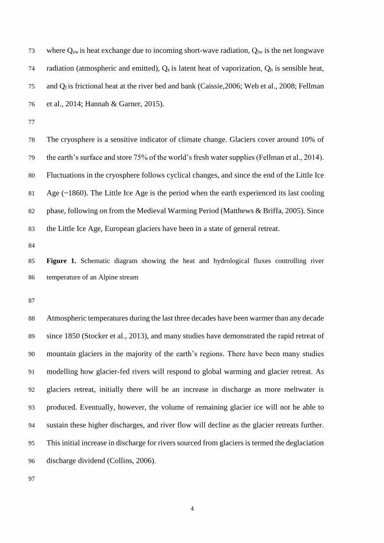
transfer in river systems (Figure 1) Heat exchanges occur by short-wave radiation (solar 67
radiation), long-wave radiation (atmospheric downward radiation less emitted radiation), 68
friction between water surface and streambed/banks, and evaporation, as well as heat 69
exchange between the air and water (Johnson et al., 2014; Mohseni and Stefan, 1999). The 70
net heat budget (Qn) can be calculated using the equation: 71
𝑄𝑛 = 𝑄𝑠𝑤 + 𝑄𝑙𝑤 + 𝑄𝑒 + 𝑄ℎ + 𝑄𝑓 72
4
where Qsw is heat exchange due to incoming short-wave radiation, Qlw is the net longwave 73
radiation (atmospheric and emitted), Qe is latent heat of vaporization, Qh is sensible heat, 74
and Qf is frictional heat at the river bed and bank (Caissie,2006; Web et al., 2008; Fellman 75
et al., 2014; Hannah & Garner, 2015). 76
77
The cryosphere is a sensitive indicator of climate change. Glaciers cover around 10% of 78
the earth’s surface and store 75% of the world’s fresh water supplies (Fellman et al., 2014). 79
Fluctuations in the cryosphere follows cyclical changes, and since the end of the Little Ice 80
Age (~1860). The Little Ice Age is the period when the earth experienced its last cooling 81
phase, following on from the Medieval Warming Period (Matthews & Briffa, 2005). Since 82
the Little Ice Age, European glaciers have been in a state of general retreat. 83
84
Figure 1. Schematic diagram showing the heat and hydrological fluxes controlling river 85
temperature of an Alpine stream 86
87
Atmospheric temperatures during the last three decades have been warmer than any decade 88
since 1850 (Stocker et al., 2013), and many studies have demonstrated the rapid retreat of 89
mountain glaciers in the majority of the earth’s regions. There have been many studies 90
modelling how glacier-fed rivers will respond to global warming and glacier retreat. As 91
glaciers retreat, initially there will be an increase in discharge as more meltwater is 92
produced. Eventually, however, the volume of remaining glacier ice will not be able to 93
sustain these higher discharges, and river flow will decline as the glacier retreats further. 94
This initial increase in discharge for rivers sourced from glaciers is termed the deglaciation 95
discharge dividend (Collins, 2006). 96
97

5
Changes to river hydrology in mountain regions, as glaciers retreat, pose implications for 98
river water temperature. Collins, (2009), Hood and Berner, (2009), and Fellman et al., 99
(2014) have assessed the impact of stream hydrology on water temperature in glacier-fed 100
regions. Such work analyses the percentage glaciation of the river catchment and analyses 101
how this impacts stream temperature. These studies, however, analyse streams in highly 102
glaciated catchments at high latitudes (Hood & Berner, 2009; Fellman et al., 2014) and 103
narrow, fast flowing glacier-fed rivers (Collins, 2009). 104
105
Atmospheric factors (e.g., net radiation) is thought to be the most important factor driving 106
stream temperature in rivers, attributing to more than 90% of a rivers energy budget (Webb 107
et al, 2008). It is thought that, in mid-latitude high elevations regions atmospheric factors 108
could account for an even higher constituent of a rivers heat budget. Hydrological factors 109
influence on water temperature is also accentuated in such regions, as mountain glaciers 110
considerably moderate riverflow. Over 90% of discharge in some Swiss glacier-fed rivers 111
occurs in the months April-October, with very small or even negligible discharge in the 112
winter months. This has implications for the temperature of glacier-fed rivers, with an 113
almost paradoxical (Arismendi et al., 2012; Collins, 2009) or a moderating (Moore, 2006) 114
effect occurring. Water temperature in such rivers peak early, in the spring, and is cooler 115
during the summer months. In the current warming climate, water temperature will be 116
positively influenced by atmospheric and environmental conditions, however this is also 117
expected to, initially, increase riverflow, and this increase in riverflow will negatively 118
drive water temperature (Collins, 2009). 119
120
1.1. Aims and Objectives 121
6
The principal aim of this study was to analyse water temperature of four glacier-fed 122
streams and one non-glacier-fed stream in the Swiss Alps with basin glacier coverage, for 123
the glacier-fed rivers, ranging from 36.9% to 83.7%. The specific objectives of this study 124
were: 125
1. Develop understanding of river water temperature in rivers draining large Alpine 126
glaciers in mid-latitude regions, developing on recent work in similar fields (e.g., 127
Brown et al., 2006; Brown and Hannah, 2008; Cadbury et al., 2008; Collins, 2009; 128
Hood & Berner 2009; Fellman et al., 2014). 129
2. Examine the influence of percentage glacierisation on meltwater temperature 130
3. Use multiple linear regression to determine the major influence on meltwater 131
temperature from a range of basin and river properties, alongside the hydro-132
meteorological factors: Solar radiation, precipitation and riverflow. 133
134
Previous studies have assessed the water temperature of glacier-fed rivers in either 135
catchments with litter glacier-cover (Brown et al., 2006), areas of different climatic 136
conditions (Hood & Berner, 2009; Cadbury et al., 2008; Chikita et al., 2010; Blaen et al., 137
2013; Fellman et al., 2014) and that encompass a smaller range of glacier-fed river in terms 138
of their hydromorphology (Collins, 2009). Therefore, this study will expand understanding 139
of river temperature in a variety of high mountain glacier-fed rivers using regression 140
models (after Fellman et al., 2014) to assess the relationship between climatic and basin 141
factors, and river water temperature. 142
143
2. Method 144
145
2.1. Study Area 146
7
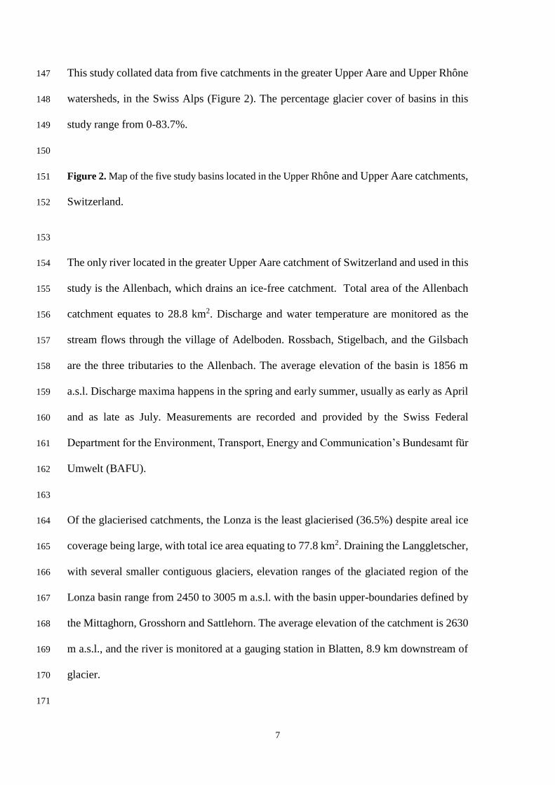
This study collated data from five catchments in the greater Upper Aare and Upper Rhône 147
watersheds, in the Swiss Alps (Figure 2). The percentage glacier cover of basins in this 148
study range from 0-83.7%. 149
150
Figure 2. Map of the five study basins located in the Upper Rhône and Upper Aare catchments, 151
Switzerland. 152
153
The only river located in the greater Upper Aare catchment of Switzerland and used in this 154
study is the Allenbach, which drains an ice-free catchment. Total area of the Allenbach 155
catchment equates to 28.8 km2. Discharge and water temperature are monitored as the 156
stream flows through the village of Adelboden. Rossbach, Stigelbach, and the Gilsbach 157
are the three tributaries to the Allenbach. The average elevation of the basin is 1856 m 158
a.s.l. Discharge maxima happens in the spring and early summer, usually as early as April 159
and as late as July. Measurements are recorded and provided by the Swiss Federal 160
Department for the Environment, Transport, Energy and Communication’s Bundesamt für 161
Umwelt (BAFU). 162
163
Of the glacierised catchments, the Lonza is the least glacierised (36.5%) despite areal ice 164
coverage being large, with total ice area equating to 77.8 km2. Draining the Langgletscher, 165
with several smaller contiguous glaciers, elevation ranges of the glaciated region of the 166
Lonza basin range from 2450 to 3005 m a.s.l. with the basin upper-boundaries defined by 167
the Mittaghorn, Grosshorn and Sattlehorn. The average elevation of the catchment is 2630 168
m a.s.l., and the river is monitored at a gauging station in Blatten, 8.9 km downstream of 169
glacier. 170
171

8
The Massa is the largest catchment in this study (195 km2), yet is the third most glacierised 172
(65.9%). The main glacier in the basin is the Grosser Aletschgletcher (1760-4195 m a.s.l.) 173
the river has been monitored year-round 2.4 km downstream of the glacier portal by BAFU 174
since 2003. 175
176
Findelen is located close to the town of Zermatt and has been maintained by the Alpine 177
Glacier Project (AGP) for the past 40 years. During this time the AGP has amassed one of 178
the longest collection of Alpine glacier meltwater data in the world. Since 2003, with the 179
introduction of automatic water quality loggers, water temperature has been monitored 180
every summer field season close to a hydroelectric intake around 1 km from the glacier 181
portal. Here, water from the Findelenbach is collected and contributes to the Grand 182
Dixence hydroelectric power generation. Findelenbach accounts for only 5% of the greater 183
Grand Dixence watershed. As a result, discharge is monitored year-round by the Grand 184
Dixence S.A. power company, who kindly make the data available to the Alpine Glacier 185
Project. The Findelen basin is 24.9 km2 and is 73% glacierised. 186
187
Contiguous to the Findelen catchment, is the Gornera basin. The Gornera is the second 188
largest catchment in this study, with an area measuring 82 km2, and elevations ranging 189
from 2005 to 4636 m a.s.l. Switzerland’s second largest glacier, Gornergletscher, is the 190
principal glacier in this basin, covering an area of 60 km2 (Huss et al., 2007). The Gornera 191
catchment (83.7% glacier covered) was the most glacier covered catchment of this study. 192
Measurements are taken 1.5 km from the portal of Gornergletscher and, as with the 193
Findelen catchment, discharge is measured and provided by the Grand Dixence S.A., at 194
their hydroelectric intake. Stream temperature is recorded throughout the summer field 195

9
season by the Alpine Glacier Project (AGP) researchers. An overview of the study basins 196
is given in Table 1. 197
198
Table 1: Characteristics of the five study basins used in this study 199
200
2.2 Measurements 201
For the Massa, Lonza and Allenbach data were collected for the period of 1 January 2003 202
and 31 December 2016 by the Swiss Federal Department for the Environment, Transport, 203
Energy and Communication’s Bundesamt für Umwelt (BAFU). Water temperature and 204
discharge measurements are taken hourly throughout the sampling period. At the AGP’s 205
Findelen and Gornera basins, both water temperature and discharge measurements were 206
collected throughout the ablation season for the years 2003-2016, with precise dates 207
depending on access to the field site each year. Stream temperature was recorded at the 208
AGP’s Gornera and Findelen basins with Hydrolab MS5 Minisondes with a temperature 209
sensor (accurate to 0.10 °C, measuring at a resolution of 0.01 °C). Validation of Minisonde 210
data was conducted in more recent years with the use of a secondary set of temperature 211
data instruments. Since 2013, a set of Tiny Tag Aquatic 2 data loggers have been used 212
alongside the Hydrolab MS5 Minisondes. Tests of the instrument’s reliability, consistency 213
and measurement stability can be conducted using the pair of instruments in tandem. 214
215
Data provided by BAFU were pre-processed prior to public availability. Data collected 216
through the AGP also required pre-processing; for example, as no permanent fixture was 217
available close to the Findelenbach, the data logger was situated on the river bank. 218
However, due to weather anomalies and lower meltwater resulting in a fall in water level 219
let to the temperature sensor rising above the water level. This data was therefore removed. 220

10
Furthermore, there were issues with minisonde battery life being reduced because of the 221
environmental and water damage. Data provided from the Grande Dixence, also needed to 222
be pre-processed, with data points removed from the dataset. This was required due to the 223
de-gravelling process that is conducted by the hydroelectric power company. De-224
gravelling is a process where large volumes of water is flushed through the system to 225
remove sediment that has built up due to the high suspended sediment present in glacier-226
fed rivers. As a result of de-gravelling, discharge readings would spike usually once during 227
the early morning, and once in the evening during the summer months. A simple data 228
processing script was developed to remove all spikes in discharge data before data analysis 229
was undertaken. To find the associated errors within the collected data sets, analysis of 230
the data was conducted using the R programming language (R Core Team, 2013). An R 231
script was created that would assess each value within the data set and compare it to the 232
previous and next datapoint. The indices of these values were printed and the datapoints 233
were assessed manually to determine if they were correct or errors. Most of the errors 234
occurred during degravelling processes that usually occurred at regularly spaced intervals 235
easing the data correction process. In terms of sensors temporarily exiting the water, when 236
river flows declined, a similar script was developed. This would simply look for values 237
higher than the expected maximum data and remove datapoints that were within this range. 238
239
Solar radiation data was obtained by MeteoSwiss (Federal Office for Meteorology and 240
Climatology, Switzerland). The closest long-term data available for this study were 241
measurements made in the town of Zermatt (1608 m a.s.l). It is assumed that there is little 242
variation in solar radiation across the study sites, and the solar radiation measured at 243
Zermatt would be analogous to that across the region where the study was conducted. 244
Similarly, precipitation values were obtained, through MeteoSwiss, for the Zermatt region. 245

11
This was used to indicate the influence of the preceding winters precipitation, in the form 246
of snowfall, on the following summer riverflow and therefore water temperature. Both 247
solar radiation and precipitation data was available year-round throughout the period, 1 248
January 2003 to 31 December 2016. 249
250
After Fellman et al (2014) multiple linear regression was employed to assess relationships 251
between catchment variables, environmental variables and meltwater temperature 252
characteristics. The hourly data samples were averaged over monthly periods to provide 253
mean monthly water temperature at each river. It was required, therefore, that this analysis 254
could only be conducted on months in which there were no gaps in the data set 255
256
For year to year comparison and presentation of water temperature and discharge, averages 257
of 7-day measurements were taken. Maximum Weekly Water Temperature (MWAT) 258
statistic was calculated. MWAT is a metric of water temperature, the seasonal maximum 259
of 7-day average temperatures. This is a useful technique for comparing water temperature 260
as it is said to smooth out the dataset and correlates well with various environmental and 261
biological indices (Fellman et al., 2014). As a result of averaging over 7-day periods 262
beginning on 1 January, 29 February during a leap year is the same day of the year as 1 263
March in a non-leap year (Day 60). An 8-day week therefore occurs at the end of the year 264
during Week 52. 265
266
Stream and basin characteristics were calculated using a combination of analysis of 267
ASTER imagery within ArcGIS alongside analysis of satellite imagery from Google Earth. 268
River length was calculated alongside widths at 10 m intervals to calculate stream surface 269
area. River width was calculated using imagery photographed in the summer months to 270

12
ensure discharge was at high levels. Assessment of discharge data for the month in which 271
satellite imagery was used, ensured that the river level corresponded to river levels during 272
the months selected for cross-river analysis. Percentage glacierisation statistics were 273
obtained from BAFU for the Massa, Lonza and Allenbach basins, and recent literature for 274
the Findelenbach and Gornera. 275
276
277
3. Results 278
3.1. Solar radiation 279
Seasonal patterns of solar radiation followed typical cycle for a mid-latitude region of the 280
globe. Measured solar radiation in Zermatt, rises to a peak in late June, close to the summer 281
solstice, then begins to decline to a minimum in late December during the time of the 282
winter solstice. 2003, 2009, 2012, and 2015 were the that witness highest average summer 283
air temperature, measuring 19.9 °C, 18.7 °C, 18.7 °C and 19.2 °C respectively. This study 284
demonstrated that these years of high summer air temperatures also witness high levels of 285
spring solar radiation, however, years of greatest solar radiation do not necessarily 286
correlate with highest average summer temperature. For example, the year of highest 287
maximum solar radiation was 2013. 288
289
3.2. Precipitation 290
Measurements of precipitation for the Zermatt region were assessed for this study as they 291
provide a surrogate measure indicating the extent of the winter snowpack in the preceding 292
winter prior to each summer ablation season. Winter precipitation observations provide an 293
interesting insight for glacier hydrology studies as the total and extent of winter snow will 294
impact seasonal stream hydrology and therefore, temperature. Snowfall influences runoff 295
regimes in glacier-fed river catchments (Collins, 2006). Discharge from glacier-fed river 296

13
catchments will rise earlier or later in the season dependent on the extent of winter snow 297
cover. The timing of high volumetric flow is important for water temperature studies, as 298
this will affect the heating capacity of the river. Secondly, liquid precipitation throughout 299
the ablation season will provide warmer runoff, increasing meltwater temperature in the 300
glacier-fed river catchments. The driest year of the study period was 2003 where rainfall 301
remained low throughout the calendar year (7-day total precipitation maximum = 25.9 302
mm). Following this dry year, the years 2004-2007 saw higher precipitation totals with 303
maxima 7-day total occurring during 2007, 103.4 mm. For winter precipitation (P11-5), 304
herein defined as precipitation total for the period of 1 November – 31 May, the greatest 305
winter precipitation total occurred during 2013-14 totalling 469.7 mm. Only in two other 306
accumulation seasons did precipitation total greater than 400 mm, 2008-09 (422.4 mm) 307
and 2012-13 (444.4 mm). The driest winter was that of 2003-04 where only 163.8 mm of 308
precipitation fell. The only other year in which precipitation equated to less than 200 mm 309
was 2010-11 when winter precipitation totalled 164.4 mm. The average winter 310
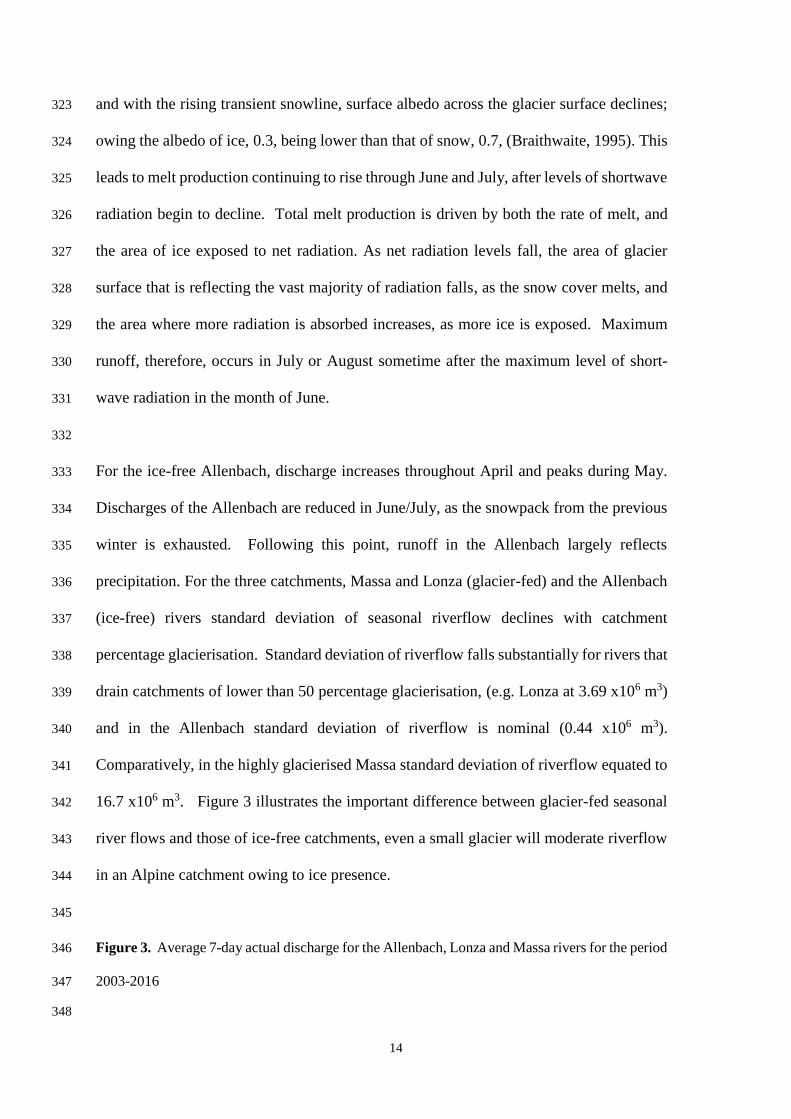
precipitation total throughout the study period was 329.9 mm. 311
312
3.3. River flow 313
Measurements of discharge from Swiss catchments are abundant, with complete year-314
round series available at hourly interval. Data collected by hydroelectric power companies, 315
e.g., the Grande Dixence S.A., are gauged at many intake points, often immediately 316
downstream of glaciers, where meltwater is extracted. Assessing the seasonal variation in 317
river flow, both the Massa and Lonza are demonstrative of the typical discharge regimes 318
expected of river draining glacierised Alpine catchments. Runoff in the winter months, 319
herein defined as the months October through to November, make up <10% of annual 320
runoff. Throughout April and May, river discharge increases from minimum flow as a 321
result of increasing energy availability and, in turn, melt production. As winter snow melts, 322
14
and with the rising transient snowline, surface albedo across the glacier surface declines; 323
owing the albedo of ice, 0.3, being lower than that of snow, 0.7, (Braithwaite, 1995). This 324
leads to melt production continuing to rise through June and July, after levels of shortwave 325
radiation begin to decline. Total melt production is driven by both the rate of melt, and 326
the area of ice exposed to net radiation. As net radiation levels fall, the area of glacier 327
surface that is reflecting the vast majority of radiation falls, as the snow cover melts, and 328
the area where more radiation is absorbed increases, as more ice is exposed. Maximum 329
runoff, therefore, occurs in July or August sometime after the maximum level of short-330
wave radiation in the month of June. 331
332
For the ice-free Allenbach, discharge increases throughout April and peaks during May. 333
Discharges of the Allenbach are reduced in June/July, as the snowpack from the previous 334
winter is exhausted. Following this point, runoff in the Allenbach largely reflects 335
precipitation. For the three catchments, Massa and Lonza (glacier-fed) and the Allenbach 336
(ice-free) rivers standard deviation of seasonal riverflow declines with catchment 337
percentage glacierisation. Standard deviation of riverflow falls substantially for rivers that 338
drain catchments of lower than 50 percentage glacierisation, (e.g. Lonza at 3.69 x10⁶ m3) 339
and in the Allenbach standard deviation of riverflow is nominal (0.44 x10⁶ m3). 340
Comparatively, in the highly glacierised Massa standard deviation of riverflow equated to 341
16.7 x10⁶ m3. Figure 3 illustrates the important difference between glacier-fed seasonal 342
river flows and those of ice-free catchments, even a small glacier will moderate riverflow 343
in an Alpine catchment owing to ice presence. 344
345
Figure 3. Average 7-day actual discharge for the Allenbach, Lonza and Massa rivers for the period 346
2003-2016 347
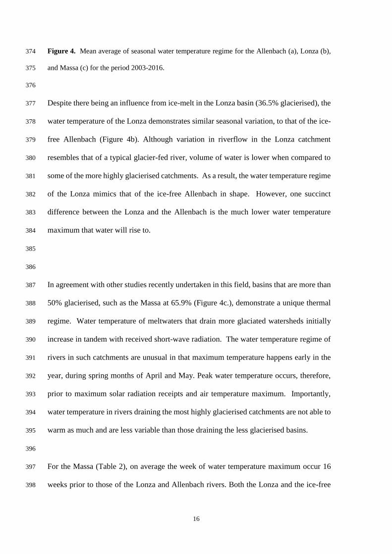
348
15
Maximum discharge rises with percentage glacierisation, being highest in the Massa and 349
lowest in the ice-free Allenbach. Seasonally variation in river discharge in those that drain 350
glaciers is greater than those that do not. Glacier coverage influences discharge of a basin, 351
a small glacier will moderate flow, reducing variation however, when glacierisation of the 352
basin rises above ~25%, glaciers increase variation substantially, with over 90% of 353
discharge being delayed into the months of April to October. 354
355
The ratio of standard deviation to the mean is useful for seasonal comparison of runoff 356
variability across multiple river catchments (Collins, 2006). This Coefficient of Variation 357
(CV), shows that week to week variation in runoff was greatest in the Massa, averaging 358
1.29 across the study years, averaged 1.07 in the Lonza, and was lowest in the Allenbach 359
with an average of 0.87. There appeared to be no clear link between summer temperatures 360
and week-to-week coefficient of variation in any of the three catchments assessed. Nor did 361
there appear to be a link between coefficient of variation of discharge and winter 362
precipitation of the previous winter and coefficient of variation of discharge. 363
364
365
3.4. Water Temperature 366
Water temperature of the Allenbach (0% glacierisation) typically reflect those of snow-367
melt fed rivers. In such streams, water temperature rises in-line with incoming short-wave 368
radiation, January and June, as shown in Figure 4a. Water temperature continues to rise, 369
consistently reaching their maximum about six weeks following peak solar radiation 370
receipts. Water temperature in the Allenbach then fall in July and August, when solar 371
radiation receipts are substantially lower. 372
373
16
Figure 4. Mean average of seasonal water temperature regime for the Allenbach (a), Lonza (b), 374
and Massa (c) for the period 2003-2016. 375
376
Despite there being an influence from ice-melt in the Lonza basin (36.5% glacierised), the 377
water temperature of the Lonza demonstrates similar seasonal variation, to that of the ice-378
free Allenbach (Figure 4b). Although variation in riverflow in the Lonza catchment 379
resembles that of a typical glacier-fed river, volume of water is lower when compared to 380
some of the more highly glacierised catchments. As a result, the water temperature regime 381
of the Lonza mimics that of the ice-free Allenbach in shape. However, one succinct 382
difference between the Lonza and the Allenbach is the much lower water temperature 383
maximum that water will rise to. 384
385
386
In agreement with other studies recently undertaken in this field, basins that are more than 387
50% glacierised, such as the Massa at 65.9% (Figure 4c.), demonstrate a unique thermal 388
regime. Water temperature of meltwaters that drain more glaciated watersheds initially 389
increase in tandem with received short-wave radiation. The water temperature regime of 390
rivers in such catchments are unusual in that maximum temperature happens early in the 391
year, during spring months of April and May. Peak water temperature occurs, therefore, 392
prior to maximum solar radiation receipts and air temperature maximum. Importantly, 393
water temperature in rivers draining the most highly glacierised catchments are not able to 394
warm as much and are less variable than those draining the less glacierised basins. 395
396
For the Massa (Table 2), on average the week of water temperature maximum occur 16 397
weeks prior to those of the Lonza and Allenbach rivers. Both the Lonza and the ice-free 398
17
Allenbach tend to see MWAT occur during week 32 (06 – 12 August) of the year, as 399
opposed to week 16 (16 – 22 April) for the Massa, despite the Lonza having a glacier 400
influence. Generally, the ice-free Allenbach will see an earlier MWAT than the glacier-401
fed Lonza, probably as a result of the greater volume of water being warmed in the Lonza 402
than that of the Allenbach. 403
404
Table 2. Maximum weekly average temperature statistics for the Allenbach, Lonza and Massa 405
rivers for the period 2003-2016. 406
407
Figure 5a illustrates water temperature of the five study catchments for the period 26 June 408
– 10 September 2006. Water temperature of the Findelenbach, and more so the Gornera, 409
are low throughout this summer months, with little variation, similar to the those of the 410
Massa. Stream temperatures in the Findelenbach and Gornera are highly responsive to 411
hydroclimatological perturbations. Both rivers appear more responsive to precipitation 412
events, with summer rainfall positively affecting water temperature. When assessing the 413
water temperature of the Findelenbach and Gornera, it is clear that the Findelenbach warms 414
to a higher degree than the Gornera, this is in line with previous thinking whereby the river 415
draining the more highly glacierised catchment has lower water temperatures. 416
Surprisingly, however, maximum weekly water temperatures of the Findelenbach are 417
warmer than those of the Massa despite the Massa draining a less glacierised catchment. 418
419
Thermal characteristics of the Findelenbach are different to the Massa and Gornera, Figure 420
5b, with lower minima and higher maxima water temperature. This greater range in 421
temperature, suggests that unlike the other two rivers draining highly glacierised 422
catchments heat exchange constituents are holding different influences over the 423
Findelebach when compared to the Massa and Gornera. 424
18
425
These data suggest that stream temperatures of the Gornera and Massa are influenced by 426
forces other than solar radiation and air temperature, potentially solely reflecting heat 427
generated from the conversion of potential energy to kinetic energy as the river flows 428
downstream. Assessing the Lonza and Allenbach, less or no glacier influence, it could be 429
assumed that throughout July the weather was warm with lots of available solar radiation, 430
as water temperatures were therefore able to rise. At the beginning of August, the 431
temperature of both streams falls, suggesting that the weather became cooler with more 432
cloud cover inhibiting the received solar radiation at the stream surface. This theory is 433
corroborated in the Massa where the temperature rises and becomes more variable during 434
this time, hinting that the volume of water in the channel decreased as there was less solar 435
radiation and therefore less ice melt. As a result, water was flowing more slowly which 436
would increase the residence time of water within the channel, despite the levels of solar 437
radiation being lower. 438
439
Figure 5. a). hourly water temperature observations of the five study catchments and b). box plot 440
showing river temperatures across the five study catchments for the period 26 June 2006 – 10 441
September 2006. 442
443
The multiple linear regression (MLR) used here assessed the relationship between 7-day 444
mean stream temperature and 7-day receipts of solar radiation, 7-day precipitation totals 445
and 7-day average river flow. 7-day statistics were used as they moderate extremes and 446
provide better fit for modelling (Kelleher et al., 2012). To ensure comparison would 447
provide useful information, standardised coefficients (βstd), were utilised. βstd requires the 448
data to be standardised, such as the variance is equal to 1. This allows the statistics to be 449
19
comparable across each predictor variable and allows direct comparison of which 450
independent variable is having greatest effect on the dependant variable. 451
452
MLR was first conducted across the three study sites for which data is available year-453
round, including the non-glacierised Allenbach. For consistency, the year 2006 was used 454
for the MLR analysis as it provided good comparison with the second model which 455
incorporated the Gornera and Findelenbach rivers. Owing to a complete data set, with no 456
gaps in the data across all sites, the calendar month of August 2006 was selected for the 457
second MLR model. 458
459
To assess the basin properties that most influence water temperature across all five of the 460
study catchments, three basin properties were selected (Table 3). Monthly averages were 461
computed for the water temperature of all five river in this study. When assessing the 462
regression of all five study basins, it was clear that, in-line with the findings of most other 463
studies (Collins, 2009; Fellman et al., 2014; Stahl and Moore, 2006), that percentage 464
glacier cover of the basin, had the greatest effect (βstd = -1.11) on stream temperature in 465
the rivers draining those valleys (R2adj=0.99, y = 0 + -1.11* %Glac + 0.19 * GaugElev 466
+0.12 * StreamArea). However, when assessing the glacier-fed rivers only, stream surface 467
area was a stronger determiner of water temperature (R2adj=0.92, y = -0.31 + 0.46 * 468
StreamArea + -0.35 * %Glac). Generally, it will be the case that streams of greater 469
percentage glacierisation will be narrower and shorter owing to the basin hypsometry in a 470
glaciated catchment, however this does not always hold true, as displayed by the 471
Findelenbach (Table 1). Percentage glacierisation could, therefore, be said to be a 472
surrogate for stream surface area and in most cases, this would hold true and explain the 473
strong relationship found in previous studies (e.g., Fellman et al., 2014). 474

20
475
Table 3. Statistics of multiple linear regression models of percentage glacierisation, and stream 476
surface area, gauge elevation, and monthly average water temperature for the period 1 August – 477
31 August 2006 for the five rivers in this study including the ice-free Allenbach, and of multiple 478
linear regression models of percentage glacierisation, and stream surface area, and monthly 479
average water temperature for the period 1 August – 31 August 2006 for only the four glacier-fed 480
rivers in this study . 481
482
4. Discussion 483
Seasonal variation in water temperature in the three study basins, where year-round data 484
are available, is in line with those in other studies including those assessing streams in 485
other regions of the globe. However, when assessing the five study basins, some 486
interesting results have been obtained. Interestingly, this study has highlighted the 487
phenomena first suggested by Collins, 2009 whereby the seasonal thermal regime of rivers 488
that drain highly glacierised basins (i.e., >50%) displays a spring maximum (Collins, 2009; 489
Fellman et al., 2014). This unusual thermal regime sees warming temperatures in line with 490
increasing levels of solar radiation up to a peak after which water temperatures then begin 491
to decline slightly and remain subdued, with little variation, for the entirety of the summer 492
period (May to September). At the end of the summer period water temperatures briefly 493
rise, before decreasing following the falling levels of incoming shortwave radiation. 494
495
Meltwater temperatures are subdued as a result of summer discharge from glaciers. 496
Summer discharges from Alpine glaciers account for over 90% of total annual flow (Figure 497
3 and Figure 4). Outside of this summer period meltwater production is low, if not 498
negligible, and under these conditions meltwaters are quick to respond to energy inputs 499
and therefore able to warm rapidly. However, discharges rapidly rise in the spring and, 500
21
despite higher levels of energy being available, it becomes more difficult to heat 501
meltwaters when volume of flow is greater. 502
503
Seasonal thermal regimes for basins lower than 50% appear to be remarkably similar in 504
shape to basins where there is no ice influence. River flow for rivers draining even a 505
slightly glacierised catchment are highly variable and the high summer discharges 506
recorded in the Lonza (36.5% glacierised) do appear to influence water temperature and 507
this is reflected in the reduced water temperatures of the Lonza when compared to the ice-508
free Allenbach. 509
510
Seasonal variation in river flow of catchments in the European Alps is well understood 511
(Collins, 1989). For glacier-fed rivers timing of maximum water temperature appears to 512
be dependent on the time of increasing discharge. MWAT for the highly glacierised Massa 513
show that Maximum water temperature occurs anywhere between early-April and mid-514
May. The data shows that there is no link between warm summers and reduced water 515
temperature in glacier-fed rivers, however. For glacier-fed rivers it is likely that timing 516
and magnitude of maximum water temperature in the Spring is influenced by both short-517
wave radiation receipts in first fourth months of the year, as well as the extent of the winter 518
snowfall over the preceding winter. Winter precipitation will have a clear influence over 519
the timing of rising discharge and, therefore, modify the temperature regime accordingly. 520
Should winter snowfall of the preceding winter be high, the extent of the winter snowpack 521
will be greater, and meltwater production will be delayed. During dry winters, the winter 522
snowline will be higher in the valley and more ice will be exposed to incoming short-wave 523
radiation in the spring. In this scenario, there will be more ice-melt earlier in the year and 524
discharges will rise sooner and potentially be of a greater magnitude (Fleming, 2005). The 525

22
data used in this study could not definitively show the influence of winter precipitation on 526
water temperature of alpine streams, further studies of the long-term data available linked 527
with meteorological variables not utilised in the present study, e.g., summer air 528
temperature, would be of interest. The results of this cursory analysis linking winter 529
precipitation and summer stream temperature indicate a more in-depth relationship 530
between winter snowfall, discharge, summer air temperature and summer insolation. 531
532
Prior to reaching their spring maxima, water temperature in glacier-fed rivers that drain 533
the most highly glacierised catchments show strong daily and seasonal variation. After 534
their spring maxima, daily and seasonal ranges fall dramatically, notably throughout June 535
– September. The unusual summer thermal regime that is unique to highly glacierised 536
glacier-fed rivers is triggered by an increase in discharge within ~10% of the annual total 537
(Figure 3 and Figure 4). Further increases in river flow have little influence over the water 538
temperature. 539
540
Previous studies have often suggested that the basin percentage glacier cover is the key 541
determiner of stream temperatures in glacier-fed rivers (Collins, 2009; Fellman et al., 542
2014; Hood and Berner, 2009; Moore, 2006; Stahl and Moore, 2006). The results of this 543
study suggest that there is a more complex interaction between basin controls and the 544
temperature of glacier-fed streams. 545
546
Short-wave radiation was a good predictor for the 7-day mean stream temperature of the 547
Massa, Lonza and Allenbach rivers. Regression slopes when assessing incoming solar 548
radiation increased, albeit only slightly, with rising basin percentage glacierisation. 549
Precipitation also positively influenced water temperature in the three of the catchments. 550
23
When assessing the Massa (65.9% glacierised), incoming solar radiation was the best 551
determiner (ranging βstd across the study years from 0.67 to 1.07) for river temperature. 552
Also holding a positive influence over stream temperature (ranging βstd across the study 553
years from 0.11 to 0.29) was precipitation, with the low βstd coefficients indicating a lesser 554
impact that precipitation has as a predictor. As expected, there is a negative relationship 555
between riverflow in the Massa and river temperature (ranging βstd across the study years 556
from -0.04 to -0.38). This corroborates research of North American (Fellman et al., 2014; 557
Moore, 2006) ice-melt-fed rivers, potentially suggesting that the large rise in cold ice-melt 558
during summer months negatively drives river temperature (Uehinger et al., 2003). Low 559
adjusted R2 values, however, were often demonstrated when assessing the relationship of 560
discharge and water temperature. This is likely due to the reason that as radiation increases, 561
ice-melt from the glacier system significantly reduce water temperatures. As suggested 562
previously, as riverflow increases there is an initial reduction in water temperature. 563
However, as discharge rises further, there appears to be no greater reduction in the 564
temperature of a stream. This suggests that glacier-fed river temperature is not a driven by 565
simple relation between quantity of runoff produced and its greater heating capacity (Gu 566
and Li, 2002), instead there may be a more complex interaction between riverflow, and 567
river dynamics, together with cold ice-melt inputs. 568
569
In terms of basin controls over stream temperature, stream surface area was the greatest 570
predictor for the rivers in this study during the month of August, 2006. This explains 571
previous findings, in most glacierised catchments where percentage glacierisation is 572
significant, stream lengths are usually low and stream widths are often confined to steep 573
valley walls. This is true for both the highly glacierised Gornera and Massa. Previous work 574
has demonstrated that stream length is one of the key basin characteristics that influence 575

24
water temperature (Brown and Hannah, 2007). The Findelenbach however, is much wider 576
as the river is able to widen significantly with rising discharge, thanks to the network of 577
channels that make up the braided channel system. On the other hand, with rising 578
discharge, the Massa and Gornera are confined by their basin profile and have to, therefore, 579
deepen and flow faster. It becomes difficult for heat exchange to occur as residence time 580
is reduced. In the Findelenbach, residence times are longer and the channel is shallower 581
and as a result incoming solar radiation holds much greater control over stream 582
temperature. This allows the Findelenbach to warm to higher temperatures than would 583
be expected for such a highly glacierised catchment and not follow the typical seasonal 584
thermal regime of rivers draining other highly glacierised catchments. 585
586
The analysis of data within this study, along with the results of the multiple linear 587
regression, suggest that reduced summer water temperatures, for some glacier-fed rivers, 588
are less influenced by incoming solar radiation than originally thought. It is likely that, as 589
found in Chikita et al. (2010), the greatest component of the heat budget in glacier-fed 590
rivers within narrow channels is friction, the conversion of potential energy to kinetic 591
energy as the river flows down valley. An in-depth heat budget study, of the Gornera and 592
Massa rivers, should be conducted to ascertain if this theory holds true. This theory 593
explains the unique thermal regime of some glacier-fed rivers. Rising water temperature 594
in line with solar radiation is thwarted as river levels begin to rise in the Spring. Such 595
rivers reflect rising discharge by deepening and increased velocity, as this point solar 596
radiation is unable to warm the greater volume of water within in the channel. Throughout 597
the summer months therefore, when discharge of glacier-fed rivers remains high, water 598
temperature is reflecting greater warming from other components of the heat budget. Once 599
discharge subsides in the late summer, temperatures again are influenced, principally, by 600

25
solar radiation and therefore rise before declining with falling levels of solar radiation to 601
its minimum at the winter solstice. 602
603
This study proposes an interesting discussion regarding the response of glacier-fed river 604
temperature to a warming climate. During a time of deglaciation, a retreating glacier will 605
result in river length increasing and, augmented by the deglaciation discharge dividend, an 606
initial rise in river flow from rivers draining glaciated basins. In terms of river temperature 607
response to a retreating glacier, the longer stream length will result in increased residence 608
time (between glacier portal and gauging point), however, the rising volume of water 609
within the channel will decrease residence time, assuming the river flows more quickly as 610
discharge rises. Residence time will directly increase water temperature, as an aliquot of 611
water moving through the system will reside in the channel longer. Rising discharge will, 612
however, mean there will be direct decrease in water temperature as there is a bigger 613
volume of water to be warmed within the reach. However, for this to hold true, and posed 614
by the results of this paper, what is important is how the river responds to rising discharge 615
(Figure 6). Rising river flow will increase velocity, depth, and width. How rivers respond 616
is important, as these three variables have different impacts on stream temperature. Both 617
increased velocity and depth will negatively impact temperature, but width will positively 618
impact temperature as there is a wider area for which heat exchange can take place. In 619
rivers which widen as discharge rises, such as the Findelenbach, will see temperatures also 620
rise in a warming climate. In rivers which instead deepen and flow more quickly, such as 621
the Gornera and Massa, temperature will likely fall as the climate warms and glaciers 622
retreat. 623
624

26
Figure 6. Schematic diagram showing the response of melt water temperature to deglaciation in 625
a glacier-fed river catchment, as well as the response of melt water temperature to increasing 626
discharge and changes in stream width, depth, and velocity. 627
628
629
5. Conclusion 630
631
Previous studies have demonstrated that discharge from highly glacierised catchments 632
holds a strong control over water temperature (Collins, 2009; Hood & Berner 2009; 633
Fellman et al., 2014). This theory implies that warm summers with high ice melt will lead 634
to cooler water temperatures. The more glaciated the catchment from which a river drains, 635
the cooler the spring water temperature will be. Such rivers have a unique temperature 636
regime whereby they reach their maxima during the spring and remain consistent and cool 637
throughout the summer, catchments of less than 50% glacierisation do not follow this 638
pattern, with maximum temperatures occurring later in the year and following direct solar 639
radiation. This study, however, has demonstrated that in some circumstances, water 640
temperature of glacier-fed rivers does not follow this pattern. One glacier-fed river in 641
Switzerland, which has been the focus of a stream temperature study since 2003 642
demonstrates an unusual temperature regime when considering its catchment is over 70% 643
glacierised. It raises questions, to which further studies must be undertaken, as to what the 644
main control of water temperature is in high mountain environments at mid-latitude 645
regions of the globe. The results of this small study potentially indicate that the main 646
control of water temperature during periods of low river flow is solar radiation. However, 647
after river flow surpasses a critical point, solar radiation is not able to excerpt its influence 648
and becomes of less importance in the transfer of energy from the atmosphere to the river. 649

27
This is a response to numerous factors including, water velocity, volume and residence 650
time but also channel morphology. 651
652
The interesting findings of warmer than expected temperature in the Findelenbach 653
suggests that stream surface area is a key variable in influencing water temperature in high 654
mountain catchments. It poses interesting questions to how the river will respond to a 655
period of climatic change and deglaciation. Augmented by the deglaciation discharge 656
dividend, river flow from glaciated catchments will initially rise, before eventually falling 657
as the ever-shrinking volume of glacier ice will be unable to sustain high river flows. This 658
study suggests that in rivers such as the Findelenbach, where the river is not contained by 659
steep valley sides, increasing river flow will result in a wider river, coupled with the retreat 660
of the glacier increasing the stream length, the surface area of the river will increase and 661
therefore, the water will reach higher temperatures. Previous studies would imply that in 662
the most glaciated catchments there will likely be a decrease in water temperature as 663
glacier-ice melts and river flow increases. Further study into the three highly glaciated 664
catchments used herein should be undertaken to see if this holds true for the Massa and 665
Gornera rivers. 666
667
Acknowledgements 668
The authors would like to thank the Grande Dixence S.A. for providing river discharge 669
data for their hydroelectric power intakes at Findelen and Gorner Basins. As well as, the 670
Swiss Federal Department for the Environment, Transport, Energy and Communication’s 671
Bundesamt für Umwelt (BAFU) for proving water temperature and river flow 672
measurements for the Massa, Lonza and Allenbach. Finally, this paper is dedicated to the 673
life of the late Professor David N. Collins whose comittment to the study of high mountain 674

28
environments made this study possible. Thanks must, therefore, also go to the hundreds 675
of students, over many years, who were inspired by David to visit Switzerland and collect 676
water quality measurements for the Alpine Glacier Project and whose data was used in this 677
study. Finally, we are grateful for the suggestions and comments of the three anonymous 678
reviewers which helped improve this paper. 679
680
681
682
683
684
685
686
687
688
689
690
691
References 692
Arismendi, I., Johnson, S.L., Dunham, J.B., Haggerty, R. and Hockman‐Wert, D., 693
2012. The paradox of cooling streams in a warming world: regional climate trends do not 694
parallel variable local trends in stream temperature in the Pacific continental United 695
States. Geophysical Research Letters, 39(10). 696
Blaen, P.J., Hannah, D.M., Brown, L.E. and Milner, A.M., 2013. Water 697
temperature dynamics in High Arctic river basins. Hydrological Processes, 27(20), 698
pp.2958-2972. 699
Braithwaite, R.J., 1995. Positive degree-day factors for ablation on the Greenland 700
ice sheet studied by energy-balance modelling. Journal of Glaciology, 41(137), pp.153-701
160. 702
Brown, L.E., Hannah, D. M., and Milner, A.M., 2006. Hydroclimatological 703
influences on water column and streambed thermal dynamics in an alpine river system. 704
Journal of Hydrology, 325(1), pp.1-20. 705
29
Brown, L.E. and Hannah, D.M., 2007. Alpine stream temperature response to 706
storm events. Journal of Hydrometeorology, 8(4), pp.952-967. 707
Brown, L.E. and Hannah, D.M., 2008. Spatial heterogeneity of water temperature 708
across an alpine river basin. Hydrological Processes, 22(7), pp.954-967. 709
Cadbury, S.L., Hannah, D.M., Milner, A.M., Pearson, C.P. and Brown, L.E., 2008. 710
Stream temperature dynamics within a New Zealand glacierized river basin. River 711
Research and Applications, 24(1), pp.68-89. 712
Caissie, D., 2006. The thermal regime of rivers: a review. Freshwater 713
biology, 51(8), pp.1389-1406. 714
Chikita, K.A., Kaminaga, R., Kudo, I., Wada, T. and Kim, Y., 2010. Parameters 715
determining water temperature of a proglacial stream: the Phelan Creek and the Gulkana 716
Glacier, Alaska. River research and applications, 26(8), pp.995-1004. 717
Collins, D.N., 1989. Hydrometeorological conditions, mass balance and runoff 718
from alpine glaciers. In Glacier fluctuations and climatic change (pp. 235-260). Springer, 719
Dordrecht. 720
Collins, D.N., 2006. Climatic variation and runoff in mountain basins with 721
differing proportions of glacier cover. Hydrology Research, 37(4-5), pp.315-326. 722
Collins, D.N., 2009. Seasonal variations of water temperature and discharge in 723
rivers draining ice-free and partially-glacierised Alpine basins. In Northern Research 724
Basins Symposium (Vol. 17, pp. 67-74). 725
Dickson, N.E., Carrivick, J.L. and Brown, L.E., 2012. Flow regulation alters alpine 726
river thermal regimes. Journal of Hydrology, 464, pp.505-516. 727
Fellman, J.B., Nagorski, S., Pyare, S., Vermilyea, A.W., Scott, D. and Hood, E., 728
2014. Stream temperature response to variable glacier coverage in coastal watersheds of 729
Southeast Alaska. Hydrological Processes, 28(4), pp.2062-2073. 730
Fleming, S.W., 2005. Comparative analysis of glacial and nival streamflow 731
regimes with implications for lotic habitat quantity and fish species richness. River 732
Research and Applications, 21(4), pp.363-379. 733
Garner, G., Malcolm, I.A., Sadler, J.P. and Hannah, D.M., 2014. What causes 734
cooling water temperature gradients in a forested stream reach?. Hydrology and Earth 735
System Sciences, 18(12), p.5361. 736
Gu, R.R. and Li, Y., 2002. River temperature sensitivity to hydraulic and 737
meteorological parameters. Journal of Environmental Management, 66(1), pp.43-56. 738

30
Hannah, D.M. and Garner, G., 2015. River water temperature in the United 739
Kingdom: changes over the 20th century and possible changes over the 21st 740
century. Progress in Physical Geography, 39(1), pp.68-92. 741
Hannah, D.M., Malcolm, I.A., Soulsby, C. and Youngson, A.F., 2008. A 742
comparison of forest and moorland stream microclimate, heat exchanges and thermal 743
dynamics. Hydrological Processes, 22(7), pp.919-940. 744
Hari, R.E., Livingstone, D.M., Siber, R., Burkhardt-Holm, P. and Guettinger, H., 745
2006. Consequences of climatic change for water temperature and brown trout populations 746
in Alpine rivers and streams. Global Change Biology, 12(1), pp.10-26. 747
Hood, E. and Berner, L., 2009. Effects of changing glacial coverage on the physical 748
and biogeochemical properties of coastal streams in southeastern Alaska. Journal of 749
Geophysical Research: Biogeosciences, 114(G3). 750
Johnson, M.F., Wilby, R.L. and Toone, J.A., 2014. Inferring air–water temperature 751
relationships from river and catchment properties. Hydrological processes, 28(6), 752
pp.2912-2928. 753
Johnson, S.L., 2004. Factors influencing stream temperatures in small streams: 754
substrate effects and a shading experiment. Canadian Journal of Fisheries and Aquatic 755
Sciences, 61(6), pp.913-923. 756
Kelleher, C., Wagener, T., Gooseff, M., McGlynn, B., McGuire, K. and Marshall, 757
L., 2012. Investigating controls on the thermal sensitivity of Pennsylvania 758
streams. Hydrological Processes, 26(5), pp.771-785. 759
Khamis, K., Hannah, D.M., Brown, L.E., Tiberti, R. and Milner, A.M., 2014. The 760
use of invertebrates as indicators of environmental change in alpine rivers and 761
lakes. Science of the Total Environment, 493, pp.1242-1254. 762
Kurylyk, B.L., Moore, R.D. and MacQuarrie, K.T., 2015. Scientific briefing: 763
quantifying streambed heat advection associated with groundwater–surface water 764
interactions. Hydrological Processes, 30(6), pp.987-992. 765
Leach, J.A. and Moore, R.D., 2011. Stream temperature dynamics in two 766
hydrogeomorphically distinct reaches. Hydrological Processes, 25(5), pp.679-690. 767
Malcolm, I.A., Soulsby, C., Hannah, D.M., Bacon, P.J., Youngson, A.F. and 768
Tetzlaff, D., 2008. The influence of riparian woodland on stream temperatures: 769
implications for the performance of juvenile salmonids. Hydrological processes, 22(7), 770
pp.968-979. 771

31
Matthews, J.A. and Briffa, K.R., 2005. The ‘Little Ice Age’: Re‐evaluation of an 772
evolving concept. Geografiska Annaler: Series A, Physical Geography, 87(1), pp.17-36. 773
Milner, A.M. and Petts, G.E., 1994. Glacial rivers: physical habitat and 774
ecology. Freshwater Biology, 32(2), pp.295-307. 775
Milner, A.M., Brittain, J.E., Brown, L.E. and Hannah, D.M., 2010. Water sources 776
and habitat of Alpine streams. In Alpine Waters (pp. 175-191). Springer Berlin Heidelberg. 777
Mohseni, O. and Stefan, H.G., 1999. Stream temperature/air temperature 778
relationship: a physical interpretation. Journal of hydrology, 218(3-4), pp.128-141. 779
Mohseni, O., Stefan, H.G. and Eaton, J.G., 2003. Global warming and potential 780
changes in fish habitat in US streams. Climatic change, 59(3), pp.389-409. 781
Moore, R.D., 2006. Stream temperature patterns in British Columbia, Canada, 782
based on routine spot measurements. Canadian Water Resources Journal, 31(1), pp.41-783
56. 784
Robinson, C.T., Uehlinger, U. and Hieber, M., 2001. Spatio‐temporal variation in 785
macroinvertebrate assemblages of glacial streams in the Swiss Alps. Freshwater 786
Biology, 46(12), pp.1663-1672. 787
R Core Team (2013). R: A language and environment for statistical 788
computing. R Foundation for Statistical Computing, Vienna, Austria. 789
URL: http://www.R-project.org/. 790
Stahl, K. and Moore, R.D., 2006. Influence of watershed glacier coverage on 791
summer streamflow in British Columbia, Canada. Water Resources Research, 42(6). 792
Stocker, T.F., Qin, D., Plattner, G.K., Tignor, M., Allen, S.K., Boschung, J., 793
Nauels, A., Xia, Y., Bex, V. and Midgley, P.M., 2013. IPCC, 2013: summary for 794
policymakers in climate change 2013: the physical science basis, contribution of working 795
group I to the fifth assessment report of the intergovernmental panel on climate change. 796
Uehlinger, U., Malard, F. and Ward, J.V., 2003. Thermal patterns in the surface 797
waters of a glacial river corridor (Val Roseg, Switzerland). Freshwater Biology, 48(2), 798
pp.284-300. 799
Webb, B.W. and Nobilis, F., 2007. Long-term changes in river temperature and the 800
influence of climatic and hydrological factors. Hydrological Sciences Journal, 52(1), 801
pp.74-85. 802
Webb, B.W., Hannah, D.M., Moore, R.D., Brown, L.E. and Nobilis, F., 2008. 803
Recent advances in stream and river temperature research. Hydrological processes, 22(7), 804
pp.902-918. 805

32
Woltemade, C.J. and Hawkins, T.W., 2016. Stream temperature impacts because 806
of changes in air temperature, Land cover and stream discharge: Navarro River watershed, 807
California, USA. River Research and Applications, 32(10), pp.2020-2031. 808