mount arapit – the tallest wall in the balkans · mount arapit – the tallest wall in the...
TRANSCRIPT
Mount Arapit – The Tallest Wall in the Balkans
Access
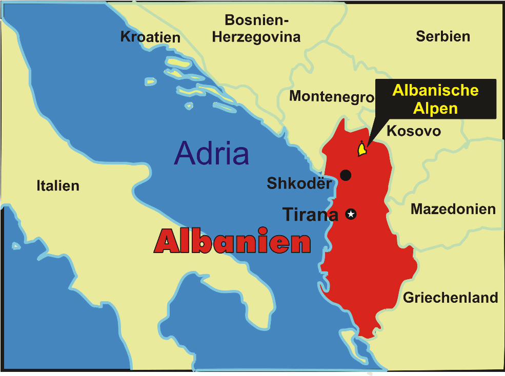
Drive from Shkodhra north in direction Podgorica, turn right in Koplik, follow the narrow road to Boga ( 1hour from Shkodrha) where the paved road ends. From here take the dirty road, which is in a bad state for another 30 kilometres. this road is best to do with 4x4 although locals also use their common cars. The pass is often blocked by snow, it can usually be passed from june through octobre. Inquire in Shkodrha about actual conditions bevor you leave.
There is a detailed map of the area, called “Wanderkarte Nordalbanien - Albanische Alpen - Thethi und Kelmend - Albanien 1: 50 000” to buy via Amazon.
Mountain and first ascent
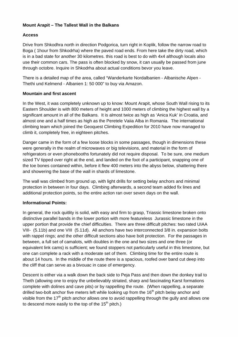
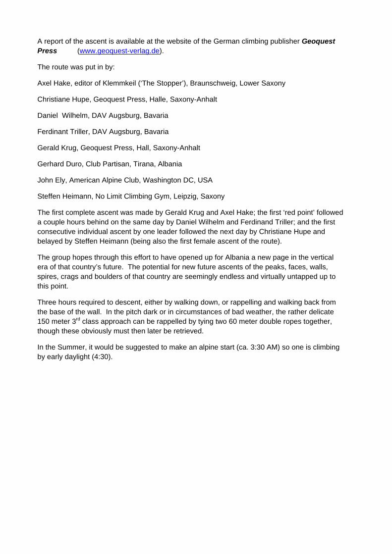
In the West, it was completely unknown up to know: Mount Arapit, whose South Wall rising to its Eastern Shoulder is with 800 meters of height and 1000 meters of climbing the highest wall by a significant amount in all of the Balkans. It is almost twice as high as ‘Anica Kuk’ in Croatia, and almost one and a half times as high as the Peretele Vaiia Alba in Romania. The international climbing team which joined the Geoquest Climbing Expedition for 2010 have now managed to climb it, completely free, in eighteen pitches.
Danger came in the form of a few loose blocks in some passages, though in dimensions these were generally in the realm of microwaves or big televisions, and material in the form of refrigerators or even phonebooths fortunately did not require disposal. To be sure, one medium sized TV tipped over right at the end, and landed on the foot of a participant, snapping one of the toe bones contained within, before it flew 400 meters into the abyss below, shattering there and showering the base of the wall in shards of limestone.
The wall was climbed from ground up, with light drills for setting belay anchors and minimal protection in between in four days. Climbing afterwards, a second team added fix lines and additional protection points, so the entire action ran over seven days on the wall.
Informational Points:
In general, the rock quitlity is solid, with easy and firm to grasp, Triassic limestone broken onto distinctive parallel bands in the lower portion with more featureless Jurassic limestone in the upper portion that provide the chief difficulties. There are three difficult pitches: two rated UIAA VIII- (5.11b) and one VIII (5.11d). All anchors have two interconnected 3/8 in. expansion bolts with rappel rings; and the other difficult sections also have bolt protection. For the passages in between, a full set of camalots, with doubles in the one and two sizes and one three (or equivalent link cams) is sufficient; we found stoppers not particularly useful in this limestone, but one can complete a rack with a moderate set of them. Climbing time for the entire route is about 14 hours. In the middle of the route there is a spacious, roofed over band cut deep into the cliff that can serve as a bivouac in case of emergency.
Descent is either via a walk down the back side to Peja Pass and then down the donkey trail to Theth (allowing one to enjoy the unbelievably striated, sharp and fascinating Karst formations complete with dolines and cave pits) or by rappelling the route. (When rappelling, a separate drilled two-bolt anchor five meters left while looking up from the 16th pitch belay anchor and visible from the 17th pitch anchor allows one to avoid rappelling through the gully and allows one to descend more easily to the top of the 15th pitch.)
A report of the ascent is available at the website of the German climbing publisher Geoquest Press (www.geoquest-verlag.de).
The route was put in by:
Axel Hake, editor of Klemmkeil (‘The Stopper’), Braunschweig, Lower Saxony
Christiane Hupe, Geoquest Press, Halle, Saxony-Anhalt
Daniel Wilhelm, DAV Augsburg, Bavaria
Ferdinant Triller, DAV Augsburg, Bavaria
Gerald Krug, Geoquest Press, Hall, Saxony-Anhalt
Gerhard Duro, Club Partisan, Tirana, Albania
John Ely, American Alpine Club, Washington DC, USA
Steffen Heimann, No Limit Climbing Gym, Leipzig, Saxony
The first complete ascent was made by Gerald Krug and Axel Hake; the first ‘red point’ followed a couple hours behind on the same day by Daniel Wilhelm and Ferdinand Triller; and the first consecutive individual ascent by one leader followed the next day by Christiane Hupe and belayed by Steffen Heimann (being also the first female ascent of the route).
The group hopes through this effort to have opened up for Albania a new page in the vertical era of that country’s future. The potential for new future ascents of the peaks, faces, walls, spires, crags and boulders of that country are seemingly endless and virtually untapped up to this point.
Three hours required to descent, either by walking down, or rappelling and walking back from the base of the wall. In the pitch dark or in circumstances of bad weather, the rather delicate 150 meter 3rd class approach can be rappelled by tying two 60 meter double ropes together, though these obviously must then later be retrieved.
In the Summer, it would be suggested to make an alpine start (ca. 3:30 AM) so one is climbing by early daylight (4:30).


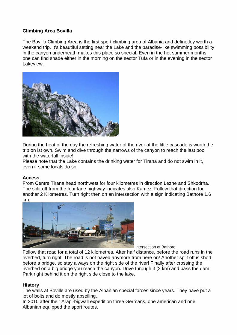
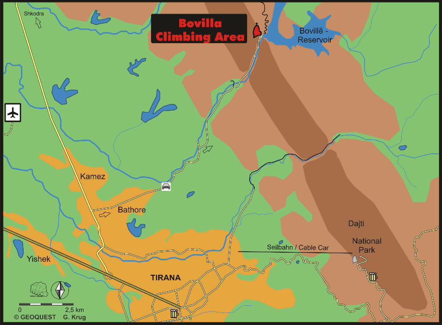
Climbing Area Bovilla The Bovilla Climbing Area is the first sport climbing area of Albania and definetley worth a weekend trip. It’s beautiful setting near the Lake and the paradise-like swimming possibility in the canyon underneath makes this place so special. Even in the hot summer months one can find shade either in the morning on the sector Tufa or in the evening in the sector Lakeview.
During the heat of the day the refreshing water of the river at the little cascade is worth the trip on ist own. Swim and dive through the narrows of the canyon to reach the last pool with the waterfall inside! Please note that the Lake contains the drinking water for Tirana and do not swim in it, even if some locals do so. Access From Centre Tirana head northwest for four kilometres in direction Lezhe and Shkodrha. The split off from the four lane highway indicates also Kamez. Follow that direction for another 2 Kilometres. Turn right then on an intersection with a sign indicating Bathore 1.6 km.
Intersection of Bathore Follow that road for a total of 12 kilometres. After half distance, before the road runs in the riverbed, turn right. The road is not paved anymore from here on! Another split off is short before a bridge, so stay always on the right side of the river! Finally after crossing the riverbed on a big bridge you reach the canyon. Drive through it (2 km) and pass the dam. Park right behind it on the right side close to the lake. History The walls at Boville are used by the Albanian special forces since years. They have put a lot of bolts and do mostly abseiling. In 2010 after their Arapi-bigwall expedition three Germans, one american and one Albanian equipped the sport routes.
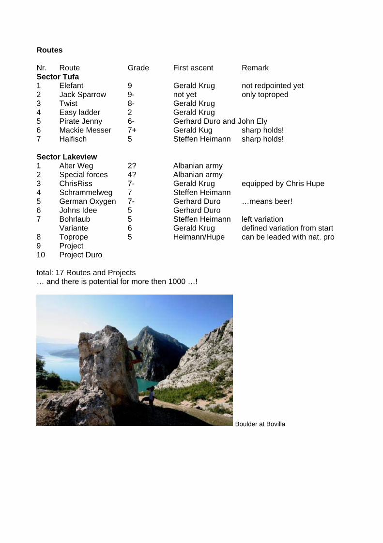
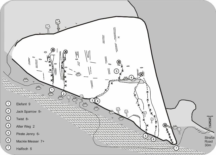
Routes Nr. Route Grade First ascent Remark Sector Tufa 1 Elefant 9 Gerald Krug not redpointed yet 2 Jack Sparrow 9- not yet only toproped 3 Twist 8- Gerald Krug 4 Easy ladder 2 Gerald Krug 5 Pirate Jenny 6- Gerhard Duro and John Ely 6 Mackie Messer 7+ Gerald Kug sharp holds! 7 Haifisch 5 Steffen Heimann sharp holds! Sector Lakeview 1 Alter Weg 2? Albanian army 2 Special forces 4? Albanian army 3 ChrisRiss 7- Gerald Krug equipped by Chris Hupe 4 Schrammelweg 7 Steffen Heimann 5 German Oxygen 7- Gerhard Duro …means beer! 6 Johns Idee 5 Gerhard Duro 7 Bohrlaub 5 Steffen Heimann left variation Variante 6 Gerald Krug defined variation from start 8 Toprope 5 Heimann/Hupe can be leaded with nat. pro 9 Project 10 Project Duro total: 17 Routes and Projects … and there is potential for more then 1000 …!
Boulder at Bovilla