nasa ames planetary mapping
TRANSCRIPT

http://irg.arc.nas.gov Intelligent Robotics Group
NASA Ames Research Center
Contact: [email protected]
NASA Ames Planetary Mapping Making NASA’s data more rapidly and universally available

Intelligent Robotics Group
NASA Ames Research Center
Source: B. A. Archinal, L. R. Gaddis, R. L. Kirk, T. M. Hare, and M. R. Rosiek. Urgent Processing and Geodetic Control of Lunar Data. Workshop on Science Associated with the Lunar Exploration Architecture, 2007.
We are in the midst of a major geospatial information explosion. For the first time, 10‘s of Terabytes of map data are being collected by robotic explorers.
Really Big Data Why do we need to build automated systems to handle large volumes of Planetary data?
Approximate data volumes from various Mars (red) and Lunar (blue) missions.
Data volumes are in Terabytes!

Intelligent Robotics Group
NASA Ames Research Center
• In the past, widely used maps such as the Viking MDIM mosaic took years to produce.
• Today, human intensive processes can be automated so that data can be processed & distributed more rapidly.
Why do we need to build automated systems to handle large volumes of Planetary data? Really Big Images

Intelligent Robotics Group
NASA Ames Research Center
• Bridging the gap between PDS and Geo-browser platforms
Enabling faster, easier, and universal access
• Developers in the Lunar Mapping and Modeling Program (LMMP)
Providing stereo-derived topography and imagery from Apollo Metric Camera scans
• LROC & HiRISE Team Members Validating and estimating the errors of ���
LROC-derived DTMs
• Assorted other projects: Vision Workbench, Ames Stereo Pipeline, Neo-
Geography Toolkit, Small body mapping
Some of our Projects Automated 3D surface reconstruction, mosaicking, gigapixel imaging
Automated Stereo Reconstruction of Jackson Crater (LROC)

Intelligent Robotics Group
NASA Ames Research Center
Our Automated Pipeline Unified architecture for processing & serving planetary data through web services
• Our geospatial data pipeline has been developed to automatically produce high-quality planetary maps and models
• It is extremely flexible & extensible, supporting many data source and open standards & protocols.
• Our software stack runs on Pleiades, the NASA Ames supercomputer

Intelligent Robotics Group
NASA Ames Research Center
Ames Stereo Pipeline Open-source automated stereogrammetry software
Models of Earth using imagery that contains an RPC Model.
Models of Earth using Digital Globe Stereo 1B imagery.
Models from traditional stereo cameras using the TSAI format.
Models of the other planets using USGS’s ISIS cube files.

Intelligent Robotics Group
NASA Ames Research Center
Ames Stereo Pipeline (ASP) Open-source automated stereogrammetry software
tiny.cc/ames-stereo-pipeline
• What it is… • Command-line tools for computing
clusters and super computers
• C++ code hosted on GitHub
• Binaries available for Linux and OS-X
• Apache 2 license
• Data processed with ASP • Apollo Metric Camera
• Digital Globe 1B products
• Lunar Reconnaissance Orbital Camera (LROC-NA)
• Mars High Resolution Imaging Science Experiment (HiRISE)
• Mars Orbiter Camera (MOC)
• MRO Context Camera (CTX)

Intelligent Robotics Group
NASA Ames Research Center
High-resolution terrain model (digital elevation map)
Apollo Zone DEM • Mosaick of 4,000 images
• Apollo Metric Camera • 73,728 x 368,640 pixels
• Equatorial Lunar Surface(38S-34N lat) • 1,024 pixel / deg • Vert. acc 40.9m (LOLA) • Vert. stdv 37.8m • Horiz. acc 91.3m (LOLA)
• Controlled to LOLA through LRO-WAC
• 40,000 CPU hours���(4 days on NASA Pleiades)

Intelligent Robotics Group
NASA Ames Research Center
Albedo Reconstruction Scalability from single core to super computer (GNU parallel)
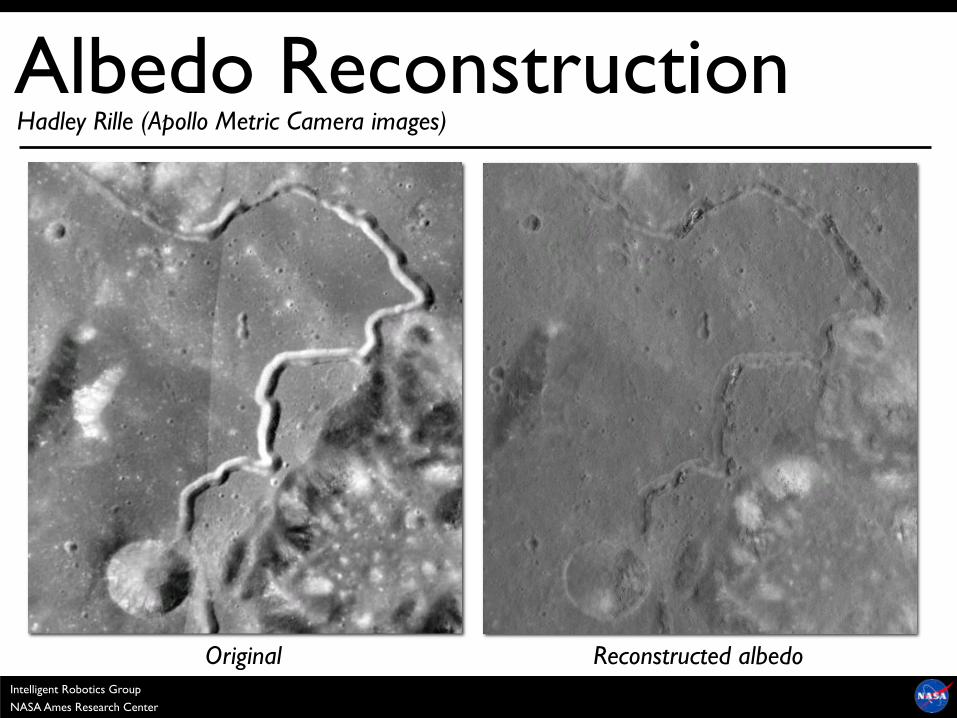
• Image formation model: ���Camera Transfer Function, Albedo, Exposure Estimation, Surface Reflectance, and Shadow
• For the Moon, uses Lunar-Lambertian Model (can be extended to non-Lunar surfaces) to reduce the effect of varying illumination
• Overlapping images allows for shadow removal
Sun position
Camera position Orbital Image, DEM
Shadow Map, Weights
Ortho-projection
Init Exposure
Init Albedo
Update Exposure
Update Albedo
Conv? Original Reconstructed albedo
Intelligent Robotics Group
NASA Ames Research Center
Albedo Reconstruction Hadley Rille (Apollo Metric Camera images)
Original Reconstructed albedo
Intelligent Robotics Group
NASA Ames Research Center
Albedo Reconstruction Hadley Rille (Apollo Metric Camera images)

Intelligent Robotics Group
NASA Ames Research Center
High-resolution base map (digital image mosaick)
Apollo Zone DIM
Albedo Maps Data Resolution Coverage
LRO-WAC 100 m/pixel 100%
LRO-NAC 1 m/pixel < 2% (early 2013)
Apollo Metric 10 m/pixel 18%

Intelligent Robotics Group
NASA Ames Research Center
Mosaicking & Blending Highly accurate reconstruction, blending, and error modeling

Intelligent Robotics Group
NASA Ames Research Center
Cryospheric mapping for Earth science (glaciology, climate change, etc) ASP for Earth
Jakobshavn Glacier, Greenland • 6 input images • 2500 km2 coverage
• 5 m/post

Intelligent Robotics Group
NASA Ames Research Center
1.15 km
100% scale (0.5 m/pixel)
Non-vegetated areas ASP for Earth

Intelligent Robotics Group
NASA Ames Research Center
60% success rate processing Digital Globe stereo pairs without human input ASP for Earth
• Colorized DEM of the Basalt Hills Quarry
• Used for planetary rover analog testing
• Based on DigitalGlobe WorldView imagery

Intelligent Robotics Group
NASA Ames Research Center
Explore the Moon and Mars in 3D
• “Google Moon” & “Google Mars” provide data availability & fusion for planetary data
• Includes “live” imagery of Mars from the THEMIS camera (appears on-line 2-4 days after downlink)
• Guided tours of the Moon and Mars narrated by Buzz Aldrin, Jack Schmitt, Ira Flatow, and Bill Nye.
NASA / Google
Geologic Maps
Geospatial Image Browsing/Indexing
Tours Narrated by Notable Scientists and Astronauts
High Resolution 3D Terrain
Geo-located Panoramic Imagery
Modern / Historical Base Maps
Try it for yourself in Google Earth 5.0!
This work was done at ARC under a reimbursible space act agreement (RSAA). The RSAA does not imply exclusive access to NASA data or to our team.

Intelligent Robotics Group
NASA Ames Research Center
• “Moon for Google Earth” • Co-developed with Google • IRG created content, processing
scripts, and base maps
• Built in to Google Earth 5.0
• Content • Global maps: topography, geologic,
historical, etc.
• Spacecraft imagery: Apollo, Clementine, Lunar Orbiter
• 3D models of spacecraft, landers, ���and crew rovers.
• Tours (Andy Chaikin, Buzz Aldrin ���and Jack Schmidt)
• And much more …
Released July 20, 2009 Google Moon

Intelligent Robotics Group
NASA Ames Research Center
• “Mars for Google Earth” • Co-developed with Google • IRG created content, processing
scripts, and base maps
• Built in to Google Earth 5.0
• Content • Global maps: topography, infrared,
historical, etc.
• Imager footprints & overlays: ���HiRISE, CTX, MOC, etc.
• MER tracks & panoramas • Tours (Bill Nye & Ira Flatow)
• Live from Mars: THEMIS images ���within hours
• And much more …
Released February 2, 2009 Google Mars

Intelligent Robotics Group
NASA Ames Research Center
Bringing the Mars experience to WorldWide Telescope
• Featuring the largest digital image mosaic of Mars ever created
• Data sets for WWT Mars were���created using the NASA Nebula cloud computer
• Guided tours of Mars narrated by Dr. Carol Stoker and Dr. Jim Garvin
NASA / Microsoft
This work was done at ARC under a reimbursible space act agreement (RSAA). The RSAA does not imply exclusive access to NASA data or to our team.
http://worldwidetelescope.org
Total # of images 74,359 13,342
Pixels / Image 16 Megapixels 1.25 Gigapixels
Total Image Tiles ~38 Million ~526 Million
Total Mosaic Size 843 Gigabytes 12 Terabytes
INPU
T
OU
TPU
T
MOC HiRISE
Intelligent Robotics Group
NASA Ames Research Center
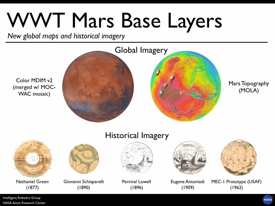
WWT Mars Base Layers
Nathaniel Green (1877)
Giovanni Schiaparelli (1890)
MEC-1 Prototype (USAF) (1962)
Eugene Antoniadi (1909)
Percival Lowell (1896)
Historical Imagery
Global Imagery
Color MDIM v2 (merged w/ MOC-
WAC mosaic)
Mars Topography (MOLA)
New global maps and historical imagery

Intelligent Robotics Group
NASA Ames Research Center
74,359 Mars Global Surveyor MOC Images
13,342 Mars Reconnaissance Orbiter HiRISE Observations
From Mars Global Surveyor and Mars Reconnaissance Orbiter
WWT High Resolution Layers
Intelligent Robotics Group
NASA Ames Research Center
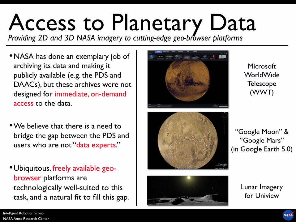
“Google Moon” & “Google Mars”
(in Google Earth 5.0)
Lunar Imagery for Uniview
• NASA has done an exemplary job of archiving its data and making it publicly available (e.g. the PDS and DAACs), but these archives were not designed for immediate, on-demand access to the data.
• We believe that there is a need to bridge the gap between the PDS and users who are not “data experts.”
• Ubiquitous, freely available geo-browser platforms are technologically well-suited to this task, and a natural fit to fill this gap.
Providing 2D and 3D NASA imagery to cutting-edge geo-browser platforms
Microsoft WorldWide Telescope (WWT)
Access to Planetary Data

Intelligent Robotics Group
NASA Ames Research Center
Live Data into Google Earth
Mission Instrument Team Provides
Spacecraft Orbit lon, lat, alt, time (CSV file)
Data Footprint lat,lon of vertices (CSV file)
Instrument data (ISIS cube, PNG, JPEG, etc.)
KML Convert data pull (periodic)
publish to Google Earth
(via public or private URL)
(using ARC Neo-Geography Toolkit)
Continuous, automatic data release