networked north
DESCRIPTION
ÂTRANSCRIPT

networked north penn avenue and west broadway avenue
erin garnaas-holmes05.14.2013LA 8205

networked north // 05.14.2013 // PAGE 2
CONTENTS:
Context
Existing Conditions
Planning Principles, Goals and Strategies
Design Process
Land Use and Circulation
Places
Interactive Features
3
4
5
6
7
8
10

2011 Median Income
North 3.5 miles
% Unemployment (2010)
14.0-19.9%
20.0-49.9%
North
% of Commuters who Average Commute Time
North
North M
emoria
l Medica
l Cente
r
Robbinsdale
Penn Ave and West
Broadway
Penn Ave and Plymouth
Downtown
Van White
BlvdGolden Valle
y Rd
Golden Valley Rd
connected north
North Minneapolis has the highest concentration of low-income residents, unemployment, and African Americans in the Twin Cities. The neighborhoods of North Minneapolis have historically been excluded from improvements to the city and cut off from amenities; there are less parks, no lakes, less access to the Mississippi River, no movie theaters, one grocery store, and few bus
lines that run through North Minneapolis.
The Metropolitan Council and Metrotransit are currently exploring options for a new Light Rail Transit line to run to the Northwest of downtown. Given three alignment options, offi cials and residents have settled on the D1 Alignment, which runs along an existing rail line just west of Near North Minneapolis.
This is a mistake. This option would continue to exclude North Minneapolis from amenities that it deserves. If the LRT instead ran up Penn Avenue and West Broadway via the D2 Alignment, it would bring transportation access and development that North Minneapolis desperately needs. This would address many of the needs the community has expressed: jobs, increased housing stock, retail amenities,
increased transit, better public spaces.
Near North is already a community of low-income, transit-dependent residents, many of whom are unemployed or working in the suburbs of Minneapolis. A local LRT station could increase mobility (and thus access to jobs) and also spur development in struggling nodes of the region.
“When a transit system allows an unemployed individual to fi nd and keep a job, this can save the Federal Government and the States signifi cant costs by reducing payments for such programs as unemployment compensation, Food Stamps, Temporary Assistance for Needy Families (TANF), and/or Medicaid. And, when an elderly rural resident who is unable to drive uses transit to obtain health services, this promotes preventive health care for rural seniors, thereby keeping down overall health care costs.”
- Dennis Brown, Public Transportation on the Move in Rural America
[People who most need public space are] people who are more time constrained and who live in neighborhoods that are densely populated and less wealthy, with fewer cars and inadequate bike and pedestrian facilities.
Ironically these kinds of communities do not normally have the muscle to get more parks through the political process.”
- Peter Harnik, Urban Green
PROPOSED LRT ALIGNMENTS
TRANSITRIDERS
COMMUTEUNEMPLOY-
networked north // 05.14.2013 // PAGE 3
Context
D1 D2D3
Average Commute Time Average Commute Time Average Commute Time Average Commute Time Average Commute Time
NorthNorth
COMMUTECOMMUTECOMMUTECOMMUTECOMMUTECOMMUTE2011 Median Income
NorthNorth 3.5 miles3.5 miles3.5 miles3.5 miles3.5 miles
% Unemployment (2010)% Unemployment (2010)% Unemployment (2010)% Unemployment (2010)
14.0-19.9%
20.0-49.9%20.0-49.9%
UNEMPLOY-UNEMPLOY-UNEMPLOY-UNEMPLOY-UNEMPLOY-UNEMPLOY-UNEMPLOY-UNEMPLOY-UNEMPLOY-UNEMPLOY-UNEMPLOY-UNEMPLOY-UNEMPLOY-UNEMPLOY-
NorthNorth
% of Commuters who % of Commuters who % of Commuters who % of Commuters who TRANSITTRANSITTRANSITTRANSITTRANSITTRANSITTRANSITTRANSITRIDERSRIDERSRIDERSRIDERSRIDERSRIDERS

vacancyExisting Conditions
transit dependent population
boarded windows local art
wide roads and vast empty lots local businesses
vacant storefronts underused back streets
PE
NN
AV
EN
UE
N
WEST BROADWAY AVEA
DemolishedRetailVacant Parking
Church
12’ 12’ 12’ 12’ 12’ 12’ 90’
12’12’ 12’ 12’ 6’ 10’-2510’-25 6’
A
B
A’
B’
A’
B B’
The intersection of West Broadway Avenue and Penn Avenue North is an important transportation nexus of the neighborhood and one of the proposed station locations along the D2 Alignment.
The neighborhood is defi ned by vacant spaces. The 2011 tornado passed directly through this area, destroying several buildings. Boarded storefronts show that this stretch of West Broadway currently struggles to thrive as the commercial corridor that many neighborhood plans envision.
An LRT station, however, could bring new housing developments and increased commercial activity, both of which have been called for by neighborhood residents. The wide streets and empty lots provide ample space for the train itself and the development it would bring.
networked north // 05.14.2013 // PAGE 4

networked north // 05.14.2013 // PAGE 5
Networked North proposes a plan that equitably delivers amenities to the neighborhood surrounding West Broadway and Penn Avenue, using the LRT as a catalyst for action and development.
This plan is based on four primary planning principles that frame the goals and strategies of further development in the character and ownership of the local community.
1. Create a vibrant, thriving place at Penn and Broadway.
3. Retain local ownership over the space
4. Fit new development into community context.
2. Connect the area to surrounding communities and amenities.
planning principles goals strategies
Preserve/enhance business on corners
Promote alternative transportation modes
Infi ll vacant spaces with business, high density housing and public space
Link affordable housing Increase access to nature
Encourage public engagement
Increase pedestrian friendliness
Connect housing+retail to transit
Connect destinations nearby (especially open space)
Facilitate movement/pass-through and rest/linger/stay
Create high-performance infrastructure
Avoid displacement caused by gentrifi cation
Bring transit into public space
Prioritize local businesses during development
Pedestrian malls
Partner with local artists and organizations
Plan for mix of housing types and forms
Interactive public space/art
Parklets
Paving patterns to delineate circulation and slow traffi c
Clearly marked bicycle lanes
Ecologically productive public spaces
Color
Human-centric signal system
networked north // 05.14.2013 // PAGE 6
pedestrian street parklet
curbless street zones
dynamic patterns
public art installations
transit plaza
lrt on penn avenue
permeable platform
WEST B
RO
ADW
AY AVEPEN
N A
VE N
PEN
N A
VE N
26TH AVE26TH AVE24TH AVE
24TH AVE
QUEE
N AVE
N
QUEE
N AVE
N
23RD AVE
23RD AVE
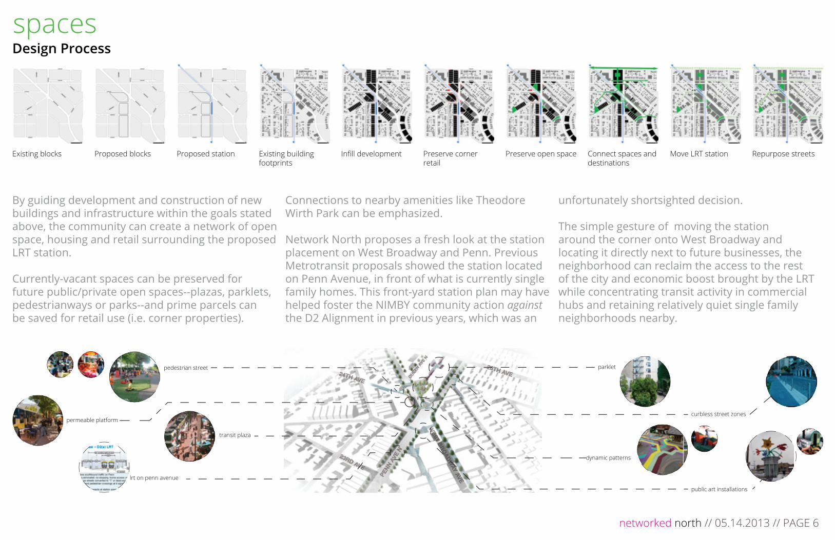
Design Process spaces
Existing blocks Proposed blocks Proposed station Infi ll development Repurpose streetsExisting building footprints
Preserve corner retail
Move LRT stationPreserve open space Connect spaces and destinations
By guiding development and construction of new buildings and infrastructure within the goals stated above, the community can create a network of open space, housing and retail surrounding the proposed LRT station.
Currently-vacant spaces can be preserved for future public/private open spaces--plazas, parklets, pedestrianways or parks--and prime parcels can be saved for retail use (i.e. corner properties).
Connections to nearby amenities like Theodore Wirth Park can be emphasized.
Network North proposes a fresh look at the station placement on West Broadway and Penn. Previous Metrotransit proposals showed the station located on Penn Avenue, in front of what is currently single family homes. This front-yard station plan may have helped foster the NIMBY community action against the D2 Alignment in previous years, which was an
unfortunately shortsighted decision.
The simple gesture of moving the station around the corner onto West Broadway and locating it directly next to future businesses, the neighborhood can reclaim the access to the rest of the city and economic boost brought by the LRT while concentrating transit activity in commercial hubs and retaining relatively quiet single family neighborhoods nearby.

LRT Right-of-way Car Right-of-way Pedestrian Right-of-way
WEST B
RO
ADW
AY AVEPEN
N A
VE N
PEN
N A
VE N
26TH AVE26TH AVE24TH AVE
24TH AVE
QUEE
N AVE
N
QUEE
N AVE
N
23RD AVE
23RD AVE LRT alignmentPedestrian circulationBicycle routeAutomobile traffi c
CIRCULATION
networked north // 05.14.2013 // PAGE 7
Land Use and On-Site Circulation
WEST B
RO
ADW
AY AVE
WEST B
RO
ADW
AY AVEPEN
N A
VE N
PEN
N A
VE N
26TH AVE26TH AVE24TH AVE
24TH AVE
QUEE
N AVE
N
QUEE
N AVE
N
23RD AVE
23RD AVE
LAND USE
Retail/Mixed UseSingle Family ResidentialHigh Density ResidentialCultural Institution
connections
The LRT station would incentivize high density housing, mixed use and infi ll development nearby. The local community can organize with developers early on to retain certain portions of aff ordable housing and match architectural styles to community character.
Spaces can be reserved for community organizations, artist and local business. Inspired by Juxtaposition Art’s proposed new facility on Broadway, new architecture can also be modern, bright, colorful and alive.
A circulation network controlled by lights and paving patterns can be established around the separated train platforms, ensuring pedestrian safety, train effi ciency and continued automobile use.

Plaza, parklet, pass-through
WEST B
RO
ADW
AY AVE
WEST B
RO
ADW
AY AVEPEN
N A
VE N
PEN
N A
VE N
26TH AVE26TH AVE
24TH AVE24TH AVE
QUEE
N AVE
N
QUEE
N AVE
N
23RD AVE
23RD AVE
A
B’
C’
A’B
C
D
E
F
F’
D’
E’
places
Infi ll development can not only bring new businesses and housing to Penn Ave North and West Broadway Ave, but also defi ne new public spaces. New buildings can frame public spaces and privately-owned public spaces, creating a navigable network of outdoor environments that are friendly to the pedestrian. Bikes and walkers can pass through tree-lined alleys between public right of ways. Transit-riders and neighbors can rest in shaded plazas that are connected to storefronts and the LRT station. The excessively wide streets of West Broadway and Penn can seem shorter if their lanes are reduced to make way for the rails, and if they are lined with activated buildings and spaces. Clearly marked pedestrian crossings and new street trees can create a seamless and comfortable experience for pedestrians walking through the area.
LRT STATION PLAZA
pedestrian streetLRT station
LRT station
Cross
ing
Plaza
Mixed Use/Retail
Mixed Use/Retail
Mixed Use/Retail
Mixed Use/Retail
Cross
ing
40’
networked north // 05.14.2013 // PAGE 8
20’15’ 15’
A A’
15’ 13’ 13’ 13’10’ 10’ 10’ 10’ 21’
C’C
20’
B’B
15’ 15’12’ 12’ 6’ 10’-25’10’-25’ 6’
F F’10’10’10’10’10’ 9’ 9’
E E’
25’24’20’16’16’ 62’ 12’3’7’
D D’
networked north // 05.14.2013 // PAGE 8

Plaza, parklet, pass-through
extended storefront
curbless crossing
stormwater runnel
embedded LEDs
pezioelectric platforms
stormwater pond
iconic community center
information hub
permeable station platforms
playspace
seating steps + stage + storage
seating element
North Minneapolis deserves iconic and activated public spaces. Networked North calls for a transit-oriented plaza that provides comfortable places to rest, shop, eat, walk, play, and watch. LRT station platforms that blend into public spaces and sidewalk storefronts increase pedestrian access and walkability. Painted pavers and temporary planters direct circulation but encourage permeability across the entire space, between stores, cafes, outdoor seating, and the rest of the city beyond the plaza.
Tree lined streets and shaded plazas provide comfort and a breath of life. Safe playspaces and interactive public art and stormwater technology activate the plaza, demonstrating to passersby and lingering users how they are connected to the broader network of the city around them.
places
networked north // 05.14.2013 // PAGE 9

Interactive Features
Inspired by forms of street art, graffi ti artists, and computer networks, the lines of colored pavers intersect transparent stormwater runnels and paths of embedded light. The runnels carry stormwater from the entire site into a treatment pond, demonstrating how the infrastructure works while giving people a place to rest. Meanwhile, as people pass over the piezoelectric platforms in the middle of the plaza, power is generated and stored. When enough people have walked, run, biked, jumped, played or danced across the surface, a button at the center of the plaza becomes active. When pressed, light fl ows from the plaza through the paths and buildings around it, illuminating the connections to the surrounding city and showing the impact that each person can have on his or her surroundings.
stormwater runnels
LED paths
illuminated network
big button
piezoelectric meter
networked north // 05.14.2013 // PAGE 10

Networked North demonstrates how Light Rail Transit along the D2 Alignment--through North Minneapolis, not around--could become a catalyst for vibrant, community-led development that creates new housing while adding value to existing properties, fosters new businesses while bringing customers to existing ventures, and builds new public space that inspires imagination while providing the simple park amenities like tree-shaded seating. North is home to brilliant artists, business entrepreneurs and concerned families that have much to off er the region: these communities deserve equitable access to the rest of the city, and they deserve thriving, colorful and fun public spaces.
networked north // 05.14.2013 // PAGE 11