newsletter-nr. 8 of 2015 – annum...
TRANSCRIPT
1
GeologicalSocietyofAfrica www.geologicalsocietyofafrica.org
NEWSLETTER-Nr. 8 of 2015 – Annum 51
Contents
GSAf MATTERS 2
26th Colloquium of African Geology – 23-27.November.2016 2
GSAf – GSA Memorandum of Understanding 3
Report on a meeting of GIRAF coordinators and the President of GSAf in Graz, Austria 3
NEWS 4
About Africa 4
About the World 13
About Space/Astronomy 20
HUMOR 23
GEOETHICS 24
LITERATURE 26
Africa 26
Links to Journals, Reviews & Newsletters 29
INTERESTING SITES / SOFTWARE 32
EVENTS 33
In Africa and about Africa 33
Rest of the World 34
PROFESSIONAL COURSES/WORKSHOPS/SCHOLARSHIPS 37
INTERESTING PICTURES 38
Edited by
Lopo Vasconcelos Editor of the GSAf Newsletter [email protected]
1Newsletter of the Geological Society of Africa (GSAf) - Nr. 8; August, 2015 –Annum 5.
2
GSAf MATTERS
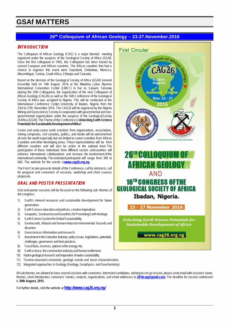
26th Colloquium of African Geology – 23-27.November.2016
INTRODUCTION The Colloquium of African Geology (CAG) is a major biennial meeting organized under the auspices of the Geological Society of Africa (GSAf). Since the first colloquium in 1965, this Colloquium has been hosted by several European and African countries. The African countries that had a chance to organize this event were Swaziland, Zimbabwe, Morocco, Mozambique, Tunisia, South Africa, Ethiopia and Tanzania.
Based on the decision of the Geological Society of Africa (GSAf) General Assembly held on 14th August, 2014 at the Mwalimu Julius Nyerere International Convention Centre (JNICC) in Dar es Salaam, Tanzania (during the 25th Colloquium), the organization of the next Colloquium of African Geology (CAG26) as well as the 16th Conference of the Geological Society of Africa was assigned to Nigeria. This will be conducted at the International Conference Center, University of Ibadan, Nigeria from the 23rd to 27th November 2016. The CAG26 will be organized by the Nigeria Mining and Geosciences Society in cooperation with governmental and non-governmental organizations under the auspices of the Geological Society of Africa (GSAf). The Theme of the Conference is Unlocking Earth Science Potentials for Sustainable Development of Africa”.
Senior and early-career earth scientists from organizations, associations, mining companies, civil societies, politics, and media will be welcome from all over the world especially but not limited to career scientists from African Countries and other developing areas. These representatives will be from different countries and will also be active at the national level. The participation of these individuals from different sectors and countries will enhance international collaborations and increase the involvement of the international community. The estimated participants will range from 300 to 600. The website for the events is www.cag26.org.ng.
The First Circular presents details of the Conference, call for abstracts, call for proposal and conveners of sessions, workshop and short courses proposals.
ORAL AND POSTER PRESENTATION Oral and poster sessions will be focused on the following sub- themes of the congress:
1) Earth’s mineral resources and sustainable development for future generation.
2) Earth Science education and policies, creative imperatives 3) Geoparks, Geotoursim and Geoethics for Promoting Earth Heritage 4) Earth Science System for Global Sustainability 5) Geohazards, Natural and human-induced environmental hazards and
disasters 6) Geosciences information and research 7) Investment in the Extractive Industry: policy issues, legislations, potentials,
challenges, governance and best practices. 8) Fossil fuels, reserves, options in the energy mix. 9) Earth science, the construction industry and human settlement.
10) Hydro-geological research and imperative of water sustainability 11) Tectono-structural constraints, geologic events and basin characterization. 12) Integrated approaches in Geology (Geology, Geophysics and Geochemistry) All sub-themes are allowed to have several sessions with conveners. Interested candidates, wishing to set up session, please send email with session's name, themes, short introduction, conveners’ names, contacts, organizations, and email addresses to [email protected]. The deadline for session submission is 30th August, 2015.
For further details, visit the website at http://www.cag26.org.ng/
3
GSAf – GSA Memorandum of Understanding
“The Geological Society of Africa (GSAf) and the Geological Society of America (GSA) have signed a Memorandum of Agreement in August 2015, to hold a joint scientific conference in Addis Ababa Ethiopia in March 2017. Details will be announced at a later date.”
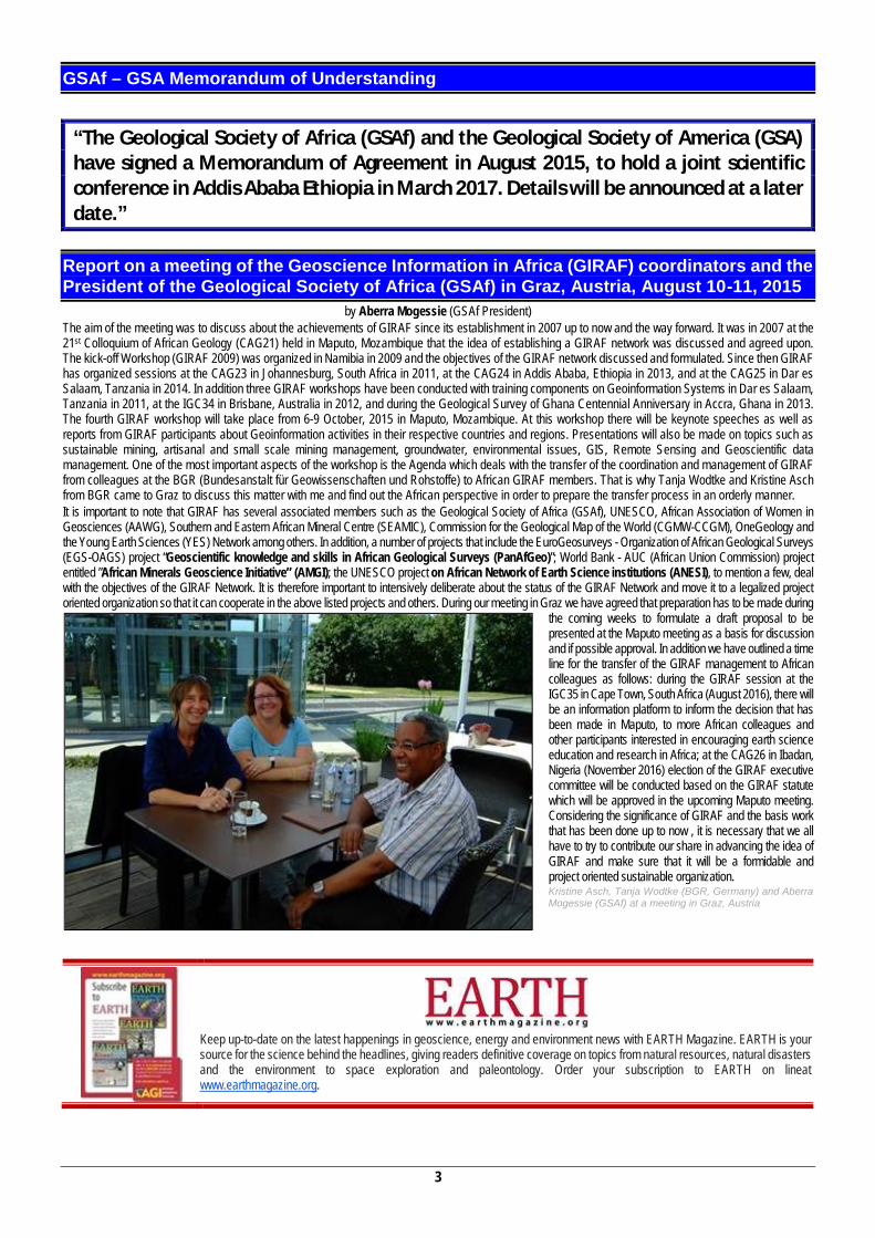
Report on a meeting of the Geoscience Information in Africa (GIRAF) coordinators and the President of the Geological Society of Africa (GSAf) in Graz, Austria, August 10-11, 2015
by Aberra Mogessie (GSAf President) The aim of the meeting was to discuss about the achievements of GIRAF since its establishment in 2007 up to now and the way forward. It was in 2007 at the 21st Colloquium of African Geology (CAG21) held in Maputo, Mozambique that the idea of establishing a GIRAF network was discussed and agreed upon. The kick-off Workshop (GIRAF 2009) was organized in Namibia in 2009 and the objectives of the GIRAF network discussed and formulated. Since then GIRAF has organized sessions at the CAG23 in Johannesburg, South Africa in 2011, at the CAG24 in Addis Ababa, Ethiopia in 2013, and at the CAG25 in Dar es Salaam, Tanzania in 2014. In addition three GIRAF workshops have been conducted with training components on Geoinformation Systems in Dar es Salaam, Tanzania in 2011, at the IGC34 in Brisbane, Australia in 2012, and during the Geological Survey of Ghana Centennial Anniversary in Accra, Ghana in 2013. The fourth GIRAF workshop will take place from 6-9 October, 2015 in Maputo, Mozambique. At this workshop there will be keynote speeches as well as reports from GIRAF participants about Geoinformation activities in their respective countries and regions. Presentations will also be made on topics such as sustainable mining, artisanal and small scale mining management, groundwater, environmental issues, GIS, Remote Sensing and Geoscientific data management. One of the most important aspects of the workshop is the Agenda which deals with the transfer of the coordination and management of GIRAF from colleagues at the BGR (Bundesanstalt für Geowissenschaften und Rohstoffe) to African GIRAF members. That is why Tanja Wodtke and Kristine Asch from BGR came to Graz to discuss this matter with me and find out the African perspective in order to prepare the transfer process in an orderly manner. It is important to note that GIRAF has several associated members such as the Geological Society of Africa (GSAf), UNESCO, African Association of Women in Geosciences (AAWG), Southern and Eastern African Mineral Centre (SEAMIC), Commission for the Geological Map of the World (CGMW-CCGM), OneGeology and the Young Earth Sciences (YES) Network among others. In addition, a number of projects that include the EuroGeosurveys - Organization of African Geological Surveys (EGS-OAGS) project “Geoscientific knowledge and skills in African Geological Surveys (PanAfGeo)”; World Bank - AUC (African Union Commission) project entitled ”African Minerals Geoscience Initiative” (AMGI); the UNESCO project on African Network of Earth Science institutions (ANESI), to mention a few, deal with the objectives of the GIRAF Network. It is therefore important to intensively deliberate about the status of the GIRAF Network and move it to a legalized project oriented organization so that it can cooperate in the above listed projects and others. During our meeting in Graz we have agreed that preparation has to be made during
the coming weeks to formulate a draft proposal to be presented at the Maputo meeting as a basis for discussion and if possible approval. In addition we have outlined a time line for the transfer of the GIRAF management to African colleagues as follows: during the GIRAF session at the IGC35 in Cape Town, South Africa (August 2016), there will be an information platform to inform the decision that has been made in Maputo, to more African colleagues and other participants interested in encouraging earth science education and research in Africa; at the CAG26 in Ibadan, Nigeria (November 2016) election of the GIRAF executive committee will be conducted based on the GIRAF statute which will be approved in the upcoming Maputo meeting. Considering the significance of GIRAF and the basis work that has been done up to now , it is necessary that we all have to try to contribute our share in advancing the idea of GIRAF and make sure that it will be a formidable and project oriented sustainable organization. Kristine Asch, Tanja Wodtke (BGR, Germany) and Aberra Mogessie (GSAf) at a meeting in Graz, Austria
Keep up-to-date on the latest happenings in geoscience, energy and environment news with EARTH Magazine. EARTH is your source for the science behind the headlines, giving readers definitive coverage on topics from natural resources, natural disasters and the environment to space exploration and paleontology. Order your subscription to EARTH on lineat www.earthmagazine.org.
4
NEWS
About Africa
African Leaders Endorse a Science Funding Platform for Africa: the Alliance for Accelerating Excellence in Science in Africa (AESA) For immediate release Nairobi/Addis Ababa/London/Seattle/Johannesburg, March 9, 2015: In a key development for scientific and health research in Africa, the African Union (AU) Heads of State and Government Summit in Addis Ababa, Ethiopia, endorsed the establishment of the Alliance for Accelerating Excellence in Science in Africa (AESA) - a platform created by the African Academy of Sciences (AAS) and the NEPAD Agency. This pan-African platform offers an opportunity for the long-term development of research leadership, scientific excellence and innovation that impact on Africa’s developmental challenges. The AESA platform will, among other things, identify challenges that hinder rapid scientific advancement in Africa, run open calls for proposals with transparent review processes, actively manage grants and evaluate and measure the impact of such investments. AESA will promote the collaborative and coordinated implementation of the Africa Union’s (AU) Science, Technology and Innovation Strategy for Africa (STISA 2024) in the area of health. H.E. Dr. Martial De-Paul Ikounga, Commissioner of Human Resources, Science and Technology (HRST) at the AU said: “We developed STISA as a multi-purpose policy advocacy strategy for mainstreaming innovation in the priority areas of the African Union of which health and wellbeing are part. Mobilization of domestic excellence and financial resources and leveraging external support are vital for the successful implementation of STISA 2024”. H.E. Dr. Ibrahim Assane Mayaki, CEO of NEPAD Agency remarked that the NEPAD Agency is committed to work with African institutions in applying science, technology and innovation in addressing Africa’s challenges in health and is therefore pleased to draw upon the capacity that resides at the African Academy of Sciences to establish AESA. African leaders at the 24th Summit meeting from 30-31 January 2015 also called upon Member States, regional and global partners as well as private foundations to support the Alliance in order to strengthen health research and innovation in Africa. AESA has already received the recognition and financial support of three developmental partners, the Bill and Melinda Gates Foundation, the Wellcome Trust and UK’s Department for International Development (DfID). In a response to this call by the Summit these three partners issued a statement saying: ‘We welcome the African Union’s recent call to establish the Alliance for Accelerating Excellence in Science in Africa (AESA), to be led by the African Academy of Sciences (AAS) in collaboration with the NEPAD Agency. The announcement marks a major step toward advancing global health and development across the continent. We are funding the development of AESA and share the vision of supporting the next generation of outstanding African researchers, who will help solve some of the continent’s greatest health and development challenges. When announcing AESA at a recent meeting of twenty African Academies, the AAS President Prof. Aderemi Kuku referred to this development by saying ‘this marks a new dawn for science development on the continent’. A formal launch of AESA is planned on the side-lines of the next AU summit in June 2015 in South Africa. About the African Union (AU) The African Union (AU) is a Union of 54 African states which aims to accelerate the process of integration in the continent to enable it play its rightful role in the global economy while addressing multifaceted social, economic and political challenges. The highest leadership of the AU is the
Assembly of Heads of States and Government. The secretariat of the AU is the African Union Commission (AUC), based in Ethiopia. About the African Academy of Sciences (AAS) AAS is a pan African organization. An Academy of all Sciences that honors the best African and non-African scientific leaders and is implementing programs in 6 key STI areas. It has been recognizing African and Africa experts by recruiting them into the AAS Fellowship since 1985. These Fellows, who are proven STI leaders live and work in all corners of the continent. AAS has a strategic partnership with the AU, and its technical bodies such as NEPAD and the PAU. AAS enjoys the support of several governments (particularly Kenya and Nigeria), major international funding partners and is regarded as s “Strategic Partner” by the African Union Commission and NEPAD Agency. About NEPAD Agency NEPAD Agency is the technical body of the African Union. The core mandate of the NEPAD Agency is to facilitate and coordinate the implementation of regional and continental priority programmes and projects and to push for partnerships, resource mobilisation and research and knowledge management. The NEPAD Agency is based in Johannesburg, South Africa. About Wellcome Trust The Wellcome Trust is a global charitable foundation dedicated to improving health. We support bright minds in science, the humanities and the social sciences, as well as education, public engagement and the application of research to medicine. Our investment portfolio gives us the independence to support such transformative work as the sequencing and understanding of the human genome, research that established front-line drugs for malaria, and Wellcome Collection, our free venue for the incurably curious that explores medicine, life and art. About DFID The Department for International Development (DFID) is leading the UK Government in fighting poverty through job creation, women and girls’ empowerment and helping save lives in humanitarian emergencies. DFID’s Research and Evidence Division (RED) objective is to make DFID more systematic in using evidence as a basis for how best to reduce global poverty, and provide high quality relevant evidence to others. It aims to achieve this through commissioning research on key questions in development, robust evaluations of UKaid’s funded programmes, high quality statistics and active engagement with policy makers. For more information on research funding offered by the Department for International Development and its programme partners please visit: https://www.gov.uk/government/organisations/department-for-internationaldevelopment/about/research About the Bill & Melinda Gates Foundation Guided by the belief that every life has equal value, the Bill & Melinda Gates Foundation works to help all people lead healthy, productive lives. In developing countries, it focuses on improving people’s health and giving them the chance to lift themselves out of hunger and extreme poverty. In the United States, it seeks to ensure that all people – especially those with the fewest resources – have access to the opportunities they need to succeed in school and life. Based in Seattle, Washington, the foundation is led by CEO Sue Desmond-Hellman and Co-Chair William H. Gates Sr., under the direction of Bill and Melinda Gates and Warren Buffett.
5
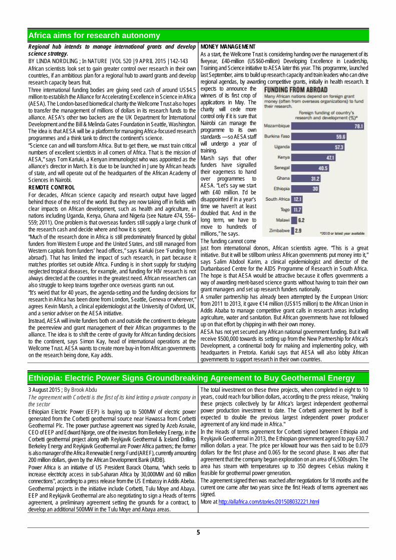
Africa aims for research autonomy Regional hub intends to manage international grants and develop science strategy. BY LINDA NORDLING ; In NATURE | VOL 520 | 9 APRIL 2015 | 142-143 African scientists look set to gain greater control over research in their own countries, if an ambitious plan for a regional hub to award grants and develop research capacity bears fruit. Three international funding bodies are giving seed cash of around US$4.5 million to establish the Alliance for Accelerating Excellence in Science in Africa (AESA). The London-based biomedical charity the Wellcome Trust also hopes to transfer the management of millions of dollars in its research funds to the alliance. AESA’s other two backers are the UK Department for International Development and the Bill & Melinda Gates Foundation in Seattle, Washington. The idea is that AESA will be a platform for managing Africa-focused research programmes and a think tank to direct the continent’s science. “Science can and will transform Africa. But to get there, we must train critical numbers of excellent scientists in all corners of Africa. That is the mission of AESA,” says Tom Kariuki, a Kenyan immunologist who was appointed as the alliance’s director in March. It is due to be launched in June by African heads of state, and will operate out of the headquarters of the African Academy of Sciences in Nairobi. REMOTE CONTROL For decades, African science capacity and research output have lagged behind those of the rest of the world. But they are now taking off in fields with clear impacts on African development, such as health and agriculture, in nations including Uganda, Kenya, Ghana and Nigeria (see Nature 474, 556–559; 2011). One problem is that overseas funders still supply a large chunk of the research cash and decide where and how it is spent. “Much of the research done in Africa is still predominately financed by global funders from Western Europe and the United States, and still managed from Western capitals from funders’ head offices,” says Kariuki (see ‘Funding from abroad’). That has limited the impact of such research, in part because it matches priorities set outside Africa. Funding is in short supply for studying neglected tropical diseases, for example, and funding for HIV research is not always directed at the countries in the greatest need. African researchers can also struggle to keep teams together once overseas grants run out. “It’s weird that for 40 years, the agenda-setting and the funding decisions for research in Africa has been done from London, Seattle, Geneva or wherever,” agrees Kevin Marsh, a clinical epidemiologist at the University of Oxford, UK, and a senior adviser on the AESA initiative. Instead, AESA will invite funders both on and outside the continent to delegate the peerreview and grant management of their African programmes to the alliance. The idea is to shift the centre of gravity for African funding decisions to the continent, says Simon Kay, head of international operations at the Wellcome Trust. AESA wants to create more buy-in from African governments on the research being done, Kay adds.
MONEY MANAGEMENT As a start, the Wellcome Trust is considering handing over the management of its fiveyear, £40-million (US$60-million) Developing Excellence in Leadership, Training and Science initiative to AESA later this year. This programme, launched last September, aims to build up research capacity and train leaders who can drive regional agendas, by awarding competitive grants, initially in health research. It expects to announce the winners of its first crop of applications in May. The charity will cede more control only if it is sure that Nairobi can manage the programme to its own standards — so AESA staff will undergo a year of training. Marsh says that other funders have signalled their eagerness to hand over programmes to AESA. “Let’s say we start with £40 million. I’d be disappointed if in a year’s time we haven’t at least doubled that. And in the long term, we have to move to hundreds of millions,” he says. The funding cannot come just from international donors, African scientists agree. “This is a great initiative. But it will be stillborn unless African governments put money into it,” says Salim Abdool Karim, a clinical epidemiologist and director of the Durbanbased Centre for the AIDS Programme of Research in South Africa. The hope is that AESA would be attractive because it offers governments a way of awarding merit-based science grants without having to train their own grant managers and set up research funders nationally. A smaller partnership has already been attempted by the European Union: from 2011 to 2013, it gave €14 million (US$15 million) to the African Union in Addis Ababa to manage competitive grant calls in research areas including agriculture, water and sanitation. But African governments have not followed up on that effort by chipping in with their own money. AESA has not yet secured any African national government funding. But it will receive $500,000 towards its setting up from the New Partnership for Africa’s Development, a continental body for making and implementing policy, with headquarters in Pretoria. Kariuki says that AESA will also lobby African governments to support research in their own countries.
Ethiopia: Electric Power Signs Groundbreaking Agreement to Buy Geothermal Energy 3 August 2015 ; By Brook Abdu The agreement with Corbetti is the first of its kind letting a private company in the sector Ethiopian Electric Power (EEP) is buying up to 500MW of electric power generated from the Corbetti geothermal source near Hawassa from Corbetti Geothermal Plc. The power purchase agreement was signed by Azeb Asnake, CEO of EEP and Edward Njorge, one of the investors from Berkeley Energy, in the Corbetti geothermal project along with Reykjavik Geothermal & Iceland Drilling. Berkeley Energy and Reykjavik Geothermal are Power Africa partners; the former is also manager of the Africa Renewable Energy Fund (AREF), currently amounting 200 million dollars, given by the African Development Bank (AfDB). Power Africa is an initiative of US President Barack Obama, "which seeks to increase electricity access in sub-Saharan Africa by 30,000MW and 60 million connections", according to a press release from the US Embassy in Addis Abeba. Geothermal projects in the initiative include Corbetti, Tulu Moye and Abaya. EEP and Reykjavik Geothermal are also negotiating to sign a Heads of terms agreement, a preliminary agreement setting the grounds for a contract, to develop an additional 500MW in the Tulu Moye and Abaya areas.
The total investment on these three projects, when completed in eight to 10 years, could reach four billion dollars, according to the press release, "making these projects collectively by far Africa's largest independent geothermal power production investment to date. The Corbetti agreement by itself is expected to double the previous largest independent power producer agreement of any kind made in Africa." In the Heads of terms agreement for Corbetti signed between Ethiopia and Reykjavik Geothermal in 2013, the Ethiopian government agreed to pay 630.7 million dollars a year. The price per kilowatt hour was then said to be 0.079 dollars for the first phase and 0.065 for the second phase. It was after that agreement that the company began exploration on an area of 6,500sqkm. The area has steam with temperatures up to 350 degrees Celsius making it feasible for geothermal power generation. The agreement signed then was reached after negotiations for 18 months and the current one came after two years since the first Heads of terms agreement was signed. More at http://allafrica.com/stories/201508032221.html
6
Obama Speaks To African Union - Full Speech
President Obama addressed the African Union in Addis Ababa, Ethiopia. He is the first U.S. president to address the 54-member continental bloc. https://www.youtube.com/watch?v=z9g5-46Lww8
Ethiopia powers up ambitions for green, climate-resilient industry 23 July, 2015 by News Desk in African Innovation, News and the News Desk post series. EXTRACT FROM THE FOLLOWING THIRD PARTY SOURCE: Written by: William Davison for The Guardian The hulking waste-to-energy power plant taking shape on the edge of Addis Ababa, Ethiopia’s capital, symbolises ambitions to convert the agrarian Horn of Africa country into an eco-friendly industrial powerhouse. The government’s US$120m (£76.8m) Reppie project, being built to EU emissions standards, will incinerate the city’s rubbish to generate 50MW of electricity. A computer-generated image on display at the site shows the future factory shrouded by a tree-filled park. In about a year, green, cutting edge Reppie will replace a vast rubbish dump picked over by hundreds of scavengers. Currently, toxic effluent from the landfill seeps into nearby rivers when it rains, and methane perpetually drifts into the atmosphere. The power plant is just one facet of Ethiopia’s four-year-old climate resilient green economy (CRGE) strategy, which aims for the nation to become middle-income by 2025, while limiting its carbon footprint to less than 2010 levels by 2030. “In doing this we ensure our development is sustainable, and another thing is we ensure we contribute positively to the global interest,” said the minister of environment and forest, Belete Tafere. Successful implementation of the plan, formally presented to the UN last month, would mean a reversal of existing trends in a nation that regularly suffers droughts and floods. Ethiopia’s deforested, intensively cultivated highlands are degraded and eroded. The capital has ageing vehicles spewing fumes and a dearth of green public spaces, while its rivers are choked with garbage. The CRGE initiative has four pillars: renewable energy, modernising agriculture, reforestation and adopting energy-efficient technology. Ethiopia’s hydropower possibilities, in the government’s eyes, resolve the inherent tension in industrialising while trying to curb emissions. Although Ethiopia produces only 2,300MW of power for 96 million people – compared with the UK’s 110,000MW for a population of 64 million – mountainous terrain and nine river basins give it the potential for 45,000MW from hydropower. Developing dams, while also investing in wind, solar and geothermal energy, should create the ability to power a manufacturing boom without burning fossil fuels. “We are absolutely going to depend on the renewable resources for our energy development,” Belete said. “Industries are going to use only energy from the grid that is renewable.” An initial plank of the CRGE is slotting into place with the imminent completion of the 1,870MW Gibe III hydropower station. Despite Ethiopia’s dire need for power, western pressure groups such as International Rivers are up in arms over the $1.8bn project. They claim it will facilitate large-scale irrigation that will have a devastating impact on up to 500,000 people by drying out Lake Turkana. The government ramped up its hydropower programme in 2011 by beginning the Grand Ethiopian Renaissance Dam on the Blue Nile. The 6,000MW capacity will make it Africa’s largest power plant.
Tapping into this clean energy, along with factories, will be public transport – including a 5,000km electrified rail network. The government has already used Chinese loans and contractors to build a track to Djibouti’s port from Addis Ababa, as well as a light rail system in the city. One obvious barrier to achieving all the CRGE goals in a growing but still poor economy is finding the required US$150 billion investment, Belete admits. A study by the UK’s Overseas Development Institute (ODI) estimated the government’s annual resources to be US$440m when US$7.5bn a year is needed. The 2014 ODI study also noted that “considerable investments” are required to ensure the local governments responsible implement the CRGE. The upside is that Ethiopia’s semi-authoritarian system is ideally set up for mobilising communities to engage in activities such as tree planting, as well as water-harvesting projects and constructing terracing to prevent soil erosion. The finance ministry has set up a CRGE facility to pool donor climate-finance funds, but the level of contributions will depend on how much victims of climate change such as Ethiopia are compensated by the industrialised nations that have caused it. Full implementation of the plan is “contingent upon an ambitious multilateral agreement being reached among parties that enables Ethiopia to get international support and that stimulates investments”, the government said of forthcoming climate change talks in its UN submission. High-level negotiations resume in Paris in December. While that process continues, Ethiopia is exploring all options, including private investment. Ken Montler and his US companies Pangea and Global Electric Transport (GET) see commercial opportunity in Ethiopia’s eco-friendly vision. Following a successful venture in the Philippines, Pangea plans to assemble electric buses in the country that will be used in a GET-managed public transport system. Montler says the Nile megadam and technological leapfrogging to electric trains and vehicles gives Ethiopia a chance of being carbon-neutral in the next decade. “You really have to be electric to hit those kind of numbers,” he said. Critical for success is the trajectory of agriculture, with livestock emissions of methane and nitrous oxide responsible for 42% of the total in 2010. However, the approach to the sector that employs 80% of Ethiopians lacks the coherence of the renewable energy plan. It hinges partly on boosting productivity by methods such as mechanisation, higher yielding seeds, irrigation, using organic fertilisers and “efficiency improvement to the livestock value chain” – strategies that aren’t a marked departure from decades-old attempts to modernise a sector dominated by subsistence farming on dwindling highland plots and pastoralism in semi-arid areas. The plan also rests on an assumption that agriculture’s importance will reduce as Ethiopia follows a well-trodden path to prosperity via industrialisation and urbanisation, Belete said. “As the country is moving for transformation, people could have an interest in depending on different livelihoods. Now they don’t have any other options.” - See more at: http://africageographic.com/blog/ethiopia-powers-ambitions-green-climate-resilient-industry/#sthash.Ars1ETPn.Oxaw7W4a.dpuf
7
Is There Really A 2 Billion-Year-Old Nuclear Reactor In Africa? July 27, 2015 | by Caroline Reid An ancient nuclear reactor that was churning away 2 billion years ago sounds like a fabricated myth. Maybe it's because the term reactor implies a manmade structure. Instead, the reactor is a region of natural uranium within the Earth's crust, found in Okla, Gabon. Uranium is naturally radioactive, and the conditions in this rocky area happened to be just right to cook up some nuclear reactions. The natural reactor must have annoyed nuclear scientists: The first nuclear reactor to produce electricity started up in 1951, and this only produced a trivial amount of energy. The pile of rock in the ground in Okla, on the other hand, had created nuclear power around 2 billion years ago! It was discovered in 1972, when some French scientists took uranium ore from the mine in Gabon to test its uranium content. Now, typically, uranium ore is made up of three types (isotopes) of uranium, each one with a different number of neutrons: Uranium 238, which is the most abundant, uranium 234, which is the rarest, and uranium 235, which nuclear scientists are most interested in because it can sustain nuclear chain reactions. One would expect to find that the uranium ore is composed of 0.720% uranium 235 since that is the percentage found in other rock samples from the Earth's crust, the Moon and even meteorites. However, these French scientists found something fishy: The uranium sample only contained 0.717% of uranium 235. What might seem to be a minor discrepancy of 0.003% is very significant with regards to uranium. That meant that, back at the mine, around 200 kilograms (around 440 pounds) of uranium 235 appeared to be missing. It hadn't been lost or stolen. Instead, this missing 0.003% had undergone nuclear fission and split into other atoms. This conclusion may very well have furrowed some brows since there are three very specific conditions that a reactor needs to churn out energy continuously. And as even scientists had struggled to create a nuclear reactor, it seemed unlikely that nature just happened to create one purely by accident. Unlikely, but not impossible, because that is exactly what happened.
The conditions that the natural reactor happened to fulfill are as follows. The first was owning a good percentage of Uranium 235 to fuel the reaction. While 0.720% might seem small, it's perfect for nuclear fission, and when the ore samples from Okla are compared to other samples from all over the world, it is likely that this was the percentage over 2 billion years ago when the reactor started. The second condition is a source of neutrons. Uranium 235 decays naturally into thorium and releases a neutron in the process. This neutron can then whoosh towards another Uranium 235 atom and start the fission process. Nuclear fission is when an atom breaks apart into smaller atoms, usually releasing energy in the process. This neutron fuses with a Uranium 235, and together they combine to form Uranium 236, which is unstable. The Uranium 236 is then overwhelmed with instability and splits, creating a variety of smaller, stable atoms and some neutrons. These neutrons can then happily shoot towards other atoms and continue the chain reaction. The nuclear reactor had a supply of a regulating substance as well: a flow of natural groundwater. As the atoms started to split, they released neutrons as well as energy. The water would slow down the neutrons, but the energy would heat up the water. After a time, the water would get so hot that it would start to boil off. Eventually, enough of the water would have boiled away until there wasn't enough left in the reactor to slow down the neutrons. The neutrons started shooting off into the ground without reacting with anything, and the reaction would stop. Then, the natural flow of groundwater would trickle in until there was enough water to start the whole process again. This watery cycle probably continued for hundreds of thousands of years. Sadly, all good days are numbered, even for a happy natural reactor: The levels of uranium 235 got used up and the level was too low to sustain any more meaningful reactions. The reactor eventually slowed to a stop, leaving only a few traces behind that it ever existed – including the enigma of the "missing uranium." At http://www.iflscience.com/environment/there-really-ancient-nuclear-reactor-africa
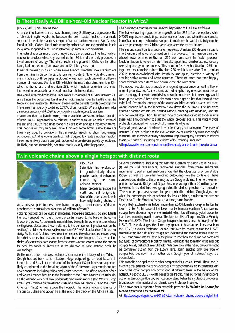
Twin volcanic chains above a single hotspot with distinct roots
015.07.28 Scientists find explanation for geochemically distinct parallel tracks of volcanoes formed by the same volcanic hotspot Many processes inside the earth are still enigmatic. One of the open questions is how neighboring chains of
volcanoes, supplied by the same volcanic hotspot, can emit material of distinct geochemical composition over tens of millions of years? Volcanic hotspots can be found in all oceans. "Pipe-like structures, so-called 'Mantle Plumes', transport hot material from the earth's interior to the base of the earth's lithospheric plates. As the mantle material rises beneath the plate, pressure release melting takes places and these melts rise to the surface forming volcanoes on the seafloor," explains Professor Kaj Hoernle from GEOMAR, lead author of the current study. As the earth's plates move over the hotspots, the volcanoes are moved away from their sources but new volcanoes form above the hotspots. "As a result long chains of extinct volcanoes extend from the active volcano located above the hotspot for over thousands of kilometers in the direction of plate motion," adds the volcanologist. Unlike most other hotspots, scientists can trace the history of the Tristan-Gough hotspot back to its initiation. Huge outpourings of flood basalts in Etendeka and Brazil at the initiation of the hotspot 132 million years ago most likely contributed to the breaking apart of the Gondwana supercontinent into new continents including Africa and South America. The rifting apart of Africa and South America has led to the formation of the South Atlantic Ocean basin. As the Atlantic widened, two underwater mountain ranges (the Walvis Ridge and Guyot Province on the African Plate and the Rio Grande Rise on the South American Plate) formed above the hotspot. The active volcanic islands of Tristan da Cuhna and Gough lie at the end of the track on the African Plate.
Several expeditions, including two with the German research vessel SONNE (I) led by Kiel researchers, recovered samples from these submarine mountains. Geochemical analyzes show that the oldest parts of the Walvis Ridge, as well as the intial volcanic outpourings on the continents, have compositions similar to the presently active Gough volcano. The northwestern part of the Walvis Ridge and Guyot Province younger than 70 million years, however, is divided into two geographically distinct geochemical domains: "The southern part also shows the geochemically enriched Gough signature, while the northern part is geochemically less enriched, similar to the present Tristan da Cunha Volcano," says co-author Joana Rohde. A very likely explanation is hidden more than 2,500 kilometers deep in the Earth's lower mantle. At the base of the lower mantle beneath southern Africa, seismic surveys have shown a huge lens of material, which has different physical properties than the surrounding mantle material. This lens is called a "Large Low Shear Velocity Province" (LLSVP). The Tristan-Gough hotspot is located above the margin of this LLSVP. "In its early stages, the plume only appears to have sucked in material from the LLSVP," explains Professor Hoernle, "but over the course of time the LLSVP material at the NW side of the margin was exhausted and material from outside the LLSVP was drawn into the base of the plume." Since then, the plume has contained two types of compositionally distinct mantle, leading to the formation of parallel but compositionally distinct plume subtracks. "At some point in the future, the plume might be completely cut off from the LLSVP lens, again erupting only one type of composition, but now Tristan rather than Gough type of material." says the volcanologist. This model is also applicable to other hotspot tracks such as Hawaii. There, too, is evidence that parallel chains of volcanoes emit geochemically distinct material with one or the other composition dominating at different times in the history of the hotspot. A second LLSVP exists beneath the Pacific. "Thanks to the investigations at the Tristan-Gough-Hotspot, we now understand better the mysterious processes taking place in the interior of our planet," says Professor Hoernle. The above post is reprinted from materials provided by Helmholtz Centre for Ocean Research Kiel (GEOMAR). At http://www.geologyin.com/2015/07/twin-volcanic-chains-above-single.html
8
Gemfields Mozambique mine to yield rubies for over 20 years (2015-07-23) Precious stones miner Gemfields announced Tuesday that an independent report has confirmed its majority-owned Montepuez ruby mine in Mozambique has enough reserves to last at least 20 years. According to the report, which includes a maiden JORC mineral resource estimate and
ore reserve, the mines indicated and inferred mineral resource stand at 467 million carats of ruby and corundum at a grade of 62.3 carats per tonne of ore. It also estimates probable ore reserves of 432 million carats at a diluted grade of 15.7 carats per tonne over 21 years. Until recently, Gemfields was synonymous with emeralds. But the world's biggest producer of the green gemstone is trying now to highlight its newly-
acquired ruby mines in Mozambique. Until recently, Gemfields was synonymous with emeralds. But the world's biggest producer of the green gemstone is trying now to highlight its newly-acquired ruby mines in Mozambique, from which a cache of exceptional-quality rubies have made their way onto jewels by the likes of Fabergé, Georg Jensen and Miiori – modelled by brand ambassador actress Mila Kunis. The company said it expects trading in gemstones to account for a "sizeable chunk" of its revenue over the next five to 10 years. Gemfields plans to increase Montepuez's capacity to 5.6 million tonnes from 3.3 million tonnes and expects about $65 million in capital spending over the next two years and $305 million over its whole life. The Mozambique asset is forecast to generate a value of nearly $1billion and over 42.7 billion in cash. Source: www.mining.com At http://www.clubofmozambique.com/solutions1/sectionnews.php?secao=mining&id=2147490567&tipo=one
First measurements taken of South Africa's Iron Age magnetic field history
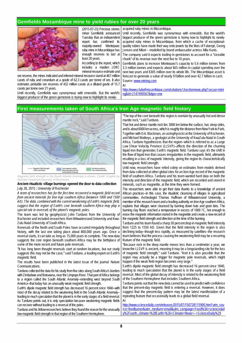
Magnetic field strength in the South Atlantic Anomaly is shown. Credit: Graphic by Michael Osadciw/University of Rochester. Ancient ritualistic village burnings opened the door to data collection July 28, 2015 ; University of Rochester A team of researchers has for the first time recovered a magnetic field record from ancient minerals for Iron Age southern Africa (between 1000 and 1500 AD). The data, combined with the current weakening of Earth's magnetic field, suggest that the region of Earth's core beneath southern Africa may play a special role in reversals of the planet's magnetic poles. The team was led by geophysicist John Tarduno from the University of Rochester and included researchers from Witwatersrand University and Kwa-Zulu Natal University of South Africa. Reversals of the North and South Poles have occurred irregularly throughout history, with the last one taking place about 800,000 years ago. Once a reversal starts, it can take as long as 15,000 years to complete. The new data suggests the core region beneath southern Africa may be the birthplace of some of the more recent and future pole reversals. "It has long been thought reversals start at random locations, but our study suggests this may not be the case," said Tarduno, a leading expert on Earth's magnetic field. The results have been published in the latest issue of the journal Nature Communications. Tarduno collected the data for his study from five sites along South Africa's borders with Zimbabwe and Botswana, near the Limpopo River. That part of Africa belongs to a region called the South Atlantic Anomaly--extending west beyond South America--that today has an unusually weak magnetic field strength. Earth's dipole magnetic field strength has decreased 16 percent since 1840--with most of the decay related to the weakening field in the South Atlantic Anomaly--leading to much speculation that the planet is in the early stages of a field reversal. As Tarduno points out, it is only speculation because weakening magnetic fields can recover without leading to a reversal of the poles. Tarduno and his fellow-researchers believe they found the reason for the unusually low magnetic field strength in that region of the Southern Hemisphere.
"The top of the core beneath this region is overlain by unusually hot and dense mantle rock," said Tarduno. That hot and dense mantle rock lies 3000 km below the surface, has steep sides, and is about 6000 km across, which is roughly the distance from New York to Paris. Together with Eric Blackman, an astrophysicist at the University of Rochester, and Michael Watkeys, a geologist at the University of KwaZulu-Natal in South Africa, Tarduno hypothesizes that the region--which is referred to as a Large Low Shear Velocity Province (LLSVP)--affects the direction of the churning liquid iron that generates Earth's magnetic field. Tarduno says it's the shift in the flow of liquid iron that causes irregularities in the magnetic field, ultimately resulting in a loss of magnetic intensity, giving the region its characteristically low magnetic field strength. Until now, researchers have relied solely on estimates from models derived from data collected at other global sites for an Iron Age record of the magnetic field of southern Africa. Tarduno and his team wanted hard data on both the intensity and direction of the magnetic field, which are recorded and stored in minerals, such as magnetite, at the time they were formed. The researchers were able to get their data thanks to a knowledge of ancient African practices--in this case, the ritualistic cleansing of villages in agricultural communities. Archeologist Thomas Huffman of Witwatersrand University, a member of the research team and a leading authority on Iron Age southern Africa, explains that villages were cleansed by burning down huts and grain bins. The burning clay floors reached a temperature in excess of 1000 ?C, hot enough to erase the magnetic information stored in the magnetite and create a new record of the magnetic field strength and direction at the time of the burning. Tarduno and his team found a sharp 30 percent drop in magnetic field intensity from 1225 to 1550 AD. Given that the field intensity in the region is also declining today--though less rapidly, as measured by satellites--the research team believes that the process causing the weakening field may be a recurring feature of the magnetic field. "Because rock in the deep mantle moves less than a centimeter a year, we know the LLSVP is ancient, meaning it may be a longstanding site for the loss of magnetic field strength," said Tarduno. "And it is also possible that the region may actually be a trigger for magnetic pole reversals, which might happen if the weak field region becomes very large." Earth's dipole magnetic field strength has decreased 16 percent since 1840, leading to much speculation that the planet is in the early stages of a field reversal. Most of the global decay of intensity is related to the weakening field of the Southern Hemisphere that includes Southern Africa. Tarduno points out that the new data cannot be used to predict with confidence that the present-day magnetic field is entering a reversal. However, it does suggest that the present-day pattern may be the latest manifestation of a repeating feature that occasionally leads to a global field reversal. At http://www.sciencedaily.com/releases/2015/07/150728115900.htm?utm_source=feedburner&utm_medium=email&utm_campaign=Feed%3A+sciencedaily%2Fearth_climate+%28Earth+%26+Climate+News+--+ScienceDaily%29
9
In Africa, More Smoke Leads to Less Rain, NASA Shows
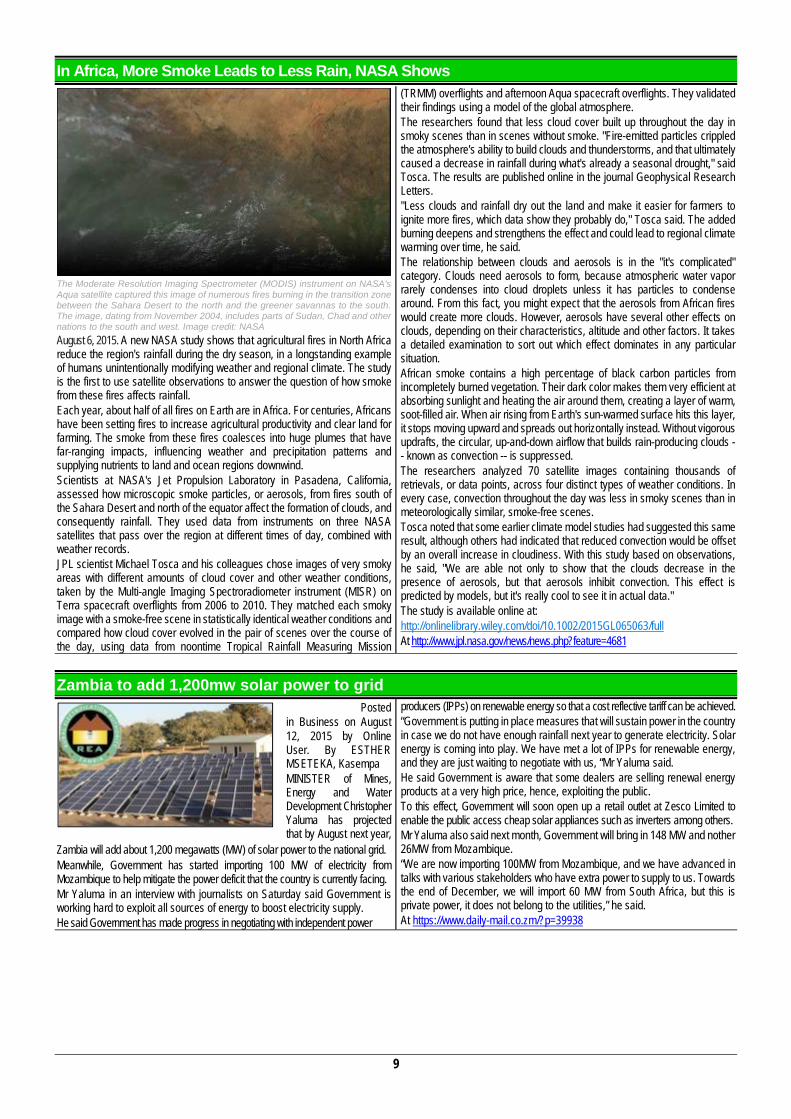
The Moderate Resolution Imaging Spectrometer (MODIS) instrument on NASA's Aqua satellite captured this image of numerous fires burning in the transition zone between the Sahara Desert to the north and the greener savannas to the south. The image, dating from November 2004, includes parts of Sudan, Chad and other nations to the south and west. Image credit: NASA August 6, 2015. A new NASA study shows that agricultural fires in North Africa reduce the region's rainfall during the dry season, in a longstanding example of humans unintentionally modifying weather and regional climate. The study is the first to use satellite observations to answer the question of how smoke from these fires affects rainfall. Each year, about half of all fires on Earth are in Africa. For centuries, Africans have been setting fires to increase agricultural productivity and clear land for farming. The smoke from these fires coalesces into huge plumes that have far-ranging impacts, influencing weather and precipitation patterns and supplying nutrients to land and ocean regions downwind. Scientists at NASA's Jet Propulsion Laboratory in Pasadena, California, assessed how microscopic smoke particles, or aerosols, from fires south of the Sahara Desert and north of the equator affect the formation of clouds, and consequently rainfall. They used data from instruments on three NASA satellites that pass over the region at different times of day, combined with weather records. JPL scientist Michael Tosca and his colleagues chose images of very smoky areas with different amounts of cloud cover and other weather conditions, taken by the Multi-angle Imaging Spectroradiometer instrument (MISR) on Terra spacecraft overflights from 2006 to 2010. They matched each smoky image with a smoke-free scene in statistically identical weather conditions and compared how cloud cover evolved in the pair of scenes over the course of the day, using data from noontime Tropical Rainfall Measuring Mission
(TRMM) overflights and afternoon Aqua spacecraft overflights. They validated their findings using a model of the global atmosphere. The researchers found that less cloud cover built up throughout the day in smoky scenes than in scenes without smoke. "Fire-emitted particles crippled the atmosphere's ability to build clouds and thunderstorms, and that ultimately caused a decrease in rainfall during what's already a seasonal drought," said Tosca. The results are published online in the journal Geophysical Research Letters. "Less clouds and rainfall dry out the land and make it easier for farmers to ignite more fires, which data show they probably do," Tosca said. The added burning deepens and strengthens the effect and could lead to regional climate warming over time, he said. The relationship between clouds and aerosols is in the "it's complicated" category. Clouds need aerosols to form, because atmospheric water vapor rarely condenses into cloud droplets unless it has particles to condense around. From this fact, you might expect that the aerosols from African fires would create more clouds. However, aerosols have several other effects on clouds, depending on their characteristics, altitude and other factors. It takes a detailed examination to sort out which effect dominates in any particular situation. African smoke contains a high percentage of black carbon particles from incompletely burned vegetation. Their dark color makes them very efficient at absorbing sunlight and heating the air around them, creating a layer of warm, soot-filled air. When air rising from Earth's sun-warmed surface hits this layer, it stops moving upward and spreads out horizontally instead. Without vigorous updrafts, the circular, up-and-down airflow that builds rain-producing clouds -- known as convection -- is suppressed. The researchers analyzed 70 satellite images containing thousands of retrievals, or data points, across four distinct types of weather conditions. In every case, convection throughout the day was less in smoky scenes than in meteorologically similar, smoke-free scenes. Tosca noted that some earlier climate model studies had suggested this same result, although others had indicated that reduced convection would be offset by an overall increase in cloudiness. With this study based on observations, he said, "We are able not only to show that the clouds decrease in the presence of aerosols, but that aerosols inhibit convection. This effect is predicted by models, but it's really cool to see it in actual data." The study is available online at: http://onlinelibrary.wiley.com/doi/10.1002/2015GL065063/full At http://www.jpl.nasa.gov/news/news.php?feature=4681
Zambia to add 1,200mw solar power to grid Posted
in Business on August 12, 2015 by Online User. By ESTHER MSETEKA, Kasempa MINISTER of Mines, Energy and Water Development Christopher Yaluma has projected that by August next year,
Zambia will add about 1,200 megawatts (MW) of solar power to the national grid. Meanwhile, Government has started importing 100 MW of electricity from Mozambique to help mitigate the power deficit that the country is currently facing. Mr Yaluma in an interview with journalists on Saturday said Government is working hard to exploit all sources of energy to boost electricity supply. He said Government has made progress in negotiating with independent power
producers (IPPs) on renewable energy so that a cost reflective tariff can be achieved. “Government is putting in place measures that will sustain power in the country in case we do not have enough rainfall next year to generate electricity. Solar energy is coming into play. We have met a lot of IPPs for renewable energy, and they are just waiting to negotiate with us, “Mr Yaluma said. He said Government is aware that some dealers are selling renewal energy products at a very high price, hence, exploiting the public. To this effect, Government will soon open up a retail outlet at Zesco Limited to enable the public access cheap solar appliances such as inverters among others. Mr Yaluma also said next month, Government will bring in 148 MW and nother 26MW from Mozambique. “We are now importing 100MW from Mozambique, and we have advanced in talks with various stakeholders who have extra power to supply to us. Towards the end of December, we will import 60 MW from South Africa, but this is private power, it does not belong to the utilities,” he said. At https://www.daily-mail.co.zm/?p=39938
10
Rapport sommaire de l’activite sismique de la region des Grands Lacs, ce 7 aout 2015 a 3h24
CENTRE D’EXPERTISE ET D’ETUDE GEOLOGIQUE CEEG
BUREAU REGIONAL Contact: +243853101056; +243993791996
E-mail : [email protected], [email protected] N°160, AV. La Frontière, Q. Katindo, Commune de Goma
FRENCH Origine Le tremblement de terre ressentit 7 Aout 2015 à 3h24 a une origine tectonique. En Effet la sous-région des Grands Lacs est caractérisée par une zone extensive (rifting) dont l’extension est évaluée à 1cm par an. Par conséquent, cette activité tectonique s’accompagne toujours d’une activité sismique intense. Signalons que le dernier séisme de grand ambleur dans la région remonte de Février 2008. Localisation du séisme (Epicentre) L’histoire sismique de la région et l’évaluation des dégâts de ce matin nous amène à émettre l’hypothèse selon laquelle l’épicentre du séisme serait localisé en territoire de Kalehe (Ihusi au bord du Lac Kivu) près de la faille de Birava exactement dans la région Sud-Ouest du Lac Kivu. Intensité du séisme Selon l’observation des dégâts et le rapport des analystes du CEEG Goma de ce matin, l’intensité serait de 6 sur l’échelle de Merchalli (Magnitude 5.8 sur l’échelle de Richter selon l’observatoire Volcanologique de Goma). Il est à présent difficile de rallier ce séisme à l’activité volcanique de la région et ceci n’aurait aucun d’impact direct sur une éventuelle éruption volcanique. La population de Goma n’a pas à s’inquiéter pour l’instant seulement elle doit rester vigilant et attentive aux directives des autorités.
Comme le séisme est généralement dû à une libération brisque de l’énergie, une série des petites secousses se feront ressentir pendant une durée de 10 à 15 jours liés à une libération d’énergie résiduelle et en cours d’accumulation. Nous relevons les dégâts suivant : Plusieurs blessés et pertes en vie humaines sont signalés dans les localités de Mabingu, Katana (selon un sommaire rapport fourni par la zone de santé de Kabamba, Katana), Lwiro, Lugendo, Kabamba, Kavumu, Tshovi, Kavumu, Bagira (en ville de Bukavu) etc. On signale également des maisons écroulées et plusieurs dégâts matériels. Conseil pour la population Le Centre d’Expertise et d’Etude Géologique (CEEG) conseille la population de la sous-région des grands lacs, de Goma et Bukavu en particulier d’observer les principes de bases suivants : - Ne pas paniquer en cas de catastrophe (Tremblement de terre) étant
donné que nous vivons dans une zone à activité sismique permanente et continuelle.
- S’éloigner des immeubles, des objets suspendus et instables en cas de tremblement de terre ;
- Protéger surtout la tête en se réfugiant sous une table, table bureau ou encadrement des portes lors d’un tremblement ou s’il y a possibilité de sortir à l’extérieur.
ENGLISH
SUMMARY REPORT OF THE REGION SEISMIC ACTIVITY IN THE GREAT LAKES ON AUGUST 7TH, 2015 AT 3:24 am, By CEEG Origin The earthquake felt on August 7th, 2015 at 3:24am has a tectonic origin. Indeed the under-region of the Great Lakes is characterized by an extensive zone (rifting) whose extension is valued to 1cm per year. Therefore, this tectonic activity always comes with an intense seismic activity. Let's signal that the last earthquake of big impact in the region goes back up from February 2008. Localization of the earthquake (Epicenter) The seismic history of the region and the assessment of the damages that day morning brings us to give out the hypothesis according to which the epicenter of the earthquake would be localized in territory of Kalehe (Ihusi near the Lake Kivu) close to the fault of Birava precisely in the Southwesterly region of the Lake Kivu. Intensity of the earthquake According to the observation of the damages and the report of researchers of CEEG Goma this morning, the intensity would be 6 (six) on the Merchalli scale (Magnitude 5.8 on the Richter scale, information of Goma Volcanology observatory). In our days it is difficult to rally this earthquake to the volcanic activity of the region and it would not have any direct impact on a possible volcanic eruption. The population of Goma doesn't have to worry for the meantime only it must remain heedful and attentive to instructions of authorities.
As the earthquake is generally due to an abrupt liberation of energy, a sequence of small jolts will make themselves feel during a period of 10 to 15 days bound to a vestigial energy liberation and under accumulation. Damages: Several injureds and dead of men are signaled in the localities of Mabingu, Katana (report provided by the health zone of Kabamba and Katana), Lwiro, Lugendo, Kabamba, Kavumu, Tshovi, Kavumu, Bagira (in city of Bukavu) etc. We also signals the collapsed houses and several material damages. Advice for the population The Center of Expertise and Geological survey (CEEG) counsels the population of the under-region of the Great lakes, of Goma and Bukavu in particular to observe the following principles: Not to panic in case of disaster (Earthquake) because we live in a region
with permanent and continual seismic activity. To move away of buildings, suspended and unsteady objects in case of
earthquake; To protect the head especially while taking refuge under a table, table
office or framing of the doors at the time of a tremor or if there is possibility to leave outside.
By Jholy KAMBASU SENGEMOYA, Tomple BYAMUNGU MAYANGE, Patrick BACIRHONDE MAHESHE, Guy SHUNGU LAMA, Léon BORA UZIMA BAHAVU, Chance BAHATI MBAMBU and Rocky KIRO KUBUYA, all Geologists and researchers of the Center of Expertise and Geological Survey (North-Kivu, DR Congo).
Note: Material provided by Dr. Greg Tanyieleke, GSAf Vice-President for Cental Africa.
11
How do continents break up? Classical theory of mantle plume is put in question New insights from South Africa August 13, 2015 ; GFZ GeoForschungsZentrum Potsdam, Helmholtz Centre When the western part of the super-continent Gondwana broke up around 130 Million years ago, today's Africa and South-America started to separate and the South Atlantic was born. It is commonly assumed that enormous masses of magma ascended from the deep mantle up to higher levels, and that this hot mantle plume (the Tristan mantle plume) weakened the continental lithosphere, eventually causing the break-up of the continental plate of Gondwana. A group of German scientists are now questioning this theory. On the basis of seismic measurements published in the current issue of the journal Geology, scientists from Potsdam (GFZ German Research Centre for Geosciences), Bremerhaven (Alfred-Wegener-Institute, AWI) and Kiel (GEOMAR) show that impacts of the mantle plume on the continental crust are actually surprisingly small. This is by no means in agreement with a large plume playing an important role in the break-up process. Accordingly, a dominant or controlling role of a mantle plume for the break-up of the continent is thus questionable. Hot ascending mantle plumes in the Earth's mantle are an important driving force in plate tectonics. With an assumed diameter of the plume heads of up to several thousand kilometers, the amount of hot material ascending from the core mantle boundary at 2900 km depth is sufficient to migrate through the continental lithosphere. This process leads to the eruption of large volcanic material (flood basalts) at the Earth's surface. This is also the case for Southern Africa and South America: the Parana/Etendeka/ flood basalt provinces are the direct consequences of the Gondwana break-up starting some 130 million years ago. Traces of the break-up process can be found on
the newly formed ocean floor: the Walvis Ridge off the coast of Northern Namibia images the track of the mantle plume. In order to study these processes, German scientists investigated structures which are related to the break-up process of Gondwana in the South Atlantic. The upwelling of large amounts of hot mantle material produces regions of crustal and mantle rocks with different seismic velocities (with respect to the surrounding, unaffected regions). In cooperation with colleagues from AWI and GEOMAR, and with the support of the Geological Survey of Namibia, scientists from GFZ have carried out extensive seismic investigations on and offshore Northern Namibia. The crustal structure was investigated along several seismic lines. "For the first time we could obtain images of the deeper crustal structure in the region where the Walvis Ridge joins the African continent, in order to study the impact of a mantle plume" explains Trond Ryberg from GFZ. "Our seismic investigations found a distinctive high-velocity anomaly in the lower crust between 20 and 40 km depth." This region of anomalously high seismic velocities can be related to the intrusion of magmatic material in the lower crust of the Earth. This was expected according to the current perception. But surprisingly, the size of the anomaly was far too small to be created by a large plume head playing an active role in the break-up process. Trond Ryberg: "The crustal structure in the investigated region reflects the general process of continental break-up rather than the immediate impact of the plume head on the lithosphere. In addition, we were able to reconstruct the direction of the mantle plume flow." It seems that the break-up of Gondwana in the South Atlantic and, in general, the role of mantle plumes during the continental break-up needs to be carefully re-evaluated. At http://www.sciencedaily.com/releases/2015/08/150813092824.htm
Africa, first movement to implement Sendai Framework The 7th Africa Working Group Meeting on DisasterRisk Reduction that was celebrated from 21 to 22 July, followed by the 4th High Level Meeting on Disaster Risk Reduction on 23 July, has been the starting point for the implementation the Sendai Framework for Disaster Risk Reduction in Africa. Representatives from the majority of African countries, the African Union, Africa’s Regional Economic Communities and a host of other international organizations have sat together for three days of talks in Yaoundé, Cameroon. The aim of this meeting was to compare the existing disaster risk reduction programmes in Africa with the Sendai Framework and try to narrow the gap between them. “We are now at a stage where our efforts are concentrating on paving the road for effective implementation of the Sendai Framework on the continent in the next 15
years. This is the only way that Africa will be able to curb the ever-increasing disaster risk and associated consequences, which claimed over 700,000 lives and caused economic loss amounting to over 1.3 billion US dollars over the past decade” said Olushola Olayide, head of the African Union’s Division of Environment, Climate Change, Water and Land Management. This has been the first inter-governmental meeting concentrated on the direct implementation of the Framework proposed for the period 2015-2030 since it was adopted in March at the World Conference on Disaster Risk Reduction. Read full story: UNISDR http://www.unisdr.org/archive/45177 Publishing Date: 23/07/2015 At http://www.un-spider.org/news-and-events/news/africa-first-movement-implement-sendai-framework
UK and South Africa sign space based scientific agreement Last 16 of July the UK Space Agency (UKSA) and the South African Space Agency (SANSA) signed a Memorandum of Understanding (MoU) to increase collaboration in scientific projects related to space. Both institutions will share infrastructure and knowledge in fields including applications for weather monitoring, climate change and satellite information. Areas covered in this document include making UKSA satellite data accessible to SADC users and SANSA being access point for NovaSar data in South Africa. "I am delighted to sign this MoU on behalf of the UK Space Agency, which reflects the growing strength in collaboration in cutting edge science between our two countries. South Africa, and in particular SANSA, are key partners for the UK, with a range of new activities linking the UK and South African space
industry partners under the UK’s International Partnership Space Program", stated Sir Mark Walport, the UK Government Chief Scientific Adviser. Dr Sandile Malinga, CEO of SANSA, commented, "SANSA is currently collaborating with UKSA in space applications addressing climate change, the development of space weather models and planning infrastructure developments for space." Read full story: Satnews - http://www.satnews.com/story.php?number=1392254122 Publishing Date: 28/07/2015 At http://www.un-spider.org/news-and-events/news/uk-and-south-africa-sign-space-based-scientific-agreement
Other Stories Clues to How Homo sapiens Conquered Earth Emerge from Digs in South Africa. By Kate Wong, Jul 14, 2015.
http://www.scientificamerican.com/article/clues-to-how-homo-sapiens-conquered-earth-emerge-from-digs-in-south-africa-slide-show1/ Remote sensing, satellite imagery, surveys use to estimate population of Mogadishu. August 13, 2015. American Statistical Association.
http://www.sciencedaily.com/releases/2015/08/150813092814.htm Marks on 3.4-million-year-old bones not due to trampling, analysis confirms. 2015.08.15. http://www.geologypage.com/2015/08/marks-on-34-
million-year-old-bones-not.html
12
OUR BLUE MARBLE
Africa, Europe and Middle East from a Million Miles Away
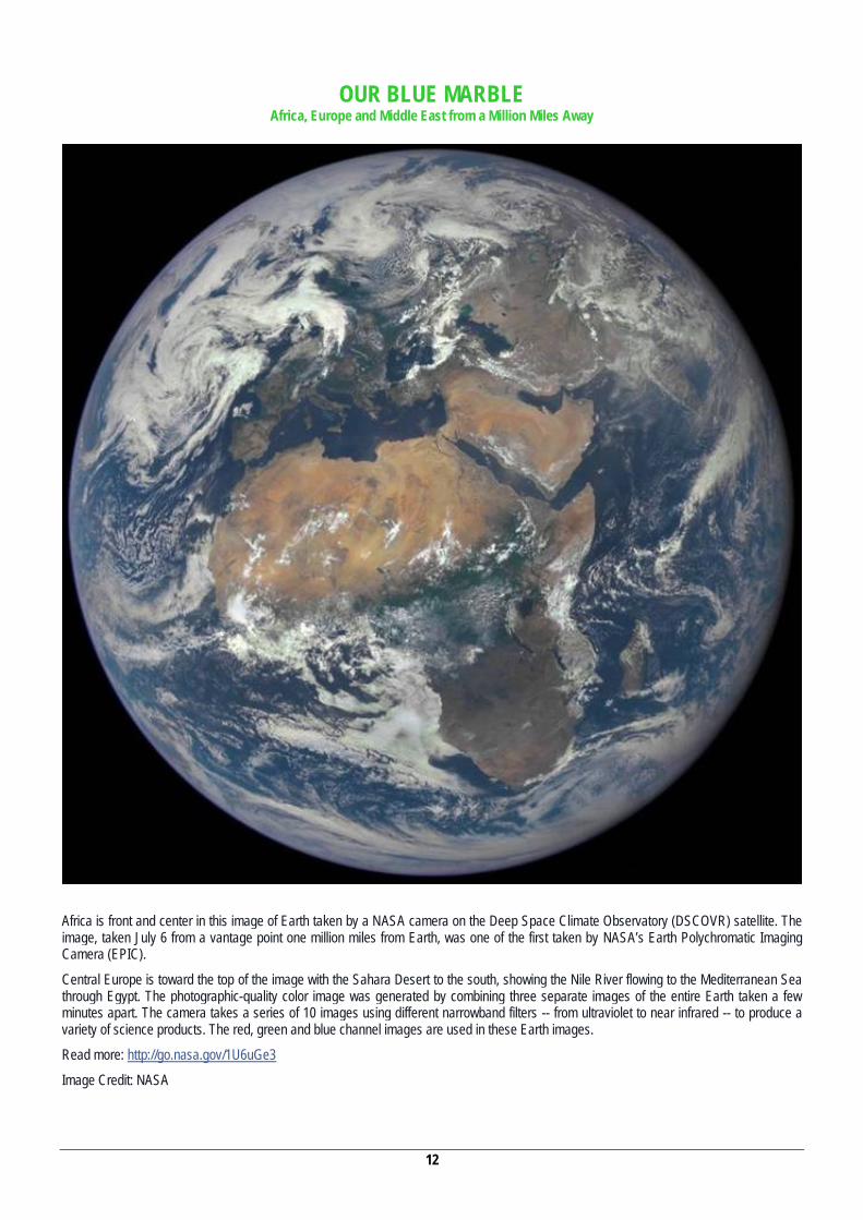
Africa is front and center in this image of Earth taken by a NASA camera on the Deep Space Climate Observatory (DSCOVR) satellite. The image, taken July 6 from a vantage point one million miles from Earth, was one of the first taken by NASA’s Earth Polychromatic Imaging Camera (EPIC).
Central Europe is toward the top of the image with the Sahara Desert to the south, showing the Nile River flowing to the Mediterranean Sea through Egypt. The photographic-quality color image was generated by combining three separate images of the entire Earth taken a few minutes apart. The camera takes a series of 10 images using different narrowband filters -- from ultraviolet to near infrared -- to produce a variety of science products. The red, green and blue channel images are used in these Earth images.
Read more: http://go.nasa.gov/1U6uGe3
Image Credit: NASA
13
About the World
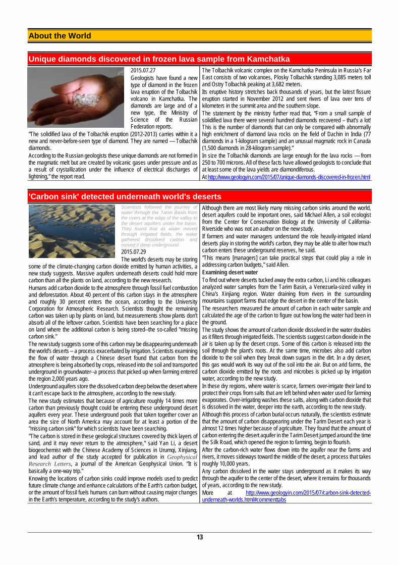
Unique diamonds discovered in frozen lava sample from Kamchatka 2015.07.27 Geologists have found a new type of diamond in the frozen lava eruption of the Tolbachik volcano in Kamchatka. The diamonds are large and of a new type, the Ministry of Science of the Russian Federation reports.
“The solidified lava of the Tolbachik eruption (2012-2013) carries within it a new and never-before-seen type of diamond. They are named — Tolbachik diamonds. According to the Russian geologists these unique diamonds are not formed in the magmatic melt but are created by volcanic gases under pressure and as a result of crystallization under the influence of electrical discharges of lightning,” the report read.
The Tolbachik volcanic complex on the Kamchatka Peninsula in Russia's Far East consists of two volcanoes, Plosky Tolbachik standing 3,085 meters toll and Ostry Tolbachik peaking at 3,682 meters. Its eruptive history stretches back thousands of years, but the latest fissure eruption started in November 2012 and sent rivers of lava over tens of kilometers in the summit area and the southern slope. The statement by the ministry further read that, “From a small sample of solidified lava there were several hundred diamonds recovered – that’s a lot! This is the number of diamonds that can only be compared with abnormally high enrichment of diamond lava rocks on the field of Dachin in India (77 diamonds in a 1-kilogram sample) and an unusual magmatic rock in Canada (1,500 diamonds in 28-kilogram sample).” In size the Tolbachik diamonds are large enough for the lava rocks — from 250 to 700 microns. All of these facts have allowed geologists to conclude that at least some of the lava yields are diamondiferous. At http://www.geologyin.com/2015/07/unique-diamonds-discovered-in-frozen.html
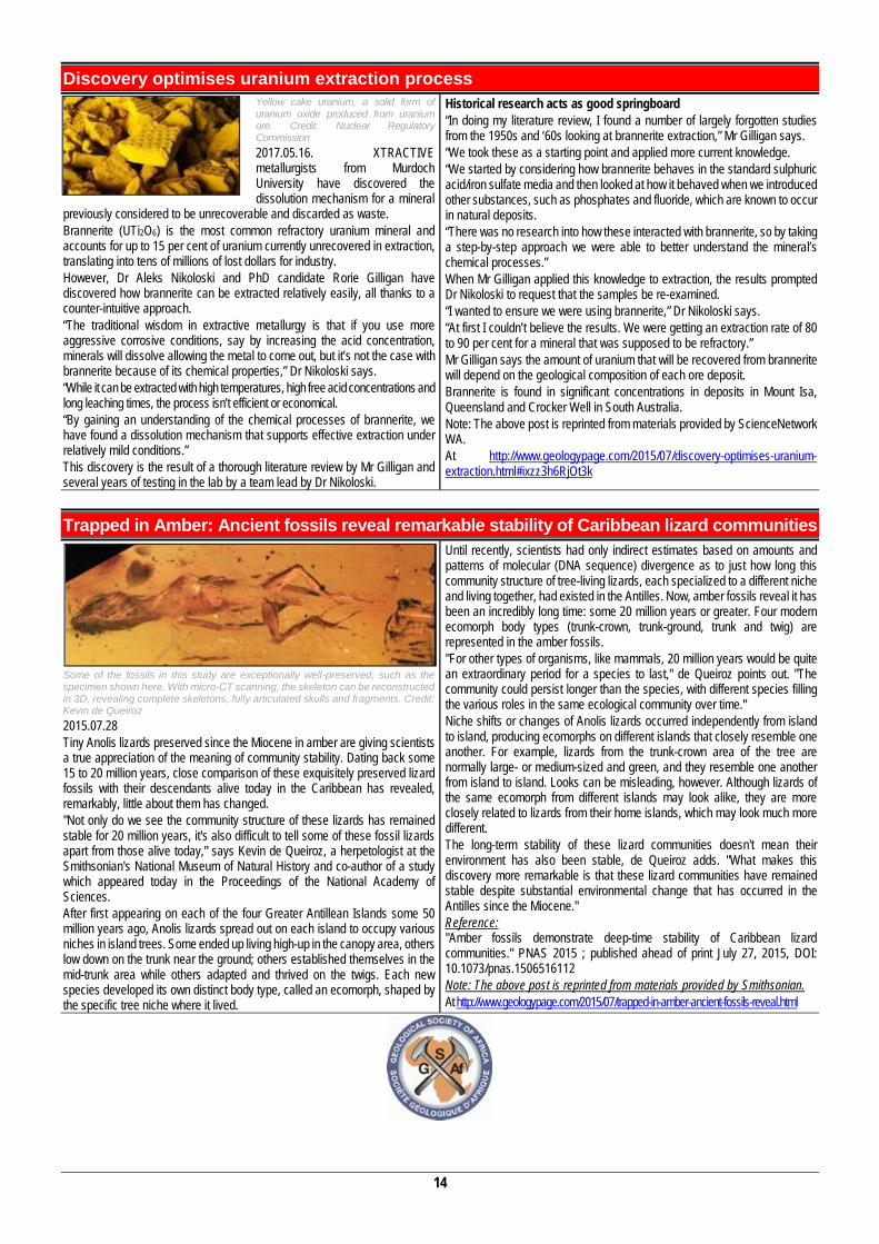
'Carbon sink' detected underneath world's deserts Scientists followed the journey of water through the Tarim Basin from the rivers at the edge of the valley to the desert aquifers under the basin. They found that as water moved through irrigated fields, the water gathered dissolved carbon and moved it deep underground. 2015.07.29 The world's deserts may be storing
some of the climate-changing carbon dioxide emitted by human activities, a new study suggests. Massive aquifers underneath deserts could hold more carbon than all the plants on land, according to the new research. Humans add carbon dioxide to the atmosphere through fossil fuel combustion and deforestation. About 40 percent of this carbon stays in the atmosphere and roughly 30 percent enters the ocean, according to the University Corporation for Atmospheric Research. Scientists thought the remaining carbon was taken up by plants on land, but measurements show plants don't absorb all of the leftover carbon. Scientists have been searching for a place on land where the additional carbon is being stored--the so-called "missing carbon sink." The new study suggests some of this carbon may be disappearing underneath the world's deserts -- a process exacerbated by irrigation. Scientists examining the flow of water through a Chinese desert found that carbon from the atmosphere is being absorbed by crops, released into the soil and transported underground in groundwater--a process that picked up when farming entered the region 2,000 years ago. Underground aquifers store the dissolved carbon deep below the desert where it can't escape back to the atmosphere, according to the new study. The new study estimates that because of agriculture roughly 14 times more carbon than previously thought could be entering these underground desert aquifers every year. These underground pools that taken together cover an area the size of North America may account for at least a portion of the "missing carbon sink" for which scientists have been searching. "The carbon is stored in these geological structures covered by thick layers of sand, and it may never return to the atmosphere," said Yan Li, a desert biogeochemist with the Chinese Academy of Sciences in Urumqi, Xinjiang, and lead author of the study accepted for publication in Geophysical Research Letters, a journal of the American Geophysical Union. "It is basically a one-way trip." Knowing the locations of carbon sinks could improve models used to predict future climate change and enhance calculations of the Earth's carbon budget, or the amount of fossil fuels humans can burn without causing major changes in the Earth's temperature, according to the study's authors.
Although there are most likely many missing carbon sinks around the world, desert aquifers could be important ones, said Michael Allen, a soil ecologist from the Center for Conservation Biology at the University of California-Riverside who was not an author on the new study. If farmers and water managers understand the role heavily-irrigated inland deserts play in storing the world's carbon, they may be able to alter how much carbon enters these underground reserves, he said. "This means [managers] can take practical steps that could play a role in addressing carbon budgets," said Allen. Examining desert water To find out where deserts tucked away the extra carbon, Li and his colleagues analyzed water samples from the Tarim Basin, a Venezuela-sized valley in China's Xinjiang region. Water draining from rivers in the surrounding mountains support farms that edge the desert in the center of the basin. The researchers measured the amount of carbon in each water sample and calculated the age of the carbon to figure out how long the water had been in the ground. The study shows the amount of carbon dioxide dissolved in the water doubles as it filters through irrigated fields. The scientists suggest carbon dioxide in the air is taken up by the desert crops. Some of this carbon is released into the soil through the plant's roots. At the same time, microbes also add carbon dioxide to the soil when they break down sugars in the dirt. In a dry desert, this gas would work its way out of the soil into the air. But on arid farms, the carbon dioxide emitted by the roots and microbes is picked up by irrigation water, according to the new study. In these dry regions, where water is scarce, farmers over-irrigate their land to protect their crops from salts that are left behind when water used for farming evaporates. Over-irrigating washes these salts, along with carbon dioxide that is dissolved in the water, deeper into the earth, according to the new study. Although this process of carbon burial occurs naturally, the scientists estimate that the amount of carbon disappearing under the Tarim Desert each year is almost 12 times higher because of agriculture. They found that the amount of carbon entering the desert aquifer in the Tarim Desert jumped around the time the Silk Road, which opened the region to farming, begin to flourish. After the carbon-rich water flows down into the aquifer near the farms and rivers, it moves sideways toward the middle of the desert, a process that takes roughly 10,000 years. Any carbon dissolved in the water stays underground as it makes its way through the aquifer to the center of the desert, where it remains for thousands of years, according to the new study. More at http://www.geologyin.com/2015/07/carbon-sink-detected-underneath-worlds.html#commenttabs
14
Discovery optimises uranium extraction process Yellow cake uranium, a solid form of uranium oxide produced from uranium ore. Credit: Nuclear Regulatory Commission 2017.05.16. XTRACTIVE metallurgists from Murdoch University have discovered the dissolution mechanism for a mineral
previously considered to be unrecoverable and discarded as waste. Brannerite (UTi2O6) is the most common refractory uranium mineral and accounts for up to 15 per cent of uranium currently unrecovered in extraction, translating into tens of millions of lost dollars for industry. However, Dr Aleks Nikoloski and PhD candidate Rorie Gilligan have discovered how brannerite can be extracted relatively easily, all thanks to a counter-intuitive approach. “The traditional wisdom in extractive metallurgy is that if you use more aggressive corrosive conditions, say by increasing the acid concentration, minerals will dissolve allowing the metal to come out, but it’s not the case with brannerite because of its chemical properties,” Dr Nikoloski says. “While it can be extracted with high temperatures, high free acid concentrations and long leaching times, the process isn’t efficient or economical. “By gaining an understanding of the chemical processes of brannerite, we have found a dissolution mechanism that supports effective extraction under relatively mild conditions.” This discovery is the result of a thorough literature review by Mr Gilligan and several years of testing in the lab by a team lead by Dr Nikoloski.
Historical research acts as good springboard “In doing my literature review, I found a number of largely forgotten studies from the 1950s and ‘60s looking at brannerite extraction,” Mr Gilligan says. “We took these as a starting point and applied more current knowledge. “We started by considering how brannerite behaves in the standard sulphuric acid/iron sulfate media and then looked at how it behaved when we introduced other substances, such as phosphates and fluoride, which are known to occur in natural deposits. “There was no research into how these interacted with brannerite, so by taking a step-by-step approach we were able to better understand the mineral’s chemical processes.” When Mr Gilligan applied this knowledge to extraction, the results prompted Dr Nikoloski to request that the samples be re-examined. “I wanted to ensure we were using brannerite,” Dr Nikoloski says. “At first I couldn’t believe the results. We were getting an extraction rate of 80 to 90 per cent for a mineral that was supposed to be refractory.” Mr Gilligan says the amount of uranium that will be recovered from brannerite will depend on the geological composition of each ore deposit. Brannerite is found in significant concentrations in deposits in Mount Isa, Queensland and Crocker Well in South Australia. Note: The above post is reprinted from materials provided by ScienceNetwork WA. At http://www.geologypage.com/2015/07/discovery-optimises-uranium-extraction.html#ixzz3h6RjOt3k
Trapped in Amber: Ancient fossils reveal remarkable stability of Caribbean lizard communities
Some of the fossils in this study are exceptionally well-preserved, such as the specimen shown here. With micro-CT scanning, the skeleton can be reconstructed in 3D, revealing complete skeletons, fully articulated skulls and fragments. Credit: Kevin de Queiroz 2015.07.28 Tiny Anolis lizards preserved since the Miocene in amber are giving scientists a true appreciation of the meaning of community stability. Dating back some 15 to 20 million years, close comparison of these exquisitely preserved lizard fossils with their descendants alive today in the Caribbean has revealed, remarkably, little about them has changed. "Not only do we see the community structure of these lizards has remained stable for 20 million years, it's also difficult to tell some of these fossil lizards apart from those alive today," says Kevin de Queiroz, a herpetologist at the Smithsonian's National Museum of Natural History and co-author of a study which appeared today in the Proceedings of the National Academy of Sciences. After first appearing on each of the four Greater Antillean Islands some 50 million years ago, Anolis lizards spread out on each island to occupy various niches in island trees. Some ended up living high-up in the canopy area, others low down on the trunk near the ground; others established themselves in the mid-trunk area while others adapted and thrived on the twigs. Each new species developed its own distinct body type, called an ecomorph, shaped by the specific tree niche where it lived.
Until recently, scientists had only indirect estimates based on amounts and patterns of molecular (DNA sequence) divergence as to just how long this community structure of tree-living lizards, each specialized to a different niche and living together, had existed in the Antilles. Now, amber fossils reveal it has been an incredibly long time: some 20 million years or greater. Four modern ecomorph body types (trunk-crown, trunk-ground, trunk and twig) are represented in the amber fossils. "For other types of organisms, like mammals, 20 million years would be quite an extraordinary period for a species to last," de Queiroz points out. "The community could persist longer than the species, with different species filling the various roles in the same ecological community over time." Niche shifts or changes of Anolis lizards occurred independently from island to island, producing ecomorphs on different islands that closely resemble one another. For example, lizards from the trunk-crown area of the tree are normally large- or medium-sized and green, and they resemble one another from island to island. Looks can be misleading, however. Although lizards of the same ecomorph from different islands may look alike, they are more closely related to lizards from their home islands, which may look much more different. The long-term stability of these lizard communities doesn't mean their environment has also been stable, de Queiroz adds. "What makes this discovery more remarkable is that these lizard communities have remained stable despite substantial environmental change that has occurred in the Antilles since the Miocene." Reference: "Amber fossils demonstrate deep-time stability of Caribbean lizard communities." PNAS 2015 ; published ahead of print July 27, 2015, DOI: 10.1073/pnas.1506516112 Note: The above post is reprinted from materials provided by Smithsonian. At http://www.geologypage.com/2015/07/trapped-in-amber-ancient-fossils-reveal.html
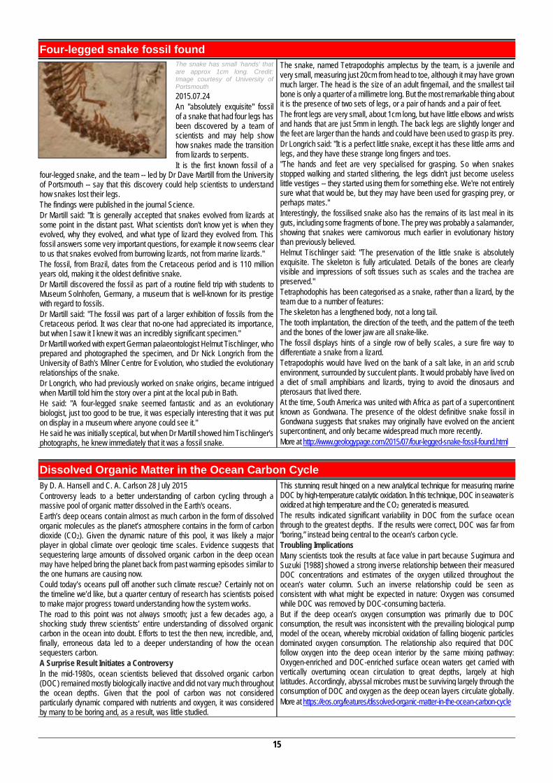
15
Four-legged snake fossil found The snake has small ‘hands’ that are approx 1cm long. Credit: Image courtesy of University of Portsmouth 2015.07.24 An "absolutely exquisite" fossil of a snake that had four legs has been discovered by a team of scientists and may help show how snakes made the transition from lizards to serpents. It is the first known fossil of a
four-legged snake, and the team -- led by Dr Dave Martill from the University of Portsmouth -- say that this discovery could help scientists to understand how snakes lost their legs. The findings were published in the journal Science. Dr Martill said: "It is generally accepted that snakes evolved from lizards at some point in the distant past. What scientists don't know yet is when they evolved, why they evolved, and what type of lizard they evolved from. This fossil answers some very important questions, for example it now seems clear to us that snakes evolved from burrowing lizards, not from marine lizards." The fossil, from Brazil, dates from the Cretaceous period and is 110 million years old, making it the oldest definitive snake. Dr Martill discovered the fossil as part of a routine field trip with students to Museum Solnhofen, Germany, a museum that is well-known for its prestige with regard to fossils. Dr Martill said: "The fossil was part of a larger exhibition of fossils from the Cretaceous period. It was clear that no-one had appreciated its importance, but when I saw it I knew it was an incredibly significant specimen." Dr Martill worked with expert German palaeontologist Helmut Tischlinger, who prepared and photographed the specimen, and Dr Nick Longrich from the University of Bath's Milner Centre for Evolution, who studied the evolutionary relationships of the snake. Dr Longrich, who had previously worked on snake origins, became intrigued when Martill told him the story over a pint at the local pub in Bath. He said: "A four-legged snake seemed fantastic and as an evolutionary biologist, just too good to be true, it was especially interesting that it was put on display in a museum where anyone could see it." He said he was initially sceptical, but when Dr Martill showed him Tischlinger's photographs, he knew immediately that it was a fossil snake.
The snake, named Tetrapodophis amplectus by the team, is a juvenile and very small, measuring just 20cm from head to toe, although it may have grown much larger. The head is the size of an adult fingernail, and the smallest tail bone is only a quarter of a millimetre long. But the most remarkable thing about it is the presence of two sets of legs, or a pair of hands and a pair of feet. The front legs are very small, about 1cm long, but have little elbows and wrists and hands that are just 5mm in length. The back legs are slightly longer and the feet are larger than the hands and could have been used to grasp its prey. Dr Longrich said: "It is a perfect little snake, except it has these little arms and legs, and they have these strange long fingers and toes. "The hands and feet are very specialised for grasping. So when snakes stopped walking and started slithering, the legs didn't just become useless little vestiges -- they started using them for something else. We're not entirely sure what that would be, but they may have been used for grasping prey, or perhaps mates." Interestingly, the fossilised snake also has the remains of its last meal in its guts, including some fragments of bone. The prey was probably a salamander, showing that snakes were carnivorous much earlier in evolutionary history than previously believed. Helmut Tischlinger said: "The preservation of the little snake is absolutely exquisite. The skeleton is fully articulated. Details of the bones are clearly visible and impressions of soft tissues such as scales and the trachea are preserved." Tetraphodophis has been categorised as a snake, rather than a lizard, by the team due to a number of features: The skeleton has a lengthened body, not a long tail. The tooth implantation, the direction of the teeth, and the pattern of the teeth and the bones of the lower jaw are all snake-like. The fossil displays hints of a single row of belly scales, a sure fire way to differentiate a snake from a lizard. Tetrapodophis would have lived on the bank of a salt lake, in an arid scrub environment, surrounded by succulent plants. It would probably have lived on a diet of small amphibians and lizards, trying to avoid the dinosaurs and pterosaurs that lived there. At the time, South America was united with Africa as part of a supercontinent known as Gondwana. The presence of the oldest definitive snake fossil in Gondwana suggests that snakes may originally have evolved on the ancient supercontinent, and only became widespread much more recently. More at http://www.geologypage.com/2015/07/four-legged-snake-fossil-found.html
Dissolved Organic Matter in the Ocean Carbon Cycle By D. A. Hansell and C. A. Carlson 28 July 2015 Controversy leads to a better understanding of carbon cycling through a massive pool of organic matter dissolved in the Earth's oceans. Earth’s deep oceans contain almost as much carbon in the form of dissolved organic molecules as the planet’s atmosphere contains in the form of carbon dioxide (CO2). Given the dynamic nature of this pool, it was likely a major player in global climate over geologic time scales. Evidence suggests that sequestering large amounts of dissolved organic carbon in the deep ocean may have helped bring the planet back from past warming episodes similar to the one humans are causing now. Could today’s oceans pull off another such climate rescue? Certainly not on the timeline we’d like, but a quarter century of research has scientists poised to make major progress toward understanding how the system works. The road to this point was not always smooth; just a few decades ago, a shocking study threw scientists’ entire understanding of dissolved organic carbon in the ocean into doubt. Efforts to test the then new, incredible, and, finally, erroneous data led to a deeper understanding of how the ocean sequesters carbon. A Surprise Result Initiates a Controversy In the mid-1980s, ocean scientists believed that dissolved organic carbon (DOC) remained mostly biologically inactive and did not vary much throughout the ocean depths. Given that the pool of carbon was not considered particularly dynamic compared with nutrients and oxygen, it was considered by many to be boring and, as a result, was little studied.
This stunning result hinged on a new analytical technique for measuring marine DOC by high-temperature catalytic oxidation. In this technique, DOC in seawater is oxidized at high temperature and the CO2 generated is measured. The results indicated significant variability in DOC from the surface ocean through to the greatest depths. If the results were correct, DOC was far from “boring,” instead being central to the ocean’s carbon cycle. Troubling Implications Many scientists took the results at face value in part because Sugimura and Suzuki [1988] showed a strong inverse relationship between their measured DOC concentrations and estimates of the oxygen utilized throughout the ocean’s water column. Such an inverse relationship could be seen as consistent with what might be expected in nature: Oxygen was consumed while DOC was removed by DOC-consuming bacteria. But if the deep ocean’s oxygen consumption was primarily due to DOC consumption, the result was inconsistent with the prevailing biological pump model of the ocean, whereby microbial oxidation of falling biogenic particles dominated oxygen consumption. The relationship also required that DOC follow oxygen into the deep ocean interior by the same mixing pathway: Oxygen-enriched and DOC-enriched surface ocean waters get carried with vertically overturning ocean circulation to great depths, largely at high latitudes. Accordingly, abyssal microbes must be surviving largely through the consumption of DOC and oxygen as the deep ocean layers circulate globally. More at https://eos.org/features/dissolved-organic-matter-in-the-ocean-carbon-cycle
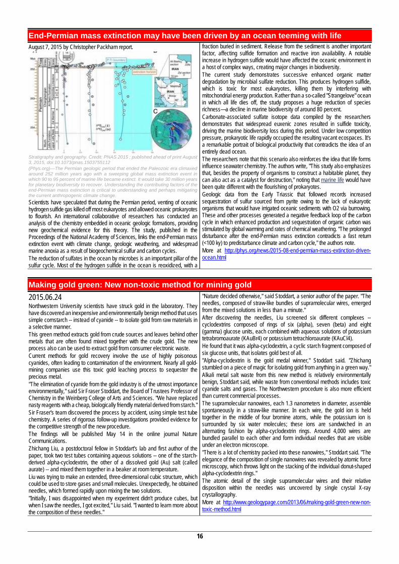
16
End-Permian mass extinction may have been driven by an ocean teeming with life August 7, 2015 by Christopher Packham report.
Stratigraphy and geography. Credit: PNAS 2015 ; published ahead of print August 3, 2015, doi:10.1073/pnas.1503755112 (Phys.org)—The Permian geologic period that ended the Paleozoic era climaxed around 252 million years ago with a sweeping global mass extinction event in which 90 to 95 percent of marine life became extinct. It would take 30 million years for planetary biodiversity to recover. Understanding the contributing factors of the end-Permian mass extinction is critical to understanding and perhaps mitigating the current anthropogenic climate change. Scientists have speculated that during the Permian period, venting of oceanic hydrogen sulfide gas killed off most eukaryotes and allowed oceanic prokaryotes to flourish. An international collaborative of researchers has conducted an analysis of the chemistry embedded in oceanic geologic formations, providing new geochemical evidence for this theory. The study, published in the Proceedings of the National Academy of Sciences, links the end-Permian mass extinction event with climate change, geologic weathering, and widespread marine anoxia as a result of biogeochemical sulfur and carbon cycles. The reduction of sulfates in the ocean by microbes is an important pillar of the sulfur cycle. Most of the hydrogen sulfide in the ocean is reoxidized, with a
fraction buried in sediment. Release from the sediment is another important factor, affecting sulfide formation and reactive iron availability. A notable increase in hydrogen sulfide would have affected the oceanic environment in a host of complex ways, creating major changes in biodiversity. The current study demonstrates successive enhanced organic matter degradation by microbial sulfate reduction. This produces hydrogen sulfide, which is toxic for most eukaryotes, killing them by interfering with mitochondrial energy production. Rather than a so-called "Strangelove" ocean in which all life dies off, the study proposes a huge reduction of species richness—a decline in marine biodiversity of around 80 percent. Carbonate-associated sulfate isotope data compiled by the researchers demonstrates that widespread euxenic zones resulted in sulfide toxicity, driving the marine biodiversity loss during this period. Under low competition pressure, prokaryotic life rapidly occupied the resulting vacant ecospaces. It's a remarkable portrait of biological productivity that contradicts the idea of an entirely dead ocean. The researchers note that this scenario also reinforces the idea that life forms influence seawater chemistry. The authors write, "This study also emphasizes that, besides the property of organisms to construct a habitable planet, they can also act as a catalyst for destruction," noting that marine life would have been quite different with the flourishing of prokaryotes. Geologic data from the Early Triassic that followed records increased sequestration of sulfur sourced from pyrite owing to the lack of eukaryotic organisms that would have irrigated oceanic sediments with O2 via burrowing. These and other processes generated a negative feedback loop of the carbon cycle in which enhanced production and sequestration of organic carbon was stimulated by global warming and rates of chemical weathering. "The prolonged disturbance after the end-Permian mass extinction contradicts a fast return (<100 ky) to predisturbance climate and carbon cycle," the authors note. More at http://phys.org/news/2015-08-end-permian-mass-extinction-driven-ocean.html
Making gold green: New non-toxic method for mining gold 2015.06.24 Northwestern University scientists have struck gold in the laboratory. They have discovered an inexpensive and environmentally benign method that uses simple cornstarch -- instead of cyanide -- to isolate gold from raw materials in a selective manner. This green method extracts gold from crude sources and leaves behind other metals that are often found mixed together with the crude gold. The new process also can be used to extract gold from consumer electronic waste. Current methods for gold recovery involve the use of highly poisonous cyanides, often leading to contamination of the environment. Nearly all gold-mining companies use this toxic gold leaching process to sequester the precious metal. "The elimination of cyanide from the gold industry is of the utmost importance environmentally," said Sir Fraser Stoddart, the Board of Trustees Professor of Chemistry in the Weinberg College of Arts and Sciences. "We have replaced nasty reagents with a cheap, biologically friendly material derived from starch." Sir Fraser's team discovered the process by accident, using simple test tube chemistry. A series of rigorous follow-up investigations provided evidence for the competitive strength of the new procedure. The findings will be published May 14 in the online journal Nature Communications. Zhichang Liu, a postdoctoral fellow in Stoddart's lab and first author of the paper, took two test tubes containing aqueous solutions -- one of the starch-derived alpha-cyclodextrin, the other of a dissolved gold (Au) salt (called aurate) -- and mixed them together in a beaker at room temperature. Liu was trying to make an extended, three-dimensional cubic structure, which could be used to store gases and small molecules. Unexpectedly, he obtained needles, which formed rapidly upon mixing the two solutions. "Initially, I was disappointed when my experiment didn't produce cubes, but when I saw the needles, I got excited," Liu said. "I wanted to learn more about the composition of these needles."
"Nature decided otherwise," said Stoddart, a senior author of the paper. "The needles, composed of straw-like bundles of supramolecular wires, emerged from the mixed solutions in less than a minute." After discovering the needles, Liu screened six different complexes -- cyclodextrins composed of rings of six (alpha), seven (beta) and eight (gamma) glucose units, each combined with aqueous solutions of potassium tetrabromoaurate (KAuBr4) or potassium tetrachloroaurate (KAuCl4). He found that it was alpha-cyclodextrin, a cyclic starch fragment composed of six glucose units, that isolates gold best of all. "Alpha-cyclodextrin is the gold medal winner," Stoddart said. "Zhichang stumbled on a piece of magic for isolating gold from anything in a green way." Alkali metal salt waste from this new method is relatively environmentally benign, Stoddart said, while waste from conventional methods includes toxic cyanide salts and gases. The Northwestern procedure is also more efficient than current commercial processes. The supramolecular nanowires, each 1.3 nanometers in diameter, assemble spontaneously in a straw-like manner. In each wire, the gold ion is held together in the middle of four bromine atoms, while the potassium ion is surrounded by six water molecules; these ions are sandwiched in an alternating fashion by alpha-cyclodextrin rings. Around 4,000 wires are bundled parallel to each other and form individual needles that are visible under an electron microscope. "There is a lot of chemistry packed into these nanowires," Stoddart said. "The elegance of the composition of single nanowires was revealed by atomic force microscopy, which throws light on the stacking of the individual donut-shaped alpha-cyclodextrin rings." The atomic detail of the single supramolecular wires and their relative disposition within the needles was uncovered by single crystal X-ray crystallography. More at http://www.geologypage.com/2013/06/making-gold-green-new-non-toxic-method.html
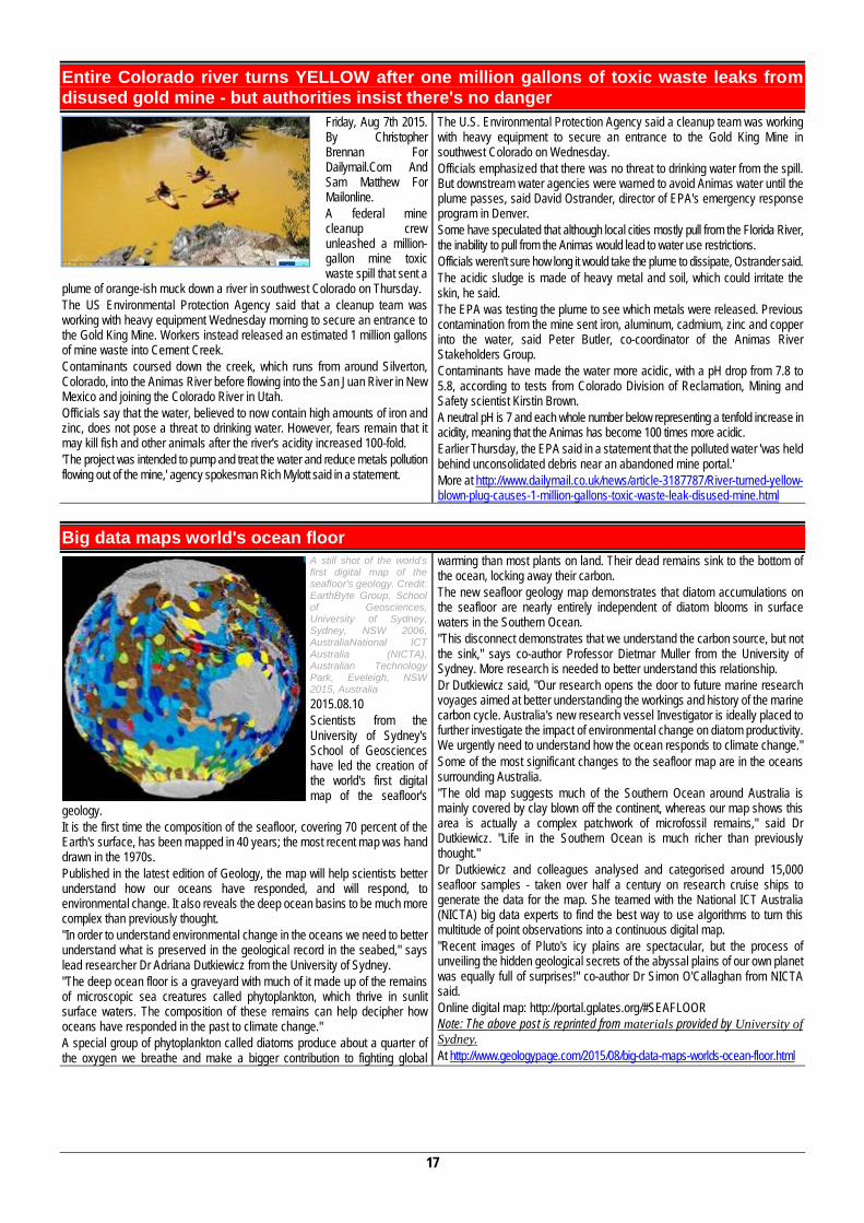
17
Entire Colorado river turns YELLOW after one million gallons of toxic waste leaks from disused gold mine - but authorities insist there's no danger
Friday, Aug 7th 2015. By Christopher Brennan For Dailymail.Com And Sam Matthew For Mailonline. A federal mine cleanup crew unleashed a million-gallon mine toxic waste spill that sent a
plume of orange-ish muck down a river in southwest Colorado on Thursday. The US Environmental Protection Agency said that a cleanup team was working with heavy equipment Wednesday morning to secure an entrance to the Gold King Mine. Workers instead released an estimated 1 million gallons of mine waste into Cement Creek. Contaminants coursed down the creek, which runs from around Silverton, Colorado, into the Animas River before flowing into the San Juan River in New Mexico and joining the Colorado River in Utah. Officials say that the water, believed to now contain high amounts of iron and zinc, does not pose a threat to drinking water. However, fears remain that it may kill fish and other animals after the river's acidity increased 100-fold. 'The project was intended to pump and treat the water and reduce metals pollution flowing out of the mine,' agency spokesman Rich Mylott said in a statement.
The U.S. Environmental Protection Agency said a cleanup team was working with heavy equipment to secure an entrance to the Gold King Mine in southwest Colorado on Wednesday. Officials emphasized that there was no threat to drinking water from the spill. But downstream water agencies were warned to avoid Animas water until the plume passes, said David Ostrander, director of EPA's emergency response program in Denver. Some have speculated that although local cities mostly pull from the Florida River, the inability to pull from the Animas would lead to water use restrictions. Officials weren't sure how long it would take the plume to dissipate, Ostrander said. The acidic sludge is made of heavy metal and soil, which could irritate the skin, he said. The EPA was testing the plume to see which metals were released. Previous contamination from the mine sent iron, aluminum, cadmium, zinc and copper into the water, said Peter Butler, co-coordinator of the Animas River Stakeholders Group. Contaminants have made the water more acidic, with a pH drop from 7.8 to 5.8, according to tests from Colorado Division of Reclamation, Mining and Safety scientist Kirstin Brown. A neutral pH is 7 and each whole number below representing a tenfold increase in acidity, meaning that the Animas has become 100 times more acidic. Earlier Thursday, the EPA said in a statement that the polluted water 'was held behind unconsolidated debris near an abandoned mine portal.' More at http://www.dailymail.co.uk/news/article-3187787/River-turned-yellow-blown-plug-causes-1-million-gallons-toxic-waste-leak-disused-mine.html
Big data maps world's ocean floor A still shot of the world's first digital map of the seafloor's geology. Credit: EarthByte Group, School of Geosciences, University of Sydney, Sydney, NSW 2006, AustraliaNational ICT Australia (NICTA), Australian Technology Park, Eveleigh, NSW 2015, Australia 2015.08.10 Scientists from the University of Sydney's School of Geosciences have led the creation of the world's first digital map of the seafloor's
geology. It is the first time the composition of the seafloor, covering 70 percent of the Earth's surface, has been mapped in 40 years; the most recent map was hand drawn in the 1970s. Published in the latest edition of Geology, the map will help scientists better understand how our oceans have responded, and will respond, to environmental change. It also reveals the deep ocean basins to be much more complex than previously thought. "In order to understand environmental change in the oceans we need to better understand what is preserved in the geological record in the seabed," says lead researcher Dr Adriana Dutkiewicz from the University of Sydney. "The deep ocean floor is a graveyard with much of it made up of the remains of microscopic sea creatures called phytoplankton, which thrive in sunlit surface waters. The composition of these remains can help decipher how oceans have responded in the past to climate change." A special group of phytoplankton called diatoms produce about a quarter of the oxygen we breathe and make a bigger contribution to fighting global
warming than most plants on land. Their dead remains sink to the bottom of the ocean, locking away their carbon. The new seafloor geology map demonstrates that diatom accumulations on the seafloor are nearly entirely independent of diatom blooms in surface waters in the Southern Ocean. "This disconnect demonstrates that we understand the carbon source, but not the sink," says co-author Professor Dietmar Muller from the University of Sydney. More research is needed to better understand this relationship. Dr Dutkiewicz said, "Our research opens the door to future marine research voyages aimed at better understanding the workings and history of the marine carbon cycle. Australia's new research vessel Investigator is ideally placed to further investigate the impact of environmental change on diatom productivity. We urgently need to understand how the ocean responds to climate change." Some of the most significant changes to the seafloor map are in the oceans surrounding Australia. "The old map suggests much of the Southern Ocean around Australia is mainly covered by clay blown off the continent, whereas our map shows this area is actually a complex patchwork of microfossil remains," said Dr Dutkiewicz. "Life in the Southern Ocean is much richer than previously thought." Dr Dutkiewicz and colleagues analysed and categorised around 15,000 seafloor samples - taken over half a century on research cruise ships to generate the data for the map. She teamed with the National ICT Australia (NICTA) big data experts to find the best way to use algorithms to turn this multitude of point observations into a continuous digital map. "Recent images of Pluto's icy plains are spectacular, but the process of unveiling the hidden geological secrets of the abyssal plains of our own planet was equally full of surprises!" co-author Dr Simon O'Callaghan from NICTA said. Online digital map: http://portal.gplates.org/#SEAFLOOR Note: The above post is reprinted from materials provided by University of Sydney. At http://www.geologypage.com/2015/08/big-data-maps-worlds-ocean-floor.html
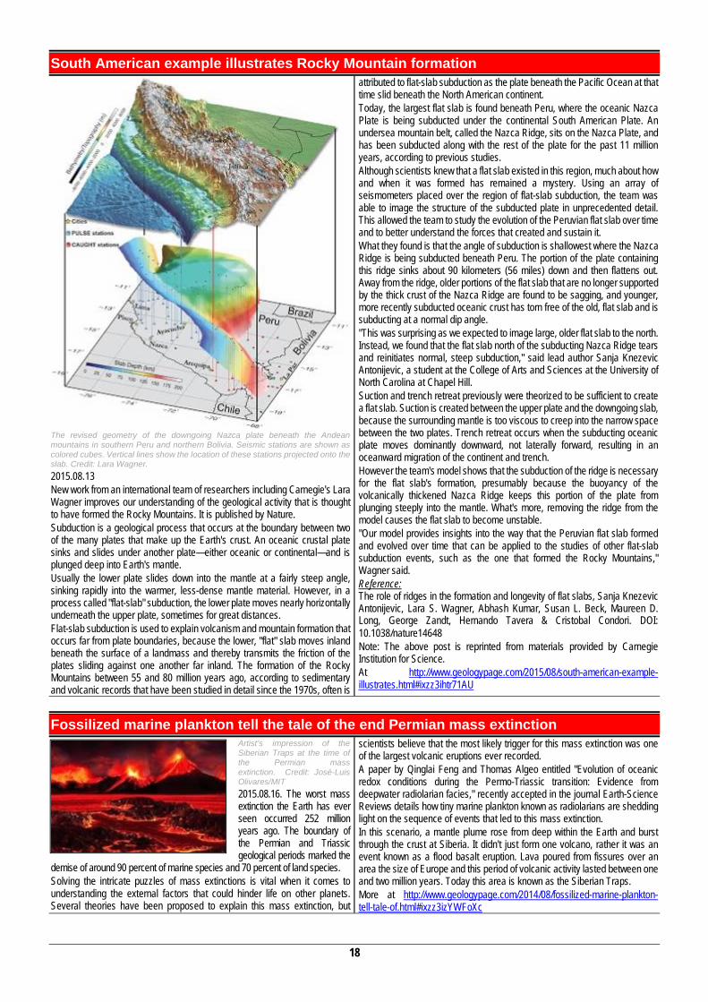
18
South American example illustrates Rocky Mountain formation
The revised geometry of the downgoing Nazca plate beneath the Andean mountains in southern Peru and northern Bolivia. Seismic stations are shown as colored cubes. Vertical lines show the location of these stations projected onto the slab. Credit: Lara Wagner. 2015.08.13 New work from an international team of researchers including Carnegie's Lara Wagner improves our understanding of the geological activity that is thought to have formed the Rocky Mountains. It is published by Nature. Subduction is a geological process that occurs at the boundary between two of the many plates that make up the Earth's crust. An oceanic crustal plate sinks and slides under another plate—either oceanic or continental—and is plunged deep into Earth's mantle. Usually the lower plate slides down into the mantle at a fairly steep angle, sinking rapidly into the warmer, less-dense mantle material. However, in a process called "flat-slab" subduction, the lower plate moves nearly horizontally underneath the upper plate, sometimes for great distances. Flat-slab subduction is used to explain volcanism and mountain formation that occurs far from plate boundaries, because the lower, "flat" slab moves inland beneath the surface of a landmass and thereby transmits the friction of the plates sliding against one another far inland. The formation of the Rocky Mountains between 55 and 80 million years ago, according to sedimentary and volcanic records that have been studied in detail since the 1970s, often is
attributed to flat-slab subduction as the plate beneath the Pacific Ocean at that time slid beneath the North American continent. Today, the largest flat slab is found beneath Peru, where the oceanic Nazca Plate is being subducted under the continental South American Plate. An undersea mountain belt, called the Nazca Ridge, sits on the Nazca Plate, and has been subducted along with the rest of the plate for the past 11 million years, according to previous studies. Although scientists knew that a flat slab existed in this region, much about how and when it was formed has remained a mystery. Using an array of seismometers placed over the region of flat-slab subduction, the team was able to image the structure of the subducted plate in unprecedented detail. This allowed the team to study the evolution of the Peruvian flat slab over time and to better understand the forces that created and sustain it. What they found is that the angle of subduction is shallowest where the Nazca Ridge is being subducted beneath Peru. The portion of the plate containing this ridge sinks about 90 kilometers (56 miles) down and then flattens out. Away from the ridge, older portions of the flat slab that are no longer supported by the thick crust of the Nazca Ridge are found to be sagging, and younger, more recently subducted oceanic crust has torn free of the old, flat slab and is subducting at a normal dip angle. "This was surprising as we expected to image large, older flat slab to the north. Instead, we found that the flat slab north of the subducting Nazca Ridge tears and reinitiates normal, steep subduction," said lead author Sanja Knezevic Antonijevic, a student at the College of Arts and Sciences at the University of North Carolina at Chapel Hill. Suction and trench retreat previously were theorized to be sufficient to create a flat slab. Suction is created between the upper plate and the downgoing slab, because the surrounding mantle is too viscous to creep into the narrow space between the two plates. Trench retreat occurs when the subducting oceanic plate moves dominantly downward, not laterally forward, resulting in an oceanward migration of the continent and trench. However the team's model shows that the subduction of the ridge is necessary for the flat slab's formation, presumably because the buoyancy of the volcanically thickened Nazca Ridge keeps this portion of the plate from plunging steeply into the mantle. What's more, removing the ridge from the model causes the flat slab to become unstable. "Our model provides insights into the way that the Peruvian flat slab formed and evolved over time that can be applied to the studies of other flat-slab subduction events, such as the one that formed the Rocky Mountains," Wagner said. Reference: The role of ridges in the formation and longevity of flat slabs, Sanja Knezevic Antonijevic, Lara S. Wagner, Abhash Kumar, Susan L. Beck, Maureen D. Long, George Zandt, Hernando Tavera & Cristobal Condori. DOI: 10.1038/nature14648 Note: The above post is reprinted from materials provided by Carnegie Institution for Science. At http://www.geologypage.com/2015/08/south-american-example-illustrates.html#ixzz3ihtr71AU
Fossilized marine plankton tell the tale of the end Permian mass extinction Artist’s impression of the Siberian Traps at the time of the Permian mass extinction. Credit: José-Luis Olivares/MIT 2015.08.16. The worst mass extinction the Earth has ever seen occurred 252 million years ago. The boundary of the Permian and Triassic geological periods marked the
demise of around 90 percent of marine species and 70 percent of land species. Solving the intricate puzzles of mass extinctions is vital when it comes to understanding the external factors that could hinder life on other planets. Several theories have been proposed to explain this mass extinction, but
scientists believe that the most likely trigger for this mass extinction was one of the largest volcanic eruptions ever recorded. A paper by Qinglai Feng and Thomas Algeo entitled "Evolution of oceanic redox conditions during the Permo-Triassic transition: Evidence from deepwater radiolarian facies," recently accepted in the journal Earth-Science Reviews details how tiny marine plankton known as radiolarians are shedding light on the sequence of events that led to this mass extinction. In this scenario, a mantle plume rose from deep within the Earth and burst through the crust at Siberia. It didn't just form one volcano, rather it was an event known as a flood basalt eruption. Lava poured from fissures over an area the size of Europe and this period of volcanic activity lasted between one and two million years. Today this area is known as the Siberian Traps. More at http://www.geologypage.com/2014/08/fossilized-marine-plankton-tell-tale-of.html#ixzz3izYWFoXc
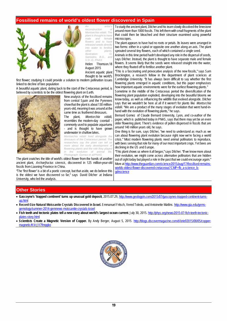
19
Fossilised remains of world’s oldest flower discovered in Spain An artist’s reconstruction of Montsechia vidalii. The plant is thought to have male and female flowers and to have released seeds directly into water to fertilise other plants. Illustration: O. Sanisidro, B.G., and V.D.-G. PNAS Helen Thomson.18 August 2015 Ancient aquatic plant thought to be world’s
first flower; studying it could provide a solution to modern pollination issues linked to decline of bee population A beautiful aquatic plant, dating back to the start of the Cretaceous period, is believed by scientists to be the oldest flowering plant on Earth.
New analysis of the fossilised remains from central Spain and the Pyrenees show that the plant is about 130 million-years-old, meaning it was around at the same time as feathered dinosaurs. The plant, Montsechia vidalii, resembles the modern-day coontail - commonly used to populate aquariums - and is thought to have grown underwater in shallow lakes. Montsechia vidalii lived alongside the dinosaurs of the Cretaceous period. The researchers say the plant can tell us more about the early development of flowering plants and the role they played in the evolution of animal life. Photograph: Gomez et al/PNAS
The plant snatches the title of world’s oldest flower from the hands of another ancient plant, Archaefructus sinensis, discovered in 125 million-year-old fossils from Liaoning Province in China. “The ‘first flower’ is a bit of a poetic concept, but that aside, we do believe this is the oldest we have discovered so far,” says David Dilcher at Indiana University, who led the analysis.
To study the ancient plant, Dilcher and his team slowly dissolved the limestone around more than 1000 fossils. This left them with small fragments of the plant that could then be bleached and their structure examined using powerful microscopes. The plant appears to have had no roots or petals. Its leaves were arranged in two forms: either in a spiral or opposite one another along an axis. The plant sprouted several tiny flowers, each of which contained a single seed. Animals in this time period hadn’t developed any role in the dispersal of seeds, says Dilcher. Instead, the plant is thought to have separate male and female flowers. It seems likely that the seeds were released straight into the water, where they floated off to fertilise another plant. “This is a fascinating and provocative analysis of the new fossils,” says Sam Brockington, a research fellow in the department of plant sciences at Cambridge University. “It has always been difficult to say whether the first flowering plants emerged in aquatic conditions, but this paper emphasises how important aquatic environments were for the earliest flowering plants.” Sometime in the middle of the Cretaceous period the diversification of the flowering plant population exploded, developing into the beautiful blooms we know today, as well as influencing the wildlife that evolved alongside. Dilcher says that we wouldn’t be here at all if it weren’t for plants like Montsechia vidalii. “We are a product of the many stages of evolution that went hand-in-hand with the evolution of flowering plants,” he says. Bernard Gomez of Claude Bernard University, Lyon, and co-author of the paper, which is published today in PNAS, says that there may yet be an even older flowering plant. There’s evidence of pollen dispersed in fossils that are around 140 million years old, he says. One thing is for sure, says Dilcher, “we need to understand as much as we can about flowering plant evolution because right now we’re facing a world crisis.” Most modern flowering plants need animal pollinators to reproduce, with bees serving that role for many of our most important crops. Yet bees are declining in the US and Europe. “This plant shows us where it all began,” says Dilcher. “If we know more about their evolution, we might come across alternative pollinators that are hidden out of sight today but played a role in the past that we could encourage again.” More at http://www.theguardian.com/science/2015/aug/17/fossilised-remains-worlds-oldest-flower-discovered-cretaceous?CMP=fb_a-science_b-gdnscience
Other Stories Gascoyne's 'trapped continent' turns up unusual gold deposit, 2015.07.29, http://www.geologyin.com/2015/07/gascoynes-trapped-continent-turns-
up.html Record-Size Natural Moissanite Crystals Discovered in Israel. Emmanuel Fritsch, Vered Toledo, and Antoinette Matlins. http://www.gia.edu/gems-
gemology/summer-2014-gemnews-moissanite-crystals-israel Fish teeth and tectonic plates tell a new story about world's largest ocean current. July 30, 2015. http://phys.org/news/2015-07-fish-teeth-tectonic-
plates-story.html Scientists Create a Magnetic Version of Copper. By Andy Berger, August 5, 2015. http://blogs.discovermagazine.com/d-brief/2015/08/05/copper-
magnetic/#.VcJV7fmqqko
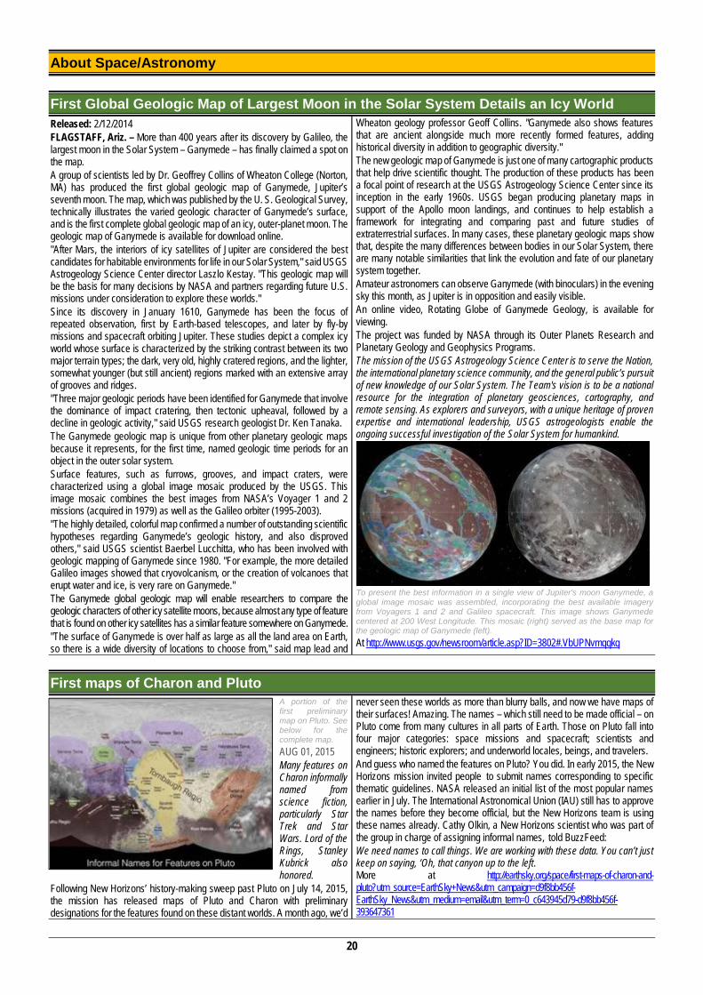
20
About Space/Astronomy
First Global Geologic Map of Largest Moon in the Solar System Details an Icy World Released: 2/12/2014 FLAGSTAFF, Ariz. – More than 400 years after its discovery by Galileo, the largest moon in the Solar System – Ganymede – has finally claimed a spot on the map. A group of scientists led by Dr. Geoffrey Collins of Wheaton College (Norton, MA) has produced the first global geologic map of Ganymede, Jupiter’s seventh moon. The map, which was published by the U. S. Geological Survey, technically illustrates the varied geologic character of Ganymede’s surface, and is the first complete global geologic map of an icy, outer-planet moon. The geologic map of Ganymede is available for download online. "After Mars, the interiors of icy satellites of Jupiter are considered the best candidates for habitable environments for life in our Solar System," said USGS Astrogeology Science Center director Laszlo Kestay. "This geologic map will be the basis for many decisions by NASA and partners regarding future U.S. missions under consideration to explore these worlds." Since its discovery in January 1610, Ganymede has been the focus of repeated observation, first by Earth-based telescopes, and later by fly-by missions and spacecraft orbiting Jupiter. These studies depict a complex icy world whose surface is characterized by the striking contrast between its two major terrain types; the dark, very old, highly cratered regions, and the lighter, somewhat younger (but still ancient) regions marked with an extensive array of grooves and ridges. "Three major geologic periods have been identified for Ganymede that involve the dominance of impact cratering, then tectonic upheaval, followed by a decline in geologic activity," said USGS research geologist Dr. Ken Tanaka. The Ganymede geologic map is unique from other planetary geologic maps because it represents, for the first time, named geologic time periods for an object in the outer solar system. Surface features, such as furrows, grooves, and impact craters, were characterized using a global image mosaic produced by the USGS. This image mosaic combines the best images from NASA’s Voyager 1 and 2 missions (acquired in 1979) as well as the Galileo orbiter (1995-2003). "The highly detailed, colorful map confirmed a number of outstanding scientific hypotheses regarding Ganymede’s geologic history, and also disproved others," said USGS scientist Baerbel Lucchitta, who has been involved with geologic mapping of Ganymede since 1980. "For example, the more detailed Galileo images showed that cryovolcanism, or the creation of volcanoes that erupt water and ice, is very rare on Ganymede." The Ganymede global geologic map will enable researchers to compare the geologic characters of other icy satellite moons, because almost any type of feature that is found on other icy satellites has a similar feature somewhere on Ganymede. "The surface of Ganymede is over half as large as all the land area on Earth, so there is a wide diversity of locations to choose from," said map lead and
Wheaton geology professor Geoff Collins. "Ganymede also shows features that are ancient alongside much more recently formed features, adding historical diversity in addition to geographic diversity." The new geologic map of Ganymede is just one of many cartographic products that help drive scientific thought. The production of these products has been a focal point of research at the USGS Astrogeology Science Center since its inception in the early 1960s. USGS began producing planetary maps in support of the Apollo moon landings, and continues to help establish a framework for integrating and comparing past and future studies of extraterrestrial surfaces. In many cases, these planetary geologic maps show that, despite the many differences between bodies in our Solar System, there are many notable similarities that link the evolution and fate of our planetary system together. Amateur astronomers can observe Ganymede (with binoculars) in the evening sky this month, as Jupiter is in opposition and easily visible. An online video, Rotating Globe of Ganymede Geology, is available for viewing. The project was funded by NASA through its Outer Planets Research and Planetary Geology and Geophysics Programs. The mission of the USGS Astrogeology Science Center is to serve the Nation, the international planetary science community, and the general public’s pursuit of new knowledge of our Solar System. The Team's vision is to be a national resource for the integration of planetary geosciences, cartography, and remote sensing. As explorers and surveyors, with a unique heritage of proven expertise and international leadership, USGS astrogeologists enable the ongoing successful investigation of the Solar System for humankind.
To present the best information in a single view of Jupiter's moon Ganymede, a global image mosaic was assembled, incorporating the best available imagery from Voyagers 1 and 2 and Galileo spacecraft. This image shows Ganymede centered at 200 West Longitude. This mosaic (right) served as the base map for the geologic map of Ganymede (left). At http://www.usgs.gov/newsroom/article.asp?ID=3802#.VbUPNvmqqkq
First maps of Charon and Pluto A portion of the first preliminary map on Pluto. See below for the complete map. AUG 01, 2015 Many features on Charon informally named from science fiction, particularly Star Trek and Star Wars. Lord of the Rings, Stanley Kubrick also honored.
Following New Horizons’ history-making sweep past Pluto on July 14, 2015, the mission has released maps of Pluto and Charon with preliminary designations for the features found on these distant worlds. A month ago, we’d
never seen these worlds as more than blurry balls, and now we have maps of their surfaces! Amazing. The names – which still need to be made official – on Pluto come from many cultures in all parts of Earth. Those on Pluto fall into four major categories: space missions and spacecraft; scientists and engineers; historic explorers; and underworld locales, beings, and travelers. And guess who named the features on Pluto? You did. In early 2015, the New Horizons mission invited people to submit names corresponding to specific thematic guidelines. NASA released an initial list of the most popular names earlier in July. The International Astronomical Union (IAU) still has to approve the names before they become official, but the New Horizons team is using these names already. Cathy Olkin, a New Horizons scientist who was part of the group in charge of assigning informal names, told BuzzFeed: We need names to call things. We are working with these data. You can’t just keep on saying, ‘Oh, that canyon up to the left. More at http://earthsky.org/space/first-maps-of-charon-and-pluto?utm_source=EarthSky+News&utm_campaign=d9f8bb456f-EarthSky_News&utm_medium=email&utm_term=0_c643945d79-d9f8bb456f-393647361
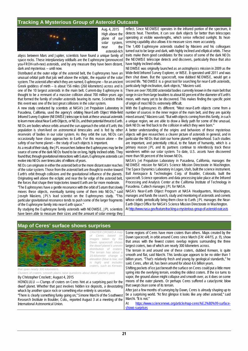
21
Tracking A Mysterious Group of Asteroid Outcasts Aug. 4, 2015 High above the plane of our solar system, near the
asteroid-rich abyss between Mars and Jupiter, scientists have found a unique family of space rocks. These interplanetary oddballs are the Euphrosyne (pronounced you-FROH-seh-nee) asteroids, and by any measure they have been distant, dark and mysterious -- until now. Distributed at the outer edge of the asteroid belt, the Euphrosynes have an unusual orbital path that juts well above the ecliptic, the equator of the solar system. The asteroid after which they are named, Euphrosyne -- for an ancient Greek goddess of mirth -- is about 156 miles (260 kilometers) across and is one of the 10 largest asteroids in the main belt. Current-day Euphrosyne is thought to be a remnant of a massive collision about 700 million years ago that formed the family of smaller asteroids bearing its name. Scientists think this event was one of the last great collisions in the solar system. A new study conducted by scientists at NASA's Jet Propulsion Laboratory in Pasadena, California, used the agency's orbiting Near-Earth Object Wide-field Infrared Survey Explorer (NEOWISE) telescope to look at these unusual asteroids to learn more about Near Earth Objects, or NEOs, and their potential threat to Earth. NEOs are bodies whose orbits around the sun approach the orbit of Earth; this population is short-lived on astronomical timescales and is fed by other reservoirs of bodies in our solar system. As they orbit the sun, NEOs can occasionally have close approaches to Earth. For this reason alone -- the safety of our home planet -- the study of such objects is important. As a result of their study, the JPL researchers believe the Euphrosynes may be the source of some of the dark NEOs found to be on long, highly inclined orbits. They found that, through gravitational interactions with Saturn, Euphrosyne asteroids can evolve into NEOs over timescales of millions of years. NEOs can originate in either the asteroid belt or the more distant outer reaches of the solar system. Those from the asteroid belt are thought to evolve toward Earth's orbit through collisions and the gravitational influence of the planets. Originating well above the ecliptic and near the far edge of the asteroid belt, the forces that shape their trajectories toward Earth are far more moderate. "The Euphrosynes have a gentle resonance with the orbit of Saturn that slowly moves these objects, eventually turning some of them into NEOs," said Joseph Masiero, JPL's lead scientist on the Euphrosynes study. "This particular gravitational resonance tends to push some of the larger fragments of the Euphrosyne family into near-Earth space." By studying the Euphrosyne family asteroids with NEOWISE, JPL scientists have been able to measure their sizes and the amount of solar energy they
reflect. Since NEOWISE operates in the infrared portion of the spectrum, it detects heat. Therefore, it can see dark objects far better than telescopes operating at visible wavelengths, which sense reflected sunlight. Its heat-sensing capability also allows it to measure sizes more accurately. The 1,400 Euphrosyne asteroids studied by Masiero and his colleagues turned out to be large and dark, with highly inclined and elliptical orbits. These traits make them good candidates for the source of some of the dark NEOs the NEOWISE telescope detects and discovers, particularly those that also have highly inclined orbits. NEOWISE was originally launched as an astrophysics mission in 2009 as the Wide-field Infrared Survey Explorer, or WISE. It operated until 2011 and was then shut down. But the spacecraft, now dubbed NEOWISE, would get a second life. "NEOWISE is a great tool for searching for near-Earth asteroids, particularly high-inclination, dark objects," Masiero said. There are over 700,000 asteroidal bodies currently known in the main belt that range in size from large boulders to about 60 percent of the diameter of Earth's moon, with many yet to be discovered. This makes finding the specific point of origin of most NEOs extremely difficult. With the Euphrosynes it's different. "Most near-Earth objects come from a number of sources in the inner region of the main belt, and they are quickly mixed around," Masiero said. "But with objects coming from this family, in such a unique region, we are able to draw a likely path for some of the unusual, dark NEOs we find back to the collision in which they were born." A better understanding of the origins and behaviors of these mysterious objects will give researchers a clearer picture of asteroids in general, and in particular the NEOs that skirt our home planet's neighborhood. Such studies are important, and potentially critical, to the future of humanity, which is a primary reason JPL and its partners continue to relentlessly track these wanderers within our solar system. To date, U.S. assets have discovered more than 98 percent of the known NEOs. NASA's Jet Propulsion Laboratory in Pasadena, California, manages the NEOWISE mission for NASA's Science Mission Directorate in Washington. The Space Dynamics Laboratory in Logan, Utah, built the science instrument. Ball Aerospace & Technologies Corp. of Boulder, Colorado, built the spacecraft. Science operations and data processing take place at the Infrared Processing and Analysis Center at the California Institute of Technology in Pasadena. Caltech manages JPL for NASA. NASA's Near-Earth Object Program at NASA Headquarters, Washington, manages and funds the search, study and monitoring of asteroids and comets whose orbits periodically bring them close to Earth. JPL manages the Near-Earth Object Office for NASA's Science Mission Directorate in Washington. At http://www.nasa.gov/feature/tracking-a-mysterious-group-of-asteroid-outcasts
Map of Ceres’ surface shows surprises CRATER CROWD A map of Ceres based on images taken by the Dawn spacecraft shows the dwarf planet’s uneven distribution of craters. The terrain has about a 15-kilometer change in elevation (blue is low, red is high) and includes craters, such as Kerwan,
that span nearly 300 kilometers. Clusters of craters, smooth plains raise questions about dwarf planet’s past By Christopher Crockett ; August 4, 2015 HONOLULU — Clumps of craters on Ceres hint at a surprising past for the dwarf planet. Whether that past involves hidden ice deposits, a devastating whack by another space rock or something else entirely is uncertain. “There is clearly something funky going on,” Simone Marchi of the Southwest Research Institute in Boulder, Colo., reported August 3 at a meeting of the International Astronomical Union.
Some regions of Ceres have more craters than others. Maps created by the Dawn spacecraft, in orbit around Ceres since March (SN: 4/4/15, p. 9), show that areas with the fewest craters overlap regions surrounding the three largest craters, two of which are nearly 300 kilometers across. The terrain in and around one of these craters, dubbed Kerwan, is quite smooth and flat, said Marchi. This landscape appears to be no older than 1 billion years. “That’s relatively fresh and young by geological standards,” he said. Ceres, after all, has been around for about 4.6 billion years. Shifting pockets of ice just beneath the surface on Ceres could put a little more spring into the overlying terrain, eroding the oldest craters. If the ice turns to vapor, the ground above might collapse and smooth over, as it does on some moons of the outer planets. Or perhaps Ceres suffered a cataclysmic blow that swept clean some of its terrain. After just a few months of surveying by Dawn, Ceres is already shaping up to be a surprising world. “At first glimpse it looks like any other asteroid,” said Marchi. “It is not.” At https://www.sciencenews.org/article/map-ceres%E2%80%99-surface-shows-surprises
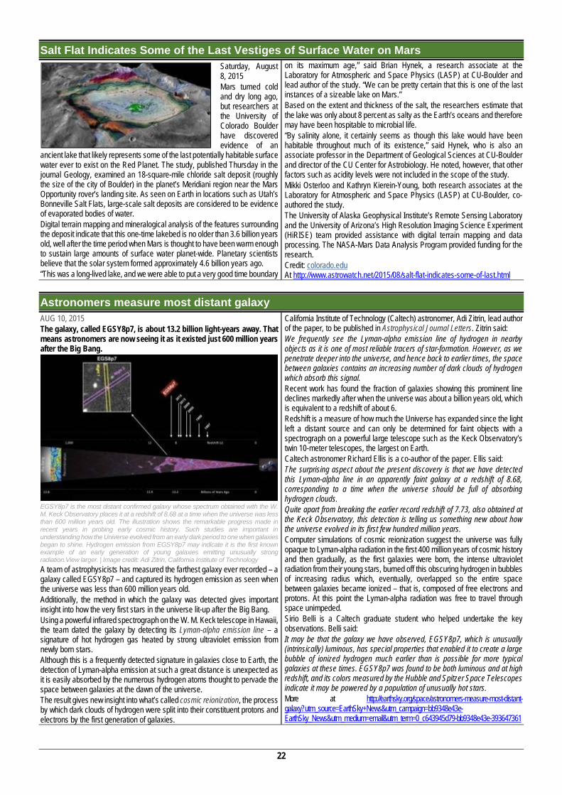
22
Salt Flat Indicates Some of the Last Vestiges of Surface Water on Mars Saturday, August 8, 2015 Mars turned cold and dry long ago, but researchers at the University of Colorado Boulder have discovered evidence of an
ancient lake that likely represents some of the last potentially habitable surface water ever to exist on the Red Planet. The study, published Thursday in the journal Geology, examined an 18-square-mile chloride salt deposit (roughly the size of the city of Boulder) in the planet’s Meridiani region near the Mars Opportunity rover’s landing site. As seen on Earth in locations such as Utah’s Bonneville Salt Flats, large-scale salt deposits are considered to be evidence of evaporated bodies of water. Digital terrain mapping and mineralogical analysis of the features surrounding the deposit indicate that this one-time lakebed is no older than 3.6 billion years old, well after the time period when Mars is thought to have been warm enough to sustain large amounts of surface water planet-wide. Planetary scientists believe that the solar system formed approximately 4.6 billion years ago. “This was a long-lived lake, and we were able to put a very good time boundary
on its maximum age,” said Brian Hynek, a research associate at the Laboratory for Atmospheric and Space Physics (LASP) at CU-Boulder and lead author of the study. “We can be pretty certain that this is one of the last instances of a sizeable lake on Mars.” Based on the extent and thickness of the salt, the researchers estimate that the lake was only about 8 percent as salty as the Earth’s oceans and therefore may have been hospitable to microbial life. “By salinity alone, it certainly seems as though this lake would have been habitable throughout much of its existence,” said Hynek, who is also an associate professor in the Department of Geological Sciences at CU-Boulder and director of the CU Center for Astrobiology. He noted, however, that other factors such as acidity levels were not included in the scope of the study. Mikki Osterloo and Kathryn Kierein-Young, both research associates at the Laboratory for Atmospheric and Space Physics (LASP) at CU-Boulder, co-authored the study. The University of Alaska Geophysical Institute’s Remote Sensing Laboratory and the University of Arizona’s High Resolution Imaging Science Experiment (HiRISE) team provided assistance with digital terrain mapping and data processing. The NASA-Mars Data Analysis Program provided funding for the research. Credit: colorado.edu At http://www.astrowatch.net/2015/08/salt-flat-indicates-some-of-last.html
Astronomers measure most distant galaxy AUG 10, 2015 The galaxy, called EGSY8p7, is about 13.2 billion light-years away. That means astronomers are now seeing it as it existed just 600 million years after the Big Bang.
EGSY8p7 is the most distant confirmed galaxy whose spectrum obtained with the W. M. Keck Observatory places it at a redshift of 8.68 at a time when the universe was less than 600 million years old. The illustration shows the remarkable progress made in recent years in probing early cosmic history. Such studies are important in understanding how the Universe evolved from an early dark period to one when galaxies began to shine. Hydrogen emission from EGSY8p7 may indicate it is the first known example of an early generation of young galaxies emitting unusually strong radiation.View larger. | Image credit: Adi Zitrin, California Institute of Technology A team of astrophysicists has measured the farthest galaxy ever recorded – a galaxy called EGSY8p7 – and captured its hydrogen emission as seen when the universe was less than 600 million years old. Additionally, the method in which the galaxy was detected gives important insight into how the very first stars in the universe lit-up after the Big Bang. Using a powerful infrared spectrograph on the W. M. Keck telescope in Hawaii, the team dated the galaxy by detecting its Lyman-alpha emission line – a signature of hot hydrogen gas heated by strong ultraviolet emission from newly born stars. Although this is a frequently detected signature in galaxies close to Earth, the detection of Lyman-alpha emission at such a great distance is unexpected as it is easily absorbed by the numerous hydrogen atoms thought to pervade the space between galaxies at the dawn of the universe. The result gives new insight into what’s called cosmic reionization, the process by which dark clouds of hydrogen were split into their constituent protons and electrons by the first generation of galaxies.
California Institute of Technology (Caltech) astronomer, Adi Zitrin, lead author of the paper, to be published in Astrophysical Journal Letters. Zitrin said: We frequently see the Lyman-alpha emission line of hydrogen in nearby objects as it is one of most reliable tracers of star-formation. However, as we penetrate deeper into the universe, and hence back to earlier times, the space between galaxies contains an increasing number of dark clouds of hydrogen which absorb this signal. Recent work has found the fraction of galaxies showing this prominent line declines markedly after when the universe was about a billion years old, which is equivalent to a redshift of about 6. Redshift is a measure of how much the Universe has expanded since the light left a distant source and can only be determined for faint objects with a spectrograph on a powerful large telescope such as the Keck Observatory’s twin 10-meter telescopes, the largest on Earth. Caltech astronomer Richard Ellis is a co-author of the paper. Ellis said: The surprising aspect about the present discovery is that we have detected this Lyman-alpha line in an apparently faint galaxy at a redshift of 8.68, corresponding to a time when the universe should be full of absorbing hydrogen clouds. Quite apart from breaking the earlier record redshift of 7.73, also obtained at the Keck Observatory, this detection is telling us something new about how the universe evolved in its first few hundred million years. Computer simulations of cosmic reionization suggest the universe was fully opaque to Lyman-alpha radiation in the first 400 million years of cosmic history and then gradually, as the first galaxies were born, the intense ultraviolet radiation from their young stars, burned off this obscuring hydrogen in bubbles of increasing radius which, eventually, overlapped so the entire space between galaxies became ionized – that is, composed of free electrons and protons. At this point the Lyman-alpha radiation was free to travel through space unimpeded. Sirio Belli is a Caltech graduate student who helped undertake the key observations. Belli said: It may be that the galaxy we have observed, EGSY8p7, which is unusually (intrinsically) luminous, has special properties that enabled it to create a large bubble of ionized hydrogen much earlier than is possible for more typical galaxies at these times. EGSY8p7 was found to be both luminous and at high redshift, and its colors measured by the Hubble and Spitzer Space Telescopes indicate it may be powered by a population of unusually hot stars. More at http://earthsky.org/space/astronomers-measure-most-distant-galaxy?utm_source=EarthSky+News&utm_campaign=bb9348e43e-EarthSky_News&utm_medium=email&utm_term=0_c643945d79-bb9348e43e-393647361
23
Charting the slow death of the universe AUG 13, 2015 A study of 200,000 galaxies found they had lost half their energy in just 2 billion years.
According to a report by an international team of astronomers, the energy produced in a section of the universe today is only about half what it was two billion years ago. This fading is occurring across all wavelengths from the ultraviolet to the far infrared. The universe is slowly dying, the researchers say. The team studied more than 200,000 galaxies to measure the energy generated within a large portion of space. The survey data includes measurements of the energy output of each galaxy at 21 wavelengths, from the ultraviolet to the far infrared. This study, part of the Galaxy And Mass Assembly (GAMA) project, the largest multi-wavelength survey ever put
together, involved many of the world’s most powerful telescopes and represents the most comprehensive assessment of the energy output of the nearby universe. All the energy in the universe was created in the Big Bang, with some portion locked up as mass. Stars shine by converting mass into energy, as described by Einstein’s famous equation E=mc2. The GAMA study sets out to map and model all of the energy generated within a large volume of space today and at different times in the past. Simon Driver of the University of Western Australia led the large GAMA team. Driver said: While most of the energy sloshing around in the universe arose in the aftermath of the Big Bang, additional energy is constantly being generated by stars as they fuse elements like hydrogen and helium together. This new energy is either absorbed by dust as it travels through the host galaxy, or escapes into intergalactic space and travels until it hits something, such as another star, a planet, or, very occasionally, a telescope mirror. The concept that the universe is slowly fading has been known since the late 1990s, but this work shows that it is happening across all wavelengths from the ultraviolet to the infrared, representing the most comprehensive assessment of the energy output of the nearby universe. Driver said: The universe will decline from here on in, sliding gently into old age. The universe has basically sat down on the sofa, pulled up a blanket and is about to nod off for an eternal doze. The team presented this work at the International Astronomical Union XXIX General Assembly in Honolulu, Hawaii, August 10, 2015. At http://earthsky.org/space/charting-the-slow-death-of-the-universe?utm_source=EarthSky+News&utm_campaign=52e5c89c53-EarthSky_News&utm_medium=email&utm_term=0_c643945d79-52e5c89c53-393647361
Other stories Video: Zoom to the center of the Milky Way, 2015.08.13. http://earthsky.org/space/video-zoom-in-to-the-center-of-the-milky-
way?utm_source=EarthSky+News&utm_campaign=52e5c89c53-EarthSky_News&utm_medium=email&utm_term=0_c643945d79-52e5c89c53-393647361 Astronomers find teeny supermassive black hole. Aug 17, 2015. http://earthsky.org/space/astronomers-find-teeny-supermassive-black-
hole?utm_source=earthsky+news&utm_campaign=6bdf3fc26e-earthsky_news&utm_medium=email&utm_term=0_c643945d79-6bdf3fc26e-393647361
HUMOR
(IN Facebook Page of “Geology Page”, at
https://www.facebook.com/geology.page/photos/a.136966176356867.40325.110842275635924/872856839434460/?type=1&theater
24
GEOETHICS
We include a new section of Geoethics, considering the MoU signed between the Geological Society of Africa – GSAf - and the International Association for Geoethics - IAGETH (see in http://geologicalsocietyofafrica.org/file/News_51822e20ed5140.17111100.pdf). For the IAGETH website p[lease visit http://www.icog.es/iageth/
http://www.icog.es/iageth/
Should We Mine This Asteroid For Platinum? July 25, 2015 ; Trace Dominguez This week an asteroid passed by Earth worth an estimated 5 trillion dollars in platinum. Is it possible to mine precious metals in space? In 2011 asteroid UW158, worth an estimated $5.4 trillion, flew by Earth. In 2013, asteroid 2012 DA14, estimated to be worth around $20 trillion, flew by. How do scientists know what an asteroid is made out of? Once it's been located in space, scientists can use ground-based infrared telescopes and spectrometers to see which minerals exist within it. They can even bounce radar off the asteroids and determine composition by what is reflected back. It's never made of just one thing, it's moving, so there's rarely a scientific consensus, but they do have a general idea. Spectrometry and infrared analysis of UW158 suggested it might contain up to 90 million tons of the ultra-rare metal platinum, thus the high price tag. But getting to it, mining it, and then hauling platinum plus any other valuable minerals or metals back is also extremely expensive. Billionaires like Google's Larry Page and Eric Schmidt, as well as Virgin's Richard Branson all have
expressed interest in space exploration and could potentially want to mine astroids like UW158. The problem is sending the materials to mine an asteroid into high Earth orbit costs about 10 million dollars per ton...and the tech for mining space rock is untested, although last week Planetary Resources' Arkyd 3 Reflight spacecraft launched from the International Space Station. The A3R is a proof-of-concept test vehicle for landing and extracting resources from an asteroid. The A6, scheduled to launch later this year, will have tools to spot water, and infrared to find minerals on asteroids. At http://testtube.com/dnews/should-we-mine-this-asteroid-for-platinum/?utm_campaign=trueAnthem:+Trending+Content&utm_content=55b7997404d3017179000001&utm_medium=trueAnthem&utm_source=facebook
Earth’s Most Famous Climate Scientist Issues Bombshell Sea Level Warning JULY 20 2015 ; By Eric Holthaus Monday's new study greatly increases the potential for catastrophic near-term sea level rise. Here, Miami Beach, among the most vulnerable cities to sea level rise in the world. In what may prove to be a turning point for political action on climate change, a breathtaking new study casts extreme doubt about the near-term stability of global sea levels. The study—written by James Hansen, NASA’s former lead climate scientist, and 16 co-authors, many of whom are considered among the top in their fields—concludes that glaciers in Greenland and Antarctica will melt 10 times faster than previous consensus estimates, resulting in sea level rise of at least 10 feet in as little as 50 years. The study, which has not yet been peer-reviewed, brings new importance to a feedback loop in the ocean near Antarctica that results in cooler freshwater from melting glaciers forcing warmer, saltier water underneath the ice sheets, speeding up the melting rate. Hansen, who is known for being alarmist and also right, acknowledges that his study implies change far beyond previous consensus estimates. In a conference call with reporters, he said he hoped the new findings would be “substantially more persuasive than anything previously published.” I certainly find them to be. To come to their findings, the authors used a mixture of paleoclimate records, computer models, and observations of current rates of sea level rise, but “the real world is moving somewhat faster than the model,” Hansen says. Hansen’s study does not attempt to predict the precise timing of the feedback loop, only that it is “likely” to occur this century. The implications are mindboggling: In the study’s likely scenario, New York City—and every other coastal city on the planet—may only have a few more decades of habitability left. That dire prediction, in Hansen’s view, requires “emergency cooperation among nations.” We conclude that continued high emissions will make multi-meter sea level rise practically unavoidable and likely to occur this century. Social disruption and economic consequences of such large sea level rise could be devastating. It is not difficult to imagine that conflicts arising from forced migrations and economic collapse might make the planet ungovernable, threatening the fabric of civilization.
The science of ice melt rates is advancing so fast, scientists have generally been reluctant to put a number to what is essentially an unpredictable, nonlinear response of ice sheets to a steadily warming ocean. With Hansen’s new study, that changes in a dramatic way. One of the study’s co-authors is Eric Rignot, whose own study last year found that glacial melt from West Antarctica now appears to be “unstoppable.” Chris Mooney, writing for Mother Jones, called that study a “holy shit” moment for the climate. One necessary note of caution: Hansen’s study comes via a nontraditional publishing decision by its authors. The study will be published in Atmospheric Chemistry and Physics, an open-access “discussion” journal, and will not have formal peer review prior to its appearance online later this week. [Update, July 23: The paper is now available.] The complete discussion draft circulated to journalists was 66 pages long, and included more than 300 references. The peer review will take place in real time, with responses to the work by other scientists also published online. Hansen said this publishing timeline was necessary to make the work public as soon as possible before global negotiators meet in Paris later this year. Still, the lack of traditional peer review and the fact that this study’s results go far beyond what’s been previously published will likely bring increased scrutiny. On Twitter, Ruth Mottram, a climate scientist whose work focuses on Greenland and the Arctic, was skeptical of such enormous rates of near-term sea level rise, though she defended Hansen’s decision to publish in a nontraditional way. In 2013, Hansen left his post at NASA to become a climate activist because, in his words, “as a government employee, you can’t testify against the government.” In a wide-ranging December 2013 study, conducted to support Our Children’s Trust, a group advancing legal challenges to lax greenhouse gas emissions policies on behalf of minors, Hansen called for a “human tipping point”—essentially, a social revolution—as one of the most effective ways of combating climate change, though he still favors a bilateral carbon tax agreed upon by the United States and China as the best near-term climate policy. In the new study, Hansen writes, "there is no morally defensible excuse to delay phase-out of fossil fuel emissions as rapidly as possible." More att http://www.slate.com/blogs/the_slatest/2015/07/20/sea_level_study_james_hansen_issues_dire_climate_warning.html?wpsrc=sh_all_dt_tw_top
25
Yes, Mr. President, We Remade Our Atlas to Reflect Shrinking Ice While discussing his new plan to combat global warming, the President referenced one of the most striking shifts in the history of National Geographic maps. By Christine Dell'Amore, National Geographic ; August 03, 2015. Unveiling his most aggressive plan yet to combat climate change, President Obama on Monday referenced recent dramatic changes that National Geographic made to its atlas because of melting sea ice. "Shrinking ice caps forced National Geographic to make the biggest change in its atlas since the Soviet Union broke apart," Obama said during a speech Monday at the White House. He's right. The shrinking of the Arctic ice sheet in the 10th edition of theNational Geographic Atlas of the World is one of the most striking changes in the publication's history. After the publication of the atlas in September 2014, the ice has melted even further, notes National Geographic Geographer Juan José Valdés. "The end of Arctic summer is still several weeks away, and it's still too early to say if another record will be broken. But one need only look at the maps derived from satellite imagery to see the impact of global warming," he says.
Obama on Monday released the final rule of his so-called Clean Power Plan, which aims to address climate change by reducing heat-trapping carbon dioxide emissions from power plants. As the ocean heats up due to global warming, Arctic sea ice has been locked in a downward spiral. Since the late 1970s, the ice has retreated by 12 percent per decade, worsening after 2007, according to NASA. May 2014 represented the third lowest extent of sea ice during that month in the satellite record,according to the National Snow and Ice Data Center (NSIDC). Ice loss is accelerated in the Arctic because of a phenomenon known as the feedback loop: Thin ice is less reflective than thick ice, allowing more sunlight to be absorbed by the ocean, which in turn weakens the ice and warms the ocean even more, NASA says. Because thinner ice is flatter, it allows melt ponds to accumulate on the surface, reducing the reflectiveness of the ice and absorbing more heat. "You hear reports all the time in the media about this," Valdés said. "Until you have a hard-copy map in your hand, the message doesn't really hit home." Much more at http://news.nationalgeographic.com/2015/08/150803-arctic-ice-obama-climate-nation-science/?utm_source=Facebook&utm_medium=Social&utm_content=link_fb20150803news-obama&utm_campaign=Content&sf11666211=1
Mauritius president says traditional science can save Africa President Ameena Gurib-Fakim of Mauritius. Photo: LegacyProject By This Is Africa on July 24, 2015 — Award-winning biologist and current President of the island of Mauritius, Dr Ameenah Gurib-Fakim, urged Africa to pursue scientific independence so as to produce an Africa-centric science that
will address the continent's environmental problems Speaking to the BBC in London, President Gurib-Fakim encouraged African education institutions to promote intra-African science, similar to intra-African trade, so as to find ‘African solutions to African problems’.
She added that the science community needs to revisit African traditional knowledge systems for addressing solutions that the continent could use. “We need to re-look at what we refer to as ‘traditional knowledge’…in the threats and challenges coming up like climate change, traditional knowledge as well as science will provide a third way for addressing solutions which African can depend on” She also urged governments to endorse traditional medicine and science, in similar ways to how the governments of China and India have established the systems in their countries. At http://thisisafrica.me/ameenah-gurib-fakim-says-traditional-science-can-save-africa/
How a lizard and a snake beat king coal Blogpost by Elsa Lee - 7 August, 2015 This week two major wins came out of the campaign to protect Australia's Great Barrier Reef. But the fight is not over… When news broke of Australia's Federal Court overturning the approval of the Carmichael coal mine – a A$16 billion mine, rail and port project proposed for the Galilee Basin in Queensland, right on the doorstep of the Great Barrier Reef – there was rapturous applause. But the good news didn't stop there. The same day Australia's biggest bank pulled the plug on Carmichael – the first bank that was involved in the project and now no longer wants to be. This was a good day for the Reef! Local NGOs, Mackay Conservation Group and the Environmental Defenders Office Queensland, mounted the legal challenge; and the courtroom questioning flushed out all sorts of inaccuracies around the mine's use of water, super inflated job promises, and identified the massive environmental impacts of the mine. But at the end of the day the Federal Court overturned
the approval due to two native endangered reptiles whose plight was ill-considered when the mine got the green light. Yep, that’s right a lizard and a snake, or rather the yakka skink and the ornamental snake. The company behind the mine is part of the Adani group – a multinational conglomerate, seeking to burn this coal in Indian coal-fired power stations. In a statement, the Adani group referred to the overturning of their license to operate as merely a "technicality". "It is regrettable that a technical legal error from the Federal Environment Department has exposed the approval to an adverse decision," said the statement. If endangered species are a mere "technicality" how can this company ever be trusted with putting in place any measures to protect the environment? At http://www.greenpeace.org/international/en/news/Blogs/makingwaves/lizard-and-a-snake-beat-king-coal-reef/blog/53734/
Russia just claimed a huge chunk of the Arctic Hanna Kozlowska, August 04, 2015 Russia believes that it owns 1.2 million sq. kilometers (463,000 sq. miles) of the Arctic. The country has requested that the UN recognize the claim, which it first made in 2002. At the time the UN sent it back, asking for more supporting evidence. “Ample scientific data collected in years of Arctic research are used to back the Russian claim,” the country’s foreign ministry says in a statement. Russia and other countries adjacent to the area—the US, Canada, Denmark and Norway—are vying for Arctic territories, which are estimated to contain one-fourth of the world’s reserves of oil and gas. According to United States Geological Survey estimates, the region north of the Arctic circle contains 90 billion barrels of oil, 1,669 trillion cubic feet of natural gas and 44 billion barrels of natural gas liquids.
Last year, the Russian government said the territory it claims could contain 5 billion tons of oil and natural resources. With the Arctic cap melting as a result of climate change, the resources are expected to be increasingly accessible to drilling. The Arctic Ocean is currently a neutral area, but countries with continental shelfs that extend into the territory can claim parts of it as an exclusive economic zone. In 2007, the Russians dropped a canister with a Russian flag to the bottom of the Arctic Ocean, making a symbolic claim to the territory. Earlier this year, the country organized massive Arctic military maneuvers involving thousands of troops, ships, submarines and aircraft. At http://qz.com/471723/russia-just-claimed-a-huge-chunk-of-the-arctic/
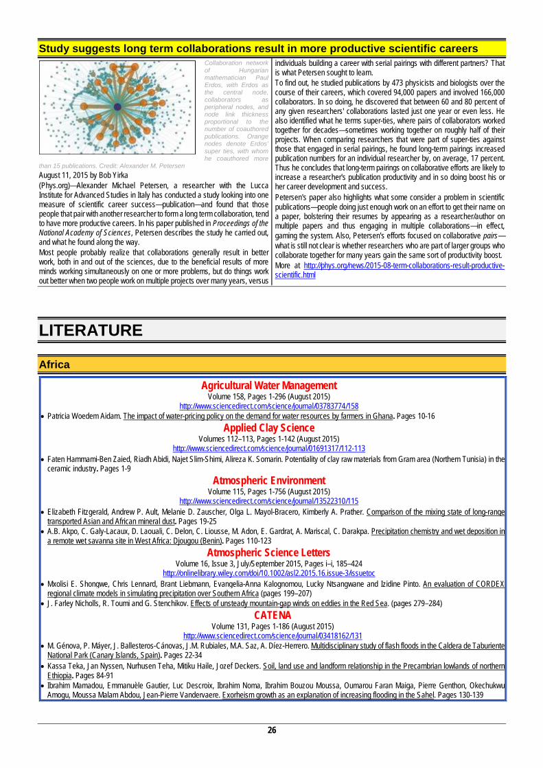
26
Study suggests long term collaborations result in more productive scientific careers Collaboration network of Hungarian mathematician Paul Erdos, with Erdos as the central node, collaborators as peripheral nodes, and node link thickness proportional to the number of coauthored publications. Orange nodes denote Erdos’ super ties, with whom he coauthored more
than 15 publications. Credit: Alexander M. Petersen August 11, 2015 by Bob Yirka (Phys.org)—Alexander Michael Petersen, a researcher with the Lucca Institute for Advanced Studies in Italy has conducted a study looking into one measure of scientific career success—publication—and found that those people that pair with another researcher to form a long term collaboration, tend to have more productive careers. In his paper published in Proceedings of the National Academy of Sciences, Petersen describes the study he carried out, and what he found along the way. Most people probably realize that collaborations generally result in better work, both in and out of the sciences, due to the beneficial results of more minds working simultaneously on one or more problems, but do things work out better when two people work on multiple projects over many years, versus
individuals building a career with serial pairings with different partners? That is what Petersen sought to learn. To find out, he studied publications by 473 physicists and biologists over the course of their careers, which covered 94,000 papers and involved 166,000 collaborators. In so doing, he discovered that between 60 and 80 percent of any given researchers' collaborations lasted just one year or even less. He also identified what he terms super-ties, where pairs of collaborators worked together for decades—sometimes working together on roughly half of their projects. When comparing researchers that were part of super-ties against those that engaged in serial pairings, he found long-term pairings increased publication numbers for an individual researcher by, on average, 17 percent. Thus he concludes that long-term pairings on collaborative efforts are likely to increase a researcher's publication productivity and in so doing boost his or her career development and success. Petersen's paper also highlights what some consider a problem in scientific publications—people doing just enough work on an effort to get their name on a paper, bolstering their resumes by appearing as a researcher/author on multiple papers and thus engaging in multiple collaborations—in effect, gaming the system. Also, Petersen's efforts focused on collaborative pairs—what is still not clear is whether researchers who are part of larger groups who collaborate together for many years gain the same sort of productivity boost. More at http://phys.org/news/2015-08-term-collaborations-result-productive-scientific.html
LITERATURE
Africa
Agricultural Water Management Volume 158, Pages 1-296 (August 2015)
http://www.sciencedirect.com/science/journal/03783774/158 Patricia Woedem Aidam. The impact of water-pricing policy on the demand for water resources by farmers in Ghana. Pages 10-16
Applied Clay Science Volumes 112–113, Pages 1-142 (August 2015)
http://www.sciencedirect.com/science/journal/01691317/112-113 Faten Hammami-Ben Zaied, Riadh Abidi, Najet Slim-Shimi, Alireza K. Somarin. Potentiality of clay raw materials from Gram area (Northern Tunisia) in the
ceramic industry. Pages 1-9 Atmospheric Environment
Volume 115, Pages 1-756 (August 2015) http://www.sciencedirect.com/science/journal/13522310/115
Elizabeth Fitzgerald, Andrew P. Ault, Melanie D. Zauscher, Olga L. Mayol-Bracero, Kimberly A. Prather. Comparison of the mixing state of long-range transported Asian and African mineral dust. Pages 19-25
A.B. Akpo, C. Galy-Lacaux, D. Laouali, C. Delon, C. Liousse, M. Adon, E. Gardrat, A. Mariscal, C. Darakpa. Precipitation chemistry and wet deposition in a remote wet savanna site in West Africa: Djougou (Benin). Pages 110-123
Atmospheric Science Letters Volume 16, Issue 3, July/September 2015, Pages i–i, 185–424
http://onlinelibrary.wiley.com/doi/10.1002/asl2.2015.16.issue-3/issuetoc Mxolisi E. Shongwe, Chris Lennard, Brant Liebmann, Evangelia-Anna Kalognomou, Lucky Ntsangwane and Izidine Pinto. An evaluation of CORDEX
regional climate models in simulating precipitation over Southern Africa (pages 199–207) J. Farley Nicholls, R. Toumi and G. Stenchikov. Effects of unsteady mountain-gap winds on eddies in the Red Sea. (pages 279–284)
CATENA Volume 131, Pages 1-186 (August 2015)
http://www.sciencedirect.com/science/journal/03418162/131 M. Génova, P. Máyer, J. Ballesteros-Cánovas, J.M. Rubiales, M.A. Saz, A. Díez-Herrero. Multidisciplinary study of flash floods in the Caldera de Taburiente
National Park (Canary Islands, Spain). Pages 22-34 Kassa Teka, Jan Nyssen, Nurhusen Teha, Mitiku Haile, Jozef Deckers. Soil, land use and landform relationship in the Precambrian lowlands of northern
Ethiopia. Pages 84-91 Ibrahim Mamadou, Emmanuèle Gautier, Luc Descroix, Ibrahim Noma, Ibrahim Bouzou Moussa, Oumarou Faran Maiga, Pierre Genthon, Okechukwu
Amogu, Moussa Malam Abdou, Jean-Pierre Vandervaere. Exorheism growth as an explanation of increasing flooding in the Sahel. Pages 130-139
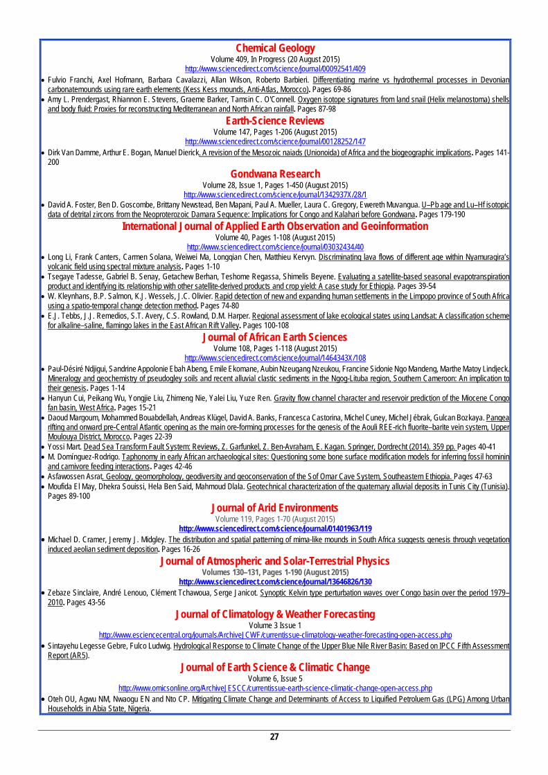
27
Chemical Geology Volume 409, In Progress (20 August 2015)
http://www.sciencedirect.com/science/journal/00092541/409 Fulvio Franchi, Axel Hofmann, Barbara Cavalazzi, Allan Wilson, Roberto Barbieri. Differentiating marine vs hydrothermal processes in Devonian
carbonatemounds using rare earth elements (Kess Kess mounds, Anti-Atlas, Morocco). Pages 69-86 Amy L. Prendergast, Rhiannon E. Stevens, Graeme Barker, Tamsin C. O'Connell. Oxygen isotope signatures from land snail (Helix melanostoma) shells
and body fluid: Proxies for reconstructing Mediterranean and North African rainfall. Pages 87-98 Earth-Science Reviews
Volume 147, Pages 1-206 (August 2015) http://www.sciencedirect.com/science/journal/00128252/147
Dirk Van Damme, Arthur E. Bogan, Manuel Dierick. A revision of the Mesozoic naiads (Unionoida) of Africa and the biogeographic implications. Pages 141-200
Gondwana Research Volume 28, Issue 1, Pages 1-450 (August 2015)
http://www.sciencedirect.com/science/journal/1342937X/28/1 David A. Foster, Ben D. Goscombe, Brittany Newstead, Ben Mapani, Paul A. Mueller, Laura C. Gregory, Ewereth Muvangua. U–Pb age and Lu–Hf isotopic
data of detrital zircons from the Neoproterozoic Damara Sequence: Implications for Congo and Kalahari before Gondwana. Pages 179-190 International Journal of Applied Earth Observation and Geoinformation
Volume 40, Pages 1-108 (August 2015) http://www.sciencedirect.com/science/journal/03032434/40
Long Li, Frank Canters, Carmen Solana, Weiwei Ma, Longqian Chen, Matthieu Kervyn. Discriminating lava flows of different age within Nyamuragira’s volcanic field using spectral mixture analysis. Pages 1-10
Tsegaye Tadesse, Gabriel B. Senay, Getachew Berhan, Teshome Regassa, Shimelis Beyene. Evaluating a satellite-based seasonal evapotranspiration product and identifying its relationship with other satellite-derived products and crop yield: A case study for Ethiopia. Pages 39-54
W. Kleynhans, B.P. Salmon, K.J. Wessels, J.C. Olivier. Rapid detection of new and expanding human settlements in the Limpopo province of South Africa using a spatio-temporal change detection method. Pages 74-80
E.J. Tebbs, J.J. Remedios, S.T. Avery, C.S. Rowland, D.M. Harper. Regional assessment of lake ecological states using Landsat: A classification scheme for alkaline–saline, flamingo lakes in the East African Rift Valley. Pages 100-108
Journal of African Earth Sciences Volume 108, Pages 1-118 (August 2015)
http://www.sciencedirect.com/science/journal/1464343X/108 Paul-Désiré Ndjigui, Sandrine Appolonie Ebah Abeng, Emile Ekomane, Aubin Nzeugang Nzeukou, Francine Sidonie Ngo Mandeng, Marthe Matoy Lindjeck.
Mineralogy and geochemistry of pseudogley soils and recent alluvial clastic sediments in the Ngog-Lituba region, Southern Cameroon: An implication to their genesis. Pages 1-14
Hanyun Cui, Peikang Wu, Yongjie Liu, Zhimeng Nie, Yalei Liu, Yuze Ren. Gravity flow channel character and reservoir prediction of the Miocene Congo fan basin, West Africa. Pages 15-21
Daoud Margoum, Mohammed Bouabdellah, Andreas Klügel, David A. Banks, Francesca Castorina, Michel Cuney, Michel Jébrak, Gulcan Bozkaya. Pangea rifting and onward pre-Central Atlantic opening as the main ore-forming processes for the genesis of the Aouli REE-rich fluorite–barite vein system, Upper Moulouya District, Morocco. Pages 22-39
Yossi Mart. Dead Sea Transform Fault System: Reviews, Z. Garfunkel, Z. Ben-Avraham, E. Kagan. Springer, Dordrecht (2014). 359 pp. Pages 40-41 M. Domínguez-Rodrigo. Taphonomy in early African archaeological sites: Questioning some bone surface modification models for inferring fossil hominin
and carnivore feeding interactions. Pages 42-46 Asfawossen Asrat. Geology, geomorphology, geodiversity and geoconservation of the Sof Omar Cave System, Southeastern Ethiopia. Pages 47-63 Moufida El May, Dhekra Souissi, Hela Ben Said, Mahmoud Dlala. Geotechnical characterization of the quaternary alluvial deposits in Tunis City (Tunisia).
Pages 89-100 Journal of Arid Environments
Volume 119, Pages 1-70 (August 2015) http://www.sciencedirect.com/science/journal/01401963/119
Michael D. Cramer, Jeremy J. Midgley. The distribution and spatial patterning of mima-like mounds in South Africa suggests genesis through vegetation induced aeolian sediment deposition. Pages 16-26
Journal of Atmospheric and Solar-Terrestrial Physics Volumes 130–131, Pages 1-190 (August 2015)
http://www.sciencedirect.com/science/journal/13646826/130 Zebaze Sinclaire, André Lenouo, Clément Tchawoua, Serge Janicot. Synoptic Kelvin type perturbation waves over Congo basin over the period 1979–
2010. Pages 43-56 Journal of Climatology & Weather Forecasting
Volume 3 Issue 1 http://www.esciencecentral.org/journals/ArchiveJCWF/currentissue-climatology-weather-forecasting-open-access.php
Sintayehu Legesse Gebre, Fulco Ludwig. Hydrological Response to Climate Change of the Upper Blue Nile River Basin: Based on IPCC Fifth Assessment Report (AR5).
Journal of Earth Science & Climatic Change Volume 6, Issue 5
http://www.omicsonline.org/ArchiveJESCC/currentissue-earth-science-climatic-change-open-access.php Oteh OU, Agwu NM, Nwaogu EN and Nto CP. Mitigating Climate Change and Determinants of Access to Liquified Petroluem Gas (LPG) Among Urban
Households in Abia State, Nigeria.
28
Journal of Hydrology Volume 527, Pages 1-1190 (August 2015)
http://www.sciencedirect.com/science/journal/00221694/527 Scott D. Meier, Eliot A. Atekwana, Loago Molwalefhe, Estella A. Atekwana. Processes that control water chemistry and stable isotopic composition during
the refilling of Lake Ngami in semiarid northwest Botswana. Pages 420-432 Journal of Metamorphic Geology
Volume 33, Issue 6. August 2015 Pages 557–670 http://onlinelibrary.wiley.com/doi/10.1111/jmg.2015.33.issue-6/issuetoc
C. B. Cross, J. F. A. Diener and Å. Fagereng. Metamorphic imprint of accretion and ridge subduction in the Pan-African Damara Belt, Namibia (pages 633–648).
Journal of Remote Sensing & GIS Volume 4, Issue 2
http://www.omicsgroup.org/journals/ArchiveJGRS/currentissue-geophysics-remote-sensing-open-access.php Elhoucine Essefia B*, Najoua Gharsallia B, Sabrine Kalabi AB, Mohamed AB and Yaicha BC. Spectral Analysis of a Core from the Sebkha of Sidi Mansour,
Southern Tunisia: The Holocene Cyclostratigraphy. Journal of Volcanology and Geothermal Research
Volume 301, Pages 1-332 (15 August 2015) http://www.sciencedirect.com/science/journal/03770273/301
S. Eisele, A. Freundt, S. Kutterolf, R.S. Ramalho, T. Kwasnitschka, K.-L. Wang, S.R. Hemming. Stratigraphy of the Pleistocene, phonolitic Cão Grande Formation on Santo Antão, Cape Verde. Pages 204-220
Boris Chako Tchamabé, Takeshi Ohba, Gabor Kereszturi, Karoly Németh, Festus Tongwa Aka, Dieudonné Youmen, Issa, Yasuo Miyabuchi, Seigo Ooki, Gregory Tanyileke, Joseph Victor Hell. Towards the reconstruction of the shallow plumbing system of the Barombi Mbo Maar (Cameroon) Implications for diatreme growth processes of a polygenetic maar volcano. Pages 293-313
Marine and Petroleum Geology Volume 65, Pages 1-342 (August 2015)
http://www.sciencedirect.com/science/journal/02648172/65 Jonny E. Wu, Ken McClay, Edyta Frankowicz. Niger Delta gravity-driven deformation above the relict Chain and Charcot oceanic fracture zones, Gulf of
Guinea: Insights from analogue models. Pages 43-62 Yousif M. Makeen, Mohammed Hail Hakimi, Wan Hasiah Abdullah. The origin, type and preservation of organic matter of the Barremian–Aptian organic-
rich shales in the Muglad Basin, Southern Sudan, and their relation to paleoenvironmental and paleoclimate conditions. Pages 187-197 Yousif Taha Hadad, Wan Hasiah Abdullah. Hydrocarbon source rock generative potential of the Sudanese Red Sea basin. Pages 269-289
Marine Environmental Research Volume 109, (August 2015)
http://www.sciencedirect.com/science/journal/01411136 Paolo Magni, Brahim Draredja, Khalil Melouah, Serena Como. Patterns of seasonal variation in lagoonal macrozoobenthic assemblages (Mellah lagoon,
Algeria). Pages 168-176 Ocean & Coastal Management
Volume 112, Pages 1-74 (August 2015) http://www.sciencedirect.com/science/journal/09645691/112
F.E. Jonah, N.W. Agbo, W. Agbeti, D. Adjei-Boateng, M.J. Shimba. The ecological effects of beach sand mining in Ghana using ghost crabs (Ocypode species) as biological indicators. Pages 18-24
Palaeogeography, Palaeoclimatology, Palaeoecology Volume 431, Pages 1-68 (1 August 2015)
http://www.sciencedirect.com/science/journal/00310182/431 Tsegai Medin, Bienvenido Martínez-Navarro, Florent Rivals, Yosief Libsekal, Lorenzo Rook. The late Early Pleistocene suid remains from the
paleoanthropological site of Buia (Eritrea): Systematics, biochronology and eco-geographical context. Pages 26-42 Precambrian Research
Volume 265, Pages 1-328 (August 2015) The structural, metamorphic and magmatic evolution of Mesoproterozoic orogens
Edited by Nick Roberts, Trond Slagstad and Giulio Viola http://www.sciencedirect.com/science/journal/03019268/265
W.P. Colliston, D.H. Cornell, A.E. Schoch, H.E. Praekelt. Geochronological constraints on the Hartbees River Thrust and Augrabies Nappe: New insights into the assembly of the Mesoproterozoic Namaqua-Natal Province of Southern Africa. Pages150-165
David H. Cornell, Valby van Schijndel, Siri L. Simonsen, Dirk Frei. Geochronology of Mesoproterozoic hybrid intrusions in the Konkiep Terrane, Namibia, from passive to active continental margin in the Namaqua-Natal Wilson Cycle. Pages 166-188
P. Mendonidis, R.J. Thomas, G.H. Grantham, R.A. Armstrong. Geochronology of emplacement and charnockite formation of the Margate Granite Suite, Natal Metamorphic Province, South Africa: Implications for Natal-Maud belt correlations. Pages 189-202
Christopher J. Spencer, Robert J. Thomas, Nick M.W. Roberts, Peter A. Cawood, Ian Millar, Simon Tapster. Crustal growth during island arc accretion and transcurrent deformation, Natal Metamorphic Province, South Africa: New isotopic constraints. Pages 203-217
Quaternary Geochronology Volume 29, Pages 1-116 (August 2015)
http://www.sciencedirect.com/science/journal/18711014 C. Tribolo, M. Rasse, S. Soriano, E. Huysecom. Defining a chronological framework for the Middle Stone Age in West Africa: Comparison of methods and
models for OSL ages at Ounjougou (Mali). Pages 80-96
29
Quaternary Science Reviews Volume 122, Pages 1-300 (15 August 2015)
http://www.sciencedirect.com/science/journal/02773791/122 Nick Blegen, Christian A. Tryon, J. Tyler Faith, Daniel J. Peppe, Emily J. Beverly, Bo Li, Zenobia Jacobs. Distal tephras of the eastern Lake Victoria basin,
equatorial East Africa: correlations, chronology and a context for early modern humans. Pages 89-111 Fabio Di Vincenzo, Laura Rodriguez, José Miguel Carretero, Carmine Collina, Denis Geraads, Marcello Piperno, Giorgio Manzi. The massive fossil humerus
from the Oldowan horizon of Gombore I, Melka Kunture (Ethiopia, >1.39 Ma). Pages 207-221 Remote Sensing of Environment
Volume 165, Pages 1-264 (August 2015) http://www.sciencedirect.com/science/journal/00344257/165
Marc T. Mayes, John F. Mustard, Jerry M. Melillo. Forest cover change in Miombo Woodlands: modeling land cover of African dry tropical forests with linear spectral mixture analysis. Pages 203-215
Waste Management Volume 42, Pages 1-208 (August 2015)
http://www.sciencedirect.com/science/journal/0956053X J.R. Kinobe, G. Gebresenbet, C.B. Niwagaba, B. Vinnerås. Reverse logistics system and recycling potential at a landfill: A case study from Kampala City.
Pages 82-92
Links to Journals, Reviews & Newsletters New entries in red AAPG Bulletin: http://aapgbull.geoscienceworld.org/ Acta Crystallographica Section A:
http://onlinelibrary.wiley.com/journal/10.1111/(ISSN)2053-2733 Acta Crystallographica Section B:
http://onlinelibrary.wiley.com/journal/10.1111/(ISSN)2052-5206 Acta Crystallographica Section C:
http://onlinelibrary.wiley.com/journal/10.1111/(ISSN)2053-2296 Acta Crystallographica Section D:
http://onlinelibrary.wiley.com/journal/10.1111/(ISSN)1399-0047 Acta Crystallographica Section E:
http://onlinelibrary.wiley.com/journal/10.1111/(ISSN)1600-5368 Acta Crystallographica Section F:
http://onlinelibrary.wiley.com/journal/10.1111/(ISSN)2053-230X Acta Geologica Sinica (English Edition):
http://onlinelibrary.wiley.com/doi/10.1111/acgs.2015.89.issue-1/issuetoc Acta Geologica Sinica: http://onlinelibrary.wiley.com/journal/10.1111/(ISSN)1755-6724 Advances in Materials Science and Engineering:
http://www.hindawi.com/journals/amse/ Advances in Space Research: http://www.sciencedirect.com/science/journal/02731177 Advances in Water Resources: http://www.sciencedirect.com/science/journal/03091708 Aeolian Research: http://www.sciencedirect.com/science/journal/18759637 African Journal of Ecology:
http://onlinelibrary.wiley.com/doi/10.1111/aje.2015.53.issue-1/issuetoc Agricultural Meteorology: http://www.sciencedirect.com/science/journal/00021571 Agricultural Water Management: http://www.sciencedirect.com/science/journal/03783774 American Mineralogist: http://ammin.geoscienceworld.org/ Annales de Paléontologie: http://www.sciencedirect.com/science/journal/07533969 Annals of Geophysics: http://www.annalsofgeophysics.eu/index.php/annals/index Anthropocene: http://www.sciencedirect.com/science/journal/22133054 Applied Clay Science: http://www.sciencedirect.com/science/journal/01691317 Applied Geochemistry: http://www.sciencedirect.com/science/journal/08832927 Arabian Journal of Earth Sciences:
http://www.arabianjournalofscience.com/index.php/AJES/index Area: http://onlinelibrary.wiley.com/journal/10.1111/(ISSN)1475-4762 ASLO: Limnology and Oceanography: http://www.aslo.org/lo/ ATBU Journal of Environmental Technology: http://www.ajol.info/index.php/atbu Atmospheric Environment: http://www.sciencedirect.com/science/journal/13522310 Atmospheric Research: http://www.sciencedirect.com/science/journal/01698095 Atmospheric Science Letters:
http://onlinelibrary.wiley.com/doi/10.1002/asl2.2015.16.issue-1/issuetoc Australian Journal of Earth Sciences:
http://onlinelibrary.wiley.com/journal/10.1111/(ISSN)1440-0952 Basin Research: http://onlinelibrary.wiley.com/journal/10.1111/(ISSN)1365-2117 Biogeosciences: http://www.biogeosciences.net/ Boreas: http://onlinelibrary.wiley.com/journal/10.1111/(ISSN)1502-3885 Bulletin of Canadian Petroleum Geologyhttp://bcpg.geoscienceworld.org/ Bulletin of Geosciences Czech Geological Survey: http://www.geology.cz/bulletin/ Bulletin of the Seismological Society of America: http://bssa.geoscienceworld.org/ Canadian Journa of Earth Sciences: http://cjes.geoscienceworld.org/
Canadian Mineralogist: http://www.canmin.org/ CATENA: http://www.sciencedirect.com/science/journal/03418162 Chem Sus Chem: http://onlinelibrary.wiley.com/journal/10.1002/(ISSN)1864-564X Chemical Geology: http://www.sciencedirect.com/science/journal/00092541 Chemie der Erde: Geochemistry: http://www.sciencedirect.com/science/journal/00092819 Chinese Journal of Geophysics:
http://agupubs.onlinelibrary.wiley.com/agu/journal/10.1002/(ISSN)2326-0440/ Clays and Clay Mineralshttp://ccm.geoscienceworld.org/ Cold Regions Science and Technology:
http://www.sciencedirect.com/science/journal/0165232X Comptes Rendus Geoscience:
http://www.sciencedirect.com/science/journal/16310713 Comptes Rendus Palevol: http://www.sciencedirect.com/science/journal/16310683 Computers & Geosciences: http://www.sciencedirect.com/science/journal/00983004 Computers and Geotechnics: http://www.sciencedirect.com/science/journal/0266352X Continental Shelf Research: http://www.sciencedirect.com/science/journal/02784343 Cretaceous Research: http://www.sciencedirect.com/science/journal/01956671 Crystal Research and Technology:
http://onlinelibrary.wiley.com/journal/10.1002/(ISSN)1521-4079 Crystals: http://www.mdpi.com/journal/crystals Current Opinion in Environmental Sustainability:
http://www.sciencedirect.com/science/journal/18773435 Current Science on-line: http://www.currentscience.ac.in/ Deep Sea Research Part II: Topical Studies in Oceanography:
http://www.sciencedirect.com/science/journal/09670645 Deep SeaResearch Part I: Oceanographic Research Papers:
http://www.sciencedirect.com/science/journal/09670637 Dendrochronologia: http://www.sciencedirect.com/science/journal/11257865 Directory of open access journals:
http://www.doaj.org/doaj?func=abstract&id=171996&toc=y Doklady Earth Sciences: http://www.maik.rssi.ru/cgi-
bin/journal.pl?name=earthsci&page=main Dynamics of Atmospheres and Oceans:
http://www.sciencedirect.com/science/journal/03770265 Earth and Planetary Science Letters:
http://www.sciencedirect.com/science/journal/0012821X Earth and Space Science:
http://agupubs.onlinelibrary.wiley.com/agu/journal/10.1002/(ISSN)2333-5084/ Earth Science Frontiers: http://www.sciencedirect.com/science/journal/18725791 Earth Science Reviews: http://www.sciencedirect.com/science/journal/00128252 Earth Surface Processes and Landforms:
http://onlinelibrary.wiley.com/journal/10.1002/(ISSN)1096-9837 Earth System Science: India: http://www.ias.ac.in/jess/index_body.html Earth’s Future: http://onlinelibrary.wiley.com/journal/10.1002/(ISSN)2328-4277 Ecohydrology: http://onlinelibrary.wiley.com/journal/10.1002/(ISSN)1936-0592 Elementa: Science of the Anthropocene: http://www.elementascience.org/ Elements: http://www.elementsmagazine.org/ Energies: http://www.mdpi.com/journal/energies Engineering Geology: http://www.sciencedirect.com/science/journal/00137952
30
Enseñanza de las ciencias de la tierra (Spanish): http://dialnet.unirioja.es/servlet/revista?codigo=1892
Environmental and Engineering Geoscience: http://eeg.geoscienceworld.org/ Environmental Health Perspectives: http://ehp.niehs.nih.gov/ Environmental Progress & Sustainable Energy:
http://onlinelibrary.wiley.com/journal/10.1002/(ISSN)1944-7450 Environmental Toxicology and Chemistry:
http://onlinelibrary.wiley.com/journal/10.1002/(ISSN)1552-8618 Environmetrics: http://onlinelibrary.wiley.com/journal/10.1002/(ISSN)1099-095X ENVOLVERDE: Revista Digital de Meio Ambiente e Desenvolvimento (Portuguese):
http://envolverde.com.br/ Eos, Transactions American Geophysical Union:
http://onlinelibrary.wiley.com/journal/10.1002/(ISSN)2324-9250 Episodes: http://www.episodes.co.in/ Estuarine, Coastal and Shelf Science:
http://www.sciencedirect.com/science/journal/02727714 Estudos Geologicos (Spanish):
http://estudiosgeol.revistas.csic.es/index.php/estudiosgeol/issue/archive European Journal of Mineralogy: http://eurjmin.geoscienceworld.org/ European Journal of Soil Science:
http://onlinelibrary.wiley.com/journal/10.1111/(ISSN)1365-2389 Evolution: Education and Outreach:
http://www.springer.com/life+sciences/evolutionary+%26+developmental+biology/journal/12052 Fuel Processing Technology: http://www.sciencedirect.com/science/journal/03783820 Fuel: http://www.sciencedirect.com/science/journal/00162361 Gems and Gemmology: http://www.gia.edu/gems-gemology Geoarcheology: http://onlinelibrary.wiley.com/journal/10.1002/(ISSN)1520-6548 Geobiology: http://onlinelibrary.wiley.com/journal/10.1111/(ISSN)1472-4669 Geobios: http://www.sciencedirect.com/science/journal/00166995 GEOBRASIL(Portuguese): http://www.geobrasil.net/geobrasil.htm Geochemistry, Geophysics, Gedosystems:
http://onlinelibrary.wiley.com/journal/10.1002/(ISSN)1525-2027 Geochemistry, Geophysics, Geosystems:
http://agupubs.onlinelibrary.wiley.com/agu/journal/10.1002/(ISSN)1525-2027/ Geochemistry: Exploration, Environment, Analysis:
http://geea.geoscienceworld.org/content/current Geochimica et Cosmochimica Acta:
http://www.sciencedirect.com/science/journal/00167037 Geoderma: http://www.sciencedirect.com/science/journal/00167061 Geofluids: http://onlinelibrary.wiley.com/journal/10.1111/(ISSN)1468-8123 Geografiska Annaler: Series A, Physical Geography:
http://onlinelibrary.wiley.com/journal/10.1111/(ISSN)1468-0459 Geography Compass: http://onlinelibrary.wiley.com/journal/10.1111/(ISSN)1749-8198 Geologica Acta: http://www.geologica-acta.com/ContentsAC.do Geological Journal: http://onlinelibrary.wiley.com/journal/10.1002/(ISSN)1099-1034 Geological Survey of Denmark and Greenland Bulletin:
http://www.geus.dk/publications/bull/index-uk.htm Geology (GSA): http://geology.gsapubs.org/ Geology Today: http://onlinelibrary.wiley.com/journal/10.1111/(ISSN)1365-2451 Geomorphology: http://www.sciencedirect.com/science/journal/0169555X Geophysical Journal Internationalhttp://gji.oxfordjournals.org/ Geophysical Prospecting: http://onlinelibrary.wiley.com/journal/10.1111/(ISSN)1365-
2478 Geophysical Research Letters:
http://agupubs.onlinelibrary.wiley.com/agu/journal/10.1002/(ISSN)1944-8007/ Geophysical Research: Space Physics:
http://agupubs.onlinelibrary.wiley.com/agu/jgr/journal/10.1002/(ISSN)2169-9402/ Geophysics (GSA): http://geophysics.geoscienceworld.org/ Geoscience Australia AusGeo:
http://www.ga.gov.au/ausgeonews/ausgeonews201309/ Geoscience Data Journal:
http://onlinelibrary.wiley.com/journal/10.1002/(ISSN)2049-6060 Geoscience e-Journals At-A-Glance: http://www.univ-brest.fr/geosciences/e-
journals/iconography.html Geoscience Frontiers: http://www.sciencedirect.com/science/journal/16749871 Geosciences: http://www.mdpi.com/journal/geosciences Geosphere: http://geosphere.geoscienceworld.org/ Geostandards and Geoanalytica lResearch:
http://onlinelibrary.wiley.com/journal/10.1111/(ISSN)1751-908X Geotextiles and Geomembranes: http://www.sciencedirect.com/science/journal/02661144 Geothermics: http://www.sciencedirect.com/science/journal/03756505 Global and Planetary Change:
http://www.sciencedirect.com/science/journal/09218181 Global Biogeochemical Cycles:
http://agupubs.onlinelibrary.wiley.com/agu/journal/10.1002/(ISSN)1944-9224/ Global Biogeochemical Cycles:
http://onlinelibrary.wiley.com/journal/10.1002/(ISSN)1944-9224
Global Ecology and Biogeography: http://onlinelibrary.wiley.com/journal/10.1111/(ISSN)1466-8238
Global Journal of Environmental Sciences: http://www.globaljournalseries.com/index.php/gjes
Global Journal of Geological Sciences: http://www.globaljournalseries.com/index.php/gggs Gondwana Research: http://www.sciencedirect.com/science/journal/1342937X Greenhouse Gases: Science and Technology:
http://onlinelibrary.wiley.com/journal/10.1002/(ISSN)2152-3878 Groundwater Monitoring & Remediation:
http://onlinelibrary.wiley.com/journal/10.1111/(ISSN)1745-6592 Groundwater: http://onlinelibrary.wiley.com/journal/10.1111/(ISSN)1745-6584 GSA-Bulletin: http://gsabulletin.gsapubs.org/ GSA-Field Guides Book Reviews: http://fieldguides.gsapubs.org/ GSA-Geological Society of America Bulletin: http://gsabulletin.gsapubs.org/ GSA-Geology: http://geology.gsapubs.org/ GSA-Geosphere: http://geosphere.gsapubs.org/ GSA-Lithosphere: http://lithosphere.gsapubs.org/ GSA-Memoirs: http://memoirs.gsapubs.org/ GSA-Reviews in Engineering Geology: http://reg.gsapubs.org/ GSA-Special Papers: http://specialpapers.gsapubs.org/ Hydrological Processes: http://onlinelibrary.wiley.com/journal/10.1002/(ISSN)1099-
1085 Hydrology and Earth System Sciences: http://www.hydrology-and-earth-system-
sciences.net/ Hydrology: Current Research:
http://www.omicsonline.org/ArchiveHYCR/currentissue-hydrology-current-research-open-access.php
Hydrometallurgy: http://www.sciencedirect.com/science/journal/0304386X Icarus: http://www.sciencedirect.com/science/journal/00191035 Inovative Energy and Research: http://www.omicsonline.com/open-
access/ArchiveIEP/currentissue-innovative-energy-policies-open-access.php International Councilfor Science (ICSU) Newsletter: http://www.icsu.org/news-centre/insight International Geosphere-Biosphere Programme (IGBP) E-bulletin: http://www.igbp.net/ International Journal of Applied Earth Observation and Geoinformation:
http://www.sciencedirect.com/science/journal/03032434 International Journal of Climatology:
http://onlinelibrary.wiley.com/journal/10.1002/(ISSN)1097-0088 International Journal of Coal Geology:
http://www.sciencedirect.com/science/journal/01665162 International Journal of Disaster Risk Reduction:
http://www.sciencedirect.com/science/journal/22124209 International Journal of Greenhouse Gas Control:
http://www.sciencedirect.com/science/journal/17505836 International Journal of Mineral Processing:
http://www.sciencedirect.com/science/journal/03017516 International Journal of Mining Science and Technology:
http://www.sciencedirect.com/science/journal/20952686 International Journal of Rock Mechanics and Mining Sciences:
http://www.sciencedirect.com/science/journal/13651609 International Journal of Sediment Research:
http://www.sciencedirect.com/science/journal/10016279 International Journal of Waste Resources: http://www.omicsonline.com/open-
access/ArchiveIJWR/currentissue-international-journal-waste-resources-open-access.php
International PeatJ ournal: http://www.peatsociety.org/publications/International -peat-journal
International Union of Geodesy and Geophysics (IUGG) E-Journals: http://www.iugg.org/publications/ejournals/
Interpretation: http://interpretation.geoscienceworld.org/ Island Arc: http://onlinelibrary.wiley.com/journal/10.1111/(ISSN)1440-1738 ISPRS International Journal of Geo-Information: http://www.mdpi.com/journal/ijgi ISPRS Journa of Photogrammetry and Remote Sensing:
http://www.sciencedirect.com/science/journal/09242716 Italian Journal of Geoscience: http://italianjgeo.geoscienceworld.org/ Journal for Nature Conservation: http://www.sciencedirect.com/science/journal/16171381 Journal of Advances in Modeling Earth Systems:
http://onlinelibrary.wiley.com/journal/10.1002/(ISSN)1942-2466 Journal of Aerosol Science: http://www.sciencedirect.com/science/journal/00218502 Journal of African Earth Sciences: http://www.sciencedirect.com/science/journal/1464343X Journal of Applied Geophysics: http://www.sciencedirect.com/science/journal/09269851 Journal of AppliedCrystallography:
http://onlinelibrary.wiley.com/journal/10.1111/(ISSN)1600-5767 Journal of Arid Environments: http://www.sciencedirect.com/science/journal/01401963 Journal of Asian Earth Sciences: http://www.sciencedirect.com/science/journal/13679120 Journal of Astrobiology & Outreach:
http://www.esciencecentral.org/journals/astrobiology-and-outreach.php
31
Journal of Astrophysics & Aerospace Technology: http://www.omicsgroup.org/journals/ArchiveJAAT/currentissue-astrophysics-aerospace-technology-open-access.php
Journal of Atmospheric and Solar-Terrestrial Physics: http://www.sciencedirect.com/science/journal/13646826
Journal of Climatology and Weather Forecasting: http://www.esciencecentral.org/journals/ArchiveJCWF/currentissue-climatology-weather-forecasting-open-access.php
Journal of Coastal Zone Managenent: http://www.omicsonline.com/open-access/ArchiveJCZM/currentissue-coastal-development-open-access.php
Journal of Contaminant Hydrology: http://www.sciencedirect.com/science/journal/01697722 Journal of Contemporary Water Research & Education:
http://onlinelibrary.wiley.com/journal/10.1111/(ISSN)1936-704X Journal of Earth Science and Climate Change:
http://www.omicsonline.org/ArchiveJESCC/currentissue-earth-science-climatic-change-open-access.php
Journal of Environmental & Engineering Geophysics: http://jeeg.geoscienceworld.org/
Journal of Environmental Quality: https://www.agronomy.org/publications/jeq Journal of Flood Risk Management:
http://onlinelibrary.wiley.com/journal/10.1111/(ISSN)1753-318X Journal of Foraminiferal Research: http://jfr.geoscienceworld.org/ Journal of Geochemical Exploration:
http://www.sciencedirect.com/science/journal/03756742 Journal of Geodynamics: http://www.sciencedirect.com/science/journal/02643707 Journal of Geography & Natural Disasters:
http://www.omicsgroup.org/journals/ArchiveJGND/currentissue-geography-natural-disasters-open-access.php
Journal of Geography and Regional Planning: http://www.academicjournals.org/JGRP/Archive.htm
Journal of Geology & Geophysics: http://www.omicsgroup.org/journals/ArchiveJGG/currentissue-geology-geosciences-open-access.php
Journal of Geophysical Research: Atmospheres: http://agupubs.onlinelibrary.wiley.com/agu/jgr/journal/10.1002/(ISSN)2169-8996/
Journal of Geophysical Research: Biogeosciences: http://agupubs.onlinelibrary.wiley.com/agu/jgr/journal/10.1002/(ISSN)2169-8961/
Journal of Geophysical Research: Earth Surface: http://agupubs.onlinelibrary.wiley.com/agu/jgr/journal/10.1002/(ISSN)2169-9011/
Journal of Geophysical Research: Oceans: http://agupubs.onlinelibrary.wiley.com/agu/jgr/journal/10.1002/(ISSN)2169-9291/
Journal of Geophysical Research: Planets: http://agupubs.onlinelibrary.wiley.com/agu/jgr/journal/10.1002/(ISSN)2169-9100/
Journal of Geophysical Research: Solid Earth: http://agupubs.onlinelibrary.wiley.com/agu/jgr/journal/10.1002/(ISSN)2169-9356/
Journal of Great Lakes Research: http://www.sciencedirect.com/science/journal/03801330 Journal of Hydrology: http://www.sciencedirect.com/science/journal/00221694 Journal of Integrated Coastal Management: http://www.aprh.pt/rgci/index_eng.html Journal of Integrated Coastal Zone Management / Revista de Gestão Costeira
Integrada: http://www.aprh.pt/rgci/revista14f4.html Journal of Marine Systems: http://www.sciencedirect.com/science/journal/09247963 Journal of Metamorphic Geology:
http://onlinelibrary.wiley.com/journal/10.1111/(ISSN)1525-1314 Journal of Meteorology and Climate Science: http://www.ajol.info/index.php/jmcs Journal of Mining and Geology (Nigeria): http://www.ajol.info/index.php/jmg/index Journal of Natural Gas Science and Engineering:
http://www.sciencedirect.com/science/journal/18755100 Journal of Paleontology (GSA): http://jpaleontol.geoscienceworld.org/ Journal of Petroleum Geology:
http://onlinelibrary.wiley.com/journal/10.1111/(ISSN)1747-5457 Journal of Petroleum Geology: http://www.jpg.co.uk/ Journal of Petroleum Science and Engineering:
http://www.sciencedirect.com/science/journal/09204105 Journal of Petroleum Technology: http://www.spe.org/jpt/ Journal of Quaternary Science:
http://onlinelibrary.wiley.com/journal/10.1002/(ISSN)1099-1417 Journal of Remote Sensing and GIS:
http://www.omicsgroup.org/journals/ArchiveJGRS/currentissue-geophysics-remote-sensing-open-access.php
Journal of Rock Mechanics and Geotechnical Engineering: http://www.sciencedirect.com/science/journal/16747755
Journal of Sedimentary Research: http://jsedres.geoscienceworld.org/ Journal of Soil and Water Conservation: http://www.jswconline.org/ Journal of South American Earth Sciences:
http://www.sciencedirect.com/science/journal/08959811 Journal of Structural Geology-http://www.sciencedirect.com/science/journal/01918141 Journal of Sustainable Development in Africa: http://www.jsd-africa.com/
Journal of Synchrotron Radiation: http://onlinelibrary.wiley.com/journal/10.1111/(ISSN)1600-5775
Journal of Terramechanics: http://www.sciencedirect.com/science/journal/00224898 Journal of Tethys: http://jtethys.org/ Journal of the Geological Society: http://jgs.geoscienceworld.org/ Journal of Unconventional Oil and Gas Resources:
http://www.sciencedirect.com/science/journal/22133976 Journal of Volcanology and Geothermal Research:
http://www.sciencedirect.com/science/journal/03770273 Laboratório Nacional de Engenharia e Geologia (Portuguese):
http://www.lneg.pt/iedt/unidades/16/paginas/26/30/38 Lakes & Reservoirs: Research & Management:
http://onlinelibrary.wiley.com/journal/10.1111/(ISSN)1440-1770 Land Degradation & Development:
http://onlinelibrary.wiley.com/journal/10.1002/(ISSN)1099-145X Lethaia: http://onlinelibrary.wiley.com/journal/10.1111/(ISSN)1502-3931 Limnology and Oceanography Bulletin:
http://onlinelibrary.wiley.com/journal/10.1002/(ISSN)1539-6088 Limnology and Oceanography e-Lectures:
http://onlinelibrary.wiley.com/journal/10.1002/(ISSN)2164-0254 Limnology and Oceanography: Fluids and Environments:
http://onlinelibrary.wiley.com/journal/10.1002/(ISSN)2157-3689 Limnology and Oceanography:
http://onlinelibrary.wiley.com/journal/10.1002/(ISSN)1939-5590 Limnology and Oceanography: Methods:
http://onlinelibrary.wiley.com/journal/10.1002/(ISSN)1541-5856 Lithology and Mineral Resources: http://www.springerlink.com/content/106290/ Lithos: http://www.sciencedirect.com/science/journal/00244937 Lithosphere: http://lithosphere.gsapubs.org/ Madagascar Conservation & Development: http://www.ajol.info/index.php/mcd Mantle Plumes: http://www.mantleplumes.org/RecentPapers.html Marine and Petroleum Geology: http://www.sciencedirect.com/science/journal/02648172 Marine Chemistry: http://www.sciencedirect.com/science/journal/03044203 Marine Ecology: http://onlinelibrary.wiley.com/journal/10.1111/(ISSN)1439-0485 Marine Environmental Research:
http://www.sciencedirect.com/science/journal/01411136 Marine Geology: http://www.sciencedirect.com/science/journal/00253227 Marine Micropaleontology: http://www.sciencedirect.com/science/journal/03778398 Marine Pollution Bulletin: http://www.sciencedirect.com/science/journal/0025326X Meteoritics & Planetary Science:
http://onlinelibrary.wiley.com/journal/10.1111/(ISSN)1945-5100 Meteorological Applications:
http://onlinelibrary.wiley.com/journal/10.1002/(ISSN)1469-8080 Mineral Research & Exploration Bulletin (Turkey):
http://www.mta.gov.tr/v2.0/eng/all-bulletins.php?id=145#down Mineralium Deposita: http://link.springer.com/journal/126 Mineralogical Magazine: http://minmag.geoscienceworld.org/content/current Minerals Engineering: http://www.sciencedirect.com/science/journal/08926875 Minerals: http://www.mdpi.com/journal/minerals Mining Science and Technology (China):
http://www.sciencedirect.com/science/journal/16745264 Mining Weekly: http://www.miningweekly.com/ Mires and Peat: http://mires-and-peat.net/pages/volumes.php Monthly Notes of the Astronomical Society of Southern Africa: http://www.mnassa.org.za/ Natural Gas & Electricity: http://onlinelibrary.wiley.com/journal/10.1002/(ISSN)1545-
7907 Natural Resources Forum:
http://onlinelibrary.wiley.com/journal/10.1111/(ISSN)1477-8947 Nature: http://www.nature.com/nature/index.html NERC Open Research Archive: http://nora.nerc.ac.uk/ New Scientist: http://www.sciencedirect.com/science/journal/02624079 New Zealand Journal of Geology & Geophysics:
http://www.royalsociety.org.nz/publications/journals/nzjg Ocean & Coastal Management: http://www.sciencedirect.com/science/journal/09645691 Ocean Modelling: http://www.sciencedirect.com/science/journal/14635003 Oil and Energy Trends: http://onlinelibrary.wiley.com/journal/10.1111/(ISSN)1744-7992 Oil Geology in Geology & Geophysics: Africa - Offshore Magazine:
http://www.offshore-mag.com/geology-geophysics/africa.html OPEC Energy Review: http://onlinelibrary.wiley.com/journal/10.1111/(ISSN)1753-0237 Ore Geology Reviews: http://www.sciencedirect.com/science/journal/01691368 Organic Geochemistry: http://www.sciencedirect.com/science/journal/01466380 PAGES – Past Global Changes – Magazine: http://www.pages-igbp.org/ Palaeogeography, Palaeoclimatology, Palaeoecology:
http://www.sciencedirect.com/science/journal/00310182 Palaeoworld: http://www.sciencedirect.com/science/journal/1871174X Paleoceanography:
http://agupubs.onlinelibrary.wiley.com/agu/journal/10.1002/(ISSN)1944-9186/
32
Paleontology: http://onlinelibrary.wiley.com/journal/10.1111/(ISSN)1475-4983 Palynology: http://palynology.geoscienceworld.org/ Papers in Palaeontology: http://onlinelibrary.wiley.com/journal/10.1002/(ISSN)2056-
2802 Petroleum Exploration and Development:
http://www.sciencedirect.com/science/journal/18763804 Petroleum Geoscience: http://pg.eage.org/publication/latestissue?p=3 Photogrammetria: http://www.sciencedirect.com/science/journal/00318663 Physics and Chemistry of the Earth, PartsA/B/C:
http://www.sciencedirect.com/science/journal/14747065 Physics of the Earth and Planetary Interiors:
http://www.sciencedirect.com/science/journal/00319201 Planetary and Space Science: http://www.sciencedirect.com/science/journal/00320633 PLOSONE: http://www.plosone.org/ Polar Research: http://onlinelibrary.wiley.com/journal/10.1111/(ISSN)1751-8369 Polar Science: http://www.sciencedirect.com/science/journal/18739652 Precambrian Research: http://www.sciencedirect.com/science/journal/03019268 Procedia Earth and Planetary Science:
http://www.sciencedirect.com/science/journal/18785220 Proceedings of the Geologists' Association:
http://www.sciencedirect.com/science/journal/00167878 Proceedings of the National Academy of Sciences of the United States of America:
http://www.pnas.org/ ProGEO–The European Association for the Conservation of the Geological
Heritage: http://www.progeo.se/ Progress in Oceanography: http://www.sciencedirect.com/science/journal/00796611 Progress in Physical Geography: http://ppg.sagepub.com/ Quarterly Journal of Engineering Geology and Hydrogeology:
http://qjegh.geoscienceworld.org/ Quarterly Journal of Engineering Geology and Hydrogeology:
http://qjegh.geoscienceworld.org/ Quaternary Geochronology: http://www.sciencedirect.com/science/journal/18711014 Quaternary International: http://www.sciencedirect.com/science/journal/10406182 Quaternary Research: http://www.sciencedirect.com/science/journal/00335894 Quaternary Science Reviews: http://www.sciencedirect.com/science/journal/02773791 Remote Sensing of Environment:
http://www.sciencedirect.com/science/journal/00344257 Remote Sensing: http://www.mdpi.com/journal/remotesensing Resources Policy: http://www.sciencedirect.com/science/journal/03014207 Review of Palaeobotany and Palynology:
http://www.sciencedirect.com/science/journal/00346667 Revista de Geociencias (Portuguese): http://www.revistageociencias.com.br/ Revista geologica de Chile (Spanish):
http://www.scielo.cl/scielo.php?script=sci_issuetoc&pid=0716-020820050002&lng=es&nrm=iso
Revue de Micropaléontologie (French): http://www.sciencedirect.com/science/journal/00351598
River Research and Applications: http://onlinelibrary.wiley.com/journal/10.1002/(ISSN)1535-1467
Royal Society Publishing: Earth Sciences: http://royalsocietypublishing.org/site/authors/earthscience.xhtml
Russian Geology and Geophysics: http://www.sciencedirect.com/science/journal/10687971 Science Frontiers Digest of Scientific Anomalies: http://www.science-
frontiers.com/index.htm
Science Magazine Online: http://www.sciencemag.org/contents-by-date.0.shtml Sedimentary Geology: http://www.sciencedirect.com/science/journal/00370738 Sedimentology: http://onlinelibrary.wiley.com/journal/10.1111/(ISSN)1365-3091 Seismological Research Letters: http://www.seismosoc.org/publications/srl/srl-toc.php Société Algérienne de Géophysique (SAGA) Newsletter: http://www.sag.dz/ Soil Dynamics and Earthquake Engineering:
http://www.sciencedirect.com/science/journal/02677261 Soil Use and Management:
http://onlinelibrary.wiley.com/journal/10.1111/(ISSN)1475-2743 Soils and Foundations: http://www.sciencedirect.com/science/journal/00380806 South African Journal of Geology: http://sajg.geoscienceworld.org/archive/ South African Journal of Plant and Soil: http://www.ajol.info/index.php/sajps Space Research Today: http://www.sciencedirect.com/science/journal/17529298 Spatial Statistics: http://www.sciencedirect.com/science/journal/22116753 Tectonics: http://agupubs.onlinelibrary.wiley.com/agu/journal/10.1002/(ISSN)1944-9194/ Tectonophysics: http://www.sciencedirect.com/science/journal/00401951 Terra Nova: http://onlinelibrary.wiley.com/journal/10.1111/(ISSN)1365-3121 The Anthropocene Review: http://anr.sagepub.com/ The Depositional Record: http://onlinelibrary.wiley.com/journal/10.1002/(ISSN)2055-
4877 The Egyptian Journal of Remote Sensing and Space Science:
http://www.sciencedirect.com/science/journal/11109823 The Geographical Journal:
http://onlinelibrary.wiley.com/journal/10.1111/(ISSN)1475-4959 The Leading Edge: http://tle.geoscienceworld.org/ The Open Geology Journal: http://bentham.org/open/togeoj/index.htm The Photogrammetric Record:
http://onlinelibrary.wiley.com/journal/10.1111/(ISSN)1477-9730 Transactions in GIS: http://onlinelibrary.wiley.com/journal/10.1111/(ISSN)1467-9671 Trends in Ecology & Evolution: http://www.sciencedirect.com/science/journal/01695347 Tunnelling and Underground Space Technology:
http://www.sciencedirect.com/science/journal/08867798 Turkish Journal of Earth Sciences: http://journals.tubitak.gov.tr/earth/index.php UN-SPIDER Knowledge Portal: http://www.un-spider.org/about/updates/ Urban Climate: http://www.sciencedirect.com/science/journal/22120955 Vadose Zone Journal: http://vzj.geoscienceworld.org/ Volumina Jurassica: http://voluminajurassica.org/ Waste Management: http://www.sciencedirect.com/science/journal/0956053X Water and Environment Journal:
http://onlinelibrary.wiley.com/journal/10.1111/(ISSN)1747-6593 Water Research: http://www.sciencedirect.com/science/journal/00431354 Water Resources Research:
http://agupubs.onlinelibrary.wiley.com/agu/journal/10.1002/(ISSN)1944-7973/ Wave Motion: http://www.sciencedirect.com/science/journal/01652125 Weather and Climate Extremes: http://www.sciencedirect.com/science/journal/22120947 Weather: http://onlinelibrary.wiley.com/journal/10.1002/(ISSN)1477-8696 Wetlands Ecology and Management: http://link.springer.com/journal/11273 Wiley Interdisciplinary Reviews: Climate Change:
http://onlinelibrary.wiley.com/journal/10.1002/(ISSN)1757-7799 Wiley Interdisciplinary Reviews: Water:
http://onlinelibrary.wiley.com/journal/10.1002/(ISSN)2049-1948 Zeitschrift für anorganische und allgemeine Chemie:
http://onlinelibrary.wiley.com/journal/10.1002/(ISSN)1521-3749
INTERESTING SITES / SOFTWARE Numbat3D "3D facies models of petroleum reservoirs": http://www.geologypage.com/2014/08/numbat3d.html Surfer 13: full-function 3D visualization, contouring and surface modeling package. http://www.geologypage.com/2015/07/surfer13.html EllipseFit: integrated program for geological finite strain analysis: http://www.frederickvollmer.com/ellipsefit/index.html Elk (Sharpergeo), free geotechnical platform. http://www.geologypage.com/2014/11/Elk.html Latest Pluto map in Google Earth. http://www.gearthblog.com/blog/archives/2015/07/latest-pluto-map-google-earth.html
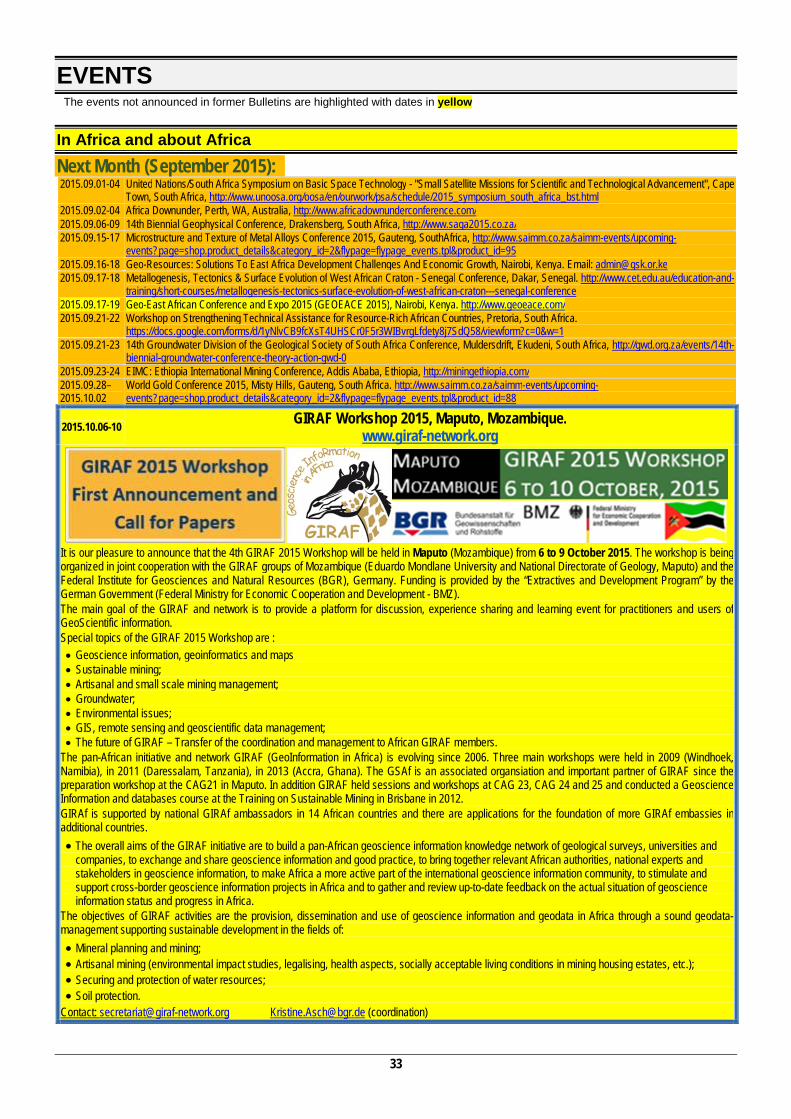
33
EVENTS The events not announced in former Bulletins are highlighted with dates in yellow
In Africa and about Africa Next Month (September 2015): 2015.09.01-04 United Nations/South Africa Symposium on Basic Space Technology - "Small Satellite Missions for Scientific and Technological Advancement", Cape
Town, South Africa, http://www.unoosa.org/oosa/en/ourwork/psa/schedule/2015_symposium_south_africa_bst.html 2015.09.02-04 Africa Downunder, Perth, WA, Australia, http://www.africadownunderconference.com/ 2015.09.06-09 14th Biennial Geophysical Conference, Drakensberg, South Africa, http://www.saga2015.co.za/ 2015.09.15-17 Microstructure and Texture of Metal Alloys Conference 2015, Gauteng, SouthAfrica, http://www.saimm.co.za/saimm-events/upcoming-
events?page=shop.product_details&category_id=2&flypage=flypage_events.tpl&product_id=95 2015.09.16-18 Geo-Resources: Solutions To East Africa Development Challenges And Economic Growth, Nairobi, Kenya. Email: [email protected] 2015.09.17-18 Metallogenesis, Tectonics & Surface Evolution of West African Craton - Senegal Conference, Dakar, Senegal. http://www.cet.edu.au/education-and-
training/short-courses/metallogenesis-tectonics-surface-evolution-of-west-african-craton---senegal-conference 2015.09.17-19 Geo-East African Conference and Expo 2015 (GEOEACE 2015), Nairobi, Kenya. http://www.geoeace.com/ 2015.09.21-22 Workshop on Strengthening Technical Assistance for Resource-Rich African Countries, Pretoria, South Africa.
https://docs.google.com/forms/d/1yNlvCB9fcXsT4UHSCr0F5r3WIBvrgLfdety8j7SdQ58/viewform?c=0&w=1 2015.09.21-23 14th Groundwater Division of the Geological Society of South Africa Conference, Muldersdrift, Ekudeni, South Africa, http://gwd.org.za/events/14th-
biennial-groundwater-conference-theory-action-gwd-0 2015.09.23-24 EIMC: Ethiopia International Mining Conference, Addis Ababa, Ethiopia, http://miningethiopia.com/ 2015.09.28–2015.10.02
World Gold Conference 2015, Misty Hills, Gauteng, South Africa. http://www.saimm.co.za/saimm-events/upcoming-events?page=shop.product_details&category_id=2&flypage=flypage_events.tpl&product_id=88
2015.10.06-10 GIRAF Workshop 2015, Maputo, Mozambique. www.giraf-network.org
It is our pleasure to announce that the 4th GIRAF 2015 Workshop will be held in Maputo (Mozambique) from 6 to 9 October 2015. The workshop is being organized in joint cooperation with the GIRAF groups of Mozambique (Eduardo Mondlane University and National Directorate of Geology, Maputo) and the Federal Institute for Geosciences and Natural Resources (BGR), Germany. Funding is provided by the “Extractives and Development Program” by the German Government (Federal Ministry for Economic Cooperation and Development - BMZ). The main goal of the GIRAF and network is to provide a platform for discussion, experience sharing and learning event for practitioners and users of GeoScientific information. Special topics of the GIRAF 2015 Workshop are : Geoscience information, geoinformatics and maps Sustainable mining; Artisanal and small scale mining management; Groundwater; Environmental issues; GIS, remote sensing and geoscientific data management; The future of GIRAF – Transfer of the coordination and management to African GIRAF members.
The pan-African initiative and network GIRAF (GeoInformation in Africa) is evolving since 2006. Three main workshops were held in 2009 (Windhoek, Namibia), in 2011 (Daressalam, Tanzania), in 2013 (Accra, Ghana). The GSAf is an associated organsiation and important partner of GIRAF since the preparation workshop at the CAG21 in Maputo. In addition GIRAF held sessions and workshops at CAG 23, CAG 24 and 25 and conducted a Geoscience Information and databases course at the Training on Sustainable Mining in Brisbane in 2012. GIRAf is supported by national GIRAf ambassadors in 14 African countries and there are applications for the foundation of more GIRAf embassies in additional countries. The overall aims of the GIRAF initiative are to build a pan-African geoscience information knowledge network of geological surveys, universities and
companies, to exchange and share geoscience information and good practice, to bring together relevant African authorities, national experts and stakeholders in geoscience information, to make Africa a more active part of the international geoscience information community, to stimulate and support cross-border geoscience information projects in Africa and to gather and review up-to-date feedback on the actual situation of geoscience information status and progress in Africa.
The objectives of GIRAF activities are the provision, dissemination and use of geoscience information and geodata in Africa through a sound geodata-management supporting sustainable development in the fields of: Mineral planning and mining; Artisanal mining (environmental impact studies, legalising, health aspects, socially acceptable living conditions in mining housing estates, etc.); Securing and protection of water resources; Soil protection.
Contact: [email protected] [email protected] (coordination)

34
2015.10.05-09 International Conference on the Rise of Animal LIfe: Cambrian and Ordovician biodiversification events", Marrakesh, Morocco, http://www.fstg-marrakech.ac.ma/rali2015/
2015.10.06-08 ECOMOF:ECOWAS Mining & Petroleum Forum, Accra, Ghana, http://www.ecomof.com/ 2015.10.12-14 International Symposium On Slope Stability In Open Pit Mining And Civil Engineering – Slope Stability 2015, Cape Town, South Africa,
http://www.saimm.co.za/saimm-events/upcoming-events?page=shop.product_details&category_id=2&flypage=flypage_events.tpl&product_id=87 2015.10.14-15 2014 Joburg Indaba. South Africa, http://www.joburgindaba.com/ 2015.10.26-30 1st International Conference on the Hydrology of African Large River Basins, Hammamet, Tunisia. Contact: [email protected] 2015.10.27-28 OIL & GAS SUMMIT'15: Fueling the Future – Angolan New Challenges, Luanda, Angola, https://oilgasacademy.files.wordpress.com/2014/11/ogslnd.jpg 2015.10.28-30 Nuclear Materials Development Network Conference, Port Elizabeth, South Africa, http://www.saimm.co.za/saimm-events/upcoming-
events?page=shop.product_details&category_id=2&flypage=flypage_events.tpl&product_id=84 2015.10.30 Mintek 5th Analytical Symposium – Quality Analytical Chemistry, Randburg, J’burg, SA
http://www.gssa.org.za/uploads/MintekAnalyticalScience5thSymposiumProgrammeRegistrationForm.pdf 2015.11.08-13 23rd International Symposium on Mine Planning & Equipment Selection - MPES2015 – Smart Innovation in Mining. Johannesburg, South Africa,
http://www.saimm.co.za/saimm-events/upcoming-events?page=shop.product_details&category_id=2&flypage=flypage_events.tpl&product_id=83 2015.11.11-13 Esri South Africa User Conference (AUC), Cape Town, South Africa.
http://www.esri.com/events/auc?utm_source=esri&utm_medium=email&utm_term=73903&utm_content=article&utm_campaign=2015_auc 2015.11.11&13 23rd International Symposium on Mine Planning & Equipment Selection - MPES2015, Smart Innovation in Mining, Johannesburg, South Africa.
http://www.saimm.co.za/saimm-events/upcoming-events?page=shop.product_details&category_id=2&flypage=flypage_events.tpl&product_id=83 2015.11.16-18 4th Regional South Africa YWP Conference and 1st African YWP Conference, Pretoria, South Africa, http://www.ywp-za.org/ 2015.11.17-19 JMP Mali 2015 - 6th International Mali Mining and Petroleum Conference & Exhibition, Bamako, Mali, http://jmpmali.com/ 2015.11.23-25 Hydro 2015 – Developing Sustainable Hidrography in Africa. Cape Town, South Africa. http://www.hydro2015.org/ 2015.11.24-26 8th International Conference on the Geology of Africa 2015, Assiut, Egypt. Contacts: [email protected]; [email protected] 2015.11.25-30 Origin and Evolution of the Cape Mountains and Karoo Basin. Port Elizabeth, South Africa. http://aeon.org.za/capekaroo 2015.12.02-04 Improving Sustainability Concept in Developing Countries (ISCDC), Cairo, Egypt. http://www.ierek.com/events/improving-sustainability-
concept-developing-countries/ 2015.12.18-20
Université Sidi Mohamed Ben Abdellah Faculté des Sciences Dhar El Mahraz, Fès
Organisent
Le 22éme Colloque International des Bassins Sédimentaires Sous le thème :
“Protection de l’environnement et Gestion durable des ressources naturelles”
Contacts: [email protected] [email protected]
2016 2016.03.14-20 “30 years after the Lake Nyos disaster”, Yaoundé, Cameroon, Greg Tanyileke: [email protected] or Dmitri Rouwet: [email protected] 2016.04.13-14 ine to Market Conference 2016, Emperors Palace, South Africa. http://www.saimm.co.za/saimm-events/upcoming-
events?page=shop.product_details&category_id=2&flypage=flypage_events.tpl&product_id=98 2016.05.01 Southern African Rock Engineering Symposium, Cape Town, South Africa. http://www.isrm.net/conferencias/detalhes.php?id=3267&show=conf 2016.06.27-29 International Conference on Mining and Metallurgy, Cape Town, South Africa. http://mining-metallurgy.conferenceseries.com/ 2016.08.16-19 10th Heavy Minerals Conference, "Expanding the horizon", Sun City, South Africa, http://www.saimm.co.za/saimm-events/upcoming-
events?page=shop.product_details&category_id=2&flypage=flypage_events.tpl&product_id=85 2016.08.27-2016.09.04
35th International Geological Congress (35 IGC), Cape Town, South Africa. http://www.35igc.org/
2016.08.27-
2016.09.04 2nd Circular: http://www.35igc.org/Content/Downloads/35th_IGC_Announcement_SecondCircular.pdf
2016.10.01-07 8th Conference of the AAWG, Sibiu, Romania. Email: [email protected]
2017 2017.09.18-22 11th International Kimberlite Conference, Gaborone, Botswana, http://www.11ikc.com/ (website not yet active!)
Rest of the World Next Month (September 2015): 2015.09.01-03 Sustainable City 2015 - 10th International Conference on Urban Regeneration and Sustainability, Medellin, Colombia. http://www.wessex.ac.uk/15-
conferences/sustainable-city-2015.html?utm_source=wit&utm_medium=email&utm_campaign=city15rem3&uid=225297 2015.09.02-04 Energy and Sustainability 2015 - 6th International Conference on Energy and Sustainability. Medellin, Colombia. http://www.wessex.ac.uk/15-
conferences/energy-and-sustainability-2015.html?utm_source=wit&utm_medium=email&utm_campaign=esus15rem1&uid=225297 2015.09.02-05 Mires of Northern Europe: Biodiversity, Dynamics, Management, Republic of Karelia, Petrozavodsk, Russia, [email protected] 2015.09.03-05 XXVII Reunião da Comissão de Tectónica da Sociedade Geológica da Espanha (27th Meeting of the Tectonical Commission of the Geological
Society of Spain), Miranda do Douro, Portugal. http://www.sociedadgeologica.es/comisiones/memorias_tectonica/Primera%20circular%20de%20la%20XXVII%20Reuni%C3%B3n%20de%20la%20Comisi%C3%B3n%20de%20Tect%C3%B3nica%20de%20la%20Sociedad%20Geol%C3%B3gica%20de%20Espa%C3%B1a_FINAL.pdf (in Spanish)
2015.09.05-07 Baltic Peat Forum, Tallinn, Estonia, http://www.turbaliit.ee
35
2015.09.05-11 67th Annual Meeting of the ICCP (International Committee for Coal & Organic Petrology), Potsdam, Germany, http://www.iccop.org/first-circular-for-the-67th-iccp-meeting-and-call-for-abstracts/
2015.09.05-13 International Association for Mathematical Geosciences (IAMG), Freiberg, Germany, http://eurogeologists.us8.list-manage.com/track/click?u=7622a1c0fc286079ff6a153b7&id=faa7f7ae9d&e=0b7c0ac1f2
2015.09.06-08 China Shale Gas 2015 – an ISRM Specialized Conference, Wuhan, China. http://www.isrm.net/conferencias/detalhes.php?id=3290&show=conf 2015.09.06-08 Energy Quest 2016 - International Conference on Energy Production and Management in the 21st Century, Ancona, Italy. http://www.wessex.ac.uk/16-
conferences/energy-quest-2016.html?utm_source=wit&utm_medium=email&utm_campaign=eq16cfp&uid=225297 2015.09.06-10 21st European Meeting of Environmental and Engineering Geophysics Near Surface Geoscience 2015, Turin, Italy.
http://www.eage.org/event/index.php?eventid=1119&Opendivs=s3 2015.09.06-10 1st Conference on Proximal Sensing Supporting Precision Agriculture Near Surface Geoscience 2015, Turin, Italy.
http://www.eage.org/event/index.php?eventid=1279&Opendivs=s3 2015.09.06-10 1st European Airborne Electromagnetics Conference Near Surface Geoscience 2015, Turin, Italy. http://www.eage.org/event/index.php?eventid=1325&Opendivs=s3 2015.09.07-10 Metamaterials 2015 – 9th International Congress on Advanced Electromagnetic Materials in Microwaves and Optics. Oxford, UK.
http://congress2015.metamorphose-vi.org/ 2015.09.07-10 Geomodel 2015 - 17th science and applied research conference on oil and gas geological exploration and development, Gelendzhik, Russia.
http://www.eage.org/event/index.php?eventid=1334&Opendivs=s3 2015.09.07-11 The World Multidisciplinary Earth Sciences Symposium – WMESS, Prague, Czech Republic, http://eurogeologists.us8.list-
manage.com/track/click?u=7622a1c0fc286079ff6a153b7&id=a7bcd8ce94&e=0b7c0ac1f2 2015.09.07-11 Petroleum Geostatistics 2015, Biarritz, France. http://www.eage.org/event/index.php?eventid=1155&Opendivs=s3 2015.09.08-12 The VIII International Symposium of ProGEO, Reykjavík, Iceland. http://www.progeo.se/Iceland2015_1circ.pdf 2015.09.09-11 The 5th European Conference on Crystal Growth ECCG5, Bologna, Italy. http://www.eccg5.eu/ 2015.09.13-15 42nd IAH International Congress, AQUA 2015, Rome, Italy, http://www.iah2015.org/ 2015.09.13-16 AAPG 2015 International Conference & Exhibition. Melbourne, Australia. http://ice.aapg.org/2015 2015.09.13-17 XVIECSMGE 2015 "Geotechnical Investigation for Infrastructure and Development", 16th European Conference on Soil Mechanics and Geotechnical
Engineering, Edinburgh, United Kingdom. http://xvi-ecsmge-2015.org.uk/ 2015.09.13-18 42nd IAH International Congress, Rome, Italy. http://www.iah2015.org/ 2015.09.14-16 United Nations International Conference on Space-based Technologies for Disaster Management - “A consolidating role in the implementation of the
Sendai Framework for Disaster Risk Reduction: 2015-2030”, Beijing, PR China. http://www.un-spider.org/BeijingConference2015 2015.09.17-18 CIMP2015 (Micropalentology), Bergen, Norway, http://www.tmsoc.org/cimp-meeting-2015/ 2015.09.17-19 III Simposio del Mioceno-Pleistoceno del Centro y Norte de Argentina, Corrientes, Argentina, http://alpaleobotanicapalinologia.blogspot.com/p/eventos.html 2015.09.20-24 4th International Conference on Fault and Top Seals. Artor Science? Almeria, Spain. http://www.eage.org/event/index.php?eventid=1154&Opendivs=s3 2015.09.20-23 Canadian Geotechnical Society Annual Meeting, GeoQuebec, Quebec, Canada. http://www.geoquebec2015.ca/ 2015.09.20-24 5th International Symposium on Soil Organic Matter 2015, Göttingen, Germany, http://www.som2015.org/ 2015.09.20-25 8th Hutton Symposium on Granites and Related Rocks. Florianopolis, Brazil. http://www.hutton8.com.br/ 2015.09.20-26 32nd TSOP (The Society of Organic Petrology) Annual Meeting Yogyakarta, Indonesia. http://tsop2015.ugm.ac.id/geo/ 2015.09.21-23 Symposium on the Iberian Atlantic Margin (MIA2015), Malaga, Spain, http://www.ma.ieo.es/MIA15/ingles.html 2015.09.21-24 LuWQ2015 – International Conference on LANDUSE and WATER QUALITY: Agricultural Production and the Environment, Vienna, Austria.
http://web.natur.cuni.cz/luwq2015/ 2015.09.21-25 Applied Isotope Geochemistry (AIG 11), Orléans, France. http://aig11.brgm.fr 2015.09.22-26 GEOINV2015 – Congress on Geoheritage Inventories, Toulouse, France, http://iugs.org/uploads/Flyer%20Geo%20inv%202015-1.pdf 2015.09.23-26 Geological Heritage Inventories:Achievements, Toulouse, France. http://iugs.org/uploads/GHI%20Conference%202015.pdf 2015.09.24-25 Workshop on Volcanic Rocks and Soils – an ISRM Specialised Conference, Isle of Ischia, Italy. http://www.wvrs-ischia2015.it/ 2015.09.26-27 10th Anniversary Asian Regional Conference of IAEG, Kyoto, Japan. http://2015ars.com/ 2015.09.27-30 Society of Economic Geologists (SEG) 2015 Conference: World-Class Ore Deposits: Discovery to Recovery, Hobart, Tasmania.
http://www.seg2015.org 2015.09.28 ISPRS Geospatial Week 2015, La Grande Motte, France. http://www.isprs-geospatialweek2015.org/ 2015.09.29–2015.10.02
Chapman Conference on Magnetospheric Dynamics, Fairbanks, Alaska, USA. http://chapman.agu.org/magnetospheric/
2015.10.01-06 German Congress for Geography, Berlin, Germany, http://www.dkg2015.hu-berlin.de/ 2015.10.04-08 MS&T’15: Materials Science & Technology Conference and Exhibition, combined with ACerS 117th Annual Meeting, Columbus, OH, USA.
http://ceramics.org/dates-deadlines/mst15-materials-science-technology-conference-and-exhibition-combined-with-acers-117th-annual-meeting
2015.10.05-08 32nd Annual International Pittsburgh Coal Conference, Pittsburgh, PA, USA, http://www.pccpitt.org/ 2015.10.05-08 8th Congress of the Balkan Geophysical Society, Chania, Greece, http://www.eage.org/event/index.php?eventid=1313&Opendivs=s3 2015.10.07-10 EUROCK 2015 – ISRM European Regional Symposium - 64th Geomechanics Colloquium, Salzburg, Austria. http://www.eurock2015.com/en/ 2015.10.10-17 International Conference on Geoethics in the framework of the Mining Pribram Symposium 2015, Prague and Pribram, Czech Republic. Contact:
[email protected]; [email protected]; [email protected] 2015.10.11-13 Geodesign Summit Europe, Salzburg, Austria,
http://geodesignsummit.com/europe/index.html?utm_source=esri&utm_medium=email&utm_term=102601&utm_content=banner&utm_campaign=geodesign_Summit_europe_2015
2015.10.12-13 APGCE 2015 Energising Asia Through Geoscience Ideas and Solutions, Kuala Lumpur, Malaysia, http://www.eage.org/event/index.php?eventid=1312&Opendivs=s3
2015.10.12-16 The 6th International Wildfire Conference, Gangwon, SouthKorea http://en.wildfire2015.kr/ 2015.10.13-15 The 3rd Sustainable Earth Sciences Conference & Exhibition: Use of the Sub-surface to Serve the Energy Transition, Celle, Germany,
http://www.eage.org/event/index.php?eventid=1259&Opendivs=s3 2015.10.16-21 15th Water Rock Interaction, Evora, Portugal. http://www.wri15portugal.org/ 2015.10.18-24 XIV Congreso Nacional de Paleontología México, Coahuila, Mexico, Contacto: [email protected] 2015.10.20-23 China Mining Conference and Exhibition, Tianjin, China, http://en.chinamining-expo.org/ 2015.10.22-23 Renewables, energy efficiency and carbon mitigation for mines, Toronto, Canada, http://energyandmines.com/toronto/ 2015.10.27-29 Golden Jubilee International Geotechnical Conference, New Delhi, India. http://www.egnmindia2015.org/ 2015.11.01-02 Bridging Two Continents. 2nd joint scientific meeting of GSA and GSC, Baltimore, Maryland, USA. http://www.geosociety.org/meetings/15china/ 2015.11.01-05 GSA 2015, Baltimore, USA, http://www.globaleventslist.elsevier.com/events/2015/11/the-geological-society-of-america-gsa-2015-annual-meeting/ 2015.11.02-04 6ICEGE - 6th International Conference on Earthquake Geotechnical Engineering, Christchurch, New Zealand. http://www.6icege.com/
36
2015.11.02-06 Future of Earth-Space Science and Education, Trieste, Italy. http://indico.ictp.it/event/a14272/material/2/0.pdf 2015.11.03-05 10th Fennoscandian Exploration and Mining. Levi, Finland. http://10times.com/fem-levi 2015.11.05-06 Atlantic Property and Prospect Expo (APPEX) meeting, Nice, France.
https://europeevents.aapg.org/ehome/appexregional2015/Welcome/?utm_source=TouchBasePro-Email:The+Geological+Society+of+South+Africa&utm_medium=TouchBasePro%20Email%20Campaign&[email protected]&utm_content=8%2f6%2f2015&utm_campaign=TouchBasePro-Email:AAPG+-+The+Atlantic+Property+and+Prospect+Expo+(APPEX)+November+2015
2015.11.05-08 The Association of Canadian Universities for Northern Studies, 11th Student Conference, Calgary, Canada, http://arctic.ucalgary.ca/acuns-2015-student-conference
2015.11.09-13 15th Asian Regional Conference on Soil Mechanics and Geotechnical Engineering – New Innovations and Sustainability, Kyushu, Japan. http://jgskyushu.jp/xoops/uploads/15ARC/
2015.11.15-18 VIII PanAmerican Conference on Soil Mechanics and Geotechnical Engineering, Buenos Aires, Argentina. http://conferencesba2015.com.ar/website/viii-south-american-congress-on-rocks-mechanics/welcome/
2015.11.16-18 International Conference and Expo on Oil and Gas, Dubai, UAE http://oil-gas.omicsgroup.com/ 2015.11.25-27 ISPRSWGIV/4 and FIG Commission 2, International Workshop on Strengthening Education for Land Professionals and Opportunities for SDI
Development, Kathmandu, Nepal. Contact:[email protected] 2015.11.25-27 3rd Coastal and Maritime Mediterranean Conference, Ferrara, Italy, http://www.paralia.fr/ferrara_2015_880.htm 2015.11.26-28 Geo-Environment and Construction European Conference, Tirana, Albania. http://www.issmge.org/en/conferences-and-events/conferences-
issmge/eventdetail/566/-/geo-environment-and-construction-european-conference 2015.11.29-2015.12.04
MRS Fall Meeting & Exhibit, Boston, MA, USA. http://www.mrs.org/fallmeetings
2015.12.05-08 AsCA 2015 Science City, Kolkata, India, http://www.asca2015.org/ 2015.12.07-09 Global Summit on Petroliferous Basins December, Philadelphia, USA. http://petroliferousbasins.global-summit.com/ 2015.12.14-16 2015 Canberra Conference on Earth System Governance :"Democracy and Resilience in theA nthropocene", Canberra, Australia
http://www.earthsystemgovernance.org/news/2015-01-12-canberra-conference-earth-system-governance-call-papers
2016 2016.01.08-22 10th International Symposium on Environmental Geochemistry (ISEG10), Perth, Western Australia. http://www.iseg10.com 2016.01.24-29 International Conference and Expo on Advanced Ceramics and Composites (ICACC’16), Daytona Beach, Florida, USA.
http://ceramics.org/meetings/40th-international-conference-and-expo-on-advanced-ceramics-and-composites/icacc16-exhibitor-information/icacc16-expo-directory
2016.01.26-29 5th International Geologica Belgica Congress, Mons, Belgium. http://eurogeologists.us8.list-manage1.com/track/click?u=7622a1c0fc286079ff6a153b7&id=728c5d905e&e=0b7c0ac1f2
2016.02.21-26 AGU 2016 Ocean Sciences Meeting, New Orleans, Louisiana, USA. http://meetings.agu.org/meetings/os16/ 2016.03.13-17 ACS National Meeting & Exposition, San Diego, CA, USA. http://www.acs.org 2016.04.11-12 3rd International Conference on Geology, Dubai, UAE http://geology.conferenceseries.com/ 2016.05.10-12 7th In-Situ Rock Stress Symposium 2016, Tampere, Finland. http://www.isrm.net/conferencias/detalhes.php?id=3297&show=conf 2016.05.10-13 4th International Climate Change Adaptation Conference, Rotterdam, The Netherlands. http://www.adaptationfutures2016.org/ 2016.05.24-26 SUSI 2016 - 14th International Conference on Structures Under Shock and Impact, Crete, Greece. http://www.wessex.ac.uk/16-conferences/susi-
2016.html?utm_source=wit&utm_medium=email&utm_campaign=susi16rem1&uid=225297 2016.05.25-27 GEOSAFE: 1st International Symposium on Reducing Risks in Site Investigation, Modelling and Construction for Rock Engineering, X'ian, China.
http://www.isrm.net/conferencias/detalhes.php?id=3289&show=conf 2016.05.25-27 Risk Analysis 2016 - 10th International Conference on Risk Analysis, Crete, Greece. http://www.wessex.ac.uk/16-conferences/risk-analysis-
2016.html?utm_source=wit&utm_medium=email&utm_campaign=risk16rem1&uid=225297 2016.05.25-28 NGM 2016, The Nordic Geotechnical Meeting, Reykjavik, Iceland. http://www.ngm2016.com 2016.06.01-03 Geological Association of Canada – Mineraological Association of Canada Annual Meeting, From the Margin of Laurentia, to the Margin of Beringia,
to the Margin of Society Whitehorse, Yukon, Canada. http://whitehorse2016.ca/ 2016.06.07-09 Waste Management 2016 - 8th International Conference on Waste Management and the Environment, Valencia, Spain, http://www.wessex.ac.uk/16-
conferences/waste-management-2016.html?utm_source=wit&utm_medium=email&utm_campaign=wm16cfp&uid=225297 2016.06.08-10 3rd International Conference on Environmental and Economic Impact on Sustainable Development, Valencia, Spain, http://www.wessex.ac.uk/16-
conferences/environmental-impact-2016.html?utm_source=wit&utm_medium=email&utm_campaign=eid16cfp&uid=225297 2016.06.19-22 AAPG2016 Annual Convention & Exhibition, Calgary, Alberta, Canada.
http://www.aapg.org/events/conferences/ace/announcement/articleid/5662/aapg-2016-annual-convention-exhibition 2016.06.26-27 International Conference on Intelligent Earth Observing and Applications, Guilin, China. http://www.glut.edu.cn/Git/Index.asp 2016.06.26-2016.07.01
Goldschmidt Conference 2015, Yokohama, Japan, http://goldschmidt.info/2016/
2016.06.29-2016.07.01
FRIAR 2016 - 5th International Conference on Flood Risk Management and Response, Venice, Italy. http://www.wessex.ac.uk/16-conferences/friar-2016.html?utm_source=wit&utm_medium=email&utm_campaign=friar16rem1&uid=225297
2016.07.21-22 2nd Global Geologists Annual Meeting, Brisbane, Australia. http://annualmeeting.conferenceseries.com/geologists/ 2016.07.21-23 World Congress on Petroleum and Refinery. Brisbane, Australia. http://petroleum.omicsgroup.com/ 2016.07.24-28 Microscopy & Microanalysis 2016, Columbus, OH, USA. http://www.microprobe.org 2016.07.25-27 GeoChina 2016, Shandong, China. http://geochina2016.geoconf.org/ 2016.07.25-27 5th International Conference on Earth Science & Climate Change, Bangkok, Thailand. http://earthscience.conferenceseries.com/ 2016.08.01-06 16th International Summer School on Crystal Growth - ISSCG-16, Otsu, Shiga, Japan. http://www.iccge18.jp/isscg16/ 2016.08.07-08 18th International Conference on Crystal Growth and Epitaxy ICCGE-18, Nagoya, Japan, http://www.iccge18.jp/ 2016.08.07-12 Annual Meeting of the Meteoritical Society, Berlin, Germany. http://www.meteoriticalsociety.org 2016.08.15-19 15th International Peat Congress - "Peatland in Harmony-Agriculture, Industry, Nature", Kuching, Malaysia, http://www.ipc2016.com 2016.08.21-25 252nd ACS National Meeting & Exposition, Philadelphia, PA, USA. http://www.acs.org 2016.08.21-26 International Congress on Ceramics (ICC6), Dresden, Germany. http://www.icc-6.com 2016.08.29-31 EUROCK2016 – The 2016 ISRM International Symposium-Rock Mechanics & Rock Engineering, Ürgüp-Nevşehir, Turkey. http://eurock2016.org/ 2016.09.04-07 3rd ICTG International Conference on Transportation Geotechnics, Guimaraes, Portugal. http://www.webforum.com/tc3 2016.09.05-09 International Ni-Cu-PGE Symposium, Perth-Fremantle, Western Australia. http://geoconferences.org.au/events/13th-international-nickel-
copper-pge-symposium/ 2016.09.11-15 EMC2016 - 2nd European Mineralogical Conference, Rimini, Italy. http://emc2016.socminpet.it
37
2016.09.15-17 13th Baltic States Geotechnical Conference, Vilnius, Lithuania. http://www.13bsgc.lt 2016.09.25-28 Geological Society of America Annual Meeting, Denver, CO, USA. http://www.geosociety.org/meetings 2016.10.01 ARMS9 - 9th Asian Rock Mechanics Symposium, Bali, Indonesia. http://www.isrm.net/conferencias/detalhes.php?id=3268&show=conf 2016.10.16-18 Recent Advances in Rock Engineering - RARE2016, Bangalore, India. http://www.isrm.net/conferencias/detalhes.php?id=3312&show=conf 2016.10.16-21 15 Water Rock Interation, Évora, Portugal. http://wri15portugal.org/
2017 2017.04.14-17 24th International Mining Congress and Exhibition of Turkey (IMCET2015), Antalya, Turkey http://imcet.org.tr/defaulten.asp 2017.07.02-07 28th International Cartographic Conference. Washington, D.C., USA. http://www.icc2017.org/ 2017.07.17-21 XVI ICC International Clay Conference, Granada, Spain, http://www.16icc.org/
PROFESSIONAL COURSES/WORKSHOPS/SCHOLARSHIPS
ICCP Training Course: Organic Petrology for Industrial Applications
Courses on Air Pollution
01 – 04 September2015 GFZ, Potsdam, Germany http://www.iccop.org/8th-course-potsdam/
7-9 September 2015: Fundamentals of Air Quality and Climate Change 9-11 September 2015: Air Pollution: From Local to Global
Ashurst, Southampton, UK http://www.wessex.ac.uk/courses/courses-on-air-
pollution.html?utm_source=wit&utm_medium=email&utm_campaign=sc-air15&uid=225297
Geological Skills for a Young Professional
Technical and Financial Evaluation of Mineral Projects
11-12 September 2015 11.09.2015 – Sturrock Park, Wits University
12.09.2015 – CGS, Pretoria. Announcement: http://www.rca.co.za/files/michelle/GSSA%20GeoSkillsSept2015/GeoSkills2015Announcement5Aug2015(1).pdf Registration: http://www.rca.co.za/files/michelle/GSSA%20GeoSkillsSept2015/GeoSkills2015Announcement5Aug2015(1).pdf
14-18 September 2015 Organised by the Wits Business School Executive Education programme, University of Witwatersrand and the Centre for Continuing Professional Development, Imperial College London in collaboration with Ernst and Young. Brigitte Lerena, Telephone: +27 11 717 3694, Email: [email protected] Visit our website: http://www.wbs.ac.za/programmes/executive_education/finance or www.imperial.ac.uk/cpd/minevalsa
Short Course on Diamonds and their primary and secondary
sources
Short Course “Introduction to Secondary Ion Mass Spectrometry in the Earth
Sciences 20 – 23 October 2015
University of Pretoria, Pretoria, South Africa Course leaders: Mike de Wit and John Bristow
For details of this course you can contact Mike De Wit at [email protected], or John Bristow at [email protected] or at: www.ceatup.com. Registration and enquiries: - Samedah Davis Tel: +27 (012) 434 2562 Email: [email protected]
2015.11.09-13 Potsdam, Germany. http://www.gfz-potsdam.de/SIMS/short-course
Application for admission to the MSc course in Economic Geology by coursework and thesis full-time or part-time
Economic Geology Research Institute, Tel: +27 11 717 6583, E-mail: [email protected] Prof. Judith Kinnaird BSc, MSc, PhD, CEng, FGSSA,
FSEG: Director All applications must be made prior to September 30th Applications must be made on-line at www.wits.ac.za under postgraduate studies. See website: http://web.wits.ac.za/Prospective/International
38
INTERESTING PICTURES
Cascades of the World
images from a ppt, unknown author.