nisource and willbros engineering: gis and the direct
TRANSCRIPT

NiSource and Willbros Engineering: GIS and the Direct
Assessment Process
Ed Nicholson – NiSource Gas Transmission & Storage Amy Jo McKean – Willbros Engineers Carl Meinke – Willbros Engineers
Houston, May 6-9, 2013

ESRI PUG Conference – Houston, Texas - May 6-9, 2013
NiSource Gas Transmission and Storage
• Serve 16 states
• Over 15,000 miles of natural gas pipeline from the Gulf Coast to New York
• One of the largest underground storage systems in North America
• Headquarters in Houston
• Significant presence in Charleston WV, including engineering and GIS personnel

ESRI PUG Conference – Houston, Texas - May 6-9, 2013
Overall Integrity Management Assessments
• 1000 + HCA Identified during 2005
Baseline Evaluation
o 90 % Gas Driven ILI o 5% Wireline o 5% Direct Assessment
• 111 Assessments in 2012 o 40 Gas Driven ILI o 18 Wireline o 2 Hydro o 14 Relocate/Replace o 37 Direct Assessments

ESRI PUG Conference – Houston, Texas - May 6-9, 2013
Reasons for Selection of Direct Assessment
• Numerous single feeds to towns and small cities
• Unique characteristics and threats (e.g.,
age, material, coating) • Many lines not piggable
• High cost to retrofit for smart pigging
• Low flow and pressure pipelines

ESRI PUG Conference – Houston, Texas - May 6-9, 2013
HCA’s and Associated Digs for NiSource DA
HCAs Digs HCAs Digs2011 2012
ECDA 7 49 27 108SCCDA 0 0 8 35ICDA 0 0 2 11
0
10
20
30
40
50
60
70
80
90
100
110
1202011 vs 2012 HCA and Dig Comparison

ESRI PUG Conference – Houston, Texas - May 6-9, 2013
Pre-Assessment – Step 1 Data Analysis
• Utilize historic and recent data to determine if ECDA/SCCDA is feasible • Data analyses
a) ECDA-Identify appropriate Indirect Inspection tools/methods
b) SCCDA-Prioritize segments for potential susceptibility to SCC
•Required data typically found in GIS database

ESRI PUG Conference – Houston, Texas - May 6-9, 2013
Pre-Assessment – Step 1 GIS Support • Create KMZ files of HCA areas for site visits.
• Overlay GIS data to Populate Pre-Assessment Data. • Combine GIS and SME reports where necessary to complete Pre-Assessments

ESRI PUG Conference – Houston, Texas - May 6-9, 2013
Indirect Inspection – Step 2
Indirect Inspection. The Indirect Inspection Step covers aboveground inspections and/or inspections from the ground surface to identify and define the severity of coating faults, other anomalies, and areas where corrosion activity may have occurred or may be occurring. Two or more indirect inspection tools are used over the entire pipeline segment to provide improved detection reliability under the wide variety of conditions that may be encountered along a pipeline right-of-way. • SCC data includes terrain conditions: Soil
type, topography, drainage

ESRI PUG Conference – Houston, Texas - May 6-9, 2013
Indirect Inspection – Step 2
• Close Interval Survey (CIS) was chosen as 1 of the Indirect Inspection tools
1. -0.850mV (Cu/CuSO4) polarized potential criteria was utilized as the industry standard to evaluate Cathodic Protection (CP) Performance
2. An Impressed Current Cathodic Protection (ICCP) Interrupted (On/Off) CIS was conducted to evaluate the pipe to soil potentials along the HCA extents
a) On/off surveys measure the potential difference between the pipe and the ground surface as the CP current is switched on and off.

ESRI PUG Conference – Houston, Texas - May 6-9, 2013
Indirect Inspection – Step 2 GIS Support
• Pre-Processing and QC of field data prior to GIS processing
• Data Missing/Bad from vendor. • Special characters. • Multiple header rows. • Abbreviate comments.
• ModelBuilder Toolsets and Models created to perform simple ordered tasks.
• Centerline from Data. • Format data for GIS • Calculate reading severity. • Load Data to GIS.

ESRI PUG Conference – Houston, Texas - May 6-9, 2013
Indirect Inspection – Step 2
What to do with the results?
• Report out to engineer to choose dig locations.
• Create Integrity Sheets to include in reporting.

ESRI PUG Conference – Houston, Texas - May 6-9, 2013
Direct Inspection – Step 3
Direct Examination. The Direct Examination step includes analyses of indirect inspection data to select sites for excavations and pipe surface evaluations. The data from the direct examinations are combined with prior data to identify and assess the impact of external corrosion on the pipeline. In addition, evaluation of pipeline coating performance, corrosion defect repairs, and mitigation of corrosion protection faults are included in this step.
One benefit of performing any of the DA methods is that other pipeline integrity issues may be detected and additional inspections or assessments can be performed with data that has been field-verified.

ESRI PUG Conference – Houston, Texas - May 6-9, 2013
Data Workflow

ESRI PUG Conference – Houston, Texas - May 6-9, 2013
Stress Corrosion Cracking – SCC
SCC- A form of Environmentally Assisted Cracking (EAC) - Occurs below tensile strength due to a combination of stress, corrosive environment, and properties of the material. Factors Necessary for SCC (High pH SCC only) • Operating stress >60% SMYS • Operating Temperature exceeds 100°F • Segment Less than 20mi downstream of
compressor station • Pipeline Age >10 years • Coating is other than FBE (Near neutral SCC excludes temperature factor)

ESRI PUG Conference – Houston, Texas - May 6-9, 2013
SCC Algorithm
1. Incorporates NACE and CEPA criteria a) Client specific criteria & weightings for each situation
2. USGS soils and drainage data
b) Client data from previous excavation activities
3. Relative risk ranking of all different segments along a single pipeline c) Refined as much as data allows- foot by foot segments if needed.
SCC History?
Coating Type &
Condition? Soils &
Drainage? CP
-850mV instant off?
Pipe Stresses?
ESRI PUG Conference – Houston, Texas - May 6-9, 2013
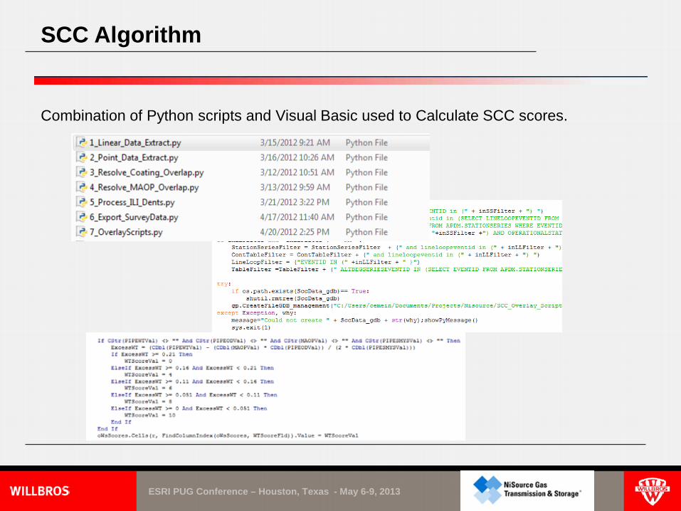
SCC Algorithm
Combination of Python scripts and Visual Basic used to Calculate SCC scores.

ESRI PUG Conference – Houston, Texas - May 6-9, 2013
Direct Inspection – Case Study
SCCDA : Line 10240 HCA No. 10:100514 • SCC Modeling correlated with Indirect surveys & ILI data over 557 segments
o 34 segments identified susceptible to SCC
o 3 excavation sites completed covering all 34 segments
o Exposing the pipe revealed FBE which eliminated the threat of SCC a) SME data and GIS records indicated Coal Tar Enamel
o Findings were corrected with NiSource’s GIS database

ESRI PUG Conference – Houston, Texas - May 6-9, 2013
Direct Inspection – Step 3
Discovery of FBE Coating – Line 10240

ESRI PUG Conference – Houston, Texas - May 6-9, 2013
Direct Inspection – Step 3
Girth Weld coated in FBE not shrink sleeve – Line 10240

ESRI PUG Conference – Houston, Texas - May 6-9, 2013
Direct Inspection – Case Study
ECDA : Line B111 HCA No. 1:27595 • 487 indications identified
o 2 “Severe” prioritized as “Scheduled” o 4 “Moderate” prioritized as “Scheduled” o 1 “Minor” prioritized as “Monitored” o 480 “NRI” (Non-relevant Indication) prioritized as “Monitored”
• 4 excavation sites completed o 3 Chosen Indications – worst case scenarios o 1 “Effectiveness/Control dig
• Results of the digs
o Minor visual damage/coating flaws at all sites o Drainage box built on and around pipeline causing damage at one location which was not in the GIS database

ESRI PUG Conference – Houston, Texas - May 6-9, 2013
Drainage box built around pipeline!?
Direct Inspection – Step 3

ESRI PUG Conference – Houston, Texas - May 6-9, 2013
Direct Inspection – Step 3
Excavation of drainage box. Standard Engineering Practice??

ESRI PUG Conference – Houston, Texas - May 6-9, 2013
Removal of drainage box showing coating damage
Direct Inspection – Step 3

ESRI PUG Conference – Houston, Texas - May 6-9, 2013
Direct Inspection – Step 3
Drainage box removed showing mechanical damage.

ESRI PUG Conference – Houston, Texas - May 6-9, 2013
Direct Inspection – Case Study
ECDA : Line 8000 HCA No. 45:578781 • 24 indications identified
o 2 “Severe” prioritized as “Monitored” o 22 “Minor” prioritized as “Monitored”
• 4 excavation sites completed o 3 “Monitored” indications – worst case scenarios o 1 “Effectiveness/Control dig
Additional digs originally selected based off PCM survey indications- A problem with the weighting factors of the survey analysis caused coating discontinuities (patches, wrap type coatings over GW) to be more severe. Adjustments were made to correct this issue and new digs selected •Results of the digs
o Extruded polyethylene coating in excellent condition was found which NiSource wanted to confirm.
ESRI PUG Conference – Houston, Texas - May 6-9, 2013
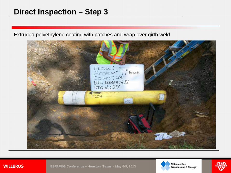
Direct Inspection – Step 3
Extruded polyethylene coating with patches and wrap over girth weld

ESRI PUG Conference – Houston, Texas - May 6-9, 2013
Direct Inspection – Step 3
Extruded polyethylene coating with patch type repair

ESRI PUG Conference – Houston, Texas - May 6-9, 2013
Direct Inspection – Step 3
Extruded polyethylene coating with wrap type coating over girth weld

ESRI PUG Conference – Houston, Texas - May 6-9, 2013
Direct Inspection – Step 3
Extruded polyethylene coating with patch and wrap type coating over girth weld

ESRI PUG Conference – Houston, Texas - May 6-9, 2013
Direct Inspection – Case Study
ECDA : Line UKY HCA No. 10:689001 • Casing excavation using Guided Wave
• Hard short discovered during excavation • Guided Wave would fail due to shorted casing • The decision was made to open cut the road • Casing was cut off • Direct Inspection was performed on carrier pipe where it was cased
• Results
• Carrier pipe was in good condition except for coating holidays caused by shorted casing

ESRI PUG Conference – Houston, Texas - May 6-9, 2013
Direct Inspection – Step 3
Casing excavation

ESRI PUG Conference – Houston, Texas - May 6-9, 2013
Direct Inspection – Step 3
Carrier pipe shorted to casing

ESRI PUG Conference – Houston, Texas - May 6-9, 2013
Direct Inspection – Step 3
Casing pipe removal process

ESRI PUG Conference – Houston, Texas - May 6-9, 2013
Direct Inspection – Step 3
Carrier pipe after casing removal–Coating damage from spacer

ESRI PUG Conference – Houston, Texas - May 6-9, 2013
Direct Inspection – Step 3
Carrier pipe with new coating wrap

ESRI PUG Conference – Houston, Texas - May 6-9, 2013
Post Assessment – Step 4
Post Assessment. The Post-Assessment Step covers analyses of data collected from the previous three steps to assess the effectiveness of the ECDA process and determine reassessment intervals.

ESRI PUG Conference – Houston, Texas - May 6-9, 2013
Post Assessment – Step 4 Enterprise GIS data loading. DA_Schema •Regions •Inspections •Digsite •DAIndications •CISReading •Reading •DigAnomaly •Activity
Other Schema •Coating •Casing •PipeSegment

ESRI PUG Conference – Houston, Texas - May 6-9, 2013
Post Assessment – Step 4
Centerline adjustment – Case study: Blue is where the centerline was moved based on Step 2 surveys and the Red line is where the original centerline existed from the digitization process from the maps. The largest adjust length was measured to be roughly 172 feet from the original centerline.

ESRI PUG Conference – Houston, Texas - May 6-9, 2013
Post Assessment – Step 4
Centerline adjustment – Blue is where the centerline was moved based on Step 2 surveys and the Red line is where the original centerline existed from the digitization process from the maps. The largest adjust length was measured to be roughly 171 feet from the original centerline.

ESRI PUG Conference – Houston, Texas - May 6-9, 2013
Conclusion
Summary 1. Direct Assessment Starts and Ends with GIS
• All Steps in the Direct Assessment Program Correct/Populate the GIS Data o SME input fills in Data and Operational Gaps o Record Research and Field Verification used to
supplement GIS Data o GIS data improvement is never complete
2. Lessons Learned • Research and Validate Data early as possible in the process • Complete Interruption Plans Critical to continuing the
Program • Alternative Assessment Methods Defined/Scoped

ESRI PUG Conference – Houston, Texas - May 6-9, 2013