noaa’s unmanned aircraft system (uas) program · noaa’s unmanned aircraft system (uas) program...
TRANSCRIPT

1
NOAA’s Unmanned Aircraft System (UAS) ProgramProfessor Albin J. Gasiewski
Director, NOAA-CU Center for Environmental TechnologyUniversity of Colorado, Boulder, COMember, NOAA UAS Working Group
Dr. F. Martin RalphNOAA/W&W/Science Technology & Infusion Program Manager
NOAA UAS Program Manager
Sara SummersNOAA UAS Deputy Program Manager
HAP Applications SymposiumUniversity of York25 October 2006
2
Program ManagementNOAA UAS ApplicationsField Activities – Altair DemoHurricane Demonstration ProjectEcosystems and ClimateResearch and DevelopmentThe Pathway Forward
2
3
Program Management
4
NOAA UAS Project Management Linking the P, P, B and E in PPBES
Program Manager: Dr. M. Ralph (ST&I), S. Summers (Deputy)Manages project planning, coordination, implementation and reporting within “Major Project” framework and guidelines.
UAS Steering Committee: RADM R. Behn, Dr. S. MacDonald Co-ChairsCoordinates PPBES Elements including Goals, Programs and Line Offices
UAS Working Group: CDR H. Halverson (Chair), S. Summers (Deputy)Day-to-day execution of the UAS project activities across Goals, Line Offices and Programs
NOAA Research Council: Dr. R. Spinrad (Chair)Assigned responsibility for UAS as a Major Project, key role in KDPs.

3
5
NOAA UAS Steering Committee Members
Line Office Reps:• RDML Richard Behn - NMAO (co-chair)• Dr. Alexander “Sandy” MacDonald, OAR (co-chair)• Greg Mandt – NWS• CAPT Craig Mclean – NOS• CDR Todd Stiles – PP&I• TBD - NMFS & NESDIS Goal Team Reps:• Dr. Marty Ralph – Weather & Water • Mike Aslaksen – Commerce & Transportation• Dr. David Fahey – Climate• TBD - Ecosystems
8
NOAA UAS Applications

4
9
Range of Applications to be Considered – in support of NOAA Requirements
• Hurricane Tracking & Intensity Research: A UAS could either fly above a storm, circumnavigate it or fly within 100 m of the ocean surface without endangering a pilot.
• Fire Weather monitoring: Winds and moisture aloft are critical to fire prediction
• Atmosphere, Ocean, and Climate Research:– UAS can provide detailed vertical profiles of the atmosphere and ocean
at a large number of fixed points over the globe.– Atmospheric Rivers that result in West Coast floods– Atmospheric Chemistry; global warming gases– Fisheries production and harmful algal blooms– Arctic and Antarctic weather and climate
• GEOSS (Global Earth Observation System of Systems): identify role that UAS have in GEOSS - international effort to link all observation systems to give us a tool for understanding how Earth’s systems interact to provide a truly comprehensive coverage
10
Range of Applications to be Considered – in support of NOAA Requirements
• Charting and Mapping: Charting the near-shore of the 3.4 million square miles and remote areas (e.g., NWHI Marine National Monument).
• Ecosystem/Habitat/Marine Mammal Support:– Coral Reef mapping: The ability to support spectrally robust
sensors in remote areas for sustained periods.– Marine Mammal mapping: A non-obtrusive instrument for
identifying, tracking, and sighting of marine mammals. – National Marine Sanctuaries: UAS may have numerous
applications for conservation science and enforcement especially in remote areas.
• Fisheries Enforcement: NOAA fisheries enforcement encompasses the entire 3.4 million square miles of the ExclusiveEconomic Zone.
5
11
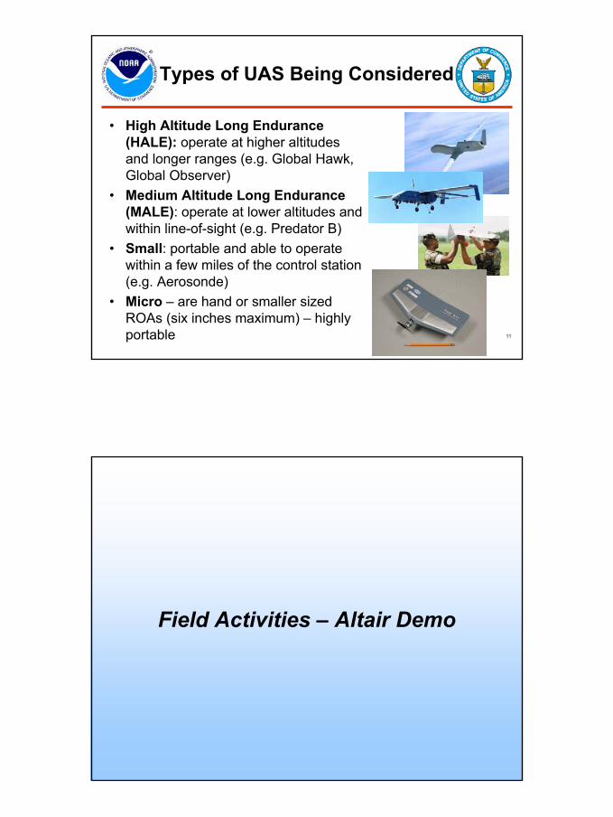
Types of UAS Being Considered
• High Altitude Long Endurance(HALE): operate at higher altitudes and longer ranges (e.g. Global Hawk, Global Observer)
• Medium Altitude Long Endurance (MALE): operate at lower altitudes and within line-of-sight (e.g. Predator B)
• Small: portable and able to operate within a few miles of the control station (e.g. Aerosonde)
• Micro – are hand or smaller sized ROAs (six inches maximum) – highly portable
12
Field Activities – Altair Demo

6
13
NOAA UAS Demonstration Projects(FY05-06)
Missions• Altair (phase I) – April-May, Nov 2005 (Weather &
Water, Climate, and Ecosystems, with NASA)• Aerosonde – Sept 2005 (Weather & Water, with
NASA)• Silver Fox – Feb 2006 (Ecosystems, with Navy)• Manta – Mar 2006 (Climate, with NASA and NSF)• Altair (phase II) – Sept 2006 (Climate and
Ecosystems, with NASA) 21 hour flight completed• Aerosonde – Sept 2006 (Weather & Water, with
NASA)
14
The NOAA Unmanned Aircraft System (UAS) Altair Demonstration Project (2005)Project Scientists:
David W. FaheyNOAA/ESRL Chemical Sciences Division
Albin J. GasiewskiNOAA-CU Center for Environmental TechnologyUniversity of Colorado
Channel Islands National Marine Sanctuary, 16 Nov. 2005

7
15
Irradiance Sensor
Desiccators
Calibration Bottle
PMVS Scanhead
GC/OZ Unit
GC Inlet Pump
Carrier Bottle
Right Front Iso View
GA Altair Installation
16
Topic…
Altair Integrated Package
Included first UAV-based passive microwave vertical sounder sensor

8
17
55 GHz 89 GHz 183 GHz
NOAA-CU CET spectrometer modules with internal fast-switched absolute calibration. Above spectrometers (plus two more under development) provide full AMSU-A/B and NPOESS CMIS and ATMS troposphericsounding compatibility.
Prototype UAV Microwave Vertical Sounder
18
Atmospheric Rivers – 14 Day Sequence

9
19
Atmospheric River Sounding Flight- Weak Atm River Penetrated on May 9, 2005 -
A
89 GHz
183 GHz
55 GHz
10 um IR
B
C
D
A B C D50 K
20
Altair Ozone Profiling
Measured ozone (O3) and altitude versus time above Palmdale-Victorville, CA during local high-altitude test flight of Altair on April 19, 2005.
10
21
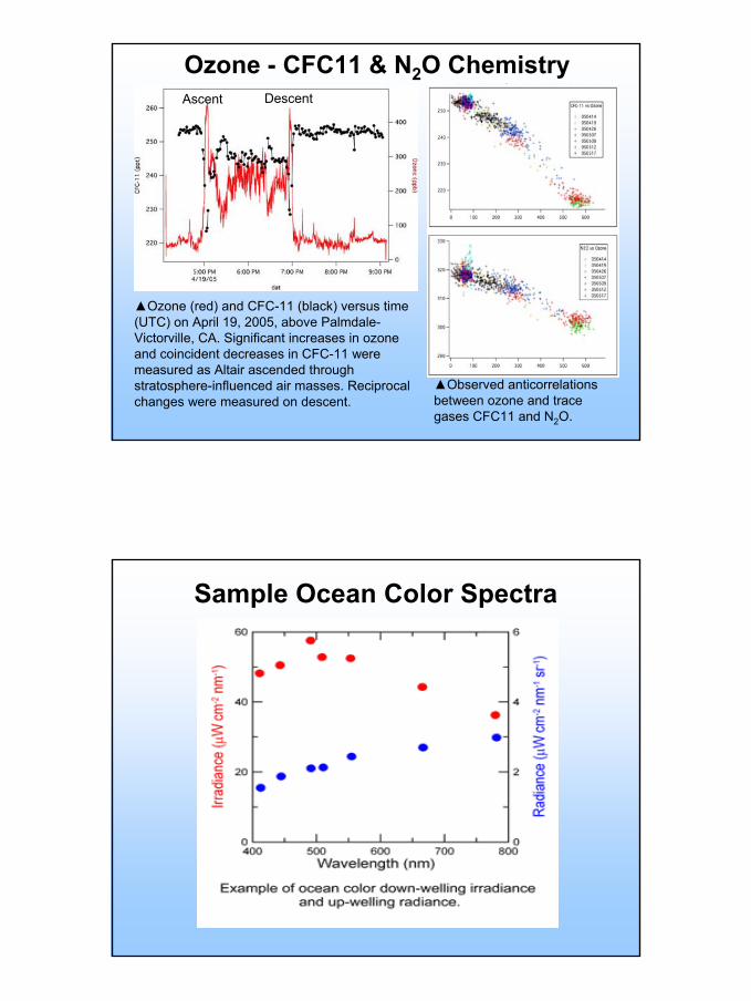
Ozone - CFC11 & N2O Chemistry
▲Ozone (red) and CFC-11 (black) versus time (UTC) on April 19, 2005, above Palmdale-Victorville, CA. Significant increases in ozone and coincident decreases in CFC-11 were measured as Altair ascended through stratosphere-influenced air masses. Reciprocal changes were measured on descent.
▲Observed anticorrelationsbetween ozone and trace gases CFC11 and N2O.
Ascent Descent
22
Sample Ocean Color Spectra

11
23
DCS Mosaic of Anacapa Island- May 7, 2005 -
260 Channel Islands images obtained in clear air~25% of Channel Islands mapping mission goals completed, including first complete mapping of Anacapa Island
24
EO/IR Streaming VideoLive streaming video from the WescamEO/IR camera was simultaneously broadcast to NOAA users around the U.S.
◄Sea lion rookery with over 100 members spotted from ~4 km altitude
Applications demonstrated included marine mammal counts, and vessel identification and tracking in the U.S. National Marine Sanctuaries waters.
Container ship observed near NMFS waters at a distance of ~20 km ▼

12
ALTAIR UAS (HALE-Class) Demo14-15 November 2005
Courtesy of Mike Aslaksen (NOS) and Sara Summers (OAR/AOML)
Objectives achieved: • Long endurance flight• Surveillance capabilities • NOAA sensors above 45 kft• Coastal remote sensing• Climate & air chemistry
science• Safe integration into the
National Airspace System down to altitudes of 7000 ft
• Establishment of partnershipsacross NOAA, NASA andprivate sector
18.4 hr NOAA mission completed
26
Hurricane Demonstration Projects

13
27
Aerosonde UAS Penetration of Tropical Storm Ophelia
16 September, 2005
969696
Satellite image of Tropical Storm Ophelia (intensity = 55 kt), with flight tracks shown:
• Aerosonde (blue)
• WP-3D (red)
Courtesy of Joe Cione andFrank Marks (OAR/AOML)
29
NOAA UAS Hurricane Demonstration Plans
FY05: Aerosonde (with NASA)– Tropical cyclone, single mission– Low-altitude, in situ reconnaissance
FY06: Aerosonde (with NASA)– Interagency workshop reached consensus on low-altitude demo– Researchers and NWS Operational Representatives agreed– Hurricane, multiple missions– Low-altitude, in situ reconnaissance and science– Implementation underway at Key West
FY07: HALE Class UAS demo planning– Platform, payload and mission profile selection
FY08: HALE Class UAS field demo– High-altitude, dropsonde and remote sensing reconnaissance and
science

14
30
31
15
32
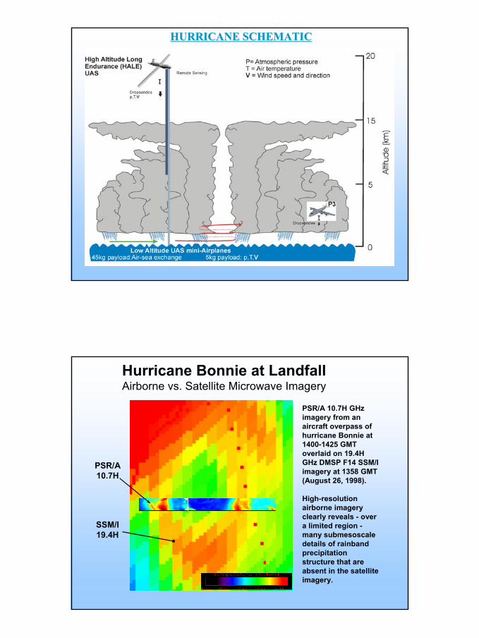
HURRICANE SCHEMATICHURRICANE SCHEMATIC
33
Hurricane Bonnie at LandfallAirborne vs. Satellite Microwave Imagery
PSR/A 10.7H GHz imagery from an aircraft overpass of hurricane Bonnie at 1400-1425 GMT overlaid on 19.4H GHz DMSP F14 SSM/I imagery at 1358 GMT (August 26, 1998).
High-resolution airborne imagery clearly reveals - over a limited region -many submesoscaledetails of rainbandprecipitation structure that are absent in the satellite imagery.
SSM/I19.4H
PSR/A10.7H

16
34
Ecosystems and Climate
35
Silver Fox
Silver Fox/Manta Hawaii Demo
Manta
Upolu Airport, Hawaii, HI

17
Above Cloud UAV
Below Cloud UAV
In Cloud UAV
Maldives Autonomous UAV Campaign (MAC)
37
1979

18
38
2003
39
Observations over the Arctic can determine if predicted global warming of Arctic is occurring. Disappearance of the Arctic Ice Cap.

19
40
Example of possible Arctic route:31 dropsonde points from >45K ft.
EILSEN
Improved Arctic Weather and Climate
Search and Rescue
Proposed UAS Base in AlaskaProvides Support for a Broad Range of Platforms, Capabilities, and U.S. NeedsTypes: High, Medium or Low AltitudeSizes: Few pounds to size of a 737Ranges: 1mile to 14,000 miles Endurance: 1 hour to >30 hoursAltitude: Few hundred ft to 65,000ft
Monitor leads and polenya
Small UAS launching from a vessel
High Level UAS can loiter for long periods
Sea Mammal Monitoring
41
Research and DevelopmentDropsonde Development
Soil MoistureSnow Water Equivalent
Hurricane Rainband ImagingDamage Assessment

20
50
Some Lessons Learned
• A number of specific NOAA requirements could be met by smaller UAS, while others demand large H(igh Altitude Long Endurance) UAS
• Partnerships are critical (e.g., NASA-NOAA partnership during Altair demos)
• The potential of civilian applications seems to have further inspired the UAS industry to help NOAA explore the civilian UAS market
• Major challenge is coordinating UAS activity with all other manned airborne activity in U.S. airspace.
54
SummaryNOAA’s UAS program focuses on the development of
unmanned platforms to suit specific NOAA mission goals in the key areas of:
Hurricane research and track/intensity forecastingFire weather monitoringAtmospheric ocean, and climate researchGEOSSCharting and MappingEcosystems, habitat, and Marine mammal supportFisheries enforcement
High altitude long endurance platforms play a major role in achieving NOAA’s long-term UAS goals.
Studies to demonstrate HALE sensor capabilities are ongoing using Altair and Global Hawk, and potentially others.

21
55
…thanks for your attention
56
Questions ?