ollondilly d control plan 2011 ouncil - … 6 - site... · bridgewater estate, camden park and...
TRANSCRIPT

Rural Living
WOLLONDILLY DEVELOPMENT
CONTROL PLAN 2011
Volume 6 – Site Specific Controls – Bridgewater Estate, Camden Park
PO Box 21 Picton NSW 2571 62-64 Menangle St Picton NSW 2571
DX: 26052 Picton Ph: 02 4677 1100 Fax: 02 4677 1831 Email: [email protected]
Rural Living www.wollondilly.nsw.gov.au WO
LL
ON
DIL
LY
SH
IRE
CO
UN
CIL

WOLLONDILLY DCP 2011 VOLUME 6 – SITE SPECIFIC – BRIDGEWATER ESTATE
Page 2 of 59
Table of contents
VOLUME 6 – SITE SPECIFIC CONTROLS – BRIDGEWATER ESTATE, CAMDEN PARK ................................................. 1
TABLE OF CONTENTS ........................................................................................................................................... 2
PART 1 – PRELIMINARY........................................................................................................................................ 4
1.1 Introduction ............................................................................................................................................ 4 1.2 Relationship to other Volumes............................................................................................................... 4 1.3 General Objectives ................................................................................................................................ 4 1.4 Other Significant LEP Provisions........................................................................................................... 5 1.5 Background to this DCP ........................................................................................................................ 5
PART 2 – DEVELOPMENT PRECINCTS .................................................................................................................... 6
2.1 Introduction ............................................................................................................................................ 6 2.2 Residential Precinct 1a and Precinct 1b................................................................................................ 6 2.3 Residential Precinct 2 ............................................................................................................................ 6 2.4 Residential Precinct 3 ............................................................................................................................ 6 2.5 Residential Precinct 4 ............................................................................................................................ 6 2.6 Rural Residential Precinct ..................................................................................................................... 7 2.7 Open Space Precinct............................................................................................................................. 7 2.8 Special Uses Precinct............................................................................................................................ 7
PART 3 – GENERAL LAND USE CONTROLS ........................................................................................................... 8
3.1 Access and major roads ........................................................................................................................ 8 3.2 Public open space ............................................................................................................................... 11 3.3 Drainage & Water Quality .................................................................................................................... 12 3.4 Flood Liable Land ................................................................................................................................ 13 3.5 Cultural Landscape.............................................................................................................................. 14 3.6 Heritage ............................................................................................................................................... 19
PART 4 – SUBDIVISION....................................................................................................................................... 20
4.1 Objectives ............................................................................................................................................ 20 4.2 Controls for Allotment Size/ Density .................................................................................................... 20 4.3 Controls – Lots adjoining Public Open Space ..................................................................................... 21 4.4 Controls – Street Drainage .................................................................................................................. 21 4.5 Controls – Residential Development ................................................................................................... 22 4.6 Controls – Woodland Tree Retention & Planting................................................................................. 23
PART 5 – RESIDENTIAL DEVELOPMENT ............................................................................................................... 24
5.1 Introduction .......................................................................................................................................... 24 5.2 Solar Access and Energy Efficiency.................................................................................................... 24 5.3 Access ................................................................................................................................................. 25 5.4 Building Envelopes .............................................................................................................................. 26 5.5 Building Height..................................................................................................................................... 30 5.6 Carparking / On-Site Parking............................................................................................................... 30 5.7 Landscaping ........................................................................................................................................ 31 5.8 Private Open Space............................................................................................................................. 32 5.9 Site Area and Dimensions (Dual Occupancy) ..................................................................................... 33 5.10 Site Facilities........................................................................................................................................ 33 5.11 Site Requirements (Integrated Housing) ............................................................................................. 34 5.12 Visual Amenity and Design.................................................................................................................. 34 5.13 Visual and Acoustic Privacy................................................................................................................. 36 5.14 Fencing and Retaining Walls ............................................................................................................... 36
PART 6 – OTHER NON-RESIDENTIAL DEVELOPMENT............................................................................................. 38
6.1 Introduction .......................................................................................................................................... 38

WOLLONDILLY DCP 2011 VOLUME 6 – SITE SPECIFIC – BRIDGEWATER ESTATE
Page 3 of 59
PART 7 – SCHEDULES........................................................................................................................................ 39
7.1 Definitions ............................................................................................................................................ 39 7.2 Maps .................................................................................................................................................... 40 Appendices ...................................................................................................................................................... 43

WOLLONDILLY DCP 2011 VOLUME 6 – SITE SPECIFIC – BRIDGEWATER ESTATE
Page 4 of 59
Part 1 – Preliminary
1.1 Introduction This Volume provides controls for development for the purposes of development within the Bridgewater Estate, Camden Park and forms part of the Wollondilly Development Control Plan 2011.
1.2 Relationship to other Volumes This Volume provides specific detail relevant to land uses which are permitted in Camden Park and any development ancillary to those uses. Any development application in Camden Park must be in accordance with this Volume as it will be used by Council to determine your development application. This Volume must also be read in conjunction with Volume 1 - General, which applies to all forms and types of development and therefore all development applications. Volume 1 also provides detailed guidelines as to how to use this Development Control Plan and how to determine which Volumes you will need to refer to in the preparation of your development application. Applicants are strongly advised to check with Council to find out what other Volumes or Council policies need to be considered prior to submitting a development application.
1.3 General Objectives This DCP provides an integrated set of objectives and controls for development. It aims to ensure that Camden Park Release Area is designed, developed and maintained in accordance with the following general objectives: (a) to provide comprehensive provisions relating to the subdivision of, building on and the
landscaping of the land, (b) to permit residential development which has regard to the heritage significance of the cultural
landscape of the historic Camden Park Estate; and (c) to protect the scenic quality of prominent features of the site, including ridgelines; and (d) to encourage the retention of trees and tree planting on the main ridgeline and to the east of
it so that tree cover will visually dominate other development when viewed at a distance from the remainder of Camden Park Estate; and
(f) to identify land required for open space and special purposes; and (g) to optimise the retention and welfare of existing safe mature trees including aboriginal
scarred trees; and (h) to minimise the impact of new development on existing agricultural and research activities
within the Elizabeth Macarthur Agricultural Institute; and (i) to permit underground extraction of coal and other mineral resources; and
WOLLONDILLY DCP 2011 VOLUME 6 – SITE SPECIFIC – BRIDGEWATER ESTATE
Page 5 of 59
(j) to prohibit residential development on land below or not filled above, the 1 per cent annual exceedance probability post-mining flood level and the appropriate freeboard; and provide for the preparation of detailed provisions for the development of the land to achieve the objectives (a)-(d) above, and
(k) to encourage the use of public transport and to address the interface with residential development to the north.
Council will not grant consent to development unless Council is of the opinion that the development is consistent with all of the objectives of this Volume.
1.4 Other Significant LEP Provisions
Development consent cannot be granted unless the land is capable of being serviced by a reticulated sewerage system. Council may not consent to development on land, which may be flood liable after mining has occurred (taken to be land below 72.6 metres AHD). Development for the purposes of exhibition homes or exhibition villages is permitted on the land. Certain aboriginal scar trees on the land have been identified as items of environmental heritage and are therefore subject to heritage provisions.
1.5 Background to this DCP
A number of planning studies were undertaken prior to the preparation of the plan and form the basis of the controls in this plan. These studies included:
� Cawdor Local Environmental Study (Purdon, Northrop, TEC – 1991) � Archaeological Site Assessment (Conacher Travers Environmental Consultants – 1999) � Flora and Fauna Assessment (Conacher Travers Environmental Consultants – 1999) � SEPP 44 Koala Assessment (Conacher Travers Environmental Consultants – 1999) � Traffic Impact and Transportation Study (Sinclair Knight Merz – 1999) � Preliminary Contamination Report (Johnstone Environmental Technology – 1999) � Stormwater Management Strategy (J. Wyndham Prince Consulting Civil Engineers – 1999) � Geological and Geotechnical Site Assessment (Brink & Associates – 1999) � Agricultural Impacts (Mullane Planning Consultants – 1999) � Environmental Investigation Report (Steven Layman Planning & Development Services –
1999) � Landscape Report: Camden Park Urban Release Area (Icon/Residential Land Development
P/L – December 2000) � Heritage Report: Analysis and Guidelines for South Camden Release Area (Planning
Workshop Australia – December 2000)

WOLLONDILLY DCP 2011 VOLUME 6 – SITE SPECIFIC – BRIDGEWATER ESTATE
Page 6 of 59
Part 2 – Development precincts
2.1 Introduction Land to which this DCP applies shall be within a defined precinct, as provided on Map 1. The following objectives apply to land within the relevant precinct as follows:
2.2 Residential Precinct 1a and Precinct 1b Objectives (a) To provide for traditional one or two-storey single dwelling houses free of dual occupancy,
multi dwelling development, residential flat and integrated housing development. (b) To achieve consistency of site area with existing adjoining residential development. (c) In the case of land adjoining existing residential development, to provide a setback that can
preserve the amenity provided by existing safe, mature trees in proximity to the common boundary.
(d) To ensure a natural corridor of canopy trees provides the backdrop to the interface with existing residential development in Camden local government area.
2.3 Residential Precinct 2 Objectives (a) To provide for traditional one or two-storey single dwelling houses free of dual occupancy,
multi dwelling development, residential flat and integrated housing development; (b) To provide a harmonious transition in site area and scale of development between
Residential 1 and Residential 3 precincts.
2.4 Residential Precinct 3 Objectives (a) To accommodate a mix of single detached dwelling houses and other high amenity housing
forms. These may be attached or detached, one or two storey in height and may have zero lot line construction in relation to one boundary only.
(b) To locate smaller lots in areas within 400 metres of an existing or likely future public transport route.
2.5 Residential Precinct 4 Objectives (a) To accommodate housing forms such dual occupancy, multi dwelling development,
residential flat and integrated housing development. These must be attached to at least one other dwelling, one or two storey in height and may have a zero lot line construction in relation to two boundaries;
(b) To encourage high amenity housing (e.g. adjacent to public open space) within 400 metres of an existing or likely future public transport route.
WOLLONDILLY DCP 2011 VOLUME 6 – SITE SPECIFIC – BRIDGEWATER ESTATE
Page 7 of 59
2.6 Rural Residential Precinct Objectives (a) To meet the objectives of the RU4 Rural Small Holdings Zone under Wollondilly LEP 2011. (b) To minimise the impact of rural residential development on the scenic qualities of the land; (c) To achieve allotment layout and development that is responsive to the natural features and
topography of the site.
2.7 Open Space Precinct Objectives (a) To meet the objectives of the RE1 Public Recreation Zone under Wollondilly LEP 2011 and
to provide additional land required to cater for the recreation needs of the residents of the Camden Park Release Area and to meet water quality objectives.
(b) To provide an open space system which takes advantage of existing drainage corridors. (c) To provide suitable land for local parks. (d) To provide open space which has high amenity values focused on a central corridor which
contains attractive and functional landscape elements including a water feature. (e) To function as a diverse ecological corridor providing links with natural systems beyond the
Release Area.
2.8 Special Uses Precinct Objectives (a) To meet the objectives of the SP2 Infrastructure zone under Wollondilly LEP 2011.
WOLLONDILLY DCP 2011 VOLUME 6 – SITE SPECIFIC – BRIDGEWATER ESTATE
Page 8 of 59
Part 3 – General Land Use Controls
3.1 Access and major roads
Objectives (a) To maximise the retention of mature trees; (b) To promote roads that generally follow contours or cross gentle slopes; (c) To provide an attractive residential street environment; (d) To ensure the safe and efficient circulation of local traffic and cyclists; (e) To provide for an efficient circulation of bus services and convenient pedestrian access; (f) To minimise the amount of “through traffic”; and (g) To ensure that roads are located in a manner that facilitates landscaping that protects the
heritage significance of the cultural landscape of the historic Camden Park Estate; and (h) To facilitate disabled access, wherever practicable. Controls – Roads 1. All subdivision and/or development of land must be consistent with:
� The general location and hierarchy of roads; � General location of proposed parks and community facilities in relation to the indicative
road layout; � Frontages over which restricted or no access is provided; � Location of traffic facilities; and � Location of landscaping. shown on the DCP Map (Figure 1) unless a variation can be justified in terms of the relevant objectives of this DCP.
2.. All roads must comply with the Table of Road Characteristics and Design Guidelines; Unless Council is satisfied that vehicular entry onto a road is satisfactory, a contribution towards the construction of a suitable entry will be required. Entries may take the form of a culvert, layback or ramp depending upon the circumstances of the site. Entries are to be located so that stopping sight distance is in accordance with Austroads guidelines is available.
3.. All roads must comply with the provisions of the Cultural Landscape Table. 4. Except as otherwise provided in this DCP, all roads shall comply with the technical
requirements of Council’s Design Specification. 5. Arrangements satisfactory to Council and the RTA shall be made for the provision of safe
and functionally adequate vehicular traffic intersections with Remembrance Driveway. 6. Bus stops shall be designed to support low line buses.

WOLLONDILLY DCP 2011 VOLUME 6 – SITE SPECIFIC – BRIDGEWATER ESTATE
Page 9 of 59
Table X Characteristics of Roads in South Camden Urban Release Area
Road
Category Road Type
Design
Speed
(km/hr)
Max Daily Flow
(veh/day)
Reservation
Width
(m)
Carriageway Width
(m)
Road Profile
(m)
Concrete
Footpath Other Criteria / Guidelines
A1 Collector - Estate Entry 50 8000 21 2 x 5.5 4 - 5.5 - 3 - 5.5 - 4 Yes * Road sections to be terminated at round-a-bout to facilitate
access across divided road.
A2. Collector - Loop Return
50 6000 17 10 3.5 - 10 - 3.5 Yes * Apply to the principal road servicing active recreation facility.
Alternatively provide 2 travelling lanes and designed off street
parking.
B1 Access Street - Multi Use
50 3000 15 8 3.5 - 8 - 3.5 see criteria * Apply to access street designed to provide temporary/emergency
connection between Collector entry roads and sections of standard
residential streets with high traffic flows.
* Footpath one side required when catchment build up for
shortest route to bus route or main pathway/cycleway system
exceeds 50 lots.
B2 Access Street – Minor 40 1500 14 7 3.5 - 7 - 3.5 see criteria * Apply to standard residential streets.
* Footpath one side required when catchment build up for
shortest route to bus route or main pathway/cycleway system
exceeds 50 lots.
C1 Cul-de-sac 25 300 13 6 3.5 – 6 - 3.5 No * Apply to standard cul-de sacs
*
Where the maximum daily flow threshold is reached the
pavement width is to be increased to 7 metres.

WOLLONDILLY DCP 2011 VOLUME 6 – SITE SPECIFIC – BRIDGEWATER ESTATE
Page 10 of 59
Table X Characteristics of Roads in South Camden Urban Release Area
Road
Category Road Type
Design
Speed
(km/hr)
Max Daily Flow
(veh/day)
Reservation
Width
(m)
Carriageway Width
(m)
Road Profile
(m)
Concrete
Footpath Other Criteria / Guidelines
C2 Cul-de-sac - Reserve Frontage 25 300 10.5 5.5 3.5 -5.5 - 1.5 No * Apply to standard cul-de-sacs where there are lots on one side
of the road only.
D1 Loop Road - Reserve Frontage 15 400 9 4 4 - 4 - 1.5 No * Applies to one directional traffic where 1 on street parking
space is provided for every 2 dwellings
* Alternatively provide 5.5 metre carriageway without parking
bays.
D2 Shareway - Reserve Frontage 15 300 9 4 3.5 - 4 - 1.5 No * Apply to roads requiring low environmental impact on
perimeter of major open space.
* Road pavement to be designed for low speed and sharing by
pedestrians, cyclists and motorists.
* Controlled verge parking by use of bollards and tree planting.
D3 Shareway - Residential Accessway 15 300 10.5 4 4 - 4 - 2.5 No * Restrict to servicing of 7 lots with 1 additional parking space per
2 dwellings. Alternative to parking bays, provide 3.5 -5.5 - 2.5m.
road profile.
E Rural Residential -Access Road 50 300 14 7 3.5 - 7 - 3.5 No * Apply to roads at interface between Rural Residential and
Residential Land uses and roads servicing Rural Residential lots.
Note : For location of main cycleway/path system see Landscape Control Plan - where cycleway is within a residential street, the footpath reservation shall be 4m wide.

WOLLONDILLY DCP 2011 VOLUME 6 – SITE SPECIFIC – BRIDGEWATER ESTATE
Page 11 of 59
Controls - Cycleways & Pedestrian Paths 1. Generally, all development shall be consistent with the cycleway network shown on the
Development Control Plan maps. 2. Provide pedestrian/cycleway access from the site to the existing public open space adjoining
the northwestern corner of the land. 3. Design, construction and signposting of cycleways shall comply with the requirements of
Austroads Guide to Traffic and Engineering Practice Part 14. 4. Combined pedestrian/cycleways in public roads and footways, shall be constructed as shown
on Figures 1 and 2 of this Volume and shall be 2 metres wide. Maximum gradient shall be 1 in 14, wherever practicable.
5. Wherever practicable paths and ramps in public places shall be built in accordance with Australian Standard 1428-1 2001. Where required for disabled access paths shall be constructed of a solid surface suitable for wheelchair access.
Controls – Public Transport 1. Bus stops shall each have a public shelter and shall be provided at intervals of no more than
800 metres; 2. Each bus stop shall include appropriate seating, lighting and public transport timetable
information; 3. Bus stops shall be easily accessible, well defined and shall be within casual observation from
nearby residences, and shall not interfere with the amenity of the locality; 4. Safe crossing points shall be provided at each bus stop, by the introduction of non-raised
pedestrian thresholds and refuges.
3.2 Public open space Objectives (a) To ensure adequate provision and distribution of public open space to meet the needs of
residents; (b) To preserve native bushland and fauna habitat; (c) To integrate open space with major drainage land in a way which provides high amenity and
maintains the natural character of the open space; and (d) To minimise the public costs of on-going maintenance of open space. (e) To ensure a high standard of disabled access to open space. (f) To indicate the extent of public facilities which can be provided as works in kind; and (g) To ensure a standard of open space provision consistent with the adjoining Elizabeth
Macarthur estate and ensure a minimum of 2.83 hectares of public open space per 1000 persons site population; and
(h) To indicate the preferred position for playing fields and other public facilities; and (i) To ensure appropriate street tree planting; and (j) To indicate the extent and standard of provision of cycleways and shared walkways for
passive recreation
WOLLONDILLY DCP 2011 VOLUME 6 – SITE SPECIFIC – BRIDGEWATER ESTATE
Page 12 of 59
Controls 1. There shall be a minimum of 2.83 hectares of public open space per 1000 persons
population. The occupancy rate shall be assumed to be an average of 3 persons per household for the purposes of calculating public open space required.
2. The provision of open space shall be consistent with the DCP Maps (Figures 1 and 2) and Development Guidelines (Appendix 2), which show: � Size and location of major and local open space areas; � Location of water elements; � Notional locations for playing fields and associated amenities.
3. Active playing fields and appropriate sized dressing rooms for those fields shall be provided for any land within the RE1 Public Recreation Zone.
4. The quality and scope of works, landscaping, finishes and facilities shall be in accordance with any site-specific development contributions plan or development agreement.
5. Wherever practicable, kerb ramps shall be placed in appropriate positions to allow disabled access to public open space.
6. Facilities within public open space shall, wherever practicable, meet Australian Standard 1428-1 2001.
3.3 Drainage & Water Quality Objectives (a) To limit post-development discharges to pre-development levels; and (b) To minimise stormwater impacts on downstream properties; and (c) To maintain post development water quality at pre-development standards. (d) To encourage water stormwater re-use. (e) Peak stormwater runoff in the Navigation Creek Catchment does not exceed that which
occurred prior to development taking place;
Note: The current drainage capacity of the Elizabeth Macarthur system should be considered in determining stormwater drainage capacity.
(f) development water quality of the creek system is maintained or enhanced by development; (g) To minimise maintenance requirements of any open water basins and water features; (h) To establish a water quality standard that complies with the ANZECC Australian Water
Quality Guidelines for Fresh and Marine Waters for recreational water quality visual use only; (i) To provide a sustainable drainage and water quality environment that is aesthetically
pleasing, includes natural and man-made landscape features and that is safe for the community;
(j) To provide a sustainable aquatic environment that preserves the potential for creating habitat for locally indigenous flora and fauna; and
(k) To ensure that localised flood levels within the Navigation Creek catchment, that exceed backwater effects from the Nepean River, do not cause localised flooding.
WOLLONDILLY DCP 2011 VOLUME 6 – SITE SPECIFIC – BRIDGEWATER ESTATE
Page 13 of 59
Controls 1. Development shall be carried out in accordance with a Council Adopted Stormwater
Management Strategy for Camden Park Release Area; 2. Water quality shall comply with the ANZECC Australian Water Quality Guidelines for Fresh
and Marine Waters for recreational water quality visual use only; 3. Off-line trash racks or gross pollutant traps shall be provided at all discharge points from the
open water column into trunk drainage that is capable of capturing all gross pollutants above a size of 3.5 mm in a 100% (1 in 1 year) storm event.
4. Any development application for subdivision of more than 3 lots, which relates to residential land adjoining the eastern boundary of the Release Area shall ensure that localised flooding shall not occur in excess of backwater effects from the Nepean River.
3.4 Flood Liable Land Objectives (a) To minimise the impact of development on flood liable land whether on site, upstream or
downstream; (b) To prohibit residential development on land, below or not filled above, the 1 in 100 year post-
mining flood level and appropriate freeboard (taken to be 74.0 metres AHD) (c) To identify the post- mining subsidence 1% AEP flood level (taken to be 72.6 metres AHD)
and prohibit development on land below, or not filled above, that level; and (d) To restrict arbitrary filling of the floodplain; and Controls 1. Development on flood liable land must satisfy the following criteria:
� No adverse flood impact on other land; � No increased erosion or siltation; � No increased risk to life and personal safety of emergency services and rescue
personnel; � Consistency with the Stormwater Management Strategy (See References).
2. This clause applies only to identified flood liable land from Navigation Creek. Development shall not be carried out on land the surface of which is, or will be after proposed filling has been carried out, below the 1% AEP post-mining flood level (which is taken to be 72.6 metres AHD), unless the Council is satisfied that a different flood level should apply.
Information Required: All development applications to subdivide flood liable land shall include the following information: (i) Location of the modified line delineating the estimated 1% AEP post-mining flood event; (ii) Consent of all owners over which it is proposed to carry out filling.
WOLLONDILLY DCP 2011 VOLUME 6 – SITE SPECIFIC – BRIDGEWATER ESTATE
Page 14 of 59
3.5 Cultural Landscape Objectives (a) To optimise the retention and welfare of existing mature trees including aboriginal scarred
trees; (b) To protect the scenic quality of prominent features of the site, in particular ridgelines; and (c) To encourage the retention of trees and tree planting on the main ridgeline and to the east of
it so that tree cover will visually dominate other development when viewed at a distance from the remainder of Camden Park Estate.
(d) To optimise the preservation of bat habitat trees and remnant Cumberland Plain Woodland species.
(e) To protect and preserve native vegetation, native fauna, habitat and biodiversity as a major contribution to the achievement of ecologically sustainable development.
(f) To ensure open space of high quality visual, recreational, ecological values; and (g) To optimise the retention and welfare of existing safe mature trees; and (h) To identify and protect prominent features of the site with appropriate landscaping, tree
planting and control of built form; and (i) To achieve residential development which has regard to the heritage significance of the
cultural landscape of the historic Camden Park Estate; (j) To achieve a subdivision pattern and road layout that has regard to the cultural landscape of
historic Camden Park Estate and is compatible with the Elizabeth Macarthur residential estate;
(k) To identify the colour and characteristics of tree species and building materials that can be used for housing and ancillary structures within the Heritage Views Protection Zone shown in the Landscape Control Plan, by permitting only those colours that are consistent with the olive green, grey and brown colours of locally native vegetation;
(l) To control the landscaping of sites within the Woodlands Zone shown in the Landscape Control Plan, by permitting only those tree species that are consistent with the olive green, grey and brown colours of native Cumberland Plain Woodland vegetation, and to ensure that distant views of the land are visually dominated by the tree cover; and
(m) To control the landscaping of sites within the Mixed Vegetation Zone shown in the Landscape Control Plan by permitting only species compatible in colour and scale with the existing vegetation character.
(n) To ensure that mature tree retention, street tree planting and historic Camden Park Estate cultural landscape objectives are integrated within a comprehensive Landscape Control Plan, Cultural Landscape Controls Table and Development Guidelines.
Controls 1. Development shall be carried out in accordance with the controls applicable to the relevant
Landscape Control Zone identified in the Landscape Control Plan. 2. Development shall be in accordance with the objectives and controls set down in table titled
– “Cultural Landscape Controls”. 3. Tree planting within a 25 metre wide strip centred on the road reservation and the front
setback area of adjacent lots that follow the main north-south saddle, shall be in accordance with the Development Guidelines for planting in the Woodlands Landscape Control Zone.
4 Development proposals for subdivision or for building works in the “Heritage Views Protection Landscape Control Zone” shown in the Landscape Control Plan shall demonstrate to the satisfaction of Council, that the development will be screened from view from historic Camden Park Estate.
5. Development in the “Heritage Views Protection Landscape Control Zone” and the “Woodland Landscape Control Zone” shall incorporate tree species selected principally from Grey Box, Iron Bark and Forest Red Gum Species listed in Appendix 2. Other Eucalyptus varieties shall be used only if they exhibit grey-green to glaucous blue-green foliage colours typical of native trees.
WOLLONDILLY DCP 2011 VOLUME 6 – SITE SPECIFIC – BRIDGEWATER ESTATE
Page 15 of 59
6. Development shall retain trees and provide additional planting on the main ridgeline and to
the east of it so that tree cover will visually dominate other development when viewed at a distance from the remainder of Camden Park Estate.
7. Where, in the opinion of Council, it is necessary for the retention and welfare of a mature or significant tree, it may permit:
8. Localized variation to standard road alignment/profile and construction practices (subject to acceptable drainage and safety impacts); and
9. A reduction in the minimum allotment size otherwise applicable by no more than 15%, except in the Residential 4 Precinct.
10. Restrictions As To User are to be placed using S.88B instruments to require that where, an existing or new tree need to be removed due to ill health, they must be replaced with an appropriate species (in terms of height and foliage).
11. Road alignments shall be such as to not require excavation or change of ground level within the root zones (ie the “drip line”) of existing eucalypt trees.
All development shall be carried out in accordance with the Landscape Control Plan, Cultural Landscape Controls and the Development Guidelines (Appendix 2).
Statement of Intent Flexibility and, if appropriate, innovative design should be applied in the siting and design of subdivisional roads, including both horizontal and vertical alignment of road sections, and pavement and path widths. The objective is to preserve trees that would be lost if conventional design and construction processes and standards are strictly followed. Variation of standard road alignments and road profiles will be permitted, subject to relevant aspects of drainage, safety and other engineering criteria being met.

WOLLONDILLY DCP 2011 VOLUME 6 – SITE SPECIFIC – BRIDGEWATER ESTATE
Page 16 of 59
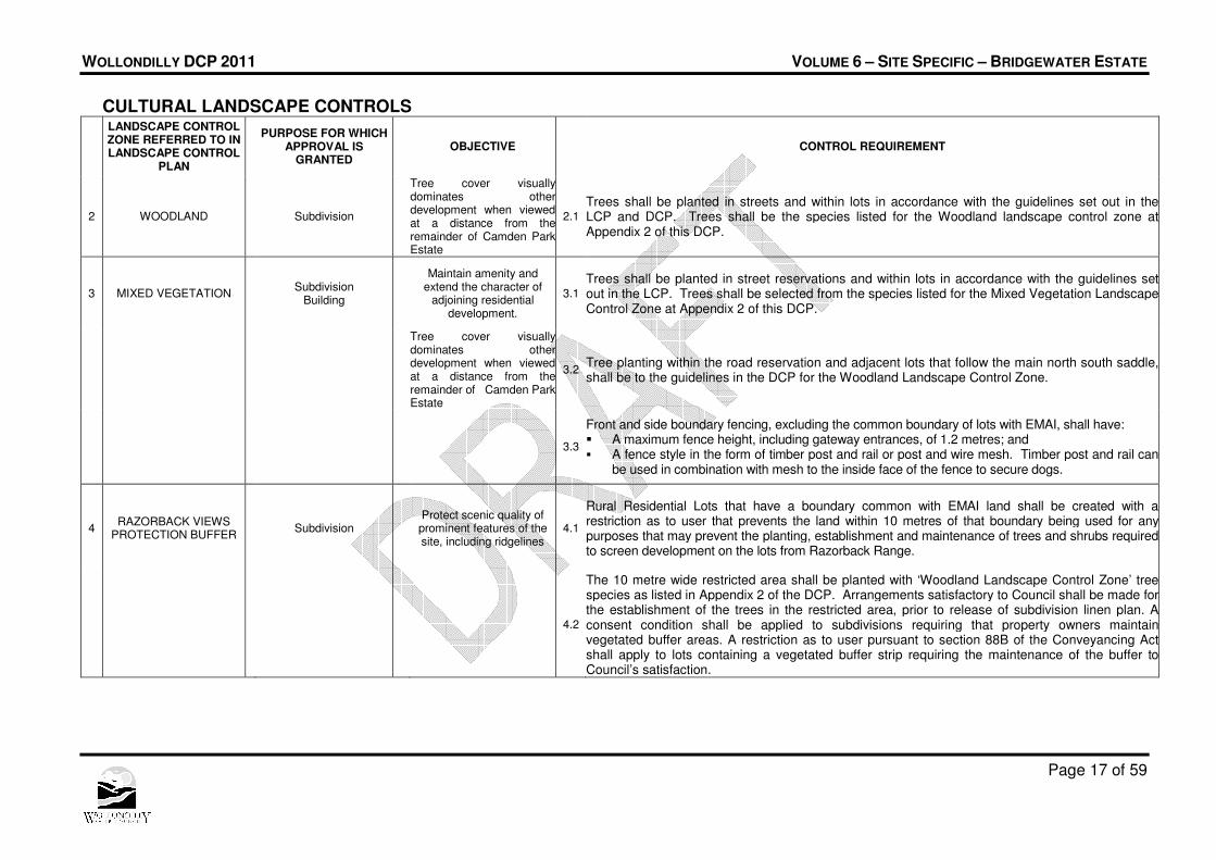
CULTURAL LANDSCAPE CONTROLS
LANDSCAPE CONTROL ZONE REFERRED TO IN LANDSCAPE CONTROL
PLAN
PURPOSE FOR WHICH
APPROVAL IS GRANTED
OBJECTIVE CONTROL REQUIREMENT
1 HERITAGE VIEWS
PROTECTION Subdivision
Development has regard to heritage significance of the cultural landscape of Historic Camden Park Estate
1.1
Subdivision roads shall be located generally at the interface between the Residential No.2 (a) and the Rural Zone No. 1(c1)(iii) as shown in the Landscape Control Plan (LCP). Native tree species scheduled in Appendix 2 of the DCP shall be established within the street footway areas and within the frontage of rural residential lots fronting those roads to provide screening of the development when viewed from Camden Park House in accordance with DCP guidelines.
1.2
The details of proposed planting in respect of the Heritage Views Protection and Woodland Cultural Landscape Zones shall be approved generally at development application stage and details shall accompany plans for which a construction certificate is issued.
1.3
Fences erected on the boundaries of Rural Residential Lots at the subdivision stage shall be from materials that blend with the colours and textures of the vegetation that is native to the site and are not reflective, when viewed from outside the development site. Fences on a common boundary with the Elizabeth Macarthur Agricultural Institute shall be a feral and domestic animal-proof black chain wire security fence (Refer to Appendix 1)
1.4
Restrictions on user shall be applied to each lot created within the Heritage Views Protection Landscape Control Zone, that will limit the tree species, building colours and materials that may to be used on any building, fence etc. in accordance with requirement 1.6 of these cultural landscape controls and provide protection to existing and planted trees in lots.
Tree cover visually dominates other
development when viewed at a distance from the
remainder of Camden Park Estate
1.5
Additional tree planting of the species in Appendix 2 shall be provided within rural residential lots at the subdivision stage, sufficient to achieve the objective of mature tree foliage dominating the built environment when the site is viewed at a distance from Camden Park Estate.
Building (including dwellings, fences and other structures to be erected on the land)
Development has regard to heritage significance of the
cultural landscape of Historic Camden Park
Estate
1.6
Dwellings, other buildings, fences and ancillary structures situated within the Heritage Views Protection Landscape Control Zone shall be erected, finished or maintained using materials, colours and textures that blend with the colours and textures of the vegetation that is native to the site. Approval shall be required for the colour to be applied to the principal surfaces of a building or structure. Textures or colours that are bright or reflective shall not be approved. Colours of the principal surfaces of a structure shall be in the range mid brown to grey to olive to green to blue green or a similar colour that is indistinguishable from that range of colours at a distance.
1.7
Front and side boundary fencing, excluding the common boundary of lots with EMAI, shall have: � A maximum fence height, including gateway entrances, of 1.2 metres; and � A fence style in the form of timber post and rail or post and wire mesh. Timber post and rail
can be used in combination with mesh to the inside face of the fence to secure dogs.
WOLLONDILLY DCP 2011 VOLUME 6 – SITE SPECIFIC – BRIDGEWATER ESTATE
Page 17 of 59
CULTURAL LANDSCAPE CONTROLS
LANDSCAPE CONTROL ZONE REFERRED TO IN LANDSCAPE CONTROL
PLAN
PURPOSE FOR WHICH
APPROVAL IS GRANTED
OBJECTIVE CONTROL REQUIREMENT
2 WOODLAND Subdivision
Tree cover visually dominates other development when viewed at a distance from the remainder of Camden Park Estate
2.1
Trees shall be planted in streets and within lots in accordance with the guidelines set out in the LCP and DCP. Trees shall be the species listed for the Woodland landscape control zone at Appendix 2 of this DCP.
3 MIXED VEGETATION Subdivision
Building
Maintain amenity and extend the character of
adjoining residential development.
3.1
Trees shall be planted in street reservations and within lots in accordance with the guidelines set out in the LCP. Trees shall be selected from the species listed for the Mixed Vegetation Landscape Control Zone at Appendix 2 of this DCP.
Tree cover visually dominates other development when viewed at a distance from the remainder of Camden Park Estate
3.2 Tree planting within the road reservation and adjacent lots that follow the main north south saddle, shall be to the guidelines in the DCP for the Woodland Landscape Control Zone.
3.3
Front and side boundary fencing, excluding the common boundary of lots with EMAI, shall have: � A maximum fence height, including gateway entrances, of 1.2 metres; and � A fence style in the form of timber post and rail or post and wire mesh. Timber post and rail can
be used in combination with mesh to the inside face of the fence to secure dogs.
4 RAZORBACK VIEWS
PROTECTION BUFFER Subdivision
Protect scenic quality of prominent features of the site, including ridgelines
4.1
Rural Residential Lots that have a boundary common with EMAI land shall be created with a restriction as to user that prevents the land within 10 metres of that boundary being used for any purposes that may prevent the planting, establishment and maintenance of trees and shrubs required to screen development on the lots from Razorback Range.
4.2
The 10 metre wide restricted area shall be planted with ‘Woodland Landscape Control Zone’ tree species as listed in Appendix 2 of the DCP. Arrangements satisfactory to Council shall be made for the establishment of the trees in the restricted area, prior to release of subdivision linen plan. A consent condition shall be applied to subdivisions requiring that property owners maintain vegetated buffer areas. A restriction as to user pursuant to section 88B of the Conveyancing Act shall apply to lots containing a vegetated buffer strip requiring the maintenance of the buffer to Council’s satisfaction.

WOLLONDILLY DCP 2011 VOLUME 6 – SITE SPECIFIC – BRIDGEWATER ESTATE
Page 18 of 59
CULTURAL LANDSCAPE CONTROLS
LANDSCAPE CONTROL ZONE REFERRED TO IN LANDSCAPE CONTROL
PLAN
PURPOSE FOR WHICH
APPROVAL IS GRANTED
OBJECTIVE CONTROL REQUIREMENT
5 AGRICULTURAL LANDS
BUFFER Subdivision
Minimise impact on agricultural and research
activities in EMAI 5.1
Land within the Camden Park Release Area that abuts the western boundary of the EMAI land shall be treated so as to act as a visual barrier between the dwellings to be constructed immediately adjacent to the common boundary and the existing agricultural/research activities within the EMAI land.
AGRICULTURAL LANDS BUFFER (continued)
5.2 The boundary treatment shall incorporate an earth mound, a high fence or a combination of a mound and fence. The adopted solution shall have regard to the visual impact of the barrier, both from within and outside the development site, arrangements for draining subdivisional lots and the practical aspects of future maintenance.
5.3 Fencing on boundaries shared with Elizabeth Macarthur Agricultural Institute lands, shall be of suitable design and
construction to prevent human and domestic animal access.
5.4
The mounded or fenced area shall be planted with Woodland Landscape Control Zone species and other native species of lower habit so as to achieve a dense screen (min 10 metres wide) that merges with other plantings and existing vegetation when viewed from historic Camden Park Estate. Arrangements satisfactory to Council shall be made for the establishment of the vegetated buffer, prior to release of subdivision linen plan.. Fencing along the boundaries with EMAI and the vegetated buffer shall be installed prior to registration of plans of subdivision.
6 FORMAL AVENUE SUB-
ZONE
To ensure safe and efficient circulation of bus services,
local traffic, cyclists and pedestrians
6.1 The lead-in sections of Collector Roads shall be landscaped to achieve a formal avenue based on the tree planting outlined in the LCP and the species identified in Appendix 2 of this DCP.
6.2 The loop return sections of Collector Roads shall be engineered having regard to the guidelines set out in the DCP for the establishment of separated parking and traffic lanes by utilizing trees in the pavement area of the road profile.

WOLLONDILLY DCP 2011 VOLUME 6 – SITE SPECIFIC – BRIDGEWATER ESTATE
Page 19 of 59
3.6 Heritage Objectives (a) To ensure the conservation of aboriginal scar trees at lots 2, 3 and 5 in DP 233005 and Lot 1
in DP 213696 (Camden Park); and (b) To ensure that the requirements of the NSW National Parks and Wildlife Act are met with
regard to Aboriginal sites and relics. (c) To promote measures that protect the condition and health of Aboriginal scar trees. (d) To achieve residential development which has regard to the heritage significance of the
cultural landscape of the historic Camden Park Estate and Camden landscape generally. (e) To ensure the retention and preservation of existing views and vistas and the significant
visual qualities of the Camden Park estate.
Heritage Controls 1. Development must conserve the Aboriginal scar trees as identified as an Item of
Environmental Heritage under Wollondilly LEP 2011 Schedule 5. 2. Development on land containing or adjoining an Aboriginal scar tree must be in accordance
with any Aboriginal Heritage Site Management Plan prepared as part of the subdivision of the land, to the satisfaction of Council and in consultation with Tharawal Local Aboriginal Land Council.
3. Development on land containing or adjoining an Aboriginal scar tree must be in accordance with Council’s Scar Tree Management Plan to the satisfaction of Council and in consultation with Tharawal Local Aboriginal Land Council.
4. During construction, monitoring of land disturbance shall be carried out to Council’s satisfaction, by the Tharawal Local Aboriginal Land Council in the vicinity of Aboriginal scar trees and in areas of high archaeological potential identified in the Conacher Travers Archaeological Site Assessment (November 1999).
5. All buildings, structures, services and infrastructure must not be located within the dripline of any identified Aboriginal scar tree.
WOLLONDILLY DCP 2011 VOLUME 6 – SITE SPECIFIC – BRIDGEWATER ESTATE
Page 20 of 59
Part 4 – Subdivision
4.1 Objectives (a) To produce a high quality urban environment that is responsive to the natural features and
topography of the site, and to its context within the cultural landscape of historic Camden Park Estate and its environment;
(b) To minimise adverse impacts upon identified views and vistas and preserve the significant visual and landscape qualities of the Camden Park Estate.
(c) To preserve significant natural features, thereby maintaining and enhancing woodland character and lessening the impact of buildings and works on the environment and the cultural landscape of historic Camden Park Estate; and
(d) To minimise adverse impacts of new development on existing and ongoing adjoining agricultural and research activities within the Elizabeth Macarthur Agricultural Institute; and
(e) To provide amenable conditions in residential areas that adjoin the Elizabeth Macarthur Agricultural Institute, particularly as regards odour and quarantine environment; and
(f) To minimise adverse visual and other impacts of new development on existing adjoining residential development in Camden local government area and fronting Remembrance Driveway; and
(g) To optimise the retention of existing safe, mature trees within new development in a configuration that is consistent with the indigenous vegetation community composition and structure and therefore maximises ecological function; and
(h) To protect the scenic quality of prominent features of the site including ridgelines and scattered hillside vegetation; and
(i) To provide a mix of residential lot sizes and development, from large lot development adjoining existing residential development to smaller lot development in areas of high amenity with good access to public open space and likely future public transport routes; and
(j) To maximise accessibility, safety and security of public open space; and (k) To provide for the needs of pedestrians and cyclists in the Release Area and to link new
cycleways with existing and planned cycleways in the Camden local government area; and (l) To optimise the use of land required for stormwater management in part, as high quality
public open space, which can where appropriate retain and enhance Cumberland Plain Woodland species; and
(m) To minimise the environmental impacts of silage pits, located within adjoining Elizabeth Macarthur Agricultural Institute land, on Navigation Creek as well as on future residential development.
4.2 Controls for Allotment Size/ Density 1. Development within the residential precincts shown on the DCP Map (Figure 1) shall be
subject to the following requirements:
Precinct Minimum Lot Size (sq. m)
Future Character
Residential 1a (Infill lots fronting Remembrance Driveway)
700 Orderly development (including subdivision) of infill lots, consistent with existing adjoining development and free of dual occupancy (except granny flats) and multi dwelling development
WOLLONDILLY DCP 2011 VOLUME 6 – SITE SPECIFIC – BRIDGEWATER ESTATE
Page 21 of 59
Precinct Minimum Lot Size (sq. m)
Future Character
Residential 1b
975
A precinct characterised by single dwelling-houses and free of dual occupancy (except attached dwellings) and multi dwelling development
Residential 2
700
A precinct characterised by single dwelling-houses and free of dual occupancy (except attached dwellings) and multi dwelling development.
Residential 3
450
A precinct characterised by a mix of high amenity detached dwellings. Except for detached garages, zero lot line construction is permitted on one boundary only and must be in accordance with an approved plan of subdivision showing building footprint1.
Residential 4
230
A precinct characterised by a mix of high amenity residential development, which may include integrated housing. Zero lot line construction is permitted on a maximum of two boundaries and must be in accordance with approved integrated housing design.
2. Except for detached garages, zero lot line construction is permitted in relation to no more
than one boundary only on lots in Precinct 3. Zero lot line construction (other than in the case of a detached garage) is permitted in relation to a maximum of two boundaries (e.g. attached dwellings in the form of “terrace house” style development) only on lots in Precinct 4.
3. Where it can be demonstrated to Council’s satisfaction that it is necessary to ensure the health and retention of significant trees the minimum lot size in Precincts 1, 2 and 3 may be varied by up to 15% of the minimum lot size which would otherwise be relevant to that precinct.
4.3 Controls – Lots adjoining Public Open Space 1. Where land adjoins public open space it shall be developed in one of the following ways:
� Single dwellings or integrated housing units which have living areas and private open space oriented towards the open space;
� A public road between the open space and dwellings. 2. Development adjoining public open space shall have boundary fencing which predominantly
consists of brick or similar masonry materials.
4.4 Controls – Street Drainage
1. The street drainage system design shall be carried out in accordance with Australian Rainfall and Runoff and Council’s Design Specification.
2. Sediment/erosion control shall be applied to all construction areas to protect the constructed and natural drainage system in accordance with “Managing Urban Stormwater – Soils & Construction” (Landcom/NSW Department of Housing, 3rd Edition August 1998).
1 The approved plan of subdivision or “restriction as to user” on title must indicate building footprint for each lot.
WOLLONDILLY DCP 2011 VOLUME 6 – SITE SPECIFIC – BRIDGEWATER ESTATE
Page 22 of 59
4.5 Controls – Residential Development 1. Development, including landscaping, shall be carried out in accordance with the DCP Map
(Figure 1), Landscape Control Plan (Figure 2) and Development Guidelines (Appendix 2), which form part of this DCP.
2. To maximise tree preservation, development other than exempt development, on land which has a common rear boundary with existing residential development in Camden local government area and development fronting Remembrance Driveway shall have a minimum rear setback of 10 metres from the rear boundary of the existing residential development. A 6 metre rear setback area shall be embellished with additional Cumberland Plain Woodland plant species. Note: Regarding lots subject to 2 above - provided that privacy and amenity of existing dwellings are
protected - Council will consider a rear setback reduced from 10 metres to a minimum of 6 metres in justified circumstances,(eg corner sites, shallow sites where necessary to achieve a better urban design outcome or energy efficiency outcome, etc.).
3. Restrictions on title shall be required at subdivision stage to ensure Cumberland Plain
Woodland conservation and maintenance within rear setback areas on lots adjoining Camden local government area.
4. To minimise impact on the Elizabeth Macarthur Agricultural Institute and on the cultural landscape of the historic Camden Park Estate development on land which abuts the boundaries of the Release Area that has a common boundary with EMAI land shall be enclosed by visually unobtrusive boundary fencing that prevents entry to EMAI land by humans and domestic animals (black chain-wire fencing or similar is preferred).
5. The human and domestic pet proof fence once constructed must not be modified or damaged to allow access from the residential areas onto EMAI land. The cost of maintaining the fence shall be shared by NSW Agriculture and adjoining neighbours. Note: Council will implement construction and maintenance of the man and domestic animal proof fence
through a condition of consent on subdivision and positive covenants on the lots created.
6. Land abutting the boundaries of EMAI shall have screen planting 10 metres deep and
generally 6 metres high or greater, and a single dwelling rear building setback of 12 metres. Where land is subject to buffer restrictions on two boundaries, Council will consider a variation to one of those buffer widths.
7. No residential development shall occur within 150 metres of the existing silage pits within the EMAI, or such lesser distance from them as is identified as being potentially affected by offensive odour in an odour impact study prepared in accordance with the Council’s requirements and adopted by the Council.
8. No new silage pits shall be constructed within 150 metres of land zoned residential or rural-residential.
9. New development shall optimise retention of existing mature trees. Regard shall be had to the Cultural Landscape provisions and the Development Guidelines of this DCP. Note: This DCP allows conditional variation to road standards and lot sizes in order to facilitate tree
retention. Refer to Cultural Landscape Section and Development Guidelines.
10. Unlandscaped cut and fill shall be limited to 0.5 metres in height above and below existing
natural ground level. 11. The maximum finished floor level above and below existing natural ground level shall be 1.2
metres. 12. No cutting of ridgelines is permitted.

WOLLONDILLY DCP 2011 VOLUME 6 – SITE SPECIFIC – BRIDGEWATER ESTATE
Page 23 of 59
4.6 Controls – Woodland Tree Retention & Planting 1. Prior to subdivision design a detailed bat habitat tree inspection shall be undertaken by a
suitably qualified fauna ecologist and the trees identified shall be incorporated into any proposed development.
2. Tree planting shall be carried out in accordance with the Landscape Control Plan, Cultural Landscape Controls Table and the Development Guidelines for the relevant Cultural Landscape Control Zone.
3. As a priority, remnant Cumberland Plain Woodland species shall be retained and enhanced within the open space zone, within road reservations and within the screen planting areas adjoining the south and east boundaries of the Release Area.
4. Remnant Cumberland Plain Woodland canopy trees located within 12 metres of the boundary of adjoining existing residential development in Camden local government area, shall be retained and embellished and new development shall observe a minimum 3 metres building setback from all such trees.
5. The open space zone, screen plantings along the south and east boundary of the Release Area and where appropriate, land within the road reserve, shall be restored to approximate Cumberland Plain Woodland vegetation community in both composition and structure.
WOLLONDILLY DCP 2011 VOLUME 6 – SITE SPECIFIC – BRIDGEWATER ESTATE
Page 24 of 59
Part 5 – Residential Development
5.1 Introduction
The provisions of this Chapter apply to all types of residential development in the Residential zone. Where provisions relate to a particular form of residential development (ie. dwellings, dual occupancy or integrated housing) this is specifically stated. The location of secondary dwellings in back yards is not permitted. Dual Occupancy development is only permitted in precincts 3 and 4. Integrated Housing is development in a high amenity location within Precinct 4, which consists of the subdivision of land into 3 or more residential lots, each having a site area up to 450 square metres; and the erection of a single dwelling house (including attached dwellings) on each of the allotments created by that subdivision.
5.2 Solar Access and Energy Efficiency Objectives (a) To provide for a residential environment, which optimizes the principles of energy efficiency
and sustainability; (b) To minimise the potential for likely future overshadowing of adjoining properties in
subdivision design; (c) To provide living areas and private open space of proposed and adjoining development with
adequate sunlight; and (d) To facilitate the design and construction of energy efficient housing.
Consideration of road orientation is an important factor in encouraging the principles of energy efficiency in subdivision design. For high amenity residential development in Precinct 4, lots shall be oriented to provide for a northern aspect for the dwelling and private open space areas. Roads running in an east west direction will provide for such orientation, whilst maintaining a minimum allotment frontage.
Controls 1. Sunlight is to be available to at least 50% of the dedicated private open space for each
dwelling for at least 3 hours between 9:00 am and 3:00 pm on June 21. 2. New development shall not result in less than 3 hours of sunlight to the habitable rooms and
50% of the private open space of any adjoining property between 9:00 am and 3:00 pm on June 21, or create more than 10% additional overshadowing if it is already less. Shadow diagrams are required for any two storey proposal.
3. All dwellings and subdivisions shall comply with any adopted policy for Energy Efficient Housing or similar.
4. To maximise energy efficiency, living areas of dwellings should have, where possible, a northerly aspect. Micro-climatic factors may require an alternative orientation as will the direction of major views.

WOLLONDILLY DCP 2011 VOLUME 6 – SITE SPECIFIC – BRIDGEWATER ESTATE
Page 25 of 59
5.3 Access Objectives (a) To make appropriate provision for vehicular access. (b) To ensure the safety of pedestrians, cyclists and vehicles. (c) To ensure driveway design minimises visual impact on streetscape. (e) To promote sustainable development by reducing reliance on the private motor vehicle by
supporting access to public transport, cycling and walking; and (f) To ensure safe and efficient vehicular access to the Release Area; and (g) To provide a hierarchy of streets forming an interconnected configuration which can support
public transport, pedestrian walkways and cycleways; and (h) To ensure adequate access for waste servicing vehicles; and (i) To promote permeability and connectivity; and (j) To foster a “walkable” urban neighbourhood.
Controls 1. Generally development shall comply with Australian Standard 2890.1 1993 - Parking
Facilities unless specifically otherwise provided in this DCP. Driveways are to be a minimum of 0.5m clear of all drainage structures on the kerb and gutter. Driveways are to take into consideration the existing public utility infrastructure including drainage. Any relocation will be at no cost to Council.
2. Driveways shall be constructed in accordance with Wollondilly Council’s Design Specification. The entrance to the development shall have minimum sight distance requirements for the relevant speed zone as required by RTA design guidelines.
3. Driveways are to be a minimum of 6m from the kerb return of a street corner. 4. Vehicular footpath crossings shall be perpendicular to the road and shall be in accordance
with the access profiles in Council’s Design Specification. 5. Driveways are to be constructed in accordance with Council’s Design Specification using:
� Non-slip surfaces where practicable; and � Have a decorative finish (i.e. stencilled or coloured, patterned concrete, paving or the
like) which is complimentary to the external materials of the dwelling. 6. The maximum driveway gradient shall be:
� 1:4 for driveways less than 5 metres long � 1:5 for driveways greater than 5 metres and less than 20 metres long; � 1:6 for driveways greater than 20 metres; and � have transition zones that are a minimum of 2 metres long. � Variations to the aboave standards must be approved by Council’s Design Engineer.
7. If required, an access strip to a rear dwelling shall be a minimum of 4 metres wide. Except where required for access in accordance with Australian Standard 2890.1 1993 - Parking Facilities, driveways shall be constructed in accordance with Wollondilly Design Specification.
8. Kerb and gutter and road shoulder construction for the road frontage of the development shall be carried out where it is not already provided.
9 Large expanses of concrete should be avoided through the use of curved driveways broken with landscaping and the use of coloured or textured paving or concrete.
10. Battleaxe handles or private rights-of-carriageway serving 2 or more battleaxe lots are to be designed to ensure that all vehicles are capable of entering and leaving the site in a forward direction. For integrated housing developments with an internal road, provisions shall be made for access by service vehicles.
WOLLONDILLY DCP 2011 VOLUME 6 – SITE SPECIFIC – BRIDGEWATER ESTATE
Page 26 of 59
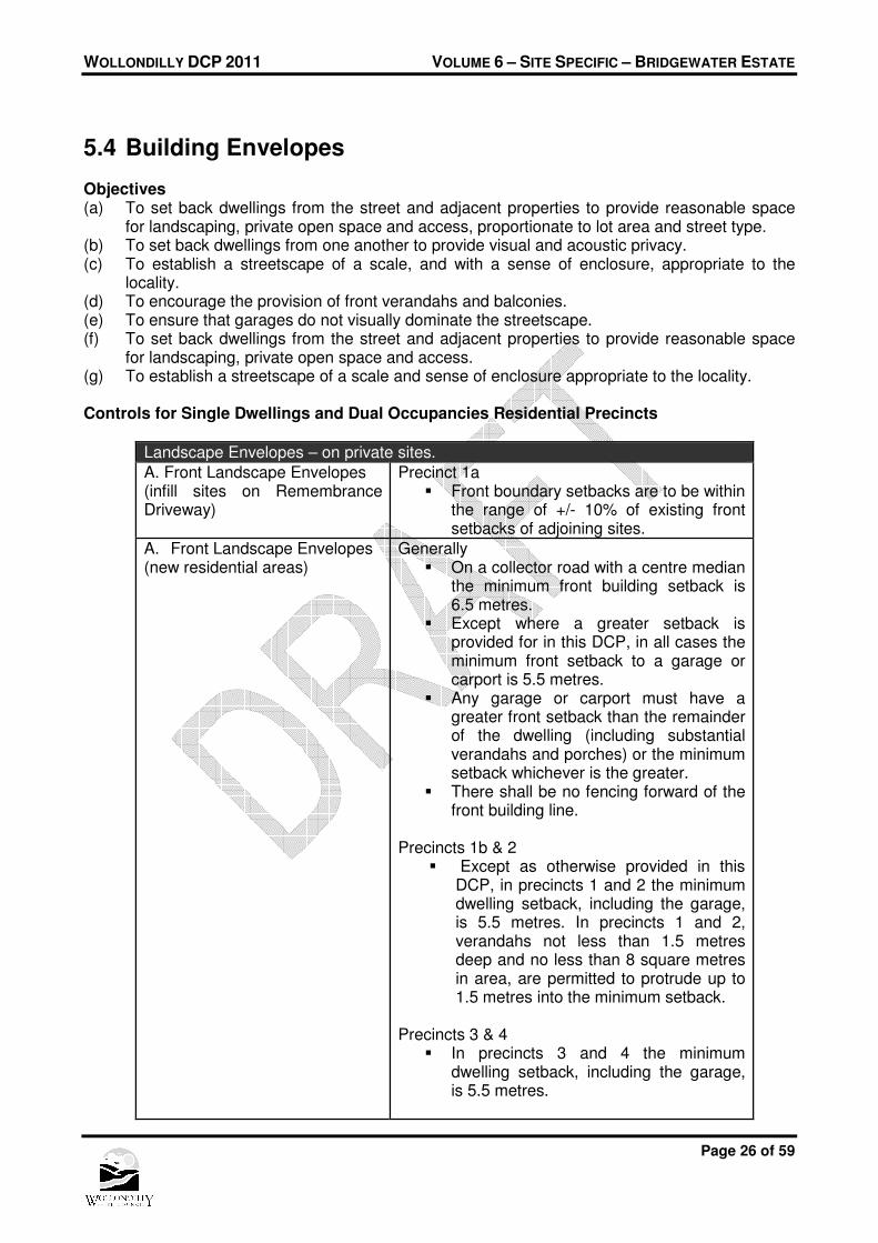
5.4 Building Envelopes Objectives (a) To set back dwellings from the street and adjacent properties to provide reasonable space
for landscaping, private open space and access, proportionate to lot area and street type. (b) To set back dwellings from one another to provide visual and acoustic privacy. (c) To establish a streetscape of a scale, and with a sense of enclosure, appropriate to the
locality. (d) To encourage the provision of front verandahs and balconies. (e) To ensure that garages do not visually dominate the streetscape. (f) To set back dwellings from the street and adjacent properties to provide reasonable space
for landscaping, private open space and access. (g) To establish a streetscape of a scale and sense of enclosure appropriate to the locality. Controls for Single Dwellings and Dual Occupancies Residential Precincts
Landscape Envelopes – on private sites.
A. Front Landscape Envelopes (infill sites on Remembrance Driveway)
Precinct 1a � Front boundary setbacks are to be within
the range of +/- 10% of existing front setbacks of adjoining sites.
A. Front Landscape Envelopes (new residential areas)
Generally � On a collector road with a centre median
the minimum front building setback is 6.5 metres.
� Except where a greater setback is provided for in this DCP, in all cases the minimum front setback to a garage or carport is 5.5 metres.
� Any garage or carport must have a greater front setback than the remainder of the dwelling (including substantial verandahs and porches) or the minimum setback whichever is the greater.
� There shall be no fencing forward of the front building line.
Precincts 1b & 2
� Except as otherwise provided in this DCP, in precincts 1 and 2 the minimum dwelling setback, including the garage, is 5.5 metres. In precincts 1 and 2, verandahs not less than 1.5 metres deep and no less than 8 square metres in area, are permitted to protrude up to 1.5 metres into the minimum setback.
Precincts 3 & 4
� In precincts 3 and 4 the minimum dwelling setback, including the garage, is 5.5 metres.

WOLLONDILLY DCP 2011 VOLUME 6 – SITE SPECIFIC – BRIDGEWATER ESTATE
Page 27 of 59
Landscape Envelopes – on private sites.
� A dwelling with a front balcony no less than 1.5 metres deep and no less than 8 square metres in area may protrude into the minimum front setback to within 3 metres of the front boundary.
� For attached dwellings where no rear
access is provided, garages should be recessed at least 300mm behind the front building alignment.
C. Secondary Landscape Envelopes (corner sites)
� Minimum 2.5 metres setback from the secondary street boundary for ground floor and first floor. Averaging of setback for 50% of the length of the dwelling wall nearest the secondary frontage is allowed, with a minimum of 1.25 metre setback. Any such setback is to be landscaped to Council’s satisfaction.
� Masonry fencing, matching the walls of
the dwelling, not located within the front setback, is required on the side boundary and shall be returned for at least 6 metres along the rear boundary. Sheet metal in fencing is not permitted.
� Minimum setback of 2.5 metres from the
boundary to the garage or carport.
� For a detached dual occupancy on a corner allotment, the dwelling fronting the secondary street will be required to comply with the front boundary setbacks.
D. Side Landscape Envelopes Precincts 1a & 1b Minimum side wall setback is 1.35 metres from side boundaries. Precinct 2 Minimum side wall setback is 900mm from side boundaries. See Site Planning Controls for Zero Lot Line controls
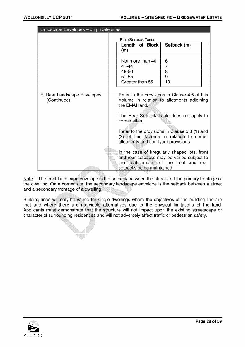
E. Rear Landscape Envelopes Precincts 1 , 2 & 3 The following minimum rear setbacks are required for all single dwellings, dual occupancy dwellings and integrated housing developments.
WOLLONDILLY DCP 2011 VOLUME 6 – SITE SPECIFIC – BRIDGEWATER ESTATE
Page 28 of 59
Landscape Envelopes – on private sites.
REAR SETBACK TABLE
Length of Block (m)
Setback (m)
Not more than 40 41-44 46-50 51-55 Greater than 55
6 7 8 9 10
E. Rear Landscape Envelopes (Continued)
Refer to the provisions in Clause 4.5 of this Volume in relation to allotments adjoining the EMAI land. The Rear Setback Table does not apply to corner sites. Refer to the provisions in Clause 5.8 (1) and (2) of this Volume in relation to corner allotments and courtyard provisions. In the case of irregularly shaped lots, front and rear setbacks may be varied subject to the total amount of the front and rear setbacks being maintained.
Note: The front landscape envelope is the setback between the street and the primary frontage of the dwelling. On a corner site, the secondary landscape envelope is the setback between a street and a secondary frontage of a dwelling. Building lines will only be varied for single dwellings where the objectives of the building line are met and where there are no viable alternatives due to the physical limitations of the land. Applicants must demonstrate that the structure will not impact upon the existing streetscape or character of surrounding residences and will not adversely affect traffic or pedestrian safety.

WOLLONDILLY DCP 2011 VOLUME 6 – SITE SPECIFIC – BRIDGEWATER ESTATE
Page 29 of 59
Controls for Integrated Housing and Dwellings in Precinct 4
Primary and Secondary Setbacks
Front Landscape Envelopes (new residential areas)
The minimum setback, including garage/s, is 5.5 metres. A dwelling or integrated housing development with a front balcony no less than 1.5 metres wide and no less than 8 square metres in area may protrude into the minimum front setback to within 3 metres of the front boundary. There shall be no fencing forward of the front building line.
Secondary Street Landscape Envelopes
2.5 metres from the secondary street boundary for ground floor and first floor. Averaging of setback for 50% of the length of the dwelling wall nearest the secondary frontage is allowed, with a minimum of 1 metre setback. Masonry fencing, matching the walls of the dwelling, not located within the front setback, is required on the side boundary and shall be returned for at least 6 metres along the rear boundary. Sheet metal is prohibited in fencing. Minimum of 2.5 metres from the boundary to the garage or carport.
Note: Any dwelling on an allotment fronting the secondary street will also be required to comply with the front Landscape Envelopes. Note: The front Landscape Envelope is the setback between the street and the primary frontage of the dwelling. The secondary street Landscape Envelope is the setback between a street and a secondary frontage of a dwelling. 1. Building lines will only be varied where there are no viable
alternatives due to the physical limitations of the land. Further, applicants must demonstrate that the structure will not impact upon the existing streetscape or character of surrounding residences and will not adversely affect traffic or pedestrian safety.
2. Integrated housing development may have zero lot line construction on no more than two boundaries. A zero lot line wall shall be constructed of brickwork (or similar) and shall satisfy the Fire Resistance Level requirements of the Building Code of Australia.
3. No openings shall be provided on the zero lot line boundary. Except in the case of party walls, an easement for maintenance shall be created on the allotment adjoining the zero lot line, within a section 88B instrument pursuant to the Conveyancing Act.

WOLLONDILLY DCP 2011 VOLUME 6 – SITE SPECIFIC – BRIDGEWATER ESTATE
Page 30 of 59
4. Except for party walls, the maximum wall length of an integrated dwelling abutting a property boundary shall be 50% of the total wall length facing that boundary for a single dwelling and 30% of the total wall length facing that boundary for a 2-storey dwelling.
Controls for Single dwellings and Dual occupancies in the Rural Residential Precinct 1. All buildings are to be setback a minimum of 18 metres from roadways. The setbacks from
an arterial road may be either 20 or 40 metres and Council should be contacted for details.
5.5 Building Height
Objectives (a) To ensure that development minimises impact on neighbouring properties in terms of bulk,
shadows, privacy and views. (b) To maintain a scale of development which is compatible with the existing or likely future
character of the locality. (c) To allow reasonable flexibility of height standards in relation to steeper land. Controls 1. The maximum wall height at any point through a building is to be 7.2m from the natural
ground level to the underside of the uppermost ceiling. 2. A dwelling may be a maximum of 2 storeys. 3. The height of the building is as defined and provided by the LEP and as identified on the
Height of Buildings Map. 4. Where parking or a basement area is provided under a building and the ceiling of the parking
area at any point projects more than 1m above natural ground level, it is considered to be a storey.
5. The ridge height of a detached garage or outbuilding shall not exceed 5.0m above the finished site level or natural ground level, whichever is greater.
6. In the case of lots with gradients in excess of 12.5%, Council may vary the building height development standards where strict adherence to the numerical standard would, in its opinion, be contrary to the general objectives of this DCP.
7. For a dual occupancy (detached or attached) where only one house has a direct street frontage (i.e. 1 dwelling is behind the other), the ‘rear’ dwelling (as determined by Council) shall have a maximum height at any point through the building of not more than 3.6 metres from the natural ground level to the underside of the uppermost ceiling.
Note: Where parking or a basement area is provided under a building, and the ceiling of the parking area at any point projects more than 1.5 metres above natural ground level, it is considered to be a storey.
8. The overall wall height of a detached garage or outbuilding shall not exceed 3.6 metres
above the finished site level or ground level, whichever is greater.
5.6 Carparking / On-Site Parking Objective (a) To provide convenient and safe parking which is adequate for residents and is not visually
obtrusive. Controls 1. For residential development in Precinct 4 a minimum of one (1) carparking space shall be
provided behind the front building line for each single dwelling house. A second parking space, which may be stacked, is also to be provided on site.

WOLLONDILLY DCP 2011 VOLUME 6 – SITE SPECIFIC – BRIDGEWATER ESTATE
Page 31 of 59
2. For residential development in Precincts 1, 2 and 3 a minimum of two (2) carparking spaces shall be provided behind the front building line for each single dwelling house
3. A single garage shall have minimum dimensions of 3m x 5.5m measured internally. A double garage shall have minimum dimensions of at least 5.5 x 5.5m. Garage doorways shall have a minimum width of 2.4m.
4. Two car parking spaces shall be provided for each dwelling house. At least one space shall be a garaged space. Stacked parking spaces are acceptable.
5. Generally development shall comply with Australian Standard 2890.1 1993 - Parking Facilities unless specifically otherwise provided in this DCP.
6. A minimum of one (1) carparking space shall be provided behind the front building line for each single dwelling house. A second parking space that may be stacked is also to be provided on site.
7. Where the development provides an internal road, visitor parking shall be provided at the rate of 1 space per 4 dwellings.
8. In the Rural Residential Precinct, natural contours must be followed when designing and constructing driveways and must not require tree removal.
5.7 Landscaping
Objectives (a) To require landscaping which is consistent with the scale of development, complements the
visual amenity of the neighbourhood and avoids large unbroken hard surfaced areas. (b) To maximise porous landscaped areas, which are easy to maintain.
Controls 1. A landscape plan prepared by a suitably qualified person shall be submitted with the
development application for dual occupancy and integrated housing development applications.
2. A maximum of one third of the street setback area of a dual occupancy development is to be paved or sealed.
3. Not less than one advanced tree of an approved species shall be planted between the front building line and the street boundary (Note: this does not apply to secondary street setback).
4. Trees adjacent to living rooms are to provide summer shade and allow winter sun entry. 5. Where landscaping is used to control overlooking, species selected are to be of a kind able
to achieve privacy within 3 years. In addition to such privacy planting, a mulched and permanently edged garden bed or beds, having a total minimum area of 10 square metres and average width no less than 1 metre (excluding edging) shall be provided within the front setback area of each dwelling. For good landscape coverage, these garden beds should be planted with shrubs at approximately to 2 plants per square metre. The remainder of landscaped areas shall be turfed.
6. For driveways servicing a rear dwelling, the area between the side boundary and the driveway shall be a mulched garden bed with permanent edging. The bed is to be planted with suitable species so as to ‘soften’ views of the driveway and any fencing.
7. All parts of the site that are not built upon or required for the purpose of access, parking, or open space shall be landscaped with appropriate vegetation. Landscaping of the site shall include both the individual allotments and the common areas and shall be consistent with the scale of the buildings on the site.
8. All parts of the site that are not built upon or required for the purpose of access, parking, or open space shall be landscaped with appropriate vegetation. Landscaping of the site shall include both the individual allotments and the common areas and shall be consistent with the scale of the buildings on the site.
9. For good landscape coverage, these garden beds should be planted with shrubs at approximately to 2 plants per square metre and shall be permanently mulched and edged. The remainder of landscaped areas, other than those identified above shall be turfed.

WOLLONDILLY DCP 2011 VOLUME 6 – SITE SPECIFIC – BRIDGEWATER ESTATE
Page 32 of 59
10. Should the development include an internal access road, landscaping shall extend to either side of the road and shall include the provision of advanced street trees, of an approved species, at 10 m intervals.
11. In the Woodlands Landscape Control Zone, Council will require the submission of a landscape maintenance bond equal to 1% of the development (building) costs with such bank guarantee to be released 12 months after satisfactory maintenance of the landscaped areas.
12. For lots within the RU4 Rural Small Holdings Zone, existing mature trees must be retained. Any approval for tree clearance is required and must be in accordance with the requirements in Volume 1 of this DCP.
Note: Where the adjoining nature strips are disturbed as a result of construction works, these areas shall also be turfed.
13. Any tree removal in Bridgewater Estate requires development consent and an arborist’s
report.
5.8 Private Open Space
Objectives (a) To ensure that private open space is clearly defined for private use and is in a location
consistent with the existing and desired neighbourhood character. (b) Private open space serves as an extension of the dwelling, providing space for relaxation,
dining, entertainment and recreation. (c) To provide for a main living area which opens on to private open space. (d) To provide an amount of private open space which is relative in size to the number of
bedrooms in the dwelling. (e) To ensure that private open space satisfies the requirements of residents in terms of
quantity, accessibility, solar access, and privacy. (f) To provide a level of open space which is relative to number of bedrooms in the dwelling. (g) To ensure that a living area of each dwelling opens onto the private open space. Controls – All Housing Types 1. The main living area is to open on to private open space which is at least 36 square metres
in area for one bedroom dwellings, 50 square metres for two bedroom dwellings and 80 square metres for three or more bedroom dwellings. Studies or other like nominated rooms will be considered as bedrooms.
2. Private open space for each dwelling at ground level is to contain a “principal area” directly connected to a living areas consisting of a rectangle no less than 6 metres x 6 metres and being not steeper than 1 in 15 gradient. On steeper sites private open space is to be terraced to provide useable space.
3. Land less than 3 metres in width does not qualify in the calculation of private open space area.
4. Private open space areas are not to be located within the front building line. Screen courtyard fences forward of the building line are not permitted.
Additional Controls – Integrated Housing 1. Private open space for each dwelling at ground level is to contain a “principal area” directly
connected to a living room consisting of a rectangle 4m x 6m and being not steeper than 1 in 15 gradient. On steeper sites private open space is to be terraced to provide useable space.
2. Should a common open space area also be provided within a community titles integrated housing development, a range of equipment shall be provided for the enjoyment of residents and may include seating and shade structures, a BBQ area and children’s play equipment.

WOLLONDILLY DCP 2011 VOLUME 6 – SITE SPECIFIC – BRIDGEWATER ESTATE
Page 33 of 59
5.9 Site Area and Dimensions (Dual Occupancy) Objectives (a) To provide for lot dimensions and areas which are adequate to ensure development
responds to: streetscape; solar and daylight access; and privacy and landscaping. (b) Lots are to have appropriate area and dimensions to enable design of: dwellings, outdoor
space, convenient vehicle access and parking. (c) To provide for a bona fide attached dwelling where this is not held on a separate title Controls 1. Detached Dual Occupancy housing, other than where one of the dwellings is a Attached
dwelling, may be permitted on a lot which: � Has an area of not less than 750 square metres; � Where both dwellings have a direct street frontage, a lot width not less than 24 metres
at any point; � Where only one dwelling has a direct street frontage (i.e., 1 dwelling is behind the
other) a lot width not less than 24 metres at any point. 2. Attached Dual Occupancy housing, other than where one of the dwellings is a Attached
dwelling, may be permitted on a lot which: � Has an area of not less than 600 square metres; � Has a lot width not less than 20 metres at any point.
3. No Dual Occupancy housing is permitted on hatchet shaped allotments or allotments having access to a street by a right of carriageway over an adjoining property.
4. Dual Occupancy housing, other than where one of the dwellings is a Attached dwelling, may be subdivided by way of Torrens Title subdivision only if each allotment created has: � In the case where detached houses both having a street frontage will be on the
proposed lots, an area not less than 450 square metres and a width not less than 12 metres at any point;
� In the case of detached houses where only one house has a direct street frontage (i.e. 1 dwelling is behind the other), the ‘front’ lot has an area not less than 300 square metres and a width not less than 15 metres at any point. Rear allotments serviced by a right of way are not permitted.
� In the case of attached houses, an area not less than 300 square metres and a width not less than 10 metres at any point.
5. Subdivision of a Attached dwelling is prohibited.
5.10 Site Facilities
Objectives (a) To ensure satisfactory provision of site facilities. (b) To ensure site facilities blend with the existing and desired neighbourhood character and
require minimal maintenance. Controls 1. Mailboxes are to be provided for each dwelling in accordance with the requirements of
Australia Post. 2. A clothesline shall be provided for each dwelling with at least 12 lineal metres of line not
visible from a public place. 3. The development application shall outline how the design of the development facilitates the
storage of garbage bins in a readily accessible location, for future occupants, that is out of public view.

WOLLONDILLY DCP 2011 VOLUME 6 – SITE SPECIFIC – BRIDGEWATER ESTATE
Page 34 of 59
5.11 Site Requirements (Integrated Housing)
Objectives (a) To provide for lot dimensions and areas which are adequate to ensure development
positively responds to: streetscape; solar and daylight access; and privacy and landscaping. (b) Lots are to have appropriate area and dimensions to enable efficient design of: dwellings,
outdoor space, convenient vehicle access and parking. (c) To ensure that the design of integrated housing is compatible with residential development in
the locality. (d) To provide diversity of housing choice within the Release Area.
Controls 1. Integrated housing allotments shall satisfy the following minimum standards: 2. The area of an allotment shall no less than 230 m2 3. The width of an allotment shall be not less than 6m. 4. No integrated housing is permitted on hatchet shaped allotments or allotments having access
to a street by a right of carriageway over an adjoining property. 5. Integrated housing may be subdivided only by means of Community Title or Torrens Title
subdivision. 6. Where any allotment to be created is less than 450 square metres, an application for
integrated housing development must be accompanied by a proposed subdivision layout, indicating allotment dimensions and area, the location of dwelling houses on each allotment and detailed dwelling design. Approved subdivision plans will not be released until completion of each dwelling house in accordance with the approved plans.
5.12 Visual Amenity and Design
Objectives (a) To ensure that building appearance from public streets and adjoining sites responds to and is
visually compatible with either the predominant character of existing surrounding residential development or, where identified, the desired future character of the area.
(b) To maintain and enhance the landscape character of the neighbourhood. (c) To minimise adverse impact of new residential development on adjoining residential land and
to facilitate appropriate integration. Controls 1. Design approval is to be obtained from the Developer’s Design Coordinator prior to the
lodgement with Council. 2. Dwellings shall be designed to enhance the existing character of the streetscape having due
regard to building form, scale and proportions. Buildings and vegetation of conservation or streetscape significance are to be retained where practicable.
3. Dwellings shall address (i.e., generally face towards) public streets and public places. 4. Development on lots adjoining public open space shall have its living areas and private open
space oriented towards the public open space. 5. Colours and materials shall have regard to the requirements of the Landscape Control Zone
and the immediate neighbourhood and shall be non-reflective. 6. The street elevation of buildings shall be no less than 9 metres in width in the case of
detached dual occupancy and a total of 15 metres in the case of attached dual occupancy. 7. Building facades on secondary frontages shall address the street and incorporate elements
within the roof and wall to create an articulated appearance. 8. Mirror-imaging or repeating of dwelling facades, as part of a dual occupancy development is
not permitted.

WOLLONDILLY DCP 2011 VOLUME 6 – SITE SPECIFIC – BRIDGEWATER ESTATE
Page 35 of 59
NON-MIRROR IMAGING OF A DUAL OCCUPANCY 9. Buildings are to have a maximum unarticulated wall length of 5m to street frontages.
Articulation is to consist of modulation together with punctuation by windows, verandahs, balconies and the like. Roof form is to be varied to provide visual variety. Garages shall not project forward of the remainder of the dwelling.
10. Highly contrasting coloured bricks/finishes are to be restricted to use on building elements such as sills, window heads, string courses etc. The body of external walls shall be an even colour.
11. Building facades or secondary facades shall incorporate elements within the roof and wall to create an articulated appearance.
12. Unrelieved walls for dwellings shall have a maximum length of 12 metres. 13. Colours and materials shall have regard to the inherent characteristics of the immediate
neighbourhood and shall be non reflective. 14. For development within the Rural Residential Precinct, the colour of dwelling houses play an
important part in their overall appearance in rural areas. 15. Certain outside colours and roofing materials may be required by the Developer
(Stocklands). 16. Any above ground water storage tanks are to be coloured or painted in earth tones to blend
with the natural environment and reduce their scenic impact.
Siting and Orientation of Dwellings � Dwellings should not be sited in the following locations: � On visually prominent ridge lines, hilltops or slopes. � On slopes greater than 25% (it should be noted that development on slopes greater than
18% requires the approval of the Soil Conservation Service). Consideration may be given to development on steeper slopes.
� On other areas which in Council’s opinion where sitings should be detrimental to the scenic quality of the area.

WOLLONDILLY DCP 2011 VOLUME 6 – SITE SPECIFIC – BRIDGEWATER ESTATE
Page 36 of 59
5.13 Visual and Acoustic Privacy
Objective (a) To site and design buildings in a manner which protects the visual and acoustic privacy of
nearby dwellings and private open space. Controls 1. Living room windows within multi dwelling developments are to be sited to minimise
overlooking of living areas of adjoining dwellings within and adjacent to the development. 2. Developments should aim to avoid overlooking of the main living areas of living areas or
private courtyards of adjoining dwellings. Within multi dwelling developments, windows of living rooms or bedrooms should be screened from common open space areas, walkways, accessways and windows of adjacent dwellings. Privacy levels may also be retained by:
3. Not placing living room windows in the side or rear boundary walls or offset windows where necessary
4. Using obscure glass, glass bricks or the like to provide light, where necessary. 5. Providing privacy screening through the use of landscaping fencing or the like. 6. Screening opposing windows, balconies or courtyards
5.14 Fencing and Retaining Walls
Objective (a) To ensure that fencing does not detract from the existing streetscape, and - where relevant -
public open space, and enhances the character of the development. Controls 1. There shall be no front fencing between the street boundary and the minimum building line,
except where: � In accordance with the provisions of this DCP regarding corner allotments; and � Where lots in Residential Precincts 3 and 4 front and are separated from public open
space areas by a public road. In this circumstance, front fencing in the form of either hedging or picket style fencing to a maximum height of 1.2 metres will be permitted.
2. Fencing on land within the RU4 Rural Small Holdings Zone must be a maximum height of 1.2 metres and predominantly open construction.
3. Fences must comply with any Developer guidelines produced by Stocklands. 4. On corner allotments and allotments adjoining public open space, boundary fencing must be
predominantly clay brick (or similar) in construction and must form part of the development application for the dwelling and be completed prior to issue of an occupation certificate.
5. On corner allotments secondary street front fencing shall not be greater than 1.5 metres high and shall be constructed predominantly of masonry materials, consistent with the principal wall materials of the dwelling.
6. Fences adjoining public open space shall not be greater than 1.5 metres high and shall be constructed predominantly of masonry materials, consistent with the design and principal wall materials of the dwelling.
7. Side and rear fences shall be a maximum of 1.8 metres in height. 8. Boundary retaining walls shall be a maximum of 0.5 metres above or below natural ground
level. 9. Wherever the rear boundary of an allotment abuts the front setback area of an adjoining
allotment the rear boundary fence shall be constructed from predominantly masonry materials, consistent with the design and principal wall materials of the dwelling, and compatible with adjoining fences, including other fencing on the allotment.

WOLLONDILLY DCP 2011 VOLUME 6 – SITE SPECIFIC – BRIDGEWATER ESTATE
Page 37 of 59
10. All side and rear fencing in the Heritage Protection and Woodland Zones, except where otherwise specifically provided in this plan, shall be constructed and finished so as to be non-reflective and shall be coloured in the range mid brown to grey to olive to green to blue green or a similar colour that is indistinguishable from that range of colours when viewed at a distance and from Camden Park Estate.
11. Pool fencing must comply with the requirements of AS1926 and the Swimming Pool Act 1992 and Regulations. The pool fence must be located a minimum of 1 metre from the pool edge - subject to officer assessment.
12. Retaining walls exceeding 600mm in height must be designed by a practicing structural engineer or constructed to manufacturers specifications.
13. On sites other than corner sites or sites adjoining public open space, side and rear fences shall be a maximum of 1.8m in height.
Note: See Appendix 3 – “Examples of Siting and Fencing Treatment on Corner Lots” for examples of appropriate fencing treatments on corner lots

WOLLONDILLY DCP 2011 VOLUME 6 – SITE SPECIFIC – BRIDGEWATER ESTATE
Page 38 of 59
Part 6 – Other non-residential development
6.1 Introduction This Part applies to development for the purposes of other land uses, being non-residential uses which may be permissible within the Camden Park area. The following objectives and controls apply to all non-residential development, in addition to those requirements in Parts 1-3 of this document. Objectives (a) To ensure development does not create a noise nuisance; (b) To ensure development is located on roads appropriate to the expected volume of traffic
generated by the development; (c) To ensure the provision of adequate car parking; (d) To make adequate provision for access by disabled persons; (e) To ensure the privacy of residents of adjacent development. Controls Carparking 1. For any proposed development, other than residential development, within a rural zone,
Council will require the provision of on-site car parking to a standard which reflects the intensity of the proposed development.
2. In determining an appropriate level of car parking to be provided for any particular development, reference should be made to Council’s Development Control Plan No.7 – Off Street Car Parking.
3. In other than residential developments, Council will require all car parking areas to be constructed to a hard standing, all weather standard.
4. Additional guidelines for the design of car parking areas can be found within the 5. Policies, Guidelines and Procedures for Traffic Generating Development published by the
Traffic Authority of New South Wales. Building setbacks 1. Generally building setbacks in rural zoned areas are 18 metres (or 20-40 metres if fronting
an arterial road). Council may require a greater setback to ensure that the amenity of the area is maintained.

WOLLONDILLY DCP 2011 VOLUME 6 – SITE SPECIFIC – BRIDGEWATER ESTATE
Page 39 of 59
Part 7 – Schedules
7.1 Definitions Attached dwelling [As provided in the Standard Instrument) Dual occupancy [As provided in the Standard Instrument) Multi dwelling development [As provided in the Standard Instrument) Residential Flat Building [As provided in the Standard Instrument) Storey means a space within a buildings that is situated between one floor level and the floor level next above, or if there is no floor above, the ceiling or roof above, but does not include: a) A space that contains only a lift shaft, stairway, or meter room. b) A mezzanine, or c) An attic State Environmental Planning Policy No 6—Number of Storeys in a Building 6 Determination of number of storeys which a building contains (1) Where the application of a provision of an environmental planning instrument requires a determination of the number of storeys, floors or levels which a building contains, that number shall, for the purposes of applying the provision, be deemed to be the maximum number of storeys, floors or levels, as the case may be, of the building which may be intersected by the same vertical line, not being a line which passes through any wall of the building. (2) Except as provided by subclause (3), when applying subclause (1) in relation to a provision referred to in that subclause, a reference in subclause (1) to storeys, floors or levels shall be treated as a reference to storeys, floors or levels, within the meaning of the provision. (3) The second reference in subclause (1) to storeys, floors or levels does not include a reference to the whole or any part of a roof used as an uncovered garden, terrace or deck. [As provided in the Standard Instrument) Release Area means the land identified on the map known as Wollondilly LEP 1991 (Amendment No.37) - Camden Park kept in the office of Wollondilly Shire Council. Zero Lot Line construction means development within 675mm of a side or rear boundary and includes party walls. AEP” means annual event probability Bridgewater Estate or otherwise identified as “Camden Park Estate” means the land identified on the map marked “Camden Park Urban Release Area” and the land occupied by the Elizabeth Macarthur Agricultural Institute (Lot 1 in DP 130228, Lot 1 in DP 168893 and Lot 11 in DP 658458) and Camden Park House (Lots 1 and 2 in DP 213696) as kept in the office of Wollondilly Shire Council. EMAI means the Elizabeth Macarthur Agricultural Institute.

WOLLONDILLY DCP 2011 VOLUME 6 – SITE SPECIFIC – BRIDGEWATER ESTATE
Page 40 of 59
Historic Camden Park Estate means the land occupied by the building known as Camden Park House (Lots 1 and 2 in DP 213696). Corner allotment means an allotment with two or more frontages to a public place. Heritage Views Protection Landscape Control Zone means the land designated as such in the Landscape Control Plan that forms part of this document. Integrated Housing Development is development, in a high amenity location within Precinct 4, which consists of the subdivision of land into 3 or more residential lots, each having a site area up to 450 square metres; and the erection of a single dwelling house (including attached dwellings) on each of the allotments created by that subdivision. Landscape Control Plan is Figure2 attached to this DCP Figure 1 sets the physical boundary limitations of this DCP. It defines land uses, principal road network, indicatively the local road layout and location of community and recreational facilities and alternative housing densities. Figure 2 is titled Camden Park Urban Release Area, Landscape Control Plan and includes details of landscaping and items of urban design.
7.2 Maps Map 1 – Precinct Boundaries Map 2 – Landscape Control Plan

WOLLONDILLY DCP 2011 VOLUME 6 – SITE SPECIFIC – BRIDGEWATER ESTATE
Page 41 of 59
Map 1 – Camden Park Precinct Boundaries

WOLLONDILLY DCP 2011 VOLUME 6 – SITE SPECIFIC – BRIDGEWATER ESTATE
Page 42 of 59
Map 2 – Camden Park Landscape Control Plan

WOLLONDILLY DCP 2011 VOLUME 6 – SITE SPECIFIC – BRIDGEWATER ESTATE
Page 43 of 59
Appendices Appendix 1 – Plant Species

WOLLONDILLY DCP 2011 VOLUME 6 – SITE SPECIFIC – BRIDGEWATER ESTATE
Page 44 of 59

WOLLONDILLY DCP 2011 VOLUME 6 – SITE SPECIFIC – BRIDGEWATER ESTATE
Page 45 of 59

WOLLONDILLY DCP 2011 VOLUME 6 – SITE SPECIFIC – BRIDGEWATER ESTATE
Page 46 of 59

WOLLONDILLY DCP 2011 VOLUME 6 – SITE SPECIFIC – BRIDGEWATER ESTATE
Page 47 of 59

WOLLONDILLY DCP 2011 VOLUME 6 – SITE SPECIFIC – BRIDGEWATER ESTATE
Page 48 of 59

WOLLONDILLY DCP 2011 VOLUME 6 – SITE SPECIFIC – BRIDGEWATER ESTATE
Page 49 of 59
Appendix 2 – Development Guidelines

WOLLONDILLY DCP 2011 VOLUME 6 – SITE SPECIFIC – BRIDGEWATER ESTATE
Page 50 of 59

WOLLONDILLY DCP 2011 VOLUME 6 – SITE SPECIFIC – BRIDGEWATER ESTATE
Page 51 of 59

WOLLONDILLY DCP 2011 VOLUME 6 – SITE SPECIFIC – BRIDGEWATER ESTATE
Page 52 of 59

WOLLONDILLY DCP 2011 VOLUME 6 – SITE SPECIFIC – BRIDGEWATER ESTATE
Page 53 of 59

WOLLONDILLY DCP 2011 VOLUME 6 – SITE SPECIFIC – BRIDGEWATER ESTATE
Page 54 of 59

WOLLONDILLY DCP 2011 VOLUME 6 – SITE SPECIFIC – BRIDGEWATER ESTATE
Page 55 of 59

WOLLONDILLY DCP 2011 VOLUME 6 – SITE SPECIFIC – BRIDGEWATER ESTATE
Page 56 of 59

WOLLONDILLY DCP 2011 VOLUME 6 – SITE SPECIFIC – BRIDGEWATER ESTATE
Page 57 of 59

WOLLONDILLY DCP 2011 VOLUME 6 – SITE SPECIFIC – BRIDGEWATER ESTATE
Page 58 of 59
Appendix 3 – Examples of Siting and Fencing of Corner Lots

WOLLONDILLY DCP 2011 VOLUME 6 – SITE SPECIFIC – BRIDGEWATER ESTATE
Page 59 of 59