opg’s deep geologic repository bruce site, tiverton ...bruce site, tiverton, ontario site...
TRANSCRIPT

OPG’S DEEP GEOLOGIC REPOSITORY
BRUCE SITE, TIVERTON, ONTARIO
SITE CHARACTERISATION PROGRESS
CNSC/NRCan Briefing
September 10, 2009
Ottawa, Ontario

• DGR Project Schedule
• Geoscientific Characterisation Planning
• Bruce site Attributes
• Status of Site Characterisation Program 2009
• Summary Interim Observations/Findings
Presentation Outline
2

2005 DGR Project Initiation
2006 Implement Phase I Site Characterisation Plan
2007 Drill Deep Vertical Boreholes DGR-1/2
2-D Seismic Reflection Survey
2008 Implement Phase II Site Characterisation Plan
Drill Deep Vertical Boreholes DGR3/4
Complete Phase I Geosynthesis
2009 Drill Deep Inclined Boreholes DGR5/6
Update Draft Phase II Geosynthesis
2010 Complete Bruce site Geological Field Work
Final Descriptive Geosphere Site Model
Final Bruce site Geosynthesis
2011 Submit Environmental Impact Statement/Safety Report
2012 Public Hearing
Geoscience Program Planning
3

Geoscience Program Planning
4
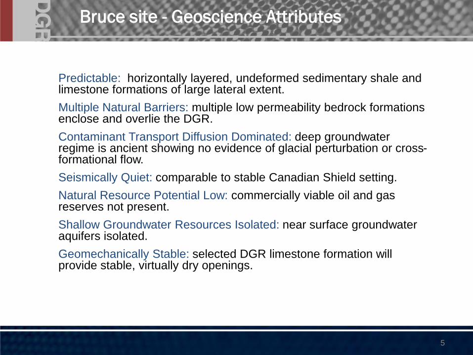
Bruce site - Geoscience Attributes
● Predictable: horizontally layered, undeformed sedimentary shale and limestone formations of large lateral extent.
● Multiple Natural Barriers: multiple low permeability bedrock formations enclose and overlie the DGR.
● Contaminant Transport Diffusion Dominated: deep groundwater regime is ancient showing no evidence of glacial perturbation or cross-formational flow.
● Seismically Quiet: comparable to stable Canadian Shield setting.
● Natural Resource Potential Low: commercially viable oil and gas reserves not present.
● Shallow Groundwater Resources Isolated: near surface groundwater aquifers isolated.
● Geomechanically Stable: selected DGR limestone formation will provide stable, virtually dry openings.
5

• Multi-year, step-wise investigative program to support Geosynthesis development, the DGR Safety Case and Engineering Design
• Phase 1: 2-D seismic survey, establishment of local seismograph network & shallow bedrock monitoring wells, drilling, coring and testing of two deep vertical boreholes (DGR-1 and DGR-2), initial exploratory laboratory testing program, and groundwater monitoring
• Phase 2A: drilling, coring and testing of two additional deep vertical boreholes (DGR-3 and DGR-4) to triangulate DGR, deep stratigraphy, K & head, expanded laboratory testing program and groundwater monitoring
• Phase 2B: drilling and testing of inclined boreholes to investigate possible sub-vertical structure, laboratory testing and groundwater monitoring.
GSCP Scope: Site Characterisation
6

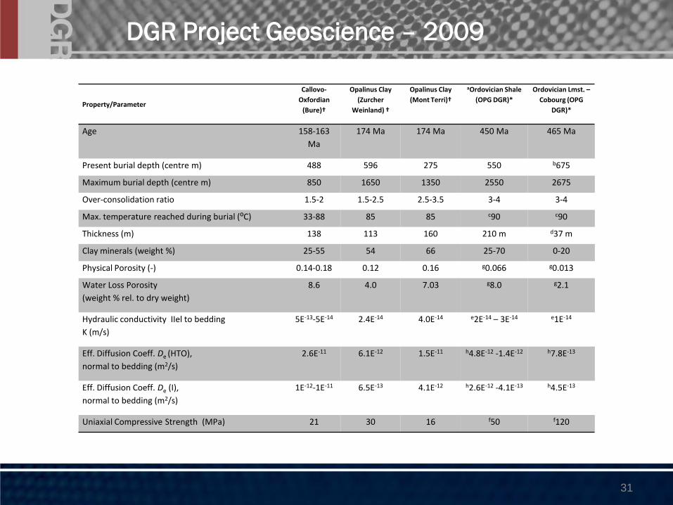
DGR Project Geoscience – 2009
7

DGR Project Geoscience - Drilling/Rock Coring
8

DGR Drilling - Core Logging/Preservation
9

DGR Project Geoscience – Core Recovery
10
DGR-3 Coring - Intact Queenston Shale 76mm

DGR Series Deep Boreholes – Core Logging
11

DGR Project Geoscience – CSF
12

Formation Strike/Dip: N20°W/0.6°SW
13
DGR Project Geoscience – Marker Beds (1)

DGR Project Geoscience – Marker Beds (2)
14
DGR Marker Bed – Georgian Bay Fossiliferous Hard Bed, DGR-2, DGR-3 & DGR-4

DGR Project Geoscience – Formation Thickness
15
Formation DGR-1/2 DGR-3 DGR-4
Amherstburg to Bass Islands Dolostones 138.9 133.0 132.5
Salina G Unit to B Unit 121.9 117.3 122.4
Salina A2 Unit to A0 Unit 81.4 82.2 83.1
Guelph and Goat Island Dolostones 22.9 23.7 23.5
Gasport to Fossil Hill Dolostones 13.6 12.3 12.4
Cabot Head and Manitoulin 36.7 34.2 34.8
Queenston Shale 70.4 74.4 73.0
Georgian Bay Shale 90.9 88.7 88.7
Blue Mountain Shale 42.7 44.2 45.1
Collinwood Member Shale 7.9 8.7 8.4
Cobourg Limestone 28.6 27.8 27.5
Sherman Fall and Kirkfield Limestones 73.9 74.5 74.0
Coboconk and Gull River Limestones 76.6 75.4 76.0
Shadow Lake Siltstone 5.2 4.5 5.1
All Ordovician Fms 396.1 398.5 397.8

DGR Series Deep Boreholes – Strike/Dip
16
Formation/Marker Bed Strike Dip
Amherstburg Dolostone N16°W 1.15°SW
Bois Blanc Dolostone N27°W 0.95°SW
Salina F Unit Dolostone Marker Bed N32°W 0.98°SW
Salina C Unit Shale N25°W 1.07°SW
Salina A0 Unit Dolostone N19°W 0.63°SW
Cabot Head Shale N19°W 0.53°SW
Queenston Shale N24°W 0.63°SW
Georgian Bay Shale N17°W 0.63°SW
Georgian Bay Fossiliferous Marker Bed N15°W 0.59°SW
Cobourg Limestone N14°W 0.63°SW
Kirkfield Limestone N18°W 0.65°SW
Coboconk Limestone N18°W 0.56°SW
Coboconk Ash Marker Bed N20°W 0.58°SW
Shadow Lake Siltstone N19°W 0.59°SW

DGR Series Deep Boreholes - Stratigraphy 2009
17

DGR Series Deep Boreholes – Hydraulic Testing
18

Instrumentation Deep Boreholes
Westbay Multi-level Casing Installation )
19

Preliminary Results
20

DGR Project Geoscience – 2009
21

2-D Seismic Survey – Results (1)
22
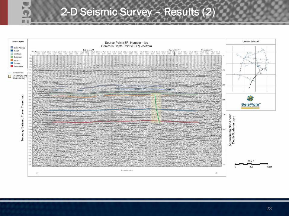
2-D Seismic Survey – Results (2)
23

DGR Site Layout - Drilling
24

• Field geomechanical testing – P & S wave, point load, slake durability
• Lab geomechanical – strength testing (uniaxial, triaxial, shear, tension), swell testing, abrasivity
• Lab mineralogical/geochemical – petrography, XRD/SEM, lithogeochemistry
• Lab petrophysical – porosity/pore sizes, fluid saturations, gas/brine permeability, gas entry pressures, surface areas
• Lab diffusion – pore and effective diffusion coefficients, diffusion porosity using iodide, tritium, radio-iodide tracers
• Lab porewater – major ions, 18O, 2H, 87/86Sr, 13C, gases (Rn, Ar, Ne, He, CH4, pCO2,
13C & 2H of CH4,13C of CO2,
3He/4He) radioisotopes (36Cl, 129I)
Core Testing Program
25

DGR Project Geoscience – Porosities
26

27
DGR1/2 Pore Fluid Chemistry
Dep
th (
m)
27

DGR Project Geoscience – 2009
28

DGR Project Geoscience – 2009
400.00
500.00
600.00
700.00
800.00
900.00
1E-14 1E-13 1E-12 1E-11
De (m2/s)
Dep
th (
m)
TD - HTO - PB
TD - HTO - NB
TD - I - PB
Radiography PB
TD - I - NB PSI
TD - I - NB
Radiography NB
Shale
Limestone
Sandstone
29

DGR Project Geoscience – 2009
30
DGR Project Geoscience – 2009
Property/Parameter
Callovo-
Oxfordian
(Bure)†
Opalinus Clay
(Zurcher
Weinland) †
Opalinus Clay
(Mont Terri)†
aOrdovician Shale
(OPG DGR)*
Ordovician Lmst. –
Cobourg (OPG
DGR)*
Age 158-163
Ma
174 Ma 174 Ma 450 Ma 465 Ma
Present burial depth (centre m) 488 596 275 550 b675
Maximum burial depth (centre m) 850 1650 1350 2550 2675
Over-consolidation ratio 1.5-2 1.5-2.5 2.5-3.5 3-4 3-4
Max. temperature reached during burial (⁰C) 33-88 85 85 c90 c90
Thickness (m) 138 113 160 210 m d37 m
Clay minerals (weight %) 25-55 54 66 25-70 0-20
Physical Porosity (-) 0.14-0.18 0.12 0.16 g0.066 g0.013
Water Loss Porosity
(weight % rel. to dry weight)
8.6 4.0 7.03 g8.0 g2.1
Hydraulic conductivity IIel to bedding
K (m/s)
5E-13-5E-14 2.4E-14 4.0E-14 e2E-14 – 3E-14 e1E-14
Eff. Diffusion Coeff. De (HTO),
normal to bedding (m2/s)
2.6E-11 6.1E-12 1.5E-11 h4.8E-12 -1.4E-12 h7.8E-13
Eff. Diffusion Coeff. De (I),
normal to bedding (m2/s)
1E-12-1E-11 6.5E-13 4.1E-12 h2.6E-12 -4.1E-13 h4.5E-13
Uniaxial Compressive Strength (MPa) 21 30 16 f50 f120
31

• Bedrock geology and formation thicknesses have been predictable and uniform
• Formations below Salina G Unit of excellent RQD with sparsely to very sparsely spaced fractures
• Formation geomechanical properties appear consistent with expectations (Ordovician shales and limestones are massive and competent, Cobourg rocks are strongest)
• Formation hydraulic properties appear consistent with expectations (Devonian dolostones are permeable, Silurian dolostones and shale are tight to permeable,Ordovician shales and limestones are very tight, Cambrian sandstones are permeable,)
• Limited opportunities for groundwater sampling during drilling below Salina F Member shale (Salina A1, Guelph, Cambrian)
Main Observations/Findings (1)
DGR Project Schedule: Geoscience
32

• The Ordovician shales and argillaceous limestones are under-pressured by upwards of 260 mBGS environmental head = very low formation permeability
• Very low Ordovician shale and DGR formation permeabilities and porewater chemistry profiles suggest mass transport dominated by diffusion
• Cambrian sandstone is permeable and over-pressured (~ 10,900 kPa, ~140 mAGS environmental head)
• No significant oil or gas occurrences detected during drilling, but some probable gas-related high pressure zones evident (A0 Salina Unit, mid Georgian Bay).
• Porewater extraction from the low porosity and permeability Ordovician shales and limestones is a challenge
• Secondary infilling minerals: halite in Ordovician shales, anhydrite in Ordovician argillaceous limestones, gypsum in upper Silurian Salina
Main Observations/Findings (2)
33

DGR Project Geoscience – 2009
34