overview of ontario power generation’s … · overview of ontario power generation’s proposed...
TRANSCRIPT
OVERVIEW OF ONTARIO POWER GENERATION’S PROPOSED L&ILW DEEP GEOLOGIC REPOSITORY BRUCE SITE, TIVERTON, ONTARIO Mark Jensen, Monique Hobbs, Tom Lam, Dylan Luhowy, Jim McLay, Branko Semec and Andre Vorauer Ontario Power Generation, Toronto, Ontario ABSTRACT A Deep Geologic Repository (DGR) for the long-term management of operational Low and Intermediate Level Radioactive Waste is being proposed by Ontario Power Generation at the Bruce Nuclear site near Tiverton, Ontario. Situated within the Michigan Basin, the Bruce site is underlain by an 850 m sedimentary sequence of carbonates, shales and evaporates. The shaft accessed DGR would be excavated a depth of 680 m within a low permeability Ordovician argillaceous limestone. An overview of the DGR project and geoscientific studies in support of an Environmental Assessment is described. RÉSUMÉ Ontario Power Generation (OPG) propose de développer un dépôt pour la gestion à long terme des déchets radioactifs de faible et de moyenne activité dans des couches géologiques profondes sur le site de Bruce, près de Tiverton en Ontario. Le site de Bruce est situé à l’intérieur du Bassin du Michigan qui inclut une séquence sédimentaire d’environ 850 m, composée de carbonates, schistes et évaporites. Le dépôt serait accessible par l’intermédiaire d’un puits et construit à une profondeur de 680 m dans la couche Ordovicienne dont la perméabilité est très faible. Cet article présente une vue d’ensemble sur les activités geoscientifiques menées dans le cadre de l ‘évaluation environnementale.
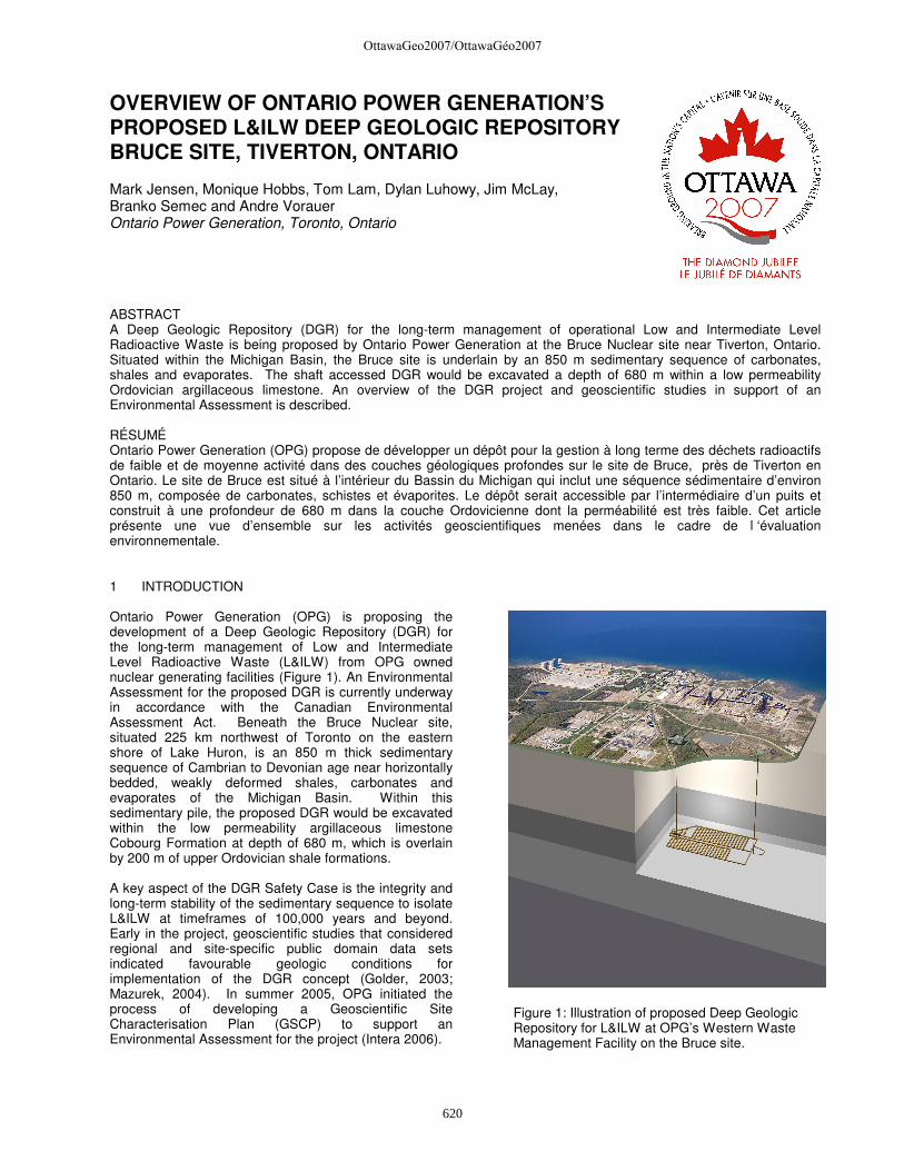
1 INTRODUCTION Ontario Power Generation (OPG) is proposing the development of a Deep Geologic Repository (DGR) for the long-term management of Low and Intermediate Level Radioactive Waste (L&ILW) from OPG owned nuclear generating facilities (Figure 1). An Environmental Assessment for the proposed DGR is currently underway in accordance with the Canadian Environmental Assessment Act. Beneath the Bruce Nuclear site, situated 225 km northwest of Toronto on the eastern shore of Lake Huron, is an 850 m thick sedimentary sequence of Cambrian to Devonian age near horizontally bedded, weakly deformed shales, carbonates and evaporates of the Michigan Basin. Within this sedimentary pile, the proposed DGR would be excavated within the low permeability argillaceous limestone Cobourg Formation at depth of 680 m, which is overlain by 200 m of upper Ordovician shale formations. A key aspect of the DGR Safety Case is the integrity and long-term stability of the sedimentary sequence to isolate L&ILW at timeframes of 100,000 years and beyond. Early in the project, geoscientific studies that considered regional and site-specific public domain data sets indicated favourable geologic conditions for implementation of the DGR concept (Golder, 2003; Mazurek, 2004). In summer 2005, OPG initiated the process of developing a Geoscientific Site Characterisation Plan (GSCP) to support an Environmental Assessment for the project (Intera 2006).
Figure 1: Illustration of proposed Deep Geologic Repository for L&ILW at OPG’s Western Waste Management Facility on the Bruce site.
OttawaGeo2007/OttawaGéo2007
620
Within the GSCP site-specific field and laboratory investigations have been established to further develop and test the existing geoscientific knowledge of sub-surface conditions as they relate to geosphere stability and evolution, engineered repository systems design, and long-term repository safety. These investigations, which will eventually support regulatory submissions, are providing the first opportunity for on-site characterization of the sedimentary sequence and underlying Precambrian crystalline bedrock. The GSCP represents a stepwise 5-year, 3 phase program of geoscientific investigations. Phase I program activities were initiated in fall 2006. This paper provides an overview of the DGR project and the implementation of the GSCP, in particular, the progress of Phase I activities scheduled for completion in mid-2008. 2 BACKGROUND – DGR PROJECT Ontario Power Generation’s Western Waste Management Facility (WWMF) at the Bruce site has received L&ILW from the Pickering, Bruce and Darlington nuclear stations for over 30 years. The waste is stored in engineered above and below ground storage structures depending on the physical and radiological characteristics of the waste. At present there is approximately 70,000 m3 of L&ILW stored at the WWMF with annual waste arisings of between 2,000 m3 to 3,000 m3 following volume reduction (5,000 m3 to 7,000 m3
before volume reduction). The WWMF storage structures have a minimum design life of 50 years and are suitable for the interim storage of L&ILW. Although current storage practices are safe, these wastes will eventually need to be transferred to a long-term management facility as some of the wastes remain hazardous for thousands of years. Since the mid-1980s, OPG has reviewed a wide range of options for the long-term management of L&ILW, including above- and below-ground repository concepts considered by the Municipality of Kincardine and OPG through an Independent Assessment Study completed in March 2004. The outcome of this Independent Assessment Study was that all L&ILW repository concepts were considered technically feasible. Due to margins of safety, the municipality in spring 2004 selected the DGR concept, which then became the preferred option for long-term L&ILW management. In October 2004, the Municipality of Kincardine and OPG signed a Hosting Agreement to site a DGR on the Bruce site. This agreement explicitly excludes used nuclear fuel from the DGR. The agreement required a formal survey of community support, which was completed in January 2005. Results of the survey indicated a clear majority supporting the DGR project and a Kincardine Municipal council decision to continue with the DGR Hosting Agreement was affirmed on February 16, 2005. As envisioned, the DGR would involve the excavation of waste emplacement rooms within the Ordovician age argillaceous limestone Cobourg Formation at a depth of 680-m beneath Bruce site (Figure 1). The repository,
accessed via two vertical shafts, would require the excavation of nearly 500,000 m3 of rock to accommodate an emplaced L&ILW volume of 200,000 m3 within an approximate 27 Ha repository footprint. Support buildings would be located on ground surface above the underground workings. The current repository concept would consist of a series of emplacement rooms arranged in parallel rows on either side of central access tunnels. A concrete floor will be poured to provide a stable base for stacking of the L&ILW packages. In July 2005, OPG initiated a process that culminated in the preparation of the GSCP for the proposed DGR. The GSCP provides a comprehensive and internationally peer-reviewed basis for DGR-related geoscientific studies. In this capacity, the GSCP describes surface and sub-surface site characterisation activities necessary to:
o assess and reaffirm the technical suitability of the proposed DGR concept;
o provide evidence on the geoscientific basis for repository safety at timeframes of 100,000 years or beyond (i.e. stable rock formations; diffusion dominant transport regime);
o yield information to support development of a site-specific engineered repository design;
o provide a geoscientific basis for the post-closure safety assessment; and
o contribute to the development of an integrated DGR Safety Case describing the expected long-term safety and potential impacts of the DGR.
The activities described in the GSCP are intended to support two key deliverables:
o a Descriptive Geosphere Model, which is an integrated, multi-disciplinary, geoscientific description and explanation of the undisturbed subsurface environ as it relates to site-specific geologic, hydrogeologic and geomechanical characteristics and attributes; and
o a Geosynthesis, which is a geoscientific explanation of the overall understanding of site characteristics, attributes and evolution (past and future) as they relate to demonstrating long-term DGR performance and safety.
Upon completion of the GSCP and pending EA approval, a provisory schedule would seek regulatory approval for DGR construction in 2012 and operation in 2018.
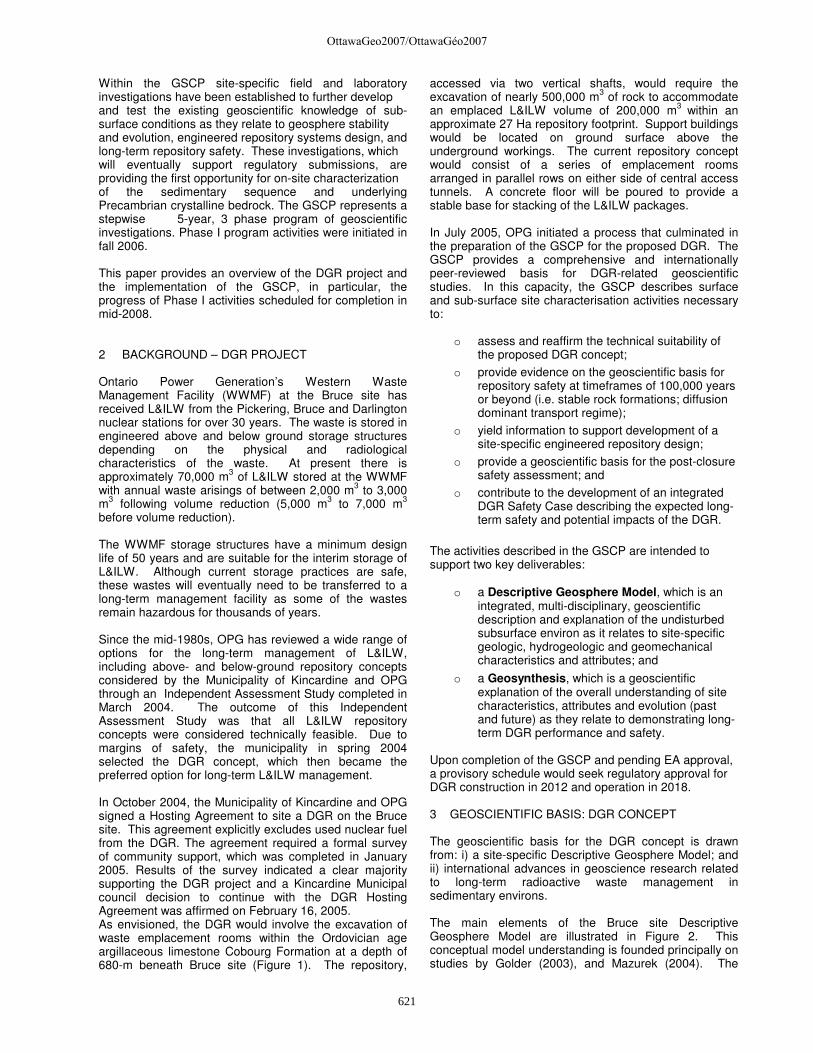
3 GEOSCIENTIFIC BASIS: DGR CONCEPT The geoscientific basis for the DGR concept is drawn from: i) a site-specific Descriptive Geosphere Model; and ii) international advances in geoscience research related to long-term radioactive waste management in sedimentary environs. The main elements of the Bruce site Descriptive Geosphere Model are illustrated in Figure 2. This conceptual model understanding is founded principally on studies by Golder (2003), and Mazurek (2004). The
OttawaGeo2007/OttawaGéo2007
621
Golder (2003) feasibility study assembled public domain geoscientific and precedent underground construction information within the bedrock formations occurring at Bruce site. As shown in Figure 2, a thin layer of glacial and glacio-fluvial sediment is underlain by a near flat lying sequence of laterally continuous Paleozoic carbonates, shales, evaporites and minor sandstones. From a hydrogeologic perspective, the bedrock sequence is divided into 3 distinct horizontally stratified bedrock regimes; i) an upper permeable fresh water carbonate aquifer (0-100 mbgs); ii) an intermediate brackish, moderately permeable stratified aquifer-aquitard system (≈100-400 mbgs); and iii) a deep, saline (TDS 200 g L-1), extremely low permeable sequence of shales and carbonates (≈400-800 mbgs). Within the deep groundwater regime, extremely low formation permeabilities (>10-19 m2), typical Na-Ca-Cl dominant fluids, distinct isotopic 18O – 2H signatures, 87Sr/86Sr signatures consistent with a marine origin and long residence times, groundwater viscosities, and environmental heads strongly support the existence of a stagnant, diffusion dominant transport regime; one that has been unperturbed by Pleistocene glacial events.
Mazurek (2004) documents a second assessment that included an international radioactive waste management perspective. The assessment involved a review of international radioactive waste management programmes and repository concepts in sedimentary media, and a compilation of existing and publicly available geoscientific information for southern Ontario. A synthesis of this latter information served as a basis to evaluate the bedrock formation attributes in the light of international experience. This approach adopted the structured NEA FEPCAT framework, which examines multiple and independent lines of reasoning focused on assessing the isolation and containment properties and, long-term geologic, hydrogeologic and geomechanical stability of the setting for radioactive waste management purposes (Mazurek et al, 2003). Internationally, the understanding of the geoscientific basis for long-term radioactive waste management in sedimentary media has advanced significantly during the last decade (Mazurek, 2004). Radioactive waste management programmes in Switzerland (Nagra), France (Andra), Belgium (Ondraf/Niras), Spain (Enresa) and Japan (JNC) have focussed on argillaceous media. Safety Cases or comparable milestones targeted at deep geologic disposal have recently been completed by Nagra, Andra and Ondraf/Niras. The development of
Figure 2: Illustration of Bruce site Descriptive Geosphere Model.
OttawaGeo2007/OttawaGéo2007
622

these Safety Cases was supported by well established collaborative research programmes at the Mont Terri (Switzerland), Mol/Dessel (Belgium) and Bure (France) Underground Research Laboratories. The key safety related attributes of argillaceous media include:
o horizontally bedded and weakly deformed units in sedimentary sequences which are geometrically simple and straight-forward to conceptualise;
o target formations are sufficiently homogeneous, which enhances predictability;
o formations possess very low permeabilities, thus mass transport is likely diffusion-dominated;
o transport through the pore space is very slow, and sorption on clay minerals retards the migration of many dissolved species;
o the formations possess an ability to self-seal fractures and faults;
o multiple lines of geoscientific evidence indicate the geosphere is robust to long-term perturbations on geologic time scales (i.e. erosion, glaciation, permafrost); and
o formations provide sufficient geomechanical stability for safe repository construction and operation.
Among other factors, the application of the FEPCAT methodology to the Paleozoic sediments of southern Ontario considered bedrock lithology, stratigraphy, geologic structure, basin evolution, diagenesis, physical and chemical hydrogeology, regional stress regime magnitude and orientation, seismology, resource potential and geomechanical attributes. Results of the assessment identified the Middle to Upper Ordovician shales and limestones as potential host formations. Specific lines of reasoning that supported this conclusion included: o The thickness of the Ordovician shales and
limestones well exceeds 100 m, a value internationally regarded as a siting preference;
o The degree of vertical and horizontal heterogeneity of geological and hydrogeological attributes in the potential host formations is limited and reasonably well known;
o Hydrogeochemical evidence indicates very long underground residence times for formation pore fluids and no resolvable cross-formational flow or mixing over geological periods of time;
o A surficial fresh-water flow system is underlain by a stagnant hydrogeologic regime. Given the absence of exfiltration areas for deep ground waters, flow does not occur or is very limited. Solute transport is probably dominated by diffusion;
o Deep infiltration of surficial waters is unlikely due to the high density of brines occurring in the deep underground and due to the presence of several horizontally layered low-permeability formations that confine the more permeable units; and
o Tunnelling in deeply buried shales and limestones appears to be feasible in spite of apparent high horizontal stresses.
Based on the results of Golder (2003) and Mazurek (2004), the principal elements or attributes of the Descriptive Geosphere Model for Bruce site favourable for DGR implementation are:
o Geologically stable shale and argillaceous limestone formations that are geometrically simple, predictable and of large lateral extent;
o Active faulting and seismicity is comparable to Shield setting;
o Argillaceous limestone formation that will host DGR will provide stable, virtually dry openings;
o Multiple horizontally layered low permeability bedrock formations enclose and overlie the DGR (multi-barriers);
o Regional stress regime (horizontally compressive) favours sealing of vertical fractures/faults;
o Mass transport is likely diffusion dominated. The deep groundwater flow systems are saline (>100 g/L), stagnant and ancient showing no evidence of glacial perturbation or cross-formational flow; and
o Shallow groundwater resources in the upper dolomitic bedrock aquifer system are hydrogeologically isolated.
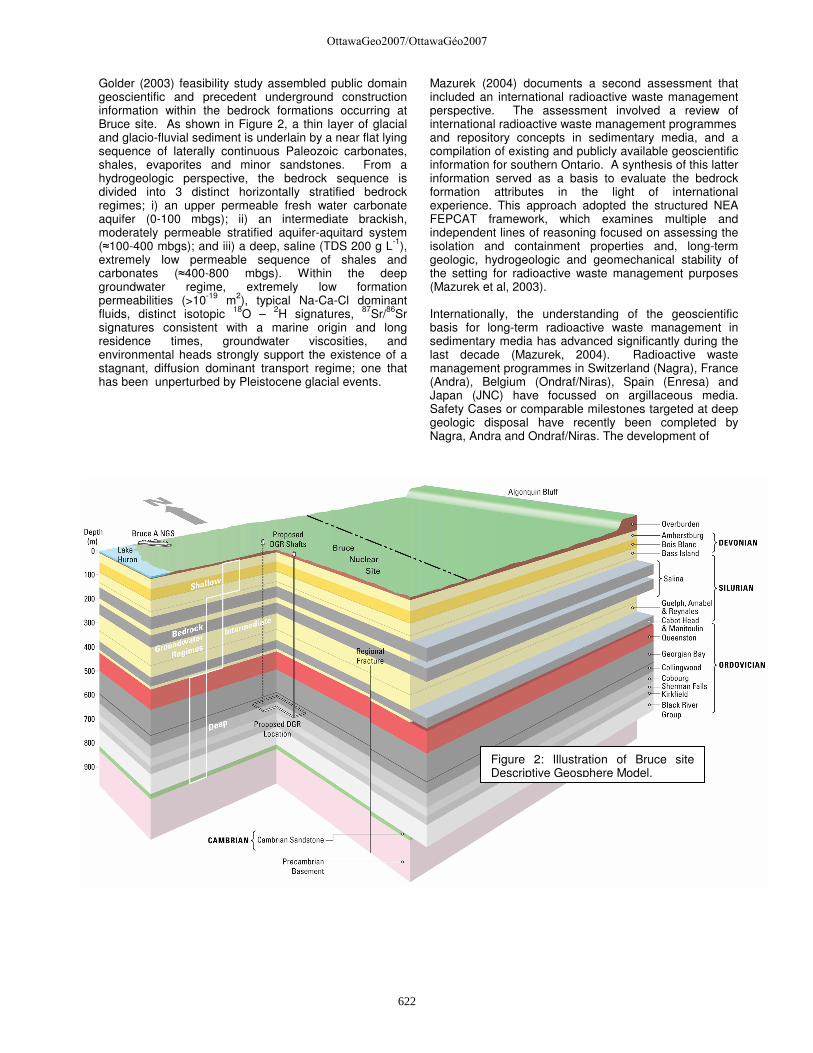
4 SITE CHARACTERISATION STUDIES The Bruce site Geoscientific Site Characterisation Plan is described in detail by Intera (2006) and is available from www.opg.com/dgr. The first Phase of the GSCP was initiated in September 2006 (Intera Engineering Ltd.). Key elements and activities associated with the work program are described below. 4.1 Site-Specific Investigations Site-specific investigations at the Bruce site involve a coordinated sequence of field and laboratory studies. Key amongst these was the completion of a 2-D seismic reflection survey and deep borehole drilling program. In the fall of 2006, a 20 line kilometre 2-D seismic reflection survey was shot along 9 transects. This survey was designed to focus on the imaging of the Ordovician sediments and in so doing provide an basis to assess the lateral continuity of the underlying bedrock formations and the presence of regional or local scale sub-vertical structural discontinuities beneath the 10 km2 Bruce site. The seismic reflection survey is complemented by a deep drilling program (Figure 3). The initial stages of the drilling program involved the coring of two deep 152 mm boreholes that combined will intersect the entire 850 m thick sedimentary sequence. The boreholes, DGR-1 (463 m) and DGR-2 (850 m), and casing design as related to the site stratigraphy are shown in Figure 4. The drilling program and borehole design was devised to
OttawaGeo2007/OttawaGéo2007
623
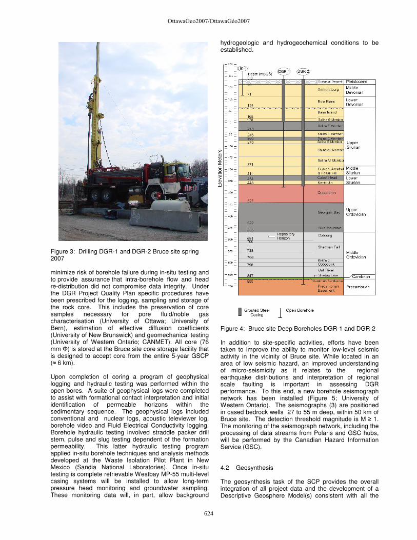
Figure 3: Drilling DGR-1 and DGR-2 Bruce site spring 2007 minimize risk of borehole failure during in-situ testing and to provide assurance that intra-borehole flow and head re-distribution did not compromise data integrity. Under the DGR Project Quality Plan specific procedures have been prescribed for the logging, sampling and storage of the rock core. This includes the preservation of core samples necessary for pore fluid/noble gas characterisation (University of Ottawa; University of Bern), estimation of effective diffusion coefficients (University of New Brunswick) and geomechanical testing (University of Western Ontario; CANMET). All core (76 mm Φ) is stored at the Bruce site core storage facility that is designed to accept core from the entire 5-year GSCP (≈ 6 km). Upon completion of coring a program of geophysical logging and hydraulic testing was performed within the open bores. A suite of geophysical logs were completed to assist with formational contact interpretation and initial identification of permeable horizons within the sedimentary sequence. The geophysical logs included conventional and nuclear logs, acoustic televiewer log, borehole video and Fluid Electrical Conductivity logging. Borehole hydraulic testing involved straddle packer drill stem, pulse and slug testing dependent of the formation permeability. This latter hydraulic testing program applied in-situ borehole techniques and analysis methods developed at the Waste Isolation Pilot Plant in New Mexico (Sandia National Laboratories). Once in-situ testing is complete retrievable Westbay MP-55 multi-level casing systems will be installed to allow long-term pressure head monitoring and groundwater sampling. These monitoring data will, in part, allow background
hydrogeologic and hydrogeochemical conditions to be established.
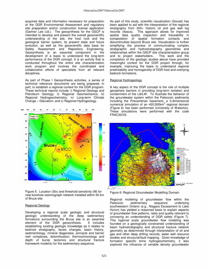
Figure 4: Bruce site Deep Boreholes DGR-1 and DGR-2 In addition to site-specific activities, efforts have been taken to improve the ability to monitor low-level seismic activity in the vicinity of Bruce site. While located in an area of low seismic hazard, an improved understanding of micro-seismicity as it relates to the regional earthquake distributions and interpretation of regional scale faulting is important in assessing DGR performance. To this end, a new borehole seismograph network has been installed (Figure 5; University of Western Ontario). The seismographs (3) are positioned in cased bedrock wells 27 to 55 m deep, within 50 km of Bruce site. The detection threshold magnitude is M ≥ 1. The monitoring of the seismograph network, including the processing of data streams from Polaris and GSC hubs, will be performed by the Canadian Hazard Information Service (GSC). 4.2 Geosynthesis The geosynthesis task of the SCP provides the overall integration of all project data and the development of a Descriptive Geosphere Model(s) consistent with all the
OttawaGeo2007/OttawaGéo2007
624
Elevation (m)61 - 175175 - 211.154211.154 - 248.692248.692 - 286.231286.231 - 323.769323.769 - 361.308361.308 - 398.846398.846 - 436.385436.385 - 473.923473.923 - 511.462511.462 - 549No Data
TownshipsBedrockRiversAlgonquin ArchBoundary
N
8 0 8 16 24 Kilometers
acquired data and information necessary for preparation of the DGR Environmental Assessment and regulatory site preparation and/or construction license application (Gartner Lee Ltd.). The geosynthesis for the GSCP is intended to develop and present the overall geoscientific understanding of the site, the host rock and the geological barrier system, its present state and future evolution, as well as the geoscientific data base for Safety Assessment and Repository Engineering. Geosynthesis is an essential component in the development of a basis to understand the long-term performance of the DGR concept. It is an activity that is conducted throughout the entire site characterization work program and involves the coordinated and collaborative efforts of specialists from all relevant disciplines. As part of Phase I Geosynthesis activities, a series of technical reference documents are being prepared, in part, to establish a regional context for the DGR program. These technical reports include: i) Regional Geology and Petroleum Geology; ii) Regional Geomechanics; iii) Regional Hydrogeochemistry; iv) Long-term Climate Change – Glaciation; and v) Regional Hydrogeology.
Figure 5: Location (Stx) and threshold sensitivity (M) for new borehole seismograph network installed within 50 km of Bruce site. Regional Geology Developing a regional scale geologic and structural geologic understanding of the deep sedimentary formations surrounding the Bruce site is an essential element of the DGR geosynthesis. It includes establishing existing geologic knowledge as it relates to bedrock stratigraphy, facies changes, basin history, sedimentology, mineral diagenesis, pinnacle and barrier reef complexes, dolomitization, thermochronology and depth of burial, tectonics and structural fracture framework model(s) for the sedimentary sequence.
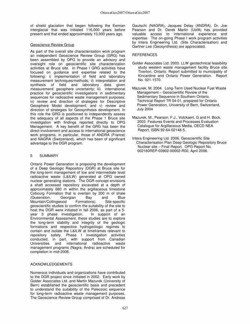
As part of this study, scientific visualization (Gocad) has been applied to aid with the interpretation of the regional stratigraphy from 300+ historic oil and gas well log records (Itasca). This approach allows for improved spatial data quality inspection and traceability in extrapolation of spatial formation contacts and discontinuities beyond Bruce site. Visualization is further simplifying the process of communicating complex stratigraphic and hydrostratigraphy geometries and relationships within the GSCP site characterisation group and to project stakeholders. This work and the completion of the geologic studies above have provided meaningful context for the DGR project through, for example, improving the basis to understand regional predictability and homogeneity of DGR host and overlying bedrock formations. Regional Hydrogeology A key aspect of the DGR concept is the role of multiple geosphere barriers in providing long-term isolation and containment of the L&ILW. To illustrate the behavior of the groundwater system within the Paleozoic sediments including the Precambrian basement, a 3-dimensional numerical simulation of an ≈20,000km2 regional domain (Figure 6) has been performed (University of Waterloo). These simulations were performed with the code FRAC3DVS.
Figure 6: Regional Groundwater Modelling Domain Regional modeling of groundwater flow within the Paleozoic sedimentary sequence underlying southwestern Ontario (e.g., Niagara Escarpment to Lake Huron) has yielded a reasoned basis to explain aspects of groundwater flow patterns, rates and quality relevant to conveying an understanding of DGR safety (Figure 7). This regional scale groundwater flow modeling was founded on a geologically constrained understanding of basin hydrostratigraphy and structural fracture network geometry as determined through interpretation of oil and gas and other deep drilling records, water well resource studies and structural/fault mapping. Given knowledge of formation specific brine hydrogeochemistry, it also explored the influence of variable density groundwater
OttawaGeo2007/OttawaGéo2007
625

-80
-70
-60
-50
-40
-30
-20
-10
0
-10.0 -8.0 -6.0 -4.0 -2.0 0.0 2.0 4.0
δδδδ18
O ‰ SMOW
δδ δδ2H
‰ S
MO
W
MISSISSIPPIAN SANDSTONE - MI
DEVONIAN CARBONATES - MI
SILURIAN CARBONATES - MI
SILURIAN F SALT - MI
SILURIAN A2 SALT - MI
SILURIAN SANDSTONES - AP
ORDOVICIAN CARBONATES - MI
ORDOVICAN SANDSTONE - MI
CAMBRIAN SANDSTONE - MI
PRECAMBRIAN - MI
GMWL
A2 SALTF SALT
distributions on groundwater movement. This work has also served as a basis for “what-if” or illustrative simulations to examine the resilience of the deep groundwater regime to perturbations created by long-term climate change and glacial isostasy.
Figure 7: FRAC3DVS Regional Freshwater Simulation – Hydraulic Head Distribution.
Regional Hydrogeochemistry
Hydrogeochemical evidence from the Paleozoic sediments of southern Ontario provides evidence that deep groundwaters have remained undisturbed despite multiple perturbations on geologic time scales. Multiple lines of evidence include formation distinct chemical compositions (Figure 8), extremely high salinities (200 – 300 g L-1) and isotopic signatures consistent with long-residence – rock/water interaction times. As part of this work program a comprehensive geochemical database of elemental and isotopic analyses on groundwater within
Figure 8: Southwestern Ontario Isotopic Signatures
2H – 18O for groundwaters with salinities > 100 g L-1. the Paleozoic sediments of south-western Ontario was assembled (University of Waterloo). These data have been assessed with respect to: i) depth of penetration of glacial waters; ii) cross formational solute migration with specific emphasize on the role of regional scale structural discontinuities; iii) inter-formational groundwater mixing within the sedimentary sequence; and iv) the spatial
variability in formational groundwater composition throughout south western Ontario. Long-term Climate Change Within the northern latitudes climate change and, in particular, glaciation events are likely to influence the long-term performance of the DGR. Prolonged and cyclic periods of glacial and peri-glacial conditions have existed in these regions on numerous occasions in recent geologic history. During the latter half of the Pleistocene, long-term climate change has resulted in 9 glacial events with a typical 115 ka cycle. Ice-sheet thickness at glacial maximum would have exceeded ≈2.5 km over southern Ontario (Figure 9). Transient temperature, hydraulic and mechanical boundary conditions resulting from glacial conditions may, on a site-specific basis, materially affect groundwater flow system dynamics, fracture network interconnectivity, fracture rejuvenation/propagation, post-glacial lake formation, groundwater redox front migration and geomechanical stability of repository access tunnels and emplacement rooms. Demonstrating a knowledge and awareness of the time history and magnitude of these effects is an important aspect in the development of a repository safety case.
Figure 9: Larentide Ice-sheet geometry, thickness and ice sheet velocities at last Glacial Maximum 21 ka BP (Glacial Systems Model - University of Toronto)
In order to explore the range of surface boundary conditions that could develop at Bruce site, the University of Toronto Glacial Systems Model was subject to a Bayesian calibration and employed to construct a suite of equally plausible models of the glaciation-deglaciation process. These boundary conditions, on normal stress, surface temperature, permafrost depth and meltwater production, are highly time dependent and vary substantially across the suite of models that are able to satisfy the observational constraints. These constraints are taken to be those appropriate to the most recent cycle
OttawaGeo2007/OttawaGéo2007
626
of shield glaciation that began following the Eemian interglacial that was initiated 116,000 years before present and that ended approximately 10,000 years ago.
Geoscience Review Group
As part of the overall site characterisation work program an independent Geoscience Review Group (GRG) has been assembled by OPG to provide an advisory and oversight role on geoscientific site characterization activities at Bruce site. In Phase I GRG activities have focused on guidance and expertise related to the following: i) implementation of field and laboratory measurement techniques/methods; ii) interpretation and synthesis of field and laboratory data given measurement/ geosphere uncertainty; iii) international practice for geoscientific investigations in sedimentary sequences for radioactive waste management purposes; iv) review and direction of strategies for Descriptive Geosphere Model development; and v) review and direction of strategies for Geosynthesis development. In this role the GRG is positioned to independently assess the adequacy of all aspects of the Phase 1 Bruce site investigation with findings reported directly to OPG Management. A key benefit of the GRG has been the direct involvement and access to international geoscience work programs, in particular, those of ANDRA (France) and NAGRA (Switzerland), which has been of significant advantage to the DGR program. 5 SUMMARY Ontario Power Generation is proposing the development of a Deep Geologic Repository (DGR) at Bruce site for the long-term management of low and intermediate level radioactive waste (L&ILW) generated at OPG owned nuclear generating stations. The DGR concept envisions a shaft accessed repository excavated at a depth of approximately 680 m within the argillaceous limestone Cobourg Formation that is overlain by 200 m of shale (Queenston, Georgian Bay and Blue Mountain/Collingwood Formations). Site-specific geoscientific studies to confirm the suitability of the site to host the DGR were initiated in fall 2006, as part of a 5-year 3 phase investigation. In support of an Environmental Assessment, these studies are to explore the long-term stability and integrity of the geologic formations and respective hydrogeologic regimes to contain and isolate the L&ILW at timeframes relevant to repository safety. Phase I investigation activities conducted, in part, with support from Canadian Universities and international radioactive waste management programs (Nagra; Andra) are scheduled for completion in mid-2008. ACKNOWLEDGEMENTS Numerous individuals and organizations have contributed to the DGR project since initiated in 2002. Early work by Golder Associates Ltd. and Martin Mazurek (University of Bern) established the geoscientific basis and precedent to understand the suitability of the Paleozoic sequence for long-term radioactive waste management purposes. The Geoscience Review Group comprised of Dr. Andreas
Gautschi (NAGRA), Jacques Delay (ANDRA), Dr. Joe Pearson and Dr. Derek Martin (UofA) has provided valuable access to international experience and expertise. The on-going Phase I work program activities by Intera Engineering Ltd. (Site Characterisation) and Gartner Lee (Geosynthesis) are appreciated. REFERENCES Golder Associates Ltd. 2003. LLW geotechnical feasibility
study western waste management facility Bruce site Tiverton, Ontario. Report submitted to municipality of Kincardine and Ontario Power Generation. Report No. 021-1570.
Mazurek, M. 2004. Long-Term Used Nuclear Fuel Waste
Management – Geoscientific Review of the Sedimentary Sequence in Southern Ontario. Technical Report TR 04-01, prepared for Ontario Power Generation, University of Bern, Switzerland, July 2004
Mazurek, M., Pearson, F.J., Volckaert, G and H. Bock. 2003. Features Events and Processes Evaluation Catalogue for Argillaceous Media, OECD NEA
Report, ISBN 92-64-02148-5. Intera Engineering Ltd. 2006. Geoscientific Site Characterisation Plan Deep Geologic Repository Bruce
Nuclear site – Final Report. OPG Report No. 002160REP-03902-00002-R00, April 2006.
OttawaGeo2007/OttawaGéo2007
627