overview on transport infrastructure sectors in the ...2415df3f54ab856e1fac… · overview on...
TRANSCRIPT
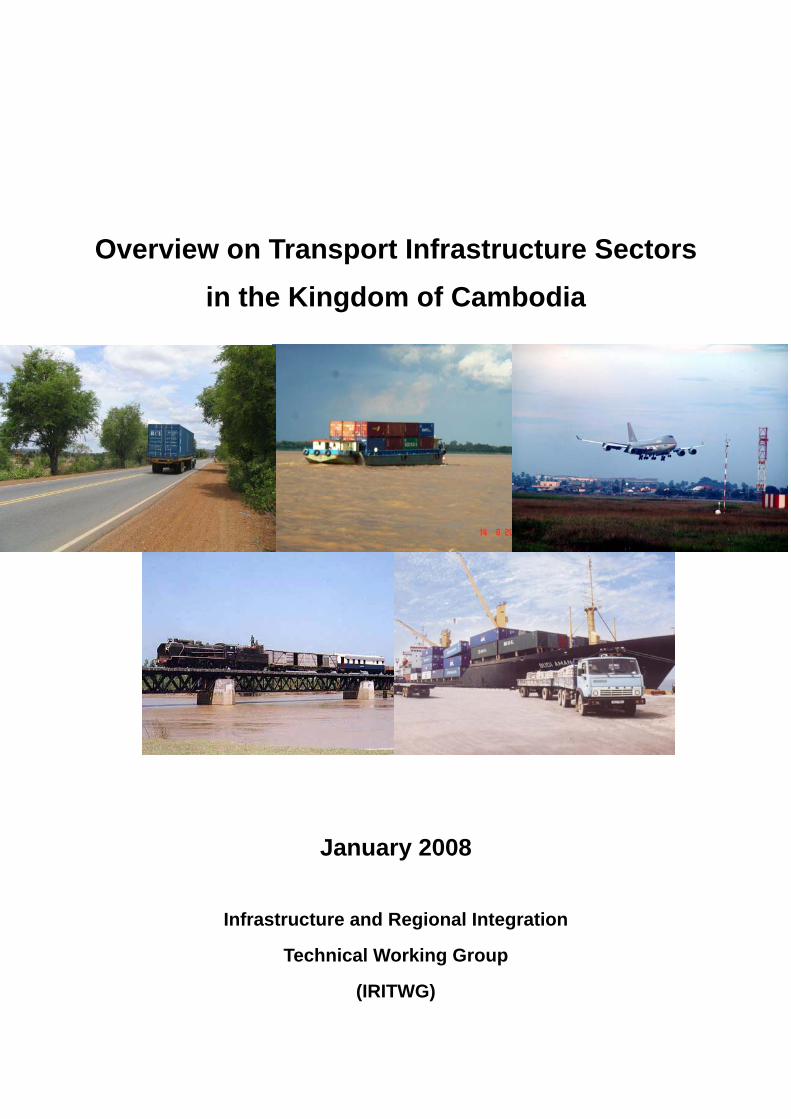
Overview on Transport Infrastructure Sectors in the Kingdom of Cambodia
January 2008
Infrastructure and Regional Integration
Technical Working Group
(IRITWG)
Overview on Transport Infrastructure Sectors in the Kingdom of Cambodia
January 2008
Infrastructure and Regional Integration
Technical Working Group
(IRITWG)
Overview on Transport Infrastructure Sectors in the Kingdom of Cambodia, (January 2008, IRITWG)
Overview on Transport Infrastructure Sectors in the Kingdom of Cambodia, (January 2008, IRITWG)
Instruction The information on each sectors are based primarily on the below documents. We also added the situation
of the authorization process in the Cambodian government for each plan that was made by the input of the
development partners.
1. Roads
The “Study on the Road Network Development in the Kingdom of Cambodia, Final Report Volume II
Main Text, October 2006, JICA.” Hereinafter referred to as “JICA study”.
Ministry of Public Works and Transport (MPWT) is preparing the final presentation document of this
road master plan that will be sent to the Council of Ministers soon for approval.
2. Railway
The project on “Restructuring of the Railway in Cambodia, Strategy Report and Action Plan, ADB,”
“Restructuring of the Railway in Cambodia, Traffic Forecast and Financial Analysis Report, April 2006,
ADB,” and “GMS Rehabilitation of the Railway in Cambodia, Final Report, November 2006, ADB.”
There is no master plan for railway at this moment.
3. Maritime and Ports
The “Study on the Master Plan for Maritime and Port Sectors in Cambodia (Interim Report), March
2007, JICA.
MPWT is now preparing the final presentation document of this master plan on maritime and ports that
will be sent to the Council of Ministers soon for approval.
4. Inland Waterway
The “Master Plan for Waterborne Transport on the Mekong River System in Cambodia, Final Report,
September 2006, Belgian Technical Cooperation.
MPWT is now preparing the final presentation document of this master plan on inland waterway that
will be sent to the Council of Ministers soon for approval.
5. Air Transportation
The “Project Profiles and Progress (Civil Aviation)”, Prepared by SSCA.
There is no master plan for air transportation at this moment.
6. Tourism
The “Statistical Yearbook 2005 and Tourism Statistical Report”, December 2005.
IRITWG is not responsible for making a master plan for tourism. We place the information on tourism
since it has a lot of effect to transport infrastructure.
Overview on Transport Infrastructure Sectors in the Kingdom of Cambodia, (January 2008, IRITWG)
TABLE OF CONTENTS Preface Instruction Table of contents 1. Roads…….……………………………………………………………………………………………1 2. Railway……………………………………………………………………………………………….8 3. Maritime and Ports………………………………………………………………………………..10 4. Inland Waterway…………………………………………………………………………………..12 5. Air Transportation…………………………………………………………………………………14 6. Tourism……………………………………………………………………………………………...16
Overview on Transport Infrastructure Sectors in the Kingdom of Cambodia,(January 2008, IRITWG)
- 1 -
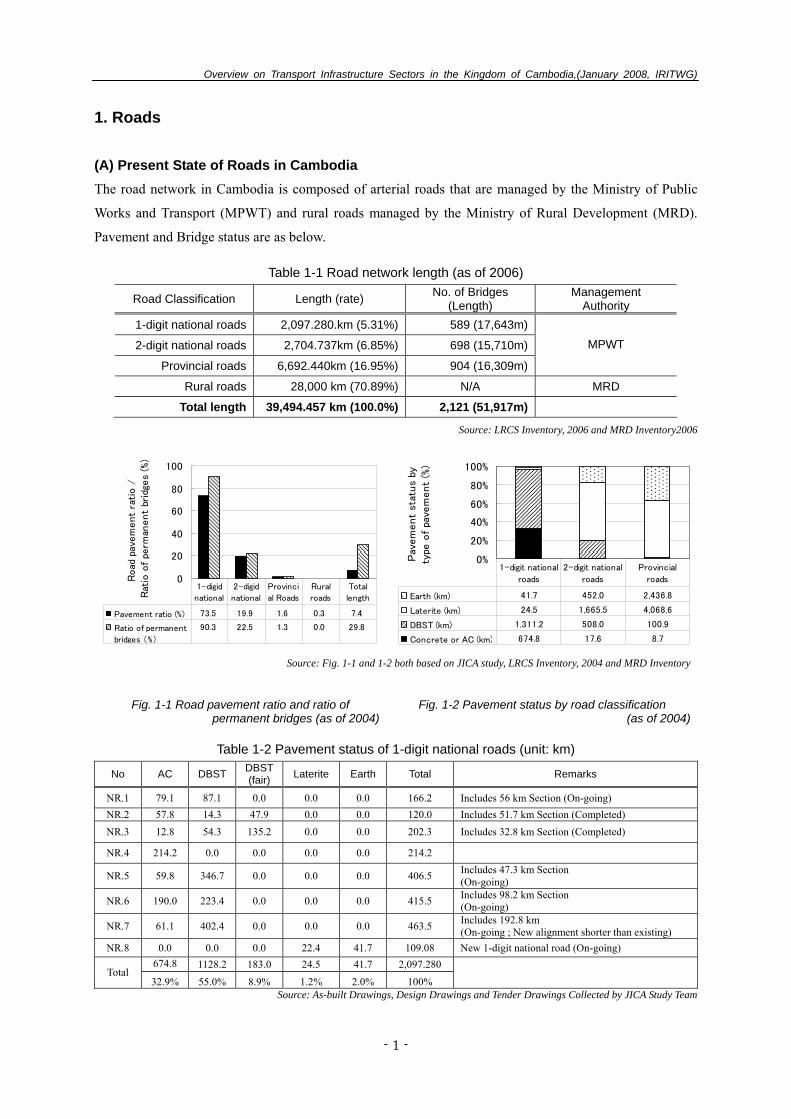
1. Roads (A) Present State of Roads in Cambodia The road network in Cambodia is composed of arterial roads that are managed by the Ministry of Public
Works and Transport (MPWT) and rural roads managed by the Ministry of Rural Development (MRD).
Pavement and Bridge status are as below.
Table 1-1 Road network length (as of 2006)
Road Classification Length (rate) No. of Bridges (Length)
Management Authority
1-digit national roads 2,097.280.km (5.31%) 589 (17,643m)
2-digit national roads 2,704.737km (6.85%) 698 (15,710m)
Provincial roads 6,692.440km (16.95%) 904 (16,309m)
MPWT
Rural roads 28,000 km (70.89%) N/A MRD
Total length 39,494.457 km (100.0%) 2,121 (51,917m)
Source: LRCS Inventory, 2006 and MRD Inventory2006
0
20
40
60
80
100
Road
pav
em
ent
rati
o /
Rat
io o
f pe
rman
ent
brid
ges
(%)
Pavement ratio (%) 73.5 19.9 1.6 0.3 7.4
Ratio of permanent
bridges (%)
90.3 22.5 1.3 0.0 29.8
1-digid
national
2-digid
national
Provinci
al Roads
Rural
roads
Total
length
0%
20%
40%
60%
80%
100%
Pav
em
ent
stat
us
byty
pe o
f pa
vem
ent
(%)
Earth (km) 41.7 452.0 2,436.8
Laterite (km) 24.5 1,665.5 4,068.6
DBST (km) 1,311.2 508.0 100.9
Concrete or AC (km) 674.8 17.6 8.7
1-digit national
roads
2-digit national
roads
Provincial
roads
Source: Fig. 1-1 and 1-2 both based on JICA study, LRCS Inventory, 2004 and MRD Inventory
Fig. 1-1 Road pavement ratio and ratio of permanent bridges (as of 2004)
Fig. 1-2 Pavement status by road classification (as of 2004)
Table 1-2 Pavement status of 1-digit national roads (unit: km)
No AC DBST DBST (fair) Laterite Earth Total Remarks
NR.1 79.1 87.1 0.0 0.0 0.0 166.2 Includes 56 km Section (On-going) NR.2 57.8 14.3 47.9 0.0 0.0 120.0 Includes 51.7 km Section (Completed) NR.3 12.8 54.3 135.2 0.0 0.0 202.3 Includes 32.8 km Section (Completed)
NR.4 214.2 0.0 0.0 0.0 0.0 214.2
NR.5 59.8 346.7 0.0 0.0 0.0 406.5 Includes 47.3 km Section (On-going)
NR.6 190.0 223.4 0.0 0.0 0.0 415.5 Includes 98.2 km Section (On-going)
NR.7 61.1 402.4 0.0 0.0 0.0 463.5 Includes 192.8 km (On-going ; New alignment shorter than existing)
NR.8 0.0 0.0 0.0 22.4 41.7 109.08 New 1-digit national road (On-going) 674.8 1128.2 183.0 24.5 41.7 2,097.280
Total 32.9% 55.0% 8.9% 1.2% 2.0% 100%
Source: As-built Drawings, Design Drawings and Tender Drawings Collected by JICA Study Team
Overview on Transport Infrastructure Sectors in the Kingdom of Cambodia,(January 2008, IRITWG)
- 2 -
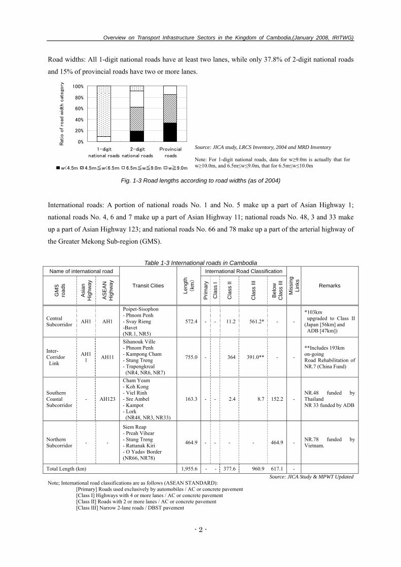
Road widths: All 1-digit national roads have at least two lanes, while only 37.8% of 2-digit national roads
and 15% of provincial roads have two or more lanes.
0%
20%
40%
60%
80%
100%
1-digitnational roads
2-digitnational roads
Provincialroads
Rat
io o
f ro
ad w
idth
cat
ego
ry
w<4.5m 4.5m≦w<6.5m 6.5m≦w≦9.0m w≧9.0m
Source: JICA study, LRCS Inventory, 2004 and MRD Inventory
Note: For 1-digit national roads, data for w≥9.0m is actually that for w≥10.0m, and 6.5m≤w≤9.0m, that for 6.5m≤w≤10.0m
Fig. 1-3 Road lengths according to road widths (as of 2004)
International roads: A portion of national roads No. 1 and No. 5 make up a part of Asian Highway 1;
national roads No. 4, 6 and 7 make up a part of Asian Highway 11; national roads No. 48, 3 and 33 make
up a part of Asian Highway 123; and national roads No. 66 and 78 make up a part of the arterial highway of
the Greater Mekong Sub-region (GMS).
Table 1-3 International roads in Cambodia
Name of international road International Road Classification
GM
S
road
s
Asi
an
Hig
hway
AS
EA
N
Hig
hway
Transit Cities
Leng
th
(km
)
Prim
ary
Cla
ss I
Cla
ss II
Cla
ss II
I
Bel
ow
Cla
ss II
I
Mis
sing
Li
nks
Remarks
Central Subcorridor AH1 AH1
Poipet-Sisophon - Phnom Penh - Svay Rieng -Bavet (NR.1, NR5)
572.4 - - 11.2 561.2* - -
*103km upgraded to Class II (Japan [56km] and ADB [47km])
Inter- Corridor Link
AH11 AH11
Sihanouk Ville - Phnom Penh - Kampong Cham - Stung Treng - Trapengkreal (NR4, NR6, NR7)
755.0 - 364 391.0** - -
**Includes 193km on-going Road Rehabilitation of NR.7 (China Fund)
Southern Coastal Subcorridor
- AH123
Cham Yeam - Koh Kong - Viel Rinh - Sre Ambel - Kampot - Lork (NR48, NR3, NR33)
163.3 - - 2.4 8.7 152.2 - NR.48 funded by Thailand NR 33 funded by ADB
Northern Subcorridor - -
Siem Reap - Preah Vihear - Stung Treng - Rattanak Kiri - O Yadav Border (NR66, NR78)
464.9 - - - - 464.9 - NR.78 funded by Vietnam.
Total Length (km) 1,955.6 - - 377.6 960.9 617.1 - Source: JICA Study & MPWT Updated
Note; International road classifications are as follows (ASEAN STANDARD): [Primary] Roads used exclusively by automobiles / AC or concrete pavement [Class I] Highways with 4 or more lanes / AC or concrete pavement [Class II] Roads with 2 or more lanes / AC or concrete pavement [Class III] Narrow 2-lane roads / DBST pavement
Overview on Transport Infrastructure Sectors in the Kingdom of Cambodia,(January 2008, IRITWG)
- 3 -
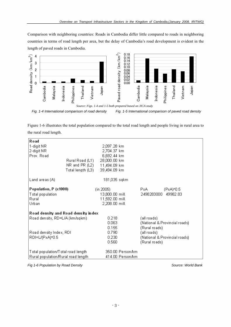
Comparison with neighboring countries: Roads in Cambodia differ little compared to roads in neighboring
countries in terms of road length per area, but the delay of Cambodia’s road development is evident in the
length of paved roads in Cambodia.
0
1
2
3
4
Cam
bodi
a
Mal
aysi
a
Indo
nesi
a
Phili
ppin
es
Thai
land
Vie
tnam
Jap
an
Road
densi
ty (
km/km
2)
0.000.020.040.060.080.100.120.140.160.18
Cam
bodi
a
Mal
aysi
a
Indo
nesi
a
Phili
ppin
es
Thai
land
Vie
tnam
Jap
an
Pav
ed
road
densi
ty (
km/km
2)
Source: Figs. 1-4 and 1-5 both prepared based on JICA study
Fig. 1-4 International comparison of road density Fig. 1-5 International comparison of paved road density
Figure 1-6 illustrates the total population compared to the total road length and people living in rural area to
the rural road length.
Fig 1-6 Population by Road Density Source: World Bank
Overview on Transport Infrastructure Sectors in the Kingdom of Cambodia,(January 2008, IRITWG)
- 4 -
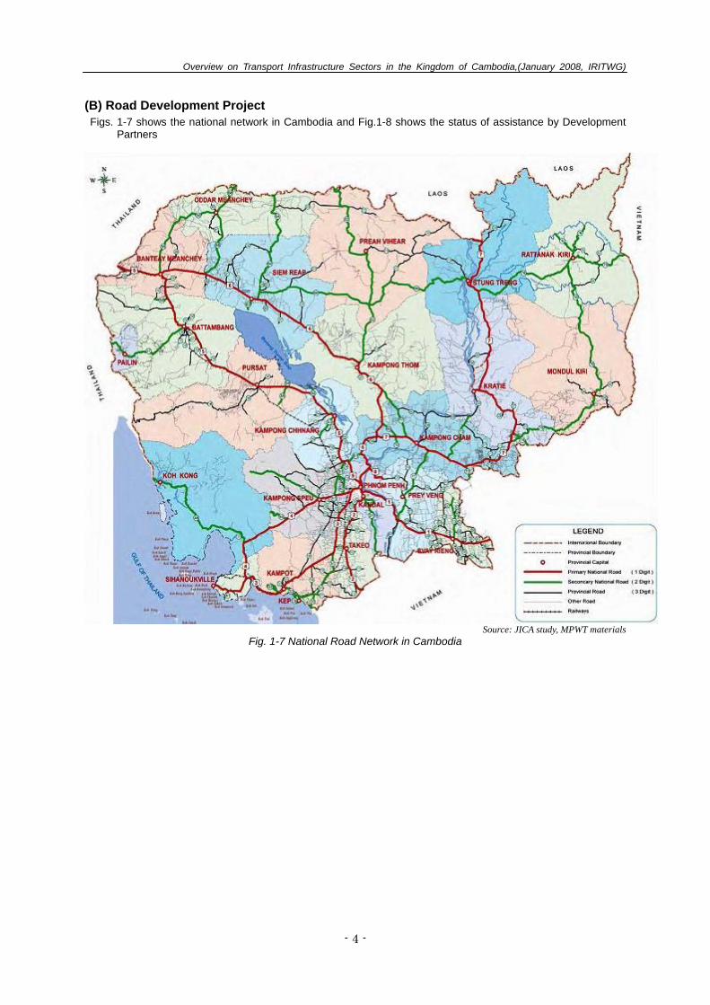
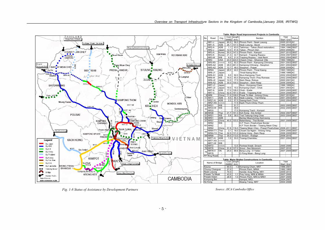
(B) Road Development Project Figs. 1-7 shows the national network in Cambodia and Fig.1-8 shows the status of assistance by Development
Partners
Source: JICA study, MPWT materials
Fig. 1-7 National Road Network in Cambodia
Overview on Transport Infrastructure Sectors in the Kingdom of Cambodia,(January 2008, IRITWG)
- 5 -
Source: JICA Cambodia Office Fig. 1-8 Status of Assistance by Development Partners
Cost length(Mill$) (km) Start End
NR1-J Japan 80.0 56.0 Phnom Penh - Neak Loeung 2005 2010 ACNR1-A ADB 26.7 107.0 Neak Loeung - Bavet 1999 2004 DBSTNR2-A ADB 1.1 63.0 Takhmau - Takeo (flood restoration) 1994 1996 DBSTNR2-J Japan 12.0 51.6 Takeo - Phnum Den 2003 2006 ACNR3-A Korea 50.0 147.0 Phnom Penh - Kampot 2007 2010 DBSTNR3-K Korea 21.3 32.7 Kampot - Trapang Ropaou 2004 2007 DBSTNR3-W WB 6.5 21.5 Trapang Ropaou - Veal Renh 2002 2004 DBST
4 NR4 USA 24.0 224.0 Chaom Chao - Sihanouk Ville 1994 1996 ACNR5-Kh Cambodia 9.0 92.0 Phnom Penh - Kampong Chhnang 2001 2003 DBSTNR5-A2 ADB 28.0 261.0 Kampong Chhnang - Sisophon 2001 2004 DBSTNR5-A2 ADB 12.7 48.0 Sisophon - Poipet 2006 2009 ACNR6A Japan 28.0 44.0 Phnom Penh - Thnal Kaeng 1993 1995 ACNR6-J1 Japan Thnal Kaeng-Skun 1996 1999 ACNR6-A1 ADB 6.0 92.0 Skun-Kampong Thom 2002 2004 DBSTNR6-W WB 16.0 65.0 Kampong Thom- Prey Romeas 2002 2006 DBSTNR6-J2 Japan 12.0 17.5 Siem Reup- Rolous 2000 2001 ACNR6-A2 ADB 30.0 100.0 Sisophon - Siem Reap 2006 2009NR7-J1 Japan Skun - Kompong Cham 1996 1999 ACNR7-J2 Japan 19.0 10.2 Kompong Cham - Chob 2001 2003 ACNR7-A ADB 17.0 128.0 Chob - Kratie 2003 2005 DBSTNR7-C China 62.8 187.0 Kratie - Trapeang Kriel 2004 2008 DBST
8 NR8 China 71.5 109.0 Preak Ta Mak - Anlong Chrey 2007 2010 AC11 NR11 ADB 9.5 90.4 Neak Loeang - Tnal Kheng 2001 2004 DBST
NR21-A ADB 2.2 57.5 Saang-Kaoh Thum 2002 2004 DBSTNR21-Kh Cambodia 17.4 Kaoh Thum-Chrey Thum
31 NR31 WB 51.7 2003 2005 DBSTNR33-W WB 39.8 2002 2005 DBSTNR33 - 17.0 Kompong Trach - Kompot
48 NR48 Thai 21.7 151.3 Koh Kong - Sre Ambel 2004 2007 DBST51 NR51 WB 5.8 38.0 Tnal Toteung-Vang Chas 2003 2004 DBST56 NR51 ADB Bantay Meanchchey-Samraong57 NR57 China 45.0 103.0 Batambang - Thai Border 2007 2009 DBST
NR62 WB K.P Thom- Preahvihear BorderNR62 - K.P Thom Border - Tbaeng Mean CheyNR62 China 57.8 116.0 Tbaeng Mean Chey - Prasat Preahvihear 2008 2011 DBSTNR64-T1 Thai 3.1 18.0 Choam Sa Ngam - Anlong Veng 2004 2006 DBSTNR64-T2 Thai 32.5 131.0 Anlong Veng - Siem Reup 2006 2009 DBST
68 NR68 Thai 35.0 113.0 O Smach - Kralagn 2008 2010NR71-A ADB 1.0 33.0 Troeng-Chamkleu 2001 2004 DBSTNR71-Kh Cambodia
NR71-W WB72 NR72 Cambodia 13.5 Ponhea Kreak- Smach 2005 200676 NR76 China 51.9 127.0 Snoul - Sen Monorom 2007 2010
NR78-V VN 25.0 69.6 Bang Lung - O Yadav 2007 2009 DBSTNR78 - O Pong Moan - Bang Lung
-
Cost length(Mill$) (km) Start End60.0 1.3 Kompong Cham, NR7 1996 200127.0 Phnom Penh, NR6A 1992 199374.0 Kandal, Svay Rieng, NR1 2009 201443.5 1.1 Prey Veng, NR8 & NR6A 2007 200928.9 1.0 Phnom Penh, NR5 & NR61 2007 2009
Kampot, NR3 2004 2007Stoeng Treng, NR7 2004 2008
Kompong BeiSe Kong
Neak Loeung
64
71
PP Ring Road
Table. Major Bridge Constructions in Cambodia
78
Name of Bridge Location Year
33
Preaek Kdam
Kizuna Churoy Changvar
Preaek Ta Meak
62
No. Road Org. Section
21
Table. Major Road Improvement Projects in Cambodia
5
Status
1
2
3
7
6
Year
Overview on Transport Infrastructure Sectors in the Kingdom of Cambodia,(January 2008, IRITWG)
- 6 -
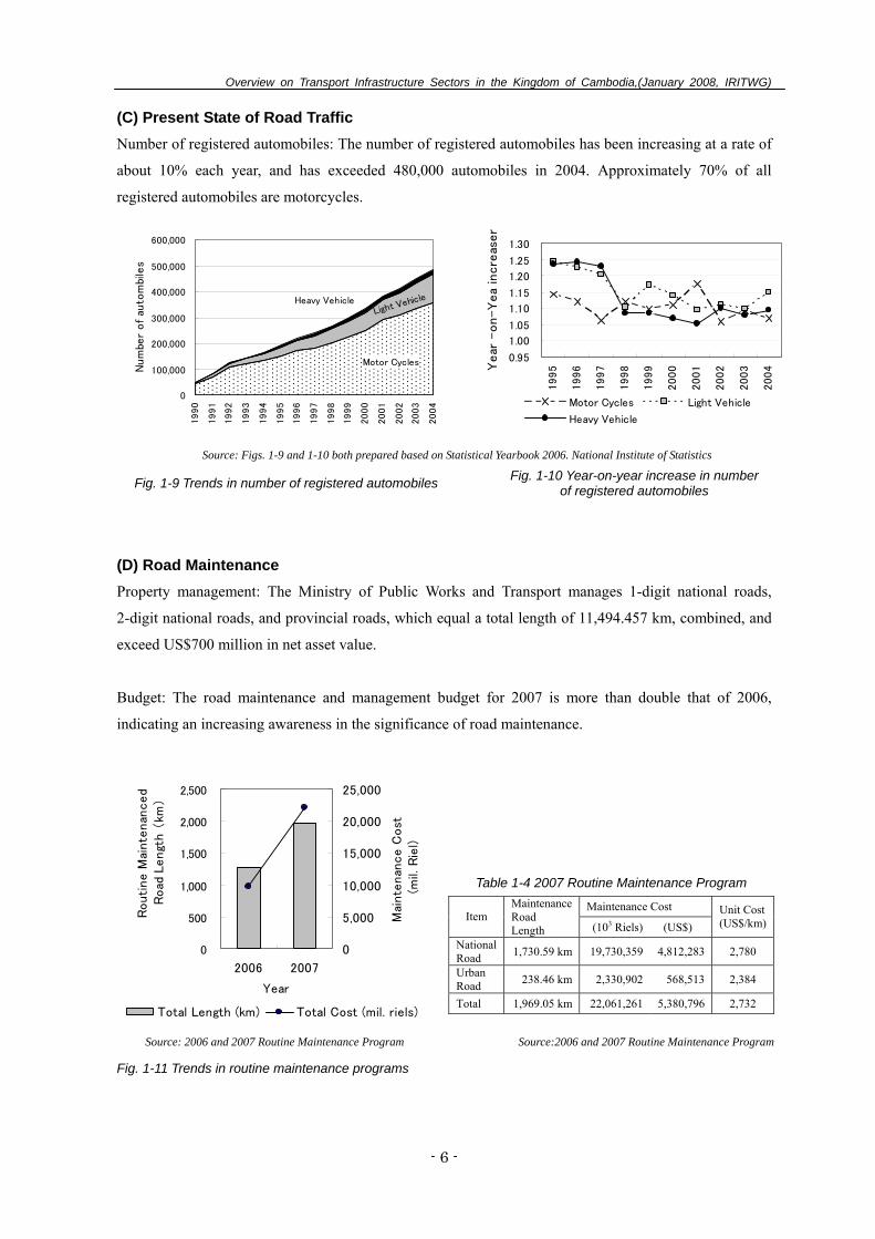
(C) Present State of Road Traffic Number of registered automobiles: The number of registered automobiles has been increasing at a rate of
about 10% each year, and has exceeded 480,000 automobiles in 2004. Approximately 70% of all
registered automobiles are motorcycles.
Motor Cycles
Light VehicleHeavy Vehicle
0
100,000
200,000
300,000
400,000
500,000
600,000
1990
1991
1992
1993
1994
1995
1996
1997
1998
1999
2000
2001
2002
2003
2004
Num
ber
of
auto
mbi
les
0.95
1.00
1.05
1.10
1.15
1.20
1.25
1.30
1995
1996
1997
1998
1999
2000
2001
2002
2003
2004Y
ear
-on-Y
ea
incre
aser
Motor Cycles Light Vehicle
Heavy Vehicle
Source: Figs. 1-9 and 1-10 both prepared based on Statistical Yearbook 2006. National Institute of Statistics
Fig. 1-9 Trends in number of registered automobiles Fig. 1-10 Year-on-year increase in number of registered automobiles
(D) Road Maintenance Property management: The Ministry of Public Works and Transport manages 1-digit national roads,
2-digit national roads, and provincial roads, which equal a total length of 11,494.457 km, combined, and
exceed US$700 million in net asset value.
Budget: The road maintenance and management budget for 2007 is more than double that of 2006,
indicating an increasing awareness in the significance of road maintenance.
0
500
1,000
1,500
2,000
2,500
2006 2007
Year
Routi
ne M
ainte
nan
ced
Road
Lengt
h (
km)
0
5,000
10,000
15,000
20,000
25,000
Mai
nte
nan
ce C
ost
(m
il. R
iel)
Total Length (km) Total Cost (mil. riels)
Table 1-4 2007 Routine Maintenance Program
Maintenance Cost Item
Maintenance Road Length (103 Riels) (US$)
Unit Cost (US$/km)
National Road 1,730.59 km 19,730,359 4,812,283 2,780
Urban Road 238.46 km 2,330,902 568,513 2,384
Total 1,969.05 km 22,061,261 5,380,796 2,732
Source: 2006 and 2007 Routine Maintenance Program Source:2006 and 2007 Routine Maintenance Program
Fig. 1-11 Trends in routine maintenance programs
Overview on Transport Infrastructure Sectors in the Kingdom of Cambodia,(January 2008, IRITWG)
- 7 -
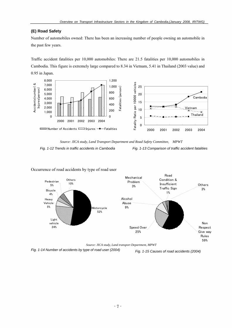
(E) Road Safety Number of automobiles owned: There has been an increasing number of people owning an automobile in
the past few years.
Traffic accident fatalities per 10,000 automobiles: There are 21.5 fatalities per 10,000 automobiles in
Cambodia. This figure is extremely large compared to 8.34 in Vietnam, 5.41 in Thailand (2003 value) and
0.95 in Japan.
0
1,000
2,000
3,000
4,000
5,000
6,000
7,000
8,000
2000 2001 2002 2003 2004
Accid
ents
(num
ber)
&In
jure
s(pe
rson)
0
200
400
600
800
1,000
1,200
Fat
alit
ies
(pers
on)
Number of Accidents Injures Fatalities
Cambodia
Thailand
Vietnam
0
5
10
15
20
25
2000 2001 2002 2003 2004Fat
alit
y R
atio
per
10000 v
ehic
les
Source: JICA study, Land Transport Department and Road Safety Committee, MPWT
Fig. 1-12 Trends in traffic accidents in Cambodia Fig. 1-13 Comparison of traffic accident fatalities
Occurrence of road accidents by type of road user
Motorcycle52%
Lightvehicle
24%
HeavyVehicle
5%
Bicycle4%
Pedestrian5%
Others10%
MechanicalProblem
3% Others3%
AlcoholAbuse
9%
Speed Over25%
RoadCondition &InsufficientTraffic Sign
1%
NonRespectGive way
Rules59%
Source: JICA study, Land transport Department, MPWT Fig. 1-14 Number of accidents by type of road user (2004) Fig. 1-15 Causes of road accidents (2004)
Overview on Transport Infrastructure Sectors in the Kingdom of Cambodia,(January 2008, IRITWG)
- 8 -
2. Railway (A) Present State of Railways in Cambodia
Table 2-1 Situation of Railway Facilities
Item Northern Line (NL) Southern Line (SL)
Length (km) 385 (including 48km missing link) 264km
Section Phnom Penh - Pursat - Battambang - Mongkol Borey - Poipet
Phnom Penh - Takeo - Kampot - Sihanoukville
Station (number) 49 (Current Operation 7) 27 (Current operation 5) Construction Year 1929 - 1942 1960 - 1969
Source: RRC, Restructuring of the Railway in Cambodia, Strategy Report and Action Plan, ADB, GMS Rehabilitation of the Railway in Cambodia, Final Report (Volume �), November 2006, ADB.
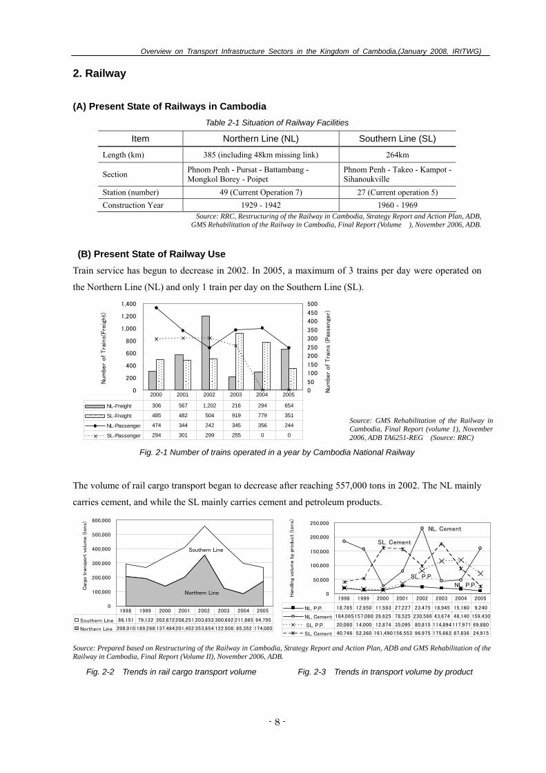
(B) Present State of Railway Use Train service has begun to decrease in 2002. In 2005, a maximum of 3 trains per day were operated on
the Northern Line (NL) and only 1 train per day on the Southern Line (SL).
0
200
400
600
800
1,000
1,200
1,400
Num
ber
of
Tra
ins(
Fre
ight)
0
50
100
150
200
250
300
350
400
450
500
Num
ber
of
Tra
ins
(Pas
senge
r)
NL-Freight 306 567 1,202 216 294 654
SL-Freight 485 482 504 919 779 351
NL-Passenger 474 344 242 345 356 244
SL-Passenger 294 301 299 255 0 0
2000 2001 2002 2003 2004 2005
Fig. 2-1 Number of trains operated in a year by Cambodia National Railway
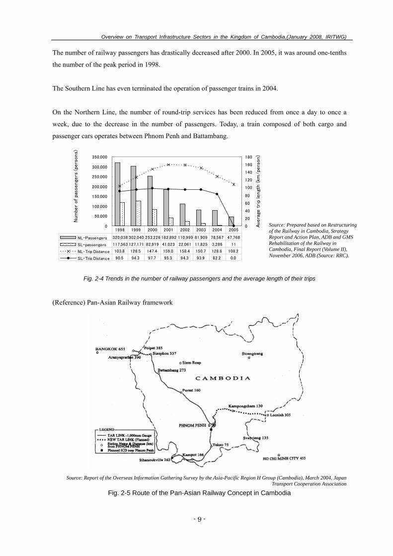
The volume of rail cargo transport began to decrease after reaching 557,000 tons in 2002. The NL mainly
carries cement, and while the SL mainly carries cement and petroleum products.
Northern Line
Southern Line
0
100,000
200,000
300,000
400,000
500,000
600,000
Car
go t
ransp
ort
volu
me (to
ns)
Southern Line 86,151 79,122 202,672208,251 203,653 300,692 211,865 94,795
Northern Line 208,010 189,268 137,484201,452 353,654 122,508 85,352 174,005
1998 1999 2000 2001 2002 2003 2004 2005
NL. P.P.
NL. Cement
SL. P.P.
SL. Cement
0
50,000
100,000
150,000
200,000
250,000
Han
dlin
g vo
lum
e b
y pr
odu
ct
(tons)
NL. P.P. 18,785 12,950 11,593 27,227 23,475 18,945 15,160 9,240
NL. Cement 184,065157,080 26,625 78,525 230,566 43,674 48,140 159,430
SL. P.P. 20,080 14,000 12,874 35,095 80,815 114,894117,971 69,880
SL. Cement 40,746 52,360 161,490156,553 96,975 175,662 87,836 24,915
1998 1999 2000 2001 2002 2003 2004 2005
Source: Prepared based on Restructuring of the Railway in Cambodia, Strategy Report and Action Plan, ADB and GMS Rehabilitation of the Railway in Cambodia, Final Report (Volume II), November 2006, ADB.
Fig. 2-2 Trends in rail cargo transport volume Fig. 2-3 Trends in transport volume by product
Source: GMS Rehabilitation of the Railway in Cambodia, Final Report (volume 1), November 2006, ADB TA6251-REG (Source: RRC)
Overview on Transport Infrastructure Sectors in the Kingdom of Cambodia,(January 2008, IRITWG)
- 9 -
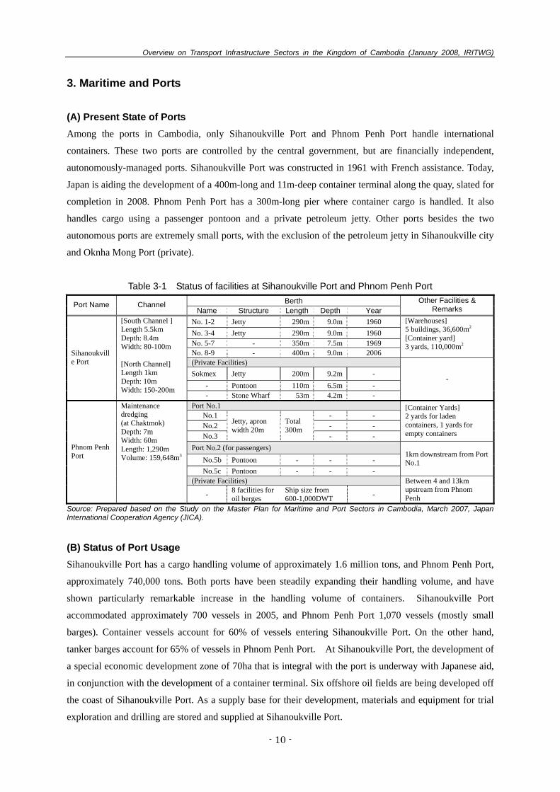
The number of railway passengers has drastically decreased after 2000. In 2005, it was around one-tenths
the number of the peak period in 1998.
The Southern Line has even terminated the operation of passenger trains in 2004.
On the Northern Line, the number of round-trip services has been reduced from once a day to once a
week, due to the decrease in the number of passengers. Today, a train composed of both cargo and
passenger cars operates between Phnom Penh and Battambang.
0
50,000
100,000
150,000
200,000
250,000
300,000
350,000
Num
ber
of
pass
enge
rs (
pers
ons)
0
20
40
60
80
100
120
140
160
180
Ave
rage
tri
p le
ngt
h (
km/pe
rson)
NL-Passengers 320,038 302,040 253,226 182,892 110,999 81,909 78,567 47,768
SL-passengers 117,563 127,171 82,919 41,023 22,061 11,825 3,286 11
NL-Trip Distance 103.8 126.5 147.4 159.0 158.4 150.7 128.6 108.2
SL-Trip Distance 90.5 94.3 97.7 95.3 94.3 93.9 82.2 0.0
1998 1999 2000 2001 2002 2003 2004 2005
Fig. 2-4 Trends in the number of railway passengers and the average length of their trips
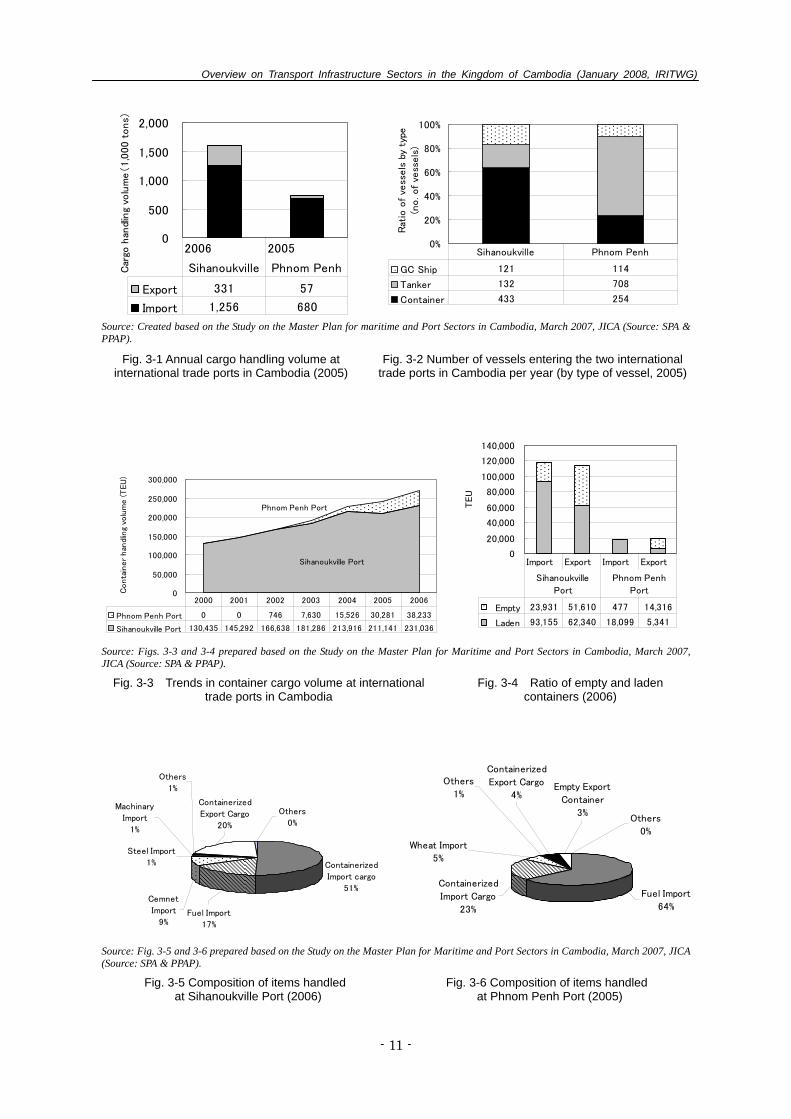
(Reference) Pan-Asian Railway framework
Source: Report of the Overseas Information Gathering Survey by the Asia-Pacific Region H Group (Cambodia), March 2004, Japan
Transport Cooperation Association Fig. 2-5 Route of the Pan-Asian Railway Concept in Cambodia
Source: Prepared based on Restructuring of the Railway in Cambodia, Strategy Report and Action Plan, ADB and GMS Rehabilitation of the Railway in Cambodia, Final Report (Volume II), November 2006, ADB (Source: RRC).
Overview on Transport Infrastructure Sectors in the Kingdom of Cambodia (January 2008, IRITWG)
- 10 -
3. Maritime and Ports (A) Present State of Ports Among the ports in Cambodia, only Sihanoukville Port and Phnom Penh Port handle international
containers. These two ports are controlled by the central government, but are financially independent,
autonomously-managed ports. Sihanoukville Port was constructed in 1961 with French assistance. Today,
Japan is aiding the development of a 400m-long and 11m-deep container terminal along the quay, slated for
completion in 2008. Phnom Penh Port has a 300m-long pier where container cargo is handled. It also
handles cargo using a passenger pontoon and a private petroleum jetty. Other ports besides the two
autonomous ports are extremely small ports, with the exclusion of the petroleum jetty in Sihanoukville city
and Oknha Mong Port (private).
Table 3-1 Status of facilities at Sihanoukville Port and Phnom Penh Port
Berth Port Name Channel Name Structure Length Depth Year
Other Facilities & Remarks
No. 1-2 Jetty 290m 9.0m 1960 No. 3-4 Jetty 290m 9.0m 1960 No. 5-7 - 350m 7.5m 1969 No. 8-9 - 400m 9.0m 2006
[Warehouses] 5 buildings, 36,600m2
[Container yard] 3 yards, 110,000m2
(Private Facilities) Sokmex Jetty 200m 9.2m -
- Pontoon 110m 6.5m -
Sihanoukville Port
[South Channel ] Length 5.5km Depth: 8.4m Width: 80-100m [North Channel] Length 1km Depth: 10m Width: 150-200m
- Stone Wharf 53m 4.2m -
-
Port No.1 No.1 - - No.2 - - No.3
Jetty, apron width 20m
Total 300m
- -
[Container Yards] 2 yards for laden containers, 1 yards for empty containers
Port No.2 (for passengers) No.5b Pontoon - - - No.5c Pontoon - - -
1km downstream from Port No.1
(Private Facilities)
Phnom Penh Port
Maintenance dredging (at Chaktmok) Depth: 7m Width: 60m Length: 1,290m Volume: 159,648m3
- 8 facilities for oil berges
Ship size from 600-1,000DWT -
Between 4 and 13km upstream from Phnom Penh
Source: Prepared based on the Study on the Master Plan for Maritime and Port Sectors in Cambodia, March 2007, Japan International Cooperation Agency (JICA). (B) Status of Port Usage Sihanoukville Port has a cargo handling volume of approximately 1.6 million tons, and Phnom Penh Port,
approximately 740,000 tons. Both ports have been steadily expanding their handling volume, and have
shown particularly remarkable increase in the handling volume of containers. Sihanoukville Port
accommodated approximately 700 vessels in 2005, and Phnom Penh Port 1,070 vessels (mostly small
barges). Container vessels account for 60% of vessels entering Sihanoukville Port. On the other hand,
tanker barges account for 65% of vessels in Phnom Penh Port. At Sihanoukville Port, the development of
a special economic development zone of 70ha that is integral with the port is underway with Japanese aid,
in conjunction with the development of a container terminal. Six offshore oil fields are being developed off
the coast of Sihanoukville Port. As a supply base for their development, materials and equipment for trial
exploration and drilling are stored and supplied at Sihanoukville Port.
Overview on Transport Infrastructure Sectors in the Kingdom of Cambodia (January 2008, IRITWG)
- 11 -
0
500
1,000
1,500
2,000C
argo
han
dlin
g vo
lum
e(1,0
00 t
ons)
Export 331 57
Import 1,256 680
2006 2005
Sihanoukville Phnom Penh
0%
20%
40%
60%
80%
100%
Rat
io o
f ve
ssels
by
type
(no. of
vess
els
)
GC Ship 121 114
Tanker 132 708
Container 433 254
Sihanoukville Phnom Penh
Source: Created based on the Study on the Master Plan for maritime and Port Sectors in Cambodia, March 2007, JICA (Source: SPA & PPAP).
Fig. 3-1 Annual cargo handling volume at international trade ports in Cambodia (2005)
Fig. 3-2 Number of vessels entering the two international trade ports in Cambodia per year (by type of vessel, 2005)
Sihanoukville Port
Phnom Penh Port
0
50,000
100,000
150,000
200,000
250,000
300,000
Conta
iner
han
dlin
g vo
lum
e (T
EU
)
Phnom Penh Port 0 0 746 7,630 15,526 30,281 38,233
Sihanoukville Port 130,435 145,292 166,638 181,286 213,916 211,141 231,036
2000 2001 2002 2003 2004 2005 2006
0
20,000
40,000
60,000
80,000
100,000
120,000
140,000
TEU
Empty 23,931 51,610 477 14,316
Laden 93,155 62,340 18,099 5,341
Import Export Import Export
Sihanoukville
Port
Phnom Penh
Port
Source: Figs. 3-3 and 3-4 prepared based on the Study on the Master Plan for Maritime and Port Sectors in Cambodia, March 2007, JICA (Source: SPA & PPAP).
Fig. 3-3 Trends in container cargo volume at international trade ports in Cambodia
Fig. 3-4 Ratio of empty and laden containers (2006)
Containerized
Import cargo
51%
Fuel Import
17%
Cemnet
Import
9%
Steel Import
1%
Others
1%
Machinary
Import
1%
Containerized
Export Cargo
20%
Others
0%
Others
0%
Empty Export
Container
3%
Wheat Import
5%
Containerized
Export Cargo
4%
Others
1%
Fuel Import
64%
Containerized
Import Cargo
23%
Source: Fig. 3-5 and 3-6 prepared based on the Study on the Master Plan for Maritime and Port Sectors in Cambodia, March 2007, JICA (Source: SPA & PPAP).
Fig. 3-5 Composition of items handled at Sihanoukville Port (2006)
Fig. 3-6 Composition of items handled at Phnom Penh Port (2005)
Overview on Transport Infrastructure Sectors in the Kingdom of Cambodia (January 2008, IRITWG)
- 12 -
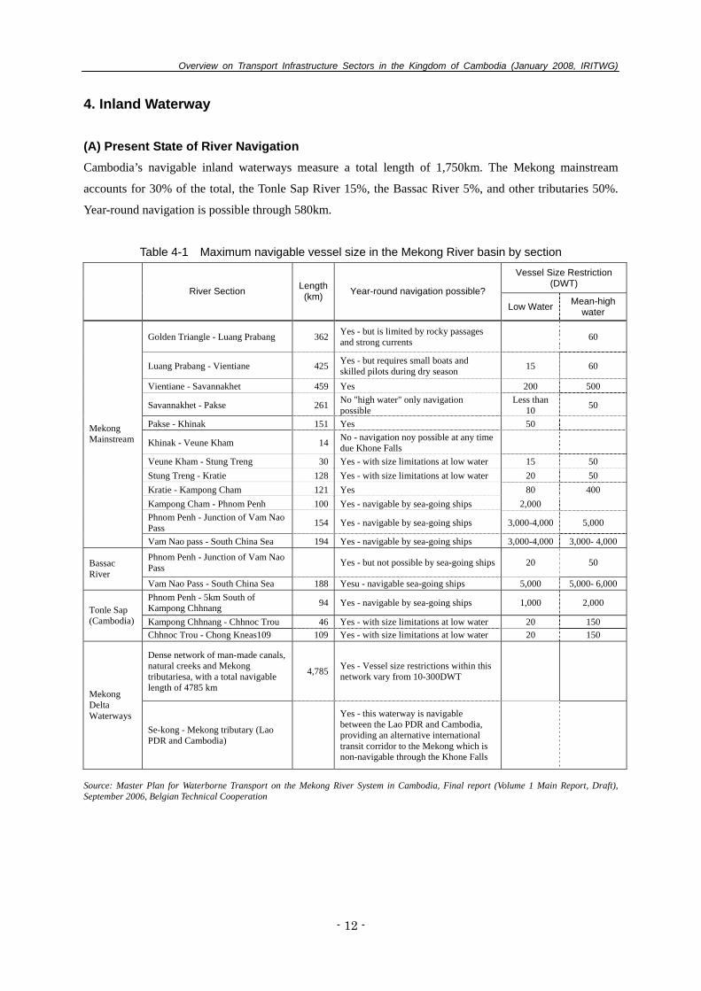
4. Inland Waterway
(A) Present State of River Navigation Cambodia’s navigable inland waterways measure a total length of 1,750km. The Mekong mainstream
accounts for 30% of the total, the Tonle Sap River 15%, the Bassac River 5%, and other tributaries 50%.
Year-round navigation is possible through 580km.
Table 4-1 Maximum navigable vessel size in the Mekong River basin by section
Vessel Size Restriction (DWT)
River Section Length(km) Year-round navigation possible?
Low Water Mean-high water
Golden Triangle - Luang Prabang 362 Yes - but is limited by rocky passages and strong currents 60
Luang Prabang - Vientiane 425 Yes - but requires small boats and skilled pilots during dry season 15 60
Vientiane - Savannakhet 459 Yes 200 500
Savannakhet - Pakse 261 No "high water" only navigation possible
Less than 10 50
Pakse - Khinak 151 Yes 50
Khinak - Veune Kham 14 No - navigation noy possible at any time due Khone Falls
Veune Kham - Stung Treng 30 Yes - with size limitations at low water 15 50 Stung Treng - Kratie 128 Yes - with size limitations at low water 20 50 Kratie - Kampong Cham 121 Yes 80 400 Kampong Cham - Phnom Penh 100 Yes - navigable by sea-going ships 2,000 Phnom Penh - Junction of Vam Nao Pass 154 Yes - navigable by sea-going ships 3,000-4,000 5,000
Mekong Mainstream
Vam Nao pass - South China Sea 194 Yes - navigable by sea-going ships 3,000-4,000 3,000- 4,000
Phnom Penh - Junction of Vam Nao Pass Yes - but not possible by sea-going ships 20 50 Bassac
River Vam Nao Pass - South China Sea 188 Yesu - navigable sea-going ships 5,000 5,000- 6,000 Phnom Penh - 5km South of Kampong Chhnang 94 Yes - navigable by sea-going ships 1,000 2,000
Kampong Chhnang - Chhnoc Trou 46 Yes - with size limitations at low water 20 150 Tonle Sap (Cambodia)
Chhnoc Trou - Chong Kneas109 109 Yes - with size limitations at low water 20 150
Dense network of man-made canals, natural creeks and Mekong tributariesa, with a total navigable length of 4785 km
4,785 Yes - Vessel size restrictions within this network vary from 10-300DWT
Mekong Delta Waterways
Se-kong - Mekong tributary (Lao PDR and Cambodia)
Yes - this waterway is navigable between the Lao PDR and Cambodia, providing an alternative international transit corridor to the Mekong which is non-navigable through the Khone Falls
Source: Master Plan for Waterborne Transport on the Mekong River System in Cambodia, Final report (Volume 1 Main Report, Draft), September 2006, Belgian Technical Cooperation

Overview on Transport Infrastructure Sectors in the Kingdom of Cambodia (January 2008, IRITWG)
- 13 -
Source:Master Plan for Waterborne Transport on the Mekong River System in Cambodia, Final report (Volume 1 Main Report, Draft), September 2006, Belgian Technical Cooperation
Fig. 4-1 Maximum navigable vessel size in the Mekong River basin
Table 4-2 Maximum navigable vessel size in the Mekong River basin
Mekong Mainstream up to Phnom Penh
Mekong River, Phnom Penh to Kampon Cham
Tonle Sap, Phnom Penh to Siem Reap
Petroleum Tanker barges 1,000 DWT / 4.0m draught - -
Container Barges 1,900 DWT (120TEU) / Draught 3.8m - -
Generak Cargo Barges 1,500 DWT / Draught 4.0m - -
Tourist Cruise Vessels
50-65 passengers Draught 1.5m - 50-65 passengers
Draught 1.5m
Speedboats 25 passengers shallow draught - 25 passengers
shallow draught Source: Master Plan for Waterborne Transport on the Mekong River System in Cambodia, Final report (Volume 1 Main Report, Draft), , September 2006, Belgian Technical Cooperation
(B) Present State of Inland Water Transportation A speedboat carries passengers between Phnom Penh and Siem Reap one round trip per day, during the
seven months from August to February. The number of passengers using inland water transportation
decreased from 129,000 in 2002 to 37,000 in 2005. 100-120DWT small ships are used for domestic cargo
transportation in Phnom Penh Port, and carry mainly food items, such as fresh produce, and packed cement.
Cargo handling volume has been greatly decreasing yearly, and has dropped to an estimated 5,700 tons in
2005.
Overview on Transport Infrastructure Sectors in the Kingdom of Cambodia (January 2008 IRITWG)
- 14 -
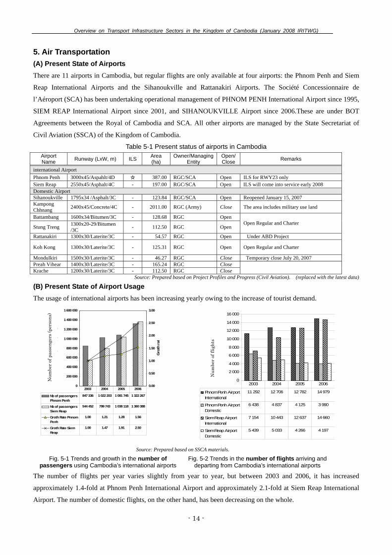
5. Air Transportation (A) Present State of Airports There are 11 airports in Cambodia, but regular flights are only available at four airports: the Phnom Penh and Siem
Reap International Airports and the Sihanoukville and Rattanakiri Airports. The Société Concessionnaire de
l’Aéroport (SCA) has been undertaking operational management of PHNOM PENH International Airport since 1995,
SIEM REAP International Airport since 2001, and SIHANOUKVILLE Airport since 2006.These are under BOT
Agreements between the Royal of Cambodia and SCA. All other airports are managed by the State Secretariat of
Civil Aviation (SSCA) of the Kingdom of Cambodia.
Table 5-1 Present status of airports in Cambodia Airport Name Runway (LxW, m) ILS Area
(ha) Owner/Managing
Entity Open/Close Remarks
international Airport Phnom Penh 3000x45/Aspahlt/4D ☆ 387.00 RGC/SCA Open ILS for RWY23 only Siem Reap 2550x45/Asphalt/4C - 197.00 RGC/SCA Open ILS will come into service early 2008 Domestic Airport Sihanoukville 1795x34 /Asphalt/3C - 123.84 RGC/SCA Open Reopened January 15, 2007 Kampong Chhnang 2400x45/Concrete/4C - 2011.00 RGC (Army) Close The area includes military use land
Battambang 1600x34/Bitumen/3C - 128.68 RGC Open
Stung Treng 1300x20-29/Bitumen /3C - 112.50 RGC Open
Open Regular and Charter
Rattanakiri 1300x30/Laterite/3C - 54.57 RGC Open Under ABD Project
Koh Kong 1300x30/Laterite/3C - 125.31 RGC Open Open Regular and Charter
Mondulkiri 1500x30/Laterite/3C - 46.27 RGC Close Temporary close July 20, 2007 Preah Vihear 1400x30/Laterite/3C - 165.24 RGC Close Krache 1200x30/Laterite/3C - 112.50 RGC Close
Source: Prepared based on Project Profiles and Progress (Civil Aviation). (replaced with the latest data)
(B) Present State of Airport Usage The usage of international airports has been increasing yearly owing to the increase of tourist demand.
0
200 000
400 000
600 000
800 000
1 000 000
1 200 000
1 400 000
1 600 000
Num
ber o
f pas
seng
ers
(per
s
0.00
0.50
1.00
1.50
2.00
2.50
3.00
Gro
th ra
t
Nb of passengersPhnom Penh
847 336 1 022 203 1 081 745 1 322 267
Nb of passengersSiem Reap
544 452 799 743 1 038 118 1 360 388
Groth Rate PnnomPenh
1.00 1.21 1.28 1.56
Groth Rate SiemReap
1.00 1.47 1.91 2.50
2003 2004 2005 2006
0
2 000
4 000
6 000
8 000
10 000
12 000
14 000
16 000
Num
ber o
f flig
h
Phnom Penh AirportInternational
11 292 12 706 12 782 14 979
Phnom Penh AirportDomestic
6 438 4 837 4 125 3 990
Siem Reap AirportInternational
7 154 10 443 12 637 14 660
Siem Reap AirportDomestic
5 439 5 033 4 266 4 197
2003 2004 2005 2006
Source: Prepared based on SSCA materials. Fig. 5-1 Trends and growth in the number of
passengers using Cambodia’s international airports Fig. 5-2 Trends in the number of flights arriving and
departing from Cambodia’s international airports
The number of flights per year varies slightly from year to year, but between 2003 and 2006, it has increased
approximately 1.4-fold at Phnom Penh International Airport and approximately 2.1-fold at Siem Reap International
Airport. The number of domestic flights, on the other hand, has been decreasing on the whole.
Num
ber
of p
asse
nger
s (p
erso
ns)
Num
ber
of fl
ight
s
Overview on Transport Infrastructure Sectors in the Kingdom of Cambodia (January 2008 IRITWG)
- 15 -
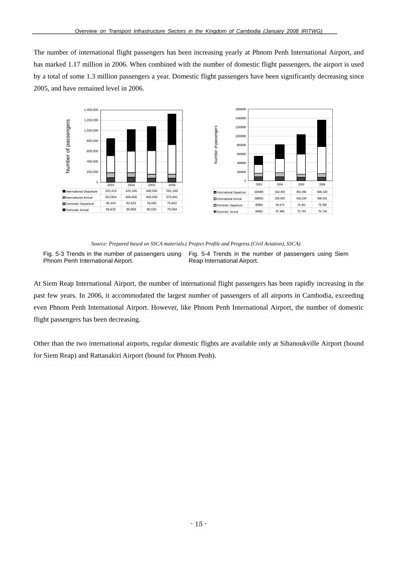
The number of international flight passengers has been increasing yearly at Phnom Penh International Airport, and
has marked 1.17 million in 2006. When combined with the number of domestic flight passengers, the airport is used
by a total of some 1.3 million passengers a year. Domestic flight passengers have been significantly decreasing since
2005, and have remained level in 2006.
0
200,000
400,000
600,000
800,000
1,000,000
1,200,000
1,400,000
Num
ber o
f pas
seng
ers
International Departure 333,419 420,106 468,590 591,190
International Arrival 322,854 409,606 455,059 575,641
Domestic Departure 95,443 92,633 78,063 75,842
Domestic Arrival 95,620 99,858 80,033 79,594
2003 2004 2005 2006
0
200000
400000
600000
800000
1000000
1200000
1400000
1600000
Num
ber o
f pas
seng
ers
International Departure 184085 310,493 454,396 608,328
International Arrival 188651 306,693 436,528 596,931
Domestic Departure 85864 94,673 74,451 79,395
Domestic Arrival 85852 87,884 72,743 75,734
2003 2004 2005 2006
Source: Prepared based on SSCA materials.( Project Profile and Progress (Civil Aviation), SSCA)
Fig. 5-3 Trends in the number of passengers using Phnom Penh International Airport.
Fig. 5-4 Trends in the number of passengers using Siem Reap International Airport.
At Siem Reap International Airport, the number of international flight passengers has been rapidly increasing in the
past few years. In 2006, it accommodated the largest number of passengers of all airports in Cambodia, exceeding
even Phnom Penh International Airport. However, like Phnom Penh International Airport, the number of domestic
flight passengers has been decreasing.
Other than the two international airports, regular domestic flights are available only at Sihanoukville Airport (bound
for Siem Reap) and Rattanakiri Airport (bound for Phnom Penh).

Overview on Transport Infrastructure Sectors in the Kingdom of Cambodia (January 2008, IRITWG)
- 16 -
6. Tourism
(A) Number of Tourists The number of foreign tourists to Cambodia fluctuates somewhat depending on the international situation,
but it has been steadily increasing since 1995. In 2005, more than 1.4 million, or 1.35 times more tourists
over the previous year, visited Cambodia.
In terms of foreign tourists’ purpose of visit to Cambodia (2005), 89% visit for sightseeing, 7% for business,
and 4% for other purposes.
0
200,000
400,000
600,000
800,000
1,000,000
1,200,000
1,400,000
1,600,000
1995
1996
1997
1998
1999
2000
2001
2002
2003
2004
2005
Year
Tourist
s (p
ers
ons)
0
5,000
10,000
15,000
20,000
25,000
Real
GD
P (B
illio
n R
iels
)
Tourist GDP Holiday
89%
Bussiness
7%
Others
4%
Source: Figs. 6-3 and 6-4 prepared based on Statistical Yearbook 2005 and Tourism Statistical Report Dec. 2005.
Fig. 6-1 Trends in foreign tourists and GDP Fig. 6-2 Foreign tourists’ purpose of visit toCambodia (2005)
In terms of the mode of transportation used by foreign tourists to arrive in Cambodia, an increasing number
of tourists are using air, land and water transportation. There has been a particularly large increase in the
percentage of tourists using large buses, owing to the development of national roads during the past few
years.
Air
Land & Boat
0
200,000
400,000
600,000
800,000
1,000,000
1,200,000
1,400,000
Pers
ons
Land & Boat 104,836 114,704 196,542 263,546 245,042 361,238 476,479
Air 262,907 351,661 408,377 531,199 455,972 626,121 856,521
1999 2000 2001 2002 2003 2004 2005
Preah Vihear
6% Boat
2%
Siem Reap
Airport
32%
Land 31%
Phnom Penh
Airport
29%
Source: Figs. 6-3 and 6-4 prepared based on Statistical Yearbook 2005 and Tourism Statistical Report Dec. 2005.
Fig. 6-3 Trends in foreign tourists' mode of tranportation to Cambodia
Fig. 6-4 Details concerning foreign tourists' means of arriving in Cambodia (2005)

Overview on Transport Infrastructure Sectors in the Kingdom of Cambodia (January 2008, IRITWG)
- 17 -
With respect to tourists entering Cambodia by land or water, the majority enter the country from Thailand
using National Road No. 5, followed by from Vietnam using National Road No. 1, from the Mekong River
by boat, and from Thailand by National Road No. 48.
0
50,000
100,000
150,000
200,000
250,000
300,000
Pers
ons
(num
ber)
2003 35,837 664 17,111 167,654 2,026 0 3,134 0 1,330 17,238
2004 51,935 1,724 22,960 242,456 4,097 4,346 4,322 4,016 466 24,916
2005 77,520 2,475 29,588 284,865 8,979 21,386 7,753 12,252 1,813 29,848
No .1 No. 2 No. 48 No. 5 No. 68 No. 13 No. 7 Mekong
Bavet Phnom Den Cham Yeam Poipet Osmach Dong Dong Kralor Others Sihanoukville Kaam
Samnor
Land Sea/River
Source: Created based on Statistical Yearbook 2005 and Tourism Statistical Report Dec. 2005.
Fig. 6-5 Trends in the number of foreign tourists at national border cities who have entered Cambodia by land or water
In terms of the number of foreign tourists by country, there has been a rapid increase in Korean tourists
during the past few years, accompanying the commencement of direct flights from Korea.
Other Asean
11%
South Korea
16%
USA
8%
Thailand
4%Preah Vihear
6%Others
8%
France
5%
Other Europe
12%
UK
5%
Japan
10%
Other Asia &
Oceania
15%
Source: Created based on Statistical Yearbook 2005 and Tourism Statistical Report Dec. 2005.
Fig. 6-6 Nationalities of foreign tourists to Cambodia (2005)

Contact address: IRITWG Secretariat Tel. 855 23 724 565 E-mail: [email protected]

Printed by