pat arnott, atms 749 atmospheric radiation transfer chapter 12: scattering and absorption by...
TRANSCRIPT

Pat Arnott, ATMS 749 Atmospheric Radiation Transfer
Chapter 12: Scattering and Absorption by Particles
Summary of Scattering Regimes: Note Particle Sizesand wavelengths of radiation!!
0.1 nm
r < 0.2 um
0.1 um < r < 10 um
10 um < r < 50 um
50 um < r < 100 um
100 um < r < 3 mm
around 1 cm
deep UV radarthermalIR

pat arnott, atms 360W. P. Arnott, AAAR tutorial, Sept. 2007 2
Light Scattering Basics (images from Wallace and Hobbs CH4).
Sphere, radius r, complex refractive index n=mr + imi
x
xx mr=1.5
Qs
Angular Distribution of scattered radiation (phase function)
x x
xDipole scattering

Pat Arnott, ATMS 749 Atmospheric Radiation Transfer
Small Particle Limit
Size parameter x << 1.
Helps understand:•Radar back scatter by hydrometeors•Absorption proportional to particle volume•Rayleigh scattering regime

Pat Arnott, ATMS 749 Atmospheric Radiation Transfer
Aerosol Optical Properties: Absorbing particles. Review
For small optical depths,
and D < 0.1 µm:
I(L)/I(0) = e(- L),
(1/m) ≈ S.O.C (m2/g) x (g/m3),
L = path length,
= aerosol concentration by mass.
•Absorption dominates for D < 0.1 µm (Rayleigh scattering).
•Aside: For non-absorbing aerosols, Extinction=Scattering. Note the strong dependence of the scattering coefficient on diameter!
particlemass
F0 (W/m2)Pext (W) = F0 ext
Pabs (W) = F0 abs
Psca (W) = F0 sca
Optical power removed by ext=abs+sca.
Rayleigh 1/r

Pat Arnott, ATMS 749 Atmospheric Radiation Transfer
General Mie Theory: Optics of Homogeneous Spheres of radius r and
refractive index mSum of Complex Terms
pat arnott, atms 360W. P. Arnott, AAAR tutorial, Sept. 2007 6
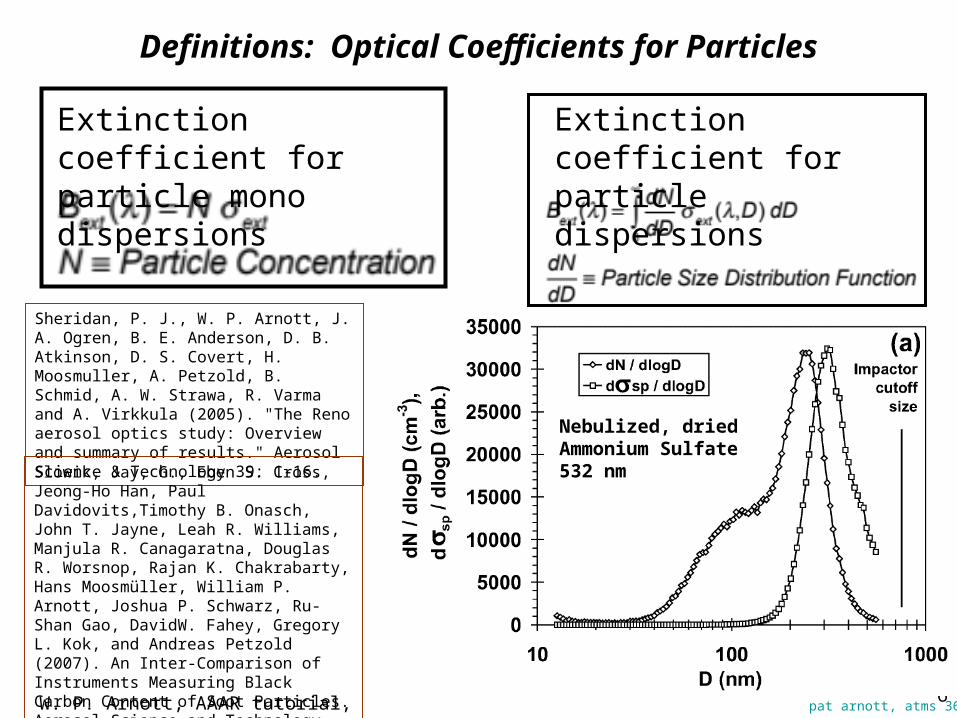
Definitions: Optical Coefficients for Particles
Extinction coefficient for particle mono dispersions
Extinction coefficient for particle dispersions
Nebulized, dried Ammonium Sulfate532 nm
Sheridan, P. J., W. P. Arnott, J. A. Ogren, B. E. Anderson, D. B. Atkinson, D. S. Covert, H. Moosmuller, A. Petzold, B. Schmid, A. W. Strawa, R. Varma and A. Virkkula (2005). "The Reno aerosol optics study: Overview and summary of results." Aerosol Science & Technology 39: 1-16.
Slowik, Jay, G., Eben S. Cross, Jeong-Ho Han, Paul Davidovits,Timothy B. Onasch, John T. Jayne, Leah R. Williams, Manjula R. Canagaratna, Douglas R. Worsnop, Rajan K. Chakrabarty, Hans Moosmüller, William P. Arnott, Joshua P. Schwarz, Ru-Shan Gao, DavidW. Fahey, Gregory L. Kok, and Andreas Petzold (2007). An Inter-Comparison of Instruments Measuring Black Carbon Content of Soot Particles. Aerosol Science and Technology, 41:295–314, 2007.
Pat Arnott, ATMS 749 Atmospheric Radiation Transfer
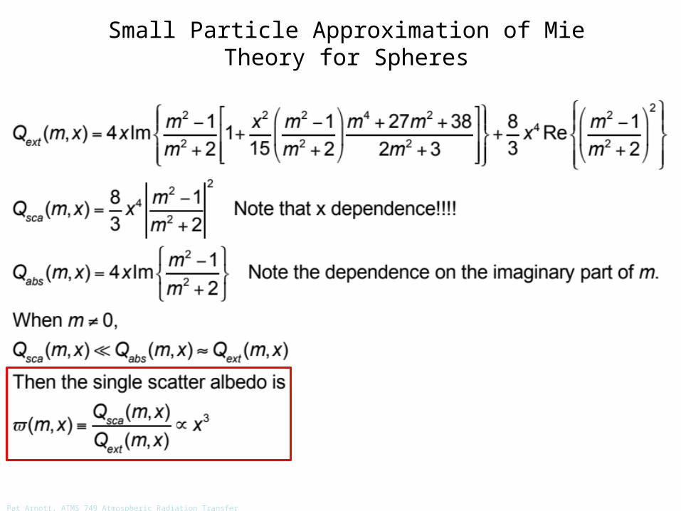
Small Particle Approximation of Mie Theory for Spheres
Pat Arnott, ATMS 749 Atmospheric Radiation Transfer
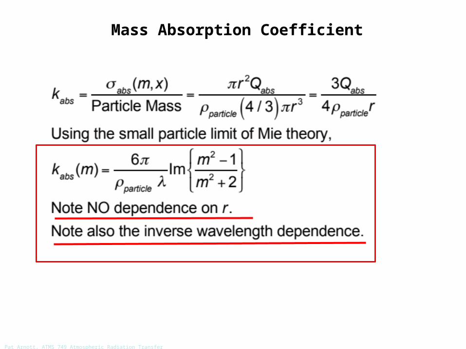
Mass Absorption Coefficient

Pat Arnott, ATMS 749 Atmospheric Radiation Transfer
Use of Mass Absorption Coefficient For Cloud Droplets

Pat Arnott, ATMS 749 Atmospheric Radiation Transfer
Accelerating Dipole Moment Produces Rayleigh Scattering
E0
+
-
Charge Q-+
P
dipole moment =P=Qx=E0
=polarizabilityx
Acceleration of dipole moment: Scattered E field!!!

Pat Arnott, ATMS 749 Atmospheric Radiation Transfer
Rayleigh Scattering Phase Function: Angular Distribution of Light Scattered by a Dipole
Refer to last pagefor polarization states.
horizontal polarization
vertical polarization
average of both

Pat Arnott, ATMS 749 Atmospheric Radiation Transfer
Rayleigh Scattering Phase Function: Angular Distribution of Light Scattered by a Dipole
3D rendering
vertical polarizationstate
horizontal polarizationstate
The Peanut!Average of bothpolarization states.

Pat Arnott, ATMS 749 Atmospheric Radiation Transfer
Mie Theory for Water Spheres (non absorbing)
Maximum, relative maxima and minima, approximate theory due to Rayleigh.
Generally m is a function of wavelength
Like sunset

Pat Arnott, ATMS 749 Atmospheric Radiation Transfer
Mie Theory for Water Spheres: m=1.33, Visible Wavelengths

Pat Arnott, ATMS 749 Atmospheric Radiation Transfer
Mie Theory for Absorbing and Scattering Spheres
modest ni has the largest absorption for modest size parameters.

Pat Arnott, ATMS 749 Atmospheric Radiation Transfer
Mie Phase Functions for Water Spheres
Note the dipole character for small xand the primary and secondary rainbows for large x.

Pat Arnott, ATMS 749 Atmospheric Radiation Transfer
Mie Phase Functions for Water Spheres: Log[p()] for details
Glory (strong backscattering, rainbow, and corona are clearly visible. Fogbow is ‘rainbow’ for small size parameter.

Pat Arnott, ATMS 749 Atmospheric Radiation Transfer
Mie Theory for Water and Ice Spheres
Absorption feature good for phase determination.

Pat Arnott, ATMS 749 Atmospheric Radiation Transfer
Mass Absorption Coefficient for Cloud Water Spheres, Microwaves
Microwave remote sensing for cloud water path L:
TB = T = [1-exp(-kL)] T (Rayleigh Jeans Approximation for brightness temperature)
microwave radiometer
T

Pat Arnott, ATMS 749 Atmospheric Radiation Transfer
Zenith Microwave Transmittance: Cloud Free Atmospheres
Choose microwave frequencies for cloud emissivity measurement wheretransmittance is high!!! Water vapor is variable; choose low frequency.
WaterVapor
RotationalLines

Pat Arnott, ATMS 749 Atmospheric Radiation Transfer
Radar: The Quickest Path to dbZ
Non polarizedoperation
Polarized andnon polarizedoperation
Doppler shift:Indicates speed.Power received:Responds to hydrometeorconcentration.
Polarization:Allows for hailand rain discrimination
d
From: http://en.wikipedia.org/wiki/NEXRAD
Power received is proportional to 1/d2. (inverse square law).

Pat Arnott, ATMS360
DefinitionsRADAR is an acronym. RAdio Detection And Ranging.
NEXRAD Weather Radar: WSR88D
Advanced Research Project Agency (ARPA) Long-range Tracking and Identification Radar (ALTAIR). Ballistic Missiles and Space Surveillance (military).
Weather Surveillance Radar, 1988, Doppler.

pat arnott, atms 360
Radar: The Quickest Path to dbZ
1. Absorption, scattering and extinction cross sections.
2. Backscattering cross section.
3. Cross section in the Rayleigh limit (particle diameter is much smaller than the wavelength of the radiation.)
4. Radar cross section for a particle in the Rayleigh limit.
5. Radar cross section for N particles in the Rayleigh limit.
Note: Key results are circled by a red box like this. The homework assignment is also given by a red box.
pat arnott, atms 360
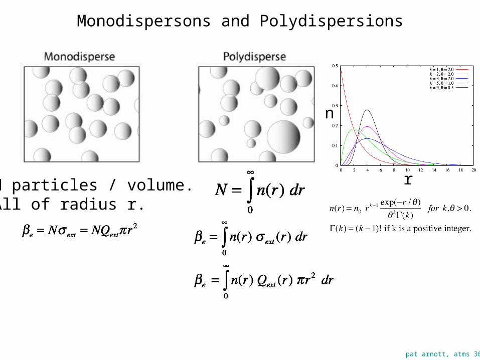
Monodispersons and Polydispersions
N particles / volume.All of radius r.
n
r

pat arnott, atms 360
Radar Theory Part 1

pat arnott, atms 360
Radar Theory Part 2: Key Results!!!
This is what is reported on radar graphs!!!
Pat Arnott, ATMS 749 Atmospheric Radiation Transfer
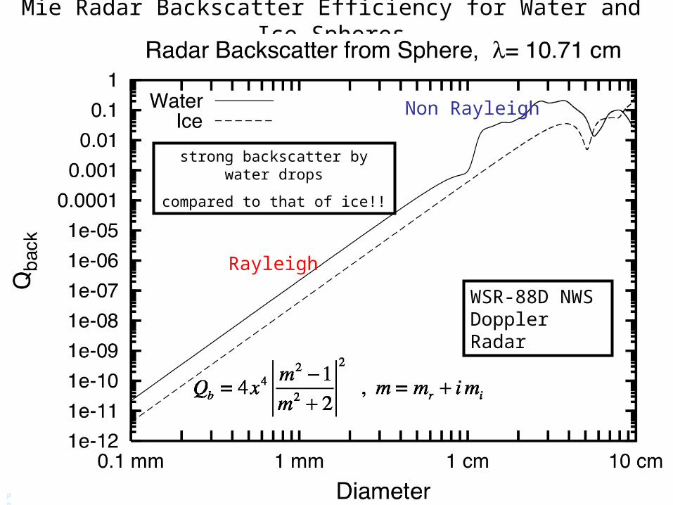
Mie Radar Backscatter Efficiency for Water and Ice Spheres
Rayleigh
Non Rayleigh
WSR-88D NWS Doppler Radar
strong backscatter by water drops
compared to that of ice!!

Pat Arnott, ATMS 749 Atmospheric Radiation Transfer
Radar Bright Band: Strong Scattering from Melting Hydrometeors
http://www.radar.mcgill.ca/bright_band.html

pat arnott, atms 360
Radar Theory Part 2: Typical Values of ZdbZ
Clear air mode of NEXRAD: -28 dbZ to 28 dbZ.
Precipitation mode of NEXRAD: 5 dbZ to 75 dbZ.
Light rain: 20 dbZ.

pat arnott, atms 360
Rainfall Rate Analogy
Falling rain: Coffee is beingpoured at some rate.
Height of coffee = H
Rainfall Rate = Height of Coffee / time elapsed pouring it.Rainfall Rate = dH / dt

pat arnott, atms 360
Rain Fall Rate for Monodispersion

pat arnott, atms 360
Radar Theory Part 3: Rainfall Rate Estimate From Radar
Definition of rainfall rate and what happens after rain hits the surface. Rainfall rate depends on the mass of water droplets and their fall speed.

pat arnott, atms 360
Rain Drop Fall Speed

pat arnott, atms 360
Rain Drop Fall Speed: A balance of Forces, Drag and Gravity
pat arnott, atms 360
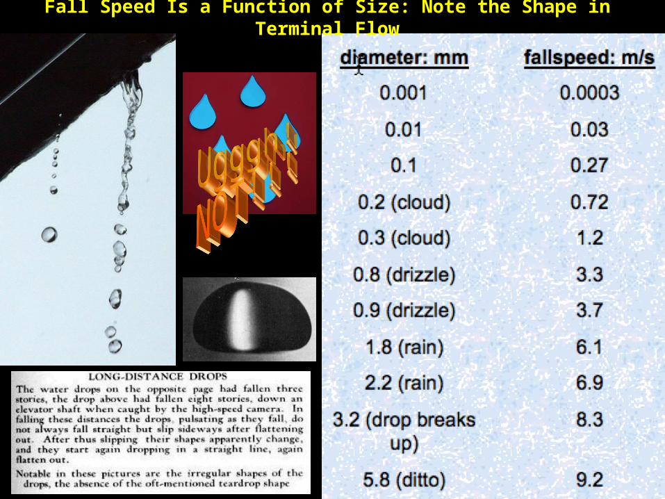
Fall Speed Is a Function of Size: Note the Shape in Terminal Flow

pat arnott, atms 360
Radar Theory Part 3: Rainfall Rate Estimate From Radar
This is one relationship used to get rainfall rate (depth / time) from radar.
Problem: People have developed many such relationships! Which is correct, if any?????
Pat Arnott, ATMS360
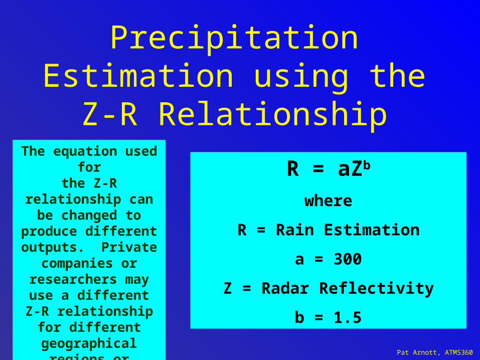
Precipitation Estimation using the
Z-R Relationship
R = aZb
where
R = Rain Estimation
a = 300
Z = Radar Reflectivity
b = 1.5
The equation used forthe Z-R relationship can be changed to produce different outputs. Private
companies or researchers may use
a different Z-R relationship for
different geographical regions or climatic
zones

pat arnott, atms 360
Polarization Diverse Radar: Now at the NWS
• Radar sends out horizontally and vertically polarized pulses.
• Hydrometeors like raindrops are flattened. The horizontal cross sections are larger than the vertical.
• Therefore for large raindrops a the horizontal polarization backscatter amount is larger than the vertical amount.
• Hail stones are more symmetrical and have less polarization diversity.

Pat Arnott, ATMS360
Antenna Beamwidth
radians
D is the antenna diameter
λ is the wavelength of signal in air
Tradeoff: Small wavelengths (high frequencies) = small antennasBut small wavelengths attenuate more
Pat Arnott, ATMS360
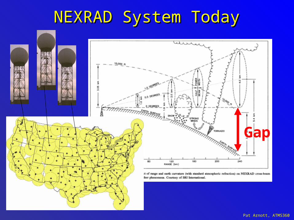
NEXRAD System TodayNEXRAD System Today
Gap
Pat Arnott, ATMS360
Supplemental and similar information for radar

Pat Arnott, ATMS360
NEXRAD RADAR• Named WSR-88D• S-band radar• radiation wavelength is λ
= 10.7 cm• Peak pulse power
is 1 MW• Pulse duration is
from 1.5 to 4.5 usec.
– Tallahassee (right)

Pat Arnott, ATMS360
More Definitions: NEXRAD and WSR-88D
NEXRAD or Nexrad (Next-Generation Radar) is a network of 159 high-resolution Doppler weather radars operated by the National Weather Service, an agency of the National Oceanic and Atmospheric Administration (NOAA) within the United States Department
of Commerce. Its technical name is WSR-88D, which stands for
Weather Surveillance Radar, 1988, Doppler.
NEXRAD detects precipitation and atmospheric movement or wind. It returns data which when processed can be displayed in a mosaic map which shows patterns of precipitation and its movement. The radar system operates in two basic modes, selectable by the operator: a slow-scanning clear-air mode for analyzing air movements when there is little or no activity in the area, and a precipitation mode with a faster scan time for tracking active weather. NEXRAD has an increased emphasis on automation, including the use of algorithms and automated volume scans.
(wikipedia).

Pat Arnott, ATMS360
Clear-Air Wind Profiler Radar Acoustic Sounder(obtain Tv(z) and (u,v,w) winds in principle)

Pat Arnott, ATMS360
Pulse Lengths for WSR-88D Radar[Weather Surveillance Radar, 1988, Doppler]
• Total radiated power in a radar pulse
• Range Resolution:
• Long Pulse:
• Short Pulse:

Pat Arnott, ATMS360
Introduction to Meteorological Radar

Pat Arnott, ATMS360
Ene
rgy
Abs
orbe
d by
Atm
osph
ere
Radar Wavelength
35 GHz
94 GHz
MaximumPropagation
Distance
20-30 km
10-15 km
8 mm3.2 mm

Pat Arnott, ATMS360

Pat Arnott, ATMS360
RADAR Echolocation(RADAR ~ RAdio Detection And Ranging)
“Microwave Echo-Location”
MicrowaveTransmitter
Receiver
Tx
Rx

Pat Arnott, ATMS360
Target Spatial Orientation
Polarization Pt
PolarizationPs
Large Drops
Small Drops
Closer look at Large
drop

Pat Arnott, ATMS360
Example: Weather Echoes
MicrowaveTransmitter
Receiver
Pat Arnott, ATMS360
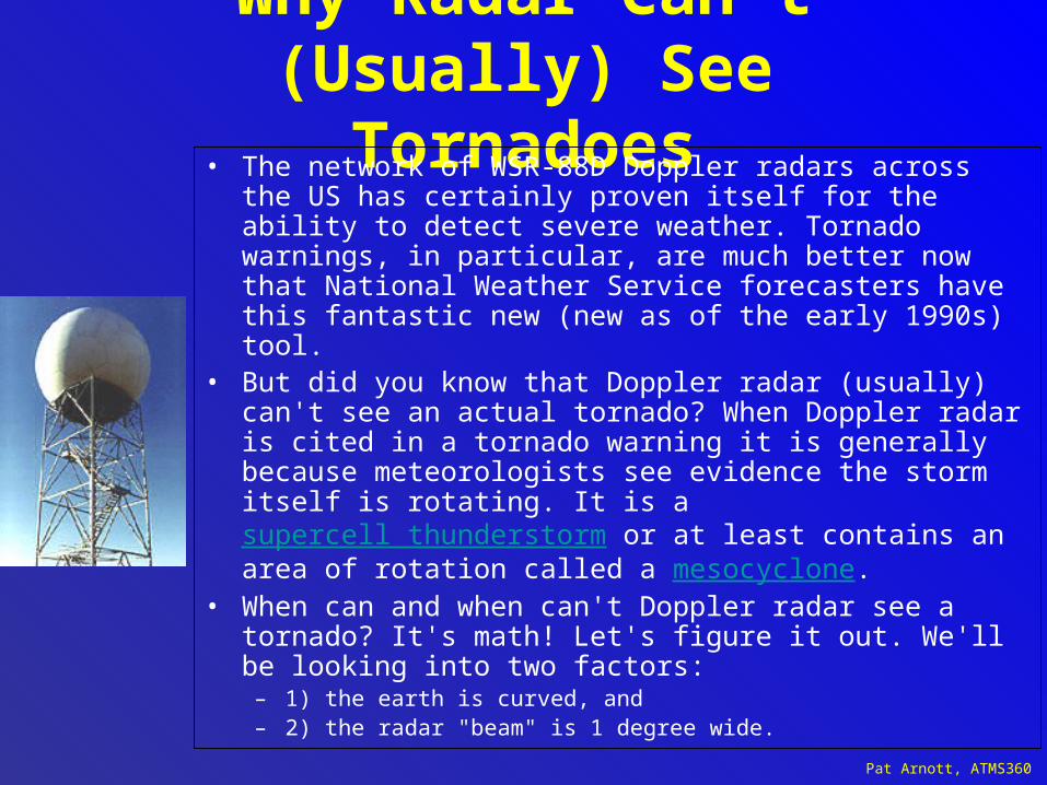
Why Radar Can't (Usually) See
Tornadoes• The network of WSR-88D Doppler radars across the US has certainly proven itself for the ability to detect severe weather. Tornado warnings, in particular, are much better now that National Weather Service forecasters have this fantastic new (new as of the early 1990s) tool.
• But did you know that Doppler radar (usually) can't see an actual tornado? When Doppler radar is cited in a tornado warning it is generally because meteorologists see evidence the storm itself is rotating. It is a supercell thunderstorm or at least contains an area of rotation called a mesocyclone.
• When can and when can't Doppler radar see a tornado? It's math! Let's figure it out. We'll be looking into two factors:
– 1) the earth is curved, and – 2) the radar "beam" is 1 degree wide.

Pat Arnott, ATMS360
Antennas
• Antenna is a transition passive device between the air and a transmission line that is used to transmit or receive electromagnetic waves.

Pat Arnott, ATMS360
Beam Height vs. Distance
○Lowest elevation slice is 0.5° so it is not totally horizontal.
○Earth’s curvature also plays a role.
○Radar beam gets higher off the ground farther from the radar.
○Makes low level precipitation invisible to radar at considerable distances.
From the National Weather Service
Greenville-Spartanburg, SC

Pat Arnott, ATMS360
Products Available
▪Reflectivity Images
▪Velocity Images (Doppler)
▪Precipitation Estimates
▪Vertically Integrated Liquid
▪Echo Tops
▪Animated Loops of Most Products
▪Many Other Products
From the National Weather Service
Greenville-Spartanburg, SC

Pat Arnott, ATMS360
Reflectivity Images
Base Reflectivity and Composite Reflectivity
Base Reflectivity
Composite Reflectivity
○0.5° elevation slice
○Shows only the precipitation at the lowest tilt level
○May underestimate intensity of elevated convection or storm cores
○Displays the maximum returned signal from all of the elevation scans
○Better summary of precipitation intensity
○Much less deceiving than Base Reflectivity
○Subtle 3-D storm structure hidden
From the National Weather Service
Greenville-Spartanburg, SC

Pat Arnott, ATMS360
Doppler Precipitation Estimate
Advantages and Limitations
●Great for scattered areas of rain where no rain gauges are located
●Has helped issue flash flood warnings more efficiently
●Helps fill in the holes where ground truth information is not available
●Much better lead time for warnings
●Provides a graphical ‘map’ of rainfall for an entire region
●Data can be overlaid with terrain and watersheds to predict reservoir and waterway crests
●Estimates based on cloud water levels and not ground level rainfall
●‘Hail Contamination’ causes highly inflated values
●High terrain causes underestimates
●Lower resolution than reflectivity images
●Useful as a supplement, not replacement for ground truth information
From the National Weather Service
Greenville-Spartanburg, SC
Pat Arnott, ATMS360
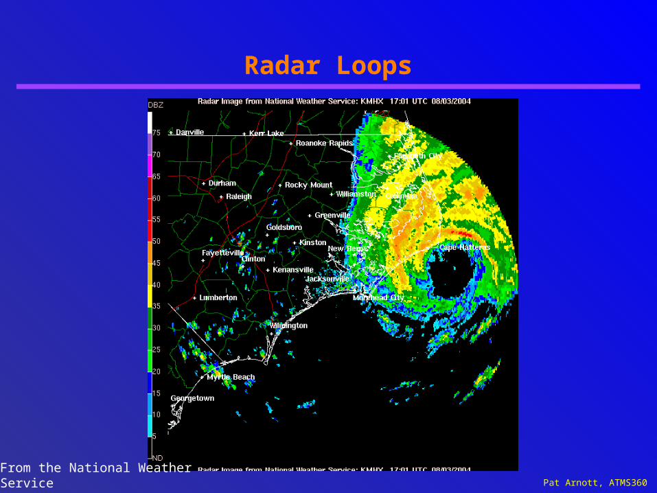
Radar Loops
From the National Weather Service
Greenville-Spartanburg, SC

Pat Arnott, ATMS360
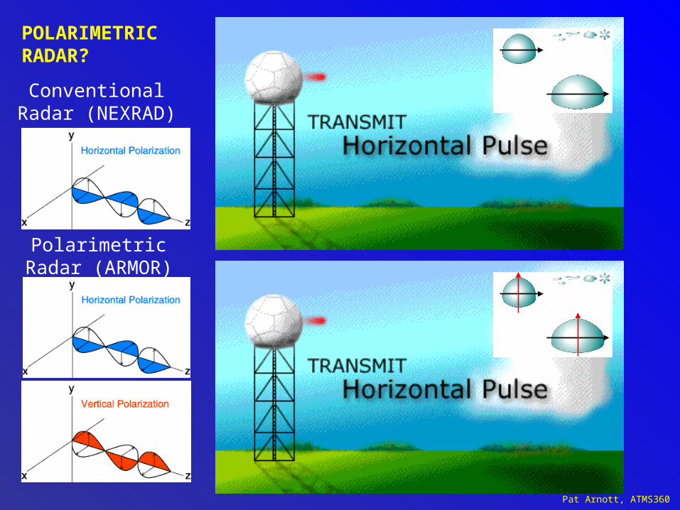
What Next for NEXRAD? WSRP-2010D
Polarimetric radar
The next major upgrade is polarimetric radar, which adds vertical polarization to the current horizontal radar waves, in order to more accurately discern what is reflecting the signal. This so-called dual polarization allows the radar to distinguish between rain, hail and snow, something the horizontally polarized radars cannot accurately do. Early trials have shown that rain, ice pellets, snow, hail, birds, insects, and ground clutter all have different signatures with dual-polarization, which could mark a significant improvement in forecasting winter storms and severe thunderstorms. The deployment of the dual polarization capability to nexrad sites will begin in 2010 and last until 2012.
Pat Arnott, ATMS360
ConventionalRadar (NEXRAD)
PolarimetricRadar (ARMOR)
POLARIMETRIC RADAR?
Pat Arnott, ATMS360
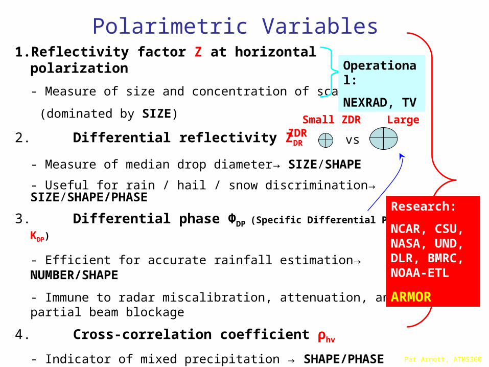
Polarimetric Variables1. Reflectivity factor Z at horizontal polarization
- Measure of size and concentration of scatters
(dominated by SIZE)
2. Differential reflectivity ZDR
- Measure of median drop diameter→ SIZE/SHAPE
- Useful for rain / hail / snow discrimination→ SIZE/SHAPE/PHASE
3. Differential phase ΦDP (Specific Differential Phase- KDP)
- Efficient for accurate rainfall estimation→ NUMBER/SHAPE
- Immune to radar miscalibration, attenuation, and partial beam blockage
4. Cross-correlation coefficient ρhv
- Indicator of mixed precipitation → SHAPE/PHASE
- Efficient for identifying nonmeteorological scatterers
Research:
NCAR, CSU, NASA, UND, DLR, BMRC, NOAA-ETL
ARMOR
Operational:
NEXRAD, TV
vs
Small ZDR Large ZDR
Pat Arnott, ATMS360
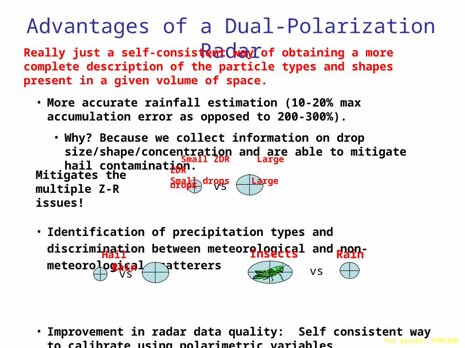
• More accurate rainfall estimation (10-20% max accumulation error as opposed to 200-300%).
• Why? Because we collect information on drop size/shape/concentration and are able to mitigate hail contamination.
• Identification of precipitation types and discrimination between
meteorological and non-meteorological scatterers
• Improvement in radar data quality: Self consistent way to calibrate using polarimetric variables
Advantages of a Dual-Polarization RadarReally just a self-consistent way of obtaining a more complete description of the particle types and shapes present in a given volume of space.
vs
Small ZDR Large ZDRSmall drops Large drops
vs
Hail Rain
vs
Insects Rain
Mitigates the multiple Z-R issues!