pdf.usaid.govpdf.usaid.gov/pdf_docs/pnaak492.pdf · 1. control number2.sjerclsfiaon(9....
TRANSCRIPT

Pt\I ~DdK~LL9Q
-7
Malaysia A Country Profile
0
1< ~ I.
~t
-~ 't'D, 'K
May 1979
Office of Foreign Disaster Assistance Agency for International Development
j Washington, D.C. 20523

1. CONTROL NUMBER2.SJErCLSFIAON(9BIBLIOGRAPHIC DATA SHEET PA! -1 oo TION-
3. TITLE AND SUBTITLE (240)
4. PERSONAL AU RS (100)
5. CORPORATE AUTHORS (101)
6. DOCUMENT DATE (110) 7. NUMBEROF PAGES (120) 8. ARC NUMBER 170
9. REFERENCE ORGANIZATION (10)
10. SUPPLEMENTARY NOTES (500)
f uat--4 a"Qiu6 Ct2 (p~r~k3& rt HlD§"46±L
11. ABSTRACT (950)
.DESCRIPTORS (920) IS. PROJECT NUMBER (150)
14. CONTRACT NO.(14b.) 15. CONTRACT TYPE (140)
4 Do'fr-ffS3 16. TYPE OF DOCUMENT (160)
W toOt
ot mPHIUIPPINIS
at S Sonskml
Snkl 1w an
MALAYSIA AND Raroad
BRUNEI tKid 1
LAAt~ u .A/FC
aRoad r - - - Road under constructul
0 O 1 00 MR., 8A0A
Port We T ng
n er IALUM Kuala Terea tganu 0MA 100ASIA 200 KilometrrsAND BRUNE S A A
wingA MA iUNEO) smBuEl
Inodng
LuutINA tu m t Ku aa tpisl L -ua aDn
k AnotI (NA1MBA -wI ( // LUM T emerlahAN
Pemr enar hgs i~CPW.AKEPULAUANNATIJNA KEsPULAUAN6.1EPISER
I AN y: or
dIA auaehen Ran a.0 ra~atn
BRU0 ESl r EEE A~ Tlf A -
rpa u, Kud
Base 500014 5-71
MALAYSIA: A COUNTRY PROFILE
prepared for
The Office of U. S. Foreign Disaster Assi-stance Bureau for Private and Development Cooperation
Agency for International Development Department of State
Washington, D. C. 20523
by
Evaluation Technologies, Inc. Arlington, Virginia
under contract AID-otr-C-1553
The profile on Malaysia is one in a series designed to provide baseline country data in support of the planning, analysis and relief operations of the Office of U. S. Foreign Disaster Assistance (OFDA). Con+ent, scope and sources have evolved over the course of the last three years, and no doubt will continue to do so. The relatively narrow focus is intentional. To avoid redundancy, some topics one might expect to find in a "country profile" are not covered here.
If the information provided can also be useful to others in the disaster assistance and development communities, so much the better. Every effort ismade to obtain current, reliable data; unfortunately it is not possible to issue updates as fast as changes would warrant. A cautionary note, therefore, to the reader: statistics are indicators at best, and ifnames and numbers matter, the bibliography will point to a current source.
We invite your comments and .corrections. Address these and other queries to OFDA, AID, as given above.
May 1979
A

OFDA COUNTRY PROFILES: APRIL 1979
Angola** Cape Verde Chad Djibouti Ethiopia Madagascar Mali Mauritania Niger* Sahel Transportation Survey Senegal-Somalia Upper Volta Zaire
ASIA
Afghanistan Bangladesh Burma India Indonesia Malaysia Nepal Pakistan Philippines
6ARIBBEAN
CARICOM Regional Profile Dominican Republic Haiti
LATIN AMERICA
Bo l1 via Brazil Chi-le Ecuador Guatemala Honduras Nicaragua Peru
NEAR EAST
Lebanon** Turkey
SOUTH PACIFIC
Fiji Tonga Western Samoa
in preparation * out of print
iI
CONTENTS
List of profiles.......................... ................... Preface........................................................
General information........ Geographic codes in use Country names........... Official holidays....... Currency exchange rate.. Host mission and staff i US mission and staff to Treaties and agreements. Travel and Visa informat Time zones.............. Ethnic and sociocultural Languages............. Education and literacy.. Religion................
Government................. National government..... Regional organization... Political parties....... Key leaders.............
Disaster preparedness...... Host disaster plan...... Volags and international Disaster types.......... Disaster history........
Population............... National population..... Regional distribution...
Population by state.. Population of capitol
. . ... .. .. . .. ... . . ... .. .... .. .
in USG information systems.. ............................ ............................ ............................ n US ........................ Malaysia .................... ................... ........ ion......................... ..................,.......... groups .....................
........ .................
..
..
..
..
..
,. ..
.. , ...
..
.. S.. ...
.. ...
.. ...
.. ...
organizations... ................. .................
.. .. .. .. .. .. .. .. .. .. .. ..
cities. .. .. ..
..
..
..
..
..
.. 4
.4.
..
S. ~ .4.
Population by district/towns.............................
ii
1-6 1 1 1 1 2 2 2 3 4 4 5 5 6
7-9 7 7 8 8
10-11 10 10 10 10
12-16 12 12 13 13 14

9* ... .. 9 ...
a.
... a.
9*
ah ...
... *9
.9
... ... ... ... ... ... ... ...
tion of GDP. ............ ............
... .. .5.. ...
... ...
...
17-23 17 17 18
... 18 19
... 19
... 20 21 21 22 22
24-27 24 25 25 26 26 27 27
28-30 S.... 28
.. 29 .. 29 .. ..
30 .. 30
31-38 ...
31 31 31 32
... a 33
... 34 36
Health, nutrition, and housing Health sector overview..... Vital statistics........... Health facilities.......... Health personnel........... Diet summary............... Nutritional status......... Food and drink............. .. Food preferences and taboos .. Housing.................... ..
Rural ................... .. Urban................... ..
Economy.................. Overview of economy... Industry.............. Mining................ GNP/GDP...............
Sector growth rates and compos Exports............... Imports..........................
Agriculture................. Overview of agriculture..
..
Commercial crops......... Food crops............... ..
Livestock................ Fishing..................
Physical geography and Climate............ Temperatures....... Rainfall .......... Land forms......... Land use........... Hydrography........ Mountains..........
land use... ........... ........... ........... ........... ........... ........... ...........
Transportation and logistics................................... 39-65 Road network.......................... ............ ........... 39 Vehicles.......... ........ ........................ ........ 40 Surface distances........................................ 40 Railroads.......... . ...................................... 42 Ports....................................................... 43 Shipping.................................................... 55 Airports..,,,...... ...... ........ ......... .,,....................57 Personal entry requirements............. ....................... 63 Airlines.................................................... 64 Air distances............................................... 65
Power and communications...................................... 66-69 Electric power.............................................. 66
Access to electricity by regions......................... 67 Radio network............................................... 67 Telephone systems........................................... 68 Television................................................... 68
Bibliography........................... 70-71
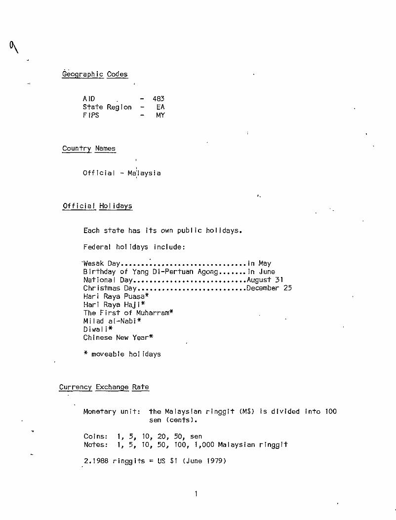
Geographic Codes
AID 483 State Region EA F IPS MY
Country Names
Official - Malaysia
Official Holidays
Each state has its own public holidays.
Federal holidays include:
'Wesak Day.................. ... in May Birthday of Yang Di-Pertuan Agong.... ... in June National Day............... ...August 31 Christmas Day.............. ...December 25 Hari Raya Puasa* Hari Raya Haji* The First of Muharram* Milad al-Nabi* Diwali* Chinese New Year*
* moveable holidays
Currency Exchange Rate
Monetary unit: the Malaysian ringgit (M$) is divided into 100 sen (cents).
Coins: 1, 5, 10, 20, 50, sen Notes: 1, 5, 10, 50, 100, 1,000 Malaysian ringgit
2.1988 ringgits = US $1 (June 1979)
1
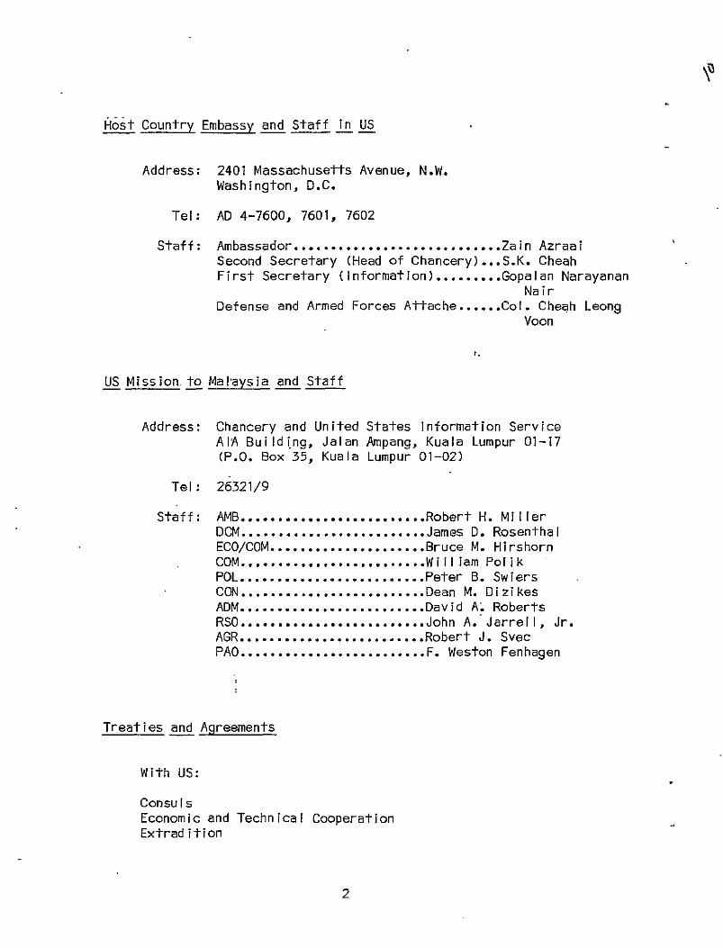
Hiost Country Embassy and Staff in US
Address: 2401 Massachusetts Avenue, N.W. Washington, D.C.
Tel: AD 4-7600, 7601, 7602
Staff: Ambassador....................... Second Secretary (Head of Chancery First Secretary (information).....
Defense and Armed Forces Attache..
....Zain Azraal )...S.K. Cheah ....Gopalan Narayanan
Nair ....Col. Cheah Leong
Voon
US Mission.to Mal'aysia and Staff
Address: Chancery and United States Information Service AIA Buildi ng, Jalan Ampang, Kuala Lumpur 01-17 (P.O. Box 35, Kuala Lumpur 01-02)
Tel: 26321/9
Staff: AMB.........................Robert H. Miller DCM.........................James D. Rosenthal ECO/COM.....................Bruce M. Hirshorn COM.........................Wil liam Pol ik POL.........................Peter B. Swiers CON.........................Dean M. Dizikes ADM.........................David A. Roberts RSO.........................John A. Jarrell, Jr. AGR.........................Robert J. Svec PA0.........................F. Weston Fenhagen
Treaties and Agreements
With US:
Consuls Economic and Technical Cooperation Extradition
2

Inheritance of Property Trade Marks Visas
With US and UK:
Air Transport Education Exchange Programs Investment Guarantees Peace Corps Limitations on Trade in Cotton Textiles and Wool and Man-Made.
Fibers
Multilateral:
Joined with United Kingdom, Singapore, Australia and New Zealand in the five-point defense arrangeinent. Under the agreement, Australian-armed forces are stationed inMalaysia; Anzak forces in Singapore.
Multilateral Treaties and Membership in International Organizations:
ASEAN Asian Developiment Bank British Commonwealth Customs Cooperation Council International Cultural Center for the Preservation and Restora
tion of Cultural Property International Rice Commission INTELSAT Comm iss ion United Nations UN-Related Agencies
Travel and Visa Information
Tourist visa not required. Passes required for visitors staying over three months. Visa required for employment, residence, education and research, $2.50. Business visa not required for stay of less than 18 days. Apply Embassy, Washington, D.C. 20008, and check specific requirements.
3

Health
Yellow fever vaccination certificate is required of travelers one year of age and older arriving from infected areas. Smallpox vaccination certificate required of travelers six months of age and older.
Time Zones
7:30 PM = noon GMT 7:30 PM = 7:00 AM EST
Ethnic and Sociocultural Groups
Three distinct ethnic groups, Malays, Chinese, and Indians, have maintained separate identities, languages,'and spheres of economic and social influence in Malaysia. According to 1970 official figures, Malays made up 46.7% of the population, Chinese 34.1%, Indians 9%, other indigenous Malaysians 8.7%, and Europeans and other foreigners the remainder. On Malay Peninsula, non-Malay indigenous groups include the nomadic Negrito Semang living on remote mountain slopes; the Senoi, cultivators in the valleys of central mountains (in Perak, Kelantan, Pahang, Selangor, and Negeri Sembilan); and the Jakun in southern coastal areas and lowlands of the states of Selangor, Malacca, Negeri Sembilan, and Johor. Together-the indigenous non-Malays are referred to as Orang Ashl, meaning "original people".
There are some Malays and Chinese in Sarawak and Sabah, but indigenous tribes make up the majority. In Sarawak the largest tribal group is the lban or Sea Dayak (about 31% of the total population). Other groups are the Land Dayak, Melanau, Kayan, Kenyah, Kajang, Kelabit, Murut, Punan and Penan. Most live in the sparsely settled interior in self-sufficient communities. The main tribal groups in Sabah are the Kadazan or Dusan (about 28% of total population) on the west coast and plains, the Bajau (13% of population) on the east coast, and the Idahan Murut (about 5% of population) in highland areas.
A patternof ethnic stratification has emerged on Malay Peninsula. Chinese, concentrated in west coast urban areas, are generally employed in commerce, industry and the professions. Indians have been plantation workers, shopkeepers and professionals. Malays, in
4
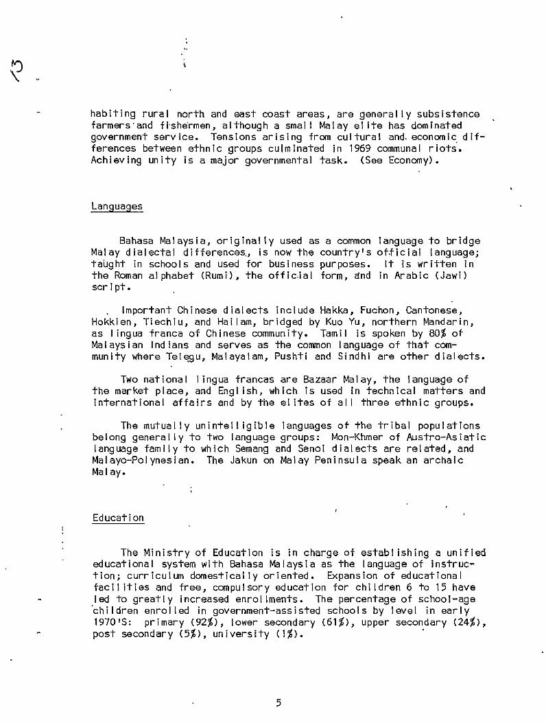
habiting rural north and east coast areas, are generally subsistence farmers'and fishermen, although a small Malay elite has dominated government service. Tensions arising from cultural and-economic differences between ethnic groups culminated in 1969 communal riots. Achieving unity is a major governmental task. (See Economy).
Languages
Bahasa Malaysia, originally used as a common language to bridge Malay dialectal differences,, is now the country's official language; taught inschools and used for business purposes. It is written in the Roman alphabet (Rumi), the official form, and in Arabic (Jawi) script.
Important Chinese dialects include Hakka, Fuchon, Cantonese, Hokkien, Tiechiu, and Hailam, bridged by Kuo Yu, northern Mandarin, as lingua franca of Chinese community. Tamil is spoken by 80% of Malaysian Indians and serves as the common language of that community where Telegu, Malayalam, Pushti and Sindhi are other dialects.
Two national lingua francas are Bazaar Malay, the language of the market place, and EngI ish, which is used in technical matters and international affairs and by the elites of all three ethnic groups.
The mutually unintelligible languages of the tribal populations belong generally to two language groups: Mon-Khmer of Austro-Asiatic language family to which Semang and Senoi dialects are related, and Malayo-Polynesian. The Jakun on Malay Peninsula speak an archaic Malay.
Education
The Ministry of Education is in charge of establishing a unified educational system with Bahasa Malaysia as the language of instruction; curriculum domestically oriented. Expansion of educational facilities and free, compulsory education for children 6 to 15 have led to greatly increased enrollments. The percentage of school-age children enrolled in government-assisted schools by level in early 1970'S: primary (92%), lower secondary (61%), upper secondary (24%), post secondary (5%), university (1%).
5
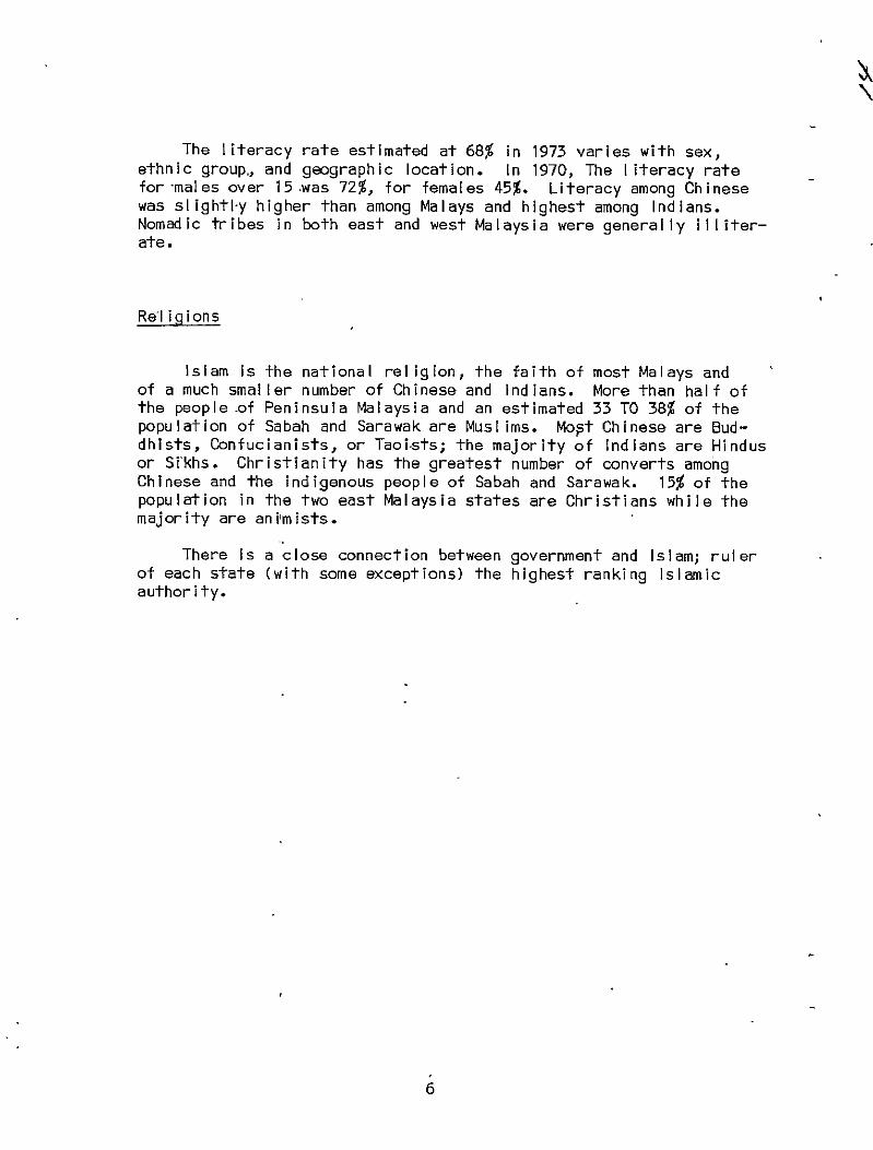
The literacy rate estimated at 68% in 1973 varies with sex, ethnic group, and geographic location. In 1970, The literacy rate for -males over 15 .was 72%, for females 45%. Literacy among Chinese was slightl-y higher than among Malays and highest among Indians. Nomadic tribes in both east and west Malaysia were generally illiterate.
Re'ligions
Islam is the national religion, the faith of most Malays and of a much smaller number of Chinese and Indians. More than half of the people of Peninsula Malaysia and an estimated 33 TO 38% of the population of Sabah and Sarawak are Musl ims. Mopt Chinese are Buddhists, Confucianists, or Taoi.sts; the majority of Indians are Hindus or Si'khs. Christianity has the greatest number of converts among Chinese and the indigenous people of Sabah and Sarawak. 15% of the population in the two east Malaysia states are Christians while the majority are animists.
There is a close connection between government and Islam; ruler of each state (with some exceptions) the highest ranking Islamic authority.
6

National Government
Malaysia is a federation of 13 equal and autonomous states headed by a constitutional monarch, the Yang Di-Pertuan Agong. Elected by the Conference of Rulers of which he is a member, the monarch serves a 5-year term; appoints the Prime Minister, Cabinet and Judges of the Federal and High Courts; commands the military and has the power to dissolve Parliament when so requested by the Prime Minister. A deputy supreme monarch, elected in the same manner, serves in the event of the monarch's disability or prolonged absence but does not automatically succeed to the throne in the event of his death.
Executive power vested in the Cabinet and Prime Minister, leader of the majority party or coalition commanding a majority in the lower house. They are responsible to the legislature.
Parliament consists of a Senate and a House of Representatives. 26 of the 58 Senate members are elected by the legislative assemblies of the states they represent; 32 are appointed by the monarch upon nomination by the Prime Minister. All serve 6-year terms. The 154 members of the House of Representatives are chosen by direct election. 114 are from the 11 states of West Malaysia; 24 are from Sarawak; 16 are from Sabah. A new election for the House of Representatives must be held after 5 years.
Regional Organization
The states of Malacca, Penang, Sabah, and Sarawak are headed by governors. The 9 dynastic states of Peninsula Malaysia (Johor, Kedah, Kelantan, Negeri Sembilan, Pahang, Perak, Perlis, Selangor, and Terengganu) are governed by hereditary rulers, usually called sultans. Governors are represented on the Conference of Rulers, but only rulers participate in the selection of the Yang Di-Pertuan Agong. Each state has a written constitution and a legislative assembly. Executive power rests in the chief ministers and executive councils, responsible to the legislative assemblies.
The states are divided into administrative districts under direction of a district officer drawn from the Civil Service. Sabah is divided into four residences: West Coast, interior, Sandakan, Tawau. Sarawak's five divisions are headquartered at Kuching, Simanggang, Sibu, Muri, and Limbong, respectively. The state districts of Peninsula Malaysia are further broken down into mukim and the residences and divisions of Sabah and Sarawak into districts and subdistricts.
7

Kuala Lumpur is a Federal Territory. The Prime Minister has responsibility for national matters; the minister of local government and federal territory has responsibility for local matters; execution of these responsibilities rests with the mayor.
The legal system, in the British common law tradition, is under federal jurisdiction and consists of a Federal Court, two high courts - one for Peninsula Malaysia and one for Sabah and Sarawak and subordinate courts. Legislative assemblies establish Kadi courts whose jurisdiction extends only to Musl ims.
Political Parties
In 1976, the ruling coal ition, the National Front, comprised 11 political parties of which the United Malay National Organization (UMNO) was the dominant group.
Key Leaders (As of July 1979)
Paramount Ruler.................. ..Ahmad Shah ibni Sultan Abu Bakar
Dep. Paramount Ruler............. Jaafar ibni Tuanku Abdul.... Rahman
Prime Minister................... Hussein bin Omn ..... Dep. Prime Minister................ ........ Mahathir bin Mohamad, Dr. Min. of Agriculture............... ........ Shariff Ahmad Min. of Culture-, Youth & Sports.... ........ Samad bin idris, Abdul Min. of Defense.................... ........ Taib bin Mahmud, Abdul Min. of Education.................. Musa bin Hitam ........ Min. of Energy, Telecommunications
Posts........................ ...Moggie, Leo Min. of Federal Territory.......... ...Hussein bin Onn Min. of Foreign Affairs............ ...Rithauddeen bin Ismal I,
Ahmad Min. of Finance............ Razaleigh Hamzah ....... Min. of Health............. ....... Chong Hon NyanMin. of Home Affairs....... ....... Ghazali bin Shafie,
Muhammad Min. of Housing & Local Government.. ....... Chen Wing Sum, Michael Min. of Information................ ....... Mohamed bin Rahmat Min. of Labor & Manpower............ ....... Ho Ung Hun, Richard Min. of Land & Regional Development. ....... Kadir bin Yusof, Abdul
8

Min. of Law & Attorney General. Min. of Primary Industries..... Min. of Public Enterprises..... Min. of Science, Technology &
Environment................. Min. of Trade & Industry....... Min. of Transport.............. Min. of Welfare Services........ Mi-n. of Works & Utilities.... Min. Without Portfolio........ Min. Without Portfolio.........
...Hamzah bin Abu Samah
...Leong Khee Seong, Paul
...Manan bin Othman, Abdul
... Ong.Kee Hui
...Mahathir bin Mohamad, Dr.
...Manickavasagam, V.
...Aishah binte Abdul Ghani
...Lee San Choon
...Mohamed bin Nasir
...Othman bin Rauf, Pengiran
9
Host Disaster Plan
Government has comprehensive plan at national, state and district levels.
Coordinating committee: Malaysian Control Center at National State Control Center and State and District Control Centers at District levels respectively.
International Organization
Inter-governmental bodies active in disaster-assistance: UNDP, UNESCO.
Volags and Other Donor Groups
The National Red Cross, CRS, Christian Children's Fund, Lutheran Church.
Disaster Types
Most frequent: floods, fire Other: civil strife; refugee problem
Disaster History.
Flooding from tropical storms occurred in late December 1970, and early January 1971, when nine-tenths of Malaysia on the Malay Peninsula (east coast, Kelantan, Teregganu, west coast) was covered by flood waters. Thousands were forced to evacuate their homes. A total of 243,000 persons was affected by the flooding; 61 persons were killed. Transportation and communications were impaired as rail and road links were severed.
Interethnic differences and tensions erupted in violence in Kuala Lumpur in 1969. In this recent example of civil strife, 173 persons were killed.
10

The international refugee problem has affected Malaysia, which in recent months has admitted Vietnamese refugees (boat people) to camps provided for them as well as Muslim Fili.pinos displaced by fighting in southern Philippines.
11

National Population
The 1970 census reported a population of 10,452,309 and an average annual growth rate of 3%, one of the highest in Asia. International immigration, a major influence on growth before 1950, has had little effect since 1957. (The immigration of laborers from the Philippines and Indonesia continues in Sabah, however, and heavy migration to cities within Malaysian states affects population distribution). Further declines in mortality are expected with continued socio-economic development. Even fertility has begun to decline as family planning programs gain acceptance. Assuming an annual growth rate of 2.7%, the TMP projects the population will grow from 12.25 million in 1975 to 13.98 million in 1980. The National Family Planning Board has set a 2% rate of population growth as a target by 1985. As fertility declines, shifts are expected in age distribution but not in racial composition.
The projected estimate of population, July 1, 1977, was 13,004,000. (World Population, 1977, US Dept. of Comerce).
Distribution of Population
Distribution is highly uneven; heaviest concentrations are in the western coastal plain of Peninsula Malaysia. During the 1960's, about 84% of the total population lived on the peninsula, with 62% of those in the four states of Selangor, Perak, Johor, and Kedah. With about 75% of land area covered with forests and swamps, the population density was about 326 people per square mile on cleared land in 1970. Urban population in Peninsula Malaysia is expected to increase from 32% in 1975 to 35.1% in 1980, half of the growth resulting from rural to urban migration.
Estimated Density Area Population Population jpe sq. mi.)
Sq Mi. (1970 Census) (1975) 1975
Peninsula Malaysia 50,806 8,809,557 10,114,854 199.1
Sabah 28,460 653,604 837,519 29.4 Sarawak 48,049 976,269 1,116,111 23.2 Total 127,315 10,439,430 12,068,484 94.8
(Source: Europa Yearbook 1978)
12

190 Census Data
States
Johore Kedah Kelantan Ma I acca Negri Sembilan Pahang Penang and Province
Wellesley Perak Perlis Sabah Sarawak Selangor Terengganu
Capital
Johore Bahru Alor Setar Kota Bharu Malacca Town Seremban
Penang*
Ipoh Kangar Kota Inabalu Kuching Kuala Lumpur Kuala Terengganu
*former I y Georgetown
Area S Mi les
7,330 3,639 5,765
637 2,565
13,886
399 8,110
307 28,460 48,050 3,166
5,002
1970 Population (000)
136 66 55 86 80
270
248 9 41 63
451 53
PopulationI
1,327,776 990,469 711,812 419,628 499,432 523,614
800,399 1,626,365
124,496 697,053
1,006,840 1,691, 062
420,149
State
Johore Ked ah Kelantan Ma lacca Negri Semb'i I an Dahang & Prov. We11esIey Derak Perlis Sabah Sarawak Selangor Terengganu
13
4 Johore
8 Administrative Districts:
Batu Pahat 249,705 Johore Baru 271,929 Kluang 134,658 Kota Tinggi 61,551 Mersing 34,657 Muar 279,161 Pontian 117,729 Segamat 127,579
Kedah I.
Population: 955,374
Ten Administrative Districts: Bal ing, Bandas Bharu, Kota Setar, a Muda, Kubang, Kulim, Lang , Padang Terap, Sik, Yan.
Kelantan
Town Council District
Kota Bharu 27,682 207,838 Pasir Mas 11,233 100,659
Tanah Merah 7,012 57,925 Tumpat 10,673 73,050
Major Towns: Bachok, Kota Bharu, Kuala Krui, Machang, Pasir Mas, Pasir Pateh, Tanah Merah, Tumpat.
Ma Iacca
Main Towns:
Alor Gajah 2,222 Bukit Baru 14,377 Jasin 3,289 Malacca 87,160 Masgid Tanah 2,149 Pulau Sebang 6,310
14
Negi Sembilan
Population: 479,312
Six Political Units: Jelebu, Johol, Rembau, Sri Menanti, Sungei, Tampin.
Pahang
Major Towns:
Bentong Jerantut Kuala Lipis Kuantan Mentakab Pekan Raub Temerloh
22,683 4,449 9,270 43,358 11,308 4,682 18,433 6,070
',,
Penang and Province Wellesley
Penang Island 433,760 Province Welles ley 343,010
Main Towns:
Bukit Meztagam 135,000 Butterworth 161,317 Georgetown
(now called Penang) 331,763
Perak
ipoh, state capital: population 300,000.
Main Towns: Bagan Serai, Batu Gajah, Bidor, Kamapr, Kuala Kangsar, Lumut, Parit Buntar, Slim River, Sungei Siput, Tanjing Malim, Tapah, Teluk Anson.
15
Pe !Iis
Population: 121,062
Mai'n Towns: Arau, Kaki Bukit, Kangar, Kuala Perl is,Padang Besar, Simpang Ampat.
Sabah
Population: 653,264
Sarawak
Kuching, capital, 63,000.
Main Towns: Limbang, Miri, Sibu, Simanggang.
Selangar
Population: 1,629,386
Terengganu
Main Towns: Besut, Kemanan, Kuala Terengganu.
16

Health Sector Overview
The general level of health has improved significantly in recent decades, but improvements are not uniform. Primitive sanitation in rural areas contributes to disease, especially entero-parasitic illnesses. Typhoid is also present in rural areas as are scrub typhus and leptospirosis. Although tuberculosis, malaria, leprosy, filariasis, and dengue still major health problems, control and eradication programs have met with some success and will be continued. Yaws has been virtually eliminated. Most of the population has been exposed to malaria and it is being brought under control; small risk in most towns in West Malaysia and Sarawak as well as in some towns in'Sabah. The campaign against leprosy has reduced its seriousness, but sulfone-resistant strains exist. Cholera 'I's endemic and has been a health problem especially in Sabah and Sarawak. Immunization programs have reduced incidences of diphtheria, whooping cough, tetanus, and polio; bronchitis and influenza remain common. Nutritional ailments arising from lack of protein and vitamins in the diet occur as does goiter. Trachoma appears in Sarawak.
The government's campaign to improve health conditions (assisted by WHO, UNICEF, and other international agencies) includes public education programs, mass immun'izations, strict enforcement of quarantine regulations, sanitary waste disposal and water supply projects, and public housing projects.
With economic and urban development have come changing patterns of mortality and morbidity. Treatment of accidents was the major cause of hospital admission in 1974. Other frequent problems included complications of pregnancy, mental illness, and heart disease.
1975 Vital Statistics
Birth rate: 31-32/1,000 population Death rate: 6/1,000 population
Infant mortality: 32/1,000 live births Life expectancy: 68
17

Health Facilities
Health facilities are inadequate and unevenly distributed among states and regions, particularly in rural areas. Most facilities are government operated; medical treatment on federal, state, and district level is free or based on ability to pay. Medical care (outpatient.and inpatient) occurs on three levels: primary at d.istrict level, intermediate referal at state level, and special ized care at regional or federal level. In 1974, 11 general and 48 district hospitals and several special institutions provided general medical care to Peninsula Malaysia; 'Sabah had 7 general and district hosp'itals; Sarawak had 7 general and 6 district hospitals. General and district hospital-s usually located in major cities, although some located in rural areas; every provincial capital inPeninsula Malaysia had at least one. The number of acute beds (excl'ades chronic and , longstaying ailments) was 16,746 inthe peninsula in 1975; Sabah and Sarawak had 1,367 and 1,584 respectively. The average acute bed to population ratio was 1.7 per 1,000 people.
Rural health services in Peninsula Malaysia delivered by 1 main health center, 4 health sub-centers, and 20 midwife cl inics for every 50,000 people. System recently modified to upgrade sub-centers and midwife clinics.. The main centers responsibile for maternal and child health, environmental sanitation, communicable diseases control, primary medical care, and fami-ly planning. In.1975, there were 73 health centers, 246 sub-centers, and 1,282 midwife clinics. Sabah'-s rural health services consist of dispensaries and village group sub-centers, while Sarawak's health services delivered by 1 main health center and 4 health sub-centers for every 25,000 people. Community health centers (1 for each 2,000 population), travel ing dispensaries, and floating clinics were added during the SMP period. Health care for tribal groups in Peninsula Malaysia comes under the flying doctor service of the East Malaysia Department of the Aborigines.
Expansion and improvement of health services are called for under the TMP.
Health Personnel
Shortages of medical personnel, especial ly doctors, dentists, and registered nurses, most acute in rural areas of Peninsula Malaysia, Sabah, and Sarawak; one doctor per 4,000 population in 1975 in the peninsula; similar doctor/patient ratios in Sabah and Sarawak estimated twice as high. The target under TMP is a ratio of 1:3,000 by 1980 and 1:2,220 by 1980. Shortages of other personnel inthe
18
health sector - laboratory technicians, radiologists, pharmacists, hospital administrators, and public health experts - have been even more critical. During the period of the SMP, crash programs undertaken for the training of paramedical personnel. Expanded university medical facilities, however, failed to meet domestic personnel demand in 1976, and foreign doctors were still needed. Plans drawn up in the TMP to staff rural health centers with a medical officer, dental officer, public health sister, nurses, and ,paramedical personnel.
Personnel: 2,482 physicians (of whom 2,299 were in Peninsula Malaysia) (1972); 823 dentists (1973); 6,845 nurses and 3,772 midwives (1973).
Diet
Average daily intake of 2,250 calories in Peninsula Malaysia And 2,020 calories in Sarawak and Sabah in 1971 (revised government figures-1975) compares with government's recommended optimum and is high compared with the rest of Southeast Asia. Rice (country is nearing self-sufficiency) is the staple for all ethnic groups. In most parts of West Malaysia rice is supplemented by fish, vegetables, some meat and fruit, when available and affordable. In East Malaysia and some remote parts of West Malaysia, yams, and sweet potatoes may be added to rice. Two main meals: one in the morning shortly after rising and one in late afternoon; numerous snacks also eaten.
In urban areas large amounts of soft drinks and other beverages are consumed, while in rural areas non-Muslims make their own drinks, largely from rice. Milk is not significant in the diet; children , receive little-or no milk after weaning. Use of canned milk for infants and small children is increasing. Some maternal and child health units and schools use powdered milk.
Nutrition
Dietary imbahances result in cases of beri-beri, iron deficiency anemia (common in women of child-bearing age) vitamins A and D deficiencies in children of rural poor. PEM occurs in preschool children. Moderate to severe malnutrition exists especially in remote inland rural districts. Protein intake tends to be insufficient in
19

It all regions. Feeding children commercial milk preparations also a problem. The sale of skimmed milk, however, is under strict control. The Applied Food and Nutrition Project will continue its efforts to improve nutritional status of rural population during the TMP period.
Food and Drink
The following list is based largely on domestically produced foodstuffs and is intended as an indicator of acceptable foods rather than a complete list:
Starches: rice (main staple food, making up more than 20% of food consumed), maize, yams, sweet potatoes, cassava, tapioca.
Vegetables: market garden vegetables
Fruits: bananas, pineapples, coconuts, oranges, rambutans (Malayan fruit closely related to the litchi nut), mangosteens.
Meat: Religious proscriptions affect choices (see taboos). Beef from cattle and water -buffalos, pork, occasionally goat. Poultry is raised by some and is presumably included in the diet.
Milk: Little fresh milk available; canned and powdered milk being used increasingly for infants and small children.
Legumes: peanuts
Fish: Fish, the second staple food, supplying 70-80% of animal protein, consumed especially by coastal Nalays. Some 20 species are sold on large scale-fresh, dried, salted, and in paste form.
Beverages: coffee, tea, mil k, soft drinks, rice drinks (smooth sweet tuak made by lbans; bitter borak made by others).
Other: condiments such as curries and chilis
20
Food Preferences
Malay: Rice is supplemented with meat, fish, fish pastes.and vegetables. Coconut oil and/or milk is used inmost preparations. Goat meat is eaten on special occasions.
Chinese: The four main styles of cooking are Peking, Shantung, Canton, and Szechuan. Pork is frequently used.
Indian: Hot and spicy dishes are preferred. eaten with rice and chapattis.
Curry is usually
In Sarawak and Sabah, Chinese and South Indian dishes are favored.
In West Malaysia, mild curries (usually without vegetables), containing coconut, are served with such condiments as peanuts, salted fish, pickles, or sliced fruit. Satay, small pieces of meat grilled on a skewer, dipped into a hot sauce of ground peanuts and chi I is, is a popular dish.
Food faboos
Islam forbids pork, flesh of predatory animals, birds, rodents, reptiles, worms; flesh of dead animals or sacrificed offerings; slaughtering must follow Islamic rites. Hindus do not eat beef, and many do not eat meat at all.
Housing
Providing all Malaysians with access to adequate housing is a major objective in national development. Despite efforts by both the public and private sectors, the country has not been able to meet housing needs, particularly for low-cost housing. During the TMP period (1976-80), it is estimated that at least 515,000 housing units will be required for Peninsula Malaysia and that the public and private sectors will construct some 482,800 units. (260,000 were completed under SMP). Reducing unit cost of houses is a major challenge in public housing program. Housing is a state responsibility, and the Ministry of Housing and Village Development is responsible for policies and programs.
21
According to the 1970 census, overcrowding was greatest in urban areas (7.07 persons per unit compared with 5.34 in rural areas), but sanitation levels were lower in rural areas (only 32% had piped water compared with 90% in cities). However, wide disparities exist in housing standards in urban areas, while sewerage system development lags far behind development of water supply systems. Because lumber is the most plentiful building material, about two-thirds of residences made of wood.
Rural:
Houses range from simple split-bamboo frame with thatched roof, to wooden dwellings with elaborate gables and tile roofs. The average house has two rooms and a back veranda where cooking is done. Poultry and livestock are kept in under-floor space. Furnishings consist of sleeping mats, a few utensils, perhaps a wooden cabinet or chest, and wall shelves.
Indians in rural areas, usually estate workers, live in barracktype dwellings. They may be of wood with thatched roofs, built on stilts with space for cooking underneath, or of brick with aluminum sheeting or tile roofs.
Rural tribes of Sabah and Sarawak generally live in a longhouse, a wooden structure on stilts built near a river. Longhouses consist of a number of family units with a common roof and veranda. Although the longhouse is built cooperatively, each of the 50 or 60 families housed in itmaintains own home. Furnishings include bamboo floor mats, hammocks for sleeping, and shelves. Pigs and poultry kept under the house to scavenge waste disposed of through a floor hole. Cooking is done on the veranda.
New Villages constructed during the period of the Emergency, inhabi-ted mainly by Chinese, providing generally inadequate housing. Some improvements were made during the SMP.
Urban:
Depending on income, Chinese in urban areas live in housing ranging from high-rise luxury apartments and ranch style homes, to flats and rowhouses and overcrowded tenement rooms. Urban Malays tend to
22

live in kampong - a, collection of wood houses on sti lts 'alI though
some live in apartment buildings. Squatter communities on the fringes of cities have increased in number and size with rural-urban migration.
23

oo~e~r~iew of Economy
Malaysia's essentially export-oriented economy is one of the most stable and prosperous in Southeast Asia. Conservative fiscal policies resulted in an economy characterized by -openness, non-Intervention, high savings rate, price stability, abundant foreign reserves, and high public consumption. However, in the dual economy inherited from the colonial period, (when export sector was foreign contrblled, Malays dominated subsistence agriculture, and non-Malay Asians acted as middlemen inthe exchange of goods), inequalities in the distribution of wealth occurred, coinciding with ethnic divisions. Most Chinese still live inthe rich, industrialized west coast states of Peninsula Malaysia while the east coast states are predominantly Malay, rural, and poor.
Following the communal riots of 1969, the government intensified efforts to redress wealth inequities and moved away from traditonal laissez-faire policy to one of greater public participation. The New Economic Policy (stated in the SMP) emphasized accelerated industrialization (creation of labor-intensive industries and disperal of industry throughout the country), rural land development, improved agricultural methods, and crop diversification. Financing of increased government expenditures was from tax revenues (62% of total in 1975), non-tax revenues (about 8%), and borrowing (30%). Debt servicing the third largest budget item in 1975 after social services and security; tax revenue as a proportion of GNP reached 24% in 1975.
The Outline Perspective Plan, for the period 1971-1990, seeks greater participation of Malays in commercial and industrial activities (at least 30% of ownership and operation by 1990) while the country's economy expands so that the restructuring of racial composition in employment does not limit opportunities for non-Malays. Moderate gains toward these goals during the SMP period, according to preliminary reports, included growth in real per capita income (about 3% annually), decline in poverty rate (49% to 43%) increase in employment of Malays in manufacturing (from 29% to 33%), in commerce (from 24% to 34%), and in ownership of business (from 3% to 7.8%).
A-wide gap in wealth remains, however, between regions and between ethnic groups. Overall unemployment was only slightly improved (7.5% to 7.4%) and like another recent problem, inflation, remains a challenge.
The Third Malaysia Plan (TMP) covers the second five year period of the Outline Perspective Plan and continues the New Economic Policy objectives. Emphasis is on reducing poverty and on restructuring
24
employment patterns so that they reflect racial composition of the country by 1990.
Greater than expected recovery in traditional exports and terms of trade in 1976 and high oil production level's have led to forecasts that government resources will exceed TMP projections, thus making possible an expanded program in the public sector. A recovery of private investment, which fell in 1975-1976 to below SMP levels, is seen as essential if income and employment goals of the TMP are to be met.*
* "Malaysia,: New Perspectives on the Third Malaysia Plan," World Bank Report No. 1594-MA.
Indus+ry
Industrial expansion, with emphasis on manufacturing, a majorgovernment goal and considered essential in broadening the economic base from specialization in rubber and tin; encouraged by special financing services and incentives. Government control over industry has increased in line with objectives of greater Malay participation and may be a factor in the decline in private investment in the manufacturing sector. Manufacturing, slowed by recession in 1975, showed significant growth in 1976. (See GDP).
Mining
Commercial reserves of tin are declining although Malaysia is still world's largest exporter, and reserves may exist in offshore and remote areas'of the country.
Production of crude petroleum has increased significantly. The state of Sarawak is largest producer. Offshore Trengganu fields began producing in 1978 and production totals for the year neared 240,000 barrels per day. The country is expected to begin producing liquified natural gas in 1984.
Iron and bauxite production decreasing; copper is the most important of other metals.
25
GNP per capita (1976): US $860 (World Bank).
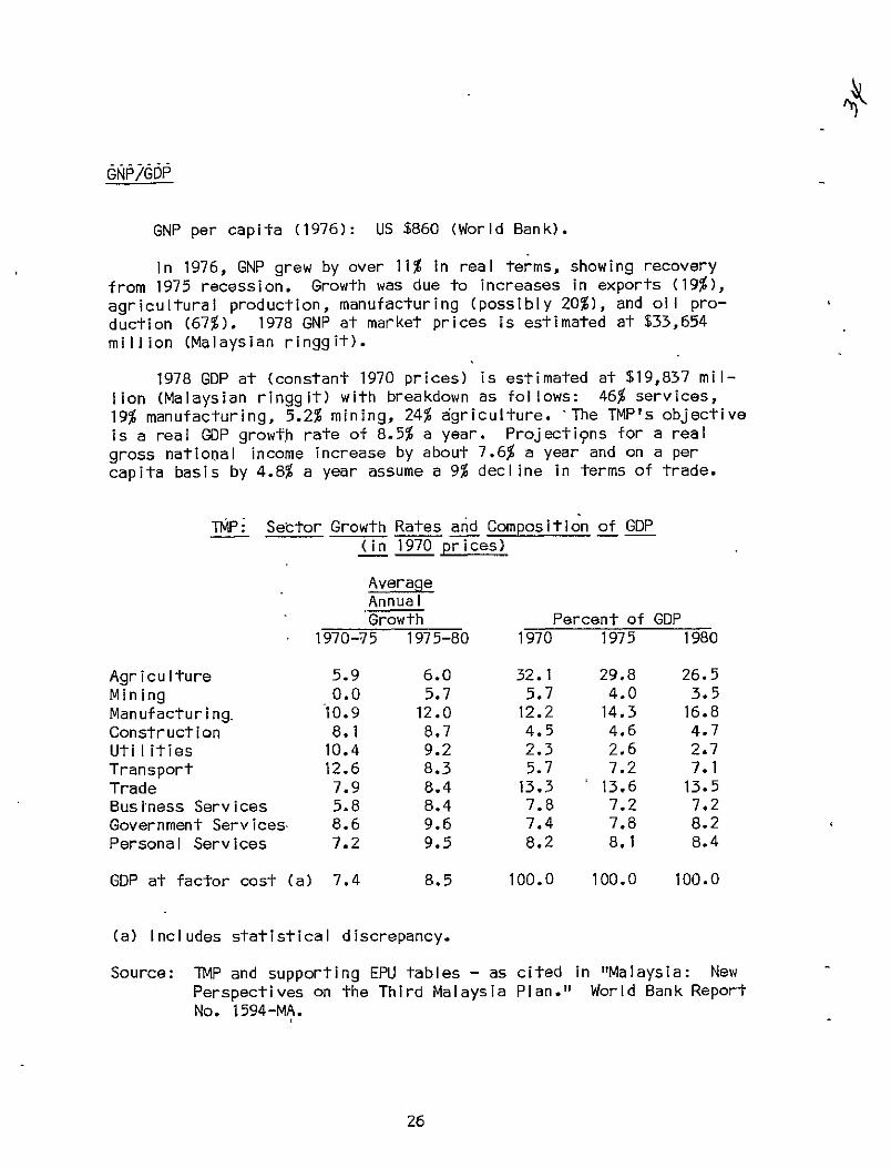
In 1976, GNP grew by over 11% in real terms, showing recovery from 1975 recession. Growth was due to increases in exports (19%), agricultural production, manufacturing (possibly 20%), and oil production (67%). 1978 GNP at market prices is estimated at $33,654 million (Malaysian ringgit).
1978 GDP at (constant 1970 prices) is estimated at $19,837 million (Malaysian ringgit) with breakdown as follows: 46% services, 19% manufacturing, 5.2% mining, 24% agriculture. 'The TMP's objective is a real GDP growth rate of 8.5% a year. Projections for a real gross national income increase by about 7.6% a year and on a per capita basis by 4.8% a year assume a 9% declire in terms of trade.
TMP: Sector Growth Rates and Composition of GDP (in 1970 prices)
Average Annual Growth Percent of GDP
1970-75 1975-80 1970 1975 1980
Agriculture 5.9 6.0 32.1 29.8 26.5 Mining 0.0 5.7 5.7 4.0 3.5 Manufacturing, 10.9 12.0 12.2 14.3 16.8 Construction 8.1 8.7 4.5 4.6 4.7 Utilities 10.4 9.2 2.3 2.6 2.7 Transport 12.6 8.3 5.7 7.2 7.1 Trade 7.9 8.4 13.3 13.6 13.5 Business Services 5.8 8.4 7.8 7.2 7.2 Government Services 8.6 9.6 7.4 7.8 8.2 Personal Services 7.2 9.5 8.2 8.1 8.4
GDP at factor cost (a) 7.4 8.5 100.0 100.0 100.0
(a) Includes statistical discrepancy.
Source: TMP and supporting EPU tables - as cited in "Malaysia: New Perspectives on the Third Malaysia Plan." World Bank Report No. 1594-MA.
26
Rubber and tin accounted for the major part of export trade until successful economic diversification policies were carried out followindependence., The export sector has contributed at least 40% of GNP each year since independence. Exports increased from about 5,000 (M $ million) in 1970 to 13,000+ (M $ million) in 1976; imports increased from about 4,000 (M $ million) in 1970 to 9,500+ (M'$ million) in 1976. Despite past deficits foreign exchange reserves have been held at levels sufficient to finance five months worth of imports. Recovery in exports resulted in a current account surplus of M $ 1.7 billion in 1976.
Major exports: rubber, petroleum, tin, saw logs and sawn timber, palm oil. Other important products: pepper, coc6nut oil, copra, bauxite, and such manufactured goods as food products, beverages, tobacco, chemicals and chemical products, wood products, textiles and clothing, rubber products, footwear, and electric components.
Principal partners (1975): Japan, United States, United Kingdom, the EEC and Singapore.
Imports
Major categories (1975): machinery-and transport equipment; food, beverages, and tobacco; manufactured goods; mineral fuels; and chemicals. 79% of total imports went to Peninsula Malaysia in 1975. The import of consumption goods isexpected to decline as industry supplies more of domestic needs.
Principal partners (197'5): Japan, United States, United Kingdom, Singapore, and the EEC.
27
6veriew of Agriculture
Agriculture, the main economic sector, contributes about onequarter of the GDP (30% in 1975), employs about 50% of the economical ly active population, and provides 55%-60% bf foreign exchange earnings. Only a small proportion of the country's 128,000 acres is cultivated - about 3% of Sabah and Sarawak and 25% of Peninsula Malaysia. Greatest amount of acreage (1975) was devoted to rubber (53%), oil palm (16%) and rice paddy (.19%); coconuts, fruits, tea, coffee, spices are also significant. Land holdings are inestates (100 ac/es or more) and in small holdings (under 100 acres). About two-thirds of small holdings are less than five acres; much rice cultivation is on tenant farms. Estates (largest control led by foreigners) accounted for 50% of rubber production in 1975, although small holder proportions are increasing. Moit rice cultivation and 80% of coconut cultivation is on small holdings. Crop diversification and improved,technology have increased agricultural output, especially in palm oil, rubber, and rice.
83% of households in poverty category in 1970 were Malay; most subsistence farmers. Other poverty groups* are east coast fishermen;rubber estate workers, and residents of New Villages. The New Economic Policy in the SMP aimed at raising rural incomes through land development, improved farming methods (drainage and irrigation, rehabilitation of low-yielding crops) to increase output, and crop diversification. I'nmid-1970's rural areas were still behind urban areas in income, health and education benefits, and employment oppbrtunities. The major change for agricultural development under TMP emphasizes improvements in previously developed areas rather thanon new land development.
* Note: Rubber estate workers, mostly Indians, and New Villagers (90% Chinese) are included in "other agriculture" category, second to rubber smallholders in size. 65% of this group is in poverty. Estate workers are often underemployed as a result of increased mechanization and the shift from rubber to less labor-intensive oil palm cultivation. Few New Villagers own land or have access to new land development. Plans for some modernizing of New Villages are included in TMP.
28
Production
Commercial Crops
Rubber, the most important export crop, accounted for 15% of GNP inmid-1970"s and for more than 30% of foreign exchange earnings. Rubber smallholders make up single largest group of farmers and 28% of rural poor. Old trees, poor farming practices, small size of holdings main causes of poverty.
Palm oil production is emphasi zed in crop diversification policy. Total area in 1975 was about 1.4 mi Ilion acres with greatest increases in Johor, Pahang, and Selangor; production was 1.3 million tons.
Coconuts are grown mainly in.Perak, Selangor, Johor, and Kelantan. 50% of Peninsula Malaysia's coconut smallholder househol'ds were in poverty in 1950. About 100,000 acres to be rehabi Iitated under TMP (double that of SMP). More intercropping has high potential for reducing poverty.
Timber an important source of revenue as Malaysia is the world's second largest producer of tropical hardwoods. 1978 production: 16 million cubic meters of saw logs (largely from Sabah) worth M $1,519.8 million while sawn timber accounted for revenues of M $844.3 million.
Other crops: pepper (90% from small holdings in Sarawak), pineapples, cocoa, coffee, tea, and tobacco.
Food Crops
Rice (main staple crop) production in 1975 was 1.3 million tons as the country neared self-sufficiency. There are about 150,000 households of paddy farmers in Peninsula Malaysia. Poverty in this sector fell from 88% to 77% during SMP as a result of increaed double cropping, drainage and irrigation, and a rise in the price of paddy. Causes of poverty in the sector: land holding arrangements-farms are small (55%.are less than 3 acres), often rented - and low-yield crops. TMP programs for expansion of drainage and irrigation includes most of remaining paddy land suited to double cropping.
Other food crops for domestic consumption: maize, sweet potatoes, cassava, market garden vegetables.
29
Livestock
Livestock products do not contribute significantly to gross value of agricultural production (5% in 1972). Two major kinds of cattle are Kelantan and local Indian dairy. Water buffalo supply most beef.' Non-Muslim Chinese raise hogs for local consumption and export. Livestock numbers in 1975: cattle (386,000), buffalo (213,000), goats (329,000), sheep (45,000), pigs (1,168,000).
Fishing
Of the 1,000 species of fish found in Malaysian waters, 250 species are used for food; 20 species are marketed fresh, dried, and salted on a large scale. Total catch in 1975 was about 568,400 tons, of which 80% was consumed locally. 63% of 43,000 fishing households were in poverty in 1975; the problem is most serious on east coast of the peninsula where output of fisheries has stagnated since 1968.
30

Climate
East and West Malaysia, in same latitudes, are subject to same air masses. The tropical climate is characterized by heavy rainfall, oppressive humidity, and a generally uniform temperature (mean 81" F).
There are no real seasons but the year is,divided into monsoon periods. The northeast monsoon (Oct.-Feb.) brings intense, steady rains; the major portion of Sabah's and Sarawak's annual mean rainfall (150") occurs during this season. The southwest monsoon (mid Aprilmid Oct.) is characterized by squalls, intense thunderstorms; Peninsula Malaysia's precipitation (mean annual of 100") occurs primarily during southwest monsoon. Serious flooding may occur during tropical storms. (See Disaster History).
Temperatures
Region, Extr- Lati- Longi-City Rge Jan Apr Jul Oct eme tude tude
Sabah, Max 85 89 89 88 99 Sandakan Min 74 76 75 75 70 05054'N 118 003'E
Sarawak, Max 85 90 90 89 98 Kuching .Min 72 73 72 73 64 01029'N 110 020'E
West Malaysia, Max 90 91 90 89 99 Kuala Lumpur Min 72 74 72 73 64 03006'N 101 042'E
Precipitation (In Inches)
Region, City
Sabah, Sandakan
Jan
19
Feb
11
Mar
9
Apr
5
a
6
Jun
-7
Jul!
7
Aug
8
Sep
9
Oct
10
Nov
15
Dec
19
Sarawak, Kuching 24 20 13 11 10 7 8 9 9 11 14 18
31
8
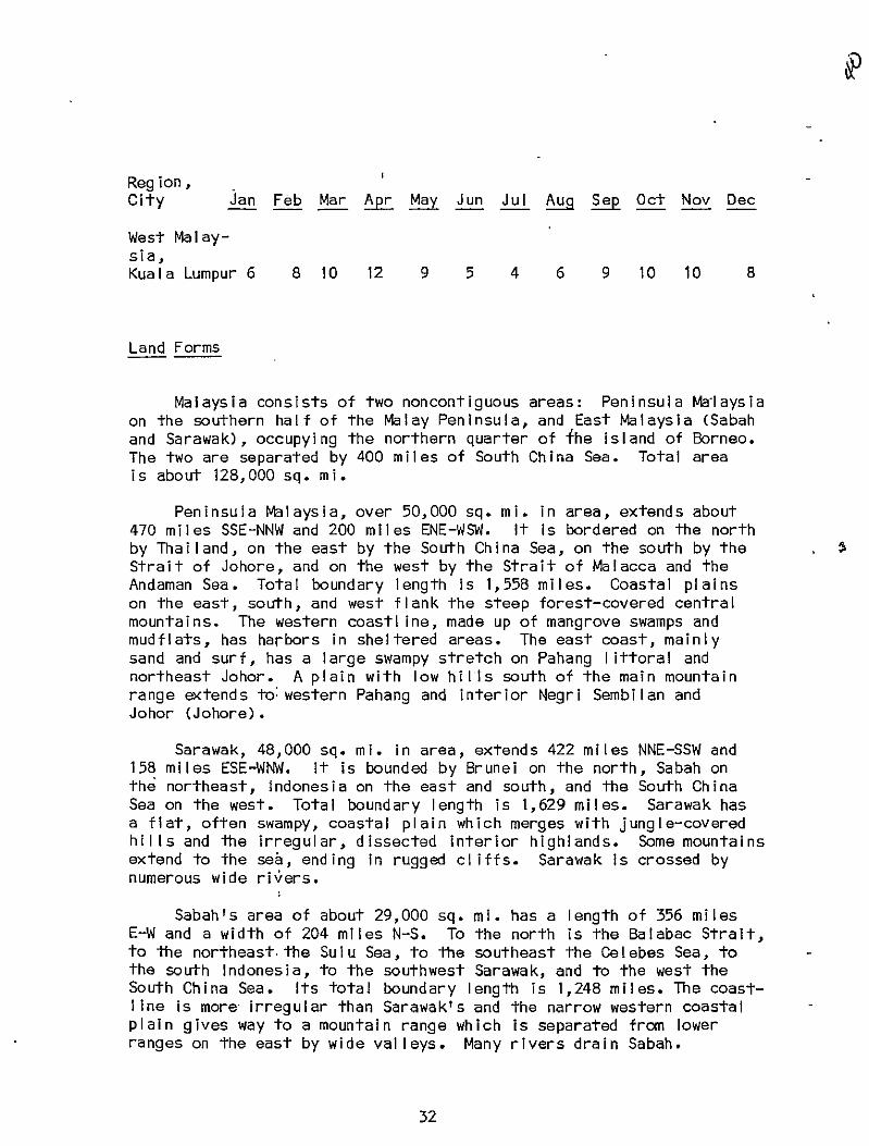
Region, City Jan Feb Mar Apr May Jun Jul Aug Sep Oct Nov Dec
West Malaysia, Kuala Lumpur 6 8 10 12 9 5 4 6 9 10 10
Land Forms
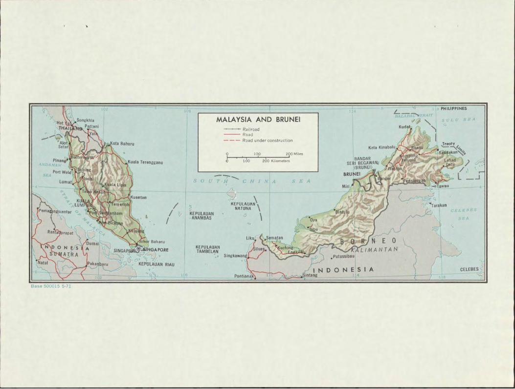
Malaysia consists of two noncontiguous areas: Peninsula Malaysia on the southern half of the Malay Peninsula, and East Malaysia (Sabah and Sarawak), occupying the northern quarter of {he island of Borneo. The two are separated by 400 miles of South China Sea. Total area is about 128,000 sq. mi.
Peninsula Malaysia, over 50,000 sq. mi. in area, extends about 470 miles SSE-NNW and 200 miles ENE-WSW. It is bordered on the north by Thailand, on the east by the South China Sea, on the south by the Strait of Johore, and on the west by the Strait of Malacca and the Andaman Sea. Total boundary length is 1,558 miles. Coastal plains on the east, south, and west flank the steep forest-covered central mountains. The western coastl ine, made up of mangrove swamps and mudflats, has harbors in sheltered areas. The east coast, mainly sand and surf, has a large swampy stretch on Pahang littoral and northeast Johor. A plain with low hills south of the main mountain range extends to: western Pahang and interior Negri Sembilan and Johor (Johore).
Sarawak, 48,000 sq. mi. in area, extends 422 miles NNE-SSW and 158 miles ESE-WNW. It is bounded by Brunei on the north, Sabah on the northeast, Indonesia on the east and south, and the South China Sea on the west. Total boundary length is 1,629 miles. Sarawak has a flat, often swampy, coastal plain which merges with jungle-covered hills and the irregular, dissected interior highlands. Some mountains extend to the sea, ending in rugged cliffs. Sarawak is crossed by numerous wide rivers.
Sabah's area of about 29,000 sq. mi . has a length of 356 miles E-W and a width of 204 miles N-S. To the north is the Balabac Strait, to the northeast the Sulu Sea, to the southeast the Celebes Sea, to the south Indonesia, to the southwest Sarawak, and to the west the South China Sea. Its total boundary length is 1,248 miles. The coastline is more- irregular than Sarawak's and the narrow western coastal plain gives way to a mountain range which is separated from lower ranges on the east by wide valleys. Many rivers drain Sabah.
32
001, 1 5 2 !

Coordinates
Lat. Long.
Alor Setar 6.24N; 100. OBE Ipoh 4.45N; 101 .05E Johore Bahru 1.28N; 103.46E Kangar Kota Baharu 6.15N; 102.23E Kota Kinabalu 5.55N; 116.05E Kuala Lumpur 3.08N; 101 .42E Kuala Trengganu 4. 53N; 102.26E Kuching 1.30N; 110.26E Malacca 2.11N; 102.15E Penang (See Port) Seremban 2.44N; 101 .57E'
Land Use
West Malaysia:
About four-fifths of the land area is covered by jungle and swamp. Almost 75% is forested, with 13,375 sq. mi. in forest reserves (8,561 sq. mi. are permanent production forests; 4,814 sq. mi. are protected forests). The lowlands of the west coast densely populated and most important production and commercial areas.
Sarawak:
Rain forests cover the greater part of the state. A mountainous interior and coastal swamplands limit agriculture to higher elevations where the hills extend to the sea and to the banks of some river deltas, which provide moderately productive paddy land.
Sabah:
23,000 sq. mi. or about 80% of the total area is forested; accessible timber areas are on the east and southeast coasts. The narrow western coastal plain the main rubber and rice areas.
33
7 Ix
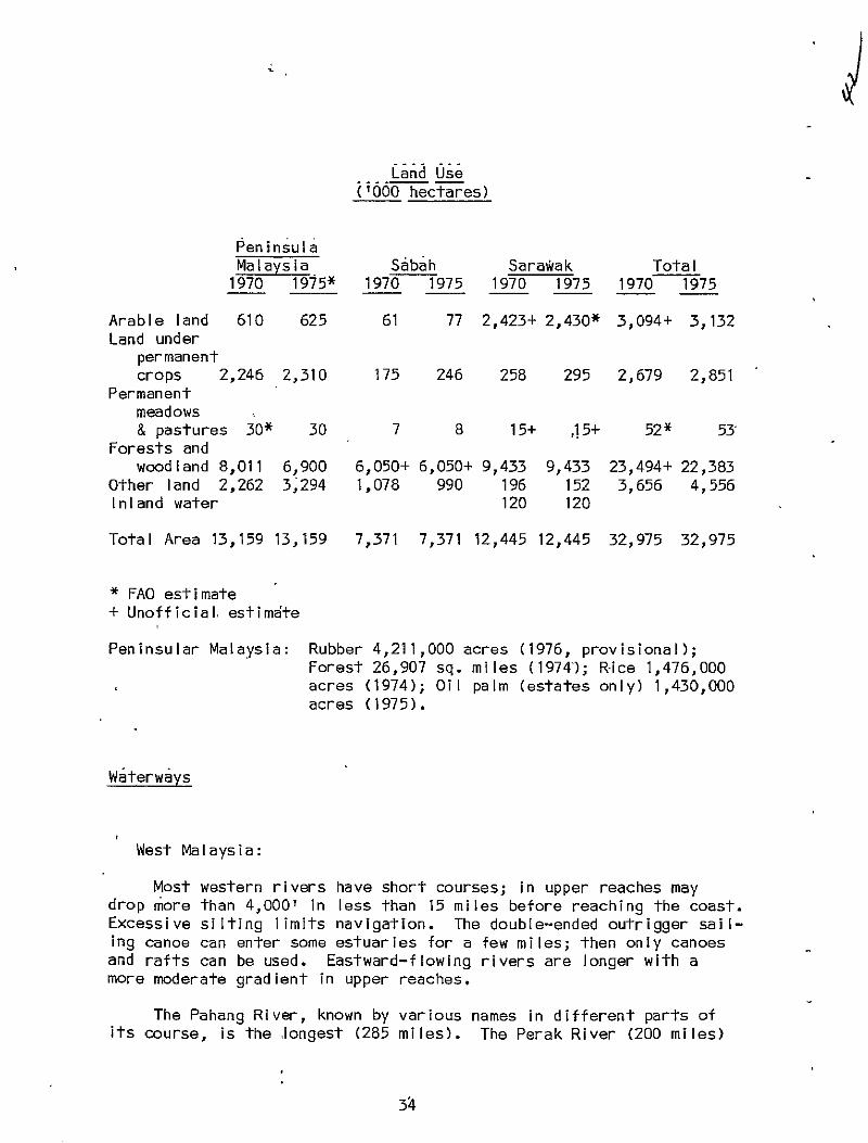
Land Ose ('000 hectares)
Peninsula Malaysia Sabah Sara~ak Total
1970 1975* 1970 1975 1970 1975 1970 1975
Arable land 610 625 61 77 2,423+ 2,430* 3,094+ 3,132 Land under
permanent crops 2,246 2,310 175 246 258 295 2,679 2,851
Permanent meadows & pastures 30* 30 7 8 15+ ,15+ 52* 53
Forests and woodland 8,011
Other land 2,262 6,900 3,294
6,050+ 1,078
6,050+ 9,433 990 196
9,433 152
23,494+ 3,656
22,383 4,556
Inland water 120 120
Total Area 13,159 13,159 7,371 7,371 12,445 12,445 32,975 32,975
* FAO estimate + Unofficial, estimdte
Peninsular Malaysia: Rubber 4,211,000 acres (1976, provisional); Forest 26,907 sq. miles (19741; Rice 1,476,000 acres (1974); Oil palm (estates only) 1,430,000 acres (1975).
Waterways
West Malaysia:
Most western rivers have short courses; in upper reaches may drop more than 4,000' in less than 15 miles before reaching the coast. Excessive silting limits navigation. The double-ended outrigger sailing canoe can enter some estuaries for a few miles; then only canoes and rafts can be used. Eastward-flowing rivers are longer with a more moderate gradient in upper reaches.
The Pahang River, known by various names in different parts of its course, is the longest (285 miles). The Perak River (200 miles)
34
empties into the Straits of Malacca. Others: Eklantan, Terengganu, and Endu empty into the South China Sea; Muar and Muda flow into the Straits of Malacca.
Sarawak:
Numerous rivers rising in the interior are the only etfective avenues for travel inland. Jungle paths connect headwaters; a few trails pass over the watershed into Kalimantan. Rajang, the principal river; 350 miles long, navigable by small ocean vessels for 60 miles, and by shallow-draft boats for 150 miles from its mouth. Baram River, 250 miles long, drains north-central area and empties into the sea just north of Miri. Lupar is 142 miles long. Limbang, 122 miles, flows between the two enclaves of Brunel.
Sabah:
Western rivers, except the Padas, empty into the South China Sea and are short. All carry silt which, deposited on the coastal plain, forms good agricultural land. Other rivers drain into the Sulu or Celebes Sea. Padas drains a large section of interior lowland. ,
Kinabatangan, Sabah's most important river, 350 miles long, rises in southern Crocker Range, flows east-west through the middle of Sabah, and empties into Sandakan Bay. Launches can travel on it for about 120 miles from the coast.
Coastline
The coastli'ne of Peninsula Malaysia is2,068 km in length; that of East Malaysia is2,607 km. (For description see Land Forms).
35

West Malaysia:
The mountain chain that forms the backbone of the Malay Peninsula continues southward from Thailand 300 miles, is 30 to 40 miles wide, and divides Peninsula Malaysia into two unequal parts. The highest peak, Gunong Korbu is 7,160'; several others exceed 6,000'. The Bintang Range, a spur extending from the main range, divides the Perak River Valley from the Muda River basin. A secondary lower range, to the east, intersecting the states of Kelantan, Terengganu, and Pehang, has the peninsula's highest peak, Gungon Tahan (7,168').
Sarawak:
The mountainous interior, characterized by irregular masses of dissected highlands, ravines, gorges, and plateaus, consists of unconnected ranges with a mean elevation of 5,000' and occasional peaks of over 7,000'. Gungong Murud, the state's highest peak, crests at 7,950'. Intermittent mountain groups of about 2,500?, such as the Santubong Mountains, may extend to the sea.
Sabah:
Near the Kalimantan border, mountains exhibit the same pattern as Sarawak's. Ranges are highly dissected with some peaks over 7,0001, but they are closer to the sea and less complex. The Crocker Range, only 1 to 20 miles from the South China Sea, is the only continuous range inMalaysian Borneo. A southward extension of the range that created the Philippine Islands, it has the highest peak in SE Asia, Gunong Kinabalu (13,455'). A series of parallel lower ranges, separated by wide valleys extend from the elevated interior to the Sulu Sea where there are long deep bays between the peninsulas formed by the ranges on the east coast. Kudat and Benoka enclose Manurda Bay in the north; Sandakan, Dent, and Simporna define Labuk, Sandakan, Darvel, and Cowie Bays in the east.
(InFeet)
Johore Mount Ophir 4,187 Gunong Besar 3,398
36
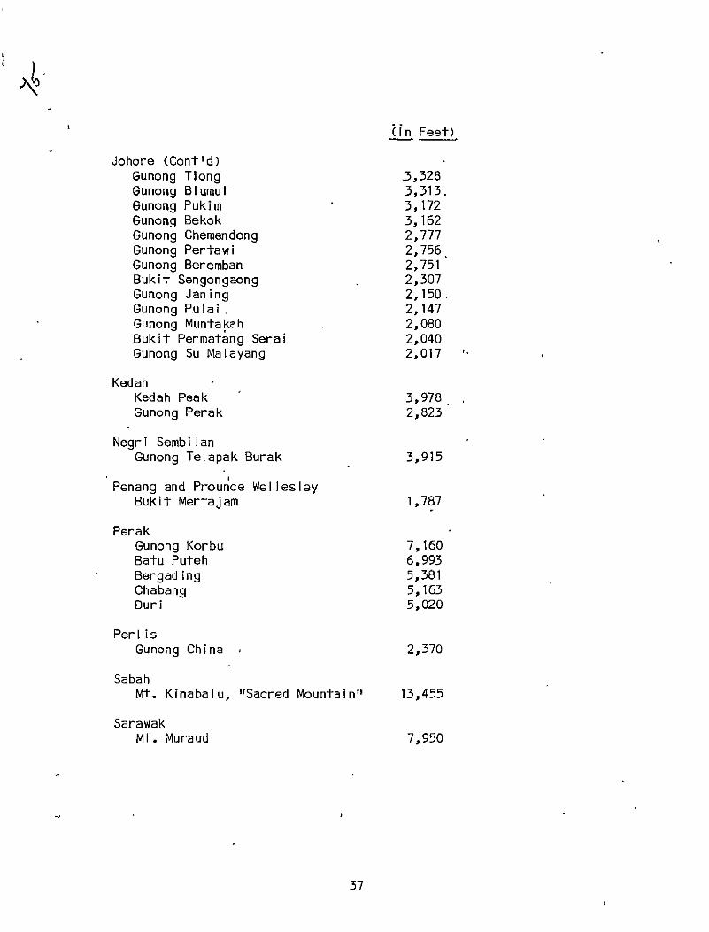
Un Feet)
Johore (Cont'd) Gunong Tiong 3,328 Gunong Blumut 3,313, Gunong Pukim 3,172 Gunong Bekok 3,162 Gunong Chemendong 2,777 Gunong Pertawi 2,756 Gunong Beremban 2,751 Bukit Sengongaong 2,307 Gunong Janing 2,150. Gunong Pulai 2,147 Gunong Muntakah 2,080 Bukit Permatang Seral 2,040 Gunong Su Malayang 2,017
Kedah Kedah Peak 3,978 Gunong Perak 2,823
Negri Sembilan Gunong Telapak Burak 3,915
Penang and Prounce Wellesley Bukit Mertajam 1,787
Perak Gunong Korbu 7,160 Batu Puteh 6,993 Bergading 5,381 Chabang 5,163 Duri 5,020
Perlis Gunong China 2,370
Sabah Mt. Kinabalu, "Sacred Mountain" 13,455
Sarawak Mt. Muraud 7,950
37

( n Fet)
Selangor Bukit Tunggul 5,457 Nuang 4,908 Pine Tree Hill 4,780 Bunga Buah 4,687 UIu Bakau 4,421 Bukit Repan 4,401
38

I.
Road Network
The main road system in Peninsula Malaysia is generally well constructed and maintained. Most roads run north-south and are west of the central mountain range; feeder roads connect rural points and industrial sites with railway stations. Roads inSabah and Sarawak concentrated around administrative and commercial. centers on the coast with generally poor access to the interior. There are no overland road connections between Sabah and Sarawak or with Brunei and Kalimantan (Indonesia). Major improvement projects as well as expansion of the road network, mainly in less developed states, are planned for the TMP.
1 1.
West Malaysia:
12,000 miles of road with 86% paved. Maintenance carried out by state PWD's with use of federal funds and equipment; generally adequate but costly. Pavement on many-roads is in poor condition because they were not built for present traffic volumes. Major projects under TMP include expected completion of the East-West Highway and Kuantan/Segamat road, and the construction of a new highway linking Jerangau,-Jabor, and Kuantan port. The new Kuala Lumpur/ Seremban expressway was nearly completed under the SMP. Development of feeder roads will continue under the TMP.
Sarawak:
2,100 miles of roads in 1974, the majority graveled or earth. Road projects under the SMP included the 30 mile Ulu Batang Mukah/ Senagal Arip road nearly completed, the Miri/Bintulu trunk road, the Matang/Istana road, and the Bintulu/Tanjung Kidurong road.
Sabah:
Sabah has 2,350 miles of road, 28% of which are paved. There are no federal roads; classification includes trunk, district, and local. Many roads built for logging did not connect towns; transportation between development centers was generally by sea. Long stretches of road become impassable during the rainy season. Most of the vehicle flbet (1 car/20 inhabitants) is in and around the three
39
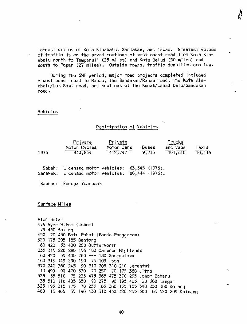
largest cities of Kota Kinabalu, Sandakan, and Tawau. Greatest volume of traffic is on the paved sections of west coast road from Kota Kinabalu north to Tamparull (25 miles) and Kota Belud (50 miles) and south to Papar (27 miles). Outside towns, traffic densities are low.
During the SMP period, major road projects completed included a west coast road to Ranau, the Sandakan/Ranau road, the Kota Kinabalu/Lok Kawi road, and sections of the Kunak/Lahad Datu/Sandakan road.
Vehicles
Registration of Vehicles
Private Private Trucks Motor Cycles Motor Cars Buses and Vans Taxis
1976 830,834 412,747 9,735 101,610 10,116
Sabah: Sarawak:
Source:
Licensed motor vehicles: Licensed motor vehicles:
Europa Yearbook
63,345 (1976). 80,444 (1976).
Surface Miles
Alor Setar 475 Ayer Hitam (Johor) 75 450 Bal ing
450 20 430 Batu Pahat (Banda Penggaram) 320 175 295 185 Bentong 60 420 55 400 260 Butterworth
235 315 220 290 155 180 Cameron Highlands 60 420 55 400 260 --- 180 Georgetown
160 315 145 290 150 75 105 Ipoh 370 240 360 245 90 310 205 310 210 Jeran tut 10 490 90 470 330 70 250 70 175 380 Jitra
525 55 510 75 235 475 365 475 370 295 Johor Baharu 35 510 110 485 350 90 275 90 195 405 20 560 Kangar
325 195 315 175 70 255 165 260 155 155 3 40 250 360 Kelang480 15 465 35 190 430 310 430 320 255 5 00 65 520 205 Keluang
40
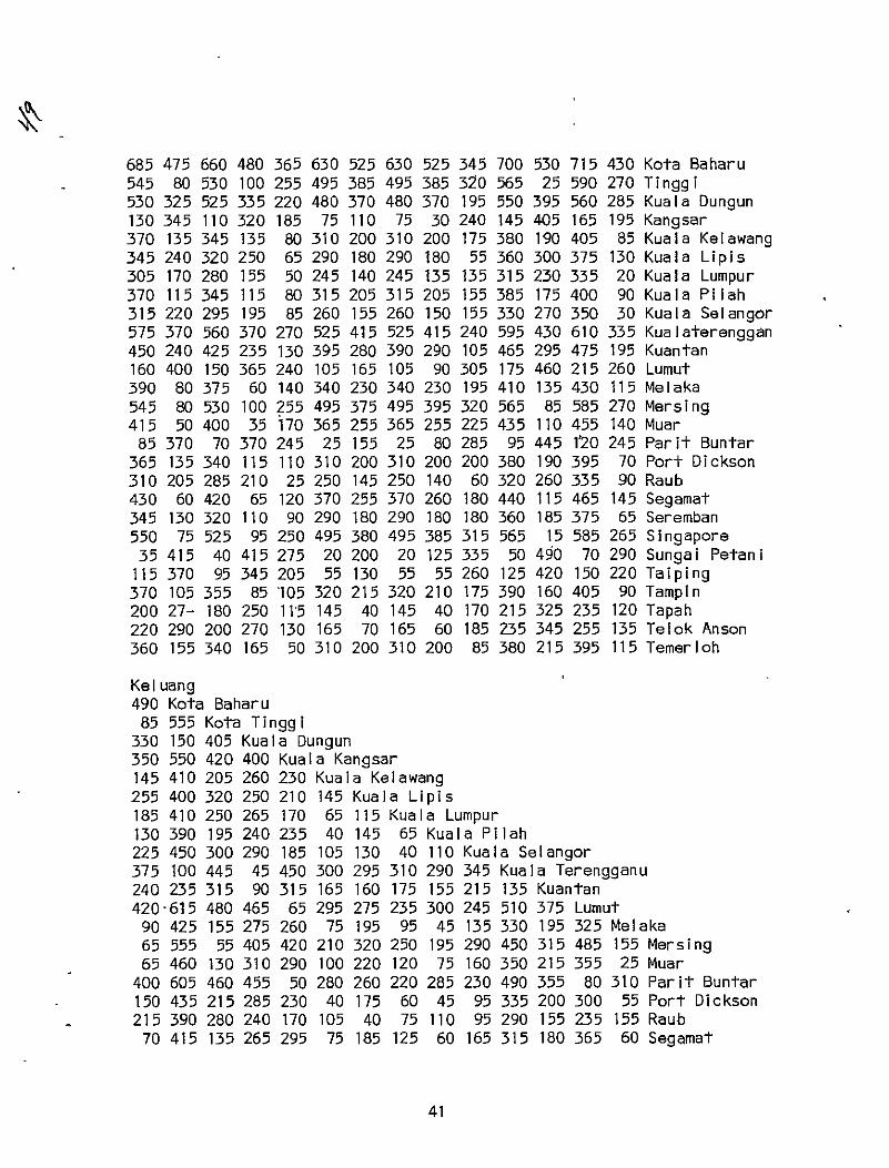
685 475 660 480 365 630 525 630 525 345 700 530 715 430 Kota Baharu 545 80 530 100 255 495 385 495 385 320 565 25 590 270 Tinggi 530 325 525 335 220 480 370 480 370 195 550 395 560 285 Kuala Dungun 130 345 110 320 185 75 110 75 30 240 145 405 165 195 Kangsar 370 135 345 135 80 310 200 310 200 175 380 190 405 85 Kuala Kelawang 345 240 320 250 65 290 180 290 180 55 360 300 375 130 Kuala Lipis 305 170 280 155 50 245 140 245 135 135 315 230 335 20 Kuala Lumpur 370 115 345 115 80 315 205 315 205 155 385 175 400 90 Kuala Pilah 315 220 295 195 85 260 155 260 150 155 330 270 350 30 Kuala Selangor 575 370 560 370 270 525 415 525 415 240 595 430 610 335 Kualaterenggan 450 240 425 235 130 395 280 390 290 105 465 295 475 195 Kuantan 160 400 150 365 240 105 165 105 90 305 175 460 215 260 Lumut 390 80 375 60 140 340 230 340 230 195 410 135 430 115 Melaka 545 80 530 100 255 495 375 495 395 320 565 85 585 270 Mersing 415 50 400 35 170 365 255 365 255 225 435 110 455 140 Muar
85 370 70 370 245 25 155 25 80 285 95 445 1'20 245 Parit Buntar 365 135 340 115 110 310 200 310 200 200 380 190 395 70 Port Dickson 310 205 285 210 25 250 145 250 140 60 320 260 335 90 Raub 430 60 420 65 120 370 255 370 260 180 440 115 465 145 Segamat 345 130 320 110 90 290 180 290 180 180 360 185 375 65 Seremban 550 75 525 95 250 495 380 495 385 315 565 15 585 265 Singapore 35 415 40 415 275 20 200 20 125 335 50 490 70 290 Sungai Petani
115 370 95 345 205 55 130 55 55 260 125 420 150 220 Taiping 370 105 355 85 '105 320 215 320 210 175 390 160 405 90 Tampin 200 27- 180 250 115 145 40 145 40 170 215 325 235 120 Tapah 220 290 200 270 130 165 70 165 60 185 235 345 255 135 Telok Anson 360 155 340 165 50 310 200 310 200 85 380 215 395 115 Temerloh
Kel uang 490 Kota Baharu 85 555 Kota Tinggi
330 150 405 Kuala Dungun 350 550 420 400 Kuala Kangsar 145 410 205 260 230 Kuala Kelawang 255 400 320 250 210 145 Kuala Lipis 185 410 250 265 170 65 115 Kuala Lumpur 130 390 195 240 235 40 145 65 Kuala Pilah 225 450 300 290 185 105 130 40 110 Kuala Selangor 375 100 445 45 450 300 295 310 290 345 Kuala Terengganu 240 235 315 90 315 165 160 175 155 215 135 Kuantan 420 615 480 465 65 295 275 235 300 245 510 375 Lumut 90 425 155 275 260 75 195 95 45 135 330 195 325 Melaka 65 555 55 405 420 210 320 250 195 290 450 315 485 155 Mersing 65 460 130 310 290 100 220 120 75 160 350 215 355 25 Muar
400 605 460 455 50 280 260 220 285 230 490 355 80 310 Parit Buntar 150 435 215 285 230 40 175 60 45 95 335 200 300 55 Port Dickson 215 390 280 240 170 105 40 75 110 95 290 155 235 155 Raub 70 415 135 265 295 75 185 125 60 165 315 180 365 60 Segamat
41

145 415 210 265 210 20 155 40 25 85 315 180 275 50 Seremban 80 550 45 400 415 210 315 245 190 295 445 310 485 1,55 Singapore
455 650 510 500 95 330 300 260 330 275 535 400 125 355 Sungai Petani 380 575 445 425 25 255 235 190 260 205 465 330 55,285 Taiping 115 410 180 260 240 55 170 75 125 115 305 170 305 25 Tampin 285 480 350 330 70 160 145 100 165 115 375 240 135 195 Tapah 305 495 365 345 90 185 160 120 185 130 395 260 155,210 Telok Anson 170 320 235 170 230 90 110 95 70 130 215 80 295 110 Temerloh
Melaka 155 Mersing 25 130 Muar (Bandar Maharani)
310 455 335 Parit Buntar 55 215 85 280 Port Dickson
155 280 180 220 140 Raub 60 135 50 350 100 145 Segamat 50 210 80 260 20 120 85 Sere mban
155 100 125 465 210 280 130 205 Singapore 355 510 380 45 325 265 395 305 510 Sungai Petani 285 440 310 30 255 195 325 235 435 75 Taiping 25 180 50 290 50 130 50 30 180 335 265 Tampin
195 350 220 120 160 100 230 145 345 165 95 170 Tapah 210 370 240 140 180 125 245 160 360 185 115 190 30 Telok Anson 110 235 140 280 115 75 100 95 230 325 255 90 165 180 Temerloh
Railroads
. West Malaysia - Malaysian Railway Administration, P.O.B. No. 1, Kuala Lumpur.
A west coast line of 489 miles, an interior line of 327 miles, and branch lines to ports and urban areas made up the 1,300 mile, single meter-guage, railroad network of Peninsula Malaysia in mid1970's. Both main lines connect with the Thailand State Railroad at the northern border and merge in the south in a joint line to Singapore.
The main line follows the west coast and extends from Singapore in the south to Butterworth (opposite Penang Island) to the north.
From Bukit Mertajam, near Butterworth, the line branches off to the Thai border at Padang Besar where connection is made with the State Railway of Thailand.
42 I
The interior line (East Coast line) runs from Gemas to Tumpat (near Kota Bahru). A 21 km branch line from Pasir Mas, 27 km south of Tumpat, connects with the State Railway of Thailand at the border station of Sungei Golok.
Branch lines serve railway - operated ports at Port Dickson, Teluk Anson, Port Klang, and Singapore.
Diesel rail car services are operated between Butterworth and Kuala Lumpur. In addition to normal express services between Kuala Lumpur and Singapore, there is a rapid diesel rail car service.
Sabah:
The 96 mile railway runs from Kota Kinabalu southwards through Papar and Beaufort, and then inland to Tenom in the Pegalan Valley. Railroad service will continue until there is a direct road between west coast and the inland rail station at Tenom. The line isof meter gauge; diesel trains are used.
The rail Isystem is state owned, wellI administered and maintained. Sabah State Railways: Kota Kinabalu.
Ports
.Much of Malaysia's exports travel through Singapore's harbor; however, Port Kiang (Kelang) handled 55% of the 29,773,000 registered tons of cargo shipped into the Malaysian peninsula in 1977. Penang, Port Dickson, Malacca are among other important port facilities in West Malaysia..
Rivers, culminating at coastal ports, remain important travel arteries in Sabah and Sarawak. Kuching and Sibu are busy ports in Sarawak. As road network expands inSabah, it is expected that port activities, now distributed among several small ports, will be concentrated in Kota Kinabalu, Sandakan, and Tawau - major ports which now handle 90% of cargo, excluding logs.
Over half of the allocation for ports under the TMP will go for expanding the existing port at Penang and for completing the new port at Kuantan - both on Peninsula Malaysia.
43

Smaller ports are listed below. Major ports - Binatang, Johore Bahru, Kota Kinabalu, Kuching, Malacca, Miri, Penang, Port Dickson, Port Kelang, Sandakan, Tawau - are listed inmore detail.
West Malaysia
Dungun - Lat. 40 46' N; long. 1030 25' E. At mouth of Dungun River. Airports: Kuatan, 144 km S and Trengganu, 50 km N.
Prai - Lat. 5' 25' N; long. 100* 21' E. Open"roadstead 0.8 km offshore.
Telok Ramunia - Lat. 10 201 N; long. 1040 16' E. In the State of -Johore.
'1
Sabah
Bakapit - Lat. 040 57? N; long. 1180 35' E. InDarvel Bay on east coast.
Kudat - Lat. 6 53' N; long. 1160 51 ' E. Airport 5.6 km.
Kunak - Lat. 40 41r N; long. 118 15' E. Eastern Sabah. Private airstrip 12.8 km from wharf.
Labuan - Lat. 50 17' N; long. 115' 15' E. Victoria Harbor on SE side of Labuan Island. International airport 3.2 km.
Lahad Datu - Lat. 50 02' N; 118 20' E. North of Sakah Island. Government-owned airport 0.8 km from town.
Semporna - Lat. 40 29' N; long. 1180 37' E. Mainly a fishing port. Airport about 3.2 km from port.
44

Sarawak
Bintulu - Lat. 30 03' N; long. 113* 08' E. Situated on north bank of Kemena River; about 1.2 km fron the entrance.
Lawas - Lat. 40 05' N; long. 115' 25' E. Town lies 17.6 km from entrance to Limbang River.
Limbang - Lat. 40 05' N; long. 115' 00' E. Situated 12.8 km above Limbang River.
Lingga - Lat. 1' 2Q10 N; long. 1110 10' E. Village lies about 25.6 km from entrance of the Batang Lupar, at the entrance to Sungei Lingga.
Sarikel - Lat. 20 08' N; long. 1110 31' E. Riverside port on Batang Rejang, 43 km from the sea. Sibu Airport 56 km by river,, 104 km by road.
Sejingkat - Lat. 10 35' 10" N; long. 1100 26' E. Kuching Airport 11.2 km.
Sibu - Lat. 2' 24' N; long. 1110 56' E. Sibu is a major town and a busy port. Airport 4.8 km.'
Tanjong Mini - Lat. 20 9' N; long. 1110 21' E. Deep water anchor 25.6 km from river entrance; mainly used by vessels load ing timber.
Binatang, Sarawak
Lat. 2* 10' N; long. 111* 38' E. Binatang lies 17.6 km above Sarikei on the true left bank of the river.
Accommodation: Paloh River Entrance: depth on the axis of the the channel is 3.5 m.
Both buoys are fitted with radar reflectors and the Fairway Buoy visible for a distance of 18.3 km. Care should be taken in navigating the channel against being set to the Northward by* the ebbtide as there is a 2.13 m patch in posi
45

*
Pilotage:
Working Hours:
tion 2' 29.2 ' N; 1110 10.5' E. Entrance to the Kuala marked by a light beacon at Tanjong Sedi on the N bank of the river. Strong cross currents and swell especially during the NE monsoon period (November to March), necessitate caution when entering. Maximum limits for vessels proceeding to Sibu via the Paloh Channel are 152.4 m overall length and 6.10 m draft. During the NE monsoon period,,draft is limited to 5.49 m due to the swell. An Inner bar with least depth of 4.27 m exists where the Paloh joins the Seredeng at Tanjong Gelang. Crossing marked by unlit transits and being sheltered, no allowance is necessary for swell. This route to Sibu almost exclusively usdd by overseas vessels; use of pilots recommended as they have knowledge of other ship movements in the river.
Leba'an Corner, 24 km below Sibu, is the junction of the two routes used by sea-going vessels bound for Sibu. A certain amount of shoaling has taken place here at the approach from the Rejang Channel and it has been found necessary to restrict the length of vessels using this route (Rejang) to 60.95 m with a draft of 3.96 m. An obstruction off Tanjong Ensurai, approx. 10 km up river from Laba'an Bend with least depth over itof 4.57 m. Caution should be exercised when rounding Tanjong Bindje due to three shoals across the river, one of which -has a least depth over it of 3.35 m.
Port is accessible to ships up to 2,000 tons d.w.
There is a single wharf about 152.4 m in length; one warehouse and loading/unloading facilities. Depth of water, 5.49 m. Fresh water is available.
available from Sarikel.
07:30 - 11:30 hrs and 13:00 - 17:00 hrs.
46

Johore Bahru, West Malaysia
Lat. 10 27' 24" N; long. 103 45' 42" E. Inthe state of Johore.
Accommodation: Small vessels to 30.48 m and draft 1.83 incan berth at the Tg. Petrie wharf, E Johore Strait. At W johore Strait ships of 1.8 m draft can berth at the Harbor Master's Jetty. Water and provisions available. Private wharf a 213.3 m berth-with 8.23 m alongside.
Development: A general cargo wharf for two ocean-going vessels and one coaster is being built.
Towage: Tugs available.
Pi lotage: Can be arranged with Harbor Master.
Airport: Approx. 32 km away.
Local Holidays: .Thursday (half-day) and Friday (full day).
Kota Kinabalu, Sabah
Lat. 50 59' N;, long. 116' E. Capital, town, W coast of Sabah.
Accommodation: Good anchorage in 16.4 m, 460 m to the NW of Grieve Reef. Wharf at terminus of 185 km railway, serving rubber estates, is of reinforced concrete over timber piles, 197.1 m long, 12.19 m wide. Least depth on outer or western berth, 7.62 m. Length of inner berth, 144.8 m. Least depth, 5.79 m. Two godowns of 3,162 sq m, and one of 2,790 sq m; one temporary shed of 592 sq m; 5,115 sq m of open storage.
Transit port for greater part of the West Coast trade and the interior. Weekly steamer passenger/palletised cargo service from Port Klang and Singapore to Sabah ports. Regular services from Japan, Hong Kong and Thailand. Rail connections
47
In ~1
to Beaufort and Malalap. Average H.W. and L.W. are 1.52 m and 0.61 m respectively above datum of soundships. Harbor is somewhat exposed to the northward. Unloading in the anchorage is sometimes interrupted by northerly gales.
Water is laid on to wharf, but 24 hours' notice required.
Development: A wharf near to the existing wharf is under construction, with four 167.6 m berths and 9.14 m draft alongside, and a 6,680 sq m transit shed. It will handle general cargo and containers.
Pi lotage: Not compulsory, but available 'on request.
Airport: 8 km from port.
Kuching, Sarawak
Lat. 1' 35' N; long. 1100 21' E. Kuching, the capital of Sarawak, is on the Sarawak River, about 35 km from its mouth.
Accommodation: The outer bar about 2.4 km to the eastward of Tanjong Po shas a least depth of 4.88 m at datum, while the inner bar at the approaches to Muara Tebas has a least depth of 4.57 m. During the NE monsoon period a heavy swell can be encountered, so an allowance of 1.83 m is recommended when crossing the outer bar. Two anchorages: (1) Tanjung Po 450 one mile from Tanjong Po line; area of safe anchorage has 0.4 km radius; depth of 11 m; (2) Sejingkar, for vessels up to 167.6 m in length with maximum draft of 7.62 m.
Berths: Pending Point, length 243.8 m, least depth 7.62 m. Covered storage 7,440 sq m. Open storage 9,300 sq m capable of handling pal letised and containerised cargos. Tanah Puteh Wharf, length 243.8 m, least depth alongside 5.18 m. The limit for vessels proceeding beyond Pending Point to Kuching Port at Tanah Puteh is 132.6 m overall length with a maximum draft of 5.18 m. Vessels
48
Towage:
Pi lotage:
Airport:
Local Holidays:
Working Hours:
Miri Roads, Sarawak
Lat. 4' 23' N;
Accommodation:
of this draft may safely anchor off Pending Point. Coastal vessels are accommodated at the upriver wharves situated in Kuching itself. Provisions available and'fresh water at Pending Point and Tanah Puteh wharves only.
As per agreement. Lighterage, scarce.
Compulsory. Pilot available by arranging through agent or calling "Shipping Kuching" 24 hours before arrival of vessel.
Kuching Airport, 10.4 km from port. Daily air service to and from Kuala Lumpur, Singapore and Kota Kinabalu.
Chinese New Year, Labor Day, Dayak Festival Day, Han Raya Puasa, Christmas -Day.
08:00 to 12:00, 13:00 to 17:00 hours. Overtime can be arranged 19:00 to 23:00, 23:00 to 06:00 hours.
long. 1130 58' E.
Miri town, which lies on both sides of the river, is accessible only to coastal vessels of shallow draft. The Miri bar is extremely shallow and dangerous with a narrow channel that usually changes at the turn of each monsoon season and also at odd times in between. Two sets of mobile leading lights indicate the channel. Least depth on the bar is about 0.3 m with an average rise of 1.2 to 1.5 m. Wharves: Coastal Wharf, length 62417 m, depth 2.13 m; Customs Wharf, length 44.50 m, depth 1.22 m.
Anchorage, open roadstead. Vessels discharging or loading general cargo anchor to NW of entrance to river, 3.2 km offshore. Lighters of 45 to 180 tons capacity, and towing launches available. Swell often restricts work to landward side only
49
~~1
during NE monsoon. Water not available, limited provisions available.
Pi lotage: Compulsory for vessels using single point buoys and taking bunker at sealine.
mooring
Airport: At Mir! Airport, 6.4 km from town center. flights to Kuching and Brunei.
Dai ly
Penang, West Malaysia
Lat. 50 25' 16" N; long. 1000 201 48" E.
Accommodation: Depth at entrance N channel 8.2 m L.W.S.T. Approaches to harbor N channel, 7.92 m; S channel, 6.70 m L.W.S.T.; anchorage ranges from 11 to 22 m. Swettenham Pier, situated on Penang Island, is a wharf 365.7 m long with 9.75 m L.W.O.S.T. alongside. Five deep water berths at Butterworth (opposite Penang Island on the mainland of Malaysia; each is capable of accommodating ocean vessels up to 182.9 long with a minimum of 9.75 m L.W.O.S.T. at each berth. Coastal and lighter wharf at Prai (mainland), 792.4 m long, depth 3 m to 4.57 m. Port Commission has 40 steel and aluminum lighters, three tank lighters, two flat tops, one wooden lighter, two water boats and three launches. Also 380 private native lighters with Port conveyance permits.
Wharves have rail and road links. The PPC ferries operate a 24 hour service conveying passengers and vehicles from Penang to Butterworth.
Development: Butterworth has a sixth berth under construction and 16 acres for a marshalling yard and a container freight station.
Towage: Five tugs available.
Pl1otage: Compulsory for vessels over 6,000 g.r.t.
Airport: Bayan Lepas on Penang Island, 19.2 km.
50

Local Holdidays: Birthday of the Prophet Mohammed, National Day, Hari Raya Puasa, Harl Raya Haji. The port commission and native lighters will not be working on these days.
Working Hours: 1st shift 07:30 15:30 hours; 2nd shift 15:30 -.23:30 hours; 3rd shift 23:30 07:30 hours. Saturday and Sunday are ordinary working days.
Port Dickson, West Malaysia
Lat. 20 31! N; long. 1010 47' E. On west coast.
Approaches: Deep water channel from NW marked by four light buoys, presents no d'ifficulties and is in accordance with Admiralty Chart No. 1140.
Anchorage: Good anchorage in27.5 to 36.6 m, west and SW of Tanjong Kamuning.
Accommodation: Shell Jetty: 213.4 m, reinforced concrete jetty with "T" head, 51.81 m by 10.97 m, with four dolphins. Distance between inner dolphins, 182.9 m; between outer dolphins, 304.8 m. Depth in approaches and alongside is7.92 m. Sand and mud at bottom. Max. size of vessel: 152.4 m long, unrestricted with draft 6.40 m (about 18,000 d.w.t.). 0.91 m keel clearance required. Vessels normally berthed/unberthed in daylight hours and vessels up to 121.9 m can be handled at any state tide. Vessels of over 121.9 m, requiring to swing, handled on flood tide only.
Esso Jetty: Reinforced island jetty, 67.05 m by 7.31 m. Distance between inner buoys, 106.7 m; between buoys, 190.2 m. Depth inapproach is 12.19 m, alongside, 10.67 m. Rocky bottom-and 0.61 m keel clearance is required. Max. size of vessel 109.7 m length o.a., unrestricted beam, draft 10.36 m; 19,500 d.w.t. vessels can be berthed at any state of tide - day and night.
Esso/Shell Single Mooring Buoy: 10.67 m mooring buoy in least depth of 27.43 m, bottom, sand,
51
mud, and rock. Min. depth inapproaches, 17.37 m. Max. size of vessel: 274.3 m length o.a. unrestricted beam, draft 14.32 m, 90,000 d.w.t. and keel clearance of 1.83 m required. -Berthing in daylight only and up to and 45;000 d.w.t. inany state of tide, above this on ebbtide onl-y. Spill boom available. No facilities for oily ballast, electricity, steam, water or bunkers. No barges.
Railway Jetty: Stone pier 192.9 m long, 45.71 m width; "T" head has 7.92 m alongside. Berthing alongside not recommended due to its dilapidated condition. Fresh water at Shell Jetty. Provisions, vegetables and ice may be obtained.
Towage: Local tug boats - no lighterage.
Pi lotage: Not compulsory except for mooring/unmooring at Esso/Shell single mooring buoy.
Airport: Kuala Lumpur, 112 km, Malacca, 96 km.
Port Kelang, West Malaysia (formerly Port Swettenham)
Lat. 3* 00t N; long. 1010 24' E.
Accommodation: Two entrances to the port: southern having 1'2.19 m depth at H.W., northern with sufficient water for the largest vessels aifloat. A bar in approach to southern entrance off Pintu Gedong in S Kelang Straits, has 6.70 m depth at L.W. The tidal harbor (1,000 acres) is 11.89 m deep at entrance, 13.41 m deep inside, H.W.
There are two main wharves:
(1)North section of the old wharf (Berth nos. 1 and 2) 792.4 m long with up to 6.10 m at L.W. mainly for coasters; (Berth nos. 3 and 3A) 313.9 m long with 9.14 m at L.W., South section (Berth nos. 4 and 5) 306.6 m long with 9.75 m at L.W. for tankers.

(2)The new wharf at North Kelang Straits has nine berths for ocean vessels with a total length of wharf, 972.2 mr9.14 m draft at L.W.S. Five transit sheds sited on the wharf, 12 other storage sheds with rail and road connections via, bridge. Five mooring buoys and 2 anchorage berths for ocean vessels in the stream. LV - 16,000 g.r.t. Four vessels not exceeding 76.19 m in length and 5.,49 m draft can berth along the N. shore.
A lighter fleet of 77. Water supplied from pipes alongside the new wharf and by barge up to 200. tons at the old wharf.
Development: Additional berth extensions of 2,133.6 m are under construction at North Ketang Straits. -Additional equipment to be purchased including two more container cranes, light straddle carriers and ten 100 - ton steel lighters.
Towage: Five deep-sea tugs (1, 000 h.p.) and three small tugs for lighterage work.
Pilolage: Complusory to and from wharves and roadstead.
Airport: 29 km from port.
Local Holidays: New Year's Day, Chinese New Year**, ProphetMohammed's birthday, Sultan of Selangar's birthday, Good Saturday, Labor Day, Wesack Day, Birthday of H.M.Y.D.P. Agong, National Day**, Hari Raya Puasa**, Deepavali**, Hari Awal Muharram*, Christmas*.
Raya Haji,
Subject to alteration Port holidays
Sandakan, Sabah
Lat. 5* 50' N; long. 1180 7' E.
53

V4
Accommodation:
Development:
Towage:
Pi lotage:
Airports:
Depth on bar, 7.62 m datum. Good holding ground and shelter for any number of ships at the anchorage. Average high water is.1.52 m and low water is 0.61 m above datum of soundings. Tidal streams turn at times of H.W. and L.W. by the shore, the ebb at 2 knots and the flood at 1.5 knots. Alongside wharf, stream frequently sets in reverse direction to harbor. Swell enters harbor only when N.E. monsoon blows strongly (Dec. to April), lighters are then sometimes unable to lie alongside ships, especially during ebb tide. For discharging, unless it is intended to go alongside wharf, vessels should anchor four cables due south of the wharf. Govt. wharf, 225.5 m long with mooring dolphins placed 30.48 m east and west of the wharf; depth alongside of 6.40 m datum. Priority for berthing alongside is afforded on a first come first served basis which applies to all Sabah ports. Several small piers and jetties, slipway and sawmills.
The port is the main transshipment port for east coast trade and center of the Sabah timber industry. Two godowns of 3,528 sq m; one transit godown of 879 sq m; 3,255 sq m of open storage. Regular weekly passenger/cargo steamer service to Singapore.
An inland wharf with four berths giving a total berthage of 576 m, least depth 9.75 m on south face, 7.62 m on east and west faces, is under construction on the western side of Pavitt Point near the present palm oil storage area, and will have a 8,370 sq m transit shed, workshops and other facilities, including provision for containers. Vessels permitted to use wharf on request.
One 337 b.h.p. harbor tug available for berthing/ unberthing.
Not compulsory.
Sandakan Airport, 12.8 km form town center; N.l.A.; Kota Kinabalu 72 km.
54
I
Tawau, Sabah
Lat. 4* 14' N; long. 1170 53? E.
Accommodation: - Good anchorage in 14.6 m with mud and hard sand bottom. Tides - M.H.W.S.T., 2.74 m, M.L.W.S.T., 0.30 m 'aboveChart Datum.- Vessels are prohibited .from anchoring within 610 m of the wharf. Sabah Ports Authority wharf, concrete over concrete plles, 198.1 m long and 12 m wide with'mooring dolphins extending 30.48 m from each end. Least depth 7.62 m along the face. Vessel-s drawing 6.40 m can usually berth. Steamer service for passengers and cargo to Sabath ports, Singapore and Malaysia. Water, provisions available.
Pilotage: Not compulsory.
Airport: Tawau Airport, 3.2 km from town center. flights to Kota Kinabalu.
Daily
Local Holidays: Jar Raya Haji, Hari Raya Puasa, Christmas Day.
Working Hours: Monday/Saturday, 07:00 to 11:30, hours.
13:00 to 20:30
Shipping
Peninsular Mal-aysia
Malaysian International Shipping Corporation Berhad (National Shipping Line of':Malaysia): 14th and 15th floors, Fitzpatrick's Bldg., Jalan Raja Chulan, P.O.B. 371, Kuala Lumpur; Europe Office: Parklaan 34, P.O.B. 23054, Rotterdam 3002, Netherlands; London Agent Lambert Bros. Ship Agencies Ltd., P.O.B. 431, 53 Eastcheap; F. 1968; fleet of 16 vessels; 3 palm oil carriers on order; regular sailings between Far East and Europe.
55
Sharikat Perkapalan Kris SDN. BHD. (The Kris Shipping Company of Malaysia): Straits Trading Bldg., Kuala Lumpur; fleet of 10 tankers and, cargo vesse Is; serv ices from Ma Iays ia to Thail and .
Sabah
Many lines use the ports; main lines listed below run regular services to and from the state. Local services are maintained by a fleet of coastal steamers and numerous small craft to all ports in Sabah, Brunei and Sarawak.
Austral ian West Pacific Line: From Japanese and Austral ian ports.
Ban Line: Monthly services to United Kingdom and Europe.
Blue Funnel Line: Monthly services to United Kingdom and Europe.
Lino Line: Monthly service between Japan and West Austral ia.
Indo-China Steam Navigation Co.: Frequent sailings from East coast ports to Japan and from Hong Kong.
Kinabalangan/Man Tung Shipping Co.: From Japan, Taiwan and Hong Kong to Sabah ports.
Netherlands Royal Dutch Mail: From United Kingdom and other European ports.
Nissho Line: Service between Sabah, Brunei and Japan.
Norwegian Asia Line: A fortnightly service to Sabah ports from Hong Kong, Japan and Shanghai; also a three-weekly service from Bang kok.
Pacific International Line: From Singapore and West Malaysian ports.
Royal Inter-Ocean Line: From Australian, Indonesian and Thai ports.
Royal Rotterdam Lloyd; From United Kingdom and other European ports.
56
Straits Steamship Co.: Weekly cargo, passenger and mail service from Singapore; Agents Harrisons and Crosfield (Sabah) Ltd., Prince Philip Drive, P.O.B. 22, Kota Kinabalu.
Sarawak
Ben Line: Sarawak Agents: C.T.C. Shipping Agencies SON. BBD., Sibu and Sarikel; direct sailings U.K./Tanjong Mani, Sarawak.
Blue Funnel and Glen Line: Sarawak Agent: The Borneo Co. (Malaysia), Sendirian Berhad, Kuching and Sibu, direct sailings from Rejang, Sarawak to U.K.
"K" Line: Sarawak, Agent: Guthrie Boustbad Shipping Agencies Ltd.; regualr cargo service: Western Australia/Tanjong Mani, Sarawak.
Norwegian Asia Line: Agents Harper Gilfillan (Borneo) SDN. BBD.; direct service Japan-Hong Kong-Sabah-Sarawak, carrying cargo.
Sarawak Steamship Co. BHD.: Kuching, Sarawak; operates weekly services to and from Singapore and Port Klang; local shipping company, shipping agents and travel agents.
Polish Ocean Lines: Sarawak Agent: Borneo United Sawmills SDN. BBD.; Sibu and Kuching; Australian Services: Sydney, Melbourne, Adelaide, and Brisbane.
Straits Steamship Co. Ltd.: Kuching, Sarawak; operates weekly services between Singapore and East Malaysian and Brunei ports, and between port Kiang/Singapore and East Malaysian ports.
Airports
Malaysia has five international airports at Kuala Lumpur, Kota Kinabalu, Penang, Johore Bahru, and Kuching. Airports for domestic services include Alor Star, lpoh, Kota Bahru in Peninsula Malaysia; Sibu and Miri in Sarawak; Sandakan, Tawau and Labuan -inSabah. Numerous smaller airstrips are located throughout Malaysia.
57

TMP allocations for Peninsula Malaysia's airports will go to Penang and Kuala Lumpur for upgrading to accommodate wide-bodied aircraft. Kuantan, Kuala Trengganu, and Kota Bahru on the east coast will be improved to receive medium range jets.
In Sabah, TMP funds will be concentrated on Kota Kinabalu, but some will go the development of new rural aerodromes in the interior. In addition, there are civil airports at Kudat, Lahad Datu, Keningau, Ranau, Telupid and Sepulot.
Expansion of Kuching Airport in Sarawak is in progress; runwaybeing extended to 8,000'. Miri will be improved to accommodate medium range jet aircraft under the TMP, and a new airport, 10 miles from Sibu, is planned instead of expanding that airport.
Air transport is vital in linking less developed Sabah and Sarawak with the rest of Malaysia, and neighboring countries. Daily Boeing 737 service between Kuala Lumpur and KotaKinabalu is provided by Malaysian Air System (MAS). MAS and foreign carriers operate direct routes between Sabah and Singapore, the Philippines, and Hong Kong. An MAS fleet of 7 Fokker F 27-500 and 4 Britten Norman Islander (BNI) is used for internal flights in Sabah and Sarawak. 5 airports in Sabah are served daily: Kota Kinabalu, Sandakan, Tawau, Lahad Datu and Labuan. Kota Kinabalu and Labuan accommodate international jet aircraft; the others receive the Fokkers.
NB: For up-to-date information consult latest issue of weekly International-Notams, International Flight Information Manual, and/or ICAO's Air Navigation Plan for appropriate region.
Runway Characteristics Eleva- Aircraft!
Location tion M/ Slope Aircraft/ Strength Fuel/ Coordinates Temp NR/Type % Length M CL (1,000 _) Octane
Johore Bahru/ Johor Bahru REG S
1038'20" N 37 16/34 0.125 1920 B LCN50h51 1030401151t E 27 INSTR
58

Remarks: Alternate Aerodromes: Kuala Lumpur Intl.
Aids: DME, VCR, PA (16-1), (34-1), VA (16+), (34+), LR, LTX, LO, MD, MC, MT. MFD, MTX, MO. Stopway 16 & 34-61.
Runway Characteristics Eleva- Aircraft/
Location tion MI Slope Aircraft/ Strength Fuel/ Coordinates Temp CT MR/Type $ Length M CL (1,000 kq) Octane
Kota Kinabalu/ Kota Kisnabalu REG S
505612711 N 3 02/02 0.11 2591 A LCN90h43 100,JA1 11602158 E 29
Remarks: Alternate Aerodromes: Brunei/Bandar Seri Begawan Intl., Kuching/Kuching, Manilla Intl.
Aids: L, VAO2, LR, LTX, MD, MC, MT, MTD, MTX, MO. L6 & 9. Jet traffic sunrise to sunset only. No telex.
Kuala Lumpur/ Intl. REG S
307749"? N 27 - 15/33 0.24 3475 A LCN100h51 100,JA1 101033I5" E 26.4 PA I
Remarks: Bangkok/Bangkok, Jakarta/Halim Perdanakusuma, Jakarta/ Kemayoran, Saigon/Tan-Son-Nhut, Singapore/Intl.
Aids: ILS (33-1), L, PA (33-1), SA (15, 33), LR, LTX, LO, MD, MC, MT, MTD, MS, MFD, MTX, MO. Stopway 15 & 33-61-. Clearway 15-1280; 33-366, L (6,7,9). No telex.
59

Location Coordinates
Eievation M/ Temp C NR/Type
Runway Characteristics
% Aircraft/ Length M CL
Aircraft/ Strength (1,000 kg)
Fuel/ Octane
Kuching/ Kuching REG S
1029'511 110020725
N E
26 29.3 07/25 0.21 1920 B LCN40h38- 100,JAI
Remarks: Alternate Aerodromes: Brunei/Bandar Seri Begawar Intl. Sibu/Sibu.
Aids: L, VA (25), LR, LTX, LO, MD, MC, MT, MTD, MTX, MO. Stopway 07 & 25-61. L 69. No telex.
Labuan/ Labuan REG S
50181211 115014152"1
N 30 E 29
14/32 N-INTSR
0.10 1945 B LCN45h67
Remarks: Alternate, Aerodromes: Brunel/Bandar Seri Begawan Intl .
Aids: L, MD, MC, (32-183).
MT, MTX, MO. Stopway (14 & 32-61). Clearway
Malacca/ Matacca REG S
2016' N 11 03/21 0.46 1372 C LCN42h30 102015t25" E 26.3 N-INSTR
Remarks: Alternate Aerodromes: Kuala Lumpur/I ntl.
Aids: L, MD, MC, MT, MTX, MO. Stopway (03 & 21-61).
60
---Runway Characteri stics Eleva 'Aircraft/
Location tion M/ Aircraft/ Strength Fuel/ Coordinates TempC NR/Type Si Length M CL (1,000 kg) Octane
Miri/ Miri REG S
4019'44" S 17 02/20 0.05 1372 LCN20h30 113059'4011 E 29
Remarks: Alternate Aerodromes: Brunei/Bandan Seri Begawar Intl.
Aids: MD, MC, MT, MTX, MO. Stopway 02 & 20-16.
Penang/ Penang REG S
5017'28" N 4 04/22 0.04 2134 B LCN55h91 100,JA1 100*16'13" E 26.7 N-INSTR
Remarks: Alternate Aerodromes: Kuala Lumpur/IntI., Songkla/Hat Yal Intl.
Aids: L, SA (04), VA (04), LR, LTX, LO, MD, MC, MT, MTD, MS, MFD, MTX, MO. Stopway 04 & 22-61. New runway L679. Three hour prior notice required for non-scheduled aircraft. No telex.
Sibu/ Sibu REG S
202012811 N 7 09/27 0.11 1372 C LCN15h2O 111050119" E 30 N-INSTR
Remarks: Alternate Aerodromes: Kuching/Kuching.
Aids: MD, MC, MD, MTX, MO. New aerodrome.
61

Location Coord nates
IEle-av-tion M/ Temp C
Runway Characteristics
Slope NR/Type E
Aircraft/ Length M
Aircraft/ Strength
CL (1,000 kg) Fuel/ Octane
Tawau/ Tawau REG-NS
401514211 N 117*531911 E
18 29
17/35 N-INSTR
0.38 1372 C LCN15h47
Remarks: No alternate return to point of departure.
Aids: MD, MC, MT, MTx, MO. Stopway (17 & 35-61).
. Key
INSTR -N-INSTR -
Instrument Approach Runway Non-Instrument Runway
Radio Aids
ILS - Instrument Landing System DME - Distance Measuring Equipment VOR - VHF Omni-Directional Range
Ligh+ing Aids
PA - Precision Approach Lighting System SA - Simple Approach Lighting System VA - Visual Approach Slope Indicator System AV - Abbreviated Approach Slope Indicator System R - Runway Edge, Threshold & Runway End Lighting C - Runway Center Line Lighting TD - Runway Touchdown Zone Lighting TX - Taxiway Lighting B - Aerodrome or Identification Beacon 0 - Obstruction Lighting
62
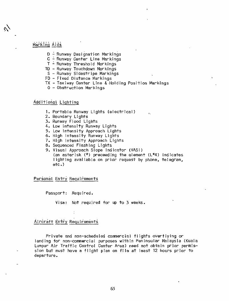
Marking Aids
D Runway Designation Markings C Runway Center Line Markings T - Runway Threshold Markings
TO - Runway Touchdown Markings S - Runway Sidestripe Markings
FD - Fixed Distance Markings TX - Taxiway Center Line & -HoldingPosition Markings
o - Obstruction Markings
Additio6al Lighting
1. Portable Runway Lights (electrical) 2. Boundary Lights 3. Runway Flood Lights 4. Low Intensity Runway Lights 5. Low Intensity Approach Lights 6. High Intensity Runway Lights 7. High Intensity Approach Lights 8. Sequenced Flashing Lights 9. Visual Approach Slope Indicator (VASI)
(an asterisk (*) preceeding the element (L*4) indicates lighting available on prior request by phone, telegram, etc.)
Personal Entry Requirements
Passport: Required.
Visa: Not required for up to 3 weeks.
Aircraft Entry Requirements
Private and non-scheduled commercial flights overflying or landing for non-commercial purposes within Peninsular Malaysia (Kuala Lumpur Air Traffic Control Center Area) need not obtain prior permission but must have a flight plan on file at least 12 hours prior to departure.
63

4
Private and non-scheduled commercial aircraft overflying East Malaysia-Sarawak (Kinabalu Flight Information Center Area) need not obtain prior permission but must have a flight plan on file at least 24 hours prior to departure.
Private and non-scheduled commercial aircraft landing for noncommercial purposes in East Malaysia must obtain prior permission from the Regional Director of Civil Aviation, Kota Kinabalu, Sabah, East Malaysia (Telegraphic Address: AIRCIVIL KOTA KINABALU/TELEX: None) at least 10 days prior to departure.
All non-scheduled commercial aircraft landing for commercial purposes in either Peninsular or East Malaysia must obtain prior permission at least two weeks prior to departure (one week it request is submitted via reply-paid telegram) from the Director General Of Civil Aviation, 20th Floor Wisma MPI, Jalan Raja Chulan, Kuala Lumpur 05-10 Peninsular Malaysia (Telegraphic Address: AIRCIVIL KUALA LUMPUR/TELEX: None). In add'ition, non-scheduled commercial aircraft landing for commercial purposes in East Malaysia must also submit a complete copy of the permission request to the Regional Director of Civil Aviation, Kota Kinabula, Sabah, East Malaysia.
All permission requests must include (a) nationality and registration marks of the 'aircraft, (b)type of aircraft, (c) number of crew and name of person in command , (d) name of registered owner of aircraft, (e) name of operator (if different from owner), (f) purpose of flight, (g) complete route of flight including points of landing and final destination, (h) proposed time table, (i) nature of cargo,including dimensions and weight, ( j)name of VIP on board and number in his party, if applicable, (k) for charter flights, rate charged for flight.
Airl ines
Domestic:
Malaysian Airline Systen (MAS) Bnd: UMBC Bldg., 4 Jalan Sulaiman, Kuala Lumpur; f. 1971 as the Malaysian successor to the Malaysia Singapore Airlines (MSA); operates a fleet of 3 Boeing 707, 9 Boeing 737, 10 F. 27, 1 DC-10 and 4 BN-2 to more than 50 international and domestic destinations. Its network consists of flights from Kuala Lumpur to Australia, Brunei, Hong Kong, India, Indonesia, Japan, Kuwait, Philippines, Singapore, Taiwan, Thailand, and the U.K.
64
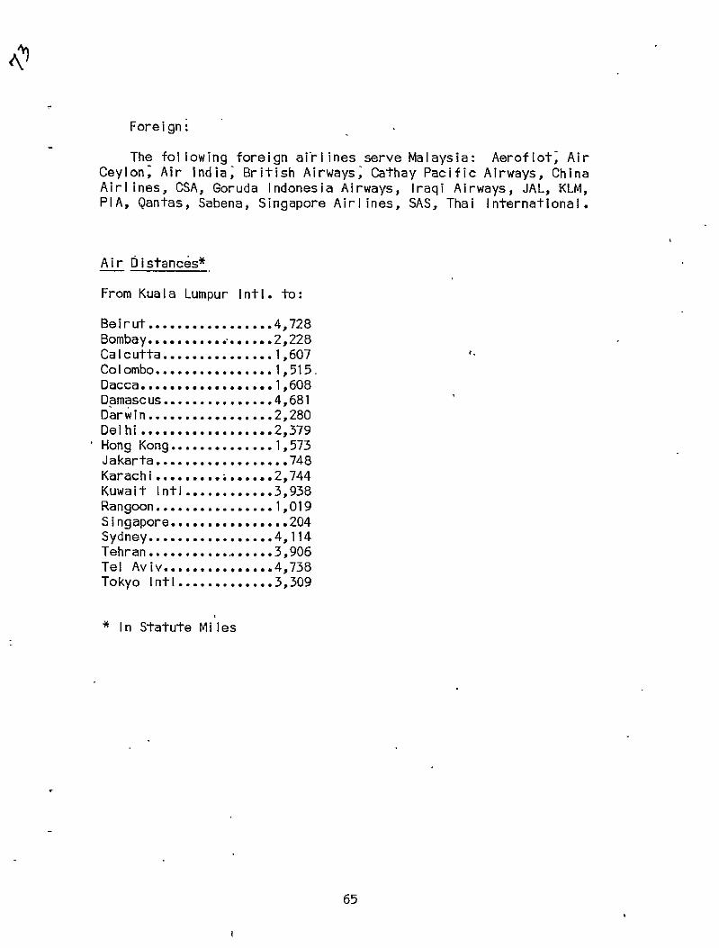
Foreign
The following foreign airlines serve Malaysia: Aeroflot, Air Ceylon; Air India, British Airways, Cathay Pacific Airways, China Airlines, CSA, Goruda Indonesia Airways, Iraqi Airways, JAL, KLM, PIA, Qantas, Sabena, Singapore Airlines, SAS, Thai International.
Air Distances*
From Kuala Lumpur Intl. to:
Beirut.................4,728 Bombay.................2,228 Calcutta...............1,607 Colombo................1,515. Dacca.................. 1,608 Damascus...............4,681 Darwin...............2,280 Delhi . ........................ 2,379 Hong Kong..............1,573 Jakarta..................748 Karachi..............2,744 Kuwait Intl............3,938 Rangoon................1,019 Singapore................204 Sydney.................4,114 Tehran...............3,906 Tel Aviv...............4,738 Tokyo Intl.............3,309
* In Statute Miles
65

Electric Power
The demand for electric power has been growing by about 14% per year since mid 1960's. Industry and mining have been largest consumers, followed by commercial and residential consumers.
Principal power suppliers are autonomous government-owned entities of which the National Electricity Board (NEB), serving Peninsula Malaysia, except for that part which is served by the Perak River Hydroelectric Company (PRHEA), accounts for about 72% of total capacity. The states of East Malaysia are served by the Sabah Electricity Board (SEB) and the Sarawak Electricity Supply Corporation (SESCO).
Total capacity installed by various power plants in 1975 was 1,194 megawatts. Installed capacity is 1,602 MW of which 18% (292 MW) is hydro, 67% (1,064 MW) is steam, and 15% (245 MW) is diesel. Private corportations and some smal I companies have an aggregate capacity of 200 MW. Hydroelectric considered best potential energy source.
Rural electrification program, begun in 1950's, accelerated under SMP. Some 2,700 villages had been electrified by the end of FY 75 and 227,000 rural consumers served. Access to electricity in Peninsula Malaysia is estimated to be 52%; averageper capita consumption in FY 75 was 475 KW.
The NEB's interconnected system covered most of western Peninsula Malaysia in 1976 and links to east coast (to Kuantan, Kota Baharu, and Kuala Terengganu) were expected to be completed by 1980, interconnecting the entire peninsula.
An Eighth Power Project financed by a World Bank loan (May 1977) was for (a) the construction, supply, and installation of a new oilfired thermal power station of 2 X 120 MW located at Pasir Gudang, on the Johore Strait; and (b) supply and installation of transmission facilities.
.NEB's present expansion program includes: (a) construction of the Temengar Hydroelectric Power Plant (4 X 87 MW) expected to be completed 1978-79; (b) installation of 3 additi'onal units at Prai Thermal Power Station (3 X 120 MW) to be in service during 1979 80 under Seventh Power Project (World Bank) and '(c) construction of the Pasir Gudang Thermal Power Station (2 X 120 MW) to be completedin 1981 under proposed Eighth Power Project (World Bank).
Electricity Supply: 230 volts AC, 3 phase, 50 cycles.
66
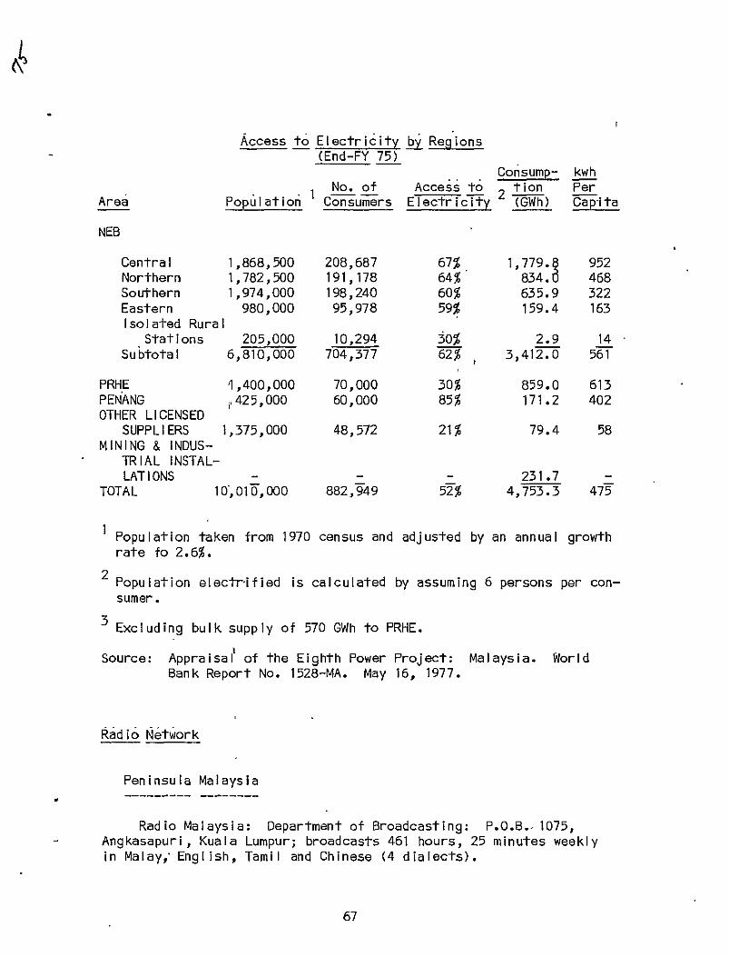
Access to Electricity by Regions(End-FY 75)
Consump- kwh No. of Access to tion Per
Area Population Consumers Electricity (GWh) Capita
NEB
Central 1,868,500 208,687 67% 1,779. 952 Northern 1,782,500 191,178 64% 834.0 468 Southern 1,974,000 198,240 60% 635.9 322 Eastern 980,000 95,978 59% 159.4 163 Isolated Rura
Stations 205,000 10,294 30% 2.9 14 Subtotal 6,810,000 704,377 62% 3,412.0 561
t
PRHE 1,400,000 70,000 30% 859.0 613 PENANG 60,000 85% 171.2 402V425,000OTHER LICENSED
SUPPLIE RS 1,375,000 48,572 21% 79.4 58 MINING & I NDUS-
TRIAL INSTAL-LATIONS 231.7
TOTAL 10,010,000 882,949 52% 4,753.3 475
Population taken from 1970 census and adjusted by an annual growth rate fo 2.6%.
2 Population electrified is calculated by assuming 6 persons per consumer.
Excluding bulk supply of 570 GWh to PRHE.
Source: Appraisal of the Eighth Power Project: Malaysia. World Bank Report No. 1528-MA. May 16, 1977.
Radio Network
Peninsula Malaysia
Radio Malaysia: Department of Broadcasting: P.O.B.-1075, - Angkasapuri, Kuala Lumpur; broadcasts 461 hours, 25 minutes weekly
in Malay, English, Tamil and Chinese (4 dialects).
67

Rediffusion (Malaya) Ltd.: P.O.B. 570, Kuala Lumpur. 2 programs; 22,752 subscribers in Kuala Lumpur; 12,132 subscribers in Penang; 7,477 subscribers in lpoh.
The number of radio receivers isestimated at 1.27 million. There are 26 AM, 1 FM stations. Submarine cables extend to India, Sri Lanka, and Singapore; connected to SEACOM submarine cable terminal at Singapore by microwave relay; 1 ground satellite station.
Sabah
Department of Broadcasting (Sabah): P.O.B. 1016 Kota Kinabalu; inaugurated in 1955 and broadcasts programs 126 h'ours a week in Malay, English, Chinese (3 dialects), Kadagan, Murut, Indonesian, and Bajau.
There are 5 AM and 1 FM stations; SEACOM submarine cable links to Hong Kong and,Singapore; 1 ground statellite station.
Sarawak
Radio Television Malaysia (Sarawak): Broadcasting House, Kuching; braodcasts 1,247 hours weekly (Sept. 1977) inMalay, English, Chinese, Iban, Bidayuh, Melanau, Kayan/Kenyah, Bisaya and Murut. There are 4 AM stations and no FM.
Telephone System
A high-capacity microwave system is used. There are about 278,000 telephones (2.7 per 100 in Peninsula Malaysia; 23,068 telephones (2.7 per 100 pop.) in Sabah; 28,000 telephones (2.4 per 100 pop.) in Sarawak. Telegraph, radiotelephone connections are possible with most foreign countries.
Television
.Radio Televis ion Malaysia: Dept. of Broadcasting, Angkasapuri, Kuala Lumpur. In 1976, there were 500,837 licensed television receivers inPeninsu IaMalaysia. Color television was expected by the end of 1978.
68

There are 16 TV stations in Peninsula Malaysia, 5 stations in Sabah, and I in Sarawak. Television coverage was extended to east coast and central regions of West Malaysia during the SMP period and simultaneous telecast services were inaugurated in 1975 linking Peninsula Malaysia with Sabah and Sarawak. It is estimated that 80% of the population is now within range of TV and radio coverage.
69

Bibliography
Asian. Recorder: A Weekly Digest of Asian Events with Index: Vol. XXV, No. 3. January 15-21, 1979.
Daykin, A.R., ed. Ports of the World. London: Benn Brothers, 1978. Duclos, Ronnie. Information Malaysia, Incorporating Malaysia Yearbook
1975/76. Kuala Lumpur: Berita Publishing SDN. BHD., 1975. Encyclopedia Britannica, Inc. Britannica Book of the Year 1976.
Chicago: Britannica, 1976. Espenshade, Edward B;, Jr. Goode's World Atlas, 14th Edition.
Chicago: Rand McNally and Co., 1974. Europa Publications Ltd. The Europa Yearbook 1978: A World Survey,
Vol. II. London: Europa Pubs. Ltd., 1978. Far Eastern Economic Review: Asia 1979 Yearbook. 'Hong Kong: Far
Eastern Economic Review, Ltd., 1979. Food and Agriculture Organization. Food Balance Sheets. Rome: FAO,
1971. International Air Transport Association. Air Distances Manual, 3rd
Ed. Effective April 1, 1976. London: IATA/International Aeradio Ltd., 1976.
International CIvI;l Aviation Organization. Air Navigation Plan. Middle East and Southeast Asia Regions. 10th Edition. Montreal: ICAO, January 1976.
International Financial Statistics. Washington, D.C.: IMF, August 1979.
Kaspar, Wolfgang. Malaysia, A Study in Successful Economic Development. Washington, D.C.: American Enterprise Institute for Public ,Policy Research, 1974.
LICROSS/Volags Steering Committee for Disasters. Country Fact Sheets. December 1978.
Paxton, John (Ed.). Statesman's Year-Book, 1974-1975. New York 1974. Third Malaysia Plan, 1976-1980. Kuala Lumpur: Government Press, 1976. Vreeland, Nena. et al. Area Handbook for Malaysia. Third Edition.
Washington, D.C.: GPO, 1977. US Government
Agency for International Development. A.I.D. Economic Data Book. I Washington, D.C.: AID/SER/FM/SRD updated as of March 1976. Agency for International Development. Disaster Alert: Malaysia * Floods, January 5, 1971; Disaster Memo Number Three: Malaysia
Floods, January 12, 1971. Central Intelligence Agency. Chiefs of State and Members of
Foreign Governments. Washington, D.C.: National Foreign Assessment Center, July 1979.
..... National Basic Intelligence Factsheet. Washington, D.C.: GPO, July 1978.
70
Commerce Department. Census Bureau. Recent Demographic Estimates for the Countries and Regions of the World. Washington, D.C.: GPO, October 1978.
..... Environmental Science Services Administration. Climates of the World. Washington, O.C.: GPO, 1972.
Health, Education and Welfare Department. Health Information for International Travel 1977. Public Health Service. Center for Disease Control. Atlanta: CDC 1977.
State Department. Background Notes: Malaysia. Washington, D.C.: GPO, January 1976.
..... Diplomatic List. Washington, D.C.: GPO, January 1979.
..... Key Off icers of Foreign Service Posts. Washington, D.C.: GPO, July 1979.
..... Treaties In Force. Washington, D.C.: GPO, January 1976.
..... Visa Requirements of Foreign Governments. Washington, D.C.: GPO, 1978.
Transportation Department. Federal Aviation Administration. International Flight Information Manual. Vol. 26. Washington, D.C.: FAA, April 1978.
World Bank. Appraisal of the Eighth Power Project, Malaysia. Report No. 1528-MA. Washington, D.C.: IBRD, May 16, 1977.
..... Malaysia: Appraisal of a Third Highway Project. Report No. 1182 a-MA. Washington, D.C.: IBRD, February 22, 1977.
..... Malaysia: New Perspectives on the Third Malaysia Plan. Report No. 1594-MA. Washington, D.C.: IBRD, October 14, 1977.
World Health Organization. 4th Report On- the World Health Situation, Pt. II.Geneva: WHO, 1974.
Worldmark Encyclopedia of the Nations. Asia and Australasia. Vol. 4. New York: Wiley, 1976.
Research Completed: May 1979 Written By: Faye Henderson Name Updating: September 1979
71
TO:
COUNTRY PROFILE USER Dear ----------------
Please use this form to note any changes, additions, corrections or suggestions you think would update and improve this country profile. Since our aim is to make these profiles as relevant as possible, your critique is essential and very much wanted. Return comments to Lucy Drobot, OFDA Country Profiles, Room 1262A.
NAME/OFFICE: PHONE: Date:
TOPIC COMMENTS
iv

IGTPQM; DATES: INITIALS:
FICHE