perth wa 6000 e-mail: [email protected] for personal use
TRANSCRIPT

REGISTRATION NO. 201210180E
Telephone: (65) 6877 6911Facsimile: (65) 6491 6407
Level 4 Central Park. 152 St Georges Terrace
Perth WA 6000
E-Mail: [email protected]
www.asaplusresources.com
22 September 2014
The ManagerCompany Announcements OfficeASX Limited 20 Bridge StreetSydney NSW 2000
Dear Sirs
REVISED REPORT RE PROPOSED ACQUISITION UPDATE
Please find attached a revised report in relation to the Proposed AcquisitionUpdate released on 2 September 2014. The revised report is released as theoriginal report omitted certain specific information required by Chapter 5 of theListing Rules and the JORC Code 2012.
The revised report replaces and supercedes the original report.
For and on behalf ofASAPLUS RESOURCES LIMITED
LAU Eng Foo (Andy)Managing Director
For
per
sona
l use
onl
y
Darlington Geological Services Pty Ltd (ABN 56 125 009 725)
10 Hispano Place
Carine Mobile: 0488 151 822
WA 6020 Email: [email protected]
INDEPENDENT GEOLOGICAL REPORT
ON
WENJIANGXIANG QIAOXIA IRON MINE CO AND SURROUNDS
FUJIAN PROVINCE, PEOPLE’S REPUBLIC OF CHINA
Prepared for Asaplus Resources Limited
Author: Peter A. Peebles BSc(Geol), MAIG, MAusIMM
Company: Darlington Geological Services Pty Ltd
Date: 22nd September, 2014
For
per
sona
l use
onl
y
The Directors 22nd September 2014 Asaplus Resources Limited 21 Bukit Batok Crescent #15-74, WCEGA TOWER, SINGAPORE, SINGAPORE, 658065 Dear Sirs, Background Information This independent geological report has been prepared by Darlington Geological Services Pty Ltd (“DGS”) (ABN 56 125 009 725) at the request of Asaplus Resources Limited (ARBN 158 717 492) (“Asaplus”) to provide an independent appraisal of the Datian Wenjiangxiang Qiaoxia Iron Mine Co in Fujian Province, People’s Republic of China. The report also covers areas outside the proposed acquisition, and is done so to enhance the understanding of the area in general. This report has been prepared in accordance with the Australasian Code for Reporting on Exploration Results, Mineral Resources and Ore Reserves December 2012 edition ("JORC Code"), the Code and Guidelines for Assessment and Valuation of Mineral Assets and Mineral Securities for Independent Expert Reports (“Valmin Code”), and Regulatory Guides 111 and 112 relating to Independent Expert Reports by the Australian Securities and Investments Commission (“ASIC”) and relevant requirements of the Listing Rules of the Australian Securities Exchange (“ASX”). This report has been prepared by Peter A Peebles who is the Principal of DGS, a qualified geologist, a Member of the Australasian Institute of Mining & Metallurgy (“AusIMM”) and a Member of the Australian Institute of Geoscientists (“AIG”). He has had 27 years’ experience in mineral exploration and evaluation and more than 20 years’ experience in mineral asset valuation. Mr Peebles has the appropriate qualifications, experience, competence and independence to be considered an “Expert” under the definitions provided in the Valmin Code and “Competent Person” as defined in the JORC Code. The information in this report that relates to Exploration Targets is based on information compiled by Mr Peebles who has sufficient experience which is relevant to the styles of mineralisation and types of deposit under consideration and to the activity which has been undertaken to qualify as a Competent Person as defined by the 2012 edition of the “Australian Code for the Reporting of Exploration Results, Mineral Resources and Ore Reserves” (JORC Code). Mr Peebles consents to the inclusion in the report of information compiled by him in the form and context in which it appears. Mr Peebles does not have any material interest either direct, indirect or contingent in Asaplus nor in any of the mineral assets included in this report nor in any other Asaplus asset. DGS has provided geological services to Asaplus by way of a previous independent geological report for inclusion in the Asaplus prospectus. DGS has had no input into the formulation of any of the mineral tenements under review. This Report has been prepared by DGS strictly in the role of an independent consulting geologist. The present status of tenements listed in this Report is based on information provided by Asaplus and the Report has been prepared on the assumption that the tenements will prove lawfully accessible for evaluation and development. The legal status of the tenements has not been investigated or assessed, nor have any political, environmental considerations been considered. This report is an Independent Geological Report and deals with the prospectivity of the tenements subject to this report only. Asaplus has warranted to DGS that full disclosure has been made of all material information in its possession or knowledge and that such information is complete, accurate and true. None of the information provided by Asaplus has been specified as being confidential and not to be disclosed in this Report.
For
per
sona
l use
onl
y
The author has taken all care to ensure that this report is based on the best information available at the time of writing this report, but will not be held liable for any inaccuracies or omissions contained with information received from Asaplus or it’s representatives. Fees for the preparation of this Report are being charged at normal commercial rates with expenses being reimbursed at cost. Payment of fees and expenses is in no way contingent upon the conclusions of this document. Information used in the preparation of this Report has been derived from technical information provided by Asaplus, as well as a site visit. The writer is generally familiar with the various geological settings and styles of mineralisation and combined with the technical data available are able to make informed comments on the Datian Wenjiangxiang Qiaoxia Iron Mine Project.
Yours faithfully, For and on behalf of Darlington Geological Services Pty Ltd
(Signed) Peter A Peebles BSc(Geol), AIG, AusIMM
For
per
sona
l use
onl
y

1 | P a g e
TABLE OF CONTENTS
1. Introduction 2. Location and Access 3. Tenure 4. Geology 4.1. Regional Geology 5. Mineralisation 5.1 Tenement A 5.2 Tenement B 5.3 Tenements C, D and E 5.3.1 Copper, Lead and Zinc
5.3.2 Iron Ore Occurrences
5.3.3 Graphite Occurrences
6. Conclusions 7. Glossary of Technical Terms 8. Bibliography
Tables Table 1: Assay Results From Samples Taken
Plates Plate 1: Sample Point For Sample SX04 Plate 2: General View Underground Plate 3: General Underground View
Figure 1: Location of Fujian Province in the Peoples Republic of China Figure 2: Location of The Xiaoxia Project Within Fujian Province Figure 3: Tenement Tenure Figure 4: Regional Geology Figure 5: Tenement A - Simplified Geology and Section Lines Figure 6: Southern Part of Tenement - Simplified Geology and Section Lines Figure 7: Section Line 13 Figure 8: Section Line 19 Figure 9: Section Line 21 Figure 10: Ore Body at the 270 metre Level Figure 11: Ore Body at the 250 metre Level Figure 12: Ore Body at the 220 metre Level Figure 13: Ore Body at the 190 metre Level Figure 14: Ore Body at the 160 m Level Figure 15: Tenements C, D and E - Geology, Drillholes and Sample Points Figure 16: Location of Iron Ore Occurrences 1 and 11
JORC Table 1 Compilation
For
per
sona
l use
onl
y

2 | P a g e
1. Introduction In an ASX Announcement dated 19th June, 2014, Asaplus Resources Ltd (AJY), announced a proposed
acquisition of a 51% stake in the Datian Wenjiangxiang Qiaoxia Iron Mine Co. In this Report this
tenement is referred to as Tenement E in Section 3 (“Tenure”) and Figure 6 (Tenement Tenure). The
purpose of this report is to be an Independent Geological Report of the tenement subject to the
proposed acquisition and of the surrounding area covered by the proposed acquisition.
Datian County is the main mineral producing county of Fujian province. Mineral resources within
Datian County are relatively rich, with abundant coal, iron ore and smaller copper, lead, zinc and
manganese deposits as well as kaolin. By Australian standards, the size of the iron ore deposits are
small and usually of a lower grade, but generally the ore is easily able to be beneficiated to an
acceptable grade and the infrastructure is already established (population centres, roads, power, rail
etc) with many steel mills and pig iron facilities being close by. There is a major steel mill in Sanming
(see Figure 2) which is approximately 60km by road from the project. This mill produces
approximately 5.5 million tonnes of steel per year and is seeking additional suitable mill feed for it’s
operations. Scattered around the project area are several much smaller “pig iron” facilities, which
again are seeking suitable feed for their operations.
Figure 1: Location of Fujian Province in the Peoples Republic of China
For
per
sona
l use
onl
y

3 | P a g e
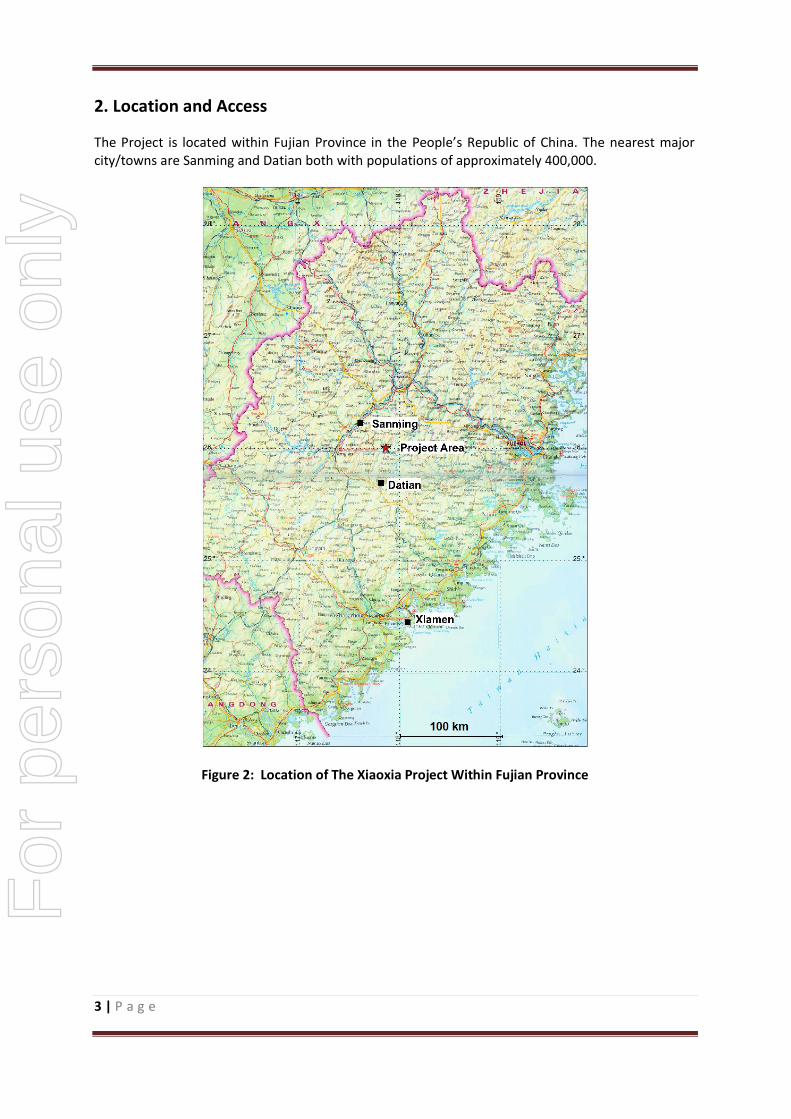
2. Location and Access
The Project is located within Fujian Province in the People’s Republic of China. The nearest major city/towns are Sanming and Datian both with populations of approximately 400,000.
Figure 2: Location of The Xiaoxia Project Within Fujian Province
For
per
sona
l use
onl
y
4 | P a g e
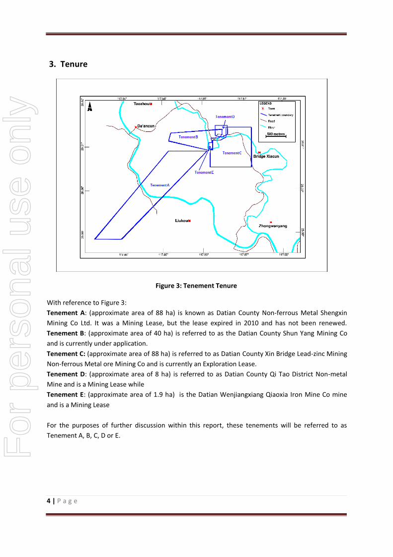
3. Tenure
Figure 3: Tenement Tenure
With reference to Figure 3:
Tenement A: (approximate area of 88 ha) is known as Datian County Non-ferrous Metal Shengxin
Mining Co Ltd. It was a Mining Lease, but the lease expired in 2010 and has not been renewed.
Tenement B: (approximate area of 40 ha) is referred to as the Datian County Shun Yang Mining Co
and is currently under application.
Tenement C: (approximate area of 88 ha) is referred to as Datian County Xin Bridge Lead-zinc Mining
Non-ferrous Metal ore Mining Co and is currently an Exploration Lease.
Tenement D: (approximate area of 8 ha) is referred to as Datian County Qi Tao District Non-metal
Mine and is a Mining Lease while
Tenement E: (approximate area of 1.9 ha) is the Datian Wenjiangxiang Qiaoxia Iron Mine Co mine
and is a Mining Lease
For the purposes of further discussion within this report, these tenements will be referred to as
Tenement A, B, C, D or E.
For
per
sona
l use
onl
y

5 | P a g e
4. Geology
4.1 Regional Geology
Figure 4: Regional Geology
For
per
sona
l use
onl
y

6 | P a g e
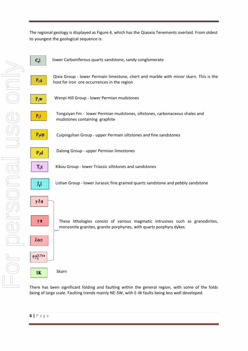
The regional geology is displayed as Figure 4, which has the Qiaoxia Tenements overlaid. From oldest
to youngest the geological sequence is:
lower Carboniferous quartz sandstone, sandy conglomerate
Qixia Group - lower Permain limestone, chert and marble with minor skarn. This is the host for iron ore occurrences in the region
Wenpi Hill Group - lower Permian mudstones
Tongziyan Fm - lower Permian mudstones, siltstones, carbonaceous shales and mudstones containing graphite
Cuipingshan Group - upper Permain siltstones and fine sandstones
Dalong Group - upper Permian limestones
Xikou Group - lower Triassic siltstones and sandstones
Lishan Group - lower Jurassic fine grained quartz sandstone and pebbly sandstone
These lithologies consist of various magmatic intrusives such as granodirites, monzonite granites, granite porphyries, with quartz porphyry dykes.
Skarn
There has been significant folding and faulting within the general region, with some of the folds being of large scale. Faulting trends mainly NE-SW, with E-W faults being less well developed.
For
per
sona
l use
onl
y

7 | P a g e
5. Mineralisation
5.1 Tenement A Figure 3 shows the location of Tenement A while Figures 5 and 6 shows the simplified geology and
section lines.
Figure 5: Tenement A - Simplified Geology and Section Lines
For
per
sona
l use
onl
y
8 | P a g e
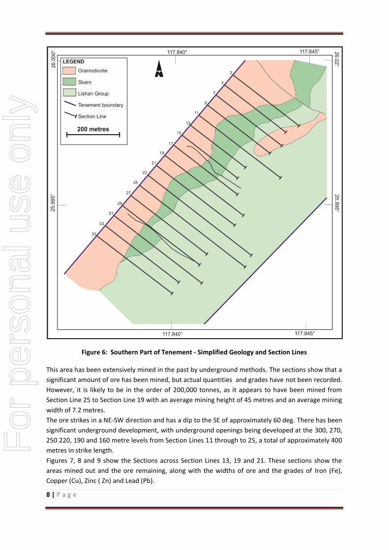
Figure 6: Southern Part of Tenement - Simplified Geology and Section Lines
This area has been extensively mined in the past by underground methods. The sections show that a
significant amount of ore has been mined, but actual quantities and grades have not been recorded.
However, it is likely to be in the order of 200,000 tonnes, as it appears to have been mined from
Section Line 25 to Section Line 19 with an average mining height of 45 metres and an average mining
width of 7.2 metres.
The ore strikes in a NE-SW direction and has a dip to the SE of approximately 60 deg. There has been
significant underground development, with underground openings being developed at the 300, 270,
250 220, 190 and 160 metre levels from Section Lines 11 through to 25, a total of approximately 400
metres in strike length.
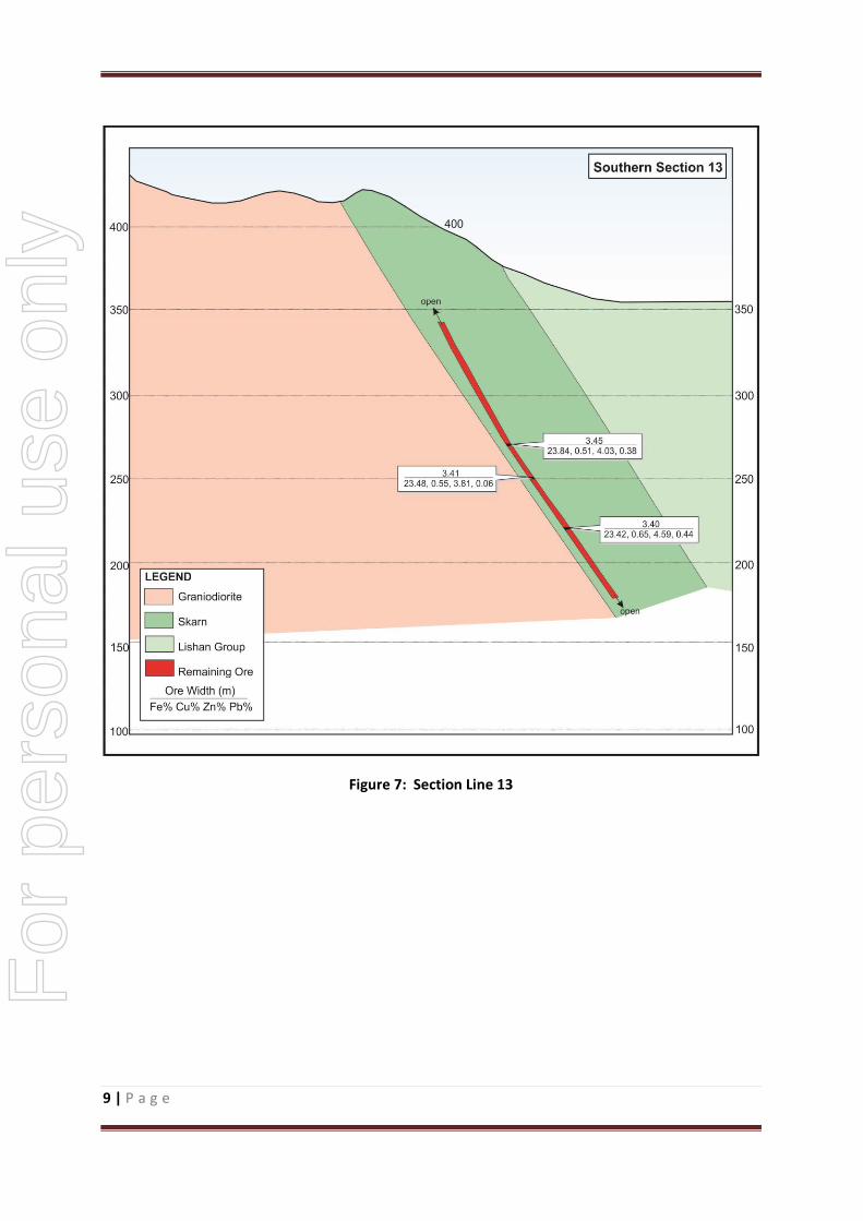
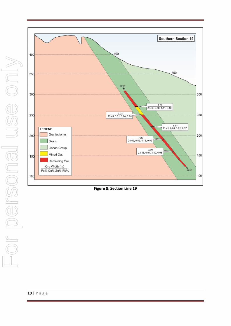
Figures 7, 8 and 9 show the Sections across Section Lines 13, 19 and 21. These sections show the
areas mined out and the ore remaining, along with the widths of ore and the grades of Iron (Fe),
Copper (Cu), Zinc ( Zn) and Lead (Pb).
For
per
sona
l use
onl
y
9 | P a g e
Figure 7: Section Line 13
For
per
sona
l use
onl
y
10 | P a g e
Figure 8: Section Line 19
For
per
sona
l use
onl
y

11 | P a g e
Figure 9: Section Line 21
For
per
sona
l use
onl
y
12 | P a g e
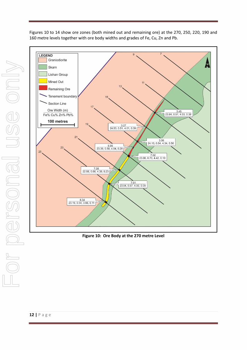
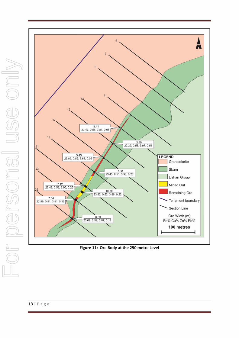
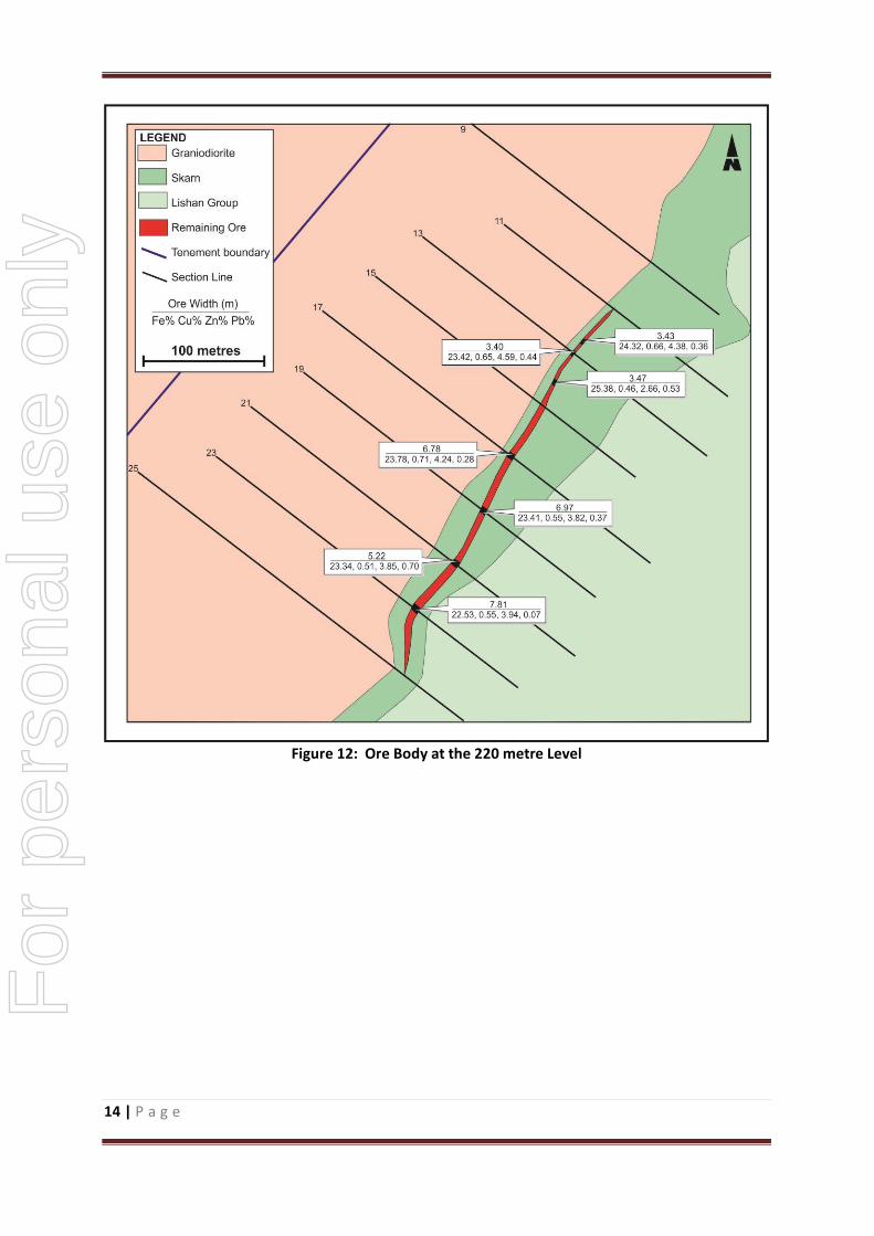
Figures 10 to 14 show ore zones (both mined out and remaining ore) at the 270, 250, 220, 190 and 160 metre levels together with ore body widths and grades of Fe, Cu, Zn and Pb.
Figure 10: Ore Body at the 270 metre Level
For
per
sona
l use
onl
y
13 | P a g e
Figure 11: Ore Body at the 250 metre Level
For
per
sona
l use
onl
y

14 | P a g e
Figure 12: Ore Body at the 220 metre Level
For
per
sona
l use
onl
y

15 | P a g e
Figure 13: Ore Body at the 190 metre Level
For
per
sona
l use
onl
y

16 | P a g e
Figure 14: Ore Body at the 160 m Level
Prior to 2010, geological investigations identified 9 remaining ore bodies, with Ore Body No1 being
by far the largest, with the other 8 being subsidiary and minor. Ore Body 1 is distributed between
Section Lines 11 to 27, and appears to be controlled by faulting. Within Ore Body 1, the ore thickness
ranges from 1.0m to 11.0m with an average thickness of 5.9m. The copper grades range from 0.46%
to 0.71% with an average grade of 0.59%. Lead grades range from 0.03% to 1.34% (average 0.69%),
with zinc ranging from 2.66% to 4.41% (average 3.54%). Iron ranges from 22.39% to 25.38% with an
average grade of about 23.7%.
The main minerals for copper, zinc and lead are the sulphides Chalcopyrite, Sphalerite and Galena
respectively, while the iron is in the form of magnetite. Silver has been encountered with grades
ranging from 29.9 g/t to 40.5 g/t with an average grade of 36.53 g/t.
Potential deleterious elements have been analysed – Arsenic (As) and Fluorite (F). The levels
encountered are minimal and should pose no problems with the potential sale of any ore produced.
The presence of magnetite indicates that the iron may be able to be beneficiated to higher grades, as
beneficiation is now becoming more common place with respect to magnetite ores.
For
per
sona
l use
onl
y

17 | P a g e
Resources for the remaining ore have been calculated but they do not comply with the current JORC
requirements and cannot be judged to be reliable. However, the exploration potential of the mine
gives rise to an exploration target of between 600,000 tonnes and 1,000,000 tonnes with an average
grades ranging from 0.4% to 0.6% Cu, 0.2% to 0.5% Pb, 3% to 5%Zn, 20 to 25% Fe and 30 to 50 g/t of
Ag. The estimate of exploration potential is based on 4 diamond drill holes, and the channel sampling
across the mine openings at various levels (underground openings being developed at the 300, 270,
250 220, 190 and 160 metre levels from Section Lines 11 through to 25, a total of approximately 400
metres in strike length. Section lines are spaced 50 metres apart – see Figures 6 to 14)
The potential quantity and grade is conceptual in nature as there has been insufficient exploration
to estimate a Mineral Resource. It is uncertain if further exploration will result in the estimation of
a Mineral Resource.
As this tenement is not part of the proposed acquisition, there are no proposed exploration
activities.
5.2 Tenement B This tenement has not been granted, but is an application only for an Exploration Licence. There is
no known metallic mineralisation within the tenement, and it is mapped as being essentially all
granodiorite, except is the extreme S-E corner. Figures 4 and 15 show the mapped geology. Figure
15 shows the location of an adit which was reportedly used to access underground workings for the
mineral “fluorite”. The age of the adit and the dimensions of any material mined are unknown.
Fluorite was observed near the entrance to the adit within a quartz vein.
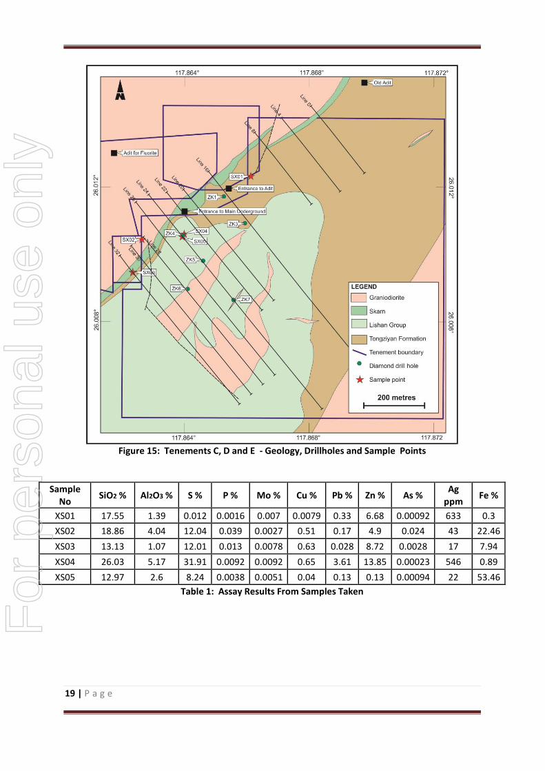
5.3 Tenements C, D and E 5.3.1 Copper, Lead and Zinc
The main minerals for the lead, zinc and copper are the metal sulphides (galena, sphalerite and
chalcopyrite). The ore is contained within the skarn, which is formed when intrusive rocks (in this
case the granodiorites and granites) come in contact with calcareous sedimentary rocks (such as
limestones). Hydrothermal metasomatic alteration of the limestones results in a bedded skarn which
contains the various metallic elements such as lead, zinc and copper. Some of the host rocks are
hornfels, which is the result of metasomatic alteration of argillaceous rocks such as siltstones. The
skarns can be traced over a distance of approximately 900 metres within the tenement boundaries.
During the field visit, five samples were collected, four from the underground workings (samples
SX02, 03, 04 and 05) and one from the from the surface (SX01). The full assay results of all samples
collected is shown as Table 1. The sample locations are shown in Figs 15 and 16.
Sample SX01 was collected from a surface outcrop which appeared to be a skarn. This sample
contained 6.7% zinc and 633 g/t of silver. This clearly indicates that, in the absence of any
underground workings nearby, there is a very legitimate target for further exploration. For
per
sona
l use
onl
y

18 | P a g e
Sample SX02 was taken from the floor of the inclined shaft (the main entrance to the underground
workings) from the 225 metre level. This sample contained 4.9 % zinc, 0.51% copper and 43.0 g/t
silver.
Sample SX03 was collected from the floor of the 170 metre level, and again the assay results are very
encouraging with zinc grading 8.7%, copper 0.63% and silver 17 g/t.
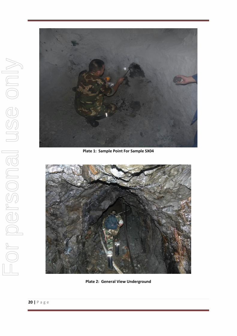
Sample SX04 was taken from the end of a drive at the 134 metre level. Concentrations of 0.65%
copper, 3.61% lead, 13.85% zinc and 546 g/t silver were recorded. These are very significant values
from an area which is at the very end of a drive. There is very obvious potential for further economic
ore to be found here. Plate 1 shows the location of where this sample was taken, while Plates 2 and
3 show the general underground environment within the drives.
Sample SX05 was taken from the 134 metre level was taken from the edge of a drive on the 134
metre level, close to where drillhole ZK4 (see Fig 15) is believed to be located. The values are low,
but this may be expected as the sample was taken from a wall. However, a value of 53.5% iron is
very worthy of note. The drillhole log for hole ZK4 does not indicate any mineralisation at this point,
with the main intersection from this drillhole being close to the 250 to 260 metre level where an
intersection of 12.3 m @ 2.05% Zn and 2.93% Pb was encountered.
Figure 15 shows the simplified geology, sample points, tenement boundaries and mine entrances
and adits.
For
per
sona
l use
onl
y
19 | P a g e
Figure 15: Tenements C, D and E - Geology, Drillholes and Sample Points
Sample No
SiO2 % Al2O3 % S % P % Mo % Cu % Pb % Zn % As % Ag
ppm Fe %
XS01 17.55 1.39 0.012 0.0016 0.007 0.0079 0.33 6.68 0.00092 633 0.3
XS02 18.86 4.04 12.04 0.039 0.0027 0.51 0.17 4.9 0.024 43 22.46
XS03 13.13 1.07 12.01 0.013 0.0078 0.63 0.028 8.72 0.0028 17 7.94
XS04 26.03 5.17 31.91 0.0092 0.0092 0.65 3.61 13.85 0.00023 546 0.89
XS05 12.97 2.6 8.24 0.0038 0.0051 0.04 0.13 0.13 0.00094 22 53.46
Table 1: Assay Results From Samples Taken
For
per
sona
l use
onl
y
20 | P a g e
Plate 1: Sample Point For Sample SX04
Plate 2: General View Underground
For
per
sona
l use
onl
y

21 | P a g e
Plate 3: General Underground View
At the top of Figure 15, an old adit is shown. This adit accessed underground workings from which
zinc, copper and lead ore was mined from 1990 to 1992 when an underground collapse occurred and
from that time the underground workings were closed. The quantity and grade of the ore is
unknown, but again the presence of underground workings adjacent to the known skarn, is very
encouraging.
Within Tenement E (see Figure 3) are significant underground workings. Mining commenced in 1989
and between then and 1997, some 7,000 to 8,000 tonnes/year were mined. From 1997 to 2010, a
further 150,000 tonnes were mined and from 2010 to mid 2013 (when the mined closed), a further
120,000 tonnes of ore were mined. This gives a total of approximately 330,000 tonnes of ore with a
reported average grade of approximately 2% zinc, 2% lead and 0.3% copper. It is reported that the
vast majority of the orebody within Tenement E (of 1.9 ha) above the 163 metre level has been
mined out, but below that level, very little ore has been mined.
From within Tenements C, D and E, resources for the remaining ore have not been calculated.
However, the exploration potential of the mine (with ore assumed to continue from the 163 m level
to the 0 m level) gives rise to an exploration target of between 700,000 to 1,000,000 tonnes with
grades ranging from 0.2% to 0.4% Cu, 1% to 3% Pb, 2% to 4%Zn, and 30 to 100 g/t of Ag. Of this
exploration potential, between 150,000 tonnes and 200,000 tonnes are contained within Tenement
E (the subject of the proposed acquisition). The estimate of exploration potential is based on 6
diamond drill holes, surface mapping and sampling, underground sampling and mapping, and the
presence of previous mining right up to the northern boundary of Tenements C and D.
For
per
sona
l use
onl
y

22 | P a g e
The potential quantity and grade is conceptual in nature as there has been insufficient exploration
to estimate a Mineral Resource. It is uncertain if further exploration will result in the estimation of
a Mineral Resource.
The Company will proceed to develop the exploration potential of the mine by expanding the
underground development below the 163m level. This will occur as soon as is practicable once the
acquisition has been approved. Such development will be ongoing.
5.3.2 Iron Ore Occurrences
Three magnetite iron ore occurrences (named No I, No II and No X) have been located. Two of
these are located adjacent to the underground workings within Tenements D and E in the region of
Lines 28 – 32 (see Fig 16). The bodies strike towards the NE and dip to the SE at between 60 and 70
deg (the same orientation as the lead, zinc and copper occurrences). Iron Ore occurrence I has a
thickness ranging from 2.5 to 6.5 metres and is approximately 240 m long with iron grades varying
between 29.44% and 40.02%. Occurrence II has a thickness ranging from 2 to 11 metres and the
grades of iron ranging from 31.47 and 39.50%.
The magnetite bodies lie within the 130 to 320 metre levels. Figure 16 shows the location of the
magnetite iron ore occurrences (No I and No II) located adjacent to the current underground
workings.
Iron Ore occurrence No X lies further to the east. It’s exact location is uncertain as reference to it’s
location is in general terms only, being between Lines 0-8 (see Fig 15). It is approximately 400
metres in length and strikes in a NE direction with a dip of 60-70 deg to the SE. It has a thickness
ranging from 5.8 m to 7.7m with an average grade of approximately 28.8% Fe. It extends from the
164m level to the 300m level.
For
per
sona
l use
onl
y

23 | P a g e
Figure 16: Location of Iron Ore Occurrences I and II
For
per
sona
l use
onl
y

24 | P a g e
Resources for the Iron Ore occurrences have been calculated but they do not comply with the
current JORC requirements and cannot be judged to be reliable. However, the exploration potential
of the Iron Ore occurrences gives rise to an exploration target of around 700,000 to 900,000 tonnes
with an average grade of between 25 and 32% Fe. The estimate of exploration potential is based on
channel sampling across the mine openings at various levels.
The potential quantity and grade is conceptual in nature as there has been insufficient exploration
to estimate a Mineral Resource. It is uncertain if further exploration will result in the estimation of
a Mineral Resource.
The potential of the iron ore will be investigated concurrent with the planned underground
development activities. This will occur as soon as is practicable once the acquisition has been
approved. Such development will be ongoing.
5.3.3 Graphite Occurrences
Three graphite occurrences have been discovered. These are named VII, VIII and IX. The exact
location of the three graphite occurrence is not known as their locations are described in general
terms only. No VII is distributed between Lines 20 – 24, whereas VIII and IX are in the vicinity of Line
16 (see Fig 15). All three Graphite Occurrences are within the Permian Tongziyan Fm.
No VII has an orientation of NNE and a shallow dip of 30 deg to the SE. The orebody is about 240m
in length and has a thickness ranging from 2.25 to 3.6m and lies within the 155 to 290m level. The
fixed carbon content is 74.3%
No VIII also has a NNE strike with a 35 to 40 deg dip to the SE. It is approx. 100m in length and has a
thickness ranging from 1.2 to 1.8m and lies within the 260 to 300m level. The fixed carbon content is
66.9%
No IX has an orientation of NNE with a dip of 35 deg to the SE. It has a length of approx. 100m and
has a thickness ranging from 1.6 to 2.3 m and lies within the 280 to 310m level. The fixed carbon
content is 74.2%.
Resources for the Graphite occurrences have been calculated but they do not comply with the
current JORC requirements and cannot be judged to be reliable. However, the exploration potential
of the graphite occurrences gives rise to an exploration target of around 500,000 to 800,000 tonnes
with an average fixed carbon content of greater than 70%. The estimate of exploration potential is
based on the results from diamond drill holes and channel sampling across the mine openings at
various levels.
The potential quantity and grade is conceptual in nature as there has been insufficient exploration
to estimate a Mineral Resource. It is uncertain if further exploration will result in the estimation of
a Mineral Resource.
For
per
sona
l use
onl
y

25 | P a g e
As the areas where the graphite occurs are not part of the proposed acquisition, there are no
proposed exploration activities.
6. Conclusions
Although there is no current mining activity within the tenements covered by this report, the area in
general has great potential to host significant tonnages of polymetallic ore (copper, lead, zinc and
silver) as well as potential for both magnetite iron ore and to a lesser extent, graphite.
The exploration potential of the polymetallic ore within the area covered by this report is suggested
to be in the order of between 1.5 and 1.8 million tonnes at potentially economic grades, of which
150,000 to 200,000 tonnes may be contained within the proposed acquisition tenement. The
potential for the magnetite iron ore within the area covered by this report is in the vicinity of
850,000 tonnes at grades of around 30%, while the graphite potential is thought to be in the vicinity
of 600,000 tonnes with a fixed carbon content of greater than 70%.
7. Glossary of Technical Terms
Adit A horizontal tunnel excavated from the surface, normally used to access
underground ore bodies
Argillaceous Containing high proportions of clay like minerals
Beneficiation A process by which mineral concentrations can be increased
Carbonaceous Containing varying amounts of carbon
Carboniferous A period of geological time from about 360 million to 300 million years ago.
Chalcopyrite Copper iron sulphide - an important ore of copper
Chert Fine grained sedimentary rock consisting of microcrystalline silica
Conglomerate Coarse grained sedimentary rocks in which the clasts are well rounded.
Dip The angle at which a rock layer or feature is inclined from the horizontal
Drive A horizontal tunnel within underground workings
Dyke A tabular igneous intrusion that cuts across pre-existing rocks
For
per
sona
l use
onl
y
26 | P a g e
Fault A feature in rocks in which observable displacement has taken place
Fluorite A mineral consisting of Calcium Fluorite
Fold A flexure in rocks
g/t Grammes per tonne (1 g/t = 1 ppm. 1 ppm = 1 part per million))
Galena Lead sulphide - an important ore of lead
Granite A coarse grained felsic rock consisting essentiallly of quartz, feldspar and
some mica
Granodiorite A granite with a lower silica content
Graphite A form of carbon
Hydrothermal A process which is influenced by circulating fluids and gasses
Igneous Rocks which have formed frm the cooling and consolidation of molten rock
material
Intrusives A body of igneous rock which invades older rocks
Jurassic A period of geological time from about 200 million to 150 million years ago.
Limestone A sedimentary rock consisting of calcium carbonate
Magnetite A magnetic form of iron ore
Marble Metamorphosed limestone
Metasomatic Alteration of rocks and minerals circulating fluids
Monzogranite A granite with equal amounts of orthoclase and plagioclase feldspars
Mudstone A sedimentary rock formed by the consolidation of muds
Permian A period of geological time from about 300 million to 250 million years ago.
Polymetallic More than one metal
Porphyry An intrusive igneous rock containing large crystals in a fine groundmass
Quartz A mineral composed of silicon dioxide (SiO2).
Sandstone A sedimentary rock made up of sand sized particles
Shale Fine grained, laminated sedimentary rock formed from clay, mud and silt.
Siltstone A sedimentary rock made up of silt sized particles
Skarn A rock formed by the interaction of fluids from an igneous intrusion and
nearby sediments - usually limestones
For
per
sona
l use
onl
y
27 | P a g e
Sphalerite Zinc sulphide - an important ore of zinc
Stope An underground opening from which ore has been removed
Strike Horizontal trend or direction of a geological feature
Triassic A period of geological time from about 250 million to 200 million years ago.
8. Bibliography
1. Fujian Province National Land Investigation Centre, May 2012
2. Fujian Rock Soil Project Exploration Institute, March 2011. Wang Hai Ping etal
3.TaTian County Wenzhian Bridge Mining Co, July 2014
For
per
sona
l use
onl
y
28 | P a g e
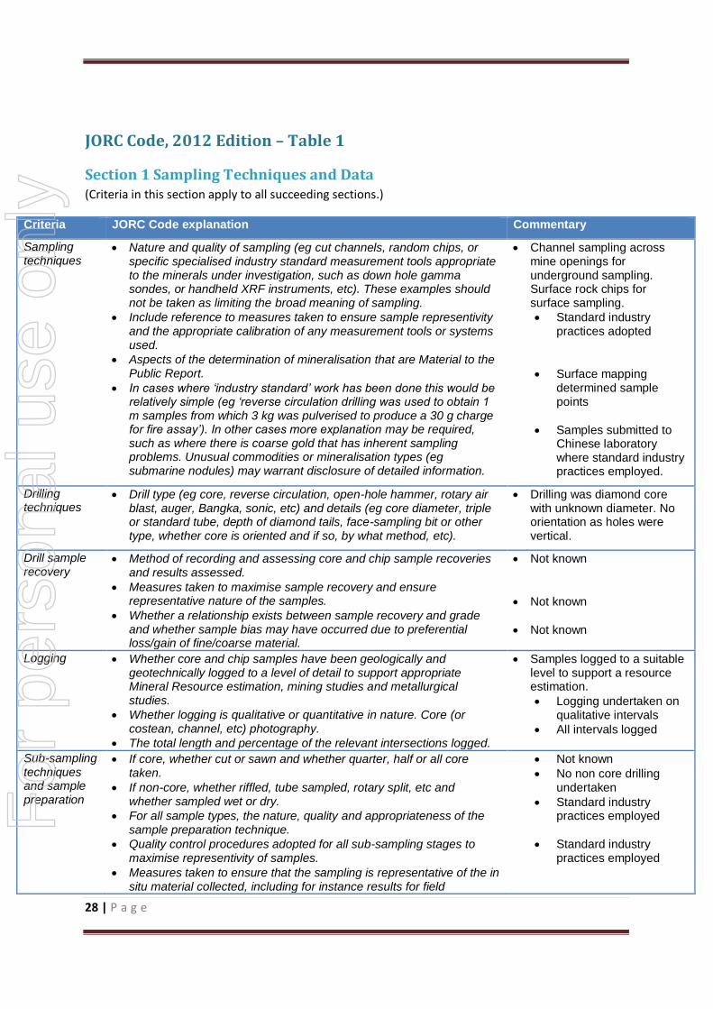
JORC Code, 2012 Edition – Table 1
Section 1 Sampling Techniques and Data (Criteria in this section apply to all succeeding sections.)
Criteria JORC Code explanation Commentary
Sampling techniques
Nature and quality of sampling (eg cut channels, random chips, or specific specialised industry standard measurement tools appropriate to the minerals under investigation, such as down hole gamma sondes, or handheld XRF instruments, etc). These examples should not be taken as limiting the broad meaning of sampling.
Include reference to measures taken to ensure sample representivity and the appropriate calibration of any measurement tools or systems used.
Aspects of the determination of mineralisation that are Material to the Public Report.
In cases where ‘industry standard’ work has been done this would be relatively simple (eg ‘reverse circulation drilling was used to obtain 1 m samples from which 3 kg was pulverised to produce a 30 g charge for fire assay’). In other cases more explanation may be required, such as where there is coarse gold that has inherent sampling problems. Unusual commodities or mineralisation types (eg submarine nodules) may warrant disclosure of detailed information.
Channel sampling across mine openings for underground sampling. Surface rock chips for surface sampling.
Standard industry practices adopted
Surface mapping determined sample points
Samples submitted to Chinese laboratory where standard industry practices employed.
Drilling techniques
Drill type (eg core, reverse circulation, open-hole hammer, rotary air blast, auger, Bangka, sonic, etc) and details (eg core diameter, triple or standard tube, depth of diamond tails, face-sampling bit or other type, whether core is oriented and if so, by what method, etc).
Drilling was diamond core with unknown diameter. No orientation as holes were vertical.
Drill sample recovery
Method of recording and assessing core and chip sample recoveries and results assessed.
Measures taken to maximise sample recovery and ensure representative nature of the samples.
Whether a relationship exists between sample recovery and grade and whether sample bias may have occurred due to preferential loss/gain of fine/coarse material.
Not known
Not known
Not known
Logging Whether core and chip samples have been geologically and geotechnically logged to a level of detail to support appropriate Mineral Resource estimation, mining studies and metallurgical studies.
Whether logging is qualitative or quantitative in nature. Core (or costean, channel, etc) photography.
The total length and percentage of the relevant intersections logged.
Samples logged to a suitable level to support a resource estimation.
Logging undertaken on qualitative intervals
All intervals logged
Sub-sampling techniques and sample preparation
If core, whether cut or sawn and whether quarter, half or all core taken.
If non-core, whether riffled, tube sampled, rotary split, etc and whether sampled wet or dry.
For all sample types, the nature, quality and appropriateness of the sample preparation technique.
Quality control procedures adopted for all sub-sampling stages to maximise representivity of samples.
Measures taken to ensure that the sampling is representative of the in situ material collected, including for instance results for field
Not known
No non core drilling undertaken
Standard industry practices employed
Standard industry practices employed
For
per
sona
l use
onl
y
29 | P a g e
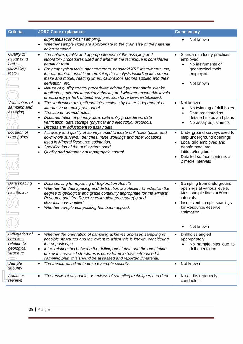
Criteria JORC Code explanation Commentary
duplicate/second-half sampling.
Whether sample sizes are appropriate to the grain size of the material being sampled.
Not known
Quality of assay data and laboratory tests
The nature, quality and appropriateness of the assaying and laboratory procedures used and whether the technique is considered partial or total.
For geophysical tools, spectrometers, handheld XRF instruments, etc, the parameters used in determining the analysis including instrument make and model, reading times, calibrations factors applied and their derivation, etc.
Nature of quality control procedures adopted (eg standards, blanks, duplicates, external laboratory checks) and whether acceptable levels of accuracy (ie lack of bias) and precision have been established.
Standard industry practices employed
No instruments or geophysical tools employed
Not known
Verification of sampling and assaying
The verification of significant intersections by either independent or alternative company personnel.
The use of twinned holes.
Documentation of primary data, data entry procedures, data verification, data storage (physical and electronic) protocols.
Discuss any adjustment to assay data.
Not known
No twinning of drill holes
Data presented as detailed maps and plans
No assay adjustments
Location of data points
Accuracy and quality of surveys used to locate drill holes (collar and down-hole surveys), trenches, mine workings and other locations used in Mineral Resource estimation.
Specification of the grid system used.
Quality and adequacy of topographic control.
Underground surveys used to map underground openings
Local grid employed and transformed into latitude/longitude
Detailed surface contours at 2 metre intervals
Data spacing and distribution
Data spacing for reporting of Exploration Results.
Whether the data spacing and distribution is sufficient to establish the degree of geological and grade continuity appropriate for the Mineral Resource and Ore Reserve estimation procedure(s) and classifications applied.
Whether sample compositing has been applied.
Sampling from underground openings at various levels. Most sample lines at 50m intervals
Insufficient sample spacings for Resource/Reserve estimation
Not known
Orientation of data in relation to geological structure
Whether the orientation of sampling achieves unbiased sampling of possible structures and the extent to which this is known, considering the deposit type.
If the relationship between the drilling orientation and the orientation of key mineralised structures is considered to have introduced a sampling bias, this should be assessed and reported if material.
Drillholes angled appropriately
No sample bias due to drill orientation
Sample security
The measures taken to ensure sample security. Not known
Audits or reviews
The results of any audits or reviews of sampling techniques and data. No audits reportedly conducted
For
per
sona
l use
onl
y
30 | P a g e
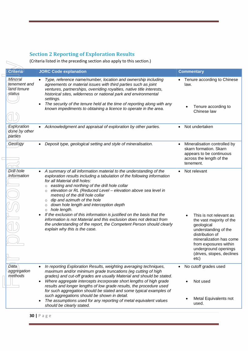
Section 2 Reporting of Exploration Results (Criteria listed in the preceding section also apply to this section.)
Criteria JORC Code explanation Commentary
Mineral tenement and land tenure status
Type, reference name/number, location and ownership including agreements or material issues with third parties such as joint ventures, partnerships, overriding royalties, native title interests, historical sites, wilderness or national park and environmental settings.
The security of the tenure held at the time of reporting along with any known impediments to obtaining a licence to operate in the area.
Tenure according to Chinese law.
Tenure according to Chinese law
Exploration done by other parties
Acknowledgment and appraisal of exploration by other parties. Not undertaken
Geology Deposit type, geological setting and style of mineralisation. Mineralisation controlled by skarn formation. Skarn appears to be continuous across the length of the tenement.
Drill hole Information
A summary of all information material to the understanding of the exploration results including a tabulation of the following information for all Material drill holes: o easting and northing of the drill hole collar o elevation or RL (Reduced Level – elevation above sea level in
metres) of the drill hole collar o dip and azimuth of the hole o down hole length and interception depth o hole length.
If the exclusion of this information is justified on the basis that the information is not Material and this exclusion does not detract from the understanding of the report, the Competent Person should clearly explain why this is the case.
Not relevant
This is not relevant as the vast majority of the geological understanding of the distribution of mineralization has come from exposures within underground openings (drives, stopes, declines etc)
Data aggregation methods
In reporting Exploration Results, weighting averaging techniques, maximum and/or minimum grade truncations (eg cutting of high grades) and cut-off grades are usually Material and should be stated.
Where aggregate intercepts incorporate short lengths of high grade results and longer lengths of low grade results, the procedure used for such aggregation should be stated and some typical examples of such aggregations should be shown in detail.
The assumptions used for any reporting of metal equivalent values should be clearly stated.
No cutoff grades used
Not used
Metal Equivalents not used.
For
per
sona
l use
onl
y

31 | P a g e
Criteria JORC Code explanation Commentary
Relationship between mineralisation widths and intercept lengths
These relationships are particularly important in the reporting of Exploration Results.
If the geometry of the mineralisation with respect to the drill hole angle is known, its nature should be reported.
If it is not known and only the down hole lengths are reported, there should be a clear statement to this effect (eg ‘down hole length, true width not known’).
Geometry of the mineralization has been determined from underground openings. Drill angle has been appropriate.
True widths of mineralization has been
determined by the orientation of
underground workings
Diagrams Appropriate maps and sections (with scales) and tabulations of intercepts should be included for any significant discovery being reported These should include, but not be limited to a plan view of drill hole collar locations and appropriate sectional views.
Included in the body of the report.
Balanced reporting
Where comprehensive reporting of all Exploration Results is not practicable, representative reporting of both low and high grades and/or widths should be practiced to avoid misleading reporting of Exploration Results.
All sampling across underground openings has been reported, including grades and widths where known.
Other substantive exploration data
Other exploration data, if meaningful and material, should be reported including (but not limited to): geological observations; geophysical survey results; geochemical survey results; bulk samples – size and method of treatment; metallurgical test results; bulk density, groundwater, geotechnical and rock characteristics; potential deleterious or contaminating substances.
Ore previously mined has been free of deleterious/contaminating substances.
Further work The nature and scale of planned further work (eg tests for lateral extensions or depth extensions or large-scale step-out drilling).
Diagrams clearly highlighting the areas of possible extensions, including the main geological interpretations and future drilling areas, provided this information is not commercially sensitive.
Future work will be to develop mining levels below the current mine levels.
For
per
sona
l use
onl
y

Darlington Geological Services Pty Ltd (ABN 56 125 009 725)
10 Hispano Place
Carine Mobile: 0488 151 822
WA 6020 Email: [email protected]
INDEPENDENT GEOLOGICAL REPORT
ON
WENJIANGXIANG QIAOXIA IRON MINE CO AND SURROUNDS
FUJIAN PROVINCE, PEOPLE’S REPUBLIC OF CHINA
Prepared for Asaplus Resources Limited
Author: Peter A. Peebles BSc(Geol), MAIG, MAusIMM
Company: Darlington Geological Services Pty Ltd
Date: 22nd September, 2014
For
per
sona
l use
onl
y

The Directors 22nd September 2014 Asaplus Resources Limited 21 Bukit Batok Crescent #15-74, WCEGA TOWER, SINGAPORE, SINGAPORE, 658065 Dear Sirs, Background Information This independent geological report has been prepared by Darlington Geological Services Pty Ltd (“DGS”) (ABN 56 125 009 725) at the request of Asaplus Resources Limited (ARBN 158 717 492) (“Asaplus”) to provide an independent appraisal of the Datian Wenjiangxiang Qiaoxia Iron Mine Co in Fujian Province, People’s Republic of China. The report also covers areas outside the proposed acquisition, and is done so to enhance the understanding of the area in general. This report has been prepared in accordance with the Australasian Code for Reporting on Exploration Results, Mineral Resources and Ore Reserves December 2012 edition ("JORC Code"), the Code and Guidelines for Assessment and Valuation of Mineral Assets and Mineral Securities for Independent Expert Reports (“Valmin Code”), and Regulatory Guides 111 and 112 relating to Independent Expert Reports by the Australian Securities and Investments Commission (“ASIC”) and relevant requirements of the Listing Rules of the Australian Securities Exchange (“ASX”). This report has been prepared by Peter A Peebles who is the Principal of DGS, a qualified geologist, a Member of the Australasian Institute of Mining & Metallurgy (“AusIMM”) and a Member of the Australian Institute of Geoscientists (“AIG”). He has had 27 years’ experience in mineral exploration and evaluation and more than 20 years’ experience in mineral asset valuation. Mr Peebles has the appropriate qualifications, experience, competence and independence to be considered an “Expert” under the definitions provided in the Valmin Code and “Competent Person” as defined in the JORC Code. The information in this report that relates to Exploration Targets is based on information compiled by Mr Peebles who has sufficient experience which is relevant to the styles of mineralisation and types of deposit under consideration and to the activity which has been undertaken to qualify as a Competent Person as defined by the 2012 edition of the “Australian Code for the Reporting of Exploration Results, Mineral Resources and Ore Reserves” (JORC Code). Mr Peebles consents to the inclusion in the report of information compiled by him in the form and context in which it appears. Mr Peebles does not have any material interest either direct, indirect or contingent in Asaplus nor in any of the mineral assets included in this report nor in any other Asaplus asset. DGS has provided geological services to Asaplus by way of a previous independent geological report for inclusion in the Asaplus prospectus. DGS has had no input into the formulation of any of the mineral tenements under review. This Report has been prepared by DGS strictly in the role of an independent consulting geologist. The present status of tenements listed in this Report is based on information provided by Asaplus and the Report has been prepared on the assumption that the tenements will prove lawfully accessible for evaluation and development. The legal status of the tenements has not been investigated or assessed, nor have any political, environmental considerations been considered. This report is an Independent Geological Report and deals with the prospectivity of the tenements subject to this report only. Asaplus has warranted to DGS that full disclosure has been made of all material information in its possession or knowledge and that such information is complete, accurate and true. None of the information provided by Asaplus has been specified as being confidential and not to be disclosed in this Report.
For
per
sona
l use
onl
y

The author has taken all care to ensure that this report is based on the best information available at the time of writing this report, but will not be held liable for any inaccuracies or omissions contained with information received from Asaplus or it’s representatives. Fees for the preparation of this Report are being charged at normal commercial rates with expenses being reimbursed at cost. Payment of fees and expenses is in no way contingent upon the conclusions of this document. Information used in the preparation of this Report has been derived from technical information provided by Asaplus, as well as a site visit. The writer is generally familiar with the various geological settings and styles of mineralisation and combined with the technical data available are able to make informed comments on the Datian Wenjiangxiang Qiaoxia Iron Mine Project.
Yours faithfully, For and on behalf of Darlington Geological Services Pty Ltd
(Signed) Peter A Peebles BSc(Geol), AIG, AusIMM
For
per
sona
l use
onl
y

1 | P a g e
TABLE OF CONTENTS
1. Introduction 2. Location and Access 3. Tenure 4. Geology 4.1. Regional Geology 5. Mineralisation 5.1 Tenement A 5.2 Tenement B 5.3 Tenements C, D and E 5.3.1 Copper, Lead and Zinc
5.3.2 Iron Ore Occurrences
5.3.3 Graphite Occurrences
6. Conclusions 7. Glossary of Technical Terms 8. Bibliography
Tables Table 1: Assay Results From Samples Taken
Plates Plate 1: Sample Point For Sample SX04 Plate 2: General View Underground Plate 3: General Underground View
Figure 1: Location of Fujian Province in the Peoples Republic of China Figure 2: Location of The Xiaoxia Project Within Fujian Province Figure 3: Tenement Tenure Figure 4: Regional Geology Figure 5: Tenement A - Simplified Geology and Section Lines Figure 6: Southern Part of Tenement - Simplified Geology and Section Lines Figure 7: Section Line 13 Figure 8: Section Line 19 Figure 9: Section Line 21 Figure 10: Ore Body at the 270 metre Level Figure 11: Ore Body at the 250 metre Level Figure 12: Ore Body at the 220 metre Level Figure 13: Ore Body at the 190 metre Level Figure 14: Ore Body at the 160 m Level Figure 15: Tenements C, D and E - Geology, Drillholes and Sample Points Figure 16: Location of Iron Ore Occurrences 1 and 11
JORC Table 1 Compilation
For
per
sona
l use
onl
y

2 | P a g e
1. Introduction In an ASX Announcement dated 19th June, 2014, Asaplus Resources Ltd (AJY), announced a proposed
acquisition of a 51% stake in the Datian Wenjiangxiang Qiaoxia Iron Mine Co. In this Report this
tenement is referred to as Tenement E in Section 3 (“Tenure”) and Figure 6 (Tenement Tenure). The
purpose of this report is to be an Independent Geological Report of the tenement subject to the
proposed acquisition and of the surrounding area covered by the proposed acquisition.
Datian County is the main mineral producing county of Fujian province. Mineral resources within
Datian County are relatively rich, with abundant coal, iron ore and smaller copper, lead, zinc and
manganese deposits as well as kaolin. By Australian standards, the size of the iron ore deposits are
small and usually of a lower grade, but generally the ore is easily able to be beneficiated to an
acceptable grade and the infrastructure is already established (population centres, roads, power, rail
etc) with many steel mills and pig iron facilities being close by. There is a major steel mill in Sanming
(see Figure 2) which is approximately 60km by road from the project. This mill produces
approximately 5.5 million tonnes of steel per year and is seeking additional suitable mill feed for it’s
operations. Scattered around the project area are several much smaller “pig iron” facilities, which
again are seeking suitable feed for their operations.
Figure 1: Location of Fujian Province in the Peoples Republic of China
For
per
sona
l use
onl
y
3 | P a g e
2. Location and Access
The Project is located within Fujian Province in the People’s Republic of China. The nearest major city/towns are Sanming and Datian both with populations of approximately 400,000.
Figure 2: Location of The Xiaoxia Project Within Fujian Province
For
per
sona
l use
onl
y

4 | P a g e
3. Tenure
Figure 3: Tenement Tenure
With reference to Figure 3:
Tenement A: (approximate area of 88 ha) is known as Datian County Non-ferrous Metal Shengxin
Mining Co Ltd. It was a Mining Lease, but the lease expired in 2010 and has not been renewed.
Tenement B: (approximate area of 40 ha) is referred to as the Datian County Shun Yang Mining Co
and is currently under application.
Tenement C: (approximate area of 88 ha) is referred to as Datian County Xin Bridge Lead-zinc Mining
Non-ferrous Metal ore Mining Co and is currently an Exploration Lease.
Tenement D: (approximate area of 8 ha) is referred to as Datian County Qi Tao District Non-metal
Mine and is a Mining Lease while
Tenement E: (approximate area of 1.9 ha) is the Datian Wenjiangxiang Qiaoxia Iron Mine Co mine
and is a Mining Lease
For the purposes of further discussion within this report, these tenements will be referred to as
Tenement A, B, C, D or E.
For
per
sona
l use
onl
y

5 | P a g e
4. Geology
4.1 Regional Geology
Figure 4: Regional Geology
For
per
sona
l use
onl
y
6 | P a g e
The regional geology is displayed as Figure 4, which has the Qiaoxia Tenements overlaid. From oldest
to youngest the geological sequence is:
lower Carboniferous quartz sandstone, sandy conglomerate
Qixia Group - lower Permain limestone, chert and marble with minor skarn. This is the host for iron ore occurrences in the region
Wenpi Hill Group - lower Permian mudstones
Tongziyan Fm - lower Permian mudstones, siltstones, carbonaceous shales and mudstones containing graphite
Cuipingshan Group - upper Permain siltstones and fine sandstones
Dalong Group - upper Permian limestones
Xikou Group - lower Triassic siltstones and sandstones
Lishan Group - lower Jurassic fine grained quartz sandstone and pebbly sandstone
These lithologies consist of various magmatic intrusives such as granodirites, monzonite granites, granite porphyries, with quartz porphyry dykes.
Skarn
There has been significant folding and faulting within the general region, with some of the folds being of large scale. Faulting trends mainly NE-SW, with E-W faults being less well developed.
For
per
sona
l use
onl
y

7 | P a g e
5. Mineralisation
5.1 Tenement A Figure 3 shows the location of Tenement A while Figures 5 and 6 shows the simplified geology and
section lines.
Figure 5: Tenement A - Simplified Geology and Section Lines
For
per
sona
l use
onl
y

8 | P a g e
Figure 6: Southern Part of Tenement - Simplified Geology and Section Lines
This area has been extensively mined in the past by underground methods. The sections show that a
significant amount of ore has been mined, but actual quantities and grades have not been recorded.
However, it is likely to be in the order of 200,000 tonnes, as it appears to have been mined from
Section Line 25 to Section Line 19 with an average mining height of 45 metres and an average mining
width of 7.2 metres.
The ore strikes in a NE-SW direction and has a dip to the SE of approximately 60 deg. There has been
significant underground development, with underground openings being developed at the 300, 270,
250 220, 190 and 160 metre levels from Section Lines 11 through to 25, a total of approximately 400
metres in strike length.
Figures 7, 8 and 9 show the Sections across Section Lines 13, 19 and 21. These sections show the
areas mined out and the ore remaining, along with the widths of ore and the grades of Iron (Fe),
Copper (Cu), Zinc ( Zn) and Lead (Pb).
For
per
sona
l use
onl
y

9 | P a g e
Figure 7: Section Line 13
For
per
sona
l use
onl
y

10 | P a g e
Figure 8: Section Line 19
For
per
sona
l use
onl
y

11 | P a g e
Figure 9: Section Line 21
For
per
sona
l use
onl
y

12 | P a g e
Figures 10 to 14 show ore zones (both mined out and remaining ore) at the 270, 250, 220, 190 and 160 metre levels together with ore body widths and grades of Fe, Cu, Zn and Pb.
Figure 10: Ore Body at the 270 metre Level
For
per
sona
l use
onl
y

13 | P a g e
Figure 11: Ore Body at the 250 metre Level
For
per
sona
l use
onl
y
14 | P a g e
Figure 12: Ore Body at the 220 metre Level
For
per
sona
l use
onl
y

15 | P a g e
Figure 13: Ore Body at the 190 metre Level
For
per
sona
l use
onl
y

16 | P a g e
Figure 14: Ore Body at the 160 m Level
Prior to 2010, geological investigations identified 9 remaining ore bodies, with Ore Body No1 being
by far the largest, with the other 8 being subsidiary and minor. Ore Body 1 is distributed between
Section Lines 11 to 27, and appears to be controlled by faulting. Within Ore Body 1, the ore thickness
ranges from 1.0m to 11.0m with an average thickness of 5.9m. The copper grades range from 0.46%
to 0.71% with an average grade of 0.59%. Lead grades range from 0.03% to 1.34% (average 0.69%),
with zinc ranging from 2.66% to 4.41% (average 3.54%). Iron ranges from 22.39% to 25.38% with an
average grade of about 23.7%.
The main minerals for copper, zinc and lead are the sulphides Chalcopyrite, Sphalerite and Galena
respectively, while the iron is in the form of magnetite. Silver has been encountered with grades
ranging from 29.9 g/t to 40.5 g/t with an average grade of 36.53 g/t.
Potential deleterious elements have been analysed – Arsenic (As) and Fluorite (F). The levels
encountered are minimal and should pose no problems with the potential sale of any ore produced.
The presence of magnetite indicates that the iron may be able to be beneficiated to higher grades, as
beneficiation is now becoming more common place with respect to magnetite ores.
For
per
sona
l use
onl
y

17 | P a g e
Resources for the remaining ore have been calculated but they do not comply with the current JORC
requirements and cannot be judged to be reliable. However, the exploration potential of the mine
gives rise to an exploration target of between 600,000 tonnes and 1,000,000 tonnes with an average
grades ranging from 0.4% to 0.6% Cu, 0.2% to 0.5% Pb, 3% to 5%Zn, 20 to 25% Fe and 30 to 50 g/t of
Ag. The estimate of exploration potential is based on 4 diamond drill holes, and the channel sampling
across the mine openings at various levels (underground openings being developed at the 300, 270,
250 220, 190 and 160 metre levels from Section Lines 11 through to 25, a total of approximately 400
metres in strike length. Section lines are spaced 50 metres apart – see Figures 6 to 14)
The potential quantity and grade is conceptual in nature as there has been insufficient exploration
to estimate a Mineral Resource. It is uncertain if further exploration will result in the estimation of
a Mineral Resource.
As this tenement is not part of the proposed acquisition, there are no proposed exploration
activities.
5.2 Tenement B This tenement has not been granted, but is an application only for an Exploration Licence. There is
no known metallic mineralisation within the tenement, and it is mapped as being essentially all
granodiorite, except is the extreme S-E corner. Figures 4 and 15 show the mapped geology. Figure
15 shows the location of an adit which was reportedly used to access underground workings for the
mineral “fluorite”. The age of the adit and the dimensions of any material mined are unknown.
Fluorite was observed near the entrance to the adit within a quartz vein.
5.3 Tenements C, D and E 5.3.1 Copper, Lead and Zinc
The main minerals for the lead, zinc and copper are the metal sulphides (galena, sphalerite and
chalcopyrite). The ore is contained within the skarn, which is formed when intrusive rocks (in this
case the granodiorites and granites) come in contact with calcareous sedimentary rocks (such as
limestones). Hydrothermal metasomatic alteration of the limestones results in a bedded skarn which
contains the various metallic elements such as lead, zinc and copper. Some of the host rocks are
hornfels, which is the result of metasomatic alteration of argillaceous rocks such as siltstones. The
skarns can be traced over a distance of approximately 900 metres within the tenement boundaries.
During the field visit, five samples were collected, four from the underground workings (samples
SX02, 03, 04 and 05) and one from the from the surface (SX01). The full assay results of all samples
collected is shown as Table 1. The sample locations are shown in Figs 15 and 16.
Sample SX01 was collected from a surface outcrop which appeared to be a skarn. This sample
contained 6.7% zinc and 633 g/t of silver. This clearly indicates that, in the absence of any
underground workings nearby, there is a very legitimate target for further exploration. For
per
sona
l use
onl
y
18 | P a g e
Sample SX02 was taken from the floor of the inclined shaft (the main entrance to the underground
workings) from the 225 metre level. This sample contained 4.9 % zinc, 0.51% copper and 43.0 g/t
silver.
Sample SX03 was collected from the floor of the 170 metre level, and again the assay results are very
encouraging with zinc grading 8.7%, copper 0.63% and silver 17 g/t.
Sample SX04 was taken from the end of a drive at the 134 metre level. Concentrations of 0.65%
copper, 3.61% lead, 13.85% zinc and 546 g/t silver were recorded. These are very significant values
from an area which is at the very end of a drive. There is very obvious potential for further economic
ore to be found here. Plate 1 shows the location of where this sample was taken, while Plates 2 and
3 show the general underground environment within the drives.
Sample SX05 was taken from the 134 metre level was taken from the edge of a drive on the 134
metre level, close to where drillhole ZK4 (see Fig 15) is believed to be located. The values are low,
but this may be expected as the sample was taken from a wall. However, a value of 53.5% iron is
very worthy of note. The drillhole log for hole ZK4 does not indicate any mineralisation at this point,
with the main intersection from this drillhole being close to the 250 to 260 metre level where an
intersection of 12.3 m @ 2.05% Zn and 2.93% Pb was encountered.
Figure 15 shows the simplified geology, sample points, tenement boundaries and mine entrances
and adits.
For
per
sona
l use
onl
y

19 | P a g e
Figure 15: Tenements C, D and E - Geology, Drillholes and Sample Points
Sample No
SiO2 % Al2O3 % S % P % Mo % Cu % Pb % Zn % As % Ag
ppm Fe %
XS01 17.55 1.39 0.012 0.0016 0.007 0.0079 0.33 6.68 0.00092 633 0.3
XS02 18.86 4.04 12.04 0.039 0.0027 0.51 0.17 4.9 0.024 43 22.46
XS03 13.13 1.07 12.01 0.013 0.0078 0.63 0.028 8.72 0.0028 17 7.94
XS04 26.03 5.17 31.91 0.0092 0.0092 0.65 3.61 13.85 0.00023 546 0.89
XS05 12.97 2.6 8.24 0.0038 0.0051 0.04 0.13 0.13 0.00094 22 53.46
Table 1: Assay Results From Samples Taken
For
per
sona
l use
onl
y

20 | P a g e
Plate 1: Sample Point For Sample SX04
Plate 2: General View Underground
For
per
sona
l use
onl
y

21 | P a g e
Plate 3: General Underground View
At the top of Figure 15, an old adit is shown. This adit accessed underground workings from which
zinc, copper and lead ore was mined from 1990 to 1992 when an underground collapse occurred and
from that time the underground workings were closed. The quantity and grade of the ore is
unknown, but again the presence of underground workings adjacent to the known skarn, is very
encouraging.
Within Tenement E (see Figure 3) are significant underground workings. Mining commenced in 1989
and between then and 1997, some 7,000 to 8,000 tonnes/year were mined. From 1997 to 2010, a
further 150,000 tonnes were mined and from 2010 to mid 2013 (when the mined closed), a further
120,000 tonnes of ore were mined. This gives a total of approximately 330,000 tonnes of ore with a
reported average grade of approximately 2% zinc, 2% lead and 0.3% copper. It is reported that the
vast majority of the orebody within Tenement E (of 1.9 ha) above the 163 metre level has been
mined out, but below that level, very little ore has been mined.
From within Tenements C, D and E, resources for the remaining ore have not been calculated.
However, the exploration potential of the mine (with ore assumed to continue from the 163 m level
to the 0 m level) gives rise to an exploration target of between 700,000 to 1,000,000 tonnes with
grades ranging from 0.2% to 0.4% Cu, 1% to 3% Pb, 2% to 4%Zn, and 30 to 100 g/t of Ag. Of this
exploration potential, between 150,000 tonnes and 200,000 tonnes are contained within Tenement
E (the subject of the proposed acquisition). The estimate of exploration potential is based on 6
diamond drill holes, surface mapping and sampling, underground sampling and mapping, and the
presence of previous mining right up to the northern boundary of Tenements C and D.
For
per
sona
l use
onl
y

22 | P a g e
The potential quantity and grade is conceptual in nature as there has been insufficient exploration
to estimate a Mineral Resource. It is uncertain if further exploration will result in the estimation of
a Mineral Resource.
The Company will proceed to develop the exploration potential of the mine by expanding the
underground development below the 163m level. This will occur as soon as is practicable once the
acquisition has been approved. Such development will be ongoing.
5.3.2 Iron Ore Occurrences
Three magnetite iron ore occurrences (named No I, No II and No X) have been located. Two of
these are located adjacent to the underground workings within Tenements D and E in the region of
Lines 28 – 32 (see Fig 16). The bodies strike towards the NE and dip to the SE at between 60 and 70
deg (the same orientation as the lead, zinc and copper occurrences). Iron Ore occurrence I has a
thickness ranging from 2.5 to 6.5 metres and is approximately 240 m long with iron grades varying
between 29.44% and 40.02%. Occurrence II has a thickness ranging from 2 to 11 metres and the
grades of iron ranging from 31.47 and 39.50%.
The magnetite bodies lie within the 130 to 320 metre levels. Figure 16 shows the location of the
magnetite iron ore occurrences (No I and No II) located adjacent to the current underground
workings.
Iron Ore occurrence No X lies further to the east. It’s exact location is uncertain as reference to it’s
location is in general terms only, being between Lines 0-8 (see Fig 15). It is approximately 400
metres in length and strikes in a NE direction with a dip of 60-70 deg to the SE. It has a thickness
ranging from 5.8 m to 7.7m with an average grade of approximately 28.8% Fe. It extends from the
164m level to the 300m level.
For
per
sona
l use
onl
y
23 | P a g e
Figure 16: Location of Iron Ore Occurrences I and II
For
per
sona
l use
onl
y
24 | P a g e
Resources for the Iron Ore occurrences have been calculated but they do not comply with the
current JORC requirements and cannot be judged to be reliable. However, the exploration potential
of the Iron Ore occurrences gives rise to an exploration target of around 700,000 to 900,000 tonnes
with an average grade of between 25 and 32% Fe. The estimate of exploration potential is based on
channel sampling across the mine openings at various levels.
The potential quantity and grade is conceptual in nature as there has been insufficient exploration
to estimate a Mineral Resource. It is uncertain if further exploration will result in the estimation of
a Mineral Resource.
The potential of the iron ore will be investigated concurrent with the planned underground
development activities. This will occur as soon as is practicable once the acquisition has been
approved. Such development will be ongoing.
5.3.3 Graphite Occurrences
Three graphite occurrences have been discovered. These are named VII, VIII and IX. The exact
location of the three graphite occurrence is not known as their locations are described in general
terms only. No VII is distributed between Lines 20 – 24, whereas VIII and IX are in the vicinity of Line
16 (see Fig 15). All three Graphite Occurrences are within the Permian Tongziyan Fm.
No VII has an orientation of NNE and a shallow dip of 30 deg to the SE. The orebody is about 240m
in length and has a thickness ranging from 2.25 to 3.6m and lies within the 155 to 290m level. The
fixed carbon content is 74.3%
No VIII also has a NNE strike with a 35 to 40 deg dip to the SE. It is approx. 100m in length and has a
thickness ranging from 1.2 to 1.8m and lies within the 260 to 300m level. The fixed carbon content is
66.9%
No IX has an orientation of NNE with a dip of 35 deg to the SE. It has a length of approx. 100m and
has a thickness ranging from 1.6 to 2.3 m and lies within the 280 to 310m level. The fixed carbon
content is 74.2%.
Resources for the Graphite occurrences have been calculated but they do not comply with the
current JORC requirements and cannot be judged to be reliable. However, the exploration potential
of the graphite occurrences gives rise to an exploration target of around 500,000 to 800,000 tonnes
with an average fixed carbon content of greater than 70%. The estimate of exploration potential is
based on the results from diamond drill holes and channel sampling across the mine openings at
various levels.
The potential quantity and grade is conceptual in nature as there has been insufficient exploration
to estimate a Mineral Resource. It is uncertain if further exploration will result in the estimation of
a Mineral Resource.
For
per
sona
l use
onl
y
25 | P a g e
As the areas where the graphite occurs are not part of the proposed acquisition, there are no
proposed exploration activities.
6. Conclusions
Although there is no current mining activity within the tenements covered by this report, the area in
general has great potential to host significant tonnages of polymetallic ore (copper, lead, zinc and
silver) as well as potential for both magnetite iron ore and to a lesser extent, graphite.
The exploration potential of the polymetallic ore within the area covered by this report is suggested
to be in the order of between 1.5 and 1.8 million tonnes at potentially economic grades, of which
150,000 to 200,000 tonnes may be contained within the proposed acquisition tenement. The
potential for the magnetite iron ore within the area covered by this report is in the vicinity of
850,000 tonnes at grades of around 30%, while the graphite potential is thought to be in the vicinity
of 600,000 tonnes with a fixed carbon content of greater than 70%.
7. Glossary of Technical Terms
Adit A horizontal tunnel excavated from the surface, normally used to access
underground ore bodies
Argillaceous Containing high proportions of clay like minerals
Beneficiation A process by which mineral concentrations can be increased
Carbonaceous Containing varying amounts of carbon
Carboniferous A period of geological time from about 360 million to 300 million years ago.
Chalcopyrite Copper iron sulphide - an important ore of copper
Chert Fine grained sedimentary rock consisting of microcrystalline silica
Conglomerate Coarse grained sedimentary rocks in which the clasts are well rounded.
Dip The angle at which a rock layer or feature is inclined from the horizontal
Drive A horizontal tunnel within underground workings
Dyke A tabular igneous intrusion that cuts across pre-existing rocks
For
per
sona
l use
onl
y

26 | P a g e
Fault A feature in rocks in which observable displacement has taken place
Fluorite A mineral consisting of Calcium Fluorite
Fold A flexure in rocks
g/t Grammes per tonne (1 g/t = 1 ppm. 1 ppm = 1 part per million))
Galena Lead sulphide - an important ore of lead
Granite A coarse grained felsic rock consisting essentiallly of quartz, feldspar and
some mica
Granodiorite A granite with a lower silica content
Graphite A form of carbon
Hydrothermal A process which is influenced by circulating fluids and gasses
Igneous Rocks which have formed frm the cooling and consolidation of molten rock
material
Intrusives A body of igneous rock which invades older rocks
Jurassic A period of geological time from about 200 million to 150 million years ago.
Limestone A sedimentary rock consisting of calcium carbonate
Magnetite A magnetic form of iron ore
Marble Metamorphosed limestone
Metasomatic Alteration of rocks and minerals circulating fluids
Monzogranite A granite with equal amounts of orthoclase and plagioclase feldspars
Mudstone A sedimentary rock formed by the consolidation of muds
Permian A period of geological time from about 300 million to 250 million years ago.
Polymetallic More than one metal
Porphyry An intrusive igneous rock containing large crystals in a fine groundmass
Quartz A mineral composed of silicon dioxide (SiO2).
Sandstone A sedimentary rock made up of sand sized particles
Shale Fine grained, laminated sedimentary rock formed from clay, mud and silt.
Siltstone A sedimentary rock made up of silt sized particles
Skarn A rock formed by the interaction of fluids from an igneous intrusion and
nearby sediments - usually limestones
For
per
sona
l use
onl
y

27 | P a g e
Sphalerite Zinc sulphide - an important ore of zinc
Stope An underground opening from which ore has been removed
Strike Horizontal trend or direction of a geological feature
Triassic A period of geological time from about 250 million to 200 million years ago.
8. Bibliography
1. Fujian Province National Land Investigation Centre, May 2012
2. Fujian Rock Soil Project Exploration Institute, March 2011. Wang Hai Ping etal
3.TaTian County Wenzhian Bridge Mining Co, July 2014
For
per
sona
l use
onl
y

28 | P a g e
JORC Code, 2012 Edition – Table 1
Section 1 Sampling Techniques and Data (Criteria in this section apply to all succeeding sections.)
Criteria JORC Code explanation Commentary
Sampling techniques
Nature and quality of sampling (eg cut channels, random chips, or specific specialised industry standard measurement tools appropriate to the minerals under investigation, such as down hole gamma sondes, or handheld XRF instruments, etc). These examples should not be taken as limiting the broad meaning of sampling.
Include reference to measures taken to ensure sample representivity and the appropriate calibration of any measurement tools or systems used.
Aspects of the determination of mineralisation that are Material to the Public Report.
In cases where ‘industry standard’ work has been done this would be relatively simple (eg ‘reverse circulation drilling was used to obtain 1 m samples from which 3 kg was pulverised to produce a 30 g charge for fire assay’). In other cases more explanation may be required, such as where there is coarse gold that has inherent sampling problems. Unusual commodities or mineralisation types (eg submarine nodules) may warrant disclosure of detailed information.
Channel sampling across mine openings for underground sampling. Surface rock chips for surface sampling.
Standard industry practices adopted
Surface mapping determined sample points
Samples submitted to Chinese laboratory where standard industry practices employed.
Drilling techniques
Drill type (eg core, reverse circulation, open-hole hammer, rotary air blast, auger, Bangka, sonic, etc) and details (eg core diameter, triple or standard tube, depth of diamond tails, face-sampling bit or other type, whether core is oriented and if so, by what method, etc).
Drilling was diamond core with unknown diameter. No orientation as holes were vertical.
Drill sample recovery
Method of recording and assessing core and chip sample recoveries and results assessed.
Measures taken to maximise sample recovery and ensure representative nature of the samples.
Whether a relationship exists between sample recovery and grade and whether sample bias may have occurred due to preferential loss/gain of fine/coarse material.
Not known
Not known
Not known
Logging Whether core and chip samples have been geologically and geotechnically logged to a level of detail to support appropriate Mineral Resource estimation, mining studies and metallurgical studies.
Whether logging is qualitative or quantitative in nature. Core (or costean, channel, etc) photography.
The total length and percentage of the relevant intersections logged.
Samples logged to a suitable level to support a resource estimation.
Logging undertaken on qualitative intervals
All intervals logged
Sub-sampling techniques and sample preparation
If core, whether cut or sawn and whether quarter, half or all core taken.
If non-core, whether riffled, tube sampled, rotary split, etc and whether sampled wet or dry.
For all sample types, the nature, quality and appropriateness of the sample preparation technique.
Quality control procedures adopted for all sub-sampling stages to maximise representivity of samples.
Measures taken to ensure that the sampling is representative of the in situ material collected, including for instance results for field
Not known
No non core drilling undertaken
Standard industry practices employed
Standard industry practices employed
For
per
sona
l use
onl
y

29 | P a g e
Criteria JORC Code explanation Commentary
duplicate/second-half sampling.
Whether sample sizes are appropriate to the grain size of the material being sampled.
Not known
Quality of assay data and laboratory tests
The nature, quality and appropriateness of the assaying and laboratory procedures used and whether the technique is considered partial or total.
For geophysical tools, spectrometers, handheld XRF instruments, etc, the parameters used in determining the analysis including instrument make and model, reading times, calibrations factors applied and their derivation, etc.
Nature of quality control procedures adopted (eg standards, blanks, duplicates, external laboratory checks) and whether acceptable levels of accuracy (ie lack of bias) and precision have been established.
Standard industry practices employed
No instruments or geophysical tools employed
Not known
Verification of sampling and assaying
The verification of significant intersections by either independent or alternative company personnel.
The use of twinned holes.
Documentation of primary data, data entry procedures, data verification, data storage (physical and electronic) protocols.
Discuss any adjustment to assay data.
Not known
No twinning of drill holes
Data presented as detailed maps and plans
No assay adjustments
Location of data points
Accuracy and quality of surveys used to locate drill holes (collar and down-hole surveys), trenches, mine workings and other locations used in Mineral Resource estimation.
Specification of the grid system used.
Quality and adequacy of topographic control.
Underground surveys used to map underground openings
Local grid employed and transformed into latitude/longitude
Detailed surface contours at 2 metre intervals
Data spacing and distribution
Data spacing for reporting of Exploration Results.
Whether the data spacing and distribution is sufficient to establish the degree of geological and grade continuity appropriate for the Mineral Resource and Ore Reserve estimation procedure(s) and classifications applied.
Whether sample compositing has been applied.
Sampling from underground openings at various levels. Most sample lines at 50m intervals
Insufficient sample spacings for Resource/Reserve estimation
Not known
Orientation of data in relation to geological structure
Whether the orientation of sampling achieves unbiased sampling of possible structures and the extent to which this is known, considering the deposit type.
If the relationship between the drilling orientation and the orientation of key mineralised structures is considered to have introduced a sampling bias, this should be assessed and reported if material.
Drillholes angled appropriately
No sample bias due to drill orientation
Sample security
The measures taken to ensure sample security. Not known
Audits or reviews
The results of any audits or reviews of sampling techniques and data. No audits reportedly conducted
For
per
sona
l use
onl
y

30 | P a g e
Section 2 Reporting of Exploration Results (Criteria listed in the preceding section also apply to this section.)
Criteria JORC Code explanation Commentary
Mineral tenement and land tenure status
Type, reference name/number, location and ownership including agreements or material issues with third parties such as joint ventures, partnerships, overriding royalties, native title interests, historical sites, wilderness or national park and environmental settings.
The security of the tenure held at the time of reporting along with any known impediments to obtaining a licence to operate in the area.
Tenure according to Chinese law.
Tenure according to Chinese law
Exploration done by other parties
Acknowledgment and appraisal of exploration by other parties. Not undertaken
Geology Deposit type, geological setting and style of mineralisation. Mineralisation controlled by skarn formation. Skarn appears to be continuous across the length of the tenement.
Drill hole Information
A summary of all information material to the understanding of the exploration results including a tabulation of the following information for all Material drill holes: o easting and northing of the drill hole collar o elevation or RL (Reduced Level – elevation above sea level in
metres) of the drill hole collar o dip and azimuth of the hole o down hole length and interception depth o hole length.
If the exclusion of this information is justified on the basis that the information is not Material and this exclusion does not detract from the understanding of the report, the Competent Person should clearly explain why this is the case.
Not relevant
This is not relevant as the vast majority of the geological understanding of the distribution of mineralization has come from exposures within underground openings (drives, stopes, declines etc)
Data aggregation methods
In reporting Exploration Results, weighting averaging techniques, maximum and/or minimum grade truncations (eg cutting of high grades) and cut-off grades are usually Material and should be stated.
Where aggregate intercepts incorporate short lengths of high grade results and longer lengths of low grade results, the procedure used for such aggregation should be stated and some typical examples of such aggregations should be shown in detail.
The assumptions used for any reporting of metal equivalent values should be clearly stated.
No cutoff grades used
Not used
Metal Equivalents not used.
For
per
sona
l use
onl
y

31 | P a g e
Criteria JORC Code explanation Commentary
Relationship between mineralisation widths and intercept lengths
These relationships are particularly important in the reporting of Exploration Results.
If the geometry of the mineralisation with respect to the drill hole angle is known, its nature should be reported.
If it is not known and only the down hole lengths are reported, there should be a clear statement to this effect (eg ‘down hole length, true width not known’).
Geometry of the mineralization has been determined from underground openings. Drill angle has been appropriate.
True widths of mineralization has been
determined by the orientation of
underground workings
Diagrams Appropriate maps and sections (with scales) and tabulations of intercepts should be included for any significant discovery being reported These should include, but not be limited to a plan view of drill hole collar locations and appropriate sectional views.
Included in the body of the report.
Balanced reporting
Where comprehensive reporting of all Exploration Results is not practicable, representative reporting of both low and high grades and/or widths should be practiced to avoid misleading reporting of Exploration Results.
All sampling across underground openings has been reported, including grades and widths where known.
Other substantive exploration data
Other exploration data, if meaningful and material, should be reported including (but not limited to): geological observations; geophysical survey results; geochemical survey results; bulk samples – size and method of treatment; metallurgical test results; bulk density, groundwater, geotechnical and rock characteristics; potential deleterious or contaminating substances.
Ore previously mined has been free of deleterious/contaminating substances.
Further work The nature and scale of planned further work (eg tests for lateral extensions or depth extensions or large-scale step-out drilling).
Diagrams clearly highlighting the areas of possible extensions, including the main geological interpretations and future drilling areas, provided this information is not commercially sensitive.
Future work will be to develop mining levels below the current mine levels.
For
per
sona
l use
onl
y