pgs geophysical woodside energy ltd - … · pgs geophysical woodside energy ltd ... 8.2.1 survey...
TRANSCRIPT

PGS Geophysical – Marine Acquisition, SINGAPORE
PGS Geophysical Woodside Energy Ltd
M/V RAMFORM VICTORY Aragorn 3D Survey Bass Strait, Tasmania
Project no 2005098 25th March to 30th May 2006
version 1


Ramform Victory ACQUISITION REPORT Woodside Energy Ltd
2005098 version 1 Aragorn 3D Survey
Bass Strait, Tasmania 25th March to 30th May 2006
2006-06-22 AR2005098_VIC_Woodside_ARAGORN 3
CONTENTS
1 INTRODUCTION ..............................................................................................5 1.1 SUMMARY .................................................................................................5 1.2 SPECIAL TECHNIQUES ......................................................................................6 1.3 KEY PARAMETERS..........................................................................................6 1.4 SYSTEMS ..................................................................................................6 1.5 PRODUCTION STATISTICS ..................................................................................7 1.6 OPERATIONAL STATISTICS..................................................................................8
2 SEQUENCE OF EVENTS .....................................................................................9 2.1 DAILY LOG ................................................................................................9 2.2 DAILY PRODUCTION AND SEA STATE ...................................................................... 12 2.3 POST PLOTTED VESSEL POSITIONS ........................................................................ 15
3 KEY PERSONNEL ........................................................................................... 16
4 HSE .......................................................................................................... 17 4.1 STATISTICS .............................................................................................. 17 4.2 INCIDENTS / NEAR MISSES ............................................................................... 18
5 SURVEY OPERATIONS REVIEW........................................................................... 19 5.1 SURVEY AREA INFORMATION.............................................................................. 19
6 SEISMIC ENERGY SOURCE ................................................................................ 22 6.1 SOURCE PERFORMANCE .................................................................................. 22 6.2 SOURCE DETAILS......................................................................................... 22 6.3 OFFSET DIAGRAMS ....................................................................................... 23 6.4 GUN ARRAY DIAGRAMS ................................................................................... 24
7 SEISMIC ACQUISITION SYSTEM........................................................................... 26 7.1 SYSTEM DETAILS ......................................................................................... 26 7.2 SYSTEM TIMING.......................................................................................... 27 7.3 STREAMERS.............................................................................................. 28
7.3.1 Streamer Performance ........................................................................................28 7.3.2 Streamer details ...............................................................................................28 7.3.3 Trace Numbering...............................................................................................28 7.3.4 Component dimensions .......................................................................................29
7.4 RECORDING SYSTEM ..................................................................................... 29 7.4.1 Recording System performance..............................................................................29
7.5 STREAMER LAYOUT ...................................................................................... 30 8 NAVIGATION AND POSITIONING......................................................................... 31
8.1 NAVIGATION PERFORMANCE.............................................................................. 31 8.2 GEODETIC REFERENCE ................................................................................... 31
8.2.1 Survey Datum...................................................................................................31 8.2.2 Map projection .................................................................................................31 8.2.3 Binning grid .....................................................................................................32
8.3 SURFACE POSITIONING ................................................................................... 33 8.3.1 System I .........................................................................................................33 8.3.2 System II.........................................................................................................33 8.3.3 Float positioning ...............................................................................................35 8.3.4 Heading reference .............................................................................................35 8.3.5 Delivered P1/90 and P2/94...................................................................................35 8.3.6 Navigation Sensor Offsets ....................................................................................36
8.4 UNDERWATER POSITIONING .............................................................................. 37

Ramform Victory ACQUISITION REPORT Woodside Energy Ltd
2005098 version 1 Aragorn 3D Survey
Bass Strait, Tasmania 25th March to 30th May 2006
2006-06-22 AR2005098_VIC_Woodside_ARAGORN 4
8.4.1 Acoustic ranging system ......................................................................................37 8.4.2 Acoustic network...............................................................................................37 8.4.3 Magnetic compasses ...........................................................................................38 8.4.4 Echosounder ....................................................................................................38 8.4.5 Sound velocity..................................................................................................39
8.5 NAVIGATION AND BINNING SYSTEMS ...................................................................... 41 8.5.1 Integrated navigation system ................................................................................41 8.5.2 Binning system .................................................................................................41
9 NAVIGATION PROCESSING................................................................................ 42 9.1 INTRODUCTION .......................................................................................... 42 9.2 DATA IMPORT ........................................................................................... 42 9.3 PRE-PROCESSING ........................................................................................ 42 9.4 NETWORK ADJUSTMENTS................................................................................. 43 9.5 DATA ANALYSIS.......................................................................................... 43 9.6 DATA EXPORT, P1/90 OUTPUT.......................................................................... 44 9.7 DATA QUALITY CONTROL PROCEDURES ................................................................... 44 9.8 COMPUTER SYSTEMS ..................................................................................... 45
10 SEISMIC DATA QUALITY .................................................................................. 46 10.1 SEISMIC INTERFERENCE .................................................................................. 46 10.2 SWELL NOISE ............................................................................................ 46 10.3 SHIP NOISE .............................................................................................. 46 10.4 BAD CHANNELS .......................................................................................... 46 10.5 RMS AND NOISE ANALYSIS................................................................................ 47 10.6 FIRST BREAK / P1/90 OFFSET CHECK.................................................................... 54 10.7 COMMON OFFSET CUBE .................................................................................. 54 10.8 BRUTE STACK QC ....................................................................................... 60
11 QC PROCESSING ........................................................................................... 62 11.1 ONLINE QC ............................................................................................. 62 11.2 OFFLINE QA/QC SEQUENCE ............................................................................. 62
11.2.1 2D QC stack .................................................................................................63 11.2.2 Navigation / seismic merge QC ..........................................................................64 11.2.3 Common offset cube.......................................................................................64 11.2.4 RMS Attribute Cube ........................................................................................64 11.2.5 Other QC Products .........................................................................................64
11.3 COMPUTER SYSTEMS ..................................................................................... 65 12 APPENDIX ................................................................................................... 66
12.1 DATA SHIPMENTS ........................................................................................ 66 12.2 ADDITIONAL NAVIGATION DELIVERABLES .................................................................. 67 12.3 SOURCE MODELLING ..................................................................................... 68 12.4 EXAMPLE SEG-D HEADER ................................................................................ 78 12.5 EXAMPLE SEG-Y HEADER................................................................................ 96
12.5.1 Trace Headers ..............................................................................................96 12.5.2 EBCDIC Header..............................................................................................99
12.6 P1/90 HEADER ........................................................................................ 100 12.7 COVERAGE PLOTS ...................................................................................... 103
12.7.1 Nears no Flex ............................................................................................. 103 12.7.2 Nearmids no Flex......................................................................................... 104 12.7.3 Far mids no Flex.......................................................................................... 105 12.7.4 Fars no Flex ............................................................................................... 106 12.7.5 Alls no Flex ................................................................................................ 107

Ramform Victory ACQUISITION REPORT Woodside Energy Ltd
2005098 version 1 Aragorn 3D Survey
Bass Strait, Tasmania 25th March to 30th May 2006
2006-06-22 AR2005098_VIC_Woodside_ARAGORN 5
1 Introduction
1.1 Summary
Mobilisation took place during the transit from the Woodside Trim project in the Great Australian Bight to the Aragorn project in the Bass Strait in Victoria, Australia. This transit began on the 22nd March 2006, but part of the transit was put on the Trim survey. The Aragorn survey began on 25th March 2006. We were on the Aragorn prospect and began deployment of the streamers on 26th March 06.
During this transit, there was a crew change in Port Lincoln on 25th March. This also included a Woodside induction for the onsigning crew members and a PGS / Woodside kick off meeting to finalise the start up.
During the survey an extensive amount of bad weather was encountered. This added up to 52% of the survey time. This also resulted in the RAMFORM VICTORY crew having to retrieve and deploy the in water equipment 6 times. During these periods, the vessel was either in port or standing by behind King Island for safety.
Due to the bad weather, Woodside Energy Ltd changed the survey and shooting plan several times. They backed off the length of the lines in Area B from 63 km to 41 km. After completing the new Area B the weather window opened up (toward the end of the survey) and we went back and shot the rest of Area B except for 3 prime lines.
Area D was not shot and the survey was terminated after the completion of Area C on 30th May 2006.
All in water equipment was onboard at 21:00 on 30th May 2006 and demobilisation was completed that same day at 24:00.
143° E 144° E
40° S
39° S
38° S
142° E 145° E41° S
37° 40' S
VIC/P 52
T 04-1
T/30P
T/32P
T/33P
T/34P
T/35P
T/L 2
PEP 150
PEP 152
PEP 153
PEP 154 A
PEP 154 B
PEP 159
PEP 163
PEP 164
PPL 1PPL 1PPL 1PPL 10PPL 11
PPL 12PPL 2PPL 3PPL 4PPL 5PPL 6PPL 7
PPL 8
PPL 9PRL 1
V 04-1
V 04-2VIC/L 22
VIC/L 23
VIC/P 37 (V)
VIC/P 38 (V)
VIC/P 43
VIC/P 44
VIC/RL 7
A U S T R A L I A
143° E 144° E
40° S
39° S
38° S
142° E 145° E41° S
37° 40' S
T A S M A N I A
Melbourne
Port Campbell
Warrnambool
B A S S S T R A I T
K I N GI S L A N D
002
002
005
005
0001
0001
150
0
0051
0052
0052
00
03
0003
0053
0004
2000
0002
143° E 144° E
40° S
39° S
38° S
142° E 145° E41° S
37° 40' S
A U S T R A L I A
Ramform Victory ACQUISITION REPORT Woodside Energy Ltd
2005098 version 1 Aragorn 3D Survey
Bass Strait, Tasmania 25th March to 30th May 2006
2006-06-22 AR2005098_VIC_Woodside_ARAGORN 6
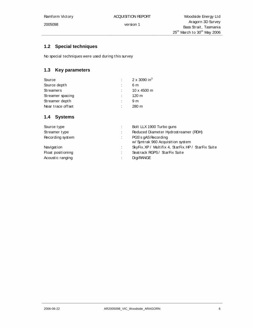
1.2 Special techniques
No special techniques were used during this survey
1.3 Key parameters
Source : 2 x 3090 in3 Source depth : 6 m Streamers : 10 x 4500 m Streamer spacing : 120 m Streamer depth : 9 m Near trace offset : 280 m
1.4 Systems
Source type : Bolt LLX 1900 Turbo guns Streamer type : Reduced Diameter Hydrostreamer (RDH) Recording system : PGS’s gAS Recording w/Syntrak 960 Acquisition system Navigation : SkyFix.XP / Multifix 4, StarFix.HP / StarFix Suite Float positioning : Seatrack RGPS / StarFix Suite Acoustic ranging : DigiRANGE

Ramform Victory ACQUISITION REPORT Woodside Energy Ltd
2005098 version 1 Aragorn 3D Survey
Bass Strait, Tasmania 25th March to 30th May 2006
2006-06-22 AR2005098_VIC_Woodside_ARAGORN 7
1.5 Production Statistics efficiencyperformanceinfill % (prime ff / infill ff)prime % complete
total averageprime traverse 1,768.05 26.39prime run out traverse 94.5 1.41infill traverse 303.92 4.54infill run out traverse 18 0.27u/shoot prime traverse 0 0u/shoot infill traverse 0 0total traverse 2,184.47 32.6prime cdp km 35,361.00 527.78prime run out cdp km 1,890.00 28.21infill cdp km 6,078.38 90.72infill run out cdp km 360 5.37u/shoot prime cdp km 0 0u/shoot infill cdp km 0 0total CDP Km 43,689.38 652.08prime sq km 1,060.83 15.83prime run out sq km 56.7 0.85infill sq km 182.35 2.72infill run out sq km 10.8 0.16u/shoot prime sq km 0 0u/shoot infill sq km 0 0total Sq Km 1,310.68 19.56
35.53%97.39%17.19%87.55%
Note: the “prime % complete” is only at 87.55% as the survey was ended early due to weather and other commitments.

Ramform Victory ACQUISITION REPORT Woodside Energy Ltd
2005098 version 1 Aragorn 3D Survey
Bass Strait, Tasmania 25th March to 30th May 2006
2006-06-22 AR2005098_VIC_Woodside_ARAGORN 8
1.6 Operational Statistics
Activity Total Hours % of Total
ProductionLine Change 246.47 15.33%Prime Production 227.87 14.17%Line Change - Infill 45.38 2.82%Infill 37.52 2.33%Run Out (Prime) 11.95 0.74%Run Out (Infill) 2.15 0.14%
StandbyWeather 889.3 55.30%Local Transit / Prospect Change 101 6.28%Fishing 15.2 0.95%
DowntimeRecording/QC Software 5.36 0.33%Acoustics 5 0.31%Active, Passive Modules 3.65 0.23%Bolt Airgun Airleak 0.75 0.05%Source Separation 0.22 0.01%Software problems inc. Crash 0.18 0.01%Streamer Interface Software 0.12 0.01%
General Demob 15.88 0.99%
Total Production 571.34 35.53%Total Standby 1,005.50 62.53%Total Downtime 15.28 0.95%Total MOB/DEMOB 15.88 0.99%
Total Hours 1,608.00Total Days 67d 0h 0m
During the survey there was a disagreement on standby time concerning crew change. The standby rate was cut in half to accommodate both parties during these times.

Ramform Victory ACQUISITION REPORT Woodside Energy Ltd
2005098 version 1 Aragorn 3D Survey
Bass Strait, Tasmania 25th March to 30th May 2006
2006-06-22 AR2005098_VIC_Woodside_ARAGORN 9
2 Sequence of Events
2.1 Daily Log
DATE Location & Comments25-Mar-06 Transit to survey area
26-Mar-06 Transit to survey area, commence streamer deployment
27-Mar-06 Deploying streamers28-Mar-06 Deploying streamers29-Mar-06 Deployment completed, commence production
30-Mar-06 Production, standby for weather recovering streamers
31-Mar-06 Standby for weather01-Apr-06 Standby for weather02-Apr-06 Standby for weather, deploying streamers03-Apr-06 Deploying streamers, production
04-Apr-06 Production, standby for weather recovering streamers
05-Apr-06 Standby for weather, alongside at Portland06-Apr-06 Standby for weather, alongside at Portland07-Apr-06 Standby for weather, alongside at Portland
08-Apr-06 Standby for weather, heading back to the prospect
09-Apr-06 Standby for weather, redeploying the streamers
10-Apr-06 Standby for weather streamer deployemnt aborted weather window to small
11-Apr-06 Standby for weather, head to shelter by King Island & anchor
12-Apr-06 Standby for weather, at anchor by King Island13-Apr-06 Standby for weather, at anchor by King Island14-Apr-06 Standby for weather, at anchor by King Island
15-Apr-06 Standby for weather, heading back to the prospect
16-Apr-06 Standby for weather, redeploying the streamers
17-Apr-06 Standby for weather streamer deployment aborted & equipment recovered
18-Apr-06 Standby for weather, head to shelter by King Island & anchor
19-Apr-06 Standby for weather, sheltering behind King Island
20-Apr-06 Standby for weather, sheltering behind King Island. Looping streamers

Ramform Victory ACQUISITION REPORT Woodside Energy Ltd
2005098 version 1 Aragorn 3D Survey
Bass Strait, Tasmania 25th March to 30th May 2006
2006-06-22 AR2005098_VIC_Woodside_ARAGORN 10
21-Apr-06 Standing by for weather, heading to Geelong for Bunkers
22-Apr-06 Standing by for weather, alongside Geelong Bunkers cancelled
23-Apr-06 Standby for weather, depart Geeelong & head back to the prospect
24-Apr-06 Standby for weather, heading back to the prospect & start deploying
25-Apr-06 Complete deployment & commence production. Downtime for air leak
26-Apr-06 Production / infill27-Apr-06 Production / infill28-Apr-06 Production / infill
29-Apr-06 Production / infill. Suspend production for helicopter crew change
30-Apr-06 Helicopter crew change abandon, return to production
01-May-06 Production. Picked up gear for Cx and Wx.
02-May-06 Quayside in Melbourne at 8:40. Standing by for Wx. Completed Cx. Took on MGO and streamer sections.
03-May-06 Quayside in Melbourne. Standing by for Wx.
04-May-06 Departed Melbourne and arrived in Geelong. Took on HFO and Lube oil. Standing by for Wx.
05-May-06 Quayside in Geelong. Standing by for Wx.06-May-06 Quayside in Geelong. Standing by for Wx.07-May-06 Quayside in Geelong. Standing by for Wx.08-May-06 Quayside in Geelong. Standing by for Wx.09-May-06 Quayside in Geelong. Standing by for Wx.
10-May-06 Departed Geelong at 12:00 for prospect. Still on Wx downtime.
11-May-06 Deploying streamers after being down for Wx.12-May-06 Wx downtime. Production.13-May-06 Production. 14-May-06 Production.15-May-06 Production.16-May-06 Production.17-May-06 Production.18-May-06 Production.19-May-06 Production.20-May-06 Production.

Ramform Victory ACQUISITION REPORT Woodside Energy Ltd
2005098 version 1 Aragorn 3D Survey
Bass Strait, Tasmania 25th March to 30th May 2006
2006-06-22 AR2005098_VIC_Woodside_ARAGORN 11
21-May-06 Production.22-May-06 Production.23-May-06 Productiion24-May-06 Production.25-May-06 Production.26-May-06 Production.27-May-06 Production. Array 1 depth rope tangled.28-May-06 Production. Fishing equipment.29-May-06 Production. 30-May-06 Production. End Of Survey.
Ramform Victory ACQUISITION REPORT Woodside Energy Ltd
2005098 version 1 Aragorn 3D Survey
Bass Strait, Tasmania 25th March to 30th May 2006
2006-06-22 AR2005098_VIC_Woodside_ARAGORN 12
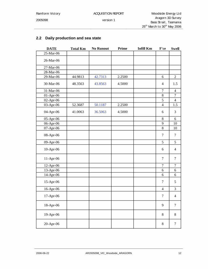
2.2 Daily production and sea state
DATE Total Km No Runout Prime Infill Km F'ce Swell25-Mar-06
26-Mar-06
27-Mar-0628-Mar-0629-Mar-06 44.9813 42.7313 2.2500 6 2
30-Mar-06 48.3563 43.8563 4.5000 4 1.5
31-Mar-06 7 401-Apr-06 8 702-Apr-06 5 403-Apr-06 52.3687 50.1187 2.2500 4 1.5
04-Apr-06 41.0063 36.5063 4.5000 6 3
05-Apr-06 8 606-Apr-06 9 1007-Apr-06 8 10
08-Apr-06 7 7
09-Apr-06 5 5
10-Apr-06 6 4
11-Apr-06 7 7
12-Apr-06 7 713-Apr-06 6 614-Apr-06 6 6
15-Apr-06 7 5
16-Apr-06 4 3
17-Apr-06 7 4
18-Apr-06 9 7
19-Apr-06 8 8
20-Apr-06 8 7

Ramform Victory ACQUISITION REPORT Woodside Energy Ltd
2005098 version 1 Aragorn 3D Survey
Bass Strait, Tasmania 25th March to 30th May 2006
2006-06-22 AR2005098_VIC_Woodside_ARAGORN 13
21-Apr-06 8 7
22-Apr-06 7 5
23-Apr-06 7 6
24-Apr-06 5 2
25-Apr-06 46.2750 44.0250 2.2500 5 2.5
26-Apr-06 85.6125 69.4315 6.7500 9.4310 4 227-Apr-06 83.9437 57.7499 4.5000 21.6938 4 2.528-Apr-06 93.3750 57.7500 4.5000 31.1250 4 2
29-Apr-06 86.9625 60.9000 2.2500 23.8125 4 2
30-Apr-06 39.3937 39.3937 3 3
01-May-06 23.7563 21.5063 2.2500 3 4
02-May-06
03-May-06
04-May-06
05-May-0606-May-0607-May-0608-May-06 7 609-May-06 7 6
10-May-06 6 5
11-May-06 6 412-May-06 60.9562 58.7062 2.2500 5 413-May-06 103.5188 96.7688 6.7500 5 414-May-06 82.2375 38.8687 2.2500 41.1188 5 415-May-06 83.4937 78.9937 4.5000 5 416-May-06 116.2500 72.8812 2.2500 41.1188 5 417-May-06 88.0875 81.3375 6.7500 5 318-May-06 104.2687 99.7687 4.5000 5 419-May-06 97.8188 34.6688 63.1500 6 520-May-06 59.9812 59.9812 5 4

Ramform Victory ACQUISITION REPORT Woodside Energy Ltd
2005098 version 1 Aragorn 3D Survey
Bass Strait, Tasmania 25th March to 30th May 2006
2006-06-22 AR2005098_VIC_Woodside_ARAGORN 14
21-May-06 67.6688 67.6688 5 422-May-06 48.2813 25.6688 22.6125 4 423-May-06 82.3313 80.0813 2.2500 4 324-May-06 82.6875 80.4375 2.2500 4 325-May-06 91.1438 86.6438 4.5000 4 326-May-06 97.0688 90.3188 6.7500 4 327-May-06 88.1813 83.6813 4.5000 4 328-May-06 69.2813 64.7813 4.5000 4 329-May-06 99.9563 32.1000 2.2500 65.6063 4 230-May-06 21.4125 16.9125 2.2500 2.2500 4 2
Wind Force: Beufort Scale Swell: Meters
0.0000
20.0000
40.0000
60.0000
80.0000
100.0000
120.0000
140.0000
25-Mar-06 01-Apr-06 08-Apr-06 15-Apr-06 22-Apr-06 29-Apr-06 06-May-06 13-May-06 20-May-06 27-May-060
2
4
6
8
10
12
Total KmWind F'ceSwell
Ramform Victory ACQUISITION REPORT Woodside Energy Ltd
2005098 version 1 Aragorn 3D Survey
Bass Strait, Tasmania 25th March to 30th May 2006
2006-06-22 AR2005098_VIC_Woodside_ARAGORN 15
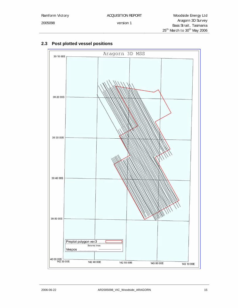
2.3 Post plotted vessel positions

Ramform Victory ACQUISITION REPORT Woodside Energy Ltd
2005098 version 1 Aragorn 3D Survey
Bass Strait, Tasmania 25th March to 30th May 2006
2006-06-22 AR2005098_VIC_Woodside_ARAGORN 16
3 Key personnel
24th March to 02nd May 2006 02nd May to 03rd June 2006
Party Chief Lea Farmer John MacKay
Chief observer Paal Halvorsen Udo Bar
Chief navigator Martin Link Thorne Sutherland
Navigator Processor Robert Millard Richard Browne
Chief mechanic Tore Garvik Torgeir Krydsby
Chief geophysicist QC Roger Elliff Gijsbert Meesters
Chief geophysicist Michael Illingworth Ye Zai Bing
Client representative onboard Paul Round Paul Round
Peter Chen Benjamin Goodwin
MMO Joshua Smith Joshua Smith
Ramform Victory ACQUISITION REPORT Woodside Energy Ltd
2005098 version 1 Aragorn 3D Survey
Bass Strait, Tasmania 25th March to 30th May 2006
2006-06-22 AR2005098_VIC_Woodside_ARAGORN 17
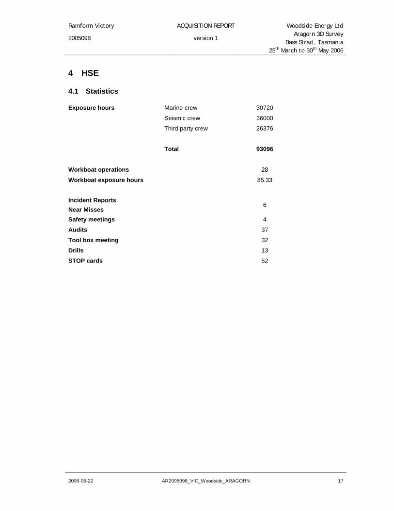
4 HSE
4.1 Statistics
Exposure hours Marine crew 30720
Seismic crew 36000
Third party crew 26376
Total 93096
Workboat operations 28
Workboat exposure hours 85.33
Incident Reports Near Misses
6
Safety meetings 4
Audits 37
Tool box meeting 32
Drills 13
STOP cards 52

Ramform Victory ACQUISITION REPORT Woodside Energy Ltd
2005098 version 1 Aragorn 3D Survey
Bass Strait, Tasmania 25th March to 30th May 2006
2006-06-22 AR2005098_VIC_Woodside_ARAGORN 18
4.2 Incidents / Near Misses
Report no. Date Action by Classification Status Comments
VIC0610 31-Mar-06 TSM / BSM
Near miss Open Focus no. 2350/06/MA – partial black out due to main engine shutdown. Under investigation
VIC0611 14-Apr-06 TSM / BSM
Equipment Failure Closed
Focus no. 2743/06/MA – potential for an oil spill from hydraulic space drainage. This is now plugged and cannot go overboard. This is on the next yard list to be re-routed in mid-July.
VIC0612 17-Apr-06 PGS Equipment damage Closed
Focus no. 2966/06/MA – Rough weather damage & equipment failure on the Cassandra. Equipment fix.
VIC0613 24-Apr-06 TSM / BSM
Equipment failure Closed
Focus no. 3242/06/MA – Failure of HFO / MGO change over valve causing diesel to be sprayed over exhaust boiler. This was modified with a plate so this could not happen.
VIC0614 30-Apr-06 PGS Near Miss Closed Focus 3242/06/MA – Monitor fell during bad weather just missing Observer. Secured better.
VIC0615 11-May-06 TSM / BSM
Equipment failure Closed
Focus 3770/06/MA - Failure of the new Westfalia Bilgemaster 3000 OWS valve after being cleaned.
Valve was taken rebuilt. Close supervision during the operation of the valve when cleaning of the cell in the future.
During the survey the onboard client representative was given access to the PGS Focus Safety system so that he could monitor incident reports, near misses, STOP cards, etc.
Ramform Victory ACQUISITION REPORT Woodside Energy Ltd
2005098 version 1 Aragorn 3D Survey
Bass Strait, Tasmania 25th March to 30th May 2006
2006-06-22 AR2005098_VIC_Woodside_ARAGORN 19
5 Survey operations review
5.1 Survey area information
Oilfield installations
There is the MEARSK GUARDIAN Rig 9 km to the North of Area D. This did not affect our shooting as we did not shoot Area D.
Oilfield activity
A small amount of activity in the THYLACINE field to the MEARSK GUARDIAN, but as all vessels co-operated very well, we did not encounter any problems.
Shipping Activity
There was virtually no shipping activity within the vicinity of the prospect. A small quantity of coastal traffic was sighted, but here again, all vessels gave us their fully co-operation when we contacted them on the VHF radio.
Sea Conditions, Tides and Currents
The prevailing winds were from the south-west as was the swell, which averaged 2 to 9 metres during the early part of the survey.
Currents, either general or localised, did not have an affect on the survey operation; neither did the tides, which varied by approximate 1.4 m in the area.
In Sea Dangers
None present during the survey.
Time sharing
There was no other seismic activity within the area, and therefore time sharing was not required.
Fishing Activity
There were 2 lines that were terminated early due to fishing traps. These were Sequences 36 and 46. Most of the fishing boats that we encountered were very cooperative and moved out of the area.
Woodside did a very good job on communicating with the fishermen on the shoreside, which was the main reason for such good cooperation.
Weather
Bad weather periods were experienced from 30th March to 03rd April, 04th April to 25th April and 01st May to 12th May 2006. During these periods the vessel either went to port for safety or stood by behind King Island.
Cetaceans
There were zero cetaceans sighted during the survey. PGS / Woodside soft start procedure was enforced throughout the survey. An MMO rode the boat to help lookout for any whales.

Ramform Victory ACQUISITION REPORT Woodside Energy Ltd
2005098 version 1 Aragorn 3D Survey
Bass Strait, Tasmania 25th March to 30th May 2006
2006-06-22 AR2005098_VIC_Woodside_ARAGORN 20
Operational Planning
Due to the effect of the weather during the early stages of the survey, several changes were made to the area and to the method of acquisition. This was done to ensure continuous data across the greatest amount of area, as well as guarantee the target zone was covered during the available weather windows.
The major change to the area consisted of shortening the longest lines of the survey, shown as Area B in the diagram below. Woodside deemed that this was sufficient to cover the primary area of interest. Two sequences had been acquired in the normal ‘race track’ acquisition cycle prior to making this change, so it was decided to collect data between these two sequences in an alternating pattern, acquiring adjacent lines in opposite directions. Once the gap between the two original sail lines was closed, acquisition continued using the alternating method in the easterly direction.

Ramform Victory ACQUISITION REPORT Woodside Energy Ltd
2005098 version 1 Aragorn 3D Survey
Bass Strait, Tasmania 25th March to 30th May 2006
2006-06-22 AR2005098_VIC_Woodside_ARAGORN 21
As the vessel approached the completion of Area B, the weather forecast remained favourable, so Woodside then decided to re-implement the original line length for Area B sail lines 1390-1550 (the eastern half of Area B), acquiring them in the same direction as the southern segments.
Once these requirements in Area B were satisfied, the vessel continued, still using an alternating pattern, acquiring data in an easterly direction until the area consisting of sail lines 1610 – 1850 (Area C), was complete.

Ramform Victory ACQUISITION REPORT Woodside Energy Ltd
2005098 version 1 Aragorn 3D Survey
Bass Strait, Tasmania 25th March to 30th May 2006
2006-06-22 AR2005098_VIC_Woodside_ARAGORN 22
6 Seismic energy source
6.1 Source Performance
The source performed very well during the survey with only 0.97 hours of downtime during the project. There were two incidents that caused the downtime. One was for an airleak and the second was for towing and handling when the depth rope tangled up in the gun and the SOL was delayed.
General maintenance was performed during line changes and did not cause any downtime.
6.2 Source details
Source type : Bolt air guns Air pressure : 2000 psi Volume : 3090 in3 Number of sources : 2 Number of sub-arrays : 3 Source separation : 60 m Sub-array separation : 12 m Source length : 14 m Gun synchronisation : ± 1.0 ms Shot interval : 18.75 m Flip - Flop Depth : 6 m Depth control : Fixed depth ropes Depth monitoring : Syntron depth transducers, GCS-90 Spacing control : Spread-ropes on sliding collars Near field signatures : 7 phones per sub-array Compressors : 3 x LMF 47/138 Source controller : GCS-90 Modelled source signature : See Appendix 12.2 for further details

Ramform Victory ACQUISITION REPORT Woodside Energy Ltd
2005098 version 1 Aragorn 3D Survey
Bass Strait, Tasmania 25th March to 30th May 2006
2006-06-22 AR2005098_VIC_Woodside_ARAGORN 23
6.3 Offset diagrams

Ramform Victory ACQUISITION REPORT Woodside Energy Ltd
2005098 version 1 Aragorn 3D Survey
Bass Strait, Tasmania 25th March to 30th May 2006
2006-06-22 AR2005098_VIC_Woodside_ARAGORN 24
6.4 Gun array diagrams

Ramform Victory ACQUISITION REPORT Woodside Energy Ltd
2005098 version 1 Aragorn 3D Survey
Bass Strait, Tasmania 25th March to 30th May 2006
2006-06-22 AR2005098_VIC_Woodside_ARAGORN 25

Ramform Victory ACQUISITION REPORT Woodside Energy Ltd
2005098 version 1 Aragorn 3D Survey
Bass Strait, Tasmania 25th March to 30th May 2006
2006-06-22 AR2005098_VIC_Woodside_ARAGORN 26
7 Seismic acquisition system
7.1 System details
Recording System : gAS, with direct Ethernet link to Viper Software Version : 3.0.2-6 Amplitude resolution : 24 bit Data Channels : 3600 Auxiliary Channels : 48 Tape Transports : 6 x IBM 3590 cartridge drives Tape Format : SEG D, 8036 Recording Media : Imation, 3590 Record Length : 9216ms Deep water delay : 0 ms Sample Rate : 2 ms High Cut Filter : 206 Hz / 276 dB/octave Low Cut Filter : 3 Hz / 12 dB/octave Gain Setting : 12 dB Amplifier : Voltage Mode differential Input Range : 0-2048 mV A/D Converter : Delta Sigma Architecture Distortion : < 0.0005 % (-106 dB) Cross-Feed Isolation : > 110 dB Power Consumption : 7.5 W per module Polarity Convention : SEG, positive pressure gives negative number SEG-D header description : see Appendix 12.3 for further details

Ramform Victory ACQUISITION REPORT Woodside Energy Ltd
2005098 version 1 Aragorn 3D Survey
Bass Strait, Tasmania 25th March to 30th May 2006
2006-06-22 AR2005098_VIC_Woodside_ARAGORN 27
7.2 System timing
t0 ( Shot Predict)
170 ms
120 ms
50 ms
System Start -170ms
Start of Record -120 ms
Fire Command -50 ms
gAS Trigger -120 ms
Acoustic / Bird Trigger 0 ms
120 ms

Ramform Victory ACQUISITION REPORT Woodside Energy Ltd
2005098 version 1 Aragorn 3D Survey
Bass Strait, Tasmania 25th March to 30th May 2006
2006-06-22 AR2005098_VIC_Woodside_ARAGORN 28
7.3 Streamers
7.3.1 Streamer Performance
The Streamers had been pre-ballasted for this area prior to start of the survey. Some fine tuning was carried out during the beginning of the survey.
During the survey there was a down time of 3.65 hours for the streamers. This is broken down into active streamer module failures and telemetry failure.
The above problems were safely fixed from the workboat.
Other general maintenance and repairs of the in-water equipment was done during the line changes from the workboat. This did not cause any production downtime.
7.3.2 Streamer details
Type of streamer : PGS Reduced Diameter Hydro-streamer Number of streamers : 10 Streamer sensitivity : 20 V/bar Streamer length : 4500 m Number of groups : 360 Group interval : 12.5 m Group length : 12.5 m Hydrophone type : T-2 Streamer depth control : Digibird 5011 Streamer depth : 9 m Number of compass-birds : See streamer layout Section 7.5
7.3.3 Trace Numbering
STREAMER TRACE
Streamer 1 1 to 360
Streamer 2 361 to 720
Streamer 3 721 to 1080
Streamer 4 1081 to 1440
Streamer 5 1441 to 1800
Streamer 6 1801 to 2160
Streamer 7 2161 to 2520
Streamer 8 2521 to 2880
Streamer 9 2881 to 3240
Streamer 10 3241 to 3600
Auxiliaries 1 to 48

Ramform Victory ACQUISITION REPORT Woodside Energy Ltd
2005098 version 1 Aragorn 3D Survey
Bass Strait, Tasmania 25th March to 30th May 2006
2006-06-22 AR2005098_VIC_Woodside_ARAGORN 29
7.3.4 Component dimensions
No. per STREAMER
(Streamers 1-2, 5-6 and 9-10) No. per STREAMER (Streamers 3-4 and7-8)
NOMINAL LENGTH (m)
Lead-in 1 1 700 to 1100
Head Stretch Sections 1 1 3
Syntrak Module 24 24 0.358
RDH-S Live Sections Active 57 to Active 66
(750 m)
Active 47 to Active 66
(1500 m) 74.54
RDH Live Sections Active 01 to Active 56
(4200 m)
Active 01 to Active 46
(3450 m) 74.54
Tail Stretch Sections 1 1 50
Power Adapter Section 1 1 0.358
7.4 Recording System
7.4.1 Recording System performance
The gAS recording system and the Syntrak MSTP system perfomed well during the survey. There was a total of 5.66 hours downtime. This is broken down into 0.18 hours downtime for a gAS lock-up, 0.12 hours downtime for a Syntrak lock-up, and 5.37 hours downtime for the edit, which includes a line change to re-shoot the Syntrak lock-up.

Ramform Victory ACQUISITION REPORT Woodside Energy Ltd
2005098 version 1 Aragorn 3D Survey
Bass Strait, Tasmania 25th March to 30th May 2006
2006-06-22 AR2005098_VIC_Woodside_ARAGORN 30
7.5 Streamer layout

Ramform Victory ACQUISITION REPORT Woodside Energy Ltd
2005098 version 1 Aragorn 3D Survey
Bass Strait, Tasmania 25th March to 30th May 2006
2006-06-22 AR2005098_VIC_Woodside_ARAGORN 31
8 Navigation and Positioning
8.1 Navigation Performance
Overall data quality from the various navigation systems ranged between good to excellent. Data from the in-water sensors (compass headings and acoustic ranging) was degraded during periods of marginal weather, but was of sufficient quality that an adequate solution was provided for all sequences. Detailed discussions on each specific system may be found in the following sections.
The only downtime attributed to Navigation causes for this survey was one instance, in which one of tail buoys was improperly configured on deployment resulting in the loss of production of five hours to troubleshoot and rectify the problem.
8.2 Geodetic reference
8.2.1 Survey Datum
Survey datum : GDA94 Ellipsoid : GRS80 Semi Major Axis : 6,378,137 m 1/Flattening : 298.257222101 m
GPS Datum : WGS84 Ellipsoid : WGS84 Semi Major Axis : 6,378,137 m 1/Flattening : 298.257223563 m
Datum shift from WGS84 to GDA94
EPSG Transformation code : N/A* X translation : -0.0046 m Y translation : -0.0394 m Z translation : -0.0687 m X Rotation : -0.015486” Y Rotation : -0.013723” Z Rotation : -0.016079” Scale (ppm) : 0.004438
Geoid height (EGM96 model) : -5.5 m (for position 39º30’ S, 142º55’ E)
* These transformation values were supplied by Woodside prior to the start of the survey.
8.2.2 Map projection
Projection : Transverse Mercator Projection System : MGA94 (UTM Zone 54) Central Meridian : 141º E Scale Factor on Central Meridian : 0.9996 Latitude of Origin : 0º False Northing : 10,000,000 m False Easting : 500,000 m

Ramform Victory ACQUISITION REPORT Woodside Energy Ltd
2005098 version 1 Aragorn 3D Survey
Bass Strait, Tasmania 25th March to 30th May 2006
2006-06-22 AR2005098_VIC_Woodside_ARAGORN 32
8.2.3 Binning grid
bin grid origin
map grid East
map
gri
d N
orth
θ
X axis
Y ax
issh
ooti
ng d
irec
tion
Origin Easting (m) : 665649.26869 Origin Northing (m) : 5586138.9409 Rotation (deg) : 331.003°
X Y
Origin bin number 967 841
Bin number increment 1 0.333…
Area size (m) 36,240.00 66,881.25
Bin interval (m) 30 6.25
Bin size minimum (m) at 0 m offset 30 6.25
Bin size maximum (m) at 4950 m offset 30 6.25
A Static bin flex was applied as follows (from near trace):
Segment Offset Range Max bin width
Near 0 – 1125 60 m
Near Mid 1125 – 2250 0 m
Far Mid 2250 – 3375 60 m
Far 3375 – 4500 90 m

Ramform Victory ACQUISITION REPORT Woodside Energy Ltd
2005098 version 1 Aragorn 3D Survey
Bass Strait, Tasmania 25th March to 30th May 2006
2006-06-22 AR2005098_VIC_Woodside_ARAGORN 33
8.3 Surface positioning
8.3.1 System I
Type : SkyFix.XP, Dual frequency DGPS Differential Corrections via : Inmarsat IOR, OCSAT High Power Reference stations : XP is a global orbit and clock correction solution;
local reference stations are not used. Software : Multifix 4, Version 1.09 Sub-Contractor : Fugro Survey
8.3.2 System II
Type : StarFix.HP, Dual Frequency phase based DGPS Differential Corrections via : Inmarsat POR, OCSAT High Power
Reference stations : Melbourne 250 km distant Bathurst 900 km distant Cobar 925 km distant Ceduna 1175 km distant Brisbane 1625 km distant
Software : SPM2000, Version 4.15 Sub-Contractor : Fugro Survey
The StarFix.HP system was very problematic throughout the survey. It would suddenly reset the HP computation. After some correspondence with the contractor, Fugro, it was suggested to change the way in which the SPM2000 selects the source for the correction data. For the start of the survey, this was set to All Sources. This was changed so that the system used a dedicated correction source (the first port), and would only use the secondary if the connection was lost. It is Fugro’s belief that there is a software problem when using the All Sources setting that is causing the HP position calculations to reset.
In post processing it was seen that StarFix.HP was unusable for the first 20 lines except for sequences 011, 014, & 015, but during these sequences there were data jumps requiring edits for a maximum of 550 shot points. From sequence 021 the HP system was stable and compared well enough with StarFix.XP to be used in the solution, however, for sequences 030, 032, 042 & 064 StarFix.HP required edits during these lines.
StarFix.XP performed well for all lines except sequence 037 were there were data spikes of no more than 20 shots required editing.
With the edits aside and poor data excepting, the two systems compared well throughout the survey as can be seen in the following comparisons. Comparisons between the systems, after processing, showed maximum mean differences in the order of 0.6 metre or less in Easting and Northing for all the sequences.

Ramform Victory ACQUISITION REPORT Woodside Energy Ltd
2005098 version 1 Aragorn 3D Survey
Bass Strait, Tasmania 25th March to 30th May 2006
2006-06-22 AR2005098_VIC_Woodside_ARAGORN 34
The following two graphs depict the mean differences in Northing and Easting respectively for complete sequences, between SkyFix.XP and StarFix.HP.
Mean difference, Skyfix XP vs Starfix HP System
-1.00
-0.80
-0.60
-0.40
-0.20
0.00
0.20
0.40
0.60
0.80
1.00
001
003
005
007
009
011
013
015
017
019
021
023
025
027
029
031
033
035
037
039
041
043
045
047
049
051
053
055
057
059
061
063
065
Sequence
Met
ers
Delta Northing
Mean difference, Skyfix XP vs Starfix HP System
-1.00
-0.80
-0.60
-0.40
-0.20
0.00
0.20
0.40
0.60
0.80
1.00
001
003
005
007
009
011
013
015
017
019
021
023
025
027
029
031
033
035
037
039
041
043
045
047
049
051
053
055
057
059
061
063
065
Sequence
Met
ers
Delta Easting

Ramform Victory ACQUISITION REPORT Woodside Energy Ltd
2005098 version 1 Aragorn 3D Survey
Bass Strait, Tasmania 25th March to 30th May 2006
2006-06-22 AR2005098_VIC_Woodside_ARAGORN 35
8.3.3 Float positioning
Relative GPS : Seatex 320/220 GPS receiver : Ashtech G 12-L UHF communication : Wood & Douglas, frequency 450-470 MHz Software version : StarFix Suite RGPS Vers.2.08.02
Data from the buoy-tracking system was very good, and only minimal gating and low-pass filtering were required to remove isolated spikes and noise. All 10 tail buoy units were operational for all sequences of the survey except for sequence 009 where TB1 required an 800 shot point edit and sequence 031 which required two edits of no more than 90 shot points. At no time were there less than 9 operational tail buoy units used in the solution.
For the source units, there were never less than five active gun units at any time. No down-time was attributed to the buoy-tracking system except as mentioned in section 7.1 during deployment.
8.3.4 Heading reference
GPS Heading / Attitude system : Seapath 200 Gyro : SG Brown Meridian Surveyor
Seapath was used as the default vessel-heading indicator, and the conventional SG Brown gyro served as a back-up. Seapath performed without interruption for all sequences except for sequence 030 where Seapath had a data loss for 52 shot points, in this instance the backup gyro was used in post processing. Seapath and gyro data were de-spiked but not filtered
8.3.5 Delivered P1/90 and P2/94
Raw navigation data were recorded in UKOOA P2/94 format during acquisition and written to 3590 tape and hard disk. At the conclusion of each sequence, the data format was checked and any necessary updates made to the header to produce a final, deliverable P2/94 file. Two sets of P2/94 data on 3590 tape were delivered to the client, and one additional set on 3590 tape was archived at PGS offices in Oslo, Norway. Also included in the delivery to the client was a DVD-ROM containing all the P2/94 files, individually compressed.
All final p294 data files were included with linefeed as per the client’s request.
The following comments concerning the datum transformation were inserted into all P2/94 files after a request by the PGS office:-
C0001 Due to format limitation in record H0120. Exact datum shift WGS84-GDA94:
C0001 dx= -0.0046, dy= -0.0394, dz= -0.0687, rx= -0.015486, ry= -0.013723,
C0001 rz= -0.016079, scale correction= 0.004438E-6
This same comment was also inserted into the P1/90 header as H2600 records.
Processed navigation data were provided in UKOOA P1/90 format. The P1/90 data were written to 3590 tape with individual sequence headers and included position records for vessel, sources, tail buoys, echo sounder, CMP positions, and all receiver groups. Two sets of P1/90 data on 3590 tape were delivered to the client, and one additional set on 3590 tape was archived at PGS offices in Oslo, Norway.

Ramform Victory ACQUISITION REPORT Woodside Energy Ltd
2005098 version 1 Aragorn 3D Survey
Bass Strait, Tasmania 25th March to 30th May 2006
2006-06-22 AR2005098_VIC_Woodside_ARAGORN 36
All final p190 data files were included with linefeed, the depth records in each file corrected for vessel draft, velocity of sound through the water column and tide corrected as per the client’s request. Also included in the delivery to the client was a DVD-ROM containing all the P1/90 files, individually compressed.
8.3.6 Navigation Sensor Offsets

Ramform Victory ACQUISITION REPORT Woodside Energy Ltd
2005098 version 1 Aragorn 3D Survey
Bass Strait, Tasmania 25th March to 30th May 2006
2006-06-22 AR2005098_VIC_Woodside_ARAGORN 37
8.4 Underwater positioning
8.4.1 Acoustic ranging system
System name : DigiRange Software version : System 3, Version 5.01 Frequency : 50- 110 kHz
8.4.2 Acoustic network
It should be noted that two units on streamer 5 were deployed in non-standard locations; one was located in the mid-net and the other was at the head of the streamer. This did not degrade positioning quality so it was decided after discussions with the onboard client representative that these would not be relocated after the start of the survey.

Ramform Victory ACQUISITION REPORT Woodside Energy Ltd
2005098 version 1 Aragorn 3D Survey
Bass Strait, Tasmania 25th March to 30th May 2006
2006-06-22 AR2005098_VIC_Woodside_ARAGORN 38
Acoustic data was of good quality throughout the duration of the project. All ranges were set to two-way ranging. However, in areas where the acoustic environment is noisier or deteriorated, such as behind the vessel and gun arrays, one-way ranges were used in Sprint post-processing i.e., the vessel to streamer and gun to streamer observations, in preference to the two-way observations. Additionally, one-way ranges were used in instances where the two-way ranges were deteriorated on any given line, decided on a line by line basis.
During periods of marginal weather, ranging between the tail-buoys did not occur due to the equipment limitations, although one-way ranging to the streamers was present.
8.4.3 Magnetic compasses
Bird Compasses : Digicourse, 5011 Bird Software version : System 3, version 5.01 Magnetic variation : 2.57
Eighteen DigiCourse compasses were deployed on each of the inner eight streamers, with twenty placed on the two outer most streamers (to assist with depth keeping, not for additional redundancy in heading data).
The compass data was at best satisfactory and fairly free of noise at the streamer’s target depth due to the continual & prevalent SW swell, for approximately 75% of the lines this required moderate processing with gating and low-pass filtering. For the remainder of the prospect weather conditions and sea state necessitated the use of strong processing and gating and filter values, during these lines, the a priori SD value for compasses was raised to a maximum of 1 degree in order to counteract these conditions. Compass data for all sequences were analysed for biases, stuck values and excessive noise. Unacceptable compasses were rejected from the post-processing solution and physically replaced when appropriate
8.4.4 Echosounder
Type and model : SIMRAD EA500 Transceiver frequency : 12 kHz/ 38kHz / 200kHz Heave compensated : Yes, MRU5
The water depth data was de-spiked, but not filtered.
No tide corrections were applied in Sprint and the depth as measured from the echo sounder was written to the raw P1/90. The propagation velocity used in the echo sounder was 1500 m/s. As mentioned above in section 8.3.4., velocity, tidal and draft corrections were applied to the final P1/90 before delivery to the client.
Data for the 12 kHz and 38 kHz transducers were recorded throughout the survey, and from Sequence 059 recording of the 200 kHz began. Final P1/90 depths were derived from the 38 kHz transducer, which performed generally well throughout the majority of the survey, up until Sequence 059 where it was deemed necessary to use the 200 kHz transducer for derived depths.
However on Sequence 03, the bow thruster was left on at the start of line and therefore no depth data for first 180 shot points was present. Client requests for data in this section necessitated the merging of the depths derived from the seismic data. Loss of depth data also happened for Sequence 036 when the bow thruster had to be used online due to marginal weather, this created three gaps no larger than 130 shot points where echo sounder data was absent, again this was rectified by having the seismic depth derived data merged into the final p190.

Ramform Victory ACQUISITION REPORT Woodside Energy Ltd
2005098 version 1 Aragorn 3D Survey
Bass Strait, Tasmania 25th March to 30th May 2006
2006-06-22 AR2005098_VIC_Woodside_ARAGORN 39
Depth ranged from approximately 100 meters - 1970 meters
After the survey was completed, one special P1/90 tape W06ARGE011 containing echo sounder positions and water depths was created.
Below is shown an extraction from the P1/90 tape W06ARGE011. This shows what the water depth data has been corrected for.
8.4.5 Sound velocity
CDT probe : Valeport 604-CTD Real time sensors : 3 x Digicourse Velocimeter - 7000
The chart on the following page was produced with data from the Valeport. A total of six profiles were collected during the survey.

Ramform Victory ACQUISITION REPORT Woodside Energy Ltd
2005098 version 1 Aragorn 3D Survey
Bass Strait, Tasmania 25th March to 30th May 2006
2006-06-22 AR2005098_VIC_Woodside_ARAGORN 40

Ramform Victory ACQUISITION REPORT Woodside Energy Ltd
2005098 version 1 Aragorn 3D Survey
Bass Strait, Tasmania 25th March to 30th May 2006
2006-06-22 AR2005098_VIC_Woodside_ARAGORN 41
Three real time sensors were used to provide dynamic sound velocities for all acoustic range calculations, both in real-time and for network adjustment in post processing. These were located on streamer 4; one at the front, one in the mid-net and one near the tail (see acoustic network diagram). Range data from each of the acoustic units was then associated with the closest probe.
8.5 Navigation and binning systems
8.5.1 Integrated navigation system
Type : SPECTRA Supplier : Concept Systems Ltd. Software version : 10.09.01 Real Time Interface : PowerRTNU v Machine type : Server IBM x235 X-terminals : IBM Netstation Tape storage : DAT Tapes External disks : Raid 5 System
8.5.2 Binning system
Type : CENSUS Supplier : I/O Inc Software Version : 4.4.1 Machine type : IBM RS/6000 H50 Tape storage : IBM 3950 External disks : RAID5 SSA Serial Storage Architecture, 76GB.

Ramform Victory ACQUISITION REPORT Woodside Energy Ltd
2005098 version 1 Aragorn 3D Survey
Bass Strait, Tasmania 25th March to 30th May 2006
2006-06-22 AR2005098_VIC_Woodside_ARAGORN 42
9 Navigation processing
9.1 Introduction
Data were processed using SPRINT. The processing was comprised of the following steps:
• Data import • Data pre-processing • Network adjustments • Data export • Final quality control
Each of these steps is covered in more detail below.
9.2 Data import
Raw data were recorded to tape and disk in P2/94 format. After the end of the line these data were checked, and if necessary, corrections were made to the header to produce a final archived version.
These data were then imported into Sprint, and a QC report generated. Included in this report were:
• P2/94 format errors or inconsistencies • differences in configuration between successive files • changes in gun sequence • time between shots not within specified limit • jump in shot numbers • number of headers
9.3 Pre-processing
All data were pre-processed to ensure consistent results in the adjustment phase.
During pre-processing, observations were grouped by sensor type. Predefined spike rejection gates and noise suppression filters were applied to the raw data. Configuration files were used to save all gating and filter values. After analysis, the final values were applied in a batch mode.
Where circumstances dictated, the values were changed interactively before the data were batched.
After pre-processing of all the observations, a quality report was generated containing the following information:
Nobs : Number of raw observations. Nrej : Number of data observations missing after processing. Bad block : Maximum block of missing raw data (in seconds). Nominal : Nominal values computed from the logged offsets, or user assigned. Mean : Mean value of the observation. Max. Delta : The maximum shot to shot increment. Units : In which unit data is recorded.

Ramform Victory ACQUISITION REPORT Woodside Energy Ltd
2005098 version 1 Aragorn 3D Survey
Bass Strait, Tasmania 25th March to 30th May 2006
2006-06-22 AR2005098_VIC_Woodside_ARAGORN 43
9.4 Network adjustments
The network adjustment stage consisted of a least squares adjustment of the processed observations for each shot point. The software allows the observations to be treated as either a complete net, or a series of sub nets (e.g.: vessel antenna, front net, tail net, etc.). Sub nets were used for analysis of problem lines. A complete net was used for final adjustment after the individual sub nets were solved.
The streamer-shaping algorithm in use was an arc of curve fit through the pre-processed compasses. The streamer shape is adjusted through network computed node positions.
At the end of the net adjustment, a quality report was generated. Items included were:
• Network configuration • Statistics on node covariance’s • All observations scale/correction/SD in use • Statistics on node shot point intervals • Statistics on observation residuals • Statistics on network variance factor and degrees of freedom • The error ellipse (semi-major axis/skew) of all defined nodes • Streamer rotation
9.5 Data analysis
Data analysis were performed for all lines and allowed all data from the Ingres database to be displayed. There were two main uses for this facility. The first was to produce a standard set of QC plots for each line, and the second was to act as an investigation tool for problems seen at any stage of processing.
Configuration files were defined to create a standard set of QC plots for every line.
Configuration files were defined to create a standard set of QC plots for every line.
The following plots were included:
• Inline streamer misclosures. • Streamer rotations. • Streamer feather angles. • Streamer separations. • Source and source sub-array separations. • Offsets for vessel to sources and sources to near hydrophone groups. • Shot point intervals (distance and time) of vessel position. • Gyro and course-made-good of vessel. • Vessel position comparison (Field position vs. Post-processed position). • Network variance factor and degrees of freedom. • Speed of sound in water. • Water depth.

Ramform Victory ACQUISITION REPORT Woodside Energy Ltd
2005098 version 1 Aragorn 3D Survey
Bass Strait, Tasmania 25th March to 30th May 2006
2006-06-22 AR2005098_VIC_Woodside_ARAGORN 44
9.6 Data export, P1/90 output
During the export process the receiver positions were computed and a P1/90-file was generated. The in-line misclosures error was accounted for by applying a linear distribution of the error to computed receiver positions. A header was added to the data during export.
The data were written to 3590 tape cartridges.
9.7 Data quality control procedures
The first line was sent to the office for QC. Both the P1 and P2 headers were checked. The line was processed and the solution was compared with the P190 file from the vessel. This procedure was repeated after each crew change to make sure there were no errors introduced.
The final P2/94 tapes were checked using PGS internal software p2list. This program checked and returned the following information:
• Which files were on a tape and if each file had a complete header. • Number of end-of-file markers and if the last record had an EOF mark. • The filename, the sequence, the media label identifier (H0003), the number of shots, the
number of shot inconsistencies (missing or double shots) and the number of records. • A checksum, which were used to verify that data on tape were identical to data on disk. • For every file the first and last E1000 record was printed. • If there were shot inconsistencies, the E1000 records surrounding the inconsistency were
printed.
Final quality control performed on the data included a number of streamer comparisons, both inline and streamer-to-streamer.
• Vessel, source and receiver positions were checked for internal consistency. • The applied streamer rotations and the inline misclosures were checked. • Latitude/longitude and grid coordinates were checked against the datum/projection defined in
the header.
The final P1/90 files were also checked using a Sprint QC tool, which checked:
• Contents of the first and last vessel record. • Source id of the first and last source record. • Number of even and odd shot points with different source id. • Number of header records found. • Number of vessel, source, tail buoy and receiver records expected and how many were found. • Number of new line characters found.

Ramform Victory ACQUISITION REPORT Woodside Energy Ltd
2005098 version 1 Aragorn 3D Survey
Bass Strait, Tasmania 25th March to 30th May 2006
2006-06-22 AR2005098_VIC_Woodside_ARAGORN 45
The final P1/90 files were checked using a PGS internal software p1check. This program checked and returned the following information:
• Tape name and date of issue. • Datum/projection information from the header. • For every line in the file: start/end shot and start/end co-ordinates. • Standard comment record (H2600) concerning lines and shots in the file. • Linefeeds in the file. • All records 80 bytes long. • Number of end-of-file markers and if the last record had an EOF mark. • Grid co-ordinates correspond to the latitude and longitude with the given datum and projection. • A checksum, which were used to verify that data on tape were identical to data on disk.
The final P1/90 tapes were checked using PGS internal software p1list. This program checked and returned the following information:
• Which files were on a tape and if each file had a complete header. • Number of end-of-file markers and if the last record had an EOF mark. • The filename, the tape version identifier (H0202) and the number of records. • A checksum, which were used to verify that data on tape were identical to data on disk. • For every line in the file the line name, FSP, LSP and the position of SOL and EOL was given.
Results of the P2list, P1list and p1plot were saved and copies are archived in the Oslo office.
All tape labels were created using PGS internal software mklab. All information on the labels was extracted from the files on the tapes.
9.8 Computer systems
Computer : Dell Poweredge 2850 Operating System : Redhat Enterprise Linux 3 WS Tape storage : 2x IBM Magstar 3590 B1A External disks : RAID 10, 219 GByte Type : SPRINT Software version : 4.3.3 Supplier : Concept Systems Ltd. Printer / Plotter : HP laserJet 5M / DesignJet 755CM

Ramform Victory ACQUISITION REPORT Woodside Energy Ltd
2005098 version 1 Aragorn 3D Survey
Bass Strait, Tasmania 25th March to 30th May 2006
2006-06-22 AR2005098_VIC_Woodside_ARAGORN 46
10 Seismic data quality
In the following sub chapters, 11.1 to 11.4, several different kinds of (external) noise that were encountered are described and their consequent effect on the seismic data quality discussed. In sub chapters 11.5 to 11.8, we describe how and with what methods the seismic data were QC'd to ensure the quality of the final product.
10.1 Seismic interference
Seismic interference was not a problem during the acquisition of this survey. Sometimes, however, a single shot showed SI from unknown origin. For shots where this occurred, a warning or edit was put in the Observer’s log, depending on the amplitude of the SI.
10.2 Swell noise
During the acquisition of this survey (March-May 2006) swell noise was experienced during several lines. This swell noise was generally coming from low pressure systems at the SW of the survey area. Because the lines were orientated from North West to South East, and the swell was coming from the SW, the swell caused relatively less noise in the data.
To attenuate the swell noise, SINK (Seismic Interference Noise Killer) was applied to the data.
Where used, the SINK program parameterisation for QC testing was similar to that being employed by PGS Data Processing who was processing the data onboard.
See sub chapter 11.8 for the effect of swell noise on the Brute Stack. Also can be seen the stack after applying SINK to the data.
10.3 Ship noise
Ship noise from passing vessels was not a problem during the acquisition of these data.
10.4 Bad channels
Noisy traces: Some traces became noisy due to different causes, like damaged streamer compartments, debris caught on streamer, etc. If the noise of a trace became above acceptable levels, the trace was edited.
Spiking traces: Some traces went spiking due to various causes such as seawater in the cable. As a result, the affected channels were edited.
Dead/Weak traces: Some traces didn't show any response at all, and some only a very weak response. These traces were also edited.
Channels failing hydrophone leakage test: In cases where particular channels failed the hydrophone leakage tests, the affected sections were swapped out at the earliest opportunity.

Ramform Victory ACQUISITION REPORT Woodside Energy Ltd
2005098 version 1 Aragorn 3D Survey
Bass Strait, Tasmania 25th March to 30th May 2006
2006-06-22 AR2005098_VIC_Woodside_ARAGORN 47
10.5 RMS and noise analysis
The RMS graphs with all streamer and channel values for the Water Column and End of Record noise windows were a useful tool to identify the different types of noise encountered. In conjunction with the raw shot plots, the shot point and channel edits were confirmed / established on a line-by-line basis. The channel average RMS plots and signal window RMS plots are also checked for bad channels and gun anomalies as a back up to the observers QC.
Examples of the available plots are given below:
Channel average RMS noise (Water Column window 130-250ms) display for all streamers.
This display is used to help select bad/noisy channels for subsequent editing. This example was taken from line W06ARG1170P1

Ramform Victory ACQUISITION REPORT Woodside Energy Ltd
2005098 version 1 Aragorn 3D Survey
Bass Strait, Tasmania 25th March to 30th May 2006
2006-06-22 AR2005098_VIC_Woodside_ARAGORN 48
Shot point average noise display of the Water Column window (130-250ms), an average of all channels for each shot in a window at the beginning of the record. This is one of the most important displays for geophysical QC as it gives information on the sea state and any external noise source. In this example from line W06ARG1170P1, a reasonably quiet line.

Ramform Victory ACQUISITION REPORT Woodside Energy Ltd
2005098 version 1 Aragorn 3D Survey
Bass Strait, Tasmania 25th March to 30th May 2006
2006-06-22 AR2005098_VIC_Woodside_ARAGORN 49
Source Comparison QC display, used to check for source anomalies. This display is an average of the RMS for all channels of each shot in the Signal window (500-1000ms below the water bottom), with the port and starboard shots plotted in red and green respectively. The blue line at the bottom shows the percentage difference in RMS between these shots, with the average of these values being displayed at the top of the display as an average difference for the whole line. In this case the average difference between the sources for the whole line is only 0.53%. This example was from line W06ARG1170P1

Ramform Victory ACQUISITION REPORT Woodside Energy Ltd
2005098 version 1 Aragorn 3D Survey
Bass Strait, Tasmania 25th March to 30th May 2006
2006-06-22 AR2005098_VIC_Woodside_ARAGORN 50
RMS Noise (Water column window 130-250ms) Display - this display is produced from the raw data for all streamers and is used to QC bad channels and to identify external noise which may affect the data. This example was from line W06ARG1170P1, streamer 1, which shows some light swell noise evidenced by the red/yellow speckling affecting the middle third of the cable. Note that noisy channels can be identified as yellow/red, horizontal lines running across the display.

Ramform Victory ACQUISITION REPORT Woodside Energy Ltd
2005098 version 1 Aragorn 3D Survey
Bass Strait, Tasmania 25th March to 30th May 2006
2006-06-22 AR2005098_VIC_Woodside_ARAGORN 51
Areal RMS Noise Display Colour bar range 0-10µbar Water Column noise window (250-750ms, channels 175-186}.
The water column noise window displays the ambient background noise levels. The average ambient background noise level for this survey was around 3-6µB. In this display we can see several dotted lines. The noise visible on these lines was caused by swell noise. The noise levels of the lines for this survey were within acceptable levels.
Some lines show areas with higher noise levels (yellow and red). On the places where there is a sudden jump to a higher/lower noise level for a certain line, the bottom speed of the vessel changed rapidly, resulting in more/less residual energy from the previous shot. On places where we see red/yellow areas that extend over several lines, the higher energy levels are caused by higher returned energy from the previous shot (caused by changes in geology).

Ramform Victory ACQUISITION REPORT Woodside Energy Ltd
2005098 version 1 Aragorn 3D Survey
Bass Strait, Tasmania 25th March to 30th May 2006
2006-06-22 AR2005098_VIC_Woodside_ARAGORN 52
Areal RMS Signal Display Colour bar range 0-700µbar Signal Window (500-1000ms below the water bottom, channels 175-186, moveout 1700m/s).
This RMS signal window display shows the strength of the reflection energy at a desired target window. As we can see, the signal level was good in general for this survey.

Ramform Victory ACQUISITION REPORT Woodside Energy Ltd
2005098 version 1 Aragorn 3D Survey
Bass Strait, Tasmania 25th March to 30th May 2006
2006-06-22 AR2005098_VIC_Woodside_ARAGORN 53
Average Water Depth (source P190) Colour bar range -100-1700m Note that for display reasons the color bar starts with (minus) -100This picture shows that the prospect deepens to the South West.

Ramform Victory ACQUISITION REPORT Woodside Energy Ltd
2005098 version 1 Aragorn 3D Survey
Bass Strait, Tasmania 25th March to 30th May 2006
2006-06-22 AR2005098_VIC_Woodside_ARAGORN 54
10.6 First break / P1/90 offset check
Direct arrivals from the near traces were merged with the P1/90, and the navigation derived first break time was overlaid on the seismic data and checked on-screen. At some places the direct arrival was contaminated by refraction energy. There was a good match between the P1/90 and the seismic data.
10.7 Common offset cube
Following the navigation merge, a single trace was selected for each bin which had a source-receiver offset closest to 660m for loading to the common offset cube. The data were pre-processed and partial NMO applied (to offset 660m) prior to loading. Once loaded to the cube, inline, cross-line and time-slices displays were viewed to check for potential navigation merge errors.
The cube as a whole performed a positive QC of the P190 data.
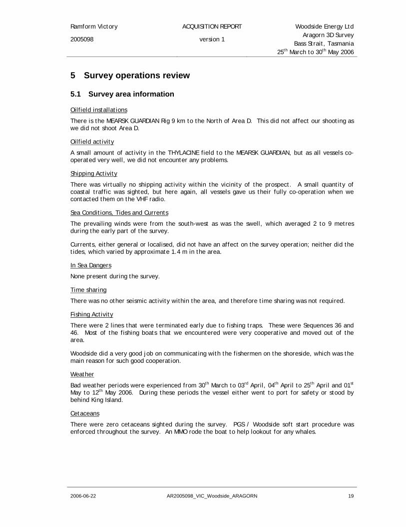
On the following pages are some representative inline, crosslines and timeslices from the final common offset cube, viz:
inline* 1100, 1400 and 1700
crosslines* 1800, 2400. 3000 and 3800
timeslices 700, 1900 and 2400
* - For clarity only the upper part of these displays is shown.,
’first break’ derived from navigation

Ramform Victory ACQUISITION REPORT Woodside Energy Ltd
2005098 version 1 Aragorn 3D Survey
Bass Strait, Tasmania 25th March to 30th May 2006
2006-06-22 AR2005098_VIC_Woodside_ARAGORN 55
Iline 1100
Iline 1400

Ramform Victory ACQUISITION REPORT Woodside Energy Ltd
2005098 version 1 Aragorn 3D Survey
Bass Strait, Tasmania 25th March to 30th May 2006
2006-06-22 AR2005098_VIC_Woodside_ARAGORN 56
Iline 1700
Xline 1800

Ramform Victory ACQUISITION REPORT Woodside Energy Ltd
2005098 version 1 Aragorn 3D Survey
Bass Strait, Tasmania 25th March to 30th May 2006
2006-06-22 AR2005098_VIC_Woodside_ARAGORN 57
Xline 2400
Xline 3000

Ramform Victory ACQUISITION REPORT Woodside Energy Ltd
2005098 version 1 Aragorn 3D Survey
Bass Strait, Tasmania 25th March to 30th May 2006
2006-06-22 AR2005098_VIC_Woodside_ARAGORN 58
Xline3800
Timeslice 700ms
Ramform Victory ACQUISITION REPORT Woodside Energy Ltd
2005098 version 1 Aragorn 3D Survey
Bass Strait, Tasmania 25th March to 30th May 2006
2006-06-22 AR2005098_VIC_Woodside_ARAGORN 59
Timeslice 1900ms
Timeslice 2400

Ramform Victory ACQUISITION REPORT Woodside Energy Ltd
2005098 version 1 Aragorn 3D Survey
Bass Strait, Tasmania 25th March to 30th May 2006
2006-06-22 AR2005098_VIC_Woodside_ARAGORN 60
10.8 Brute stack QC
As a minimum, one sub surface CMP line was stacked for each sail line pass. The captured CMP line was rotated through the streamers from line to line. This enabled all streamers to be monitored on a regular basis. Additional processing was minimised so as not to suppress the effects of noise on the stack. Velocities were supplied by Woodside. Following NMO correction, a mute was applied to remove NMO stretch, and the data was stacked. A plot of the raw brute stack was then produced for each sequence, which was closely scrutinised for the effects of noise.
To eliminate the swell noise that was present in the data of several lines and visible in several brute stacks, a SINK stack was also produced, where SINK (Seismic Interference Noise Killer) was applied to the data to take out the swell noise. The SINK parameters were taken from PGS Data Processing as agreed with Woodside. This SINK was a 2 pass SINK.
SINK was able to take out most swell noise from the data of lines where swell noise occurred. However, in cases where the swell noise exceeded certain levels, some swell noise was still visible in the stack after applying SINK.
The following plot shows a brute stack for line W06ARG1310P1. This was a quiet line where no swell noise was visible in the stack.
Brute stack line W06ARG1310P1

Ramform Victory ACQUISITION REPORT Woodside Energy Ltd
2005098 version 1 Aragorn 3D Survey
Bass Strait, Tasmania 25th March to 30th May 2006
2006-06-22 AR2005098_VIC_Woodside_ARAGORN 61
The next plot is an example of a brute stack from a noisy line, line W06ARG1390P1, where the swell noise is visible in the brute stack. Also the SINK stack of this line is shown. It can be seen that most swell noise has been taken out by SINK.
Brute Stack line W06ARG1390P1
SINK Stack line W06ARG1390P1
Ramform Victory ACQUISITION REPORT Woodside Energy Ltd
2005098 version 1 Aragorn 3D Survey
Bass Strait, Tasmania 25th March to 30th May 2006
2006-06-22 AR2005098_VIC_Woodside_ARAGORN 62
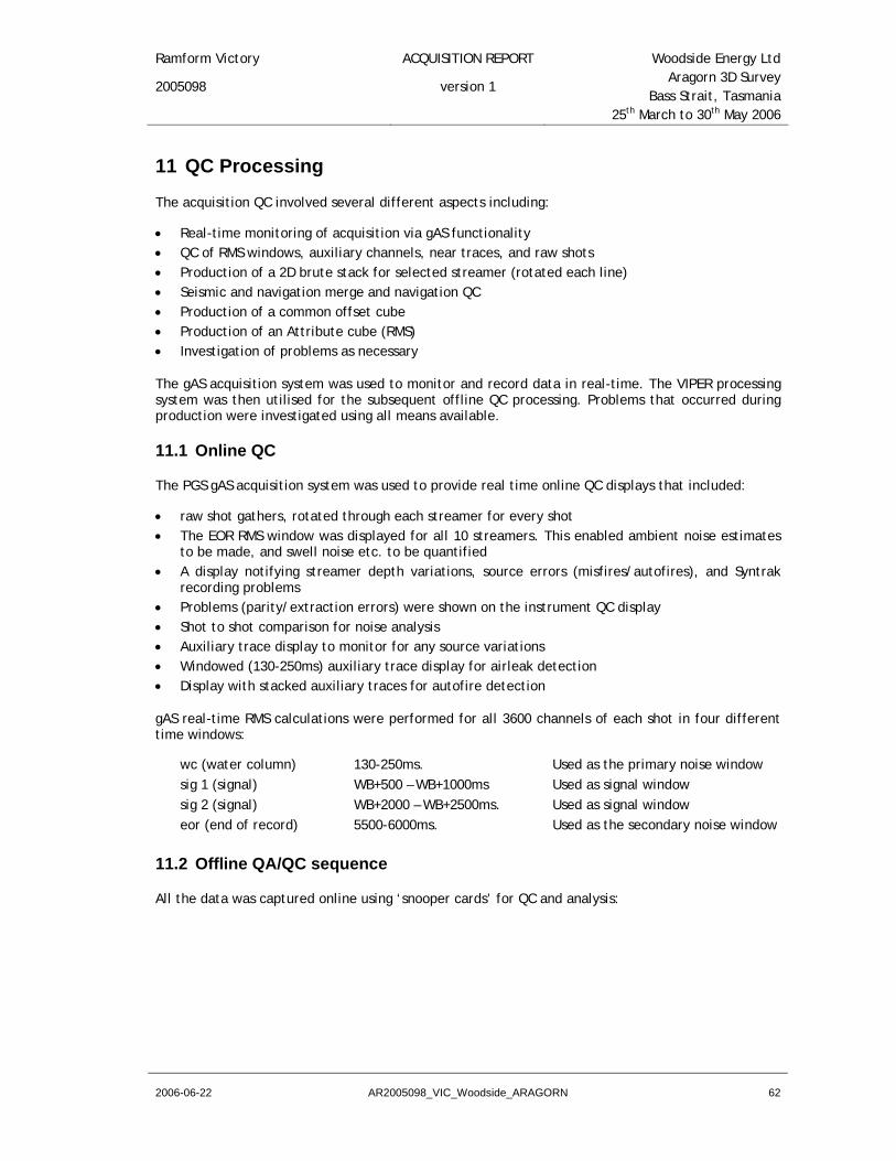
11 QC Processing
The acquisition QC involved several different aspects including:
• Real-time monitoring of acquisition via gAS functionality • QC of RMS windows, auxiliary channels, near traces, and raw shots • Production of a 2D brute stack for selected streamer (rotated each line) • Seismic and navigation merge and navigation QC • Production of a common offset cube • Production of an Attribute cube (RMS) • Investigation of problems as necessary
The gAS acquisition system was used to monitor and record data in real-time. The VIPER processing system was then utilised for the subsequent offline QC processing. Problems that occurred during production were investigated using all means available.
11.1 Online QC
The PGS gAS acquisition system was used to provide real time online QC displays that included:
• raw shot gathers, rotated through each streamer for every shot • The EOR RMS window was displayed for all 10 streamers. This enabled ambient noise estimates
to be made, and swell noise etc. to be quantified • A display notifying streamer depth variations, source errors (misfires/autofires), and Syntrak
recording problems • Problems (parity/extraction errors) were shown on the instrument QC display • Shot to shot comparison for noise analysis • Auxiliary trace display to monitor for any source variations • Windowed (130-250ms) auxiliary trace display for airleak detection • Display with stacked auxiliary traces for autofire detection
gAS real-time RMS calculations were performed for all 3600 channels of each shot in four different time windows:
wc (water column) 130-250ms. Used as the primary noise window sig 1 (signal) WB+500 – WB+1000ms Used as signal window sig 2 (signal) WB+2000 – WB+2500ms. Used as signal window eor (end of record) 5500-6000ms. Used as the secondary noise window
11.2 Offline QA/QC sequence
All the data was captured online using ‘snooper cards’ for QC and analysis:

Ramform Victory ACQUISITION REPORT Woodside Energy Ltd
2005098 version 1 Aragorn 3D Survey
Bass Strait, Tasmania 25th March to 30th May 2006
2006-06-22 AR2005098_VIC_Woodside_ARAGORN 63
11.2.1 2D QC stack
For each sail-line, a 2D QC brute stack and associated QC products were generated using the following sequence:
Reformat SEG-D to internal format Static Correction Digital filter delay –120 ms (60 samples) Geometry Assignment Assign 2D geometry: 360 channels Filter Zero phase filter - 3-6-90-120Hz Resample 2 ms to 4 ms Edit Bad shot and trace edit Trace sum Adjacent trace sum with partial NMO *(SINK) Gain T**2 dBGain 2.0dB/sec applied 0-6sec
Display Near traces for single streamer Display Single shot – all streamers Display Select shots every 250th – single streamer
NMO using Woodside supplied velocity field Mute Post NMO top mute Display NMO corrected CDP Gathers Stack nominal fold: 60 Static +10ms, gun and cable static
Display Brute 2D stack
* Also a SINK stack was produced for lines where swell noise was a problem. The SINK parameterisation was the same as being used by PGS Data Processing for the onboard production processing.
The following displays were produced for each CDP line processed:
• Near trace Display from selected stacking streamer
• Single Shot Display - all streamers 1 shot, all 10 streamers
• Shot records Display (single streamer) shots selected every 210 shots
• NMO-corrected CDP gathers display for every line
• Brute 2D Stack Display
• * SINK 2D Stack Display
• * SINK 2D Difference Stack – difference display to assess effectiveness of SINK process

Ramform Victory ACQUISITION REPORT Woodside Energy Ltd
2005098 version 1 Aragorn 3D Survey
Bass Strait, Tasmania 25th March to 30th May 2006
2006-06-22 AR2005098_VIC_Woodside_ARAGORN 64
11.2.2 Navigation / seismic merge QC
A near trace/common offset dataset was merged with the final P1/90 data. The direct arrivals from the near traces were then displayed on screen with the navigation derived first break time* overlaid on the seismic data. There was a good match between the P1/90 and the seismic data.
• The navigation derived first break time was derived using the near surface water velocity, which was taken from TS Dip measurements.
11.2.3 Common offset cube
A second P1/90 QC step was to build a common offset cube in VIPER to check for anomalies and miss-ties between sail lines on cross-line sections and time slices. After merging with the P1/90 navigation data, the trace with the nearest offset to 660m was selected for each inline/xline combination and loaded to the common offset cube. The data were pre-processed and partial NMO applied prior to loading. Once loaded to the cube, inline, cross-line, and time-slice displays were viewed to check for potential navigation merge errors.
11.2.4 RMS Attribute Cube
An attribute cube was also built using attributes derived from the middle twelve traces from each streamer for each shot. A five sample trace was output for each shot location with the following attributes assigned to samples one through five.
Average RMS for the Signal window Average RMS for the Noise window RMS Signal/Noise ratio Max. RMS Noise Average Water Depth
11.2.5 Other QC Products
A near trace display was generated for every line to monitor bad and missing shots, especially auto-fires, and to ensure that a complete sequence was captured to disk.
From all the data several RMS windows were calculated. These windows were used to qc the data for different aspects, like noisy channels, gun performance QC, etc.
The output of the near field hydrophones mounted on the gun strings was recorded on the auxiliary channels, together with the system time-break in order to identify gun-timing errors. The auxiliaries of all gun strings were stacked together and displayed online as a real-time auto-fire QC display.
A post-line display of the auxiliary traces stacked by the common gun-string was also generated as an additional QC for autofires. Further a display was produced with each of the auxiliary traces truncated from 130 to 250 ms and spliced together into a single trace per shot/array which was useful for the identification of airleaks.
Raw shots for the stacked streamer were plotted for every 210th shot. These were used to determine the impact of external noise sources e.g. seismic interference, swell noise and ship noise on the raw data. In addition a single shot (all streamers) was plotted for each line as a guide to identifying and classifying bad channels.

Ramform Victory ACQUISITION REPORT Woodside Energy Ltd
2005098 version 1 Aragorn 3D Survey
Bass Strait, Tasmania 25th March to 30th May 2006
2006-06-22 AR2005098_VIC_Woodside_ARAGORN 65
11.3 Computer systems
A five node Linux cluster has been installed onboard the M/V RAMFORM VICTORY to perform seismic QC tasks using PGS’ own Viper and gAS software.
The gAS QC system is used for online acquisition QC and acts as the primary recording system replacing the Syntrak recording system. It has been set up with special snooper cards to capture all the data in real time which is passed on to the Viper system.
The Viper system, with a full suite of pre-processing and QC tools, is used for QC processing and together with its parallel processing capability offers great scope and fast results for both on-line and off-line QC processing and investigation.
The Viper Linux cluster consists of five nodes designated for Viper QC.
Five IBM x335 nodes Dual 2.4Ghz Intel Xeon processors per node. 1.5Gb RAM per node. Two 146Gb 10k-rpm SCSI hot swap disks in nodes 1-3. Two 300Gb 10k-rpm SCSI hot swap disks in nodes 4 and 5. Dual 10/100/1000 Mbps Ethernet network adapters per node. xSeries Cable Chain Technology. LSI U40 HVD PCI Ultra Wide Differential SCSI adapter per node Three nodes have 3590 tape drive connections with the third one spare.
Two HP ProCurve network switches - each switch has 8x1000baseT Ethernet ports with 16Gbps backplane.
This onboard processing system runs Viper V3.0.3-3 which is managed by Xcat software running under RedHat Linux V7.3.

Ramform Victory ACQUISITION REPORT Woodside Energy Ltd
2005098 version 1 Aragorn 3D Survey
Bass Strait, Tasmania 25th March to 30th May 2006
2006-06-22 AR2005098_VIC_Woodside_ARAGORN 66
12 Appendix
12.1 Data shipments Date Proforma Content Boxes Wt Shipping address Comment
2nd June. 06
VIC23002654A 2 x P190 3590 tapes 2 x P294 3590 tapes 1 x P190 DVD 1 x P294 DVD Originals Project 2005098
1 2 kg Access Information Management, 80 Pilbara Street, Welshpool, WA, 6106, Australia. Phone : +61 (0)8 9356-3766 Email : [email protected] Attention : Bruce Sharman
Via NT Shipping Agencies PO Box 443 East Arm Wharf 0828 BERRIMAH NT Australia Tel +61 8 8947 2570 Fax +61 8 8947 2640
TBSO When 1st Data Tapes has arrived at des-tination.
VIC23002655A 4 x P190 3590 tapes 4 x P294 3590 tapes Copies Project 2005098
1 2 kg Access Information Management, 80 Pilbara Street, Welshpool, WA, 6106, Australia. Phone : +61 (0)8 9356-3766 Email : [email protected] Attention : Bruce Sharman
Via NT Shipping Agencies PO Box 443 East Arm Wharf 0828 BERRIMAH NT Australia Tel +61 8 8947 2570 Fax +61 8 8947 2640
2nd June. 06
VIC23002653A 2 x P190 3590 tapes 2 x P294 3590 tapes 2 x P190 3590 raw tapes 1 VEG backup tape 2 Sprint db 3590 backup tape 2 EOJ cd’s 3 Census backup tapes Project 2005098
1 2 kg PGS Geophysical AS (EXANO) Strandveien 4 P.O.Box 290 N-1326 Lysaker Norway Attn :Torfinn Brusegard Phone : (47) 67 52 64 00 Fax: (47) 67 52 64 64
Via NT Shipping Agencies PO Box 443 East Arm Wharf 0828 BERRIMAH NT Australia Tel +61 8 8947 2570 Fax +61 8 8947 2640
3 June 06 VIC23002664A Boxes 1-16 474 x 3590 SEG D DataTapes Set C.
16 120 kg
Access Information Management, 80 Pilbara Street, Welshpool, WA, 6106, Australia. Phone : +61 (0)8 9356-3766 Email : [email protected] Attention : Bruce Sharman
Via NT Shipping Agencies PO Box 443 East Arm Wharf 0828 BERRIMAH NT Australia Tel +61 8 8947 2570 Fax +61 8 8947 2640

Ramform Victory ACQUISITION REPORT Woodside Energy Ltd
2005098 version 1 Aragorn 3D Survey
Bass Strait, Tasmania 25th March to 30th May 2006
2006-06-22 AR2005098_VIC_Woodside_ARAGORN 67
TBSO When 1st SEG D Data Tapes has arrived at des-tination.
VIC23002672A BOX 1- 16 474 x 3590 SEG D DataTapes Set F
Access Information Management, 80 Pilbara Street, Welshpool, WA, 6106, Australia. Phone : +61 (0)8 9356-3766 Email : [email protected] Attention : Bruce Sharman
Via NT Shipping Agencies PO Box 443 East Arm Wharf 0828 BERRIMAH NT Australia Tel +61 8 8947 2570 Fax +61 8 8947 2640
12.2 Additional navigation deliverables
The following deliverables were issued from PGS offices in Oslo after the survey was completed.
• Vessel position tape, W06ARG011
• Water depth tape W06ARGE011, with water depths corrected for draft and sound velocity
• Vessel position plot on paper.
• Contour plot on paper.
• Coverage plots no flex on paper
• CD-ROM containing all the plots in cgm format
• P6/98 binning grid UKOOA format on tape W06ARG-P698

Ramform Victory ACQUISITION REPORT Woodside Energy Ltd
2005098 version 1 Aragorn 3D Survey
Bass Strait, Tasmania 25th March to 30th May 2006
2006-06-22 AR2005098_VIC_Woodside_ARAGORN 68
12.3 Source modelling
SIGNATURES FROM MARINE AIRGUN SOURCE LIBRARY
NUCLEUS - Marine Source Modeling 4.2.1
Modeling by Ping Zhao, PGS Technology/Geophysical Support, September 2004
Survey name : Aragorn 3D Survey PGS project No : 2005098 (Aragorn) Survey area : Bass Straight, Victoria (Aragorn) Vessel : M/V RAMFORM VICTORY Array : 3090T__60_2000_125 Source type : Bolt 1900LLXT Source volume : 3090 cu.in. Air pressure : 2000 psi Source depth : 6.0 m Subarray separation : 12.5 m Recording filter : Syntrak-24bit system, 3(12) – 206(276) Hz (dB/oct.) Receiver depth : 9.0 m Hydrophone group length : 12.5 m Compensating p-plugs : out Full system response∗ filter name : S-24 g-12.5 Sea temperature : 17 ° C
Enclosed are:
Figure 1: Array configuration top view, i.e. positive Y denotes starboard. Figure 2: Modeled far-field signature and amplitude spectrum with 24bit recording filter (without
receiver ghost). Figure 3: Modeled far-field signature and amplitude spectrum with DFS-V recording filter (without
receiver ghost). Figure 4: Modeled far-field signature and amplitude spectrum with recording and hydrophone filter
effect applied (without receiver ghost). Figure 5: Far-field signature listing with 2 ms sampling interval (without receiver ghost). Figure 6: Modeled far-field signature and amplitude spectrum with recording and hydrophone filter
effect applied (with receiver ghost). Figure 7: Far-field signature listing with 2 ms sampling interval (with receiver ghost). Figure 8: Directivity plot for constant azimuth of 0° and 90°. Figure 9: Single (on diagonal) and two gun drop-out diagram. Illegal combinations denoted in red.
∗ Full system response contains the effect of the recording filter including the effects due to the hydrophone capacitors connected in parallel.

Ramform Victory ACQUISITION REPORT Woodside Energy Ltd
2005098 version 1 Aragorn 3D Survey
Bass Strait, Tasmania 25th March to 30th May 2006
2006-06-22 AR2005098_VIC_Woodside_ARAGORN 69
Figure 1: Array configuration top view, i.e. positive Y denotes starboard.
ARRAY LISTING ARRAY NAME : 3090T__60_2000_125 NUMBER OF ACTIVE GUNS: 28 TOTAL ACTIVE VOLUME : 3090 CU.IN. NUMBER OF SPARE GUNS : 3 GUN GUN X Y Z VOLUME PRESSURE DELAY CLUSTER # TYPE (m) (m) (m) (cu.in) (psi) (ms) NUMBER 1 18 0.00 12.90 6.00 150 2000 0.00 1 2 18 0.00 12.10 6.00 150 2000 0.00 1 3 18 3.00 12.90 6.00 60 2000 0.00 2 4 18 3.00 12.10 6.00 60 2000 0.00 2 5 18 5.00 12.50 6.00 20 2000 0.00 0 6 18 7.00 12.50 6.00 40 2000 0.00 0 7 18 9.00 12.50 6.00 60 2000 0.00 0 8 18 11.00 12.90 6.00 100 2000 0.00 0 9 18 11.00 12.10 6.00 100 SPARE 0.00 0 10 18 14.00 12.90 6.00 250 2000 0.00 3 11 18 14.00 12.10 6.00 250 2000 0.00 3 12 18 0.00 0.40 6.00 100 2000 0.00 4 13 18 0.00 -0.40 6.00 100 2000 0.00 4 14 18 3.00 0.00 6.00 90 2000 0.00 0 15 18 5.00 0.00 6.00 60 2000 0.00 0 16 18 7.00 0.00 6.00 20 2000 0.00 0 17 18 9.00 0.00 6.00 40 2000 0.00 0 18 18 11.00 0.00 6.00 70 2000 0.00 0 19 18 14.00 0.40 6.00 250 2000 0.00 0 20 18 14.00 -0.40 6.00 250 SPARE 0.00 0 21 18 0.00 -12.10 6.00 150 2000 0.00 5 22 18 0.00 -12.90 6.00 150 2000 0.00 5 23 18 3.00 -12.10 6.00 150 2000 0.00 0 24 18 3.00 -12.90 6.00 150 SPARE 0.00 0 25 18 5.00 -12.50 6.00 70 2000 0.00 0 26 18 7.00 -12.50 6.00 40 2000 0.00 0 27 18 9.00 -12.50 6.00 20 2000 0.00 0 28 18 11.00 -12.10 6.00 70 2000 0.00 6 29 18 11.00 -12.90 6.00 70 2000 0.00 6 30 18 14.00 -12.10 6.00 250 2000 0.00 7 31 18 14.00 -12.90 6.00 250 2000 0.00 7
THE GUN TYPES ARE: 18: BOLT 1900 LLXT

Ramform Victory ACQUISITION REPORT Woodside Energy Ltd
2005098 version 1 Aragorn 3D Survey
Bass Strait, Tasmania 25th March to 30th May 2006
2006-06-22 AR2005098_VIC_Woodside_ARAGORN 70
Figure 2: Modeled far-field signature and amplitude spectrum with 24bit recording filter
(without receiver ghost).

Ramform Victory ACQUISITION REPORT Woodside Energy Ltd
2005098 version 1 Aragorn 3D Survey
Bass Strait, Tasmania 25th March to 30th May 2006
2006-06-22 AR2005098_VIC_Woodside_ARAGORN 71
Figure 3: Modeled far-field signature and amplitude spectrum with DFS-V recording filter
(without receiver ghost).

Ramform Victory ACQUISITION REPORT Woodside Energy Ltd
2005098 version 1 Aragorn 3D Survey
Bass Strait, Tasmania 25th March to 30th May 2006
2006-06-22 AR2005098_VIC_Woodside_ARAGORN 72
Full system response with source ghost only
Figure 4: Modeled far-field signature and amplitude spectrum with recording and hydrophone
filter effect applied (without receiver ghost).

Ramform Victory ACQUISITION REPORT Woodside Energy Ltd
2005098 version 1 Aragorn 3D Survey
Bass Strait, Tasmania 25th March to 30th May 2006
2006-06-22 AR2005098_VIC_Woodside_ARAGORN 73
Full system response with source ghost only
FAR-FIELD SIGNATURE LISTING
Array name : 3090T__60_2000_125 Total volume : 3090 cu.in. Source depth : 6.00 m Streamer depth : 0.00 m Group length : 12.50 m Average pressure : 2000 psi Ghost strength : -1.00 Primary amplitude : 54.06 bar m Peak-peak amplitude : 121.32 bar m P/B-ratio : 22.82 Bubble period (+) : 58.00 msec Bubble period (-) : 114.00 msec Seawater temperature: 17.00 C Seawater velocity : 1513.0 m/s Filter : Low-cut frequency : 7.00 Hz Low-cut slope : 18.00 dB/oct High-cut frequency: 206.00 Hz High-cut slope : 276.00 dB/oct Instrument : S-24 g-12.5 Time of 1st sample: -56.00 msec i.e. index of time zero = 29.0 Sample interval : 2.00 msec Far-field position : Distance : 9000.00 m Azimuth : 0.00 deg Angle of vertical : 0.00 deg Amplitudes are in bar m Time is increasing horizontally
0.000 0.000 0.000 -0.010 -0.047 -0.025 -0.039 -0.064 0.061 0.091 0.068 0.181 0.017 -0.066 0.291 -0.112 0.397 0.250 -0.228 0.584 -0.995 0.587 -0.745 -0.028 0.867 -2.040 3.619 -6.471 20.826 54.058 16.992 3.024 -27.813 -67.261 -30.270 -5.788 -4.220 1.618 0.568 -0.671 -0.945 4.745 3.116 0.815 3.556 2.034 1.913 3.155 2.928 2.412 2.792 2.793 2.281 2.496 2.390 2.219 2.198 2.254 2.183 1.907 1.947 1.812 1.616 1.788 1.778 1.644 1.741 1.564 1.283 1.129 0.642 0.309 0.182 -0.109 -0.232 -0.516 -0.923 -0.955 -0.951 -0.699 -0.139 -0.029 -0.103 -0.217 -0.555 -0.518 -0.596 -1.261 -1.876 -2.635 -3.132 -2.847 -2.550 -2.068 -1.376 -1.006 -0.481 -0.060 -0.077 -0.126 -0.615 -1.344 -1.723 -2.035 -1.948 -1.407 -1.028 -0.566 -0.225 -0.323 -0.298 -0.327 -0.349 0.080 0.369 0.560 0.892 0.904 0.970 1.133 0.996 1.062 1.172 1.091 1.270 1.295 1.150 1.179 0.956 0.807 0.897 0.808 0.908 0.993 0.819 0.852 0.748 0.565 0.679 0.568 0.457 0.473 0.131 -0.106 -0.280 -0.660 -0.689

Ramform Victory ACQUISITION REPORT Woodside Energy Ltd
2005098 version 1 Aragorn 3D Survey
Bass Strait, Tasmania 25th March to 30th May 2006
2006-06-22 AR2005098_VIC_Woodside_ARAGORN 74
-0.683 -0.798 -0.627 -0.640 -0.717 -0.605 -0.729 -0.702 -0.495 -0.484 -0.270 -0.123 -0.212 -0.088 -0.115 -0.166 0.069 0.066 0.092 0.211 0.023 -0.015 -0.067 -0.328 -0.313 -0.353 -0.443 -0.283 -0.286 -0.266 -0.117 -0.145 -0.006 0.197 0.224 0.389 0.443 0.357 0.416 0.319 0.228 0.302 0.230 0.229 0.252 0.104 0.067 0.002 -0.131 -0.091 -0.098 -0.138 -0.100 -0.170
Figure 5: Far-field signature listing with 2 ms sampling interval (without receiver ghost).

Ramform Victory ACQUISITION REPORT Woodside Energy Ltd
2005098 version 1 Aragorn 3D Survey
Bass Strait, Tasmania 25th March to 30th May 2006
2006-06-22 AR2005098_VIC_Woodside_ARAGORN 75
Full system response with source and receiver ghost
Figure 6: Modeled far-field signature and amplitude spectrum with recording and hydrophone filter effect applied (with receiver ghost).

Ramform Victory ACQUISITION REPORT Woodside Energy Ltd
2005098 version 1 Aragorn 3D Survey
Bass Strait, Tasmania 25th March to 30th May 2006
2006-06-22 AR2005098_VIC_Woodside_ARAGORN 76
Full system response with source and receiver ghost
FAR-FIELD SIGNATURE LISTING
Array name : 3090T__60_2000_125 Total volume : 3090 cu.in. Source depth : 6.00 m Streamer depth : 9.00 m Group length : 12.50 m Average pressure : 2000 psi Ghost strength : -1.00 Primary amplitude : -60.93 bar m Peak-peak amplitude : 126.64 bar m P/B-ratio : 23.75 Bubble period (+) : 116.00 msec Bubble period (-) : 114.00 msec Seawater temperature: 17.00 C Seawater velocity : 1513.0 m/s Filter : Low-cut frequency : 7.00 Hz Low-cut slope : 18.00 dB/oct High-cut frequency: 206.00 Hz High-cut slope : 276.00 dB/oct Instrument : S-24 g-12.5 Time of 1st sample: -56.00 msec i.e. index of time zero = 29.0 Sample interval : 2.00 msec Far-field position : Distance : 9000.00 m Azimuth : 0.00 deg Angle of vertical : 0.00 deg Amplitudes are in bar m Time is increasing horizontally 0.000 0.000 0.000 -0.010 -0.047 -0.025 -0.039 -0.064 0.061 0.103 0.115 0.205 0.059 -0.007 0.225 -0.200 0.325 0.069 -0.229 0.630 -1.276 0.702 -1.178 -0.215 1.034 -2.561 4.601 -7.104 21.679 53.867 16.418 4.751 -31.127 -60.934 -53.835 -58.706 -19.560 -0.984 31.340 65.709 27.061 10.482 6.974 -0.831 3.050 2.804 2.618 -1.715 0.083 1.453 -0.754 0.845 0.293 -0.666 -0.497 -0.191 -0.611 -0.500 -0.095 -0.590 -0.425 -0.401 -0.578 -0.465 -0.386 -0.257 -0.203 -0.229 -0.334 -0.662 -1.122 -1.334 -1.555 -1.651 -1.507 -1.624 -1.538 -1.258 -1.119 -0.580 0.099 0.510 0.826 0.735 0.391 0.150 -0.474 -1.226 -1.773 -2.401 -2.571 -2.338 -1.928 -0.775 0.530 1.663 2.641 2.762 2.453 1.900 0.735 -0.360 -1.274 -1.978 -1.870 -1.269 -0.374 0.801 1.511 1.716 1.621 1.054 0.657 0.619 0.593 0.885 1.186 1.238 1.303 1.030 0.622 0.485 0.274 0.191 0.290 0.168 0.160 0.109 -0.210 -0.285 -0.379 -0.475 -0.240 -0.179 -0.120 0.042 -0.145 -0.240 -0.237 -0.415 -0.357 -0.379 -0.601 -0.672 -0.959 -1.215 -1.149 -1.144 -0.910 -0.518 -0.341 -0.048 0.077 -0.039 0.090 0.124 0.163 0.439 0.483 0.523 0.600 0.377 0.312 0.324 0.193 0.301 0.294 0.146 0.141 -0.142 -0.390 -0.414 -0.558 -0.458 -0.272 -0.205 0.067 0.192 0.216 0.430 0.475 0.512 0.646 0.559 0.500 0.409 0.120 0.000 -0.095 -0.207 -0.129 -0.163 -0.205 -0.163 -0.298 -0.357 -0.324 -0.344 -0.237 -0.168 -0.164
Figure 7: Far-field signature listing with 2 ms sampling interval (with receiver ghost).

Ramform Victory ACQUISITION REPORT Woodside Energy Ltd
2005098 version 1 Aragorn 3D Survey
Bass Strait, Tasmania 25th March to 30th May 2006
2006-06-22 AR2005098_VIC_Woodside_ARAGORN 77
Figure 8: Directivity plot for constant azimuth of 0° and 90°.

Ramform Victory ACQUISITION REPORT Woodside Energy Ltd
2005098 version 1 Aragorn 3D Survey
Bass Strait, Tasmania 25th March to 30th May 2006
2006-06-22 AR2005098_VIC_Woodside_ARAGORN 78
12.4 Example SEG-D header --------------------------------------------------------------------------- GENERAL HEADER #1 Starting byte 0 Bytes Description Value --------------------------------------------------------------------------- 01-02 File Number 1843 03-04 SEGD Format 8036 Bits Per Sample 24 05-10 General Constants 11 Year 2006 12 Additional Header Blocks 2 12-13 Day 146 14 Hour 21 15 Minute 13 16 Second 6 17 Manufacturer's Code 41 18-19 Manufacturer's Serial Number 0 20-22 Not Used 23 Base Scan Interval (ms) 2.0 24 Polarity 25 Scan/Block Exponent 26 Record Type Normal Record 27 Record Length (ms) 6144 28 Scan-types / Record 1 29 Channel Sets/Scan Type 11 30 Skew Blocks 0 31 Extended-Header Blocks 0xFF 32 External-Header Blocks 0xFF --------------------------------------------------------------------------- GENERAL HEADER #2 Starting byte 32 Bytes Description Value --------------------------------------------------------------------------- 01-03 Expanded File Number 0 04-05 Extended Channel Sets 0 06-07 Extended Header Blocks 1290 08-09 External Header Blocks 140 10 Reserved 11-12 SEG-D Revision Number Rev. 0.0 13-14 General Trailer 15-17 Extended Record Length 200 18-19 General Header Block Number 2 20-31 Reserved 32 Extended Record Length 6

Ramform Victory ACQUISITION REPORT Woodside Energy Ltd
2005098 version 1 Aragorn 3D Survey
Bass Strait, Tasmania 25th March to 30th May 2006
2006-06-22 AR2005098_VIC_Woodside_ARAGORN 79
--------------------------------------------------------------------------- GENERAL HEADER #3 Starting Byte 64 Bytes Description Value --------------------------------------------------------------------------- 01-03 Reserved 04-06 Source Line Number (int) 0 07-09 Source Line Number (fract) 0 10-12 Source Point Number (int) 4032 13-15 Source Point Number (fract) 0 14 Source Point Index Not Used 15 Phase Control Not Used 16 Type Vibrator Not Used 17-18 Phase Angle Not Used 19 General Header Block Number 3 20 Source Set Number 0 21-32 Reserved --------------------------------------------------------------------------- CHANNEL SET HEADER #1 Starting Byte 96 Bytes Description Value --------------------------------------------------------------------------- 01 Scan Type Number 1 02 Channel Set Number 1 03-04 Channel Set Start Time (ms) 0 05-06 Channel Set End Time (ms) 6144 07-08 Pre-Amp Gain (dB) 12 09-10 Number of Channels 360 11 Channel Set Type Seismic Data 12 Scans per Base Scan 1 13-14 Alias Filter Frequency 206 15-16 Alias Filter Slope 276 17-18 Low Cut Filter 3 19-20 Low Cut Filter Slope 12 21-22 First Notch Filter 0 23-24 Second Notch Filter 0 25-26 Third Notch Filter 0 27-28 Extended Channel Set Number 0 29 Extended Header Flag 0 30 Vertical Stack 0 31 Cable Number 0 32 Array Forming 0

Ramform Victory ACQUISITION REPORT Woodside Energy Ltd
2005098 version 1 Aragorn 3D Survey
Bass Strait, Tasmania 25th March to 30th May 2006
2006-06-22 AR2005098_VIC_Woodside_ARAGORN 80
--------------------------------------------------------------------------- CHANNEL SET HEADER #2 Starting Byte 128 Bytes Description Value --------------------------------------------------------------------------- 01 Scan Type Number 1 02 Channel Set Number 2 03-04 Channel Set Start Time (ms) 0 05-06 Channel Set End Time (ms) 6144 07-08 Pre-Amp Gain (dB) 12 09-10 Number of Channels 360 11 Channel Set Type Seismic Data 12 Scans per Base Scan 1 13-14 Alias Filter Frequency 206 15-16 Alias Filter Slope 276 17-18 Low Cut Filter 3 19-20 Low Cut Filter Slope 12 21-22 First Notch Filter 0 23-24 Second Notch Filter 0 25-26 Third Notch Filter 0 27-28 Extended Channel Set Number 0 29 Extended Header Flag 0 30 Vertical Stack 0 31 Cable Number 0 32 Array Forming 0 --------------------------------------------------------------------------- CHANNEL SET HEADER #3 Starting Byte 160 Bytes Description Value --------------------------------------------------------------------------- 01 Scan Type Number 1 02 Channel Set Number 3 03-04 Channel Set Start Time (ms) 0 05-06 Channel Set End Time (ms) 6144 07-08 Pre-Amp Gain (dB) 12 09-10 Number of Channels 360 11 Channel Set Type Seismic Data 12 Scans per Base Scan 1 13-14 Alias Filter Frequency 206 15-16 Alias Filter Slope 276 17-18 Low Cut Filter 3 19-20 Low Cut Filter Slope 12 21-22 First Notch Filter 0 23-24 Second Notch Filter 0 25-26 Third Notch Filter 0 27-28 Extended Channel Set Number 0 29 Extended Header Flag 0 30 Vertical Stack 0 31 Cable Number 0 32 Array Forming 0

Ramform Victory ACQUISITION REPORT Woodside Energy Ltd
2005098 version 1 Aragorn 3D Survey
Bass Strait, Tasmania 25th March to 30th May 2006
2006-06-22 AR2005098_VIC_Woodside_ARAGORN 81
--------------------------------------------------------------------------- CHANNEL SET HEADER #4 Starting Byte 192 Bytes Description Value --------------------------------------------------------------------------- 01 Scan Type Number 1 02 Channel Set Number 4 03-04 Channel Set Start Time (ms) 0 05-06 Channel Set End Time (ms) 6144 07-08 Pre-Amp Gain (dB) 12 09-10 Number of Channels 360 11 Channel Set Type Seismic Data 12 Scans per Base Scan 1 13-14 Alias Filter Frequency 206 15-16 Alias Filter Slope 276 17-18 Low Cut Filter 3 19-20 Low Cut Filter Slope 12 21-22 First Notch Filter 0 23-24 Second Notch Filter 0 25-26 Third Notch Filter 0 27-28 Extended Channel Set Number 0 29 Extended Header Flag 0 30 Vertical Stack 0 31 Cable Number 0 32 Array Forming 0 --------------------------------------------------------------------------- CHANNEL SET HEADER #5 Starting Byte 224 Bytes Description Value --------------------------------------------------------------------------- 01 Scan Type Number 1 02 Channel Set Number 5 03-04 Channel Set Start Time (ms) 0 05-06 Channel Set End Time (ms) 6144 07-08 Pre-Amp Gain (dB) 12 09-10 Number of Channels 360 11 Channel Set Type Seismic Data 12 Scans per Base Scan 1 13-14 Alias Filter Frequency 206 15-16 Alias Filter Slope 276 17-18 Low Cut Filter 3 19-20 Low Cut Filter Slope 12 21-22 First Notch Filter 0 23-24 Second Notch Filter 0 25-26 Third Notch Filter 0 27-28 Extended Channel Set Number 0 29 Extended Header Flag 0 30 Vertical Stack 0 31 Cable Number 0 32 Array Forming 0

Ramform Victory ACQUISITION REPORT Woodside Energy Ltd
2005098 version 1 Aragorn 3D Survey
Bass Strait, Tasmania 25th March to 30th May 2006
2006-06-22 AR2005098_VIC_Woodside_ARAGORN 82
--------------------------------------------------------------------------- CHANNEL SET HEADER #6 Starting Byte 256 Bytes Description Value --------------------------------------------------------------------------- 01 Scan Type Number 1 02 Channel Set Number 6 03-04 Channel Set Start Time (ms) 0 05-06 Channel Set End Time (ms) 6144 07-08 Pre-Amp Gain (dB) 12 09-10 Number of Channels 360 11 Channel Set Type Seismic Data 12 Scans per Base Scan 1 13-14 Alias Filter Frequency 206 15-16 Alias Filter Slope 276 17-18 Low Cut Filter 3 19-20 Low Cut Filter Slope 12 21-22 First Notch Filter 0 23-24 Second Notch Filter 0 25-26 Third Notch Filter 0 27-28 Extended Channel Set Number 0 29 Extended Header Flag 0 30 Vertical Stack 0 31 Cable Number 0 32 Array Forming 0 --------------------------------------------------------------------------- CHANNEL SET HEADER #7 Starting Byte 288 Bytes Description Value --------------------------------------------------------------------------- 01 Scan Type Number 1 02 Channel Set Number 7 03-04 Channel Set Start Time (ms) 0 05-06 Channel Set End Time (ms) 6144 07-08 Pre-Amp Gain (dB) 12 09-10 Number of Channels 48 11 Channel Set Type AUX Data 12 Scans per Base Scan 1 13-14 Alias Filter Frequency 206 15-16 Alias Filter Slope 276 17-18 Low Cut Filter 3 19-20 Low Cut Filter Slope 12 21-22 First Notch Filter 0 23-24 Second Notch Filter 0 25-26 Third Notch Filter 0 27-28 Extended Channel Set Number 0 29 Extended Header Flag 0 30 Vertical Stack 0 31 Cable Number 0 32 Array Forming 0

Ramform Victory ACQUISITION REPORT Woodside Energy Ltd
2005098 version 1 Aragorn 3D Survey
Bass Strait, Tasmania 25th March to 30th May 2006
2006-06-22 AR2005098_VIC_Woodside_ARAGORN 83
--------------------------------------------------------------------------- CHANNEL SET HEADER #8 Starting Byte 320 Bytes Description Value --------------------------------------------------------------------------- 01 Scan Type Number 1 02 Channel Set Number 8 03-04 Channel Set Start Time (ms) 0 05-06 Channel Set End Time (ms) 6144 07-08 Pre-Amp Gain (dB) 12 09-10 Number of Channels 360 11 Channel Set Type Seismic Data 12 Scans per Base Scan 1 13-14 Alias Filter Frequency 206 15-16 Alias Filter Slope 276 17-18 Low Cut Filter 3 19-20 Low Cut Filter Slope 12 21-22 First Notch Filter 0 23-24 Second Notch Filter 0 25-26 Third Notch Filter 0 27-28 Extended Channel Set Number 0 29 Extended Header Flag 0 30 Vertical Stack 0 31 Cable Number 0 32 Array Forming 0 --------------------------------------------------------------------------- CHANNEL SET HEADER #9 Starting Byte 352 Bytes Description Value --------------------------------------------------------------------------- 01 Scan Type Number 1 02 Channel Set Number 9 03-04 Channel Set Start Time (ms) 0 05-06 Channel Set End Time (ms) 6144 07-08 Pre-Amp Gain (dB) 12 09-10 Number of Channels 360 11 Channel Set Type Seismic Data 12 Scans per Base Scan 1 13-14 Alias Filter Frequency 206 15-16 Alias Filter Slope 276 17-18 Low Cut Filter 3 19-20 Low Cut Filter Slope 12 21-22 First Notch Filter 0 23-24 Second Notch Filter 0 25-26 Third Notch Filter 0 27-28 Extended Channel Set Number 0 29 Extended Header Flag 0 30 Vertical Stack 0 31 Cable Number 0 32 Array Forming 0

Ramform Victory ACQUISITION REPORT Woodside Energy Ltd
2005098 version 1 Aragorn 3D Survey
Bass Strait, Tasmania 25th March to 30th May 2006
2006-06-22 AR2005098_VIC_Woodside_ARAGORN 84
--------------------------------------------------------------------------- CHANNEL SET HEADER #10 Starting Byte 384 Bytes Description Value --------------------------------------------------------------------------- 01 Scan Type Number 1 02 Channel Set Number 10 03-04 Channel Set Start Time (ms) 0 05-06 Channel Set End Time (ms) 6144 07-08 Pre-Amp Gain (dB) 12 09-10 Number of Channels 360 11 Channel Set Type Seismic Data 12 Scans per Base Scan 1 13-14 Alias Filter Frequency 206 15-16 Alias Filter Slope 276 17-18 Low Cut Filter 3 19-20 Low Cut Filter Slope 12 21-22 First Notch Filter 0 23-24 Second Notch Filter 0 25-26 Third Notch Filter 0 27-28 Extended Channel Set Number 0 29 Extended Header Flag 0 30 Vertical Stack 0 31 Cable Number 0 32 Array Forming 0 --------------------------------------------------------------------------- CHANNEL SET HEADER #11 Starting Byte 416 Bytes Description Value --------------------------------------------------------------------------- 01 Scan Type Number 1 02 Channel Set Number 11 03-04 Channel Set Start Time (ms) 0 05-06 Channel Set End Time (ms) 6144 07-08 Pre-Amp Gain (dB) 12 09-10 Number of Channels 360 11 Channel Set Type Seismic Data 12 Scans per Base Scan 1 13-14 Alias Filter Frequency 206 15-16 Alias Filter Slope 276 17-18 Low Cut Filter 3 19-20 Low Cut Filter Slope 12 21-22 First Notch Filter 0 23-24 Second Notch Filter 0 25-26 Third Notch Filter 0 27-28 Extended Channel Set Number 0 29 Extended Header Flag 0 30 Vertical Stack 0 31 Cable Number 0 32 Array Forming 0

Ramform Victory ACQUISITION REPORT Woodside Energy Ltd
2005098 version 1 Aragorn 3D Survey
Bass Strait, Tasmania 25th March to 30th May 2006
2006-06-22 AR2005098_VIC_Woodside_ARAGORN 85
--------------------------------------------------------------------------- HOST RECORDING SYSTEM STATUS BLOCK #1 Starting Byte 448 Bytes Description Value --------------------------------------------------------------------------- 01 External Header Status OK 02 Tape Unit for Writing 0 02 Buffer Used 0 03-04 Number of Channels (Cable 1) 360 05-06 Number of Channels (Cable 2) 360 07-08 Number of Channels (Cable 3) 360 09-10 Number of Channels (Cable 4) 360 11-12 Number of Channels (Cable 5) 360 13-14 Number of Channels (Cable 6) 360 15-16 Number of Channels (Cable 7) 360 17-18 Number of Channels (Cable 8) 360 19-20 Reserved 21 Transient Removal Yes 22 Filter Samples Removed 28 23 Additional Host Blocks 1 23 Module Type 24-bit 24 Number of Physical Cables 15 24 MSRS Chassis Single Chassis Used 25 Number of Receiver Lines 0 26 System Type Non-Receiver Line 27 Record Status Production Record 28 Header Revision 1 29 Software Revision 1 30-31 Blocks after SEG-D Area 1430 32 Number of Cables 10 --------------------------------------------------------------------------- HOST RECORDING SYSTEM STATUS BLOCK #2 Starting Byte 480 Bytes Description Value --------------------------------------------------------------------------- 01-02 Number of Channels (Cable 9) 360 03-04 Number of Channels (Cable 10) 360 05-06 Number of Channels (Cable 11) 0 07-08 Number of Channels (Cable 12) 0 09-10 Number of Channels (Cable 13) 0 11-12 Number of Channels (Cable 14) 0 13-14 Number of Channels (Cable 15) 0 15-16 Number of Channels (Cable 16) 0 17-31 Reserved 32 Number of Physical Cables 125 --------------------------------------------------------------------------- LINE ID BLOCK #1 Starting Byte 512 Bytes Description Value --------------------------------------------------------------------------- 01-08 Cable 1 Line ID 09-08 Cable 2 Line ID 17-24 Cable 3 Line ID 25-32 Cable 4 Line ID
Ramform Victory ACQUISITION REPORT Woodside Energy Ltd
2005098 version 1 Aragorn 3D Survey
Bass Strait, Tasmania 25th March to 30th May 2006
2006-06-22 AR2005098_VIC_Woodside_ARAGORN 86
--------------------------------------------------------------------------- LINE ID BLOCK #2 Starting Byte 544 Bytes Description Value --------------------------------------------------------------------------- 01-08 Cable 5 Line ID 09-08 Cable 6 Line ID 17-24 Cable 7 Line ID 25-32 Cable 8 Line ID --------------------------------------------------------------------------- LINE ID BLOCK #3 Starting Byte 576 Bytes Description Value --------------------------------------------------------------------------- 01-08 Cable 9 Line ID 09-08 Cable 10 Line ID 17-24 Cable 11 Line ID 25-32 Cable 12 Line ID --------------------------------------------------------------------------- REEL NUMBER HEADER Starting Byte 608 Bytes Description Value --------------------------------------------------------------------------- 01-02 Shot Time: Day 146 03 Shot Time: Hour 21 04 Shot Time: Minute 13 05 Shot Time: Second 6 06-08 Shot Time: Microseconds 852799 09 Acquisition Hardware Syntrak System 10-12 Not Used 13 External Header 1 Nav & GCS90 Combined 14 External Header 2 Digicourse Header 15 External Header 3 Not Defined 16 External Header 4 Not Defined 17-32 Reel Number 63064 --------------------------------------------------------------------------- CLIENT NAME Starting Byte 640 Bytes Description Value --------------------------------------------------------------------------- 01-32 Client Name Woodside Energy Ltd --------------------------------------------------------------------------- CONTRACTOR NAME Starting Byte 672 Bytes Description Value --------------------------------------------------------------------------- 01-32 Contractor Name PGS Geophysical --------------------------------------------------------------------------- SURVEY NAME Starting Byte 704 Bytes Description Value --------------------------------------------------------------------------- 01-32 Survey Name Aragorn 3D

Ramform Victory ACQUISITION REPORT Woodside Energy Ltd
2005098 version 1 Aragorn 3D Survey
Bass Strait, Tasmania 25th March to 30th May 2006
2006-06-22 AR2005098_VIC_Woodside_ARAGORN 87
--------------------------------------------------------------------------- PROJECT CODE Starting Byte 736 Bytes Description Value --------------------------------------------------------------------------- 01-16 Project Code 2005098 17-18 Line Type Off Line 19-24 Swath Number 0000.0 25-32 Sequence Number 57 --------------------------------------------------------------------------- CABLE #1 STATUS BLOCK 1 Starting Byte 768 Bytes Description Value --------------------------------------------------------------------------- 01-03 Transmitted Scan Count 0 04-06 Received Scan Count 0 07-09 Transmitted Extraction Count 92160 10-12 Received Extraction Count 92160 13 Scan/Extraction Count Status No Error 14 Time Break Status No Error 15 Logical Cable 0 16 Telemetry Processor Status No Error 17 DSP Programs 0 18 First Channel Set 0 19 Last Channel Set 0 20-21 MSTS Software Revision 00.00 22-23 GPS Timebreak Decimal .0000(00) 24 Physical Cable Number 0 24 Port Number 0 25-26 Time Break (ms) 0 27 QC Test 0 27 AUX Box Parameters Not present in system 28-31 Test Oscillator Frequency 000.00000 Hz 32 Test Oscillator Amplitude 0.0 (-dB) --------------------------------------------------------------------------- CABLE #1 STATUS BLOCK 2 Starting Byte 800 Bytes Description Value --------------------------------------------------------------------------- 01-32 Not Used --------------------------------------------------------------------------- CABLE #1 STATUS BLOCK 3 Starting Byte 832 Bytes Description Value --------------------------------------------------------------------------- 01-32 Not Used
Ramform Victory ACQUISITION REPORT Woodside Energy Ltd
2005098 version 1 Aragorn 3D Survey
Bass Strait, Tasmania 25th March to 30th May 2006
2006-06-22 AR2005098_VIC_Woodside_ARAGORN 88
--------------------------------------------------------------------------- CABLE #2 STATUS BLOCK 1 Starting Byte 864 Bytes Description Value --------------------------------------------------------------------------- 01-03 Transmitted Scan Count 0 04-06 Received Scan Count 0 07-09 Transmitted Extraction Count 92160 10-12 Received Extraction Count 92160 13 Scan/Extraction Count Status No Error 14 Time Break Status No Error 15 Logical Cable 0 16 Telemetry Processor Status No Error 17 DSP Programs 0 18 First Channel Set 0 19 Last Channel Set 0 20-21 MSTS Software Revision 00.00 22-23 GPS Timebreak Decimal .0000(00) 24 Physical Cable Number 0 24 Port Number 0 25-26 Time Break (ms) 0 27 QC Test 0 27 AUX Box Parameters Not present in system 28-31 Test Oscillator Frequency 000.00000 Hz 32 Test Oscillator Amplitude 0.0 (-dB) --------------------------------------------------------------------------- CABLE #2 STATUS BLOCK 2 Starting Byte 896 Bytes Description Value --------------------------------------------------------------------------- 01-32 Not Used --------------------------------------------------------------------------- CABLE #2 STATUS BLOCK 3 Starting Byte 928 Bytes Description Value --------------------------------------------------------------------------- 01-32 Not Used --------------------------------------------------------------------------- CABLE #3 STATUS BLOCK 1 Starting Byte 960 Bytes Description Value --------------------------------------------------------------------------- 01-03 Transmitted Scan Count 0 04-06 Received Scan Count 0 07-09 Transmitted Extraction Count 92160 10-12 Received Extraction Count 92160 13 Scan/Extraction Count Status No Error 14 Time Break Status No Error 15 Logical Cable 0 16 Telemetry Processor Status No Error 17 DSP Programs 0 18 First Channel Set 0 19 Last Channel Set 0

Ramform Victory ACQUISITION REPORT Woodside Energy Ltd
2005098 version 1 Aragorn 3D Survey
Bass Strait, Tasmania 25th March to 30th May 2006
2006-06-22 AR2005098_VIC_Woodside_ARAGORN 89
20-21 MSTS Software Revision 00.00 22-23 GPS Timebreak Decimal .0000(00) 24 Physical Cable Number 0 24 Port Number 0 25-26 Time Break (ms) 0 27 QC Test 0 27 AUX Box Parameters Not present in system 28-31 Test Oscillator Frequency 000.00000 Hz 32 Test Oscillator Amplitude 0.0 (-dB) --------------------------------------------------------------------------- CABLE #3 STATUS BLOCK 2 Starting Byte 992 Bytes Description Value --------------------------------------------------------------------------- 01-32 Not Used --------------------------------------------------------------------------- CABLE #3 STATUS BLOCK 3 Starting Byte 1024 Bytes Description Value --------------------------------------------------------------------------- 01-32 Not Used --------------------------------------------------------------------------- CABLE #4 STATUS BLOCK 1 Starting Byte 1056 Bytes Description Value --------------------------------------------------------------------------- 01-03 Transmitted Scan Count 0 04-06 Received Scan Count 0 07-09 Transmitted Extraction Count 92160 10-12 Received Extraction Count 92160 13 Scan/Extraction Count Status No Error 14 Time Break Status No Error 15 Logical Cable 0 16 Telemetry Processor Status No Error 17 DSP Programs 0 18 First Channel Set 0 19 Last Channel Set 0 20-21 MSTS Software Revision 00.00 22-23 GPS Timebreak Decimal .0000(00) 24 Physical Cable Number 0 24 Port Number 0 25-26 Time Break (ms) 0 27 QC Test 0 27 AUX Box Parameters Not present in system 28-31 Test Oscillator Frequency 000.00000 Hz 32 Test Oscillator Amplitude 0.0 (-dB) --------------------------------------------------------------------------- CABLE #4 STATUS BLOCK 2 Starting Byte 1088 Bytes Description Value --------------------------------------------------------------------------- 01-32 Not Used

Ramform Victory ACQUISITION REPORT Woodside Energy Ltd
2005098 version 1 Aragorn 3D Survey
Bass Strait, Tasmania 25th March to 30th May 2006
2006-06-22 AR2005098_VIC_Woodside_ARAGORN 90
--------------------------------------------------------------------------- CABLE #4 STATUS BLOCK 3 Starting Byte 1120 Bytes Description Value --------------------------------------------------------------------------- 01-32 Not Used --------------------------------------------------------------------------- CABLE #5 STATUS BLOCK 1 Starting Byte 1152 Bytes Description Value --------------------------------------------------------------------------- 01-03 Transmitted Scan Count 0 04-06 Received Scan Count 0 07-09 Transmitted Extraction Count 92160 10-12 Received Extraction Count 92160 13 Scan/Extraction Count Status No Error 14 Time Break Status No Error 15 Logical Cable 0 16 Telemetry Processor Status No Error 17 DSP Programs 0 18 First Channel Set 0 19 Last Channel Set 0 20-21 MSTS Software Revision 00.00 22-23 GPS Timebreak Decimal .0000(00) 24 Physical Cable Number 0 24 Port Number 0 25-26 Time Break (ms) 0 27 QC Test 0 27 AUX Box Parameters Not present in system 28-31 Test Oscillator Frequency 000.00000 Hz 32 Test Oscillator Amplitude 0.0 (-dB) --------------------------------------------------------------------------- CABLE #5 STATUS BLOCK 2 Starting Byte 1184 Bytes Description Value --------------------------------------------------------------------------- 01-32 Not Used --------------------------------------------------------------------------- CABLE #5 STATUS BLOCK 3 Starting Byte 1216 Bytes Description Value --------------------------------------------------------------------------- 01-32 Not Used --------------------------------------------------------------------------- CABLE #6 STATUS BLOCK 1 Starting Byte 1248 Bytes Description Value --------------------------------------------------------------------------- 01-03 Transmitted Scan Count 0 04-06 Received Scan Count 0 07-09 Transmitted Extraction Count 104448 10-12 Received Extraction Count 104448 13 Scan/Extraction Count Status No Error 14 Time Break Status No Error 15 Logical Cable 0

Ramform Victory ACQUISITION REPORT Woodside Energy Ltd
2005098 version 1 Aragorn 3D Survey
Bass Strait, Tasmania 25th March to 30th May 2006
2006-06-22 AR2005098_VIC_Woodside_ARAGORN 91
16 Telemetry Processor Status No Error 17 DSP Programs 0 18 First Channel Set 0 19 Last Channel Set 0 20-21 MSTS Software Revision 00.00 22-23 GPS Timebreak Decimal .0000(00) 24 Physical Cable Number 0 24 Port Number 0 25-26 Time Break (ms) 0 27 QC Test 0 27 AUX Box Parameters Not present in system 28-31 Test Oscillator Frequency 000.00000 Hz 32 Test Oscillator Amplitude 0.0 (-dB) --------------------------------------------------------------------------- CABLE #6 STATUS BLOCK 2 Starting Byte 1280 Bytes Description Value --------------------------------------------------------------------------- 01-32 Not Used --------------------------------------------------------------------------- CABLE #6 STATUS BLOCK 3 Starting Byte 1312 Bytes Description Value --------------------------------------------------------------------------- 01-32 Not Used --------------------------------------------------------------------------- CABLE #7 STATUS BLOCK 1 Starting Byte 1344 Bytes Description Value --------------------------------------------------------------------------- 01-03 Transmitted Scan Count 0 04-06 Received Scan Count 0 07-09 Transmitted Extraction Count 92160 10-12 Received Extraction Count 92160 13 Scan/Extraction Count Status No Error 14 Time Break Status No Error 15 Logical Cable 0 16 Telemetry Processor Status No Error 17 DSP Programs 0 18 First Channel Set 0 19 Last Channel Set 0 20-21 MSTS Software Revision 00.00 22-23 GPS Timebreak Decimal .0000(00) 24 Physical Cable Number 0 24 Port Number 0 25-26 Time Break (ms) 0 27 QC Test 0 27 AUX Box Parameters Not present in system 28-31 Test Oscillator Frequency 000.00000 Hz 32 Test Oscillator Amplitude 0.0 (-dB)
Ramform Victory ACQUISITION REPORT Woodside Energy Ltd
2005098 version 1 Aragorn 3D Survey
Bass Strait, Tasmania 25th March to 30th May 2006
2006-06-22 AR2005098_VIC_Woodside_ARAGORN 92
--------------------------------------------------------------------------- CABLE #7 STATUS BLOCK 2 Starting Byte 1376 Bytes Description Value --------------------------------------------------------------------------- 01-32 Not Used --------------------------------------------------------------------------- CABLE #7 STATUS BLOCK 3 Starting Byte 1408 Bytes Description Value --------------------------------------------------------------------------- 01-32 Not Used --------------------------------------------------------------------------- CABLE #8 STATUS BLOCK 1 Starting Byte 1440 Bytes Description Value --------------------------------------------------------------------------- 01-03 Transmitted Scan Count 0 04-06 Received Scan Count 0 07-09 Transmitted Extraction Count 92160 10-12 Received Extraction Count 92160 13 Scan/Extraction Count Status No Error 14 Time Break Status No Error 15 Logical Cable 0 16 Telemetry Processor Status No Error 17 DSP Programs 0 18 First Channel Set 0 19 Last Channel Set 0 20-21 MSTS Software Revision 00.00 22-23 GPS Timebreak Decimal .0000(00) 24 Physical Cable Number 0 24 Port Number 0 25-26 Time Break (ms) 0 27 QC Test 0 27 AUX Box Parameters Not present in system 28-31 Test Oscillator Frequency 000.00000 Hz 32 Test Oscillator Amplitude 0.0 (-dB) --------------------------------------------------------------------------- CABLE #8 STATUS BLOCK 2 Starting Byte 1472 Bytes Description Value --------------------------------------------------------------------------- 01-32 Not Used --------------------------------------------------------------------------- CABLE #8 STATUS BLOCK 3 Starting Byte 1504 Bytes Description Value --------------------------------------------------------------------------- 01-32 Not Used

Ramform Victory ACQUISITION REPORT Woodside Energy Ltd
2005098 version 1 Aragorn 3D Survey
Bass Strait, Tasmania 25th March to 30th May 2006
2006-06-22 AR2005098_VIC_Woodside_ARAGORN 93
--------------------------------------------------------------------------- CABLE #9 STATUS BLOCK 1 Starting Byte 1536 Bytes Description Value --------------------------------------------------------------------------- 01-03 Transmitted Scan Count 0 04-06 Received Scan Count 0 07-09 Transmitted Extraction Count 92160 10-12 Received Extraction Count 92160 13 Scan/Extraction Count Status No Error 14 Time Break Status No Error 15 Logical Cable 0 16 Telemetry Processor Status No Error 17 DSP Programs 0 18 First Channel Set 0 19 Last Channel Set 0 20-21 MSTS Software Revision 00.00 22-23 GPS Timebreak Decimal .0000(00) 24 Physical Cable Number 0 24 Port Number 0 25-26 Time Break (ms) 0 27 QC Test 0 27 AUX Box Parameters Not present in system 28-31 Test Oscillator Frequency 000.00000 Hz 32 Test Oscillator Amplitude 0.0 (-dB) --------------------------------------------------------------------------- CABLE #9 STATUS BLOCK 2 Starting Byte 1568 Bytes Description Value --------------------------------------------------------------------------- 01-32 Not Used --------------------------------------------------------------------------- CABLE #9 STATUS BLOCK 3 Starting Byte 1600 Bytes Description Value --------------------------------------------------------------------------- 01-32 Not Used --------------------------------------------------------------------------- CABLE #10 STATUS BLOCK 1 Starting Byte 1632 Bytes Description Value --------------------------------------------------------------------------- 01-03 Transmitted Scan Count 0 04-06 Received Scan Count 0 07-09 Transmitted Extraction Count 92160 10-12 Received Extraction Count 92160 13 Scan/Extraction Count Status No Error 14 Time Break Status No Error 15 Logical Cable 0 16 Telemetry Processor Status No Error 17 DSP Programs 0 18 First Channel Set 0 19 Last Channel Set 0

Ramform Victory ACQUISITION REPORT Woodside Energy Ltd
2005098 version 1 Aragorn 3D Survey
Bass Strait, Tasmania 25th March to 30th May 2006
2006-06-22 AR2005098_VIC_Woodside_ARAGORN 94
20-21 MSTS Software Revision 00.00 22-23 GPS Timebreak Decimal .0000(00) 24 Physical Cable Number 0 24 Port Number 0 25-26 Time Break (ms) 0 27 QC Test 0 27 AUX Box Parameters Not present in system 28-31 Test Oscillator Frequency 000.00000 Hz 32 Test Oscillator Amplitude 0.0 (-dB) --------------------------------------------------------------------------- CABLE #10 STATUS BLOCK 2 Starting Byte 1664 Bytes Description Value --------------------------------------------------------------------------- 01-32 Not Used --------------------------------------------------------------------------- CABLE #10 STATUS BLOCK 3 Starting Byte 1696 Bytes Description Value --------------------------------------------------------------------------- 01-32 Not Used --------------------------------------------------------------------------- NAVIGATION HEADER #1 Starting Byte 41728 Bytes Description Value --------------------------------------------------------------------------- 01-02 Master Block ID $1 03-06 Length of Message 1666 07-10 Program Revision 0002 11-12 Shot Switch Run-Out 13-26 Shot Time 211306.97268520060526 34-36 Time Reference UTC 37-42 Shot Number 004032 43-58 Current Line Name W06ARG1750P1 59-69 Master Latitude -39.284747 70-80 Master Longitude 142.813628 81-86 Water Depth (meters) 119.0 87-97 Source Latitude -39.287947 98-108 Source Longitude 142.815974 109-113 Master Gyro (degrees) 323.2 114-118 Master CMG (degrees) 329.7 119-122 Master Speed (knots) 4.3

Ramform Victory ACQUISITION REPORT Woodside Energy Ltd
2005098 version 1 Aragorn 3D Survey
Bass Strait, Tasmania 25th March to 30th May 2006
2006-06-22 AR2005098_VIC_Woodside_ARAGORN 95
--------------------------------------------------------------------------- GCS90 GUN-CONTROLLER HEADER #1 Starting Byte 41850 Bytes Description Value --------------------------------------------------------------------------- 01-06 ID String *GCS90 07-10 Length of Block 1550 11-16 Line Number 1750P1 17-20 Shot Number 4032 21-22 Active Array Mask 07 23 Trigger Mode External 24-25 Current Sequence Number 02 26-28 Number of Sub-Arrays 006 29-31 Number of Guns in Array 066 32-34 Number of Active Guns 028 35-37 Number of Delta-Errors 000 38-40 Number of Auto-Fires 000 41-43 Number of Mis-Fires 000 44-46 Delta Spread 006 47-52 Volume Fired 003090 53-66 Spare 67-70 Manifold Pressure 2048 71-74 Deep Tow 0000 75-78 Sub-Array String Pressure 2033 79-82 Sub-Array String Pressure 2026 83-86 Sub-Array String Pressure 2029 87-90 Sub-Array String Pressure 2002 91-94 Sub-Array String Pressure 2022 95-98 Sub-Array String Pressure

Ramform Victory ACQUISITION REPORT Woodside Energy Ltd
2005098 version 1 Aragorn 3D Survey
Bass Strait, Tasmania 25th March to 30th May 2006
2006-06-22 AR2005098_VIC_Woodside_ARAGORN 96
12.5 Example SEG-Y Header
12.5.1 Trace Headers
# This file contains the definition of trace headers and SEGY binary header # for Woodside's archive tape formats - version M.11. Pre-stacked data. # Date : 2006 # trace_header # # Starting_Byte Format Parameter_Name Data_Source Source_Name 1 INT4 TraceSeqNoLine InternalData TraceSeqNoLine 5 INT4 TraceSeqNoReel InternalData TraceSeqNoReel 9 INT4 FieldRecNo PGSHeader FFID 13 INT4 TraceNoField PGSHeader CHAN 17 INT4 SourcePointNo PGSHeader SHOT 21 INT4 CMP PGSHeader CMP 25 INT4 TraceNoSHOT PGSHeader SEQNO 29 INT2 TraceType PGSHeader TYPE 31 INT2 NoVertical ConstantValue 1 33 INT2 NoHorizontal ConstantValue 1 35 INT2 DataUse ConstantValue 1 37 INT4 Offset PGSHeader OFFSET 41 INT4 ReceiverGroupElev PGSHeader RDEPTH 45 INT4 SurfElevAtSource ConstantValue 0 49 INT4 SourceDepth PGSHeader SDEPTH 53 INT4 ElevAtReceiver ConstantValue 0 57 INT4 ElevAtSource ConstantValue 0 61 INT4 WaterDepthSource PGSHeader WDS 65 INT4 WaterDepthRec ConstantValue 0 69 INT2 ScalerElev ConstantValue 1 71 INT2 ScalerXYs ConstantValue 1 73 INT4 ShotX PGSHeader SHT-X 77 INT4 ShotY PGSHeader SHT-Y 81 INT4 ReceiverX PGSHeader REC-X 85 INT4 ReceiverY PGSHeader REC-Y 89 INT2 Units ConstantValue 1 91 INT2 WaterVelocity ConstantValue 1500 93 INT2 ReplacementVel ConstantValue 0 95 INT2 UpholeSource ConstantValue 0 97 INT2 UpholeReceiver ConstantValue 0 99 INT2 SourceDepthCorr PGSHeader SHTCOR 101 INT2 RecDepthCorr PGSHeader RECCOR 103 INT2 TotalStatic PGSHeader TOT-SHFT 105 INT2 LagTimeA ConstantValue 0 107 INT2 GunRecorderDelay PGSHeader GUNDELAY 109 INT2 DeepWaterDelay ConstantValue 0 111 INT2 WaterBottomTWT PGSHeader WBT 113 INT2 OuterMuteEndTime ConstantValue 0 115 INT2 NoSampleOnTr InternalData NoSamp 117 INT2 SampleInt InternalData SampInt 119 INT2 InstGainType ConstantValue 0
Ramform Victory ACQUISITION REPORT Woodside Energy Ltd
2005098 version 1 Aragorn 3D Survey
Bass Strait, Tasmania 25th March to 30th May 2006
2006-06-22 AR2005098_VIC_Woodside_ARAGORN 97
121 INT2 InstGainConst ConstantValue 0 123 INT2 InitialGain ConstantValue 0 125 INT2 BadTraceIdent PGSHeader BADTR 127 INT2 DespikeFlag ConstantValue 0 129 INT2 ConstantValue ConstantValue 0 131 INT2 ConstantValue ConstantValue 0 133 INT2 ConstantValue ConstantValue 0 135 INT2 ConstantValue ConstantValue 0 137 INT2 ConstantValue ConstantValue 0 139 INT2 ConstantValue ConstantValue 0 141 INT2 AntiAliasFreq3dB ConstantValue 94 143 INT2 AntiAliasSlope ConstantValue 72 145 INT2 NotchFiltFreq ConstantValue 0 147 INT2 NotchFilrSlope ConstantValue 0 149 INT2 LowCutFreq3dB ConstantValue 5 151 INT2 HighCutFreq ConstantValue 94 153 INT2 LowCutSlope ConstantValue 18 155 INT2 HighCutSlope ConstantValue 72 157 INT2 Year PGSHeader YEAR 159 INT2 Day PGSHeader DAY 161 INT2 Hour PGSHeader HOUR 163 INT2 Minute PGSHeader MINUTE 165 INT2 Second PGSHeader SECOND 167 INT2 TimeBasisCode ConstantValue 2 169 INT2 TraceWeightFactor PGSHeader 0 171 INT2 na ConstantValue 0 173 INT2 na ConstantValue 0 175 INT2 na ConstantValue 0 177 INT2 na ConstantValue 0 179 INT2 na ConstantValue 0 181 INT4 CMPX PGSHeader MID-X 185 INT4 CMPY PGSHeader MID-Y 189 INT4 Subline PGSHeader SUBLINE 193 INT4 Xline PGSHeader XLINE 197 INT4 na ConstantValue 0 201 INT4 SailLine PGSHeader SEGYLINE 205 INT4 StreamerNumber PGSHeader CABLENUM 209 INT4 SourceDepthCorr_uM PGSHeader SHTCOR2 213 INT4 RecDepthCorr_uM PGSHeader RECCOR2 217 INT4 FloatingDatum ConstantValue 0 221 INT4 TidalStatics_uM PGSHeader TCOR2 225 INT4 ReceiverDepth PGSHeader RDEPTH 229 INT4 CMPWaterDepth ConstantValue 0 233 INT4 ShotAmpScaler ConstantValue 1000 237 INT4 RecAmpScaler ConstantValue 1000 end

Ramform Victory ACQUISITION REPORT Woodside Energy Ltd
2005098 version 1 Aragorn 3D Survey
Bass Strait, Tasmania 25th March to 30th May 2006
2006-06-22 AR2005098_VIC_Woodside_ARAGORN 98
tape_binary_header 1 INT4 LineArchiveNum ConstantValue 1 5 INT4 LineNo PGSHeader SEGYLINE 9 INT4 ReelNo InternalData ReelNo 13 INT2 NoTraceRecord InternalData NoTraceRecord 15 INT2 NoAuxTraceRecord ConstantValue 0 17 INT2 SampInt InternalData SampInt 19 INT2 SampIntOrig ConstantValue 2000 21 INT2 NoSamp InternalData NoSamp 23 INT2 NoSampOrig ConstantValue 4608 25 INT2 SampType InternalData SampType 27 INT2 CDPFold ConstantValue 0 29 INT2 SortingType ConstantValue 1 31 INT2 VerticalSum ConstantValue 1 33 INT2 ConstantValue ConstantValue 0 35 INT2 ConstantValue ConstantValue 0 37 INT2 ConstantValue ConstantValue 0 39 INT2 ConstantValue ConstantValue 0 41 INT2 ConstantValue ConstantValue 0 43 INT2 ConstantValue ConstantValue 0 45 INT2 ConstantValue ConstantValue 0 47 INT2 ConstantValue ConstantValue 0 49 INT2 ConstantValue ConstantValue 0 51 INT2 ConstantValue ConstantValue 0 53 INT2 ConstantValue ConstantValue 0 55 INT2 LengthUnit ConstantValue 1 57 INT2 ConstantValue ConstantValue 0 59 INT2 ConstantValue ConstantValue 0 end

Ramform Victory ACQUISITION REPORT Woodside Energy Ltd
2005098 version 1 Aragorn 3D Survey
Bass Strait, Tasmania 25th March to 30th May 2006
2006-06-22 AR2005098_VIC_Woodside_ARAGORN 99
12.5.2 EBCDIC Header
Example of EBCDIC Header for Woodside Energy Ltd. C 1 CLIENT :WOODSIDE ENERGY Ltd ; SURVEY :ARAGORN 3D PreSTM 2006 C 2 LINE NO :W06ARG1550P1 DIRECTION : 151.00 DEGREE C 3 AREA :OTWAY BASIN C 4 DATA-SET :INDENTED SHOTS C 5 WEL SEG-Y VERSION :VERSION M.11 C 6 TAPE NO :GQ2679 to GQ2684 C 7 ACQ PREFIX :W06ARG PROCESSED DATE :APRIL 2006 C 8 SHOT/RCV INTERVAL :18.75/12.50 NO.GUNS/CABLES :02/10 C 9 CABLE LENGTH :4500m RCVS PER CABLE :360 C10 GUN SEPARATION :60m CABLE SEPARATION :120m C11 FAR PORT SOURCE NO:ARRAY-2 FAR STARBOARD SOURCE NO.:ARRAY-1 C12 FAR PORT CABLE NO.:STREAMER-10 FAR STARBOARD CABLE NO. :STREAMER-1 C13 MIN OFFSET :280m MAX OFFSET :4768m C14 SPHEROID OF REF :GRS1980 PROJECTION :MGA 94 (UTM, 52s) C15 COORDINATES UNITS :METRES PROCESSED DATUM :GDA94 C16 BINNING ORIGIN (E,N) :663327.104, 5583119.057 C17 BINNING ORIGIN (XLINE,INLINE) :2280 , 850 C18 NO. XLINES/INLINES:13723/2075 XLINE/INLINE INT :6.25/30.00 C19 GRID MIN/MAX XLINE:2280/16002 GRID MIN/MAX INLINE:850/2924 C20 ROTATION ANGLE :0.0(DEG) (CLOCKWISE=POSITIVE) C21 SAMPLE RATE (uS) :4000 MAX TIME (MS) :6140 C22 ====PROCESSED BY PGS GEOPHYSICAL ONBOARD RAMFORM VICTORY==== C23 REFORMAT: C24 SEGD CONVERSION TO INTERNAL FORMAT, C25 GUN/CABLE STATIC CORRECTION, C26 GUN DELAY CORRECTION, C27 TIDAL STATIC CORRECTION (FLAGGED ONLY), C28 ZP ANTI-ALIAS BUTTERWORTH FILTER: OUT - 93.75hz/72dB/oct, C29 RESAMPLE 4MS, C30 DESPIKE, C31 ZP LOW CUT BUTTERWORTH FILTER 5hz/18dB/oct, C32 NAVIGATION MERGE, C33 BAD TRACE EDITS (FROM OBS LOGS), C34 SINK (SWELL NOISE ATTENUATION), C35 SEGY OUTPUT. C36 C37 C38 C39 C40 END OF EBCDIC HEADER

Ramform Victory ACQUISITION REPORT Woodside Energy Ltd
2005098 version 1 Aragorn 3D Survey
Bass Strait, Tasmania 25th March to 30th May 2006
2006-06-22 AR2005098_VIC_Woodside_ARAGORN 100
12.6 P1/90 header
Example header used in the final P190
H0100 AREA ARAGORN 3D, MSS H0101 GENERAL SURVEY DETAILS 3D SINGLE VESSEL, DUAL SOURCE, TEN STREAMERS H0102 VESSEL DETAILS M/V RAMFORM VICTORY 1 H0103 SOURCE DETAILS STBD SOURCE 1 1 H0103 SOURCE DETAILS PORT SOURCE 1 2 H0104 STREAMER DETAILS STREAMER 1 360CH (STBD) 1 1 1 H0104 STREAMER DETAILS STREAMER 2 360CH 1 2 2 H0104 STREAMER DETAILS STREAMER 3 360CH 1 3 3 H0104 STREAMER DETAILS STREAMER 4 360CH 1 4 4 H0104 STREAMER DETAILS STREAMER 5 360CH 1 5 5 H0104 STREAMER DETAILS STREAMER 6 360CH 1 6 6 H0104 STREAMER DETAILS STREAMER 7 360CH 1 7 7 H0104 STREAMER DETAILS STREAMER 8 360CH 1 8 8 H0104 STREAMER DETAILS STREAMER 9 360CH 1 9 9 H0104 STREAMER DETAILS STREAMER 10 360CH 1 A A H0105 OTHER DETAILS N/A H0200 DATE OF SURVEY 25 MARCH 2006 -CONTINUING H0201 DATE OF ISSUE OF TAPE ?? MARCH 2006 H0202 TAPE VERSION IDENTIFIER W06ARGP011 H0203 LINE PREFIX H0300 CLIENT WOODSIDE ENERGY LTD. H0400 GEOPHYSICAL CONTRACTOR PGS GEOPHYSICAL - MARINE ACQUISITION H0500 POSITIONING CONTRACTOR FUGRO SURVEY AS H0600 POSITIONING PROCESSING PGS GEOPHYSICAL - MARINE ACQUISITION H0700 POSITIONING SYSTEM SYSTEM I: SKYFIX.XP H0700 POSITIONING SYSTEM SYSTEM II: STARFIX.HP H0700 POSITIONING SYSTEM INTEGRATED NAV SYSTEM : SPECTRA VERSION 10.9.01 H0800 COORDINATE LOCATION CENTER OF SOURCE H0900 OFFSET SYSTEM TO SOURCE 1 1 2 30.00 -405.00 H0901 OFFSET SYSTEM TO SOURCE 2 1 2 -30.00 -405.00 H0902 OFFSET SYSTEM TO E/S 1 2 0.50 24.70 H0903 OFFSET SYS TO NAV REF PT 1 2 0.00 0.00 H1000 CLOCK TIME GMT H1100 RECEIVER GROUPS PER SHOT 3600 H1400 GEODETIC DATUM AS SURVEY GDA94 GRS80 6378137.000 298.2572221 H1401 DATUM SHIFT GDA94-WGS84 000.0 00.0 000.0 0.015 0.014 0.016-0.0044380 H2600 H2600 DUE TO FORMAT LIMITATION IN RECORD H1401 EXACTLY DATUM SHIFT GDA94-WGS84: H2600 dx=0.0046 dy=0.0394 dz=0.0687 rx=0.015486 ry=0.013723 rz=0.016079 H2600 SCALE CORRECTION: -0.004438E-6 H2600 H1500 GEODETIC DATUM POSTPROC. GDA94 GRS80 6378137.000 298.2572221 H1501 DATUM SHIFT GDA94-WGS84 000.0 00.0 000.0 0.015 0.014 0.016-0.0044380 H2600 H2600 DUE TO FORMAT LIMITATION IN RECORD H1501 EXACTLY DATUM SHIFT GDA94-WGS84: H2600 dx=0.0046 dy=0.0394 dz=0.0687 rx=0.015486 ry=0.013723 rz=0.016079 H2600 SCALE CORRECTION: -0.004438E-6 (BURSA WOLFE CONVENTION) H2600 H1600 DATUM SHIFTS 0.0 0.0 0.0 0.000 0.000 0.000 0.0000000 H1700 VERTICAL DATUM MSL ECHO SOUNDER POSITION H1800 PROJECTION 002 UTM H1900 ZONE 54S H2000 GRID UNITS 1 INTERNATIONAL METERS 1.000000000000 H2001 HEIGHT UNITS 1 INTERNATIONAL METERS 1.000000000000

Ramform Victory ACQUISITION REPORT Woodside Energy Ltd
2005098 version 1 Aragorn 3D Survey
Bass Strait, Tasmania 25th March to 30th May 2006
2006-06-22 AR2005098_VIC_Woodside_ARAGORN 101
H2200 CENTRAL MERIDIAN 141 0 0.000E H2600*************************************************************************** H2600 THE ECHO SOUNDER DEPTH DATA HAS BEEN CORRECTED FOR PITCH. ROLL AND HEAVE H2600 IN THE ECHO SOUNDER PRIOR TO BEING PASSED TO SPECTRA. H2600 H2600 THE WATER DEPTH DATA HAS BEEN DESPIKED. H2600 H2600 THE WATER DEPTHS HAVE BEEN CORRECTED FOR DRAFT (7.3 METERS), H2600 SOUND VELOCITY (1491.64 M/S) AND TIDAL CHANGES. H2600 CONSTANT SOUND VELOCITY (1491.64 M/S) USED ON SAIL LINES 1290 TO 1590 H2600 H2600 THE SOUND VELOCITY SET IN THE ECHO SOUNDER WAS 1500 M/S. H2600 H2600 THE TSDIP RESULT OF 29 APRIL 2006 WERE USED WITH A PGS UTILITY PROGRAM H2600 TO CORRECT THE DEPTHS FOR VELOCITY CHANGE IN THE WATER COLUMN. H2600 H2600 TIDAL CORRECTIONS WAS APPLIED USING TIDAL DATA SUPPLIED BY THE CLIENT. H2600 THE DATA WAS BASED ON TIDES AT THE LOCATION 39 30 S 142 55 E. H2600 H2600 VERTICAL DATUM: MSL H2600 H2600*************************************************************************** H2600 FORMAT OF SHOT RECORDS H2600 COLUMN DESCRIPTION H2600 1 'V','E', 'Z', 'S', 'C' OR 'T' H2600 V=VESSEL REFERENCE POINT H2600 E=ECHO SOUNDER POSITION H2600 S=CENTER OF SOURCE H2600 Z=INDIVIDUAL SOURCE POSITION H2600 C=COMMON MID POINT POSITION H2600 T=TAILBOUY POSITION H2600 2-13 LINE NAME H2600 17 VESSEL IDENTIFIER H2600 18 SOURCE IDENTIFIER H2600 19 TAILBUOY/OTHER IDENTIFIER H2600 20-25 SHOT POINT NUMBER H2600 26-35 LATITUDE (DDMMSS.SS) H2600 36 46 LONGITUDE (DDDMMSS.SS) H2600 47-55 MAP GRID EASTING IN METERS H2600 56-64 MAP GRID NORTHING IN METERS H2600 65-70 WATER DEPTH H2600 71-73 JULIAN DAY H2600 74-79 TIME HHMMSS H2600 H2600 FORMAT OF RECEIVER RECORD H2600 1 'R' H2600 2-5 RECEIVER NUMBER H2600 6-14 MAP GRID EASTING IN METERS H2600 15-23 MAP GRID NORTHING IN METERS H2600 24-27 RECEIVER DEPTH REFERENCED TO SEA LEVEL H2600 28-31 RECEIVER NUMBER H2600 32-40 MAP GRID EASTING IN METERS H2600 41-49 MAP GRID NORTHING IN METERS H2600 50-53 RECEIVER DEPTH REFERENCED TO SEA LEVEL H2600 54-57 RECEIVER NUMBER H2600 58-66 MAP GRID EASTING IN METERS H2600 67-75 MAP GRID NORTHING IN METERS H2600 76-79 RECEIVER DEPTH REFERENCED TO SEA LEVEL H2600 80 STREAMER CODE

Ramform Victory ACQUISITION REPORT Woodside Energy Ltd
2005098 version 1 Aragorn 3D Survey
Bass Strait, Tasmania 25th March to 30th May 2006
2006-06-22 AR2005098_VIC_Woodside_ARAGORN 102
H2600*************************************************************************** H2600 STREAMER AND TAILBUOY NUMBERING INCREMENTS FROM STARBOARD TO PORT. H2600 H2600 STREAMER 1: RECEIVERS NUMBERED 1 (FAR) TO 360 (NEAR) H2600 STREAMER 2: RECEIVERS NUMBERED 361 (FAR) TO 720 (NEAR) H2600 STREAMER 3: RECEIVERS NUMBERED 721 (FAR) TO 1080 (NEAR) H2600 STREAMER 4: RECEIVERS NUMBERED 1081 (FAR) TO 1440 (NEAR) H2600 STREAMER 5: RECEIVERS NUMBERED 1441 (FAR) TO 1800 (NEAR) H2600 STREAMER 6: RECEIVERS NUMBERED 1801 (FAR) TO 2160 (NEAR) H2600 STREAMER 7: RECEIVERS NUMBERED 2161 (FAR) TO 2520 (NEAR) H2600 STREAMER 8: RECEIVERS NUMBERED 2521 (FAR) TO 2880 (NEAR) H2600 STREAMER 9: RECEIVERS NUMBERED 2881 (FAR) TO 3240 (NEAR) H2600 STREAMER 10: RECEIVERS NUMBERED 3241 (FAR) TO 3600 (NEAR) H2600 H2600 STREAMER ROTATIONS HAVE BEEN APPLIED ON A SHOT BY SHOT BASIS. H2600 H2600 SPRINT CALCULATED INLINE MISCLOSURES ARE DERIVED ON A SHOT BY SHOT BASIS. H2600 THESE INLINE MISCLOSURES ARE DISTRIBUTED LINEARLY OVER THE ACTIVE STREAMER H2600 LENGTH. THE CORRECTED STREAMER LENGTH IS USED TO COMPUTE THE FINAL H2600 RECEIVER POSITIONS. H2600 H2600 SPRINT VERSION 4.3.3 IS USED FOR ONBOARD NAVIGATION PROCESSING. H2600 H2600 PGS JOB NUMBER 2005098 H2600 H2600 ALL SHOTS FOR ALL STREAMERS ARE INCLUDED ON THIS TAPE, DATA NOT TO BE H2600 PROCESSED (NTBP) IS INDICATED BELOW AS NECESSARY. H2600 H2600 LINES CONTAINED IN THIS FILE: H2600 H2600 LINE: ????????? SEQUENCE: ??? FSP: ???? LSP: ???? H2600 H2600

Ramform Victory ACQUISITION REPORT Woodside Energy Ltd
2005098 version 1 Aragorn 3D Survey
Bass Strait, Tasmania 25th March to 30th May 2006
2006-06-22 AR2005098_VIC_Woodside_ARAGORN 103
12.7 Coverage plots
12.7.1 Nears no Flex

Ramform Victory ACQUISITION REPORT Woodside Energy Ltd
2005098 version 1 Aragorn 3D Survey
Bass Strait, Tasmania 25th March to 30th May 2006
2006-06-22 AR2005098_VIC_Woodside_ARAGORN 104
12.7.2 Nearmids no Flex

Ramform Victory ACQUISITION REPORT Woodside Energy Ltd
2005098 version 1 Aragorn 3D Survey
Bass Strait, Tasmania 25th March to 30th May 2006
2006-06-22 AR2005098_VIC_Woodside_ARAGORN 105
12.7.3 Far mids no Flex

Ramform Victory ACQUISITION REPORT Woodside Energy Ltd
2005098 version 1 Aragorn 3D Survey
Bass Strait, Tasmania 25th March to 30th May 2006
2006-06-22 AR2005098_VIC_Woodside_ARAGORN 106
12.7.4 Fars no Flex

Ramform Victory ACQUISITION REPORT Woodside Energy Ltd
2005098 version 1 Aragorn 3D Survey
Bass Strait, Tasmania 25th March to 30th May 2006
2006-06-22 AR2005098_VIC_Woodside_ARAGORN 107
12.7.5 Alls no Flex