pickmere to warburton and rostherne
TRANSCRIPT
Pickmere to Warburton and Rostherne
HS2 in your area
High Speed Two is the Government’s planned new, high speed railway. HS2 Ltd is the company responsible for designing and building the railway, and for making recommendations to the Government.
This factsheet is to update you about the route between Pickmere and Warburton and Rostherne on the western leg. It explains:
yy where the route would go in this area, and how it has changed since the consultation in 2013;
yy how to find more information about the route and the project; and
yy how to get in touch with us.
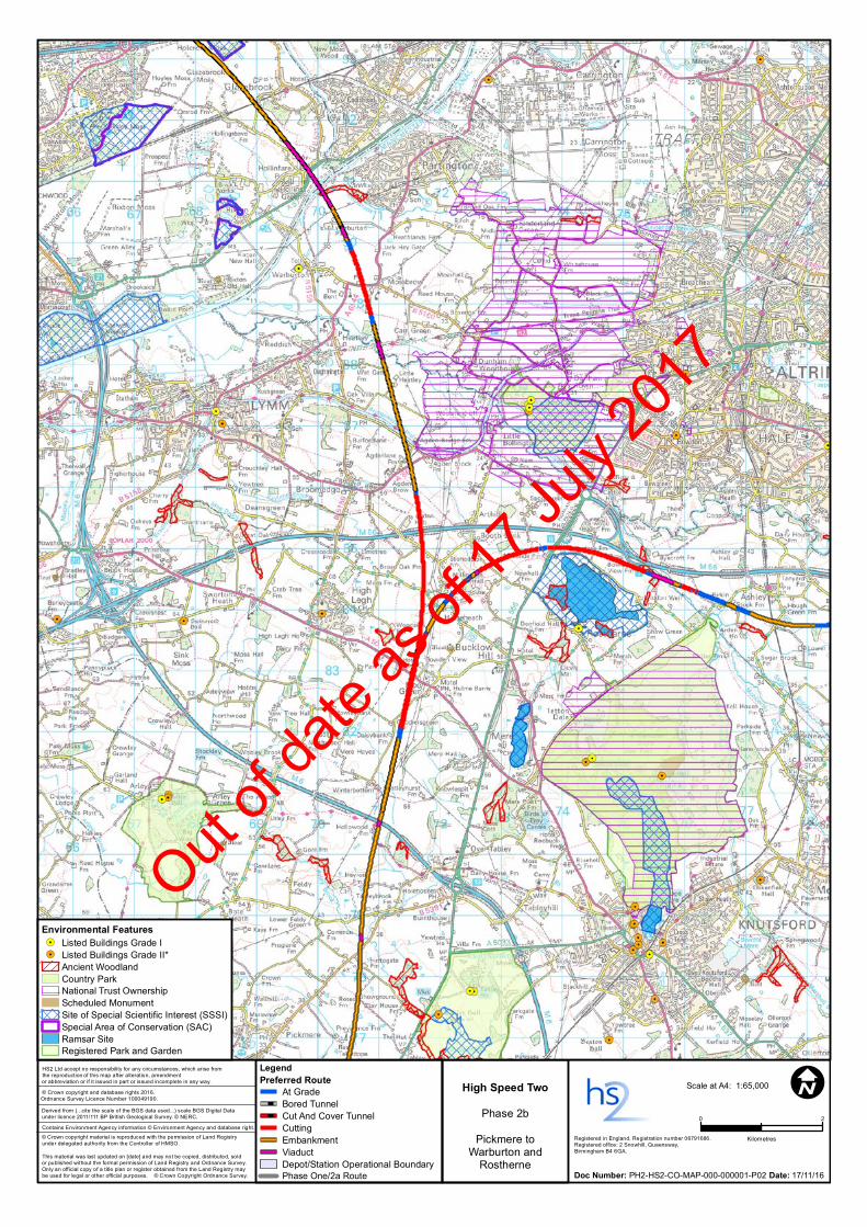
The route north of CreweThe route north of Crewe would form the northern 51 miles (82 km) of the Manchester leg on the Phase Two network. It would begin 600m to the south of the existing Crewe station, near the A500, continuing on from the Phase 2a route. The route would divide into two lines to the north-west of Knutsford. One line (the HS2 mainline) would continue north-west and finish at a junction with the existing West Coast Main Line (WCML) to the south of Wigan. The other line (the Manchester spur) would terminate at Manchester Piccadilly via a station near Manchester Airport.
In your areaNorth of the M6 crossing at Winterbottom, the mainline route would descend into cutting west of Hoo Green and would continue northwards, passing under the A50 and the M56 in a deep cutting. The ground profile changes after the M56, and the mainline continues towards Warburton on embankment, crossing over the A56. The route would then cross over the Bridgewater Canal and continue on embankment before crossing the River Bollin floodplain on a viaduct just east of Heatley.
The spur route at Winterbottom would leave the mainline just north of the M6 at Hoo Green. The spur would pass over the mainline just north of the A50, which would be realigned to cross over HS2. The spur would continue on a mixture of low embankments and minor cuttings, as the ground profile varies. The route would then cross under the A556 and continue towards Manchester between the M56 and Rostherne Mere in a cutting.
D66. WLFS2. CS658. © HS2 Ltd.
Between July 2013 and January 2014HS2 Ltd consulted the public on the proposed route and stations for Phase Two of HS2, from the West Midlands to Manchester, Leeds and beyond.
In November 2015 The Government announced its intention to bring forward the delivery of the Phase Two route between the West Midlands and Crewe, known as Phase 2a.
In November 2016The Government announced proposals for the remainder of the Phase Two route, known as Phase 2b.
Out of
date
as of
17 Ju
ly 20
17
I © Crown copyright and database rights 2016.Ordnance Survey Licence Number 100049190.
Scale at A4: 1:65,000
Derived from (...cite the scale of the BGS data used...) scale BGS Digital Dataunder licence 2011/111 BP British Geological Survey. © NERC.
© Crown copyright material is reproduced with the permission of Land Registry under delegated authority from the Controller of HMSO.
This material was last updated on [date] and may not be copied, distributed, soldor published without the formal permission of Land Registry and Ordnance Survey. Only an official copy of a title plan or register obtained from the Land Registry may be used for legal or other official purposes. © Crown Copyright Ordnance Survey.
HS2 Ltd accept no responsibility for any circumstances, which arise fromthe reproduction of this map after alteration, amendment or abbreviation or if it issued in part or issued incomplete in any way.
Registered in England. Registration number 06791686. Registered office: 2 Snowhill, Queensway,Birmingham B4 6GA.
Contains Environment Agency information © Environment Agency and database right.
Doc Number: PH2-HS2-CO-MAP-000-000001-P02 Date: 17/11/16
0 2
Kilometres
High Speed Two
Phase 2b
Pickmere to Warburton and Rostherne
LegendPreferred Route
At GradeBored TunnelCut And Cover TunnelCuttingEmbankmentViaductDepot/Station Operational BoundaryPhase One/2a Route
Environmental Features!. Listed Buildings Grade I!. Listed Buildings Grade II*
Ancient WoodlandCountry ParkNational Trust OwnershipScheduled MonumentSite of Special Scientific Interest (SSSI)Special Area of Conservation (SAC)Ramsar SiteRegistered Park and Garden
High Speed Two
Phase 2b
Pickmere toWarburton and
Rostherne
Out of
date
as of
17 Ju
ly 20
17
Changes to the route since 2013Since the 2013 consultation we have refined the route based on consultation responses, updates to design standards, lessons learnt from Phase One and ongoing strategic review of the Phase 2b proposals.
Northern chord A significant change in this area is the proposal to remove the northern chord, a 7.5km section of track between Warburton and Rostherne. The northern chord was previously designed to enable empty trains to travel between the rolling stock depot near Golborne and Manchester Piccadilly station. The relocation of the rolling stock depot to Crewe North means that this whole section of track would no longer be required. We have lowered the HS2 mainline between the A50 and M56 by up to 12m, to a maximum cutting depth of 22m. As well as responding to concerns raised in the 2013 consultation, this would reduce the impact on the A50 crossing and improve clearance when passing underneath a number of small watercourses. Lowering the mainline would also allow the HS2 spur towards Manchester to be lowered by up to 9m. Previously, the track towards Manchester would have crossed over the mainline on a viaduct up to 5m above ground level. The majority of this section (south of Peacock Lane) is now in cutting. The removal of the proposed northern chord allows HS2 Ltd to remove the proposed junction over the Bridgewater Canal, which would significantly reduce the impact on the canal and the surrounding area. Between the Bridgewater Canal and River Bollin, the route would be raised to a maximum height of 10m as a result of updated track standards and changes to the route to the north and south of this area.
For more information about changes to the Phase 2b route since 2013, please review the Summary of Route Refinements.
Key impactsThis section highlights the key impacts of the preferred route. For further information about these impacts, please review the Sustainability Statement.
Landscape and visual Landscape impacts would be generally minor until the route crosses the Bollin Valley, where a viaduct crossing would affect landscape character, notably where the embankment intrudes onto the open floodplain. Where the Manchester spur diverges from the mainline at Hoo Green, a large section of cutting accommodating both the spur and the mainline routes would result in landscape impacts. The low embankment past Hulse Heath would result in visual impacts in and around the village. The deep and wide cutting past Rostherne Mere would adversely affect the landscape setting of the mere and fragment intact open countryside. Where feasible and appropriate, we would apply a high-quality landscape design that fits into the character of the surrounding landscape. Examples of this may include the planting of trees, hedgerows and shrubs and the creation of landscape earthworks, to reduce any potential adverse impacts.
Who are HS2 Ltd?We are the company set up by the Government to deal with the design, engineering and technical requirements of building the railway.
We also have an important role in making sure that if you’re affected by the Government’s plans, you understand what to expect (and when), and how we can help.
For questions about HS2, call our Community Relations team on 020 7944 4908
Out of
date
as of
17 Ju
ly 20
17
Water The preferred route would cross a number of rivers and streams and their floodplains, as well as canals. Any impacts would be kept to a practicable minimum and we will continue to work closely with the Environment Agency and other stakeholders in order to determine how best to do this. Watercourse crossings are designed to reduce the effect on the watercourse, its wildlife and associated wetland habitats. The design is also engineered to take account of future flood risks.
Noise Our initial airborne noise appraisal for this early stage of the design process has predicted levels of railway noise on groups of dwellings during an 18-hour daytime period.*
Residual noise impacts are predicted for properties in the areas of Pickmere, Hoo Green and Agden. The sustainability mapping included within the Sustainability Statement highlights areas likely to be affected by noise based on this early appraisal. It also indicates locations at which we would explore further opportunities to mitigate airborne noise, such as the use of noise barriers and earth mounds, as well as looking at ways to reduce noise entering properties. Please see the Noise factsheet, which provides further general detail on noise impacts.
Transport networks and access Along the preferred route it is likely that several roads would require permanent or temporary realignment, such as the M6, the A50, the M56, the A56, the A6144, the A556 and additional minor roads. At this stage we have not designed or appraised road realignments. We are already working with Highways England and, in due course, would work with local authorities to reduce any traffic disruption that might arise.
Where the preferred route or its construction would potentially sever rights of way such as footpaths, bridleways and cycleways, new crossings or temporary access would be provided where practicable, subject to discussions with the relevant authorities.
Construction We are extremely aware of the issues that building a new railway presents to those who live nearby. We take our responsibilities very seriously. We are committed to reducing disruption to communities, business and the environment.
As part of the hybrid Bill process, a number of mechanisms will be introduced to control the environmental impacts of Phase 2b. For example, on Phase One, Environmental Minimum Requirements are a key element of the Government’s overall strategy for ensuring that impacts which have been assessed in the Phase One Environmental Statement are not exceeded unless under certain circumstances.
Information papers on construction for Phase One can be found at the following link:
www.gov.uk/government/publications/hs2-information-papers-construction
*Noise is conventionally measured using the equivalent continuous sound level (LAeq) indicator. This level is defined as the constant level of sound that, over a period of time, has the same total sound energy as the actual varying sound over the same period.
Contact us at HS2If you have any questions about this leaflet, please get in touch. You can contact our helpdesk on:
T: 020 7944 4908
For the latest documents including route plans and profile maps visit: www.gov.uk/hs2
Out of
date
as of
17 Ju
ly 20
17
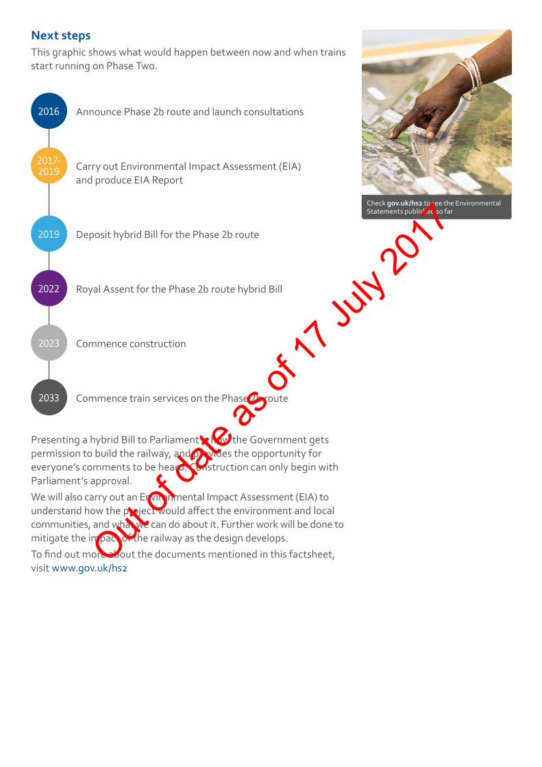
Next stepsThis graphic shows what would happen between now and when trains start running on Phase Two.
2016 Announce Phase 2b route and launch consultations
2017- 2019 Carry out Environmental Impact Assessment (EIA)
and produce EIA Report
2019 Deposit hybrid Bill for the Phase 2b route
2022 Royal Assent for the Phase 2b route hybrid Bill
2023 Commence construction
2033 Commence train services on the Phase 2b route
Presenting a hybrid Bill to Parliament is how the Government gets permission to build the railway, and provides the opportunity for everyone’s comments to be heard. Construction can only begin with Parliament’s approval.We will also carry out an Environmental Impact Assessment (EIA) to understand how the project would affect the environment and local communities, and what we can do about it. Further work will be done to mitigate the impact of the railway as the design develops. To find out more about the documents mentioned in this factsheet, visit www.gov.uk/hs2
Check gov.uk/hs2 to see the Environmental Statements published so far
Out of
date
as of
17 Ju
ly 20
17
Contact us HS2 Helpdesk Tel: 020 7944 4908 Email: [email protected]
This document may be freely downloaded and translated by individuals or organisations for conversion into other accessible formats. If you have other needs in this regard, please contact HS2 Ltd.
The Residents’ Charter is our promise to communicate as clearly as we possibly can with people who live along or near the HS2 route. You can read it by visiting:
www.gov.uk/government/publications/hs2-residents-charter
We also have an independent Residents’ Commissioner whose job is to make sure we keep to the promises we make in the Charter and to keep it under constant review. The first of the Residents’ Commissioner’s reports is published at:
www.gov.uk/government/publications/ hs2-residents-commissioner-report-1-may-2015
You can contact the Commissioner at:
Residents’ Charter and Commissioner
For more information about Phase Two, visit
www.gov.uk/government/collections/hs2-phase-two-from-the-west-midlands-to-leeds-and-manchester
And for details of events in your area, visit
www.gov.uk/government/collections/hs2-events
Project updates
Property and compensation
You can find out all about HS2 and properties along the line of route by visiting:
www.gov.uk/government/collections/hs2-property
You can also find out if you’re eligible for compensation at:
www.gov.uk/claim-compensation-if-affected-by-hs2
To see what jobs are available on HS2 at the moment, check our careers page:
http://careers.hs2.org.uk
If you’re a student wondering what careers in STEM subjects are like, check out articles and have a look around our Plotr World:
www.plotr.co.uk/careers/worlds/hs2
And if you’re a business wondering how to get involved with HS2, have a look at our guides and updates on:
www.gov.uk/hs2 – search for HS2 business
Jobs and skills
Keeping you informedWe are committed to keeping you informed via various channels
High Speed Two (HS2) Limited, Two Snowhill, Snow Hill Queensway, Birmingham B4 6GA
Out of
date
as of
17 Ju
ly 20
17