planning app proposal - citizenact
TRANSCRIPT
P e o p l eP l a n
D e v e l o p m e n tUBRP 276: Instructor Nader Afzalan
Spring 2015San Jose State University
April 4th, 2015Sonal Aggarwal, Prescott Reavis, and Kenneth Rosales

P e o p l e
P l a n
D e v e l o p m e n t
The idea behind the CitizenACT app is to create a readily available online tool that helps people understand and become engaged in land use and development decisions in their neighborhoods.
Many citizens are not aware about zoning, natural safety hazards, environmental impacts, or simply what proposed developments or plans are happening within their neighborhoods or which could have an impact on their neighborhood.
Trying to navigate through the complex and expansive city websites waste much of a person’s valuable time, especially in large cities like San Jose, California. Further, it is even more difficult if planning information online is not available or is only accessible by physically going to a city or county department office. This information gap makes it extremely difficult to follow or be current on the latest development of a resident’s project of interest.
The lack of ease in gathering information about a development is one of many major reasons why most cities find it difficult to have a high level of public participation. Creating a comprehensive app can thwart these inconveniences by providing a “one stop shop” of planning information specific to an area of interest.
Page 2 Aggarwal, Reavis, Rosales
I.Is
sue Moreover, this app has the potential
to increase community participation, community empowerment, and representation, and thus, open up the dialogue of resident perceptions, inputs, and an improved connection with a city’s planning processes.

P e o p l e
P l a n
D e v e l o p m e n t
CitizenACT is an interactive online mapping system that allows city or county residents to look up parcel information throughout their jurisdiction. For example, if a citizen wants to find out about a development that is going to be built on a property, which has been empty for the last 10 years, then he/she can either enter the address, APN information, or touch the parcel on the map to find the current or future zoning, Draft Environmental Impact Reports (EIRs), community input meetings, decision-making, or proposal information.
People are busy working, running errands, taking care of their children, filing their taxes, cooking, or going to school. Unfortunately, time is not a luxury most people posses, which poses a problem for cities who envision their citizens to be educated, aware, and engaged in the public planning processes that will affect their lives, their family and children’s future.
Residents want to be involved in planning developments in their locales, but the challenging question is how can cities maximize the opportunity to educate, empower, and engage residents in land use projects and decisions? The answer is a powerful, simple, easy to use, one- stop educational and public participatory application on land use developments, CitizenACT.
Aggarwal, Reavis, Rosales Page 3
II.
Imp
ort
ance

P e o p l e
P l a n
D e v e l o p m e n t
The Citizen ACT app goes beyond the current zoning of a lot and provides direction information of any proposed development for a particular site. The information includes the key dates for public meetings or comments due for processes such as EIRs or Conditional Use Permit approvals. There are four ways to search for the site one is interested in finding information on: 1. Entering the desired address2. Entering the APN3. Selecting the lot on the map;4. Taking a geotagged picture of the area
Figures 1-4 include examples of current online mapping tools with similar functions to the CitizenACT app.
Page 4 Aggarwal, Reavis, Rosales
III.
Exam
ple
s
Figure 1 Online planning map for the City and County of San Francisco, CA.
Figure 2 Online planning map for the City and County of Los Angeles, CA.
Figure 4 Online planning map for sites or districts with economic potential in select
cities.
Figure 3 Online planning map for the City of Chicago, IL.
Images, in order from: http://ec2-50-17-237-182.compute-1.amazonaws.com/PIM/
http://rpgis.isd.lacounty.gov/GIS-NET3_Public/Viewer.htm
http://secondcityzoning.org/
http://oppsites.com/?signup=true

P e o p l e
P l a n
D e v e l o p m e n t
Aggarwal, Reavis, Rosales Page 5
P e o p l e
P l a n
D e v e l o p m e n t
Overall, the CitizenACT app will allow its users to conduct a variety of functions, including (Figures 5-10):
1. Site Identification: Effortlessly search for a site or parcel of interest;
2. Data Provision and Analysis: Easily find and read plain English information on the site of interest ranging from zoning , development history, and Conditional Use Permit processes to environmental documents such as EIRs;
3. Public Participation: Find out when the next public meeting is and when public comments are due for a development of interest; and
4. Defining Technical Language: Utilize a glossary that helps the common citizen understand any planning jargon.
The CitizenACT app users are everyday citizens, planners, businesses and developers, it is for everyone. Many citizens are concerned about the development of their neighborhood but there is not a clear one stop resource which informs them what potential developments are in process. Professional and student planners often need 24 hour access to proposed development and zoning information and this information is usually held by planning staff and is only available during business hours.
Page 5 Aggarwal, Reavis, Rosales
IV.
Fun
ctio
n
Figure 5 This is the Home screen- Step 1 where the user can login or needs to
register to use the app.
CitizenACT has the potential to be used by community groups to understand and educate themselves on a particular development and possibly organize for or against a proposed development in their community.

P e o p l e
P l a n
D e v e l o p m e n t
Page 6 Aggarwal, Reavis, Rosales
P e o p l e
P l a n
D e v e l o p m e n t
IV.
Fun
ctio
n
Figure 6 Step 2 involves finding the area of interest.
Search for site by address or APN
Search for site by dropping a pin
Search for site by adding a geotagged picture of the area
P e o p l e
P l a n
D e v e l o p m e n t
Aggarwal, Reavis, Rosales Page 7
P e o p l e
P l a n
D e v e l o p m e n t
Page 7 Aggarwal, Reavis, Rosales
IV.
Fun
ctio
n
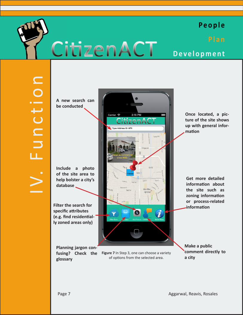
Figure 7 In Step 3, one can choose a variety of options from the selected area.
A new search can be conducted
Once located, a pic-ture of the site shows up with general infor-mation
Include a photo of the site area to help bolster a city’s database
Get more detailed information about the site such as zoning information or process-related information
Make a public comment directly to a city
Planning jargon con-fusing? Check the glossary
Filter the search for specific attributes (e.g. find residential-ly zoned areas only)

P e o p l e
P l a n
D e v e l o p m e n t
Page 8 Aggarwal, Reavis, Rosales
P e o p l e
P l a n
D e v e l o p m e n t
Aggarwal, Reavis, Rosales Page 8
IV.
Fun
ctio
n
Figure 8 The “Know More” screen
Look for zoning information
Look for environmental documents
Find out when the next public participation opportunity occurs
Information on height restric-tions, acreage, etc.
Discover if the site of interest is going to be developedHistorical develop-
ments of the site area

P e o p l e
P l a n
D e v e l o p m e n t
Aggarwal, Reavis, Rosales Page 9
P e o p l e
P l a n
D e v e l o p m e n t
Page 9 Aggarwal, Reavis, Rosales
IV.
Fun
ctio
n
Figure 9 The “Zoning” screen from the “Know More” selection
Highlighted section indicates zoning of selected location
Search for other Zoning information
Zoning information of selected location

P e o p l e
P l a n
D e v e l o p m e n t
Page 10 Aggarwal, Reavis, Rosales
IV.
Fun
ctio
n
Figure 10 The “Upcoming Meetings” screen from the “Know More” selection.
Pictures of public meetings Date of public meeting
Details of public meeting

P e o p l e
P l a n
D e v e l o p m e n t
Hack the Hood and The Hidden Genius Project (HGP) teach minority youth about the technology industry (Figures 11-12). The mission of HGP is to train and mentor undeserved black male youth in technology creation, entrepreneurship, and leadership skills to transform their communities in the present and future. Hack the Hood is an award-winning non-profit that introduces low-income youth of color to careers in tech by hiring and training them to build websites for small businesses in their own communities. Engaging youth in the development of this application will help to make sure this planning application is simple to use. If a teenager can figure out how to access zoning and planning information, then any adult should understand the process.
The time projected for the development of CitizenACT can take between eight to twelve months for its release. This time includes :1. A visioning process with the
development team and the city planning staff.
2. Back end coding of the application and the setting up of the server.
3. Developing the graphics for the application screen and the application icon.
4. Beta testing the application.5. Refinement of the application after
Beta testing.6. Final release of the application.
Aggarwal, Reavis, Rosales Page 11
V.I
mp
lem
en
tati
on
Figure 12 Image taken from:
www.hiddengeniusproject.org
Figure 11 Image taken from:
www.hackthehood.org
The total budget would be between $97,280 - $140,800 and does not include the server cost which would be around $720 annually depending on the amount of data needed to be stored.
The project team would include one project manger and lead instructor and four students to build the application. The project manager’s annual salary would be $83, 200 or $40/HR. Each student would be a paid $15/hr and work 20 hours a week.

P e o p l e
P l a n
D e v e l o p m e n t
With the help of CitizenACT, queries for zoning could be answered very easily. This would reduce the number of phone calls and people coming to planning departments. The additional time gained by planning departments could be spent on researching more on the best development and uses for their community.
Citizens with a better understanding of the zoning and planning process would become more engaged and informed on proposed development and planning activities, which then has the potential to help expedite the planning approval process and reduce future problems such as public outcries or negative environmental impacts. If plans and developments can be approved quicker the economic, social and environmental benefits can be realized for all while enhancing the quality of life.
The limitations of CitzenACT is building a webserver to host all the information from planning departments. Ensuring there is a constant draw of information from the planning department files and records to the application server may be a key challenge for app developers.
There is also the issue of liability- all the updating of information is coming from planning departments and if they do not update their files frequently then the application data will be stale.
Page 12 Aggarwal, Reavis, Rosales
V.Im
pli
cati
on The difficulty of formatting data in a
consistent manner will initially limit how far back in time information can be accessed, as many documents are still only on paper or in microfilm.
CitzenAct could be improved by having the planning department streamline their process to have all information in digital format and minimize paper use. If this strategy is employed, then this would facilitate a quicker turnaround of information to the application as well as provide for a dedicated high speed connection to CitizenACT server so information can flow at the fastest speed possible. CitizenACT improvements could allow for the submission of proposed developments directly to city planning departments and then vetted through an automated system released onto CitizenACT.